integrating land-use, transport, and the environment: case ... · both countries face rapid land...
TRANSCRIPT
IntroductionChina and India are the world’s most populous with populations in excess of one billion. Both countries face rapid land use change on the urban peripheries. Zhou and Ma (2000) note that a survey using satellite images shows that urbanized areas in the 31 largest cities in China expanded by 50-200% between 1986 and 1996. In 2001 the urban population in India was 28% of the total population with 35 cities having a population over a million as compared to 23 cities with population over a million in 1991. The number of registered vehicles in India has grown from about 37 million in 1997 to an estimated vehicle fleet of over 50 million vehicles in 2001. In the past ten years, the total number of vehicles in China has tripled, and the number of motorcycles nationwide has increased more than five fold. Poor transport infrastructure in contrast to rapid motorization and urban growth, has increasingly offset advances in pollution control from stationary sources, causing poor air quality. Particulate pollution is severe in both Chinese and Indian cities. UNES-CAP/ ADB (2002) named Delhi as the most polluted city in the world in terms of sus-pended particulate matter. According to the World Health Organization, in 1998, seven of the ten most polluted (with respect to air quality) cities in the world were in China. While air quality has improved in the national capitals of Beijing and New Delhi, it remains poor by international standards. Thus, urbanization and motorization are creating a com-plex mix of environmental problems. In this context we are conducting case studies in Chengdu. Chengdu is the capital of the Sichuan province in southwest China, with a population of 10.13 million residents, of which 3.07 million live in the urban area. Like other major cities in China, Chengdu has witnessed accelerated urban growth since 1990. This will be the first in a series of case studies in China as well as India that will integrated land use planning, travel demand es-timation and air quality management. We have studied land use change in Delhi and esti-mated travel demand characteristics of low income households in Chennai both of which are in India and will use some of the methodology developed for those cities in studying Chengdu.
Research QuestionsAccessibility to employment (and other services) is an essential quality of cities. Studies in North America and Europe have indicated that it can significantly affect travel behavior (Badoe and Miller, 2000; Srinivasan, 2002). Other studies in Indian cities like Chennai (Srinivasan, 2003) have also shown that accessibility by transit significantly affects land development, as well as travel behavior. Research on accessibility effects needs to disaggregate contributing factors in terms of space, time, as well as individuals. Our research questions for Chengdu emphasize individual mode choice in response to the transformation in urban form and personal socio-economic status. The questions can be grouped into three categories, focused on land use, transportation modeling, and their integration. 1. Land Use:
a. How can we model land use changes? This includes change at the regional and at the metropolitan scale.
b. How can we quantify mixed land uses? c. How can we measure accessibility to service in the context of China?
2. Transportation:a. How is mode choice related to demographic and socio-economic characteristics
(income, occupation, auto ownership, etc.)?b. What are the mode choice compositions for work and non-work trips? Are there
any differences between the two types of trips?3. Integration of land use and transportation models:
a. How does land use configuration (mixed land uses), accessibility, and job-hous-ing locations impact vehicle ownership and mode choice?
b. How will land use change affect travel behavior in the future (assuming a con-tinued trend of suburbanization)?
c. What are the land use and transportation policy issues raised by such a study (especially those related auto dependency and transit dependent households)?
d. Are there differences in job/housing locations and trip characteristics (mode choice, travel time, etc.) by type of business (private versus state-owned)?
4. What are the environmental implications of land use and transport planning policy interventions on air quality and its effects on human health and the economy?
The Household Land Use and Travel Behavior SurveyCurrent data about the travel and land use characteristics of households in Chinese cities, if they have been collected by local planning authorities, are generally difficult to access for independent research. Also, the level of unsanctioned internal migration in China is very high and the system of household registration, on which detailed census data are indexed, is effectively collapsing. Thus even when official survey data are available, they will rarely be truly representative because surveys generally sample the officially regis-tered population, not the actual population. We joined with survey specialists at the Research Center for Contemporary China in Beijing University to apply a unique method of sampling as part of a transport and land use survey of 1000 households in Chengdu. We used spatial sampling that overcomes the inability to reach migrants in traditional area samples based on household lists. A spa-tial grid is created in the sample space in such a way that each unit is small enough to be enumerated quickly and cheaply. Interviewers can be told to enumerate a list of addresses inside a defined geographical area bound by streets (with names) or some other easily identifiable demarcation. Arbitrarily defining small blocks independent of natural bound-aries was until recently very difficult because such units were very hard to reach in prac-tice. For instance, one could not typically instruct an interviewer to visit a site centered on “North 39 degrees, 10 minutes and 25.76 seconds, East 111 degrees, 24 minutes and 45.12 seconds.” The technical expertise, costs, and time needed to accomplish this task were simply prohibitive. Modern GPS receivers solve this problem, since they have the ability to identify small Primary Sampling Units (PSU) with considerable precision. Sur-veyors then enumerate the households residing within the boundaries of the PSU. Once listed, each household is interviewed. One drawback is that the probabilities of selection depend not on the number of households but on the number of spatial points and therefore the final sample size can-not be determined ex ante. The surveyors can only rely on “best estimates” of population densities to determine an appropriate number and size of final sampling units. Each grid square (PSU) estimate is then multiplied by a correction coefficient that accounts for the likely proportion of migrants in the district where the PSU is located.
Integrating Land-use, Transport, and the Environment:
Case Study Chengdu, China
Air Quality and its Health and Economic ImpactsHaving estimated travel demand in Chengdu, we then link into separately funded research of the HUCE China Project to estimate the health and economic damages of the cities mobile-source pol-lution. This builds on methods developed for the China Project’s upcoming book, Clearing the Air: The Health and Economic Damages of Air Pollution in China (Ho and Nielsen, forthcoming MIT Press). This study indicated that even before the explosion of car ownership in China, transportation posed the third highest health risk from air pollution of 33 sectors, due to ground-level emissions concentrated in densely populated areas. The first link is to approximate mobile source emissions caused by travel activities, such as number of trips made and vehicle kilometers traveled, with various transportation modes. We plan to project emissions by combining our travel demand model with field data on current vehicle activ-ities and fleet characteristics gained from an application of the International Vehicle Emission (IVE) model to Chengdu, in partnership with Tsinghua University. Another collaboration, between Tsinghua and Harvard’s atmospheric chemistry group and the School of Public Health, has collected data to model atmospheric transport of pollutants from the emission scenarios, and then to assess population exposures, from near-source street canyons to the Sichuan region. Applying dose-response functions from the literature will then estimate total health impacts of the emission futures. Another team, of China Project health economists, has used the same household survey to estimate the value that Chengdu citizens place on their respiratory health, in order to monetize the effects of air pollution. We can then incorporate the health and economic damages approximated by these modules into comprehensive analyses of land use and transport policy options.
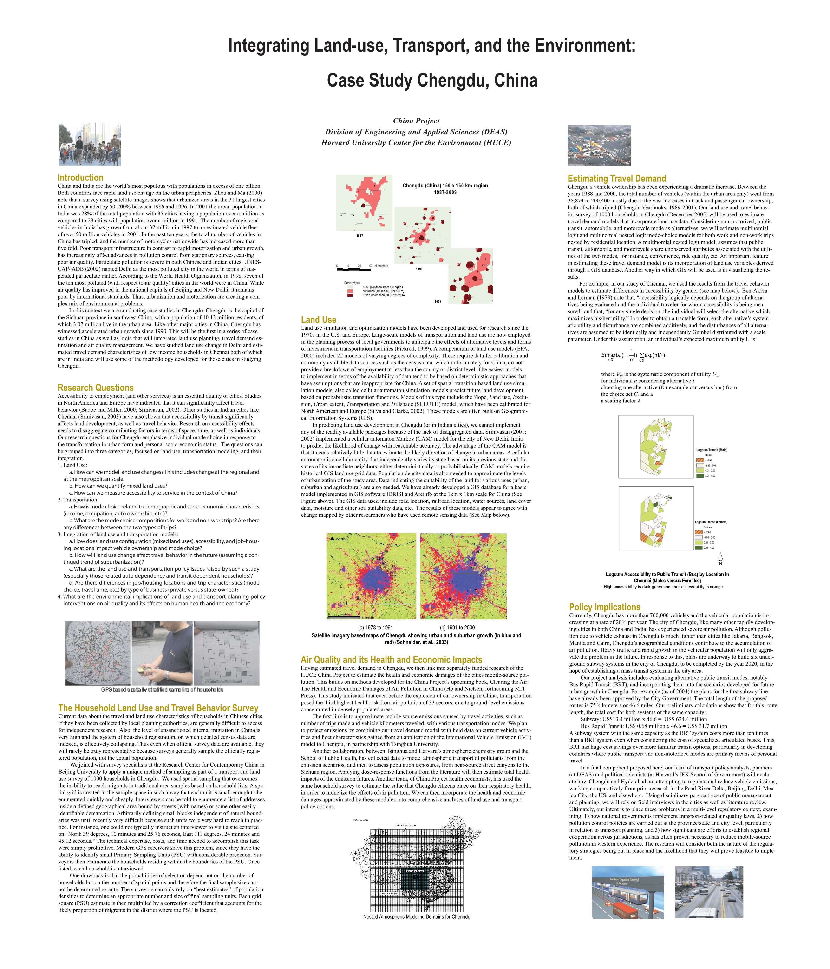
Land Use Land use simulation and optimization models have been developed and used for research since the 1970s in the U.S. and Europe. Large-scale models of transportation and land use are now employed in the planning process of local governments to anticipate the effects of alternative levels and forms of investment in transportation facilities (Pickrell, 1999). A compendium of land use models (EPA, 2000) included 22 models of varying degrees of complexity. These require data for calibration and commonly available data sources such as the census data, which unfortunately for China, do not provide a breakdown of employment at less than the county or district level. The easiest models to implement in terms of the availability of data tend to be based on deterministic approaches that have assumptions that are inappropriate for China. A set of spatial transition-based land use simu-lation models, also called cellular automaton simulation models predict future land development based on probabilistic transition functions. Models of this type include the Slope, Land use, Exclu-sion, Urban extent, Transportation and Hillshade (SLEUTH) model, which have been calibrated for North American and Europe (Silva and Clarke, 2002). These models are often built on Geographi-cal Information Systems (GIS). In predicting land use development in Chengdu (or in Indian cities), we cannot implement any of the readily available packages because of the lack of disaggregated data. Srinivasan (2001; 2002) implemented a cellular automaton Markov (CAM) model for the city of New Delhi, India to predict the likelihood of change with reasonable accuracy. The advantage of the CAM model is that it needs relatively little data to estimate the likely direction of change in urban areas. A cellular automaton is a cellular entity that independently varies its state based on its previous state and the states of its immediate neighbors, either deterministically or probabilistically. CAM models require historical GIS land use grid data. Population density data is also needed to approximate the levels of urbanization of the study area. Data indicating the suitability of the land for various uses (urban, suburban and agricultural) are also needed. We have already developed a GIS database for a basic model implemented in GIS software IDRISI and Arcinfo at the 1km x 1km scale for China (See Figure above). The GIS data used include road location, railroad location, water sources, land cover data, moisture and other soil suitability data, etc. The results of these models appear to agree with change mapped by other researchers who have used remote sensing data (See Map below).
Policy ImplicationsCurrently, Chengdu has more than 700,000 vehicles and the vehicular population is in-creasing at a rate of 20% per year. The city of Chengdu, like many other rapidly develop-ing cities in both China and India, has experienced severe air pollution. Although pollu-tion due to vehicle exhaust in Chengdu is much lighter than cities like Jakarta, Bangkok, Manila and Cairo, Chengdu’s geographical conditions contribute to the accumulation of air pollution. Heavy traffic and rapid growth in the vehicular population will only aggra-vate the problem in the future. In response to this, plans are underway to build six under-ground subway systems in the city of Chengdu, to be completed by the year 2020, in the hope of establishing a mass transit system in the city area. Our project analysis includes evaluating alternative public transit modes, notably Bus Rapid Transit (BRT), and incorporating them into the scenarios developed for future urban growth in Chengdu. For example (as of 2004) the plans for the first subway line have already been approved by the City Government. The total length of the proposed routes is 75 kilometers or 46.6 miles. Our preliminary calculations show that for this route length, the total cost for both systems of the same capacity: Subway: US$13.4 million x 46.6 = US$ 624.4 million Bus Rapid Transit: US$ 0.68 million x 46.6 = US$ 31.7 millionA subway system with the same capacity as the BRT system costs more than ten times than a BRT system even when considering the cost of specialized articulated buses. Thus, BRT has huge cost savings over more familiar transit options, particularly in developing countries where public transport and non-motorized modes are primary means of personal travel. In a final component proposed here, our team of transport policy analysts, planners (at DEAS) and political scientists (at Harvard’s JFK School of Government) will evalu-ate how Chengdu and Hyderabad are attempting to regulate and reduce vehicle emissions, working comparatively from prior research in the Pearl River Delta, Beijing, Delhi, Mex-ico City, the US, and elsewhere. Using disciplinary perspectives of public management and planning, we will rely on field interviews in the cities as well as literature review. Ultimately, our intent is to place these problems in a multi-level regulatory context, exam-ining: 1) how national governments implement transport-related air quality laws, 2) how pollution control policies are carried out at the province/state and city level, particularly in relation to transport planning, and 3) how significant are efforts to establish regional cooperation across jurisdictions, as has often proven necessary to reduce mobile-source pollution in western experience. The research will consider both the nature of the regula-tory strategies being put in place and the likelihood that they will prove feasible to imple-ment.
Nested Atmospheric Modeling Domains for Chengdu
(a) 1978 to 1991 (b) 1991 to 2000
Satellite imagery based maps of Chengdu showing urban and suburban growth (in blue and red) (Schneider, et al., 2003)
∑=∈∈ Cni
ininCni
VUE )exp(ln1)max( mm
where Vin is the systematic component of utility Uin for individual n considering alternative i choosing one alternative (for example car versus bus) from the choice set Cn and a a scaling factor µ
Estimating Travel Demand Chengdu’s vehicle ownership has been experiencing a dramatic increase. Between the years 1988 and 2000, the total number of vehicles (within the urban area only) went from 38,874 to 200,400 mostly due to the vast increases in truck and passenger car ownership, both of which tripled (Chengdu Yearbooks, 1989-2001). Our land use and travel behav-ior survey of 1000 households in Chengdu (December 2005) will be used to estimate travel demand models that incorporate land use data. Considering non-motorized, public transit, automobile, and motorcycle mode as alternatives, we will estimate multinomial logit and multinomial nested logit mode-choice models for both work and non-work trips nested by residential location. A multinomial nested logit model, assumes that public transit, automobile, and motorcycle share unobserved attributes associated with the utili-ties of the two modes, for instance, convenience, ride quality, etc. An important feature in estimating these travel demand model is its incorporation of land use variables derived through a GIS database. Another way in which GIS will be used is in visualizing the re-sults. For example, in our study of Chennai, we used the results from the travel behavior models to estimate differences in accessibility by gender (see map below). Ben-Akiva and Lerman (1979) note that, “accessibility logically depends on the group of alterna-tives being evaluated and the individual traveler for whom accessibility is being mea-sured" and that, “for any single decision, the individual will select the alternative which maximizes his/her utility.” In order to obtain a tractable form, each alternative’s system-atic utility and disturbance are combined additively, and the disturbances of all alterna-tives are assumed to be identically and independently Gumbel distributed with a scale parameter. Under this assumption, an individual’s expected maximum utility U is:
China ProjectDivision of Engineering and Applied Sciences (DEAS)
Harvard University Center for the Environment (HUCE)