international bank for reconstruction...
TRANSCRIPT

RESTRICTED
Rt.i,ort No. PA - 27a
r This report was prepared for use within the Bank and its affiliated organizations.They do not accept responsibility for its accuracy or completeness. The report maynot be published nor may it be quoted as representing their views.
INTERNATIONAL BANK FOR RECONSTRUCTION AND DEVELOPMENT
INTERNATIONAL DEVELOPMENT ASSOCIATION
KADANA IRRIGATION PROJECT
INDIA
January 21, 1070
Agriculture Projects Department
Pub
lic D
iscl
osur
e A
utho
rized
Pub
lic D
iscl
osur
e A
utho
rized
Pub
lic D
iscl
osur
e A
utho
rized
Pub
lic D
iscl
osur
e A
utho
rized
Pub
lic D
iscl
osur
e A
utho
rized
Pub
lic D
iscl
osur
e A
utho
rized
Pub
lic D
iscl
osur
e A
utho
rized
Pub
lic D
iscl
osur
e A
utho
rized

CURRENCY EQUIVAIE NTS
US$ 1.00 - Rupees (Rs) 7.5Rs 1.00 = US$ 0.13Rs 1 million a US$ 133,333-
WEIGHTS AND MEASURES - METRIC ANDENGLISH SYSTEM
1 hectare (ha) '2.47 acres1 kilometer (Ian) - 0.62. miles1 square kilometer (km2) X 0.3886 square miles1 cubic meter (mi3) 35.31 cubic feet1 million cubic meters (Mm3) - 810.7 acre feet1 kilogram (kg) 2.205 pounds1 ton a 2,205 pounds
INITIALS AND ACRONYMS
CWPC : Central Water and Power CommissionGOI : Government of IndiaGSIDB : Gujarat State Cooperative Land Development BankPWD : Public Works DepartmentTCD farm: Trial-cum-demonstration farm

INIU.A
KCADANA IRRIGAT ION P0JECT
TABLE OF CONITEXTS
SUNMMARY AND CONCLUSIONS . . . . . . . . . . . . . . . . . i
I. INTRODUCTICN . . . . . .. . . . . . . . . . . . . . 1
II. BACKGROUTTD . . . . . . . . . e . . .
III. THE PRlOJECT AP,EA . . . . . . . . . . . . . . . . . . . . 2
General . . . . . . . . . . . . . . . . . . . . . . . . . 2Climate . . . . . . . . . . . . . . . . . . . . . . . . . 3Soils and Tonograohy . . . . . . . . . . . . . . . . . . 3Drainage . . . . . . . . . . . . . . . . . . . . . . . . 4Farm Size and Land Tenure . . . . . . . . . . . . . . . . 4Agricultural Production . . . . . . . . . . . . . . . . . 5Transnortation . . . . . . . . . . . . . . . . . . . . . 5
IV. THE PROJECT . . . . . . . . . . . . . . . . . . . . . . . 5
A. Prolect Description. 5B. Prolect Works . . . . . . . . . . . . . . . . . . . . 6
Kadana Dam . . . . . . . . . . . . . . . . . . . . 6Water Distribution Systems . . . . . . . . . . . . . 6Drainape . . . . . . . . . . . . . . . . . . . . . . 7Land Levelin. 7Roads . . . . . . . . . . . . . . . . . . . . . . . . 8
C. Water Sunnly, Demand and Quality . . . . . . . . . . 8D. Enrineerina Design and Construction Schedule . . . . 9E. Cost Estinates ... . . . . . . . . . . . . . . . . 10P. Finance .12G. Procurement .13H. Disbursement . . . . . . . . . . . . . . . . . . . . 15I. Auditing of Accounts . . . . . . . . . . . . . . . . 15
V. ORGANIZATION AND MANAGEMENT . . . . . . . . . . . . . . . 16
Project Coordination and Suuervision . . . . . . . . . . 16Civil Works . . . . . . . . . . . 6 . . . . . . . . . . . 1Apricu1tural Sunport Progra' . . . . . . . . . . . . . . 18Consolidation of Land-Holdin.s . . . . . . . . . . . . . 18Evaluat4on of Azricultural Progress . . . . . . . . . . . 19Agricultural Credit .19Grain Storage and Agriculturai Processing . . . . . . . . 20Operation and Maintenance . . . . . . . . . . . . . . . . 20Oneration and Maintenance Costs . . . . . . . . . . . . . 20Water Charges .21
This renort was Drenared by Messrs. A. Golan, C. M. Bolt and E. M. Sicely.
Page No.
VI. PRODUCTION, MA.RKETPS T0SPECTS AITT F A-M I NC OME1 .. ... 24
P r.ddtition 244 Parket Prosnects . . .ttern, 25Prices . 25Farmers' Income............. .. ...... 26
VII. BETEITTS AoD JUSTIFICATION.27
VIII. RECONMENDATIONS .2 .8 Quality
ANNE Ci S
1. Existinc IrriRaticn Works2. Soils ard Topo4raDhy3. Land Tenure4. Present and Projlectled Cropnirn, Pattern, Yields,
Production Costs and Returns5. Agriculture6 . Descri-otion of Project Works7. 'Vater SuCarg, Demand and Quality8. Construction Schedule9.Cost Estimates
10. Project Organization Charts11. Ai7ricultural Suno;ort Prorzram12. Water Charges13. Farm Budgets141. Economic Rate of Return
MAAPS
1. Kadqna Irrigation Project Location2. Kadana Irrigation Pro.1ect

'I Li 4
SUMMAFfy ARD CONCL'SIC14S
i. Agriculture plays a domiiaant role in the Thianr ez:^yv and
gation is essential fcr the anhievezeait of htigher prodlzCti' iit,y as well as
to reduce the farmers' dependence on very uapredictable iatsalL Th itsl969-74 Five-Year Plan, -the Goverrnnent of India (CT'.O f.z in m.a on
the completion of on-going irrigeation projects. Tne I r-posea Kadas 'r -gation Project in the State of Gu-4arat i4n west cent:c a"' =p*oL.ete a
a&jor on-going scheme to develop iriigated wric.ture j. a ." o t"e
MEahi Eiver. lTne project inciudes:
ta) construct-ilon of YadanE; Dam cn the Mahi Rive-
(b) exnansion of the existin, irrigation 1t o he ri,gh>1tbank from 1113,O00 ha to 263,000 ha;
(c) construction of a new ir--rigation system on the left bankto serve about 20,000 ha;
(d) construction of watercourses and field channels throughoutthe project area;
(e) renodeling and expansion of the drainage systems;
(f) land leveling of about 42,000 ha; and
(g) upgrading of existing roads and construction of ne-wdistrict, village and farm-to-market roads totalingabout 3,200 km.
It would also include the construction of farmers' training facilities,groundwater investigations, a study of water charges and a trial land con-solidation program.
ii. Of the US$ 110 million which the Bank Group has lent previously toIndia for agriculture, about Us$ 60 million vas for sev,en irrigation proj-ects. One of these was the Shetrunji Project (Credit No. 13-Il of November1961) in Gujarat State. On all seven projects, heavy emphasis was placedon civil works construction without paying sufficient attention to the pro-vision of timely and adeauate inputs to complenment water supplies. As aresult, serious delays occurred in agricultural development. The GOI andthe State of Gujarat now recognize the need to provide these inputs con-currently with assured supplies of irrigation water and provision has beenmade for them in the project.
iii. Overall costs of the project from its incention in 1954 to com-pletion by mid-1975 are estimated to be Rs 735 million (US$ 98 zillion). Ofthis, about Rs 235 million, or 32, of total pro4ect costs, was spent by the

- ii -
end of 1969. An IDA credit of us$ 35 million has been requested to assistin financing the remaining expenditures of Rs 500 million (US$ 66.7 mnillion).The direct foreizn exchange component of remaining exnenditures is US$ 2.5 ,million. Over 90% of the IDA credit would therefore be used to finance /local expenditures. This is Justified on country economic grounds.
iv. Of the Us$ 66.7 mi1lion eauivalent recuired after 1969 to comoletethe project, uS$ 35 million (52%) would be orovided bv the oronosed IDAcredit, which would be re-lent by the GOI to the State of GuJarat, and thebalance by the State of Gujarat. The amount recuired exceeds the State'soverall allocation for the pro.'iect by about Rs 195 million (US$ 26 million).Therefore, assurances were obtained that allocations would be increased tomeet reauiremnent3 and that funds would be made available as needed forefficient nroject imnlementation.
v. The Irrigation Wing of the State's Public 'Works Department hasdesigned the civil works and would supervise their construction by contrac-tors. All existing contracts have been awarded on the basis of local bid-ding and the procedure followed in awardinv them is satisfactory. The wrorkswere designed for construction mainly by labor-intensive methods, which hasrendered them unsuitable for international bidders usin;7 tnechanized methods.Remaining works on the distribution system, consisting of excavation ofsmall, widely dispersed channels, are also unlikelv to attract internationalcontractors; they would be awarded on the basis of local bidding. AboutUS$ 3.2 million worth of ecuinrment would be renuired for the project. Outof this total, US$ 2.3 million worth of machinery, on which the prevailingcustoms duty is 15%' or lower, would be orocured following internationalcompetitive bidding. In addition, US$ 0.2 million of specialized tools andequinment -would be imported. The remainina machinery, on which the prevail-ing customs duty exceeds 15%, would be procured locally but would not befinanced out of the credit.
vi. Coordination is essential between the Public Works DeDartment,responsible for the design and construction of project works; the Departmentof Agriculture and Co-oneration, respcnsible for agricultural development;and other narticinating agencies, including the Departments of Finance,General Administration and Land Records, the office of the Develorment Com-missioner and the Gu,arat State Land Development Bank. To this end theGovernment of GuJarat established coordination committees at the State andproject level with overall responsibility for planning and coordinatingthe activities of the various agencies associated with the pro,lect. Inaddition, assurances were obtained that imDrovements would be made in theagricultural supporting services, particularly in extension, training,research and demonstration farms.
vii. At fll arricultural development of all project lands, the annualincremental net value of production would be about Rs 200 million ((S. 27million). The economic rate of return would be about 14°o if all nast ex-penditures are included in the analysis, or over 20%S if thev are disregarded.>The project is suitable for an IDA credit of US$ 35 million enuivalent.The borrower would be the Government of India.

.DAD'A 1PRIGATTIN_ PROJTFO
I. INTRODUCTION
1.01 The Government of Indla (GCT) he.s request-d.' en I.A c-redit; ofUS$ 35 million to assist in financing the Kadana Iirigaion Projecl, in theState of GuJarat. The project would be the ccmtllistion of arn 1l-gOifng irri-gation scheme to develop irrigated agriculture in tlc areas on the MahiRiver. It woould replace the existio,- variable runm-of-ri'ver irrigation sup-plies with an assured reizulated irrigation supply'; Increase the water dis-tribution system from 143,0c0 ha to 283,000 ha; anem! -pro-ide rainage, roads,agricultural technical services and l.end leveling tbrouZ3hout the projectarea.
1.02 The GOI and IDA are giving ,xreater attention to the d_velonn-.entand finnncinc of high-priority projects In the agricultbura sector. During1968, a number of irrigation pro1ects potentially suitable for IDA supportwere presented to the Association for its consider?ation. These projects,located in central and southern India, were revie-wed in January and Feb.r-ary L969 by Messrs. G. F. Darnell and A. Golan (TBF3D); P. Fagerberg,H. Pranich snd 1W. X. Rangeley (consultants);, and D. E. Campbell (FAO/IBRDCooperative Programme). The Kadana Irrigation Project is the first ofthis group to be presented to the Executive Directors. Tro further projectswere appraised in October-Nover,ber and technical preparation of the remain-ing projects is currently in progress at the State level with the assistanceof the F'AO/IBRD Cooperative Programme.
1.03 This report is based on technical feasibility studies preparedby two departments of the State of Gujarat - the Irrigazion Wing of theF-blic Works Department (P14D) and the Department of Agriculture and Co-op-eration (hereinafter referred to as the Department of Agriculture). Theproject was appraised in May 1969 by M!essrs. A. Golan, C. M. Bolt, E. M.Sicely and D. E. Bunger (consultant). A separate m±ssion consisting of
Messrs. M. W. Dickerson, N. Karcher and M. Masse visited the area in August1969 to review the road program. This report was prepared by Messrs. Golan,Bolt and Sicely.
II. BACKGROUND
2.01 India's population of 543 million is expanding at the rate of2.5/O per annum. Gross national product (GNP), which was US$ 39.1 billionat 1967/68 market prices, has been inereasing at arn average of 3.5% per
year during the last 10 years. Hovever, agriculture, though generatingnearly half of the GNP, providing emrloyment for about 70% of the laborforce and accounting for over half of export earning3, grew at only 3%, peryear during the same period.

- 2 -
2.02 Tro accelerate agricultural development, efforts have been madesince 1965 to introduce new technology, increase the availability of thenecessary inputs and Brovide economic incentives to encourage farmers touse these inputs. The response has been striking. The new fertilizer-responsive food-grain varieties have already contributed to a record food-grain harvest of over 95 million tons in 1967/68. Despite bad monsoonconditions in 1968/69, the first official estimate of the crop is 94 mil-lion tons.
2.03 While the major gain so far has been only in wheat, problems en-countered with some of the high-yielding varieties of rice and other cer-eals seem to be nearing solution. The prospect of further increases incereal yields holds promise for India to reach self-sufficiency in foodin the 1970's. To achieve this, however, will require that continued empha-sis be placed on adaptive research and Plant breeding; that prices bemaintained at a level high enough to encourage use of modern farming prac-tices; that an adequate supply of improved seed, fertilizers and pesticidesbe provided; and that more agricultural credit be made available for theirpurchase. Grain storage and marketing facilities must also be improved.Finally, more Indian farmers must be provided with an assured and timelywater supply.
2.04 About a quarter of the 160 million ha of land cropped in Indiaeach year is irrigated, but or.ly 60% of this area has reliable water sup-plies. The remaining areas depend on unpredictable rainfall. Despite sub-stantial investments in irrigation Drojects during the past 20 years, lessthan half of the irrigation potential of these projects is being realized.The main reasons for this are that scarce funds have been spread over alarge number of projects, limited water supplies have been dispersed overtoo large an area and, in many cases, inadequate provision has been madefor construction of field channels. To correct the situation, major empha-sis under the 1969-74 Five-Year Plan has been placed on completion ofprojects already started. Furthermore, all com.plementary inputs are to beprovided concurrently -with the irrigation system. The Kadana IrrigationProJect reflects this approach.
III. THE PROJECT AREA
General
3.01 The project is located along the banks of the Mahi River in theState of Gujarat in west central India. the Mahi, one of four major riversin Gujarat, rises in the Vindhya hills in the State of Madhya Pradesh. Itflows through the State of Rajasthan, traverses the middle of Gujarat fromnortheast to southwest and discharges into the Gulf of Cambay, some 580 kamfrom its source. Its total drainage area is about 32,3090 kmin', of whichapproximately 45% is within Gujarat. Mean annual precipitation over thedrainage area is 790 mm. Upstream of Gujarat, the river is largely undeve-loped.

3.02 Pt7fe prof.iet 7e2A inClude about 253,090 ha 3f net i-rJ.,; nec>e iszdin t'7wo non-oncnti;z .u.us, eeas. One is the 263,000 ha Mh± FIght Cank area,located iL Kai; s ,,irict and cxten:ing westwazd 4rom the ex -D A- 'vnakborldivTersion veir on t:ee 25s.i dowr to the Gulf of Cambay. The othrz ,s the20,000 h- *-mi Left Benik area, located irxmediately below the Kadand Den inPanchmahals District (see maps).
3.03 The project was aterted in 195L as a run-of-river scheme. ;. ilethe major works related to this phase of the project were completed in1959, pzccress oni the di.7tritution 3y,-eteem ha's been slo,", largely becauseof inadequate funding. Works completed to date include the mn--kbori weir,a lined m-ain canal and a distribution system capable of -servwna about 143,000he in the R'ig,zht Bark srea. Te area actually being irrigated, halmn;ever, isonly about '0,000 ha, primazrily because of t'ne delay in constr-iztion orwatercourses and field ch,annels nZd the lack of ear assured -waTter supplyroni stora. e. The w -orks and present construction stetus are described inAnnex 1.
Cl imate
Tlf*ere are three main seascns in the project area. Ihe monsoonseason (Xharif) occurs from mid-Juzre until mid-Octobere ,vhen an average of825 mm of rain falls, temperatures decline to about 35 C, hC midity rises to9:5.D and evaporation is of the order of 790 mm. The fair-weather (rabi)season e+,,tends from mid-Cctober throlugh February, when about )O rim of rainfalls, temperatures are moderate and evaporation is of the order of 880 mm.The hot-weather season lasts from 0March until mid-Jure, when rainfall isonly 15 mm, temperatures reach 44°C and evaporation totals about 960 mm.The monsoon rainfall has been less than 500 mm in 1O% of the 80 years ofre cord.
SZoils and Topograrh-y
3.05 The soils of the Right Bank area, which account for about 93% oftotal project lands, were surveyed by the PWD and adequate land classifica-tion, and soil maps were prepared. Those of the Left Bank area were alsosurveyed but, while the suitability or the land for irrigation was estab-lished, information is incomplete for final design of the irrigation sys-tem. Additional survey work now being done in the area will be completedby mid-1970.
3.06 The Right Bank area occupies part of an alluvial plain laid downby the IMl-ui end Sabarmati Rivers. Its soils are intermixed sands and clavs,of medi= texture ard good permeability in the northeast and becoming pro-gressively fitner towa-rds the southwest, where they are predominantly clayloans and clays, mostly of medium to slow permeability. They overlie deep,pervious alluvium. In the Left Bank area, the soils. -which are underlainby very pervious fractured rock, range from sand,y loams at the higher ele-vations to cla-y loams and clays in the valley bottoms. Both the Right andLeft Ean: soils are generally inherently fertile and shoMld be ve -ir produc-tive under irrigatIon.

- 4..
3.07 The topography of the project area is generally suitable for ir-rigation development. The Right Bank area slopes from the northeast to thesouthwest, with an average gradient of about 60 cm per km. Land-levelingrequirements would be low for the satisfactory establishment of field crops,including rice. In the Left Bank area, the topography is more uneven, withvalleys of undulating surface punctuated by rock outcrops. Land levelingin the form of contoured bench terraces would be needed there for optimumland and water utilization. Details of soils and topography are given inAnnex 2.
Drainage
3.08 Natural surface and vertical drainage is adequate at present inthe lighter soils that cover about 70,000 ha in the northeast of the RightBank area. The groundwater underlying the area is fresh and the watertable, at a depth of about 10 m, does not affect crop production adversely.However, a drainage system would have to be installed when perennial irri-gation is introduced. In the lower part of the Right Bank area, the heavierclay soils (100,000 ha) have only moderate to poor internal drainage. Theyare underlain by groundwater that becomes both increasingly saline andshallower tow-ards the southwest, with adverse effects on cl-op production.Main drainage, by improved natural channels, is adequate at present butwould have to be remodeled to prevent salinization under perennial irri-gation. Farm drains would have to be deep and well maintained and wouldneed to be intensified in about 25% of the area. The saline-alkaline claysoils in about 20,000 ha of the southwestern part of the Right Bank areaare underlain at moderate depth by saline groundwater, are inadequatelydrained and need to be reclaimed by intensive drainage works and leachingwith irrigation water. It would take about 4 years of reclamation for theworst-affected soils to reach their full production potential. In the LeftBank area, surface drainage is adequate and no diffic-ulties are foreseen.
Farm Size and Land Tenure
3.09 The project area is densely farmed by about 176,000 cultivators.Over 70% of the land is in holdings larger than 2 ha. Holdings smallerthan 1 ha number about 75,000 but occupy only 11.5, of the land area. Whilereturns from such holdings b-ould be low, this would not seriously affectthe project's overall viability because of the small area involved. Frag-mentation of land-holdings is cormon and it is Government policy to effectconsolidation wherever possible. Further details are given in Annex 3 andparagraph 5.12.
3.10 The Government of Gujarat and its predecessors, the Governmentsof the States of Bombay and Saurashtra, through a series of land reformacts passed between 1948 and 1963, have abolished traditional tenancy sys-tems and transferred ownership of land to its cultivators. As from the endof 1968, ovner-occupancy is the only land tenure system recognized by thelaw.

LAricual Product' .:r
3... Agri'.>;u.:c in the proJ1ct area is evolvir fro !raLr'fed d-ltivation th-at retains cron varietics and crcppi~lr -ih, q.is
e;iaoted to an erratic rainfall to high-production irrigated agr. ieltureeX.p.Loy-inz i2tnroved -varieties and a fLulil ackae of inputs. Thefgzmersare industrPous end prog2essive. Culti .eticn is done almos, entirely 'bybullocks though a few tractors are usee on the lgrz;er holdirgn. 1The Der&art-'ment of Agriculture provLces sup:nort to farmers through its e;:tension uerv-ice, seed multirlication fa:mms, research fearmsr and a t,il1u1-deCnstratinTCD) :farm in the project, area s.nd through other research facilities else-
where in the State. 'WlthIe the ..eve. of acceptance oF m.any inroed a,gricul--i,ural -oractices is goo 1, L't is limikted at present by lack of as5s.1ed Lrri-gation sun-lies. Furthermore, roor water =anageinent in t:^e .fIeld ishampering the full utilizati!n of, such supplies as sre i7l'Iable-
3.'2 Princi-pal cultivation is in the kharif sE-rin d.ng predc-.i-nantly fooe crops - bairi (pearl m.llet,1 rice, and mlzed crops of cerea-lsand pulses together with smal1 acreages of lowar (sorghum) , maize andgroundnuts. Ah ouat 10k of the kharif crop is irrigated. There is a limitedcultivation of' crops during the rabi season (mainly wheat mid mulses),Tb:out 30? being under irrigation, and yields are low, Cotton and tobacca(about a quarter of' which are irrigated) are grown as 83-morth crops, scwnin kharif and maturing in the rali season. The total area cropped, in-cluding all seasons, is about 286,000 ha, at a cropping intensity of l00'".Details of present cropping patterns, yields and returns are shown on page1 of Annex 4. Agricuiture is described in more detail in Annex 5.
Transr,ort ati on
_.13 The New Delhi-Bombay national hiirhway crossez the project area.t so connects two major consumption centers in Gujarat - Ahmedabad anld
Baroda located on either side ol the project area (Map 1). Tle nartionalrailway r5ns parallel with this road. The prolect area thus has good trans-port connections with the rest of the State End other parts of India. Withinthe project area, however, the existing road system will not be adequate toaccormiodate the expected ircrease in agricuLtural produCtion.
IV. THE PROJECT
.'!, Pro J ct 'escriPtior.
4.01 The project proposed for IDA fineancing would comnplete an on-goingscheme to develop irrigated agriculture in t-wo areas on the MLahi River.Works included in the proiect are summarized below and described in detailin Annex 6. They would consist of:
(a) a dan on ths Mahni River at Kadena creating a useful storageof 1,3300 M

- 6 -
(b) about 1,200 km of distributary and minor canals, and thelining of about 12 km of branches, to expand the areairrigated on the right bank of the river from 143,000 hato 263,000 ha;
(c) a new irrigation system to serve about 20,000 ha on theleft bank of the river;
(d) construction of watercourses and field channels throughoutthe project area;
(e) remodeling of the surface drainage system on about 100,000ha;
if) field drainage systems to reclaim and improve about37,000 ha;
(g) land leveling of about 42,000 ha; and
(h) upgrading of existing roads and the construction of newdistrict and village roads, totaling about 1,100 km, andfarm-to-market roads of an estimated length of 2,100 km.
The project would also include: the establishment of new, and improvenentof existing, trial-cum-demonstration farms; procurerent of vehicles andconstruction of farmers' training facilities for the agricultural extensionservices; an investigation of the groundwater potential in the area; col-lection and evaluation of agricultural data and a study of water charges;and a trial land consolidation program.
B. Project Works
4.02 Kadana Dam. The dam site is located near Kadana, in a gorge cutby the Mlahi River through a low range of hills in Panchmahals District inGujarat, just below the border with Rajasthan (Map 1). I'he dam would be acomposite earth-fill and masonry structure rising 58 m above stream-bed,with a crest length of about 1,400 m. The useful capecity of the reservoirwould be 1,300 Mm out of a gross storage of 1,700 !,dm ; deposition of siltwould not begin to affect the live storage for about 80 years (Annex 7).The flood discharge capacity would be 33,000 m /sec through 19 controlgates on the spillway crest. The earthen embankment would be 825 m longadjoinirg the masonry dam of about 575 T in length, including a transitionsection and spillway. Over a million m of permeable material and claycore would be placed in the embankment, while more than 750,000 m of stonewould be laid in the das. A curtain of cement grout would be injected 40 minto the rock to prevent seepage and uplift beneath the dam foundations.Minimum provisions for a future hydro-electric plant would be incornoratedin the masonry section of the dam.
4.03 Water Distribution Systems. Works to be undertaken in the RightBank area include the construction of distributary and minor canals of atotal length of about 1,200 km and lining of about 12 km of existing branch

-7-
canals. The constrlucticn of irrigation outlets to t r;w.r*es also in-
cluded in thŽese worh,-. Li the Beat Lank area, a distribu:tion sy WOeU-be conctrivite6 to serve .bout 2C(,000 ka located a alhcrt' d-r.Rlt.e .tcreemof the d.anL. It wdcv.1 be supplied by a 10 m-/sec nain canal tas - rs o:Vfdirectly f'rom Kadana L Lii . iniLng would be renuired for ebout 1%;ld-kv. length of the eanal. Much of the Left Bnzk service area ao ;iduilat-ing topograp:phy on which a contour irrigation layout would be oprolridel..
4.04 Ofteni in the rast permanent irrigatioU outlt-s Pa-d _-.R,t8r:!OUX3eOhiave been installed in Indian irr4gation -rooects lonv aute: cozoletio:a ofthe minor canals, thereby unnecesGarily deferring irrigation hit.Also, outlets have frequent1v bee.- located so t.hat t-hey sei:n t.o l.arge anarea for efficient water distribution. To provide for better d5.stributifonand to achieve early benefits from the project, sanporary pis.pe o`tlets,serving areas no larmer then 20 ha for paddy cultivation or id, with fewexcentions, 40 ha for other crops, woald. be constructed befcze each minorcanal is corm-iissioned and turned over t, the operatinFg 3ectinn. Within2 years af`er the commissi 0oni:ng of the mainor canal.s, the te=porary out.tlet3would be converted into perrnanent corncrete outlets. The fi:;al locationsof outlets wouldt tbe deterianed jointly by the Irrigation Wing, the Dep:a-.t-ment of Agriculture and the farmiers. Assurances to this effect were ob-tained during negotiations.
1,.05 Although farriers in Gujarat generally prefer to Let the Govern-ment handle the construction of watercourses and field channels, arrangementsfor obtaining credit to repay the Government are time-consuming a-nd curber-some. Consequently, there are often long delays after the water becozmesavailable at the outlet before it is used. To alleviate this situation, theGoverhnment recently amended the law under -which it carries out such works.Under the revised law, there is no longer any need for farmers to applyindividually for credit to pay for the works. instead, the Governmentwould carry out the construction of field channels as part of the projectworks and later transfer the farmers' liability to the Gujarat StateCooperative Land Development Bank (GSLDB). The GSLDB would reimburse theGovernment for its exDenditures and collect the cost directly from thefarmers under its regular terms for such works (currently 8 to 10 yearsat 8-3/4' interest). The PWD would design the leyout of the watercoursesand field channels, which would be needed in about 90C of the project area.Construction would be undertaken by the Soil Conservation branch of theDepartment of Agriculture, using small-scale labor contractors or thefarmiers' own labor.
,.o;~6 Drainage. Before perennial irrigation supplies from Fadiana Daminevitably cause a rise in the water table, the sarface drainage system.would be remodeled in about 100,000 ha of the central part of the RightBank area. In the southwestern part of the area, about 37,G00 ba would bereclaimed or improved by intensive field drainaoe, with open channels tobe laid out at spacings of 60-150 m and with buried tile drains i-n somelow-lying areas.
4.0'7 Land Leveling. About 42,000 he in the Eight Bank area would re-quire land leveling, mainlv on paddy-producing land!;. ThIe work, for Which

farmers could obtain credit from the GSLDB, would be done at farmers' requestby the Department of Agriculture's Soil Conservation branch. The branchhas proposed that tractors equipped with bulldozers should be used to carryout the work. Tne Association considers that part of the leveling could bedone more cheaply by scrapers. An agreerent was reached during negotiationsregarding the desired mix of bulldozers and scrapers for the work at hand.Assurances were also obtained during negotiations that the branch would pur-chase land-leveling equipment satisfactory to the Association. In the LeftBank area land leveling would be undertaken as part of the project works inconjunction w+ith the contour irrigation system.
4.08 Roads. Roads to be constructed under the project would includeonly those which are essential to heandle the expected increase in agricul-tural production. The road program would consist of:
(a) construction and improvement of about 1,100 kn of districtand village roads;
(b) construction of about 1,700 km of farm roads; and
(c) construction of 400 Im of farm-to-mill roads in thesugarcane-troducing area.
4.09 The all-weather district roads would have a formation width of6 n and, for the most part, a single-lane bituminized surface. Somewhatlower standards would be adoDted for the 5-m-wide village roads, which wouldbe surfaced with kanker (a local granular material). Farm roads would beconstructed on raised tracks within the fields and also surfaced with kanker.Upon completion of the program, the project area will have a road grid of1.6 km, which would be adequate to serve the needs of the farmers.
C. Water Supply, Demand and Quality
4.10 The Mahi River has been gauged near the diversion weir atWanakbori for over 20 years and at the Kadana Dam site for 6 years; rain-fall data are available for about 75 years. These records have been usedto estinate the reliability of project water suppli.9s. About 96% of theannual run-off from the catchment area of 25,000 km-- above the dam occursduring the monsoon season. The mean monsoon runoff is about 7,400 .Mm3 ,followed in the post-monsoon period by a mean flow of about 300 Mm3. There
is a 15% probability that the monsoon and post-monsoon in-flow would beless than 2,700 4m3 and 100 Mm3, respectively. The cropping pattern andirrigation intensities assumed for the project would give rise to an irri-gation demand of about 1,450 Mm3 in kharif and 970 Mm3 in the rabi and hot-weather seasons, or 2,420 Mm3 annually (Annex 7). There is only a 15' riskthat the reservoir would fail to meet the full irrigation demand and a 10%risk that the supply would be inadequate at 90' of full demand. These areacceptable risks for irrigation projects.
4.11 Data on the salt content of the river water indicate that itsquality is satisfactory for continuous irrigation.

4212 'i1-e Coverrm-enlts of GuJarat and aljasptha hrev reacheI eentconcernin wvater righnts a-d future de!elop .ent of tho Mhit ..i'er, .ri .ar-ticular retc'zinz tu rsleases firo. the pro-osed Ba3vare ,-i (Map i.Future upstze~.v' storage vouuld oermit better rexulation rf tbr,: --Iver flowsand furth'er xpeansion of the rea_i-cro7nTed area on the pro,ject.
4.13 Croundwaater is being used intensively from nrirate1y-c-wned shallowwells and tubewells in the eastern half of the Right Bink ares. Some localover-nDuing of' the squifer is 8aLready evident. Re.charge to the asquiferwould increase sufficiently, once perennial supplies bec=ne ;evsilable -fomKadana Reservoir, to per.it further limited groun-avra:er develo;e.ment. Trhi#would prcvide additional watecr for enlarging the aref! Under cart'o if ra:bias well as valuable surnlewentary s;:nuilies in periods of shortage if itzuse were carefully regalamed a:nd contrclled. Some prelim-inar studies ofthe groundwater potent-ial in the arer, have been c2ar.ried out to date btltfurther investigations are nece:.sar,f, par;,ticularly with re-gard to eitifi.-cial recLa.-rze of the aquifer, the intogrstien of ground',;er into the nrc,--ect water supply and observation of the water tgable .nnd its effect ondrainage rzesuirements. A state-wide protrrn, for grouravater investigationis recomze-ded ., the Agricultural Credit Project recently' appraised bythe Association. In the pro,ject area, the Irrigation Wirg proposes to setUpa sn investigation tear for the purpose, in collaboration with the Depart-ment of Agriculture and the Gec1o0ical Survey of india. Assurances wereobtained during negotiations that such a tean would be set un and the ne-cessary investigations started, under teris of reference satisfactory tothe Association, within 6 months after the sign Ing of the credit areement.
D. ngireerinz Design and Construction Schedule
4.14 The entire Kadana project, including the dam, its ancilary works,staff housing and access roads, was designed by qualified and competent3taff of the Centre1 Design Organization of the Irrigation and Road Wingsof the PWD in Ahmedabad. A1though the height of Kadsna Dam was limited soas not to submerge a religious shrine in Rajasthan, the design wCould permitraising the crest should objections be withdraen at a later date. With theexception of the Right Bank abutment, full investigations and designs havebeen completed. The composite earth-fill and masonry dam design is techni-cally sound and economical.
4.15 Extensions to the Right Bank canal system would be designed accord-ing to well-tried and acceptable standards by the Irrigation divisions about1 year prior to their construction, and would be based on detailed surveyscarried out by the Survey of India and the divisilonal staf TEe contourirrigation layout for the Left Benk area, however, would have to be designedand supervised during construction by a specially appointed t eam of trainedengineers and agriculturalists, since the Irrigation Wing has insuf.ficientexperience in this field at present (para. 5.05). Design and general loca-tior. of the district and villwae roads was undertaken. by the PWD. The align-wient of the farm roads and some village roads wi11 be agreed on site afterconsultation with the panchayats (local administrative councils . The pro-posed design standards, which are established by the Indian Roads Congress,are generally satisfactory.

- 10 -
4.16 Construction of the Right Bank area distribution system is alreadyabout 60% complete, while the Left Bank area has not yet been started.About 15% of the dam was built by the end of 1969, and the FWD estimatesthat it could be completed in 1972. The construction schedule shown inAnnex 8 is based on the more realistic assumption that the reservoir wouldbe commissioned in 1974. In both the Right and Left Bank areas, the irri-gation distribution systems and outlets would also be completed in 1974.Watercourses, field channels and land leveling would be finished in 1975and the construction of permanent outlets in 1976.
E. Cost Estimates
4.17 Overall costs of the project (Annex 9) from its inception in 1954to completion by mid-1975 are estimated to be Es 735 million (US$ 98 million).Out of this total, about Rs 235 million, or 32% of total project costs, wasspent by the end of 1969. The balance of Rs 500 million (US$ 66.7 million)represents the cost of remaining works to be implemented under the project.Cost estimates of the remaining works are summarized below:

- 1l-I
Rs Million Zcuivalent US' M!il1ion F.ual'Žst1 nT F II Local Fco4j~n Totael Locsl i or- ..zn 7<ctsl
1. Kadana Lam:Louipaent -i.5 5.2 9.7 0.6 O 7 1.3Construction 99.3 - 99.3 13.2 1 13.2Land acauisition 35.0 _ 35.0 4.7 _ 4-7
Sub-total 138.8 5.2 144. 18, O 0.7 - 9.
2. Water DistributionSystems:
Canals 75.0 - 75.o l0 1° 10.0Watercourses 50.0 -_ 50.0 6.6
Sub-total 125.0 - 125.0 .6 i _ 16.6
3. Drainare Systems 30.0 - 30.0 4., - 4.0
4. Foad Improvements:Construction 48.0 - 48.o 6.4 - 6.4Land acquisition 7.0 - 7.0 0.9 _ 0.9
Sub-total 55.0 - 55.0 7.3 - 7.3
5. Land Leveling:Eauipment - 10.5 10.5 - 1.24 1.4Construction 37.5 - 37.5 5.0 - 5.0
Sub-total 37.5 10.5 48.o 5.0 1.4 6.4
6. Agriciltural SupportingServices 4.6 - 4.6 0.6 - o.6
7. Groundwater Investiwationsand Agricultural Studies 2.1 - 2.1 0.3 - 0.3
8. Administration andEngineering 34.0 - 34.0 4.6 - 4.6 /
9. Contingencies 54.3 3.0 57.3 7.3 0.4 7.7
Total 481.3 18.7 500,0 64.2 2.5 66.7
4.18 Cost estimates for Kadana Dam are based cn unit rates and pricesobtained under contracts already awarded, or on current contract rates forsimilar work being carried out in Gujarat. Estimates for the Right Bankcanal distribution and drainage works are based on actual costs incurredrecently for this type of work in the project area. Appropriate adJustm.entsare included for the more costly contour irrigation system proposed for theLeft Bank area. The road improvement costs are based on similar works beingcarried out by the PWD. Estimates for watercourses, field channels andland leveling have been based on costs already incurred in executing -Jork

- 12 -
in the project area and elsewhere in the State. Allolwnces have been in-cluded for acquisition of land, administration and engineering costs andcontingencies. The latter vary from l0i in the case of the dam (for whichthe main contract is already let) to 25$ where only preliminary estimatesare available, as for the Left Bank irrigation area.
4.19 The costs include a direct foreign exchanee elerent estimated atUS$ 2.5 million (Es 18.7 million equivalent), or 4f'. of rerraininr costs, forconstruction and land-leveling machinerv and imnorted equipnment for theda-m (Annex 9).
F. Finance
4.20 Financinrg for the project would be Drovided from the IDA creditand from the development budget of the State of GuIarat. The financingplan proposed for the project would be as follows:
Hs Mlillion US$ MillionEnuivalent F.auivalent
IDA Credit:
Foreign exchange, 100'V ofrequirements 18.7 2.5
Local ex-enditures, anDroximnately50% of requirements 243.8 32.5
Sub-total 262.5 _5.0
Gularat State: l/
Local expenditures, aDproximately50Z`e of requirements 237.5 31.7
Total 500.0 .
1/ Including loans to farmers for land leveling fror the GSLIB.
4.21 The proposed IDA credit would contribute US$ 35 million towardsmeetinw the presently estimated remaining costs of the nroject of 1JSt rAt.7million. It would be eauivalent to 52% of the expenditures needed to completethe project, including all direct foreign exchange costs, and about 5Q. ofestimated local expenditures. The Association's share of the total financingwould be large enough to bring about the necessary imnrovements in orwanizaticn,funding and execution of the project. Financing of local expenditures isjlustified on country economic grounds.

'.urin4 .te *-7'')4 x71-ve-Yeer tPlan, th.e ¶K na e,-ced to finance____2tAt o?,. f ",- -,ratIs cevelonrmer t nian throuh loanos of' ur tr 30 veers bear-
in- . g __? interest, and -throuixh ,7:-ants. 'he &DJ 'c I o.t I n. would bea.locate; 'Son -ar`>us nraroects. includinr tho iadaHa I- ' 'Eoa Oeztat the e4-scretion of Sne State qovernment. Assurances were O .ie 9irizigne!cctiati-ns that the -;T, would re-lend the nroceeds o° t.;^- I.' : crdt to~'nL.ar.a. Las -- art of it. ge!neral contribut4iCn to the St:ate'7 0, D_En,
4 ..- j nJer <.u.'arat 's draft i-e-v-Year Levelonmont Plan, al'ocati ons forthe rrc iect a.ount to only Es 240 rrillion. Exciudir.r- the cost of land level-itsr. winich would be finpn-.ced throur-h loans from the (GFLD3, the differencet)tween t'e amount allocated and the rrojected renuirepents fo-r the inrojectis est]rnated to be aboult Ps l')5 million (US.;, 26 milllior)j. -!-.is differenceis mace ut- of three s:e-nrate elemnents. FIrst, Fhe f'an all.oacation eall7sshort of IDA's cost estimates for nro.jeot works includerl in the r.En byablout 's iO m.illion. .Second, a much smaller road nrcpran i?a, nGrooOed underthe Plan than is considered recessarv br IDA:. the differe--!e bot'aeea thesetwo estir.a.tes amounts to about ?s 43 million. Third, the.re -s no) nrovisionin the ̀ _lAn at nresent for the constructio;n of watercourses, the estaiblishmento+' surortnr nagricultural services or the execution or investigntions. Theseitems, with an estimated cost of Rs 72 million, are considered by !DA to beessentini to tne success of the nrolect and hlave therefore been includedl inthe cost estimates.
L.34 To ensure timelv and adecuate financinr for the nroject, the GOTand the b-vernnent of Gu.arat jointl1 apreed durinri nerotiations thatarranrements wouid be made, subject to le7islative annrove.1, in the annualdfevel enment n1ans and annual bud7etary allocations of Guiarat for the oro-vtston of funds reouired for the i4-nle-lentation of thO r,ro1ect alone thelines described in this rerort and in accordance with the exroenditureschedule rresente-1 in rararrarh 4.3C. It was also ag reed that GOI and the.overnment oP' iularat would review annually with the Association the crr-
r.ose;d construction schedule for the next fiscal year, alonF, with thefinancia' renuirements and ororosals to meet this schedule tnd that theAssociation would be informed annually as to the nrorosed allocations be-fore thev are finallv settled. To facilitate these annual reviews, itwas arreed that a detailed construction schedule for the entire nrojectwould he nrerared bv the PWD and submitted to IDA by June 3C, 1970.
G. Procurement
4 .5 nAll existin. contracts hrve been awarded on the basis of localbiddinr and th,e methods followed in awarding them are sati'sf'actory. Civilworks on the Tro.ject have been desirned for low-cost, labor-intensive con-struction. aenera%lv unattractive to international bi&ders using canital-intensive construction methods. Similarly, the remairing work on the canaldistribution srstems, conslstinr mainly of small contracts for excavationof minor channels disnersed over a larae area, and the road rrorrar. are notlikelv tn attr-ct international contractors and would therefore be a-wardedon the basis of local biddinr.

- 14 -
4.26 The intention to call for bids f'or the main .adana Dam contractwas advertised throughout the Indian press in 1267/(2 and nreliminary in-formation was reouested by over 40 Indian firms, includin.? 3 with f.'orereinaffiliations. Although an invitation to bid was advertised nationally anddocuments were issued to 14 firms, only three bids were received. Th e noorresponse was due in nart to low profit marxins exrerienced by contractorson irrigation works in comnarison with those obtained In the industrialsector. The lack of interest mav also have been due to the unfavorableterms of PWD contracts, under which, for instance, the PTWD has the right toorder reductions in construction cuantities without unit price ad,justment.After evaluation bv the PWD, the contract vas awarded in Decerber 14o1 tothe lowest bidder (Mandali Limited - a labor coonerative). whose bli ofRs 87.3 million (US$ 11.6 million) was 45 over the TrI) estimate. .levenlesser contracts for sections of the work unon the dam were also awardedincluding the main groutina contract, which has been awarded to an Austro-Indian concern, Rodio Hazaret & Cc. Remaining exnenditures on contractsawarded bv the end of 1969 would amount to about Ps 7`2 million (U1.0; lO.Lmillion), or aunroximatelv 15,, of total remaining exnenditures on the nrol-ect (Annex 9).
4.27 Exrenditures on contracts yet to be awarded on the oroJect areestimated to be US$ 31.5 million. In addition, about DV- r.5 million ofworks would be done on force account by the 77D and the Denartment o`Agriculture. Outstandinc exnenditures also include the purchase of ,.3.2 million worth of machinery for construction and land levelinz andvarious tools and ecuinment. Out of this total, US' 2___million worthof machinerv, on which the nrevailinc customs dutv is l5,-W; or lower, would be Drocured following international comoetitive biddinp Procedures. A It53 Preference would be zranted to local sunnliers in the evaluation ofesuinment sunply contracts. Tn additionr, about UCD 20,'3! worth ofspecialized tools and ecuinment which are not suitable for internationalcomnetitive biddine would be purchased from abroad under the credit. ';e-maining machinery recuirements amounting to US-'; O.Y million, on which thenrevailinA customs dutyr exceeds 15,,, would be procuredi froTr local suPnniersbut would not be eligible for financing under the credit. Assurances wereobtained during negotiations that such machinery would be Procured bvGu,1arat promptly as required for efficient pro,'ect imnlementation and -naccordance with the normal procurement nrocedures of' l-ujarat.
4.28 Bid documents for contracts to be issued for international tender-ina would be pre-ared b-v the annrorriate Denartments under the sunervLsionof the pro.ject coordinator (nara. 5.01) and would be submitted to IDA foranproval before the,! are issued. On previous similar I1hA-°inanced -ro-,lects in India, Drocurement of equirment was sub,1ect to delays because `'Oifailed to issue necessary imnort licenses Drompntlyr, often for the reasonthat items to be procured were submitted to lengthv and reneated examinnationsto determine if thev could be obtained in India. vor this rro.lect, L-reementwas reached during ner-otiations on a detailed list of goods tn be s 4bn:tte-.to international comnetitive biddin7. Assurances were alsc obtained thp.tthere would be no further clearance rrocedure and that necessary inrort licen-ses would be issued promptly.

H. Disbixrsement
4.29 The nropo_ed credit would be disbursed on a percentage bAsis, pre-sently estimated to be 58Z, against certified expenditures incurred afterLDecember 31, 1969 in carrying out civil works on the croject (iteni 1_4 ofthe cost estimates table in pararaph 4.17). Adjustrents would be made ir.the disbursement percentage as necessary throughbout the life of the projectto ensure that withdrawals from the credit may continue pro rata with re-maining expenditures on civil works and also to enable disbursement of theftll amount of the credit. Disbursemrents would also be made for the CIFcost of equipment procured from abroad.
1.30 The expenditure schedule, including disbursement of the proposedIDA credit, would be approximately as follows:
Dec. 31, 1969to
Fiscal Years Mar. 31,_1970 1970/71 1971/72 1972/73 l1973/7L 1924/75 Total… US$ Million Equivalent - -
IDA Credit 0.8 h.9 8.3 10.5 7.5 3.0 35.0
GuJarat State 1/ 0.7 4.4 7.4 9.5 6.8 2.9 31.7
Total 1.5 9.3 15.7 20.0 14.3 5.9 66.7
… - - - - - - -Rs Million Equivalent
11.3 69.7 117.7 150.0 107.1 44.2 500.0
1/ Including loans to farmers for lend leveling from the GSLDB.
I. Auditing of Accounts
4.31 The PWD and the Department of Agriculture maintain separate accointsfor the project works for which they are resronsible, and these are subjectto an annual audit by the office of the Accountant General of the State ofGuiJarat. The present auditing arrangements are satisfactory. Assuranceswere obtained during negotiations that copies of the annual project auditswould be sent to the Association within 6 months after the closing of thefiscal year.

- 16 -
V. ORGANIZATION LAD MAITAGEMHIT
Project Coordination and Sunervision
5.01 A number of denartments of the Government of Gu,arat would beconcerned with the implementation of the project. Two - the IrrigationWing of the PWD and the Department of Agriculture - would play major roles.Others involved would include the Roads Wing of the PWD, the Departments ofFinance, Revenue, General Administration (develon)ment planning) and LandRecords (consolidation of land-holdings) and the office of the DevelopmentCommissioner (administering the local government system). The GSLDB wouldalso be closely concerned because it would be financing land-leveling workand the construction of field channels. To ensure efficient and timelyimplementation of all aspects of the project, close coordination of theactivities of the various agencies would be essential. Such coordinationwould be accomplished through a State-level coordination committee on whichthe Secretaries and heads of the Departments and agencies resDonsible forthe project are represented. The committee would be presided over by theAdditional Chief Secretary of the Government of Gujarat and would beresponsible for the Dreparation and coordination of the annual plan ofoperation for the various aspects of the project. It would also exerciseoverall budgetary control over the project. Coordination of day-to-dayactivities on the project would be accomnlished through a Droject coordi-nation comnittee headed by a full-time senior zovernment officer actingas project coordinator. The project coordinator would also be the secre-tary of the State-level committee. Members of the projlect committee wouldbe the senior officers of the PIWD and the Decartment of Agriculture respon-sible for the project at the field level and the District Officers concernedwith agricultural development.
5.02 The GOI coordinates the collection of information on irrigationprojects it intends to invite IDA to finance through a snecial centralcoordinating committee, comnrising renresentatives of the Union Ministriesof Irrigation, Agriculture and Finance, under the chairmanship of theCentral Water and Power Commission (CWPC). However, the committee doesnot at present maintain a continuous association with rrojects durina theirimplementation. Such an association should be established, not only tocoordinate pro.ect programs, such as water management investigations, withthose conducted by the GOT, but also to nrovide a charnel through whichthe technical exnertise of the GOI in agriculture and engineering couldflow to a project as needed. Assurances were obtained during negotiationsthat the duties of the snecial central coordinating committee would beextended to cover project activities during the implementation stages aswell. The GOI also agreed to apDoint sufficient number of full-time staffto assist the committee in carrying out its activities.
Civil Works
5.03 The Irrigation Wing of the PWD has been responsible for imDle-mentation of all ma.or irrigation works in the State. The construction andoperation of the Kadana project, including the dam, irrigation canals andminor works, a-re at present under the control of the Superintending Engineer,

- 17
5naroda Circle, To strengthen suzerv`sion durir. construction, e vern-ament >,rozosins to azoi-.- an additional superinitending enpdnee.r -;; b, respon-sible for e rr 'er';s on Xadara Dan and i- the e t Barj ,. ' . Itwould be a :odv ticn of efectiveness that zb:-s ap jatmte id bina de.The S-uperinten-'ing Lrz.n eer, _aroda Circle e wou-d t.hen be r-'pa i a eulyfor develoiuernt of the F.ir ht Barnk caral irr'ration and draina4e s .Upon coliiletfion of -onstruction, he would ass.une responsilbilit> for f ._'overation and maintenance activitles on the pro'lect, Kh uding sd;na 1a.
5.04 The Kadana Dam is bein, constructed under Thv'D.s siiey^'isou bycontractors using marua labcor. Tihe method of construction Is acc ;aptableanad the quality of work is satisfactor,y art present. CQuality control isbeing exercised by a comparatively junior officer reportinitg to th- enggneer
in charge of constructior, . As the damn rises, hovzever, and th. z quality ofwork done by over 10 ,CCC laborers will have to be checked. . rc arrange-ments will be inadequa4te. Sunervisior of quaility wil- have to be Jone byan independent, senior officer in a rosition to ensure that sustandarduer.k is re.':ected. It would be a con.,tion cf effecti4-eness of the cre 4that such an apxpointment had been made.
5.05 The PWD, whlieh has a large staff of well-qualified engineers, hassuccessf'ully conpleted the early development of the project and severalozher large-scale projects elsewhere in Cujarat, including the IDA-financedShetrunji Project (Credit Ilo. 13-IN). However, neither the PlWD, nor the SoilConservation branch of the Department of Agriculture has had experience inthe design and construction of the type of contour irrigation system util-izing bench terraces that would be constructed in the Left Bank area. TheGovernment has informed IDA of its proposals for aopointment of competentand experienced engineer4ng and agricultural staff to act as a design endconstruction team in collaboration with land settlemient staff (para. 4.15).It would be a condition of effectiveness of the credit that a satisfactoryteamr had been appointed.
5.06 All the project roads would be constructed by local contractors,using labor-intensive methods. Contracts would be let by the district pan-chayats in accordarice with the PFW-'s rules and regulations. The work wouldbe supervised by executive engineers who have been seconded to the panchayats- but who remain under the technical direction of the PFWD. Each executiveengineer has a staff of technical assistants, and this staff would be in-creased to exercise control over the works.
5.07 The organization proposed for the construction arnd operationphases of the proj,ect is shown in Annex 10. After the appointments dis-cussed above were made, the PUD would be able tc design and sunervise al.lworks satisfactorily.
5.08 The Soil Conservation brench of the Department of Agriculturewould construct the watercourses and field channels and carry out the landleveling. However, since its performance, especially in land leveling onthe Shetrunji Project, hes not been entirely satisfactory, the branch need-ed strengthening. To this end the Government of Gujarat appointed a cua-lified engineer to head the Soil Conservaticn branch and a senior engineer

- 18 -
under him to take overall resnonsibility for the work done by the branch inthe project area. Assurances were also obtained that the Government ofGujarat would, within 6 months after the signing of the credit agreement,appoint sufficient professional staff and sunnorting field staff to form asatisfactor,y divisional organization to carry out the land developmentworks in the project area.
.4gricultural Sunnort Program
5.09 The Department of Agriculture would provide technical services tofarmers in the project area. The Denartment has an extensive organizationthroughout the State which conducts agricultural research, education andtraining; carries out on-farm development work; and nrovides extension serv-ices. It already has a large staff engaged in these activities within theproject area. Its organization chart is shown in Annex 10.
5.10 The Department proposes to appoint a senior officer of the rankof Joint Director of Agriculture, to take overall resDonsibility for theagricultural develoDment of the project, and an assistant to him, a DeputyRegistrar of Cooperative Societies, to take charge of marketing and credit.It would be a condition of ef'fectiveness of the credit that the Governmenthad made these appointments.
5.11 In most of its fields of responsibility, the Denartment of Agri-culture is supplyinz a degree of sunoort to farmers which is satisfactoryfor rainfed production at the level of develonment that has been reached atthe present time. Hcwever, a number of deficiencies in the technical serv-ices will need to be remedied to provide adequately for the higher intensityof farming under the project. In particular, water utilization on the farmneeds to be improved; this will irnvclve agricultural research, training andextension ser-vices in ar. aspect of agricultural develorment that has re-ceived little attention in India in the past. New trial-cum-demonstration(TCD) farms will be needed to supplement the work being done on the oneexisting farm, whose facilities also will have to be imnroved. A suggestedprogram for agricultural research, training, the establishment and improve-ment of TCD farms and the improvement of the apricultural extension serviceis given in Annex 11. During ne-otiations the Government of Gujarat accent-ed the suggested progran as settin, forth the minimum requirements for aneffective agricultural Program in the project area. It also undertook topresent to the Association by March 15, 1970, detailed nronosals for theprogram and to proceed with its implementation within 6 months of signingthe credit agreement.
Consolidation of Land-Holdings
5.12 A further increase in project benefits above and beyond thoseprojected in this report could be realized if holdings in the area were tobe consolidated. However, it would be difficult to administer such a pro-gram in the Right Bank area because of its size and the advanced stage ofagricultural develonment. These difficulties are not as serious in the Left

Bank area, a relatively small homogeneous unit. Furthermore, the intro-duction of contcur irrigation dictated by the topography of the area ren-ders a consolidation program here more urgent than in the Right Bank area.Although failure to undertake land consolidation In -the Left Bank areawould lead to only a marginal decline in overall projec-t benefits, it wouldresult in lower returns to the farmers in the area. In view of this, theGovernment of C-ujarat has agreed that land consolidation be attempted inthe Left Bank area. The consolidation program would require a well-coordinatedcempaign by lard settlement, agricultural and irrigation officers in associa-tion with the panchayats (Annex 3). Assurances were obtainel during nego-tiaticns that, within 6 months after the signing of the credit agreement,the State government would launch a trial land consolidation programn, ini-tially in six villages adjacent to the TCD farms to be established in thearea, and later, if feasible, expanding as soon as possible into the wholeLeft Bank area.
Lvnluatlon of Agricultural Progress
5.13 In the past the Association has found it difficult to evaluatethe progress of agricultural development in the projects it has financed inIndia. Data on agricultural production are normally collected by adminis-trative areas; therefore, production from, project areas, which hardly evercoincide w,ith administrative boundaries, is rarely distinguishable in therecords. Though this handicap could be overcome by making special collec-tions of data or sample studies in project areas, it has not yet been foundpossible to arrange for such work to be done in gny IDA-financed protects.Assurances were obtained during negotiations that the Government of GuJaratwould arrange for the State's Bureau. of Economic Statistics and other suita-ble organizations to carry out economic survevs of the development of theproject area, to establish economic "bench-mnarks" at the initiation of thejro4ect, to keep dev-elopment under review, to identitfy constraints, top2repare the repor's on agricultural development reouired by the Associationand to grepare economic evaluations of the project as necessary.
agiricultural Credit
5.1L Most of the larger landowners in the area, who cultivate over 40%of project lands, have traditionally depended on their o-n resources andremittances from relatives abroad to finance their on-farm investments andinput requirements. They are exoected to continue to rely on these sourcesin the future, though they would also have access to banks, which are expand-ing their agricultural lending rapidly. Gujarat has an efficient, well-financed and active network of credit cooperatives, consisting of primarysocieties at the village level, District Co-operative Banks at the districtlevel and ar Apex Co-operative Bank at the State level. All villages inthe project area are served by primary credit societies. About 132,000small-holders in the area are expected to rely on the credit cooperativesfor their production loans. The estimated credit requirements of thesefarmers upon completion of the project would be about Rs 100 million annu-ally, and the credit cooperatives should have no difficulty in meeting this
demand.

- 20 -
Grain Storage and Agricultural Processing
5.15 At full agricultural development, 7 years after the introductionof regulated water supply, production of food-grains is projected to reach700,000 tons annually. Some 300,000 tons are expected to be consumed onthe farms and the balance would be sold in the markets. Storage capacity(at present more than adequate at 250,000 tons) would have to be increased.Most of the increase would be provided by private merchants, who own morethan 75% of present capacity, and the remainder by marketing and processingcooperatives. Since the full storage requirement would not arise until1982 and present capacity would be adequate for most of the interveningyears, the project would not provide for additional storage. Similarly,crop processing, over 70% of which is now done by private industry, isexpected to be provided for adequately through expansion of existing inter-ests, including cooperatives, in step with the development of demand overthe next 12 years.
Operation and Maintenance
5.16 Depending upon the available flow in the river, irrigation sup-plies are at present distributed to the various parts of the canal systemso that certain distributary canals run full while others are closed. Un-gated irrigation outlets on each minor canal discharge a constant supply tothe watercourses while the corresponding distributary is flowing. Farmerstake their supplies in turn until each has received his authorized appli-cation. To ensure efficient and equitable allocation of available watersupplies, the operating schedules for distributary canals would be esta-blished annually by the Deputy Engineer in charge of the reservoir andheadworks sub-division, reporting directly to the project SunerintendingEngineer. The schedules would be based on information reFarding waterrequirements provided through the project Special Canal Advisory Committeeand the Department of Agriculture.
5.17 The canal regulating staff is at present responsible for canalmaintenance in addition to its operational duties. This has been satisfac-tory with a flow season lasting only about 5 months. When irrigation sup-plies are introduced during the rabi season, however, the canal closuretime available for maintenance will be reduced, and canal regulating staffwill be largely employed throughout much of the year on operational duties.Additional maintenance staff would therefore be introduced at sub-sectionlevel, as shown in Annex 10.
Oneration and Maintenance Costs
5.18 Operation and maintenance cost estimates for the distributionsystem have been based on the actual expenditures experienced to date onthe project. Maintenance work on the distribution system would continue tobe carried out by manual labor, which would be appropriate since the mainand branch canals would be mostly lined. The watercourses and field chan-nels would be maintained by the farmers and their maintenance costs are in-cluded in the farm production costs. The silt content of the irrigationwater would be slight and desilting work in the distribution systems would

- 21 -
be correspondingly limited. Estimates of the cost of maintenance and oper-atior of the Kadana Dam. and reservoir were based on expelnditures incurredoin similar works elsewhere in India. Appropriate adjustments were made toreflect the improved level of operation and maintenance of drains assumedfor the project. The estimates include the cost of wages and salaries,contracted work and contingencies (155). These costs would be incurred bythe operating divisions of the Irrigation Wing of the PWD.
2.19 Maintenance of the district roads is the responsibility of the?WD. Although the funds allocated for this purpose are lovw, they would beadequate. The villaae and farm roads would be maintained by the panchayatsand financed out of nroceeds from the water charges. Assurar-ces vere obtainedduring negotiations that a maintenance programn for these roads would be Dre-pared and executed by the panchayats under the general guidance of the PWDand that adequate funds would be made available to thee. for the requiredmaintenance work.
5 - '1~f~ Upon completion of the irrigation system, annual maintenancec;css, excluding watercourses and field channels, are expected to be aboutRs 5.7 million, or Es 20 per ha. The annual cost of maintaining the farmand village road system within the project area would be abou-t Rs 0.9 mil-lion, or Rs 3 per ha.
W1ater Charges
5.21 Construction and maintenance of irrigation projects in India isa responsibility of the state governments, -which also exercise the right toimpose and collect water charges fron the cultivators. Water charges inGujarat are composed of three separate imposts (Annex 12). 1wo of theseare uniform throughout the State and subject to periodic ad-ustment. Thelatest revision in 1906 resulted in an increase of more thar, 20%, -whichplaced the rates among the highes-t in India. The third charge, a better-ment levy, is the principal means by which the Government recovers thecapital cost of the project, and its level varies from project to project.The Kadana prolect level has yet to be determined. In addit-ion to the watercharges, farmers pay an annual land tax and a "local fund cess.'1 Aside fromthe above charges, large holders in the area would also be subject to anagricultural property tax. Under Finance Act 14 of 1969, =mending theWealth-Tax Act of 1957, ownership of agricultural land exceeding Rs 150,000in value would be incluided in the evaluation of private assets for tax pur-poses. starting in 1970. As a result of the Kadana pro,ect, land values inthe area would increase substantially. Tfhis in turn would result in about1l of the land owners in the area, accounting for 10% of the land, beingtaxed under the agriculTural land property provisions of the new law. Theresulting incremental collections are expected to be about Es 2.0 million perannum from the proJect area.
5.22 At present once a farmer's application for irrigation is approved,payment of the water charges becomes compulsory even -though, in the absenceof an assured water supply, timely and adequate deliveries are never assured.

- 22 -
Under the circumstances it is not surprising that farmers are reluctant toapply for an irrigation supply for their entire kharif food-grain crops,which normally require only one or two irrigations compared with five toseven irrigations for similar crops during rabi. However, after completionof the Kadana Dam, when an assured water supply would be available to theentire area during kharif, this constraint on kharif irrigation would beremoved. With returns on improved irrigation food-grains being from twoto four times as much as those from traditional local varieties under rain-fed conditions, farmers would have a strong incentive to irrigate the max-irum possible area during kharif. The shift anticipated from rainfed toirrigated kharif food-grain production could be accelerated by revising themethod of applying water charges so that a farmer producing these cropsduring kharif would be obliged to pay the prevailing water charge whetherhe chose to irrigate his crop or not. The best arrangement through whichto accomplish this change and at the same time simplifr the procedure forcollecting water charges would be reviewed as part of a water charges studydiscussed in paragraph 5.25.
5.23 Total direct investments in the project from its inception (ex-cluding the cost of land leveling and field channels, wvhich would be financedas direct loans to farmers, and the cost of roads) would amount to aboutEs 515 million (US$ 68.7 million). Annual operating and maintenance costsfor the irrigation and farm and village road systems would reach about Ps 6.6million after completion of the project.
5.24 Annual collections from the project area presently amount to aboutRs 4.0 million. Based on the existing level of charges, annual collectionswould increase, following completion of the project, to Es 21.3 million orabout Rs 75 per ha if the designed cropping pattern is followed. This wouldrepresent an increase in annual collections of about Rs 17.3 million. 'Theadditional collections would provide an annual surplus over operation andmaintenance costs of Rs 10.7 million and would be sufficient to recover over80% of the monies invested in the project without interest. Should it bedecided to recover the investment at the GOI lending rate to the State of5-3/4% interest, a betterment levy would have to be imposed at full agri-cultural development. Such a levy would, however, impose an additionalcharge of about Rs 95 per ha, thus more than doubling total annual charges,as shown in the table below.

- 23 -
Rs RsOperating Costs Million Revenue Million
Irrigation 5.7 Irrigation Water Charge 11.9Irrigation Cess 1.8
Farm and Village Roads 0.9
Total 6.6 Sub-total Irrigation Charges 13.7
Amortization at 5-3/4% Land Tax 3.5Local Fund Cess 4.1
(Annual installmentsover 28 years) 44.6 Suib-total Other Taxes 7.6
Total Collections from Chargesat Present Levels 21.3Betterment Lerv 29.9
Total 51.2 Total 51.2
5.25 The above charges, excluding the betterment levy, would be equalto about 13,r of the mean incremental cash income to be earned by farmers inthe project area (para. 6.08). With income in the area expected to nearlytriple, farmers should be able to make such payiments without losing incentive.However, pro4ect charges might prove to be too high for the small holdings,which account for about ll of the project area. The repayment capacity ofthese farms, as well as the level of betterment levy which the other farmunits could pay in addition to the proposed charges, would have to beestablished on the basis of further detailed investigations. Assuranceswere obtained during negotiations that the Government of Gularat would:
(a) ensure that annual collections from the projectarea would be at least Rs 20 million within 4 yearsof the completion of the civil works;
(b) make arrangements satisfactory to IDA to begin, within 6months after the signing of the credit agreement, a studyto review the current water charges levied in the projectarea and, within 3 years, make recoymendations on theappropriate future level of such charges that would relatethe recovery rate to the size of holdings and the farmer'sincentives and capacity to pay;
(c) discuss with IDA the recommAendations and the action itwould propose to take to implement them; and
(d) undertake periodic reviews of the water charges at inter-vals not exceeding 5 years.

- 24 -
VI. PRODUCTION, MARKET PROSPECTS AND FAR&4 INCOME
Production
6.01 The provision of irrigation and drainage and the use of comple-mentary inputs would result in a greater intensity of production through amajor change from rainfed to irrigated production in the kharif season andincreases of lesser magnitude in irrigated cropping in the other seasons.The availability of more residual soil moisture following kharif irrigationwould also permit a large increase in non-irrigated rabi cropping. Therewould be relatively little change in the croos to be grown but overall crop-ping intensity would be increased greatly, as shown in Annex 4 and summarizedbelow:
Crooned Area ProductionCron Present Future Present Future Increment
('000 ha ('000 ton)
nharif
IrrigatedFood-grains 18 180 29 493 464Other - 10 - 22 22
RainfedFood-grains 185 - 165 - -165Other 4 - 4 - -4
Rabi
IrrigatedFood-grains 15 58 15 145 130Other - 13 - 146 146
Non-irrigatedFood-grains 9 90 7 60 53Other - 10 - 25 25
Other seasons
IrrigatedFood-grains - 15 - 32 32Commercial crops 8 37 9 66 57Sugarcane - 3 - 270 270Other - 5 - 23 23
Non-irrigatedCommercial crops 46 28 40 30 -10
Total 285 449
Cropping Intensity (%) 100 158

- 25 -
o.02 Projections for future production assmnie increases in yields tolevels which are conservative in relation to the use of assured irrigation,imr.proved varieties and other inputs, the cost of which is reflected in in-creased production costs. Yield increases for the main crops in ton/ha areprojected to be as follows: paddy (coarse), from 1.7 to 3.0; bajri, from1.6 to 2.0; wheat, from 1.1 to 2.5; and tobacco, from 1.2 to 1.5. It isexpected that it would take 7 years after the completion of constructionof the irrigation works to attain the levels of production projected. De-tails of present and future crop areas, yields, production costs and pricesuae given in Ainex 4.
6.03 Seeds, fertilizers end agricultural chemicals vould be availab'lein adequate quantities from existing sources of supply.
Market Prospects
3o Demand projections for the various crops have been taken intoaccount in drawing up the cropping pattern. At present Gujarat has an an-.u&L food-grain deficit of about 2 million tons. With population expandingra.pidly and per capita income rising, derand for food-grains in the Stateis expected to reach so0me 7.5 million tons annually by 1981 as compared withthe average 1962-68 annual production of 2.4 million tons. Given the presentfood-grain deficit, scent rainfall throughout most of the State, a limitedpotential for irrigation development and a strong tradition o-f producingcasn crops, it is doubtful whether the State could supply its o-wn food-grainrequirements in the near future. On the other hand, the GO expects thatIndia as a whole would reach self-sufficiency in fcod-Lrains by the m.id-1970's. Should these expectations materialize and should they be accon-uanied by relaxation, if not outright abolition, of zonal restrictions onthe movement of food-grains, produicers in the project area would have tocompete with producers elsewhere in India (para. 6.07)
6.o5 Although India exports annually about US$ 20 million of raw cottonand over US$ 80 million of cotton fabrics, it produces only small quantitiesof long-staple cotton. Annual raw cotton imports, many of which are ac-counted for by the long-staple varieties, amount to about US$ 100 millionannually. Farmers in the proJect area already produce long-staple cotton,and the introduction of irrigation would further encourage its cultivation.kluch of the increased cotton production would therefore contribute to areduction in long-staple imports and would find a ready market in thetextile centers of Bombay and Ahmedabad.
6.o6 Tobacco uroduction on the project is mainly bidi (Burley), a typewhich supplies acout 25% of India's tobacco consumption. Taking into accountcopulation growth end increased income, total tobacco consum.ption in Indiaduring the 1970's is expected to increase annually by about 4h. Bidi to-bacco is expected to maintain its present share of the market.
Prices
6.07 The present national food zones policy - under which agriculturalprices reflect, not the interaction of supply and demand in the country as

- 26 -
a whole, but merely that within a state - is largely responsible for theprevailing high prices for agricultural produce, esnecially food-grains inGujarat. In order to evaluate the comnetitive position of the Droject infood-grain production, it was assumed that prevailing urice differences forfood-grains between the states, arising out of present marketinz restrictions,would disappear by the mid-1970's and, furthermore, that prices in Indiawould, in general, correspond with projected food-grain prices on the worldmarket. Based on these assumptions, it appears that the project would becompetitive, while still assuring adeauate returns to farmers, in the pro-duction of paddy, coarse grains and pulses. Wheat production in the areais less promising. Due to unfavorable climatic conditions, expected yieldsare low, while fertilizer inputs and thus total production costs are high.Wheat was nevertheless included in the cropning pattern to reflect presentprice incentives to farmers and the expected buoyant demand in Gujarat.However, should farmers find wheat production to be unremunerative, theycould shift production to coarse grains, vegetables and 8-month crops(especially cotton of the long-staple variety), all of which would be moreprofitable than wheat at projected world market prices.
Farmers' Income
6.08 Farm prices at full agricultural development, 7 years aftercompletion of all project works, are projected on the basis of expected1975 world market prices valued at the current exchange rate. Using theseprices, cash income 1/ in the project area would vary between Rs 230 and Rs1,200 per ha, depending on the farm size, and averaging about Rs 900 per hafor the project area as a whole. By comparison, the average present incomebased on prevailing prices is only Rs 350 per ha. Sample farm budgetsrepresentative of five typical farm sizes in the area are Dresented inAnnex 13 and summarized below:
(5) asFarm Size Cash Income Percentagein Hectares Present Future Increment Project Charges of (4)
(1) (2) (T3) (4) (5) 6- - - - - - - - - - - - - - Rs - - %
0.5 - 115 115 35 301.5 230 760 530 85 163.0 610 3,410 2,800 215 86.o 3,760 7,200 3,440 420 1216.0 11,200 19,800 11,200 1,200 11
Project Average(million 100.0 260.0 160.0 21.3 13
1/ Cash income is equal to gross value of production less family subsis-tence allowance and production costs in which management and familylabor contributions are costed at zero and before payment of projectcharges. The incomes shown are also before land taxes for holdingsexceeding Rs 150,000 in value (para. 5.21).

- 27 -
D.09 The above -ta'ole shows that the impact of nroject chalrges wouldvary greatly, dependinz on the farm size and the crorping patt-rn to be
ad.onted. Despite the high level of these charges, exnected benefits tofarmers should provide them with adeauate incentives to wxticipate inthe project. For smaller holdings, the high level of c1hl-arges could actas a disincentive to the use of irrigation water. It -woild therefore benecessary to investigate in detail the repayment capacity cf these farmers(para. 5.25).
VII. BENEFITS A-20D JUSTIFICATION
7.01 Completion of the Kadana I;rriwation Project -wonuld resle.t in three-or Ie benefits. First, there would be an exnansion [and stabilLzation ofannrual agricultural production in an area that presentlv depends cn an er-'abic rainfall. This would bring about a subst ant± al increase ir. :anrm in-
comes. Second, the project would enable India to realize the fuLll benefitsirnom past investments in irrigation facilities in Kadana area, at present
limited by the absence of an assured water sunrly. ;Finally, the project,ould contribute to India's effort to attain self-suffi Liencc in foodstuffs
and improve the balance of payments position by reduclng import needs. As-suming all the increased production of cereals and loug.-staple cotton fromthe ares to be import substitution, gross forei,n exchange savrings fronthe -oroject at full development, based on projected ,rorld market prices andt,he current exchange rate, would be about US$ 30 million annually.
7.02 Uncertainty over the continuation of the food zones Dolic,y (para.6.07) complicates the calculation of' project benefits. Four different rrice.'evels for food-grains have therefore been used in -the ecoromic rate-of-return calculation, as shown in Annex i4. The highest price level assumesa conitinuation of present price levels for -wheat, rice, 7 ba%J,r.` , jo-,rar andaai-ze; the lowest level reflects farm gate prices based upon expected world
market prices in 1975 on the hypothesis that, 'oy that time, India wouldhave attained self-sufficiency in food-grains and state foca zones -wuld beeliminated or, at leas-t, significantly relaxed. The lowest farm gate pricesare employed in the table of projected net returns given in Annex 4, page 2.
7.03 The chanjeover from the present cropping pattern to that ro ,jectedin this renort and the increase in yields and production costs are likelyto occur aradually over a 7-year period following completion of all projectworks. increased production costs reflect mainly a higher rate of farm nn-nuts. With an abundant labor sunnly in the area and in the S-tate as a whole,annual family labor contributions -were excludec from the far-m productioncosts. Since family labor in the area is already receiving uhat mounts toa subsistence waze, fuller utilization under the project of the availablefamily labor would result in very little additional economic cost.
7.04 At full agricultural development ofP all projecz. lands, the arnualgross value of production, at projected world market prices, is estimated toincrease from the present level of Rs 180 million to Rs 565 million. After

- 28 -
making allowances for increases in production costs, the annual incrementalnet value of production at full development would be approximately Rs 200million. When -these benefits and all project costs, including those in-curred to date, are discounted over the 40-year life of the project, theeconomic rate of return would be about 14%. Alternatively, if present pricelevels should continue, the annual incremental net value of production atfull development would be approximately Rs 400 million and the economic rateof return would reach 22%. For details, see Annex 14. If nast investmentswere disregarded (i.e., treated as sunk costs), and using the same assumD-tions on incremental net value of production as described above, the rateof return would fall within the range of 20% to 31%. This high rate ofreturn illustrates the benefits to be obtained from the comnletion ofon-going irrigation projects.
VIII. RECOtME1DATIONS
8.01 During credit negotiations, agreement was reached, among others,on the following principal points:-
(a) GOI's continuous association with the technical aspectsof the project throughout the implementation stages(para. 5.02); and
(b) the collection of at least Rs 20 million annually ofwater charges from the project area commencing within4 years of the completion of the civil works (para. 5.25).
8.02 A condition of effectiveness of the credit is that the executionand delivery of the Pro3ect Agreement on behalf of Gu,jarat have been dulyauthorized or ratified by all necessary governmental action, and thatGujarat shall have appointed nersonnel with qualifications acceptable tothe Association to several posts in the project (paras. 5.03, 5.04, 5.05and 5.10).
8.03 The proposed project constitutes a suitable basis for an IDA cre-dit of US$ 35 million.
January 21, 1970

ANi 1
I N D I A
KADA2NA IRRIGATION PROJECT
aisting irric:ation Works
1. The project at present depends on run-of-river supplies without storageof excess flows. Irrigation supplies are diverted at Wanakbori weir (see maps),which was completed in 1958. The weir has a total length of 790 m and a floodcapacity of 32,000 m3/sec. The maxinum flood recorded to date is 30,000 m3/sec,while the minimum flow is as little as 2 m3/sec.
2. The main canal, taking off from the Right Bank of the river at Wanakbori,has a capacity of 20O m3/sec, with a bed -width of 16.5 m and a water depth of 5.2 m.It is 7L kIn long from the weir into the Right Bank area and linad throughout -withbrick tiles. It was completed in 1959 and has operated satisfactorily for 10 years.
3. Construction of about 210 km of branch canals and 1,680 km of distributaryand minor canals has been completed in the Right Bank area. These canals could beexpanded under the project to 237 lmn and 2,960 kin, respectively. The rate ofirrigation development to date has been as follows:
Fiscal Total PotentialYear Accumulated Seasonally Area Area IgTigated
Ending Canal Commnands Irrigable Area Actually ActualMIarch Com.pleted Copleted Irrizated Potential
(ha) (ha) (a)
1959 8,100 6,100 - -1962 59,000 142,600 6,300 151965 93,800 63,300 18,700 291968 131,_500 88,200 40,000 451969 1/ 1L3,000 93,500 51,500 58
1/ Figures for 1969 are estimated.
14. The area brought under comir.nd by canal constraction has increased byabout 12,000-15,000 ha annually over the last 10 years. The annual increase inarea actually irrigated, however, has varied from nil to 11,500 ha, with an averageof only 5,600 ha/yr. During the last 3 years, the rate of irrigated area developmentat field level has shown a steady increase of 7,300 ha/yr. The time lag betweenthe completion of canals and the full development of the present irrigation potentialin the area commanded has been about 7 years.
5. The preliminary works for Kadana Dam, covering access roads, staffhousing and site investigations, have been completed. Work on the dam (describedin Annex 6) started in 19,68. Expenditures on the dam, and the works completed cnthe Mahi Right Bank area up to the beginniing of 1970, are estimated to be Rs 235million (US$ 31.4 million). Details are presented 4i Annex 9, Table 1.

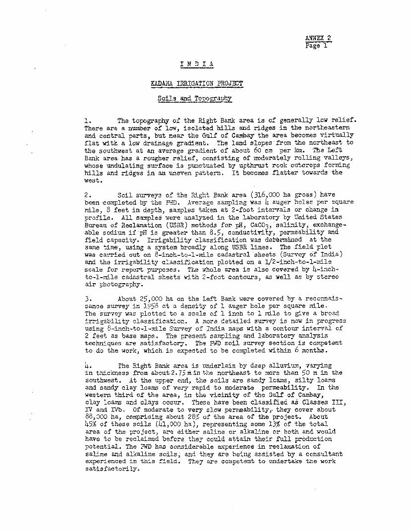
ANNEX 2Page i
I N D I A
KADAN IRRIGATION PROJMT
Soils and ToneoVany
1. The topography of the Right Bank area is of generally low relief.There are a nunmber of low, isolated hills and ridges in the northeasternand central parts, but near the Gulf of Cambay the area becomes virtuallyflat with a low drainage gradient. The land slopes-from the northeast tothe southwest at an average gradient of about 60 cm per km. The LeftBank area has a rougher relief, consisting of moderately rolling valleys,whose undulating surface is punctuated by upthrust rock outcrops formnghills and ridges in an unneven pattern. It becomes flatter towards thewest.
2. Soil surveys of the Right Bank area (316,000 ha gross) havebeen completed by the WiD. Avezage sampling was 4 auger holes per squaremdle, 8 feet in depth, samples taken at 2-foot intervals or change inprofile. All samples were analyzed in the laboratory by United StatesBureau of Reclamation (USBR) methods for pH, CaCO3, salinity, exchange-able sodium if pH is greatar than 8.5, conductivity, permeability andfield capacity. Irrigability classification was dettrbaed at thesame time, using a system broadly along UTBR lines. The field plotwas carried out on 8-inch-to-l-nile cadastral sheets (Survey of India)and the irrigability classification plotted on a 1/2-inch-to-l-indlescale for report purposes. The whole area is also covered by 4-inch-to-l-rdle cadastral sheets with 2-foot contours, as well as by stereoair photography.
3. About 25,000 ha on the Left Bank -;ere covered by a reconnais-sance survey in 1958 at a density of 1 auger hole per square mile.The survey was plotted to a scale of 1 inch to I rnle to give a broadirrigability classification. A more detailed survey is now in progressusing 8-inch-to-l-mrile Survey of Indlia maps with a contour interval of2 feet as base maps. The present sampling and laboratory analysistechniques are satisfactory. The RtD soil survey section is competentto do the work, which is expectad to be completed within 6 months.
4. The Right Baank area is underlain by deep alluvimm, varyingin thickness from about2.75m in the northeast to more than 50 m in thesouthwest. At the upper end, the soils are sandy loa-Ms, silty loa;rsand sandy clay loams of very rapid to moderate permeability. In thewestern third of the area, in the vicinity of the Gulf of Cambay,clay loams and clays occur. These have been classified as Classes III,IV and IVb. Of moderate to very slow permeability,, they cover about88,000 ha, comprising about 28% of the area of vhe project. About45% of these soils (h1,000 ha), representing some 13% of the totalarea of the project, are either saline or alkaline or both and wouldhave to be reclaimed before ther could attain their full productionpotential. The F0D has considerable experience in reclamation ofsaline and alkaline soils; and they are being assisted by a ccnsultantexperienced in this field. They are competent to undertake the worksatisfactorily.

AINYEX 2Page 2
5. The Left Bank soils are mainly sandy loams at higher levelsand adjacent to the rocky knolls and finer-textured clay loams andclays in the valley bottoms. They are of generally shallow depth (zeroto 2.5 m, with 50% over 1.2 m) overlying schists, ouartzites andphyllites. No salinity or alkalinity problems have been found inthese soils and they are unlikely to develop, provided seepage from theirrigation canals is kept within acceptable limits.
6. The soil classification of the Right Bank area is as follows:
Class Ha % of Gross Area Sxrveyed
Ia 135,286 3 .4lb 45,365 14.5II 43,219 13.8III 26,947 8.9IVa 42,510 13.7IVb 18,219 5.7
Total (gross) 311,546 100.0
Classes Ia and lb are suitable for intensive irrigation without restric-tion, and Class II has moderate restrictions due to slow internal drainageand Slat topography. Class III is suitable for seasonal cropping, ClassIVa has restricted internal drainage and some salinity but is potentiallyproductive after drainage, while Class IVb is saline-alkaline, needsdrainage and reclamation and will require careful management and a relativelylong development period before reaching full production.

NNIEX 3Page 1
I N D I A
KADANA IRRIGATION PROJEECT
Land Tenure
1. The Government of Gujarat and its predecessors, the Governmentsof the States of Bombay and Saurashtra, through a series of land reformacts passed between 191X8 and 1963, have abolished traditional tenancysystems and transferred ownership of land to its cultivators. As fromthe end of 1968, owner-occupancy is the only land tenure system recognizedby the law.
2. There are about 176,000 land-holdings in the project area.Distribution by size is as follows:
Size of Holdings % of Total Holdings % of Total Area(ha) Kaira Pan.chmahals htire Project Kaira Pancmiahals Dntire Project
Up to l 43.2 30.1 62.5 11.3 6.0 11.51-2 33.6 32.5 33.4 26.8 19.5 18.32-4 14.5 24.2 15.2 26.6 33.3 27.16-8 6.8 11.3 7.0 21.1 30.6 21.8
8 and over 1.9 1.9 1.9 114.2 10.6 21.3
100.0 100.0 103.0 100.0 lCO.0 1OO.0
Holdings are generally larger in Panchmahals than in Kaira. In both cases,however, most of the land is in holdings larger than 2 ha - over 60c of thelandl area in Kaira and nearly 75% in Panchrahals. Only 11% of the land inKaira and 6'% in Panchmahals is in holdings smaller than 1 ha. Nevertheless,the numioer of owners of holdings smaller than 1 ha is large - 71,500 inKaira (43,@ of total owners) and 3,LOO in Panchmahals (30% of total).
3. Fragmentation of small land-holdings is prohibited under the BombayPrevention of Fragmentation and Consolidation of Holdings Act, 1968, underwhich a farmier may not subdivide his land into units smaller than half anacre (0.2 ha) of irrigated land or 2 acres (0.8 ha) of non-irrigated land.
Consolidation of Land-Holdings
6. It is normal for a farmer's total holding of land to be fragmentedinto a number of discrete parcels, which may be widely separated bv landbelonging to others. 'ihile accurate data upon the degree of such fragmenta-tion are available for orly a few areas, a Government conittee in 1965-66foundl from the statistics of land registration that the average number ofclots per land-holder was 3.2 in Kaira District and 2.1 in Panchmahals. Theamount of de facto fragmentation, however, is usually greater than that shown

AIMNa 3Page 2
by the statistics, since the lsgal limitation of the minimum size ofland-holding inhibits registration of subdivision that may actually takeplace as a result of inheritance. -When irrigation is introduced into anarea and the legal minimum size is reduced from 2 acres (0.8 ha) to halfan acre (0.2 ha),holdings hitherto illegal can be registered. The actualdegree of fragmentation is then shown in the statistics. This can beexpected in the Kadana project. Furthermore, assuming that the smallestland-holdings are unitary and that some unification has taken place al-ready in the largest holdings, those of medium size, which make up mostof the land area, can be expected to have a high degree of fragmentation.In-summary, the degree of fragmentation in the project area is likely tobe much greater than that shown in the land registration statistics. Thisconclusion was confirmed in the field where it was disclosed that theowner of a 2-ha holding may often possess six or more separate parcels.Field officers of the Department of Agriculture agreed that this is thenormal pattern in the area.
5. Fragmentation of this kind constrains agricultural developmentin an irrigation project. It may not always be entirely disadvantageousunder rainfed conditions but, where irrigation is available, any possibleadvantages are outweighed by the disadvantages. Wherever possible, there-fore, fragmented holdings should be consolidated in irrigation projects.The introduction of irrigation can provide, along with the stimulus to setoff an agricultural revolution, the incentive to undertake major changesin land tenure. In Gujarat, however, this can be done only with the agree-ment of the farmers. The Government has the power, under the Bombay Preven-tion of Fragmentation and Consolidation of Holdings Act, 1948, to prenareconsolidation schemes to combine fragmented holdings into compact, unitaryones. This has been done successfully in Uttar Pradesh. In Gujarat, how-ever, attempts to introduce land consolidation - confined hitherto torelatively backhward areas without irrigation - have not so far been successful.
6. In Kaira District the relatively advanced agriculture presents amore favorable aspect to the possibility of consolidation. However, thevery degree of development has introduced strong vested interests opposingchange, as for example, the piped water systems distributing tubewell waterbetween neighboring land-holdings. Furthermore, the size of the Right Bankirrigation command in the district (263,000 ha) makes it impossible toundertake consolidation on this scale except over a period of many years.The Government considers, therefore, that it is not practicable to attemptto introduce consolidation in this area at present. It proposes to leavethe problem for the time being to the play of economic forces, which may beexpected eventually to bring about the unification of holdings to permitmechanization. However, at the same time, it appreciates the desirabilityof demonstrating land consolidation in a suitable area nearby on a scalelarge enough to be effective as an agent of more rapid change in the Districtand also, in due course, in the State at large. The Left Bank area inPanchmahals could be such a demonstration area. Consolidation would be

AKTRUM 3Page 3
particularly desirable there because the contour terracing system to be
adopted would unavoidably fragment existing holdings even morethan at present
The vested interests associated with development are not established so
strongly there, yet the people are progressive and adaptable. There
appears to be a reasonable prospect that consolidation could be carriedout successfully, given full support by Government services and adequatepreliminary field work to convince the farmers of its advantages.


I N D I A ANNYX 4
KADUA IRRI'ATION P.OJECT
Present Cropping Pattern, Yields, Production Costs rnd Returns at Current Prices
Gross Value Net ReturnsCrop Cropped Yield Price of Production Net Value of from Pro-ect
Area Production Costs ± Production Area(haT) (Ttonha ) ( *T/ - -- - V . R a) - - - - - ilion
Xnarif 'irrigated)
Paddy (coarse) 600 1.7 0.95 1,615 325 1,290 0.8Bajri 8,900 1.6 0.70 1,200 390 ol8 7.2Mixed ^rops and other 8,300 1.7 0.50 850 310 510 4.2
Sub-total 17,800 12.2
_ha_if (-ainfedl
Paddy (coarse) 39,000 1.0 0.95 950 325 625 24.4Sa3ri 52,300 0.8 0.70 560 390 170 8.9dcwar 2,300 0.8 0.60 480 380 100 0.2Faize 2,900 0.8 0.70 560 390 170 0.53roundnuts 4,400 0.8 1.20 960 420 540 2$LMixed crcps and other se,Soo 0.9 0.50 450 340 110 9.7
Sub-total 189,100 16.1
Total, Khar'f 207,200 58.3
Raoi (irri g Ated)
Wheat 9,700 1.1 0.95 1,045 6co 445 4.3Potatoes 3X0 1o.0 0.25 2,5co 1,025 1,L75 0.4Pulses 5,300 0.8 0.75 600 355 215 1.3
Sub-total 15,300 6.o
Rab- (non-irrigated)
Wheat 9,300 0.7 0.95 665 535 130 1.2
Total, Pti 24, 600 7.2
3ight-monrth (irriFated)
Tobac-o 7,500 1.2 1.50 1,800 8i0 960 7.2
SigWo-mcnth (non-irriga ed)
Tobacco 24,600 0.9 1.60 1,410 840 600 14.8Cotton 21,700 o.8 1.50 1,2CC 630 570 12.4
Sub-total 46,300 27. 2
Total, Eight nonta 53,800 34.4
Total 285,600 . 99.9
1/ Excluding taxes, water charges and family labor contribution.
2/ Cropping intensity: 100% total cropped area, 285,600 ha; net cultivated area, 283,000 ha).

Pa-ge 2UDANA IRRIOATION PROJECT
Projected Cropping Pattern, Tielda, Production Coste and Returns at Projected 1975 World Market Prices 1"
Gross Value Net ReturnsCrop Cropped Yield Pric/.~' of Production Sst Value of from Project
Area Production Costs 1/ Production Area77T (ton/ha) 7 ) - - - - - - - (as/ha) - - - - - - - (Rs millions)
Eharif (irrigated)
Paddy (coarse) 32,000 3.0 0.54 1,620 640 s80 31.4(fine) 50,000 4.0 0.59 2,360 7Lo 1,620 81.0
3aj,ri (hybrid) 60,ooo 2.0 0.45 900 730 170 IC.2Jowar (hybrid) 12,C00 2.0 O.U1 820 730 90 1.1
(fodder) 4,000 3.5 0.07 245 210 35 0.1Maize (hybrid) 14,000 2.4 o.45 1,080 870 210 2.9Groundnuts 6,ooo 1.25 1.20 1,500 560 9140 5.6Pulses 2,000 0.8 0.75 600 120 LB0 1.0Mixad crops 10,000 1.8 0.50 900 67o 230 2.3
Total. Eharif 190,000 135.6
Raci. (irrigated)
Wheat 58,000 2.5 o.49 1,225 1,000 225 13.1Potatoes 8,o0o 12.0 0.25 3,000 1,525 1,475 11.3Vegetables 5,ooo 10.0 0.25 2,500 1,410 1,090 5.5
Sub-total 71,000 30.L
.Rabi (non-irigatedj
Jowar (co-ron) 30,000 o.8 o.bl 328 328
(fodder) l0,CO 2.5 0.07 175 175 -Pulses 60,00o o.6 0.75 450 120 330 19.8
Sub-total 100,000 19.8
Total, Haoi 171,000 5'.2
3 ght-month (irrigated)
Tobacco 17,000 1.5 1.50 2,250 1,480 770 13.1Cotton (medium-loig staple) 20, 2.0 1.60 3,200 1,020 2,180 43.6
Sub-total 37,000 56.7
Eigh-t-mcnth (non-irrigated)
Tobacco 16,ODO 1.1 1.60 1,760 1,190 570 9.1Cotton 12.000 1.0 1.20 1,200 810 390 4.7
Sub-total 28,000 13.8
Tctal, Eigh-month 65,ooo 70.5
Hot-weather (irrigated)
Bajri (hybrid) 15,000 2.1 o.45 915 730 215 3.2Jowar (fodder) 5,000) 4.5 0.07 315 210 105 0.5
Sub-total 20,000 3.7
Perennial (irrigated)
Sugarcane 3,000 90.0 0.037 3,330 2,970 36c 1.1
Total h4149,000 4/ 261.1
1/ Area, yields and production costs attained 7 years after the introduction of regulated water supply.
2/ Farm-gate prices for food-grains, medium-long staple cotton and sugarcane based upon expected world market prices in 1975.
3/ Excluding taxes, water charges and family labor contribution.
14/ Cropping intensity: 158% (total cropped area, 1449,000 ha; net cultivated area, 283,0co ha).

ANNEX 5Page 1
I N D I A
KADANA IRRIGATION PROJECT
Agriculture
General
1. Kaira District, in which 93% of the area irrigated under the projectis located, has a more highly developed agriculture than any other of C-ujarat's18 districts. Its farmers are industrious, progressive and commercially oriented.Though tractors are slowly being introduced, land-holdings are generally toosmall and scattered to have favored rapid mechanization up to the present time.Agriculture, therefore, remains very much a peasant economy, depending uponbullock power and family labor, supplemented by hired labor at peak periods.However, cropping practices are relatively advanced, the Introduction of gravityirrigation from 1°60 onwards over almost half the project area having given animpetus to change. Irrigation from wells and tubeweLls 's not uncomrmon, andin many places there is even a well-established trade between neighbors inirrigation water. The owner of a tubewell will, for example, deliver water sur-plus to his o-wn needs to his neighbors' fields through a piped system. Hybridseeds, including new varieties both bred and multiplied by the Department ofAgriculture at its establishments within the District, are used widely, togetherwith the fertilizers and agricultural chemicals needed to assure optimum yields.A small-holder dairy industry flourishes in the project area, supplying milk toa central cooperative dairy that produces butter, ghee, cheese, dried milk andcasein products and sends fresh milk to markets as far away as New Delhi. Agri-cultural processing industries of various kinds are firmly established, oftenbeing run by cooperatives.
2. In general, Panchmahals District is less advanced. However, the farmersof the Lunawada and Santrampur talukas, whose holdings will be irrigated by theproject, are mostly of the same energetic and adaptable caste (Patels) as thecultivators of the Kaira District and so have a high potential for development.In the past their farming progress has been more restricted by insufficientrainfall than has that of the better-favored Kaira District. Nevertheless, theyare already using improved crop varieties and other inputs, and, once irrigationwater is available, they will undoubtedly be quick to take advantage of it.
Future Crooping Pattern (Annex 4, page 2)
3. The regulated irrigation supply to be provided under the project wouldbe used primarily to ensure the production of kharif crops. Although some ofthese crops are already served by the present irrigation system, most are stilllargely rainfed and, therefore, subject to the uncertainties of an erratic rain-fall. After the needs of the kharif crop have been satisfied, the remainingirrigation supplies would be used for rabi crops and, to a small extent, hot-weather crops, together with a small acreage of perennials. The irrigation demandand field applications for the cropping pattern are given in Annex 7. A systemof rotation of allocations of water to rabi and hot-weather crops would beemployed that would confine irrigation in these seasons to Class I and Class II

AlNEX 5Page 2
soils (those suitable for intensive production under irrigation). Under thissystem, the supply of water would be rotated year by year round the totalacreage of such soils. Since Class I and II soils all occur in the upper halfof the command, the proposed rotation would not involve unacceptably largeconveyance losses.
4. There would not be any major change, therefore, in the overall patternof seasonal production. Kharif would continue to be the predominant crop season,though the proportion of rabi and hot-weather crops to kharif crops would in-crease, not only because of the increased allocations of irrigation supplies tothem, but also because of a greater availability of residual moisture in thesoil in the rabi season after irrigation of all kharif crops. This would permitnon-irrigated rabi follow-on crops such as pulses to be grown with a greaterchance of success. The greatest impact of irrigation would be upon the yieldsof the kharif crops, since it would permit high-yielding varieties to be grownat full levels of fertilizer input, with certainty that water shortages wouldnot prevent the achievement of their full production potential.
Field TWater Management
5. The system of field irrigation in common use by farmers is pondingof level, bunded beds. Irrigation water is fed from one bed to another, eitherby an in-field channel or by bed-to-bed inundation. The beds are formed indifferent sizes according to topography and soils. This method of utilizingirrigation water is usually inefficient, wasteful of water and labor and notsufficiently flexible to'provide adequately for the varying irrigation require-ments of different crops and soils.
6. Systems employing graded border strips, furrows, corrugations orcombinatiormof these layouts, as are commonly used in modern irrigation projectsin other countries, are likely to be better suited to the conditions. At present,however, there is little experience with these system.s, either on the farms orin the Department of Agriculture, which is employing traditional methods on itsdemonstration farms. It would undoubtedly be a difficult task to bring aboutchange in this field, where the present practices are sanctified by long usage.However, the benefits of adopting better systems are likely to be substantial,in terms of savings of irrigation water, avoidance of drainage problems andimprovements in crop yields. A high priority should be given to trainingproject staff and farmers in use of improved methods and to their demonstrationin the field and on the trial farms.
Kharif Crops
7. Bajri (Pearl Millet). The most important crop in the project areain terms of acreage is bajri, grown both under irrigation and under rainfedconditions on a wide range of soil types. Mixed with coarse rice and cookedas a "hot-pot," it forms the staple diet of most rural people. Local varieties,low-yielding but very drought-resistant, form the bulk of the production atpresent. However, hybrid varieties that respond well to fertilizers, notablyHybrid 115, evolved at Gujarat's Jamnagar Agricultural Research Station, arereplacing the local varieties rapidly, especially where irrigation is available.

Page 3
8. Pad. Paddy is grown widely in the project area on a numiber ofdifferent soil types, both as a drilled rainfed crop and as one transplantedunder irrigation. Local varieties are low-yielding and mainly of the coarsequality that the cultivators prefer to eat. Varieties of medium and finequality, bred at the State's research stations, are gaining acceutance becauseof their fertilizer response and higher yields. The variety recommended atpresent for the project area is the locally-bred Sukhvel 20, which, thoughmaturing in only 110 days, is suited to irrigation because of its response tofertilizers. However, assured regulated irrigation supplies would encouragethe adoption of longer duration, higher yielding varieties. With the markedincrease in yields likely as a result of irrigation, the new varieties andhigher levels of inputs, a swing away from coarse varieties to fine varietieshas been projected.
9. Jowar orghum). Both local and hybrid varieties of jowar are cul-tivated for grain production, and local varieties of strong vegetative growthare also grown for fodder. Though well adapted to the wide range of climateand soil conditions of the area, it is not popular locally as a foodstuff.
10. Maize. Hybrid maiza, relatively new in the area, has not yet beenvery successful, despite its apparently high potential. Yields are low andcharacterized by poor fertilization of the cob. Irrigation, including goodwater management at the time of pollination, is expected to improve productionand lead to increased planting of the crop.
11. Groundnuts. Although groundnuts have given disappointilng results todate, the crop is gro-n on over 4,COO ha, and experimentation is being carriedout at the Department of Agriculture's trial,farms. A modest increase to 6,000ha is expected lmnder the project.
12. Pulses. Pulse crops, mainl.y "1gramn" (Cilcer arietinum) are conmonlySplanted in admixture with cereals, although a sziall acreage is gro-n as a purestand. It is assuned that it would continue to feature in the cropping pattern.
13. Mixed Crops. Bajri, jowar and other cereals, mixed with pulses, area major crop in the area, representing about 45% of the total kharif cultivation.It is popular because cultivators like to snread the risk of complete cropfailure under traditional conditions of uncertain rainfall and uncontrolledinsect and other crop hazards. Irrigation, together with the educational effectof crop husbandry and extension advice and the availability of crop protectionservices, is expected to bring about a rapid change. It is assumed that theacreage under mixed crops would fall from the present 97,COC ha to 10,000 ha atfull agricultural development.
ELbi CropS
1i. Wheat. Grown both as a rainfed and as an irrigated crop, wheat makesup about 80S of the total rabi cultivaticn. Yields are poor (averaging 1.1 ton/ha) because climatic conditions are marginal for present varieties. However,assuling a continuation of the present favorable price structure, at least in thenear future, the crop is likely to continue to dominate rabi production.

ANNEX 5Page 4
15. Potatoes. While this is not now a major crop, its cultivation islikely to expand rapidly under irrigation since it is well suited to the climateand the lighter soils.
16. Vegetables. Conditions are suitable for growing a wide range ofvegetables under irrigation, and production is likely to be limited only bymarket considerations.
17. Jowar. As a rabi crop, jowar is subject to thie same considerationsdescribed for kharif iowar.
18. Pulses. Sown in the stubble after a. rice crop is harvested, theseedible legume crops (mainly "1gram") grow on the residual moisture remaining inthe heavy soils. The expansion of irrigated paddy cultivation under the projectwould increase the amount of land containing residual moisture sufficient tomature a crop. An increase of rabi non-irrigatedpulses to a total of 60,000 hais envisaged.
Eight-month Crops
19. Tobacco. Kaira District grows about 70% of the tobacco produced inGuJarat (about 13 of the all-India production). The bidi variety (Burley type),grown under rainfed conditionE or under irrigation, is used to make the localcigarette. The crop is harvested leaf by leaf and air-dried. The stalk issold for nicotine extraction. This old-established crop is expected to retainits present importance.
20. Cotton. The two types of cotton grown now are the rainfed variety,"Digvijay," with a staple length of 7/8 in to 15/16 in, and "Gujarat 67," witha staple length of 1-1/8 in to 1-3/16 in, grown under irrigation. Recent localresearch work has produced a new hybrid, promising in trials. The crop is wellsuited to the local ecological conditions but, since it iF subject to attack bya wide variety of insect pests, its development will depend upon successfulplant protection measures. The extension services are carrying out advisory workand spraying crops for farmiers. The yield estimates (2 tons/ha seed cotton forirrigated long-staple .Sai 1 tGn/ha seed cotton for Digvijay) are conserva-tive and adequately take into account present production problems.
Perennial Crops
21. Sugarcane. A limited acreage (3,000 ha) of sugarcane is projected forproduction of one crop per planting in a 12-month growing cycle. The area wouldbe concentrated in the Petlad taluka, serving one sugar mill that is underconstruction.

AtNNX 6Page 1
I N D I A
KADAIA IRRIGATION PROJECT
Description of Project Wvorks
1. Kadana Dam
Purpose: To firm up and increase irrigation supplies to MahiRiver area. The structure would achieve thissatisfactorily.
Dimensions:
Length
Earth-fill section 825 m
MasonryTransition section 75 mPower section (futureplant installation) 78 mSpillway section 366 mRight abutment section 55 m
1,399 m
Maximum height froa deepest foundation to road levelEarth-fill section 33 mMasonry section 58 m
The composite type of design of the dam is appropriate for thelocation, and the design standards incorporated are suitably conservativeand safe.
Sluices:
Low level, 2 number, 1.5 m x 2.7 m 120 m3/secHigh level, 2 number, 1.5 m x 2.7 m 63 m3/secTotal sluice discharge capacity 366 m3/sec
The sluice discharge capacity would be sufficient to meet themaximum irrigation requirements.
Spi-luway:
Crest length (clear) 295 mRadial gates, 1o number, 15.5 m wide x l4 m wideDesign capacity 33,000 m3/secDesign flood head over crest l1 m

ANNEX 6Page 2
The spillway discharge caplcity safely exceeds the maximumprobable flood estimate of 30,000 m /sec.
Quantities in dam:
Excavation 910,000 m3 @ Rs 14 per m 3Earth-fill 1,160,000 m3 @ Rs5.4 per m3
Masonry 770,000 m3 @ Rs 68 per i 3Concrete 110,000 m3 @ RslO7 per mSteel in crest gates 3,000 tons
Work force: 10,000-12,000 laborers
Construction period: 1969-1972 (?WD estimate)1969-197L (IDA estimate)
The contractor's ability to quarry and transport stone at a ratesufficient to complete in 3 years is questionable; 5 years would be asafe estimated construction time, allowing for flood delays.
Reservoir:
Storage capacityGross 1,700 Mr3Live 1,300 im3
Full reservoir level 128 m above sea level
Draw down (maximum) 13.5 m
Area of submergence 17,200 ha
Population to be resettled: 1/
Gujarat 10,850Rajasthan 6,860
Agricultural land affected:
Gujarat 4i,900 haRajasthan 5,600 ha
Special features:
Supply of 125,000 tons of cement by bulk handling processto silos on site.
Substitution of 20% of cement requirements by pozzolanafrom kiln near site.
Provision for future power plant installation at the dam,with capacity of 24,500 kW.
1/ Some of the families from the reservoir area in Gujarat would besettled in the Left Bank area.

ANNEX 6Page 3
Pressure-grouted seepage cut-off curtain injected intothe rock below the dam foundations to a depth of 40 m.
2. Left Bank Area
Gross commanded area at full development 21,000 ha
Net irrigable area at full development 20,000 ha
Canal system:
Main canal capacity 10 m3/secFull supply level at head 116 m above sea level
Design of the canal system would be prepared from detailed surveysmade by the Survey of India. The layout would be based on contour irriga-tion methods adapted from experience gained elsewhere in India or abroad.
3. Right Bank Area
Gross commanded area at full development 316,000 haNat irrigable area at full development 263,000 haNet irrigable area provided with canals to date 1h3,000 ha
Wanakbori weir (completed):
Cost Rs 22.8 MLength of overflow section 670 mLength of remainder 120 m
Total length 790 mn
Canal system
Cost to date Rs 180.7 M
Main canal (completed)Length 74 km (lined)Capacity 200 mr3/sec
Branch canalsCompleted 210 km (88%)Incomplete 27 Ion
Total length 237 km (partlylined)
Distributary and minor canals
Completed 1,680 kmIncomplete 1,280 km
Total length 2, (unlined)

AlNEX 6Page 4
Area covered by canals 103,000 haArea remaining to be developed 120,000 ha
263,000
Area served by storage tanks 1/ 9o000'haCapacity of tanks (full development) 63 Mm3
b. Drainage
Over 300 km of main surface drains would require remodeling in about 100,000 haof the central part of the Right Bank area, to increase the capacity of the drainagesystem and to prevent soils salinization following the introduction of perennialirrigation.
Open-channel field drainage would be installed in the southwestern part ofthe Right Bank for the reclamation or improvement of the following areas of salinizedsoils:
Class IVb soils to be reclaimed 16,000 ha
Class IVa soils to be improved 13)000 ha
Class III soils to be improved 8,000 ha37,000 ha 2/
Depth of open drains: 0.60 m to 0.70 m
Spacing: 60 m to 150 m, to be determinedexperimentally
1/ Tanks are minor reservoirs constructed adjacent to canals in the irrigatedarea for storage of excess flows during the monsoon season. Supplies arereleased later when required.
2/ Area includes about 1,600 ha of low-lying lands in which covered tile drainagewould be provided.
5. Roads
The following program of road construction and improvement would beincluded in the project:
Major district roads 156 km§Other district roads 521 kmLVillage roads 403 km
Sub-total 1 °Farm roads 1,700 kmSugarcane extraction roads 400 km
Sub-total 2,100 kmTotal 3,180 km
The choice of the district roads segnents within the program waa basedmainly on the likely increase in village-to-market traffic resulting from the increasein marketed produce. The construction of the farm roads completes a 1.6-km grid ofroads of all categories within the project area. The choice of the grid size is basedon the estimated sensitivity of agricultural production within the area to improvementsin field - and farm-to-village transport conditions.

ANNEX 7Page 1
KADANA IRRIGATION PROJECT
Water Demand, Supply and Quality
Water Demand
Data used in assessment of irrigation water demand:
1. Effective Rainfall Contribution to Crop Water Requirements in Project Area'..._
75%Reliable Effective-Rainfall
Month Rainfall Rice Other Crons Rice Other Crops(mm) - - - % - - - - - - - 1 )_ __
Jan. - Apr. - -
May 8 90 90 -June 97 75 75 70 70July 252 65 50 165 125August 183 65 45 120 85September 84 75 75 65 65Oct. - Dec. - - - -
2. Farm Irrigation and Conveyance Efficiencies1/
Farm Irrigation Conveyanci ConveyanceMonth Efficiency Losses Efficiency
January 70 25 75February 70 25 75March 70 30 70April 70 35 65May 70 35 65June 70 30 70July 65 30 70August 65 30 70September 70 30 70October 75 25 75November 75 25 75December 75 25 75
1/ Conveyance losses are approximately as follows:
Improved watercourses 10 75Distributary canals 5 - 10Main and branch canals (lined) and
river reaches 10Total 25 - 35

ANNEX 7Page 2
3. Field Irrigation Requirements for Proposed Cropping Pattern
(Derived by IDA Staff)
Field Application
Crop Jan Feb Mar A-r May Jun Jul Aug Sep Oct Nov Dee- - - -_ MT
Kharif
Coarse paddy - - - - - 150 100 200 200 - - -Fine paddy - - - - - 150 100 200 200 200 - -Bajri (hybrid) - - - - - - 75 150 100 - - -Jowar (hybrid) - - - - - - - 75 150 75 - -Jowar (fodder) - - - - - - - 75 150 - - -Maize (hybrid) - - - - - 100 - 75 150 - - -Groundnuts - - - - - 100 - 75 150 - - -Pulses - - - - - - - 75 150 - - -Mixed - - - - - - - 75 150 - - -
Rabi
Wheat 150 - - - - - - - - - 150 150Potatoes 150 150 - - - - - - - - 150 150Vegetables 75 - - - - - - - - - 150 150
Eight-month
Tobacco - - - - - - - 75 100 150 150 150Cotton 150 - - - - 50 - 75 lO 150 150 150
Perennial
Sugarcane 100 150 200 200 200 200 75 150 150 150 150 100
Hot-weather
Bajri (hybrid) 100 150 150 200 100 - - - - - -
Jowar (fodder) 100 150 150 200 - - - - - - - -
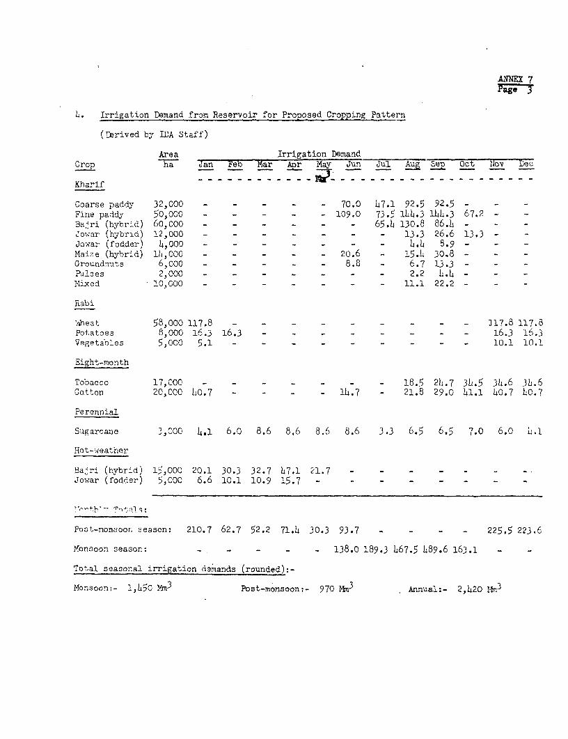
ANNEX 7Pagen
L. Irrigation Demand from Reservoir for Proposed Cropping Pattern
(Derived by IDA Staff)
Area Irrigation DemandCrop h Jan Feb Mar Anr May Jun Jul gSt 0ov Dec
Kharif
Coarse paddy 32,000 - - - - - 70.0 47.1 92.5 92.5 - -
Fine paddy 50,000 - - - - - 109.0 73.5 1..3 1)4.3 67.2 - -
Ba.4ri (hybrid) 60,000 - - - - - - 65.4 130.8 86.1 - - -JowTar (hybrid) 12,000 - - - - - - - 13.3 26.6 13.3 - -
Jowar (fodder) 4,000 - - - - - - - 4.4 8.9 - - -
Maize (hybrid) 14,000 - - _ - 20.6 - 15.1 30.8 - - -
Groundnuts 6,0oo - - - 8.8 - 6.7 13.3 - - -
Pulses 2,000 - - - - - - - 2.2 4.4 - - -
Mixed 10,000 - - - - - - - 11.1 22.2 - - -
Rabi
Theat 58,ooo 117.8 - - - - 117.8 117.8Potatoes 8,ooo 16.3 16.3 - - - - - - - 16.3 16.3Vegetables 5,000 5.1 - -- - - 10.1 10.1
Eight-month
Tobacco 17,000 - - - - 18.5 24.7 3L.5 34.6 314.6Cotton 20,000 40.7 - - - - 11.7 - 21.8 29.0 41.1 40.7 10.7
Perennial
Sugarcane 3,000 4.1 6.0 8.6 8.6 8.6 8.6 3.3 6.5 6.5 7.0 6.0 1.1
Hot-weather
Ba4ri (hybrid) 15,000 20.1 30.3 32.7 17.1 21.7 - - - - - - -Jowar (fodder) 5,000 6.6 10.1 10.9 15.7 - - - - - - - -
Post-monsoon season: 210.7 62.7 52.2 71.4 30.3 93.7 - _ - _ 225.5 223.6
Monsoon season: - - - - - 138.0 189.3 167.5 489.6 163.1 - -
Total seasonal irrigation demands (rounded):-
Monsoon:- 1,150 ,4n3 Post-monsoon:- 970 Mm3 Annual:- 2,420 Mm3

ANNEX 7Page .
Water SupPly
Data used in assessment of water availability:
5. Mahi River Catchment
River length 580 hn2Total area 31,600 hn2Kadana Dam catchment area 25,000 kn
6. River Gauging Record
Pali gauge, 86 km below Kadana 22 years, 1905-1927Kadana gauge 7 years, 1959-1966
7. Rainfall Record
haingauge recordings, catchment area 1891-1969
Weighted mean overall monsoon rainfall in catchment:maximim 1,290 mm, 196Laverage 760 mmminimum 268 mm., 1899
8. Run-off Probability at Kadana
(based on 75-year rainfall record and 7-year rainfall/run-off correlation)
Estimated maximum annual run-off 21,000 Mm3 (19144)Mean annual run-off 7,700 Mm375%-probability run-off L,1400 Nm3
85%-probability run-off 2,800 Im3
Estimated minimum annual run-off 5140 M 3 (1899)
9. Seasonal Run-off
Proportion of total annual run-off (from 7-year correlation):
Monsoon, 96%Post-monsoon, 34%Estimated 85%-probability monsoon run-off 2,700 mmEstimated 85%-probability post-monsoon run-off 100 Mm3
Annual total 2 800 Mm3
Estimated 75%-probability monsoon run-off 14,200 Mm3
Estimated 75%-probability post-monsoon run-off 200 Mm3
Annual total 4,4o00 m
Maximum flood recorded at Kadana 22,000 m.3 /sec(August
3 1968)Minirlum flow recorded at <Hanakbori weir 1.lJ m /sec

ANNEX 7Page 5
10. Reservoir Volumes
With full reservoir level of RL 127.5 m (419 ft) above sea level:
Gross storage capacity 1,700 Nn 3
Live storage capacity 1,300 Mm3
11. River Flow Utilization
(a) Utilization target adopted by Irrigation Wding, P4D, Gujarat:
Utilization, monsoon period 3(with 85%-probability run-off) 1,080 Mm
Utilization, post-monsoon period 3(with 85%-probability run-off) 930 MmAverage annual lake evaporation loss 240 iim3
Gross annual target utilization 2,250 Mm3
(b) Utilization projected by IDA:
Average monsoon season irrigation demand 1,45o Mm3) seeAverage post-monsoon season irrigation demand 970 Mm3) para sAverage aumoal lake evaporation loss 240 1r
Average gross annual utilization 2,660 Nm3
(Conpared with seasonal run-off, para. 9) 385%-probability annual total 23800 M75%-probability annual total L,L00 Mm )
Irrigation utilization at 85%-probability run-off, 95%Irrigation utilization at 75%-probability run-off, 60%
The reservoir volume which would be provided and the river flows tobe impounded would be adequate to sustain the irrigation supply reauired forthe project area under the proposed cropping pattern in at least 85 yearsout of 100.

ANNEX 7Page6
12. Main Canal Caoacity, Right Bank
Maximum anticipated demand per month h90 Mm3 (Sept)Mean maximum daily discharge 16.3 3Maximum anticipated flow 190 m/secMain canal capacity provided 200 m3/sec
dater Quality
13. 'Water Analysis
Tests to date indicate that soluble salts in the Mahi R.iver waterrange between 668 and 8h0 parts per million. pH values of between 7.5 and8.0 have been recorded. These are satisfactory levels for prolonged irri-gation use. Groundwater samples from the Right Bank area have indicatedsoluble salts, ranging from 400 to 1,600 parts per million; some leachingapplications with river water would be required annually in such instances.
1. Silt Load
Silt load measurements were taken in the Mahi River during the1968 monsoon season. The results indicate that the annual loss of reservoirstorage w3uld be of the order of 5 Inr, compared with a dead storage volumeof boo Mm . Even without upstream storage developments, this would indicatethat encroachment on live storage in Kadana Reservoir would not be likely tooccur for about 80 years, and would not adversely affect the project.

INDIA: KADANA IRRIGATION PROJECTCONSTRUCTION SCHEDULE
CALENDAR YEAR___199 197197 1972 1973 = 1974 975_
WORK ITEM -19971O _____ -_ _____ __ __
MONSOON MONSOON ~~~MONSOON ...OO MONSOON MONSOON MONSOON
KADANA DAM AND RESERVOIRI- _______
EARTH EMBANKMENTS........
MASONRY DAM
CONTROL GATES w:MOSN
RESETTLEMENT
IRRIGATION AND DRAINAGE SYSTEMS
RIGH-T 1MANK
DESIGN AND LAND ACQUISITION
DRANCII CANALS5 LINING IIIIIII
OUTLETS. WATENCOON5E. AND FIELD CIIANNEI.S 01111911
FIELD DRAINS
LEFT BANKS
DESIGN AND LAND ACQUISITION
MAIN CANAL
OUTt ETS,WATERCOUNSE5 AND FIELD CHANNELS
LAND) LEVELING
EQUIPMENT PROCUREMENT
LFVELING nsiuo
ROADS >q~~~~~~~~~~~~~~~~~~~~~~~
DISTRICT, VILLtAGE AND FARM ROADS >
NOTE: Monsoon - mid-June to mid-October IERD - 4593(R)


ANN 9
E N D I A
XAI2A1A IRIOLTI0N ?FOZCT
cost Bgtimates
For Works Carried Out to lad-1969, from 1970 to Completion a, and for Co.molete Pro,,ect
Rs (illion Euivalent us$ tillion Bo,uivalent19514 1970 ~~~~~~~~~~~~19514 1970,
througi to Total through to Total1969 Completion 2: 1969 Coivpletion 2!
1. Kadana Dam:
Constraction 35.o 109.0 144.0 4.6 14.5 19.1Reservoir land a-quisition 2.0 35.0 37.0 0.3 4.7 5.0
Sub-total 37.0 144.0 181.0 4.9 19.2 24.1
2. 'Water Distribution Systems:
Wanakbori diversion weir 23.0 - 23.0 3.1 - 3.1Right Bank canals 1144.0 61.0 205.0 19.2 8.1 27.3Left Bank canals - 14.0 14.0 - 1.9 1.9Watercourses 6.0 50.0 56.o 0.8 6.6 7.L.
Sub-total 173.0 125.0 298.0 23.1 16.6 39.7
3. Drainage Systems:
Right Bank drainage 0.3 28.0 28.3 - 3.7 3.7Left Bank drainage - 2.0 2.0 - .3 .3
Sub-total 0.3 30.0 30.3 - 4.0 I4.0
4. aoad Improvements:
Construction - 48.0 48.0 - 6J1 6.14Land acquisition _ 7.0 7.0 - 0.9 C.9
Sub-total - $5.0 5-.0 - 7.3
5. Land Leveling: 2/
Equipcmnt 2.0 11.0 13.0 0.3 1.5 1.8Construction 0.1 37.0 37.1 - L.9 4.9
Sub-total 2.1 48.0 50.1 0.3 6.14 6.7
6. Agricultural Supporting Senricest
Damonstration and training 0.5 2.3 2.8 0.1 0.3 0.LsExtension aervice vehicles 0.1 2.3 2.L4 - 0.3 0.3
Sub-total o.6 4.6 5.2 0.1 o.6 0.7
7. Investigations:
Groundwater investigations - 1.5 1.5 - 0.2 0.2Agricultural studies o 0.6 o.6 - 0.1 0.1
Sub-total - 2.1 2.1 - 0.3 0.3
8. Administration andEngineering 20,0 34.0 54.C 2.7 14.6 7.3
9. Gontingencies 2/ 2.0 57.3 59.3 0.3 7-7 8.0
Totals 235.0 5t0.0 735.0 31.4 66.7 98.1
1/ For further details, see Table 2 of this annex.
2/ Credit for land leveling would be provided for farmers through the Gujarat State Land Development Bank.
3/ Contingency allowances vary from 10% to 25%, depending on state of contract or information.
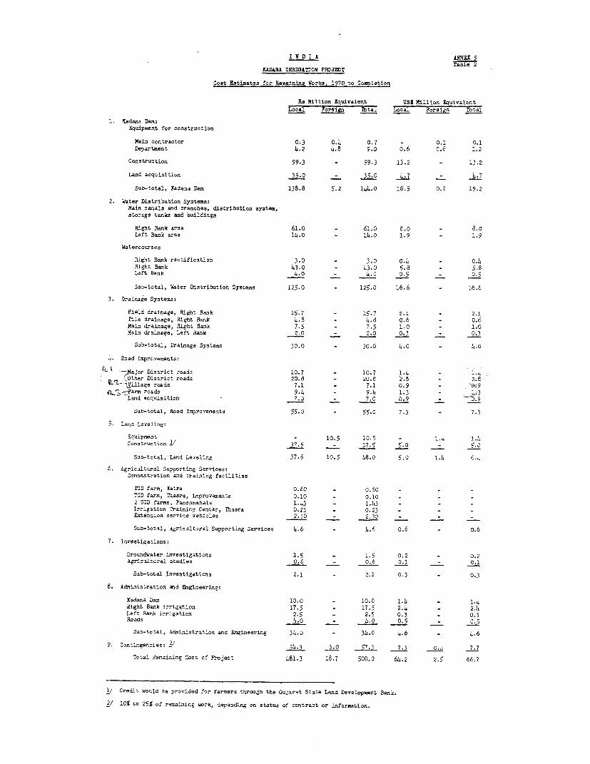
I N D Ir A ANN3X 9
Table 2X&DA&J IRRIGArON PP£JPvT
Cost Ietimates for Remaining Works, 1970 to Completion
Rs Million Equivalent US$ Million Equivalent
LOca _Voreign lbtal Local Foreign Total
1. Xadana Dam:Fquipment for construction
Main contractor 0.3 0.4 0.7 - 0.1 0.1
De,artment 4.2 4.8 9.0 0.6 C.6 1.2
Construction 99.3 - 99.3 13.2 _ 13.2
Land acquisition 35.0 - 35.0 4.7 _ 4.7
Sub-total, Kadaaa Dam 138.8 5.2 144.0 18.5 0.7 19.2
2. Water Distribution Systems:Main canals and branches, distribution system,storage tanks and buildings
Right Bank area 61.O - 61.0 8.0 8.0
Left Bank area 11.0 - 14.0 1.9 - 1.9
,Waterccurses
.Right Rank rectification 3 - 3.D 0.4 - C.4
Right Bank 43.0 - 43.0 5.8 - 5.8Left Bank 4.0 - 4.0 0.5 - 0.5
Sub-total, Water Distribution Systems 125.0 - 125.0 16.6 _ 6.6
3. Drainage Systems:
Field drainage, Right Bank 15.7 - 15.7 2.1 - 2.1
Tile drainage, Right Bank 4.8 - 4.8 0.6 - 0.6
Main drainage, Right Bank 7.5 - 7.5 1.0 - 1.0
Main drainage, Left Bank 2.0 - 2.0 0.3 - 0.3
Sub-total, Drainage Systems 30.0 - 30.0 4.0 - 4.0
4. Road Lmprovements:
aL , lor District roads 10.7 - 10.7 1.4 - 1.4
Other District roads 20.8 - 20.8 2.5 - 2.tL. 1ilage roads 7.1 _ 7.1 0.9 - .9
_4~ -Fans roads 9.4 - 9.4 1.3 - e3Land acquisition - 7.0 _ 7.0 0.9 - 0 9
Sab-total, Road Improvements 55.0 - 55.0 7.3 - 1.3
5. Land Levelings
oO.uipsmnt - 10.5 10.5 - 1.4 1.4
Construction 1/ 37.5 - 37.5 5.0 - 5.0
Sub-total, Land Leveling 37.5 10.5 48.o 5,0 1.! 6.4
6. Agricultural Supporting Services:Demonstration and training facilities
TCD farm, Kaira 0.60 - 0.60 - - -
T3D farm, Thasra, ir.provearents 0.10 - 0.10 - - -
2 TCD farms, Panchmahals 1.43 - 1.43 - - -
Irrigation Training Center, Thasra 0.23 - 0.23 - - -
Extension service vehicles 2._0 - 2.30 - - -
Sub-total, Agricultaral Supoorting Services 4.6 - 4.6 0.6 - 0.6
7. Investigations:
Groundwater investigations 1.5 - 1.5 0.2 - 0.2Agricultural studies 0.6 - O.6 0.1 - 0.31
Sub-total Investigaticns 2.1 - 2.1 0.3 - 0.3
8. Administration mad Engineering:
Kadana Dam 10.0 - 10.0 1.4 - 1.4
Right Rank irrigation 17.5 - 17.5 2.4 - 2.4
Left Bank irrigation 2.5 - 2.5 0.3 - 0.3
Roads l4.a - 4.0 0-5 _ C.5
Suo-total, Administration and Engineering 34.0 - 34.0 4.6 _ 4.6
9. Contingencies: ./ 54.3 3.0 57.3 7.3 O.- 7.7
Total Remaining Cost of ?roJect 481.3 18.7 500.0 64.2 2.5 66.7
1/ Credit would be provided for farmers through the Gu4arat State Land Development Bank.
2/ 10% to 25% of remaining work, depending on status of contract or information.

£LNMX 9Table 3
I N D I A
KADANA IRRIGAQTION PROJECT
Pachinery and Ecnuipment Reauirements
Item Quantity CostA. Machinery to be procured following international UST
competitive bidding
250 HP diesel crawler tractor with attachments 1 51,00050 HP wheel tractor 3 6,000380 HP crawler tractor with attachments 2 215,000250 HP crawler tractor with attachnments 4 215,00090-100 HP crawler tractor with angle dczer equipment 50 850,000D-7 class tractor or equivalent with hydraulic dozingequipment and earth towed scrapers of 12-16 yd. 10 550,ooo
Sub-total 1,890,000
B. Specialized tools and Equipment to be imported
Scientific and drawing equipment - 10,000Photographic and sound equipment - 5,000Equipment for geohydrological and petrological laboratories - 50,000Equipment for soil survey laboratories - 50,000instruments built into dam - L5,ooo
Sub-total 160,000
Sub-total A & B 2,050,000Contingencies 4501000
Total A & B 2,500,000
C. Equipment to be procured locally
25-ton capacity ten-wheeler trailer truck 1 27,000Wagon Drill 4'"-size drifter with feed motor, portable
3-wheel trolley and accessories 2 13,000Grout pump pneumatically operated 15 U.S.G.P.M.at pressure up to 200 P.S.I.G. 2 5,000
Crane truck mounted mobile 10 tons capacity, 30 ft boom,diesel engine driven with accessories 1 33,000
'heel-type loader 2 cu yds capacity front and sideloading, with accessories 3 140,000
Pneumatic-typed roller 100 tons capacity 1 7,000Vibrating roller, towed type with independent dieselengine, 30 tons effective capacity 2 20,000
Wheel-type tractor 80EP for towing vibrating rollers 2 20,000Mobile truck-mounted crane 30 tons capacity, 50 ft boomlength, diesel engine driven, with accessories 1 80,000
Yobile workshops and equipment 2 70,000Visual aid vans 6 15,000General purpose vehicles 30 100,000
Sub-total 600,000
Contingencies 100,000
Total C 700 000
Grand Total A & B & C 3,200,000
1/ Including 15' spare parts. CIF prices for all items under A and B.

ANNEX 9Table 4
IADANA IRRIGATION PROJECT
Estimated Rcmaining Ekpenditures Under Contracts'Placed Before January 1, 1970
Contract Contract Price stilmated Expenditure Estimated expendiueto January 1, 1970 Remaining to C,.omplti.on
Afer Januay a, Y7Rs Rs ie
1. Kadana Dam
Excavation and refilling of cut-off trench (by contractor) 651,51,8 600,000 50,000
Excavation and refilling of cut-off trench (by departmentalforces) 725,739 726,003
Supply and erection cf two steel cement silos 222,208 222,208
Partial constructioxn of spillway section masonry blocks 2,227,239 2,227,239
Drilling and grouting below cut-off trench
Chainage, 3200 to 4356 213,90095,000 300,000
Chainage, 1765 to 3200 180,972
Drilling and grouting below masonry dam (grout curtain) 2,720,081 720,000 2,000,000
Construction of masonry dam, earth-fill dam and ancillary works; 87,311,21B15,300,000 73,000,000
Approved rate adjustrents on outstanding contracts 974,666 _____7,00
Sub-total, Kadana Dam contract&'/ 95,227,571 19,890,450 75,350,000 10.05
2. Right Bank Area
Extension of branch canals, Nadiad Division 616,ooo 313,000 313,000
Construction of canal escape channel works onmain canal, Thaara Division 564,000 282,000 282,000
Extension of Petlad branch canal, Anand Division 468,00c 234,000 234,ooo
Construction of distributary and min,or canals:
- Thaara Division 81,000 o0,000 41,000Nadiad Division 1,555,000 778,000 777,000
Anand Division 1,650.ooo 825,000 825,000
Sub-total, Right Bank area 1,,91,,ooo 2,472,000 2,472,000 0-35
Total Eadana Dam and Mahi Right Bank ares 100,171,571 22,362,,50 77,822,000 10.4on-going contracts
/ Preliminary works, buildings and access roads, valued at approximatelyRs 15.3 M, carried out by departmental forces and not included incontract expenditure,

ANEX 9Table 5Page 1
I N D I A
KADANA IRRIGATION PROJECT
Estimated Expenditures Under Contracts Remaining to be Placed
After January 1, 1970
Estimated AmountRs M US$ M
equivalent
1. Kadana Dam
General:
Bridge over spillway 0.9Fabrication and erection of radialcrest gates 15.6
Permanent instruments for masonry dam 0.8Dam internal drainage pumps and fans 0.7Dam lighting 0.2Fabrication and erection of irrigation
sluices and embedded parts 0.4Fabrication and erection of construc-tion sluices and embedded parts 0.1
Permanent stop logs for crest gatesand sluices 1.-2
Embedded parts for crest gatesand sluices 0.9
Grouting treatment of right abutment 0.5Roadway on Right Bank 0.3180-ton gantry crane for crest gates 0.9Downstream protection works 0.5Architectural treatment o.5Storage warehouse at railhead 0.1Miscellaneous 0.4Right Bank saddle dam 0.4Direct canal (Left Bank) outlet gates 0.2Embedded parts for power penstockgates 0.4
Penstock stop-logs and cover 0.2
Sub-total, Contracts 25.5 3.4
Departmental Force Account WorkBuildings, site roads, maintenanceduring construction 8.9 1.2
Sub-total, Kadana Dam 34.4 4.6

ANNEX 9Table 5Page 2
Estimated AmountRs M US$ M
equivalent
2. Water Distribution Systems
Mahi Right Bank Area:
Lining of Nadiad branch canal 19.5Construction of branch, distri-
butary and minor canalextensions and associated works 25.3
Structures 4.5Buildings 6.8Storage tank extensions 2.7Wlatercourses 46.o
Mahi Left Bank Area:
Distribution system 17.7
Sub-total, Water DistributionSystem 1/ 122.5 16.4
3. Drainage Systems
Sub-surface drainage systems 4.8Open channel field drainage systems 15.8Remodeling of main drainage system 9._
Sub-total, Drainage 30.0 4.0
4. Roads
District roads 31.5Village and farm roads 16.5
Sub-total, Roads 48.0 6.4
5. Land Leveling
Land-leveling equipment 2/ 11.0Land leveling 37.0 -
Sub-total, Land Leveling 48.0 6.4
1/ Rs 2.L7 M remaining wor]k under on-going Right Bank area canal contractsnot included (see Table ).
2/ See Table 3.

ANNEX 9Table 5Page 3
Estimated AmountRs M US$ M
equivalent
6. Agricultural Supporting Services
Building construction 1.2Equipment supply 0.1Irrigation facilities construction 1.0Supply of vehicles:Visual aid vans 1/ 0.3General purpose vehicles 1/ 1.0
Motorcycles 1.0
Sub-total, AgriculturalSupporting Services b.6 0.6
7. Investigations
Construction of observation wells 0.2Supply of general purpose vehicles 0.2
Sub-total, Investigations 0.
Totals 287.9 38.
1/ See Table 3.


INDIA; KADANA IRRIGATION PROJECTPROJECT ENGINEERING ORGANIZATION
SECRETARY, NWD
R(ADS WING IRRIGATICW WING
CHIEF ENGINEER - HoaDS C}IIEF ENGINEER - IRRIGATICE PROJECTS CPIEF ENGINEER - IR-IGATION
- - -I- _ _ __- -I- - _ I -_
C O N S T R U C T I O N C O N S T r u C T I O N C O N S T R U C T I O N
Reeds Suporintending Engineer Sujperintending Engineer Irrigation Superiatling !e4iaeerBaroda Circle Kadanm Dam, & Reservoir Mared" (or Mahi) Ciral.
Panchayats Reads Division Dan Construction Quality Control Kadana Colony Reservoir Rehabilitation Water Distribution SystemsExecutive Engilneer Division Sub-Division (Staff Facilities) Division and Drainage
Division Coestr-ucti a Diviai oas~~~~~~~~~I I I I I -_I
Executive Engineer Snr. Deputy Engineer Executive Engineer Executive Engineer 3-5 Executive Ergineers7 Deputy Engineers Research Officers 3 Deputy Engineers Deputy Engineers Deputy Engineers - Canals,
Welfare Officer Outlets, Main anxd FieldDrainage
MAINTENANCE OpEMATIGN AND MAINTENANCE
I 1I I I I IPanchayat Reads PWD Roads Diviaion 1 Division 2 Division 3 Division 0 Reservoir and
Maintenance Kiinte-ance (70,000 ha) (70,000 ha) (70,000 ha) (70,000 ha) HleadworksDiii si ons Divisions Sub-Divieion
Executive Engineer Executive Engineer Executive Engineer Executive Engineer Deputy Engl.neer
4I ub-Diesliuna It Sub-Dvis0rosS) N na h Sub-Divisions(17,500 hi ea) (17,500 ha ea (17,50017hsaioa) (17,500 ha ea)
4 Deputy Englneers 4 Deputy Engineers 4 Deputy Engineers 4 Deputy Engineers
I III 41- 1~_ 1F11 116 Sections 16 Sections 16 Sections 16 Sections
(Is,500 1ha ea) (4,500 ha ea) (4s,00 ha ea) (4,500 ha ea)
Maintenance Operating
Svb-Sections Sub-Sections
z
-0

INDIA: KADANA IRRIGATION PROJECTORGANIZATION OF DEPARTMENT OF AGRICULTURE AND CO-OPERATION, GUJARAT
| sEcRETAr.Y FOR AGRICULTURE ANE CO-OPERACION A
ANIMAL HUSBANDRY DIRECTOR OF FISHERIES DIRECIOR OF AGRICULTURE ClOlEF COCiSERVATOR REGISTRAV OF
ANIMAL HUSBANDRY F IGRESL DOOPKAI SOtiCIETIE OSfi
TI -[ :I I N I EEL N PROGRAMI --- T
TION AND RESWCti ~~ ~ ~ LTAUAS grcolre ssenir ficr.~~~~~~~~~~~~~~~~~~~~~~~~~~~~~~~~~~~~~~~~~~~~Arfoo E_eso Officers . Z
EUAtNGADRSE6I EXTENI SON REGULATORY SE-RVICES|SOLCOSRVTO
_ COLLEGE COLLLEGES
rq SCFIOOLS 1 [ FRESEARCHF
_.| ~ ~ ~ F
IADII AND [AAP GHh District P-choynts
A loickoSTRA-rlONS is | sub-division ofOOq on lSmiclieTAICTS disiultuArkulEteur Officers
i_____ __ TII|wth Tu P 4kc 33yts
l | | ~~~~~~~~~~~~~~~~~~~~~~~~~~~Agriculturul Extension Officers °Z7_L rgo wsR^sAN ol Vit-LAGCS | or Vi l lrg- Level Work.,s F
AND CERTIFICATION l l | w~~~~~~~~~~~~~~~~~~~~~~~ ~~~iih Villoge Pon.hr.y.ts_
A trJl.k. is az sub-division oFrn odminstsr.tivr clistrict.

ANNEX 11Page 1
I N D I A
KADANA IRRIGATION PROJECT
Agricultural Sunport Program
1. In order to provide farmers with the assistance and support neededto accelerate the transition to modern irrigated agriculture, the Departmentof Agriculture would make improvements in its agricultural research, extension,training and demonstration services, as outlined below. The Government'sdetailed proposals for executing these inprovements would be sent to theAssociation for review prior to implementation.
Agricultural Research
2. Little basic research work is being done in the project area. Mostof the project's requirements for new crop varieties and other agronomic in-fornation would be provided by research stations elsewhere in the State, theservices of whose staffs would be available to the project as needed. Amongthe most important are a station for irrigated crops at Junagadh, a cotton andjowar station at Surat, a bajri station at Jamnagar and the State's centralrice research station at Navagam, near Kaira, immediately outside the projectarea.
3. Despite the range and diversity of agricultural studies that are beingperformed, there is a deficiency in research in water use and soil managementunder irrigated conditions. Without this, optinum utilization of irrigation watercannot be achieved. The Government would ensure that research in applied watermanagement is undertaken within the project area at one or more sites that areproperly representative of its soils and climate and that are provided withadequate irrigation facilities. The objectives of the research would be:
(a) to determine the consumptive use of irrigation waterby the crops that would be grown under the project;
(b) to evolve methods of field management of irrigation water tomake optimum use of water and soil resources;
(c) to study interrelationships of irrigation with other farmpractices in relation to soil properties and crop nutrientrequirements; and
(d) to determine field drainage requireaents consistent withmaintenance of salt balance in the soil.
Such research would be done by a team of experienced scientists, including asoil physicist, an agricultural or irrigation engineer and an irrigation agrono-mist. The Government's detailed proposals would cover the siting and timinngof estab'ishment as well as the work program for the research station(s).
ANNEX 11Page 2
Extension Services
4j. Extension work is carried out by the Department of Agriculture inconjunction with the general administrative services of the local governmentstructure at district, taluka and village level. The extension staff, thoughresponsible through a line organization to its own department, is attachedto the respective local government panchayats (councils). A District Agri-cultural Officer has specialists on his staff to deal with the particularcropping problems of his district. At taluka level there are graduate agricul-tural extension officers, while at village level there is one village-levelworker (VLW) per group of about 10 villages.
The staffing pattern at district and taluka level is intensifiedin some districts in which special attention is given to agricultural productionunder special Intensive Agriculturl District Programs (IADP) or IntensiveAgricultural Area Programs (IAAP). The two programs are differentiated bythe degree to which the normal extension staff is supplemented.
6. Kaira District, being an IAAP District, has four additional specialists.The Department also has other special extension programs - for maize, bidiand cigarette tobacco, cotton and potatoes - under which an additional sixspecialist officers are working in Kaira District.
7. Panchmahals District is not specially designated as an agriculturaldevelopment area; therefore, its extension staff is not supplemented byspecialists, except for those engaged in work on a hybrid maize scheme. Inorder to provide adequate support for the degree of agricultural developmentforeseen under the project, extension services in the Left Bank area wouldbe intensified to a level equal to that provided for the rest of the projectarea.
8. Farmers' needs for advice on the cultural requirements of individualcrops grown under rainfed conditions are provided for adequately by the presentsystem. However, the extension service is not capable at present of assistingfarmers to use irrigation water more efficiently. This is a serious deficiencyconsidering that it is necessary for a farmer to provide for the irrigationrequirements of different soils, topography and crops. The Government hasagreed to meet the need by appointing an adequate number of specialist watermanagement extension officers to act as advisers to the extension service andto the cultivators on irrigation utilization, including field layouts, irrigationmethods and irrigation intervals for different crops. These officers would alsoparticipate in training extension staff in water management (para. 12).
9. The quality of extension advice available at the village level isof vital importance in bringing about agricultural development. The VLW, whois intended to be the farmer's day-to-day adviser, has limited agriculturaltraining, which, in turn, limits has capacity to fulfill the role assigned tohim. The Government agrees that it would be appropriate at the present stageof evolution of Gujarat's extension service to substitute graduate agricultureextension officers for VIWs in areas of high agricultural potential, includingthe project area.

ANNEX 11Page 3
10. It is essential that agricultural extension workers should travelfrequently througbout the are for which they have responsibility. At presenthowever, extension officers in Gujarat are not provided with any means ofdoing so. To ensure an adequate level of support to the cultivators in theproject area, the Government would introduce a system under which motorcyclesor other motor vehicles would be made available to all the project's extensionstaff for use in the work. Suitable arrangements would also be made for operationand maintenance of the vehicles.
Training
11. The Department of Agriculture intends to supplement its presenttraining facilities by establishing a training school at Thasra, associatedwith its trial-cum-demonstration (TCD) farm there, to provide in-servicetraining for its extension staff and the staff of other government departmentsconcerned with development in the project area. The school would play avital role in raising the standards of the extension service.
12. Neither government officers nor farmers are now trained in watermanagement practices, and, consequently, there is little knowledge of how touse irrigation water efficiently. To overcome this, a high priority wouldbe given to a program in which all professional research, extension and soilconservation staff employed in the project area would receive instruction, inwater management. The program, to be agreed upon by the Government and theAssociation, would be broad enough to provide training at different levels,appropriate to the needs. Such training would commence within 2 years of thesigning of the credit. Provision would also be made for in-service refreshercourses to be given from time to tome. Training in water management would beincluded also in the curricula of schools and colleges-teaching agriculture inthe project area.
Trial-cum-Demonstration Farms
13. There is one 20-ha TCD farm in the project area at present, atThasra on the lighter soils. The farm receives irrigation water suppliesfrom the Mahi gravity system. Although situated in an area where groundwateris available to supplement canal supplies and in which progressive farmersare commonly using supplementary supplies from tubewells to diversify andoptimize their production, the farm has no supplementary supplies. Until theseare provided, it cannot fulfill its trial and demonstration role adequately;nor be an effective training ground. The Government would therefore installsupplementary irrigation facilities and expand its trial and demonstrationprograms to utilize the new facilities fully for seasonal and perennial crops.
1l. The Department of Agriculture would establish a new 20-ha TCD farmin the Right Bank area, at a site to be chosen on the heavier soils, and twonew ones in the Left Bank area.
15. The new 20-ha TCD farm in the Right Bank area would be established onsoils representative of the heavier clay loams or clays that make up about30@ of the area. It would include a proportion of saline-alkaline soils on

ANNEX 11Page 4
which the reclamation process to be adopted elsewhere on such soils can bedemonstrated. Canal irrigation supplies would be supplemented by a tubewellto provide the flexibility necessary for trials and demonstrations of a fullrange of crops and cropping practices.
16. The two TCD farms in the Left Bank area would be of about 20 haeach, one in Santrampur Taluka and one in Lunawada Taluka. They would havethe specific objective of determining, through trials, the techniques applicableto contour irrigation farming on bench terraces and then demonstrating then onintegrated farm-size units representative of farm holdings in the area afterland consolidation. The farms would play a leading role in the proposed landconsolidation propaganda campaign to persuade the farmers of the advantagesof land consolidation in combination with contour irrigation. They would beestablished and operating effectively as early as possible in order to takce fulladvantage of the time available for demonstration before the Left Bank canalsare completed in 1973 and leveling and watercourse construction for the benchterrace system are begun.
17. Irrigation water would be provided for the farms from sources otherthan the canal system to enable them to enter into operation before the canalsare constructed. Possible sources of supply include direct pumping from theMahi River, shallow wells, tubewells, tanks or reservoirs created by dams invalley bottoms. Farm locations would be selected on the basis of availabilityof water supplies as well as on soil, topographical and land fragmentationconsiderations. They would also be readily accessible by road to fulfilltheir demonstration function satisfactorily and be close to villages suitablefor the proposed pilot land consolidation exercise.
18. Design and supervision of construction of these farms would be done bya team composed of engineers and agriculturalists experienced in bench-terracecontour irrigation under conditions of shallow soils and uneven topography. Oncompletion of the farms, the team would design and supervise the construction ofthe contour irrigation system for the remainder of the Left Bank area.
19. The Left Bank TCDs would be established within 1 year of thesigning of the proposed credit to meet the requirement that their demonstrationfunction commence at the earliest possible time. The Right Bank TCD would beestablished not later than 2 years after the signing of the credit.

ANNEX 12Page 1
I N D I A
KADANA IRRIGATION PROJECT
Water Charges
1. Agricultural development in India is the responsibility of thestate governments, who also exercise the right to impose and collect watercharges from the cultivators. In the State of Gujarat, water charges arelevied under the Bombay Irrigation Act of 1879, and subsequent amendmentsthereto. Rates are adjusted periodically. The latest revision, done inApril 1968, increased rates more than 20%, which placed them among thehighest in India. It is intended that these rates will remain in effectfor 3 years, i.e., until April 1971, when they will be reviewed again.Three separate charges make up the water rates:
(a) irrigation water charge - the level of this charge depends onthe crop grown and the season of the year (a breakdown of therates by crop is presented in the attached table);
(b) irrigation cess - this is a charge levied on all lands servedby gravity irrigation at a flat rate of Rs 6.2 per ha per annum; and
(c) betterment levy - the levy varies from project to project in the Stateand is the principal means by which the capital cost of the projectis recovered. The Government has not yet decided the amount tobe charged in the Kadana project.
2. In addition to the above charges, farmers pay an annual land taxaveraging Rs 12.4 per ha on all agricultural lands and a "local fund cess"1
equivalent to 20% of the irrigation water charge, plus 50% of the land tax.The local fund cess is channeled to the taluka and village authorities(panchayats), who use the money for the maintenance of roads, provision ofdomestic water supplies and other public services.

ANNEX 12Page 2
Prevailing Levels of Irrigation Water Charges
Projected EstimatedArea Under Water Total AnnualIrrigation Charges Collection(ha) (Rs/ha) (Rs millions)
Kharif Season
Paddy, coarse 32,000 44.5 1.424
Paddy, fine 50,000 61.7 3.085
Groundnuts 6,000 - -
All others 102,000 - -
Sub-total 190,000 - 4.509
Rabi Season
Wheat and vegetables 71,000 44.5 3.159
Eight-month, Perennial and Hot-weather
Tobacco (bidi) 17,000 b9.4 0.840
Cotton 20,000 69.2 1.384
Sugarcane 3,000 370.5 1.111
Bajri and jowar 20,000 4.5 0.890
Sub-total 60,000 -4225
Grand Total 321,000 - 11.893

ANNEX 13Page i
I N D I A
KADANA IRRIGATION PROJECT
Farm Budget for Typical 0.5-ha Farm at Full Development
Cropped Total Income FromArea Production Sale of Producel/(a)J 'kg) (RS)
KharifPaddy (coarse) 0.2 600 110Bajri 0.3 600 105
Rabi7Aheat 0.2 500 125Pulses 0.2 120 -
Total 0.9 3b0
Incom and Expenditures(Rs)
Income from sale of produce 340Cash costs of production_./
Cash income 115
Water charges and other existing taxes 35
Net farm income 80
1/ After deduction of family subsistence allowance (a. family comprising6 persons with a per capita daily requirement of 16 oz cereals and3 oz pulses) and 10% of production for seed, waste, etc.
2/ Includes cash outlays for hired labor additional to family labor; eost offertilizers, chemicals and seed replacement and cost of land preparationand other qultivation.

ANNEX 13Page z
I N D I A
KADANA IRRIGATION PROJECT
Farm Budget for Typical 1.5-ha Farm at Full Development
Cropped Total Income fromArea Production Sale of Produce 2/(ha) (kg) (Rs)
KharifPaddy (coarse) 0.4 1,200 300Bajri 0.8 1,600 500Other 0.2 -
RabiWeat 0.5 1,250 450Jowar.? 0.3 360 50Pulses o.h 2h0 hoj
Total 2.6 1,3140
Income and Expenditures(Rs)
Income from sale of produce 1,340Cash costs of production3/ 580
Cash income 760
Water charges and other existing taxes 85
Net farm income 675
1/ After deduction of family subsistence allowance (a family comprising6 persons with a per capita dalily requirement of 16 oz cereals and3 oz pulses) and 10% of production for seed, waste, etc.
2/ Yields and prices averaged for grain and fodder production.
3/ Includes cash outlays for hired labor additional to family labor; cost offertilizers, chemicals and seed replacement and cost of land preparation.

ANNEX 13Page 3
I N D I A
KADANA IRRIGATION PROJECT
Farm Buget forTypical-3.0-ha Farm at Full Development
Cropped Total Income from 1/Area Production Sale of Produce-M7iy tkg) Z(Rs)
KharifPaddy (coarse) 0.2 600 -Paddy (fine) 0.6 2,400 1,200Bajri 0.5 1,000 340Other 0.5 500
RabiWheat 0.7 1,750 560Jowari/ 0.11 480 150Pulses 0.6 360 100Other 0.2 - 560
Eight-month andHot-weatherTobaccoJ/ 0.4 520 830Cotton_7 0.4 640 730Bajri 0.2 420 170
Total 4.7 5,1240
Income and axpendituresL= ~~~~~~~~~(Rs)
Income from sale of produe 5,140Cash costs of production 1.730
Cash income 3,L10
Water charges and other existing taxes 215
Net farm income 3,195
1/ After deduction of family subsistence allowance (a family comprising6 persons with a per capita daily requirement of 16 oz cereals and3 oz pulses) and 10% of production for seed, waste, etc.
2/ Yields and prices averaged for grain and fodder production.
3/ Yields and prices averaged for irrigated and non-irrigated production.
4/ Includes cash outlays for hired labor additional to family labor; cost offertilizers, chemicals and seed replacement and c'ost of land preparation.

ANNEX 13INDIg
I N D I A
KADANA IRRIGATION PROJECT
Farm Budget for Typical 6.0-ha Farm at Full DeveloEnent
Cropped Total Income fromArea Production Sale of ProduceY(ha) (kg) (Rs)
KharifPaddy (fine) 2.0 8,000 3,700Other 2.0 - 2,000
RabiWheat2/ 1.0 2,500 900Jowar_- 1.0 1,200 200Pulses 1.0 600 270Other 0.5 1,4oo
Eight-month andHot-weather
Tobacco2/ o.6 780 1,250Cotton2/ o.6 960 1,350Bajri 0.3 630 130
Total 9.0 11,200
Income and Expenditures(Rs)
Income fran sale of prodpce 11,200Cash costs of productionr/ 000
Cash income 7,200
Water charges and other existing taxes 420
Net farm income 6,780
1/ After deduction of family subsistence allowance (a family comprising6 persons with a per capita daily requirement of 16 oz cereals and3 oz pulses) and 10% of production for seed, waste, etc.
2/ Yields and prices averaged for grain and fodder production.
3/ Yields and prices averaged for irrigated and non-irrigated production.
id Includes cash outlays for hired labor additional to family labor; cost offertilizers, chemicals and seed replacement and cost of land preparation.

ANNEX 13Page 5
I NDIA
KADANA IRRIGAT ION PROJECT
Farm Budget for Typical 16.0-ha Farm at Full Develooment
Cropped Total Income fromArea Production Sale of Produce-'_(ha) tEg) (Rs)
KharifPaddy (fine) h.0 16,000 7,700Other 2.7 - 2,700
RabiJowarY/ 2.5 3,000 800Pulses 2.0 1,200 7O0Other 1.0 - 2,800
Eight-month andHot-weatherTobacco)/ 4.0 5,200 8,hOoCottonL7 3.8 6,100 8,500Ba.jri 3.2 6,700 3o000
Total 23.2 34,600
Income and Expenditures
Income from sale of prodice -34,600Cash costs of production. 13 600
Cash income
Water charges and other existing taxes 1,200
Net farm income 19,800
1/ After deduction of family subsistence allowance (a family comprising6 persons with a per capita daily requirement of 16 oz cereals and3 oz pulses) and 10% of production for seed, waste, etc.
2/ Yields and prices averaged for grain and fodder production.
3/ Yields and prices averaged for irrigated and non-irrigated production.
i/ Includes cash outlays for hired labor additional to family labor; cost offertilizers, chemicals and seed replacement and cost of land preparation.


ANNE lbPage 1
I N D I A
KAD2A IRRIGATION PROJECT
Economic Rate of Return
1. Overall food shortages, recurrent droughts and uncertainty associatedwith food imports from abroad have led the GOI to create food zones. Under thesezones, free movement of agricultural products between the states is curtailed.With every state striving to attain self-sufficiency in foodstuffs, theyfrequently encourage the production of crops in their own territory which couldbe produced more economically elsewhere. This leaves little opportunity forregional specialization in food production. As a result, there is a widedivergency in agricultural prices, with the prevailing prices in each statereflecting mainly the interaction of supply and demand within the state and notin the country as a whole.
2. Uncertainty over the continuation of the food zones policy makes itdifficult to calculate project benefits. The recurrence of years with reducedmonsoon rainfall, leading to a significant decline in food-grains production,would probably strengthen the State government's intention to continue presentpolicies, in which case the prevailing high food-grain prices would not belowered in the foreseeable future. If, however, the expected increase inagricultural production were to materialize in the years ahead, the presentfood zones arrangement might be relaxed significantly and price differencesbetween the states would tend to be smaller. In the extreme case that Indiawould attain self-sufficiency in food-grains between the time the project iscompleted and the time it will have reached full development (1975-1982), theremoval of food zones would tend to equalize prices between states as well asto bring them in line with world market prices.
3. In view of these uncertainties, different rates of return from theproject to the economy have been calculated. Four calculations have beenmade, each based on one of the following assurptions:
(a) that present prices for food-grains in Gujarat (wheat, rice,bajri, jowar and maize) would not be lowered from their presentlevels;
(b) that relaxation of the food zones policy would result in alowering of present food-grain prices by 10%;
(c) that relaxation of the food zone policy would result in alowering of present food-grain prices by 20%; and
(d) that farm-gate prices for food-grains in Gujarat would equalexpected world market prices CIF Bombay. No allowance was made forin-land transportation and handling charges between Bombay and theproject area in connecting the CIF prices to farm-gate prices.This is based on the assumption that such charges would aboutequal the cost of marketing of produce from the project area.

ANNEX 14Page 2
The assumed world market prices for 1975 are those projected by the TradePolicies and Export Projections Division of IBRD's Economics Department. Theyare as follows:
Projected World MarketPrice per Ton for 1975
(US$ CIF Bombay)
Wheat 65Coarse rice 110Fine rice 120Bajri 60Jowar 55Maize 60
The introduction of long staple cotton, which would serve as a substitute forpresent cotton imports, was valued at the expected world market price ofUS$ 0.29 per lb in all four calculations. All future prices in the projectarea thus calculated have been converted into rupees at the present exchangerate of US$ 1.00 = Rs 7.50.
14. Demand projections for the various crops and present production patternsin the are were taken into account in the project cropping pattern. On theassumption of lower price levels, wheat and some coarse grains would yield lownet returns to farmers in comparison with other crops. Should farmers adjustproduction plans in response to price differentials, higher returns could berealized. The changeover from the present cropping pattern to that projectedwas assumed to occur gradually over a 7-year period after completion of theproject. Yield and production cost increases were phased over the 7-year period.All family labor contributions were excluded from the production costs.
5. Although past expenditures, from the inception of the project to theend of 1969, amount to Rs 235 million, the effect on agricultural productionhas presumably been negligible, as the main works regulating water supply inthe project area were not yet constructed. Past expenditures have, therefore,been included in the cost stream, whereas incremental benefits were computedagainst present production levels. The economic rate of return, using thefour different assumptions on food-grain price levels discussed in paragraph 3,would range from 14% to 22%. The project cost and incremental net benefitstreams used in calculating these rates are shown in the following table:

ANNEX lbPage 3
Incremental Net Value of ProduictionUnder Four Assumptions 1/
ProjectYear Costs (1) (2) (3) (4)
........ .* * Rs YIllions . . .. .. .
1 2146.3 - - - -2 69.7 - - - -3 117.7 - - - -4 150.0 - - - -5 107.1 - - - -6 144.2 79.8 70.7 60.1 0.17 6.6 159.6 140.4 119.8 80.28 23914 210.1 180.2 120.39 279.3 245.0 210.5 140.010 319.2 279.9 240.8 160.711 359.1 314.8 270.0 180.312 399.0 349.6 300.2 200.6
v J/
40 6.6 399.0 349.6 300.2 200.6
Rate of Return: 22% 20% 19% 14%
1/ See paragraph 3 for discussion of Assumptions (1), (2), (3) and (14).
NOTE: Project costs from the seventh year onwards represent annualoperation and maintenance costs.


INDIA
KADANA IRRIGATION PROJECT LOCATION AP 1
I ' 0 .- ToAg4,, \\trc,, roeshope e LEGEND
tm | - S tate boundaries
IN D IA District boundaries
Area - Main roadsof n'ap 1
. g X .t < § ,CW/ | , IIIg~~~~~~~-.-------- Railways
:\ (: ) BonswrosR / z Project irrigationareas
I '.kit. a A i A s H' .,.,. ~ ~~~ ~ *i .__ __ __ __ __ __i
Geliak ...... P R A
KADANA ,..t
RESERVOIR -- J
' V ( - / t \ tKodorc OamSite)>? wr aMAHI~~~ .AT N C HtAH A LS2a
Uri, ~ ~ ~ ~ I
G(U~~ A I R
BANK AREA BAAD DAfC
I~~~~~~~~~~~~~~~~~~~~~~~~~~~~~~~(
A~O
10 ;, 'C 2wod 30 4n 5o 6
_____________________________ ~~~~~~~~~SURATKILOMETERS GULF O
-~~~~~ ~CAMB4A Y
OCTO ER 1 155D - 25'40R


.~~~~~~~~~~~~~~~~~~~~~~~~~~~~~~~~C Ai .L :
N~~~~~~
'~~~~~~~~~~~~~~~~~~~~~~~~~~~~~~~~~~~-l .............
a M o
4 II~~~~~~~~~~~~~~ o~~~~~~~~~~~~I >~~~~~~~I
=K. ' 1 '. ! o
4~~~ ~~ .. .