international union of speleology - tu dresdenrcssimmert/pkarst/08_newsletter/...international union...
TRANSCRIPT


International Union of Speleology
PSEUDOKARST COMMI SSION
NEWSLETTER Nachrichtenbrief
No/Nr: 25. February, 2015
Editor / Redakteur: Jan Urban Associates / Mitarbeiter: Rudolf Pavuza, Christa Pfarr
Mail-address / Postadresse: Institute of Nature Conservation PAS, Al. A. Mickiewicza 33, 31-120 Kraków, Poland
Homepage address: http://www.pseudokarst.de.vu/
Kraków – Wien
FRONT COVER: Rumcajs Chamber in the Jaskinia Zbójecka (Brigand Cave) in the Beskid Wyspowy Mountains, Polish part of the Outer Carpathians. Typical boulder cave formed in the flysch sandstones (Photo: J. Urban) VORDERE UMSCHLAGSEITE: Rumcajs-Halle in der Zbójecka-Höhle (Räuberhöhle) im Beskid Wyspowy-Gebirge (Beskiden); polnischer Teil der Äußeren Karpaten. Typische Blockhöhle im Flyschsandstein. BACK COVER : Upper photograph – Cobbles fossilized by pigotite are now exhumed due to the flow reactivation. (Photo: M. Vaqueiro). Lower photograph – Paleochannel orthogonal to the reverse fault (photo: M. Vaqueiro). HINTERE UMSCHLAGSEITE : oberes Bild – Kleines Blockwerk, zementiert mit Pigotit, derzeit durch Fließwasser erosiv exhumiert. Unteres Bild – Eine Paläo-Rinne, im rechten Winkel zur Aufschiebung. Correspondence addresses / Kontaktadresse: Jan Urban, Institute of Nature Conservation PAS, al. A Mickiewicza 33, 31-120, Kraków, Poland; e-mail: [email protected] Rudolf Pavuza, Karst & Caves Research Unit, Museum of Natural History Vienna, Museumsplatz 1/10, 1070 Vienna, e-mail: [email protected]

Contents: page Inhalt: Seite
PAPERS / BEITRÄGE.
G. Szentes News from New Zealand ……...………………………………….… 1
Neuigkeiten aus Neuseeland …………………………………............ 4
J.R. Vidal Romaní, L. González López, M.J. López Galindo, J. Sanjurjo Sánchez, M. Vaqueiro Rodríguez Speleothems in magmatic rock caves and associated microorganisms ................................................................................. 8
Speläotheme und Mikroorganismen in Höhlen magmatischer Gesteine ..................................................................................…........ 11
J.R. Vidal Romaní, M. Vaqueiro Rodríguez, J. Sanjurjo Sánchez, M.J. López Galindo, L. González López Mineralogy of speleothems in magmatic rock caves ...................... 14
Mineralogie der Speläotheme aus Höhlen in magmatischen Gesteinen ......................................................................................….. 18
J.R. Vidal Romaní, M. Vaqueiro Rodríguez, J. Sanjurjo Sánchez, M.J. López Galindo, L. González López Morphologic types of speleothems in magmatic rock caves ....….. 20
Morphologische Typologie von Speläothemen von Höhlen in magmatischen Gesteinen ................................................................... 24
A.R. Farrant, S.R. Noble, A.J.M. Barron, C.A. Self, S.R. Grebby Speleothem U-series constraints on scarp retreat rates and the evolution of the River Severn valley: evidence from gull-caves in the Cotswold Hills, UK ..............……………....…………....…… 27
Zeitliche Einordnung der Hangrückverlagerung und Entwicklung des Severn-Tales mittels Uran-Alter von Speleothemen aus Spalthöhlen in den Cotswold Hills, UK ... 28
R. Pavuza Pseudokarren in the ophiolites of the “Tablelands” of western Newfoundland, Canada ………………………………..................... 30
Pseudokarren in den Ophioliten der „Tablelands“ im westlichen Neufundland, Kanada ………………………………….................... 32
M. Vaqueiro-Rodríguez, R. Costas-Suárez, J.R. Vidal-Romani Geomorphological mapping of the seismotectonic cave system of A Trapa, Ribadelouro - Tui (Galicia, Spain) ................................................... 34
Geomorphologische Kartierung des seismotektonischen Höhlensystems A Trapa, Ribadelouro, Tui (Galicien, Spanien) ... 39

EVENT ANNOUNCEMENTS AND REPORTS / VERANSTAL TUNGSHINWEISE UND KURZBERICHTE
13th International Symposium on Pseudokarst – First Circular …. 42
13th Internationales Symposium für Pseudokarst – Erstes Zirkular ………………………………………………………...…….. 43
Database „List of non-karst caves of Hungary” …………………… 43
Datenbank der Nichtkarsthöhlen Ungarns ……………..……..…… 44
Editorial note ........................................................................................ 44
Redaktionelle Anmerkung .................................................................. 44

1
NEWS FROM NEW ZEALAND
George Szentes1 1UIS Pseudokarst Commission; New Lynn, Auckland, New Zealand; e-mail [email protected]
The October 2013 issue of the NSS News reports on the exploration and survey of sea caves
in the South Island of New Zealand, which have been carried out by Nicolas Barth and his group. The explored caves are located in the Otago Region near the coastal town Dunedin. The host rock formation of these caves is the Miocene, so called Caversham Sandstone. It is greyish, yellowish, medium grained limy sandstone, which forms a cliffed coastline along Dunedin South Coast and the Matanaka Coast north of Dunedin (Fig. 1). The 150 m thick, gently dipping sandstone is distinctly bedded. Along the coastline nearly vertical joints are to be seen, which form dominant weakness zones in the rock and open the way to the cave development of the coastal erosion (Fig. 2).
Fig. 1. Location of the South Coast and the Matanaka Coast (tourist info website) Abb. 1. Lage der Südküste und der Matanaka-Küste
Fig. 2. The Caversham Sandstone along the South Coast of Dunedin, the hosting rock of the sea caves (from the website Geology of New Zealand) Abb. 2. Caversham-Sandstein entlang der Südküste von Dunedin, in dem die Meeres-höhlen entwickelt sind
The Nicolas Barth’s team has explored several caves with impressive length. There are solution
forms and calcite formations in the caves due to the partly calcareous nature of the hosting rock. The explorations completely revise the longest sea caves in the world list and re-established the genetics of the sea caves, which are composed of narrow flooded passages, huge chambers, underground beaches and stalactite decoration.
The caves have been known since long time, but never been studied, surveyed and connections between some caves had not been found. In 1892 the Timaru Herald newspaper had described some caves

2
of the coastal region. The NSS News October 2013 issue presents many caves with photos and cave surveys.
The most impressive is the Matainaka Cave (Mata(i)naka means whitebait in Maori), which opens in the Matanaka Coast. The surveyed length of the cave is 1540 m, thus it is the longest sea cave of the world, which exceeds the longest sea cave (401 m long Sea Lion Cave in the US State Oregon) surveyed until now. The Matainaka Cave has 18 entrances. It is composed of large passages alternating with narrow squeezes, flooded deep water sections and big chambers. Some places are decorated with nice speleothems. There is a diverse sea life in the flooded sections.
Some of the caves from the coastlines are described hereinafter without attempting to be comprehensive. The estimated length of the Skull Head Cave is around 800 m. It is the second longest cave in the region and has seven entrances in a 200 m long coastal section. Its 100 m long strait passage, the Ice Cream Parlor, is the nicest decorated passage among the coastal caves. The 404 m long Pink Cathedral Cave has a 150 m long main passage, decorated with speleothems, which ends in a spectacular underground beach. The 400 m long Noisy Cave has six entrances. The 300 m long Gemma’s Cave is notable for the colorful walls. The 250 m long Lamb Lost Cave has one of the greatest passage dimensions among the costal caves and at the end of the cave lamb bones were found. The Pebble Beach Cave, 150 m long , is characterised by a 30 m long collapse chamber and a pebble beach, which gives the name of the cave. The 91 m long Cave of Hundred Names is in scientific terms one of the most important in the region, since the speleothems of the cave contain one of the most remarkable climate records in the South Island.
Under the influence of the discoveries in the South Island the cavers of the North Island began to study the Waitakere Ranges Coast, West of Auckland. The cliffs of the coast consist of a jumbled mixture of sedimentary rocks, which are overlain by andesitic volcanic formation the so called Manakau Breccia. There are many locations with well known caves, but also great possibilities to find new caves or connections and extend the length of the caves. (The author of this article had described some of the caves in the 16th, 22nd and 23rd issues of the Pseudokarst Commission Newsletter).
The members of the Auckland Speleo Group led by Peter Crossley investigated the Waitakere Coast and surveyed some new or forgotten caves (Fig. 3). In the northern part of the Bethells Beach two large cliffs, the Erangi Point and the Kotau Point rise from the sea. Beneath both cliffs extensive sea caves have developed. Parts of the caves were known long ago, but the exact surveys and new discoveries have given the recent extent of the caves. In the Erangi Point the team surveyed the so called Great Highway, a 180 m long, flooded through passage. This Great Highway is connected with the parallel large Back Highway by a narrow passage. This whole underground system forms the Erangi Point Cave, which is opened to the surface with eight entrances. The surveyed length of the Erangi Point Cave is 1040 m, therefore this is the second longest sea cave of the world (Fig. 4). The visit of the cave is difficult, wet suit is necessary and the spring low tide is advised to access.
Fig. 3. Location of the described caves in the Waitakere Coastal Region and Tongapurutu Coast (tourist info website). Abb. 3. Lage der beschriebenen Höhlen der Küstenregion Waitakere und an der Tongapurutu Coast

3
Fig. 4. Surveys of the Erangi Point Cave, the second longest sea cave of the world and the neighbouring Kotau Point Cave, the third longest sea cave of the world (Auckland Speleo Group) Abb. 4. Plan der Erangi Point Cave, der zweitlängsten Meereshöhle der Welt, und der benachbarten Kotau Point Cave, der drittlängsten Meereshöhle der Welt (Auckland Speleo Group)
A narrow gut separates the Erangi Point from the Kotau Point within which the Kotau Point Cave is located. Eight entrances lead to this cave within the cliff (Figs. 4 and 5). The surveyed length of the Kotau Point Cave is 485 m, which means that this is the third one on the list of the longest sea caves. The passages are less flooded than in the neighbouring Erangi Point Cave. A part of the cave is frequently visited by local beach walkers through the Sickman’s Entrance.
In the Mercer Bay the large sea cave (mentioned in the Pseudokarst Commission Newsletter no 23) has been completely surveyed, including some narrow crawls and a huge shaft (tomo in Maori) from the surface. The total length of the cave is 470 m. According to its surveyed length the Mercer Bay Cave is the fourth one in the sea caves world-list.
Smaller caves have been recorded in the North Piha Beach (Fig. 3). These caves were known before, but a survey and documentation were required in order to complete the Waitakere Coast cave study. The No. 1 cave is a single chamber about 10 m in diameter. The dunes in front of the entrance block the cavity from the sea. The No. 7 Cave is a 50 m long 5-7 m high and 1 m wide passage, which follows a NE-SW trending fault (Fig. 6). The cave is flooded during the high tide, and sea weeds were floated to the end of the passage (Fig. 7). The No 8 Cave is a spacious chamber, which is also flooded during the rising tide. At the end of the chamber interesting masses of rounded cobbles and blocks have accumulated (Fig. 8).
In the dry relict caves of the North Piha Beach (mainly in the Caves No. 1 and No. 2) little blue penguins Eudyptula minor are nesting, therefore protection of the environment and the pest control is needed for these caves. The Department of Conservation (DOC) has placed some artificial nests in the caves in order to help the breeding. On the higher sections of the walls and in the cavities of the roof cave swiftlets Aerodramus are nesting.
Peter Crossley with the help of the locals has listed five caves in the Karekare Beach. The relic sea caves open at the foot of the volcanic agglomerate rock wall several hundred meters away from the coastline. In the proximity of the caves, between the rock wall and the dunes a swampy depression has formed. It is fed by the streaming water from the cave and by the minor waterfalls from the rock wall. The

4
longest cave, marked No 582, is over 80 m long. In September the cave was completely flooded by fresh water, which was streaming through the crevices of the volcanic gravel and flows out from the cave (Fig. 9). The lengths of the other caves are between 10 and 20 m. The survey and documentation have been planned in the near future.
Fig. 5. One of the entrances to the Kotau Point Fig. 6. Cave No. 7 in the North Piha Beach (Photo Cave (Photo G. Szentes) G. Szentes) Abb. 5. Einer der Eingänge der Kotau Point Cave Abb. 6. Höhle Nr. 7 am North Piha Beach
Many other possibilities still exist to find and to study interesting sea caves in both islands of New Zealand. One of the interesting possibilities to study are the caves of the Tonapurutu Coast in North Taranaki 30 km to the north of the City of New Plymouth (Fig. 2). The steep cliffs of the coastline are composed of medium-bedded sandstone, in which many caves flooded by the high tides (Fig. 10 and 11) are to be found. The caves are well known and frequently visited, however they were never surveyed and studied from the point of view of speleology. In some caves Maori petroglyphs are to be found.
NEUIGKEITEN AUS NEUSEELAND Die Zeitschrift NSS News berichtet in ihrer Oktoberausgabe 2013 über die Erforschung
und Vermessung von Meereshöhlen auf der Südinsel von Neuseeland durch Nicolas Barth und seine Gruppe. Die Höhlen befinden sich in der Region Otago, nahe der Küstenstadt Dunedin und sind in miozänem Caversham-Sandstein entwickelt. Das ist ein graufarbener bis gelblicher, mittelkörniger, kalkiger Sandstein, der eine Klippenküstenlinie entlang der Dunedin-Südküste und der Matanaka-Küste nördlich von Dunedin bildet (Abb.1). Der 150 m mächtige, sanft einfallende Sandstein ist deutlich geschichtet. Entlang der Küstenlinie sind fast vertikale Klüfte zu sehen, die dominante Schwächezonen im Gestein verursachen und die Bildung von Höhlen durch Küstenerosion erlauben (Abb. 2).
Das Team von Nicolas Barth erforschte etliche Höhlen von eindrucksvoller Länge, in denen Lösungsformen und calcitische Bildungen aufgrund der teilweisen Kalkhaltigkeit des umgebenden Gesteins vorhanden sind. Durch die Forschungen müssen die Liste der längsten Meereshöhlen der Welt umgeschrieben und die möglichen Formen von Meereshöhlen neu definiert werden. Diese Höhlen

5
bestehen aus engen, wassererfüllten Gängen, großen Hallen, unterirdischen Stränden und Tropfsteinschmuck.
Die Höhlen sind seit langem bekannt, waren aber noch nie erforscht und vermessen worden, Verbindungen zwischen einigen Höhlen wurden neu entdeckt. 1892 wurden in der Zeitung Timaru Herald einige Höhlen der Küstenregion beschrieben. Die Oktobernummer der NSS News stellt etliche Höhlen mit Fotos und Plänen vor.
Fig. 7. Sea weed at the end of the Cave No. 7 in the North Piha Beach (Photo G. Szentes) Abb. 7. Seetang am Ende der Höhle Nr. 7 am North Piha Beach
Am eindrucksvollsten ist die Matainaka Cave (Mata(i)naka bedeutet auf Maori whitebait – Schulen von Jungfischen), die in der Matanaka-Küste liegt. Mit einer vermessenen Länge von 1540 m ist sie die längste Meereshöhle der Welt und übertrifft die 401 m lange Sea Lion Cave (Oregon, USA), die bisher längste vermessene Meereshöhle. Die Matainaka-Höhle hat 18 Eingänge. Sie besteht aus weiten Gängen, die mit engen Schlüfen abwechseln, gefluteten Unterwasserteilen und großen Räumen. An einigen Stellen findet sich schöner Tropfsteinschmuck. Die Unterwasserteile sind von verschiedensten Meereslebewesen bevölkert.
Einige der Höhlen an der Küste werden im Folgenden ohne Anspruch auf Vollständigkeit beschrieben. Die geschätzte Länge der Skull Head Cave beträgt rund 800 m und sie ist die zweitlängste Höhle in dem Gebiet. Ihre sieben Eingänge verteilen sich über
einen 200 m langen Küstenabschnitt. Ihr 100 m langer, gerader Gang, der Ice Cream Parlor, enthält den schönsten Sinterschmuck aller Küstenhöhlen. Die 404 m lange Pink Cathedral Cave hat einen 150 m langen, mit Speläothemen geschmückten Hauptgang, der in einem spektakulären unterirdischen Strand endet. Die 400 m lange Noisy Cave verfügt über sechs Eingänge. In der 300 m langen Gemma’s Cave sind die farbenprächtigen Wände bemerkenswert. Die Gangdimensionen in der 250 m langen Lamb Lost Cave gehören zu den größten unter den Küstenhöhlen und am Ende der Höhle wurden Schafknochen gefunden. Die Pebble Beach Cave (150 m) zeichnet sich durch eine 30 m lange Versturzkammer
und den namengebenden Kiesstrand aus. Die 91 m lange Cave of Hundred Names ist eine der wissenschaftlich wichtigsten Höhlen des Gebiets, weil die Speläotheme eines der bedeu-tendsten Klima-Archive der Südinsel enthalten. Fig. 8. Accumulated rounded cobbles and blocks at the end of the Cave No. 8 in the North Piha Beach (Photo G. Szentes) Abb. 8, Ansammlung von gerundeten Kieseln und Blöcken am Ende der Höhle Nr. 8 am North Piha Beach

6
Angeregt durch die Entdeckungen auf der Südinsel begannen die Höhlenforscher der Nordinsel die Waitakere-Ranges-Küste westlich von Auckland zu untersuchen, deren Klippen aus einer bunten Mischung verschiedener Sedimentgesteine bestehen, die von einer andesitischen, vulkanischen Formation, der sogenannten Manakau Brekzie überdeckt sind. Dort sind zwar Höhlen an vielen Stellen bekannt, aber es gibt auch noch großes Potential für neue Höhlen oder Verbindungen sowie für die Verlängerung der bekannten Höhlen. (Der Autor dieses Artikels beschrieb einige der Höhlen in der 16., 22. und 23. Ausgabe des Newsletters der Pseudokarstkommission).
Peter Crossley und die Mitglieder der Auckland Speleo Group untersuchten die Waitakere-Küste und vermaßen einige neue oder vergessene Höhlen (Abb. 3). Im nördlichen Teil des Bethells Beach ragen zwei große Klippen, Erangi Point und Kotau Point, aus dem Meer. Unter beiden sind ausgedehnte Meereshöhlen entwickelt. Die Höhlen sind teilweise schon lange bekannt, aber genaue Vermessungen und neue Entdeckungen ergaben die aktuelle Ausdehnung der Höhlen. Im Erangi Point wurde der sogenannte Great Highway, eine 180 m lange, geflutete Durchgangshöhle vermessen, die durch einen engen Gang mit dem parallelen Back Highway verbunden ist. Dieses ganze unterirdische System bildet die Erangi Point Cave, die acht Eingänge an die Oberfläche besitzt. Die vermessene Länge der Erangi Point Cave beträgt 1040 m, was sie zur zweitlängsten Meereshöhle der Welt macht (Abb. 4). Die Befahrung der Höhle ist schwierig und sollte nur bei Ebbe stattfinden. Man braucht dazu einen Taucheranzug. Fig. 9. Water streaming out of the Cave No. 582 in the Karekare Beach (Photo P. Crossley) Abb. 9. Wasser fließt aus der Höhle Nr. 582 am Karekare Beach
Erangi Point und Kotau Point sind durch eine Meerenge getrennt, in der sich die Kotau Point Cave befindet, in die acht Eingänge innerhalb der Klippe führen (Abb. 4 und 5). Die vermessene Länge dieser Höhle beträgt 485 m und sie nimmt damit den dritten Platz auf der Liste der längsten Meereshöhlen ein. Die Gänge sind weniger stark geflutet als in der benachbarten Erangi Point Cave. Ein Teil der Höhle wird oft von einheimischen Strandspaziergängern durch den Sickman’s Eingang besucht.
Die große Meereshöhle in der Mercer-Bucht (erwähnt im Newsletter der Pseudokarst Kommission Nr. 23) wurde vollständig vermessen, inklusive einiger enger Schlufpassagen und eines weiten Schachts (auf Maori tomo) von der Oberfläche. Die Gesamtlänge der Mercer Bay Cave ist 470 m und sie steht somit an der vierten Stelle der Meereshöhlenliste.
Kleinere Höhlen wurden am North Piha Beach aufgenommen (Abb. 3). Sie waren zwar schon früher bekannt, mussten aber zur Vervollständigung der Studie über die Höhlen der Waitakere-Küste vermessen und dokumentiert werden. Die No.1 Cave besteht aus einem einzigen Raum von 10 m Durchmesser. Die Dünen vor dem Eingang trennen die Höhle vom Meer. Die No.7 Cave ist ein Gang mit 50 m Länge, 5-7 m Höhe und 1 m Breite, der einer NE-SW streichenden Störung folgt (Abb. 6). Während der Flut ist die Höhle von Wasser erfüllt und Seetang wurde bis ans Ende des Ganges gespült (Abb. 7). Die No.8 Cave ist

7
ein weiter Raum, der bei steigendem Wasser ebenfalls geflutet wird. Am Ende des Raums haben sich interessante Ansammlungen von gerundeten Kieseln und Blöcken gebildet (Abb. 8).
In den trockenen Höhlenrelikten des North Piha Beach (vor allem in Caves No. 1 und 2) nisten kleine blaue Pinguine Eudyptula minor, deshalb müssen diese Höhlen geschützt und Schädlingsbekämpfung durchgeführt werden. Das Department of Conservation (DOC, australische Umweltschutzbehörde) hat die Höhlen als Bruthilfe mit einigen künstlichen Nestern bestückt. In den höheren Teilen der Wände und in den Aushöhlungen an der Decke nisten Salangane (Segler)
der Gattung Aerodramus. Fig. 10. Sea cave in the Tongapurutu Beach (Photo G. Szentes) Abb. 10. Meereshöhle an der Tongapurutu Beach
Peter Crossley konnte mit der Hilfe von Einheimischen fünf Höhlen am Karekare Beach aufnehmen. Die Höhlenrelikte liegen am Fuß der Felswand aus vulkanischem Agglomerat, einige hundert Meter von der Küstenlinie entfernt. In der Umgebung der Höhlen, zwischen der Felswand und den Dünen hat sich eine
sumpfige Depression gebildet. Sie wird vom aus der Höhle fließenden Wasser und von kleinen Wasserfällen von der Felswand gespeist. Die längste der Höhlen, No. 582, ist über 80 m lang. Im September war die Höhle komplett mit Süßwasser erfüllt, das durch die Spalten im Vulkanschotter eindringt und aus der Höhle hinausfließt (Abb. 9). Die anderen Höhlen haben eine Länge zwischen 10 und 20 Metern. Vermessung und Dokumentation sind für die nahe Zukunft geplant. Fig. 11. Sea cave in the Tongapurutu Beach (Photo G. Szentes) Abb. 11. Meereshöhle ann der Tongapurutu Beach
Auf beiden Inseln Neuseelands gibt es noch Potential für die Entdeckung und Erforschung interessanter Meereshöhlen. Zu diesen vielversprechenden Möglichkeiten gehören die Höhlen der Tonapurutu-Küste in Nord-Taranaki 30 km nördlich der Stadt New Plymouth (Abb. 2). Die steilen Klippen der Küstenlinie bestehen aus mittel gebanktem Sandstein, in dem sich etliche Höhlen befinden, die bei Flut von Wasser erfüllt sind (Abb. 10 und 11). Die Höhlen sind gut bekannt und werden oft besucht, wurden aber nie vermessen und speläologisch erforscht. In einigen Höhlen kann man Maori-Petroglyphe finden.

8
SPELEOTHEMS IN MAGMATIC ROCK CAVES AND ASSOCIATED MICROORGANISMS
Juan Ramón Vidal Romaní1,2, Laura González López1,2, María José López Galindo1, Jorge Sanjurjo Sánchez1,2, Marcos Vaqueiro Rodríguez1,2
1University Institute of Geology “Isidro Parga Pondal”, University of A Coruña; Edif. de Servicios Centrales de Investigación, Campus de Elviña, 1507, A Coruña, Spain; e-mail: [email protected] 2Club de Espeleoloxía “A Trapa”(CETRA); Manuel de Castro, 8-3ºD, Vigo 36210, Spain
Abstract. Formerly, the speleothems in the magmatic rock caves had been considered to be produced by the rock weathering, but recently, scanning electron microscopy has showed their direct relation with the biogenic activity, hence they can be named biospeleothems. They have three types of components: inorganic, formed due to physicochemical disaggregation of rocks; biological, formed by troglobiont organisms incorporated in the sediment; and biomineral, authigenic minerals/mineraloids produced by the reaction of the mineral substratum with the metabolic products derived from the organic activity. These speleothems are microecosystems where bacteria, fungus, algae, thecamoebians, mites, springtails and arachnids live and die. They form a trophic net where bacteria, which disaggregate the minerals and the organic matter from the rest of microorganisms, prevail. Consequently, chemical-mineralogical composition of the speleothems are not influenced by rock composition.
Key words: biospeleothems, magmatic rocks, caves, organisms.
1. Introduction The study of speleothems occurring in cavities developed in magmatic rocks (effusive or intrusive)
meet great difficulties due to the size and nature of these formations almost exclusively built of organic remains and amorphous mineraloids, which requires to be mostly studied by scanning electron microscopy (S.E.M.). Other difficulties are due to the insufficient knowledge of the relationship between the genesis of these speleothems and the organic activity in the underground environment, which seems to be essential in the formation of them. The conditioning factors in the formation of these speleothems are the silicon (Si) availability and its association with water circulation, which is slow, provided by capillarity and/or superficial tension, whereas the gravity (dripping) is insignificant factor in this process. The speleothem formation is related to the reduction-detention of the water contribution to the underground system, as well as water evaporation, and consequently, deposition of the charge transported in dissolution or dragged, and the development or the death of microorganisms. Obviously, the biological factors in the underground system act during the wet stages and the main phases of the speleothem development are directly linked to this organic activity (Vidal Romaní et al. 2014). When the water disappears, the organic activity stops and the microorganisms change from factor actively building the speleothem to the element being a part of its fabric, or simply acting as physical support of the charge transported by water. The sedimentary, mineralogical and mor-phological features of these speleothems as well as the organisms that live within them are very similar in the formations of this type in all climatic zones of the Earth (Fig. 1).
Fig. 1. World distribution of magmatic rock outcrops (in gray) where the studied cavities are located and their relation with climatic zones. The black triangles mark the sampling points of studied speleothems. Abb. 1. Weltweite Verbreitung magmati-scher Gesteine (grau) mit den untersuchten Höhlen und deren klimatische Positionierung.

9
2. Types of speleothems There are two main types of speleothems regardless their location at the ceiling, on the walls
or bottom of the cavities. A simple classification based on the morphology distinguishes: (1) planar and (2) cylindrical forms. The first group is related to the laminar and slow flow of water film, which is branched by uneven rock surface affected by the previous weathering. This distribution of clasts in the perimeter of the water drops is responsible for a diversified structure of microgour fields occupying the ceiling, floor or wall. Slow water flow produces a preferential enlargement of the microgours with preferential orientation along with the water movement direction. In these type of formations, the interaction with organisms is not very important. They are used as physical base by bacteria, algae, springtails and mites for their activity.
The second types of sediments, cylindrical speleothems, comprises linear forms with different thicknesses growing individually or in groups in various directions. They are known, as stalactites and stalagmites because of their morphological similarity to the speleothems in karst caves. However, these terms must be disregarded, as in the caves in magmatic rocks the dripping is not a process controlling the shape and spatial orientation of speleothems. The cylindrical coatings forming
the speleothems are microbial mats that receive the water supply through capillary channels or by simple superficial condensation. Their internal texture reminds stromatolites growth, though in smaller scale, hence the name of terrestrial microstromatolites may be more adequate for them (Fig. 2). Fig. 2. Internal structure of a terrestrial micro-stromatolite, A Trapa Cave, Pontevedra, Spain (Photo Inst. of Geol. Univ. of A Coruña) Abb. 2. Internstruktur eines terrestrischen Mikrostromatolithen, A Trapa Höhle, Pontevedra, Spanien
3.Microorganisms associated with speleothems Apart from bacteria, other microorganisms of greater size are frequently associated with these
formations: algae (diatoms), thecamoebans (González et al. 2013), mites, fungi, springtails and arachnids that live and die there. They use the biomineral substratum as physical settlement basis to develop their life cycle, that is the reason why speleothems in granite cavities may be considered as a micro ecosystems.
The study of these types of ecosystems (Vidal Romaní, Vilaplana 1984; Kashima et al 1987) allowed us to show the relationship between the microorganisms activity and the formation of speleothems, justifying in this way their identification as biospeleothems (Forti 2001; Vidal Romaní et al. 2010 a, b). In these formations, three types of components are distinguished regarding their relation to the microbiological activity: (1) inorganic – components produced by the granular disaggregation of the rocks (and being detrital fraction – Gradziński et al. 2010), (2) biological – microorganisms which live in the underground environment and are incorporated into the sediment totally or partially, and (3) biomineral (Westall, Cavalazzi 2011) – formed by the direct or indirect interaction between the inorganic mineral substratum and the metabolic products generated by organisms, which cause the dissolution of minerals, even the most stable ones like quartz, and formation of new, authigenic minerals/mineraloids (Fig. 3).
Fig. 3. Nanospheres of Opal-A, Ávila, Spain. (Photo Inst. of Geol. Univ. of A Coruña) Abb. 3. Nanospheren aus Opal-A, Ávila, Spanien

10
In the caves formed in magmatic rocks, Si is the essential element of biominerals (e.g. the biogenic silica which forms frustules of the diatoms or the plates of the testate amoebae – Fig. 4), common
organisms in these environments, but also there are other microminerals (gypsum, anhydrite) whose relation with the microorganisms is less direct. Since the three components are dissolved, suspended or dragged in the infiltration water, their deposition occurs when the water inflow decreases or stops or the evaporation prevails.
Fig. 4. Plates of testate amoeba Corythion sp. integrating into the substratum, Castelo da Furna Cave, Northern Portugal. (Photo Inst. of Geol. Univ. of A Coruña) Abb.4. Testate Amöben [Corythion sp.], ins Substrat eingebaut, Castelo da Furna Höhle, Nord-Portugal
4. Discussion and conclusions It is clear that the relationship between the morphology of the speleothems and the organic activity
is various, depending on the type of implied organisms. Bacteria are undoubtedly the microorganisms significantly affecting the development of speleothems (Fig. 5). The growth of cylindrical ones is due to filament framework producing the tubular formations. When the organisms die or remain latent, they can be used as a basis for the deposition of the silica dissolved in water that covers the framework formed by bacteria (Vidal Romaní et al 2014).
Fig. 5. Cover of filamentous bacteria on the speleothem surface, Castelo da Furna, Northern Portugal. (Photo Inst. of Geol. Univ. of A Coruña) Abb. 5. Überzug filamentöser Bakterien auf der Speläothem-Oberfläche, Castelo da Furna, Nord-Portugal
In the planar speleothems, the detrital components prevail and are used by numerous microorganisms as physical basement for their activities. For example, mites can even develop constructive activity such as the excavation of refuges and nests (Figs. 6 and 7).
In both types of speleothems, the remnants of died microorganisms can be incorporated into the structures of the speleothems, though, due to their small size and limited number, they play a secondary role in the growth and final size and shape of the speleothem. Acknowledgments Ana Martelli translated the text into English and revised the layout of this paper. References Forti P. 2001. Biogenic speleothems: an overview. Intern. Journal of Speleology 30A: 39-56. Gradziński M., Chmiel M.J., Lewandowska A., Michalska-Kasperkiewicz B. 2010. Siliciclastic microstromatolites in
a sandstone cave: role of trapping and binding of detrital particles in formation of cave deposits. Annales Societatis Geologorum Poloniae 80: 303-314.
Kashima N., Irie T., Kinoshita N. 1987. Diatom contributors of coralloid speleothems, from Togawa-Sakaidani-Do Cave in Miyazaki Prefecture, Central Kyushu, Japan. Intern. Journal of Speleology 16: 95-100.
González López L., Vidal Romaní J. R., López Galindo M.J., Vaqueiro Rodríguez M., Sanjurjo Sánchez J. 2013.

11
First data on testate amoebae in speleothems of caves in igneous rocks. Cadernos do Laboratorio Xeolóxico de Laxe 37: 37-56.
Vidal Romaní J. R., Vilaplana J. M. 1984. Datos preliminares para el estudio de espeleotemas en cavidades graníticas. Cadernos do Laboratorio Xeolóxico de Laxe 7: 305-324.
Vidal Romaní J.R., Sanjurjo J., Vaqueiro Rodríguez M., Fernández Mosquera D. 2010 a. Speleothem development and biological activity in granite cavities. Geomorphologie: relief, processus, environnement 4: 337-346.
Vidal Romaní J. R., Sanjurjo Sánchez J., Vaqueiro Rodríguez M., Fernández Mosquera D. 2010 b. Speleothems of Granite Caves. Comunicações Geológicas 97: 71-80.
Vidal Romaní J. R., Vaqueiro Rodríguez, M., González López L., Sanjurjo Sánchez J. 2014. Bioweathering and development of cavities related to underground water circulation in magmatic rock massifs. Environmental Earth Sciences. DOI:10.1007/s12665-014-3743-2
Westall F., Cavalazzi B. 2011. Biosignatures in Rocks. In Ed. Reitner J, Thiel V, Eds. Encyclopedia of Geobiology, Springer Netherlands: 189-201..
SPELÄOTHEME UND MIKROORGANISMEN IN HÖHLEN MAGMATISCHER GESTEINE
Zusammenfassung. Früher wurde angenommen, dass die Entstehung von Speläothemen in Höhlen magmatischer Gesteine mit der klassischen Verwitterung der Gesteine zusammenhängt, neuerdings konnte durch SEM-Techniken ein Zusammenhang mit biologischen Aktivitäten entdeckt werden, weshalb sich die Bezeichnung „Biospeläotheme“ anbietet. Diese setzen sich aus drei Bestandteilen zusammen: anorganisches Material, durch physikochemische Auflösung des Gesteines entstanden, biologische Anteile troglobiontischer Organismen, deren Bestandteile im Sediment zu finden sind und Biominerale - authigene Minerale und Mineraloide, die durch die Reaktion des Substrates mit Stoffwechselprodukten der Organismen entstehen. In diesen Speläothemen existieren Bakterien, Pilze, Algen, Schalenamöben, Milben, Springschwänze und Spinnentiere. Sie bilden eine Nahrungskette, wo Bakterien, die die Minerale und das organische Material zerlegen, dominieren. Daher ist die letztendliche Zusammensetzung der Speläotheme von der Zusammensetzung des Muttergesteines weitgehend unabhängig.
Schlüsselwörter: Biospeläotheme, Magmatite, Höhlen, Organismen 1. Einführung
Die Untersuchung der Speläotheme in Höhlen magmatischer Gesteine ist aufgrund ihrer Art und geringen Größe schwierig, darüber hinaus erfordert die Zusammensetzung aus organischem Material sowie oft amorphen Mineraloiden eine spezielle Untersuchung im Rasterelektronenmikroskop. Andere Schwierigkeiten hängen mit dem geringen Wissen über den Zusammenhang zwischen der Genese und den organischen Prozessen, die essentiell sein dürften, zusammen. Die bestimmenden Faktoren dabei sind einerseits die Verfügbarkeit von Silizium im Zusammenhang mit der (langsamen) Wasserzirkulation, die durch Kapillar- und Oberflächenspannungseffekte bestimmt ist, wohingegen gravitative Wasserbewegungen weniger relevant sind. Der Wasserrückhalt im Untergrund, die Wasserverdunstung, der Transport von Sedimentmaterial und die Mitwirkung der Mikroorganismen bestimmen die Bildung der Speläotheme. Klarerweise sind die organischen Aktivitäten und damit die Hauptabschnitte der Speläothembildungen an die Feuchtphasen gebunden (Vidal Romani et al., 2014). In den Trockenphasen werden die nun inaktiven Mikroorganismen in die Strukturen der Speläotheme eingebaut. Die morpholo-gischen, sedimentären und mineralogischen Charakteristiken sowie die beteiligten Mikroorganismen sind dabei interessanterweise in allen bisher untersuchten Klimazonen der Erde ähnlich (Abb. 1).
Fig. 6. Mite excavating its cache on the surface of a flowstone, Tcharkulda, Western Australia. (Photo Inst. of Geol. Univ. of A Coruña) Abb. 6. Milbe, im Begriff ihr Versteck auf der Oberfläche eines Flowstones auszubilden, Tcharkulda, West-Australien

12
Fig. 7. Nesting colonies of mites on the surface of a flowstone microgour, Las Jaras, Córdoba, Spain (Photo Inst. of Geol. Univ. of A Coruña) Abb. 7. Einnistende Kolonien von Milben auf der Oberfläche eines Flowstone-Mikrogours, Las Jaras, Córdoba, Spanien 2. Speläothem – Typologie
Es gibt zwei Haupttypen von Speläothemen, die von der Lokation (Decke, Wand, Boden) unabhängig auftreten: planare und zylindrische Formen. Erstgenannte sind an das laminare, langsame Fließen des Wasserfilms gebunden, das durch die unebenen Oberflächen der vorab durch Verwitterung beanspruchten Felsoberflächen gesteuert wird. Die Verteilung von Gesteinskörnern im Bereich der Wassertropfen beeinflusst die sich daraus ergebenden Formen der „Mikrogours“ an Decke, Wand und Boden, wobei sich eine Elongierung der winzigen Becken in Fließrichtung ausbildet. Bei diesen Bildungen dürften Organismen nicht maßgeblich sein. Freilich werden dann die entstandenen Formen von Bakterien, Algen, Springschwänzen und Milben als Lebensraum genutzt.
Der zweite Typ von Speläothemen in mehr oder minder zylindrischer, elongierter Form umfasst lineare Varietäten unterschiedlicher Dicke, einzeln oder in Gruppen in verschiedene Richtung wachsend. Sie werden gelegentlich als Tropfsteine - Stalaktiten oder Stalagmiten - aufgrund der Ähnlichkeit mit Formen aus Karsthöhlen bezeichnet. Dies ist aber letztlich unpassend, da der Tropfenfall hier kein relevanter Prozess für die Bildung und Ausformung ist. Die zylindrischen Überzüge, die die Speläotheme bilden, sind mikrobielle Matten, die das Wasser durch Kapillaren oder durch Oberflächenkondensation zugeführt bekommen. Ihr Internaufbau erinnert an maßstäblich verkleinerte Stromatolithen, weshalb die Bezeichnung „terrestrische Mikrostromatolithen“ zutreffender ist (Abb. 2). 3. Mikroorganismen und Speläotheme
Abgesehen von Bakterien sind häufig auch größere Organismen wie Algen (Diatomeen), Schalenamöben (Gonzales et al. 2013), Milben, Pilze, Springschwänze und Spinnen im Umfeld der Speläotheme zu finden. Sie benutzen das aus Biomineralen gebildete Substrat als Lebensraum. Man kann daher durchaus von einem „Mikrö-Ökosystem“ sprechen.
Die Untersuchungen dieser Ökosysteme (Vidal Romani, Vilaplana 1984; Kashima et al. 1987) ermöglichte es, den Zusammenhang zwischen mikrobieller Aktivität und der Speläothembildung zu erkennen und die Bezeichnung „Biospeläotheme“ zu rechtfertigen (Forti 2001; Vidal Romani et al. 2010 a,b). Die drei Bestandteile dieser Phänomene sind dabei (1) anorganisch – Komponenten aus der Gesteinsverwitterung als detritäre Fraktion (Gradzinski et al. 2010), (2) biologisch – Mikroorganismen, die im Umfeld von (1) leben und ins Sediment eingebaut werden, sowie (3) biomineralogisch – (Westall, Cavalazzi 2011), authigene Minerale und Mineraloide, die durch Wechselwirkung zwischen Mineralsubstrat und Stoffwechselprodukten der Mikroorganismen entstehen, wobei sogar die – stabilste – Quarzfraktion aufgelöst werden kann (Abb. 3). Silizium (in Form von Kieselsäure) ist dabei das wichtigste Element für die Biominerale magmatischer Höhlen (z.B. für die Diatomeen und Amöben, Abb. 4), jedoch können auch andere Mikrominerale (Gips, Anhydrit) eine – allerdings weniger direkte – Bedeutung für die Prozesse haben. Alle drei genannten Komponenten (gelöst oder aufgeschlämmt) werden dann abgelagert, wenn der Wassernachschub stoppt und die Evaporation dominiert. 4. Diskussion und Schlussfolgerungen
Es ist augenscheinlich, dass der Zusammenhang zwischen Morphologie und biologischer Aktivität unterschiedlich und von der Art der beteiligten Organismen abhängig ist. Bakterien beeinflussen dabei fraglos die Speläothementwicklung maßgeblich (Abb. 5). Bei den zylindrischen Formen dienen die

13
Organismen dabei – lebendig oder abgestorben – als Basis für die Ablagerung von Kieselsäure aus den sie bedeckenden Wasserfilmen (Vidal Romani et al. 2014). Bei den planaren Formen dominieren detritäre Bestandteile und werden von zahlreichen Organismen aktiv als Lebensraum genutzt. So bilden zum Beispiel Milben Aushöhlungen als Rückzugsräume (Abb. 6 und 7).
In beiden Fällen werden die Reste der Mikroorganismen in die Speläotheme eingebaut, quantitativ spielen sie indessen eher eine untergeordnete Rolle aufgrund ihrer Dimension und begrenzten Anzahl. Danksagung und Literatur Siehe englischer Text

14
MINERALOGY OF SPELEOTHEMS IN MAGMATIC ROCK CA VES Juan Ramón Vidal Romaní1,2, Marcos Vaqueiro Rodríguez1,2, Jorge Sanjurjo Sánchez1,2, María José López Galindo1, Laura González López1,2
1University Institute of Geology “Isidro Parga Pondal”, University of A Coruña; Edif. de Servicios Centrales de Investigación. Campus de Elviña, 15071, A Coruña, Spain; e-mail: [email protected] 2Club de Espeleoloxía “A Trapa”(CETRA); Manuel de Castro, 8-3ºD, Vigo 36210, Spain Abstract. The speleothems occurring in caves formed in magmatic rocks are built of two types of mineral components: inherited and authigenic. The first come from the host rock destruction and are normally crystalline. The second are formed directly in the speleothem and may be either amorphous (opal-A) or crystalline (whiskers and nanominerals). Both types of minerals/mineraloids have genetic relation because whiskers and nanominerals are formed during the dehydration of the silicon hydrogel at the end of the wet stage of the speleothem development. Due to their scarce concentration they may be only analyzed either morphologically (punctual symmetry) or by Scanning Electronic Microscopy (S.E.M). The following minerals/mineraloids were identified: gypsum, anhydrite, evansite, pigotite, taranakite, allophane, hematite, goethite, halite, calcite, aragonite, plumboaragonite, malachite, etc. The formation of these minerals is closely related to the microbiological activity except for the carbonate whiskers which are originated by the sequestration of the CO2. Key words: biospeleothems, inherited minerals, authigenic minerals, magmatic rocks, caves 1. Introduction
In the caves developed in magmatic rocks, the significant records of their evolution through time are their speleothems, whose sedimentation depends equally on the water availability in the system and the biological activity developed therein. Four stages are distinguished in the formation of the speleothems: 1) detritic stage, i.e. stage of accumulation of rock clasts produced by physical weathering (Fig. 1); 2) colonization by microorganisms and dissolution of the rock; 3) formation of the silicon hydrogel (Fig. 2); and 4) formation of whiskers and nanominerals growing from the silicon hydrogel. This last stage starts at the beginning of the dry period ending with the consolidation of the silicon hydrogel as amorphous opal.
Fig. 1. Detritic stage ( stage of accumulation of rock clasts produced by physical weathering), Berrocal del Rugidero, Extremadura, Spain (Photo Inst. Univ. de Geología) Abb. 1. Detritisches Stadium; Akkumulation des Gesteinsdetritus nach physikalischer Verwitterung, Berrocal del Rugidero, Extremadura, Spanien
Fig. 2. Dehydrated silicon hydrogel covering the detritic accumulation of clasts, Porteliña, Galicia, Spain (Photo Inst. Univ. de Geología) Abb.2. Dehydriertes Kieselsäure-Hydrogel auf der detrischen Akkumulation von Gesteinsdetritus, Porteliña, Galicien, Spanien

15
The four stages are repeated indefinitely as far as the underground system receives water supply, even if they are spaced in time. There are two types of morphologies in the speleothems depending on laminar or lineal water flow. In both types, granular materials saturated with water (slurry) (in the first stage) form tabular or cylindrical accumulations over the internal surface of the cavity regardless its slope.
Given the minute circulation velocity of the water flows in these underground systems, the tension that controls the sedimentation is not the gravity, but the capillarity and the superficial tension. Such
dynamics of the environments is responsible for the peculiar morphology of the deposits – speleothems (Fig. 3). Fig. 3. Set of cylindrical speleothems, Castelo da Furna, Northern Portugal (Photo Inst. Univ. de Geología) Abb.3. Akkumulation zylin-drischer Speläotheme, Castelo da Furna, Nord-Portugal
2. Mineralogy of speleothems: inherited and authigenic minerals There are two types of minerals: inherited that come from the destruction of the host rock where the
cavity develops and therefore, are not relevant for our work, and authigenic, formed directly in the cavity and being amorphous or crystalline. The authigenic minerals and amorphous mineraloids present the greatest number of species cited up to now, like evansite, pigotite, taranakite, allophane, hematite, goethite and opal-A (Table 1) (Willems et al. 2002; Vidal Romani et al. 2014). All are formed by chemical weathering of the rock, often in combination with the microbiological activity developed in the cavity.
Table. 1. Minerals forming speleothems in magmatic rock caves (after Vidal Romani et al. 2014) Tab. 1. Speläothembildende Minerale in Magmatithöhlen (nach Vidal Romani et al. 2014)
Types of minerals Major minerals Whiskers Nanominerals
Gypsum X Anhydrite . X Opal-A X Calcite X Aragonite X Plumboaragonite X Halite X Evansite X Pigotite X Taranakite X Hematite X Goethite X Malachite X Allophane X

16
2.1. Amorphous authigenic mineraloids The opal-A (SiO2.15(H2O) is certainly the most interesting substance formed in speleothems.
This mineraloid was examined by various analytical techniques: elemental chemical analysis, XRD, XRF and DTA-GTA (Vidal Romaní et al. 2010, 2014). It is a silica polymorph whose formation implies the dissolution of Si enhanced by biochemical weathering of bacteria, algae, fungi and lichens (Vidal Romaní et al. 2010). The precipitation of the silicon hydrogel dissolved in water is due to oversaturation by evaporation, process that has also an important role in the genesis of the crystalline authigenic minerals and mineraloids.
2.2. Crystalline authigenic minerals.
There are two types of authigenic minerals: whiskers and nanominerals. In both types, the nucleation and the growth of crystals are produced from the hydrogel in physical, though not crystallographic, continuity with it. Whiskers form large sets visible to the eye and multiple twins. The most frequent mineral species are gypsum-anhydrite and calcite-aragonite. In turn, nanominerals are much smaller than whiskers and appear as isolated crystalline individuals or in biaxial twins. Up to now, halite (Fig. 4), plumboaragonite, malachite have been identified, though the list of species is not closed.
The identification of whiskers and nanominerals is carried out under the S.E.M. along with their crystalline morphology combined with the semi-quantitative chemical analysis of the minerals by retro-dispersed electron diffraction. It is not always possible to identify them by XRD due to their low concentration and dispersion in the speleothem. The authigenic minerals may appear in monomineral groups (gypsum-anhydrite and calcite-aragonite).
Fig. 4. Nanocry-stal of halite in the Boda Grot-tor, Sweden (Photo Inst. Univ. de Geología) Abb. 4. Halit-Nanokristall in der Boda Grot-tor, Schweden
2.2.1. Whiskers of gypsum Some authors attribute the source of sulphur (S) to the activity of microorganisms (Franklin et al.
1994; Welch, Ullman 1996) which are able to produce sulphate oxides from oxidation of organic matter. Gypsum crystals (CaSO4.2H2O) appear in twins of hemisphere globular shape (lepispheres), growing indistinctly on planar (Fig. 5) or cylindrical (Fig. 6) opal-A basement.
During the formation of gypsum whiskers in the last stage of the evolution-growth of the speleothems the scarcity of water may give rise to the crystallization of anhydrous calcium sulphate (monoclinic) of pseudohexagonal habit (centred twin) (Vidal Romani et al. 2014).

17
Fig. 5. Gypsum hemisphere in flowstone, Fig. 6. Gypsum lepisphere on the final end Los Riojanos Pampa de Achala, Argentine (Photo of a cylindrical speleothem, Castelo da Furna, Inst. Univ. de Geología) Northern Portuga (Photo Inst. Univ. de Geología) Abb. 5. Gipshalbkugel in Sinterbildung, Los Abb. 6. Gipskugel am Ende eines zylindrischen Los Riojanos Pampa de Achala, Argentinien Speläothems, Castelo da Furna, Nord-Portugal 2.2.2. Whiskers of calcite
The interpretation of the calcite (CaCO3) crystals origin meets the problem of the source of carbon (C) and of calcium (Ca). Regarding the relationship between the development of speleothems and the precipitation water that seeps through the fissure systems of the rock, the source of C can be
the soil CO2. They are associated with caves developed in basic or ultrabasic magmatic rocks; diabases (Sallstedt et al. 2014), sienites, granodiorites (Vidal Romaní et al. 2010) or basalts (Woo at al. 2008). Up to now, no speleothems with calcite have been cited in caves of acid magmatic rocks (Fig. 7). Fig. 7. Whiskers of calcite in the dolerite cave of Tjuv-Antes Grotta. Sweden (Photo Inst. Univ. de Geología) Abb. 7. Calcitnadeln in der Dolerithöhle Tjuv-Antes Grotta, Schweden
3. Conclusions Speleothems in cavities developed in magmatic rocks show a wide variety of minerals
and mineraloids with opal-A as the dominant one. We have studied these paragenesis in locations around the world distributed in very diverse climatic environments apparently without differentiation in the spectrum of minerals/mineraloids, that is everywhere very similar and that is connected with the activity of the micro-organisms that occupy the cavities.
Acknowledgments. Ana Martelli translated the text into English and revised the layout of this paper. References Franklin S. P., Ajas A. Jr., Dewers T. A., Tieh T. T. 1994. The role of carboxilic acids in albite and quartz
dissolution: An experimental study under diagenetic conditions. Geochimica et Cosmochimica Acta 58 (20): 4259-4279
Sallstedt T., Ivarsson M., Lundberg J.E.K., Sjöberg R., Vidal Romaní J. R. 2014. Speleothem formation and microbial colonization in a granite/dolerite cave, Northern Sweden. International Journal of Speleology 43,3:

18
305-314. Vidal Romaní J.R., Sanjurjo J., Vaqueiro Rodríguez M., Fernández Mosquera D. 2010. Speleothem development and
biological activity in granite cavities. Geomorphologie: relief, processus, environnement 4: 337-346. Vidal-Romaní J. R, González López L., Vaqueiro Rodríguez M.; Sanjurjo J. 2014. Bioweathering related to
groundwater circulation in cavities of magmatic rock massifs. Environmental Earth Sciences. DOI 10.1007/s12665-014-3743-2.
Welch S. A., Ullman W. J. 1996. Feldspar dissolution in acidic and organic solutions: Compositional and pH dependence of dissolution rate. Geochimica et Cosmochimica Acta, 60 (16), 2939-2948
Willems L., Compère P., Hatert F., Pouclet A., Vicat J. P., Ek C., Boulvain F. 2002. Karst in granitic rocks, South Camerun: cave genesis and silicon and taranakite speleothems. Terra Nova 14: 355-362.
Woo K.S., Choi D.W., Lee K.C. 2008. Silicification of cave corals from some lava tube caves in the Jeju Island, Korea: Implications for speleogenesis and a proxy for paleoenvironmental change during the Late Quaternary. Quaternary International 176–177: 82–95.
MINERALOGIE DER SPELÄOTHEME AUS HÖHLEN IN MAGMATISCHEN GESTEINEN
Zusammenfassung. Die Speläotheme der Höhlen in Magmatiten bestehen aus inhärenten und authigenen Mineralen. Erstere stammen aus dem Muttergestein selbst und sind üblicherweise kristallisiert. Die zweite Gruppe ist sekundär im Speläothem entstanden und kann einerseits amorph sein (Opal-A), aber auch kristallin (als Nadeln oder Nanominerale). Diese letztgenannten Minerale bzw. Mineraloide hängen genetisch zusammen, da sie durch die Dehydratation des Kieselsäure-Hydrogels am Ende einer humiden Phase der Speläothementwicklung gebildet werden. Sie können entweder morphologisch („Punctual Symmetry“) oder mittels S.E.M. (Scanning Electronic Microscope) analysiert werden. Es wurden dabei gefunden: Gips, Anhydrit, Evansit, Pigotit, Taranakit, Allophan, Hämatit, Goethit, Halit, Calcit, Aragonit, Blei-Aragonit, Malachit und andere mehr. Die Bildung ist eng an die mikrobiologische Aktivität in der Höhle geknüpft, wenn man von Karbonatnadeln absieht, die unter Mitwirkung von CO2 entstanden sind. Schlüsselwörter: Biospeläotheme, inhärente Minerale, authigene Minerale, Magmatite, Höhlen 1. Einleitung
Die Speläotheme in Höhlen magmatischer Gesteine sind bedeutende Datenspeicher für ihre Entwicklungsgeschichte, da diese sowohl vom Wasserangebot, als auch der biologischen Aktivität abhängt. Bei ihrer Entstehung kann man vier Schritte unterscheiden: 1) die detritische Phase – die Ansammlung von feinem Verwitterungsmaterial der Muttergesteine (Abb. 1); 2) die Besiedlung durch Mikroorganismen und die Auflösung von Gestein; 3) Bildung von Kieselsäure-Hydrogel (Abb. 2); 4) Bildung von Mineralnadeln und Nanomineralen aus dem Hydrogel. Die letzte Phase setzt am Beginn von Trockenperioden ein und endet mit der Verfestigung des Hydrogels als amorpher Opal.
Die vier Phasen können sich solange wiederholen, solange ein immer wiederkehrender, zyklischer Nachschub an Wasser gegeben ist, durchaus auch mit großen Pausen dazwischen. Die Form der Speläotheme ist von der Art des Wasserfließens (laminar/linear) abhängig. In beiden Fällen bildet das Granulat-Wasser-Gemisch zunächst tafelige bis zylindrische Ansammlungen über dem Substrat. Zieht man die sehr geringe Fließgeschwindigkeit in diesen unterirdischen Environments ins Kalkül, sieht man, dass nicht die Schwerkraft, sondern Kapillareffekte und Oberflächenspannung entscheidend für die Sedimentation und die eigenartige Ausprägung der Speläotheme sind (Abb. 3).
2. Mineralogie der Speläotheme: inhärente und authigene Minerale Von den beiden Typen von Mineralen – inhärente und authigene – ist der erstgenannte, der durch die Aufarbeitung der Bestandteile des Muttergesteines entsteht weniger interessant. Authigene Minerale hingegen entstanden direkt in der Höhle und sind amorph oder kristallin. Die authigenen amorphen Minerale und Mineraloide stellen die größte Gruppe dar und umfassen Evansit, Pigotit, Taranakit, Allophan, Hämatit, Goethit und Opal-A (Tafel 1; Willems et al.,2002; Vidal Romani et al.,2014). Sie bildeten sich allesamt durch chemische Verwitterung des Muttergesteines, oft in Verbindung mit mikrobieller Aktivität.

19
2.1. Amorphe authigene Mineraloide Opal-A (SiO2.15H2O) ist fraglos am bedeutendsten in dieser Gruppe, es wurde mittels
mannigfaltiger Techniken untersucht (XRD, XRF, DTA-GTA; Vidal Romani et al. 2010, 2014). Es handelt sich um polymorphe Kieselsäure, deren Entstehung die Auflösung von Si-Mineralen unter biochemischer Mitwirkung (Bakterien, Algen, Pilze und Flechten; Vidal Romani et al. 2010) impliziert. Die Ablagerung von Kieselsäure-Hydrogel entsteht durch Übersättigung bei Verdunstung – ein Prozess, der auch bei der Entstehung der kristallinen authigenen Minerale und Mineraloide entscheidend ist. 2.2. Kristalline authigene Minerale
Es gibt zwei morphologische Typen: Nadeln und Nanominerale. In beiden Fällen erfolgt die Keimbildung und das Wachstum direkt und kontinuierlich aus dem Hydrogel. Nadeln bilden sich in großen Gruppen, für das Auge sichtbar und mitunter als Zwilling. Am häufigsten sind dabei Gips und Anhydrit sowie Calcit und Aragonit. Im Gegensatz dazu sind Nanominerale sehr viel kleiner und zeigen sich als isolierte Einzelkristalle oder biaxialen Zwillingen. Bis jetzt konnten Halit (Abb.4), Pb-Aragonit und Malachit identifiziert werden, weitere Minerale sind indessen zu erwarten. Die Identifikation der Nadeln und Nanominerale und ihrer Morphologie mittels S.E.M wurde durch die semiquantitative chemische Analyse mittels retrodisperser Elektronenmikroskopie ergänzt. Nicht immer ist jedoch die Identifikation mittels XRD aufgrund ihrer geringen Konzentration und Verteilung im Speläothem möglich. Die authigenen Minerale können in mehr oder minder reiner Form auftreten (Gips/Anhydrit oder Calcit/Aragonit).
2.2.1. Gipsnadeln
Einige Autoren betrachten die mikrobiologische Aktivität als Quelle für den im Gips enthaltenen Schwefel (Franklin et al. 1994; Welch, Ullman 1996). Dabei werden S-Oxide durch Oxydation von organischem Material produziert. Gipskristalle (CaSO4.2H2O) treten als Zwillinge in halbkugel- bis kurgelförmiger förmiger Ausbildung (sogenannte Lepispheren) auf, die auf planaren (Abb. 5) oder zylindrischem (Abb.6) Opal-A aufwachsen.
Während der Gipsbildung kann es in der letzten Phase durch Wasserknappheit zur Ausbildung von Anhydrit (monoklin mit pseudohexagonalem Habitus) kommen (Vidal Romani et al. 2014). 2.2.2. Calcitnadeln
Bei der Interpretation der auftretenden Calcitnadeln (CaCO3) tritt das Problem der Herkunft des Kohlenstoffes und des Calciums zutage. Aufgrund des letztendlichen Zusammenhanges der Speläothemgenese mit dem Niederschlagswasser kann als Kohlenstoffquelle das CO2 aus dem Boden angenommen werden. Doch sind Calcitnadeln bislang nur in Höhlen in basischen bis ultrabasischen Gesteinen gefunden worden: in Diabasen (Sallstedt et al. 2014) Syeniten und Granodioriten (Vidal Romani et al. 2010) oder Basalten (Woo et al. 2008). Bis jetzt konnten keine Calcitnadeln in Höhlen in sauren Magmatiten gefunden werden (Abb. 7). 3. Schlussbemerkungen
Speläotheme aus Höhlen in magmatischen Gesteinen zeigen ein breites Spektrum verschiedener Minerale und Mineraloide mit Opal-A als bedeutendsten Vertreter. Wir haben diese Paragenesen weltweit in sehr unterschiedlichen Klimaten untersucht und dabei keine nennenswerten Unterschiede gefunden, die Gegebenheiten sind überall ähnlich und an mikrobielle Aktivitäten in den Höhlen gebunden. 4. Literatur und Abbildungen Siehe englischer Text

20
MORPHOLOGIC TYPES OF SPELEOTHEMS IN MAGMATIC ROCK CAVES
Juan Ramón Vidal Romaní1,2, Marcos Vaqueiro Rodríguez1,2, Jorge Sanjurjo Sánchez1,2, María José López Galindo1, Laura González López1,2
1University Institute of Geology “Isidro Parga Pondal”, University of A Coruña; Edif. de Servicios Centrales de Investigación. Campus de Elviña. 15071; A Coruña. Spain; e-mail: [email protected] 2Club de Espeleoloxía “A Trapa”(CETRA; Manuel de Castro, 8-3ºD, Vigo 36210, Spain Abstract. Since the opal speleothems were described for the first time by Caldcleugh in 1829, different criteria have been used for their classification: mineralogical criterion that only considers the chemical-mineralogical compositions of the sample; morphologic criterion that compares them with biostructures belonging to marine (coralloids) environments or even more unscientific things (popcorns); sedimentary criterion that compares them with their karstic counterparts (stalactites, stalagmites and flowstones), postulating that these latter develop due to the water dripping. The classification presented in this paper is based on the morphology and the most influential factors on their formation such as water circulation regime (dripping, capillarity, surface tension, etc.), association of microorganisms that occupy the magmatic rock caves and chemical-mineralogical composition of the bedrock. Key words: speleothems, magmatic rock caves, morphology 1. Introduction
Because of the small dimensions of opal speleothems and their inconspicuous aspect, they have been unnoticed during a long time up to 1829 when they were described in the scientific literature for the first time (Caldcleugh 1829). Considering the great complexity to study them due to both their mineralogical features and their interaction with microorganisms, their description and scientific classification were based on different criteria: mineralogical criterion that distinguishes if the speleothem is formed by crystalline or amorphous substance being identified by their chemical composition (pigotite, evansite, opal-A); morphological criterion based on their similarities to marine bioconstructions (coralloids, stromatolites) (Woo et al. 2008) or terrestrial stromatolites (Wright 1989); and the genetic criterion compares them to their karstic counterparts which originate owing to water dripping from the ceiling (stalactites) (Caldcleugh 1829) to the cave bottom (stalagmites and flowstones). Speleothems of magmatic rock caves are not related to water dripping or loss of CO2 dissolved in water, but to the evaporation or the interference with troglobiont microorganisms (biominerals). Their main features are conditioned by slow velocity of the water circulation, where gravity (the geomorphic stress responsible for the dripping processes) is not so significant in the formation of speleothems. The geomorphic stress vector is secondary if compared with other stresses: capillarity, surface tension or water adhesion to the rocky surface. 2. Formation of speleothems in magmatic rock caves
In the cave systems developed in massifs of magmatic rocks, there is a clear relationship between continuity of rainfalls and dimensions of speleothems. Another circumstance that constrains the formation and development of speleothems in caves of magmatic rock massifs is undoubtedly the low solubility of these rock types in water. Another constraining factor is that water moves slowly (trickles or seepage). Both factors explain that in the first stage water drags mineral particles which are produced by physical or mechanical weathering of the rock, mainly by moistening-drying cycles. In this stage, speleothems form an agglomerate of angular mineral grains which will evolve toward their final shape due to successive contributions of water and organic matter as well as the chemical and biological weathering carried out by micro-organisms. 3. Classification of speleothems
The following morphological types of speleothems are distinguished: cylindrical or planar speleothems (Vidal Romaní et al 2010).

21
3.1. Cylindrical speleothems: 3.1.1. Individualized cylindrical speleothems
Individualized cylindrical speleothems (Vidal Romaní, Vilaplana 1984) are associated with slow water movement, and thus they may develop independently of gravity on the wall, ceiling or bottom of the cave (Fig. 1). They are usually thicker (up to 4 mm of diameter) and cylindrical, reaching the length between 4 and 10 mm. Fig. 1. Cylindrical speleothems covering bottom, ceiling and wall of the Gruta Irmã de Fora (Ilha de Santa Catarina, Brazil) (Courtesy photo of Grupo Pierre Martin de Espeleologia) Abb. 1. Zylindrische Speläotheme von Höhlenboden, -wand und –decke in der Gruta Irmã de Fora (Ilha de Santa Catarina, Brasilien)
3.1.2. Grass-shaped speleothems Grass-shaped speleothems are associations of very thin cylindrical forms (maximum 1 mm
in diameter) which cover the ceilings, walls or even the bottoms of cavities (Fig. 2). These speleothems grow by capillary movements of the water through the agglomera-tions of clastic angular grains soaked in water. They are usually crown with gypsum or calcite whiskers on their ends and the sediment matrix is opal-A. Fig. 2. Grass-shaped speleothems growing by capillary flow of water, Castelo da Furna, Portugal (Photo Inst. Univ. de Geología) Abb.2. Grasartige Speläotheme, enstanden durch Kapillarbewegun-gen von Wasser, Castelo da Furna, Portugal
3.1.3 Stalactites sensu stricto (s.s.)
Stalactites s.s. are not frequently found in magmatic rock caves. They are formed on the upper part of rock surfaces (ceiling or eaves of cavities) when the weight of the drops overcomes the superficial tension (then dripping is produced). They usually develop as individual elongated forms with gypsum whiskers on their tops.

22
3.1.4. Stalagmites s.s. Stalagmites s.s. are not frequently found in magmatic rock caves. They are formed by the
precipitation of the substances dissolved and/or dragged by the water which falls from stalactites (Fig. 3). Fig. 3. Pigotite stalag-mite, Galilleiro, Ons Island, Galicia, Spain (Courtesy photo of C.E. Aradelas) Abb.3. Stalagmit aus Pigotit, Galilleiro, Insel Ons, Galicien, Spanien.
3.1.5. Terrestrial microstromatolites
Terrestrial microstromatolites have been initially described in caves formed in sandstones (Gradziński et al. 2010), however recently they have been also observed (by authors) in caves formed in magmatic rock caves. In magmatic rock caves they are formed by the growth of biofilms of cyanobacteria which live as long as there is humidity in the caves. In dry periods such biofilms harden, becoming mineral-organic substratum for the formation of new algae biofilms in the next humid stages. Therefore, the growth of the speleothems is produced by the development of algae and/or cyanobacteria biofilms which act as traps for sediments and water, and are consolidated when water evaporation stops the development of organisms. In cross-section, their growth may be seen in rhythmical layers (Fig. 4).
Fig. 4. Terrestrial micro-stromatolite with typical foliated texture, Trapa. Galicia, Spain (Photo Inst. Univ. de Geología) Abb. 4 Terrestrischer Mikrostromatolit mit typisch geschichtetem Aufbau, A Trapa, Galicien, Spanien

23
3.2. Planar speleothems Planar speleothems comprise continuous covers of the rock surfaces with variable thicknesses
and may also hide the rock microrugosity. They are chaotic accumulations of angular clasts produced firstly by rock weathering along the discontinuity planes (diaclases and fracturation) and then dragged by water. In the case of planar speleothems, the water movement, usually in drops which adhere to the cave ceiling, walls or bottom is responsible for a detailed speleothem morphology comprising microgour fields (Fig. 5). The key of the sedimentation lies in the slow flow of the water which does not excess the adhesion force of the sand-water slurry and the rock surface on which it moves.
The microgours are formed by the successive advance of the water film during the humid phases being marked by lineal accumulations with sinuous development of interference patterns, which reflect the way in which the water moved. Depending on the part of a cave in which such speleothems are formed: wall, ceiling or floor, they have a diverse appearance due to the different velocity of water. Obviously, the greater velocity is on sloped surfaces.
The pattern of the microgours is homogenous, though the edges may have a preferential enlargement according to the direction of the individualized water flow (Fig. 5).
The most irregular microgour fields coincide with speleothems situated at the cave ceilings (Fig. 6). In such cases, the accumulation of detritic grains resembles the pattern of the foam-like textures of the sand grains dragged by waves on the backshore with a characteristic distribution of voids and edges formed by accumulation of sand grains. When the planar speleothem is thicker, the water retained in the pores may go outside leaving fungi-like forms which are cemented by the amorphous opal when water evaporates.
Fig. 5. Wall pigotite microgours in Furna Fig. 6. Ceiling microgour. Peña del Hierro, da Lameira, Ons Island, Galicia, Spain (Courtesy Huelva, Spain (Photo Inst. Univ. de Geología photo of C.E. Aradelas) Abb. 6. Mikrogours an der Decke, Peña Abb. 5. Sinterbecken – Mikrogours aus Pigotit del Hierro, Huelva, Spanien an der Höhlenwand, Furna da Lameira, Insel Ons, Galicien, Spanien
Finally, in the flowstone developed on the cave floors (Fig. 7) the pattern, that the microgour fields show, is more regular with the regularly spaced sinuous lines depending on the features of the water flow. Fig. 7. Bottom microgour. Ézaro, Galicia, Spain (Photo Inst. Univ. de Geología) Abb. 7. Mikrogours am Höhlenboden, Ézaro, Galicien, Spanien
24
4. Conclusions The types of speleothems found in the magmatic rock caves are defined by the features of the water
flows owing to which they are formed. Though dripping processes in exceptional cases give rise to some kind of speleothems, gravity has usually a secondary role in the formation of these deposits, which are essentially ruled by capillarity, superficial tension and adhesion of water to rock surfaces disregarding their slope. Likewise, the interference of the sedimentary processes with microorganisms that live in these environments are incompatible with quick water flow, therefore both variables, life and water dynamics, are closely interrelated. References Caldcleugh A. 1829. On the geology of Rio de Janeiro. Transactions of the Geological Society 2: 69-72. Gradziński M., Chmiel M.J., Lewandowska A., Michalska-Kasperkiewicz B. 2010. Siliciclastic microstromatolites in
a sandstone cave: role of trapping and binding of detrital particles in formation of cave deposits. Annales Societatis Geologorum Poloniae 80: 303-314.
Vidal Romaní J. R., Vilaplana J. M. 1984. Datos preliminares para el estudio de espeleotemas en cavidades graníticas. Cadernos do Laboratorio Xeolóxico de Laxe 7: 305-324.
Vidal Romaní J.R., Sanjurjo J., Vaqueiro Rodríguez M., Fernández Mosquera D. 2010. Speleothem development and biological activity in granite cavities. Geomorphologie: relief, processus, environnement 4: 337-346.
Woo K.S., Choi D.W., Lee K.C. 2008. Silicification of cave corals from some lava tube caves in the Jeju Island, Korea: Implications for speleogenesis and a proxy for paleoenvironmental change during the Late Quaternary. Quaternary International 176–177: 82–95.
Wright V.P. 1989. Terrestrial stromatolites and laminar calcretes: a review. Sedimentary Geology 65: 1-13.
MORPHOLOGISCHE TYPOLOGIE VON SPELÄOTHEMEN VON HÖHLEN IN MAGMATISCHEN GESTEINEN
Zusammenfassung. Seit Speläotheme aus Opal erstmalig von Caldcleugh im Jahr 1829 beschrieben wurden, kamen verschiedene Kriterien für ihre Klassifikation zur Anwendung. Mineralogische Kriterien, die nur die chemisch-mineralogische Zusammensetzung berücksichtigten, morphologische, die sie mit marinen Biostrukturen (Coralloiden) verglichen oder sogar nur volkstümlich bezeichneten (z.B. Popcornsinter) und sedimentäre Kriterien, wobei ein Vergleich mit den Gegenstücken aus dem Karst erfolgte (Stalaktiten, Flowstones...) unter Bezugnahme auf deren Entstehung durch Tropfwasser. Im vorliegenden Beitrag wird eine Klassifikation vorgestellt, die auf den morphologischen Eigenheiten sowie den wesentlichen Bildungsbedingungen wie Wasserzirkulation (Tropftätigkeit, Kapillaren, Oberflächenspannung etc.) und den Beitrag der Mikroorganismen, die in den Hohlräumen der Gesteine leben und nicht zuletzt der Geochemie der Muttergesteine aufbaut. Schlüsselwörter: Speläotheme, Höhlen in Magmatiten,, Morphologie 1. Einleitung
Wegen der Kleinheit der Opal-Speläotheme und ihrer Unscheinbarkeit wurden sie bis 1829 nicht wahrgenommen, als sie erstmalig in der wissenschaftlichen Literatur vorgestellt wurden (Caldcleugh, 1829). Aufgrund der offensichtlichen Komplexität ihrer Genese in mineralogischer und mikrobiologischer Hinsicht wurden sie seither aus verschiedenem Blickwinkel betrachtet: mineralogische Kriterien waren dabei der kristalline oder amorphe Charakter und ihre chemische Zusammensetzung (Pigotit, Evansit, Opal-A), morphologische Kriterien berücksichtigten die Ähnlichkeit mit marinen Biostrukturen (Coralloiden, Stromatoliten, Woo et al. 1989) und terrestrischen Stromatoliten (Wright, 1989) und genetische Kriterien verglichen sie mit ihren Gegenstücken aus dem Karst, die aus Tropfwässern abgeschieden werden: Stalaktiten (Caldcleugh, 1829) sowie Stalagmiten und Flowstones. Speläotheme aus Höhlen in magmatischen Gesteinen entstehen nicht aus Tropfwasser durch Verlust von CO2, sondern durch Verdunstung unter Mitwirkung troglobionter Mikroorganismen (man spricht daher von Biomineralen). Ihre Haupteigenschaften sind durch die sehr geringe und langsame Wasserzirkulation im Gestein determiert, wobei die Schwerkraft für die Genese weniger wichtig ist im Vergleich zu anderen Randbedingungen wie Kapillarität, Oberflächenspannung oder Adhäsion zur Höhlenwand.

25
2. Bildung von Speläothemen in Höhlen in Magmatiten In Höhlen magmatischer Gesteine gibt es einen klaren Zusammenhang zwischen
den Niederschlägen und der Dimensionierung der Speläotheme. Ein weiterer begrenzender Faktor ist die geringe Löslichkeit der Gesteine sowie die langsame Wasserbewegung im Gestein. Beides impliziert, dass das Sickerwasser zu Beginn Gesteinspartikel mit sich führt, die durch physisch/mechanische Verwitterung des Gesteine, vorwiegend durch mannigfaltige feucht/trocken-Zyklen, entstanden sind. In dieser ersten Phase bilden sich Agglomerate von Mineralbruchstücken, die sich in der Folge durch weiteren Waserdurchsatz unter Mitwirkung organischen Materials sowie chemisch-biologische Verwitterungsprozesse durch Mikroorganismen weiterentwickeln. 3. Klassifikation der Speläotheme
Generell lassen sich die Speläotheme in zwei große Gruppen einteilen: Zylindrische oder planare Speläotheme (Vidal Romani et al. 2010). 3.1. Zylindrische Speläotheme 3.1.1. Einzelne zylindrische Speläotheme
Diese sind an sehr langsam fließende Wässer gebunden (Vidal Romani 1984) und entwickeln sich daher unabhängig von der Schwerkraft an Höhlenwänden, an der Decke oder am Boden (Abb. 1). Sie sind üblicherweise bis 4 mm dick, zylindrisch und zwischen 4 und 10 mm lang. 3.1.2. „Grasartig“ geformte Speläotheme
Ansammlungen von sehr dünnen, zylindrischen Formen mit einem maximalen Durchmesser von 2 mm, die Höhlenwand, Höhlendecke oder auch den Boden von Höhlen bedecken (Abb. 2). Sie entstehen durch Kapillarbewegungen des Wassers in den wassergesättigten Agglomeraten aus Mineralkörnern. Sie sind üblicherweise durch Gips- oder Calcithärchen an ihren Enden versehen und ihre Sedimentmatrix besteht aus Opal-A. 3.1.3. Stalaktiten sensu stricto
Man findet diese nicht häufig in Magmatithöhlen, am ehesten in den oberen Höhlenteilen (Decke, Wand) wenn das Gewicht des Tropfens die Oberflächenspannung übersteigt. Es sind dies eher lange Einzelformen mit Gipshärchen an ihrem Ende. 3.1.4. Stalagmiten sensu stricto
Auch Stalagmiten sind nicht häufig. Sie bilden sich durch Abscheidung gelöster Substanzen aus dem Tropfwasser (Abb. 3). 3.1.5. Terrestrische Mikrostromatoliten
Ursprünglich wurden diese Formen aus Sandsteinhöhlen beschrieben (Gradzinski et al. 2010), die Autoren konnten sie aber auch in Höhlen magmatischer Gesteine beobachten. Hier bilden sie sich aus Mikrofilmen von Cyanobakterien, solange ausreichend Feuchtigkeit vorhanden ist. In Trockenphasen härten diese Beläge aus und werden zu einem mikro-organischen Substrat z.B. für neue Algenrasen in der nächsten humiden Phase. Das Wachstum dieser Speläotheme ist also gebunden an das Wachstum von Algen und/oder Cyanobakterien-Biofilme, die als Sedimentfallen und Wassersammelstellen fungieren und die beim Ausbleiben der Wasserzufuhr verfestigen. Im Querschnitt sieht man die rhythmischen Anwachsbereiche gut (Abb. 4). 3.2. Planare Speläotheme
Sie umfassen flächenhafte Bildungen auf Felsflächen mit variabler Dicke und können die natürliche Rauhigkeit des Gesteins vollkommen überdecken. Es handelt sich um winzige kantige Bruchstücke – durch Verwitterung des Gesteins an Trennflächen entstanden – die vom Wasser zusammengeschwemmt wurden. Das Tropf- und Sickerwasser ist dabei für die Entstehung dieser winzigen Sinterbecken (sogenannte Mikrogours) maßgeblich, wobei der Schlüssel dazu die sehr geringe Fließbewegung ist, die nicht ausreicht um die Adhäsion dieses Wasser-Sandgemisches zu überwinden. Die Mikrogours entwickeln sich durch die langsame, gravitative Fortbewegung des Wassern während humider Phasen in linearer Richtung mit sinusförmigen Undulationen. Je nachdem, wo sich die Speläotheme bilden – Decke,

26
Wand oder Boden – entwickeln sie unterschiedliche Formen aufgrund der unterschiedlichen Geschwindigkeit der Wasserbewegung. Das Muster der Mikrogours ist regelmäßig, wobei die Kanten zur relativen Vergrößerung neigen (Abb. 5). Am unregelmäßigsten sind die Formen an der Höhlendecke (Abb. 6). Hier dürften schaumblasenartige Akkumulationen von feinstem Gesteinssand maßgeblich sein, der durch nachfließendes Wasser unter Einbeziehung von Unebenheiten des Gesteins bewegt wird. Bei dickeren Formen wird Wasser aus den Poren nach aussen gedrückt und kann dann pilzförmige Aggregate bilden, die durch amorphen Opal beim Verdunsten des Wassers zementiert werden. Schließlich zeigen die flächenförmigen Speläotheme am Höhlenboden (Abb. 7) eine vergleichsweise ruhigere Morphologie mit regelmäßigen sinusoidalen Formen, die ebenfalls vom langsam fließenden Wasser bestimmt werden. 4. Folgerungen
Die verschiedenen Typen von Sinterbildungen von Höhlen in Magmatiten werden durch die Art der Wasserbewegung bestimmt. Obschon die Tropftätigkeit in seltenen Fällen auch hier Sinterbildungen hervorbringt, ist doch die Schwerkraft nur von sekundärer Bedeutung für die Genese. Hauptfaktoren sind Kapillareffekte, Oberflächenspannung und Adhäsion, die Neigung der Gesteinsflächen ist eher zweitrangig. Ebenso unterschiedlich zu Systemen hoher Dynamik (z.B. Karst) ist die Wechselwirkung mit verschiedenen, die Speläotheme und die angrenzenden Gesteine besiedelnden Mikroorganismen, die in Höhlen magmatischer Gesteine besonders intensiv ist. 5. Literatur und Abbildungen Siehe englischer Text

27
SPELEOTHEM U-SERIES CONSTRAINTS ON SCARP RETREAT RATES AND THE EVOLUTION OF THE RIVER SEVERN VALLEY: EVIDENCE FROM GULL-CAVES IN THE COTSWOLD HILL S, UK
Andrew R. Farrant1, Stephen R. Noble2, A.J. Mark Barron1, Charles A. Self3, Stephen R. Grebby1
1British Geological Survey; Keyworth, Nottingham, UK 2NERC Isotope Geoscience Laboratory, British Geological Survey; Keyworth, Nottingham, UK 3Bristol, UK; e-mail: [email protected]
The lower part of the River Severn valley is a major landscape feature in the west of England, up to 20 km wide and typically 250 m deep. Much of the low-lying ground in the centre of the valley is underlain by mudstones of Triassic and Lower Jurassic age. On the eastern flank of the valley lies the prominent escarpment of the Cotswold Hills, which comprises a sequence of gently dipping, interbedded limestones and mudstones of Lower to Middle Jurassic age. The edge of the Cotswold escarpment has foundered as a result of mass movement, leaving open joints (gulls) which are sometimes large enough to explore (gull-caves). The valley sides of some Cotswold tributaries to the River Severn have also foundered to reveal gulls and gull-caves (Fig. 1). Some of these caves contain calcite speleothems whose age has been determined by uranium-series dating (Figs. 2, 3). This provides a minimum age for cave inception and hence the formation of the Cotswold escarpment (Farrant et al. 2015).
Fig. 1. Location map of Cotswold gull-caves (marked in red) Abb. 1. Lageplan der Cotswold Spalthöhlen (rote Markierungen)
The modelling of landscape evolution requires quantitative estimates of the erosional processes at work. River terraces and their associated sedimentary deposits can provide a time line for the progressive incision of a river valley, but they do not provide information about the style of excavation. A valley may develop by progressive incision and widening through fluvial channel migration, or be created in situ by the progressive removal of more easily eroded lithologies.
The uranium-series ages from the base of speleothems from the Cotswold gull-caves range between 49.5 ka and 348 ka, which means that the gulls themselves must be older. From the exploration

28
of Cotswold limestone mines, gulling is generally restricted to about 200 m from the scarp edge, though exceptional gulls can be found 600 m into the mines (Self, Farrant 2013). From this a maximum scarp retreat rate can be calculated for the last 348 ka (or otherwise the gulls and their speleothems would have been destroyed by erosion). Comparing this with the rate of valley incision (from river terrace data) allows the rates of lateral to vertical erosion to be constrained. Even if the highest possible figure of 600 m of lateral erosion in 348 ka is used, this still falls far short of the amount needed to create the Severn valley by scarp retreat. This suggests that the regional topography was created in situ by differential erosion. The limestone-capped Cotswold Hills proved resistant to valley widening, so the River Severn eroded into the softer mudstones lying to the west (Farrant et al. 2015).
Fig. 2. Calcite speleothems in the gull-cave Sally's Rift (Photo C. Self) Abb. 2. Calcit-Speläotheme in der Spalthöhle Sally’s Rift Fig. 3. Calcite-cemented bridge in the gull-cave Sally's Rift (Photo C. Self) Abb. 3. Calcitverkittete Felsbrücke in der Spalthöhle Sally’s Rift References Farrant A.R., Noble S.R., Barron A.J.M., Self C.A., Grebby S.R. 2015. Speleothem U-series constraints on scarp
retreat rates and landscape evolution: an example from the Severn valley and Cotswold Hills gull-caves, UK. Journal of the Geological Society 172 (1): 63-76.
Self C.A., Farrant A.R. 2013. Gulls, gull-caves and cambering in the southern Cotswold Hills, England. In: Filippi M., Bosák P., (Eds.) Proceedings of the 16th International Congress of Speleology, Brno 21-28.07.2013, vol. 3. Czech Speleological Society, Praha: 132-136.
ZEITLICHE EINORDNUNG DER HANGRÜCKVERLAGERUNG UND ENTWICKLUNG DES SEVERN-TALES MITTELS URAN- ALTER
VON SPELEOTHEMEN AUS SPALTHÖHLEN IN DEN COTSWOLD HILLS, UK.
Der Unterlauf des Severn-Flusses ist ein wichtiges Landschaftselement im Westen Englands
mit seiner Breite von bis zu 20 Kilometer und typischen Tiefe von 250 Metern. Die meisten tiefgelegenen Abschnitte des Tales sind von triassisch-jurassischen Tonsteinen unterlagert. Am Ostrand des Tales liegt der markante Steilabbruch der Cotswold Hills, der eine wechsellagernde Abfolge schwach einfallender Kalk- und Tonsteine von unter- bis mitteljurassischem Alter umfasst. Die Kante des Abbruches ist eine Folge von Massenbewegungen, die offene Klüfte und Spalten (sogenannte „Gulls“) zur Folge hatten,

29
die manchmal befahrbare Ausmaße annehmen (Abb. 1). Manche der Zubringer aus diesem Gebiet zum Severn weisen ähnliche Erscheinungen auf. Einige der Spalthöhlen enthalten Calcit-Speläotheme, deren Alter mittels der Uranserienmethode datiert wurde (Abb. 2, 3). Daraus ergibt sich ein Minimumalter der Höhlenbildung und daher auch der Ausbildung des Steilabbruches (Farrant et al. 2015).
Die Modellierung der Landschaftsentwicklung erfordert quantitative Schätzwerte der entsprechenden Erosionsprozesse. Flussterrassen und ihre zugehörigen Sedimente können einen Zeithorizont für das Einschneiden eines Flusstales liefern, doch sagen sie über die Art des Prozesses nichts aus: Ein Tal kann sich durch fortschreitendes Einschneiden und Erweitern durch Verlagerung des Flussbettes entwickeln, aber auch in situ durch fortschreitenden Abtrag leichter erodierbaren Materials entstehen.
Die durch die Uranserienmethode erhaltenen Alter der jeweiligen Speläothem-Basis aus den Cotswold-Spalthöhlen liegen zwischen 49,5 ka und 348 ka, was impliziert, dass diese „Gulls“ selbst älter sind. Aufgrund der Untersuchung der Cotswold Kalksteinbergbaue ist die Bildung der Gulls generell auf einen Bereich von 200 m von der Abbruchkante beschränkt, obschon ausnahmsweise solche auch 600 m weit in den Bergbauen zu finden sind (Self, Farrant 2013). Aus den Datierungsergebnissen lässt sich nun eine maximale Hangrückverlagerung berechnen. Vergleicht man diesen Wert mit der wahren Eintiefung des Tales, ermittelt mit Hilfe der Flussterrassen, kann man die Relation von vertikaler zu lateraler Erosion gegenüberstellen: auch bei Annahme des höchstmöglichen Wertes von 600 m in 348 ka reicht letztgenannter bei weitem nicht aus, um die Talentwicklung durch Hangrückverlagerung an den Cotswold Hills zu erklären. Die im Hangenden aus Kalkstein gebildeten Cotswold Hills erwiesen sich als vergleichsweise widerstandsfähig gegen Talerweiterung, daher muss sich der Severn-Fluss hauptsächlich seine Talung im Westen in den weicheren Tonsteinen in situ durch selektive Erosion gebildet haben (Farrant et al. 2015). Literatur und Abbildungen Siehe englischer Text

30
PSEUDOKARREN IN THE OPHIOLITES OF THE “TABLEL ANDS” OF WESTERN NEWFOUNDLAND, CANADA
Rudolf Pavuza1
1Karst and Cave Research Unit, Museum of Natural History; Vienna, Austria; e-mail: [email protected]
Abstract. Peculiar types of pseudokarst-karren could be observed in a section of the Gros Morne National Park (Newfoundland, Canada) called “Tablelands” where ophiolites in form of peridotites dominate the geological setting. Within a curious yellow landscape – due to weathering of these originally dark rocks – different erosional features dissembling karstic karren occur. 1. Geological framework
In Western Newfoundland slices of the ultrabasic ocean floor of the ancient “Iapetus Ocean” were uplifted onto elements of the North American Plate during the closure of this 1000 km-wide ocean, a process that subsequently connected Europe and North America 400 million years ago. Some 100 million years later the plates began to split again – and they still continue to do so.
The ophiolites, namely peridotites (rocks from the Earth upper mantle) at the West Coast of Newfoundland (Fig. 1) are an impressive remnant of this process – even visible from space (Fig. 2). In an area known as “Tablelands” (part of the Gros Morne National Park, altitude 200 to 700 m) these usually dark rocks form a peculiar yellow colored landscape lacking almost entirely any noteworthy vegetation (Fig. 3). This is due to some heavy metals as well as high amounts of magnesia and iron (from the peridotite) and a certain lack of essential nutrients for plant growth.
The peridotite, originally a dark-green rock, changes its color in the course of weathering to a ochreous-yellow appearance, both of which can be seen on fresh rock surfaces (Fig. 4). Fig. 1. Position of Newfoundland and the observation area (source: Open Street Map) Abb. 1. Lage von Neufundland und des Beobachtungsgebietes
Fig. 2. Satellite view of Newfoundland and the observation area – bright spots – near its western coastline (source: NASA Visible Earth) Abb. 2. Satellitenbild von Neufundland mit dem Beobachtungsgebiet – helle Bereiche – an seiner Westküste

31
Fig. 3. / Abb. 3. Winterhouse Brook Canyon, Gros Morne National Park (Photo R. Pavuza)
2. Observations
In September 2014 the author visited the area during a touristic Newfoundland trip. Not expecting anything in connection with karst or even pseudokarst in this landscape we were surprised to find boulders with karren-like features, occasionaly imitating karren almost perfectly (Fig. 5). Lacking an appropriate terminology, we tried to apply the karstic terms (Sweeting 1972).
The genesis of these pseudokarst-features – not related to dissolution of the rocks – has not been studied yet, but there are indications that the primary structures of the rocks (Fig. 6), as well as the weakness of the resulting yellowish weathered rocks and/or the serpentine dykes may be the most crucial factors. Fig. 4. Genuine- and weathering-color of perido-tite (Photo R. Pavuza) Abb. 4. Original- und Verwitterungsfarbe von Peridotit
It is possible that some of the pseudokarren structures formed directly on the bolders by erosion (Fig. 7), part of them however possibly earlier under more or less phreatic flow similar to anastomotic karst features, finally imitating “Deckenkarren” to a certain extent (Fig. 8). 3. Outlook
This unintentional mimicry of karst features – not related with respect to the processes involved but in its immediate appearance – deserves further studies. Besides the variety of (pseudokarst) formations the indication of a possible endogenic genesis (anastomoses) can be interesting for hydrogeological considerations. Reference Sweeting, M.M. 1972. Karst Landforms. Macmillan, London.
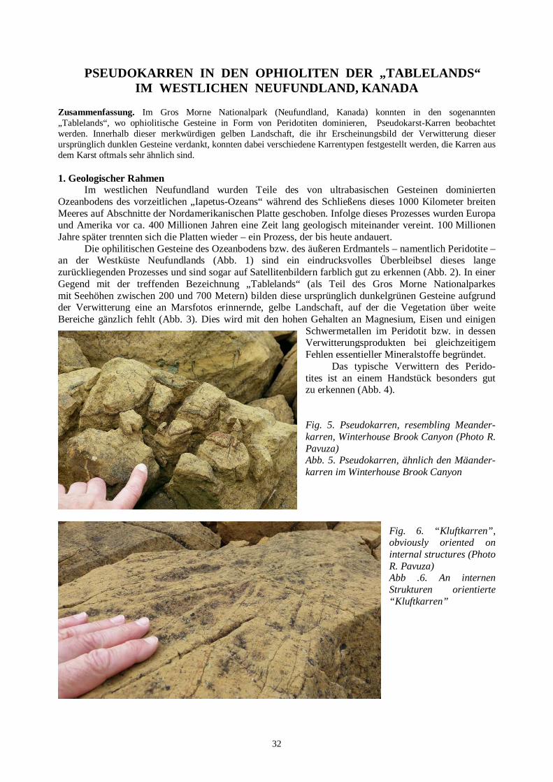
32
PSEUDOKARREN IN DEN OPHIOLITEN DER „TABLELANDS “ IM WESTLICHEN NEUFUNDLAND, KANADA
Zusammenfassung. Im Gros Morne Nationalpark (Neufundland, Kanada) konnten in den sogenannten „Tablelands“, wo ophiolitische Gesteine in Form von Peridotiten dominieren, Pseudokarst-Karren beobachtet werden. Innerhalb dieser merkwürdigen gelben Landschaft, die ihr Erscheinungsbild der Verwitterung dieser ursprünglich dunklen Gesteine verdankt, konnten dabei verschiedene Karrentypen festgestellt werden, die Karren aus dem Karst oftmals sehr ähnlich sind. 1. Geologischer Rahmen
Im westlichen Neufundland wurden Teile des von ultrabasischen Gesteinen dominierten Ozeanbodens des vorzeitlichen „Iapetus-Ozeans“ während des Schließens dieses 1000 Kilometer breiten Meeres auf Abschnitte der Nordamerikanischen Platte geschoben. Infolge dieses Prozesses wurden Europa und Amerika vor ca. 400 Millionen Jahren eine Zeit lang geologisch miteinander vereint. 100 Millionen Jahre später trennten sich die Platten wieder – ein Prozess, der bis heute andauert.
Die ophilitischen Gesteine des Ozeanbodens bzw. des äußeren Erdmantels – namentlich Peridotite – an der Westküste Neufundlands (Abb. 1) sind ein eindrucksvolles Überbleibsel dieses lange zurückliegenden Prozesses und sind sogar auf Satellitenbildern farblich gut zu erkennen (Abb. 2). In einer Gegend mit der treffenden Bezeichnung „Tablelands“ (als Teil des Gros Morne Nationalparkes mit Seehöhen zwischen 200 und 700 Metern) bilden diese ursprünglich dunkelgrünen Gesteine aufgrund der Verwitterung eine an Marsfotos erinnernde, gelbe Landschaft, auf der die Vegetation über weite Bereiche gänzlich fehlt (Abb. 3). Dies wird mit den hohen Gehalten an Magnesium, Eisen und einigen
Schwermetallen im Peridotit bzw. in dessen Verwitterungsprodukten bei gleichzeitigem Fehlen essentieller Mineralstoffe begründet.
Das typische Verwittern des Perido-tites ist an einem Handstück besonders gut zu erkennen (Abb. 4). Fig. 5. Pseudokarren, resembling Meander-karren, Winterhouse Brook Canyon (Photo R. Pavuza) Abb. 5. Pseudokarren, ähnlich den Mäander-karren im Winterhouse Brook Canyon
Fig. 6. “Kluftkarren”, obviously oriented on internal structures (Photo R. Pavuza) Abb .6. An internen Strukturen orientierte “Kluftkarren”

33
2. Beobachtungen Im September besuchte der Autor dieses Beitrages die Gegend im Rahmen eines Urlaubes ohne
die Erwartung, irgendwelche Karst- oder Pseudokarstphänomene zu sehen. Überraschenderweise zeigten sich jedoch in den „Tablelands“ an vielen Blöcken Formen, die den (Karst)Karren oftmals täuschend ähnlich sind (Abb. 5). Aufgrund des Fehlens einer einschlägigen Terminologie versuchten wir, die bei Sweeting (1972) angeführten Bezeichnungen für bestimmte Karrentypen im Karst deskriptiv anzuwenden.
Die Genese dieser Phänomene, die offenbar nicht durch (chemische) Lösungsvorgänge entstanden sind, konnten wir nicht eingehend untersuchen, doch gibt es Anzeichen, dass die Primärstrukturen des Gesteines (Abb. 6), aber auch die Weichheit des Verwitterungsmaterials bzw. der Serpentinitgänge von Bedeutung sein dürften.
Es ist dabei denkbar, dass einige der Formen direkt auf den Blöcken durch gravitativ-erosive Prozesse entstanden sind (Abb. 7), einige jedoch unter mehr oder weniger phreatischen Bedingungen ähnlich wie bei den Anastomosen im Karst, wobei sich dann deckenkarren-ähnliche Formen bilden können (Abb. 8). Fig. 7. Apparently (!) gravity-oriented “Rillenkarren” (Photo R. Pavuza) Abb. 7. Scheinbar (!) schwer-kraft-orientierte “Rillenkarren” Fig. 8: Anastomoses, resembling „Decken-karren“ (Photo R. Pavuza) Abb. 8: Anastomosen, ähnlich den Decken-karren 3. Ausblick
Diese zufällige Imitation von Karstformen – nicht im Hinblick auf die Genese, sondern die resultierenden Formen – verdient durchaus eine eingehendere Abklärung. Abgesehen von der Formenvielfalt und deren Hintergründe könnten auch die Hinweise auf eine endogene Genese für hydrogeologische Fragestellungen in diesen Gesteinskörpern interessant sein. Literatur und Abbildungen Siehe englischer Text.

34
GEOMORPHOLOGICAL MAPPING OF THE SISMOTECTONIC C AVE SYSTEM OF A TRAPA, RIBADELOURO, TUI (GALICIA, SPAIN)
Marcos Vaqueiro-Rodríguez1,2, Reinaldo Costas-Suárez,1,2, Juan Ramón Vidal-Romaní1,2 1Club de Espeleoloxía A Trapa (CETRA); Manuel de Castro, 8-3ºD, Vigo 36210, e-mail: [email protected] 2University Institute of Geology “Isidro Parga Pondal”, University of A Coruña; Edif. de Servicios Centrales de Investigación, Campus de Elviña, 1507, A Coruña, Spain; e-mail: [email protected]
Abstract. Up to now, the A Trapa system is the largest cave formed within granite blocks in the Iberian Peninsula, the second in Europe and the fifth worldwide. The cave is associated with a reverse fault, and its development, morphology and evolution seems to be influenced by the fault dynamics and the successive movements of blocks toward the axis of the valley. In the central sector of the cave system a large pigotite flowstone is preserved, the oldest speleothem of this type recorded up till now. The study of cave deposits indicates that the last stage of the cave evolution falls into the Late Holocene. Key words: granite, cave, seismotectonics, mapping, granite geomorphology 1. Introduction
The A Trapa system is a group of granite cavities, which channels the underground watercourse of the San Simón River in a section of 255 m, with 102 m difference in height between the swallow-hole and the resurgence, and a mean watercourse slope of 27.4º (Fig. 1). 1,587 m of passages and galleries were mapped, with a difference in height of 86.6 m between the highest and the lowest levels.
The A Trapa system is associated with a reverse fault of N125ºE direction, which coincides with the main underground conduit.
Fig. 1. The seismotectonic cave system of “A Trapa”: spatial model of the cave, views at 0º and 270º Abb. 1. Das seismotektonische Höhlensystem “A Trapa”. Räumliches Modell mit Sichtwinkel 0° und 270°
The dynamics of the fault (Vidal Romaní et al. 2014) existing since the Paleogene probably triggered a large mass rock slide of a surface of 5400 m2 which partially covered the original streambed of the San Simón River displacing this streambed toward the north. During dry seasons, the stream has only the underground section through the A Trapa cave, but during the periods of large floods, the stream uses two channels: the main watercourse that is displaced by the front of the slide and the underground one that drains through A Trapa cave, 15 m below the present ground surface (Fig. 2).

35
2. Site description 2.1. Location
The system is located at the Ribadelouro parish, Tui township (Pontevedra) on the southern slope of the mountain branch of Mount Aloia in the Serra do Galiñeiro Mountains. The swallow hole of the stream is located at UTM X:526950, Y:4661152; Z:260 m. 2.2. Geology
The A Trapa cave is developed in two-mica alkaline granite, which is medium to coarse grained, characterised by equigranular texture and affected by the phase F2 of the Hercynian deformation with N160ºE direction (IGME 1981), and therefore without influence on genesis of the cave that formed directly related to the system of joints. 2.3. Hydrology and climate
The station set on the Mount Aloia summit recorded an annual rainfall of 2,356 l/m2 (= 2356 mm) in 2012-2013, with monthly maximum intensities of 408.2 l/m2.The watercourse of the San Simón Stream runs to ESE of the Sierra do Galiñeiro, in an area of pluviometric gradient III (93-100 mm/100 m of the high) (Martínez et al. 1999). Its springs are located close to the top of the Mount Aloia (Tui). The large volume of the stream flow is due to the topographic effect of the Serra do Galiñeiro (700 m of altitude) acting as a barrier to the Atlantic storms. In spite of this large rainfall, the upstream basin of the permanent swallow-hole has a small size (the length of the stream above the swallow-hole is slightly over 1.7 km).
Fig. 2. KML (Keyhole Markup Language) cave and river models projected on the background of local orthophotography; green dotted line marks the border of the head scarp where main rock slide starte,. red dashed line indicates the plane of the reverse fault Abb. 2. KML (Keyhole Markup Language) Höhle und Fluss projiziert auf ein Orthofoto; die grün-gepunktete Linie markiert die Grenze jenes Abrisses, wo die Blockgleitung begonnen hat, die rote unterbrochene Linie markiert den Bereich der Aufschiebung 3. Seismo-tectonic constraints
The A Trapa system is located at the Galicia-Trás-os-Montes area of the Variscan massif. It is in the seismic-tectonic dominion I (S Galicia-N Portugal) structurally characterized by the existence of several faults active from the Paleogene up to the Late Quaternary with prevailing NNE-SSW and N-S orientations (Viveen et al. 2012).

36
In this seismic-tectonic domain more than 40 historical earthquakes have been recorded concentrated on the Atlantic littoral zone and northwest section of Portugal. The maximum earthquake intensities confirm the existence of an important seismic activity of moderate magnitude in the area of the cave and also epicentres of various importance distributed in the cross-border zone with Portugal i.e. proximity of the cave (López 2008).
The tectonic horst of Mount Aloia, Sierra do Galiñeiro reaches its present position owing tothe uplift between the Paleogene and the present. From the Paleogene (ca 58 Myr ago) to the Middle Pleistocene the average uplift rate was about 0,8 m·ka-1 (Viveen et al. 2013). Nowadays, the uplift continues about 0.3 m·ka1 with a moderate associated seismic activity (Vidal Romaní et al. 2014). 4. Morphology and development of the system
The A Trapa system formation has been a long process consisting of the two following stages: initial release of the rock substratum owing to the weathering, followed by an active dynamics of rock slopes with gravitational movements of blocks, which filled up the lowest parts of the valley, forming a system of cavities of boulder cave type (Vidal Romani, Vaqueiro 2007), crossed by the San Simón Stream. The relationship between the cave framework and the fault N125ºE allows to divide the A Trapa cave into three large sections: swallow-hole or highest zone, central or fault zone, and resurgence zone.
The present underground streambed is a channel delimited by either tilted blocks or continuous walls excavated in the in situ rock with undulated surfaces. Intermittently, small accumulations of cobbles occur. Small-sized cylindrical potholes and numerous scallops were also identified (Fig. – see back cover). These erosive forms are located at various height above the present streambed marking the incision stages of the San Simón Stream.
The erosion carried out by the stream not only affects the rock substratum but also the collapsed blocks, which filled the valley, thus the slides of the blocks preceded the channel incision. However, the movements of boulders could have continued later, because the erosional (streambed) potholes on their surfaces were tilted (i.e. the pothole elongation axes are not in vertical positions – Fig. 3). The occurrence of several (at least two) phases of the boulder slides are clearly recognized: In a first phase, a generalized slide would be propagated toward the bottom of the valley bringing around to fill it up. In a second phase, a new slid was restricted to the central part of the A Trapa cave, and the accumulation of boulders would have covered the underground system. The blocks mobilized in the second phase also show development of pothole patterns.
Fig. 3. To the left, a pot-hole with two axes; the scale shows the present vertical axe. Note that the block was rotated about 60º. To the right, tilted pot-holes developed on a fallen block (Photo M. Vaqueiro) Abb. 3. Linkerhand ein Strudeltopf mit zwei Achsen, die Skala markiert die Vertikalachse. Der Block wurde um ca. 60° rotiert. Rechterhand rotierte Strudeltöpfe auf einem abgeglittenen Block
Both gravitational movements could have been assisted by the erosional incision of a stream channel, although they are supposedly triggered by the movement of the N125ºE fault. The successive slides of boulders which occurred in this zone are also observed as the changes of the streambed of the San Simón Stream in its underground section. For example, it is proved by the pigotite speleothems

37
covering some old potholes and even the nascent terrace deposits. All these features indicate that the conditions of the watercourse were changing along with the time from erosive (development of pothole) to underwater accumulative (deposits of gravels) to subaerial accumulative (pigotite speleothems – Fig. – see back cover).
Fig. 4 Two successive composed sections of the Féveros sector. Sedimentation fossilized ancient erosive forms on which new erosive forms are developed. Colours and symbols described in details in Costas et al. (2013). Abb. 4. Zwei aufeinanderfolgende Querschnitte im Höhlenteil Féveros. Durch Sedimentation wurden frühere Erosionsformen konserviert, wobei sich dann in den Sedimenten neue Formen bildeten. Farben und Symbole zur Zeichnung finden sich in Costas et al. (2013).

38
Up to now, an absolute chronology of the cave evolution stages does not exist. However we have reconstructed a relative sequence of the evolution stages of the cave based on geomorphological data. The Féveros section, located at the middle section of the A Trapa cave (heights between -25 and -50 m), shows the most complete sequence of forms and deposits. From floor to ceiling there are (Fig. 4): a permanently active streambed (-44 m, Fig. 5); above this streambed a hanging channel that is active only during extreme flooding episodes is situated under the intermediate streambed paleo-level (-39 m) active only occasionally; above this paleo-level, there is a clearly inactive upper paleo-level (-34 m, Fig. 6); and finally, there is a relatively shallow cave level (-28 m), whose formation coincided with the second slide of blocks, mentioned before .
Fig. 5. Féveros part of the A Trapa system: lower paleolevel (-42 m) (Photo M. Vaqueiro) Abb. 5. Höhlenteil Féveros im A Trapa Höhlensystem: unteres Paläo-Level (-42 m)
The TL (thermoluminescence) dating of the deposits in the relict streambed below the level -28 m, displays the age of 2.7±0.60 kyr BP, while the deposits at the upper level (-34 m) were dated with the same technique (TL) at 7.05±0.86 kyr BP (Sanjurjo et al. 2013). Most the Palae-olithic archaeological sites recognised in the A Trapa system are located at this level (Sanjurjo et al., 2013).
The best preserved pigotite flowstone (Fig. 7) in this part of the cave connects the three described paleolevels between the heights -36 m and -44 m. Its inner zone was dated by radiocarbon method at 3760 cal yr BP, while its external part (currently eroded by migration of the streambed during floods) – at 2960 cal yr BP.
Fig. 6. Féveros part of the A Trapa system: upper paleolevel (-34 m). (Photo M. Vaqueiro). Abb. 6. Höhlenteil Féveros im A Trapa Höhlensystem: oberes Paläo-Level (-34 m)
The lowermost section of the A Trapa system, resurgence zone, shows a quite different morphology. It is developed down-stream of the confluence of superficial and underground courses and chan-nelling of the San Simón underground stream. This section is 26 m deep (spacing between the confluence of stream flows and the flow resurgence)
and runs through a chaos of blocks with the parts of the streambed cutting into the rock substratum in situ, and being a vadose channel with a locally asymmetrical keyhole shape (cross-section) similar to the karst conduits sensu stricto. The widening of the cross section of the underground channel is related

39
to the weakness planes of the rock massif related to shear zones. This fact has already been highlighted in similar caves such as O Folón cave (Vaqueiro et al. 2011). Acknowledgements Thanks to Ana Martelli, Rosa María Suárez, David Costas Vázquez, Begoña Barreiro and Elena de Uña, colleagues from CETRA and IUX. Fig. 7. Pigotite flowstone (-42 m) (Photo: M. Vaqueiro) Abb. 7. Pigotit-Sinterbildung (-42 m). References Costas R., Suárez R.M., Vaqueiro R. 2013. Geomorphological mapping of granite caves. Cadernos do Laboratorio
Xeolóxico de Laxe 37: 89-104. IGME 1981. Geological Map of Spain E1:50.000. Tuy, sheet number 261 (4-12). López C. 2008. Actividad sísmica, zonación sismotectónica y riesgo sísmico en el NO de la Península Ibérica. Serie
Nova Terra. Instituto Universitario de Xeoloxía. A Coruña, 35, 270 pp. Martínez A., Castillo F., Pérez A., Valcárcel M., Blanco R. 1999. Atlas climático de Galicia. Norme Editorial,
Santiago de Compostela, 75 pp. Sanjurjo J., Vidal Romaní J.R., Vaqueiro M., Costas R., Grandal A. 2013. TL estimation of ages of pottery fragments
recovered from granite caves in the NW coast of Spain. Cadernos do Laboratorio Xeolóxico de Laxe 37: 73-88. Vaqueiro M., Costas R., Suárez R.M., López J.M., Vidal J.R. 2011. Pseudokarst in granites: How granite caves are
developed – the case of Galician caves. Proceedings of the 11th International Symposium on Pseudokarst, Höhlen- und Karstforschung, Dresden, 144-159.
Vidal Romani J.R., Vaqueiro M. 2007. Types of granite cavities and associated speleothems: Genesis and evolution. Nature Conservation 63: 41-46.
Vidal Romaní J.R., Vaqueiro M., Sanjurjo J. 2014. Granite landforms in Galicia. In: Gutiérrez M., Gutiérrez M. (Eds.), Landscapes and landforms of Spain. Springer Verlag, 348 pp.
Viveen W., Van Balen R.T., Schoorl J.M., Veldkamp A., Temme A.J.A.M., Vidal Romaní J.R. 2012. Assessment of recent tectonic activity on the NW Iberian Atlantic Margin by means of geomorphic indices and field studies of the Lower Miño River terraces. Tectonophysics 544-545: 13–30.
Viveen W., Van Balen R.T., Schoorl J.M., Veldkamp A., Temme A.J.A.M., Vidal Romaní J.R. 2013. Reconstructing the interacting effects of base level, climate, and tectonic uplift in the Lower Miño River terrace record: A gradient modelling evaluation. Geomorphology 186: 96-118.
GEOMORPHOLOGISCHE KARTIERUNG DES SEISMOTEKTONISCHEN HÖHLENSYSTEMS A TRAPA,
RIBADELOURO, TUI (GALICIEN, SPANIEN) Zusammenfassung. Derzeit ist das A Trapa Höhlensystem die längste Höhle in Granitblöcken auf der Iberischen Halbinsel, die zweitlängste in Europa und die fünftlängste weltweit. Die Höhle liegt im Umfeld einer Aufschiebung und ihre Entstehung, Entwicklung und Morphologie dürfte durch die Dynamik dieser Störung und die Bewegung von Blöcken in Richtung der Längsachse des Tales bestimmt sein. Im zentralen Teil der Höhle gibt es eine große Sinterbildung aus Pigotit – das älteste bislang beobachtete Speläothem dieser Art bisher. Die Untersuchungen des Höhleninhaltes weisen auf eine letzte Phase der Höhlenentwicklung im jüngeren Holozän hin.

40
1. Einleitung Das A Trapa Höhlensystem ist eine Gruppe von Granithöhlen um den hier auf eine Länge
von 255 Metern unterirdisch fließenden Fluss San Simon, wobei zwischen Versickerung und Wiederaustritt ein Höhenunterschied von 102 Metern überwunden wird. Das mittlere Gefälle beträgt dabei 27,4° (Abb. 1). Insgesamt wurden 1587 Meter Gangstrecke kartiert, der maximale Höhenunterschied zwischen höchst- und tiefstgelegenen befahrbaren Abschnitten beträgt 86,6 Meter.
Das A Trapa Höhlensystem ist mit einer tektonischen Aufschiebung in SE-Richtung assoziiert, diese Richtung entspricht auch im Wesentlichen den unterirdischen Gangfolgen.
Die Dynamik dieser Störung (Vidal Romani et al. 2014), die seit dem Paläogen existiert, hat vermutlich eine große Massenbewegung auf einer Fläche von 5400 m2 induziert und das ursprüngliche Flussbett blockiert. Dieses verlagerte sich daraufhin Richtung Norden. Während der Trockenzeiten benutzt der Fluss indessen nach wie vor den unterirdischen Weg durch das A Trapa Höhlensystem (Abb. 2), bei Hochwässern wird auch das oberirdische Flussbett aktiviert. 2. Beschreibung 2.1. Lage
Das Höhlensystem liegt in der Gemeinde Ribadelouro, die zur Stadt Tui (Pontevedra) gehört, am Südhang des zur Serra do Galiñeiro zählenden Mount Aloia. Die Versickerungsstelle des Flusses hat die UTM-Koordinaten X:526950, Y:4661152, Z:260.
2.2. Geologie
Die A Trapa Höhe ist im mittel bis grobkörnigem Zweiglimmergranit von einheitlicher Textur angelegt, der durch die Phase F2 der hercynischen Deformation in SSE-Richtung (IGME, 1981) beeinflusst ist. Diese hat aber keinen Einfluss auf die Entwicklung der Höhle, die sich störungsorientiert entwickelt hat.
2.3. Hydrologie und Klima Auf dem Mount Aloia wurde eine jährliche Niederschlagsmenge von 2356 mm (2012-2013) registriert, das Monatsmaximum betrug dabei 408,2 mm (= 408,2 Liter/m2). Der San Simon-Fluß fließt von der Serra do Galiñeiro Richtung ESE mit einem pluviometrischen Gradient von 93-100 mm/100 m (Martinez et al., 1999). Seine Quellzone liegt nahe der Kuppe des Mount Aloia bei Tui. Die hohe Niederschlagsmenge ist durch die 700 m hohe Barriere der Serra do Galiñeiro gegen die Stürme des Atlantik begründet. In Relation zur hohen Niederschlagsmenge hat der Oberlauf – oberhalb der Versickerung – des San Simon eine relativ geringe Dimension (etwas über 1,7 km). 3. Seismotektonische Rahmenbedingungen
Das A Trapa System liegt im Gebiet Galicia-Trás-os-Montes des variszischen Massivs. Es gehört zum seismotektonischen Abschnitt I (Südgalicien – Nordportugal), der durch mehrere seit dem Paläogen bis ins jüngere Quartär aktive Störungen gekennzeichnet ist. Diese sind NNE-SSW und N-S orientiert (Viveen et al. 2012). In diesem seismotektonischen Abschnitt wurden 40 Erdbeben an der Atlantikküste sowie im Nordwestabschnitt Portugals registriert. Die Maximalintensitäten bestätigen eine bedeutende Zone moderater Erdbebenaktivität im Bereich der Höhle mit Epizentren verschiedener Intensitäten längs der Grenze zu Portugal in der Nähe von A Trapa (López 2008).
Der tektonische Horst des Mount Aloia hat seine gegenwärtige Position aufgrund der Hebung zwischen dem Paläogen und der Gegenwart erreicht. Seit dem Paläogen (~ 58 Mya) bis ins Mittelpleistozän war die durchschnittliche Hebungsrate rund 0,8 m pro 1000 Jahren (Viveen et al. 2013). Heute liegt sie bei 0,3 m/1000 Jahren mit moderater seismischer Aktivität (Vidal Romani et al 2014). 4. Höhlenentwicklung und Morphologie
Die Bildung des A Trapa Höhlensystems ist eine langandauernde in zwei aufeinanderfolgenden Phasen. Nach einer initialen Phase der Auflösung des Gefüges durch Verwitterung folgte eine aktive gravitative Felsbewegung, wobei die tiefstgelegenen Bereiche des Tales aufgefüllt wurden und sich Blockhöhlen bildeten (Vidal Romani, Vaqueiro, 2007), die durch den San Simon Fluss durchflossen wurden. Der Zusammenhang zwischen der Höhlenerstreckung und der SE-gerichteten Störungszone

41
unterteilt die A Trapa Höhle in drei große Abschnitte: Versickerungszone/höchste Zone – Zentrale Zone/Störungszone – Resurgenz. Das gegenwärtige unterirdische Flußbett ist eine Art Rinne, die entweder durch verkippte Blöcke oder durch anstehenden Felsen in situ – mit kolkartigen Oberflächen – begrenzt wird. Dabei kommt es zur Ansammlung kleiner Mengen von Bachkiesel und auch Fließfacetten und Strudellöcher können beobachtet werden (Abb. – siehe hintere Umschlagseite). Diese Formen können in unterschiedlicher Höhe über dem aktuellen Flussbett beobachtet werden und geben Hinweis auf die Eintiefungsgeschichte des San Simon-Flusses.
Die Erosion durch den Fluss betrifft aber nicht nur das Festgestein in situ, sondern auch die allochthonen Blöcke, da auch die Bewegungsbahnen der abgeglittenen Blöcke das spätere Flussbett präformierten. Doch dürften auch Blöcke späterhin weiterbewegt worden sein, wie man aus verkippten Strudeltöpfen erkennen kann: ihre Achsen sind nicht vertikal (Abb. 3). Dabei kann man zumindest 2 Phasen der Blockbewegungen klar unterscheiden. In der ersten kam es zum Abgleiten und zur Platznahme im Tal, in der zweiten kam es zur begrenzen Abgleitung nur im zentralen Bereich der A Trapa Höhle, wodurch das unterirdische Flussbett teilweise überdeckt wurde. An diesen Blöcken kann auch das erwähnte Verkippen der Strudeltöpfe beobachtet werden. Beide gravitativen Prozesse wurden möglicherweise gefördert durch die Erosion des Flussbettes, obschon sie ursprünglich durch die Bewegungen an der erwähnten SE gerichteten Störung offenbar ausgelöst wurden. Das sukzessive Abrutschen der Blöcke ist auch in der Änderung der Position des Flussbettes zu erkennen, so sieht man zum Beispiel Pigotitformationen über alten Strudeltöpfen oder sogar in Entstehung befindlichen Ablagerungen. All dies zeigt die Entwicklung der Wasserwege von erosiven Phasen (Strudeltöpfe) über Unterwasserphasen (Ablagerung von Kiessedimenten) zur subaerischen Phase (Pigotitbildungen, Abb. – siehe hintere Umschlagseite).
Bis jetzt gibt es keine absoluten Daten zur Altersentwicklung der Höhle, sehr wohl aber eine relative Abfolge auf Basis der geomorphologischen Beobachtungen. Der Höhlenabschnitt „Féveros“, etwa im mittleren Bereich von A Trapa (relative Höhe zwischen -25 m und – 50 m) zeigt am besten die komplette Abfolge von Formen und Ablagerungen. Vom Boden bis zur Decke sieht man (Abb. 4): ein permanent aktives Flussbett (-44 m, Abb. 5), darüber eine „hängende“ Rinne, die nur bei Hochwasser aktiv ist (-42 m ) sowie ein gelegentlich noch aktives Paläo-Niveau (-39 m), dann folgt über diesem ein inaktives Paläo-Niveau auf -34 m (Abb. 6) und schließlich ein relativ seichtes Niveau (-28 m), dessen Bildung mit der zweiten Phase des Abgleitens der Blöcke zusammenfällt.
Die Thermolumineszenzdatierung (TL) der Sedimente des -28m Niveaus ergab ein Alter von 2,7 ± 0,7 kyr BP, wogegen das Niveau auf -34 m, ebenfalls mittels TL ein Alter von 7,05 ± 0,86 kyr BP ergab (Sanjuro et al. 2013), Die meisten archäologischen Funde der A Trapa stammen von hier (Sanjuro et al. 2013).
Die besterhaltenen Pigotitformationen (Abb. 7) in diesem Höhlenabschnitt verbinden die drei Niveaus zwischen -36 m und -44 m. Die innerste Zone dieser Speläotheme wurde mit der Radiocarbonmethode datiert und ergab ein kalibriertes Alter von 3760 Jahren BP, die äußerste Zone, die derzeit durch Erosion während Hochwasserereignissen erodiert wird hingegen ein Alter von 2960 Jahren BP.
Der tiefste Abschnitt von A Trapa, der Wiederaustritt des Flusses, zeigt eine sehr unterschiedliche Morphologie. Es ist dies der Bereich unterhalb des Zusammenflusses des ober- und unterirdischen Flusslaufes, wobei die letzten 26 Meter gemeinsam unterirdisch bis zum Wiederaustritt fließen. Hier gibt es eine chaotische Ansammlung von Blockwerk, teilweise schneidet der Fluss im Anstehenden ein und bildet asymmetrische Schlüssellochprofile, ähnlich wie im Karst. Die Raumerweiterung dieses Abschnittes ist an Schwächezonen im Bereich von tektonischen Scherzonen gebunden, ähnlich wie dies auch aus anderen vergleichbaren Höhlen, wie zum beispiel O Folón beschrieben wurde (Vaqueiro et al. 2011). Danksagungen, Literatur und Abbildungen Siehe englischer Text

42
43
ERSTES ZIRKULAR ZUM 13. INTERNATIONALEN SYMPOSI UM FÜR PSEUDOKARST
16.- 19. 9. 2015 Kunčice pod Ondřejnikem, Beskiden, Tschechische Republik
Webseite: http://conference.osu.eu/pseudokarst Themen des Symposiums Wissenschaft – Exploration – Dokumentation... Proceedings Sie sollen vorab erscheinen! Beiträge zusammen mit den Anmeldungen in elektronischer Form bis 30.6.2015 an [email protected] (Näheres dazu sowie Formulare auf der Webseite) Termine 16.06.2015 Termin für Registrierung und Übersendung der Abstracts 26.06.2015 Zweites Zirkular wird versendet 30.07.1025 Termin für die Überweisung des Kongressbeitrag (Unterkunft und Verpflegung müssen erst vor Ort bezahlt werden, Info dazu auf der Homepage), Teilnahmegebühr 80 Euro/60 Euro/40 Euro (Vollzahler, Begleitung, Studenten) Lokalität H-resort (siehe http://www.hresort.cz )
LIST OF NON-KARST CAVES OF HUNGARY
The internet database: „List of non-karst caves of Hungary” can be found at the address: nonkarstic.elte.hu . This database is prepared by István Eszterhás and George Szentes in two languages: Hungarian and English, and presents distribution of non-karst caves (on topographic maps), as well as the maps, short descriptions and photographs of these caves. It seems to be very useful for people/cavers, who want to know more about the caves in Hungary or about the caves in different rocks, forming due to various genetic processes, as well as it can be used as a model for people working on similar databases for their regions or countries.

44
LISTE DER NICHTKARSTHÖHLEN UNGARNS
Im Internet findet sich eine graphisch unterstützte Liste mit Informationen über die Nichtkarsthöhlen Ungarns unter folgender Adresse: nonkarstic.elte.hu Sie wurde von Isztván Eszterhás und George Szentes ungarischer und englischer Sprache konzipiert und zeigt die Verteilung der Höhlen auf topographischen Karten, Höhlenpläne und bringt kurze Beschreibungen sowie auch Fotos. Sie ist gedacht für Interessenten an Höhlen in Ungarn in verschiedenen Gesteinen und mit verschiedenartigsten Entstehungsbedingungen und kann (und sollte) als Vorbild für vergleichbare Aktivitäten in anderen Gebieten und Ländern dienen.
EDITORIAL NOTE This issue of the Pseudokarst Commission Newsletter contains mostly papers which present studies
crucial for further progress in our understanding of formation of unique non-karst caves in various rocks, as see caves, gull caves, polygenetical (tectonic-gravitational-corrosional) caves, as well as formation and scientific usability of their speleothems (role of organisms and seeping water in formation of speleothems, speleothem datings and their interpretations). The papers are short, but they refer to more comprehensive publications – a procedere seeming appropriate for a newsletter. However, the most important actual message for all Members and Friends of the UIS Pseudokarst Commission is the First Circular announcing the 13th International Symposium on Pseudokarst, which will be held in the Beskydy Mts., Czech Rep., in autumn 2015. We hope to meet as many as possible readers of this Newsletter in the Beskydy Mts. this September, and we suppose to get there sufficient and again very interesting materials for the next issue of the Newsletter. Anyway, everybody are kindly asked to send to the editors (the adresses – see the first pages of this issue) materials on interesting “pseudokarst objects, things and events”. The date of publication of the next issue will depend on materials which we will get, but it will be not later than the first months of the 2016.
This issue will be published both in the digital and paper versions owing to the financial support of the UIS Bureau. The paper version will be sent to the most important world libraries collecting the karst and cave literature. We hope that the next issue will be also published in these two versions. REDAKTIONELLE ANMERKUNG
Diese Ausgabe des Nachrichtenbriefs der Pseudokarst-Kommission betrifft hauptsächlich Artikel,
die wichtige Untersuchungen zum Fortschritt des Wissens über die Bildung von Nichtkarsthöhlen verschiedener Gesteine und Typen, wie Meereshöhlen, Spalthöhlen, polygenetische Höhlen (tektonisch – gravitativ – korrosiv) bringen. Darüber hinaus wird über die Bildung und wissenschaftliche Verwertbarkeit der Speläotheme (hinsichtlich Beteiligung von Organismen und Sickerwasser, Datierung und Interpretation der Daten) berichtet. Zwar sind die meisten Artikel eher kurz gefasst, doch wird auf eine reichhaltige tiefergehende einschlägige Literatur verwiesen – ein Prozedere, das einem „Nachrichtenbrief“ angepasst erscheint. Vieleicht aktuell am wichtigsten ist die Information über das 13.Internationale Symposium für Pseudokarst in den Beskiden (Tschechische Republik) im Herbst 2015, bei dem wir uns auch Material für den nächsten Nachrichtenbrief erhoffen.
Darüber hinaus ersuchen wir aber wie stets um die Zusendung von Materialien und Manuskripten für den nächsten Nachrichtenbrief, der Anfang 2016 erscheinen soll.
Die vorliegende Ausgabe erscheint in digitaler Form sowie auf Papier mit einem finanziellen Beitrag der UIS. Diese Exemplare werden an die wichtigsten Bibliotheken weltweit verschickt, die an Karst- und Höhlenliteratur interessiert sind. Wir hoffen, dass dies auch im nächsten Jahr möglich sein wird, obgleich es keine Unterstützung mehr durch die UIS geben soll.

45