introduction to geology 1.2 geology in …(viii) historical geology (i) physical geology as a branch...
TRANSCRIPT

1.1 INTRODUCTION TO GEOLOGY
Geology is a branch of science dealing with the study of the Earth. It is also known as
earth science (in Greek, Geo means Earth, Logos means Science). The study of the earth
comprises of the whole earth, its origin, structure, composition and history (including the
development of life) and the nature of the processes.
1.2 GEOLOGY IN CIVIL ENGINERRING:
The role of geology in civil engineering may briefly be outlined as follows:
1. Geology provides a systematic knowledge of construction materials, their structure and
properties.
2. The knowledge of Erosion, Transportation and Deposition (ETD) by surface water helps
in soil conservation, river control, coastal and harbour works.
3. The knowledge about the nature of the rocks is very necessary in tunneling, constructing
roads and in determining the stability of cuts and slopes. Thus, geology helps in civil
engineering.
4. The foundation problems of dams, bridges and buildings are directly related with geology
of the area where they are to be built.
5. The knowledge of ground water is necessary in connection with excavation works, water
supply, irrigation and many other purposes.
6. Geological maps and sections help considerably in planning many engineering projects.
7. If the geological features like faults, joints, beds, folds, solution channels are found, they
have to be suitably treated so that the stability of the structure is greatly increased.
8. Pre-geological survey of the area concerned reduces the cost of engineering work.
1.3 SCOPE OF GEOLOGY
Engineering Geology: A well established interdisciplinary branch of Science and Engineering
has a scope in different fields as outlined below:
(a) In Civil Engineering: Geology provides necessary information about the site of construction,
materials used in the construction of buildings, dams, tunnels, tanks, reservoirs, highways
and bridges. Geological information is most important in planning the various phases (stage),
design phase and construction phase of an engineering project.
(b) In Mining Engineering: Geology is useful to know the method of mining of rock and mineral

deposits on earth‟s surface and subsurface.
(c) In Ground Water: Resources development geology is applied in various aspects of resources
and supply, storage, filling up of reservoirs, pollution disposal and contaminated water disposal.
(d) Land pollution.
(e) Nuclear explosion.
(f) Oceanography.
(g) Space exploration.
In each of the above-mentioned fields Geology has to deal with an integral part of the earth.
1.4 DIFFERENT BRANCHES OF GEOLOGY
For studying the earth in detail, the subject of Geology has been divided into various branches.
They are as follows:
(i) Physical Geology (ix) Economic Geology
(ii) Crystallography (x) Mining Geology
(iii) Mineralogy (xi) Civil Engineering Geology
(iv) Petrology (xii) Hydrology
(v) Structural Geology (xiii) Indian Geology
(vi) Stratigraphy (xiv) Resources Engineering
(vii) Paleontology (xv) Photo Geology
(viii) Historical Geology
(i) Physical Geology
As a branch of geology, it deals with the “various processes carried out by physical agents such
as wind, water, glaciers and sea waves”. These agents go on modifying the surface of the earth
continuously. Physical geology includes the study of Erosion, Transportation and Deposition
(ETD).
Thus the study of physical geology plays a vital role in civil engineering as:
(a) It reveals constructive and destructive processes of physical agents at a particular site.
(b) It helps in selecting a suitable site for different types of project to be undertaken after
studying the effects of physical agents.
(ii) Crystallography
As a branch of geology, it deals with „the study of crystals‟. A crystal is a regular polyhedral
form bounded by smooth surfaces.

The study of crystallography is not much important to civil engineering, but to recognize
the minerals the study of crystallography is necessary.
(iii) Mineralogy
This deals with the study of minerals. Minerals are basic units with different rocks and ores of
the earth are made up of.
Details of mode of formation, composition, occurrence, types, association, properties uses etc. of
minerals form the subject matter of mineralogy. For example: sometimes quartzite and marble
resemble one another in shine, colour and appearance while marble disintegrates and
decomposes in a shorter period because of its mineral composition and properties.
(iv) Petrology
Petrology deals with the study of rocks. The earths crust also called lithosphere is made up of
different types of rocks. Hence petrology deals with the mode of formation, structure, texture,
composition, occurrence, and types of rocks. This is the most important branch of geology from
the civil engineering point of view.
(v) Structural Geology
The rocks, which from the earths crust, undergo various deformations, dislocations and
disturbances under the influence of tectonic forces. The result is the occurrence of different
geological structures like folds, fault, joints and unconformities in rocks. The details of mode of
formation, causes, types, classification, importance etc of these geological structures from the
subject matter of structural geology.
(vi) Stratigraphy
The climatic and geological changes including tectonic events in the geological past can also be
known from these investigations. This kind of study of the earth‟s history through the
sedimentary rock is called historical geology. It is also called stratigraphy (Strata = a set of
sedimementary rocks, graphy description).
(vii) Paleontology
As a branch of geology, it deals with „the study of fossils‟ and the ancient remains of plants and
animals are referred to as fossils. Fossils are useful in the study of evolution and migration of
animals and plants through ages, ancient geography and climate of an area.

(viii) Historical Geology
As a branch of geology, it includes “the study of both stratigraphy and paleontology”. Its use in
civil engineering is to know about the land and sea, the climate and the life of early times upon
the earth.
(ix) Economic Geology
Minerals can be grouped as general rock forming minerals and economic minerals. Some of the
economic minerals like talc, graphite, mica, asbestos, gypsum, magnesite, diamond and gems.
The details of their mode of formation, occurrence, classification. Association, varieties,
concenteration, properties, uses from the subject matter of economic geology.
(x) Mining Geology
This deals with the application of geological knowledge in the field of mining. A mining
engineer is interested in the mode and extent of occurrence of ores, their association, properties
etc. It is also necessary to know other physical parameters like depth direction inclination
thickness and reserve of the bodies for efficient utilization. Such details of mineral exploration,
estimation and exploration are dealt within mining geology.
(xi) Civil Engineering Geology
As a branch of geology, it deals with “all the geological problems that arise in the field of civil
engineering along with suitable treatments”. Thus, it includes the construction of dams, tunnels,
mountain roads, building stones and road metals.
(xii) Hydrology
As a branch of geology, it deals with “the studies of both quality and quantity of water that are
present in the rocks in different states”(Conditions).
Moreover, it includes:
(a) Atmospheric water,
(b) Surface water, and
(c) Underground water.
(xiii) Indian Geology
As a branch of geology, it deals with “the study of our motherland in connection with the
coal/petroleum, physiography, stratigraphy and economic minerals of India”.
(xiv) Resources Engineering
As a branch of geology deals with “the study of water, land, solar energy, minerals, forests, etc.
fulfill the human wants”.

(xv) Photo Geology
As a branch of geology deals with “the study of aerial photographs”.
1.5 RELATIONSHIP OF GEOLOGY WITH OTHER BRANCHES OF SCIENCE AND
ENGINEERING
In order to carry out civil engineering projects safely and successfully, geology should be related
to the other branches bordering sciences as described below:
1. Geochemistry
This branch is relatively more recent and deals with the occurrence, distribution, abundance,
mobility etc, of different elements in the earth crust. It is not important from the civil engineering
point of view.
2. Geophysics
The study of physical properties like density and magnetism of the earth or its parts. To know its
interior form the subject matter of geophysics. There are different types of geophysical
investigations based ion the physical property utilized gravity methods, seismic methods,
magnetic methods. Engineering geophysics is a branch of exploration geophysics, which aims at
solving civil engineering problems by interpreting subsurface geology of the area concerned.
Electrical resitivity methods and seismic refraction methods are commonly used in solving civil
engineering problems.
3. Geohydrology
This may also be called hydrogeology. It deals with occurrence, movement and nature of
groundwater in an area. It has applied importance because ground water has many advantages
over surface water. In general geological and geophysical studies are together taken up for
groundwater investigations.
4. Rock Mechanics
As a branch of science, it is related with geology in dealing with the behaviour of rocks that is
subjected to static and dynamic loads (force fields).
5. Mining Engineering
Geology is related to mining engineering in dealing with the formation and distribution of
economic minerals and response to fracturing processes. Without the knowledge of structural

features of rock masses and mode of occurrence and mineral deposits, a mining engineer cannot
determine the method of mining.
6. Civil Engineering
Before constructing roads, bridges, tunnels, tanks, reservoirs and buildings, selection of site is
important from the viewpoint of stability of foundation and availability of construction materials.
The geology of an area, rock-forming region, their physical nature, permeability, faults and
joints, etc are important. Thus, geology is related to civil engineering construction jobs with
economy and success.
1.6 INTERNAL STRUCTURE OF EARTH:
• Direct observation of earth is not possible due to fact that the interior became hotter
• The deepest whole in the earth is only about 8km, this is quite negligible in
comparison with radius of the earth
• The internal structures of earth is based on the existence yield at by indirect
geophysical method (seismic method)
• The earth body comprises of several layers which are like shells resting one above
the earth
• The layers are distinguished by the physical and chemical properties
• The interior of the earth has been obtain from the study of earthquakes waves
through the earth
There are three types of waves. They are
P-waves/Primary waves/Longitudinal waves:
The waves travel in solid, liquid and gaseous medium.
They have short wavelength and frequency.
S-waves/Secondary waves/Transverse waves:
These waves travel in solid medium.
They have short wavelength and high frequency.
L-waves/Surface waves/Rayleigh waves:
These are transverse waves and confined to outer skin of crust.
These waves responsible for most of the destructive coarse of earthquake.
The shell of the increasing density are found towards the centre of the earth is 80g/cc. Each
shell is formed off different materials on the basics of seismic investigation the earth interior has
been broadly divided into three major parts,
Crust
Mantle
Core
Crust
The crust is the near surface layer with variable thickness (5-50 km). The crust in the
oceanic region is considerably thinner than the crust in the continental region and is remarkably
homogeneous with a thickness of 6 km. In contrast, the thickness of continental crust is highly
heterogeneous.
It can be divided into two layers
Upper layer (continental crust)
Lower layer (oceanic crust)
The Mohorovicic continuity marks the lower boundary. The boundary between SIAL and SIMA
is called Conrad discontinuity.
SIAL
Upper continental crust
It consists of all types of rocks (Igneous, Sedimentary, Metamorphic rocks)
This layer is rich in silica and aluminium
The rocks are granitic and granodiotic composition
The density of SIAL is 2.4g/cc
The Conrad discontinuity which is located at the depth of 11km
SIMA
Lower continental crust
Thickness 23km extends from the Conrad discontinuity upto to Mohorovicic
discontinuity
This layer is rich in silica and magnesium
The types of rocks are basalitic composition
The density is 3g/cc

Mantle:
The mantle is the thickest of Earth‟s layers and takes up 83% of the Earth‟s volume. It
extends down to about 2900 km from the crust to Earth‟s core and is largely composed of a dark,
dense, igneous rock called „peridotite‟, containing iron and magnesium. The mantle has three
distinct layers: a lower, solid layer; the asthenosphere, which behaves plastically and flows
slowly; and a solid upper layer. Partial melting within the asthenosphere generates magma
(molten material), some of which rises to the surface because it is less dense than the
surrounding material. The upper mantle and the crust make up the lithosphere, which is broken
up into pieces called „plates‟, which move over the asthenosphere. The interaction of these plates
is responsible for earthquakes, volcanic eruptions and the formation of mountain ranges and
ocean basins. The section on plate tectonic theory later in this topic explains the occurrence of
these events further.
Upper Mantle:
The layer below the Moho discontinuity down to 400 km is referred to as the upper
mantle. A hot envelope of semi-molten materials whose top parts are semi-solid
(Asthenosphere). Its general composition consists of Silica and Magnesium rich minerals (i.e.:
SIMA). The Outer Mantle is usually traversed by huge, but slow convection currents that result
in fragmentation of the overlying crustal plates.
Lower mantle:
A hot envelope of molten materials and It is general composition consists molten Si + Mg rich
minerals (i.e.: SIMA). The Inner Mantle is usually of more temperature than the above shell.
Toward its base the short waves display great reduction in their velocities (Gutenberg
Discontinuity)
Core:
The core has two layers: an inner core that is solid and an outer core that is liquid. The core is
mostly iron, with some nickel and takes up 16% of Earth‟s total volume. The core is divided into
two parts. They are
Outer Core:
A very hot envelope of strongly molten materials. It is mainly composed of molten SIMA as well
as some S, Ni and Fe. Due to the great overlying pressure, this part behaves as solid, however, it
is a real melt, so the short waves suffer a great reduction in the velocities in this part.

Inner Core:
A very hot envelope of strongly molten materials. It is entirely composed of molten Ni and Fe,
the same as meteorites. Due to the very excessive overlying pressure, this part behaves as solid,
so the short waves display increase in velocities in this part.
Fig 1.1 Internal Structure of the Earth

WEATHERING
The physical and chemical conditions of rocks are altered when they are exposed to the
atmosphere. Such an altered product is known as weathered material and the process involved is
called weathering.
Weathering and erosion constantly change the Earth. Weathering wears away exposed surfaces
over time. It smoothes sharp, rough areas on rocks. Weathering also helps create soil as tiny bits
of weathered rock mix with plant and animal remains.
Fig 1.2 Weathering Process
Agents of weathering
There are several methods by which rocks undergo weathering. These may be broadly
classified under two main classes:
Physical (Mechanical) Weathering
Chemical Weathering.
Biological Weathering
Physical Weathering
It is a natural process of disintegration of rocks into smaller fragments and particles
without inducing any chemical change in the end product. A single rock block, for instance, may

be disintegrated gradually into numerous small irregular fragments which in turn may break into
particles of still smaller dimensions.
a) Frost Action
As is known, water on freezing undergoes an increase in its volume by about ten percent.
This expansion is accompanied by exertion of pressure at a rate of 140 kg/cm2 on the walls of
vessel containing the freezing water.
If the original rock form a slope, as is commonly the case in hilly and mountainous
regions, these frost formed fragments get heaved up and then roll down slope under the influence
of gravity finally accumulating at the base of the slope. Such conical heaps of angular and sub
angular fragments are called scree or talus. In some cases, especially when the slopes are
stabilized and the pull of gravity is weaker, the fragments remain strewn over the entire surface
of the slope. Such fragment-covered slopes of the scree deposits are referred to as talus slopes.
Fig 1.3 Freeze thaw
b) Thermal Effects
There is another process of physical breakdown of rocks under direct slow heating
(followed by cooling) of the exposed rocks by the blazing sun. This phenomenon is especially of
great significance in arid, desert, and semi – arid regions.
Spheroidal Weathering
Exudation

Spheroidal Weathering
Rocks, like many other solids, expand on heating and contract on cooling. Phenomenon
of peeling off of curved shells or layers from rocks under the influence of thermal effects in
association with chemical weathering is often termed as exfoliation.
Fig 1.4 Freeze thaw and exfoliation
Exudation is a process similar to frost action but in this case disintegration takes place due to
formation of crystals of salts like sodium chloride etc. within the cavities. The process is seen in
rocks near shores.
Chemical Weathering
It is a process of alteration of rocks of the crust of the Earth by chemical decomposition
brought about by atmospheric gases and moisture. The chemical change in the nature of rock
takes place in the presence of moisture containing many active gases from the atmosphere such
as carbon dioxide, nitrogen, hydrogen and oxygen. Chemical weathering is therefore, essentially
a process of chemical reactions between the gases of atmosphere and the surface of the rock.
Following are chief processes of chemical weathering: Solution, hydration and
hydrolysis, oxidation and reduction, Base Exchange, formation of colloids and carbonation.
(a) Solution
Some rocks contain one or more minerals that can be removed in solution by water.
Rock salt, gypsum and calcite are a few common examples.
(b) Hydration and Hydrolysis
First : The process of addition of water molecules is termed hydration. Examples
: In some minerals with ferrous ion, the Fe++
ion holds the water molecule to form a water-iron
complex or a hydroxide. Similarly, CaSO4 or anhydrite, gets slowly converted to gypsum by
hydration :

CaSO4+2H2O CaSO4 . 2H2O
Anyhydrite Water Gypsum
Fig 1.5 Chemical Weathering process
C. Oxidation and Reduction
Iron is a chief constituent of many minerals and rocks. These iron containing materials
are especially susceptible to chemical weathering through the processes of oxidation and
reduction.
Oxidation: Ferrous iron (Fe++
) of the minerals is oxidized to ferric iron (Fe+++
) on
coming in contact with moist air rich in oxygen. The ferric iron is not completely stable. It
moves to still higher levels of oxidation converting first to ferric oxide and then getting hydrated
to form a stable ferric hydroxide :
(i) 4 Fe + 3O2 2Fe2O2

Iron + Oxygen Ferric oxide
(ii) Fe2O3 + H2O Fe2O3.H2O
2 Fe S2 + 7O2 + 2H2O 2FeSO4 + 2H2 SO4
Pyrite Oxygen Water Ferrous Sulphuric Sulphate acid
Reduction
In specific types of environment, especially where soil is rich in decaying vegetation
(swamps), minerals and rocks containing iron oxides, may undergo a reduction of the oxides to
elemental iron. The carbonaceous material causing reduction is supplied by the decaying
vegetation.
Colloid Formation
The process of hydration, hydrolysis and oxidation (and reduction) acting on rocks and
minerals under various atmospheric conditions may not always end in the formation of a stable
end product. Often they result in splitting of particles into still smaller particles – the colloids –
characterized by atoms with only partially satisfied electrical charges. Formation of colloidal
particles is especially common in the weathering of clay minerals, silica and iron oxides.
e) Carbonation
It is the process of weathering of rocks under the combined action of atmospheric carbon
dioxide and moisture.
Biological weathering
Role of Plants and organisms
It is a well known fact that plants and organisms also cause considerable decomposition
and disintegration of rocks of the crust.
Plants
Hydrogen (H+) ions are known to be released at the roots of plants due to their growth
and metabolism. These ions replace K+, Ca
++ and Mg
++ ions from the minerals and rocks
surrounding the root system and use them in the nutrition of the plants. But in the process, the
surrounding minerals and rocks get decomposed.
Root systems of conifers and other big tress creep into pre-existing cracks in the nearby
rocks. The cracks get gradually widened due to the growth of the roots trapped within. Often
this results in loosening of the stone fragments followed by their rolling down slope. Man

himself is known to be the greatest destroyer of rocks. He breaks them daily for a variety of
uses.
GEOLOGICAL WORKS OF RIVER
Introduction
Almost 71% of the surface area of earth is covered with water in the form of rivers, seas
and oceans.
Water in its liquid form, is the most important geological agent that modifies the surface
morphology of the earth on a very large scale.
The running water is aptly considered as the most powerful of all the natural geological
agents of change. Surface water flowing in channels of their own are called streams.
A considerably large stream flowing through extensive area and receiving many other
smaller streams from other sides is known as River.
Sources of stream water
Most of the water flowing as rain or snow on the surface tends to flow directly or indirectly into
the sea. The greater parts of precipitation continues its seaward journey superficially that is
flowing right over the surface of the earth.
Sub-surface water
A good part of rain water and melt water is absorbed by the soil and rocks of the surface and
starts its seaward journey below the surface of the earth. The water that has infiltrated into the
earth is called sub-surface water.
Three stages of river
There are three stages of the river. They are
1. Youthful stage
2. Mature stage
3. Old stage
1. Youthful stage
The most dynamic of all rivers is a youthful river. It is characteristically found at higher
elevations, in mountainous areas, where the slope of the land is steeper. Water that flows over
such a landscape will flow very fast.
The observations of a youthful river are
The river flows down a steep gradient and erosion is prominent over deposition.
The channel is deeper than it is wide and V-shaped due to down-cutting rather than lateral
(side to side) erosion.
Capable of moving all sediment sizes from ions in solution, to silt and clays and also
cobbles and pebbles.
Rapids may be present due to the water velocity and the presence of boulders in the
channel. Waterfalls are also a feature of a young river.
2. Mature stage
The river is in middle stage of its journey. The river still downcuts though to a much lesser
degree than the youthful stage does but it also erodes laterally, though not as extensively when
compared to the old stage.
The observations of a mature river are
The river flows down a moderate gradient
The channel is U-shaped and wider than a youthful river yet deeper than an old age
channel due to moderate down cutting but also lateral (side to side) erosion.

Meanders may be present though they will not be as “curvy” as those found in old stage.
Erosion is present though deposition of sediments also occurs.
There is more water in the stream channel, i.e. the river has a greater discharge than the
youthful river. This means the river is capable of carrying a greater volume of sediment.
3.Old stage
In this stage, river cannot have its own dynamic behavior. During flood stages, water that
overflows the river bank, pouring over and beyond levees, attains velocities not only capable of
moving large boulders.
The observations of an old river are:
The river flows down a very shallow gradient
The channel is wider than its deep with a very broad and U-shape due to extensive lateral
erosion.
Oxbow lakes exist within the floodplain. Meanders were cut off from the main stream due to
extensive erosion and deposition. The meander is now its own lake but, with no water entering to
replenish its supply, it will eventually dry up and become a meander scar.
Natural leeves, ridges formed by successive floods that deposit sediment over time, flank the
outside meander curves.
Point bars are areas of deposition on the inside curve of a meander. When water velocity
decreases on the inside curves, deposition of sediment occurs, filling in the inside curve over
time.
Erosion is present on the outside curves of meanders while deposition of sediments occur on the
inside curves.
River Profile
The streams develop and flow in well defined channels developed and modified by the water
itself. In most of the cases, the tendency of a river is to flow towards the sea. As such from the
place of origin to its termination in the sea, every river is characterized with a longitudinal
profile. The high land or mountainous region wherefrom the stream actually originates is called
its head region.
From the head region, the stream flows through gradually decreasing slopes and then
through almost flat lands before it actually empties into the sea is called its mouth region.

During its passage from head to mouth, river erodes its own bed, transport the debris
delivered to it by own erosion of its tributaries down scope movement and drain wash and finally
deposits the transported material into ocean. The entire geologic work of river can therefore be
studied under
Erosion
Transportation
Deposition
Erosion process:
Rivers erode their beds by several processes depending upon on the nature of the bed rock and
the quality of water contained in the river.
If the bed rock is of such a composition that it is dissolved by the rain water, then the bed
rock will slowly and steadily get eroded away chemically in solution by the process
called “corrosion”.
If the bed rock is hard and resistant it will be mechanically eroded away slowly by the
abrasive action caused by sands, gravels and other fragments present in the river water. A
common type of abrasion results in the formation of cylindrical holes called “pot holes”.
Pot holes are the circular and deep holes cut into solid rocks by sand grains and pebbles,
swirling in fast eddy. They are commonly found on the channel floor.
There are four main processes of erosion that occur in rivers. These are:
1. Hydraulic action
2. Abrasion / Corrasion
3. Attrition
4. Corrosion
1. Hydraulic action
It is the mechanical loosening and removal of the material from the rock through pressure
exerted by running water.
Higher velocity greater is the pressure of running water to bodily move out parts of the
rock or grains of soils from the parent body
Joints fissures cavities cracks are helpful to the running water in carrying out hydraulic
action.

2. Abrasion / Corrasion
The flowing water uses rock fragments such as pebbles, gravels and sands as a tool for
scratching and grinding the sides and floor of the riverbed.
It is a slow method involving loosening, disintegrating, rubbing, grinding & polishing the
rock fragments.
It is capable of eroding & smoothening even the hardest rock.
3. Attrition
This term refers to wear & tear of the load sediments being transported by a moving
natural agent through the process of mutual impacts and collision which they suffer
during their transport.
The attrition causes the rock fragments to become more rounded and smaller in size.
The variation in size of sand particle is 2mm to 0.6mm
4. Corrosion
It includes the solvent and the chemical action of water on country rocks. The chemical
decay works along joints and cracks and thus helps in breaking the bed rocks.
Carbon dioxide dissolves in the river to form a weak acid. This dissolves rock by
chemical processes.
This process is common where carbonate rocks such as limestone and chalk are evident
in a channel.
Transportation
Transportation of material in a river begins when friction is overcome. Material that has been
loosened by erosion may be then transported along the river. There are four main processes of
transportation. These are:
1. Suspension / suspended load
2. Solution / solution load
3. Saltation
4. Traction
1. Suspension / suspended load
Suspension is when material made up of very fine particles such as clay and silt is lifted as a
result of turbulence and transported by the river. Faster-flowing, turbulent rivers carry more
suspended material.
2. Solution / solution load

Solution load is when dissolved material is carried by a river. This often happens in areas where
the geology is limestone and is dissolved by slightly acidic water.
3. Saltation
Saltation is when material such as pebbles and gravel; that is too heavy to be carried in
suspension is bounced along the river by the force of the water.
4. Traction
Traction is when large materials such as boulders are rolled and pushed along the river bed by
the force of the river.
Type of Fluvial deposits
All those deposit that are laid down by running water are called alluvial fluvial or
fluviatile deposits
i)Alluvial fans & cones
Alluvial fan is used when slope of the deposit is
below 10˚ and alluvial cone when the slope is from 10 ˚ -
50˚
ii)Flood plain deposit
There may come periods of high-water level in a
stream during which it over flows in its banks and
spreads over vast area on its sides
Some period less water

Such a process gets repeated year after year. The low lying areas surrounding major rivers are
actually made up of the layer of mud deposit laid after a number of floods hence they are called
flood plains
a)Convex flood plain
The flood deposits consists mostly of finest
sand and silt and clay
a) Flat flood plain
Here deposit are made up of sand and silt of all grades
3) Deltas
Deltas are defined as alluvial deposit of roughly triangular shape that are deposited by
the rivers at the points where they enter into the sea
i)The bottom set beds
It is formed at the base of the delta by a gentle sea ward inclination
ii)The foreset bed
It shows very steep inclination
towards sea and made up of thick layers of
sand & clay
iii)The topset beds
It is a thin layer with gentle slope
River meandering
When a stream flows along a curved
zigzag path forming loop shaped course is
meandering
The process of development of zigzag
course by stream is known as river meandering

E=Erosion
D=Deposition
Development Meandering
Ox bow lakes
There isolate curved or loop shaped parts of a
meandering stream often contains some supplies of
water called as oxbow lakes
NATURAL LEEVES:
Natural levees are the lower ridges which are formed on the both sides of the river channel by
the accumulations of sediments.
POINT BARS:
In meandering rivers sediments deposits occur as a point bars. The point bars are the crescent
shape deposits which occur at inside bends of a river channel.

Work of wind
Introduction:
Atmosphere is composed chiefly of gases collectively known as air.
Air in motion is called wind
Wind is one of the major geological agents of change on the surface
Winds create temporary or permanent changes on the land surface depending on wind
volume, wind velocity, nature of the surface, duration for which the wind blows and so
on.
Strong winds blowing over loose ground and dry soils and deserts may create many
features within short span of time
Wind acts as agent of erosion as a carrier for transportation of particles and grouirs and
then deposit huge quantities at different places.
Wind Erosion
It is of three types
Deflation
Abrasion
Attrition
DEFLATION:( TO BLOW AWAY)
Wind possesses not much erosive power over locks or over the ground covered with
vegetation
Wind moving with sufficient velocity over dry and lace sands or bare ground covered
with dust, its remove huge quantity of the material from the surface known as deflation
Blowout and Oasis
Desert Pavement
Dreikanter
Hammada
Blowout and Oasis
In some desert deflation may remove the sand from a particular location to such an exert
depression (ie) small or great is created the base of which is virtually touching the water
table and such depression is known as blow outs.

Oasis is defined as much deeper and extensive depressions intersect by water table and
partially filled up with water.
Desert Pavement
When sand and dust are either blown away from a deposit of alluvium or locally removed
by sheet erosion, stones too large to be moved become concentrated at the surface.
Eventually, a continuous cover of stones forms a Desert pavement.
Dreikanter
It is a type of ventifacts that typically formed in deserts or periglacial environment due to
abrasive action of wind.
It exhibit a characteristic 3 faced pyramidal shape.
Hammada
It is bare rock surface ( found in desert) from which thin cover of sand has been blown
away by strong winds.
It is also a desert pavement extending for a considerable distance in deserts.
ABRASION
Wind is a powerful agent for eroding wear off the rock surfaces when equipped with
sand & dust particles.
This load is acquired by the strong winds quite easily while blowing over sand heaps
and loose dry soil.

This type of erosion involves polishing and eroding of rock surface by a national agent
known as abrasion.
1. Ventifacts
2. Pedestal / Mushroom rocks
3. Yardangs
1. Ventifacts
These are small sized rock fragments having one,two,three or more polished faces
The polishing of the sides of the originally rough fragments is carried out by prolonged
wind abrasion on the surface of each fragment.
After one faces is plashed a second face is made available to the wind action by overturning of the fragments during gushes of wind
These wind polished & facetted fragments are called ventifacts.
2.
3.
4.
5.
2. Pedestal or Mushroom Rocks
It is known as mushroom rocks
They flat topped rock masses that are characterized with slender lower region
The top is commonly referred as overhang and the support as pedestal. They are
generally few meters in height
The excessive thinning in the lower region of pedestal rock is attuluited by abrading
It is estalilished that a sand loaded wind carries most of its sand particle in the lower
region generally within a height of 2m from the surface
>2m=Abrasion is done in upper region

3. Yardangs
It is an elongated low lying ridges forming overhangs above depression
Yardangs occasion groups
Yardangs are formed in area where rocks of alternate hard and soft rock lying one
over other with gentle slope.
Attrition by wind:
The sand grains and other particles that are lifted by the winds and carried away
do not travel in a straight path
Their path is determined by their density and velocity of the wind
It moves in Zig-Zag paths
The wear& tear of load sediments suffered by them due to mutual impacts
during transport is Attrition.
Sediment transport by wind:
Suspension
The light and silt grade particles may be lifted high up in the upper
regions of the wind and moved along with it is known as transport in
suspension, because the particles once lifted are not allowed to rest on
ground again and again unless they are finally deposited.

Saltation:
The heavier and course sediments such as pellicles gravels and sand grains are
lifted up only for short distance (ie)up to 2m.
This type of sediment transport by wind is salutation.
Deposition by wind:
Aeolian deposits:
Sediments once picked up by the wind from any source on the surface are carried
towards to varying distance depending on the carrying of the wind.
Landforms and deposits made by accumulation of wind-blown sediments are commonly
referred as Aeolian deposits.
Dunes:
These are v- shaped deposits of sand-grade particles accumulated by winds.
A sand dune is defined as a broadly conical heap of sand characterized with two slopes
on either side of a medial ridge or crest.
A typical dune is characterized with a gentle windward side and a steep leeward side
meeting at the crest
Sand dunes show great variation in their shape size & groping two type of dunes.
Barchan Dunes
Isolated, crescent shaped dunes with horns pointing downwind
Develop in areas of limited available sand with moderate winds from one
direction.

Transverse dunes
A dune forming an asymmetrical ridge transverse to dominant wind direction.
o Occurs in areas with abundant sand.
o Can form by merging of individual barchans.
Longitudinal Dunes
Develop in areas of limited available sand with strong, bi-directional winds
Form evenly spaced ridges.
Star Dunes
An isolated hill of sand having a base that resembles a star in outline.
Tends to remain fixed in place in areas where wind blows from all directions
Parabolic dunes
A “U” or “V” shaped dune with long trailing arms
Common in coastal areas with abundant sand, and prevailing ocean winds
Migrate landward
Typically vegetated
Loess
Loess is wind-laid dust consisting largely of silt.
o Important resource in countries where it is thick and widespread because it
provides rich agricultural lands.

Work of ground water
HYDROLOGIC CYCLE
There is a natural cycle of water on the surface of the earth. This is called Hydrologic cycle.
The cycle consists of the following parts:
EVAPORATION: Evaporation occurs when the physical state of water is changed from a liquid
state to a gaseous state.
CONDENSATION: Condensation is the process by which water vapor changes it's physical
state from a vapor, most commonly, to a liquid. Water vapor condenses onto small airborne
particles to form dew, fog, or clouds.
PRECIPITATION: The clouds are condensed on the mountains producing rain.
SURFACE RUN OFF: Part of rain water flows on the surface in the form of rivers and reaches
back the sea.
INFILTRATION: Part of the rain water penetrates into the ground and is stored up in the open
spaces of rocks. This is called groundwater.
TRANSPIRATION: The groundwater is absorbed by the roots of plants and is again let off in
to the atmosphere as vapour through the leaves.
OCCURRENCE OF GROUND WATER
Ground water
A part of rain water penetrates into the ground. The rocks immediately below the ground surface
contain openings and cracks. They are filled up by this water. This is called groundwater or sub-
surface water.
Sources of groundwater
Rain water (meteoric water) is the chief source of groundwater.
Sometimes, hot water may be contributed by deeper magmatic sources. It is called juvenile
water. The pores in sedimentary rocks contain water trapped during deposition. This is called
connate water.
There are two zones of groundwater.

The lower zone is called zone of saturation. Here all the openings in rocks are completely filled
with water. The uppermost level of this zone is called water-table.
The upper zone is called zone of aeration. Here, the openings are filled partly with water and
partly with air. This is also called Vadose Zone.
An underground rock which contains lot of pore spaces which are interconnected can give a good
supply of groundwater. Such a rock is called aquifer. Sand is an excellent aquifer.
Aquifer
Aquifer has two properties namely, good porosity and permeability.
Volume percentage of pore spaces in rock is called porosity. When pores are numerous and
occupy more spaces a large quantity of water can be stored.
The speed of passage of water through the rock is called permeability. A high permeability will
help in recharging of the well after pumping.
On the basis of porosity and permeability, aquifer can be classified as follows
Aquifer - a saturated geologic unit that can store enough water and transmit it fast enough under
ordinary to be hydrologically significant
Aquifuge - a rock that neither transmits nor stores water
Aquiclude - a geologic unit that only stores water but does not transmit enough water
Aquitard - a unit that stores and transmits water fast enough to be hydrologically significant but
insufficient for well production
Types of aquifer
Aquifers come in two types which are shown below: unconfined and confined.
Unconfined aquifers are those into which water seeps from the ground surface directly above
the aquifer.
Confined aquifers are those in which an impermeable dirt/rock layer exists that prevents water
from seeping into the aquifer from the ground surface located directly above. Instead, water
seeps into confined aquifers from farther away where the impermeable layer doesn't exist.
Perched aquifer will occur when low-permeability materials interbed with higher permeability
units, causing downward percolating water to form a perched saturated lense in the zone of

saturation. The water present in this aquifer is perched water. The water table of this aquifer is
perched water table.
Spring
When groundwater issues out on the land surface on its own accord, it is called a spring. A
spring is formed whenever water-table cuts the land surface. An example is shown in the
following figure, a stream valley is slowly deepened it touches the water table and a spring is
formed.
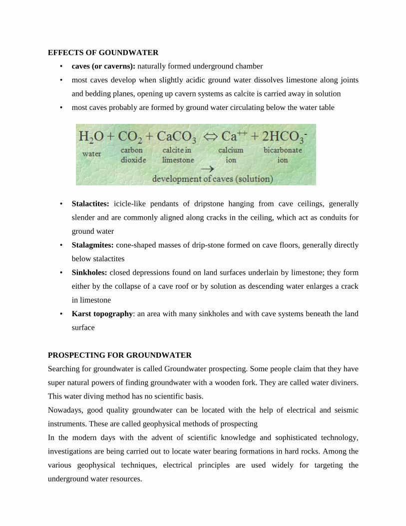
EFFECTS OF GOUNDWATER
• caves (or caverns): naturally formed underground chamber
• most caves develop when slightly acidic ground water dissolves limestone along joints
and bedding planes, opening up cavern systems as calcite is carried away in solution
• most caves probably are formed by ground water circulating below the water table
• Stalactites: icicle-like pendants of dripstone hanging from cave ceilings, generally
slender and are commonly aligned along cracks in the ceiling, which act as conduits for
ground water
• Stalagmites: cone-shaped masses of drip-stone formed on cave floors, generally directly
below stalactites
• Sinkholes: closed depressions found on land surfaces underlain by limestone; they form
either by the collapse of a cave roof or by solution as descending water enlarges a crack
in limestone
• Karst topography: an area with many sinkholes and with cave systems beneath the land
surface
PROSPECTING FOR GROUNDWATER
Searching for groundwater is called Groundwater prospecting. Some people claim that they have
super natural powers of finding groundwater with a wooden fork. They are called water diviners.
This water diving method has no scientific basis.
Nowadays, good quality groundwater can be located with the help of electrical and seismic
instruments. These are called geophysical methods of prospecting
In the modern days with the advent of scientific knowledge and sophisticated technology,
investigations are being carried out to locate water bearing formations in hard rocks. Among the
various geophysical techniques, electrical principles are used widely for targeting the
underground water resources.

In the electrical resistivity method four electrodes are driven down into the flat ground in a
collinear manner. The outer electrodes are designated as current electrodes, since they are
connected to the current measuring system. The inner electrodes are called potential electrodes
and are connected to voltage measuring units. By measuring current and potential it is possible to
estimate the true resistivity of buried rock layers by applying Ohm‟s law.
The resistivity of rocks at various depths can be calculated on the following principle : If
electrodes (generally four) are inserted in the ground and connected in a circuit to a source of
electrical energy, the current will flow from one electrode and pass through the ground, finally
leaving through the other electrode. The depth to which this current penetrates in the ground,
depends upon the distance between the two outer electrodes (it is generally of the order of ¼th
the distance between electrodes). Thus, it is possible to send the current deeper into the ground
by simply increasing the distance between the electrodes.
Resistivity =
32
xx
Current
Voltage
It should be possible to determine the resistivity of the given formation-rocks by measuring the
passing current in the potentiometer circuit; and at different depths, by repeating experiments
with different electrode spacings.
The resistivity is decreasing below 60 m depth and up to 120m depth ; whereas geology
of the area confirms the existence of the same type of rock (say Sandstone) up to this 120 m
depth ; then it easily gives the inference that water, is existing between 60 m and 120 m depth.
Both seismic and resistivity surveys should be made and interpreted by persons who are fully
trained in their work.
Electrical testing done in oil wells, and their recording, called electrical logs or resistivity
logs.