investigating drainage response to the balapur fault
TRANSCRIPT
121
INVESTIGATING DRAINAGE RESPONSE TO THE
BALAPUR FAULT INTERACTION ON THE
NORTHEASTERN PIR PANJAL FLANK, KASHMIR
VALLEY, INDIA
Shabir Ahmad* and M. I. Bhat
Department of Earth Sciences, University of Kashmir, Srinagar-190006 *Correspondence author: [email protected].
ABSTRACT
Soft terrain lithology like Karewa deposits are mostly dominated by the erosional activity
thereby quickly vanish recent fault traces. Kashmir Valley being tectonically active and specially
its west-southwest Karewa dominant terrain, we used geomorphic features chiefly drainage
analysis for indications of active deformation. Drainage anomalies such as sudden drainage
deflections, and stream captures are used to infer zones of remnant and recent tectonic activity.
Though our initial interpretation is based on remote-sensing observations, however, all the
relevant features have been equally verified with field evidences. The study demonstrates the
usefulness of drainage features in exploring the extension of the Balapur fault together with a few
paleoseismic sites for future programme. The exercise can be useful for soft rock terrain in other
deforming parts of the world.
Key words: active tectonics, geomorphic and drainage anomalies, Balapur fault, field mapping,
Kashmir valley
INTRODUCTION
The precise drainage features
predominantly stream capture and
beheaded streams are considered to
identify recently active fault traces
(Schumm, 1977; Bloom, 1979).
Additionally, drainage features are
not only useful tools for
identification of fault traces but their
gross character is evident on
topographic maps and aerial
photographs (Howard, 1967; Kurz et
al., 2007; Gloaguen et al., 2007,
2008). Depending upon various
variables such as relief, slope,
structure, climate and vegetation
characteristics the nature of drainage
pattern can vary greatly from one
type of terrain to another. It can also
provide important clues toward
understanding the Quaternary
tectonic activity of a region at both
regional and local scales
(Goldsworthy and Jackson, 2000).
Thus, an integrated observation from
general landform topography
J. Himalayan Ecol. Sustain. Dev. Vol.8 (2013) ISSN 0973-7502
122
together with the characteristics of
the drainage features of main
channels (e.g., sharp deflections, and
braided bar deposits) and the
behavior of their adjacent tributaries
(e.g., stream captures, beheaded
streams, and stream deflections) can
reveal recent tectonic activity.
Bounding on the east-north
east by the Great Himalaya and west-
south west by the Pir Panjal Ranges,
Kashmir valley is located on the
eastern limb of the Kashmir-Hazara
syntaxial bend (Fig. 1). In tectonic
terms, two well established, parallel,
sequential faults such as Panjal thrust
(=MCT) and Murree thrust (=MBT)
are bounded on its Southwestern end
(Thakur et al., 2010), and Zanskar
thrust on its Northeastern end
(Agrawal and Agrawal, 2005).
Furthermore, several out-of-
sequence faults have been identified
south of Panjal thrust such as Riasi
thrust (RT), Kotli thrust (KT), and
Balakot-Bagh fault (BBF), the latter
was the source of 2005 Mw 7.6
Muzzafarabad earthquake. Kashmir
Valley has been devastated by
earthquakes as suggested by its
historical record (Oldham, 1883;
Jones, 1885; Iyanger and Sharma,
1996; Iyanger et al., 1999;
Ambraseys and Jackson, 2003;
Ahmad et al., 2009) which includes
1555 and 1885 mega events but
which of the faults have produced
these devastated events is yet
unknown. Evidently, a few studies
are available in literature such as
lineament analysis (Ganju and Khar,
1984), observations of southward-
facing fault scarp segments (Yeats et
al., 1992) and severe northward
trajectory deflections in the
tributaries of Jhelum (Bhat et al.,
2008) which are however, devoid of
any field derived data. The
identification of fault begins with a
NW-SE trending reverse Balapur
fault (BF). The fault (BF) was
identified recently in southwest of
the Kashmir Valley (Ahmad, 2010)
and later confirmed by paleoseismic
trench study (Madden et al., 2010),
substantiated by other studies
(Madden et al., 2011; Ahmad and
Bhat, 2012; Ahmad et al., 2013).
Thus, the present study examines
drainage characteristics of a segment
of the Balapur fault interaction in the
west-southwest of the Kashmir
Valley (Fig. 1).
J. Himalayan Ecol. Sustain. Dev. Vol.8 (2013) ISSN 0973-7502
123
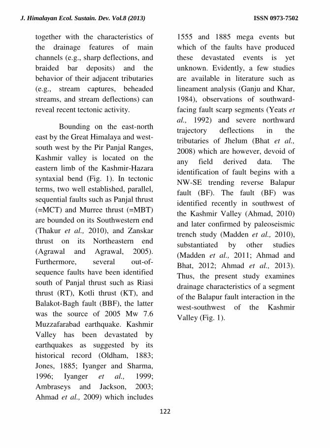
Fig. 1. Showing Kashmir and its adjoining major Himalayan structures. The figure is a
SRTM-90m base; sequential mapped faults (MCT, MBT and HFT) and some out-of-sequence
faults (RT, KT and BBF) are adapted from Thakur et al., (2010). Mapped MMT is adapted from
Hussain et al., (2009). Little is known in Kashmir Valley faults where field, trench and terrace
deformation studies (Ahmad, 2010, Madden et al., 2010; Madden et al., 2011; Ahmad and Bhat,
2012; Ahmad et al., 2013) depict northeast dipping Balapur fault (BF) together with two inferred
faults (shown as dashed lines). KV = Kashmir Valley; MCT = Main Central thrust; MBT = Main
Boundary thrust; HFT = Himalayan Frontal thrust; MMT = Main Mantle thrust; BBF = Balakot-
Bagh fault; RT = Riasi Thrust; KT = Kotli thrust BF = Balapur fault.
J. Himalayan Ecol. Sustain. Dev. Vol.8 (2013) ISSN 0973-7502
124
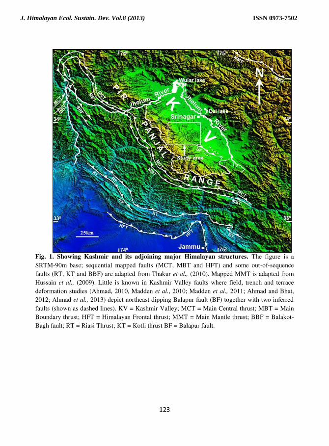
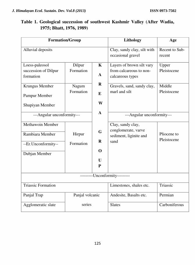
Geological Setting
The exposed bedrock and
surficial units in and around the
study area are shown in Figure 2 and
the stratigraphic succession is given
in Table 1. The oldest rocks exposed
in the upper reaches of the study area
are Panjal Volcanic Series
(Middlemiss, 1910) (Upper
Carboniferous-Permian) and Triassic
limestone together with some
basement inliers. However, most of
the area is covered by fluvioglacial
sediments, collectively known as the
Karewas or wudr in Kashmiri dialect
(Plio-Pleistocene), which has been
assigned group status (Farooqi and
Desai, 1974; Bhatt, 1989). These
consist of unconsolidated clays,
sands, and conglomerates with
lignite beds unconformably lying on
the bedrock and are overlain by the
recent river alluvium (Bhatt, 1975,
1976; Wadia, 1975; Burbank and
Johnson, 1982; Singh, 1982). The
Karewa Group has been subdivided
into the progressively younger
Hirpur, Nagum, and Dilpur
Formations, respectively (Bhatt,
1989).
Fig. 2. Geological Formations of the part of Northeastern Pir Panjal Range
(modified after Middlemiss, 1911; Bhatt, 1989)
J. Himalayan Ecol. Sustain. Dev. Vol.8 (2013) ISSN 0973-7502
125
Table 1. Geological succession of southwest Kashmir Valley (After Wadia,
1975; Bhatt, 1976, 1989)
Formation/Group Lithology Age
Alluvial deposits Clay, sandy clay, silt with
occasional gravel
Recent to Sub-
recent
Loess-paleosol
succession of Dilpur
formation
Dilpur
Formation
K
A
R
E
W
A
G
R
O
U
P
Layers of brown silt vary
from calcareous to non-
calcareous types
Upper
Pleistocene
Krungus Member
Pampur Member
Shupiyan Member
Nagum
Formation
Gravels, sand, sandy clay,
marl and silt
Middle
Pleistocene
---Angular unconformity--- ---Angular unconformity---
Methawoin Member
Hirpur
Formation
Clay, sandy clay,
conglomerate, varve
sediment, liginite and
sand
Pliocene to
Pleistocene
Rambiara Member
--Er.Unconformity--
Dubjan Member
---------Unconformity---------
Triassic Formation Limestones, shales etc. Triassic
Panjal Trap Panjal volcanic
series
Andesite, Basalts etc. Permian
Agglomeratic slate Slates Carboniferous
J. Himalayan Ecol. Sustain. Dev. Vol.8 (2013) ISSN 0973-7502
126
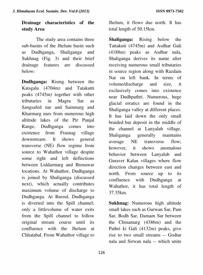
Drainage characteristics of the
study Area
The study area contains three
sub-basins of the Jhelum basin such
as Dudhganga, Shaliganga and
Sukhnag (Fig. 3) and their brief
drainage features are discussed
below:
Dudhganga: Rising between the
Katsgalu (4704m) and Tatakutti
peaks (4745m) together with other
tributaries in Magru Sar as
Sangsafed nar and Sainmarg and
Kharmarg nars from numerous high
altitude lakes of the Pir Panjal
Range, Dudhganga comes into
existence from Frasnag village
downstream. It shows general
transverse (NE) flow regime from
source to Wahathor village despite
some right and left deflections
between Liddarmarg and Brenawar
locations. At Wahathor, Dudhganga
is joined by Shaliganga (discussed
next), which actually contributes
maximum volume of discharge to
Dudhganga. At Barzul, Dudhganga
is diverted into the Spill channel;
only a littlevolume of water exits
from the Spill channel to follow
original stream course until its
confluence with the Jhelum at
Chhatabal. From Wahathor village to
Jhelum, it flows due north. It has
total length of 50.15km.
Shaliganga: Rising below the
Tattakuti (4745m) and Asdhar Gali
(4188m) peaks as Asdhar nala,
Shaliganga derives its name after
receiving numerous small tributaries
in source region along with Razdain
Nar on left bank. In terms of
volume/discharge and size, it
exclusively comes into existence
near Dudhpathri. Numerous, huge
glacial erratics are found in the
Shaliganga valley at different places.
It has laid down the only small
braided bar deposit in the middle of
the channel at Lanyalab village.
Shaliganga generally maintains
average NE transverse flow;
however, it shows anomalous
behavior between Lanyalab and
Guravet Kalan villages where flow
direction changes between east and
north. From source up to its
confluence with Dudhganga at
Wahathor, it has total length of
37.35km.
Sukhnag: Numerous high altitude
small lakes such as Gurwan Sar, Pam
Sar, Bodh Sar, Damam Sar between
the Chinamarg (4386m) and the
Pathri ki Gali (4132m) peaks, give
rise to two small streams -- Godtar
nala and Sirwan nala -- which unite
J. Himalayan Ecol. Sustain. Dev. Vol.8 (2013) ISSN 0973-7502
127
on the southern side of Zugu
Kharyan forest region to form a
sizable stream known as Sukhnag.
Besides, several tiny streams north of
Tosh maidan to Sugan forest region
directly joining Sukhnag. While
descending from the northeastern Pir
Panjal Range at Tosh maidan it
passes through a sand choked plain
across the Karewa terrain only to
strike against Triassic limestone
outcrop at Guripur village to Qasba
Biru and to assume a narrow course.
It shows a significant anomalous
flow regime among all the three
streams. It disappears in marshes of
Rakh Aral, west of Hokarsar. It has
total length of 87.15km.
Fig. 3. Showing drainage characteristics of the study area. Solid and dashed
lines reflect hard rock, distinct and soft rock, indistinct sub-basin
boundaries. Notice the drainage pattern changes its look once the
streams enter soft rock or Karewa terrain
J. Himalayan Ecol. Sustain. Dev. Vol.8 (2013) ISSN 0973-7502

128
MATERIAL AND METHODS
At the initial stage, we
conducted a systematic survey to
compile the existing information
related to the Balapur fault (Ahmad,
2010; Madden et al., 2010; Madden
et al., 2011; Ahmad and Bhat, 2012;
Ahmad et al., 2013) and other fault
relevant studies in the area (Ganju
and Khar, 1984; Yeats et al., 1992;
Bhat et al., 2008). After compiling
the relevant information from
published literature we subsequently,
consult topographic maps derived
from Survey of India (SoI) 1:50,000
scales followed by 90m resolution
DEM derived from SRTM (Shuttle
Radar Topographic Mission) with
the help of software ‗Global Mapper‘ to finalize the interaction of recent
Balapur fault traces using drainage
signatures together with field
observations.
RESULTS AND DISCUSSION
To specifically notice
drainage interaction (e.g., streams
captures, beheaded streams, sharp
drainage deflections etc.) along the
strike of the Balapur fault, we
analyze one of its segment from
Kelar village, runs through Yusmarg
to Takibal village and covers parts of
Romushi, Dudhganga, Shaliganga
basins and Sukhnag basins (Fig. 4).
Fig. 4. Drainage features of the study area along the strike of the Balapur fault
J. Himalayan Ecol. Sustain. Dev. Vol.8 (2013) ISSN 0973-7502
129
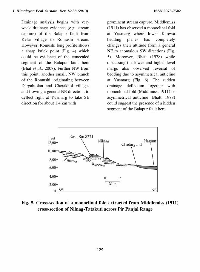
Drainage analysis begins with very
weak drainage evidence (e.g. stream
capture) of the Balapur fault from
Kelar village to Romushi stream.
However, Romushi long profile shows
a sharp knick point (Fig. 4) which
could be evidence of the concealed
segment of the Balapur fault here
(Bhat et al., 2008). Further NW from
this point, another small, NW branch
of the Romushi, originating between
Dargahtolan and Cherakhol villages
and flowing a general NE direction, to
deflect right at Yusmarg to take SE
direction for about 1.4 km with
prominent stream capture. Middlemiss
(1911) has observed a monoclinal fold
at Yusmarg where lower Karewa
bedding planes has completely
changes their attitude from a general
NE to anomalous SW directions (Fig.
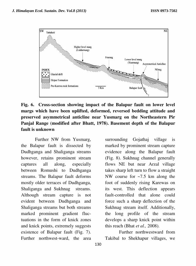
5). Moreover, Bhatt (1978) while
discussing the lower and higher level
margs also observed reversal of
bedding due to asymmetrical anticline
at Yusmarg (Fig. 6). The sudden
drainage deflection together with
monoclonal fold (Middlmiss, 1911) or
asymmetrical anticline (Bhatt, 1978)
could suggest the presence of a hidden
segment of the Balapur fault here.
Fig. 5. Cross-section of a monoclinal fold extracted from Middlemiss (1911)
cross-section of Nilnag-Tatakuti across Pir Panjal Range
J. Himalayan Ecol. Sustain. Dev. Vol.8 (2013) ISSN 0973-7502
130
Fig. 6. Cross-section showing impact of the Balapur fault on lower level
margs which have been uplifted, deformed, reversed bedding attitude and
preserved asymmetrical anticline near Yusmarg on the Northeastern Pir
Panjal Range (modified after Bhatt, 1978). Basement depth of the Balapur
fault is unknown
Further NW from Yusmarg,
the Balapur fault is dissected by
Dudhganga and Shaliganga streams
however, retains prominent stream
captures all along, especially
between Romushi to Dudhganga
streams. The Balapur fault deforms
mostly older terraces of Dudhganga,
Shaliganga and Sukhnag streams.
Although stream capture is not
evident between Dudhganga and
Shaliganga streams but both streams
marked prominent gradient fluc-
tuations in the form of knick zones
and knick points, extremely suggests
existence of Balapur fault (Fig. 7).
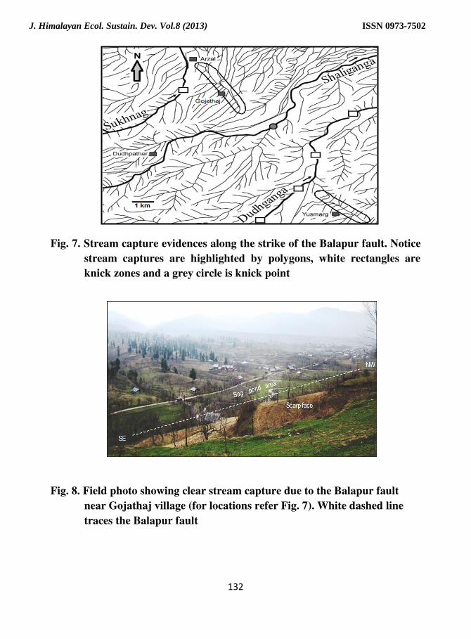
Further northwest-ward, the area
surrounding Gojathaj village is
marked by prominent stream capture
evidence along the Balapur fault
(Fig. 8). Sukhnag channel generally
flows NE but near Arzal village
takes sharp left turn to flow a straight
NW course for ~7.5 km along the
foot of suddenly rising Karewas on
its west. This deflection appears
fault-controlled that alone could
force such a sharp deflection of the
Sukhnag stream itself. Additionally,
the long profile of the stream
develops a sharp knick point within
this reach (Bhat et al., 2008).
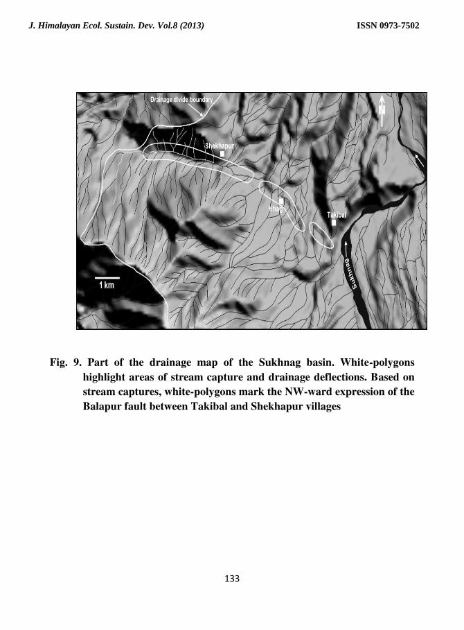
Further northwestward from
Takibal to Shekhapur villages, we
J. Himalayan Ecol. Sustain. Dev. Vol.8 (2013) ISSN 0973-7502
131
notice stream captures (Fig. 9),
drainage deflections, alignment of
some springs, and attitude of beds
(i.e. SW dipping) all support the
existence of the Balapur fault in this
segment.
The Balapur fault is
associated with a 0.7km long
asymmetrical anticlinical fold and is
exposed on the left bank of
Rambiara. The fault is sub-vertical
with an average dip of 60o NE. Close
to the fault, the bedding dip
measures 40-45o SW; however, away
from the fault the amount of dip
decreases immediately until it is just
5o NE at the northeastern end of the
anticline. On the basis of structural
data such as dip and/strike of
bedding planes, similar fault-
associated anticlines mostly asym-
metrical in nature are observed in the
field along the strike of the Balapur
fault on the banks of the
several streams, like Veshav near
Kulgam, Sasara near Manshiwor,
Romushi near Abhom, Shaliganga
near Lanyalab and Sukhnag near
Gurpur village. However, unlike in
the Rambiara asymmetrical anti-
clinical fold area, intense agricultural
activity and/or plantation has masked
stratigraphic cross-section of fault of
all the latter asymmetrical fold
structures.
Field investigations also
reveal numerous evidences along the
strike of Balapur fault where Karewa
terrace deposits have been clearly
deformed in latest by Quaternary and
these locations would certainly
provide suitable stratigraphic rela-
tions for paleoseismic analysis
especially nearby Lanyalab (locally
called Wusan Wudar) and Gojathaj
villages.
J. Himalayan Ecol. Sustain. Dev. Vol.8 (2013) ISSN 0973-7502
132
Fig. 7. Stream capture evidences along the strike of the Balapur fault. Notice
stream captures are highlighted by polygons, white rectangles are
knick zones and a grey circle is knick point
Fig. 8. Field photo showing clear stream capture due to the Balapur fault
near Gojathaj village (for locations refer Fig. 7). White dashed line
traces the Balapur fault
J. Himalayan Ecol. Sustain. Dev. Vol.8 (2013) ISSN 0973-7502
133
Fig. 9. Part of the drainage map of the Sukhnag basin. White-polygons
highlight areas of stream capture and drainage deflections. Based on
stream captures, white-polygons mark the NW-ward expression of the
Balapur fault between Takibal and Shekhapur villages
J. Himalayan Ecol. Sustain. Dev. Vol.8 (2013) ISSN 0973-7502
134
CONCLUSIONS
The soft rock terrains such as
Karewas are exceptionally domin-
ated by the erosional activity as a
result, wiping of recent faults traces.
However, recent fault traces can be
revealed through geomorphic feat-
ures specifically by drainage anal-
ysis. To decipher active deformation
along an unknown segment of the
Balapur fault, we accordingly, emp-
loy the technique on the dominant
soft rock Karewa terrain in west-
southwest side of the Kashmir
Valley. Drainage anomalies such as
sudden drainage deflections, and
stream captures are used to infer
zones of remnant and recent tectonic
activity. Though our initial int-
erpretation is based on remote-
sensing observations, however, all
the relevant features have been
equally verified with field evidences.
The study demonstrates the
usefulness of drainage features in
exploring the extension of the
Balapur fault together with a few
paleoseismic sites for future
program. The exercise can be useful
for soft rock terrain in other
deforming parts of the world.
ACKNOWLEDGEMENT
We are thankful to department of
earth sciences for providing
necessary laboratory facilities.
REFERENCES
Ahmad, B., Bhat, M. I. and Bali, B.
S. 2009. Historical record of
Earthquakes in the Kashmir
valley. Himalayan Geology,
30 (1): 75-84.
Ahmad, S. 2010. Tectonic
Geomorphology of the
Rambiara basin, southwest
Kashmir Valley. Unpublished
M. Phil Thesis, University of
Kashmir, Srinagar.
Ahmad, S. and Bhat, M. I. 2012.
Tectonic geomorphology of
the Rambiara basin, SW
Kashmir Valley reveals eme-
rgent out-of-sequence active
fault system. Himalayan
Geology, 33(2): 162-172.
Ahmad, S., Bhat, M. I. Madden, C.
and Bali, B. S. 2013.
Geomorphic analysis reveals
active tectonic deformation
on the eastern flank of the Pir
Panjal Range, Kashmir
Valley, India. Arabian
Journal of Geosciences, DOI
10.1007/s12517-013-0900-y
Agarwal, K. K. and Agrawal, G. K.
2005. A genetic model of
thrust bounded intermontane
basin using scaled sandbox
analogue models: an example
from the Karewa Basin,
J. Himalayan Ecol. Sustain. Dev. Vol.8 (2013) ISSN 0973-7502
135
Kashmir Himalayas, India.
International Journal of
Earth Science, 94(1): 47–52.
Ambraseys, N. and Jackson, D.
2003. A note on early
earthquakes in northern India
and Southern Tibet. Current
Science, 84: 540-582.
Bhatt, D. K. 1975. On the
Quaternary geology of the
Kashmir valley with special
reference to stratigraphy and
sedimentation. Geological
Survey of India, Misc Pub.,
24 (1): 188-203.
Bhatt, D. K. 1976. Stratigraphical
status of Karewa Group of
Kashmir, India. Himalayan
Geology, 6: 197-208.
Bhatt, D. K. 1978. Geological
observations of the margs of
Kashmir Valley, India.
Himalayan Geo1ogy, 8:769-
783.
Bhatt, D. K. 1989. Lithostratigraphy
of the Karewa Group,
Kashmir valley, India and a
critical review of its fossil
record. Geological Survey of
India, Mem, 122: 1-85.
Bhat, M. I., Malik, M. A. and Bali,
B. S. 2008. Tectonic
Geomorphology of the Pir
Panjal range. Workshop on
October 8, 2005 Kashmir
Earthquake and After. Jam
Univ: 39-42.
Bloom, A. L. 1979. Geomorphology.
Prentice-Hall Pvt. Ltd.,
India, New Delhi.
Burbank, D. W. and Johnson, G. D.
1982. Intermontane-basin de-
velopment in the past 4 Myr
in the north-west Himalaya.
Nature, 298: 432-436.
Farooqi, I. A. and Desai, R. N. 1974.
Stratigraphy of Karewas,
India. Journal of Geological
Survey of India, 15(3): 299-
305.
Ganju, J. L. and Khar, B. B. 1984.
Tectonics and hydrocarbon
prospects of Kashmir valley –
possible exploratory targets.
Petroleum Asia Journal, 4:
207-216.
Gloaguen, R., Marpu, P. R. and
Niemeyer, I. 2007. Automatic
extraction of faults and
fractal analysis from remote
sensing data. Nonlinear Pro-
cesses in Geophysics 14 (2):
131–138.
Gloaguen, R., Kaessner, A., Wobbe,
F., Shahzad, F. and
Mahmood, S. A. 2008.
J. Himalayan Ecol. Sustain. Dev. Vol.8 (2013) ISSN 0973-7502
136
Remote sensing analysis of
crustal deformation using
river networks. In: IEEE
International Geosciences
and Remote Sensing Sym-
posium, Boston, USA, pp.
IV-1–IV-4.
Goldsworthy, M. and Jackson, J.
2000. Active normal fault
evolution in Greece revealed
by geomorphology and drai-
nage pattern. Journal of
Geological Society of Lond-
on, 157: 967-981.
Howard, A. D. 1967. Drainage
analysis in geologic inter-
pretation, a summation.
American Association of Pe-
troleum Geology, 51: 2246-
2259.
Hussain, A. Yeats, R. S. and
MonaLisa. 2009. Geological
setting of the 8th October,
2005 Kashmir 518 earth-
quake. Journal of Seism-
ology, 13(3): 15-325.
Iyenger, R. N., and Sharma, D. 1996.
Some earthquakes of Kash-
mir from historical sources.
Current Science, 71: 330-
331.
Iyenger, R. N., Sharma, D. and
Siddiqui, J. M. 1999.
Earthquake history of India in
Medieval times. Indian
Journal of History of Science,
34(3): 181-237.
Jones, E. J. 1885. Notes on the
Kashmir earthquake of 30th
May 1885. Records, Geolo-
gical Survey of India, 18:
153-156.
Kurz, T. Gloaguen, R., Ebinger, C.,
Casey, M. and Abebe, B.
2007. Deformation distri-
bution and type in the Main
Ethiopian Rift (MER): a
remote sensing study. Jour
Afr E Sc 48 (2–3): 100–114.
Madden, C., Trench, D. Meigs, A.,
Ahmad, S., Bhat, M. I. and
Yule, J. D. 2010. Late
Quaternary Shortening and
Earthquake Chronology of an
Active Fault in the Kashmir
Basin, Northwest Himalaya.
Seismological Research Lett-
ers, 81(2): p. 346.
Madden, C., Ahmad, S. and Meigs,
A. 2011. Geomorphic and
paleoseismic evidence for
late Quaternary deformation
in the southwest Kashmir
Valley, India: Out-of-
sequence thrusting, or defo-
rmation above a structural
ramp? (Abstract-ID T54B--
J. Himalayan Ecol. Sustain. Dev. Vol.8 (2013) ISSN 0973-7502

137
07) American Geophysical
Union Fall Meeting.
Middlemiss, C. S. 1910. A revise of
the Silurian-Trias sequence in
Kashmir. Geological Survey
of India, Records, 40: 206-
260.
Middlemiss, C. S. 1911. Sections in
Pir Panjal and Sindh valley,
Kashmir. Geological Survey
of India, Records, 41(2): 115-
144.
Oldham, T. 1883. A Catalogue of
Indian earthquakes. In:
Oldham RD (ed), Memoir,
Geological Survey of India,
19: 163-215.
Schumm, S. A. 1977. The Fluvial
System. John Wiley, New
York, pp 338.
Singh, I. B. 1982. Sedimentation
pattern in the Karewa basin,
Kashmir valley, India and its
geological signific-ance.
Journal of Palaeontological
Society of India, 27: 71-110.
Thakur, V. C. Jayangondaperumal,
R. and Malik, M. A. 2010.
Redefining Medlicott–Wadia's main boundary fault
from Jhelum to Yamuna: An
active fault strand of the main
boundary thrust in northwest
Himalaya. Tectonophysics,
DOI: 10.1016/j.tecto. Cited
14 Mar 2010.
Wadia, D. N. 1975. Geology of
India. 4th edition, Tenth
reprint, Tata McGraw-Hill,
New Delhi.
Yeats, R. S., Nakata, T., Farah, A.,
Fort, M., Mizra, M. A.,
Pandey, M. R. and Stein, R.
S. 1992. The Himalayan
frontal fault system. Annales
Tectonicae, 6: 85-98.
J. Himalayan Ecol. Sustain. Dev. Vol.8 (2013) ISSN 0973-7502