investigating the potential of modern geo-info
TRANSCRIPT

INVESTIGATING THE POTENTIAL OF MODERN GEO-INFO TECHNOLOGIES IN PLANNING URBAN COMMUNITY SETTLEMENTS
The Case of Nairobi Peri-Urban Settlements
BY
ANDREW THIAINE IMWATI
B.SC. (HONS), SURVEYING & PHOTOGRAMMETRY; M. ENG., LAND INFORMATION MANAGEMENT; MISK; MKIP
A thesis submitted in partial fulfillment of the requirements for the Degree of Doctor of Philosophy in Urban and Regional Planning
University of NAIROBI Library
UNIVERSITY OF NAIROBI
School of The Built Environment
July, 2010.

Declaration
This PhD thesis is my original work and has not been presented for a degree in any other University.
Signed Date ...:? it?. 1 Q.
ANDREW THIAINE IMWATI (Candidate)
This thesis has been submitted for examination with our approval as University Supervisors.
Signed
PROF. PETER M. NGAU(Lead Supervisor)
PROF. GALCANO C. MULAKU (Supervisor)
DateSri
Date__ . . . . . . 7 ^ . __
Signed Date ' l • \ o ■
PROF. GEORGE N. NGUGI (Supervisor)

Dedication
This thesis is partly dedicated to my parents - Joel Imwati, a believer in the power of wisdom and
knowledge, and Joyce Imwati, a believer in self-determination and hard work, the two doctrines
that have helped to shape and continue to guide my life; and partly to my beloved family - wife
Hellen K. Thiaine, and children; Dennis Kairithia, Faith Kamathi, Chris Mwenda and Betty
Kanario, for their steadfast encouragement and moral support as I struggled with this PhD
project.
11

Acknowledgem ents
It takes determination and perseverance in addition to academic and professional acumen for one to successfully undertake a challenging project such as writing a PhD thesis of this nature. It would also have been impossible to complete the task of writing the thesis without the support and encouragement o f my tutors, concerned friends and relatives, some of whose input has helped to shape the thesis. Circumstances allows for the mention of only a few of the many persons who deserve special acknowledgement and appreciation.
Firstly, my sincere gratitude goes to my supervisors; Prof. P. Ngau, Prof. G. Mulaku and Prof. G. Ngugi, of the University of Nairobi, without whose guidance, advice and support, this study would not have been successfully completed.
Secondly my sincere appreciation goes to all the academic staff and fellow students of the Department of Urban and Regional Planning (DURP) in the School of the Built Environment and the University in general, all who contributed and/or participated in various ways in this research.
Thirdly, thanks go to my research assistants, Kennedy Mutuku, Moses Orege and David Mwiti who helped in data collection, processing, graphics and general thesis compilation. I am also indebted to Douglas Musiega, for proof-reading the initial draft o f this thesis.
This thesis has been undertaken through a scholarship given by the Government of Kenya to which I am truly indebted.
Last but not least, my sincere acknowledgement and appreciation goes to all those individuals not mentioned above, of which I say; “THANKS AND GOD BLESS THEM ALL”.
in

Abstract
For many years, planners and urban development managers in Third World countries have endeavored to respond to the challenges posed by the phenomenal urbanization trends, but with limited success. The main limitations to planning and management efforts are attributable to the inadequacies of the existing national land use policies, institutional and technical frameworks, mapping and planning systems and approaches. Additionally, the apparent exclusion of the affected community citizens and other stakeholders, of the present day era of democratic information-age society, has further played a major role to ineffectiveness in planning and managing urban settlements of most third world cities, such as Nairobi, Kenya.
In view of the prevailing urbanization trends and challenges therefore, the main purpose of this study is to investigate the potential of modem digital geo-information technologies (GITs) as alternatives for effective development planning and management o f rapidly growing urban settlements as opposed to conventionally used cadastral-based geo-systems and planning approaches. The geo-information systems include; Remote Sensing technology (RS), Global Positioning Systems (GPS), Geographic Information Systems (GIS) and the Internet. Further, the study particularly explores the potential of GITs integration with community-based participatory planning and management of rapidly growing urban settlements.
Firstly, the research provides an overview of the theoretical concepts that appertains to the study subject matter (Chapter Two). Secondly a brief analytical review of related literature is given, which initially includes an overview of the current urbanization trends and challenges at global, regional and local perspectives (Chapter Three). Thirdly the mapping, development planning and management needs, problems and requirements in Kenya’s urban areas in general, and Nairobi City in particular are examined. Using a case study of a typical peri-urban settlement of Mlolongo, a satellite o f Nairobi, spatial development problems are closely studied (Chapter Four). Fourthly, in an attempt to seek diverse views regarding the research problem and concerns, a questionnaire interview instrument is used in soliciting alternative opinions from a spectrum of stakeholders and actors (Chapter Five).
Chapter Six demonstrates the potential of modem GITs vis-a-vis traditionally used cadastral- based mapping / planning techniques in terms of; cost-effectiveness and efficiency, accuracy acceptability, multi-user applicability, and enhancement of public participation in development planning, management and governance of urban community settlements. Finally, Chapter Seven provides the summary, conclusions and recommendations as drawn from the research results and study findings
IV

TABLE OF CONTENTSPage
Declaration................................................................................................ i
Dedication...................................................................................................... ii
Acknowledgements ..................................................................................... iii
Abstract......................................................................................................................
Table of Contents.......................................................................................... v
List o f Figures.......................................................................................................... ix
List o f Plates............................................................................................................... x
List of Tables................................................................................................ xi
List of Abbreviations.................................................................................. xii
Chapter One: INTRODUCTION............................................. 1
1.1. Introduction and Background to the Study............................... 1
1.2. Statement of the Research Problem 2
1.3. Research Questions....................................................................... 3
1.4. Research Objectives...................................................................... 3
1.5. Research Hypothesis..................................................................... 4
1.6. Study Justification andContribution............................................. 4
1.7. Research Methodology................................................................. 5
1.7.1. Data Sources and Collection Techniques..................................... 5
1.7.2. Study Population and Sampling Techniques........................... 6
1.7.3. Data Analysis and Results Presentation Techniques........... 6
1.7.4. Study Area Definition................................................................ 7
1.7.5. Field Surveys and Questionnaire Interviews............................. 10
1.7. 6. Research Outline and Process...................................................... 13
1.8. Definition of Operational Terms and Concepts.......................... 16v

Chapter Two: CONCEPTUAL AND THEORETICALFRAMEWORK............................................... 19
2.1. Introduction.................................................................................. 19
2.2. Contemporary Planning Concepts and Approaches.................... 19
2.2.1. Strategic Versus Participatory Planning Approaches................. 24
2.2.2. Best Practice to Planning Modem Urban Communities............. 25
2.3. Spatial Planning, Geo-Data Needs and Requirements............... 26
2.4. Geo - Spatial Data Acquisition Systems and Techniques......... 28
2.4.1. Conventional Cadastral-based Geo-dataAcquisition Techniques....................................................... 29
2.4.2. Modem Geo-data Acquisition Systems and Techniques.......... 32
2.5. Conceptual and Theoretical Analysis......................................... 39
2.6. Role of GITs in Enhancing Public Participation....................... 41
2.6.1. Conceptual Community-based GIS Development................... 41
2.6.2. Considerations in Developing CommunityGIS-based Module................................................................... 44
2.6.3. Conceptual Community GIS Development Strategy................. 44
Chapter Three: LITERATURE REVIEW........................ 48
3.1. Introduction...................................................................................... 48
3.2. Current Urbanization Trends, Concerns and Challenges:A Global, Regional and Local Perspective................................... 49
3.2.1. Urbanization Challenges in Third World Countries........... ... 51
3.2.2. Emergence and Spatial Development of Peri-urbanSettlement Zone............................................................................ 52
3.2.3. Urbanization Trends and Challenges in Kenya................... ... 53
3.3. Spatial Planning and Mapping Process in Kenya................... 57
3.3.1. The Physical Planning Act, Cap. 286 (Rev. 1996)........................ 58VI

3.3.2. The Survey Act, Cap 299 ( Rev. 1989)........................................ 59
3.4. Evolving Role of Geo-Info Technology in SpatialPlanning....................................................................................... 62
3.4.1. Recent Studies on Potential Use and Application of ModemGITs.............................................................................................. 66
3.4.2. Integration of Modem GITs with Community Participation......... 68
Chapter Four: THE STUDY AREA BACKGROUNDAND SETTING................................................ 74
4.1. Introduction................................................................................... 24
4.2. Development and Planning Needs for NairobiPeri-urban Settlements................................................................... 74
4.2.1. Spatial Development Concerns for Nairobi Metropolitan........... 75
4.2.2. Need for a Comprehensive Geo- Spatial Frameworkfor the NMR................................................................................ 76
4.3. The Case Study of Mlolongo Settlement...................................... 79
4.3.1. Location and Spatial Development ofMlolongo Settlement..................................................................... 79
4.3.2. Origin of Mlolongo Settlement..................................................... 82
4.3.3. Spatial Development and Land Use Patterns of Mlolongo........... 83
4.3.4. Physical and Socio-economic Development Dynamicsand Attributes................................................................................ 90
4.3.5. Infrastructural and Social Amenities Needs and Requirements... 92
4.3.6. Demographic and Socio-economic Development Trends............ 96
4.3.7. Environmental Implications and Concerns................................... 97
4.4. Consequences of Ignorance to Planning Guidelines................... 98
vii

Chapter Five: FINDINGS FROM FIELD SURVEYSAND INTERVIEWS....................................... 102
5.1. Introduction...................................................................................... 102
5.2. Urban Planning and Mapping Requirements in Kenya.................... 102
5.2.1. Status of the Existing Mapping Geo-data Resource-base................ 103
5.2.2. Recent Mapping / Planning Initiatives byVarious Local Authorities............................................................... 107
5.3. Questionnaire Interview Findings and Analysis................................ 109
5.3.1. Findings from Land Officials and Experts....................................... 109
5.3.2. Findings from Local Residents and Leaders of Mlolongo............. 116
5.4. Post Research Assessment on the Current Situation...................... 121
Chapter Six: POTENTIAL OF MODERN GITS INPLANNING / MAPPING URBAN SETTLEMENTS................................................. 123
6.1. Introduction........................................................................................ 123
6.2. Conventional Cadastral-based Vs Modem GITs Techniques......... 123
6.2.1. Conventional Planning / Mapping Process in Kenya...................... 123
6.2.2. Proposed Alternative Modem GITs-based Planningand Mapping Process.................................................................... 125
6.3. Comparative Empirical Analysis..................................................... 127
6.3.1. Cost-effectiveness and Efficiency of GITs...................................... 127
6.3.2. Accuracy Acceptability of GITs Data............................................. 129
6.3.3. Potential of Modem GITs for Rapid Planning................................ 138
6.3.4. Potential of GITs in EnhancingCommunity Participation............................................................... 141
6.4. Locally Available GITs-Spatial Data Resources......................... 146
V lll

Chapter Seven: SUMMARY, CONCLUSIONS ANDRECOMMENDATIONS.............................. 147
7 i Study Summary and Conclusions.................................................. 147
7.1.1. Summary........................................................................................ 147
7.1.2. Conclusions.................................................................................... 150
7.2. Recommendations.,........................................................................ 150
7.2.1. Suggestions for Further Research.................................................. 151
7.2.2. Study Limitations and Achievements............................................. 152
IX

list of figures
Fig. 1.1. Map of Kenya Showing Study Area Setting andLocation of Nairobi City........................................................... 8
Fig. 1.2. Rapidly Growing Peri-urban Settlements of Nairobi(Study Area)............................................................................... 9
Fig. 1.3. Summary of Research Outline andProcess...................................................................................... 15
Fig. 2.1. Systematic Planning Approach.................................................. 21Fig.2.2. Conflict Resolution Planning Approach..................................... 22Fig. 2.3. Participative Planning Approach............................................... 23Fig. 2. 4. Orthogonal Plane (x, y, z) Coordinate System....................... 30Fig. 2.5. Example of Cadastral Survey Map (Vector Coordinate
Data).......................................................................................... 31Fig. 2. 6. A Typical Hand-held GPS Set................................................. 35Fig. 2.7. Components of a Simple Desk-Top GIS Module................... 37Fig. 2.8. Multi-data Source and Contents in a Modem GIS Data
Base.......................................................................................... 38Fig. 2.9. GISs Types and Development Hierarchy................................. 43Fig. 2.10. Community GIS Versus Higher Order GISs......................... 43Fig. 2.11. Community-based GIS Development Strategy..................... 47Fig. 3.1. Current Urban Development Scenario in Developing
Countries.................................................................................. 65Fig. 3.2. Public Participation Ladder..................................................... 72Fig.3.3. Participatory Community GIS Module Development
Approach.................................................................................... 73Fig. 4.1. Proposed Nairobi Metropolitan Region Districts..................... 77Fig. 4.2. Location of Mlolongo in Machakos District............................ 80Fig. 4.3. Location of Mlolongo Township with Respect to
Nairobi City Boundary............................................................ 81Fig.4.4. Structural Plan for Road Expansion at Mlolongo
Township.................................................................................. 99Fig. 5.1. Aerial-photo Mapping Coverage of Nairobi by
ICA Project.......................................................................... 108Fig. 6.1. Conventional Cadastral - based Mapping and
Planning Process................................................................. 124Fig. 6.2. Alternative Modem GITs-based Mapping / Planning
Process................................................................................... 126Fig. 6.3. Five Coordinate Points on Cadastral Map of within the
Study Site............................................................................... 135Fig. 6.4. Model Development Plan Layout for Mlolongo................. 140
x

list of tables
Table 1.1. Land Officials, Experts and ProfessionalsInterview category.................................................................. 12
Table 1.2. Local Residents and Leaders Interview Category.................... 12Table 2.1. Planning Data Types and Requirements.................................. 28Table. 2.2. Traditional LIS and Modem GIS Data
Contents / Scope.................................................................... 36Table 2.3. Conventional Vs Non-conventional
Planning Approaches............................................................. 40Table 2.4. Analytical Comparative Matrix.............................................. 40Table 5.1. Topo-Maps; At Varying Contours Vertical Intervals............. 104Table 5.2. Township Maps and Plans...................................................... 105Table 5.3. Topo-Cadastral Maps and Plans............................................. 105Table. 5.4. Status of the Existing Geo-data Base in City Hall................ 106Table. 5.5. Level of Geo-data Needs by Various City Departments...... 107Table 5.6. Regarding Challenges posed by Current Urbanization........ 110Table 5.7. Regarding Planning data needs and Requirements............... I l lTable 5.8. Regarding Land Use Planning and
Management Process............................................................... 112Table 5.9. Regarding Local Use of Modem GITs................................. 114Table 5.10. Training Levels and Output Capacity by
Local Institutions............................................................... 115Table 5.11. Need for Community Involvement..................................... 116Table 5.12. Regarding Planning and Management
Problems and Needs............................................................. 117Table 5.13. Public Awarenes^on Technical Planning Processes........... 118Table 5.14. Security of Land Tenure and Use......................................... 119Table 5.15. Responses on Community Involvement in
Planning and Management................................................... 120Table. 6.1 .Cost Estimate of Conventional Planning / Mapping
of 1000 Plots........................................................................... 128Table 6.2. Cost Estimates of GITs-based Mapping / Planning
of 1000 Plots......................................................................... 128Table 6.3. Chain and Image (scaled) Distance
Accuracy Comparison........................................................... 131Table 6.4. Chain and Image Area Accuracy Comparison........................ 132Table. 6.5. GIS Image Map and Cadastral Map
Coordinates Comparison.......................................................... 133
XI

Table 6.6. GPS and Cadastral Map CoordinatesAccuracy Comparison.............................................................. 133
Table 6.7. SOK PID Parcel Mapping Area Accuracy Estimates.............. 137Table 6.8. Basic Requirements for a Simple Community-
based GIS Module..................................................................... 144Table 6.9. Other Resource Requirements............................................... 144
/
xii

list of plates
Plate 1.1. Randomly Selected Interview Sites in the Study Area............ 11Plate 2.1 QuickBird Satellite Image of Nairobi City Centre.................. 33Plate 4.1. A 1978 Aerial Photo of Mlolongo and the Surrounding
Area........................................................................................... 85Plate 4.2. A 1998 Aerial Photo for Mlolongo Township.......................... 86Plate 4.3. A 2003 Aerial Photo for Mlolongo Township.......................... 87Plate 4.4. A 2003 Aerial-photo for EastLands Suburbs of Nairobi
City............................................................................................ 88Plate 4.5. A 2003 GIS Image Land Use Map for Mlolongo
Settlement................................................................................... 89Plate 4. 6. Typical Parallelogram - shaped Building Plots Found in
Mlolongo.................................................................................. 93Plate 4.7. Typical Un-serviced Infrastructural Development Mix in
Mlolongo.................................................................................. 94Plate 4.8. Step-roofed Temporary Structures on Steep Escarpments......... 95Plate 4.9. Newly Built Petrol Station Before and After Demolition........ 100Plate 4.10 . Other Demolitions along the Road Reserve........................... 101Plate 6.1. Location of the 6 Selected Plots in the Study
Area Site................................................................................ 134Plate 6.2. Example of Spatial /attributes Data Contents of GIS
Image Map................................................................................ 139
XUl

LIST o f a b b r e v ia t io n s
AD: After the Death of Jesus ChristBq : Before the Birth of Jesus ChristCBO: Community Based OrganizationDCA: Directorate of Civil AviationESRI: Environmental Systems Research InstituteFAO: Food and Agricultural OrganizationGIS: Geographic Information SystemGPS: Global Positioning SystemGIT: Geo-Information TechnologyJICA: Japanese International Cooperation AgencyKenya Rep.: Republic of KenyaKICC: Kenyatta International Conference CenterNCCRN-S: National Centre of Competence in Research North - South of Swiss NSDI: National Spatial Data Infrastructure PDP: Part Development Plan PID: Preliminary Index DiagramRCMRD: Regional Centre for Mapping of Resources for DevelopmentRESTEC: Remote Sensing Technology Centre of JapanRIM: Registry Index MapRS: Remote SensingSDP: Structural Development PlanSOK: Survey of KenyaUNCHS: United Nations Centre for Human Settlement WHO: World Health Organization
XIV

Chapter OneINTRODUCTION
1.1. Introduction and Background to the Study
In the last few decades, the world has witnessed unprecedented demographic and
spatial urban growth. Unfortunately, the phenomenal global urbanization trends now
present enormous challenges to urban planners, managers and other players,
especially in third world countries. Most of the developing countries lack adequate
mitigation measures, such as financial, policy and technical capacity in addressing
the prevalent urbanization syndrome challenges, albeit, in the face of other pressing
administrative, political, and socio-economic development demands that compete for
the limited financial resource base (UNECE, 1998, 2000; UN-Habitat, 2008).
Urban development planning and management in most developing countries has
therefore remained an elusive exercise, a situation that has led to problematic spatial
development and a crisis in most of the Third World nations, such as Kenya.
Critically lacking today in the development agenda of most developing countries is
a reliable national spatial data infrastructure (NSDI) frameworks and the necessary
democratic principles, policies, institutional and technical paradigms to guide the
rapid spatial-demographic urban growth currently being witnessed in these nations
(UNECE, 1998).
Efficient spatial planning 'and management systems can only be based on
comprehensive geo-information resource-base so as to inform and support policy
decision making processes. Sound development policies should be action oriented,
inclusive and knowledge-based. Practical knowledge can only be based upon
reliability, availability, affordability, functionality and currency of the existing
national geo-information resource base, which depends upon the efficiency of geo
data acquisition techniques and management systems, presentation, access and
dissemination for various multi-disciplinary uses and applications (UNCHS, 1992,
1993 & 1998; Dale & McLaughlin, 2001).
1

The adverse effects and implications of the current urbanization trends is more felt in
the developing and transitional countries of Africa, Asia and Latin America, often
characterized by sporadic growth of unplanned informal settlements in most urban
areas, such as Nairobi, Kenya. The spread of informal structures further help to
illustrate the pertinent weaknesses and inability of the existing conventional
planning and mapping systems in coping with the pace of urban development
trends. Hence the urgent need for more cost-effective and efficient alternative
initiatives and approaches for addressing the challenges posed by the current
urbanization trends (UN-Habitat & Kenya Rep., 2008).
Fortunately at the same time, the dramatic urbanization trends have been
accompanied by rapid digital geo-info technological evolution and advancement
that, if well harnessed, can offer the modern information-age society new alternative
interventions to mitigating the challenges posed by the prevalent urbanization
syndrome. In view of the foregoing, studies in other parts of the world such as South
Africa and some Asian countries indicate that, if effectively harnessed, modern GITs
alongside participatory planning approaches can offer the much needed alternative
addressing the spatial development planning and management crisis now evident in
many urban areas of developing countries (Sliuzas, 2001 and Karanja, 2002).
1.2. Statement of the Research Problem
Lack of sound legal, institutional, technical and administrative frameworks has
significantly contributed to the current urban development planning and management
crises in Third World countries as urban areas continue to grow without proper
planning guidelines in the face of an ever escalating population growth. Evidently,
conventionally used cadastral-based mapping and planning geo-systems and
approaches are seemingly getting limited in copying with the spatial development
demands posed by the dramatic urbanization trends in Kenya and other developing
countries.
In absence of the necessary official development control guidelines, many urban
dwellers continue to build illegal structures in urban areas in total disregard of the
government statutes and regulations. A case that practically highlights such urban
2

developmental concerns in Kenya is Mlolongo Township, a satellite settlement of
Nairobi City. The settlement has virtually sprung up in under ten years without any
formal mapping, planning and/or development control guidelines, and now fast
degenerating into a slum. Mlolongo settlement is a typical example of many other
unplanned peri-urban settlements that are rapidly growing into slums around Nairobi
City periphery.
The main focus of this study therefore, is to examine urban planning needs and
requirements in Kenya, with reference to peri-urban settlements of Nairobi City in
particular, and further to investigate the potential use of modern geo-information
technologies (GITs) alternative tools as opposed to hitherto used conventional
cadastral-based geo-info systems and planning approaches in Kenya.
1.3. Research Questions
The study is guided by the following three broad questions:
1. What are the planning and management requirements for the rapidly growing
urban settlements in Kenya and Nairobi City peri-urban in particular?
2. What is the potential of modern GITs-based systems for efficient planning and
mapping of rapidly growing urban settlements?
3. What is the potential of modern GITs in enhancing community participation in
development planning, management and governance of urban community
settlements?
,0*1.4. Research Objectives
The main objective of the study therefore, is to explore the potential use of modern
geo-information technology (GITs)-based approaches in planning / mapping and
managing urban settlements in Kenya.
The specific objectives are:
1. To determine planning, mapping and management requirements and needs for
the rapidly growing peri-urban settlements of Nairobi City
3

2. To explore the potential of modern GITs for effective spatial geo-data
provision, needed for spatial planning, mapping and management of rapidly
growing urban settlements.
3. To investigate the potential of modern GITs-based approaches in enhancing
community participation in development planning, mapping, management
and governance of urban settlements.
1.5. Research Hypothesis
The study seeks to test the hypothesis that;
As compared to conventionally used geo-info systems and planning approaches,
modern geo-info systems are more cost-effective and efficient tools for
comprehensive planning / mapping and management in rapid spatial
development milieus.
1.6. Study Justification and Contribution
In recent years, research on the use of modern GITs and participatory planning
approaches have successfully been taking place in many countries such as South
Africa, India and Ghana (Barry and Ruther, 2001). However, investigations indicate
that not enough research has been carried out locally in embracing digital geo
systems and democratic planning approaches in Kenya. This is despite overwhelming
evidence to show the limitations of traditional cadastral-based systems and planning
approaches in meeting the current urban development and management challenges in
the country.
The main goal of this study is therefore, to explore the potential use of modern GITs
and community-based developmental planning approaches in Kenya. If the results
are to the affirmative, the study would help to bridge the existing research gap on the
study subject matter. It is also expected that the study findings will significantly
contribute to the existing knowledge in local domain on the potential benefits of
modern digital geo-technologies and inclusive democratic planning approaches, not
only in Kenya, but also in other developing countries of the world in general.
4

1.7. Research Methodology
The main purpose of the study is to examine the potential of modern geo
information technologies (GITs) in spatial planning and mapping, and the extent to
which they can enhance community participation in development management and
governance of urban community settlements. The research is therefore deductive in
nature, in that it seeks to integrate and link technological and scientific knowledge
(applied sciences) with community-based development programmes in urban settings
(Patton, 1990 and Nachmiasand Nachmias 1976).
1.7.1. Data Sources and Collection Techniques
The research employed three main investigation techniques for data collection. First,
documentary investigation (secondary data collection) was carried out, based on
review of available related literature and concepts to the study subject. The review
provided the necessary theoretical and conceptual basis on which the study was
anchored. Existing graphical and statistical records, and spatial/attribute information
further provided supplementary sources of secondary data.
Secondly, instrumental-aided techniques; field measurements, observations, office
visits and personal perceptions provided the necessary primary spatial and attribute
sources. Instrument-aided measurements mainly involved the use of remote sensing
(RS) techniques (satellite imageries), digital camera system (DCS), hand-held global
positioning system (GPS) set, and ground survey measurements. Personal
perceptions and casual experience were used to supplement the overall field data
collection based on the author’s background knowledge on the study subject.
Thirdly, a questionnaire instrument was used to solicit views from a spectrum of
relevant stakeholders and actors on various urban land-use planning, mapping and
management requirements and concerns in Kenya. The investigations were carried
out through face-to-face field interviews with local residents and leaders of
Mlolongo settlement, while questionnaire mailing was mainly used for other
respondents such as government and local authority officials, land experts and
professional categories of respondents.
5

1.7.2. Study Population and Sampling Techniques
Stratified cluster sampling techniques were used for field investigations purposes.
Cluster sampling techniques involve the selection of an intact group of the study
population where all members (entities and factors etc ) are included in the sample
and each member becomes a unit of observation (Mugenda & Mugenda 1999).
The sampling techniques were therefore based on the following criteria:
i) Being large enough to include the various land-use systems and variables that
are typical of unplanned settlements of Nairobi peri-urban areas.
ii) Exhibiting the general characteristics, spatial and socio-economic dynamics of
land-use patterns of informal peri-urban / urban settlements.
The target study sample units (or units of observation) comprised the various land
use-related spatial and attribute dynamics as observed through field surveys and
interviews conducted with the local residents and leaders of Mlolongo Township.
The spatial unit locations were selected so as to sufficiently include the various study
variables and elements of the target study population. The various spatial elements
and variables of observation included spatial extent, nature, types, patterns and
trends, susceptibilities and other factors and dynamics found in the settlement.
Attribute dynamics included land ownership, land-use and tenure, shelter and
tenancy, property rights and interests, demographic, cultural, and other socio
economic dynamics found in the study area.
1.7.3. Data Analysis and Results Presentation Techniques
In order to adequately address the afore stated objectives and research problem, both
qualitative and quantitative techniques were used for data analysis and results
presentation. Both qualitative and quantitative data was variously collected,
compiled, analyzed and presented. For example, analytical discussions were used for
theoretical data while simple frequency tables, percentages were used for field
surveys and interview data analysis and presentation. Statistical tables, mathematical
computations and percentages were mainly used for quantitative analysis and
presentation of data collected from field observations and measurements.
6

1.7.4. Study Area Definition
Had it been practically possible, the study would have comprehensively been carried
out at national and / or Nairobi’s city-wide levels, given the prevailing challenges
posed by the dramatic urbanization trends in the country. However, due to logistical,
financial and other limitations, the research was limited to Nairobi peri-urban areas.
Nevertheless, a brief preview on various urban planning and management needs and
requirements was provided at global, regional and local levels (Chapter Four).
To effectively address the research problem, questions and objectives, a sample
case study area o f Mlolongo Township, a satellite of Nairobi City, was selected for
detailed analytical investigations. Further, attempts were made to generalize the
discussion at city-wide levels so as to include other urban / peri-urban areas with
similar problematic developments. Figures 1.1 and 1.2. are maps of Kenya showing
the location of Nairobi and its rapidly growing peri-urban settlements ( study area)
respectively.
7

Fig.1.1. Map of Kenya Showing Study Area Setting and Location of Nairobi City
Source; Derived from: www mapsofivorld.com (2010)
8

Fig. 1.2. Rapidly Growing Peri-urban Settlements of Nairobi (Study Area)
77777 Rapidly growing peri-urban settlements of Nairobi City
City Boundary extend
Source: Prepared from SOK Map Catalogue, (2006)
1.7.5. Field Surveys and Questionnaire Interviews
In order to effectively address the research objectives, field and office visits and
excursions were made to relevant study area sites and offices in order to physically
observe and examine the prevailing spatial planning, mapping and development
needs and requirements. The study area sites visited included; Nairobi peri-urban
9

areas settlements of Dagoreti, Ruiru, Githurai, Muiki, Ruai, Mlolongo and Athi
River, and Kima Kimie peri-urban settlement of Machakos Township.
Similarly, office visits were made to various government and local municipality land
offices, including; the Departments of Surveys and Physical Planning of the
Ministry of Lands and Settlement, Nairobi City Council Planning Department, the
Mavoko Municipality offices, Machakos District Physical Planning and Surveys
departments. Further casual visits were made to Nakuru and Mombasa
municipalities in order to study planning and land related issues and matters of
concern relevant to the study. Useful discussions were held with the respective
government and local authority land officials who were visited.
Further, questionnaire interviews were held with the local community residents and
leaders of Mlolongo Settlement regarding various spatial development planning and
management issues affecting the community (See Appendices 1A and IB). Plate 1.1
prepared from a 2003 QuickBird satellite image shows the linear-strata site
locations where interview candidates were randomly selected in the study area site.
The main aim of the field surveys and interviews was to study, assess and examine
the inherent spatial development planning and mapping requirements, problems,
needs and concerns for the various urban municipalities and settlements. By and
large, the exercise specifically served in unearthing the depth of public concern
regarding the current urban development crisis in in the respective local authorities,
and by extension, other urbarfsettlements in the country as a whole.
10

Source: Prepared from 2003 QuickBird Image, RCMRD (2006)
11

For purposes analytical discussion and presentation of findings, the various
respondents were categorized into two main sample sets; (1) Land experts and
professionals, (2) Local residents and leaders of Mlolongo Settlements (Tables 1.1
and 1.2).
Questionnaire Interview Candidates and Respondents
Table 1.1. Land Officials, Experts and Professionals Interview category
Respondents Number Percentage Respondent TypesPhysical Planners 10 33 3 University of Nairobi
4 Government & Local Authority Officers
3 Private PractitionersLand Surveyors 10 33 3 University of Nairobi,
4 Government & Local Authority Officers
3 Private PractitionersLand Managers / Economists 6 20 2 University of Nairobi,
2 Government/Local Authority Officers
2 Private PractitionersArchitects & Quantity Surveyors
4 14 2 University of Nairobi 2 Private Practitioners
Total 30 100 %
Table 1.2. Local Residents and Leaders Interview Category
Respondents Number Percentage Respondent TypesLand Owners and Leaders 25 10 Land Owners
5 Local LeadersTenants 45 75 15 Business
30 ResidenceTotal 60 100 %
Sample Set 1: Expert and Professionals Respondents - were selected from varied
disciplines, including; private practitioners, professionals in public offices,
researchers and academicians. The main aim of the interview was to seek diverse
expert opinions and information on challenges faced in urban development planning
12

and management in Nairobi and other urban areas of the country. A total of 40
candidates were interviewed with 30 of them responding, which constitutes a 75%
response rate. This sample set was considered sufficient for analysis purposes,
mainly due to the homogeneity of responses from the various candidates.
Sample Set 2: Local Residents and Leaders o f Mlolongo - comprised business and
residential tenants, land owners and opinion leaders including area chief and his
assistant, local councilor and two local committee members of Mlolongo Township.
Note that the leaders involved were also land owners in the settlement. A total of 65
candidates were interviewed, 60 of which positively cooperated in the discussion.
This gave a response rate of about 92 %. The 5 cases in which the respondents were
reluctant to cooperate were found to be suspicious of the exercise mainly due to the
sensitivity of land matters in the area. Again due to the similarity of responses on
various issues raised in the questionnaire a sample set of 60 respondents,
representing 12% of the unit population was considered sufficient for analysis
purposes. The settlement comprised about 500 residential and commercial units,
mainly high-rise flats at the time of study.
1.7. 6. Research Outline and Process
The introductory part of this chapter briefly elucidates the topic study subject.
Therefore, in order to guide the research process and effectively address the afore-
stated study objectives and research problem, a multi-staged approach was adopted
in the study. Figure 1.3. is an analytical summary and outline of the research
process, chapter by chapter. *
The first stage of the study provides the theoretical and conceptual framework that
is aimed at relating and focusing the investigation to the study topic and subject as
(Chapter Two). Stage two presents an analytical review of related literature and
concepts that are pertinent to the study as provided for in Chapter Three of the thesis.
Stage three of the study provides the study area background, setting and analysis.
Urban planning requirements and geo-data needs in Kenya are critically examined
with special reference to Nairobi peri-urban settlements. A satellite settlement of
13

Nairobi, Mlolongo Township, was used as a representative study case sample to
closely investigate the various issues of concerns for the sprawling peri-urban areas
of the City (Chapter Four). The fourth stage of the study engages practical
investigation approach, through field surveys and interviews with a spectrum of
stakeholders regarding various issues of study concern as provided for in Chapter
Five.
Stage five attempts to practically explore the potential of modem GITs as alternative
tools for comprehensive spatial mapping and development planning, especially for
the rapidly growing urban community settlements. Based on some pre-determined
criterion, comparative empirical investigation and analysis were used to
demonstrate the potential of modern GITs versus conventional cadastral-based geo
info systems and approaches (Chapter Six). Finally, Chapter Seven provides the
summary, conclusions and recommendations that are drawn from the research
results, findings and outcome of the study.
14

pig i.3. Summary of Research Outline and Process
research s t a g e
i theoretica l and c o n ceptu a l fram ew ork (Chapter 2)
2. REVIEW OF RELATED literature (Chapter 3)
RESEARCH TASKS
ITo anchor the stuc relevant theoretica conceptual basis.
To analytically inv * weaknesses, streng
conventional Vs G spatial mapping £
y subject on 1 and
e st i gateths and potential of rITs geo-systems in ind planning
'irTo analytically study and review related literature and concepts relevant to the study subject
3. STUDY AREA SETTING AND ANALYSIS (Chapter 4)
4. FIELD SURVEYS AND INTERVIEWS FINDINGS (Chapter 5)
6. SUMMARY, CONCLUSIONSAND
RECOMMENDATIO-
’ r
5. THE POTENTIAL OF MODERN GITS(Chapter 6)
t
To identify and examine mapping / planning/ spatial development needs in Kenya and Nairobi peri-urban settlements in particular. A sample
case study area of Mlolongo Settlement was used
To present findings from field surveys and interviews regarding urban planning, mapping and management concerns in Kenya and Nairobi in particular
To demonstrate the potential of modem GITs in terms of; cost-effectiveness, efficiency, accuracy, applicability, and in enhancing public participation in community development processes
To summarize, draw conclusions and recommendations from the research results and study findings
15

1.8. Definition of Operational Terms and Concepts
land - the term “ land” though associated with many meanings and concepts, is
here conceptualized as the physical surface materials on, above and under the earth’s
surface, the ecosystems, bio-diversities and the complex biosphere that surround
humankind (Platt, 1975).
Land use - relates to the human activities or economic functions associated with a
specific piece of land. For example, a tract of land on the urban fringe may be put
into residential, commercial or industrial use.
Informal land use/settlements - refer to all forms of unauthorized developments on
formal and informal land tenure systems. They include slum estates, squatter
invasions, hawkers markets, roadside kiosks and other unauthorized residential and
commercial developments. These illegal developments are often found on both
public and private lands that are vacant and/or unprotected.
Land tenure (or property rights) - refers to recognized interests in land or property
vested in an individual, group, community or institution, and can apply separately to
land and/or development on it.
Land titling/registration - refers to the process of authoritatively ascertaining and
documenting rights to land and/or use as claimed by an individual, group or
institution.
Land ownership (or proprietorship) - refers to possession of legal tenurial rights or
interests to property by an individual, group, community or institution.
Land use management - refers to the process whereby the resources of land are put
into planned good use which is guided by official policies and/or regulations.
Land use planning - in an urban context, planning is the art of foreseeing,
anticipating and guiding change, and arbitrating between the economic, socio
cultural, political and physical forces that determine the location, form and effect of
land use development (Dale and McLaughlin, 1986).
Peri-urban settlements - refer to settlements found just within and outside official
boundaries limits of a given town or city. They are also referred to as suburbs or the
interface zones of interaction where urban and rural districts meet.
16

Sprawl - means to spread in an untidy way in different directions over a large area
(verb). It also refers to a large area covered with buildings without any formal plan,
for example a city’s suburban sprawl (noun), (Oxford Dictionary, 1995).
Syndrome - refers to a set of symptoms which together indicate or lead to a particular
disease, or sporadic abnormal behaviour and/or phenomena (Oxford Dictionary,
1995).
Symptom - refers to a change, for example in a body that indicates a particular
disease or undesirable phenomena.
Mitigation - means to lessen the effects/impacts, or improve the condition of
something.
Geo-Information Technologies (GITs) - refer to the kindred technologies of Remote
Sensing (RS), Global Positioning Systems (GPS), Geographic Information Systems
(GIS), non-metric Digital Camera Systems (DCS) and the Internet that are currently
gaining popularity for geo-spatial data acquisition, processing, analysis,
manipulation, information management and dissemination for various multi
disciplinary applications (Lillesand et al, 2000).
Data - refers to a collection of characters and/or facts without any semantic
connotations or any particular meaning attached to it. For instance digits 2.2 can
represent several things, e.g. length, temperature or even a price.
Information - When data sets are organized or processed and have specific semantic
connotations attached to them, then they become information.
Knowledge - refers to the insight(s) acquired through the analysis or synthesis of
information presented to an individual.
Metadata and Meta-informdfion- refers to data about data and information about
information respectively. For example, metadata may be compared to a catalogue or
an inventory of particular data sets.
Geo- The prefix geo- is used when referring to objects or subjects that are related to
the earth; e.g. geocentric, which means having the earth as the center; geography -
the scientific study of the earth’s surface and its features.
Spatial - refers to anything that has physical dimensions or relates to space - e.g.
positions, locations and distances of objects on the earth’s physical surface or
atmospheric space.
17

Conventional - refers to processes and/or systems and procedures that always follow
the traditionally accepted and laid-down ways, methods and techniques of doing
things without much change.
Community participation- refers to involvement of the local residents in the initial
planning and implementation process of community-based projects through
participation in activities such as decision making, funding, material and labour
contributions, information provision, governance and management.
Community-based organizations (CBOs) - refers to local community organizations
and stakeholders with interest in community development issues and programmes.
Non-governmental organizations (NGOs) - refers to non-governmental organizations
and other private organizations with interest in community development issues and
programmes.
Stakeholders- refers to individuals and/or organized groups of individuals such as
community-based organizations and actors with interest in community development
issues and programmes.
Deductive research -refers to the application of scientific knowledge and technical
principles in arriving at conclusions and answers that best addresses social problems
and/or phenomena through conceptual and empirical analysis deduction
process/techniques (Patton, 1990).
Proactive Planning - refers to the ad-hoc and / or on-purpose planning actions that
are usually necessitated by unanticipated spatial development situations such as the
spontaneous growth of informal settlements that now sprout in almost every urban
centre in Kenya today, without any formal guidelines and / or control.
18

Chapter TwoCONCEPTUAL AND THEORETICAL FRAMEWORK
2.1. Introduction
Most urban areas of developing countries such as Nairobi, Kenya, are rapidly
growing without any comprehensive spatial development policies, mapping and
planning guidelines and / or development control. The inadequacies of the currently
used geo-data acquisition systems and planning approaches have been identified as
some of the major contributors to the urban development planning and management
crisis currently being witnessed in most developing countries, Kenya included.
This Chapter, therefore attempts to briefly and analytically examine the underlying
theoretical and conceptual principles, effectiveness and applicability of conventional
planning approaches and geo-data systems in spatial planning and mapping against
the alternatives offered by participatory planning approaches and modern digital
geo-data/ information systems in urban settings.
2.2. Contemporary Planning Concepts and Approaches
Contemporary planning concepts have been variously defined and preferred by
various writers (Kaiser et al 1995 and Henderson 1997). Ratcliffe (1974), for
example, defines planning as the process of allocating resources, particularly land in
such a manner as to obtain maximum efficiency, whilst paying heed to the nature of.0*
the built environment and the welfare of the community. Dale and MacLaughlin
(1986), further defines planning as the art of anticipating change, and arbitrating
between the economic, social, political and physical forces that determine the
location, form, and effect of urban development.
Spatial planning encompasses a variety of basic activities such as land use zoning,
infrastructure services delivery, development control and environmental
management, and other spatial and socio-economic development programs that are
aimed at achieving envisioned and desired goals within the natural and built
environments of a given land space. However, in view of the various opinions by
19

different schools of thought, there is no single definition that adequately covers the
breadth of activities and practices involved in spatial planning process. Conceptually,
however, planning must be anchored on the following principles:
j Planning is future-oriented - Goals and objectives of planning are usually
made to affect a future condition in the spatial environment. Sustainability of
the spatial-environmental systems should be a main concern of the planning
processes.
jj Planning defines and evaluates alternative solutions to problems - Good
planning practices should be rational and comparative in selecting different
alternatives and strategies that best address the problems at hand.
Hi, Planning is political - Planning decisions usually infringe on rights of
individuals or communities - hence the need to involve the affected
stakeholders in the planning debate for acceptance and successful
implementation o f planning projects.
iv. Planning has special moral responsibility - Planning should be ethical and
representative in addressing the needs of the disadvantaged in the society,
such as the physically handicapped, minority groups, women, children and
future generations.
Several approaches to spatial planning and/or plan-making process exist depending
on the planning problems being addressed. Figures 2.1, 2.2 and 2.3, briefly outline
three contemporary approaches to spatial planning process, namely; systematic,
conflict-tackling and participative (co-operative) approaches. Systematic approach
assumes a rather conventions! approach where there is consensus and the existence
of no conflicts between the actors involved in the planning process. Conflict-tackling
is used largely as a political approach that is usually aimed at seeking a solution
between two different actors in conflict. In this approach, the procedure of plan
making is generally seen as a search for consensus between some conflicting
demands that are presented by different politicians and/or other stakeholders
(Huxhold, 1991).
20

Fig. 2.1. Systematic Planning Approach
Source; Modified from Sarly, (1972)
21

Fig.2.2. Conflict Resolution Planning Approach
Source; Modified from Sarly, (1972) & Laurini, ( 2001)
22

Fig. 2.3. Participative Planning Approach
Source; Author’s Construct, (2007)
On the other hand, participative planning is basically a ‘proactive planning’ and
inclusive approach where the main actors are generally the affected community
residents and other stakeholders who are forced to respond to specific spatial
planning and management needs. The approach has gained popularity in developed
world while an increasing number of developing countries are using it.
Most proponents of the approach argue that integration of community-based planning
with modern digital geo-technologies, especially GIS and Remote Sensing, provides
the much needed tools for planning and managing third world urban settlements
(McCormick et al, MacKinven & Sandt, 2008; Kingston, 2007). Participatory
planning is therefore a variant of conflict avoidance and consensus seeking
23

approaches in that it is solely based on the needs and aspirations of the community. It
is to be noted that, in each of the three stated approaches, availability of reliable geo
spatial data/information is central to the planning process.
2 2.1. Strategic Versus Participatory Planning Approaches
Traditionally, conventional planning, or the so called strategic planning approaches,
have been used for many years in countries such as Kenya, as a means to formulate
strategic official policy guidelines that are broadly aimed land use development
control at national / regional and local (urban) levels. At regional level, the approach
aims at classifying and categorizing the available national land resource-base into
various broad uses such as urban settlements, agriculture, forestation, conservation,
recreation, and other uses based on development potentials, opportunities, priorities
and constraints existing in a given region.
Strategic planning also provides for integration and co-ordination of physical,
spatial-environmental, infrastructural networks, socio-economic facilities and
services at national, regional to local levels. At local planning level, it aims at
providing a coordinated framework and guideline for urban development and
management. The process, in Kenya, involves both short-term and long -term
development programs, usually ranging from 5 to 20 years and 20 to 30 years
respectively depending on development requirements and needs of a given locality.
Local zone plans specifies guidelines for urban land use zoning, development control
and regulations that are necessary for efficient and optimum development of a given.0*
urban development area. Unfortunately, the complex, lengthy and largely
bureaucratic mapping and planning procedures and requirements prescribed by the
Survey and Planning Acts have significantly slowed the pace of development
planning and management process in the country, especially in the rapidly growing
urban areas (Kenya Rep., 1991).
The term ‘proactive planning’ is used here to refers to the ad-hoc and / or on-
purpose planning actions that are usually necessitated by unanticipated spatial
development situations such as the spontaneous growth of informal settlements that
now sprout in almost every urban centre in Kenya today, without any formal
24
guidelines and / or control. There is a growing usage of ‘proactive planning’
approaches among planners and stakeholders as it does not require lengthy official
procedures that are involved in the strategic (conventional) planning approach.
Reaction planning is more inclusive and democratic approach in that it involves
constant consultation and/or participation of the community/residents and other
stakeholders. The other basic requirement in reaction planning is rapid geo-data
source for quick and comprehensive identification, mapping and planning, especially
in developed settlements. Use of remote sensing (satellite imagery and aerial
photography), GPS and GIS therefore comes handy as viable alternative for
mapping and planning such urban settlements.
2.2.2. Best Practice to Planning Modern Urban Communities
Urban planning can be considered as multi-disciplinary process that involves many
actors and stakeholders in solving common problems. Normally, there are two main
players in the planning game; the official (de jure ) i.e the government and /or local
authority agents on one hand and the un-official (de facto ), i.e other actors and
stakeholders, including local citizens, on the other hand. In most of the cases,
however the de jure rarely and adequately includes the de facto players in the game
(sic), spatial development and management agenda of their communities (Laurini,
2001 and Klein, 1997).
The exclusion of local residents, has for instance more often than not been
detrimental to implementation of development planning projects, especially where
the affected residents feel thdT the intended developments are against the interests and
wellbeing of the community at large. In Kenya for example, local residents have
severally mobilized themselves to oppose developments in various urban centres, eg
in Nairobi, especially where land tenure and use systems are questionable and or in
conflicts.
It is also important to note that, today’s urban citizenry is more informed and
democratically enlightened than of the yester years. Hence, the best practice in
planning for modern urban communities should be as much as possible be inclusive,
25

pragmatic, participative and democratic in nature so as to adequately involve the
majority of urban dwellers of the digital-information age.
Stefano et al, (2008), for instance proposes the use and integration of modern GITs
with ‘proactive community-based’ approaches, rather than the routine official
approaches, as the “best practice’ and interventions to spatial planning and
management of today’s urban community settlements. Similarly, Home and Barry
(1997) recommends the need for a multi-stakeholder approach that involves local
community residents and other stakeholders, as a powerful alternative tool towards
effective for planning and management of informal settlements in Southern African
cCities and in other developing countries.
2.3. Spatial Planning, Geo-Data Needs and Requirements
Spatial planning is a future-oriented activity that should keep pace with the changing
geo-data acquisition innovations of the digital era, while focusing on the following
goals and aspirations in planning for modern urban communities:
• Better quality of spatial environments (livable, safe, and aesthetically
pleasing).
• Effective organization of urban spatial activities (e.g. work, residence,
commerce and recreation).
• Environmentally harmonious and socially sustainable “smart growth “of
urban and peri-urban communities.
• Efficient infrastructural and communication networking between the various
urban and rural functions, administrative, management and services delivery.
• Sustained rejuvenation and revitalization of deteriorating, aging or
dilapidated infrastructure and spatial developments.
• Provision of a variety of residential, commercial, industrial housing options,
employment opportunities and economic development.
• Democratization and inclusive policy - making process in various planning,
management and governance issues among others (Kaiser et al, 1995).
2 6

Reliable and up-to-date geo-data is key pre-requisite in any spatial planning process,
without which no sustainable urban development can be realized. It is required at
every stage of the plan-making process. Reliability and comprehensiveness of a geo
data base further depends on continuous, data collection, updating, dissemination,
interpretation, analysis, and presentation to various users and planning agencies.
Kaiser et al (1995) refer to the above processes and activities as “planning
intelligence” that is vital support to any spatial development and management
program. Planning intelligence permits conversion of raw data into useful
information and knowledge through statistical analysis, modeling and application in
support of planning objectives and achievements of envisaged development planning
and management goals (Catanese, 1979; Nedovic-Budic et al, 2003).
Planning process requires various multi-contextual and multi-dimensional geo-spatial
data sets; land use, land tenure, socio-economic, spatial environmental management,
community health, shelter provision, communication, utility infrastructure and
services provision. The data should be availed in acceptable formats, accuracy
standards and scales, depending on the planning task at hand. For example large
scale topo-cadastral maps of 1:1000 - 1: 10,000 are necessary for detail urban
planning while medium scale base maps of between 1:10,000 - 1:50,000 are required
for most general planning activities.
Spatial environmental and ecological data (e.g. climatic, critical areas, watersheds and
drainage basins, habitats etc) may be sourced from ground surveys, remote sensing,
global position systems ancTexisting conventional topographic maps to supplement
the planning process.
Spatial-attributes data may be derived from existing records and sources; zoning
maps, land use and tenure records, subdivision surveys, census tracts, neighborhoods,
community knowledge, institutional and districts administrative records. This data
may be analyzed, processed and presented either qualitatively or quantitatively. Data
on the existing systems of land use/tenure types such as zoning types and the existing
land ownership systems are required in deciding the location of various categories of
*and uses to be included in a development plan. In an already developed planning
27

area, this data can be collected directly from field observation. Attribute information
such as, place names, culture, history, views and suggestions required in the planning
process, may be gathered from local residents and other stakeholders. Table 2.1 lists
the basic spatial - attribute data/information types that are generally required in
planning and managing urban settlements.
Table 2.1. Planning Data Types and Requirements
Data Types Various Planning Data Requirements and ContentsLand (spatial) Land use types and systems dynamics - residential,
commercial, industrial, recreational, institutional etc ; by density, intensity; ownership, land supply/demand; user conflicts; tenure systems, land registration progress, property valuation and taxation, development potential etc.
Development Plans and policies
Master/structural/strategic plans; zoning and subdivision regulations; building codes; policy development programs; budgeting; conflicts and hazards mitigation etc
Spatialdevelopment and housing
Buildings by type; quality and value; development zoning and permits; current status; number of dwelling units; by dwelling type; by quality; supply and demand; types, nature and rate of informal settlements proliferation etc
Environmental and geophysical
Topographic - elevation, slope, terrain; soil types; wetlands, floodplain; air quality; water supply and quality; ecosystems, biodiversities/habitats; natural hazards incidences and location ,etc
Socio-economics and demographic
Totals; by gender; by race; by ethnicity; by education; income levels; employment/ employment; poverty levels; occupation, business types; industrial production etc.
Utilities,facilities /services
Water; electricity; energy; sewage / drainage; solid waste; communication; recreation and entertainment; educational; health and security/safety etc.
Transportation Road types, traffic flows, adequacy of transport, demands etc.
Source; Modified from Nedovic-Budic et al, (2003)
2.4. Geo - Spatial Data Acquisition Systems and Techniques
The source and comprehensiveness of geo-spatial data is of crucial importance to the
effectiveness and efficiency of any given planning and management programme
Fourie, 2001). In Kenya, for example planners have largely depended on slim geo
data resource base provided by conventional cadastral based mapping and geo-data
28

acquisition systems. Faced with the rapid urbanization trends therefore, the demand
for efficient alternative sources of rapid and comprehensive geo-data acquisition is,
needless to say, currently overwhelming. The kindred modern digital geo
technologies, namely; Remote Sensing (RS), Geographic Information Systems (GIS)
and Global Positioning Systems (GPS), if well harnessed, can provide the needed
alternative.
2.4.1. Conventional Cadastral-based Geo-data Acquisition Techniques
Conventional cadastral-based data acquisition techniques have been the basic source
of parcel-based spatial data for various land use planning in most countries, Kenya
included. However, the traditional techniques are increasingly getting limited in
providing planning data as comprehensively and rapidly as demanded by the
dynamic urban spatial development trends in most third world countries.
Historically, land surveying is one of the oldest art and science known to man. For
instance, The Holy Bible, which was written hundreds of years Before Christ (BC),
makes several references to boundary demarcation and land parcel definition
(Genesis 2:8, Deuteronomy 27: 17 and Proverbs 22:28). However, it was in the First
Century AD, during the philosophical and scientific revolution era when the art of
surveying was tremendously developed and perfected by the Greeks. Over the
centuries, the technology has seen a lot of improvements in both techniques and
styles though the basic concepts and principles still remain much the same (Aduol,
2006; Oliver and Clendenning, 1979).
Conventional surveying and mapping techniques involve tedious, rigorous and costly
ground measurements processes. The principle and concept behind the cadastral
mapping is to mathematically measure and represent each ground feature or point of
interest on a map or plan as accurately as possible, in either two dimensions
coordinates (x, y) or in three dimensional orthogonal (x, y, z) system as illustrated
in Figure 2.4 (Banister et al, 1998). For instance, the horizontal accuracy standard
requirement for specific cadastral boundary surveys is +/- 0.01m (or 1cm),
especially in urban areas.
29

F ig . 2. 4. Orthogonal Plane (x, y, z) Coordinate System
Source: Banister etal, 1998.
It is from such vector measurements (Fig. 2.4), that various cadastral maps and plans
are prepared and produced through tediously complex mathematical computations
and cartographic processes. Figure 2.5. shows an example of a cadastral map
illustrating vector coordinate data prepared from cadastral survey mapping
techniques. Note that it requires high level of training in surveying and mapping
techniques for one to successfully carry out such high accuracy surveys. In Kenya for
instance, it is only university trained graduates (government and licensed surveyors)
who are legally and officially mandated to undertake such cadastral title and other
topo-surveys. It also takes a long and tedious process by the Survey of Kenya before
the survey maps and plans are approved and registered for public use and other
planning purposes. m
30

F ig . 2.5. Example of Cadastral Survey Map (Vector Coordinate Data)
Source; Survey of Kenya (2006).
31

2 4 2. Modern Geo-data Acquisition Systems and Techniques
The rapid development and advancement of modern digital geo-info technologies
(GITs) as efficient tools for rapid geo-spatial data acquisition, information
management and dissemination now provides planners unprecedented opportunities
for alternative sources of reliable, affordable and comprehensive geo-data needed
for various land-base resource mapping, planning and spatial development
management activities at national, regional and local (urban) levels (Barrets and
Curtis. 1997; Lillesand Keifer,1999 and Esri, 2002).
Remote Sensing (RS) Geo-data Acquisition Techniques
Lillesand and Keifer, (1999) defines remote sensing technology as the science and art
of obtaining information about an object, area and/or phenomena through the
analysis and interpretation of data acquired by a device that is not in contact with the
object, area or phenomena under investigation.
Remotely sensed (RS) data, mainly satellite imageries and aerial photos, provide
wealth of spatial data that portray physical features/developments in reality as
illustrated in Plate 3.1. Such data can be used directly (raw) or when geo-
referenced/rectified (processed and accuracy improved) for various mapping,
planning and management purposes. For example, RS now provide vital source for
both static and dynamic geo-spatial data that can effectively be used to rapidly
assess, monitor and/or study static, dynamic phenomena and other spatial
developments stereoscopically in three dimensions (3-D) representation..0*
RS data has tremendously improved in accuracy over the last few years. For example
commercial satellite systems such as QuickBird, IKONOS and SPOT are now
providing image data at resolutions of between 0.5-1.0 meters which is sufficient for
most detail urban planning and mapping at scales of between 1:1,000 and 1:10, 000.
Such data can easily be ordered through the Internet within 1-2 weeks or purchased
from local vendors, e.g. Regional Centre for Mapping of Resources for Development
(RCMRD) at very affordable costs. It is important to also note that, with now
improved image quality, affordability, portability and computer compatibility,
modern digital cameras now provide versatile tools for rapid field data collection
32

(including video interview recording) for various planning activities and as data
sources for input in a GIS - data base.
plate 2.1. QuickBird Satellite Image of Nairobi City Centre
Image Source; www.mapsgeosystems
Approx. Scale: 1: 500

G lobal Positioning Systems (GPS)
Global Positioning Systems (GPS) has become a solution to one o f man’s longest
and most troublesome problems. It now (instantaneously) provides the answer to
hitherto bothersome question, ‘Where on earth am I?' For many centuries, this
problem was solved using the sun and the stars (Leica, 1999).
Global Positioning Systems are rapidly gaining popularity as important tools for
providing spatial position (coordinates) data rapidly for various mapping and
planning activities. The GPS now provides valuable technique for mapping built-up
un-surveyed and/or un-planned areas such as informal settlements, which would have
been difficult and costly using conventional ground mapping techniques.
For example, simple hand-held GPS sets are currently relatively affordable (at about
Ksh. 25,000 or US$ 200) and with improved accuracies of about 2m. Hand-held
GPS sets now provide majority of planners and surveyors with handy tools for rapid
field position (coordinate) data collection. Their capability for direct digital data
input and merging with RS data in a GIS data base, further makes GPS invaluable
tool for comprehensive digital mapping, plan drafting and production for various
large scale development planning purposes. Fig. 2.6. shows a typical hand-held GPS
set which is the size of a common cell-phone.
It is to be however noted here that the higher accuracy Geodetic GPS sets, costing
over Ksh. 5milions are relatively complex to use and unaffordable for most people.
They are mainly used govetffiment institutions, such as Survey of Kenya mainly for
geodetic control surveys that require high accuracy standards of about +/- 0.01m and
above.
Other GPS-based techniques of acquiring data remotely using devices such as lasers
and range finders are rapidly gaining popularity for field data collection from aerial
or terrestrial view points. Use of voice technology is also continually being improved
as another technique for rapid data collection. For example, suppose somebody
walking, biking or driving is equipped with a voice device to capture description of
h*s spatial environment. By directly storing this voice information (verbal
34

description), or transmitting it to the control office together with hand-held GPS
coordinate positions ,eg using a cell-phones, the data can spontaneously be availed
for field phenomena assessment, monitoring, and other spatial planning activities,
such as traffic flows and progress of engineering works and other dynamic planning
activities.
Fig. 2. 6. A Typical Hand-held GPS Set
Source;Leica,( 1999)
*/Ty Or
35

Geographic Information Systems (GIS)
A modern Geographic Information System (GIS) may be defined as a computer-based
system that is designed to gather, manage, analyze, display and disseminate geo-
coded and geo-referenced data and information (Korte, 1997).
A modern GIS differs from other computer based drafting systems such as AutoCAD
in that GIS offer additional capabilities of performing spatial analysis that other
systems lack. It is also differs from traditional land information systems (LISs) in
terms of scope and data content as can be seen from Table 2.2. It is to be noted that
LISs were initially designed to support parcel-based cadastral operations and other
small scale land use management functions before the modern GIS gained in
popularity and complexity. A typical desk-top (PC-based) GIS is composed of
software, hardware, data and temporal components as illustrated in Figure 2.7. Figure
2.8 further illustrates multi-data sources and contents in a typical modern GIS
network.
Table. 2.2. Traditional LIS and Modern GIS Data Contents / Scope
,4----------------------- GEOGRAPHIC INFORMATION ---------------------------------- ►,
* ----------------------- LAND INFORMATION----------------- ►,
Environmental Infrastructure Cadastral Socio-economicInformation Information Information Information
Soil types Utilities Tenure systems Social amenitiesGeology M Buildings Valuation & Crime rates &Watercourses Transportation taxation PopulationVegetation types & communicatior Land use zones densitiesClimate etc systems etc Boundaries etc Economic
activities etc
Source; After, Dale & McLaughlin, (1986)
36

pig 2.7. Components of a Simple Desk-Top GIS Module
(a) Hardware and Software Components of a Desk-Top GIS
(b). Spatial / Attributes Data and Temporal Dimensions of Modern GIS
37

Source; Modified after R
EST
EC
, (1999)
00
Decision Making
Fig. 3.26 C onceptual app roach for technology in tegration in a m odern C IS
pig. 2.8. Multi-data Source and C
ontents in a M
odern GIS D
ata-Base

The rapid advancement in digital technology, has propelled the development and
popularity of modern GIS, especially through integration of various geo-spatial data
sources and acquisition systems that include existing conventional and digital data
sources, ground mapping and surveys (spatial and attribute data collection), GPS,
RS, and Internet sourced data. The capability of modern GIS for automation, data
coding and merging large quantities of both spatial and attribute data sets/layers,
eliminates most difficulties associated with manual GISs (traditional cartographic
techniques). It also provides planners, surveyors and other land managers with
invaluable tool for efficient services delivery.
2.5. Conceptual and Theoretical Analysis
The three main contemporary planning models and approaches currently as currently
being applied in most countries, such as Kenya, have been briefly elucidated above;
the systematic, conflict-tackling and participative (co-operative) models. Further, the
basic concepts of conventional geo-data acquisition techniques vis-a-vis, modern
GITs (mainly; RS, GPS, GIS) as alternative tools for spatial mapping and planning
data provision have also been discussed, mainly for the purposes of acquainting the
ordinary reader with the basic theoretical and technical principles.
In recapitulation of the foregoing therefore, Table 2.3 provides brief conceptual
theoretical comparative analysis of the basic characteristics of the two classical
planning approaches (conventional versus participative) in terms of procedural
applicability, effectiveness ffnd efficiency in spatial planning. Similarly Table 2.4.
provides a brief comparative matrix summarizing the basic characteristics
(advantages and disadvantages) of traditionally used geo-data acquisition systems
versus modern GITs systems, in terms of; spatial data acquisition techniques,
accuracy, applicability and use, costs, procedures, data types, data formats and
interpretability for various spatial mapping and planning purposes.
39

Table 2.3. Conventional Vs Non-conventional Planning Approaches
approach CONVENTIONAL NON-CONVENTIONAL
P r o c e d u r e s , r e q u i r e m e n t s a n da p p l ic a t io n in s p a t i a l
p la n n in g
Procedural, rigid, official, state - controlled, centralized, exclusive and bureaucratic top-down approach
Non-procedural, reaction - planning, participatory, inclusive, decentralized, not state dominated, cooperative bottom -up approach
“C o s N e f fe c t iv e n e s s
a n d e f f ic ie n c y in s p a t ia l p l a n n i n g
Expensive, tedious, complex, cumbersome, lengthy, manual / analogue process
Relatively cheaper, simpler, efficient, enables multi-stakeholder involvement
Table 2.4. Analytical Comparative Matrix
Criteria ConventionalSystems
Modern GITs Systems
Data acquisition techniques and accuracy range
Cadastral surveys and photogrammetric mapping: Accuracy ±0.0 lm to ±0.1 m Scales: 1:1000 and larger
RS, GPS, GIS: Accuracy ± 0.5m to ±5m Scales: 1:1000 and smaller Digital Cameras: Pictorial and video data collection
Applicability and use Precise parcel based planning and detail topo-mapping
Detailed site, urban and regional planning and mapping
Cost-effectiveness and efficiency for spatial mapping and planning
Expensive and slow in terms of financial, resources outlay and time.m
Cheaper and faster in terms of financial, resources outlay and time
Planning and mapping procedures and requirements
Procedurally tedious, official and complex Requires high accuracies.Less amenable for public participation
Rapid spatial data sources. Enables automation GIS mapping, plan preparation and productionUser friendly and amenable for mass participation
Oata types, formats and interpretability
Mainly analogue vector, selective data Interpretation difficult for most ordinary people
Digital, raster, thematic, pictorial, stereoscopic (3-D) data.Interpretation easy for most ordinary people.
40

2.6. Role of GITs in Enhancing Public Participation
As compared to conventional cadastral (vector data), modern GITs sourced digital
data (RS, GIS, GPS) is endowed with vast wealth of pictorial data content, that
effectively provide virtual reality and vivid spatial representation as portrayed in
colour aerial photographs, satellite imageries and GIS map products, usually
presented either in 2-D and / or 3-D formats. The vivid features representation can
easily enable ordinary citizens to visualize, recognize, interpret and understand
their physical environments with minimum introductory explanation. The
understanding would further effectively encourage local and / or public
participation in the planning, management and governance debate.
It is important to note here that, the local community residents of a given urban
settlement (especially informal peri-urban settlements), are the main custodians to
vital data/information such as land ownership and use, socio-economic conflicts,
cultural rights, spatial development planning problems and needs, etc. that is
necessary in the initial stages of planning process. Consequently therefore, when
their views, opinions and local knowledge held by the residents are solicited and
incorporated in a modern GIS data base module ,and linked with current RS and GPS
data of the locality, can provide a powerful tool for efficient planning, development
and management of respective community settlements. Hence the need to bring on
board the local community residents in the planning, development and management
agenda of their settlement.
2.6.1. Conceptual Community-based GIS Development
Conceptually, a community-based GIS should be differentiated from other types of
GISs such as; project GISs, departmental and enterprise-wide based GISs that are
basically meant to serve specific private or public institutional and/or commercial
enterprises. The latter category is therefore corporate GISs types that are also usually
more complex in design and application and require huge capital outlays.
On the other hand, a community-based GIS is usually initiated and owned by the
community members mainly through contributory cost-sharing approach for the
benefit of the respective community members (www.ppgis.net). Figures 2.9 and 2.10
41

ttempts to illustrate community GIS and other types of GISs in terms of
development hierarchy, functions and applications. A community GIS should also
broadly seen as part of public spatial data infrastructure (SDI) for a given local
jurisdictional district.
It is important to note here that, currently in most developed countries, public
institution SDIs are being networked to create large-scale national spatial data
infrastructure (NSDI) frameworks. The growth of NSDIs has been attributed to a
drive towards capturing, managing and disseminating large-scale spatial-attributes
geo-data/ information packages and their metadata (infrastructure, geo-physical,
environmental, socio-economic, thematic etc) so as to cater for various resource
development planning and management at regional and / or national levels. A
functional spatial data infrastructure (SDI/NSDI) network should be analogously
seen as an efficient road or telecommunication network; and just like roads and
telecommunication lines facilitate spatial distribution and delivery of various
packages of essential goods and services, SDI networks facilitate the conveyance of
virtually unlimited packages of geo-spatial data/information for various spatial
development planning and management purposes (Nedovic-Budic et al, 2003;
Maser, 2000; ESRI, 1999).
42

2.9. GISs Types and Development HierarchyFig
Fig. 2.10. Community GIS Versus Higher Order GISs
Source: Author’s Construct (2009)
43

2 6 2 . Considerations in Developing Community GIS-based Module
The following factors should be considered in the development and implementation
of a community-based GIS project:
i Awareness creation - to introduce, sensitize and educate local community
members on the benefits, uses and advantages of the project in addressing
various community development concerns and hence solicit their support and
cooperation.
ii. Feasibility study - to assess the needs and requirements of project development
such that the various community development concerns are addressed in project
formulation and implementation. The role of community members in project
development for example through financial, material, labour and or otherwise is
investigated to verify if it benefits both the community and the community-
based GIS. Other sources of support, eg from NGOs and other potential
stakeholders are identified in the feasibility study. It may also involve
formation of community-based organizations spearheaded by local opinion
leaders such as chairpersons of women groups and other welfare
associations.Thorough cost-benefit analysis should be carried to establish the
viability of the project and also whether revenues generated from products and
services arising from the development, maintain and sustain the GIS module.
iii. Systems accessibility and service delivery - Since the facility is community
owned, genuine local residents can freely access products and services provided
by the system through payment of a specified minimal fee. Outsiders should be
levied higher fees. The revenue generated should be used for maintenance;
general running of the project and other arising needs such as future expansion.
Due to literacy and technical limitations, members of the public can interact
with the system through assistance from employed technical.
2.6.3. Conceptual Community GIS Development Strategy
As pointed out above, community GIS is normally a public project, initiated and
owned by the respective community residents. Therefore, through multi-stakeholder
involvement and support, local communities are able to initiate and develop GIS
module networks that can enable them to address various common cross-cutting
44

tial development planning and management needs of their settlements. These spneeds include; infrastructural planning, services provision, development control,
nvironmental management, security surveillance and other spatial and socio
economic development challenges and needs that affect them. Figure 2.11 attempts to
strategize a conceptual community-based GIS development module at local levels,
and by extrapolation and generalization, at regional (eg. city-wide) levels.
The implementation strategy and model framework development would basically
entail the following:
• Use of medium resolution satellite imageries, such as Landsat or SPOT data, and
GPS to rapidly locate and map out the various peri-urban developments at local
and /or city-wide level (regional) at affordable mapping and planning costs.
• Involving local communities at inter-municipality/jurisdiction settlement levels
in identifying development planning and management problems, needs and
requirements, especially through intra/inter community networking forums such
as community welfare associations (CWAs) and/or CBOs, awareness creation
and sensitization campaigns.
• Development of integrated GITs/community based GIS module(s) at community
level and networking, e.g. through use of Internet.
• Involvement of stakeholders and partners such as local councils, related
government agencies and departments, NGOs, private developers and estate
managers for financial and technical support.
Some of the attribute data/information that can be provided by the local residents and
easily input into the GIS data-base includes:
• Tenancy and ownership data, e.g. Data that can be collected through interviews to
indicate rented and owner-occupied premises, types of tenancy, user types, e.g.
commercial or residential, building types etc.
• Proprietorship history and land tenure systems; e.g. council allotment certificates
(quasi -legal), disputes, eviction threats; land use conflicts (e.g. Demolition along
road reserve now going on as a result of tenure insecurity and user conflicts).
• Other socio-economic attributes data such as; population, income, social services,
security and business types.
45

It is important to note here that, with adequate sensitization and awareness creation,
local communities and other stakeholders such as, NGOs, private planners,
surveyors, and land managers, government and local authorities can be brought on
board in supporting, developing and implementing such community GIS projects,
leading to a multi-stakeholder and participatory win-win strategic approach to
problem solving for the majority of urban indigent community settlers settlements .
46

i l l Community-based GIS Development Strategy Fig-
CONCEPTUALIZATION, INITIALIZATION AND
a d o p t io n f o r m u l t i-a p p l ic a t io n s a n d NSDIDEVELOPMENT FOR URBAN DEVELOPMENT PLANNING /m a n a g e m e n t a c t iv it ie s a t d if f e r e n t l e v e l s
47

Chapter ThreeREVIEW OF RELATED LITERATURE
3.1. Introduction
Given the enormous global challenges currently posed by the dramatic urbanization
trends, most of the world countries are now paying more attention on the need for
effective urban planning, development, management and governance towards
improving the living conditions of the ever increasing urban populations. In most of
the developed countries for example, more than 70% of the national population now
live and work in urban areas and / or settings that are well planned. However, most
third world countries like Kenya that are faced with astronomic urbanization growth
trends, with estimated urban populations ranging from over 30% and above, and a
high urban demographic growth rate of about 5% per year, lack the basic
infrastructural services and social amenities.
Unfortunately, the majority of third world countries currently lack the necessary
capacity and preparedness, in terms of effective and functional urban development
planning policies, institutional and technical paradigms for addressing / mitigating
the effects of the prevailing urban development crisis, basic services and demands
for their urban community settlers. In order to effectively cater for the charging
urban demographic, spatial and socio-economic development needs and demands,
there is urgent need for r^w initiatives and interventions for efficient spatial
mapping, planning and management of urban community settlements of developing
countries.
Based on the existing literature therefore, this Chapter provides an overview on
pertinent urban development concerns and requirements at global, regional and
local levels, with special reference to Kenya. Further, recent studies and experiences
on potential use of modern digital geo-info technologies (GITs) in planning urban
settlements, and their role in enhancing public participation are studied.
48

3.2. Current Urbanization Trends, Concerns and Challenges:A Global, Regional and Local Perspective
The pervasive global urbanization trends now presents enormous challenges to urban
planners and development managers of the modern information-age society,
especially in the transition and developing countries of the world. For example, in the
last five decades or so (after the colonial era), Africa and other third world countries
of Asia and Latin America, have witnessed astronomic spatial and demographic
urban growth. The phenomenal urbanization syndrome now occurring in most of
these countries has led to numerous negative and undesirable consequences,
including; poor and / or lack of infrastructural services and basic social amenities,
eg. shelter, public utilities, access roads, water, electricity, transport and
communication, among others. Environmentally hazardous health and life threatening
living conditions are a common thing in most urban settlements of third world
countries, especially in Africa.
The above consequences are a direct manifestation of the inefficiencies and / or lack
of effective spatial development planning, management administrative and
governance systems. Faced with other pressing demands and challenges, eg., poverty
eradication, provision of social facilities, political, governance and administrative
bottlenecks, etc., that compete for the meager budgetary resource-base, most of the
developing countries lack the necessary financial muscle and technical capacity to
adequately cope with the dramatic urban development trends. For example, unlike in
most developed countries^of the west where most urban areas have been
comprehensively mapped and planned at minimal scales of 1:10,000 and larger ahead
of developments, most urban areas of third world countries currently lack any formal
mapping , planning and spatial development control.
Efficient mapping and planning systems are a basic pre-requisite to effective and
functional spatial, environmental and socio-economic development, management and
governance of any given urban settlement, large and medium cities, towns and small
market centres world over. Currently, however most third world countries lack
comprehensive land use policies, institutional and technical frameworks for
addressing and / or mitigating the urbanization crisis, albeit faced with astronomical
49

demographic growth. In most of the cases, the majority of official policy documents
are often found gathering dust in book-shelves, over months and years still waiting
for implementation.
According to the UN-Habitat, (2002) a great majority of urban populations in
developing countries - particularly in Africa , Asia and Latin America, now live and
work in unplanned informal settlements of large and medium cities and towns. In this
regard, the Istanbul Declaration of Heads of State and Government more than a
decade ago, regretfully acknowledged the undesirable conditions of human life
within informal settlements of most developing countries as having reached crisis
proportions, hence the need for practical intervention and mitigation measures
(UNCHS, 1997). Unfortunately, despite the Declaration, the situation remains much
the same to-date in most countries. In Kenya for example, most squatter settlers and
urban indigent live in deplorable conditions, often threatened with health and live-
threatening situations, and frequently faced with actual physical evictions by both
public authorities and / or private land owners on which they squat.
Similarly, Okpala (2001) observes that, there can be hardly any sustainable urban
development management, land administration and governance without sound land
use planning policies, institutional, technical frameworks, and more so, efficiently
functional geo-spatial information resource-base on which such development efforts
can be based. Unfortunately however, the existing and traditionally used geo
information systems and planning approaches are proving inadequate in meeting the.m
above demands posed by the urbanization syndrome.
In view of the foregoing, the UN-Habitat (2008) specifically highlighted the growing
state of urban human squalor in global terms. It estimates the world’s urban
dwellers at over 30 per percent who are now living in dirty slums and other
informal settlements. The Habitat further says the figure is even higher in Sub-
Saharan Africa where over 50 percent of urban dwellers are found in informal
settlements. Most of informal settlements are characterized by various problems,
including; poor infrastructural services, poor environments and living conditions,
50

inadequate
conoids*
social amenities, congestion, poverty, social unrest, and land use related
3 j i Urbanization Challenges in Third World Countries
At regional levels, urban developmental issues and concerns have recently become
subjects o f many research studies in the third world countries. For example, a Swiss-
based Research Network, named; National Centre of Competence in Research
^Qrth-South (NCCR-North-South), is currently researching on methodological
frameworks and strategic pathways for mitigating spatial developmental challenges
in developing countries, Kenya included. The NCCR-North-South has employed the
term urbanization syndrome to refer to the phenomenal pandemic-like urban growth
now taking place in developing countries (NCCR-North-South, 2003).
According to the above school of thought, the dramatic urbanization trend is
currently attributable to most of problematic developmental challenges found in
urban settlements of third world countries. These problematic developments are
usually characterized by the following core symptoms:
• Indiscriminate encroachment and sprawl of urban developments onto
hitherto adjacent rural agro-pastoral lands.
• Frequent land use and resources related conflicts, eg. water, grazing
rights, etc, which in most cases degenerate into deadly clashes.
• Destruction of natural eco-systems, environmental degradation, pollution
and human congestion.
• Conflicting land use and land tenure systems (formal and informal).
• Depletion and/or over-use of existing infrastructure services and other
social amenities due to increasing populations in most urban settlements.
• Uncontrolled growth of informal settlements, slums and other unplanned
spatial developments among other developmental problems.
• Hazardous living conditions for the majority of the urban indigent
especially in risky areas such as wetlands, escarpments and other
wastelands.
51

Although many countries such as Kenya, have initiated official policy programmes
that are aimed at addressing the above challenges, including; poverty eradication
programme, improvement of urban economies, provision of better shelter and
infrastructural services, they have not been successful enough, mainly due to
administrative and financial constraints (Mwangi, 2002).
3.2.2. Emergence and Spatial Development of Peri-urban Settlement Zone
The emergence and rapid development of unplanned informal settlements now being
w itn e sse d in many countries is one of the major challenges facing many third world
countries today. The term peri-urban is here being interchangeably used with other
common terms such as; rural-urban fringe / interface, suburbs, urban periphery, and
more recently extended metropolitan regions (EMRs) (www.gisdevelopment.net).
However, in our definition, the peri-urban zone refers to the zone o f interaction
found at the edges of a given city, small, medium and large town or urban center
jurisdictional limits, and the immediately adjacent rural areas (Berg, 2000; Sandt,
2007).
In most developing countries, peri-urban community settlements are dynamically
developing as zones o f conflicts in that they are commonly characterized by
incompatible spatial developments, such as un-harmonious land use and tenure
systems, conflicting planning and zoning regulations, development controls,
jurisdictional and administrative by-laws, socio-economic developments, cultural and
political paradigms. The emergence of this dynamic zone with its complex problems
of adjustments between rural and urban lifestyles, has led to a myriad of land use
planning and management problems in most urban areas of third world countries such
as Nairobi, Kenya. It is important to note here that, though of recent peri-urban
development concerns have assumed topical research importance in most developing
countries, such as South Africa, Asia and Latin America, unfortunately the subject
still remains a neglected area of serious urban research locally ( Masser, 2000; NSI, 2006).
52

Composition and Characteristic of Peri-urban Community Settlements
In most countries such as Kenya for instance, peri-urban areas are mainly comprised
0f informal community settlements, mainly slums and shanties that sporadically
proliferate and mushroom mostly on unprotected and vacant private and / or public
lands such as, public utility reserves, road reserves, forests, waste lands etc. The
majority of squatter invasions are irregular, and in most of the cases, politically and /
or administratively motivated. Most of the shanties spring-up over-night, as make
shift structures, mainly made of cartons, polythane papers, cheap iron sheets and
other temporary materials affordable to the urban squalor. It is to be noted that
normally informal settlements vary in, size, structural development and
demographic, social and ethnic composition, and generally lack any definite spatial
distribution. The squatter settlements are usually common targets of forced evictions
and demolitions by local authorities and/or private land owners due to lack of the
necessary legal mandate, land use and tenure rights and security (Anau, et al, 2002;
Lasimberg, 2004).
In Kenya for instance, inhabitants of informal settlements comprise of low income
and / or unemployed urban poor, where social conflicts, crime, poor living conditions
and livelihoods pervade. In order to alleviate the living conditions of peri-urban
communities therefore, there is urgent for multi-stakeholder intervention
regularization of land tenure, mapping and development planning through effective
involvement of the affected community residents. Due to the nature and spatial
composition of these settlements modern GITs-based approaches can offer the best
viable and cost-effective alternative to planning and managing urban community
settlements as opposed to conventionally used approaches (Colchester, 2002; ICL,
2006; www.landcoaltion .org).
3.2.3. Urbanization Trends and Challenges in Kenya
Urbanization trends in Kenya has taken leaps and bolds for the last three decades.
For example, at independence (1963), the country had about 30 urban centres and a
total population of nearly 8.6 million people, of which about 9% were living in
urban areas. In 1979, the population had almost doubled to about 17.3 million of
53

which 2.3 million or about 15% was urbanized in nearly 90 urban centres. The 1989
national census give a total population of approximately 21.8 million against the
World Bank Report of 1991 of about 24 million, of which 20% (4.8 million) was
urbanized (Kenya Rep., 2002.
The 1999 census results estimated the national population at over 30 million people
with an urban population at over 10 million. This gives a population growth trend
of between 3% and 4%. With the un-released 2009 official census results, the
current population is estimated at anywhere between 35 and 40 million with an urban
population approaching 30% of the total. Currently Nairobi’s population is estimated
at between 3.5 to 4.0 million with other large cities like Kisumu and Mombasa at
anywhere between 1.0 to 1.2 million people. Other large and medium towns in the
country are experiencing similar exponential spatial and demographic growth
( Kenya Rep. 2002 & 2008)
Currently there are well over 115 urban municipalities and councils and numerous
market centres in the country. Unfortunately, most of the old and new urban centres
continue to expand and grow without any realistic and / or comprehensive guiding
structural, demographic and socio-economic development plans. Further more, the
existing policy, institutional and technical paradigms for urban development
management have not kept pace with the dramatic urban spatial and demographic
growth, neither have they been pro-growth or pro-poor enough towards addressing
and / or mitigating the urbanization challenges in the country.
In an attempt to address urban development crisis, the Government has established
whole ministries, such as the recently established Ministries of Housing and Nairobi
Metropolitan Development that are aimed at mitigating the current urbanization
challenges in the country. However, for such initiatives to succeed they must be
anchored on sound and functional spatial development planning and urban
management frameworks and systems, but unfortunately such frameworks are now
lacking. Lack of an inclusive land use planning policies, institutional and technical
and statutory weaknesses of Physical Planning, Survey Acts and other land related
54

laws governing land use management and administration further compounds the
current spatial development crises, especially in urban areas of the country.
Though many of government land policies in Kenya have emphasized on the
importance of urban land-use planning and management in the last few decades,
research indicates that most of the policies have largely been ineffective, mainly due
to lack of efficiently functional national spatial data infrastructure (NSDI)
frameworks and appropriate development planning and management approaches
Due to this inadequacy, activities such as land use planning, development monitoring
and control, land tenure administration, land valuation and taxation, environmental
management, services and infrastructure provision, administrative and political
boundary demarcation and land policy decision making are difficult if not impossible
to implement (Mwaura, 2003).
The current urban land use planning approaches in the country are largely sectoral
and uncoordinated. The unprecedented growth of small urban centres and the
expansion of existing local authorities through uncontrolled subdivision and
settlement of peripheral urban lands currently overwhelms planning authorities in
terms of capacity and resource availability in meeting the planning and management
demands presented by escalating spatial and demographic urban growth in the
country. For instance, the majority of new and up-coming peri-urban settlements,
urban centres and markets continue to develop without any comprehensive structural
physical development plans, mainly due to the inadequacies of the existing mapping
and planning systems and apfttoaches. This has not only resulted into various land use
and tenure related conflicts, but also proliferation of haphazard and amorphous
morphological spatial developments in these centres without any control.
For instance, Njuki (1999), observes that, though the government has endeavored to
regularize informal urban developments in the country, it has been faced with
daunting administrative constraints mainly due to the inadequacies of the existing
traditional systems of data provision and poor planning approaches. He regrets the
continued use of conventional cadastral mapping techniques that were designed in
«he 1950's and are now, not only antiquated, but also ineffective for rapid and
55

comprehensive mapping of complex spatial developments found in informal
settlement areas. Though conventional cadastral technique has been hitherto the
primary system for defining land and property rights and, hence for supplying
planning data in urban areas, its complex technical measurement procedures it is a
system that is hardly understood by most people without basic training in surveying
and mapping, hence limiting its popularity and applicability for dynamic and
comprehensive urban land use planning.
Similarly Yahya (2002), while investigating customary tenancies in the urban and
peri-urban areas of Mombasa District in Kenya, also observed that, due to lack of
reliable geo-data, most of the informal land tenure / use rights were recorded in the
clan's collective memory. The contents of these mental registers are normally
customarily transmitted verbally from generation to generation. This verbal data can
not be depended upon in terms of spatial and legal accuracy, hence the urgent need
for documenting these records through involvement of the local residents, if the
rampant land related conflicts in the District are to be effectively mitigated. He also
blames this geo-data dearth on the inadequacies of the traditional cadastral systems
of data acquisition.
One of the major challenges facing the country today is poverty eradication that is
prevalent in most urban and rural areas. In this regard the Government of Kenya, for
example drew up a National Poverty Eradication Plan policy for implementation in
the period 1999-2015 (Kenya Rep.,2008). Poverty is an ethical, social, political and
economic imperative of humankind whose causes should be addressed in the concept
of sectarian strategies, such as effective spatial-environmental management, food
security, population control and management, adequate health and shelter provision,
efficient human and natural resources development planning and management at
local, regional and national levels. One of the limiting factors in these sectors is the
lack of an effectively efficient geo-spatial information resource-base on which
informed development policy decision making processes can be based (UN -
Habitat, 2001).
56

Kenya’s socio-economic life-line is largely based on its rich natural land-based
resources. However, one of the most pressing issues in country today is the need for
effective land use planning, management and administration system. For example,
the majority of spatial, environment and socio-economic problems and conflicts in
both urban and rural areas of the country today are land (use and tenure) related. In
the last three decades, Kenya has experienced dramatic urbanization growth,
spatial, demographic and socio-economic growth.
Spatially there has been multiplication, increase and concentration of urban centres
coupled with an overwhelming growth and sprawl of large and medium cities and
towns that is paralleled by proportionate urban population increase. This has
resulted into stiff competition and / or depletion of the available amenities and
services, including; secure land tenure and use, shelter, social facilities resulting
into undesirable conflicts, especially in urban areas. Unfortunately due its inherent
weaknesses, the existing mapping and planning process is currently, by and large,
unable to effectively meet and / or address the spatial development demands,
especially in the rapidly growing urban settlement areas.
3.3. Spatial Planning and Mapping Process in Kenya
Spatial planning and mapping processes in Kenya are mainly governed by the two
Acts of Parliament, namely the Physical Planning Act Cap.286 (Rev. 1996) and the
Survey Act, Cap 299 (Rev. 1989). The inherent weaknesses of the two Acts and.m
other related land statutes have, to a large extent, played a big role to spatial planning
and management inefficiencies in the country’s urban settlements (Olima, 2003). For
instance, the rigid procedural requirements prescribed by the two statutes are
generally lengthy, complex and bureaucratic in nature, hence significantly
contributing to the inefficiencies of planning and mapping process in the country.
The existing planning approach is generally based on the Master Plan Model of
planning that was adopted from Britain by-laws and regulations at independence in
1963, more than four decades ago. The master plan approach basically rely on rigid
regulations and centralized town planning system that effectively capture the

dynamic urban sprawl from central areas of urban centres into the peripheral areas.
This has lead to the emergence of a dual development pattern for most urban centres;
a planned central area and generally unplanned peri-urban zone. The unplanned peri
urban zones are in most cases found in the adjacent private freehold land which are
haphazardly and / or informally subdivided and developed with or without proper
planning guidelines.
The restrictive regulations that are the tenets of the master plan strategy, usually
involve unrealistically high cadastral survey standards, tedious procedures and
requirements, and slow data delivery that militate against efficient planning and
mapping, hence further escalating informal development crisis in most urban areas.
In effect the bureaucratic planning and mapping approaches as prescribed by the two
statutes (briefly analyzed below), largely excludes multi-stakeholder participation in
development planning, mapping, spatial management and governance processes
(Kenya Rep. 2002).
3.3.1. The Physical Planning Act, Cap. 286 (Rev. 1996)
The preamble to the Act reads; An Act o f Parliament to provide for the preparation
and implementation o f physical development plans and for connected purposes. In
accordance with Part IV-B, Section 24 (1) of the Act, it is only the Director of
Physical Planning who, “may prepare with reference to any government land, trust
land or private land within the area of authority of a city, municipal, town or urban
council or with reference to any trading or marketing center, a local development
plan ”.
By interpretation and application, therefore, it means that the Act effectively excludes
the affected residents and other stakeholders in the crucial stages of planning
decision making and plan implementation.
The Act is also restrictive and seemingly rigid in terms of what spatial data types
and processes that are required for land use development plan preparation. For
example, Section 25 (a) and (b) spells out the content and requirements of a local
58

physical development plan, usually referred to as Part Development Plan (PDP)
preparation. It specifies;
(a) the type of survey in respect of the area to which the plan relates, should be carried out in such a manner as may be prescribed by the Survey Act....; and(b) such maps and descriptions as may be necessary to indicate the manner in
which the land in the area may be used having regard to the Third Schedule
(of the Act) in relation to each type of the physical development plan.
The above brief reference to the relevant sections of the Act imply that the Act by its
nature, leaves little room for multi-stakeholder involvement in the planning process.
It can therefore be largely regarded as essentially bureaucratic and / or top-down
planning approach.
3.3.2. The Survey Act, Cap 299 ( Rev. 1989)
The Survey Act is the sole authority in setting standards and guidelines on all types
of spatial-attribute data / information acquisition necessary for planning in the
country. The preamble to the Act states; An Act o f Parliament to make provision in
relation to surveys and geographical names and the licensing o f land surveyors, and
for connected purposes.
The Act vests all the powers as regards to land survey activities in the country on the
Director of Survey and his Appointees. Section 22 for example states that; Any
survey o f land for the purposes o f any written law for the time being in force relating
to the registration o f transactions in or o f title to land (other than the first
registration o f the title in accordance with the provisions o f Land Consolidation Act
or the Land Adjudication A ct) shall be done in accordance with the directions o f the
Director o f Surveys.
The Act clearly dictates on; ‘who should carry the survey, how the survey should be
carried out, what standards and accuracies, what material and instruments, etc ( See
Section 45 and The Survey Regulations under Subsidiary Legislation of thee Act).
59

In the strict sense of the Act, it is only licensed surveyors and / or government survey
officers who are legally mandated to carry out any type of land survey....by
interpretation collection data required for planning purposes (Sections 2, 3, 10-20). In
effect the Act therefore excludes other stakeholders in providing planning data and
information by further noting that; data collection, custody and ownership, and all
land records belong to the Government. Section 32 (1) and (2) of the Act, for instance
states;(1) Every surveyor who executes any surveys in accordance with the
provisions o f this Act and o f any provision made thereunder shall send to the
Director all plans, field notes and computations relating thereto, and all such
plans, field notes and computations shall be deposited in the Survey Office
and shall become the property o f the Government;
(2) No plan deposited in the Survey Office in accordance with subsection (1)
shall be altered or amended in any way without the permission o f the
Director......... and; No land shall be deemed to have been surveyed or
resurveyed until the plan thereof has been authenticated by the signature o f
the Director or o f a Government Surveyor authorized in writing by the
Director.... by the affixing o f the seal o f the Survey o f Kenya.
Section 36 (a) and (b) continues to warn that; No person, other than a surveyor, shall;
(a) survey any holding or land for the purpose o f preparing any plan which is
attached to, or is referred to in, any document ..., or deal with or affect any right,
....under any written law for the time being in force relating to the registration o f the.0*
land or title to land; or
(b) perform any survey which affects or may affect the delimitation o f the boundaries,
or the location o f survey mark, o f any holding or land registered or to be registered
under any written law for the time being in force relating to the registration o f the
land or title to land.
The above rigid and restrictive statutory requirements therefore effectively excludes
stakeholders participation in geo- data acquisition and / o collection , and hence in
spatial planning and management processes. The fact that the A c t, by its nature and
interpretation effectively prohibits other types data collection techniques, including
60

modern GITs techniques in urban areas, other than the slow and costly cadastral
methods as stipulated in the law, means that planning data inadequacy for urban
areas is here to stay if no urgent policy and legal changes to the status-quo are made.
S ec tio n 42, further discourages collection and use of cheaper alternative data sources
by other actors, by stipulating that; Any person who intends to carry out any aerial
photography (by extension satellite imaging) for use in mapping or similar purposes
shall before carrying out the same, give to the Director in writing not less than one
month’s notice o f his intention to do so.
From the above brief description and analysis of the two Acts, it is evident that their
inherent weaknesses, both statutory and technical, significantly contribute to the slow
pace and inefficiency in spatial mapping, planning, land use development
management and administration, especially in urban areas of the country. It is also to
be noted that, other land related statutes such as the Registered Titles Act (RTA ) and
the Government Land Act (GLA) are equally to blame on the current situation on
land crisis in the country.
In recapitulation therefore, the foregoing strongly postulates that the need for comprehensive
policy, statutory, technical and institutional re-arrangement, review and / or complete
overhaul of the existing land use planning, mapping, development management and
administration paradigms is seriously wanting. It is also important to note here that, the
seemingly exclusive and the bureaucratic conventionally attitude that ....'the professional (
planner, surveyor, manger, developer, etc)... know-it-all anddo-it-all doctrine ’ ... virtually
denies other stakeholders, especially the affected local community residents the vital
opportunity to fully participate in development planning, management and governance of
their respective settlements, hence the urgent need for an institutionalized multi-stakeholder
approach.
61

3 .4 . Evolving Role of Geo-Info Technology in Spatial Planning
Different schools of thought have taken different stances on conventional and
communicative (non-conventional) scientific rationalities regarding underpinnings
of planning theory and the evolving role of geo-info technology in planning for
today’s modern democratic society. Conventional rationality is based on procedural
and positivist ideals, which put geo-data and information gathering and scientific
analysis at the core, without involving the majority of actors in the process. It largely
assumes a direct and technical relationship between geo-data / information and the
quality of decisions made based on this information.
On the other hand, the more progressive-cum-modern realists have argued that
scientific rationalities should provide insight into the evolving role of geo
information and public participation in spatial development planning and
management process. Communicative (corporate) rationality focuses on an inclusive
process, public participation, dialogue, consensus building and conflicts mitigation
approach (Innes, 1996; Keat & Urry, 1982; Feyerabend, 1978).
While the two theoretical stances are often viewed as competing, the role of geo
information is however crucial to both: it is not restricted to the opposing view
points. Participants in spatial planning and management processes now heavily rely
on multi-sourced, multi-context and multi-dimensional geo-spatial data/information
now being availed by modem GITs. This data/information mainly includes spatial-
graphics, attributes, and statistical, quantitative and qualitative measures and have the
cognitive meanings attached to spatial environments. Realists such as, Guhathakurta
(1999), observes that the evolving role of digital geo-info technologies in spatial
planning now transcends the “communicate versus calculate (functional)” dichotomy
to even higher levels of community development planning, management and
governance.
Computerized digital geo-systems have progressively been used to support planning
functions for over 20 years now. The 1990s, for example saw a rapid increase in the
use of modern GITs by planners in the developed countries, and of recent in the third
6 2

world countries. Studies conducted in the USA and Australia, for example, point to
local urban planners and managers as the most progressive users of digital geo
information. Recently, they have been joined by researchers, commercial and non
profit sectors such as NGOs and community based organizations (Sieber, 2000).
The current global trends of today, s modern information-age society is that of
“moving from manual systems to digital records computerization, modernization and
automation, to e-market geographies and democratic citizen-online inclusive
approaches” (ESRI, 1999). Most developed countries have taken cognizance of this
reality and are aggressively harnessing the use of digital geo-information systems
through citizen-online involvement in most community-based resources development
planning and management activities, and with profound benefits. Developing
countries are therefore left with no alternative, but to follow suite if the challenges
posed by the current urbanization syndrome in these countries are to be effectively
mitigated.
Sadly to note is that, though critical for sustainable national economic development,
effective spatial planning practices in most of the developing countries have remained
an elusive reality, a situation that has led to problematic spatial development crisis in
these nations (Maser, 2000). Critically lacking in the development agenda of these
nations is a reliable national spatial data infrastructure (NSDI) paradigm and the
necessary supporting democratic principles, land policies and institutional
frameworks for spatial development planning and management. Over two decades
ago, Dale and McLaughlin (1986) for example, expressed the above concern better by
stating that;
‘....the need for thoughtful and careful stewardship o f the land, together with
more intensive use and management o f its resources, has emerged as a matter o f
major global concern. Increasingly, it has been recognized that policy makers,
planners, land administrators and individual citizens all have a need for basic
geo-data and information about land resource...., and the need for spatial data
on a day by day basis ’.
63

The above statements are as relevant, if not more critical today, as they were in 1986
when Dale and McLaughlin wrote them. Given the current astronomic global
urbanization trends therefore, the need for urgent and sound policy-based actions by
the relevant government authorities and other stakeholders in addressing and / or
m itig atin g the challenge can not be overemphasized.
Okpala (2001) again notes that, economically, socially ecologically/ environmentally,
sustainable development planning of towns and cities is difficult and potentially
ineffective in the absence of reasonably adequate geo-spatial data and information
regarding the available land on which urban developments are sited - a need that can
only be satisfied by the availability of comprehensive, reliable and affordable geo
spatial data sources and appropriate planning approaches as opposed to hitherto used
traditional geo-data acquisition techniques and planning approaches.
Further, Payne (2000), also observes that, due to the inadequacies of the existing
conventional geo-data acquisition techniques, it has been difficult for governments to
formulate appropriate policies for planning and managing informal settlements and
spatial developments in rapidly urbanizing countries by noting that conventional
geo-info systems unnecessarily impose costs which militate against widespread
applications given the scarce resources and capabilities of third world countries,
hence the urgent need for exploring new alternative innovations. Fig. 3.1. for example
summarizes the current urban development scenario and the need for alternative
interventions in addressing the urbanization crisis in developing countries.
64

pig. 3.1. Current Urban Development Scenario in Developing Countries
Source: Author’s Construct ( 2009)

R e se a rch on potential use and application of modern GITs for various community-
b ase d development planning and management activities has been taking place in
m an y countries such as South Africa, El Salvador, Indonesia, Morocco, Botswana,
N a m ib ia , Jordan, Tanzania, India, Nicaragua, Jamaica and many others (Ericsson &
E r ik sso n , 1998; Mulaku & McLaughlin, 1986; Masser, 2000; Reeve & Petch, 1999;
S iiu z a s , 2001 and Karanja, 2002) in last two decades. Findings from the studies
su g g e st that when properly harnessed, GITs offer planners and managers
u n p reced en ted opportunities and potential for efficient planning and management of
urban settlements.
Examples in Germany and Tanzania
In Germany and Tanzania, Karanja, (2002) successfully demonstrated the use of
Remote Sensing (RS) in detecting and monitoring unplanned urban developments in
the Cities of Hannover and Dar es Salaam. The author adequately illustrated the
potential of knowledge based systems in assessing dynamic developments for
reaction planning and management.
Similarly while researching on the dynamics of informal housing in Dar es Salaam,
Siiuzas (2001) recommends the use of innovative geo-information technologies and
community-based approaches to improve the data base and policy decision-making
for planning and managing informal settlement management areas of the City. He
observes that the available conventionally sourced data is usually limited by their
deficiencies in spatial, thematic or temporal contexts. For instance the official
cadastral maps and development plans may not cover the full extent of the urban
development at required scales and be produced at the required short term planning
intervals.
A project by World Health Organization (WHO) carried out in the informal
settlements of Dar-es-Salaam in the year 2000 to identify priority areas for the
construction of health clinics, also illustrated the practical applicability of RS and
3 4.1. Recent Studies on Potential Use and Application of Modern GITs
66

CIS technologies for rapid mapping and planning of dynamic socio-economic
developments in informal settlement areas (Kyariga, 2001).
E x a m p le in Colombia
In Colombia another study by Turkstra (1998) demonstrated the potential of aerial
photography for rapid monitoring of urban growth and land use changes in the City
of Villavicencio between 1939 and 1994. Using simple un-rectified near-vertical
multi-date aerial photographs it was possible to rapidly depict the emergence and
proliferation of squatter settlements within the urban and peri-urban areas of the City,
and therefore provide the much needed geo-data for forward planning and
management.
Examples in Britain, South Africa and Kenya
For a long time, Britain has relied on general boundary surveys that are based on
photogrammetric techniques using hedges and physical features for demarcation,
delineation and mapping of property boundaries. In South Africa, GITs-based point
position (PP) techniques are being experimented for mapping and planning informal
settlement areas of South African cities, while in Kenya aerial-photo-enlargements
(or PIDs techniques) have been successfully used since 1966 for quick mapping and
land registration in many rural areas of the country (Imwati, 1989; Mulaku, 1995;
Barry and Ruther, 2001).
General boundary mapping techniques and concepts are based on the premises that,.m
where position accuracy is not the primary concern, especially when the sole purpose
of the survey is to identify approximate location of land parcels and not their precise
dimensions, lower accuracy mapping techniques, e.g. using high resolution satellite
imageries and/or aerial photographs are sufficiently cost-effective alternatives to the
expensive conventional cadastral survey and mapping techniques.
However some proponents of high precision cadastral and geodetic survey and
mapping techniques strongly hold the alternative view that, traditional techniques are
here to stay given that the techniques have survived the test of time and proven high
technical accuracy standards, reliable in minimizing and/or mitigating disputes in
67

urban and other specific boundary survey areas (Aduol, 2006, Halakhe, 1989 and
IVlwenda, 1986). Most attribute majority of the land and boundary litigations in P1D
mapped areas in Kenya to the inherent inaccuracies of the general boundary survey
techniques. But, it should be far and foremost noted that one of the main argument of
this study is the need to harness the potential advantages offered by modem GITs,
albeit their relatively lower accuracy levels, as viable spatial mapping / planning
techniques alternatives in urban settings, in a complimentary manner and not as a
replacement to the relatively costly conventional cadastral-based techniques.
3.4.2. Integration of Modern GITs with Community Participation
An overview of recent works by various authors strongly indicate that, effective use
and integration of modern GITs with community participation now offer the much
needed intervention to mitigating the challenges posed by the current urbanization
trends in developing countries (McCormick et al,; MacKinven & Sandt, 2008;
Kingston, 2007). Many examples on use of GITs and public involvement in
community planning and management are currently found in various internet
publications such as Public Participation Geographic Information System (PPGIS)
and GIS development (www.ppgis.net and http: //www.gisdevelopment.net.)
www.landcoalaition.org,www.cenesta.org,www.ermisafrica.org,www.iapad.org,
and other current website publications and journals.
Most of the writers have shown that with adequate sensitization local community/
residents are able to understand and visually interpret satellite images and GIS maps
of their settlements and h^nce offer opinions and views regarding spatial
development planning and governance of their communities. Kingston (2007), for
example demonstrates the potential use of satellite imageries to develop internet
maps for use by the public through interactive ‘public participation GIS’ to access
spatial geo-information on-line that can help in improved services delivery to local
communities, and hence enhance participatory planning and management of relevant
settlements.
68

For example, through use of GIS data base and internet communication, the public
can be interactively engaged in various routine community management and
governance activities. Unlike the complex conventional cadastral-based planning
approaches that rarely involve ordinary community residents, modern GITs-based
planning process is comparatively simpler, user friendly and hence amenable for
mass participation. The approach generally entails scaling down of inherent complex
technicalities and processes involved in the latter by simplifying data collection,
visualization, mapping, plan making and decision making.
Community-based participatory planning is a multi-stakeholder approach that
involves people of different backgrounds (especially local residents) in the planning
process. Involvement of local residents in the planning process allows for the needs
of the residents to be considered in the overall planning, development management
and governance process of a given community (Armer, 1998). Participatory planning
is seen as a pragmatic reaction that considers the prevailing local situation, available
resources and what works for, and is affordable to the community/residents.
Community involvement further enables local residents to pool resources together in
solving common problems or threats to their settlements, such as contributing
towards community development projects, or resisting construction of dangerous
industrial developments in their settlement. The pooling together gives them the
synergy and the capacity, both financial and moral resolve to address various issues
which would have been otherwise impossible for individual community members.
The modern society is endowed with the intelligence to comprehend and positively
respond to various issues that affect it. Hence with minimal sensitization, community
residents are now able to effectively participate in various development planning,
management and governance matters affecting individual members though the
following communication channels:
• Debate - local residents can effectively participate in the initial development
planning debate regarding a given development project by giving their views
based on their interests and local experiences.
• Information and data gathering - most basic information and attribute data
about a given community settlement, especially regarding land issues such as
69

tenurial and cultural rights, is in the custody of the local residents. They can
only freely and willing provide this data/information if they are made part and
parcel of the process.
• Facilitation and support - with adequate sensitization, community members
can willingly contribute in various ways, including financial and material
donations, labour and land space provision in support of the project
implementation especially when made to feel as part-owners of the project.
• Decision-making process - residents can readily and effectively participate in
decision making processes regarding community-based project
implementation, land related dispute resolution, environmental, social and
governance issues that affect them
The concept of public involvement in spatial planning and management is not new.
Various people have proposed different levels and degrees of public participation in
planning and management processes (Craig, et at, 2002 and Kingston 2002). Figure
3.1, for example, is a ladder indicating levels of public participation in community
planning and management process. The bottom level of the ladder for instance
indicates low public involvement in the process.
The fore-going account points to the efficiency of the existing geo-data/information
systems and planning approaches in effective development planning, management
and governance of urban community settlements. Fig.3.2. conceptually summarizes
community-based participatory planning and management model, underlining the
need for efficient and effective geo-info systems and planning approaches as support-
base.
In order for the public to actively participate in decision making regarding their
community development matters, they should be fully aware of spatial aspects of
their community environments that they live in. This can only be effectively realized
if the public members are able to visualize and understand the spatial nature and
reality of their settlement. Apparently, conventionally used urban plans, maps and
written statements may look easier to be understood by planners and other
70

professionals, but a lot of ordinary people are unable to interpret and or understand
them (Nobre,1999).
To enable the public to positively contribute to the planning debate, including their
opinions and spatial/attribute information, and hence offer constructive remarks
regarding proposed development plans, there is need for more interactively
communication mechanism and geo-data/information presentation media. Studies and
experiences indicate that pictorial data and virtual graphics (photos, satellite
imageries and animated virtual graphics) are easily comprehended, understood and
interpreted by the majority of lay-people (Laurini, 2001). Satellite imageries and
aerial photographs (remote sensing data), GPS, GIS and the Internet now provide the
mechanism and media for enhancing public participation in planning urban
communities. Figure 3.3 further illustrates the basic approach, process and
requirements in developing an integrated community-based planning and
management GIS model.

* Integrated community-based GIS development oncost-sharing basis
pig. 3.2. Public Participation Ladder
Public involvement and contribution in project implementation and management process
Public participation in assessing consequences, recommendations and final decision making process
Public participation in defining interests and determining agenda
Public participation in the debate - and the right to object and or support
Informing, educating and awareness creation to the public by planning authorities and/or project facilitators
Public right to know - and multi-stakeholder opinion seeking
Need for comprehensive and up-to-date geo-spatial and attributes data/information
Community planning and development project proposal - through multi-stakeholder consultation
Source: Modified after Kingston (2007)
72

pig 3.3. Participatory Community GIS Module Development Approach
Urban community past and present spatial development needs andrpmiirpm(»nt«
Localcommunityresidentsaspirations
YParticipatory planning process
V
Residents and stakeholder views, opinions etc
V
Plan for the desired community settlement
Concernedmultistakeholderinvolvement
V
£>Community development goals and objectives
___! 1____Technical,
Inclusive, / Community- Y capacity anddemocratic, / based \ resourcespolicy and -------- ► ( development j*------- requirements-institutional V planning efforts J contributoryarrangements. and support / basis
p ^ 17
COMMUNITY-BASED GIS MODULE DEVELOPMENT
Source: Author’s Construct, (2008)
73

Chapter Fourthe study area back g ro und and settin g
4 .1. Introduction
The challenges currently being posed by the phenomenal urbanization trends
(urbanization syndrome), spatial mapping, planning and management needs and
concerns, have been elsewhere adequately elucidated at global, regional and local
levels in Chapter Three. In order to further set the study in the local scene, this
Chapter examines urban mapping, planning and development management
requirements, needs and problems for peri-urban settlements of Nairobi. For the
purposes of detailed investigations, a representative sample case study area site of
Mlolongo Township, a satellite peri-urban settlement of Nairobi City, was selected.
4.2. Development and Planning Needs for Nairobi Peri-urban Settlements
Before Kenya’s Independence in 1963, Nairobi City occupied only about 90 km2 in
spatial extent. After 1963, the ‘Old City’ boundaries were extended to cover the
present City area of about 700 km2. The new boundary limits enclosed the then agro
pastoral adjacent settlements now comprising of Langata, Waithaka, Riruta
Parklands, Roysambu, Dandora, Ruaraka, Kahawa, Njiru, Embakasi (including Jomo
Kenyatta Airport) and Mugumoini (Nairobi Game Park) as they are today. However
the boundary changes were demarcated without any supporting and comprehensive
long term strategic development plan to guide the spatial growth of the extended
metropolis (Mbogua et al, 1973 and Kingoriah 1980).
Since the 1963 boundary changes, the gazetted City limits have remained much the
same despite the city’s astronomical demographic and spatial growth over the last
few decades. The 1979, 1989 and 1999 National Census for example, estimated the
population of Nairobi City at about 0.828, 1.325 and 2.137 millions respectively
(Kenya Rep., 2005). Currently the population is estimated at over 3.5 million people
This reflects a growth rate of about 4 % per year. At this rate the functional City
74

region is estimated to host a population of about 6 million by the year 2030 (Kenya
Rep., 2008).
The demographic growth of the City’s peri-urban settlement areas has been
accompanied by the City’s economic influence and spatial expansion from its
former jurisdiction limits of about 700 km to now encompass about 15 local councils
and municipalities of the neighbouring Districts of Kiambu, Thika, Machakos and
Ol-Kajiado with an estimated functional metropolitan region area of about 32,000
km2. The spatial growth has led to rapid mushrooming of the new residential-cum-
commercial satellite centers and informal settlements that now skirt the old city
jurisdiction and the neighbouring urban councils without any comprehensive and
coordinating physical development plan, a situation that now present City Hall and
the neighbouring local authorities with numerous planning and management
challenges.
4.2.1. Spatial Development Concerns for Nairobi Metropolitan
Faced with the enormous challenges as currently posed by the astronomic spatial
growth and sprawl of Nairobi metro region, the Government of Kenya, through the
newly formed Ministry of Nairobi Metropolitan Development, recently formulated
policy measures and interventions towards addressing the spatial, infrastructural and
socio-economic development crisis now facing the rapidly expanding metropolis.
The strategic development initiatives are comprehensively aimed at incorporating the
adjacent local municipalities and councils in the proposed Nairobi Metropolitan
Region (NMR) strategy framework (Kenya Rep., 2008), including; Kiambu, Limuru,
Machakos, Mavoko, Thika, Ruiru, Kajiado, Karuri, Kikuyu and Tala/Kangundo local
authorities.
The NMR is initially intended to cover about 32,000 square kilometres of the
immediate jurisdictional zone, but later extended to encompass the existing rural
districts of Kiambu, Kajiado, Machakos, Thika, and parts of other adjacent districts
comprising a spatial aerial extent of about 70,000 km2 as shown in Figure 4.1. The
main objectives of the NMR initiatives was to coordinate and harmonize the dynamic
spatial growth/sprawl, infrastructural and socio-economic development through
75

comprehensively effective land-use planning, management and governance. The
strategic framework is further aimed at optimising the region’s resources utility,
transportation, services delivery and effectively addressing the different and diverse
needs of its fast growing population, especially the majority of low income and poor
urban populace living in substandard informal settlements that comprise over 70% of
the region’s total population.
Further more, through the initiative, the Government intends to drastically reverse the
current sporadic proliferation and mushrooming of informal settlements and other
unplanned structural developments through efficient spatial planning and
management of the newly created NMR. The on-going slum upgrading project at
Kibera, which one of the largest and oldest slum in Africa, is meant to serve as a pilot
case for the redevelopment and improvement of other informal settlements, found
within and in the peri-urban areas of the City (Kenya Rep., 2008)
4.2.2. Need for a Comprehensive Geo- Spatial Framework for the NMR
For the new Ministry of Nairobi Metropolitan Development (MNMD) to effectively
meet its stated ambitious mandate as per the proposed Vision 2030 Initiative, there is
urgent need for establishment of a comprehensively functional spatial data
infrastructure (SDI) framework on which the various intended development
programmes can be based, in absence of which, the various policy decision
implementation, and realization of the initiative will be in futility to say the least.
Given the large spatial extent and developmental complexity of the NMR,
conventionally used geo-systems and planning approaches cannot efficiently meet the
year-marked spatial development demands of the NMR. If well embraced, modern
geo-info technologies (GITs) can offer viable and cost-effective alternatives for
developing and establishing such large scale geo-spatial data / information resource
base (SDI) at metro-wide) levels, as opposed to traditionally used cadastral-based
techniques.
76

Fig. 4.1. Proposed Nairobi Metropolitan Region Districts
S O U T H ,
i s h i a r a I t s e ik u r uS S «KERUtIAKU
* • $.«*< o • ^S/JtW&R zKIAM BERE
MBEERE +;OLDONYO ■. OfiURU
M, iRAGWJ
MWINGISAKUTtEKTHIKA
KIAMBUHYOKQ
NGARE
KEDONG
LALmtVBO
TAN 28/4
ITAMZANMlOLMOLOGTAN42/3
(TANZANIA) HOSHI
MWII fIMANGAU Mwi
uu
PbKMACHAKOSOLMO-
\R fW D T
K lS f ip kAVISUN INAROOSURA
>9—KOS IKANGA
OR
t h a Y uKILUNGUENTASEKERA
MUTOMOKAJIADO
WTT tNi *M BDLE" 'G W A R A
' YAN 28/4JENI t
IKOYO 'MARIK U T H A
KMYAI7
UASONGA * LENI
KIBwEA! /
AM B/bSEU 1 OLTUKA
MZIMASPRINGS
E M B U ARUSHA SA-37-13 RO M S TAN 31
KANGE-CHWAk u r ia
MAKTAU
Scale: 1: 50,000 Topo-Map IndexL E G E N D
Proposed NMR Extent
Thlka District
Machakos District
Kiambu District
Nairobi Province
Kajiado District
Source: SOK (2006)
77

Depending on mapping / planning scales and financial availability, a two-staged
alternative approach in establishing a modern SDI framework for NMR can be
envisaged;
i. Use of digital photogrammetric mapping (relatively costly) - mainly to
provide high accuracy data (at scales of between 1: 1,000 - 1: 5,000) for
detailed mapping, development planning and management small urban
centres and other high density development areas within NMR.
ii. Use of satellite imaging (relatively cheaper)-medium and high resolution
satellite imagery data such as SPOT (2.5m), IKONOS (1.0m) and
QuickBird (0.6m) to rapidly provide spatial mapping and planning data (
at scales of between 1: 5,000 - 1: 10,000) for the rest of NMR.
Note that, recently acquired high resolution IKONOS and / or QuickBird imageries
can also be digitally draped on the existing topo-cadastral data (maps and plans), for
quick up-dating and revision for detail mapping and planning purposes, while the
lower accuracy LandSat and / or SPOT imageries can likewise be used at metro-wide
levels for various mapping and planning activities. The above can significantly serve
in cost-cutting the initial field data acquisition expenses.
With improvement, and / or up-dating, the existing wealth of geo-spatial
data/information resource, mainly in form of topo-cadastral maps, zone maps / plans,
administrative and political boundaries, demographic and other statistical data can be
can be used as inputs for the development of a functional SDI framework for the
intended NMR initiative, that is currently needed for various land-use planning and
zoning activities, management and administration (tenure registration,
alienation/annexation, valuation and taxation), environmental management, planning
and implementation of engineering works, socio-economic management,
transportation and communication, among other metro development and management
activities.
78

4 3. The Case Study of Mlolongo Settlements
Mlolongo Settlement, a satellite township of Nairobi, is a typical example of the
many unplanned settlements that are rapidly and informally mushrooming at the
periph eral zones of the City and its adjacent rural district jurisdictions. The
settlement was therefore selected as a representative sample case study site for the
p u rp o se s of detailed investigation on various planning, mapping and spatial
developing needs and requirements for the City’s peri-urban settlement areas.
Mlolongo was selected as a suitable candidate based on the following criteria:
1 Its proximity to the City boundary, though administratively the township
falls in Machakos District.
Its rapid spatial and demographic growth in less than a decade is unique to
the study.
3. The settlement has developed without formal mapping, planning and
development control guidelines, hence exhibiting a myriad of spatial
management problems that are characteristic of other urban and peri-urban
informal settlements.
4. Its historical development and location along a major highway (Nairobi-
Mombasa Highway), and its vibrant socio-economic activities present good
study variables.
5. Recent concerns and attempts by local community residents of Mlolongo to
address development planning and management issues in a participatory
manner are also in line with the arguments of this study.
Mlolongo Settlement also serves as a typical example illustrating the inability by the
Local Authorities and the Government to effectively respond to the current urban
development crisis in the country.
4.3.1. Location and Spatial Development of Mlolongo Settlement
Though administratively located in Mavoko Municipality, Machakos District,
Mlolongo Township can be, for the purpose of this study, be considered a typical
Nairobi peri-urban settlement. It is situated on the North-Western edge of Machakos
District, approximately 20km from Nairobi City Centre along the Nairobi-Mombasa
Highway. It falls in Syokimau Sub-location, Katani Location, Athi River Division,
79

Machakos District boundary, in Eastern Province of Kenya, at the south-eastern
“armpit ” of Nairobi City boundary with Machakos as shown in Figs. 4.2 and 4.3
r e s p e c t iv e ly .
pig. 4.2. Location of Mlolongo in Machakos District
Source: After Omondi, 2003.
80

Location of Township with Respect lo Nairobi CityBoundary
Scale: 1: 50; fifijJJNairobiIs&&-map)
s°urce: Survey of Kenva^Jfigfe 81

4.3.2. Origin of Mlolongo Settlement
The residents of Mlolongo gave two possible historical origin of the name of the
township. Some attached the name mlolongo to frequent long queues of slow moving
traffic witnessed in the township usually caused by heavy trucks as they slow down at
the Weigh Bridge. The term “mlolongo” literally means “a long queue of slow moving
things” in the both local Kikamba dialect and in Kiswahili language.
However some of the residents interviewed attached a political connotation to the
name of the settlement by claiming that the name originated after 1988 in
appreciation to the then President of Kenya, for freely giving them the site for
settlement. President Daniel Moi was the architect of the “queuing voting system” then
referred to as mlolongo that was used in the general election of 1988. Previously the
area was known as Weigh Bridge.
Part of the land towards the river valley had earlier been allocated to an Asian
entrepreneur for quarrying purposes but who had to be given an alternative site away to
avoid damage to the highway (Omondi, 2003). This paved way for the residents to
irregularly acquire and quickly settle on the land, often through dubious arrangements
that that were hatched within local political circles. The area between the old road and
the river valley is actually called Ngwata in Kikamba language, meaning “grabbed or
self-acquired land”, i.e, alienation without following formal and/or official land
allocation process. The new allottees hurriedly “subdivided” the land among
themselves and settled without any formal survey and/or planning guidelines. The true
testimony to this is the haphazard and amorphous spatial development of the township.
However, the County Council of Mavoko consequently assumed control of the
settlement and issued Letters o f Allotment to the settlers, hence giving the Council
mandate to collect revenues through taxation. Unfortunately, the Municipality had
made no serious efforts to regularize land tenure and use through title registration
and/or re-planning of the settlement to this day. Land tenure and use in Mlolongo is
therefore, by all means, insecure and informal. It is also to be noted that most of the
Mlolongo land, comprising of about 112 acres, including part of the township and the
road reservation said to have been compulsorily acquired by the Government in 1972
82

was, at the time of investigation, at the centre of legal tussle between a Mrs. Humphrey
and the Government (Thatiah, 2006).
The elderly lady claimed that she was inadequately compensated by the Government,
and hence the whole land belonged to her. One therefore wonders; Did the official
compulsory acquisition process actually take place as per the law, or was she
defrauded?. If so... then the land legally belonged to her since she claimed that the
Head Title was still in her custody, though she refused to physically show us the
document at the time.
The majority of land owners now agreed that insecurity of tenure is currently one of
their major problems. Most live under fear of eviction since they lack legal land
ownership documents. The letters of allotments issued by Mavoko Council are not a
guarantee to ownership. Those who have attempted to pursue official title registration
independently have found it extremely difficult and expensive. So far only two land
owners claimed to have acquired title deeds through private surveyors, but at a huge
cost. It is not clear how the survey process was carried out since the necessary
development plan approvals and cadastral maps could not be traced at the Survey of
Kenya offices, though the owners claimed to have official title deeds from the
Commissioner of Lands.
4.3.3. Spatial Development and Land Use Patterns of MIolongo
Mlolongo Township has rapidly grown as a vibrant market centre in the last few.m
years. The township has no administrative functions and is administered from
Mavoko Municipality offices, Athi River Township which is located about 5 Km
away from the settlement. Its rapid growth has been boosted by its unique location
along the busy Nairobi-Mombasa Highway. The availability of cheap land, nearby
industrial developments, the heavy trucks Weigh-bridge stop over, accessibility and
proximity to Nairobi City has further propelled its demographic and economic
growth as one of the City’s dormitory satellite townships.
83

plates 4.1, 4.2 and 4.3 show the 1978, 1998 and 2003 aerial photos for Mlolongo
Township indicating the rapid spatial growth of the settlement, especially between
1998 and 2003, a period of only 5 years. In 1978 for example their was no noticeable
infrastructural developments on the site, except for the heavy trucks weighbridge
station. In 2003 the settlement had rapidly grown to occupy well over 200 hectares,
and currently witnessing astronomic spatial and infrastructural developments
(residential, commercial and industrial developments) in the last few years. Figure
4.5. above shows the current spatial extent of Mlolongo Township.
The township is characterized by an incongruent mix of residential, commercial
developments, light industries and services. Since the settlement initially lacked the
necessary spatial development planning and control guidelines, land use patterns are
largely amorphous and haphazard. Compare the physical development pattern of
Mlolongo in 2003 (Plate 4.3) with some of planned estates of Nairobi shown in Plate
4.4 where proper planning and security of tenure (title registration) proceeded
infrastructural development. This implies that initial planning, the underlying land
tenure and use system, to a large extent, dictate the spatial development patterns for a
given urban community settlement. Plate 4.5 is a GIS image map showing the general
land use and spatial development patterns of Mlolongo Township prepared from a
2003 QuickBird satellite image data as at 2006.
84

Plate 4.1. A 1978 Aerial Photo of Mlolongo and the Surrounding Area
Source; Survey of Kenya, (2006)
Weighbridge in 1978
Mlolongo Site in 1978. Only Weighbridge Existed
! * V
t9ow\t/v j o A i n tc 9 °/y m/7/j - 816/ ojo- i fs t
85

plate 4.2. A 1998 Aerial Photo for Mlolongo Township
Source; Survey of Kenya, (2006)
86

Plate 4.3. A 2003 Aerial Photo for Mlolongo Township
Source; Survey of Kenya, (2006)
87

plate 4.4. A 2003 Aerial-photo for EastLands Suburbs of Nairobi City
Source; Survey of Kenya, (2006)
88

plate 4.5. A 2003 GIS Image Land Use M ap for Mlolongo Settlement
S( A l.£ 1:2500
Image Source; RCMRD, (2006)
89

4.3.4. Physical and Socio-economic Development Dynamics and Attributes
In spatial planning, physical analysis of the existing situation is normally based on
factual data and / or information from field surveys, interviews, reconnaissance,
casual perceptions, observations and existing graphical and statistical data of the
study area (Mugenda & Mugenda 1999). The above geo-data/ information sources
provide indicators for rational and realistic assessment of both human and physical
elements of growth for both the study area and its surrounding region that exert
mutual influence. Therefore for the purposes of spatial analysis of Mlolongo
Settlement, its past, present and future development and growth must be identified
and understood in relation to its surrounding hinterlands, i.e, Mavoko Municipality in
which it falls, and the City of Nairobi for which it now acts as a dormitory town for
low and medium earners working in the City, especially in industries along Nairobi-
Mombasa Highway.
Spatial-economic Development Dynamics
As can be seen in Plate 4.1, Mlolongo was generally vacant land, except for the heavy
trucks weigh-bridge station and its workers quarters. The rest of the land at the time
was mainly being used for grazing and beef cattle holding grounds for the Kenya
Meat Commission (KMC) factory located at Athi River township a few kilometers
away from Mlolongo Settlement area.
As mentioned above, following a presidential directive by the then Kenya President
Daniel Moi in 1988, most ofthe people squatting along the Nairobi-Mombasa Highway
near the Directorate of Civil Aviation (DCA) transmission station were relocated to the
current Mlolongo township site between the old and new Mombasa Road next to the
weighbridge station. Note that the old Mombasa road was constructed in the early 60s
whereas the new Mombasa road was constructed in the early 70s (Plates 4 .land 4.2).
The rest of the land to the east of the old Mombasa road along the seasonal river valley
was allocated to certain Asian developers for quarrying purposes. However, due to
government’s fear of possible destruction of the nearby infrastructural developments,
including the new road, weighbridge, DCA and upcoming industries to the north by
quarry blasts and activities, the allocation was revoked and the Asian developers were
90

offered an alternative site 15 km away to the west, Katani area. The land left by Asians,
was hurriedly and irregularly acquired, developed and settled without any mapping,
planning and development control guidelines, in total disregard of the insecurity of
tenure associated with irregular land allocation (usually referred to as grabbed land, or
Ngwata in local Kikamba dialect). Politically instigated and informal land and dealings
immediately started among the local politicians, local Wakamba tribe people and new
immigrants, mainly from Nairobi thirsty for cheap land for shelter. Consequently,
informal infrastructural development took place thereafter, especially in the mid 90s to
date.
The main factors that have influenced the rapid growth of Mlolongo settlement are
therefore threefold;
1. Official and political - as initially triggered by uncertainty of land ownership,
presidential political directive, and later involvement by the local politicians in
irregular land acquisition, allocation and transaction.
2. Administrative- failure by the local authority in effecting formal land allocation,
mapping, planning and development control guidelines.
3. Socio-economic - quest for cheap land for shelter and economic business activities
by low income local residents and other immigrants from Nairobi.
The ever busy heavy trucks weighbridge stop-over and available employment
opportunities from the nearby industries have further fueled the rapid spatial,
demographic and socio-economic development of Mlologo Township as a vibrant market
centre..m
Physical Attributes
In terms of physical location, Mlolongo Township regionally enjoys strategic
physical location as a satellite settlement of a major city, the Nairobi of City.
Situated at the northern border of Machakos District, along a major highway (
Nairobi-Mombasa Road - Class A1 category), next to the internationally famous
Nairobi National Park, in the vicinity of Kenya main airport (Jomo Kenyatta
International Airport), and adjacent to economically vibrant Athi Rive and Kitengela
urban areas, the settlement cannot enjoy a better physical and economic location
when compared to other peri-urban settlements of Nairobi. However, despite its
91

advantageous location, the township is spatially and socio-economically growing into
an amorphous slum without any formal planning and the necessary development
guidelines. Most essential infrastructural services, amenities and facilities for the
astronomically increasing population are seriously wanting.
4.3.5. Infrastructural and Social Amenities Needs and Requirements
Mlolongo’s spatial and economic growth has basically revolved around its adjacency
to a major transportation system. Though the township is linked with an efficient
transportation and communication system, mainly through the Nairobi-Mombasa
Highway and its proximity to an international airport, Jommo Kenyatta Airport
(JKA), the internal access road network within the settlement is a sorry state of
affairs.
Due to lack of planning the existing accesses and / or lanes are grossly substandard,
eg, the majority of them being too narrow (less than 3m in width), without formal lay
out and / or pattern, and leaving no way-leave reserves for other essential
infrastructural services such as drainages, sewage lines, water and electricity service
lines, etc. The majority of the accesses / lanes are un-motorable and mostly littered
with stagnant, filthy, environmentally and health hazard liquid and uncollected solid
wastes. Note that an attempt by the District Physical Planner to prepare a structural
development plan for the township in 2004 proved futile mainly due to lack of
financial resources and technical capacity as can be seen in the draft provided for in
Appendix 11(5).
The existing housing and other essential socio amenities and facilities in Mlolongo
Township are deplorable and wanting to say the least. As earlier pointed out, the
poor quality of housing standards in Mlolongo is a direct indicator of lack of proper
planning, development control and consequently, the level of the living standards of
the majority of local community residents. For instance, the settlement is generally
typified by a spontaneous and incongruent mix of congested and densely populated
semi and permanent residential and commercial building units of various types, sizes
(horizontal and vertical), and infrastructural composition without any logical spatial
pattern (Plates 4.6 and 4.7).
92

Again due to initial absence o f formal planning guidelines, the settlement lacks
public spaces for social amenities such as, recreation, children open play grounds,
education, health and places o f worship, among others. Due to critical demand, most
of the above amenities and social services are currently being provided within
privately owned premises, in some cases even in proximity of incompatible premises
such as bars and brothels that are morally common eye-sore in the township.
Currently informal structures are rapidly spreading into risky and hazard-prone
areas o f the adjacent river valley and its steep escarpments (Plate 4.8). The rapid
population increase over the last few years has also overstretched the available basic
social amenities, infrastructural services, resulting into increased land use and tenure
related conflicts, crime, insecurity and other social conflicts.
Plate 4. 6. Typical Parallelogram - shaped Building Plots Found in Mlolongo
Source: Author’s Pictures, (2006)

plate 4.7. Typical Un-serviced Infrastructural Development Mix in Mlolongo
Source: Author’s Pictures, (2006)

plate 4.8. Step-roofed Temporary Structures on Steep Escarpments
Source: Author’s Pictures, (2006)
95

4.3.6. Demographic and Socio-economic Development Trends
Though the last national population census data of 1999 does not provide separate
demographic statistics for the settlement, investigations reliably indicate that the
township has witnessed high demographic growth in the last decade. Casual
observations reveal that the bulk of the population comprises young families, mainly
of the low income group, who have taken advantage of cheap land, low house rents
and employment opportunities in the City, which is only about 15 Km away, and the
many industries along the Nairobi-Mombasa Highway. Though the population is
largely multi-ethnic, the dominant group is that of the Akamba ethnic group who
were the initial allottees of the land. However, people from other areas have bought
land and settled in the township.
With now over 2000 residential units (most of which are multi-storey buildings) and
assuming an average family household size of about 5 people, the population of the
settlement may be reasonably approximated at over 10,000 people. By projection,
therefore, this population is expected to be more than double in the next 5 years
given the high rate of spatial and demographic developments currently taking place
within and around the Township. The heavy trucks Weigh Bridge terminal, mainly
on transit to countries such as Uganda, Rwanda and Burundi also significantly
contribute to the day-and-night commuter population increase to the township.
Mlolongo can be described as a hub of socio-economic activities by day and night.
The mix of infrastructural development comprising of residential, commercial and
industrial premises provide a conducive climate for affordable shelter, small
businesses and economic activities of all types, especially for the unemployed
majority of the residents and outsiders. For instance, the majority of small-scale
businesses and economic activities generally found in the township include; various
types of simple merchandise shops and kiosks, food businesses, hotels and bars,
communication and transport related businesses, light commercial enterprises and
services that are haphazardly scattered all over the township.
The majority of the local community residents interviewed during the study largely
attribute attributed most of the spatial planning, infrastructural and socio-economic
96

development problems of the township to their exclusion in the development
management and governance process by the government and the local municipally
authorities. Interestingly the majority of residents, especially the local opinion
leaders are now demanding to be effectively involved in the development agenda, as
a forward step towards addressing the spatial development and management crisis
now prevailing in the settlement. The residents and other stakeholders argued that
their inclusion would provide a golden opportunity for them to realistically
contribute to the improvement of the community, for example, through better spatial
development planning, environmental management, security provision, and
regularization of the thorny land-rights and use conflicts.
4.3.7. Environmental Implications and Concerns
Apart from environmental pollution emanating from housing and other physical
infrastructure solid and liquid wastes and refuse, nearness to a busy transportation
highway and heavy trucks stop-over subjects Mlolongo community to other forms of
environmentally hazardous contamination and pollution, including;
iii. Noise pollution - emanating from loud engines heavy trucks at the ever-
congested weighbridge station and other regular vehicular traffic on the
busy highway.
iv. Semi-liquid, gaseous and dust contamination- emanating from in-organic
petro-chemical engine wastes, fumes and loose dust particles from
vehicular movement and other transportation activities.
The above pollutants are not only risky to environmental biodiversity, but also
injurious to public health. In the same breathe therefore, there is urgent need for
policy measures and interventions towards environmental and pollution control and
management for Mlolongo and other similarly affected urban settlements in the
country. Generally speaking, where possible the government should always put in
place environmental policy measures that are aimed at reducing damage to the
existing environmental ecosystem, biodiversity and socio-economic well-being of a
given area in the country so as to mitigate and / or minimize such adverse impacts and
threats such as now found at Mlolongo Township.
97

4.4. Consequences of Ignorance to Planning Guidelines
The sporadic growth and development of Mlolongo Township as unplanned /
uncontrolled settlement now characteristically exemplifies the prevailing spatial
mapping, planning and development management, needs problems and concerns for
most peri-urban settlements of Nairobi (both within and outside the City boundary
limits), including; Kibera, Mathare, Korogocho, Githurai, Muiki, Ruai and many
others. The majority of these settlements (old and new) have sporadically and
rapidly mushroomed in the last two decades or so, in total contravention and
disregard of the existing statutory official government regulations and requirements,
as proscribed in the various Acts of Parliament, including; the Survey Act, Physical
Planning Act, Environmental Coordination and Management ACT, and the Local
Authority Act, among others.
The bitter consequences of ignorance and /o disregard of the law were for example,
realized recently through the demolition of illegal developments that had encroached
into the Nairobi-Mombasa Highway road reservation in Mlolongo township (Fig.
4.4). The Ministry of Public Works lived to its earlier notice to the developers and
land owners to remove all the structures illegally built on the proposed road
reservation or face the bull-dozer. Plates 4.9 and 4.10 show some of the structures that
were brought down after their owners failed to heed the ministerial warning. Field
inspection indicated that on average, most of the affected structures encroached into
the road reserve by between 3 to 5 meters.
The demolition is a clear manifestation of the consequences of public ignorance to the
laid-down statutory mapping and planning guidelines and regulations. The local
authorities and other stakeholders including professional planners, surveyors,
architects, estate managers and developers also carry the blame for sanctioning,
approving and implementing such developments in disregard of ethical and official
legal requirements. For example, had the local municipality of Mavoko taken some
time to carry out simple planning and ground demarcation surveys before approving
any development plans, the losses, (which runs in tens of millions shillings), would
have been greatly minimized if not avoided all together at Mlolongo. Currently
98

similar demolitions are now taking place in other parts of the City as the Government
embarks on a city-wide roads expansion project, such as the Nairobi-Thika Highway,
regrettably at colossal losses to the unfortunate land owners and developers.
Fig.4.4. Structural Plan for Road Expansion at Mlolongo Township
Source; Ministry of Public Works, (2006)

Plate 4.9. Newly Built Petrol Station Before and After Demolition
/
Source: Author’s Pictures, (2006)
100

plate 4.10 . Other Demolitions along the Road Reserve
Source: Author’s Pictures, (2006)
1 0 1

Chapter FiveFINDINGS FROM FIELD SURVEYS AND INTERVIEWS
5.1. Introduction
As outlined in Chapter One, various methods and techniques of investigation were
used during the study including; conceptual and theoretical investigations, review of
related literature, field surveys and interviews. Both qualitative and quantitative
techniques are used for data analysis and presentation of research findings.
This Chapter, therefore examines the current spatial planning and mapping
requirements and needs in Kenya, and the rapidly expanding Nairobi metropolitan
region in particular. Further, using a questionnaire interview instrument, views from
a spectrum of stakeholders regarding the current urban planning, mapping, spatial
development and management issues and matters of concern are solicited and
analytically presented (See Tables 1.1, 1.2 and Appendix IB). The findings further
helps in gauging the level of urban development planning challenges, public concern
and the need for interventions in addressing and / or mitigating the current
urbanization crisis in the country.
5.2. Urban Planning and Mapping Requirements in Kenya
Currently, the necessary spatial geo-data that is needed for various urban mapping.0*
and planning in Kenya is grossly inadequate. Most of the basic spatial data is
variously generated by either the Survey of Kenya and Physical Planning departments
(government), and private mapping and planning agencies who mainly use
traditional cadastral-based (analogue techniques) for data acquisition. Primary spatial
data is vital for new mapping / planning activities, amendment and updating of
existing data, eg. registry index maps (RIMs), preparation of structural development
plans, etc., for both urban and rural development purposes.
Presently due to the inability by the government to carry out subdivision surveys and Planning of numerous new grants in various urban centres of the country, the bulk of
1 0 2

survey work has been left to private surveyors and planners. Therefore, the existing
geo-data base, mostly in form of survey maps, development plans and other
statistical records is, not only inadequate, but also lacks proper organization, custody
and management where it exists.
Hence, the uncoordinated nature of the geo-data resource-base in Kenya is currently
incapable of inefficiently meeting the enormous mapping and planning demands in
the country today. Investigations at the Ministry of Lands, Nairobi Council City and
a few district land offices, for instance revealed the following;
• That there is no coordination and / or networking in terms of data collection
and sharing by the various collectors, which usually lead to unnecessary
duplication of efforts.
• That geo-data/information gathering, processing, storage, management, access
and dissemination to users is grossly inefficient.
• That the master RIMs for most urban areas are rarely amended or updated,
some even for over 20 years, despite the availability of new cadastral field
data.
• That the existing manual cataloguing and storage system, data retrieval data
accessibility was a nightmare in various land records offices.
• That data insecurity, due to theft, miss-placement, tear and wear etc, are a
common thing in most land record offices.
• That there were no serious attempts in improving the status-quo, eg through of
creation of back-up copies, computerization and modernization of the
existing geo-data base with the various public land offices.
5.2.1. Status of the Existing Mapping Geo-data Resource-base
The Department of Surveys, Ministry of Lands Survey, is the main provider of
various types of spatial data for planning activities in the country. The data supplied
by the Survey of Kenya (SOK) mainly include various types of cadastral
maps/plans, topographic, geodetic and trigonometric data, aerial photographs, special
and thematic maps and other land related statistical data. Tables 5.1, 5.2 and 5.3
indicate some of the basic maps and plans provided by the SOK for various urban,
103

regional and national planning and management purposes . Sadly most of the data is
currently of limited planning use where it exists.
Other spatial data such as land adjudication maps, local development plans and statistical records are found in various provincial and district land department offices. Unfortunately this data resources base is not only inadequate, but mostly out-of-date and unmanaged where it exists, and hence cannot effectively serve any meaningful planning and management purposes.
Investigations at Nairobi City Hall, for instance, revealed that various departments
dealing with spatial and socio-economic planning, development and management
issues are in dire need for up-date and reliable mapping geo-data/information. Tables
5.4 and 5.5 indicate the level and status of the existing geo-data base in City Hall as
at the time of investigation, June 200. Strange enough, the old colonial 1948
structural development plan for the City still hanged on the walls of most offices (See
Appendix II).
Table 5.1. Topo-Maps; At Varying Contours Vertical Intervals
Series Scale Coverage Availability Planning usesY731 1:50,000 Coast, South,
Central and Western Kenya
Limited old editions
Limited use due to age
SK61 1:50,000 Most urban and other potential areas
Limited old and new editions for different areas
Very useful for urban and regional activities
Y633 1:100,000 Northern and N. Eastern Kenya
Available Regional planning not much used
Y503 1:250,000 Whole of Kenya Available Nationaladministrativeplanning
1:1,000,000 Whole of Kenya Available Limited regional and national planning uses
SK80 1:2,500,000 Kenya, Tanzania and Uganda
Limited Limited national planning uses
Source: SOK, (2006)
104

Table 5.2. Township Maps and Plans
Series Scales Description and Coverage
Availability Planning Uses
SK13 1:2,500 Topo-Cadastral for old Nairobi
City Centre
Limited - not in production
Very useful for detail urban planning if
production resumedSK59 1:5,000 Annotated
Photographic Mosaic for old Nairobi City
Limited - not in production
Very useful for detail urban planning if production resumed
SK88 1:10,000 Topo-cadastral for some parts of Nairobi City
Limited; slowed or halted production
Very useful for detail urban planning if production resumed
Source: SOK (2006)
Table 5.3. Topo-Cadastral Maps and Plans
Series Scales Description and coverage
Availability Planning Uses
SK62 1:1,000 & 1:2,500
Most Nairobi City Registration Blocks
Limited; updates and amends slow, old, poorly maintained
Useful for detail urban planning activities
SK64 1:2.500 Mombasa Registration Blocks
Limited; updates and amends slow, old, poorly maintained
Useful for detail urban planning activities
SK49 1:50.000 Registry Index Maps indicate Registration Blocks in most urban areaS*
Limited; updates and amends slow, old, poorly maintained
Useful base-maps for urban planning
SK43 1:250,000 Special Sheets sowing cadastral details at national level
Limited Limited use at regional and national levels
Source: SOK, (2006)
105

Table. 5.4. Status of the Existing Geo-data Base in City Hall
Map/Plan Name Source/Type/Series
Scale Coverage Availability/Status
Nairobi and District SOK/SK13 1:2,500 City Centre and few old estates
Limited old copies
Nairobi and District SOK/SK14 1:5000 City Centre and few old estates
Limited old copies
City of Nairobi (Topo-Cadastral)
SOK/SK88 1:10,000 City Centre and few old estates
Limited copies 1976 Edi.
Out of ProductionConstituencies Nairobi Map
SK52A 1:50,000 Entire Nairobi Available-2002 Edi.
Nairobi: Topo-Maps SOK/IO Shts: 148 & 149
1:50,000 Nairobi and Environs
Available at SOK 1996 SPOT Image revised.
Nairobi Zoning Map NCC/ TH 1:33,330 Entire Nairobi Limited copies-1948; and 1975 amendments
Nairobi Zoning Map NCC /TH 1:50,000 Entire Nairobi Limited copies of above 1975 amendments
Structural Plans NCC/TH Various Few Blocks Limited old copiesValuation Maps NCC/TH Various Few Blocks Limited old copiesRegistry Index Maps SOK/SK84 1:1000
1:2,500Few Blocks Limited old copies
Nairobi City Centre SOK/SK66 1:5,000 City Centre Limited old copiesNairobi and Environs SOK/SK20
SOK/SK551:25,0001:100,000
Nairobi and Environs
Limited old copies
City of Nairobi SOK/SK88SOK/SK48
1:10,0001:20,000
City Centre and few Blocks
Limited old copies
Nairobi Cadastral Maps
SOK/SK7 1:10,000 Few Blocks Limited old copies
Cadastral Survey Maps
VariousSources
1:1,000others
Various L.R. Blocks
Several copies mainly in Survey Section
SOK/SK=Survey o f Kenya / Map Serial No: NCC=Nairobi City Council: TH-Thematic map: L.R. = Land Registry Block: SPOT Im. = SPOT Satellite Image overlay used to revise SOK/IO
Source: Nairobi City Council (2006)
106

Table. 5. 5. Level of Geo-data Needs by Various City Departments
Department / Section
Data type needed Main use DemandLevel
Availability
City Planning Comprehensive and uptodate land use maps at various scales
Various spatial development planning activities
Very high Highlyinadequate
Land Valuation Uptodate cadastral map at City Blocks levels
User classification, valuation for tax
assessment
Very high Highlyinadequate
Rates Uptodate cadastral maps at City Blocks levels
Preparation of taxation records
Very high Highlyinadequate
City Engineer Comprehensive and uptodate land use topo- cadastral maps/plans at various scales
Preparation of structural plans for various engineering projects
Very high Highlyinadequate
Water & Sewag< Comprehensive and uptodate land use topo- cadastral maps/plans at various scales
Preparation of structural plans for
water supply and sewage services
Very high Highlyinadequate
Environment Comprehensive and uptodate land use topo- cadastral maps
Preparation of zone maps for various environmental management activities
High Inadequate
Source: Nairobi City council (2006)
5.2.2. Recent Mapping / Planning Initiatives by Various Local Authorities
Given the level of the current planning data inadequacies, financial and technical
capacity constraints, the country heavily relies on external donor support for most of
its large-scale mapping pjpjects. In 2003 for example, a Japan International
Cooperation Agency (JICA) sponsored aerial mapping project for Nairobi City was
undertaken and completed in November 2005. The project was aimed at establishing
a comprehensive spatial data framework for the City. The mapping provided
topographic maps at 1:2500 scales for the City Center and 1:5000 for the rest of the
municipality (Fig. 5.1). Unfortunately, most of the adjacent peri-urban areas were not
covered in the mapping project. A similar project (by JICA) was underway for the
city of Mombasa at the time of the study. Hopefully the rapidly growing peri-urban
interlands of the Island will be included in the mapping project.
107

Fig. 5.1. Aerial-photo Mapping Coverage of Nairobi by JICA Project
Source; JICA Report, (2005)
108

Photogrammetric mapping projects of such magnitude and scale runs into hundreds
of millions of shillings, a cost that is beyond the reach of local municipalities in the
country without external support. There is need, therefore, for cheaper alternatives
for mapping the rapidly growing urban and peri-urban areas if the spatial
development crisis in the country is to be effectively mitigated. Projects such as the
Habitat that sponsored Kenya Slum Upgrading Programme (KENSUP) are difficult
to implement in absence of adequate mapping of these settlements.
Now faced with scarcity of necessary planning data, a few local authorities such as
Nakuru Municipality have initiated mapping projects using modern geo-technologies
(GITs). In 2002, for example the Municipality initiated a project named, Local Urban
Observatory (LUO) database system aimed at supporting spatial mapping, planning
and management of the rapidly growing township. The system included development
of a modern GIS and use of remote sensing (RS) and GPS data acquisition
techniques. It was found that other municipalities such as Mombasa, Kisumu City
and Machakos have expressed desire for initiating similar projects, although faced
with financial, technical and manpower constraints.
5.3. Questionnaire Interview Findings and Analysis
As generally is the case in most open and /or unstructured questionnaire instruments,
several questions were asked during the interviews and discursions with the relevant
respondent candidates. However, in order to avoid verbosity and loss of focus on the
purpose of the study subject , a set of seven (7) key broad questions were used for
the investigation, analysis and presentation of the interview findings and results
(See Appendix IA). It is to be noted here that, casual discussions were also
informally held with other concerned stakeholders during the research process, of
which views were factored in the general discourse.
5.3.1. Findings from Land Officials and Experts
Interview responses and results findings from various land officials and professional experts dealing with land matters, planning and management matters were solicited,
109

discussed and analytically presented using simple frequency as provided for in
Tables 5.6 to 5.11, based on field investigations and interviews carried out in 2006.
Table 5.6. Regarding Challenges posed by Current Urbanization
Crisis Level No. Respondents (%) Response
Critical 24 80Not critical 6 20
Total 30 100
From the above table, 80 % of the respondents admitted that the urbanization
syndrome challenge is critical and needed urgent interventions if sustainable urban
development is to be realized. Twenty percent of respondents argued that the
challenge was less urgent and can easily be managed if the relevant authorities and
other concerned stakeholders were committed in addressing the problem. The
respondents regretted that, although the government and majority of the local
authorities were aware of the dangers posed by the current urbanization trends, there
exists no sound policy, institutional frameworks in place and/or technical
preparedness to address the challenge.
Most respondents agreed that land management and administration problems such
as irregular land alienation, poor land use planning and zoning, development control,
valuation and taxation, land related disputes and conflicts were some of the main.0* . . . . .
consequences/challenge of the urbanization. The situation is even worse in peri
urban and small market centres where spatial developments are rapidly taking
place without any meaningful attempts to harmonize and/or regularize land tenure
and use systems in these areas, hence the rampant land related and socio-economic
conflicts currently found in most urban and peri-urban settlements.
In reference to Nairobi, the city has already outgrown its spatial limits and, yet no
comprehensive strategic spatial development planning policy framework for the City
and its mushrooming satellite towns had been put in place. According to the Director
of City Planning, it is technically difficult to plan, control, monitor or assess the rapid
110

spatial developments in peri-urban areas of the City mainly due to inadequate
technical capacity and resources.
Table 5.7. Regarding Planning data needs and Requirements
Data Needs No. Respondents (%) Response
Critical 25 83Not critical 5 17
Total 30 100
It can be seen that 83% of the respondents agreed that planning data needs are
critical. Most respondent agreed that cadastral-based geo-data acquisition techniques
were slow and expensive, and hence grossly inadequate in meeting planning data
demands. Some surveyors, however have slowly started using GPS for field
mapping and computer plotting, though this digital data format is yet to be officially
recognized and acceptable by the Director of Surveys.
The existing geo-data such as maps, plans and attributes are not only out-dated, but
also limited in terms of; thematic contents, spatial coverage, appropriate mapping
scales, compatibility, standards and formats. Another concern by the respondents is
that, there exists no mechanism for data networking and sharing, hence planners and
development managers are either forced to collect their own data or purchase from
others, a situation that leads to duplication of data collection efforts.
In City Hall, data processing procedures such as computations, analysis, recording,
map/plans compilation drafting, production and reproduction are done using tedious
and time consuming manual techniques. Other problems expressed by various
respondents include poor data/information storage and handling, hence making
data/information accessibility, retrieval, and dissemination a nightmare. Due to poor
storage and handling, data insecurity due to tear and wear, theft and loss is common
in most government and council land offices.
I l l

Respondents expressed the urgent need to address the various issues raised through
the use of cost-effective data acquisition techniques, better geo-information
management, updating data and techniques, improved storage, institutional
networking and data sharing, and the development of efficient metadata
(cataloguing) systems for easy accessibility and dissemination. Respondents further
suggested the urgent need for the following measures that would help in meeting
the current demands in planning and data management:
Rapid and comprehensive acquisition of reliable and up to date geo-data;
- Adoption of cost-effective techniques of geo-data acquisition now afforded
by modern geo-technologies as opposed to the slow and expensive traditional
techniques;
Improvement in geo-information management through computerization,
automation and development of modern GIS modules;
- Inter-departmental networking to facilitate efficient data/information
accessibility, retrieval, and dissemination for both internal and external uses;
Capacity building through recruitment and/or retraining of technical staff on
modern digital mapping and planning techniques;
Increased budgetary allocation in mapping and planning activities among
other measures.
Table 5.8. Regarding Land Use Planning and Management Process
Efficiency Level N<* Respondents (%) ResponseEfficient 3 10Inefficient 27 90
Total 30 100
Ninety percent (90%) of the respondents said that the current planning and
management process in Kenya was very inefficient. Majority of them attributed the
inefficiency of the process to the weaknesses of the existing policy, institutional and
technical paradigms, that are not only cumbersome and procedurally complex, but
also slow and expensive. For example there does not exists a comprehensive
planning and management policy guidelines for the City of Nairobi to guide its
1 1 2

current rapid spatial growth. Most structural development plans, zonal development
plans and part development plans are prepared in piece-meal and on ad-hoc basis,
usually on demand, and at times, out of crisis, and hence cannot comprehensively
meet the current urban development planning demands. Majority of respondents
regretted that there seems to be no serious policy decisions in place for addressing
the spatial development crisis posed by the rapid urbanization trends and land use
related conflicts in the country.
Land use planning, management and administration functions such as, development
zoning and control, subdivision, valuation and taxation, land registration, etc, are
grossly inefficient in the absence effective spatial planning and management system.
Most respondents identified the following as some of the main weaknesses of the
current spatial planning and management system;
i. Lack of comprehensive policy and institutional planning and management
frameworks.
ii. Inadequate geo-spatial data/information resource base
iii. Bureaucratic, cumbersome and complex procedures, e.g. lengthy planning
approval processes and requirements.
iv. Inadequate and/or incompetent personnel, e.g. lack of trained physical
planners, surveyors and draftsmen.
v. Lack of modern tools and equipments, e.g. use of outdated manual tools
and equipments.
vi. Administrative and political patronage and interference, e.g. by.m
politicians, external agents and senior officers.
vii. Non-involvement and/or lack of participation by the affected community/
residents.
viii. Land ownership problems, e.g. insecurity of land tenure and use in most
urban and peri-urban settlements.
113

Table 5.9. Regarding Local Use of Modern GITs
Use of modern GITs No. Respondents (%)Response
Effectively used GITs (RS, GPS, GIS) 9 30Not used effectively but aware of GITs potential
15 50
Not aware of GITs potential 6 20
Total 30 100
The low level (30%) of use of modern GITs by planners, surveyors and other land
experts implies that the potential of the geo-systems is yet to be adequately exploited
for various spatial planning and management activities in Kenya. Though there are
currently several institutions and agencies dealing with modern GITs for data
acquisition, products and services provision, 20 % of the respondents were not even
aware of their potential use. Only 30 % of those interviewed have actually used RS,
GPS, and GPS digital data in their work. Fifty (50%) had partially used or were
aware of their potential use and applications. Majority of them were surveyors and
planners. In fact most of the surveyors were found to have used the hand - held GPS
set for field data collection. Only one respondent (a surveyor) who had developed a
fully functional a modern GIS in his firm. The reasons given by most respondents
for the low level of use of modern GITs include;
i. Lack of knowledge and training in RS, GPS, GIS and computer
technologies,
ii. Lack of enlightenment on their potential use and applications in mapping
and planning,
iii. Lack of necessary resources - eg financial and technical capacity,
Though surveyors and physical planners are currently the majority users of modem
GITs, most claimed that adequate training was necessary for one to fully exploit the
potential of the geo-technologies.
On the importance of harnessing the modern technologies in mapping, land use
Planning and management in the country, most government official and land experts
were affirmative on the following;
114

i. Review and or amendments of the Survey and Planning Acts to
accommodate GITs geo-data sources use and applications.
ii. Revision of the Survey Manual by relaxing the survey standards,
procedures and requirements - e.g. the high cadastral mapping accuracy
requirements of about +/- 0.01m (1cm) for mapping scales o f between
1:1000 -1: 10,000 in urban areas need to be relaxed to about +/- 0.1m -
0.5m in some cases such as peri-urban areas.
iii. Establishment of GISs modules in various public land departments and
agencies,
iv. Awareness creation and enlighten to potential users and consumers, such
as government and local authority departments, private practitioners,
professionals, researchers and academicians on the potential of modem
GITs geo-data/information products, uses and applications,
v. Expansion in training and retraining on RS, GPS, GIS and computer
related disciplines. Table 5.5 shows the approximate level of personnel
training output by various institutions in the country in 2006. More than
three times the output (and deployment) of qualified technical personnel
is required if the current mapping and planning work backlog pending in
various urban and rural areas of the country is to be effectively disposed
off (Oduol, 2006).
Table 5.10. Training Levels and Output Capacity by Local Institutions
Institution Course " offered
TrainingLevel
Approx.Yearlyoutput
Deployment
Nairobi Survey - YES Und. Graduate 20 70 % - publicUniversity Planning-
YESGraduate(M.A)
10 30% - Private
KISM Survey - YES Planning - NO
Diploma 30-40 10 % -Public 90 % - Others
Kenya Poly. Survey- YES Planning- NO
Diploma 30 10 % - Public 90 % - Others
RegionalCentre
Survey - YES Planning - NO
Diploma 20 Not available
ik u a t Survey Graduate 30 Not available
115

Table 5.11. Need for Community Involvement
Need Level No. Respondents (%)Response
Urgent 2790
Necessary but not urgent 3 10
Total 30 100
Ninety percent (90 %) of the respondents stressed the need for more involvement of
community/residents in development planning and management process. Most
argued it would effectively motivate the residents not only to cooperate and support,
but also to make them feel part and parcel of the process. Involvement of the
community and other stakeholders would further give them the opportunity to
willingly contribute to the process in various ways, including; financial, material and
labour, information and decision making. Respondents reiterated that inclusive
community-based planning approach would also serve to demystify the seemingly
exclusive, bureaucratic and technically complex spatial mapping, planning and
management processes.
The few, about 10%, who argued that community involvement is not urgent,
claimed that technical aspects such as, surveying/mapping, plans preparation and
title registration processes were too technical and hence not amenable for mass
participation, and therefore community/residents would have limited role in the
processes. However, a common feeling among them was the need for their
enlightenment, education and research on the best mechanism for effectively
engaging the community/residents and other stakeholders at the grass root level.
5.3.2. Findings from Local Residents and Leaders of Mlolongo
As earlier indicated (Table 2.2), sixty (60) local residents and leaders of Mlolongo
Township were interviewed on various development planning and management
issues of concerns, problems, needs and requirements. Based on field investigations
and interviews carried out in 2006 , their responses and views were analytically
presented and discussed as provided for in Tables 5.12 to 5.15.

Table 5.12. Regarding Planning and Management Problems and Needs
Level of Problems and needs No. Respondents (%)Response
Acute 56 93Not acute 4 7
Total 60 100
Most of the residents, 93%, claimed that infrastructural services such as drainage
and sewage system, access roads, lack of open play grounds, education, health
facilities and other utilities and amenities are acute problems in the settlement. They
attributed most of the problems to lack of proper planning and development control
by the local municipality. The population is rapidly increasing, leading to
overstretching of the available basic social amenities and infrastructural services. The
settlement is for low income community as was found from monthly rents levels at
the time that ranged from between Ksh. 2000 to Ksh. 3000, depending on house
units sizes and structural types ( temporary or permanent).
Other socio-economic problems experienced by the residents include;
i. Undesirable socio-economic developments such as bars and kiosks
businesses,
ii. Escalation of insecurity and crime,
iii. Environmental degradation and pollution due to poor solid and liquid waste
disposal,
iv. Congestion and poor housing standards,
v. Land related conflicts^especially due to the insecurity of land tenure and use
among others.
Most of the above problems are largely attributed to the failure by the local authority
in rendering essential services, lack of planning guidance, enforcing development
and administrative regulations, despite the municipality collecting taxes from the
local residents. On the other hand, the District Planning Officer and Mavoko
Municipal Officers interviewed complained about financial constraints, lack of
planning base maps and personnel and technical capacity in addressing the
Problems. The Clerk to Mavoko Municipality however said that plans were under
117

way for the re-planning of the settlement, land tenure regularization and
improvement of services delivery to the community.
Table 5.13. Public Awareness on Technical Planning Processes
Awareness Level No. Respondents Response
Generally aware 5 33^Generally not aware 10 67
Total 15 100
Lack of awareness by the majority of land owners on the technical and official
planning and management processes also contribute to poor spatial development of
Mlolongo settlement. Views of the fifteen land owners interviewed were sought on
the issue. Only about 33% of the respondents were generally aware of the various
surveying, planning and land registration processes. When asked why they did not
follow or adhere to official when developing their property, some complained that
the processes and requirements were technically too involving and costly. Others
were just ignorant claiming that other developers had also taken the risks [One
wonders why the local authority gives approval to such developments].
Some of the 67% argued that the area was part of rural Machakos District and hence
not subject to official local authority development rules and regulations. Others
blamed the local authority for^not playing its role in educating the people on the same
and/or taking charge of the planning and development processes right from the initial
stages. They further claimed that the plots were speedily and irregularly allocated
(grabbed land or ngwata in local Kamba language), hence they had no time to
pursue official development processes mainly due to fear of being repossessed of
their grab. Most wish they had adhered to the laid down planning requirements,
since they can now see the consequences of their ignorance. They said that they
were ready to cooperate and support the re-planning and tenure and use
regularization initiatives proposed by the Mavoko Municipality.
118

Table 5.14. Security of Land Tenure and Use
Needs Level No. Respondents (%)Response
Acute58 97
Not acute 2 3
Total 60 00
A total of 97% of the respondents said that improvement of security through
regularization of land ownership and use are critical in the settlement. Most land
owners complained that their efforts to have Mavoko County Council regularize land
ownership and issue them with legal title deeds has been an endless struggle over the
years. They claimed that the letters of allotments issued by the Council were not only
insecure guarantee to ownership, but also discourage genuine development and
property transactions in the area. Those who have independently attempted to pursue
registration of their property had found it extremely difficult mainly due to the
bureaucratic procedures and requirements. The two cases who have managed to get
their title deeds claim that they spent over Ksh. 300,000 to get their titles through
private surveyors, and with a lot of difficulties. This amount is way beyond
affordability by the majority of land owners.
The local residents and leaders have now formed a committee known as Mlolongo
Development Committee (MDC), that is mandated with the responsibility of
fostering a common front where all land owners can collectively contribute money
and pay for the tenure regularization and re-planning of the settlement. This is to be
done in collaboration with the Machakos District Physical Planning Office and
Mavoko Municipal Council. Some have even agreed to demolish parts of their
structures that would hinder re-planning process, such as overhanging roof canopies
and temporary structures to allow for better access roads, laying of water and sewer
lines and other infrastructural utilities.
119

Table 5.15. Responses on Community Involvement in Planning and Management
Willingness Level No. Respondents (%) ResponseWilling 60 100Not willing 0 0
Total 60 100
All the 60 respondents (100%) agreed that they would like to be actively involved in
various development planning and management activities of their community
whenever they were called upon. In fact, majority of them attributed most of
development problems in Mlolongo to their exclusion in the process by the
government and the local authority. They, for instance argued that relevant
information required in the planning process, such as land ownership, disputes, land
dealings and transactions, place names, location of cultural and burial sites was in
their domain. It is to be noted that this data/information is vital, especially at the
initial stages of decision making, to the plan-preparation and final plan-
implementation stage.
The local leaders further argued that, though not conversant with technical processes,
they were able to positively participate in decision making regarding various matters
such as land conflicts resolution and/or mitigation, needs and siting of public
amenities and facilities. The opinion leaders also claimed that, since they were “the
people on the ground” they stood a better chance of convincing the residents on
certain important development decisions if they were involved from the word go.
They complained that it was unfortunate they were only informed after certain
decisions had been made by the concerned authorities, though the residents bore the
brunt of the “top-down official” decisions. People therefore tended to withhold
support for such development decisions since they felt left-out in the initial process.
Respondents indicated the need for public sensitization and education on the
importance and implications of proposed projects before implementation, since the
projects often involved land while land was an “emotive and sensitive issue”.
t/A" w * Sf, roe(120

5.4. Post Research Assessment on the Current Situation
A post research assessment in June and July, 2008, (almost five years since the
research was started) indicated that little has been done by relevant planning
authorities and stakeholders in addressing the planning and management crisis,
especially in the rapidly growing settlements. For example, visits to various
government departments and land offices, including Departments of Surveys and
Physical Planning of the Ministry of Lands, Nairobi City Hall, Machakos District
Survey and Physical Planning Offices and Mavoko Municipality land offices,
revealed enormous surveying/mapping, planning, land management and
administrative work-backlogs that continue to mount.
In some cases, poor land use planning and management policies, institutional and
administrative inefficiencies are to blame for most of the problems. A case in point
is Nairobi City Hall, which has failed to effectively make use of the 2005 JICA
digital mapping data and GIS data-base despite the colossal amount of money used
for the project. Needless to say, the JICA mapping had offered City Hall a golden
opportunity to roll-out a new comprehensive structural development plan for the
entire City and its environs, but regrettably, the spatial data/information resource is
now over 6 years old (since field data collection), and rapidly getting out-of-date to
serve any meaningful spatial development planning purposes and needs of the City
and its astronomically sprawling environs.
Impromptu discussions held with land officers at the Director of Surveys and
Physical Planning Department, Ministry of Lands, for example majority regrettably
indicated that the persistent government’s laxity in amending the restrictive Survey
and Physical Planning Acts, and continued use of procedurally expensive and slow
conventional cadastral-based mapping and planning processes, may remain in use
for a long time to come unless drastic actions are urgently taken. Majority of the
officers, especially those conversant with modern GITs (RS, GIS and GPS), agreed
that official (statutory) acceptance, adoption and use of the digital geo-systems is
the only viable panacea and intervention in addressing and/or mitigating the spatial
development crisis in the country.
121

Some of the officers lamented that it would be difficult, if not impossible and/or
unthinkable, for one to imagine undertaking mapping and/or planning of all urban
centres, peri-urban settlements of medium and large towns and cities, and rural
markets in the country using conventional ground methods. Therefore, given the
rapid urbanization trends, it is unfortunate that informal settlements, and other
unplanned and uncontrolled developments will continue mushrooming in most
urban and peri-urban areas of the country as the relevant authorities and actors
continue to wallow in scarce geo-data, inappropriate planning approaches and
ineffective statutes.
However, spot-check visits that were aimed at assessing the current consumer and
user levels, revealed that some government departments and local authorities have
made significant progress in streamlining and improving their operations through
computerization, training of technical personnel in digital mapping and use of
modern geo-technologies, especially GIS and satellite data (RS), for various
development planning and management activities. Training institutions such as the
University of Nairobi, Jomo Kenyatta University of Agriculture and Technology,
Kenya Institute of Surveying and Mapping and Kenya Polytechnic University
College, were also doing a tremendous job by expanding their training capacity and
output in planning, surveying and mapping, modem GITs and other computer-based
disciplines. Regrettably the relevant government departments, local authorities and
other institutions dealing with land-use planning, mapping and management matters
had not fully exploited the existing pool of young technically qualified manpower
currently graduating from the above institutions.
122

Chapter SixPOTENTIAL OF MODERN GITS IN PLANNING /
MAPPING URBAN SETTLEMENTS
6.1. Introduction
Based on the conceptual and theoretical propositions and findings from the foregoing
investigations ( in previous Chapters) it has been shown that, modern digital geo
information technologies (GITs); namely Remote Sensing (RS), Global Positioning
Systems (GPS) and Geographic Information Systems (GIS) and the Internet, and
community-based participatory planning, can provide viable alternative tools for
efficient planning, mapping and spatial development management of the rapidly
growing urban settlements, as opposed to hitherto used geo-systems and
approaches.
This Chapter therefore seeks to demonstrate the potential of modern GITs vis-a-vis
conventionally used cadastral-based planning and mapping geo-systems and
approaches in Kenya, and by extension, other developing countries of the world with
similar urban spatial developmental problems.
6.2. Conventional Cadastral- based Vs Modern GITs Techniques
6.2.1. Conventional Planning / Mapping Process in Kenya
It was indicated (in Chapter Three) that, planning / mapping process in Kenya is
mainly governed by two main Acts of Parliament; the Physical Planning Act and the
Survey Act, and their weaknesses thereof critically analyzed. Figure 6.1. is a
summarized version of the basic stages involved in the conventional cadastral-based
mapping /planning process as prescribed by the two Acts’ statutory regulations and
requirements. However, it should be noted here that, in reality the process is more
intricate in practice than what is indicated in the figure.
123

Fig. 6.1. Conventional Cadastral - based Mapping / Planning Process
11. Geo-spatial data / information (analogue maps, plans and statistical attributes data) officially availed for various spatial development planning and management, land administration and other uses
124

Again as conceptually found (in Chapter Two ), modern GITs-based systems, if well
adapted, can provide viable and efficient alternatives to spatial mapping and planning
of rapidly growing urban settlements. Similarly, Figure 6.2.outlines a summary of
the basic stages that would be involved in a modern GITs-based process. Basically,
the process entails the use of remotely sensed data (high resolution geo-referenced
satellite imagery and/or aerial photographs), GPS and GIS for rapid and
comprehensive geo-data acquisition, drafting and map/plan preparation and
production. As compared to the largely manual and tedious conventional cadastral-
based techniques, GIS digital techniques (computer) for example facilitates faster
and/or automated data processing, analyzing, correlation, merging, maps and plans
compilation, preparation and production, geo-data/info storage, access and
dissemination.
6.2.2. Proposed Alternative Modern GITs-based Planning / Mapping Process
125

Fig. 6.2. Alternative Modern GITs-based Mapping / Planning Process
1. Owner identifies urban land for development planning purposes
7. Geo-spatial data/information (digital/analogue maps, plans and statistical attributes data) officially availed for various spatial development planning and management/land administration and other uses. Digital data/Records readily computer compatible
126

6.3. Comparative Empirical Analysis
In order to practically investigate and practically demonstrate the potential of
modern GITs-based techniques for spatial planning and mapping vis-a-vis hitherto
used conventional cadastral-based techniques and approaches, the following five
(5) pre-determined criteria were used as a basis for comparative empirical
investigation and analysis;
• Cost-effectiveness and efficiency,
• Accuracy acceptability,
• Potential for rapid mapping and planning,
• Potential in enhancing participatory planning,
• Potential of use and application in community planning and management.
6.3.1. Cost-effectiveness and Efficiency of GITs Mapping / Planning Process
To facilitate comparative cost-effectiveness and efficiency analysis, an attempt was
made to itemize and cost the main stages involved in conventional
planning/mapping process used in Kenya and the proposed alternative GITs-based
processes as outlined in Figures 6.1 and 6.2 respectively. The analysis was mainly
based on simulative data and information, such as official fees, other monitory and
time costs, requirements variously gathered from the Ministry of Lands, Machakos
and Mavoko municipal land offices, and private mapping agencies, mainly RCMRD.
Table 6.1. provides estimated monetary and time values of cadastral-based process,
while Table 6.2. gives similar comparative values of a modern GITs-based process.
For illustration purposes, the simulative analysis was based on a typical unplanned
peri-urban satellite settlement such as Mlolongo Township, comprising of about
1000 unit plots.
127

Table. 6.1.Cost Estimate of Conventional Planning / Mapping of 1000 Plots
Cost Elements Rate per Plot (Ksh)
Amount(Ksh)
Time Est.
1.Development Plan (DP) preparation and approval
300 300,000 2 months
2. Field mapping survey 5,000 5,000,000 6 months3. Cadastral map processing under RTA (Act) by Director of Surveys
1000 1,000,000 12 months
4. Sundry ( data, stationery, errands etc) 200,000
Total Estimate 6,500,000 20 months
Table 6.2. Cost Estimates of GITs-based Mapping / Planning of 1000 Plots
Cost Elements Rate per 25km2 scene
(Ksh)
Amount(Ksh)
TimeEstimate
1. QuickBird satellite image data purchase/ ordering, processing, geo-referencing
100,000 100,000 3 weeks
2. Interpretation and DP preparation from image map by planner
100 100,000 2 weeks
3. Data processing/GPS control/GIS digital mapping ground-truthing/ checking / editing and map revision by surveyor
300 300,000 3 weeks
4.0fficial checking/inspection/ registration/authentication under general boundary (RLA) by Director of Surveys
100 100,000 4 weeks
5. Sundry ( data, Stationary, errands etc) 50,000Total 650,000 3 months
From Tables 6.1 and 6.2. the estimated monetary and time costs are;
1. Modern GITs Process: Ksh. 650,000 3 Months2. Conventional Process: Ksh. 6,500,000 22 Months
Approx, percentage of 1 in 2 : 10 % 14 %
From the above results it can be concluded that modern GITs-based mapping
/planning process would be about 10 times cheaper and about 14 times shorter in
duration than conventional cadastral-based process. Though simulative data was used
for the comparison, the above serves as a good indicator that modern GITs process is
potentially more cost-effective and efficient than cadastral-based process
128

6.3.2. Accuracy Acceptability of GITs Data
Conceptually it was found that, though conventional cadastral-based geo-data
acquisition systems (mostly analogue data) are of relatively higher accuracy than
modern GITs data the former offers other advantages: rapid and comprehensive
data provision, data currency, affordability, computer compatibility, multi-user and
ease of applicability that far outweighs their lower accuracy levels. Cadastral-based
techniques will continue to play its role where high precision data is required as the
two geo-systems continue playing complimentary roles for the foreseeable future,
without lessening the importance of the drive towards increased use digital geo
techniques in urban settings.
To practically investigate and demonstrate the accuracy level and acceptability of
GITs derived data in mapping and planning, field experimentation was carried out to
using actual field measurements and observations. The following simple procedures
were used for comparative empirical analysis of satellite image, GIS map and
hand-held GPS measurements data against those of cadastral sourced data ;
1. Testing Accuracy o f Satellite Image Measurements Data
i.) A total of 6 plots were selected at varying terrain slopes within the study
area of Mlolongo Settlement. The purpose for selecting the plots at varying
slopes was to practically test the accuracy and acceptability of raw QuickBird
satellite image (of 0.6m resolution) measurements at different terrain levels.
Note that similar dat^and mapping techniques are popularly used in several
rural areas in Kenya using raw (un-rectified) aerial photo enlargements for
field mapping and production of title registration “maps” known as
Preliminary Index Diagrams (PIDs) (Mulaku,1995). The six (6) test plots
were selected at the following general terrain gradients; 2 plots (1 and 2) on
relatively flat ground, 2 plots (3 and 4) on mild sloppy ground and 2 plots (5
and 6) on a steep river side as shown in Plate 6.1.
ii) Using a cadastral tape (chain) ground dimensions of all the parcels were
taken as precisely as possible. Parcel distances and areas were computed and
reduced using cadastral methods of surveying.
129

iii) . Similar (common) plot dimensions were directly scaled (using engineers
rule) from the image map at a scale of 1:2500
iv) . The two data sets (linear and plot areas) were computed and reduced to a
common mapping scale of 1:2500 for all the six (6) plots.
v) . Using analytical computation techniques, the accuracy of image map
measurements (linear and area) were empirically compared as shown in
Tables 6.3 and 6.4.
It should be noted that since the exercise was meant to asses relative accuracy levels
of GITs data, there was found no need for rigorous error analysis, hence relative
linear measurement discrepancies between the two data sets were found sufficient
enough for comparison purposes.
2. Testing Hand-Held GPS and GIS Image Map Coordinate Data
i) . Using an existing cadastral map of a section of Mlolongo Township, five
(5) points were selected and coordinates taken (Fig. 6.3).
ii) . A hand-held GPS was used in the field to measure the coordinates of the 5
points in the field.
iii) . A digital (computer) GIS image map of the area was prepared the
coordinates of the 5 points measured using computer cursor.
iv) . The accuracy of GPS and GIS map coordinates was analytically
computed and empirically compared with cadastral map data. The results are
presented in Tables 6J> and 6.6.
130

Table 6.3. Chain and Image (scaled) Distance Accuracy Comparison
Plot No.P.No. 1 (Flat Ground)
ChnD(Hor)
ChnD(Slope)
ChnD(Vert)
ApproxSlope
ImD(Scale)
Ch-Im(Discr)
Sidel 33.0 33.0 0.0 0:0 33.0 0.0
~Side2 14.0 14.0 0.0 14.0 0.0
"Side3 33.1 33.1 0.0 33.0 0.0
Side4 14.1 14.1 0.0 14.0 +0.1
P.No. 2 ( Flat Ground)
'Side 1 69.6 69.6 0.0 0:0 69.5 +0.1
Side 2 49.8 49.8 0.0 50.0 -0.2
Side 3 69.5 69.5 0.0 69.5 0.0
Side 4 49.7 49.7 0.0 49.5 +0.2
P. No.3 (Mild Slope)
Side 1 39.6 39.5 39.5 +0.1
Side 2 30.8 31.2 0.5 1:62 31.0 -0.2
Side 3 39.3 39.6 39.5 -0.2
Side 4 30.7 32.3 0.5 1:61 30.5 +0.2
P. No.4( Mild Slope)
Side 1 72.8. 73.6 0.8 1:91 72.5 +0.3
Side 2 79.0 79.2 79.0 0.0
Side 3 72.8 73.5 0.8 1:91 72.5 +0.3
Side 4 79.2 79.1 79.0 +0.2
P. No.5(Steep Slope)
Side 1 18.0 18.8 1.4 1:13 18.0 0.0
Side 2 12.2* 12.3 12.5 -0.3
Side 3 18.1 19.0 1.4 1:13 18.0 +0.1
Side 4 12.2 12.1 12.0 +0.2
P. No.6(Steep Slope)
Side 1 18.3 19.2 1.6 1:11 18.0 +0.3
Side 2 12.7 12.7 12.5 +0.2
Side 3 18.5 19.3 1.6 1:12 18.5 0.0
Side 4 12.6 12.6 12.5 +0.1
ChnD=Chain Distance; ImD=Image Distance; Hor =Horizontal; D iscr- Discrepancy
131

Table 6.4. Chain and Image Area Accuracy Comparison
Plot No. (Gradient)
Ch.Area (Hor )m2
Im.Area (Hor) m2
Ch-Im ( Discr)
Discr /accu (1:X)
1 (flat) 446.2 445.5 0.7 1:636
2 (flat) 3445.2 3440.3 4.9 1:702
3 (slopy) 1168.2 1165.3 2.9 1:402
4 (slopy) 5810.5 5787.5 23.0 1:252
5 (steep) 217.4 207.0 10.4 1:20
6 (steep) 240.6 228.1 12.5 1:18
Computations:
Total Chain Dist (Horiz): Total Image Dist. (Scaled): Total Discrepancy (Error): Cumulative % error: Therefore estimated accuracy
899.6m898.0( Ch. Dist.-Im. Dist) = 1.6m(Total Error/Total Horiz. Chain Dist.) x 100of image = 1.6/ 898 => 1 : 561
% = 0.18 %
From the above analytical computations, it means that for every 561m measured
(scaled) on the image one is likely to loose or gain lm, or about + / - 0.02m (2cm) for
every 10m measured. Since the total distance was not continuous, the above result
serves as a good linear accuracy estimate, since line segments measurement errors
also accumulate. The minimum scalable distance using Engineers scale rule on the
image map at 1:2500 scale was found to be about 0.5 meters. This therefore means
mapping/planning is possible at tolerable errors of between +/- 0.02 to +/- 0.5m on
relatively flat grounds.
Parallelogram formula {Area = /2 (a +c) x d) was used to estimate areas of the 6
parallelogram-shaped plots. Again with precautions image area accuracies of over
1:500 can be realized on relatively flat terrains. The above area accuracy estimate is
therefore good enough for mapping/planning at common scale of 1:2500.
132

Table. 6.5. GIS Image Map and Cadastral Map Coordinates Comparison
Point No. MapCods Im Cods Map - Im (Discr)
Discr / accu (1:X)
T Roadl (E) 270691.23 270690.14 +1.09 1:633
(N) 9846507.72 9846508.03 -0.31 1:1639
2 R20 (E) 270771.81 270771.51 +0.30 1:2572
(N) 9846587.20 9846586.58 +0.62 1:946
3 R1 (E) 270588.84 270589.19 -0.35 1:1683
(N) 9846759.84 9846760.53 -0.69 1:1102
Average (1:X) 1:1429
MapCods = Map Coordinates, Im Cods= Image Coordinates
Table 6.6. GPS and Cadastral Map Coordinates Accuracy Comparison
Point No. Map Cods (meters)
GPS. Cods (meters)
Map- GPS (Discr)
Discr / accur(liX)_____
I Road 1 (E) 270691.23 270695.0 -3.77 1:184
(N) 9846507.72 9846512.0 -4.28 1:120
2 R20 (E) 270771.81 270775.0 -3.19 1:243
(N 9846587.20 9846584.0 +3.20 1:182
3 R1 (E) 270588.84 270592.0 -3.16 1:187
(N) 9846759.84 9846753.0 +6.84 1:110
Average (1:X) ..** 1:171
MapCods= Map coordinates, GPS Cods= GPS Coordinates
The above GPS measurement accuracy estimate (about 1:170) is sufficient for point
positioning on a 1:50,000 topo-map for general field reconnaissance surveys.
133

Plate 6.1. Location of the 6 Selected Plots in the Study Area Site
1:2500
□ Six Measurement Plots
Selected six (6) plots in the study area (marked in red)
A
Source: Prepared from 2003 QuickBird Satellite Image, RCMRD (2006)
134

Fig. 6.3. Five Coordinate Points on Cadastral Map of within the Study Site
Scale: 1: 1000
Source: SOK, (2006)
135

3. Required Field Measurement Precautions
The following precautions should be taken into consideration when taking field
measurements;
1. Since the image accuracy (both linear and area) reduces with increasing slope
and decreasing plot sizes, supplemental measurements should be taken using a
measuring tape (eg. a good quality linen tape) on very steep gradients. The accuracy
also depends on the lengths of lines and scale.
2. Since satellite imaging is orthogonal (only horizontal image dimensions are
mapped), due precautions should be taken to minimize effects of image shadows,
such as over-hangs of roof-top canopies when scaling image distances.
3. In order to improve on accuracy, GPS readings should be taken for at least 3
minutes per reading to allow for stability and with at least 4 satellites being
observed. An average of 3 sets of readings per station should be used.
4. Engineer’s scale rule measurements may be reasonably approximated to an
accuracy of about + /- 0.5m on a 1:2500 map or image, hence scaled image
measurements should be rounded to One Decimal Place and in multiples of 0.5m.
Similarly precautions should be taken during digitization process when preparing the
GIS image map.
Accuracy of PID Mapping Techniques Used In Kenya
In comparison to modern day satellite imaging, aerial photography has been
conventionally been used for a long time as a form of remote sensing (RS) technique
for spatial mapping and planning by many countries. For instance, aerial-photo.m
enlargements, commonly known as preliminary index diagrams (PIDs) mapping
techniques, have been widely used for rural land titling (registration) programmes in
Kenya since 1966 under the recommendations of Lawrence Report (of 1966). To
date the technique has successfully facilitated registration of millions of parcels in
the rural district areas of the country (Mulaku, 1995; Mulaku and McLaughlin,
1996).
Preliminary Index Diagrams (PIDs), though of lower accuracy, are easily prepared
from ‘un-rectified’ aerial - photo enlargements, and used as quick-fix mapping /
planning alternative source of rapid geo-spatial data as opposed to the expensive and
136

slow cadastral-based registry index maps (RIMs) prepared from traditional ground
survey techniques. The use of PIDs (also referred to as general boundary survey
techniques) was purposely aimed at quickening and cheapening the titling and land
delivery process in the unregistered rural areas of the country where lower accuracies
are tolerable (Kenya Rep, 1966a; Caukwell 1977; Mwenda, 1986; Halakhe,1989 and
Imwati, 1989).
The term ‘diagram’ is therefore purposely used to disqualify PIDs from precise
maps cadastral survey generated registry index maps (RIMs). PIDs therefore carry an
official disclaimer that they are not guarantee to specific boundary location by
affixing the word “Approx” (for approximate) to differentiate them from the RIMs
(Imwati, 1989). For example, the average mapping area accuracy estimates of PID
maps, in relation to parcel sizes on mild terrains, as estimated by the Survey of
Kenya (SOK) are given in Table 6.7.
Table 6.7. SOK PID Parcel Mapping Area Accuracy Estimates
Parcel Size (Hectares)
Approx. Accuracy (+/-) (Hectares)
Approx. Average Error( %)
Less 0.4 (lacre) 0.004 -008 1.0
0.4 -1.5 (3.75acres) 0.08-0.1 10.0
1.5 - 12 (30 acres) 0.2-0.4 3.0
over 12 0.4 and better 3.0
Source; SOK (2006)
From Table 6.7, it can therefore be reasonably deduced that the majority of PID
parcel areas may be incorrect by between 3% to 10 % of the actual ground
measurements. Mulaku, (1995), for instance, arrived at similar accuracies while
researching on possibilities for improving PID surveys in Kenya. He found that the
minimum expected PID boundary position uncertainty was about +/- 2m and the
corresponding area discrepancy was between 5-15 % (average 10%). His analytical
investigations were based on a 3.5 hectares average parcel sizes.
137

6.3.3. Potential of Modern GITs for Rapid Planning and Mapping
To investigate the potential of modern GITs for rapid mapping / planning, a model
plan for Mlolongo Township was rapidly prepared using modern GITs techniques.
The main aim of the exercise was to demonstrate the effectiveness of GITs in terms
of costs, time and comprehensiveness in mapping and planning informal settlements.
The following simple procedure was used in the experimentation:
1. A geo-referenced QuickBird satellite image (resolution 0.6 meters) of 2003
was used to prepare a GIS land-use map of the study area to identify the
various categories of land uses, such as residential commercial and industrial
developments (See Plate 4.5). Plate 6.2 shows spatial and attribute (tables)
data contents derived from the digital GIS map data base.
2. Using hand-held GPS set and existing topo-cadastral maps of the area,
perimeter and blocks boundaries of the planning area were quickly
coordinated and mapped on the GIS image map.
3. ArcView GIS software and on-screen digitization techniques were used to
rapidly prepare a simplified structural development plan model for Mlolongo
Settlement as illustrated in Figure 6.4 indicating possible land use blocks;
transport and communication, industrial, commercial, residential and public
utilities (schools, health centres, open and recreational spaces ), etc.
138

Plate 6.2. Example of Spatial /attributes Data Contents of GIS Image Map
(to L.v ]»•<.* b'Wtaca Wndw fctotoHI £2 E M El
V ' •«<>»«• ti«ji »hp
Ou Mttf I hp□» !>.*» »*/V
y R l r U J h fA/V M.j«' I.
/ V< «hpL_J
✓ 0 » _m jp ^9
|4 ^ « r r v u - K C I < u ^A dc<>. P to to^op_________|
Source: Author’s Construct, (2007)
139

Fig. 6.4. Model Development Plan Layout for Mlolongo Township
LEGEND
Public U tility
Commercial Centre
Comm ercial/Residential
Residential
Secondary Sch
|_________ | Prim ary Sch
Kindergaten
Church
Cemetry
n Health Centre
_________ Seasonal River
_ ----- " 20m River Buffer
UNDEVELOPED LAND
1
Source: Author’s Construct (2006)
140

Note that the model purposely ignores the existing haphazard development layouts so
as to comprehensively include missing land uses such as transportation, industrial,
commercial, residential and public utilities such as schools, health centres, open /
recreation grounds, and other infrastructure facilities in a better organized manner.
The model plan can, for example can be used as a basis for the intended re
planning and / or land use and tenure regularization by the local authority.
It took about one week to carry out field measurements and ‘ground-truthing’ data
compilation, plan layout preparation, digitization and production of the model
development plan. Costs consideration of the exercise was considerably minimal.
Going by the cost-effectiveness and efficiency analysis detailed in Section 6.3.1, the
actual process would have cost not more than one million Kenya Shillings and taken
about two months to complete. As earlier demonstrated in Section 6.3.1, a cadastral-
based process would be more than ten (10) times more expensive, i.e. about Ksh.
10,000,000/= and about two years to complete.
6.3.4. Potential of GITs in Enhancing Community Participation
In order to explore the potential of modern GITs geo-data in facilitating community
involvement and participation in planning and management activities, a simple field
experimentation was conducted with Mlolongo residents. The aim of the experiment
was to investigate how easily the residents were able to understand and interpret both
conventional and modern GITs data, and hence to determine their potential in
participating in various planning, management and governance activities. The actual
activities included taking part in geo-data/information provision, exchange of ideas
and in decision making processes.
The exercise was carried out using an old conventional cadastral map and the 2003
QuickBird satellite image of the settlement. As earlier indicated in Section 6.3,
conventional cadastral maps/plans generally portray physical features in vector
formats, mainly linear and alpha-numeric descriptions and representation as
illustrated on a 1990 cadastral map of the area (Fig. 6.3). On the other hand, remotely
sensed data (satellite imagery) portray physical features pictorially (in reality) in
raster format representation as illustrated in Plates 6.1 and 6.2..
141

The following simple procedure was used in the exercise:
1. The cadastral map and the satellite image (enlargements) shown in Figs. 6.3
and Plate 6.2 were simultaneously displayed to a randomly selected group of
10 local residents of Mlolongo. The selected were of different background,
but of different literacy levels. All were between primary and secondary
school levels, but none had any basic experience in mapping and planning (
e.g. map reading)
2. The participants were given simple introduction on the source and use of the
two exhibits.
3. Without any further explanation, the residents were asked to try as much as
possible to describe any physical features such as roads and buildings
portrayed on both exhibits that they could positively identify and recognize.
It was observed that the majority of participants were unable to understand,
interpret and/or meaningfully describe features on the cadastral map. Only two
participants from the group were able to generally describe linear features such roads
and boundary lines. Surprisingly, the majority of participants were able to quickly
identify, interpret and describe various features on the image map. Some could even
positively identify and pin-point their residences with ease.
The vivid birds-view reality of the haphazard developments as portrayed by the
coloured pictorial image further aroused their enthusiasm in the discussion, enabling
them to freely provide useful information, opinions, ideas and suggestions on what
they wished could be done in order to improve their neighborhood. They provided
useful information on land ownership, the need for proper planning, improvement
and provision of infrastructural services and essential utilities.
A similar response was recorded when a joint study team from the Department of
Urban and Regional Planning of the University of Nairobi, Nairobi City Council and
Department of Physical Planning of the Ministry of Lands carried out a policy
review with the residents of Nairobi’s [so named for the purpose of the study] Zones
3, 4, 5 (Nairobi C.C, 2006). In this case the residents were shown the 2003 aerial
colour photo- enlargements of their settlements. The residents were for example able
142

to easily identify some of the undesirable developments such as unsightly business
premises, bars, and restaurants that had become a nuisance in the locality.
Consequently, the study team lead by Professor Peter Ngau, was able to gain support
of community members in proposing solutions to development problems in the area.
Obviously, the study would not have been as successful had the team relied on
conventional maps alone.
6.3.5. Prototyping a Community-based GIS Model
The basic component requirements for any GIS development are hardware, software,
data, technical and human resources. The size, complexity and design of the GIS
largely depend on the availability of funds for acquisition of the above requirements.
For a simple Desk-top GIS, the design requires only two PCs, A4 colour printer and
scanner and easy-to-use software packages such as ArcView for spatial and attribute
data capture, processing, analysis and geo-info reproduction. Tables 6.8 and 6.9
provide the basic requirements and costs estimates for developing a simple
community GIS prototype module for a small urban community settlement of about
1,000 residential units such as Mlolongo Township.
The tables illustrate that only about Ksh. 835,000, or say approx. Ksh 1,000,000
(about US$ 15, 000-depending on ex-change rate) is required to set up such a
module. Assuming that all the 1,000 plot owners of the settlement
cooperated/participated in the development on cost sharing basis, it would translate
to a contribution of Ksh. 1000 per person. This amount is by all means affordable to.0*
most of the plot owner, especially if they are adequately assured on accruing benefits
from the project. Indeed, many of them could even comfortably afford up to
Ksh 10,000 (US$ 150) if adequately sensitized. Other stakeholders such as local
NGOs can also contribute if adequately involved from the design stage to project
implementation and commissioning.
143

Table 6.8. Basic Requirements for a Simple Community-based GIS Module
Items Specification Rate(Ksh)
Amount(Ksh)
Initial Requirements Public Education, expert facilitation, mobilization costs, etc
100,000 100,000
2. Desktop PCs
and Monitors
160GB, 512 RAM,
SP: 3.2 + ; 15 Monitor
50,000 100,000
1.Colour Printer A4 Size (eg HP3940 DJet) 10, 000 10,000
1. Scanner A4 Size (eg HP2400) 10,000 10,000
1. Hand-H. GPS 1 -2 meter accuracy 30,000 30,000
ArcView GIS Version 8.2 20,000 20,000
RS Imagery 1 Scene (geo-ref. 25km^) 4000 100,000
Other data purchase Existing spatial/attribute (misc.) 30,000
Data from residents Land related, socioeconomic data /information
(misc) 30,000
Sundry e.g internet Connection and surffing (misc.) 20,000
Total 450,000
Table 6.9. Other Resource Requirements..... 144
Item Specifications Cost Estimate (Ksh.)
Office Rent Two rooms at Mlolongo 20,000 (2 Months)
Furniture 50,000
Electricity and water bills 20,000
Clerical staff "Secretary and messenger 60,000 ( 3 months salary)
Draftsman 1 Cartographer 45,000 ( 3 months salary)
GIS/Computer Expert 1 Technician 60,000 ( 3 months salary)
Surveyor/Planner 1 Professional 90,000 ( 3 months salary)
Casual Staff 2 support staff 30,000( 3 months salary)
Sundry, eg stationary etc (misc.) 10,000
Total 385,000
Note: The above rates were based on prevailing local market estimates at the time
144

A community-based GIS can be put into a host of uses and applications by
community residents and other relevant stakeholders for various development
activities of the respective settlements, including :
- Spatial mapping planning and development management and governance.
- Assisting (through consultation with government and local authorities
officials) in various land-use administration activities, e.g; land titling and
registration, taxation, revenue collection, zoning and development control
etc.
Documentation, modernization and automation of land-related records and
services delivery, e.g, property dealings and transactions, dispute resolution,
land use auditing, etc.
- Contributing to revenue generation eg. through data sales and other clerical
services.
- Crime and security monitoring and management e.g., by the local
administration and police in identifying crime spots using GIS maps for
patrol purposes.
Inventory of business and socio-economic activities, eg. commercial and
light industries, public amenities etc.
Planning for new infrastructural services and social utilities e.g. water and
sewage systems, schools, health facilities etc
- Assisting in research on various spatial and socio-economic issues of
respective urban settlements, eg. environmental management, transport and
communication needs, demography trends, economic development
activities, etc.
- The government, local authorities and other concerned stakeholders can also
use community GIS data-base for various spatial development planning,
management and administration activities for the benefit and improvement of
lives for the majority of residents in the rapidly growing urban community
settlements, such as Mlolongo Township.
Uses and Applications of a GITs Community-based GIS Module
145

6.4. Locally Available GITs-Spatial Data Resources-base
Currently there are many public and private agencies providing modern digital (GITs)
data, eg., through digital photogrammetry, satellite imaging, GPS and GIS data
products and services at various scales, formats and contents. They include, among
others; the Survey of Kenya (SOK), the Directorate of Survey and Remote Sensing
(DSRS) and other smaller private firms such as GeoMaps Kenya Ltd. Unfortunately,
in custody of these agencies there exists a valuable wealth of multi-date, multi
epoch and multi-contextual data resource lying idle and underutilized as archive
materials. A case in point is the 2003 JICA sponsored Nairobi mapping project that
generated aerial photography (colour) mapping data products for the whole City and
its environs, but regrettably this valuable data is currently underutilized and now
almost “archive’ material at SOK and City Hall. The on-going JICA mapping of
Mombasa City and its environs is also soon to generate similar wealth of such data.
Various archival and recently acquired aerial colour photography, high and medium
resolution satellite imagery data, eg. QuickBird, IKONOS, SPOT, LANDSAT
imageries, GPS coordinate data, and GIS data products can be affordably obtained
from RCMRD and other local agencies and firms. Reasonably accurate image maps
can be freely downloaded through Internet from Google Earth mapping system for
most general planning and mapping purposes. If well exploited, therefore, the above
geo-data resource-base, provides great potential and opportunity for various land use
planning, development management and administration in both urban and rural areas
of the country, including; neural resource management, e.g. agriculture, forestry and
wildlife, land use assessment, monitoring, change-detection, land use audit, natural
and man-made disaster management etc, especially in dynamic spatial development
milieus as currently found inmost urban settlement areas of the country.
146

Chapter SevenSUMMARY, CONCLUSIONS AND
RECOMMENDATIONS
7.1. Study Summary and Conclusions
The introductory chapter of the thesis, effectively provided a synoptic overview to
the study topic and subject, at global, regional perspectives. Consequently a multi-
staged approach was outlined and adopted for the research process. Based on the
author’s background experience on the study subject and review of existing
literature, analytical investigation and discussion were used to theoretically and
conceptually focus and set the study on the subject matter (Chapters Two and
Three). Chapters Four, Five and Six further attempted to anchor the research on the
local scene (study area) so as to effectively address the afore-stated research
problem, questions and objectives stipulated in Chapter One. Theoretical, conceptual,
empirical investigation, qualitative and quantitative analysis techniques were
employed in the research process.
7.1.1. Summary
Based on the overall study outcome from the various stages of the study chapters,
therefore the following general summary can be drawn from research results and
findings;
• As compared to other contemporary planning approaches, participatory.m
planning approaches offer ‘best practice’ alternative to efficient planning
of the now democratic modern-day information-age urban communities.
• Availability and affordability of rapid and comprehensive geo-spatial data /
information source is crucial to effective urban development planning,
management and governance in rapid spatial development milieus of today’s
modern society.
• Hitherto used conventional geo-systems and planning approaches are
continuously getting limited in addressing the current urban spatial
development and management crisis in developing countries such as Kenya.
147
• If embraced, modern GITs (RS, GPS, GIS and Internet) can offer the much
needed cost-effective and efficient tools for rapid and comprehensive spatial
mapping , planning and development management of rapidly growing urban
community settlements. Furthermore modern GITs were found to be more
amenable for mass participation in enhancing community - based
development planning, management and governance of urban community
settlements.
• Traditionally used planning, mapping, land use development, management
and administration systems and approaches are inefficient in addressing and
/ or mitigating the challenges posed by current urbanization syndrome in
Kenya today.
• In absence of sound and effective urban land use development policies,
institutional and technical frameworks, the majority of urban and peri-urban
settlements such as Mlolongo are rapidly growing into slums, and without
any formal planning, mapping and / or development control guidelines.
Through a questionnaire interview instrument, views solicited from a spectrum of
respondents on the subject matter further indicated that;
• The challenges posed by the rapid urbanization trends ( syndrome) are
not only real, but a major threat to spatial and socio-economic
development of modern day Kenya (about 80% affirmative response)
• Most of the technical experts and professionals interviewed affirmed that
planning data needs and requirements are critical in the country (about
83% affirmative response), and the existing spatial development and
management paradigms are defective (about 90% affirmative response)
• Currently, the use of modern GITs as alternative tools for spatial mapping,
development planning and management by various local public and
private agencies is low (about 30% response ), and there is urgent need for
awareness creation on potential of GITs, especially with the local technical
professionals.
• The existence of huge backlog of planning, mapping and title registration
work in most districts and urban municipalities is mainly attributed to lack
148

of adequate technical and personnel capacity (eg qualified planners,
surveyors, and other land experts), that are coupled with official
administrative bottlenecks and financial constrains.
• The need for involving the affected community residents in the planning
and management process in a participatory manner is of very important
necessity (about 90% affirmative response), hence the need for public
education and enlightenment for effective participation (about 100%
affirmative response)
• The current spatial development planning and management, and other land
related socio-economic problems, including; insecurity of land tenure, land
use conflicts, crime, congestion and environmental pollution etc., in the
rapidly growing urban settlements such as Mlolngo Township are acute
(about 93% affirmative response)
As a prove to the stipulated hypothesis, regarding the potential of modem GITs as
better alternative geo-info systems and techniques for spatial mapping and planning
as compared to conventional cadastral-based techniques, it was empirically and
analytically demonstrated that;
• Based on the existing mapping / planning process in Kenya, it was
demonstrated that modern GITs-based process was about 10 times cost-
effective and efficient (in terms of monitory and time duration) than
cadastral-based geo-systems and approaches.
• Using field experimentation it was practically, found that modern GITs can
afford sufficient data accuracies for detail urban mapping and planning at
common scales of between 1: 1,000 to 1: 20, 000.
• Further it was illustrated that modern GITs can provide better alternatives for;
rapid and comprehensive spatial mapping and planning, and enhances public
participation in development management and governance of urban
community settlements, especially the rapidly growing peri-urban settlements
such as Mlolongo Township development plan model.
149

7.1.2. Conclusions
Again based on the overall study outcome, as summarized above, it can be
reasonably be concluded that the postulated research problem, questions and
objectives were adequately addressed, and the research hypothesis satisfactorily
validated (and proved). Hopefully, the results and findings of the study will serve as
a useful reference to both public and private agencies, professionals, experts,
researchers, managers, and other stakeholders and actors dealing with land-related
matters, at national, regional and local levels.
Further, it is hoped that the overall study outcome will provide a useful researched,
technical/methodological frameworks, propositions and strategic pathways to
addressing and/or mitigating the challenges posed by the current urbanization
syndrome, not only in Kenya, but by extension, in other developing countries of the
world that are experiencing similar problematic urban spatial and socio-economic
developments.
7.2. Recommendations
Arising from the above findings and overall study outcome, the following main
recommendations are drawn:
1. Given the rapid urbanization trends in Kenya and other developing
countries of the world, there is urgent need for comprehensive review /
overhaul and/or amendment of the existing land statutes, policies,
institutional and technical paradigms. In Kenya for instance, there is
urgent need for overhaul and/or amendment of both the Survey and
Physical Planning Acts, and related statutes so as to effectively address
the current spatial and socio-economic developmental demands of
modern Kenyan society.
2. Secondly, the study calls for speedier official acceptance and
embracement of the prevailing modern digital geo-info technological
innovations and democratic principles of the modern information age
society, eg in adopting the use of modern GITs and participatory
150

community-based as alternative tools for spatial mapping, development
planning and management, especially for the rapidly growing urban
community settlements, such as Mlolongo Township.
3. Finally, there is urgent need for improvement of the existing geo-data
resource base, eg through records modernization, computerization and
automation of services delivery by various public and private agencies.
This, for example, can be achieved through effective exploitation of the
locally available wealth of modern GITs geo-spatial data resources,
technical and human capacity (qualified graduates) and inclusive (public
participatory) approaches in development planning, management and
governance of urban settlements; as opposed to the largely top-down
bureaucratic approaches hitherto used in the country today.
7.2.1. Suggestions for Further Research
In view of the above therefore, it is recommended that future research studies be
carried out to:
1. Test, extrapolate and replicate the study findings and propositions in
other urban areas with similar spatial problematic developments and
challenges in Kenya and other developing countries.
2. Demonstrate actual case studies on successful use of GITs in specific
urban neighborhoods to study other spatial, physical, environmental,
demographic, and other socio-economic development dynamics in
Kenya. ■»
3. Finally, to specifically study and demonstrate the potential applicability of
innovations provided by digital geo-info techs (GITs) evolution and
democratic principles of modern information-age society in improving
the living conditions of the majority of urban poor indigents, especially
in Africa, Asia and Latin American countries.
151

7.2.2. Study Limitations and Achievements
The study has broadly and generally given the picture on the prevailing urbanization
trends, and urban development concerns, problems and needs of the modern
information-age urban communities at global, regional and local perspectives.
However, in an attempt to localize the study, the research investigation specifically
limited to a single sample study case area, Mlolongo Settlement, a rapidly growing
informal peri-urban settlement of Nairobi City, to diagnostically investigate, examine
the pertinent spatial mapping, planning and development requirements for urban
settlements in Kenya. By recommendation, a broad scope - city-wide (regional)
investigation, would have provided a more encompassing study, but for logistical,
financial, time, material and other resources. However, given the available
resources, the study has to a large extent, reasonably and successfully strived to
achieve the intended goals and objectives.
152

LIST OF REFERENCES
Aduol, F. O. (2006). From Rope-Stretchers to E-Mapping; The Story of the
Discipline of Surveying, (Inaugural Lecture Booklet,
University of Nairobi, May 2006).
American Society for Photogrammetry and Remote Sensing, (1997). Manual o f
Photographic Interpretation, 2nd Edition. Falls Church, VA.
Anua, N. et al. (2002). Negotiating More tha Boundaries: Conflict, Power and
agreement building in the Demarcation of village borders in
Malinau.
Armer, J. (1998). Planning Public Health Care Facilities in Dar es Salaam,
Tanzania: Proceedings of First International Health
Geographic Conference, October 16-18, Baltimore.
Bannister, A., S. Raymond and R. Baker (1998). Surveying; Seventh Edition.
Longman. Singapore.
Barrets, C. and C. Leornard (1997). Introduction to Environmental Remote
Sensing. Third Edition; Chapman & Hall, New York.
Barry, M. and Ruther, H. (2001). Data Collection and Management for Informal
Settlements Upgrades. Proceedings, International Conference
on Spatial Information for sustainable Development, Nairobi,
Kenya, 2-5 October 2001.
Binns, B. O. (1953). Cadastral Surveys and Records o f Rights in Land; (FAO Land
Tenure Study, Rome, (1953).
Camphell, H. and Masser'*1. (1995). GIS and Organizations: How effective are
GIS in practice?. Taylor & Francis. London.
Catenese, A. (1979). Information for Planning; The practice of local government
Planning, International City Management Association.
Washington, DC.
Colchester, M. (2002). Mapping as a Step for Securing Community Control: Some
Lesions from south East Asia.
Caukwell. R. (1977). Cadastral Survey in Kenya and its Role in the Development
of the Country. Master of Science Thesis; Department of
Surveying and Photogrammtry, University of Nairobi, Kenya.
153

Empowerment Public Participation and GIS.Craig, W., et al (2002). Community
t a . Tavlor and Francis.London, y Techniques. Elsevier Applied
Curran, P. (1990). Compendium o f CarWgrap
Dale, P. (1991). Geographic Informan -J cities, 8 ( l) ,P P l0' 1O‘developme ■ ^ ^formation Management, An
Dale, P. and McLaughlin J. ^ reference to cadastral problems in
Introduction, Clarendon Press. London.
-Third WOrld^ ° Ug uci’i.0„Ma cadastral projectsEricssion, A. and Eriksson S. ( lvv ' _ ______ „i r™r,r*cc i
in developing
Cadastre
1998.
• . Fin XXI International Congress 7,countries, riu and Management; Brighton, England , July 19-25,
• mental Systems Research Institute (ARCESRI, (1999, 2001,2002, 2003). Envronme ^ Stree, Red|ands
NEWS), Periodicals. 380
California. US* ' |imitation: Experience and Methodolgies, FAO, (2006). Participatory Lana
re Collection, 2uuoFAO Lan te Information, Not the Cadastre
Fourie, C.(2001). The Use o f New Forms o in informal settlements._ i A r Tenure becur j
t0 r0V‘ of International Conference on Spatial Proceedings p evelopment. Nairobi, Kenya, 2-Information to
5 Octffber 2001 ^ ^ Evaluating Social Projects in
Freeman, H, Rossi P. and Wright • Deve,0pment Centre for Economic
r Ve/°PT ontnd”development. Paris.
I T 3 N ew international Version (1984).Genesis 2(8). The Holy Bible, ^ ^ contemporary planning theory: is
Guharthakurta, S. (1999). Urban mo e mg 0f planning education andthere a common groun
, j o/^)t281 ~292research. ^ Cadastral Boundary Delimitation
Halakhe, J.G. (1989). An Valued' ^ ^ ^ Report, Depart of Surveying
Process in nf New Brunswick, Canada 1989.Engineering, University of N
154

Henderson, J.A. (1997). Community Planning and Development. Lecture Notes
Spring Semster, 1997; Whittier College, Carlifornia;
htt:www.obie,whittier.edu/lecture.html
Home, R. and Barry M. (1997). Land rights in the new South Africa. Is new
technology the answer?. RICS Education Trust. University of
East London.
Huxhold, W.E. (1991). An Introduction to Urban Geographic Information systems.
Oxford University Press. London.
ILC, (2006). Mapping for Change: Practice, Technologies and Communication:
International Land Coalition (ILC), 2006; www.landcoalition.net
Imwati, A. T. (2000). Remote Sensing and GIS Lecture Notes, Kenya Institute of
Surveying and Mapping (KISM), 2000. Nairobi. Kenya.
Imwati, A.T. (1989). An Evaluation of Land Titling in Kenya; M.Eng. Thesis,
University of New Brunswick, Canada, May 1989
Innes, J. E. (1996). Planning through consensus building: a new view of
comprehensive planning ideal. Journal o f the American
planning Association , 62(4), 460-472.
Japanese International Co-operation Agency - JICA, (2004). JICA Nairobi
Mapping Project. Report. Nairobi, 2004.
Johnson, et al. (1992). Geographical Information Systems (GIS) and Mapping
Practices and Standards. Reston, V A.
Jothmani, P. (1997). Operational Urban Sprawl Monitoring using Satellite Remote
sensing: Excerpts from the studies of Ahmedabad, Vdodara.M*
and Surat, India, (http:/lwww.gisdevelopment.net).
Kaiser, Godschalk and Chapin (1995). Urban Land Use Planning; University of
Illionos Press. Urbana and Chicago.
Karanja, N. (2002). Use of Knowledge Based Systems for the Detection and
Monitoring of Unplanned Developments; PhD Thesis.
University of Hannover. Germany.
Kenya Rep. (1966a). Report o f the Mission on Land Consolidation and
Registration in Kenya (1965-1966), (By Lawrence and
Adams). Government Printer, Nairobi.
155

Kenya Rep. (1970b). “The Land Adjudication Act”; Laws of Kenya Chapter 284;
Revised Edition. Government Printer, Nairobi.
Kenya Rep. (1989 & 1996). The Acts of Parliament; Physical Planning Act
Cap.286 (Rev. 1996) and Survey Act, Cap 299 ( Rev. 1989).
Kenya Rep,. (1991). Handbook on Land Use Planning, Administration and
Development procedures: Ministry of Lands and Housing,
1991.
Kenya Rep. (2002). Report of the Commission of Inquiry into the Land Law
System of Kenya on Principles of National Land Policy,
Constitutional and Institutional Frameworks for Land
Administration (Njonjo C. et al, November, 2002)
Kenya Rep. ( 2003). See 7th , 8th ,& 9th National Development Plans, Sessional
Papers and other various Government Policy Documents;
Government Printer.
Kenya Rep. (2003). Survey of Kenya Maps Catalogue, March , 2003 Edition.
Kenya Rep. ( 2005). Statistical Abstract, 2005; Government Printers, Nairobi,
2005.
Kenya Rep. (2005): The Kenya Gazzette, 23 / 09/2005; Government Printer,
Nairobi
Kenya Rep.,(2008). Nairobi Metro 2030 Vision: A World Class African
Metropolis: Ministry of Nairobi Metropolitan Development
Report.
Kingoriah, G. K. (1980). Policy Impacts on Urban Land Use Patterns in Nairobi;.0*
Kenya 1899-1979. Thesis Desertation, Indiana State
University, Terre Haute, Indiana. USA.
Kingston, R., (2002). Web Based PPGIS in the UK: In: W. Craig (ed). Community
Empowerment Public Participation and GIS. London: Taylor
and Francis.
Klein M., ‘ Coordination Science: Challenges and Directions’. Technology
for Collaborative Applications, Springer Verlag, pp 161-76
Klosterman R.E. (1997). Guidelines for Computer Aided Planning Models.
URISA Confrence Proceedings, Washington DC; Volume 2.
Korte, P. (1997). The GIS Book, 4th Edition. Onword Press. Santa Fe. USA.
156

Kyariga, T. (2001). Urban Authority Support Unit, Tanzania; Proceedings. FIG
Conference. Nairobi 2001.
Lasimberg, A. (2004). Community Mapping in Malaysia: www.ppgis.net
Laurini, R. (2001). Information Systems for Urban Planning. Taylor & Francis.
London and New York.
Leica, Co. Ltd. (1999). GPS Basics', Introduction to GPS; Version 1.0; English
Version. Leica Geosystems Inc. 3155 Medlock Bridge Road.
USA.
Lillesand, T. and Kiefer R. (1999). Remote Sensing and Image Interpretation 4th
Edition. John Wiley & Sons , Inc. New York.
Masser, I. (2000). Managing our urban future. ITC Journal. Volume 2 - Issue 3/4
-2000.International Institute for Aerospace Survey and Earth
Sciences. ITC News. Enschede, the Netherlands. 2000-2.
Mather, P. (1996). Geographical Information Handling - Research and
Applications. John Wiley & Sons. New York.
Mbogua, J. P., Nganga A. J. and McNamara R.S., (1973). Nairobi-Metropolitan
Growth Strategy, Volume 1- Main Report: Nairobi Urban
Study Group, 1973. Nairobi City Council, Nairobi.
Mbwagwa, R. K. (2002). Physical Planning Handbook', Dept of Physical Planning,
Ministry of Lands and Settlement. Nairobi.
McCormick et al,; MacKinven & Sandt and Kingston, J. and Others: PPGIS
Research Papers (2008): http://www.0p2 is.net and
http://www. 2isdevelopment. net..0*
McLaughlin, J. (2001). Land Information Management: From Records Automation
to citizens On-Line; Also, Proceedings, International
Conference on Spatial Information for sustainable
Development, Nairobi, Kenya, 2-5 October 2001.
Moffit, H. F. and Mikhail E. M. (1980). Photogrammetry. Third Edition. Harper &
Row, Publishers, New York.
Mugenda, O. and Mugenda A. (1999). Research Methods', Quantitative and
Qualitative Approaches. African Centre for Technology
Studies (ACTS), Nairobi.
157

Mulaku, G. and McLaughlin J. (1996): Concepts for improving property mapping
in Kenya; South African Journal o f Surveying and Mapping,
Vol. 23, Part 4; April 1996, pp. 211-216.
Mulaku, G.C. (1995). Concepts for PID Improvement; PhD Thesis, University of
New Brunswick, Fredericton, Canada.
Mwangi, I. (2001). Syndrome Pre-Synthesis Project (SSP) Report: Conference on
Regional and Global Perspectives of Syndrome Mitigation
Research: Grindewald, Switzerland; September, 2001.
Mwaura, A., (2003). A Framework for Urban Renewal in a Low-income
Residential Neighbourhood: A case of Kaloleni, Makongeni
and Mbotela, Nairobi, Kenya:- M.A. Thesis, University of
Nairobi, Department of Urban and Regional Planning.
Mwenda, J. (2001). Spatial Information in Land Tenure Reform with Special
Reference to Kenya; Proceedings, International Conference
on Spatial Information for sustainable Development, Nairobi,
Kenya, 2-5 October 2001.
Mwenda, J. N. (1986). An assessment of the Cadastral Survey System in Kenya,
M.Eng. Report, Department of Surveying Engineering,
University of New Brunswick, Canada.
Nachmias, D. and Nachmias, C. (1976). Research Methods in the Social Sciences.
New York, St. Martin’s.
Nairobi City Council ( 2006). Draft Report on policy review o f zones 3,4 and 5 o f
Nairobi City. Nairobi City Council. Nairobi.
Nakuru Municipal Council (1996): Localizing Agenda 21: Action Planning for
Sustainable Urban Development: Proceedings of the
Workshop organized by the Nakuru Municipal Council,
Habitat and the Belgium Consortium, 6-9 November, 1995.
NCCR - North South (2003). Research Partnerships for Mitigating Syndromes o f
Global Change; Swiss National Centre of Competence in
Research North - South; Publication Edition 2002 / 2003.
University of Berne. Website: www.nccr-north-
south.unibe.ch.
158

Nedovic-Budic Z., Feeney M. F., Rajabifard A. and Wiliamson I.. (2003). Are
SDIs serving the needs o f local planning? Case study of
Victoria, Australia and Illinois, USA. Department of Urban
and Regional Planning, University of Illinois. Urbana.
Website; www.elsevier.com.
Njonjo Commission Report on Land Reform in Kenya, (2003). Commentary. Daily
Nation, Issue of 7/5/2003. Nairobi.
Njuki, A. (2001). Cadastral Systems and Their Impact on Land Administration in
Kenya. Proceedings, International Conference on Spatial
Information for sustainable Development, Nairobi, Kenya, 2-
5 October 2001.
N-SI, (2006). Land and Conflict Transformation: Policy, Practice and
possibilities for Land Coalition, North-South Institute, 2006.
Oliver, G. and Clendinning, J. (1979). Principles o f Surveying: 4th Edition, Volume
1, Plane Surveying. VNR Company, New York - Toronto -
London - Melbourne
]sIobre J.A. (1999). ‘Improving Public Participation in Urban Planning Decision
Making’ . Brochure Report, Public Works Ministry of the
Macau Government, May 1999
O’ Riordan, T. (1971). Perspectives on Resource Management, Pion Ltd., London.
O’Brien, D. (1999). ‘Data Access: A Common Window’, Proceedings of the
SORSA Workshop, Ottawa, August 11-14 1999.
Obudho, R.A. (1997). Nairobi: National Capital and Regional Hub, in The Urban
Challenge in Africa. Growth and Management of Its Large
Cities. Edited by Carol Rakodi. United Nations University
Press.
Okpala, C.I. (2001). Spatial Information: The Basic Tool for Sustainable Human
Settlements Development Planning and Management.
Proceedings of FIG Conference. Nairobi, 2001.
Olima, W. (2007). Efficiency and Equity in Managing Land (in Kenya): Daily
Nation Feature Article; Wednesday April 25, 2007
Oliver, J. and Clendinning J. (1978). Principles o f Surveying; 4th Edition. Van
Nostrand ReinHold Company. New York.
159

Omondi, F. O. (2003). Influence of Road Transport System on Growth and
Development of Human Settlements: A Case of Mlolongo in
Machakos District, Kenya M.A. Thesis, University of
Nairobi, Department of Urban and Regional Planning.
Omwenga, M. (2001). The Missing Link. Spatial Information Required in the
Preparation and Implementation of Physical Development
Plans in Kenya. Proceedings, International Conference on
Spatial Information for sustainable Development, Nairobi ,
Kenya , 2-5 October 2001.
Otieno J. (2002). A Tale of City without a Plan; Daily Nation Article, 11 / 01 /
2002.
Oxford Dictionary (1995). Advanced, New Students Edition, 1995.
Patton, M. (1990). Qualitative Evaluation and Research Methods', 2nd Edition,
Sage Publications, Newbury Park London new Delhi.
Payne G., Pugh C., Ravetz J. and Meacher M. (2001). Urban land tenure policy
options. Titles or rights. Habitat International, Vol. 25(3),
2001. www.styluspub.com/books.
Payne, G. (1997). Urban land tenure and property rights in developing countries.
A review. ITDG Publications. London.
Payne, G., Rakodi C., and Abbott J. (2002). Land, Rights and Innovation;
Improving tenure security for the urban poor. ITDG
Publications, London.
Ratcliffe, J. (1974): An Introduction to Town and Country Planning. Hutchinson.
London.
Reeve, D. & J. Petch. (1999). GIS, Organizations and People; A social technical
approach. Taylor & Francis, London.
RESTEC, (199). Remote Sensing Technology Centre of Japan; Lectures on GIS
and Remote Sensing, Tokyo, Japan, 1999.
Robinson, H. Morrison L., Muehrcke C., Kimerling J. and Guptill C.
(1995):Elements of Cartography. John Willey & Sons, Inc.,
New York.
Ryttersgaard, J. (2001). Spatial Data Infrastructure- Developing Trends and
Challenges; Proceedings, International Conference on Spatial
160

Information for sustainable Development, Nairobi, Kenya, 2-
5 October 2001.
Sabins, F. (1996). Remote Sensing; Principles and Interpretation. #rd Ed. , W. H.
Freeman. New York.
Sandt, J. & Mackinen, P. (2007). Mapping Indegenious Territories: The World
Conservation Union: www.ppgis.net
Sadik, N. (1999). Meeting the urban population challenge. City Development
Strategies 1: 16-23.
Sarly, R.M. (1972). The Planning Process; University College London. Working
Paper.
Seiber, R. (2000): GIS Implementation in the Grassroots. Journal o f Urban and
Regional Information Systems Association, 12(1), 15-29.
Sliuzas, R. and Ottens F. (1999). Can geographic information technology improve
urban land management practice in Tanzania?; The
integration between formal and informal land management in
Africa, Dar es Salaam.
Stefano, D. et al. (2008). Participatory Planning as a Tool for Empowerment:
Experiences and Lessssions Learnt from the ILC:
www. landcoalition. org
Survey of Kenya (SOK), (2005): Report on JICA Mapping Project for Nairobi
City. Nairobi.
Survey of Kenya (SOK), (2006). Survey of Kenya Map Catalogue, Year 2003
Edition. Nairobi.
Thatiah, P. (2006). Sunday Nation, January 8, 2006; Special Report. Nairobi.
Turkstra, K. (1998). Urban Development and Geographic Information: Spatial and
temporal patterns of urban development and land values using
integrated geo-data; Villavicencio , Columbia. ITC
Publication No. 60.
UNESEC, (1998). Convention on Access to Information: Public Participation in
decision-making in Environmental Matters: United Nations
Economic and Social Council, Geneva, 1998.
161

UNESEC, (2000). Integrated Planning and management of Land Resources:
United Nations Economic and Social Council, April / May
2000.
UN - Habitat (2008). UN-Habitat Report of the Conference on Harmonious
Urbanization, October 2008, Kakamega -Kenya
UN - Habitat (2001). Habitat Agenda, Proceedings of the Conference on Human
Settlement, Nairobi - 2001. Nairobi.
UNCHS, (1992). “Sustainable Cities” : Programme Outline for Urban
Environment. Nairobi, June, 1992.
UNCHS, (1993). “Improvement of Municipal Management”: Report, July and
October, 1993.
UNCHS, (1996). Urbanizing World, Global Report on Human Settlement. Nairobi.
Wolf, P.R. (1974). Elements of Photogrammetry. McGraw-Hill Kogakusha, Ltd.
Tokyo. Japan.
Yahya, S. (2001). Lending a Voice to Oral Registries -LIS as a Tool for Validating
Customary Leaseholds. Proceedings, International
Conference on Spatial Information for sustainable
Development, Nairobi, Kenya , 2-5 October 2001.
Yahya, S.S. (1976). Urban Land Policy in Kenya - PhD Thesis, University of
Nairobi.
Yin, R. K., (1984). Case Study Research; Design and Methods; Applied Social
Research Methods Series, Volume 5. Sage Publications..m
Beverly Hills.
162

APPENDICES
APPENDIX IA: QUESTIONNAIRE INTERVIEW RESPONDENTS
The following are the set of seven (7) broad sample questions that were used to
guide the field surveys and interviews.
S et One Category Questions: To Land Officials, Experts and Professionals
1. What are your views and opinions on the implications and effects regarding the
challenges posed by the rapid urbanization trends (urbanization syndrome) in Kenya
and other developing countries?
2. Given that the traditionally used cadastral-based data acquisition systems and
planning approaches are proving to be relatively inefficient and seemingly limited
for effective spatial mapping and planning, especially for spatial development and
management of the rapidly growing urban and peri-urban areas in Nairobi and other
of parts of the country;
Questions:
(a) What are your suggestions regarding the existing geo-spatial data
needs, mapping and planning requirements ?
(h) What are your suggestions for improvement ?.m
3. Depending on background knowledge and experience on the use of conventional
cadastral survey / mapping techniques and the new digital geo-information
technologies (GITS); namely; remote sensing (especially satellite imageries),
geographic information systems (GIS), global position systems (GPS) and the
Internet;
Questions:
(a) What are your opinions and views regarding the continued use o f the
traditional geo-systems and approaches in today's information-age
163

modern Kenya?
(b) What are your suggestions on official adoption and use o f the
advancing digital geo-info technologies (GITs) as alternative tools
for spatial data acquisition, mapping, planning and development
management in urban settings ?
4. The existing land use mapping, planning, development management,
administration and governance paradigms are mainly still based on the British
colonial system that was adopted after Kenya’s independence in 1963;
Questions:
(a) After almost half a century, do you think it is the time for policy,
institutional, statutory and technical paradigms change to the status-
quo ?
(b) What are your proposals and/or suggestions on the urgency and
needs for the necessary system paradigm’s changes and re
arrangements.
(c) In your opinion, does the existing mapping and approaches
effectively involve the affected local residents, other relevant
stakeholders and actors ?
I f NOT, what are your views regarding the need for a more
inclusive multi-stakeholder and participatory spatial mapping,
planning and development management approach, especially for.m
the rapidly growing urban community settlements ?
Set Two Category Questions: To Local Residents and Leaders of Mlolongo
1. The rapid development of Mlolongo township is currently characterized by
various spatial, socio-economic and other land - related problematic developments,
including; lack of proper spatial planning and development control guidelines,
management and governance needs, land use and tenure conflicts, environmental
mismanagement, insecurity and crime, needs and requirements among others;
164

Questions:
(a) How acute are the above problems to you as local residents o f
Mlolongo?
(b) What are your opinions, suggestions and proposals for addressing
and/or mitigating the above , towards improvement and betterment
o f the living conditions o f the local residents?
2. As a typical and unplanned peri-urban settlement of Nairobi, the haphazard spatial
growth and development of Mlolongo may be largely attributed to the inherent
inadequacies and exclusiveness of the existing spatial land use development system,
as proscribed in the various land - related Acts of Parliament;
Questions:
(a) . Are you aware o f the official government regulations and
requirements for infrastructural developments in urban areas, eg.
tenure and use rights, need for survey and title (deed) registration
development approval, development control, environmental
requirements, etc, that are mandatory before any structural
developments (e.g building constructions) are officially permitted by
the respective local authorities ?
(b) . I f you did not follow the necessary official procedures (and why)
then, are you aware that your property and developments are
illegally and officially insecure and at risk?
(c) . Given the opportunity, would you like (and how) to be enlightened
on the above official processes, and hence to be effectively involved
and participate, as part and parcel, in the spatial and socio
economic development management and governance agenda o f
Mlolongo Township ?
165

3. In view of the rapid growth and haphazard development of Mlolongo Township
as an unplanned informal settlement;
Question:
What are your views and comments on the failure and / or needs by the local
authority (and government in general) in addressing the various land related
and other socio-economic development issues o f concern affecting the
community settlement?
166

APPENDIX IB: LIST OF KEY INTERVIEW CANDIDATES
The following are some of the key questionnaire interview candidates;
1. Government and Local Authority Officers Interviewed
Reuben M . M urugu: Senior Assist Director of Surveys,Ministry of Lands.
D avid M ashinde: Deputy Director of Physical Planning, Ministry of Lands.
Jam es M. M aina: Deputy Director of Planning, City Council of Nairobi.
John K. Bareh: Assist Director of Planning (Research)- City Councilof Nairobi.
P eter M. M bui: District Physical Planner, Machakos District.
John K. K ariuki: Surveyor, Mavoko Municipality , Machakos District.
John M ugam bi: Engineer / Planner (Ag), Mavoko Municipality, MachakosDistrict.
2. Land Experts and Professionals Interviewed
Prof. M. Syaga: Professor, Land Economics and Management,University of Nairobi.
Dr. Tom Konyimbih: Senior Lecturer, Real Estate & ConstructionManagement, University of Nairobi.
Dr. Robert Rukwaro: Senior Lecturer, Real Estate & ConstructionManagement, University of Nairobi.
Dr. Isaack Karanja: Senior Lecturer, Urban and Regional Planning,University of Nairobi.
Dr. Faith Karanja: Lecturer, Geospatial and Space Technology,University of Nairobi.
Mr. David Nyika: Senior Lecturer, Geospatial and Space Technology,University of Nairobi.
Mr. Ibrahim Mwathane: Principal Landscape Surveyors / Former Chairman,Institution of Surveyors of Kenya (ISK).
Mr. Silas .Muriithi: Principal- Two EMS Associates Ltd., Nairobi.
167

3. Residents and Leaders of Mlolongo Interviewed
Fifty Five(55) Local Residents: Land owners and tenants of MlolongoSettlement
Five (5) Local Leaders: Local Area Chief, Assistant Chief,Councilor and other two opinion leaders of Mlolongo Settlement.
168

APPENDIX II: SUPPORTIVE DATA AND MATERIALS
The following are some of the raw supportive data and materials as gathered from
various government and private offices variously referred to in the research. Note
that no attempt was made to refine and / or amend the same so as to reflect the actual
nature and status quo of the existing data, hence the poor illegibility.
1. Price List of Maps and Plans Data Available at Survey of Kenya in 2006
SURVEY OF KENYA PRICE LISTTOPOGRAPHICAL MAPS CADASTRAL MAPS ( D y e l i n e P r i n t )
Kshs • 'Kshs1:50. 000 Kenya (Y 731) 400/- 1:10,000 Nairobi (SK 7) (3 sheets) 400/-1 50. 000 Kenya ( SK 61) 400/- 1:10.000 Eidoret (SK 6 ) 400'-1 100.000 Konya ( Y633 ) 400/- 1:10,000 Nakuru ( SK 16) 400-1 250.000 Easi Africa ( Y503) 500/- 1:10.000 Kitale (SK 17) 400-1 250.000 East Africa <SK 60) 400 - 1:10.000 Kisumu (SK 18) 400/-1 1.000 000 Worlo Series 1301 400/- 1 10.000 Mombasa. Malindi (Sk 21) 400.-1 2.500.000 East Africa fSK 80) 400/- 1:25.000 Nairobi & Environs (SK 20) 400/-
10.000 Settlement Schemes Areas(SK21 Dyeline Prints) 150/
1:50.000 Settled Areas(SK49) 400/-SPECIAL MAPS . ^ j o t
1 3.000.000 and other Scales National Atlas of Kenya 7500/ PHOTOSTAT PRINTS
1 4 000.000 East Africa (SK 53) 400/- Monochrome Fascimile per print1.3 000 000 Kenya Physical & General (SK10) 400/- (A4 size) 10/-1.2 000.000 Mean Annual Rainfall of East Africa 2 Sheets 300/- (A3 size) 20'-1:2.000 000 Rainfall Probability Maps 300/- Search Fees 200-1-2 000 000 Monthly Rainfall Map of East Afnca 2 Sheets 300'-1 1 750 000 Tourist Map of Kenya (SK 83) 500/-i 1 000 000 Kenya Route Map (SK 81) 700/- Certified true copy of Deed Plan 2000'-1 1 000.000 Kenya Route (SK81B) 500/-1:1.000 000 (SK 81C. SK 810 & SK 81E) 500/- DYELINE PRINTS ( e g P.I.D, R.I.M)
1:1.000.000 Population 2 Sheets (per set of two) 500/- I) Up to A1 100'1.1.000.000 Kenya Administrative Boundaries overprint Up to A 150'-
( SK 81 A) 500/- ii) Machine Plots ( standard size1 250.000 Kenya Coast ( SK 79) 400/- 80x 120 cm) 1000/-l 250.000 Konya Vegetation Map (O O S) (LR3006) 400/- in) Miscellaneous Plans per lOOsqcm.1:250.000 Tsavo West National Park (SK 78) 400/ on medium paper(minimum sh 100/ ) 100'1 100 000 Nairobi and Environs (SK8) 400/- tv) Prints of Survey Plans ( cadastral)1 100.000 Moru National Park (SK65) 400/- Survey Plan Form 1 50'-1:100 000 Mount Kilimanjaro (O O.S 522) 400/- Survey Plan Form 2 100 -1:100.000 Nairobi & Machakos Soil Survey (D O S (LU) Survey Plan Form 3 & 4 150 -
3014)400/- Plus search fee(for each case above) 200 •1 125.000 Mt Kenya National Park and Environs
(D O S 2657) 400/- AERIAL PHOTOGRAPHS Shs1 250.000 Tsavo East National Park (SK82) 400/- Contact Prints 500/-1 100.000 Marsabtt National Park <SK 84) 400/-1 25.000 Nairobi National Park (SK71) 400/- POSTAGE AND PACKING (By Surface mail)r 50.000 Samburu & Buffalo Springs Game Reserve Delivery within Kenya to other addresses the
(SK85) 400/- charges are approximately :- KShs1 50 000 Amboseii National Park ( SK8) 400/- Not over 20gms 36/1:25.000 Mount Kenya (SK75) 400/- Not over 500gms 80'
Kenya Atlas (within Kenya) 100/-1 40.000 Shimba Hills National Reserve (SK93) 400- Kenya Atlas (international) 400'-
_L
169

SURVEY O F K E N Y A PRICE LIST - (C O m .) Kshs.
S P E C I A L M A P S
1: 1 5 0 .0 0 0 A b e r d a re & Lake N a k u r u N a t io n a l R e se rve(D O S 2 7 9 7 ) 5 0 0 /-
1: 1.000.000 K e n ya T e rr i to r ia l Sea an d E c o n o m ic Z o n e (SK 9 0 ) 5 0 0 /-1 :1 .0 0 0 .0 0 0 K enya B o u g u e r G ra v ity A n o m a ly M ap (SK 81 G ) 5 0 0 /-1: 25 0 . 0 0 0 La ke Basin D e v e lo p m e n t A u th o r i t y (S K 104) 4 0 0 /-1: 1 0 0 .0 0 0 M aasm M a ra G a m e R e s e rv e (SK 8 6 ) 4 0 0 /-1: 1.000.000 K e n ya P ro v in c e s & D is t r ic t M ap (SK 81 H ) 5 0 0 /-1 :4 0 .0 0 0 M o u n t E lg on N a t io n a l P a rk (SK 9 4 ) 4 0 0 /-1 :1 .0 0 0 .0 0 0 K e n ya G e o d e t ic C o n t r o l N e tw o r k (SK 93 ) 5 0 0 /-1 :5 0 .0 0 0 V e g e ta tio n & p re s e n t La nd use M ap 4 0 0 /-1 :S 0 .0 0 0 L a n d fo rm s lo p e s & D ra in a g e M ap 4 0 0 /-1 :1 0 0 .0 0 0 S u ita b il ity m ap fo r R a in fc d A g r ic u ltu r e 4 0 0 /-
1 :1 0 0 .0 0 0 S u ita b il ity M a p fo r i r r ig a te d A g r ic u ltu r e 4 0 0 /-1 :1 0 0 .0 0 0 E v a lu a tio n M a p o f H a z a rd o f s o il E ro s .o n 4 0 0 /-
1 :5 0 .0 0 0 S u rfa c e G e o lo g y a n d S oil M a p 4 0 0 /-1 :1 0 0 .0 0 0 L a n d fo r m D ra in a g e M ap 4 0 0 /-
1:1 0 0 .0 0 0 P o te n tia l S u ita b il ity M a p fo r R anch in g 4 0 0 /-
1: 1 0 0 .0 0 0 C u r r e n t s u ita b il i ty M a p f o r R a n ch in g 4 0 0 /-
1: 1 0 0 ,0 0 0 L a n d fo rm D ra in a g e M a p fo r R an ch in g 4 0 0 /-
1 :1 .5 0 0 .0 0 0 K enya B ird s S h o o tin g b lo c k s SK 83 4 0 0 /-
1: 1 .5 0 0 .0 0 0 K enya P o p u la t io n D e n s ity M ap (1 9 7 9 C e n s u s ) SKI IS 4 0 0 /-1 :1 .0 0 0 .0 0 0 K enya P hys ica l a n d G e n e ra l SK 57 4 0 0 /-1 :1 .0 0 0 .0 0 0 P a r lia m e n ta ry C o n s t itu e n c ie s SK 8 1 C 4 0 0 /-
1 :1 .0 0 0 .0 0 0 K enya M a p erf W ild l i fe M a n a g e m e n t SK 8 1 A 4 0 0 /-1 :1 .0 0 0 .0 0 0 2931 K il im a n ja ro 1 C A O c h a r t SK 76 4 0 0 /-1: 1 .0 0 0 .0 0 0 2 9 1 0 L a ke T u rk a n a 1 C A O c h a r t SK 76 4 0 0 /-1: 1 .0 0 0 .0 0 0 K enya h u n t in g M a p SK 8 1 B 4 0 0 /-1 :5 0 0 ,0 0 0 K e r io V a lle y D e v e lo p m e n t A u th o r i t y M ap
( N o r t h an d S o u th s h e e ts ) SK 1 10 4 0 0 /-1 :5 0 .0 0 0 N a ir o b i A re a P a r lia m e n ta ry C o n s t itu e n c ie s SK 5 2 A 4 0 0 /-
1:5 0 .0 0 0 M o m b a s a & ,d i s t r i c t P a r lia m e n ta ry C o n s t itu e n c ie s SK 6 8 A 4 0 0 /-1 :5 0 .0 0 0 V e g e ta tio n M a p o f A b e rd a re s N a t io n a l P a rk SK 121 4 0 0 /-1 :2 5 .0 0 0 V e g e ta tio n M a p o f M t. K enya SK 1 1 5 4 0 0 /-1 :5 .000 G la c ie rs o f M t. K e n ya SK 120 4 0 0 /-1 :3 0 .0 0 0 L A K E N A K U R U N A T IO N A L P A R K 4 0 0 /-1 :2 5 .0 0 0 H e ll s G a te N a t io n a l P a rk 4 0 0 '-1 :2 5 .0 0 0 N a k u r u M u n ic ip a li ty La nd use M ap 4 0 0 /-
170

SURVEY OF KENYA PRICE LIST -(cntd.) KShs.
1 :2 .000 .000 In tegra ted A.T.C R adar C overage & A irspace
O rgan isa tion 400/-
1 :10.000,000 O .A .U - G eograph ica l D istribu tion of
A nim al D isease 400/-
1:10.000,000 O .A .U C attle D istribu tion M ap 400/-
1 :10.000.000 O .A .U G oats D istribu tion Map 400/-
1 :10.000.000 O .A .U 'S heep D istribu tion Map 400/-
1:250.000 Instrum ents Approach C harts for J .K .I.A •
N airobi VO R /D M E , RW Y06 400/-
1:250,000 Moi In ternationa l A irport M om basa
VO R /LO MC RW Y 21 400/-
TO W N SH IP M APS AND PLANS
1:20.000 City of Nairrobi (SK 46) 500/-
1:14.000 Mombasa Island and Environs (SK 54) 400/-
1:10.000 City of Nairobi (SK 88) 400/-
1:5,000 Nairobi & District (SK 13 and SK 14) 400/-
1:10,000 Town Maps (SK 92.96,97.98 & 100) 400/-
1:50,000 Nairobi Area (SK 52 & SK 52A) 400/-
1:50.000 Mombasa Area (SK 68 & 68A) 400/-
1:2,500 Town Maps (SK 27,28.29.30.33,36A.40 44.&70) 400/-
1:5,000 Town Maps (SK24.25.31.32..38.59,66.67.89,99. &103) 400/-
1:10,000 Nairobi (SK 7) 400/-
1:10,000 Eldoret (SK6) 400/-
1:10,000.«*
Nakuru (SK 16) 400/-
1:10.000 Kitale (SK 17) 400/-
1:10,000 Kisumu (SK 18) 400/-
1:25.000 Nairobi & Environs (SK 20) 400/-
1:10,000 Mombasa, Malindi (SK 21) 400/-
Source: SOK Maps Catalogue, ( 2006)
171
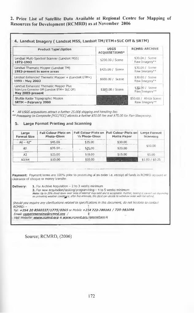
2. Price List of Satellite Data Available at Regional Centre for Mapping of Resources for Development (RCMRD) as at November 2006
4. Landsat Imagery ( Landsat MSS, Landsat TM/ETM+SLC Off & SRTM)
Product Type\Option USGSACQUISITIONS"'
RCMRD ARCHIVE
Landsat Multi-Spectral Scanner (Landsat MSS) 1972-1992
$200.00 / Scene $30.00 / Scene Raw Imagery**
Landsat Thematic Mapper (Landsat TM) 1982-present In some areas
$425.00/ Scene $30.00 / Scene Raw Imagery**
Landsat Enhanced Thematic Mapper + (Landsat E T M + )
1999 - May 2003 $600.00/ Scene $30.00 / Scene Rawlmagciy**
Landsat Enhanced Thematic Mapper Plus Scan Une Corrector Off (Landsat ETM + SLC Off) May 2003-present
$300.00 / Scene $30.00/ Scene Raw Imagery**
Shuttle Radar Topographic Mission SRTM - February 2000
$50.00 / Africa Scene Raw Imagery**
* A ll USGS acquisitions attract a further 25.00$ shipping and handling fee.** Processing to Composite [FCC/TCC] attracts a further $50.00 fee and $75.00 for Pan-Sharpening.
5. Large Format Printing and Scanning
LargeFormat Size
Full Colour Plots on Photo-Gloss
Full Colour Plots on Vi Photo-Gloss
Full Colour Plots on Matte Paper
Large Format Scanning
AO - 42" $45.00 $35.00 $30.00$10.00
AJ 435 00 — * . $25,00 $20.00
A2 $25.00 $18.00 $15.00 $5.00
A3/A4 $10.00 *1.00/»,25..
Payment: Payment terms are 100% prior to processing of an order i.e. receipt of funds in RCMRD account or clearance of cheque or money transfer.
Delivery: 1. For Archive Acquisition - 2 to 3 weeks minimum2. For new acquisition/tasking/programming - 4 to 5 weeks minimumN o te : Up to 20% cloud cover over 'area o f in te rest may exist and is acceptable. Further, tasking is earned out depending on prevailing weather conditjfjfis; after five atterrigts, the client can decide to withdraw order with fu ll refund.
Should you require any clarifications related to specifications in this document, do not hesitate to contact RCMRD: - \Tel: +254 20 8560227/1775/0265 or Mobile +254 723-786161 / 735-981098 Email: remotesensinQ@rcmrd. o n / t.Visit Website: www.rcmrd.oiQ et www.rcmrd.omyqeonetwPJk
Source; RCMRD, (2006)
172

3. The 1979, 1989 and 1999 Population Census Results of Nairobi and other Provinces
KENYA POPULATION CENSUSES, 1979,1989 and 1999 Population Size by Province and District,1979,1989,1999
Province/District1979
PopulationCensus(000's)
1989Population
Census(000’s)
1999Population Census
(000's)Males Females Total Sex Ratio
Nairobi 828 1,325 1,150 987 2,137 117Kilifi •• 431 592 263 292 555 90Kwale 288 383 241 256 497 94lamu 42 57 38 35 73 109Mombasa 341 462 354 299 653 118Taita Taveta 148 207 124 124 248 100Tana River 92 128 92 91 183 101Malmdi •*** 139 143 282 97Coast Province 1,342 1,829 1,251 1,240 2,491 101Garlssa 129 . 125 205 185 390 111Mandera 106 124 131 119 250 110Wajif 139 123 172 149 321 115’NJEastern Province 374 372 508 453 961 112Embu 263 370 136 141 277 96liiolo 43 70 51 50 101 102iGlui" 464 653 243 274 517 89Mwingi*** 141 162 303 87Machakos” 1,023 1,402 446 469 915 95Makueni” * 370 397 767 93Marsahit** 96 129 61 61 122 100Moyale*” 27 27 54 100Meru* 830 1,145Mbeere**’ 83 90 173 92Meru Central” ’ 248 252 500 98Meru North"* 295 313 608 94Tharaka*” 48 53 101 91Nithi” * 100 105 205 95Eastern Province 2,719 3,769 2,249 2,394 4,643 94Kjambu” 686 914 366 376 742 97Thika*” 324 323 647 100Kirinyaga” 291 392 225 230 455 98Murang'a” 648 858 166 185 351 90Maragwa*” 187 202 389 93Nyandarua** 233 345 227 239 466 95Nyeri 486 607 316 339 655 93Central Province 2,344 m 3,116 1,811 1,894 3,705 96Baringo” 204 348 130 135 265 96Koibatek*” 69 69 138 100Elgeyo Marakwel* 149 216Keiyo” * 70 72 142 97Marakuret*” 69 72 141 96Kajiado 149 259 205 200 405 103Kencho” 633 901 240 232 472 103Bomet*” 186 198 384 94
Source; Kenya Rep., (2005)
173

4. Official Boundary Limits and Land Use Zones for Nairobi City as per the 1948 Colonial Structural Development Plan (also adopted at Independence, 1963)
Source: City Hall, (2006)
174

5. Land Use Zones for Nairobi City as at 1948 and 1963
Source: City Hall, (2006)
N* ,r°5 I175

6. Draft Development Plan for MIolongo Township Prepared by the Machakos District Physical Planner (2005)
Source; Machakos District Physical Planning Office, (2006)
176