ipad_application_shootoout_rfs
TRANSCRIPT

www.FAASafety.gov - Safer Skies through Education
iP d A li i
viPad ApplicationShootoutv Tom PerkowskiFAA Safety TeamLead Representative

M h
Pre-brief & Contact Info.
• Most screenshots are current as of 19AUG2012
• Please hold questions
Download copy of presention at: http://db.tt/5P57qROmcase sensitiveq
until end so we can get through all material
• Programs typically have
case sensitive
Tom PerkowskiPrograms typically have more than one way to do a task, where possible both are covered
Copyright 2012 Thomas Perkowski, All Rights Reserved1

Test Objective
• Evaluate three leading iPad moving map applications in-flight (with a prejudice to ForeFlight and WingX) f f h f h f fli h ( i for performance over the four phases of flight (taxi, departure, en route and approach) for VFR and IFR operations using the following factors:operations using the following factors:– Ease of use – Features– Stability– Human Factors
• Evaluate iPhone version of applications as a backupEvaluate iPhone version of applications as a backup
Copyright 2012 Thomas Perkowski, All Rights Reserved2

Methods
• Have an in-flight application installed on each iPad– Rich – ForeFlight– Chris – Garmin Pilot– Tom – WingX & ForeFlight
• Fly from KCRQ (Mc Clellan-Palomar) to KSMX (Santa Maria)Outbound perform IFR tasks– Outbound perform IFR tasks
– Inbound perform VFR tasks
• Use screenshot function on iPad to take pictures of tasks b f dbeing performed
Participants• Rock Swanson, PIC• Rich Martindell• Chris Martindell• Tom Perkowski
Copyright 2012 Thomas Perkowski, All Rights Reserved3

• Class B & C Airspace • Coastal Waters
Route Characteristics
Class B & C Airspace• Mountainous Terrain• MOA, Warning & Restricted Airspace
Coastal Waters• RNAV, ILS, Airport Diagram at KSMX
Copyright 2012 Thomas Perkowski, All Rights Reserved44

Test Plan – Data Points
Outbound IFR• Find and display charts• Alternate airport
Inbound VFR• Aircraft Position on Airport
Diagram• Alternate airport• Aircraft on approach plate• Readability of plate
g• Look up alternate airports• Fuel Prices
• Switching from IFR en route to terminal environment
Inbound VFR
• Frequencies• Food/Services• TFR’sInbound VFR
• Terrain Display• Direct to Airport
TFR s
• Track VOR Inbound• Class B Airspace Warning
Copyright 2012 Thomas Perkowski, All Rights Reserved5

GPS Accuracy – iPad2 External GPS
�
Copyright 2012 Thomas Perkowski, All Rights Reserved6

GPS Accuracy – Internal iPhone
�
Copyright 2012 Thomas Perkowski, All Rights Reserved7

GPS Accuracy – iPad3 Internal GPS
�
Copyright 2012 Thomas Perkowski, All Rights Reserved8

How the Shootout will Look
ForeFlight Screenshot Left WingX Screen Shot Right
Copyright 2012 Thomas Perkowski, All Rights Reserved9

How the Shootout will Look
Garmin Pilot Screen Shot Middle
Copyright 2012 Thomas Perkowski, All Rights Reserved10

Start Page / Database Validity
�
Copyright 2012 Thomas Perkowski, All Rights Reserved11

Start Page / Database Validity
�
Copyright 2012 Thomas Perkowski, All Rights Reserved12

ForeFlight Menus
�
Copyright 2012 Thomas Perkowski, All Rights Reserved

WingX Menus
� � �
Copyright 2012 Thomas Perkowski, All Rights Reserved

WingX Menus (continued)
�
Copyright 2012 Thomas Perkowski, All Rights Reserved

VFR Route Overview
Copyright 2012 Thomas Perkowski, All Rights Reserved16

Airport Diagram
Runway HotspotsRunway Hotspots are clearer in ForeFlight
�
Copyright 2012 Thomas Perkowski, All Rights Reserved17

Airport Diagram
�
Copyright 2012 Thomas Perkowski, All Rights Reserved18

iPhone – Airport Diagram
�
Copyright 2012 Thomas Perkowski, All Rights Reserved19

VFR Sectional
Tap and hold toTap and hold to find Nearest
�
GPS AccuracyNearest
Copyright 2012 Thomas Perkowski, All Rights Reserved20

VFR Sectional
�
GPS Accuracy
Copyright 2012 Thomas Perkowski, All Rights Reserved21

iPhone – VFR Sectional
�
Copyright 2012 Thomas Perkowski, All Rights Reserved22

Nearby Airport
�
Copyright 2012 Thomas Perkowski, All Rights Reserved23

Nearby Airport
�
Copyright 2012 Thomas Perkowski, All Rights Reserved24

Nearby Airport (cont.)
�
Copyright 2012 Thomas Perkowski, All Rights Reserved25

Nearby Airport (cont.)
�
Copyright 2012 Thomas Perkowski, All Rights Reserved26

Nearby VOR
�
Copyright 2012 Thomas Perkowski, All Rights Reserved27

Direct to…
�
Copyright 2012 Thomas Perkowski, All Rights Reserved28

Direct to…
�
Copyright 2012 Thomas Perkowski, All Rights Reserved29

Weather
�
Copyright 2012 Thomas Perkowski, All Rights Reserved30

Weather – Garmin Pilot
�
Copyright 2012 Thomas Perkowski, All Rights Reserved31

ForeFlight Wx from Airports Page
�
Copyright 2012 Thomas Perkowski, All Rights Reserved32

ForeFlight AFD & Airport NOTAMS
�
Copyright 2012 Thomas Perkowski, All Rights Reserved33

Frequencies
�
Copyright 2012 Thomas Perkowski, All Rights Reserved34

Frequencies – Garmin Pilot
�
Copyright 2012 Thomas Perkowski, All Rights Reserved35

Food/Services
�
Copyright 2012 Thomas Perkowski, All Rights Reserved36

Food/Services
�
Copyright 2012 Thomas Perkowski, All Rights Reserved37
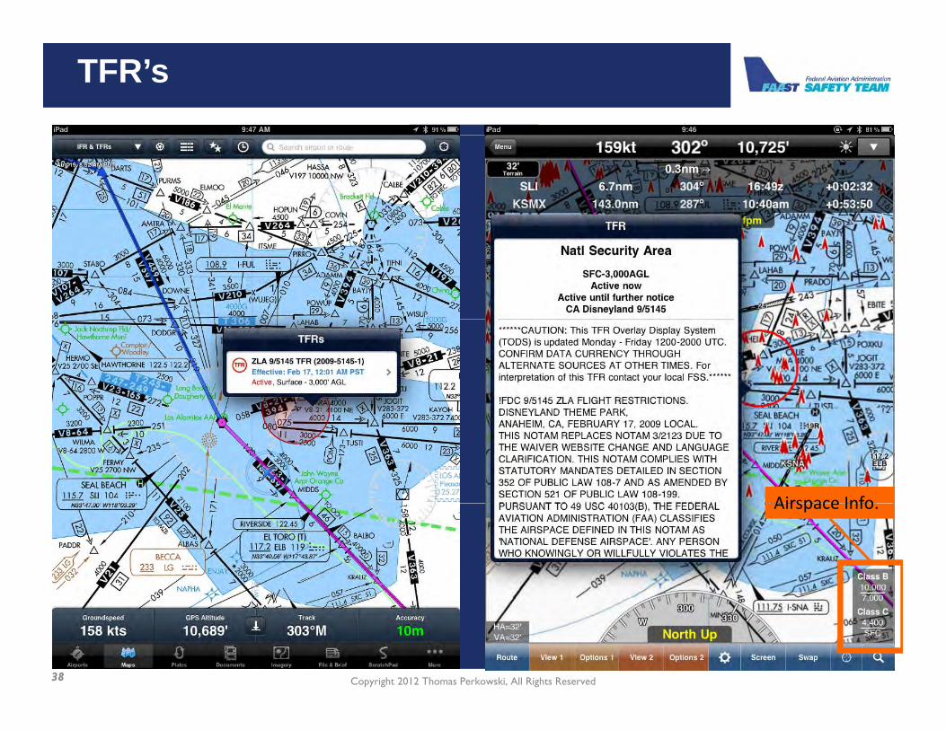
TFR’s
�
Airspace InfoAirspace Info.
Copyright 2012 Thomas Perkowski, All Rights Reserved38
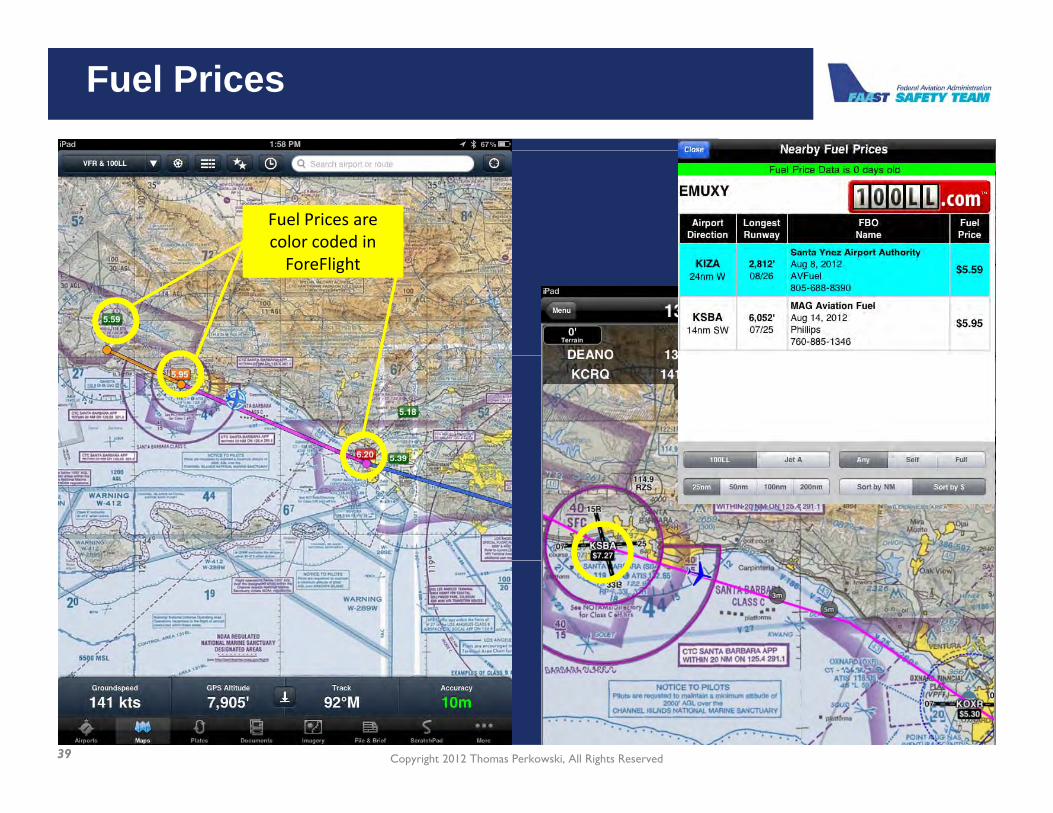
Fuel Prices
Fuel Prices are color coded in ForeFlight
�
Copyright 2012 Thomas Perkowski, All Rights Reserved39

Fuel Prices
�
Copyright 2012 Thomas Perkowski, All Rights Reserved40

Fuel Detail
�
Copyright 2012 Thomas Perkowski, All Rights Reserved41

Fuel Detail – Garmin Pilot
�
Copyright 2012 Thomas Perkowski, All Rights Reserved42

Measuring Tool
�
Copyright 2012 Thomas Perkowski, All Rights Reserved43

Measuring Tool
�
Copyright 2012 Thomas Perkowski, All Rights Reserved44

IFR Route Overview
Copyright 2012 Thomas Perkowski, All Rights Reserved45

Route Planning – ForeFlight
Copyright 2012 Thomas Perkowski, All Rights Reserved46
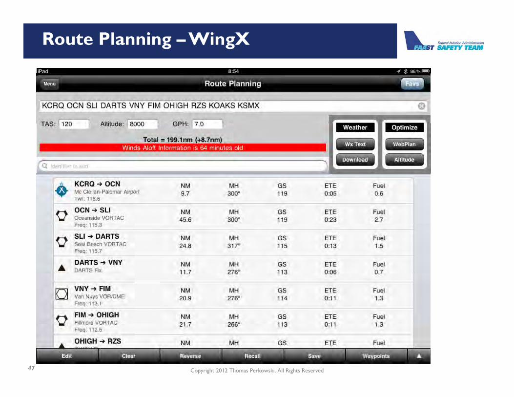
Route Planning – WingX
Copyright 2012 Thomas Perkowski, All Rights Reserved47

Route Planning – Garmin Pilot
Copyright 2012 Thomas Perkowski, All Rights Reserved48

Enroute
Missing TFR
Orange, last leg; Pink, current leg; Blue Next Leg
�
Where you will be in 5 and 15 minutes
Blue Next Leg
Copyright 2012 Thomas Perkowski, All Rights Reserved49

Enroute
Missing TFR
Pink, current leg; Teal Past & F L
�
Future Leg
Copyright 2012 Thomas Perkowski, All Rights Reserved50

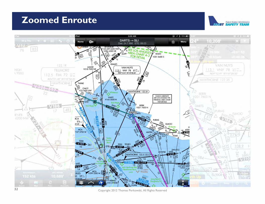
Zoomed Enroute
�
Copyright 2012 Thomas Perkowski, All Rights Reserved51
Zoomed Enroute
�
Copyright 2012 Thomas Perkowski, All Rights Reserved52

iPhone – Enroute
�
Copyright 2012 Thomas Perkowski, All Rights Reserved53

Find and display charts
�
Copyright 2012 Thomas Perkowski, All Rights Reserved54

Aircraft on approach plate
�
Copyright 2012 Thomas Perkowski, All Rights Reserved55

Approach plate
�
Copyright 2012 Thomas Perkowski, All Rights Reserved56

Zoomed into Plate
ForeFlight is cleaner
�
Copyright 2012 Thomas Perkowski, All Rights Reserved57

iPhone – Approach Plates
��
Copyright 2012 Thomas Perkowski, All Rights Reserved58

WingX Position Reports & CAP Grids
�
Copyright 2012 Thomas Perkowski, All Rights Reserved59

WingX TERPS & Aero Data
�
Copyright 2012 Thomas Perkowski, All Rights Reserved60
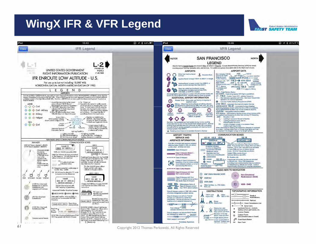
WingX IFR & VFR Legend
�
Copyright 2012 Thomas Perkowski, All Rights Reserved61

WingX Split Screen Views
�
Copyright 2012 Thomas Perkowski, All Rights Reserved62

WingX Split Screen Views (continued)
�
Copyright 2012 Thomas Perkowski, All Rights Reserved63

WingX Route Views & Chart Doodle
��
Copyright 2012 Thomas Perkowski, All Rights Reserved64

WingX North Up v. Track Up
�
Copyright 2012 Thomas Perkowski, All Rights Reserved65

WingX VFR Corridor Screen
�
Copyright 2012 Thomas Perkowski, All Rights Reserved66
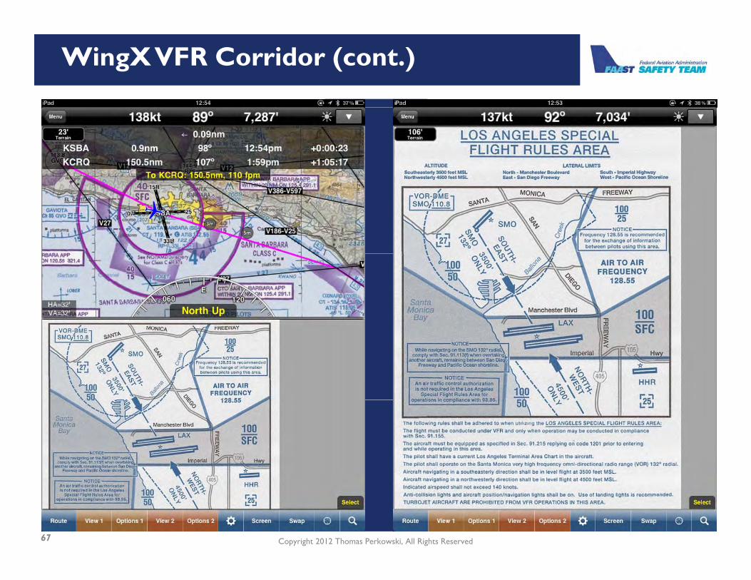
WingX VFR Corridor (cont.)
�
Copyright 2012 Thomas Perkowski, All Rights Reserved67

WingX GPS Altitude Correction & Airspace Warning
�
Copyright 2012 Thomas Perkowski, All Rights Reserved68

Garmin Pilot Split Screen Views
�
Copyright 2012 Thomas Perkowski, All Rights Reserved69

Garmin Pilot Radial Menu
�
Copyright 2012 Thomas Perkowski, All Rights Reserved70

Cost Comparison
ComponentComponent(typically per year)(typically per year) ForeFlightForeFlight WingXWingX Garmin Garmin
PilotPilotTrial Period 30 Days Free $0.99 for 30 Days 30 Days Free
Base Application $74.99$99.99 (1 year) /$199.99 (3 years)
$49.99 on saleTypically $99.99
Geo-Refereced Approach Plates $75 $74.99 $49.99
Safe Taxi n/a n/a $29 99Safe Taxi n/a n/a $29.99
Fuel Prices n/a $29.99 n/a
Canada IFR $149.99 n/a n/aCanada IFR $149.99 n/a n/a
Synthetic Vision n/a $99.99 n/a
Copyright 2012 Thomas Perkowski, All Rights Reserved71
Nice comparison article - Navigation app showdown: ForeFlight vs. Garmin Pilot vs. WingX:http://ipadpilotnews.com/2012/08/navigation-app-showdown-foreflight-vs-garmin-pilot-vs-wingx/

Results
ForeFlightPros• Easy to use
WingXPros• Feature Rich (3 5 15m RW ext )• Easy to use
• Documents / Add your own plates• Nicer look and feel
• Feature Rich (3-5-15m, RW ext.)• ADS-B Traffic and Wx / AHRS• Split View
• Well written manualCons• ADS-B Wx Only, Single Unit
• Terrain• Class B TransitionsCons
Updates Since Test• Runway proximity advisor• Xplane integration
• Industrial LookUpdates Since Test• GPWS for terrain and obstaclesXplane integration GPWS for terrain and obstacles• FlightShare to share routes• Xplane integration with Attitude• Terrain profile• Terrain profile• Chart doodles – draw on plates
Copyright 2012 Thomas Perkowski, All Rights Reserved72

Results
Garmin PilotPros• Virtual Panel• Virtual Panel• Split Screen• Great Look and Feel• Price• Thorough ManualCons• ADS-B Tx & Wx with GDL 39 onlyUpdates Since Test• N/AN/A
Copyright 2012 Thomas Perkowski, All Rights Reserved73

www.FAASafety.gov - Safer Skies through Education
QuestionsQuestionsDownload Copy of Presention at:
http://db.tt/5P57qROmp qcase sensitive
Copyright 2012 Thomas Perkowski, All Rights Reserved74
p @619-321-8550