it's elemental! a case study in the use of multi-element
TRANSCRIPT
Northeast Historical Archaeology
Volume 41 Article 6
2012
It's Elemental! A Case Study in the Use of Multi-element Geochemical Analysis as an Aid inLocating Cultural Features at the Foundation SiteMichael J. Gall
Follow this and additional works at: http://orb.binghamton.edu/neha
Part of the Archaeological Anthropology Commons
This Article is brought to you for free and open access by The Open Repository @ Binghamton (The ORB). It has been accepted for inclusion inNortheast Historical Archaeology by an authorized editor of The Open Repository @ Binghamton (The ORB). For more information, please [email protected].
Recommended CitationGall, Michael J. (2012) "It's Elemental! A Case Study in the Use of Multi-element Geochemical Analysis as an Aid in Locating CulturalFeatures at the Foundation Site," Northeast Historical Archaeology: Vol. 41 41, Article 6.https://doi.org/10.22191/neha/vol41/iss1/6 Available at: http://orb.binghamton.edu/neha/vol41/iss1/6

96 Gall/Multi-element Geochemical Analysis
Introduction The use and benefits of geochemical analysis to provide information about areas of concentrated human and/or domesticated-animal activity within archaeological sites have been well documented in the Middle Atlantic region and elsewhere for over half a century (Deetz and Dethlefsen 1963: 242–243; Cook and Heizer 1965; Sopko 1983; Custer et al. 1986; Pogue 1988; Catts et al. 1995: 97–99; Grettler et al. 1995: 71–74, 137–143; Middleton and Price 1996: 673–687; Heite and Blume 1998: 139–147; Bedell 2002: 80–82; Gall 2007; Gall, Hayden, and Stops 2006; Gall, Lore, and Hayden 2007, 2008, 2009a, 2009b; Holliday and Gartner 2007: 301–333). Anthropogenic chemical residues can vary in concentration from site to site based on site-specific activities, regional cultural practices, soil development, environmental conditions, and post-occupation activities (Middleton and Price 1996: 683; Fernández et al. 2002; Vyncke et al. 2011). Initial geochemistry analysis of anthrosol deposits from archaeological sites during the
early 20th century focused on the analysis of soil phosphorous (P) to locate areas of human habi ta t ion on the landscape (Middleton and Price 1996: 673). Subsequent research confirmed a high correlation of soil P with anthrosol deposits. The use of soil P analysis continues into the 21st century to identify locations of former prehistoric and historical human habitation, delineate vertical and horizontal archaeological site boundaries, interpret spatial use, and guide excavation placement (Bjelajac, Luby, and Ray 1996: 243–248; Middleton and Price 1996: 673; Entwistle, Abrahams, and Dodgshon 2000: 302; Sarris et al. 2004: 927–939; Holliday and Gartner 2007: 301–333; Rypkema et al. 2007: 1,859–1,867; Salisbury 2012: 178–190). Archaeologists have since expanded geochemical investigations to include anthropogenic multi-element chemical residue analyses and have identified close correlations between element suites and past occupation activities. Multi-element chemical residue analysis has ultimately proven successful as an archaeological prospection and interpretive tool to detect, delineate, and
It’s Elemental! A Case Study in the Use of Multi-element Geochemical Analysis as an Aid in Locating Cultural Features at the Foundation Site
Michael J. Gall Analysis of soil pH and anthropogenic multi-element chemical residue distribution patterns has proved a valuable prospecting method for locating areas of concentrated human and/or domesticated-animal activity within archaeological sites. The application, analysis, and results of a geochemical study at the Foundation site (28MO352), a significant ca. 1733 to 1790s farmstead site in Manalapan Township, Monmouth County, New Jersey, is presented as a case study. Multi-element geochemical analysis using Mehlich-3 and ICP-AES was employed as a critical, cost-efficient method to aid in targeting areas for intensive excavation. The method enabled the identification of numerous activity areas and buried cultural features, assisted in the recovery of significant site data, and provided a richer understanding of the site’s historical occupants.
L’analyse du pH du sol et des modèles de distribution s’est avéré être une méthode utile pour choisir l’emplacement des unités de fouille qui serviraient à identifier les secteurs d’un site archéologique démontrant une forte concentration d’activité humaine ou d’activité par des animaux domestiqués. L’application, l’analyse et les résultats d’une étude géochimique du site archéologique Foundation Site (28MO352), une importante ferme datant de ca. 1733-1790 et située à Manalapan, un canton du comté de Monmouth dans l’état du New Jersey, ont servi d’étude de cas. Afin d’identifier des secteurs propices aux fouilles intensives, l’analyse géochimique d’éléments multiples menée à l’aide des méthodes d’analyse Mehlich 3 et ICP-AES offrait une méthode critique et abordable. Grâce à cette méthode, plusieurs secteurs d’activité ont été identifiés, de même que des éléments culturels. La grande quantité de données accumulées nous offre une meilleure compréhension des anciens occupants de ce site.

Northeast Historical Archaeology/Vol. 41, 2012 97
interpret broad activities within archaeological sites and to differentiate among discrete activity areas (Deetz and Dethlefsen 1963: 242–243; Cook and Heizer 1965; Eidt 1977; Middleton and Price 1996: 673–687; Wells et al. 2000: 450; Parnell, Terry, and Nelson 2002; Middleton 2004; Sarris et al. 2004; Cook et al. 2006; Wilson, Davidson, and Cresser 2008: 412–424; Oonk, Slomp, and Huisman 2009; Salisbury 2012, 2013; Milek and Roberts 2013: 1,845–1,865). Geochemical analysis undertaken at archaeological sites in the United States over the past several decades, particularly in the Middle Atlantic region, has largely developed around agronomic geochemical analysis methods. In the Middle Atlantic region, such techniques typically have relied upon the quantification of weakly sorbed (i.e., extractable or available) elements or those forms available for plant nutrient uptake, which represent a minute portion of total compositional element forms in the soil (Holliday and Gartner 2007: 313). This cost-effective and time-efficient, two-step method involves the application of a weak or moderately weak-acid chemical extraction solution, such as a Mehlich-3 mixed reagent, to separate element cation bonds in dried soil samples. In the second step, extracted elements in the solution are quantified using inductively coupled plasma (ICP) spectrometry (Parnell, Terry, and Nelson 2002; Oonk, Slomp, and Huisman 2009). This method of measuring extractable elements was selected over the use of strong-acid extraction solutions to quantify total element forms. Middleton and Price (1996: 675) argued that total compositional element analysis can aid in determining an element’s source within the soil, but the data can obscure the identifiable nuances in anthropogenic chemical residues presented by extractable element analysis (Parnell, Terry, and Nelson 2002). Despite decades of research, debate continues over the advantages of total com-positional vs. available element form analysis in archaeological contexts (Middleton and Price 1996: 675; Wilson, Davidson, and Cresser 2006; Holliday and Gartner 2007: 301–333). Extractable element analysis may be strengthened as an interpretive tool by using a multi-element analysis approach. Multi-element analysis has revealed that charcoal left in place for hundreds of years can load anthrosols
with calcium (Ca), barium (Ba), copper (Cu), strontium (Sr), zinc (Zn), phosphorus (P), and lead (Pb), and bone has been found associated with high levels of Ca and P, moderate levels of Ba and Sr, and low concentrations of Cu, Zn, and Pb (Wilson, Davidson, and Cresser 2006, 2008). In situ wood burning may also be associated with elevated anthropogenic P, Ca, and iron (Fe) residues (Middleton 2004). Organic and inorganic waste disposal can have a high correlation with elevated quantities of P and manganese (Mn), and ferrous-metal deposits and butchering locales can load the soil with Fe (Parnell, Terry, and Nelson 2002; Wilson, Davidson, and Cresser 2006; Holliday and Gartner 2007). Wilson and associates have identified a positive correlation of elevated Ca, Sr, and Zn associated with hearths, dwellings, byres, and middens on a variety of farm sites in the United Kingdom (Wilson Davidson, and Cresser 2006). Ethnoarchaeological studies in conjunction with multi-element analysis have also found a close correlation between areas of site maintenance, ritual activities, and heavily trafficked areas or pathways, and low multi-element residue patterns due to the absence of accumulated organic and inorganic wastes in such locales (Milek and Roberts 2013; Sarris et al. 2004; Terry et al. 2004). Geochemical so i l analyses in the Northeast and Middle Atlantic regions have been extensively utilized on archaeological sites in plowzone settings, particularly in the state of Delaware (Sopko 1983: 24–30; Custer et al. 1986: 89–94; Pogue 1988: 1–15; Grettler et al. 1995; Fisher 2001; Sullivan and Kealhofer 2004; Gall 2007). Regulatory, compliance-related archaeological surveys carried out for the Delaware Department of Transportation during the late 20th and early 21st centuries employed soil geochemistry on over three dozen historical archaeological sites to aid in spatial-use and activity-area interpretations. At many of the sites, extensive plowzone artifact sampling followed by mechanical topsoil removal was undertaken during data-recovery investigations to identify sub-plowzone cultural features (Bedell 2002: 80–82). In such cases, geochemical analysis was used primarily to confirm suspected or identified activity areas based on exposed sub-plowzone cultural features and/or high-artifact plowzone densities, the latter of which may have represented

98 Gall/Multi-element Geochemical Analysis
the locations of plow-disturbed cultural features (Bedell 2002: 109). Plowzone artifact densities, however, rarely correspond with extant buried cultural features, increasing the interpretive value offered by geochemical analysis (Bedell 2002; Terry et al. 2004: 1,237). Far fewer studies utilizing geochemical analysis have been conducted in New Jersey (MAAR Associates, Inc. 1988; Gall 2007; Gall, Lore, and Hayden 2007, 2008; Lore and Bini 2007). Most New Jersey regulatory, compliance-related archaeological surveys involving geochemical analysis are also associated with archaeological sites identified in plowed contexts. Complete mechanical plowzone removal of soils at such sites would enable the identification of extant buried cultural features across a site, a method that is rarely employed in the state, most notably due to budgetary constraints and other limiting factors of cultural resource management projects. To compensate, archaeologists traditionally have relied on a combination of artifact- and data-collection methods, including metal detection, surface collection, geophysical surveys, and system-atic hand-excavation of test pits to focus on areas of concentrated occupation at sites that might contain large subsurface cultural features like cellars, wells, and refuse pits. Equally important smaller feature types, such as struc-tural post-and-sill stains associated with earthfast buildings, shallow pits, and the remains of former fence lines delineating activity areas can prove more elusive without the costly endeavor of exposing large areas though excavation. To aid in overcoming this limitation and to develop an adequate, cost-efficient excavation strategy, multi-element geochemical pros-pecting can be utilized to identify historical activity areas that may contain buried cultural features. Geochemical prospection has been utilized to guide intensive, focused investigation during mitigation-level surveys at several 18th- and 19th-century archaeological sites in central New Jersey and Delaware (Gall 2007; Gall, Lore, Hayden 2007, 2008, 2009a, 2009b; Versar, Inc. 2012; Gall and Modica 2013a, 2013b; Gall et al. 2014). Focused investigation also relied upon soil-attribute analysis and artifact-distribution data obtained from metal detection, surface collection, and shovel test pit excavations. The results of geochemical analysis and its use in
identifying activity-areas and features at the ca. 1733 to 1790s Foundation site (28MO352) in Manalapan Township, Monmouth County, New Jersey, are presented here as a case study.
Foundation Site Identification and Excavation Phase I archaeological testing, metal detection, and surface artifact collection by the Cultural Resources Consulting Group (2006) identified the archaeological remains of a mid- to late-18th-century farmstead designated the Foundation site (28MO352). Formerly situated in an agricultural field on a 139 ac. parcel, the site overlooks the Manalapan Brook to the south, the north branch of the Manalapan Brook to the north, and Woodward Road to the west (fig. 1). An initial surface reconnais-sance, a metal-detector survey, and shovel tests excavated at 10 and 50 ft. intervals identi-fied 18th-century cultural material in three small surface clusters and a buried stone foun-dation (Out Kitchen 2) on the apex and side slopes of a peninsular-shaped knoll (Cultural Resources Consul t ing Group 2006) . Subsequent Phase II and III archaeological investigations were performed at the site in 2006 and 2007 by Richard Grubb & Associates, Inc. (Gall, Hayden, and Stops 2006; Gall, Lore, and Hayden 2008) (fig. 2). Phase II testing defined the site boundaries and determined that the archaeological deposits represented a significant archaeological resource, eligible for inclusion on the New Jersey and national registers of historic places under Criterion D. Historical and archaeological data indicate the Foundation site may have been occupied between 1733 and 1749 by Robert Hankinson, an English farmer. Despite a gap in the chain of title, the property was likely acquired prior to 1768 by Peter Forman, an English cooper, for his son Jonathan. Jonathan resided on the farmstead with his wife Deborah until dying intestate in 1784, after which time his widow continued to occupy the site. Between 1786 and 1795, Jonathan’s brother William gradually bought out the estate heirs’ interest in the farm. During this time Deborah may have continued to live on the farmstead, or it may have been rented to tenants. By the late 1790s the farmstead was abandoned and razed (Gall, Lore, and Hayden 2008).

Northeast Historical Archaeology/Vol. 41, 2012 99
The Foundation site measures 205 ft. long by 213 ft. wide (27,680.19 sq. ft. or 0.635 ac.). Phase II and III archaeological testing included the excavation of 124 shovel test pits, 38 hand-dug excavation units primarily measuring 5 × 5 ft., and 13 variously sized mechanically excavated strip blocks at target locations. Approximately 17.16% (4,751.10 sq. ft.) of the site was excavated during the Phase II and III archaeological surveys. Shovel test pits were plotted on two staggered 25 ft. interval grids, spaced 12.5 ft. apart across the site and with additional shovel testing placed in select locations. Shovel test pits were given northing and easting coordinate designations (e.g., N1000/E2000) to enable the graphic projection of quantitative artifact and geochemical data. The staggered grid method was utilized as an aid for locating cultural features, such as large cellars, which might be situated between standard 25 ft. interval grid points. The majority of excavated test pits, with the exception of one test pit excavated within the foundation of Out Kitchen 2, yielded low quantities (e.g., n=1–6) of cultural material (fig. 3). Artifact counts were slightly higher in the southeast portion of the site. The low artifact densities in plowzone soils may be the result of historical site activities, particularly the translocation of artifact-rich soils into large cavities, such as cellars, crawlspaces,
and wells, to level the terrain during changes in site habitation and following site abandonment. The relatively low artifact density across the site was problematic as a data set for use in targeting the suspected location of additional activity areas and cultural features, particularly small features that might elude detection with geophysical survey methods. Additional auger testing to identify deep anthrosol deposits between 25 ft. interval grid points also was conducted, resulting in a portion of the site that was archaeologically tested at 12.5 ft. intervals. Shovel and auger testing identified Well 2 (post-1760s–1800), the foundation of Out Kitchen 2 (post-1770s–1800), an earthfast dwelling cellar (1730s–1800), and a pit feature. Unit and mechanical strip block testing at areas targeted based on geochemical data resulted in the identification of 71 additional cultural features comprising the remains of three more earthfast (i.e., post-in-ground) structures (Out Kitchen 1, Corn Crib, and Hay Barrack), Well 1 (pre-1760s), and several small pits and post stains. Both wells contained notably wide builders’ trenches forming broad feature footprints. The builder ’s trench associated with Well 1 also contained noteworthy archaeological deposits associated with the pre-1760s site occupation that were not found in great quantities elsewhere on the
Figure 1. Site location map (United States Geological Survey 1981). (Figure by the author, 2012.)

100 Gall/Multi-element Geochemical Analysis
element levels, rather than total element forms, calculated from the upper layer of subsoil contexts using Mehlich-3 and ICP spectrometry, have a higher correlation with anthropogenic chemical residues than do samples from plowzone contexts (Gall, Lore, and Hayden 2007). This may be a direct result of environ-mental conditions, soil characteristics, or methods utilized in element extraction and measurement (Holliday and Gartner 2007: 301–333). Extractable element forms in the upper portion of the soil profile can be modified by environmental factors, weathering, and
site, leading to an important data set integral to site interpretation. The builder ’s trench deposits in Well 1 likely were translocated from artifact-rich topsoil near the feature following the destruction of Out Kitchen 1 by fire during the 1760s and the subsequent creation of the well.
Methodology Geochemical archaeological studies undertaken on well-drained sandy soils in New Jersey’s coastal plain suggest that pH and elevated extractable (i.e., weakly sorbed)
Figure 2. Phase II–III excavation base map. (Figure by the author, 2012.)

Northeast Historical Archaeology/Vol. 41, 2012 101
crop harvesting. The sandy soils that characterize New Jersey’s coastal plain have a lower sorption capacity than finely textured silts and clays and thus allow for the increased transfer or mobilization of weakly sorbed elements down through the soil profile (Holliday and Gartner 2007: 302, 306, 309). Research conducted by Ahler (1973: 116–131) at the Rogers Rock Shelter in Missouri using the Bray-1 acid extraction solution, comparable to the Mehlich-3 solution (Holliday and Gartner 2007: 311), indicates that elevated levels of available P correlated with artifact density only in the lower levels
of the stratigraphic profile. A similar correlation was identified in comparable soils at the Manalapan Village House site (28MO349), situated 0.59 mi. southeast of the Foundation site. There, geochemical analysis of soil samples obtained from the plowzone and the under-lying Bt1 horizon using Mehlich-3 and ICP atomic emission spectrometry (ICP-AES) methods identified a higher correlation of cultural features and activity areas with elevated available multi-element chemical residues and pH (potential hydrogen) in the subsoil than in the plowzone (Gall, Lore, and Hayden 2007). Similar correlations were identif ied in
Figure 3. Interpolated artifact isopleth distribution map. (Figure by the author, 2012.)
102 Gall/Multi-element Geochemical Analysis
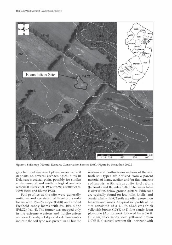
western and northwestern sections of the site. Both soil types are derived from a parent material of loamy aeolian and/or fluviomarine sediments with glauconite inclusions (Jablonski and Baumley 1989). The water table is over 80 in. below ground surface. FrkB soils are typically found on low hills, knolls, and coastal plains. FrkC2 soils are often present on hillsides and knolls. A typical soil profile at the site consisted of a 1.1 ft. (33.5 cm) thick yellowish brown (10YR 4/4) fine sandy loam plowzone (Ap horizon), followed by a 0.6 ft. (18.2 cm) thick sandy loam yellowish brown (10YR 5/6) subsoil stratum (Bt1 horizon) with
geochemical analysis of plowzone and subsoil deposits on several archaeological sites in Delaware’s coastal plain, possibly for similar environmental and methodological analysis reasons (Custer et al. 1986: 89–94; Grettler et al. 1995; Heite and Blume 1998). Soil profiles at the site were generally uniform and consisted of Freehold sandy loams with 2%–5% slope (FrkB) and eroded Freehold sandy loams with 5%–10% slope (FrkC2) (fig. 4). The former was mapped only in the extreme western and northwestern corners of the site, but slope and soil characteristics indicate the soil type was present in all but the
Figure 4. Soils map (Natural Resource Conservation Service 2008). (Figure by the author, 2012.)
Northeast Historical Archaeology/Vol. 41, 2012 103
The laboratory utilized the Mehlich-3 mixed reagent to separate available or extractable element forms in each soil sample. Developed in the mid-1980s, Mehlich-3 is a moderately weak-acid, mixed-reagent solution used with acidic and neutral soils for available multi-element extraction. The Mehlich-3 solution utilizes five mixed components. The acetic acid (CH3COOH) component prevents calcium from being precipitated as calcium fluoride. Ammonium nitrate (NH4NO3) facilitates Ca, Mg, Na, and K basic cation extraction. Nitric acid (HNO3) aids in the extraction of basic and micronutrient cations and extracts a portion of Ca phosphates. The ammonium fluoride (NH4F) component extracts iron and alu-minum phosphates and aids in the extraction of basic cations. Ethylenediaminetetraacetic acid (EDTA) is utilized to chelate micronutrients (Loide, Nõges, and Rebane 2005). Main available elements extracted included Ca, K, Mg, and P, and analyzed trace available elements consisted of B, Cu, Fe, Mn, and Zn. The extracted available elements were quantified with an ICP-AES, which uses a phototube to measure the intensity of light spectra emitted by extracted elements heated in a plasma torch. The instrument works well with elements in the top and upper left of the periodic table that easily radiate light when superheated (Holliday and Gartner 2007: 312). Main elements were initially measured in pounds per acre and converted to parts per million. Trace elements were quantified in parts per million. This Mehlich-3 and ICP-AES method provided a fast, cost-efficient approach to obtain multi-element data. Statistical comparison of the offsite and onsite samples did not identify a difference between sample sets, likely due to the proximity to the site boundary of the sources of offsite samples, which was dictated by active construction activities around the site. To determine if elevated element levels represented anthropo-genic chemical residues, extractable element background levels were calculated based on the mean of the five lowest elemental concentrations, which were used to approximate natural back-ground geochemical levels (tab. 1). Three of the five lowest geochemical samples were from areas suspected to represent former, heavily trafficked paths within the site. Kept free of refuse and debris that load soils with anthropogenic chemical
quartz pebbles over a yellowish brown (10YR 4/6) sandy clay loam subsoil stratum (Bt2 horizon) with pockets of glauconite. The Bt2 horizon caps a B/C interface horizon composed of 0.8 ft. (24.3 cm) of thick brown (7.5YR 5/4) sandy loam with sand-sized grains of glauconite and 0%–5% quartzose pebble content. The B/C interface horizon is present over a 35 in. (88.9 cm) thick yellowish brown (10YR 5/8) sandy loam C horizon with dark grains of glauconite (Jablonski and Baumley 1989). The upper sandy subsoil layer at the site has an average pH of 5.4, which may affect the availability of element form density for plant uptake. The quantity of weakly sorbed element forms in the site soils is also determined by the cation exchange capacity (CEC), expressed as a soil’s ability to retain and exchange cations, i.e., positively charged ions. Samples with a high CEC number, such as alkaline clays and organic soils, have a greater efficiency to retain cations. Sandy and more acidic soils have a lower CEC capacity. The soils at the Foundation site consist primarily of Freehold sandy loam soils (FrkB), which have a higher CEC number (9.1–11) in the uppermost subsoil stratum than in the topsoil (3.3–8.2). The higher CEC in the subsoil horizon may result in a closer relationship between extractable element forms and historical activities and features. The downward migration or leaching of nutrients through the soil profile into subsoil deposits over time may also result in accumu-lations of extractable element forms associated with former site activities. For this reason, soil samples were collected from the upper layer of the subsoil from 104 shovel tests using a clean stainless-steel scoop. Of these, 90 samples were within the delineated site boundary and 14 were offsite, adjacent to the site boundary. The location of recovered offsite samples was restricted by project-related development to areas within 12.5 ft. of the site. Each sample consisted of approximately 360 ml of soil placed in a clean 5 in. square, resealable polyethylene bag labeled with corresponding provenience information. Soil samples were processed by Rutgers Soil Testing Laboratory in Milltown, New Jersey, which conducted soil fertility analysis to test for soil pH and several main and trace elements. For cost efficiency purposes, only B, Ca, Cu, Fe, K, Mg, Mn, P, and Zn were targeted for analysis.

104 Gall/Multi-element Geochemical Analysis
several historical activity areas within the Foundation site; many of the activity areas identified by the data were subsequently determined to contain cultural features through traditional archaeological excavation. The majority of the identified activity areas were situated in portions of the site where close-interval shovel testing, a method tradi-tionally utilized to select excavation locations, did not yield notable quantitative or qualitative artifact or anthrosol anomalies (fig. 3). Areas containing anomalous spikes in anthropo-genic, multi-element chemical residues or pH levels relative to approximated background levels were identified and delineated. The soil chemical distribution data was used in conjunction with soil-profile and artifact-distribution data to target excavation unit and strip block locations during the archaeological data recovery, resulting in the identification of 71 cultural features. For ease of discussion, only the shape and location of major structural features identified during the data recovery, such as the house, Out Kitchen 1, Out Kitchen 2, Well 1, Well 2, Corn Crib, Hay Barrack, and several small pits and post stains in the southeast portion of the site are identified on geochemical distribution maps. The remaining features
residues, path areas typically exhibit low element concentrations within sites (Sarris et al. 2004: 937). Similar use of identified low elemental concentration areas to approximate elemental background levels within sites was conducted by Wells and associates at residential areas in Piedras Negras, Guatemala (Wells et al. 2000: 454), and by Hutson and Terry (2006: 395) on plaster floor samples at Chunchucmil, Yucatan, Mexico. Quantified multi-element and pH data from the site were displayed on interpolated frequency distribution maps as smoothed contour, topo-graphic isopleths. The frequency distribution maps were generated using Golden Software, Inc., Surfer 7.0 surface-mapping software. This software applies kriging algorithms or optimal interpolation to produce an estimated surface from highly varied values plotted on standard interval points (Salisbury 2012: 183). The method works well to depict multi-element distribution data as an aid in visually identifying possible archaeological activity areas (Salisbury 2012: 183).
Results Multi-element data analysis using interpo-lated isopleth distribution maps proved useful as an archaeological prospection tool for identifying
P K Ca Cu Mn Zn Fe
Lowest Five Samples
Mean(S.D.)
34.9(24.38)
62.1(22.8)
931.5(274.95)
1.00(6.24)
1.2(0.42)
0.66(0.21)
106.38(37.6)
Non-Feature Mean(S.D.)
74.24(30.12)
83.96(31.66)
677.20(271.1)
1.77(0.69)
5.24(3.57)
1.66(0.69)
141.67(35.78)
Domestic* Mean(S.D.)
133.75(38.01)
122.13(49.18)
1177.13(744.33)
2.15(1.07)
13.55(2.99)
2.33(0.39)
208.48(50.07)
Service† Mean(S.D.)
110(73.71)
118.33(31.34)
711.5(159.97)
1.87(0.72)
14.37(10.13)
2.00(0.62)
177.87(74.59)
Pits Mean(S.D.)
161.17(40)
126.83(23.59)
660.67(74.47)
3.03(0.31)
13.2(6.63)
3.27(0.91)
196.57(34.97)
Storage‡ Mean(S.D.)
83.25(52.68)
98.75(28.64)
872.75(539.17)
4.00(2.27)
4.7(2.12)
2.35(0.21)
172.2(22.77)
Path Mean(S.D.)
33.95(29.15)
73.14(23.78)
854.86(237.31)
1.63(0.7)
2.63(1.17)
1.1(0.31)
93.99(12.66)
* The Domestic group includes the house, Out Kitchen 1, and Out Kitchen 2.† The Service group includes Well 1 and Well 2.‡ The Storage group includes the Corn Crib and Hay Barrack.
Table 1. Group means and standard deviation (S.D.) for selected elements (Table by the author, 2013.)

Northeast Historical Archaeology/Vol. 41, 2012 105
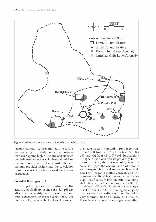
anomalies and in areas with one geochemical anomaly did not result in the identification of sub-plowzone cultural features. The element suites at double- and multilayer anomalies were not consistent across the site, but element suites at certain feature types were similar, particularly at the house, Out Kitchen 1, and Out Kitchen 2. Of 23 double-layer anomalies, 13 were excavated in 11 strip blocks, of which 8, or 72%, contained features (fig. 5). Only 3 (25%) of the 12 tested double-layer anomalies were associated with high artifact densities, indicating that artifact density alone is not a strong indicator of cultural feature locations. Of 11 areas with multilayer anomalies, 8 were archaeologically tested, all (100%) of which
represent the remains of small posts and pits. The suspected locations of heavily trafficked paths between activity areas are also illustrated on geochemical distribution maps. Visually identified anomalous pH and element spikes, with the exception of Mg and B for reasons explained below, were identified on the interpolated frequency distribution maps, interpreted, and manually delineated. At the Foundation site, locations with two overlapping visually delineated element spikes (double-layer anomalies) and locations with three or more overlapping visually delineated element spikes (multilayer anomalies) were identified and separately delineated (figs. 5 and 6). Excavations in areas with no geochemical
Figure 5. Double-layer anomaly map. (Figure by the author, 2012.)
106 Gall/Multi-element Geochemical Analysis
P is maximized in soil with a pH range from 5.5 to 6.5, K from 5 to 7 pH, Ca from 5 to 8.5 pH, and Mg from 4.5 to 7.5 pH. Fertilization; the type of bedrock and its proximity to the ground surface; the presence of glauconitic soils; soil type; the accumulation of organic and inorganic historical refuse, such as shell and bone; organic matter content; and the presence of cultural features containing dense deposits of calcium-rich material like bone, shell, charcoal, and mortar may affect soil pH. Subsoil pH at the Foundation site ranged in value from 4.9 to 6.1, indicating the majority of site subsoil deposits was characterized as very strongly acid to slightly acid (fig. 7). These levels did not have a significant effect
yielded cultural features (fig. 6). The results indicate a high correlation of cultural features with overlapping high pH values and elevated multi-element anthropogenic chemical residues. Examination of soil pH and multi-element patterns provides insight into the correlation between extant cultural features and geochemical distribution.
Potential Hydrogen (PH) Soil pH provides information on the acidity and alkalinity of site soils. Soil pH can affect the availability and form of main and trace-element ions in the soil (Sopko 1983: 25). For example, the availability of weakly sorbed
Figure 6. Multilayer anomaly map. (Figure by the author, 2012.)

Northeast Historical Archaeology/Vol. 41, 2012 107
Cultural features with a high soil pH identified through shovel testing include the pre-1760 earthfast house, Well 2, and the post-1760 Out Kitchen 2. These cultural features contained charcoal and shell deposits that may have increased the feature soil pH and the pH of the underlying subsoil. Areas with cultural features associated with high soil pH, but not identified through shovel test pit excavation were Out Kitchen 1, Well 1, and a number of small pits and post stains in the southeast corner of the site. Other sampled areas with elevated pH that did not contain intact cultural features may have represented discrete
on the availability and values of the elements tested in the subsoil. Analysis of the mapped data reveals high pH levels in a scatter of locations primarily situated in the southern and southeastern port ions of the s i te where cultural features and activity areas were most abundant. Of the 12 areas with elevated pH, 7 were archaeologically sampled; the majority of test locations was located in upland portions of the site. Five of the tested areas contained one or more cultural features, the majority of which was associated with former buildings and contained a mix of faunal, charcoal, and architectural material.
Figure 7. Interpolated pH isopleth distribution map. (Figure by the author, 2012.)
108 Gall/Multi-element Geochemical Analysis
element’s density (Pogue 1988: 3; Middleton and Price 1996: 675; Wilson, Davidson, and Cresser 2008: 416). Studies undertaken in the United Kingdom identified a correlation between Ca and domestic hearths, and deter-mined that Ca can be more strongly influenced by functional area within a site than by general site-wide human occupation (Wilson, Davidson, and Cresser 2008: 416). Once loaded into the soil, Ca rapidly bonds with P to form calcium phosphate. In sandy soils with a low CEC, unbound Ca quickly leaches through occupation layers and accumulates in deeper soil horizons, and can be a poor anthropogenic
activity or refuse-disposal areas, or areas where cultural features were disturbed by plowing.
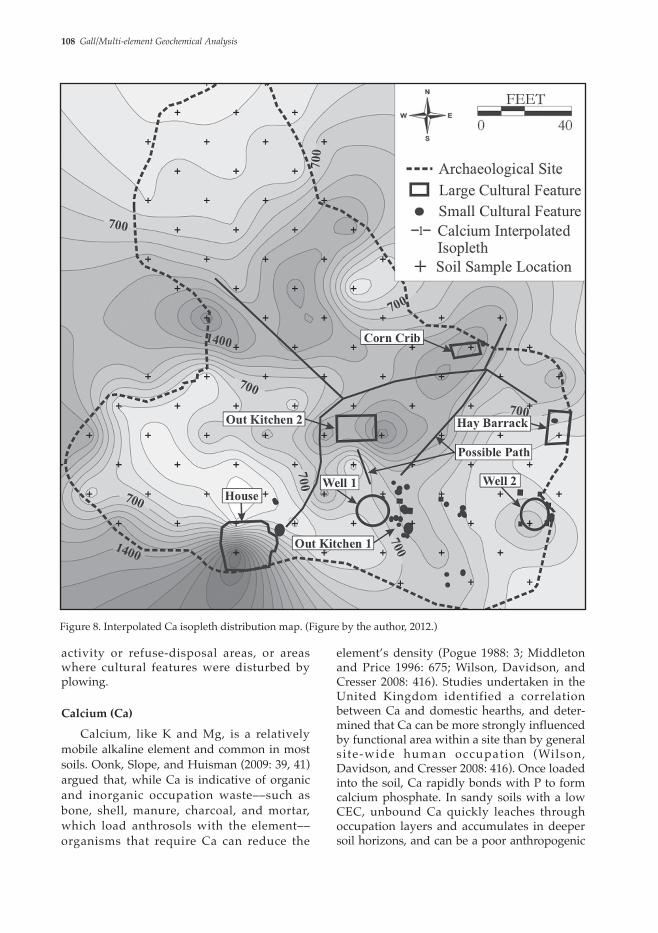
Calcium (Ca)
Calcium, like K and Mg, is a relatively mobile alkaline element and common in most soils. Oonk, Slope, and Huisman (2009: 39, 41) argued that, while Ca is indicative of organic and inorganic occupation waste––such as bone, shell, manure, charcoal, and mortar, which load anthrosols with the element––organisms that require Ca can reduce the
Figure 8. Interpolated Ca isopleth distribution map. (Figure by the author, 2012.)
Northeast Historical Archaeology/Vol. 41, 2012 109
and Zn and a weak positive correlation with Fe (tab. 2). This weak correlation may result from the mobility of the element’s extractable forms in acidic, sandy soils. Table 1 also displays the negative correlation of Ca with P, K, Mn, and Zn when examined in relation to approximated background levels and feature types (tab. 1). Fifteen areas with elevated Ca were identified, of which seven were archaeologically sampled (fig. 8). Four of the sampled areas (i.e., Out Kitchen 2, Well 2, and the house) contained cultural features identified prior to unit or strip block excavation. Two of the remaining sampled areas contained cultural features.
indicator in such soils (Oonk, Slomp, and Huisman 2009: 41). Mixed reagents like Mehlich-3, however, can be used to dissolve a portion of the calcium phosphate bonds and extract the alkaline element, but its athropo-genic and calcium phosphate forms cannot be differentiated. The leaching process that characterizes unbound Ca does not appear to have had a significant impact on the ability to identify concentrations of Ca in site activity areas at or near most identified activity areas at the site. Statistical analysis in SPSS software using Pearson’s r correlation indicates that Ca has a weak negative correlation of Ca with P, K, Mn,
Figure 9. Interpolated P isopleth distribution map. (Figure by the author, 2012.)

110 Gall/Multi-element Geochemical Analysis
densities often have a high correlation with activity areas on archaeological sites. Significant research has focused on the formation and interpretive value of total and available soil P (Holliday and Gartner 2007). Phosphorous is present in inorganic and organic waste, such as bone, plant waste, and charcoal, and remains in place for thousands of years (Sjöberg 1976: 448; Custer et al. 1986: 93). Organic P is generally found in the surface soil where it is easily absorbed by plants and, therefore, less stable than inorganic P, which accumulates in the subsoil and serves as the best indicator of human activity (Sjöberg 1976:
These included Out Kitchen 1 and the Corn Crib. A cluster of posts and pits in the southeast corner of the site was associated with moderately elevated Ca levels. The majority of features associated with high Ca levels were also characterized by high concentrations of bone, shell, and/or charcoal, which likely loaded anthrosols with extractable Ca.
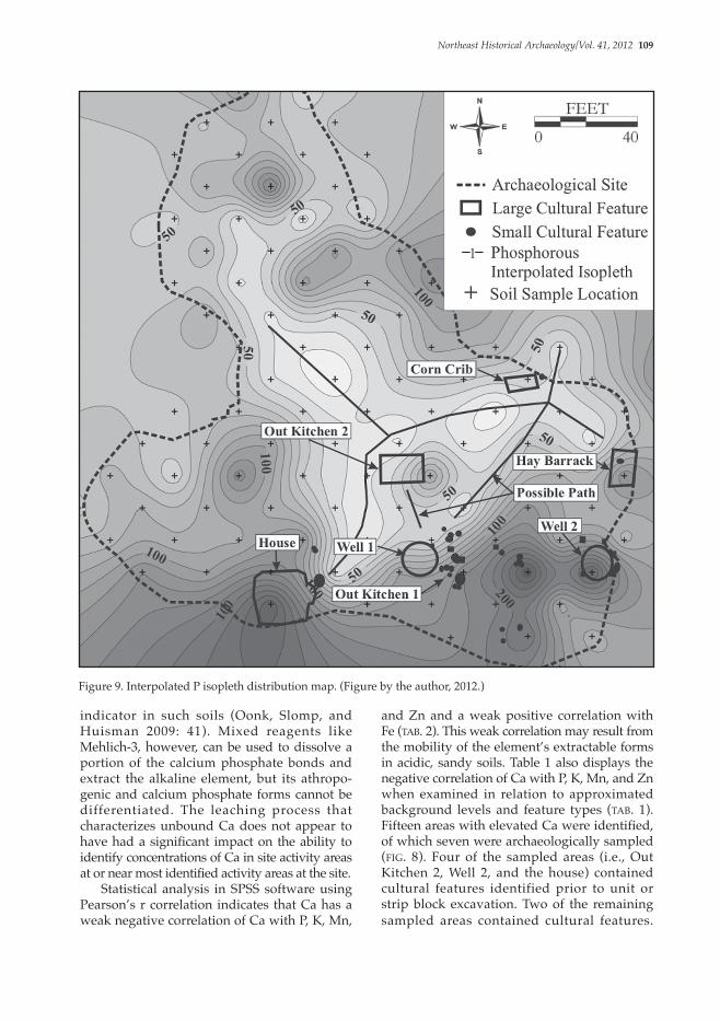
Phosphorous (P) Phosphorous, particularly available P, has been intensively examined by archaeologists since the mid-20th century, and elevated P
Figure 10. Interpolated Mn isopleth distribution map. (Figure by the author, 2012.)

Northeast Historical Archaeology/Vol. 41, 2012 111
which also includes nonanthropogenic P formed from natural sediments and weathering (Holliday and Gartner 2007: 313). Holliday and Gartner (2007: 303) argued that differentiation of the various P forms in terms of chemistry, the biochemical cycle, and sequential extraction is key to utilizing P in archaeological contexts. In sandy soil like that of the Foundation site, soil P can leach through the stratigraphic profile. Phosphorous mobili-zation also increases in neutral and near-neutral pH soils. Though significantly reduced from its total forms, available P is often present at archaeological sites in elevated
448; Pogue 1988: 3; Schuldenrein 1995: 107). When added to the soil, P can rapidly form bonds with Ca, Al, and Fe ions to form phosphates. Identifying the correlation of Ca, Al, and Fe with cultural features and their statistical correlation with soil P is integral to interpret anthropogenic P residues. The calcium phosphate occurs in higher frequency in alkaline soils, while acidic soils produce more aluminum and iron phosphates. The Mehlich-3 solution used in this study extracts iron, aluminum, and a portion of calcium phosphate but does not differentiate between its forms. Available P comprises a minute percent of total P, the latter of
Figure 11. Interpolated Zn isopleth distribution map. (Figure by the author, 2012.)
112 Gall/Multi-element Geochemical Analysis
of ethnoarchaeological studies of Q’eqchi’ Maya houses at Las Pozas, Guatemala, and at a modern Maya farmstead in San Pedro, Belize, where identified patterns of low P and trace elements were associated with heavily trafficked and continuously cleaned areas (Fernández et. al. 2002: 503–504; Holliday and Gartner 2007: 308). Phosphorous at the site had a high positive correlation with Fe, K, Mn, and Zn (tab. 2). Phosphorous distribution was high in the south-east, southwest, and northern portions of the site (fig. 9). Eight of the ten areas with elevated P were archaeologically sampled, of which six yielded cultural features. Cultural features in three of the tested areas were identified in shovel test pits. Features associated with high P include the house, Hay Barrack, Well 2, Out Kitchen 2, and pits and post stains in the southeast portion of the site. Low phosphorous-distribution patterns at the Foundation site may represent heavily trafficked historical pathways between structures, also evinced by low Fe, Mn, and Zn levels at the site. These possible paths extend from the northeast corner of the house to the west side of Out Kitchen 2 and Well 1, between the north side of Out Kitchen 2 and the space between the Corn Crib and Hay Barrack, and between Out Kitchen 2 and Well 1. An additional path may extend from the northwest side of Out Kitchen 2 to a northwest-facing gentle side slope in the northwest portion of the site. The latter possible path may have led to sheet-midden refuse-disposal areas suggested by two isolated
levels relative to offsite locations or control samples, and can be broadly indicative of human activity (Holliday and Gartner 2007: 304, 306, 309, 313). The opposite correlation has been observed in acidic, poorly-drained, hydric soils (Gall et al. 2014). The reduction of P in microenvironmental conditions similar to that of the Foundation site highlights the necessity to examine and combine P-data interpretation with that of additional elements, such as Ca, Cu, Fe, Mn, and Zn (Middleton and Price 1996; Parnell, Terry, and Nelson 2002; Terry et al. 2004; Cook et al. 2006: 629; Holliday and Gartner 2007: 307; Wilson, Davidson, and Cresser 2008: 412–421; Oonk, Slomp, and Huisman 2009; Milek and Roberts 2013). High P densities have proven useful in identifying areas of concentrated human and animal waste, hearths, outbuildings, and animal pens in acidic well-drained soils (Sullivan and Kealhofer 2004). The opposite correlation can take place in hydic soils. Elevated P can result from human excrement; organic waste, such as bone, meat, and plants; human burials; and charcoal (Holliday and Gartner 2007: 302, 306). Areas within archaeological sites with well-drained soils that have low P and other element densities have been attributed, through archaeological and ethno-archaeological research, to represent high-traffic pathways and ritual areas where anthropogenic chemical residues from unwanted wastes did not accumulate (Sarris et al. 2004: 937). This pattern is evinced by chemical residue analysis undertaken as part
OnsiteElements
P K Ca Cu Mn Zn Fe
P 1.000 – – – – – –
K .504 1.000 – – – – –
Ca -.067 -.060 1.000 – – – –
Cu .219 .069 .104 1.000 – – –
Mn .698 .458 -.183 .271 1.000 – –
Zn .557 .356 -.196 .576 .637 1.000 –
Fe .812 .518 .099 .222 .569 .476 1.000
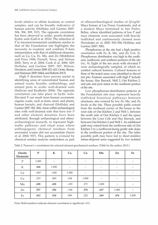
Table 2. Pearson’s r correlations for selected element geochemical residues. (Table by the author, 2013.)
Note: Bold numbers indicate element correlation is significant >0.3.
Northeast Historical Archaeology/Vol. 41, 2012 113
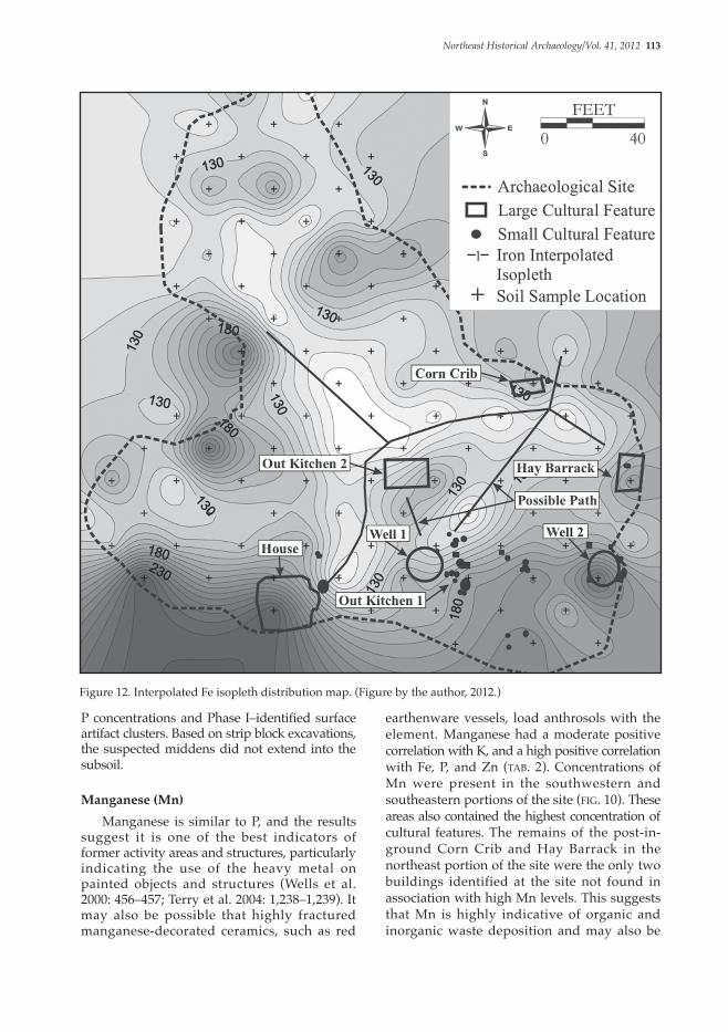
earthenware vessels, load anthrosols with the element. Manganese had a moderate positive correlation with K, and a high positive correlation with Fe, P, and Zn (tab. 2). Concentrations of Mn were present in the southwestern and southeastern portions of the site (fig. 10). These areas also contained the highest concentration of cultural features. The remains of the post-in-ground Corn Crib and Hay Barrack in the northeast portion of the site were the only two buildings identified at the site not found in association with high Mn levels. This suggests that Mn is highly indicative of organic and inorganic waste deposition and may also be
P concentrations and Phase I–identified surface artifact clusters. Based on strip block excavations, the suspected middens did not extend into the subsoil.
Manganese (Mn) Manganese is similar to P, and the results suggest it is one of the best indicators of former activity areas and structures, particularly indicating the use of the heavy metal on painted objects and structures (Wells et al. 2000: 456–457; Terry et al. 2004: 1,238–1,239). It may also be possible that highly fractured manganese-decorated ceramics, such as red
Figure 12. Interpolated Fe isopleth distribution map. (Figure by the author, 2012.)

114 Gall/Multi-element Geochemical Analysis
Foundation site did correspond with many of the identified cultural features (Entwistle, Abrahams, and Dodgshon 1998: 66) (fig. 11). Elevated levels of Zn were present near the Corn Crib, Out Kitchen 2, the northwest corner of the house, Well 1, and Out Kitchen 1. Lower Zn values were situated near Well 2 and the Hay Barrack. Two areas of elevated Zn in the western portion of the site were archaeologically tested, but no cultural features were identified. Elevated zinc in that portion of the site may correspond to nonextant cultural features or refuse-disposal patterns. Possible high-traffic areas within the site contain notably low Zn
associated with painted buildings. Both farm-related buildings, however, were associated with high Zn and Fe levels.
Zinc (Zn) Zinc is known to accumulate in site soils from the burning of wastes, decaying organic matter, refuse, excreta, and charcoal (Entwistle, Abrahams, and Dodgshon 2000: 300; Wilson, Davidson, and Cresser 2008: 418). This element had a moderate positive correlation with Fe and K, and a high positive correlation with Cu, Mn, and P. Zn is relatively mobile in acidic soils, but Zn distribution at the
Figure 13. Interpolated K isopleth distribution map. (Figure by the author, 2012.)
Northeast Historical Archaeology/Vol. 41, 2012 115
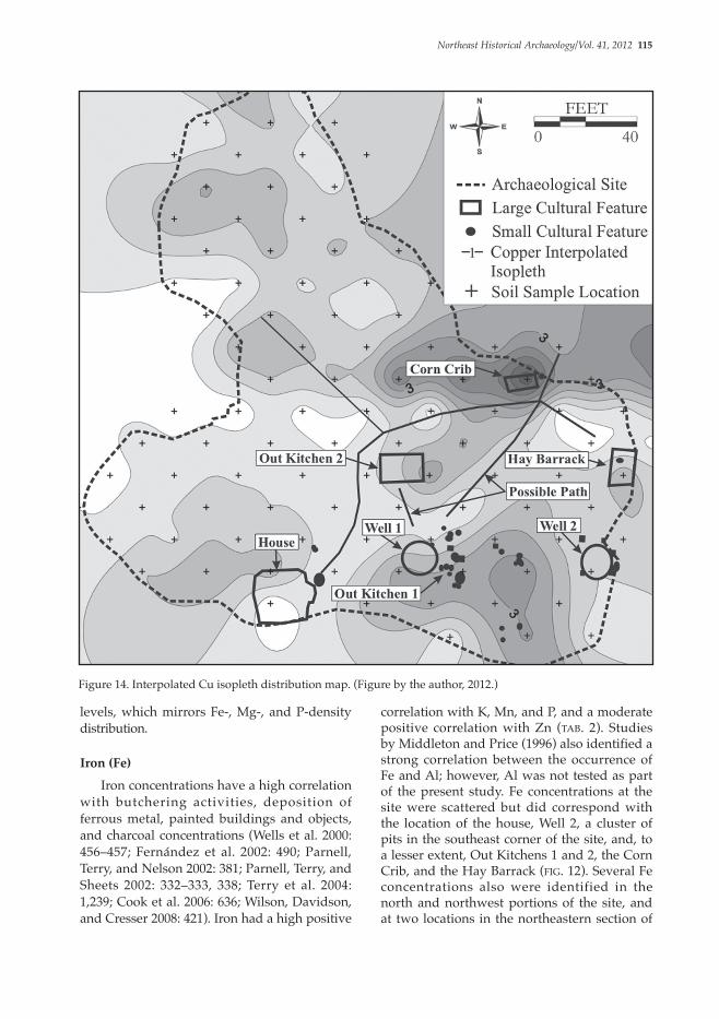
correlation with K, Mn, and P, and a moderate positive correlation with Zn (tab. 2). Studies by Middleton and Price (1996) also identified a strong correlation between the occurrence of Fe and Al; however, Al was not tested as part of the present study. Fe concentrations at the site were scattered but did correspond with the location of the house, Well 2, a cluster of pits in the southeast corner of the site, and, to a lesser extent, Out Kitchens 1 and 2, the Corn Crib, and the Hay Barrack (fig. 12). Several Fe concentrations also were identified in the north and northwest portions of the site, and at two locations in the northeastern section of
levels, which mirrors Fe-, Mg-, and P-density distribution.
Iron (Fe)
Iron concentrations have a high correlation with butchering activities, deposition of ferrous metal, painted buildings and objects, and charcoal concentrations (Wells et al. 2000: 456–457; Fernández et al. 2002: 490; Parnell, Terry, and Nelson 2002: 381; Parnell, Terry, and Sheets 2002: 332–333, 338; Terry et al. 2004: 1,239; Cook et al. 2006: 636; Wilson, Davidson, and Cresser 2008: 421). Iron had a high positive
Figure 14. Interpolated Cu isopleth distribution map. (Figure by the author, 2012.)

116 Gall/Multi-element Geochemical Analysis
elements like Ca and Mg (Oonk, Slomp, and Huisman 2009: 41). The extractable quantity of K is often dependent on microenviron-mental conditions such as soil pH and texture (Pogue 1988: 3). High K levels generally indicate the presence of intense in situ wood burning or the accumulation of redeposited charcoal, which also enriches the soil with Mg and Ca (Pogue 1988: 3). Potassium at the site had a moderate positive correlation with Mn and Zn, and a high positive correlation with Fe and P (tab. 2). Dense concentrations of K at the Foundation site were present at the location of Out Kitchen 1. This structure
the site. The latter two also corresponded with Zn anomalies and contained the remains of the Corn Crib and Hay Barrack. Low densities of Fe between the house and Out Kitchen 2, northwest of Out Kitchen 2, and between Out Kitchen 2 and the Corn Crib–Hay Barrack area may result from refuse removal or presence of pathways at the site.
Potassium (K) Potassium is an alkaline element often found at identifiably high levels within archaeological soils and is less mobile in acidic sandy soils compared to other alkaline
Figure 15. Interpolated B isopleth distribution map. (Figure by the author, 2012.)

Northeast Historical Archaeology/Vol. 41, 2012 117
charcoal, refuse, and excreta (Entwistle, Abrahams, and Dodgshon 2000: 300). Cu has also been found in elevated concentrations in buildings and near objects painted or dyed in metallic-based pigments (Terry et al. 2004: 1,239; Wells et al. 2000: 456–457). It also may be released by highly fractured ceramics having copper oxide decoration. This trace element is a strong indicator of anthropogenic chemical residue (Oonk, Slomp, and Huisman 2009: 42). Copper also may be deposited by rain and windblown dust. At the Foundation site, copper had a high positive correlation only with Zn. Examination of elevated Cu distribution at the
was destroyed by fire prior to the early 1760s, and the resultant charcoal deposits likely correlate with high K levels in this portion of the site. Potassium distribution also corresponds with the location of Out Kitchen 2, Well 1, the Hay Barrack, and several pits in the southeast corner of the site, and, to a lesser extent, Well 2 (fig. 13).
Copper (Cu) Copper is a relatively stable element, particularly in acidic soils, and can be released from decaying organic matter like bone and
Figure 16. Interpolated Mg isopleth distribution map. (Figure by the author, 2012.)

118 Gall/Multi-element Geochemical Analysis
Manalapan Village House site (28MO349), situated in comparable environmental settings less than one-half mile south and east of the Foundation site, respectively (Gall, Lore, and Hayden 2007, 2009a). With the exception of a larger-interval soil-collection grid employed at the Manalapan Village House site (i.e., 25 ft. interval collection grid), the sample collection and laboratory processing methods were similar for all three sites. Geochemical data analysis from the Foundation site reveals element suite patterns associated with certain feature types (tabs. 1 and 3). Similar patterns are present nearby at the two aforementioned historical sites. High geochemical values at and near domestic structures at the Foundation site, such as the house, Out Kitchen 1, and Out Kitchen 2, consistently included elevated levels of pH, Ca, Cu, Fe, K, Mn, P, and Zn. Samples in or adjacent to the former dwelling and out kitchen at the Manalapan Village House site, the latter of which was destroyed by fire in 1800, reveal a pattern similar to that at the Foundation site. Geochemical patterns identified at domestic buildings, such as the house and out kitchen at the Garret Forman site, also included elevated levels of pH, Ca, Fe, K, Mn, P, and Zn. Manganese appeared to be a distinguishing factor with domestic structures at all three sites and was rarely found in association with nondomestic buildings. The prevalence of Mn at the domestic structures may be related to the chemical’s presence in metallic-based paints used on or in the structures, though other possibilities may exist (Parnell, Terry, and Sheets 2002: 332–333; Wells et al. 2000). Studies at a Classic Maya village in Cerén, El Salvador, identified similar elevations of Mn, as well as other heavy metals, such as Cu, Fe, Hg, Pb, and Zn, near the painted door of a ceremonial structure (Terry 2004: 1,239). Analysis of other feature types indicates that soils at or near outbuildings at the Foundation site, such as the Hay Barrack and Corn Crib, exhibited high values of Cu, Fe, K, and Zn. Well 1 had elevated Cu, K, and Zn (tabs. 1 and 3). The data from the Foundation site suggests Ca, Cu, Fe, K, Mn, P, and Zn were strong indicators of anthropogenic chemical residues and activity areas. In comparison, outbuildings and animal pens at the Manalapan Village House site typically exhibited high levels of pH, Ca, Fe, K, and Mg. Areas in
site demonstrates a strong correlation with the location of most identified structures at the site, including the Corn Crib, Hay Barrack, Out Kitchens 1 and 2, and pits southeast of Out Kitchen 1 (fig. 14). Copper marked the northern edge of the house and the southern edge of Well 1. High levels of Cu, as well as Mn and Zn, 25 ft. north of Out Kitchen 2, likely marked the location of an additional activity area that may have contained one or more cultural features.
Boron (B) and Magnesium (Mg) In this study, B and Mg were the least useful in predicting the locations of cultural features or former activity areas. Boron may occur in high densities on sites from the burning of plant-based material, such as wood, or possibly accumulates due to modern agricultural fertilizers. The relationship of B to possible historical activities within the site is unclear. None of the B elevations correspond with feature or known activity-area locations (fig. 15). Magnesium is an alkaline element and follows a similar path as Ca. Oonk, Slomp, and Huisman (2009: 41) indicated that Mg has a relatively low concentration in occupation wastes, and because it is susceptible to leaching from occupation horizons in acidic, sandy soils and is found in abundance in soil solution and groundwater, it is a poor anthropogenic indicator. At the Foundation site, the Corn Crib and the western side of Out Kitchen 2 were associated with a moderately high Mg level (fig. 16). Most other high Mg levels were found at the periphery of the site in side slope settings, none of which was archaeologically sampled. The acidic, sandy soils that characterized the site likely played a large role in the poor retention of anthropogenic Mg residue at the site.
Intersite Comparisons Compared with geochemical data from two nearby farmstead sites, this case study provides important data and future method-ological and research avenues for geochemical prospection and data interpretation at historical archaeological sites in the Middle Atlantic region. Using similar methods, geochemical analysis recently was conducted at the early to mid-19th-century Garret Forman site (28MO354) and the mid- to late-18th-century

Northeast Historical Archaeology/Vol. 41, 2012 119
Feature Culture Material pH B Ca Cu Fe K Mg Mn P Zn
Foundation Site†
House* Bone, shell, and charcoal–rich with domestic and architectural material
X X X X X X X X
Out Kitchen 1* Burnt post stains with shell and bone
X X X X X X X
Out Kitchen 2* Artifact-rich topsoil with charcoal, shell, and bone
X X X X X X X X X
Corn Crib* Burnt post stains X X X X X
Hay Barrack*
Post stains X X X X X
Southeastern Pits
Charcoal, shell, bone X X X X X X X X
Well 1* Artifact-rich topsoil with charcoal, shell, and bone
X X X
Well 2* Redeposited subsoil X X X X X
Manalapan Village House Site‡
House* Redeposited charcoal X X X
Out Kitchen* Burned in situ wood, plaster, bone, shell and domestic and architec-tural material
X X X X X X X
Meat Store House*
Earthen floor with crushed bone and charcoal
X X X X X X
Well Shell and bone
Rectangular Pit*
Redeposited topsoil (nearly artifact free)
X
Outdoor Bake Oven
Fire-reddened soil
Large Pit (possible chicken coop)*
Nails, bone, and shell X X X
Small Pit* Brick, shell, bone, and charcoal
X X X X X
Table 3. Anthropogenic geochemical concentrations at and near various feature types from three proximate archaeological sites. (Table by the author, 2013.)

120 Gall/Multi-element Geochemical Analysis
and Hayden 2007, 2009a). Multilayer anomalies were visually defined as areas containing three or more overlapping element spikes based on interpolated isopleths. These were often smaller than and encompassed within the footprint of broader double-layer anomalies, designated as areas where interpolated isopleths of only two elevated geochemical signatures overlapped. At the Foundation site, all of the archaeologically tested multilayer anomalies contained cultural features, and 72% of the tested double-layer anomalies yielded cultural features. Thirty-one double-layer and twelve multilayer geochemical anomalies were identified at the Garret Forman site. Twelve double-layer geochemical anomalies were archaeologically tested, of which seven (n=58%) correlated with activity areas represented by subsurface cultural fea-tures. Five of the twelve multilayer geochemical anomalies were archaeologically tested, of which four (n=80%) correlated with former activity areas containing cultural features. Similarly, all five of the tested double-layer anomalies and all seven investigated multilayer anomalies at the Manalapan Village House site were located at or proximate to activity areas containing cultural features. The results suggest
proximity to storage or refuse pits rich in bone, shell, and charcoal deposits at the Garret Forman site yielded elevated pH, Ca, Cu, Fe, K, Mg, Mn, P, and Zn. Pits in the southeastern portion of the Foundation site exhibited similar geochemical patterns with the exception of Ca and Mn. The wide range of geochemical residues in and near such feature types may result from elements loaded in feature context soils from shell, bone, and charcoal over time. With the exception of Well 2 at the Foundation site, areas around well features typically did not exhibit strong anthropogenic chemical residues at any of the three sites, possibly because of the concentrated nature of refuse in a narrow shaft and maintenance around the structures during site occupation. The results of this case study are enlightening when compared to the use of multi-element analysis as a tool for archaeological prospecting at the Foundation site and other nearby historical archaeological sites. The utilization of double- and multilayer geochemical signatures to target locations for excavation and aid in cultural feature identification at the Foundation site has had similar results at the Garret Forman site and the Manalapan Village House site (Gall, Lore,
Feature Culture Material pH B Ca Cu Fe K Mg Mn P Zn
Paddock* Dense bone, shell, and ceramic deposits
X X X X X
Small Animal Pen
No cultural material X X X X
Garrett Forman Site†
House Ceramics, bone, shell, charcoal, nails, and brick
X X X X X X X
Out Kitchen Charcoal, dense bone, shell, ceramics, and nails
X X X X X X X
Well Upper portion with redeposited topsoil and subsoil
X X X X
Small Pit and Possible Privy
Low numbers of brick, shell, and ceramics
X X X X X X X X X X
Table 3. (continued)
* Indicates sample taken in footprint of or adjacent to feature.† Soil samples taken at 25 ft. interval grid points on two offset grids spaced 12.5 ft. apart.‡ Soil samples taken at 25 ft. interval grid points.

Northeast Historical Archaeology/Vol. 41, 2012 121
residues from subsoil samples taken in sandy, acidic soils due to the migration of weakly sorbed geochemical residues through the soil profile. This study also shows that concentrations of some available element forms, such as Ca, Cu, Fe, K, Mn, P, and Zn, using the above-referenced methods, correlate better with former activity areas and structures than do other chemical residues, like B and Mg (Gall, Lore, and Hayden 2007, 2008, 2009b). Peaks in B deposits may be the result of modern fertilization practices, and weakly sorbed forms of Mg appear to be too unstable in acidic sandy soils to represent anthro-pogenic chemical residues accurately. The study strongly suggested that Mn correlated well with the location of domestic structures. One possibility is that Mn is present in interior and exterior paints applied to structures, though other reasons also may exist. The various techniques applied in the archaeological investigation of the Foundation site highlighted issues associated with the heavy or sole reliance on artifact-distribution patterns to identify former activity areas and buried cultural features. While some activity areas were characterized by surface and plow-zone artifact deposits (e.g., Out Kitchen 2 and the general location of Out Kitchen 1), the majority were not. Additional data provided by shovel test pit excavation identified anthro-sols associated with the house and Well 2. Identification of these features and activity areas furnished only partial evidence of the former farmstead, spatial use, and development at the site over time. Excavations guided by geochemical soil analysis, however, provided abundant data leading to the identification of the Corn Crib, Hay Barrack, Out Kitchen 1, Well 1, and several post stains and pits in the southeast portion of the site. Together, these features produced significant data on the pre-1760s site occupation period, spatial use, and architectural construction methods. Without the analysis of geochemical soil data, significant information on the first half of the site’s occupation period, recovered in feature soils associated with Well 1 and Out Kitchen 1, may have been overlooked during the excavation program. Interpolated isopleths of quantified geochemical data also supplied evidence for the possible location of heavily trafficked pathways between structures and activity areas at the site. Ultimately, geochemical soil
that the probability of encountering a former activity area containing cultural features markedly increases with the number of overlapping elevated geochemical signatures, excluding B and Mg, regardless of the element suite composition among the following elements: Ca, Cu, Fe, K, Mn, P, and Zn. Some feature types, however, may be less detectable geochemically given feature attributes such as size, shape, and feature matrix composition.
Conclusions Decades of research in the Middle Atlantic region and elsewhere have demonstrated that anthropogenic chemical residue analysis can be an important tool in identifying and interpreting spatial use within archaeological sites. Geochemical soil-analysis data can be applied to confirm archaeological interpretations based on identified cultural features and artifact-distribution patterns. Analysis may provide new data about space use and site boundaries that cannot be gleaned from artifact analysis alone. Multi-element anthropogenic chemical residue analysis can also be utilized as a tool to locate discrete or broad activity areas within archaeological sites that may contain buried cultural features and to guide excavations that ultimately aid in the recovery of significant site data. The geochemical survey methods employed at the 18th-century Foundation site (28MO352) generally identified activity areas containing cultural features within less than 5 ft. of soil-sample locations. Samples taken at closer, 10 or 12.5 ft. intervals are likely to yield more accurate data to aid in targeting and delineating former activity areas that contain cultural features, particularly earthfast buildings. Interpretation of activity areas within interior living and working spaces, however, requires sampling at significantly closer intervals. This case study and other geochemical studies at sites in plowed contexts indicate that multi-element and pH data must be examined and analyzed together when targeting areas for excavation and forming site interpretations. The geochemical soil data also must be examined in context with microenvironmental conditions and other archaeological information. In this study, Mehlich-3 and ICP-AES lab methods worked well to quantify anthropogenic chemical

122 Gall/Multi-element Geochemical Analysis
Cook, Sherburne F., and Robert F. Heizer 1965 Studies on the Chemical Analyses of
Archaeologica l Si tes . Universi ty of California Publications in Anthropology 2. Berkeley.
Cultural Resources Consulting Group 2006 Phase IB Archaeological Survey-East Parcel
and Phase IB Historic Architectural Survey- East and West Parcels, K. Hovnanian Companies, Four Seasons at Manalapan, Block 66, Lots 7.01, 9, 13, and 14, Manalapan Township, Monmouth County, New Jersey. Manuscript, K. Hovnanian at Manalapan II, LLC, Edison, NJ.
Custer, Jay F., Ellis C. Coleman, Wade P. Catts, and Kevin Cunningham
1986 S o i l C h e m i s t r y a n d H i s t o r i c Archaeological Site Activity Areas: A Test Case from Northern Delaware. Historical Archaeology 20(2): 89–94.
Deetz, James, and Edwin Dethlefsen 1963 Soil PH as a Tool in Archaeological Site
Interpretation. American Antiquity 29(2): 242–243.
Eidt, Robert C. 1977 Detection and Examination of Anthrosols
from Phosphate Analysis. Science 197: 1,327–1,333.
Entwistle, Jane A., Peter W. Abrahams, and R. A. Dodgshon
1998 Multi-Element Analysis of Soils from Scottish Historical Sites. Interpreting Land-Use History through the Physical and Geochemical Analysis of Soil. Journal of Archaeological Science 25(1): 53–68.
2000 The Geoarchaeological Significance and Spatial Variability of a Range of Physical and Chemical Soil Properties from a Former Habitation Site, Isle of Skye. Journal of Archaeological Science 27(4): 287–303.
Fernández, Fabián G., Richard E. Terry, Takeshi Inomata, and Markus Eberl
2002 An Ethnoarchaeological Study of Chemical Residues in the Floors and Soils of Q’eqchi’ Maya Houses at Las Pozas, Guatemala. Geoarchaeology 17(6): 487–519.
Fisher, Lisa E. 2001 Recovering Elements in Historical
Archaeology: The Use of Soil Chemical Analysis for Overcoming the Effects of Post-Depositional Plowing. M.A. thesis, C o l l e g e o f Wi l l i a m a n d M a r y, Williamsburg, VA.
data served as an important tool in the recovery of significant site data, indicating the method can be utilized in conjunction with traditional methods of archaeological testing and other survey and data-collection techniques available to archaeologists.
Acknowledgments The author would like to thank the staff of Richard Grubb & Associates, Inc., for their assistance in all aspects of the archaeological data recovery. Sharon White, Ph.D., assisted with statistical analysis. Rutgers University Soil Testing Lab processed the geochemical data. Dennis Pogue provided data on geochemical analysis investigations in Virginia. Richard Veit, Ph.D., of Monmouth University and Jesse Walker of Richard Grubb & Associates, Inc., are thanked for providing edits and comments on an earlier draft of this article. The author also appreciates the comments and suggestions provided by the anonymous peer reviewers.
ReferencesAhler, Stanley A. 1973 A Chemical Analysis of Deposits at Rogers
R o c k S h e l t e r, M i s s o u r i . P l a i n s Anthropologist 18(60): 116–131.
Bedell, John 2002 Historic Context: The Archaeology of Farm and
Rural Dwelling Sites in New Castle and Kent Counties, Delaware 1730–1770 and 1770–1830. Delaware Department of Transportation Archaeology Series No. 162. Dover.
Bjelajac, Victor, Edward M. Luby, and Rose Ray 1996 A Validation Test of a Field-Based
Phosphate Analysis Technique. Journal of Archaeological Science 23(2): 243–248.
Catts, Wade P., Jay F. Custer, JoAnn E. Jamison, Michael D. Scholl, and Karen Iplenski
1995 Final Archaeological Investigations at the William Strickland Plantation Site (7K-A-117), A Mid-Eighteenth Century Farmstead, State Route 1 Corridor, Kent County, Delaware. Delaware Department of Transportation Archaeology Series No. 119. Dover.
Cook, Duncan, Brigitte Kovacevich, Timothy Beach, and Ronald Bishop
2006 Deciphering the Inorganic Chemical Record of Ancient Human Activity Using ICP-MS: A Reconnaissance Study of Late Classic Soil Floors at Cancuen, Guatemala. Journal of Archaeological Science 33(5): 628–640.

Northeast Historical Archaeology/Vol. 41, 2012 123
Gall, Michael J., and Glenn Modica 2013a Phase II Archaeological Survey, Garrison
Energy Center Project, City of Dover, Kent County, Delaware. Report to Calpine Corporation, North Region Office, Wilmington, Delaware from Richard Grubb & Associates, Inc., Cranbury, NJ.
2013b Management Summary, Phase III Archaeological Data Recovery, Locus B of the Garrison Energy Site (7K-C-455B), Garrison Energy Center Project, City of Dover, Kent County, Delaware. Report to Calpine Corporation, North Region Office, Wilmington, Delaware from Richard Grubb & Associates, Inc., Cranbury, NJ.
Gall, Michael J., Glenn Modica, Tabitha Hilliard, and Anthony Lipari
2014 Freedom, Ident i ty, and Cul tura l Formation: Phase III Archaeological Data Recovery, Locus B of the Garrison Energy Site (7K-C-455B), Garrison Energy Project, City of Dover, Kent County, Delaware. Report to Calpine Corporation, North Region Office, Wilmington, Delaware from Richard Grubb & Associates, Inc. , Cranbury, NJ.
Grettler, David J., George L. Miller, Keith Doms, Brian Seidel, Macon Coleman, and Jay F. Custer
1995 Landowner and Tenant Opportunity in Seventeenth Century Central Delaware: Final Archaeological Investigations at the Richard Whitehard (7K-C-203C) and John Powell (7K-C-203H) Plantations, State Route 1 Corridor, Kent County, Delaware. Delaware D e p a r t m e n t o f Tr a n s p o r t a t i o n Archaeology Series No. 127. Dover.
Heite, Edward F., and Cara L. Blume 1998 Mitsawokett to Bloomsbury: Archaeology and
History of an Unrecognized Indigenous Community in Central Delaware. Delaware D e p a r t m e n t o f Tr a n s p o r t a t i o n Archaeology Series No. 154. Dover.
Holliday, Vance T., and William G. Gartner 2007 Methods of Soil P Analysis in Archaeology.
Journal of Archaeological Science 34(2): 301–333.
Hutson, Scott R., and Richard E. Terry 2006 Recovering Social and Cultural Dynamics
from Plaster Floors: Chemical Analyses at Ancient Chunchucmil, Yucatan, Mexico. Journal of Archaeological Science 33(3): 391–404.
Gall, Michael J. 2007 Status, Land Use, Material Culture and the
Agricultural Ladder: Cottage Holding and Farming in Princeton, New Jersey: Archaeological Data Recovery at the P. Tulane Site (28-Me-305), Circa 1820s–1870, Princeton Township, Mercer County, New Jersey. Report to Somerset County Department of Public Works, Engineering Division, Somerville, NJ, from Richard Grubb and Associates, Inc., Cranbury, NJ.
Gall, Michael J., Philip A. Hayden, and Alana K. Stops
2006 Phase I and II Archaeological Survey and Assessment of Visual Effects to the Monmouth Battlefield, the Village at Manalapan, Highway 33 and Millhurst Road (Block 66, Lots 8 and 25.01), Manalapan Township, Monmouth County, New Jersey. Report to Kenderian Zilinski Associates, Wall, NJ, from Richard Grubb & Associates, Inc., Cranbury, NJ.
Gall, Michael J., Robert Lore, and Philip A. Hayden 2007 Life at the Van Kirk/Walton/Forman
Farmstead (ca. 1742–1800): Archaeological Data Recovery at the Manalapan Village House Site (28-Mo-349), Manalapan Township, Monmouth County, New Jersey. Report to Kenderian Zilinski Associates, Wall, NJ, from Richard Grubb & Associates, Inc., Cranbury, NJ.
2008 Earthfast in Eighteenth-Century New Jersey: Archaeological Data Recovery at the Foundat ion Si te (28-Mo-352) , Manalapan Township, Monmouth County, New Jersey. Administrative Consent Order, Four Seasons at Manalapan, EA ID # A060001-1326-02-0003.1. Report to K. Hovnanian at Manalapan II , LLC, Hamilton, NJ, from Richard Grubb & Associates, Inc., Cranbury, NJ.
2009a B lacksmi th ing and Farr ie r ing in Eighteenth-Century Somerset County: Archaeological Excavations at the Voorhees Site (28-So-153), Franklin Township, Somerset County, New Jersey. Report to Somerset County Engineering, Somerville, NJ, from Richard Grubb & Associates, Inc., Cranbury, NJ.
2009b Farm Life in Nineteenth-Century Monmouth County: Archaeological Data Recovery at the Garret Forman Site (28-M o - 3 5 4 ) , M a n a l a p a n To w n s h i p , M o n m o u t h C o u n t y, N e w J e r s e y. Administrative Consent Order, Four Seasons at Manalapan, EA ID # A060001-1326-02-0003.1. Report to K. Hovnanian at Manalapan II, LLC, Hamilton, NJ, from Richard Grubb & Associates, Inc. , Cranbury, NJ.

124 Gall/Multi-element Geochemical Analysis
Oonk, Stijn, Caroline P. Slomp, and D. J. Huisman 2009 Geochemistry as an Aid in Archaeological
Prospection and Site Interpretation: Current Issues and Research Directions. Archaeological Prospection 16(1): 35–51.
Parnell, J. Jacob, Richard E. Terry, and Zachary Nelson
2002 Soil Chemical Analysis Applied as an Interpretive Tool for Ancient Human Activities in Piedras Negras, Guatemala. Journal of Archaeological Science 29(4): 379–404.
Parnell, J. Jacob, Richard E. Terry, and Payson Sheets 2002 Soil Chemical Analysis of Ancient
Activities in Cerén, El Salvador: A Case Study of a Rapidly Abandoned Site. Latin American Antiquity 13(3): 331–342
Pogue, Dennis 1988 A n t h ro s o l s a n d t h e A n a l y s i s o f
Archaeological Sites in a Plowed Context: The King’s Reach Site. Northeast Historical Archaeology 17: 1–15.
Rypkema, Heather A., Wayne E. Lee, Michael L. Galaty, and Jonathan Haws
2007 R a p i d , I n - S t r i d e S o i l P h o s p h a t e Measurement in Archaeological Survey: A New Method Tested in Loudon County, Virginia. Journal of Archaeological Science 34(11): 1,859–1,867.
Salisbury, Roderick B. 2012 Soilscapes and Settlements: Remote Mapping of
Activity Areas in Unexcavated Prehistoric Farmsteads. Antiquity 86(331): 178–190.
2013 Interpolating Geochemical Patterning of Activity Zones at Late Neolithic and Early Copper Age Settlements in Eastern Hungary. Journal of Archaeological Science 40(2): 926–934.
Sarris, Apostolo., Michael L. Galaty, Richard W. Yerkes, William A. Parkinson, Atilla Gyucha, Doc M. Billingsley, and Robert Tate
2004 Geophysical Prospection and Soil Chemistry at the Early Copper Age Settlement of Veszto-Bikeri, Southeastern Hungary. Journal of Archaeological Science 31(1): 927–939.
Schuldenrein, Joseph 1995 Geochemistry, Phosphate Fractionation, and the
Detection of Activity Areas at Prehistoric North American Sites. In Pedological Perspectives in Archaeological Research, ed. by Mary E. Collins, Brian J. Carter, Bruce G. Gladfelter, and Randal J. Southard, 107–132. Soil Science Society of America Special Publication 44. Madison, WI.
Jablonski, C. F., and Robert J. Baumley 1989 Soil Survey of Monmouth County, New
Jersey. United States Department of Agriculture, Soil Conservation Service, Washington, DC.
Loide, Valli., Märt Nõges, and Jaanus Rebane 2005 Assessment of Agrochemical Properties of
the Soil Using the Extraction Solution Mehlich 3 in Estonia. Agronomy Research 3(1): 73–80.
Lore, Robert, and Tara Bini 2007 Late Woodland Adaptations in the
Mi l l s tone River Bas in , Phase I I I Archaeological Investigation, Cherry Valley Road Site (28-Me-304), Princeton Township, Mercer County, New Jersey. Report to Somerset County Department of Public Works, Engineering Division, Somerville, NJ, from Richard Grubb and Associates, Inc., Cranbury, NJ.
MAAR Associates, Inc. 1988 Archaeological Data Recovery at an 18th
and 19th Century Farmstead, Red Bank, M o n m o u t h C o u n t y, N e w J e r s e y. Manuscript, International Technology Corporation, Edison, NJ.
Middleton, William D. 2004 Identifying Chemical Activity Residues on
Prehistoric House Floors: A Methodology and Rat ionale for Mult i -E lement Characterization of a Mild Acid Extract of Anthropogenic Sediments. Archaeometry 46(1): 47–65.
Middleton, William D., and T. Douglas Price 1996 Identification of Activity Areas by Multi-
element Characterization of Sediments from Modern and Archaeological House Floors Using Inductively Coupled Plasma-atomic Emission Spectroscopy. Journal of Archaeological Science 23(5): 673–687.
Milek, Karen B., and Howell M. Roberts 2013 Integrated Geoarchaeological Methods for
the Determination of Site Activity Areas: A Study of a Viking House in Reykjavik, Iceland. Journal of Archaeological Science 40(4): 1,854–1,865.
Natural Resource Conservation Service 2008 Soil Survey Geographic (SSURGO) Database
for Monmouth County, NJ. United States Department of Agriculture, Washington, DC.

Northeast Historical Archaeology/Vol. 41, 2012 125
Vyncke, Kim, Patrick Degryse, Elvira Vassilieva, and Marc Waelkens
2011 Identifying Domestic Functional Areas: Chemical Analysis of Floor Sediments at the Classical-Hellenistic Settlement at Düzen Tepe (SW Turkey). Journal of Archaeological Science 38(9): 2,274–2,292.
Wells, E. Christian, Richard E. Terry, J. Jacob Parnell, Perry J. Hardin, Mark W. Jackson, and Stephen D. Houston
2000 Chemical Analysis of Ancient Anthrosols in Residential Areas at Piedras Negras, Guatemala. Journal of Archaeological Science 27(5): 449–462.
Wilson, Clare A., Donald A. Davidson, and Malcolm S. Cresser
2006 Sequential Element Extraction of Soils f r o m A b a n d o n e d F a r m s : A n Inves t iga t ion o f the Par t i t ion o f Anthropogenic Element Inputs from H i s t o r i c L a n d U s e . J o u r n a l o f Environmental Monitoring 8(4): 439–444.
2008 M u l t i - e l e m e n t S o i l A n a l y s i s : A n Assessment of Its Potential as an Aid to Archaeological Interpretation. Journal of Archaeological Science 35(2): 412–424.
Author InformationMichael J. Gall is a senior archaeologist with Richard Grubb & Associates in Cranbury, New Jersey.
Michael J. GallSenior ArchaeologistRichard Grubb & Associates, Inc.259 Prospect Plains Road, Building DCranbury, NJ [email protected]
Sjöberg, Alf 1976 Phosphate Analysis of Anthropic Soils.
Journal of Field Archaeology 3(4): 447–454.
Sopko, Joseph 1983 G e o p h y s i c a l a n d S o i l C h e m i c a l
I n v e s t i g a t i o n s a t N e w Wi n d s o r Cantonment . Nor thea s t H i s t o r i c a l Archaeology 12: 24–30.
Sullivan, Kelly Ann, and Lisa Kealhofer 2004 I d e n t i f y i n g A c t i v i t y A r e a s i n
Archaeological Soils from a Colonial Virginia House Lot Using Phytolith Analysis and Soil Chemistry. Journal of Archaeological Science 31(12): 1,659–1,673.
Terry, Richard E., Fabian G. Fernández, J. Jacob Parnell, and Takeshi Inomata
2004 The Story in the Floors: Chemical Signatures of Ancient and Modern Maya Activities at Aguateca, Guatemala. Journal of Archaeological Science 31(9): 1,237–1,250.
United States Geological Survey 1981 7.5” Quadrangle: Freehold, NJ. United States
Geological Survey, Washington, D.C..
Versar, Inc. 2012 Working on the Farm: Archaeological Data
Recovery Report from the Jones Site (7NC-J-204), New Castle County, Delaware. Report to Delaware Department of Transportation, Dover, DE, from Versar, Inc., Springfield, VA.