jenn martins semester 1 midterm process
DESCRIPTION
PDF of my process and progress in my senior thesis at Parsons.TRANSCRIPT

How are cities divided?tHesis MidterM ProGress
JeNN MartiNs

idea exPloratioN: PecHakucHasThe first assignments we had were to create PechaKuchas (20 slides x 20 seconds each) about (1) ourselves, (2) creative processes, and (3) 20 possible thesis topics after this self exploration.
Jenn Martins
designer
music/concert
lover
“artist”
organizer/victim
of OCD
Paula Scher / Me / Compare & Contrast!
Jenn Martins
TRAVELcollective design

20 tHesis ideas
TRAVELsocial media platform
TRAVELhelp resource
TRAVELtrack yourself + friends
TRAVELcollective design
TRAVELbackpacker forum
MUSICtour + release date program
TECHkids html program
TECHparsons coding tutoring
TECHstudent-to-student skills program
TECHobserve interaction with tech
TECHno social media
CREATIVEobserve creative processes
CREATIVEwork spaces
CULTUREcultural difference discussions
DESIGNdaily education
DESIGNmap of paths
CITYold + new
CITYlanguage differences in areas
POLITICSeasy-to-understand graphics
DESIRES“bucket-list” network
These are the ideas I thought I might want to develop for thesis. I came to these ideas using the observations I made about myself after the other two PechaKuchas and a self-reflection probe. The main areas were travel, music, technology, creative processes, culture, design, city, politics, and desires.

3 tHesis ideasI then narrowed my list of 20 thesis ideas to 3 categories and made a mind map for each. The 3 categories were travel, technology, and maps.
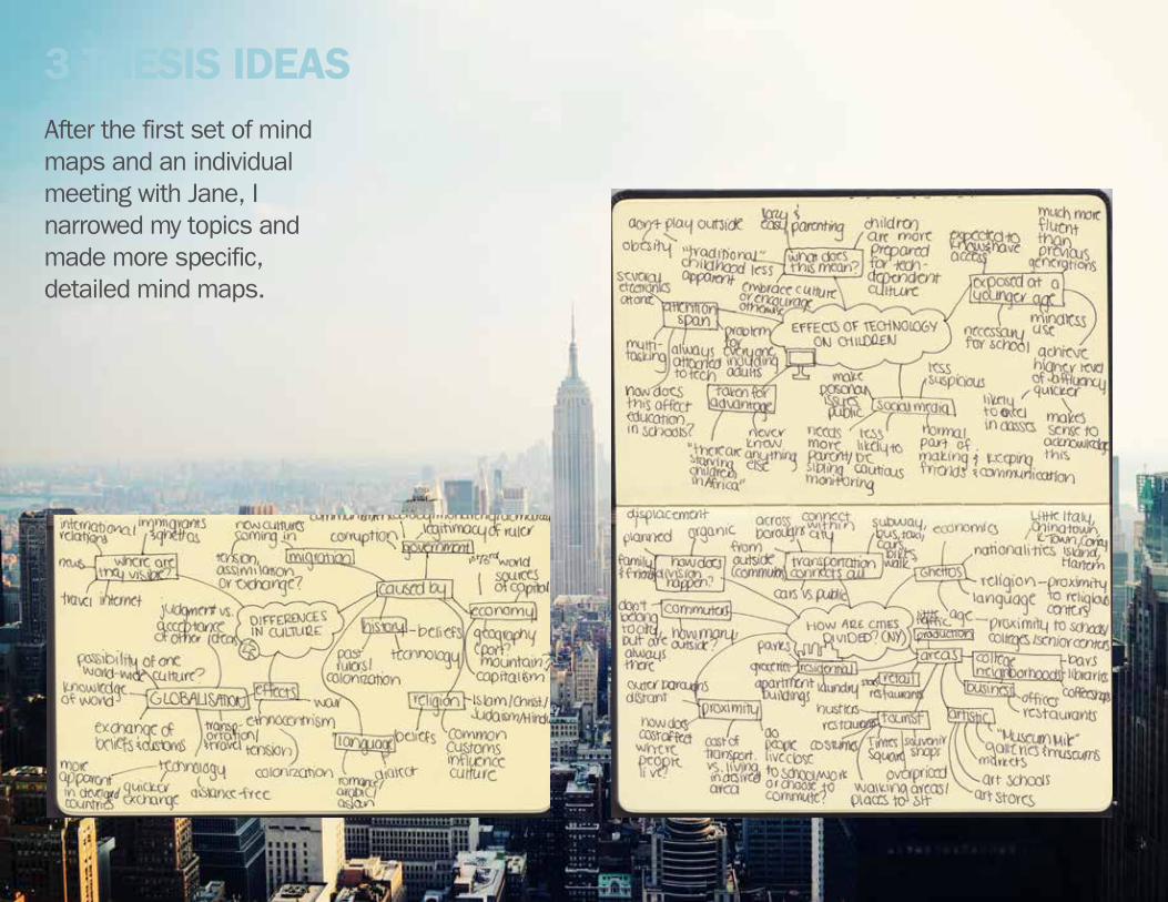
3 tHesis ideasAfter the first set of mind maps and an individual meeting with Jane, I narrowed my topics and made more specific, detailed mind maps.

1st researcH stateMeNt + researcH“I’m researching cultural and economic divisions in New York and analyzing why and how these divisions came to be to better understand how they interact with each other.”
I used this to begin my research and brainstorm ideas of maps that could be created illustrating the divisions in Manhattan.

2Nd (curreNt) researcH stateMeNtAfter doing some research, I rephrased and refocused my research statement.
“Using Manhattan as a case study, I’m researching how cities are divided, how these divisions came to be, and how the different pieces interact with each other. I’ll be looking mainly into cultural, ethnic and economic aspects.”

researcHA lot of the research I did involved maps. The image on the left is a map from the 1980’s illustrating how NYC is ethnically divided. The map on the right is from the NYC government site and shows how they currently divide the city into districts.

researcHThis is a map done by the New York Times which also separates NYC ethnically.

researcHThe Welikia/Mannahatta Project uses science to create images of how NYC appeared befored Hudson discovered it.
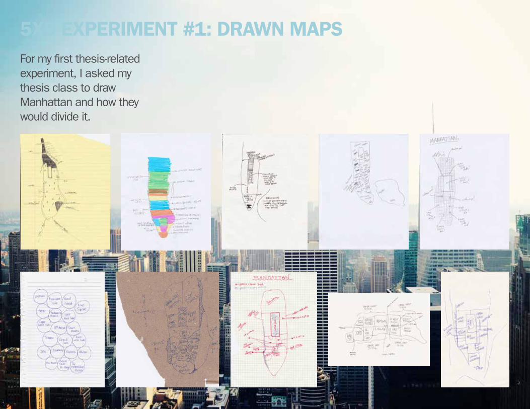
5x5 exPeriMeNt #1: drawN MaPsFor my first thesis-related experiment, I asked my thesis class to draw Manhattan and how they would divide it.
These are the different ways people mapped Manhattan:•neighborhoods and notable places (this was the only map to not include a
geographic map of the city—it was simply naming these different areas)•neighborhoods (both vertical and horizontal)•pointing out places that are significant (where they used to live, where friends live,
where they do and do not go, where they enjoy nature)•divisions by highways and roads•pointing out only locations (where celebrities live, where shows are filmed, where
certain schools or stores are)
Some interesting things I found:•geographical inaccuracies•generalizing entire neighborhoods (Inwood represented as being expensive and
distant, Wall Street is men in suits, cobblestoned streets, dollar signs)• realization that they don’t know certain areas of the city (question marks, saying
that they want to do something here but haven’t)
5x5 exPeriMeNt #1: drawN MaPs
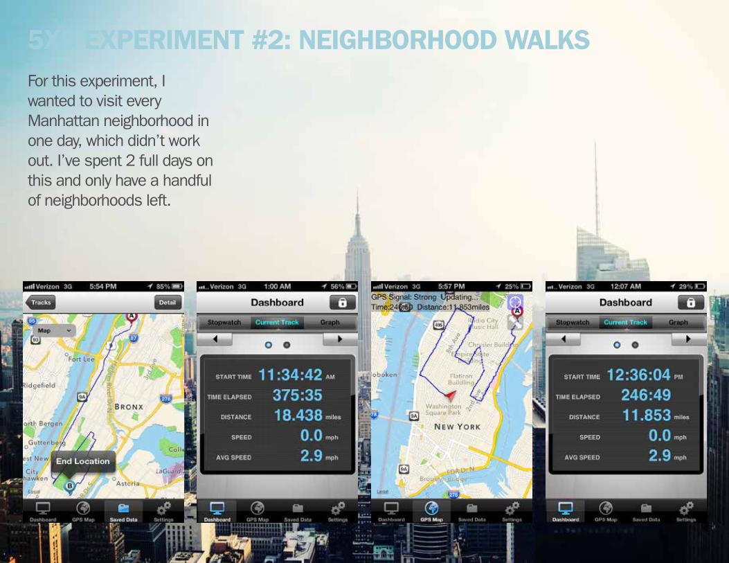
5x5 exPeriMeNt #2: NeiGHborHood walksFor this experiment, I wanted to visit every Manhattan neighborhood in one day, which didn’t work out. I’ve spent 2 full days on this and only have a handful of neighborhoods left.

As I walked through Manhattan, I took photos and notes and filled out a chart. The chart was used to document which neighborhoods were primarily residential, retail, offices, etc. as well as my mood while in the neighborhood.
5x5 exPeriMeNt #2: NeiGHborHood walks

5x5 exPeriMeNt #3: NeiGHborHood MaP
INWOOD
FORT GEORGE
WASHINGTON HEIGHTS
HAMILTONHEIGHTS
HARLEM
MORNINGSIDEHEIGHTS
EASTHARLEM
UPPER WEST SIDE
LINCOLN SQUARE
CENTRALPARK
YORKVILLE
UPPER EAST SIDE
LENOXHILL
CLINTON
HELL’SKITCHEN
MIDTOWN
THEATERDISTRICT
GARMENTDISTRICT
MIDTOWNSOUTHCHELSEA
TURTLEBAY
MURRAY HILL
KIPS BAY
GRAM-ERCY PARK
SUTTON
BEEK-MAN
STUY TOWN
NO
HO
BO
WER
YM
EDIC
ALCI
TYTU
DO
R
ABC CITY
EAST VILLAGE
GREENWICH VILLAGE
WEST VILLAGE
SOHO LOWER EASTSIDETRIBECA
LITT
LE
ITALY
CIVIC CENTER
WHITE HALL
CHINATOWN
TWO BRIDGES
WALL STREET
BATTERY PARK CITY
MEATPACKINGDISTRICT
MANHATTANNEIGHBORHOODS
JENN MARTINS
45 Neighborhoods• Inwood• Fort George• Washington Heights• Hamilton Heights• Harlem• Morningside Heights• UWS• Lincoln Square• East Harlem• Yorkville• UES• Lenox Hill• Clinton• Hell’s Kitchen• Chelsea• Midtown• Midtown South• Theater District• Garment District• Turtle Bay• Murray Hill• Kips Bay
• Gramercy Park• Sutton• Beekman• Tudor• Medical City• Stuyvesant• Meatpacking District• West Village• Greenwich Village• NoHo• East Village• Alphabet City• SoHo• TriBeCa• Little Italy• Chinatown• Civic Center• Bowery• Lower East Side• Two Bridges• Battery Park City• Wall Street/Financial District• White Hall
For this experiment, I made myself a map of the neighborhoods I would be using throughout my thesis, as there are many different versions and variations.

INWOOD
FORT GEORGE
WASHINGTON HEIGHTS
HAMILTONHEIGHTS
HARLEM
MORNINGSIDEHEIGHTS
EASTHARLEM
UPPER WEST SIDE
LINCOLN SQUARE
CENTRALPARK
YORKVILLE
UPPER EAST SIDE
LENOXHILL
CLINTON
HELL’SKITCHEN
MIDTOWN
THEATERDISTRICT
GARMENTDISTRICT
MIDTOWNSOUTHCHELSEA
TURTLEBAY
MURRAY HILL
KIPS BAY
GRAM-ERCY PARK
SUTTON
BEEK-MAN
STUY TOWN
NO
HO
BO
WER
YM
EDIC
ALCI
TYTU
DO
R
ABC CITY
EAST VILLAGE
GREENWICH VILLAGE
WEST VILLAGE
SOHO LOWER EASTSIDETRIBECA
LITT
LE
ITALY
CIVIC CENTER
WHITE HALL
CHINATOWN
TWO BRIDGES
WALL STREET
BATTERY PARK CITY
MEATPACKINGDISTRICT
MANHATTANNEIGHBORHOODS
JENN MARTINS
5x5 exPeriMeNt #3: NeiGHborHood MaP
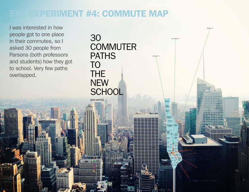
5x5 exPeriMeNt #4: coMMute MaP
INWOOD
FORT GEORGE
WASHINGTON HEIGHTS
HAMILTONHEIGHTS
HARLEM
MORNINGSIDEHEIGHTS
EASTHARLEM
UPPER WEST SIDE
LINCOLN SQUARE
CENTRALPARK
YORKVILLE
UPPER EAST SIDE
LENOXHILL
CLINTON
HELL’SKITCHEN
MIDTOWN
THEATERDISTRICT
GARMENTDISTRICT
MIDTOWNSOUTHCHELSEA
TURTLEBAY
MURRAY HILL
KIPS BAY
GRAM-ERCY PARK
SUTTON
BEEK-MAN
STUY TOWN
NO
HO
BO
WER
YM
EDIC
ALCI
TYTU
DO
R
ABC CITY
EAST VILLAGE
GREENWICH VILLAGE
WEST VILLAGE
SOHO LOWER EASTSIDETRIBECA
LITT
LE
ITALY
CIVIC CENTER
WHITE HALL
CHINATOWN
TWO BRIDGES
WALL STREET
BATTERY PARK CITY
MEATPACKINGDISTRICT
GREENWICH, CT
SUNSET, BK
TOTOWA, NJ
PROSPECT HEIGHTS, BK
RAVENSWOOD, QN
WEST HARRISON, NY
CLINTON HILL, BKBUSHWICK, BK
DUMBO, BK
DOBBS FERRY, NY
ASTORIA, QN
UNION SQ
TNS
TAXI
SUBWAY
TRAIN
BUS
BIKE
WALK
30 COMMUTERPATHS TO THENEW SCHOOLJENN MARTINS
I was interested in how people got to one place in their commutes, so I asked 30 people from Parsons (both professors and students) how they got to school. Very few paths overlapped.

INWOOD
FORT GEORGE
WASHINGTON HEIGHTS
HAMILTONHEIGHTS
HARLEM
MORNINGSIDEHEIGHTS
EASTHARLEM
UPPER WEST SIDE
LINCOLN SQUARE
CENTRALPARK
YORKVILLE
UPPER EAST SIDE
LENOXHILL
CLINTON
HELL’SKITCHEN
MIDTOWN
THEATERDISTRICT
GARMENTDISTRICT
MIDTOWNSOUTHCHELSEA
TURTLEBAY
MURRAY HILL
KIPS BAY
GRAM-ERCY PARK
SUTTON
BEEK-MAN
STUY TOWN
NO
HO
BO
WER
YM
EDIC
ALCI
TYTU
DO
RABC CITY
EAST VILLAGE
GREENWICH VILLAGE
WEST VILLAGE
SOHO LOWER EASTSIDETRIBECA
LITT
LE
ITALY
CIVIC CENTER
WHITE HALL
CHINATOWN
TWO BRIDGES
WALL STREET
BATTERY PARK CITY
MEATPACKINGDISTRICT
GREENWICH, CT
SUNSET, BK
TOTOWA, NJ
PROSPECT HEIGHTS, BK
RAVENSWOOD, QN
WEST HARRISON, NY
CLINTON HILL, BKBUSHWICK, BK
DUMBO, BK
DOBBS FERRY, NY
ASTORIA, QN
UNION SQ
TNS
TAXI
SUBWAY
TRAIN
BUS
BIKE
WALK
30 COMMUTERPATHS TO THENEW SCHOOLJENN MARTINS
5x5 exPeriMeNt #4: coMMute MaP

5x5 exPeriMeNt #5: 14tH st cross-sectioNMy fifth experiment was to examine a cross-section of Manhattan, independent of traditional divisions (grid/streets/neighborhoods). I chose 14th Street because it’s a street I am on often and am familiar with, and also because it is very populated and busy.
What I kid was walk from one end of the street to the other (East to West) and try to take in my surroundings. I usually walk around NY while listening to music on my iPod, but I made sure not to do that, so I could hear the sounds. What I found was that 14th Street is louder in the middle of the island near Union Square and quieter on the ends near the rivers. The street is primarily retail and then food/drink-related businesses. There are very few residential buildings and there is, of course, Union Square Park.
I didn’t take any photos while walking down 14 Street but when I got home, I created a rough panoramic image of the South side of the street.
tHesis bloG:JeNNMartiNs.tuMblr.coM