joint comprehensive plan: growth management plan · pdf filejoint comprehensive plan: growth...
TRANSCRIPT

Joint Comprehensive Plan: Growth Management Plan for Dover Borough/Dover Township Region
January 2008 i
Joint Comprehensive Plan: Growth Management Plan for Dover
Borough/Dover Township Region
Joint Comprehensive Plan Advisory Committee Members
Bradley Lentz, Borough Manager Lori Koch, Borough Council Michael Husson, Township Scott Kurtzman, Township Vincent Rice, Township Madelyn Shermeyer, Township
Wayne Hoffman, Township Terry Myers, Township Engineer Georgia Sprenkel, Township Bryan Rehm, Dover Area School District Pam Shellenberger, YCPC Barbara McKinney, YCPC
Planning Consultant: Johnson, Mirmiran & Thompson Adopted - Dover Township
Adopted - Dover Borough Amended December 10, 2007

Joint Comprehensive Plan: Growth Management Plan for Dover Borough/Dover Township Region
January 2008 ii
Table of Contents Introduction ................................................................................................................... 1
Background ................................................................................................................. 1 Dover Borough Comprehensive Planning ................................................................ 1 Dover Township Comprehensive Planning .............................................................. 1 York County Comprehensive Plan and Growth Management Plan .......................... 2
Municipalities Planning Code ....................................................................................... 2
Keystone Principles ..................................................................................................... 3 The Plan ......................................................................................................................... 6
Plan Purpose and Goals .............................................................................................. 6 Planning Process ......................................................................................................... 7
Summary of Existing Conditions ................................................................................. 9
Summary of Community Issues, Concerns and Priorities .......................................... 10 Priority Preference Survey ..................................................................................... 10
Visual Preference Survey (VPS) ............................................................................ 11
Community Survey ................................................................................................. 13
Growth Management Policy ....................................................................................... 15 Vision Statement........................................................................................................ 16 Plan Objectives .......................................................................................................... 16
Growth Management Concepts & Strategies ............................................................. 17 Community and Neighborhood Design Elements .................................................... 26
Pedestrian Oriented Development ............................................................................. 26 Traditional Neighborhood Development (TND) .......................................................... 27 Multimodal Transportation System and Street Pattern .............................................. 28
Public Open Space, Park and Recreation Standards ................................................ 29 Access Management Techniques .............................................................................. 30
Preservation/Conservation Tools and Techniques .................................................... 32
Growth Management Plan .......................................................................................... 35
Village Concept Plan ................................................................................................... 35 Dover Borough Revitalization Plan ........................................................................... 35
Analysis of Mix of Land Use for Dover Borough (Village) .......................................... 36
Opportunities for Infill Development and Redevelopment .......................................... 36 Potential Commercial Development of Niche Markets ............................................... 37
Niche Business Development Strategies ............................................................... 39 Future Land Use Plan ................................................................................................. 40
Future Development Patterns .................................................................................... 43
Zoning Analysis ...................................................................................................... 43 Growth Area Boundaries ........................................................................................... 46 Fiscal Impacts of Future Growth ................................................................................ 51
Future Housing Plan ................................................................................................... 53
Housing Capacity Analysis ........................................................................................ 54 Current Housing Trends ............................................................................................ 54 Residential Real Estate Trends 2005 ........................................................................ 55
Local Averages ...................................................................................................... 55 National Averages .................................................................................................. 55
Housing Trends Applied to the Future Land Use Plan ............................................... 56 Future Transportation Plan ........................................................................................ 59
Projected Transportation Conditions.......................................................................... 59

Joint Comprehensive Plan: Growth Management Plan for Dover Borough/Dover Township Region
January 2008 iii
Roadway Classifications ........................................................................................ 59
Transportation Improvements .................................................................................... 61
Transportation Needs with Short-Term Solutions ................................................... 61 Traffic Signal Improvements .................................................................................. 61 Left-turn Lane Warrants ......................................................................................... 61 Summary of Recommended Intersection Improvements ....................................... 62 Alternative Solutions to Intersection Signalization .................................................. 62
State Roadway & Intersection Improvement Projects ............................................ 63 Roadway Design Standards to Support Development ........................................... 64
Need for Non-Vehicular Modes with Short-Term Solutions ....................................... 64 Transit Routes ........................................................................................................ 64 Trails/Greenways ................................................................................................... 64
Bicycle Routes ....................................................................................................... 64 Sidewalk Network ................................................................................................... 65
Transportation Needs with Long-Term Solutions ....................................................... 65
Future Community Facilities & Services Plan .......................................................... 67
School District Impacts .............................................................................................. 67 Police and Fire Services Impacts .............................................................................. 67 Emergency Management Services ............................................................................ 69
Future Water and Sewer Service Areas (Public Infrastructure Area) ......................... 69 Future Water Service ............................................................................................. 69
Future Sewer Service ............................................................................................. 72 Libraries ................................................................................................................. 74
Economic Development Plan ..................................................................................... 76
Economic Analysis ..................................................................................................... 76 York County Economic Development Corporation (YCEDC) ..................................... 76
York County Industrial Development Authority .......................................................... 77
Economic Development Strategy .............................................................................. 77
Future Trail/Greenway, Open Space and Park/Recreation Plan .............................. 78 Standards for Park and Recreation Lands ................................................................. 78
Interrelationship of Plan Elements ............................................................................ 80
Plan Consistency ........................................................................................................ 82 York County Comprehensive Plan ............................................................................. 82
West Manchester Township Comprehensive Plan .................................................... 82 Manchester Township Comprehensive Plan ............................................................. 82 Conewago Township Comprehensive Plan ............................................................... 83
Warrington Township Comprehensive Plan ............................................................... 83 Washington Township Comprehensive Plan ............................................................. 83 Paradise Township Comprehensive Plan .................................................................. 83
Jackson Township Comprehensive Plan ................................................................... 84
Implementation Plan ................................................................................................... 85 References ................................................................................................................... 91 Appendices .................................................................................................................. 96
Appendix 1: Intergovernmental Cooperative Planning Agreement ........................... 96 Appendix 2: Existing Conditions Report .................................................................... 96 Appendix 3: Summary of Community Input .............................................................. 96 Appendix 4: Build-Out Analysis Report ..................................................................... 96
Appendix 5: Zoning Analysis .................................................................................... 96

Joint Comprehensive Plan: Growth Management Plan for Dover Borough/Dover Township Region
January 2008 1
Introduction This regional growth management plan was developed through a collaborative planning process that integrated technical analysis with community input. The plan is a blue-print or guide for future development and redevelopment within the region. The content of this plan is based upon the following supporting documents: Existing Conditions Report, Build-Out Analysis Report, Summary of Community Input and Zoning Analysis. These supporting documents are described in the Appendix. This plan provides an update of facts and statistics, results of analysis, vision statement, plan goals and objectives, growth management strategies, explanation of various plan elements and implementation plan. This plan builds upon the basic planning principles outlined in the Comprehensive Plan Addendum, August 1994, for Dover Township and replaces the 1964 Dover Borough Comprehensive Plan.
Background
Dover Borough and Dover Township entered into an intergovernmental cooperative planning agreement to jointly participate in the creation of a Joint Comprehensive Plan in the form of a growth management plan with emphasis on management of growth for the region and revitalization for the Borough. A copy of the intergovernmental cooperative planning agreement is contained in the Appendix 1.
Dover Borough Comprehensive Planning
The Dover Borough Comprehensive Plan of record was adopted in 1964 and has not been updated since. The Land Use Plan and the Transportation Links of the plan depict development concentrated in and around the Borough supported by a transportation loop. At the time of the plan, access around the Borough and parking within the Borough were sited as critical issues. Many of the population projections have been reached and recommendations such as expand infrastructure (roads, water and sewer), establish public services (police and fire) and develop public facilities (parks and recreation facilities) have been accomplished as population grew and development occurred. Since the adoption of the 1964 plan, the Borough constructed a wastewater treatment plant and has worked cooperatively with surrounding municipalities including Dover Township to provide additional water supply, create a regional police force, share staff and equipment and conduct joint planning efforts. The Borough is nearing maximum build-out, and the 1964 plan does not address revitalization needs.
Dover Township Comprehensive Planning
The Dover Township Comprehensive Plan update was adopted in August of 1994. This update was an addendum to the 1987 Comprehensive Plan. At that time, the focus of the plan was very similar to the focus of this plan. The last comprehensive planning effort emphasized development of a plan to: provide future direction for the density and intensity of growth and development; provide for the effects of existing and future growth and development on roadways and community facilities and services; evaluate the effectiveness of current policy for the preservation of agricultural areas relative to public opinion and attitudes; provide for the management of stormwater flows from development; and, promote the management and protection of public drinking water

Joint Comprehensive Plan: Growth Management Plan for Dover Borough/Dover Township Region
January 2008 2
supplies. Upon adoption of the 1994 plan, subsequent zoning amendments were made. Since 1994, the Township has been using this plan as a guide for community development and has made several zoning map and ordinance updates to implement the plan. Additionally, the Township has worked cooperatively with surrounding municipalities as well as the Borough to provide additional water supply, create a regional police force, share staff and equipment, provide a regional wastewater treatment plant and conduct joint planning efforts.
York County Comprehensive Plan and Growth Management Plan
The York County Planning Commission adopted its first growth management plan in September of 1997 and adopted subsequent amendments to that plan in 2001, 2002, 2003, 2004 and 2006. The purpose of the County’s “Growth Management Plan” is to present an overall countywide framework for growth and provide mechanisms to collaborate with municipalities to determine the specific location, pattern and timing of future development through the delineation of growth areas and identification of important resources such as agricultural lands and rural resource areas. The County’s Growth Management Plan builds upon the 1992 Comprehensive Plan and is a component of the 1992 Comprehensive Plan. The County Comprehensive Plan was presented as a tool for coordinating land use planning throughout York County focusing on three key goals: protection and preservation of important natural resources; direction of growth and development to appropriate locations; and, facilitated coordinated planning at all level of government. Source: York County Growth Management Plan, Amended December 13, 2006
Municipalities Planning Code
The Pennsylvania Municipalities Planning Code (MPC) empowers the Township and Borough, individually or jointly, to:
plan their development and to govern the same by zoning, subdivision and land development ordinances, planned residential development and other ordinances, by official maps that identify the reservation of certain land for future public purpose and by the acquisition of such land;
promote the conservation of energy through the use of planning practices and to promote the effective utilization of renewable energy sources; and,
provide for transfer of development rights.
Article III, Comprehensive Plan of the MPC provides a guide to basic plan elements, procedures and details of the legal status of the Comprehensive Plan. Article XI, Intergovernmental Cooperative Planning and Implementation Agreements outlines the requirements for County or Multi-municipal Comprehensive Plans in Section 1103. In addition to required plan elements outlined in Section 301, the following must be addressed in accordance with this section of the MPC (Section 1103):

Joint Comprehensive Plan: Growth Management Plan for Dover Borough/Dover Township Region
January 2008 3
designation of growth areas to address orderly and efficient development to accommodate projected growth in order to provide for an adequate tax base and to provide services to such development;
designation of potential future growth areas where future development is planned for densities to accompany the orderly extension and provision of services;
designation of rural resource areas;
accommodation of all categories of uses within the area of the plan;
planning for developments of area-wide significance and impact; and,
conservation and enhancement of the natural, scenic, historic and aesthetic resources within the area of the plan.
Source: MPC, Act of July 31, 1968, P.L. 805, No. 247 as amended.
Keystone Principles
The Commonwealth of Pennsylvania adopted the Keystone Principles & Criteria for Growth, Investment & Resource Conservation in May of 2005. These principles and criteria were designed to support a coordinated interagency approach to fostering sustainable economic development and conservation of resources through the state’s investments in communities. The principles outline general goals and objectives for economic development and resource conservation. The criteria help measure the extent to which particular projects accomplish identified goals. Projects to be funded by state agencies are to be evaluated with the recognition that rural, suburban and urban areas have different characteristics and needs. For example, what might work in an urban area might not work in a rural area. The following is a brief description of the state’s Keystone Principles that provide the basis for growth, investment and resource conservation.
Redevelopment First – The State is giving priority to cities, towns, brownfields and previously developed sites in urban, suburban, and rural communities for economic development activity that create jobs, housing, mixed-use development and recreational assets. Conservation of heritage resources and rehabilitation of historic buildings and neighborhoods for compatible contemporary uses is a priority.
Provide Efficient Infrastructure – The State is emphasizing fix it first by making improvements to existing infrastructure resulting in highway and public transportation investments that use context sensitive design to improve existing developed areas and attract residents and visitors to these areas. This emphasis includes providing multi-modal choices and adequate public facilities within designated growth areas. Other strategies include the use of on-lot and community water and septic/sewer systems in rural areas and the requirement

Joint Comprehensive Plan: Growth Management Plan for Dover Borough/Dover Township Region
January 2008 4
for private and public expansions consistent with comprehensive plans and implementing ordinances.
Concentrate Development – The State is supporting both infill and greenfield development that is compact and conserves land and is integrated with existing or planned transportation, water and sewer services and schools. The goal is to create well-designed developments that are walkable communities with options for non-vehicular modes of travel that offer healthy life style opportunities. It is important that these types of developments be planned and designed for successful and timely completion.
Increase Job Opportunities – The State is focusing on retaining and attracting a diverse, educated workforce by partnering with local communities to provide quality economic opportunities that improve the quality of life for current and future residents. The state is investing in businesses that offer good paying, high quality jobs, and that are located near existing or planned water and sewer infrastructure, housing, existing workforce, and transportation access (highways or transit).
Foster Sustainable Businesses – The State is promoting efforts to strengthen natural resource based businesses that use sustainable practices in energy production and land uses such as agriculture, forestry, fisheries, recreation and tourism. Support is for construction and promotion of green buildings and infrastructure that use land, energy, water and materials efficiently. This principle supports economic development that increases or replenishes knowledge-based employment, or builds on existing industry clusters.
Restore and Enhance the Environment – The State is supporting efforts to maintain and expand land, air and water protection and conservation programs. The conservation and restoration of environmentally sensitive lands and natural areas for ecological health, biodiversity and wildlife habitat are a priority. The emphasis is to promote development that respects and enhances the state’s natural lands and resources.
Enhance Recreational and Heritage Resources – The State is promoting maintenance and improvement of recreational and heritage assets and infrastructure including parks, forests, greenways and trails, heritage parks, historic sites and resources, fishing and boating areas and game lands offering recreational and cultural opportunities for residents and visitors.
Expand Housing Opportunities – The State is emphasizing the construction and rehabilitation of housing of all types to meet the needs of people of all incomes and abilities. It is important to coordinate the location of housing with the location of jobs, public transit, services, schools and other existing infrastructure. New housing developments should be consistent with local plans and community character.

Joint Comprehensive Plan: Growth Management Plan for Dover Borough/Dover Township Region
January 2008 5
Plan Regionally and Implement Locally – The State is encouraging multi-municipal, county and local planning and implementation that has broad public input and support of these principles. The State is providing funding for such planning efforts.
Be Fair - The State is supporting equitable sharing of the benefits and burdens of development. The State applies these principles and criteria for selection of projects so that all communities are assisted regardless of characteristic: suburban, urban or rural.
Source: Keystone Principles & Criteria for Growth, Investment & Resource Conservation, Commonwealth of Pennsylvania, Economic Development Cabinet, May 31, 2005.
The goals, objectives, concepts, plan elements and implementation strategies of this plan were developed applying the above principles so that the Borough and Township are best positioned to develop partnerships with state agencies to realize the vision for the future of the region through successful implementation of the plan.

Joint Comprehensive Plan: Growth Management Plan for Dover Borough/Dover Township Region
January 2008 6
The Plan The Growth Management Plan for Dover Borough/Dover Township Region provides a blue-print or guide for future development and redevelopment within the region. A growth management plan is a conscious effort to influence the rate, amount, type, location and quality of future development. Management of these aspects of growth can affect the overall form and nature of development measured by a set of impact characteristics including environmental and fiscal impacts and outputs as a result of development including but not limited to: traffic congestion, damage caused by unmanaged stormwater run-off, inadequate public facilities and services and other affects of sprawl. This act of guiding growth is not intended to stop growth; instead, manage growth in an environmentally sensitive and fiscally responsible manner.
Plan Purpose and Goals
The purpose of the plan is to comply with the MPC requirement of Section 301(c) to review the comprehensive plan at least every ten years to determine if the plan remains generally consistent with the county comprehensive plan as well as meets the needs of the municipality, and make updates or prepare new plans to address municipal and regional needs. Prior to creation of this plan, the Borough and the Township reviewed their Comprehensive Plans of record and determined there was a need for update of Borough and Township plans. At the onset of this joint comprehensive planning effort, the Borough and the Township identified a number of critical issues which provided the basis for plan goals. The goals of the plan are to:
provide a plan that protects agricultural and natural lands;
provide a plan to improve traffic control resulting in safer and more efficient flow of vehicles;
provide a plan with growth management strategies and design standards that promote high quality and desired quantities of residential growth;
provide a plan that meets the needs of the citizens;
provide a plan that addresses recreational needs;
provide a plan that includes best management practices for adequate stormwater controls;
provide a revitalization/development plan that preserves and enhances Borough and village lifestyles;
provide a plan that addresses tax burdens associated with needs of the Dover Area School District;

Joint Comprehensive Plan: Growth Management Plan for Dover Borough/Dover Township Region
January 2008 7
provide a plan that identifies consistent land use patterns across municipal boundaries laying the groundwork for consistent land use regulations;
provide a plan that identifies growth areas where the logical expansion of water and sewer facilities should be planned;
provide a plan for the promotion of commercial and industrial development to create a sustainable community;
provide a plan that protects water resources; and
provide a plan with a variety of tools and techniques that furthers the state’s growing greener and smart growth initiatives.
Planning Process
The Borough and Township jointly implemented a collaborative comprehensive planning process that integrated community involvement with technical analysis and evaluation of growth management, smart growth and growing greener planning strategies. This process included routine meetings with a Joint Comprehensive Plan Advisory Committee (JCPAC), surveys including a community survey and visual preference survey, discussions with key stakeholders (including regional economic development specialists, property owners and developers), collaboration with county planners and public meetings and hearings. The planning process is documented in a report contained in Appendix 3: Summary of Community Input, a project website and JCPAC meeting agendas and notes. The planning process commenced in November of 2005 with completion in February of 2007 followed by a formal review and adoption process. The diagram on the following page outlines this collaborative planning process.

Joint Comprehensive Plan: Growth Management Plan for Dover Borough/Dover Township Region
January 2008 8
JCPAC- Joint Comprehensive Plan Advisory Committee YCPC- York County Planning Commission
Joint Comprehensive Plan: Growth Management Plan for Dover Borough/Dover Township Region
January 2008 9
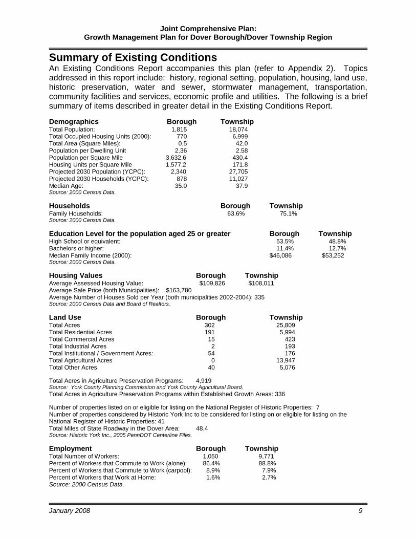
Summary of Existing Conditions
An Existing Conditions Report accompanies this plan (refer to Appendix 2). Topics addressed in this report include: history, regional setting, population, housing, land use, historic preservation, water and sewer, stormwater management, transportation, community facilities and services, economic profile and utilities. The following is a brief summary of items described in greater detail in the Existing Conditions Report.
Demographics Borough Township Total Population: 1,815 18,074 Total Occupied Housing Units (2000): 770 6,999 Total Area (Square Miles): 0.5 42.0 Population per Dwelling Unit 2.36 2.58 Population per Square Mile 3,632.6 430.4 Housing Units per Square Mile 1,577.2 171.8 Projected 2030 Population (YCPC): 2,340 27,705 Projected 2030 Households (YCPC): 878 11,027 Median Age: 35.0 37.9 Source: 2000 Census Data.
Households Borough Township Family Households: 63.6% 75.1% Source: 2000 Census Data.
Education Level for the population aged 25 or greater Borough Township High School or equivalent: 53.5% 48.8% Bachelors or higher: 11.4% 12.7% Median Family Income (2000): $46,086 $53,252 Source: 2000 Census Data.
Housing Values Borough Township Average Assessed Housing Value: $109,826 $108,011 Average Sale Price (both Municipalities): $163,780 Average Number of Houses Sold per Year (both municipalities 2002-2004): 335 Source: 2000 Census Data and Board of Realtors.
Land Use Borough Township Total Acres 302 25,809 Total Residential Acres 191 5,994 Total Commercial Acres 15 423 Total Industrial Acres 2 193 Total Institutional / Government Acres: 54 176 Total Agricultural Acres 0 13,947 Total Other Acres 40 5,076
Total Acres in Agriculture Preservation Programs: 4,919 Source: York County Planning Commission and York County Agricultural Board.
Total Acres in Agriculture Preservation Programs within Established Growth Areas: 336
Number of properties listed on or eligible for listing on the National Register of Historic Properties: 7 Number of properties considered by Historic York Inc to be considered for listing on or eligible for listing on the National Register of Historic Properties: 41 Total Miles of State Roadway in the Dover Area: 48.4 Source: Historic York Inc., 2005 PennDOT Centerline Files.
Employment Borough Township Total Number of Workers: 1,050 9,771 Percent of Workers that Commute to Work (alone): 86.4% 88.8% Percent of Workers that Commute to Work (carpool): 8.9% 7.9% Percent of Workers that Work at Home: 1.6% 2.7% Source: 2000 Census Data.

Joint Comprehensive Plan: Growth Management Plan for Dover Borough/Dover Township Region
January 2008 10
Summary of Community Issues, Concerns and Priorities
Community issues, concerns, and priorities were derived from the community-at-large using several techniques including a priority preference survey, a visual preference survey (VPS), a community survey, and several facilitated discussions with the JCPAC. The compilation of survey results and facilitated discussions provides a generalized view of the community’s issues, concerns, and priorities. These views were used to develop plan objectives and strategies. Appendix 3 includes data collection, analysis techniques and detailed results of survey activities.
Priority Preference Survey
At a March 2006 public meeting, a priority preference survey was conducted to offer citizens an opportunity to evaluate a comprehensive listing of topics and issues using a colored dot prioritization method to indicating their level of priority or importance. The listing of issues was organized by a variety of planning topics. Topics include those typically addressed through a comprehensive planning process, as outlined in the MPC with issues and concerns for each topic identified by the JCPAC and community. Figure 1: Priority Issues and Concerns Identified by the Community shown on the following page presents a summary listing of priority issues and concerns by key topic. The prioritization of issues and concerns depicted below by color coded topic identifies those issues/concerns that are paramount to the citizens to ensure sustainable community development. Additional details describing the results of this public involvement technique are provided in Appendix 3. Plan objectives and strategies address these issues and concerns by topic in the context of various plan elements.

Joint Comprehensive Plan: Growth Management Plan for Dover Borough/Dover Township Region
January 2008 11
Figure 1: Priority Issues and Concerns Identified by the Community
0 5 10 15 20 25 30 35
School Grow th w ith associated tax burden
Signif icant Population Grow th w ithin the Tow nship
Rehabilitate housing in declining neighborhoods
Need to increase housing values
Protection of Agricultural and Conservation Districts
Land use regulations consistency (TWP and Borough)
Controlling the quality and quantity of residential development
Adequate supply and protection of w ater resources
Improve traff ic control, safety and flow
Adequate police, f ire and emergency services
Promote commercial and industrial development
Adequate facilities to meet needs
The following colors correspond with particular topics including: Gray = Utilities, Yellow = Economic development, Purple =
Public services, Brown = Transportation Blue = Water and sewer, Red = Land use, Orange = Housing, Green = Growth
Visual Preference Survey (VPS)
At the same March 2006 public meeting, a visual preference survey (VPS) was conducted to provide opportunity for citizen evaluation of physical images of natural and built environments depicted with images of streetscapes, land uses, site design, building types and varying aesthetics and natural amenities. The results of this type of survey are an indication of the community’s level of preference for what they have viewed and what they identify as appropriate for the community. The following images include the top preferred and top opposed preferences.

Joint Comprehensive Plan: Growth Management Plan for Dover Borough/Dover Township Region
January 2008 12
Top Preferred Images:
Top Opposed Images:
The top preferred images of the VPS match issues and concerns as identified in the priority preference survey including agriculture preservation, conservation of land and recreation improvements associated with less developed or lower density development. The top opposed (least preferred) images mirror the community’s dissatisfaction with franchised commercial uses and high density, nondescript/cookie-cutter residential development which detracts from the rural character of the community. Plan objectives and strategies address these preferences.

Joint Comprehensive Plan: Growth Management Plan for Dover Borough/Dover Township Region
January 2008 13
Community Survey
A Borough- and Township-wide Community Survey was developed and administered as a component of the public involvement portion of the comprehensive planning process. This public involvement technique was used to collect citizen opinions, attitudes, and facts about the community. The results of the community survey provide the Borough and the Township vital information about assets within the community, about how the community would like to change, key issues, and where tax dollars should be spent. The results of the community survey were incorporated with other supporting documents and results including the Existing Conditions Report and Visual Preference Survey and Priority Preferences Activity results to focus technical analysis to support strategy development that meets community goals and objectives of Dover Borough and Dover Township. The results of the community survey signify the community’s awareness of the responsibilities of local government as well as an understanding of development impacts. Results also indicate that in order to address concerns regarding increased taxes, demand for services, preservation of rural character, and efficient transportation growth management tools and techniques must be applied. Results of the community survey also point out the community’s desire that future development be of good quality improving existing infrastructure and preserving historic character of the community with phasing of growth to expand on past developments resulting in minimal impacts on the rural character and non-developed areas of the community while maintaining or improving the quality of life for residents of the region. In general, respondents were satisfied with the overall quality of life in Dover Borough and Dover Township, as illustrated in Figure 2: Satisfaction Responses for Overall Quality of Life - Combined.
Figure 2: Satisfaction Responses for Overall Quality of Life - Combined
8.1%
66.9%
8.5%12.9%
3.6%
0.0%
10.0%
20.0%
30.0%
40.0%
50.0%
60.0%
70.0%
80.0%
Very Satisfied Satisfied No Opinion Dissatisfied Very
Dissatisfied
Source: Dover Borough- Dover Township Community Survey, June 2006.

Joint Comprehensive Plan: Growth Management Plan for Dover Borough/Dover Township Region
January 2008 14
According to Dover Borough respondents, land uses need to include more public open space, commercial development, and residential development with specific concerns regarding recreation, parking, mixed-uses and historic preservation. Dover Township respondents indicated a need to include more agriculture, public open space, and commercial uses with specific comments concerning passive and active recreation, restaurants, quality low-density residential development with consideration for specialized housing such as age restricted communities, and increased consideration for natural environments and natural resources. According to respondents, the Borough is strong in providing emergency services, garbage and recycling services, water and sewer services, and police protection, but is weak in providing entertainment facilities, land use planning, and improved sidewalk conditions. Based upon responses, there are varying degrees of satisfaction with respect to stormwater management, historic preservation, and recreation opportunities. Respondents rated the overall quality of housing in Dover Borough as good. According to respondents, Dover Township is strong in providing emergency services, garbage and recycling services, water and sewer services, and police protection, but is weak in providing environmental protection, land use planning, entertainment facilities, and agricultural protection. Based upon responses, there are varying degrees of satisfaction with respect to social services, shopping facilities, and street maintenance. Respondents rated the overall quality of housing in Dover Township as average. Respondents favor preservation/conservation of agricultural lands, conservation of open space, and preservation/conservation of environmentally sensitive lands including steep slopes, wetlands, floodplains, and wellhead protection areas. Respondents also prefer land use regulations that promote cluster development patterns to preserve agricultural, forest and environmentally sensitive lands, and zoning regulations that allow non-traditional lot design to promote preservation/ conservation of open space, agricultural lands and environmentally sensitive lands. Respondents did not, however, prefer use of common open space for off-lot sewerage systems.

Joint Comprehensive Plan: Growth Management Plan for Dover Borough/Dover Township Region
January 2008 15
Growth Management Policy This portion of the plan contains a vision for the future, plan objectives, growth management concepts and strategies, and community and neighborhood design elements to guide future development and redevelopment of the region. This policy provides the basis for development of plan elements that address future community development activities. The policy is built around a framework of growth management strategies for developing a sustainable community that:
recognizes that growth occurs within some limits and is ultimately limited by the carrying capacity of the environment;
values cultural diversity;
respects other life forms and supports biodiversity;
promotes shared values amongst the members of the community through education;
employs ecological decision-making such as integration of environmental criteria into all municipal government, business and personal decision-making processes;
makes decisions and plans in a balanced, open and flexible manner that includes the perspectives from the social, health, economic and environmental sectors of the community;
makes best use of local controls, capabilities and resources;
uses renewable and reliable sources of energy;
minimizes harm to the natural environment;
does not compromise the sustainability of other communities (a regional perspective); and,
does not compromise the sustainability of future generations by its activities. It is the following regional vision, objectives, growth management concepts and strategies, and community and neighborhood design elements established in this portion of the plan that provide the framework for elements of the Growth Management Plan. Subsequent sections consisting of the following elements make up the Growth Management Plan: Village Concept Plan, Dover Borough Revitalization Plan, Future Land Use Plan, Future Housing Plan, Future Transportation Plan, Future Community Facilities & Services Plan, Economic Development Plan, Future Trail/Greenways, Open Space and Park/Recreation Plan and Implementation Plan.
Joint Comprehensive Plan: Growth Management Plan for Dover Borough/Dover Township Region
January 2008 16
Vision Statement
The regional vision is that the Township and Borough will be an economically sustainable rural community with a vibrant Village consisting of businesses that reflect the lifestyle and needs of the village and surrounding rural community. It will be a community promoting quality of life through preserving the beauty of rural landscapes while providing for the conveniences of modern living.
Plan Objectives
The plan objectives have been developed based upon issues and concerns expressed by the community, the JCPAC, local elected officials and staff. These plan objectives address plan goals and are consistent with requirements identified in the MPC. The plan objectives provide the basis for development of growth management and community revitalization strategies, policies, projects and programs.
1. Provide a growth management strategy that addresses the quality, quantity, location and phasing of residential growth to meet needs of all income levels and to meet access and circulation needs.
2. Provide for the health, safety and welfare of our citizens by developing a plan for
adequate public utilities including water, sewer and stormwater management to meet both current and future needs.
3. Provide for the safe and efficient movement of people, goods and services with access to multi-modes of transportation in and through the Township and Borough.
4. Identify economic development opportunities and strategies with an emphasis on commercial and industrial development that are compatible with the community and supported by adequate facilities including utilities, water, sewer and transportation facilities.
5. Provide strategies for preservation and conservation of agricultural lands, natural
resources (including but not limited to water resources) and environmentally sensitive lands through regulation and partnership with landowners.
6. Preserve and enhance the rural village character within the Borough and
locations throughout the Township. 7. Provide for adequate public facilities and services including parks and recreation
facilities, community centers, and desired programs for all ages at locations accessible to current and anticipated neighborhoods.
8. Provide necessary services including police, fire, emergency services, schools,
disposal of solid waste and other similar services to meet the needs of all citizens and businesses.

Joint Comprehensive Plan: Growth Management Plan for Dover Borough/Dover Township Region
January 2008 17
9. Establish land use policy that adheres to the principles of smart growth to build a sustainable community including provisions for preservation and conservation of natural resources and agricultural lands, reduction of development impacts on the environment, restriction of growth outside of the growth boundary, adequate public facilities and services, and improved accessibility to goods and services.
Growth Management Concepts & Strategies
There are six key growth management concepts with accompanying strategies outlined in this section that provide the framework for preparation of a growth management plan. The key concepts are described in terms of boundaries, landscapes and resources. The following provides the purpose for each of these concepts.
1. Establish growth boundaries including a designated growth area, a future growth area, a rural resource area and a public infrastructure area in order to provide adequate public facilities and services.
2. Preserve natural landscapes including open space, farmland, natural beauty,
and environmentally sensitive areas in order to promote public health, safety and welfare.
3. Preservation and enhancement of rural landscapes by clustering development
in and around rural villages and crossroads.
4. Promote mixed use infill development within undeveloped and underutilized suburban landscapes within growth boundaries.
5. Enhance urban landscapes by directing development towards existing
urbanized areas to reduce sprawl.
6. Preserve historic resources across all landscapes. The following section provides a description for each of these concepts, a locator map identifying geographic areas for each boundary, landscape or resource area and key strategies associated with each.

Joint Comprehensive Plan: Growth Management Plan for Dover Borough/Dover Township Region
January 2008 18
Growth Boundaries: Growth boundaries are a means to delineate where more intense development is appropriate and where it is not. Boundaries are not intended to build a wall between communities or to stop growth. Instead, growth boundaries assist with management of growth in a responsible manner with respect to sustainability of the community by directing growth to the most appropriate locations. Growth areas are applicable to all landscapes and can be used around urban and densely developed suburban areas as well as around rural villages.
STRATEGY: Provide adequate public facilities through private and public
partnerships to support growth within growth boundaries. STRATEGY: Provide for a variety of uses at a variety of densities and intensities
within the growth boundary to reduce development pressures outside of designated growth areas. The goal is to reduce urban sprawl working toward developing a sustainable community.
STRATEGY: Provide for the phasing and timing of growth by establishing a
designated growth area and future growth area adequate in size and location to accommodate anticipated short-term growth while reserving adequate lands for long-term growth.
STRATEGY: Identify growth boundaries to preserve natural and rural
landscapes.
STRATEGY: Use growth boundaries to allow public infrastructure improvements to keep pace with development in order to maintain a high quality of life by providing adequate public facilities.
Two types of growth boundaries used to support growth management are identified in the MPC and used to identify growth boundaries in this plan. They are defined as follows:
Designated growth area is a region within the county that preferably includes and surrounds a city, borough or village, and within which residential and mixed use development is permitted or planned for at densities of one unit to the acre or more and commercial, industrial and institutional uses are permitted or planned for and public infrastructure services are provided or planned.
Source: Pennsylvania Municipalities Planning Code
Future growth area is an area outside of and adjacent to a designated growth area where residential, commercial, industrial and institutional uses and development are permitted or planned at varying densities and public infrastructure services may or may not be provided, but future development at

Joint Comprehensive Plan: Growth Management Plan for Dover Borough/Dover Township Region
January 2008 19
greater densities is planned to accompany the orderly extension and provision of public infrastructure services.
Source: Pennsylvania Municipalities Planning Code
The MPC also provides a definition for areas currently and planned to be services by public infrastructure such as water, sewer and other services.
Public infrastructure area is a designated growth area and all or any portion of a future growth area where public infrastructure services will be provided and outside of which such public infrastructure services will not be required to be publicly financed.
Source: Pennsylvania Municipalities Planning Code
Natural Landscapes: Natural landscapes are undeveloped
areas consisting of wetlands and acquifer recharge zones, woodlands, steep slopes, prime agricultural lands, floodplains, unique natural areas and similar environmentally sensitive areas. These areas provide benefit to public health, safety and welfare with respect to essential resources found in nature such as water, air, land, forests, fish and wildlife, topsoil, and minerals.
STRATEGY: Preserve and protect natural resources, forested lands and unique
landscapes by using a variety of tools and techniques in order to establish sound land use policies, encourage community revitalization in urban areas and infill development in suburban areas, address recreational needs and protect agricultural lands and open space.
STRATEGY: Promote strategically located greenways that protect the region’s
natural resources and environmental quality, while providing opportunities for future linkages and connections via trails and paths.
STRATEGY: Promote the development of a greenway plan consistent with the
County and State’s plans as an integral part of the joint comprehensive planning initiatives and implementation plan. Encourage linking greenway concerns with implementation strategies that address sound land use, community revitalization, recreation needs, various modes of travel and open space protection.
The MPC provides the following guidance with respect to preservation and conservation of natural resources.
Preservation or protection when used in connection with natural and historic resources, shall include means to conserve and safeguard these resources from

Joint Comprehensive Plan: Growth Management Plan for Dover Borough/Dover Township Region
January 2008 20
wasteful or destructive use, but shall not be interpreted to authorize the unreasonable restriction of forestry, mining or other lawful uses of natural resources.
Source: Pennsylvania Municipalities Planning Code
Rural resource area is an area within which rural resource uses including, but not limited to, agriculture, timbering, mining, quarrying and other extractive industries, forest and game lands and recreation and tourism are encouraged and enhanced, development that is compatible with or supportive of such uses is permitted and public infrastructure services are not provided except in villages.
Source: Pennsylvania Municipalities Planning Code
Rural Landscapes: Rural landscapes are areas consisting of prime agricultural lands and natural areas where development should be limited and targeted to serve the needs of local residents. Where new growth should occur, access to the transportation corridors should be carefully planned to protect the function of the corridor, preserve the scenic character of the landscape and enhance traffic safety.
STRATEGY: Limit development to densities that can be supported by existing transportation networks with minor upgrades.
STRATEGY: Provide a cluster development option with incentives to limit access
to transportation networks while minimizing new infrastructure needs to support development and preserving both natural and rural landscapes.
STRATEGY: Identify rural villages and village crossroads outside of the
designated growth area where concentrated development should occur as well as identify the types of development that should be permitted to support the needs of local residents.
STRATEGY: Promote conservation-based development to protect natural
resources, agricultural lands and viewsheds/viewscapes. The MPC provides the following guidance with respect to preservation and conservation of rural resources.
Rural resource area is an area within which rural resource uses including, but not limited to, agriculture, timbering, mining, quarrying and other extractive industries, forest and game lands and recreation and tourism are encouraged and enhanced, development that is compatible with or supportive of such uses is permitted and public infrastructure services are not provided except in villages.
Source: Pennsylvania Municipalities Planning Code
o Rural Village is an unincorporated settlement that is part of a township where residential and mixed use densities of one unit to the acre or more

Joint Comprehensive Plan: Growth Management Plan for Dover Borough/Dover Township Region
January 2008 21
exist or are permitted and commercial, industrial or institutional uses exist or are permitted.
Source: Pennsylvania Municipalities Planning Code
o Rural crossroads is a community consisting of a group of people
primarily using land for cultivation and pasturage or a small group of dwellings in a rural area. The center of these villages is typically located at a crossroads.
o Agricultural land is land used for agricultural purposes that contains soils
of the first, second or third class as defined by the United States Department of Agriculture natural resource and conservation services county soil survey.
Source: Pennsylvania Municipalities Planning Code
Conservation-based Development requires the consideration and preservation of resources on the site within the development process. The process involves the identification of resources through a site analysis plan and the design of a proposed development in the least intrusive manner. This tool is appropriate for the Township who seeks to protect and retain natural resources and character in the face of development pressure. Overall benefits or advantages to this approach include: minimal disruption to natural systems with the introduction of development; resource protection with little public cost while accommodating context sensitive development patterns; retention of resources and community character within the development process; quality permanent open space and desirable, livable and walkable neighborhoods; a clear process for achieving conservation subdivisions; a practical alternative to conventional, tract development; and, reduction of takings arguments that may occur in large-lot zoning or other preservation requirements.
o Cluster development is used to preserve and conserve natural features
and environmentally sensitive areas including viewsheds or veiwscapes while reducing the amount of infrastructure improvements required in support of this development pattern. This development patterns can be used in both suburban and rural landscapes.

Joint Comprehensive Plan: Growth Management Plan for Dover Borough/Dover Township Region
January 2008 22
Suburban Landscapes: Suburban landscapes are located within the Growth Boundary encompassing lands that are either serviced or can be serviced by logical extensions of existing infrastructure including roads, water, sewer and a variety of services to support development. Suburban landscapes are areas within and around the fringes of urban landscapes where predominantly residential neighborhoods are located and planned with connections to retail shopping, employment centers and
institutional facilities. These uses are typically located in close proximity to each other with residential development clustered to preserve and conserve natural resources and open space. Developments include a variety of housing types and densities with appropriate linkages to eliminate sprawl and traffic congestion. The land use pattern should be designed to support alternative modes of transportation such as transit, bicycling and pedestrians. Park and recreational facilities should be accessible to all residential neighborhoods via sidewalks, greenways, and roadways. Transportation corridors within the suburbs should provide access to major employment and commercial areas. Use of access management tools and techniques will maintain corridor function as a major transit and road connection between centers.
STRATEGY: Provide a cluster development option with incentives to limit access
to the transportation network. STRATEGY: Plan and program public improvements that offer multi-modes of
transportation and provide linkages to suburban centers and park and recreation facilities.
STRATEGY: Promote suburban center development consisting of mixed uses. STRATEGY: Provide tools and techniques to promote access management. STRATEGY: Develop redevelopment and infill development standards consistent
with neighborhood scale, design and land use patterns for suburban landscapes and walkable communities.
Cluster development is used to preserve and conserve natural features and environmentally sensitive areas including viewsheds or veiwscapes while reducing the amount of infrastructure improvements required in support of this development pattern. This development pattern can be used in both suburban and rural landscapes.
Suburban centers are areas where there is a mix of community-oriented commercial uses, offices, public services, local parks, schools and medium to high density residential uses.

Joint Comprehensive Plan: Growth Management Plan for Dover Borough/Dover Township Region
January 2008 23
Urban Landscapes: Urban landscapes are located within the Growth Boundary encompassing lands that are serviced by existing infrastructure including roads, water, sewer and a variety of services to support development. Urban landscapes are areas where there is a concentration of a high density of mixed uses. These areas have typically developed historically around a variety of economic opportunities including rail operations, manufacturing, center of commerce and/or villages offering basic goods and services to rural communities.
STRATEGY: Coordinate redevelopment and infill development strategies to
enhance the village core with improvements characteristic of traditional neighborhood developments.
STRATEGY: Plan and program public improvements that offer multi-modes of
transportation and provide linkages from neighborhoods to the village core, community facilities, and goods and services.
STRATEGY: Plan and program transportation improvements sensitive to the
context of neighborhoods and varying landscapes along major corridors.
Village Core is the heart of the Borough and the Township. The village core is an area characteristic of diverse, concentrated development patterns occurring over time, offering a walkable/pedestrian friendly environment. A mixed-use village core should include a variety of retail and commercial services, civic and residential uses as well as public open space. Future mixed-use development of the village core should consider combining ground-floor and upper-story offices or residential uses. The main street of the village core is a diverse and densely developed area with transitions to less dense and less diverse development patterns traveling outward from the center to the remaining areas within the village. The village core should be enhanced with linkages to village neighborhoods and other development. Sidewalks and consistent landscaping treatments create linkages between older and newer segments of the village should be part of development standards.
Traditional neighborhood development (TND) is an area of land developed for a compatible mixture of residential units for various income levels and nonresidential commercial and workplace uses, including some structures that provide for a mix of uses within the same building. Residences, shops, offices, workplaces, public buildings, and parks are interwoven within the neighborhood so that all are within relatively close proximity to each other. Traditional neighborhood development is relatively compact, limited is size and oriented toward pedestrian activity. It has an identifiable center and discernable edges. The center of the neighborhood is in the form of a public park, commons, plaza, square or prominent intersection of two or more major streets. Generally, there is a hierarchy of streets laid out in a rectilinear or grid pattern of interconnecting

Joint Comprehensive Plan: Growth Management Plan for Dover Borough/Dover Township Region
January 2008 24
streets and blocks that provides multiple routes from origins to destinations and is appropriately designed to serve the needs of pedestrians and vehicles equally.
Preservation of Historic Resources: Preservation of historic resources is crucial to the preservation of neighborhood character. Historic resources define the essence of local communities and neighborhoods as well as provide opportunities for economic development such as tourism. Preservation of historic resources also improves property values as well as
contributes to the aesthetics of desirable communities with a higher quality of life for residents.
STRATEGY: Identify and document historic resources in accordance with PHMC
standards. STRATEGY: Establish Historic Districts using tools such as National Register
Districts, local historic districts, and Historic Architectural Review Board Districts (zoning overlays) to protect clusters of historic resources.
STRATEGY: Develop architectural standards as part of neighborhood design
elements for infill or redevelopment of sites and rehabilitation of structures to preserve historic integrity and character of historic neighborhoods.
All Landscapes can benefit from the Department of Conservation and Natural Resources’ (DCNR) greenways initiative. DCNR provides guidance with respect to the role greenways play in preserving and conserving natural landscapes.
Greenways are corridors of open space. Greenways vary greatly in scale, from narrow ribbons of green that run through urban, suburban and rural areas to wider corridors that incorporate diverse natural, cultural and scenic features. Greenways can incorporate both public and private property, and can be land- or water-based, following old railways, canals, or ridge tops, or they may follow stream corridors, shorelines, or wetlands, and include water trails for non-motorized craft. Greenways differ in their location and function, but overall, a greenway will protect natural, cultural, and scenic resources, provide recreational benefits, enhance natural beauty and quality of life in neighborhoods and communities, and stimulate economic development opportunities.

Joint Comprehensive Plan: Growth Management Plan for Dover Borough/Dover Township Region
January 2008 25
One method used to preserve and conserve local and regional natural resources is to create a network of greenways consisting of hubs and spokes. According to DCNR, the hubs of the network are the state parks, forests, game lands, lakes and other destination areas. The spokes of the network are greenways connecting natural areas and recreational and cultural destinations with the places where we live, work and play. Greenways will establish a green infrastructure as part of the future land use plan consisting of open space vital to the health of both ecological systems and communities. Greenways contribute significantly to the quality of life and provide a focal point for community design and land use strategies as well as yield economic benefits. The following is a listing of benefits as outlined in Pennsylvania’s Greenways Plan:
o greenways enhance the sense of place in a community or region; o greenways accentuate the scenic beauty and majesty of our state, region
and municipality; o greenways protect water resources by buffering non-point sources of
pollution; o greenways provide opportunities to protect and manage wildlife, forests
and ecological systems; o greenways provide recreation opportunities for families and individuals of
all ages and abilities; o greenways provide alternatives to automotive transportation, reducing
traffic congestion and pollution; o greenways add positively to our economic climate, including tourism; o greenways are a core component of strategies to foster health and
wellness. Source: DCNR – Pennsylvania Greenways: An Action Plan for Creating Connections
Conservation techniques are used to preserve valued community resources such as agricultural lands and natural resource areas as well as environmentally sensitive areas contributing to the environmental sustainability of the community.
o Agricultural preservation can be accomplished through a variety of
programs including preservation and conservation of agricultural soils through the designation of Agricultural Security Areas (affords protections to property owner from nuisance suites and eminent domain only and does not preserve the land), Preservation of farmlands through the York County Agricultural Land Preservation Board and preservation through Farm and Natural Lands Trust.
o Conservation Easement Programs can also offer an opportunity to
preserve lands with high value based upon the presence of natural resources and features.
o Conservation districts and agricultural zoning provide opportunities for
preservation and conservation.

Joint Comprehensive Plan: Growth Management Plan for Dover Borough/Dover Township Region
January 2008 26
Community and Neighborhood Design Elements New and existing development must incorporate design elements that create continuity, compatibility and consistency between old and new developments. Considering the best qualities of existing development augmented by other design standards or elements that result in pedestrian friendly and aesthetically pleasing neighborhoods is crucial to maintaining and improving a high quality of life for residents and businesses in both urban and suburban landscapes within the Borough and the Township. The advantages of this design approach include an increased sense of neighborhood and community and a reduced emphasis on the automobile, including alternative modes of transportation such as walking, to create a more aesthetically pleasing streetscape and neighborhood and increased property values. The following provides details of various design approaches, tools, and techniques such as: pedestrian oriented development, traditional neighborhood development, multimodal transportation systems and street patterns, public open space, park and recreation standards, access management techniques, and preservation/conservation tools and techniques.
Pedestrian Oriented Development
Neighborhoods with an emphasis on pedestrian-oriented layout provide a framework for even distribution of traffic with multiple modes of travel. The following are key characteristics of pedestrian-oriented development that translates into design standards for new development and redevelopment of areas in and around the Village Core.
The neighborhood has a discernible center. This is often a square, green space or memorable street corner. A transit stop should be located at this center.
Most of the dwellings are within a five-minute walk of the center, an average of roughly 2,000 feet.
The neighborhood consists of a variety of dwelling types including single family dwellings, rowhouses/townhouses and apartments. The neighborhood consists of older people, singles and families of all income levels.
Shops and workplaces are located at the edges of the neighborhood. The goods and services offered should be of varied types to sufficiently supply the weekly needs of a household.
Schools are close enough to the neighborhood so that most children can walk.
Playgrounds are accessible to residential neighborhoods, located not more than a tenth of a mile away.
Streets form a connected network which disperses traffic by providing a variety of pedestrian and vehicular routes to any destination.

Joint Comprehensive Plan: Growth Management Plan for Dover Borough/Dover Township Region
January 2008 27
Streets are relatively narrow and shaded by trees and traffic calming improvements are used to slow traffic and to create an environment suitable for pedestrians and bicycles.
Buildings in the neighborhood center are placed close to the street, creating well defined out-door public space.
Parking lots and garages rarely front the street. Parking is located to the rear of buildings and is usually accessed by alleys.
Prominent sites at the termination of street vistas or in neighborhood centers are reserved for civic buildings. These sites provide for a variety of community activity and public gathering places.
Source: CoolTown Studios – Designing and investing in next gen urban neighborhoods.
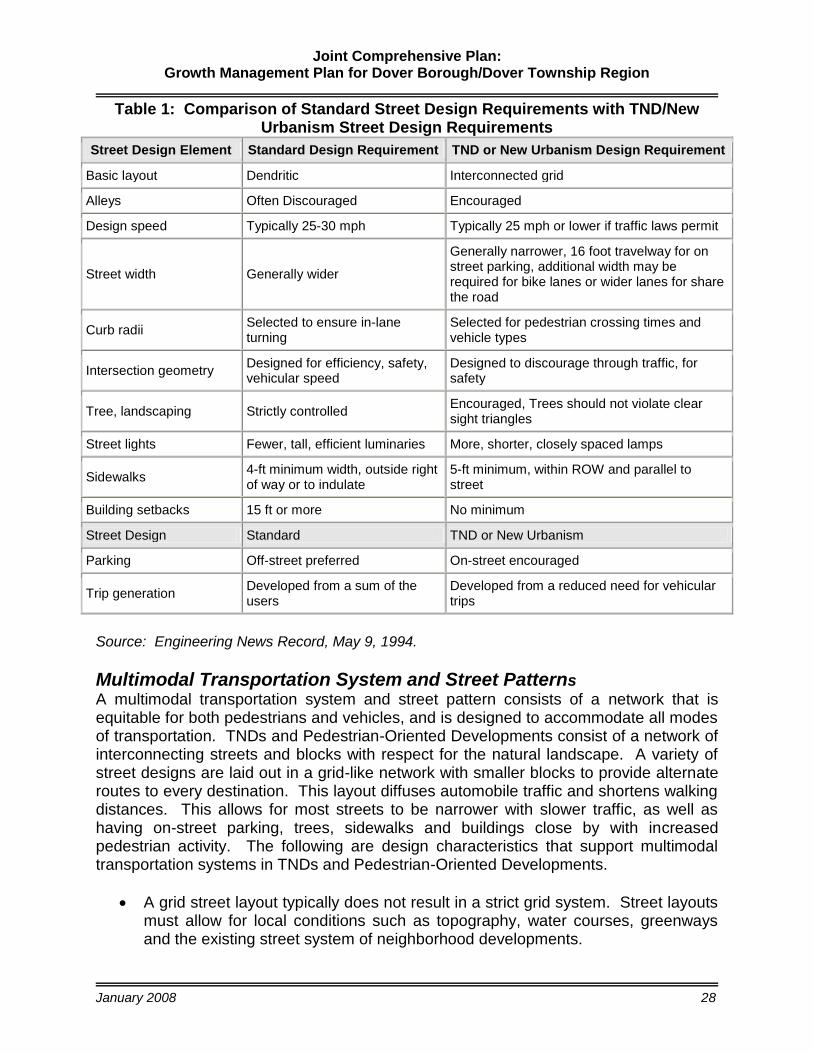
Traditional Neighborhood Development (TND)
A Traditional Neighborhood Development (TND) is designed to result in a compact, mixed-use, pedestrian-oriented community. TNDs are typically limited in size and oriented toward pedestrian activity. The majority of the population is within a 5-minute walking distance (approximately ¼ mile) of the neighborhood center. If destinations are located more than 1,500 feet apart, people will drive. Source: Lewisburg, Pennsylvania
Article VII-A of the MPC outlines characteristics of TNDs and provisions for TND regulations. The MPC has included this form of development pattern as a tool to encourage innovation in residential and nonresidential development and renewal consisting of a mixed-use form of development that will result in better housing, recreation and access to community goods and services and employment opportunities. Section 706-A contains a variety of standards and conditions for this type of development that is typically applied to new development, an outgrowth or extension of existing development, infill development or any combination of these types of development. When establishing standards, conditions and plans for this type of development many planners, designers and developers make the mistake of applying typical standards for infrastructure improvements with respect to roadway and streetscape design. Source: Pennsylvania Municipalities Planning Code Article VII-A, Section 706-A
The table on the following page outlines standard streetscape design requirements compared to the suggested TND or New Urbanism design requirements. The TND or New Urbanism design requirements should be considered for existing urban landscapes and developing urban landscapes and densely developed suburban landscapes or areas that are desired to be walkable communities.
Joint Comprehensive Plan: Growth Management Plan for Dover Borough/Dover Township Region
January 2008 28
Table 1: Comparison of Standard Street Design Requirements with TND/New Urbanism Street Design Requirements
Street Design Element Standard Design Requirement TND or New Urbanism Design Requirement
Basic layout Dendritic Interconnected grid
Alleys Often Discouraged Encouraged
Design speed Typically 25-30 mph Typically 25 mph or lower if traffic laws permit
Street width Generally wider
Generally narrower, 16 foot travelway for on street parking, additional width may be required for bike lanes or wider lanes for share the road
Curb radii Selected to ensure in-lane turning
Selected for pedestrian crossing times and vehicle types
Intersection geometry Designed for efficiency, safety, vehicular speed
Designed to discourage through traffic, for safety
Tree, landscaping Strictly controlled Encouraged, Trees should not violate clear sight triangles
Street lights Fewer, tall, efficient luminaries More, shorter, closely spaced lamps
Sidewalks 4-ft minimum width, outside right of way or to indulate
5-ft minimum, within ROW and parallel to street
Building setbacks 15 ft or more No minimum
Street Design Standard TND or New Urbanism
Parking Off-street preferred On-street encouraged
Trip generation Developed from a sum of the users
Developed from a reduced need for vehicular trips
Source: Engineering News Record, May 9, 1994.
Multimodal Transportation System and Street Patterns
A multimodal transportation system and street pattern consists of a network that is equitable for both pedestrians and vehicles, and is designed to accommodate all modes of transportation. TNDs and Pedestrian-Oriented Developments consist of a network of interconnecting streets and blocks with respect for the natural landscape. A variety of street designs are laid out in a grid-like network with smaller blocks to provide alternate routes to every destination. This layout diffuses automobile traffic and shortens walking distances. This allows for most streets to be narrower with slower traffic, as well as having on-street parking, trees, sidewalks and buildings close by with increased pedestrian activity. The following are design characteristics that support multimodal transportation systems in TNDs and Pedestrian-Oriented Developments.
A grid street layout typically does not result in a strict grid system. Street layouts must allow for local conditions such as topography, water courses, greenways and the existing street system of neighborhood developments.

Joint Comprehensive Plan: Growth Management Plan for Dover Borough/Dover Township Region
January 2008 29
Modified grid street layout uses the combination of “T” streets and the crossroad intersection to produce an irregular grid with a large amount of variety. The modified grid system is often used to respond to the natural environment and preserve existing natural features. It also creates numerous sites with high visibility that can be used as focal points to terminate a street.
Grid street layout creates a common area or community green space as a focal point. Larger community buildings, civic buildings, mixed-use or commercial buildings are often located around these common areas.
Perpendicular streets are typically the intersection of two perpendicular streets. Such street arrangements result in the opportunity for landscaped circles or islands in low traffic areas or a roundabout in areas with higher traffic areas.
“T” streets create a termination of the street and provide sites with high visibility for a prominent building or buildings. “T” streets can also be used to slow traffic through neighborhoods by reducing the length of through-streets and keeping blocks short.
Alleys are highly encouraged to eliminate the need for driveways and the visual dominance of garages from the street. Alleys provide rear access and an alternative route for local traffic in densely developed areas along heavily utilized arterials.
Public Open Space, Park and Recreation Standards
Well-configured public spaces such as squares, plazas, greens, landscaped streets, greenways, and parks are woven into the pattern of neighborhoods and contribute to the social activity, recreation and visual enjoyment of residents. Neighborhood design should create a hierarchy of useful open spaces including a formal square in the center of the neighborhood, parks and playgrounds located throughout the neighborhoods and street environments designed to promote walking and casual meetings between residents. Article V of the MPC allows for a municipal subdivision and land development ordinance to include provisions requiring the public dedication of land suitable for use and improvement as recreation facilities or payment of fees in lieu thereof. The MPC does not include standards or guidance for how much land should be dedicated based upon amount, type or density of development. The MPC does require that municipalities prepare and adopt a recreation plan as a prerequisite to requiring the dedication of recreation land or the payment of a fee in lieu thereof. Those standards are typically contained in the subdivision and land development ordinance. The National Park and Recreation Association provides standards for various park facilities as described in Table 2: Park Facility Standards.

Joint Comprehensive Plan: Growth Management Plan for Dover Borough/Dover Township Region
January 2008 30
Table 2: Park Facility Standards
Park Facilities Facility Type Standards
Recommended Size Formula
Regional Park 250 Acres 5 Acres/1,000
Community Park 20 Acres 3 Acres/1,000
Neighborhood Park 5 Acres 5 Acres/1,000
Source: National Park and Recreation Association
Access Management Techniques
Access management is a means of controlling the ways in which vehicles can access major roadways, using techniques such as limiting the number of driveways and intersections along local roadways. The balancing of local accessibility and the need for overall mobility is sometimes difficult. The National Highway Institute indicates that “an effective access management program can reduce crashes as much as 50 percent, increase roadway capacity by 23 to 45 percent, and reduce travel time and delay as much as 40 to 60 percent.” Properly managed access is vital to the safety and efficiency of the Borough and Township’s road network. Access management focuses on balancing mobility and accessibility. Mobility is the movement of traffic while accessibility is the ability of traffic to enter and exit a roadway from adjacent properties. Without applying access management techniques, studies show that corridors experience: diminished roadway capacity, resulting in greater congestion; an increase in the number of crashes with other vehicles, as well as pedestrians and cyclists; reduced community character; an unfriendly environment for those who walk or bicycle; commercial strip development; overburdened arterials resulting in more cut-through traffic in residential areas; homes and businesses adversely affected by a continuous cycle of widening roads; and, increased commute times, fuel consumption and vehicular emissions. The following is a summary table of benefits prepared by PennDOT.

Joint Comprehensive Plan: Growth Management Plan for Dover Borough/Dover Township Region
January 2008 31
Table 3: Benefits of Access Management
Stakeholders Benefits of Access Management
Community/ Neighborhoods
Safer transportation system
More attractive roadway corridors
Lower taxes for future roadway investment
Preservation of property values
Safer pedestrian and bicycle travel
Improved appearance of the built environment
Reduced fuel consumption and air emissions
Business Community More efficient roadway system captures a broader
market area
Stable property values
More consistent development environment
Reduced transportation and delivery costs
Pedestrians Safer walking routes due to fewer conflicts with traffic
Refuge areas created by medians
Bicyclists Fewer conflicts with traffic
More predictable traffic patterns
Greater choice of alternative travel routes
Transit Riders Reduced delay and travel times
Safer walking environment for access to stations
Motorists Fewer traffic conflicts which increases driver safety
Fewer traffic delays
Governmental Agencies
Lower cost of providing a safe and efficient roadway
Improved internal and intergovernmental coordination
More success in accomplishing transportation goals
Lowered accident and accident response costs
Access management ordinances are designed to provide vehicular access to land development in a manner that preserves the safety and efficiency of the transportation system. Source: PennDOT, Access Management, Model Ordinances for Pennsylvania Municipalities Handbook.

Joint Comprehensive Plan: Growth Management Plan for Dover Borough/Dover Township Region
January 2008 32
Preservation/Conservation Tools and Techniques
A variety of conservation-based development tools and techniques that promote sustainability through preservation and conservation have been evaluated on the following pages with respect to key advantages and disadvantages and ease of implementation. These tools and techniques will be recommended in the implementation section of the plan for various landscapes.

Joint Comprehensive Plan: Growth Management Plan for Dover Borough/Dover Township Region
January 2008
33
Table 4: Assessment of Conservation-based Development Tools & Techniques
Key Tools/Techniques Key Advantages Implementation Key Disadvantages Preserve and Repair Riparian Buffers
Reduction of peak storm flow.
Filtering pollutants.
Reduction of nutrients in waterways.
Streambank stabilization
Stream temperature control
Legal basis to establish is
founded in the MPC.
Establish buffers, greenways,
open space and recreational
areas through Comprehensive
Plan.
Support local watershed groups.
Riparian Corridor Conservation
District – zoning overlay district.
Consistency between zoning,
subdivision/land development
and stormwater management
ordinances.
Best Management Practices
should be developed.
Establishments of buffers must be
clearly tied to health, safety and
welfare issues or could be considered
a taking.
Stormwater Management Best Management Practices (BMPs)
Provides acceptable practices for
compliance with regulation of stormwater
management.
Minimizes the increase of surface
volumes, rates and frequencies resulting
from development.
Minimizes increases to downstream
flooding.
Increases recharge to groundwater.
Increases treatment and pollutant
removal for groundwater recharge and
surface water discharge.
Decreases erosion, scour and
streamdowncutting in upper reaches and
sedimentation in lower reaches.
Contributes to the aesthetic amenities of
new development.
Reduces infrastructure requirements,
space requirements and maintenance
costs for stormwater handling facilities.
Enhances stream and riparian corridor
management.
Legal basis to allow these
standards in subdivision and land
development ordinance is
founded in the MPC.
Include a hierarchy of BMPs in
Stormwater Management
Ordinance and/or
Subdivision/Land Development
Ordinance.
Reference most current BMP
manuals.
Stormwater management plans
should be included as part of the
Preliminary Plan submission.
Inspection and enforcement
procedures.
Evaluating and selecting BMPs is
complex.
Must be an individual, organization or
agency responsible for operation and
maintenance of BMPs along with
demonstration of financial ability and
commitment to fulfill responsibilities.
Requires increased application review
and increased inspections and
enforcement (may require additional
staffing).
Some BMPs require additional capital
costs but may reduce lifecycle costs.
Continued education is required for
planners, reviewers and designers to
keep up to date with new practices.
Homeowners will be required to be
more educated about practices and
techniques.

Joint Comprehensive Plan: Growth Management Plan for Dover Borough/Dover Township Region
January 2008
34
Table 4: Assessment of Conservation-Based Development Tools & Techniques
Key Tools/Techniques Key Advantages Implementation Key Disadvantages Wellhead Protection Areas
Protects existing water supply and maintains safe sources of drinking water.
Preserves longevity of sources of water supply and reduces the need and cost to develop new sources.
Reduces the need for increased treatment technologies to purify water.
Places restrictions on development in identified areas that contribute water directly to wells.
Reduces or eliminates potential well contaminant sources.
Legal basis is founded in the MPC.
Delineation should be done by a professional hydro-geologist or engineer.
Assessments can be costly.
Motivating owners and operators of small water systems to participate may be difficult.
Locating Individual Sewage Systems in Open Space
Provide flexibility to create variable lots sizes and layouts to achieve preservation goals.
Best match between land use needs and specific site characteristics.
Reserves the best soils suitable for subsurface disposal.
Allow for a subdivision design where some lots are served by on-lot systems and other by off-lot systems.
Subdivision/land development ordinance amendments.
Promote sketch plan submissions and reviews.
Adopt a sewage facilities management program.
Implementation requires municipal involvement in sewage facilities planning and management.
Cluster Development Standards
Alternative to conventional development patterns that allow for preservation/conservation.
Fewer environmental impacts.
Potential reduction in infrastructure costs.
Ability to create walkable neighborhoods and sense of community.
On-lot systems can be used if designed properly.
Legal basis founded in the MPC.
Amendment of zoning ordinance and subdivision/land development ordinance.
May result in the need for community sewer systems.
Continued use of agricultural uses in open spaces of cluster development creates conflict.
Transportation and air quality impacts are the same as conventional development.
Poor design can result in greater visual impacts than conventional design.
Use of Nitrate Levels to Restrict Development (Develop a Nitrates Map)
Guides development supported by on-lot systems to appropriate areas.
Contributes to public health, safety and welfare.
Identifies areas for expansion of public water and sewer systems or restriction of development.
Development of a Nitrates Map.
Identification of appropriate site analysis and testing.
Part of plan review and permitting.
Cost associated with development of a nitrates map.
Additional cost to developer/property owner.
Joint Comprehensive Plan: Growth Management Plan for Dover Borough/Dover Township Region
January 2008
35
Growth Management Plan This plan is a blue-print or guide for future development and redevelopment within the region. The Growth Management Plan builds upon the Growth Management Policy and Community and Neighborhood Design Elements previously outlined through the development of plan components including: a Village Concept Plan, Dover Borough Revitalization Plan, Future Land Use Plan, Future Housing Plan, Future Transportation Plan, Future Community Facilities & Services Plan, Economic Development Plan, Future Trail/Greenway, Open Space and Park/Recreation Plan, Interrelationship of Plan Elements, Plan Consistency and Implementation Plan. These plan components are described in the following sections.
Village Concept Plan Based upon input received from the community-at-large and the JCPAC, community and neighborhood design elements were identified and detailed in a Village Concept Plan. The concept plan outlines a number of design elements to enhance village character and to revitalize the physical appearance of the village. The concept plan identifies a village core boundary and addresses gateways, greenway connections to the village core, historic preservation opportunities, parking and streetscape improvements, possible locations for a new Borough Hall, recommendations for traffic calming and pedestrian safety improvements, wayfinding signage, a main street area and redevelopment/development opportunities. Refer to the Village Concept Plan (Figure 3) for details of recommended improvements, possibilities and opportunities. The Village Concept Plan provides the basis for development of the Dover Borough Revitalization Plan and the Future Land Use Plan 2030 for the Borough and the Township.
Dover Borough Revitalization Plan The Village Concept Plan provides the basis for a revitalization plan for the Borough and development of surrounding areas within the Township. Revitalization of the Borough focuses on the following Village Design Principles briefly described below (a full description for each principle is provided on the Village Concept Plan).
Gateway development at the northern and southern Borough boundaries along Route 74 and western and eastern boundaries on Canal Road.
Greenway connections from the Township into the Borough with connections to existing parks, schools, recreation facilities and the square.
Historic preservation based upon inventory of resources and establishment of a Historic Architectural Review Board.
On street parking should be maintained and augmented by public parking lots strategically placed to the north and south of the square.
Streetscape improvements along main street to improve aesthetic appearance and character of the Borough.
Possible locations for future development of Borough Hall that contribute to building a sense of place.

Joint Comprehensive Plan: Growth Management Plan for Dover Borough/Dover Township Region
January 2008
36
Circulation improvements that place a higher importance on pedestrian access and safety. Transportation improvements within the Borough and Village Core should include facilities for both vehicular and non-vehicular modes of transportation and at a scale that is consistent with the character of the Village Core.
Wayfinding signage should be put in place to enhance visitor’s ability to easily locate key points of interest within the Village Core.
Architectural design for rehabilitation, historic restoration and infill development/redevelopment should be developed so that the character of the Borough and Village Core is maintained.
Analysis of Mix of Land Use for Dover Borough (Village)
The following table provides guidelines for planning the appropriate mix of land uses to support traditional neighborhood development patterns in the village. The guidelines, when compared to land use percentages for the Borough, suggest the need for mixed land uses in the village core such as first floor commercial with upper floors apartments as well as additional uses within the village consisting of high density residential (condominiums, apartments or townhouses), commercial and employment uses (office and industrial).
Table 5: Suggested Mix of Land Uses Land Use Type Standard* Dover Borough Percentages
Low - Medium Density Residential
Maximum of 60% 51%
High Density Residential Minimum of 20% and maximum of 60%
12%
Workplace Uses (Office, Industrial)
Minimum of 2% and maximum of 30%
.5%
Commercial Uses Minimum of 2% and maximum of 30%
5%
Civic Uses Minimum of 2% 18%
Public Space Minimum of 5% or 3 acres (whichever is greater)
5.5%
Vacant/Undeveloped Lands
8%
*Source: Architectural Graphic Standards, Tenth Edition, the American Institute of Architects
Opportunities for Infill Development and Redevelopment
Opportunities for infill development exist within the residential neighborhoods surrounding the Borough’s main street (Route 74) and square. Those areas include pockets for infill residential development consistent with surrounding residential development patterns, architectural styles and density. Areas targeted for high density residential should have direct access to main street via pedestrian connections and improvements such as sidewalks.

Joint Comprehensive Plan: Growth Management Plan for Dover Borough/Dover Township Region
January 2008
37
Potential Commercial Development of Niche Markets
For the Borough, the traditional market analysis that attempts to recreate a one-stop-shopping center for all has been replaced with niche market, clustering and mixed-use development strategies. Retail is not the only sector important to Borough revitalization. Emphasis should be placed on additional analysis exploring new and unique opportunities demonstrating their market potential based on reliable data. Niche markets refer to the existence of consumer groups with identifiable tastes and life-styles. A niche is a specialization that allows an area to gain dominance in certain categories of the retail market. According to the Center for Community Economic Development, successful communities often have two or three successful niches. And, once a niche is established, other businesses are often attracted to business communities interested in selling to the same targeted consumer segments. A retail service and sales niche consisting of various consumer goods and dining opportunities may be supported by patrons of existing businesses in and around the Borough. Development of local professional offices (both in the Borough and Township), businesses and surrounding residential communities in and around the Village provide a support base for niche businesses. The market demand for non-franchised restaurants, a bakery, a deli and a coffee shop may consist of employees of existing business establishments, future non-residential development around the Borough, new residential housing in surrounding areas supported by streetscape improvements with on-street parking to increase pedestrian levels. Location, access and amenities contribute to the success of retail service/sales establishments. The following table includes a listing of dining out characteristics identified by the Center for Community Economic Development in support of the National Main Street effort. These characteristics are typically evaluated when determining local demand for restaurants of various types.

Joint Comprehensive Plan: Growth Management Plan for Dover Borough/Dover Township Region
January 2008
38
Table 6: Evaluation Criteria for Restaurant Demand in Village Core
Characteristic Threshold Village Core Rating Household Income Majority of households with annual
income greater than $70,000 Below Average
($43,489 – 30.1% > $60,000)
Age Majority of households headed by persons between ages 45 and 54
Above Average (43.5% between 35-54)
Household Size One and two person households spend more on dining out
Average (2.59/household)
Household Composition & Number of Wage Earners
Households with only husband and wife spend more on dining out and employed persons living alone spend the most on dining out
Above Average (69.5% of households)
Occupation Presence of Managerial, Professional and Office Workers
Persons employed in managerial and professional occupations Majority of employees in these occupations categories results in higher disposable incomes
Average (49.9%)
Below Average Approximately 20.6%
Presence of Industrial Workers
Occupation category results in average disposable incomes
Above Average Approximately 35.9%
Source of Characteristics and Thresholds: Center for Community Economic Development Source: 2000 US Census Statistics.
The National Restaurant Association has identified five major groups as frequent diners to include: busy parents of children typically using drive-thru and carry-out restaurants; older adults and empty nesters frequenting inexpensive sit-down restaurants; people who are convenience driven routinely using a variety of carry-out services including restaurants, delis and grocery stores; young/urban professionals with no children dining at higher priced restaurants; and, educated adults driven by taste and craving eating at moderately priced sit-down restaurants. Evaluation of the above criteria suggests that several of the thresholds exist to support a non-franchised restaurant; yet, the household income and low percentage of professionals should be considered seriously. As growth occurs and these thresholds are met, niche markets in this area may emerge to support these types of uses to be located predominantly within the Village Core. The Census Tracts within the designated growth areas has a median household income of $43,489. Since there is no prevailing formula for consistently calculating disposable income, several “rules” of thumb” concerning expenditure has been applied to estimate the disposable income of households within this area. The expenditure “rules of thumb” are derived from the Office of Housing and Urban Development, Realtors, banking institutions, and Federal and State taxation entities. Expenditure “rules of thumb” include the following: up to 30% of household income is expended on housing (rent or mortgage), 15-20% is expended on transportation (automobile payments and fuel), 15-20% is expended on sustenance (food and dining out); and, 15-25% is expended on taxes (federal, state, and local). Therefore, 5% would be disposable income. Assuming that the households within the Village Core expended 30% on housing, 17% on transportation, 17% on sustenance, and 20% on taxes (a total of 84% of the total household income), there is approximately 16% of a household’s income considered to

Joint Comprehensive Plan: Growth Management Plan for Dover Borough/Dover Township Region
January 2008
39
be disposable income. Therefore, the disposable income per household in the Village Center is calculated as sixteen percent of the median household income ($43,489 X 16%), or approximately $7,000 ($6,958). The presence of professional services in and immediately around the Borough would support opportunities for a deli-style sandwich/coffee shop focusing on weekday business. While most consumers prefer to make purchases at shopping centers close to their homes, many office workers will make lunch-time purchases such as cards, books, CDs/DVD’s, gifts and similar purchases near their places of work. Medical facility users are typical consumers of retail businesses such as drug stores, florists and medical supplies. These uses are often located in proximity to medical centers and clusters of doctors’ offices. Promotion of office development and medical centers in proximity to the Borough will support these and other various small scale specialty retail and service businesses. Entrepreneurs interested in pursuing these opportunities should conduct a more detailed market analysis applying the general business development strategies outlined in the following section.
Niche Business Development Strategies
The following are some general business development strategies when considering a new business start-up or business expansion opportunity with respect to one of the previously identified targeted niche markets.
Consider niche businesses that capture existing niche consumers.
Taking on a new niche for an existing business can be a low risk way to grow your business.
Know your potential customer/client so that Niche marketing can be cost effective.
Meet unique needs of niche markets through effective communication with target groups.
Consider direct competitors and test the market to gauge receptiveness to products and services.
Take the time to develop a business plan.

Joint Comprehensive Plan: Growth Management Plan for Dover Borough/Dover Township Region
January 2008
40
Future Land Use Plan Article III of the MPC requires a plan for land use, which may include provisions for the amount, intensity, character and timing of land use proposed for all classifications of land use. The Future Land Use Plan 2030 designates the proposed distribution and general location for residential, commercial, industrial, open space/recreation, community facilities and other categories of public and private uses of land. The Future Land Use Plan 2030 (Map 1) illustrates the land use policy and future strategy for regional growth management including revitalization of the Borough and development of the Township. The Future Land Use Plan was prepared based upon input from the community and working collaboratively with the JCPAC to identify areas of preservation/conservation and areas for growth. The plan was also developed based upon technical analysis of impacts through use of Build-out Analysis along with consideration of other plan elements to support development of a sustainable community. One of the primary issues addressed through this planning process and development of a future land use plan was the limited amount of lands available for development within the existing growth boundary and of those limited lands areas devoted to non-residential development were inadequate when measuring impacts on the Dover Area School District and when evaluating tax burdens on existing residential property owners. The following tables demonstrate this concern for future development of the Township. Table 7 identifies the existing general land uses within the Borough and the Township. Percentages of existing land use suggest a need for additional non-residential uses to support development of a sustainable community.
Table 7: Existing General Land Uses
General Land Use Description
Acres in Dover
Borough
Percent of Acres in
Dover Borough
Acres in Dover
Township
Percent of Acres in Dover
Township
Total Acres in
the Region*
Percent of Total
Acres in the
Region
Low Density Residential 13.7 4.5% 3,539.2 13.9% 3,552.9 13.8%
Medium Density Residential 139.7 46.3% 2,073.9 8.1% 2,213.6 8.6%
High Density Residential 37.2 12.3% 380.4 1.5% 417.6 1.62%
Commercial 12.7 4.2% 368.2 1.4% 380.9 1.5%
Mixed Commercial / Residential 2.7 0.9% 54.5 0.2% 57.3 0.2%
Industrial 1.8 0.6% 193.2 0.8% 195.0 0.8%
Parks / Open Space / Recreation 11.2 3.7% 217.0 0.9% 228.2 0.9%
Institutional / Governmental 54.4 18.0% 175.5 0.7% 230.0 0.9%
Agriculture - 0.0% 13,947.4 54.7% 13,947.4 54.0%
Utility / Transportation 5.6 1.9% 12.1 0.0% 17.7 0.1%
Vacant 22.9 7.6% 4,545.9 17.8% 4,568.8 17.7%
Total* 302.0 100.0% 25,507.4 100.0% 25,809.3 100.0%
*Total Acres of parcels, the total does not include acreage dedicated to roadway rights-of-way Source: November 2005 York County Tax Assessment Office data.

Joint Comprehensive Plan: Growth Management Plan for Dover Borough/Dover Township Region
January 2008
41
Table 8 depicts the distribution of future land uses by categories based upon the Future Land Use Plan 2030 (refer to Map 1).
Table 8: Future Land Uses 2030
General Land Use Description Acres in
Dover Borough
Percent of Acres in
Dover Borough
Acres in Dover
Township
Percent of Acres in
Dover Township
Total Acres* Percent of
Total Acres
Low Density Residential 13.7 4.5% 2,901.4 11.4% 2,915.1 11.3%
Medium Density Residential 142.9 47.3% 2,322.8 9.1% 2,465.7 9.6%
High Density Residential 46.4 15.3% 462.5 1.8% 508.8 2.0%
Commercial 12.7 4.2% 524.1 2.1% 536.8 2.1%
Business Commercial - 0.0% 455.4 1.8% 455.4 1.8%
Mixed Commercial / Residential 5.5 1.8% 75.4 0.3% 80.9 0.3%
Industrial / Business Park 1.4 0.5% 794.1 3.1% 795.5 3.1%
Parks / Open Space / Recreation 19.3 6.4% 557.0 2.2% 576.3 2.2%
Institutional / Governmental 54.4 18.0% 159.1 0.6% 213.5 0.8%
Agriculture - 0.0% 12,565.7 49.3% 12,565.7 48.7%
Conservation - 0.0% 4,677.8 18.3% 4,677.8 18.1%
Utility / Transportation 5.6 1.9% 12.1 0.0% 17.7 0.1%
Vacant - 0.0% - 0.0% - 0.0%
Total* 302.0 100.0% 25,507.4 100.0% 25,809.3 100.0%
*Total Acres of parcels, the total does not include acreage dedicated to roadway rights-of-way Source: November 2005 York County Tax Assessment Office data.
The bold land use descriptions in Table 8 represent newly identified types of land uses which more closely depict the desired land uses of the future, and the highlighted rows represent agricultural land uses where conservation represents less intense agriculture practices (small agriculture lots, gentlemen farms, fallow fields, or wood lots) with residential uses and agriculture represents land that is “active” agricultural land and associated agricultural uses. The following is a description for each of the land use classifications depicted on the Future Land Use Plan 2030. Land Use Classification Description Low Density Residential Single family detached dwellings with a density of 0.66 units
per acre or 1.5 acre lots or greater outside the growth boundaries. Single family detached dwellings with a density of two units per acre or ½ acre lots inside the growth boundary.
Medium Density Residential Includes single family detached, condominiums, two family
residential, townhouses, and three-family residential with a density of 0.66 to 5.0 units per acre or 0.20 and 1.5 acre lots.
High Density/Residential Apartments and houses converted to apartments with four or
more families, mobile home parks with a density of five units per acre or 0.20 acre lots.

Joint Comprehensive Plan: Growth Management Plan for Dover Borough/Dover Township Region
January 2008
42
Conservation Forest and other wooded land unmanaged, developed with low density residential land uses, environmentally sensitive lands, excluding woodland managed principally for agricultural purposes. For purposes of implementation, very low density single family detached dwellings at a density of 0.33 to 0.20 units per acre or 3 – 5 acre lots.
Mixed Use Areas (Urban, Suburban, Natural and Rural Landscapes)
Village Core Overlay Area A mixed-use center including a variety of retail and commercial
services, civic and residential uses as well as parks, open space and recreation land. The village core is located within the Growth Boundary and is serviced by public water and sewer. For purposes of implementation, provision for the village core will be addressed through the use of an overlay district referred to as the Village Core Overlay Area.
Rural Village A settlement or cluster of residential and mixed use densities
of one unit to the acre or more exists or are permitted and commercial, industrial or institutional uses exist. Rural villages are located outside of the Growth Boundary and are not intended to be served by public water and public sewer unless necessary to address a health and safety issue.
Rural Crossroads A community consisting of land for cultivation and pasturage
with a small group of dwellings in a rural area. The center of these villages is typically located at a crossroads outside of the Growth Boundary and is not intended to be served by public water and public sewer unless necessary to address a health and safety issue.
Employment and Future Employment Areas (Urban and Suburban Landscapes)
Business/Commercial A wide array of office, business and professional commercial
uses including business park development consisting of buildings with multiple tenants including professional offices, high-tech light manufacturing and knowledge-based operations.
Commercial A wide array of commercial uses predominantly retail and
service in nature. Mixed Commercial/Residential Mixed use developments including commercial and medium
density residential uses. Industrial/Business Park Warehousing, light manufacturing, mining and quarrying,
business parks and businesses supporting agricultural economy, including industrial and business park development consisting of light manufacturing, contractors offices and other similar manufacturing operations.
Institutional/Governmental Churches, graveyards, cemeteries, post offices, police, fire,
government centers, schools, school auxiliary (gymnasiums, pools), museums and indoor swimming pools.
Rural Resource Areas (Natural and Rural Landscapes)
Conservation Forest and other wooded land unmanaged, developed with low
density residential land uses, environmentally sensitive lands, excluding woodland managed principally for agricultural purposes.

Joint Comprehensive Plan: Growth Management Plan for Dover Borough/Dover Township Region
January 2008
43
Agricultural Fields, tree farms, orchards, timber, dairy farms, horse farms, hog farms, cattle farms, poultry farms, parcels with agriculture auxiliary structures and agri-businesses. Low density residential uses are included.
Park/Open Space/Recreation (Urban, Suburban, Natural and Rural Landscapes)
Parks/Open Space/Recreation Lands This classification includes public, semi-public and private or commercial facilities. Common areas, recreational parks, greenways, trails, paths, recreational camps/camp grounds, playgrounds, playing fields and open space. For purposes of implementation, provision for these uses will be included throughout the region in various zoning districts.
Utilities (Urban, Suburban, Natural and Rural Landscapes)
Utilities Water pumping stations and treatment/purification facilities,
storage and distribution, water towers; wastewater treatment plants and pumping stations; electrical stations and substations; and natural gas pumping stations, gas manufacturing and storage facilities; refuse disposal; telecommunications facilities; and transportation facilities. For purposes of implementation, provision for these uses will be included throughout the region in various zoning districts.
Future Development Patterns
A Future Land Use 2030 Map: Development Patterns (Map 2) was produced as part of the Build-out Analysis. This map shows existing land uses with projected land use patterns based upon development trends and current zoning regulations. The map depicts the affects of sprawl on the Rural Resource Area or areas outside of the Growth Area Boundaries. The development patterns also depict the affects of current zoning with respect to densities of residential development permitted within areas zoned Agricultural and Conservation. The development patterns show the affects of no restrictions on residential development and small minimum lot sizes as well as the impacts of a sliding scale for residential development within the Agricultural Zoning District as well as the three acre minimum lot within the Conservation District. These development patterns suggest additional tools and techniques may be necessary to preserve or conserve lands within the Rural Resource Area.
Zoning Analysis
Current zoning does not permit adequate lands for non-residential development to support plan goals and objectives to develop a sustainable community with a balanced economy providing adequate tax revenues to support adequate public facilities and services and school district needs. Table 9 depicts the acres by current zoning district for the Township.

Joint Comprehensive Plan: Growth Management Plan for Dover Borough/Dover Township Region
January 2008
44
Table 9: Zoning Acreage Dover Township
Zoning Code Description Acres
Percent of Total Acres
CV Conservation 12,165 45.4%
A Agriculture 9,038 33.7%
V Village 176 0.7%
ROS Residential Open Space 532 2.0%
R1 Low Density Residential 2,153 8.0%
R2 Low Density Residential 628 2.3%
R3 Medium Density Residential 479 1.8%
R4 High Density Residential 375 1.4%
C Commercial 529 2.0%
PO Professional Office 4 0.0%
MX Mixed Use Residential 181 0.7%
BP Business Park Office 274 1.0%
I Industrial 257 1.0%
Total* 26,790 100% *Total Acres of parcels, the total includes acreage dedicated to roadway rights-of-way
and may therefore differ from other table data that is based on parcel acreages.
As part of the analysis and planning to support development of a future land use plan, there was great debate about expansion of growth boundaries and future growth boundaries. If expansion of growth boundaries would occur, certain zoning changes would be required to reserve lands for future non-residential development. The following table, Table 10, summarizes lands available for development by zoning district under current conditions. The Build-Out Analysis examined the adequacy of non-residential lands available for development to fiscally sustain the Township and School District. Additionally, Table 11 identifies the number of parcels located within the Conservation Zone less than three acres, equal to three acres and greater than three acres. The Conservation Zone uses three acres as the minimum lot size for development. Based upon the number of existing lots less than 3 acres, this technique to conserve natural resources is diminished. Trends are included in the Appendix 5 of this document with respect to review and approval of variance and special exception appeals for both the Borough and Township.

Joint Comprehensive Plan: Growth Management Plan for Dover Borough/Dover Township Region
January 2008
45
Table 10: Land Available for Development by Zoning District
Zoning Districts Zone Code
Acres Available for Development
Conservation District CV 3,337.3
Agriculture District A 4,255.3
Low Density Single Family District R-1 662.5
Residential Open Space District ROS 268.9
Low Density Residential District R-2 95.4
Medium Density Residential District R-3 76.8
High Density Residential District R-4 102.0
Residential - (Borough) R 9.2
Village (Borough) V 3.0
Mixed Use District MX -
Village District (Township) V 30.4
Commercial C 132.9
Industrial I 66.7
Business / Office Park BP 155.1
Professional Office PO -
Dover Borough Sub-total 12.2 Dover Township Sub-total 9,183.3
Total 9,195.5
Table 11: Undeveloped Land in the Conservation Zoning District
Undeveloped Land (Available for Development) in the Conservation Zoning District
Number of
Parcels Total
Acreage Percent of Total
Number of parcels less than 3.0 Acres 99 105.0 3%
Number of parcels greater than 3.0 Acres* 157 3,232.2 97%
Total 256 3,337.3 100% Note: No land available for development in the Conservation Zoning District was exactly 3.0 acres
*125 parcels in this category are 6.0 acres or greater and amount to 3,091.7 acres
Further analysis of the Zoning Ordinances for both the Borough and the Township resulted in identification of the following areas of concern.
A lack of key definitions consistent with the MPC as well as additional definitions required to define common uses consistent with today’s economy are needed with general provisions and special exception criteria associated with those uses.
Inadequate sign regulations.
A need for provisions that adequately address mixed uses.
Definitions for uses of regional significance need to be addressed and special exception or conditional use provisions should be developed.

Joint Comprehensive Plan: Growth Management Plan for Dover Borough/Dover Township Region
January 2008
46
Additional agricultural and agri-business definitions and regulations in the Township Ordinance.
Further analysis of zoning ordinances and maps should take place upon adoption of this plan.
Growth Area Boundaries
The Designated Growth Area and Future Growth Area boundaries are depicted in Figure 3. These growth areas represent an increase in area designated primarily for non-residential development to the north of the Borough and high density residential development northwest of the Borough. This expansion of the Designated Growth Area and Future Growth Area also increases the growth area established in the York County Comprehensive Plan. Managed growth in these areas are projected to provide opportunities for the development of employment centers, increase tax base and reduce fiscal impacts on the Dover Area School District. The expansion of the growth areas are primarily to the north of Dover Borough and established Commercial Zoning Districts in the Township along Route 74. The following table, Table 10: Comparison of Growth Areas, identifies the change in these designations.
Figure 3: Future Growth Boundaries
Future Growth Boundaries February 2007

Joint Comprehensive Plan: Growth Management Plan for Dover Borough/Dover Township Region
January 2008
47
Table 12: Comparison of Growth Areas
Growth Area Boundaries Total Acres*
Designated Growth Area 2005 6,494.0
Established Primary Growth Area 5,118.3
Established Future Growth Area 1,375.7
Future Growth Area 7,294.2
Designated Growth Area 6,392.1
Future Growth Area 902.16
Total Change in Acreage 800.3
Designated / Primary Growth Area 1,273.8
Established Future / Future Growth Area (473.5)
*Total Acres of parcels includes acreage dedicated to roadway rights-of-way and may therefore differ from other table data that is based on parcel acreages.
Table 12 illustrates the growth areas of the Dover region. The Designated Growth Area of 2005 is comprised of two distinct areas: an Established Primary Growth Area and an Established Future Growth Area. The new Future Growth Area is also comprised of two distinct areas: a Designated Growth Area and a Future Growth Area. The total Future Growth Area is approximately 7,300 acres which is approximately 800 acres larger than previous total acreages of Established Growth Areas. The Future Growth Area is the result of careful consideration by the community and JCPAC for existing land uses, preserved lands, environmentally sensitive issues, and desired future land uses to meet plan goals, objectives and strategies. Map 2: Future Land Use 2030: Development Patterns illustrates the considerations that were made when deciding the boundaries of the Future Growth Area. The following tables illustrate current land uses that are within the boundaries of the Designated Growth Area and the new Future Growth Area. Table 13: 2005 Land Use in Designated Growth Areas includes data for the 2005 Established Growth Areas (Established Primary Growth Area and the Established Future Growth Area). As the table illustrates, the 2005 Growth Areas encompass approximately 6,500 acres or 25 percent (25.2%) of the land uses in Dover Township and Dover Borough. The table also illustrates that the predominant land uses within the 2005 Growth Areas include agriculture (35.1%), medium density residential (23.2%), and vacant (15.3%) land uses. The table further illustrates land use categories within the 2005 Growth Area as a percent of total acreage; for instance, the agriculture land use within the 2005 Growth Area represents approximately 9 percent (8.8%) of the total acreage of the region; the medium density land use within the 2005 Growth Area represents approximately 2 percent (1.9%) of the total acreage was in the region. Table 13 also illustrates by land use classification the percentage from each municipality within the established growth area. For instance 13.7 acres of low density residential of Dover Borough represents 2.8 percent (2.8%) of the low density residential in the established growth area, and 481.9 acres of Dover Township represents 97.2 percent (97.2%) of the low density residential in the established growth area.

Joint Comprehensive Plan:
Growth Management Plan for Dover Borough/Dover Township Region
January 2008
48
Table 13: 2005 Land Use in Designated Growth Areas
(Established Primary Growth Area and Established Future Growth Area)
General Land Use Description Total
Acres*
Percent of Total Acres
Total Acreage in Established
Growth Areas
Percent of Acres in
the Established
Growth Areas
Established Growth
Area Acreages
as a Percent of Total Acres
Acres From Dover
Borough In the
Established Growth Areas
Percent of Established
Growth Area
Acreages
Acres From Dover
Township In the
Established Growth Areas
Percent of Established Growth Area
Acres
Low Density Residential 3,567.0 13.8% 495.7 7.6% 1.9% 13.7 2.8% 481.9 97.2%
Medium Density Residential 2,213.6 8.6% 1,504.6 23.2% 5.8% 139.7 9.3% 1,364.9 90.7%
High Density Residential 409.8 1.59% 403.1 6.2% 1.56% 37.2 9.2% 365.9 90.8%
Commercial 452.9 1.8% 330.1 5.1% 1.3% 12.7 3.9% 317.4 96.1%
Business Commercial 7.8 0.03% - 0.0% 0.0% - 0.0% - 0.0%
Mixed Commercial / Residential 57.3 0.2% 44.8 0.7% 0.2% 2.7 6.1% 42.1 93.9%
Industrial 195.0 0.8% 188.8 2.9% 0.7% 1.8 0.9% 187.1 99.1%
Parks / Open Space / Recreation 228.2 0.9% 61.3 0.9% 0.2% 11.2 18.3% 50.1 81.7%
Institutional / Governmental 247.9 1.0% 180.4 2.8% 0.7% 54.4 30.2% 125.9 69.8%
Agriculture 13,999.6 54.2% 2,280.3 35.1% 8.8% - 0.0% 2,280.3 100.0%
Utility / Transportation 17.7 0.1% 13.5 0.2% 0.1% 5.6 41.4% 7.9 58.6%
Vacant 4,412.6 17.1% 991.3 15.3% 3.8% 22.9 2.3% 968.4 97.7%
Total 25,809.3 100.0% 6,494.0 100.0% 25.2% 302.0 ~ 6,192.0 ~
*Total Acres of parcels, the total includes acreage dedicated to roadway rights-of-way and may therefore differ from other table data that is based on parcel acreages
Note: Designated Growth Areas include Established Primary Growth Area and Established Future Growth Area

Joint Comprehensive Plan:
Growth Management Plan for Dover Borough/Dover Township Region
January 2008
49
Table 14: 2005 Land Use in Future Growth Area
2005 General Land Use Description
Total Acres*
Percent of Total Acres
Total Acreage in Future Growth
Area
Percent of Acres in
the Future Growth
Area
Future Growth
Area Acreage
as a Percent of
Total Acres
Acres From Dover
Borough In the Future Growth
Area
Percent of
Future Growth
Area Acreage
Acres From Dover
Township In the Future Growth
Area
Percent of Future Growth
Area Acres
Low Density Residential 3,567.0 13.8% 553.6 7.9% 2.1% 13.7 2.5% 539.9 97.5%
Medium Density Residential 2,213.6 8.6% 1,536.3 21.9% 6.0% 139.7 9.1% 1,396.6 90.9%
High Density Residential 409.8 1.59% 403.1 5.7% 1.6% 37.2 9.2% 365.9 90.8%
Commercial 452.9 1.8% 346.6 4.9% 1.3% 12.7 3.7% 333.9 96.3%
Business Commercial 7.8 0.03% - 0.0% 0.0% - 0.0% - 0.0%
Mixed Commercial / Residential 57.3 0.2% 45.5 0.6% 0.2% 2.7 6.0% 42.8 94.0%
Industrial 195.0 0.8% 189.8 2.7% 0.7% 1.8 0.9% 188.1 99.1%
Parks / Open Space / Recreation 228.2 0.9% 61.3 0.9% 0.2% 11.2 18.3% 50.1 81.7%
Institutional / Governmental 247.9 1.0% 236.6 3.4% 0.9% 54.4 23.0% 182.1 77.0%
Agriculture 13,999.6 54.2% 2,397.3 34.2% 9.3% - 0.0% 2,397.3 100.0%
Conservation - 0.0% - 0.0% 0.0% - 0.0% - 0.0%
Utility / Transportation 17.7 0.1% 13.5 0.2% 0.1% 5.6 41.4% 7.9 58.6%
Vacant 4,412.6 17.1% 1,227.7 17.5% 4.8% 22.9 1.9% 1,204.8 98.1%
Total 25,809.3 100.0% 7,011.5 100.0% 27.2% 302.0 ~ 6,709.5 ~ *Total Acres of parcels, the total includes acreage dedicated to roadway rights-of-way
and may therefore differ from other table data that is based on parcel acreages
Note: Future Growth Area Data includes the Designated Growth Area and the Future Growth Area

Joint Comprehensive Plan: Growth Management Plan for Dover Borough/Dover Township Region
January 2008
50
Table 14: 2005 Land Use In the Future Growth Area illustrates the land uses of 2005 that are included in the Future Growth Area (Future Growth Area and Designated Growth Area combined). As Table 14 illustrates, the Future Growth Area includes approximately 27 percent (27.2%) of the total acreage of Dover Township and Dover Borough. The predominant land uses within the Future Growth Area (inclusive of the Designated Growth Area) includes agriculture (34.2%), medium density residential (21.9%), and vacant (17.5%) land uses. Table 14 also illustrates by land use classification the percentage from each municipality within the Future Growth Area, for instance 13.7 acres of low density residential from Dover Borough represents 2.5 percent (2.5%) of the low density residential in the established growth area, and 539.9 acres from Dover Township represents 97.5 percent (97.5%) of the low density residential in the established growth area. Data in Tables 13 and 4 provide a base upon which to evaluate future land use assumptions. The following tables provide data which illustrate land use changes within Future Growth Areas as a result of preferred development within the Future Growth Area. Table 15: Future Land Use 2030 in Future Growth Area, illustrates the potential future land uses within the Future Growth Area, and compares the totals to the total Future Land Use 2030 acreages.
Table 15: Future Land Use 2030 in Future Growth Area
Future Land Use Classification Total
Acres*
Percent of Total Acres
Total Acreage in
Future Growth Area
Percent of Acres in the
Future Growth Area
Future Growth
Area Acreage as a Percent of Future Land
Use
Low Density Residential 4,685.4 18.2% 972.3 13.9% 20.8%
Medium Density Residential 3,567.6 13.8% 2,838.3 40.5% 79.6%
High Density Residential 595.9 2.3% 580.2 8.3% 97.4%
Commercial 555.0 2.2% 509.8 7.3% 91.9%
Business Commercial 567.6 2.2% 497.6 7.1% 87.7%
Mixed Commercial / Residential 60.5 0.2% 48.8 0.7% 80.6%
Industrial / Business Park 644.3 2.5% 639.2 9.1% 99.2%
Parks / Open Space / Recreation 667.3 2.6% 261.0 3.7% 39.1%
Institutional / Governmental 224.0 0.9% 212.6 3.0% 94.9%
Agriculture 12,704.7 49.2% 345.4 4.9% 2.7%
Conservation 1,519.3 5.9% 92.7 1.3% 6.1%
Utility / Transportation 17.7 0.1% 13.5 0.2% 76.4%
Total 25,809.3 100.0% 7,011.5 100.0% ~ *Total Acres of parcels, the total includes acreage dedicated to roadway rights-of-way
and may therefore differ from other table data that is based on parcel acreages.
As Table 15 illustrates, over ninety percent of high density residential, commercial, industrial / business park, and institutional / governmental land uses will be within the Future Growth Area. Over seventy-five percent of the medium density, business

Joint Comprehensive Plan: Growth Management Plan for Dover Borough/Dover Township Region
January 2008
51
commercial, mixed commercial / residential, and utility / transportation land uses will also be within the Future Growth Area.
Fiscal Impacts of Future Growth
The following section provides an assessment of impact of residential and non-residential land uses. This impact assessment focuses on the potential revenue generated based upon future development to support the Future Land Use Plan 2030. Fiscal impacts for both land use classifications were calculated to determine projected revenues (School taxes and County taxes). Additionally, estimates for average assessed values where calculated to support this analysis. This analysis was conducted as part of the Build-out Analysis (refer to appendix item for more detail). The projected revenue generated as part of this fiscal analysis is compared with the cost to provide schools and basic public services in the Future Community Services and Facilities Plan. Potential residential and non-residential fiscal impacts resulting from development permitted by the Future Land Use Plan 2030 are depicted in the tables on the following page. Table 16: Potential Residential Fiscal Impacts illustrates the projected additional 5,493 housing units (build-out 4,947 housing units plus the unaccounted 548 housing units) provide an assumed total assessed value of $889.6 million, and could generate $16.7 million in school taxes and $4.0 million in York County Taxes. Table 17: Potential Non-Residential Fiscal Impacts provides the estimate fiscal impacts of projected non-residential development for improved assessed values only and does not include assessed land values. Table 17 illustrates that the 982 acres of non-residential land available for development could provide 45.9 million square feet of non-residential space whose improved assessed value can potentially be assessed at $433.4 million; yield a potential $8.1 million in school taxes and an additional $1.9 million in York County taxes.

Joint Comprehensive Plan: Growth Management Plan for Dover Borough/Dover Township Region
January 2008
52
Table 16: Potential Residential Fiscal Impacts
Type of Unit (Units In Structure) New Units
New Units as Percent of Total
Units
Estimated Total Square Footage of New Units
New Unit Square
Footage as a Percent of
Total Square Footage
Average Sale Price Per Total
Finished Square Foot*
Presumed Assessed Value (Estimated Square Footage X
Average Sale Price per Square Foot)
Potential School Tax (18.77 Mils)
Potential County Tax (4.51 Mils)
Housing units: 1; detached units in structure 4,039 73.5% 7,190,925 80.0% $ 102 $ 733,474,321 $13,767,313 $ 3,307,969
Housing units: 1; attached units in structure 880 16.0% 1,164,235 12.9% $ 86 $ 100,124,172 $ 1,879,331 $ 451,560
Housing units: 2 units in structure 176 3.2% 228,863 2.5% $ 94 $ 21,513,161 $ 403,802 $ 97,024
Housing units: 3 or 4 units in structure 72 1.3% 100,700 1.1% $ 86 $ 8,660,157 $ 162,551 $ 39,057
Housing units: 5 to 9 units in structure 80 1.5% 68,173 0.8% $ 86 $ 5,862,879 $ 110,046 $ 26,442
Housing units: 10 to 19 units in structure 130 2.4% 109,831 1.2% $ 86 $ 9,445,430 $ 177,291 $ 42,599
Housing units: 20 to 49 units in structure - 0.0% - 0.0% $ 86 $ - $ - $ -
Housing units: 50 or more units in structure 17 0.3% 14,693 0.2% $ 86 $ 1,263,587 $ 23,718 $ 5,699
Housing units: Mobile home 99 1.8% 115,898 1.3% $ 80 $ 9,271,877 $ 174,033 $ 41,816
TOTAL 5,493 100.0% 8,993,317 100.0% $ 889,615,585 $16,698,085 $ 4,012,166
*For 1 unit detached, 1 unit attached, two units in structure (condominiums), and mobile homes, the average total finished square footage were used to calculate total square footages, while national average square footages were used for structures with 3 to 50+ units per structure.
** Estimate prices used for units with 3 - 50+ units in structure (attached values)
Table 17: Potential Non-Residential Fiscal Impacts
Current Zoning Build-Out Conditions Build-Out Results NON-RESIDENTIAL Fiscal Impacts
Zoning Districts Zone Code
Minimum Square Footage Needed
Maximum Height
Maximum Lot Coverage
Assumed Type of Build-out
Acres Available for Development
Residential Acres
Non-Residential
Acres
NON-RESIDENTIAL
BUILD-OUT Total Square Footage
Average Assessed
Improved Value per Square Foot
Potential Tax Income (Build-out Square footage X Average
Assessed Value per Square Foot)
Potential School Tax (18.77 Mils)
Potential County Tax (4.51 Mils)
Village (Borough) V 8,000 35 feet - 2.5 floors 30%
Commercial (50%) Residential (50%) 3.0 1.5 1.5 39,275 9.66 $ 379,392 $ 7,121 $ 1,711
Village District (Township) V
NONRESIDENTIAL 32,670 with water AND sewer 43,560 with water OR sewer
35 feet - 2.5 floors
35% residential or nonresidential
Commercial (40%) Residential (60%) 7.4 4.4 3.0 90,439 9.66 $ 873,643 $ 16,398 $ 3,940
Commercial C
10,000 with water AND sewer 43,560 with water OR sewer 65,240 with neither
40 feet - 3.0 floors 75%
Residential (10%) Commercial (90%) 478.5 47.9 430.7 28,139,659 9.66 $ 271,829,105 $ 5,102,232 $ 1,225,949
Industrial I 20,000 square feet 50 feet - 3.0 floors 75% Industrial (100%) 392.1 - 392.1 12,808,930 8.85 $ 113,359,032 $ 2,127,749 $ 511,249
Business / Office Park BP 5 acres (217,800 square feet)** 50 feet 30% Commercial (100%) 155.1 - 155.1 4,864,840 9.66 $ 46,994,355 $ 882,084 $ 211,945
Dover Borough Sub-total 3.0 1.5 1.5 39,275 $ 379,392 $ 7,121 $ 1,711
Dover Township Sub-total 1,033.1 52.3 980.8 45,903,868 $ 433,056,136 $ 8,128,464 $ 1,953,083
Total 1,036.1 53.8 982.3 45,943,143 $ 433,435,528 $ 8,135,585 $ 1,954,794
*Minimum 30 acre parcel needed to be considered

Joint Comprehensive Plan: Growth Management Plan for Dover Borough/Dover Township Region
January 2008
53
Future Housing Plan Article III of the MPC requires a plan to meet the housing needs of present residents and of those individuals and families anticipated to reside in the Borough and Township. Housing unit and population projections were prepared to support the build-out analysis and this plan element. Results of the analysis for the Preferred Build-out in support of the Future Land Use Plan are depicted in the table below.
Table 18: Projected Housing Units and Population 2030
Municipality
ADJUSTED Total
Housing Units (2005)
ADJUSTED Total
Population Based on
Population Per
Dwelling Unit (2005)
UNACCOUNTED Approved
Housing Units Not Accounted for in the Build-
Out
UNACCOUNTED Population Not Accounted for
in the Build-Out
PREF BUILD-
OUT Additional Housing
Units
PREF BUILD-
OUT Additional Population
TOTAL PROJECTED
HOUSING UNITS
(Adjusted Housing
Units plus Unaccounted
Housing Units plus Pref Build-
Out Housing Units)
TOTAL PROJECTED POPULATION
(Adjusted Population
plus Unaccounted
Population plus Pref Build-Out
Population)
Dover Borough 851 1,955 - - 59 136 910 2,091
Dover Township 8,384 20,997 548 1,372 4,888 12,241 13,820 34,610
Total 9,235 22,952 548 1,372 5,615 12,377 14,730 36,701
Note: The above housing unit and population projections are based upon maximum build-out and are assumed by the year 2030. This assumption is based upon the fluctuation in the building market as well as lands available for
development.
According to the projections, the 59 preferred scenario build-out housing units in Dover Borough yield 136 more people; and result in a projected 910 housing units and population of 2,091 people. The 548 unaccounted housing units in Dover Township plus the 4,888 build-out housing units results in a total projection of 13,820 housing units and a population of 34,610 people. The Dover Area (Dover Borough and Dover Township) is projected under the Preferred Build-out scenario to have 14,730 housing units with a 36,701 people. A comparison of projections has been included. Table 19: York County Planning Commission Projections to 2030 (from the Existing Conditions Report) is shown below. Note that York County Planning Commission projections are based on past population trends and that the build-out projections are based on lands available for development with an average number of persons per dwelling unit applied.
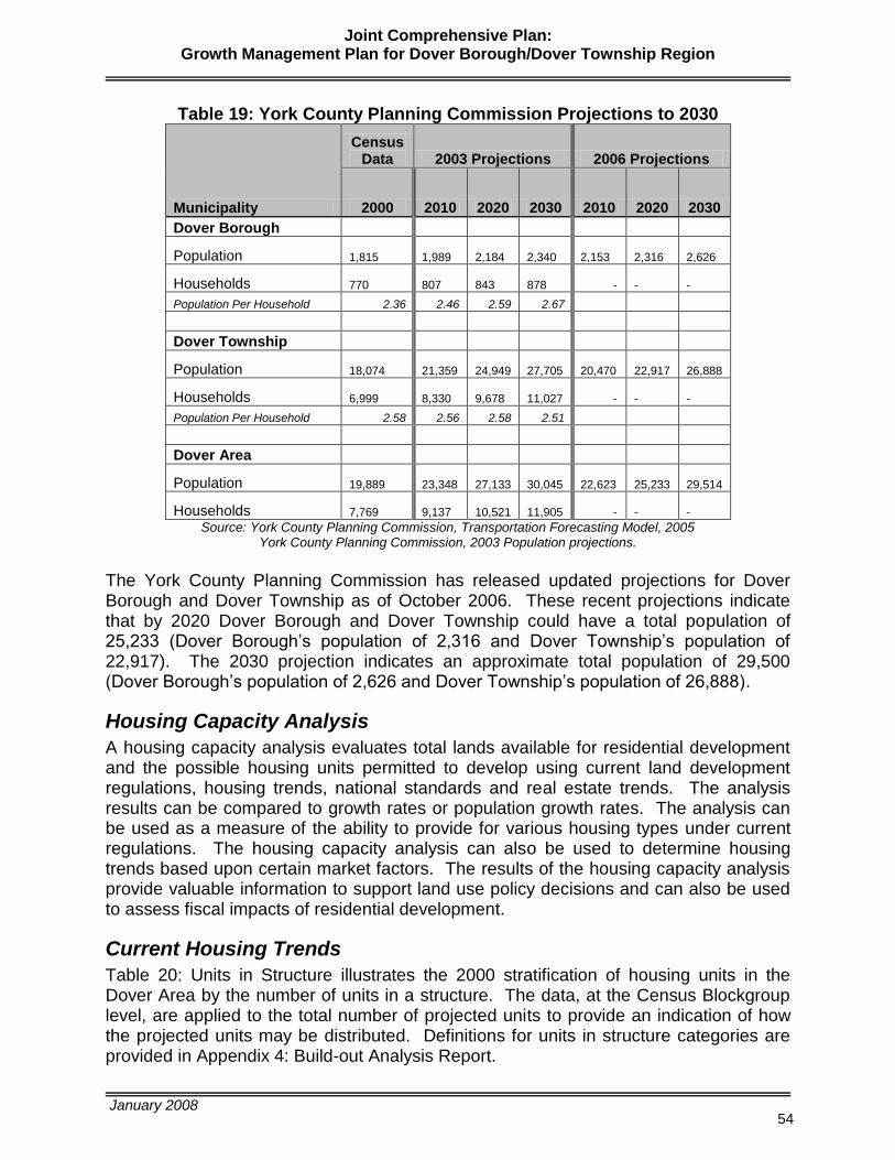
Joint Comprehensive Plan: Growth Management Plan for Dover Borough/Dover Township Region
January 2008
54
Table 19: York County Planning Commission Projections to 2030
Municipality
Census Data 2003 Projections 2006 Projections
2000 2010 2020 2030 2010 2020 2030
Dover Borough
Population 1,815
1,989
2,184
2,340
2,153
2,316
2,626
Households 770
807
843
878 -
-
-
Population Per Household 2.36 2.46 2.59 2.67
Dover Township
Population 18,074
21,359
24,949
27,705
20,470
22,917
26,888
Households 6,999
8,330
9,678
11,027 -
-
-
Population Per Household 2.58 2.56 2.58 2.51
Dover Area
Population 19,889
23,348
27,133
30,045
22,623
25,233
29,514
Households 7,769
9,137
10,521
11,905 -
-
-
Source: York County Planning Commission, Transportation Forecasting Model, 2005 York County Planning Commission, 2003 Population projections.
The York County Planning Commission has released updated projections for Dover Borough and Dover Township as of October 2006. These recent projections indicate that by 2020 Dover Borough and Dover Township could have a total population of 25,233 (Dover Borough’s population of 2,316 and Dover Township’s population of 22,917). The 2030 projection indicates an approximate total population of 29,500 (Dover Borough’s population of 2,626 and Dover Township’s population of 26,888).
Housing Capacity Analysis
A housing capacity analysis evaluates total lands available for residential development and the possible housing units permitted to develop using current land development regulations, housing trends, national standards and real estate trends. The analysis results can be compared to growth rates or population growth rates. The analysis can be used as a measure of the ability to provide for various housing types under current regulations. The housing capacity analysis can also be used to determine housing trends based upon certain market factors. The results of the housing capacity analysis provide valuable information to support land use policy decisions and can also be used to assess fiscal impacts of residential development.
Current Housing Trends
Table 20: Units in Structure illustrates the 2000 stratification of housing units in the Dover Area by the number of units in a structure. The data, at the Census Blockgroup level, are applied to the total number of projected units to provide an indication of how the projected units may be distributed. Definitions for units in structure categories are provided in Appendix 4: Build-out Analysis Report.
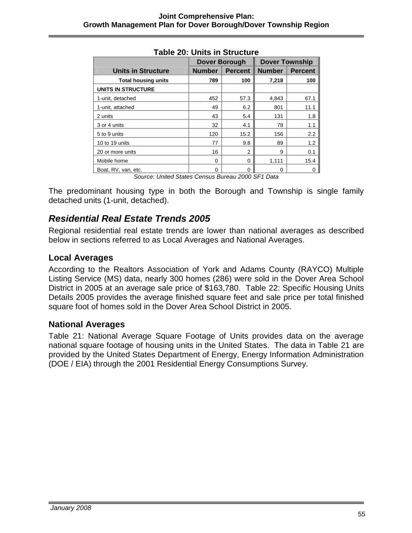
Joint Comprehensive Plan: Growth Management Plan for Dover Borough/Dover Township Region
January 2008
55
Table 20: Units in Structure
Units in Structure
Dover Borough Dover Township
Number Percent Number Percent
Total housing units 789 100 7,218 100
UNITS IN STRUCTURE
1-unit, detached 452 57.3 4,843 67.1
1-unit, attached 49 6.2 801 11.1
2 units 43 5.4 131 1.8
3 or 4 units 32 4.1 78 1.1
5 to 9 units 120 15.2 156 2.2
10 to 19 units 77 9.8 89 1.2
20 or more units 16 2 9 0.1
Mobile home 0 0 1,111 15.4
Boat, RV, van, etc. 0 0 0 0
Source: United States Census Bureau 2000 SF1 Data
The predominant housing type in both the Borough and Township is single family detached units (1-unit, detached).
Residential Real Estate Trends 2005
Regional residential real estate trends are lower than national averages as described below in sections referred to as Local Averages and National Averages.
Local Averages
According to the Realtors Association of York and Adams County (RAYCO) Multiple Listing Service (MS) data, nearly 300 homes (286) were sold in the Dover Area School District in 2005 at an average sale price of $163,780. Table 22: Specific Housing Units Details 2005 provides the average finished square feet and sale price per total finished square foot of homes sold in the Dover Area School District in 2005.
National Averages
Table 21: National Average Square Footage of Units provides data on the average national square footage of housing units in the United States. The data in Table 21 are provided by the United States Department of Energy, Energy Information Administration (DOE / EIA) through the 2001 Residential Energy Consumptions Survey.

Joint Comprehensive Plan: Growth Management Plan for Dover Borough/Dover Township Region
January 2008
56
Table 21: National Average Square Footage of Units
Type of Home
Average Square Footage
Average Sale Price (Structure Value)
Average Square Footage of Mobile Homes 1,062
Singlewide $38,000 to $48000
Doublewide $72,000*
Average Square Footage of SFD – Detached 2,553
$182,487
Average Square Footage of SFD – Attached 2,373
$113,975
Apartments - 2-4 units buildings 1,393
$122,215**
Apartments - 5 + units buildings 847
NA
NA – Not Available *Manufactured Homes Quote – Price Guide (2005), mh-quote.com
**Using Condominium values from Realtors Association of York and Adams County Inc data Source: United States Department of Energy, Energy Information Administration,
2001 Residential Energy Consumptions Survey and RAYAC 2005 Data.
Table 22: Specific Housing Unit Details 2005
Type
Total Finished Square
Feet Sold Price
Sale Price / Total Finished Square Foot
Detached 1,781 $ 182,487 $ 102
Attached 1,323 $ 113,975 $ 86
Mobile Home / w Land 1,174 $ 93,709 $ 80
Condominium 1,302 $ 122,215 $ 94
Housing Trends Applied to the Future Land Use Plan
Housing trends applied to the Future Land Use Plan as part of the build-out analysis have projected and distributed housing unit types across various zoning districts as depicted in table 23 on the following page. Methods used to achieve these results are detailed in the Build-Out Analysis Report contained in Appendix 5.

Joint Comprehensive Plan: Growth Management Plan for Dover Borough/Dover Township Region
January 2008
57
Table 23: Classification of Projected Housing Units by Zoning District
Zoning District CV A R-1 ROS R-2 R-3 R-4 R V MX V C Total
Percent of Total
Units From Build-Out Results 735 208 1,178 554 1,416 334 249 51 8 - 4 208
4,947
Units Not Accounted For In Build-Out 178 219 151
548
Type of Unit (Units In Structure) / Number of Projected Housing Units per
Zoning District 735 208 1,356 773 1,416 485 249 51 8 - 4 208 5,495
Housing units: 1; detached units in structure 672 185 1,036 591 937 317 93 45 4 - 4 156 4,039 73.5%
Housing units: 1; attached units in structure - - 288 164 256 58 91 2 1 - - 19 880 16.0%
Housing units: 2 units in structure - - - - 34 105 2 4 1 - - 30 176 3.2%
Housing units: 3 or 4 units in structure - 4 32 18 - 5 9 - 0 - - 4 72 1.3%
Housing units: 5 to 9 units in structure - - - - 46 - 33 - 2 - - - 80 1.5%
Housing units: 10 to 19 units in structure - - - - 124 - 5 - 1 - - - 130 2.4%
Housing units: 20 to 49 units in structure - - - - - - - - 0 - - - 0 0.0%
Housing units: 50 or more units in structure - - - - 17 - - - 0 - - - 17 0.3%
Housing units: Mobile home 63 19 - - - - 16 - - - 0 - 99 1.8%
TOTAL 735 208 1,356 773 1,415 485 249 51 8 - 4 208 5,493 100.0%
Table 23: Classification of Projected Housing Units by Zoning District - Preferred Build-out illustrates in which zoning districts the projected housing units may be constructed as well as illustrates the type of housing units that may be expected. The yellow highlighted columns represent the two zoning districts of Dover Borough, while the remaining columns comprise the zoning districts of Dover Township. Note that the percentage of mobile homes that may be expected (1.8%) is far less than the percentage of mobile homes that are already in the Dover Area (15.4%). Data from Table 23 are also used in the fiscal impact estimations.
Joint Comprehensive Plan: Growth Management Plan for Dover Borough/Dover Township Region
January 2008
58
This page intentionally left blank.
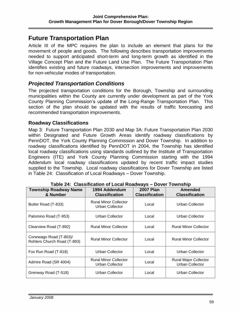
Joint Comprehensive Plan: Growth Management Plan for Dover Borough/Dover Township Region
January 2008
59
Future Transportation Plan Article III of the MPC requires the plan to include an element that plans for the movement of people and goods. The following describes transportation improvements needed to support anticipated short-term and long-term growth as identified in the Village Concept Plan and the Future Land Use Plan. The Future Transportation Plan identifies existing and future roadways, intersection improvements and improvements for non-vehicular modes of transportation.
Projected Transportation Conditions
The projected transportation conditions for the Borough, Township and surrounding municipalities within the County are currently under development as part of the York County Planning Commission’s update of the Long-Range Transportation Plan. This section of the plan should be updated with the results of traffic forecasting and recommended transportation improvements.
Roadway Classifications
Map 3: Future Transportation Plan 2030 and Map 3A: Future Transportation Plan 2030 within Designated and Future Growth Areas identify roadway classifications by PennDOT, the York County Planning Commission and Dover Township. In addition to roadway classifications identified by PennDOT in 2004, the Township has identified local roadway classifications using standards outlined by the Institute of Transportation Engineers (ITE) and York County Planning Commission starting with the 1994 Addendum local roadway classifications updated by recent traffic impact studies supplied to the Township. Local roadway classifications for Dover Township are listed in Table 24: Classification of Local Roadways – Dover Township.
Table 24: Classification of Local Roadways – Dover Township
Township Roadway Name & Number
1994 Addendum Classification
2007 Plan Classification
Amended Classification
Butter Road (T-833) Rural Minor Collector
Urban Collector
Local
Urban Collector
Palomino Road (T-953) Urban Collector Local Urban Collector
Clearview Road (T-892) Rural Minor Collector Local Rural Minor Collector
Conewago Road (T-803)/ Rohlers Church Road (T-893)
Rural Minor Collector Local Rural Minor Collector
Fox Run Road (T-818) Urban Collector Local Urban Collector
Admire Road (SR 4004) Rural Minor Collector
Urban Collector Local
Rural Major Collector Urban Collector
Grenway Road (T-518) Urban Collector Local Urban Collector

Joint Comprehensive Plan: Growth Management Plan for Dover Borough/Dover Township Region
January 2008
60
Land use is an important determinant of the function of an area’s roads and the classification of roadways can change over time as well as change along roadway segments based upon “levels of development”, the roadway characteristics and travel patterns. Both PennDOT and FHWA recognize the change of roadway classification along various roadway segments associated with changes in “levels of development” or land use patterns. Local roadways identified in this plan have been given roadway classifications defined by roadway sections based upon “levels of development”, usage and function within the study area or Dover Borough/Dover Township region. For example, the section of Butter Road within Dover Township is classified as an urban collector while the section of Butter Road within Conewago Township is classified as a rural minor collector. Admire Road extends into Paradise Township and is classified as a local road in the 2006 Jackson-Paradise Joint Comprehensive Plan, while in Dover Township the classification is rural major collector/urban collector. For these roadways and others extending beyond the Township boundary into areas of lower “levels of development”, the roadway classifications change based upon usage, function and land use patterns. In many instances, local roadway segments to the north, east and west, outside of the Dover Borough/Dover Township Designated and Future Growth Areas in surrounding Townships are of lower classifications. Urban and rural functional classification systems and design standards as modified by York County Planning Commission for classification of local roadways are described in Table 25. This table should be used to assist with future classification or reclassification of local roadways.
Table 25: Urban and Rural Functional Classification Systems and Design Standards
URBAN AND RURAL FUNCTIONAL CLASSIFICATION SYSTEMS AND DESIGN STANDARDS
LANES
Urban System Classification
Rural System Classification
Average Daily Traffic
Right-of-Way Width (feet) Number
Minimum Width
(Feet)
Shoulder Width (Feet) Type of Shoulder
Arterial Interstate/Freeway
Other Principal Minor
Arterial Interstate/ Freeway
Other Principal Minor
All Volumes 6,000 - 20,000 3,000 - 6,000
120 plus median 120 plus median
80
4 or more 4 2
12 12 12
10 - 12 8 - 10 8 - 10
Paved/Stabilized Paved/Stabilized Paved/Stabilized
Collector ~ 800 - 3,000 60
2 11 8
Stabilized (36 Feet minimum pavement
includes parking lanes)
~
Collector Major Minor
800 - 3,000 800 - 3,000
60 60
2 10 4
Stabilized (28 Feet minimum pavement)
Local ~ Less than 800 50
2 10 6-8
Stabilized (36 Feet minimum pavement
including parking lanes)
~ Local Less than 800 50
2 10 4
Stabilized (28 Feet minimum pavement)

Joint Comprehensive Plan: Growth Management Plan for Dover Borough/Dover Township Region
January 2008
61
Note: The Roadway Classification section and maps 3, 3A and 3B were adopted by Dover
Township on December 10, 2007 as an amendment to the plan. The Roadway Classification section and maps 3, 3A and 3B were adopted by Dover Borough in January, 2008 as an amendment to the plan.
Transportation Improvements
Several key transportation improvements are depicted on Map 3B: Transportation Improvements within Designated and Future Growth Areas. A summary of transportation needs and improvements including traffic signal improvements, left turn land warrants, alternatives solutions to intersection signalization, state roadway and intersection improvement projects and reference to roadway design standards to support development are provided in this section.
Transportation Needs with Short-Term Solutions
The Township conducted a Regional Traffic Impact Study in 2004. This study addressed proposed development of several key tracts that have direct impact on key transportation routes. The study resulted in projected traffic for key corridors to 2015 and recommendations for improvements to ensure proper management of traffic flow. Based upon analysis conducted, the study provided recommendations contained in the following sections: Traffic Signal Improvements, Left-turn Lane Warrants, and Summary of Recommended Intersection Improvements.
Traffic Signal Improvements
The study identified the following intersections anticipated to meet traffic signal warrants for recommended signal improvements.
Carlisle Road and Tower Drive
Carlisle Road and Donwood Drive
Davidsburg Road and Admire Road
Admire Road and South Salem Church Road Other alternatives to signalization should be considered (refer to Alternative Solutions to Intersection Signalization on page 60). For example, consideration should be given to an access road to join Donwood and Tower Village developments. Improvement of an access road may eliminate the need for signalization.
Left-turn Lane Warrants
The study included a left-turn lane analysis for un-signalized intersections. And, for signalized intersections, left-turn lanes are recommended for construction when the volume of left-turning approached 100 vehicles per hour. Table 26 identifies those intersections recommended for left-turn lanes and recommended distance of the lane.
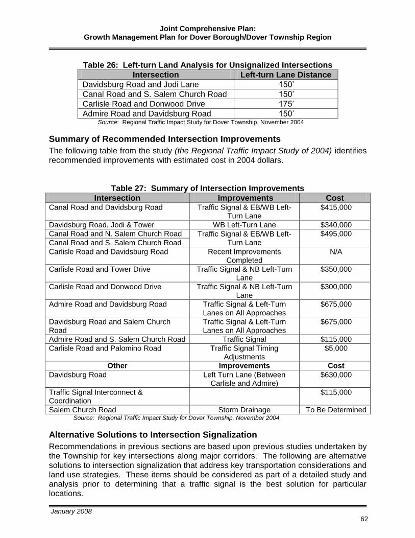
Joint Comprehensive Plan: Growth Management Plan for Dover Borough/Dover Township Region
January 2008
62
Table 26: Left-turn Land Analysis for Unsignalized Intersections
Intersection Left-turn Lane Distance
Davidsburg Road and Jodi Lane 150’
Canal Road and S. Salem Church Road 150’
Carlisle Road and Donwood Drive 175’
Admire Road and Davidsburg Road 150’ Source: Regional Traffic Impact Study for Dover Township, November 2004
Summary of Recommended Intersection Improvements
The following table from the study (the Regional Traffic Impact Study of 2004) identifies recommended improvements with estimated cost in 2004 dollars.
Table 27: Summary of Intersection Improvements
Intersection Improvements Cost Canal Road and Davidsburg Road Traffic Signal & EB/WB Left-
Turn Lane $415,000
Davidsburg Road, Jodi & Tower WB Left-Turn Lane $340,000
Canal Road and N. Salem Church Road Traffic Signal & EB/WB Left-Turn Lane
$495,000
Canal Road and S. Salem Church Road
Carlisle Road and Davidsburg Road Recent Improvements Completed
N/A
Carlisle Road and Tower Drive Traffic Signal & NB Left-Turn Lane
$350,000
Carlisle Road and Donwood Drive Traffic Signal & NB Left-Turn Lane
$300,000
Admire Road and Davidsburg Road Traffic Signal & Left-Turn Lanes on All Approaches
$675,000
Davidsburg Road and Salem Church Road
Traffic Signal & Left-Turn Lanes on All Approaches
$675,000
Admire Road and S. Salem Church Road Traffic Signal $115,000
Carlisle Road and Palomino Road Traffic Signal Timing Adjustments
$5,000
Other Improvements Cost
Davidsburg Road Left Turn Lane (Between Carlisle and Admire)
$630,000
Traffic Signal Interconnect & Coordination
$115,000
Salem Church Road Storm Drainage To Be Determined Source: Regional Traffic Impact Study for Dover Township, November 2004
Alternative Solutions to Intersection Signalization
Recommendations in previous sections are based upon previous studies undertaken by the Township for key intersections along major corridors. The following are alternative solutions to intersection signalization that address key transportation considerations and land use strategies. These items should be considered as part of a detailed study and analysis prior to determining that a traffic signal is the best solution for particular locations.

Joint Comprehensive Plan: Growth Management Plan for Dover Borough/Dover Township Region
January 2008
63
Improved Accessibility o Service roads for non-residential development to reduce the number of
driveways limiting the need for additional traffic signals along a corridor o Improve existing signalized intersections with turn lanes and technology
upgrades Restricted turning movements at intersections where appropriate Left and right turn lanes where appropriate
o Interconnectivity between and within residential development Cul-de-sacs should only be used where appropriate with lot design
situated so future connections/extensions can be made to support interconnectivity
Connector roads between residential developments
Access Management Strategies o Shared driveways o Turn lanes o Acceleration and deceleration lanes Reference PennDOT’s Access Management, Model Ordinances for Pennsylvania Municipalities Handbook.
Growth Management Strategies o Land use and site design provisions to reduce the need for signalized
intersections (i.e. shared driveways and density/intensity of land use patterns along major transportation corridors)
o Provision of adequate public facilities including new roadways, upgraded roadways and multi-modal facilities where and when necessary
Safety Improvements o Adequate sight distances and other geometric improvements at
intersections
Multi-Modalism o Pedestrian facilities and safety improvements to reduce dependency on
vehicular travel o Access to transit
Education/Consideration of Non-Traditional Solutions o Roundabouts where appropriate
State Roadway & Intersection Improvement Projects
The York County Transportation Plan developed from the York Areas Metropolitan Planning Organization’s (YAMPO) Long Range Transportation Plan (LRTP) includes a number of un-programmed roadway improvement projects located within the Township. Those planned improvements include the following:
Harmony Grove Road (SR 4014) realignment with Route 74
Canal Road (SR 921) signal at Fox Run Road
East Canal Road (SR 921) signal at Bull Road (SR 4001)
Roosevelt/Bull Road from Greenbriar Road to Canal Road upgrade to Major Collector Design Standards

Joint Comprehensive Plan: Growth Management Plan for Dover Borough/Dover Township Region
January 2008
64
Roadway Design Standards to Support Development
As development continues, local roadways will be developed to provide safe and efficient access to major roadways. The Borough and Township have roadway standards contained in their Subdivision/Land Development Ordinance to ensure sufficient improvement of roadways for public use. Roadway design standards should provide for urban landscapes, suburban landscapes and rural landscapes.
Need for Non-Vehicular Modes with Short-Term Solutions
This section focuses on development or expansion of non-vehicular modes of transportation such as transit routes, trails/greenways, bicycle routes and sidewalk networks.
Transit Routes
Rabbittransit provides public, fixed route transportation services to the Dover Area as described in the Existing Conditions Report. It is rabbittransit’s policy to add routes based upon need. As growth continues in the region and aging populations continue to live longer, existing routes may be extended or additional routes may be added based upon need.
Trails/Greenways
Greenways enhance the sense of place in a community, accentuate the scenic beauty and majesty of the Borough and Township, protect natural resources, provide recreation opportunities for families and individuals of all ages and abilities, provide alternatives to automotive transportation, add positively to the economic climate (including tourism) and foster health and wellness. Collaboration between the Borough, Township and the York County Rail Trail Authority for future development of trails/greenways is important.
Dover Trolley Line Project - A trail has been proposed for Dover referred to as the Dover Trolley Line Project. This project originated in the early 1990’s and is proposed to be built along the right-of-way of the old trolley line that once connected Dover Borough with York City. Plans call for the construction of a 1.5 mile trail along a section of the right-of-way in Dover Township. This section of the right-of-way is approximately 30 feet wide and runs through undeveloped farmland between Fox Chase Estates and Pine View Manor developments. The 8-foot wide trail would be used primarily by local area residents for walking, hiking and biking. Approximately 1,600 feet of the right-of-way will be cleared while sewer lines are being installed behind Fox Chase Estates. Property easements continue to be acquired. Additional funding would be required to finalize design and construct the facility.
Bicycle Routes
The Comprehensive Bikeway Study for York County identifies Carlisle Road from the square in Dover Borough south to West Manchester and Carlisle Road from the Borough square north to Warrington Township as a bicycle route for both commuter and recreational bicycling. The Comprehensive Bikeway Study also identifies East Canal Road from the square in Dover Borough east along East Canal Road to Park Street,

Joint Comprehensive Plan: Growth Management Plan for Dover Borough/Dover Township Region
January 2008
65
then south "across-country" along the Old Trolley Line right-of-way to Old Trolley Road and south along Brookside Avenue to the Dover Township Border and beyond. Safety improvements are needed along both routes to support recreational and commuter bicycling. A segment of Pennsylvania Bike Route S is located within Dover Township along East Berlin Road. Bicycle routes and corridors are identified on Map 3.
Sidewalk Network
The Future Transportation Plan (Map 3) depicts areas within the Village Core where sidewalk improvements are needed to close gaps within the existing system, to replace existing sidewalks for safety and aesthetic purposes and to extend sidewalks to make connections to suburban neighborhoods surrounding the Village Core. Streetscape improvements along “main street” (Route 74) within the Borough should include replacement of curb and sidewalks, pedestrian signals and crosswalks, street trees and other aesthetics such as pedestrian scale ornamental lighting, tree grates and brick treatments. These improvements within the Borough are essential to revitalization efforts. Pedestrian access to transit services offered within the region is essential to both the Borough and Township. Municipal ordinances should provide for adequate facilities for non-vehicular modes with connections to transit facilities.
Transportation Needs with Long-Term Solutions
The transportation network is an essential element for the orderly development and redevelopment of the Borough and the Township. The circulation patterns established by the plan serve as the framework so that the Future Land Use Plan can be realized. The future transportation needs include providing access to lands in the Township identified for future development as well as providing safe access to and around the Borough. In addition to short-term upgrades or improvements to the existing transportation network, future network improvements have been identified on Map 3. Additionally, this plan identifies a number of potential greenways that may be considered for trail improvements to make connections to the Village Core, refer to the Village Concept Plan, and future Trail/Greenways, open space, and recreation plan on Map 5. In addition to future roadways identified in this plan element, other long term solutions must be explored in order to adequately support development within the designated growth areas as well as within the larger region. The following are improvements that must be considered as long-term solutions to meeting the economic needs of the Township and the Borough and other municipalities.
Eastward Roadway to Connect to I-83 (Canal Road Interchange/Exit 26): A regional public/private partnership must be developed to readdress an eastward connection across multiple municipalities to make connection to I-83. This connection would support economic development of this region primarily providing the transportation network necessary to make sites identified in the Future Land Use Plan element for non-residential development accessible and marketable. Development within the Township and surrounding Townships has been stymied by the lack of adequate roadway infrastructure. Although YAMPO
Joint Comprehensive Plan: Growth Management Plan for Dover Borough/Dover Township Region
January 2008
66
completed a Planning Feasibility Study, the first step in the planning process for a project of this type, no additional steps have been taken. The following outlines the steps required to address a project of this nature.
o Step 1 – Project Planning & Programming
Planning Feasibility Study Project Scoping & Programming
o Step 2 – Preliminary Engineering Environmental Clearance Alternative Analysis Point of Access Study
o Step 3 – Final Design o Step 4 – Construction
Since the project involves Canal Road, a state route, and a proposed I-83 Interchange, PennDOT and FHWA will be partners in this process and inclusion of this project on the Transportation Improvement Plan (TIP) is necessary. Due to the history and nature of this project, it may be necessary to also involve private developers and other state economic development and capital improvement dollars to support development of this project. Townships adjacent to Dover Township and Dover Borough should take necessary steps to establish a regional partnership to actively pursue this project on both a technical and political level. East Manchester has identified this project in their Comprehensive Plan.
Bull Road Improvements: The widening of Bull Road is crucial to future development as well as necessary for improved safety for current and future motorists. As previously stated, this project has been identified as an un-programmed project. The purpose of widening this roadway is for improved accessibility to the community and region, improved commuting opportunities and improved safety.
Route 74 Improvements: The widening of Route 74 north and south of the Borough will provide improved access to the Borough, Township and the larger region. If improvements are planned, appropriate levels of traffic calming and maintaining on-street parking within the Borough limits is crucial to not only preserving the character of the Borough, but is vital to the economic survival of the Borough. Widening improvements should be made along with other roadway improvement shown on the Transportation Plan 2030 to develop alternative routes around the Borough for truck traffic and commuter traffic.

Joint Comprehensive Plan: Growth Management Plan for Dover Borough/Dover Township Region
January 2008
67
Future Community Facilities & Services Plan
The Build-out Analysis projected impacts associated with the Future Land Use Plan for a number of community facilities and services including schools and police and fire services. The following section identifies those specific impacts and presents future plans for those facilities and services.
School District Impacts
Table 28 indicates that the projected 5,493 additional homes may introduce approximately 3,000 new students into the Dover Area School District and the 2006 cost to educate one student for one year ($8,509 per student) could potentially result in a cost to the school district of approximately twenty six million dollars ($25,923,175). The table also indicates that the approximately twenty-five million dollars ($24,833,669) collected in potential school taxes would result in a deficit of approximately one-million dollars ($1,089,506) when comparing cost versus revenues. Table 28: Impact on School District Using Local Conditions – Preferred Build-out
Variables
Potential School Tax Collected
(18.77 Mils)
Potential County Tax Collected
(4.51 Mils) Potential Total
Taxes Collected
A. Potential Residential Development $ 16,698,085 $ 4,012,166 $ 20,710,251
B. Potential Non-residential Development $ 8,135,585 $ 1,954,794 $ 10,090,379
C. Potential Taxes Collected (Residential & Non-residential) $ 24,833,669 $ 5,966,961 $ 30,800,630
D. Potential New Residential Units* 5,493
E. Average Students per Residential Unit** 0.5546
F. Potential New Students (D*E) 3,047
G. Average School District Cost per Student*** $ 8,509
H. Potential Cost for New Students (F*G) $ 25,923,175
I. Difference Between School District Income & Cost (C - H) $ (1,089,506) *From Build-out Analysis – Table 11. **Refer to Local Conditions Worksheet below *** Pennsylvania Department of Education, 2006 Note: estimates are in 2005-2006 dollars.
Police and Fire Services Impacts
Dover Borough and Dover Township are part of a partnership of eight (8) municipalities that are members of the Northern York County Regional Police Board of Commissioners. Currently, the Borough purchases 4% of regional police services while the Township purchases approximately 24% of the regional police services. As population increases in the Township, additional cost will be associated with the purchase of police patrol and protection services. The following Tables from the Build-out Analysis projects costs for police and fire services for the Borough and Township.

Joint Comprehensive Plan: Growth Management Plan for Dover Borough/Dover Township Region
January 2008
68
Table 29: Cost of Police & Fire Services for Dover Borough
Service
2005 2005
Estimated Expenditure to Provide
Services for
Estimated Expenditure to Provide
Services for
Estimated Expenditure to Provide
Services for
Estimated Expenditure to Provide
Services for
Budgeted Amount
Calculated Per Capita
Expenditure to Provide
Service
County Projected
Population of 2020
County Projected
Population of 2030
Maximum Build-out
Population
Preferred Build-out
Population
Police $155,000 $81 $176,773 $189,399 $169,326 $169,245
Fire $10,000 $5 $11,405 $12,219 $10,924 $10,919
Total $165,000 $86 $188,178 $201,619 $180,251 $180,164
Population* 1,915 NA 2,184 2,340 2,092 2,091 *US Census 2003 estimate Note: estimates are in 2005-2006 dollars.
Table 30: Cost of Police & Fire Services for Dover Township
Service
2005 2005
Estimated Expenditur
e to Provide Services
for
Estimated Expenditur
e to Provide Services
for
Estimated Expenditure to Provide
Services for
Estimated Expenditure to Provide
Services for
Budgeted Amount
Calculated Per Capita
Expenditure to Provide
Service
County Projected
Population of 2020
County Projected
Population of 2030
Maximum Build-out
Population
Preferred Build-out
Population
Police $1,422,520 $75 $1,876,015 $2,083,250 $2,728,189 $2,602,464
Fire $237,085 $13 $312,667 $347,206 $454,695 $433,741
Total $1,659,605 $88 $2,188,682 $2,430,455 $3,182,883 $3,036,205
Population* 18,918 NA 24,949 27,705 36,282 34,610 *US Census 2003 estimate Note: estimates are in 2005-2006 dollars.
Table 29: Cost of Police & Fire Services for Dover Township and Table 30: Cost of Police & Fire Services for Dover Borough illustrates estimates to provide services to current and future citizens of the Township and the Borough. The tables estimate, for 2005 the per capita expenditure to provide police and fire services based on the budgeted amount of municipal funding to provide these services divided by the total population of the Township or the Borough. Future expenditure for services is calculated by multiplying the calculated 2005 per capita expenditure by the total projected population. In Dover Township, based on 2005 per capita expenditure, the estimated expenditure to provide police and fire services in 2020 is approximately $2.2 million, 2030 is approximately $2.4 million, under a maximum build-out approximately $3.2 million, and under a preferred build-out approximately $3.0 million. The estimates are based on 2005 -2006 dollars and assume no change in current police and fire services, or costs

Joint Comprehensive Plan: Growth Management Plan for Dover Borough/Dover Township Region
January 2008
69
to provide police and fire services, or change in the Township’s current commitment to receive these services. In Dover Borough, based on 2005 per capita expenditure, the estimated expenditure to provide police and fire services in 2020 is approximately $188,000, 2030 is approximately $202,000, and under either a maximum build-out or preferred build-out approximately $180,000. The estimates are based on 2005 - 2006 dollars and assume no change in current police and fire services, or costs to provide police and fire services, or change in the Borough’s current commitment to receive these services.
Emergency Management Services
The York County Department of Emergency Services, Office of Emergency Operations coordinates with the York County Planning Commission on mitigation efforts to prevent disasters from occurring. The agency offers training programs and educational brochures to the public for disaster preparedness. The Department coordinates with local municipalities for persons and agencies with special needs, so that appropriate transportation and evacuation planning is done. Disaster Recovery Programs are facilitated through damage assessment training and relief assistance information. Source: http//www.york-county.org/departments/ema/ema.htm
Future Water and Sewer Service Areas (Public Infrastructure Area)
Map 4: Future Water and Sewer Service Facilities illustrates future service areas, facilities and the Public Infrastructure Area. This map identifies areas within the Designated Growth Area and Future Growth Areas consistent with the Future Land Use Plan 2030 for extension of public water and sewer lines. The area outlined by both growth areas is identified as the Public Infrastructure Area This is an area where public infrastructure services will be provided and outside of which such public infrastructure services will not be required to be publicly financed unless public health, safety and welfare are at risk. Extension of these facilities will be primarily accomplished as private development occurs with possible public-private partnerships as needed to establish employment centers.
Future Water Service
The York County Comprehensive Plan emphasizes concentration of future development in designated growth areas, which are areas able to provide a full range of public services, facilities and infrastructure. The York County Water Supply Plan prepared in January 1998 projects water needs based upon projected population growth to 2010. The projected needs/demand for the Borough and the Township are shown in the tables on the following page. The County’s plan indicates that the existing and projected water provider (the Borough and the Township with ability to purchase additional water from York Water Company) is expected to meet future needs. Additionally, Dover Township will be exploring possible locations for future wells to support growth.

Joint Comprehensive Plan: Growth Management Plan for Dover Borough/Dover Township Region
January 2008
70
Table 31: Projected Water Needs 2010
Municipality 1990-2010 Population Increase
Percentage Served by
Water System
Projected Increase
Water System Users
Existing/Projected Water Provider
Dover Borough 62 100% 62 Dover Borough Water System
Dover Township 4,966 90% 4,469 Dover Township Source: 1998 York County Water Supply Plan.
Table 32: Projected Residential Water Demands
Water System
1998 Ave Daily
Demand Per Person (gpd)
Projected Population Increase
1990-2010
Projected 2010
Additional Average
Daily Demand
(gpd)
Projected Population Increase
2010-2030
Projected 2030
Additional Average
Daily Demand
(gpd)
Dover Borough Water System
67.1 62 4,160 276 18,520
Dover Township 79.4 4,469 354,839 12,067 958,112
Total ~ 4,531 358,999 12,343 976,632 Sources: 1998 Average, 2010 Population Projections and Projected 2010 Average
Daily Demand – 1998 York County Water Supply Plan. Projected Population 2010-2030 and Projected 2030 Additional Ave Daily Demand calculated based upon 2030
Future Land Use Plan and Build-out Analysis

Joint Comprehensive Plan: Growth Management Plan for Dover Borough/Dover Township Region
January 2008
71
Table 33: Projected Non-Residential Water Demands
Municipality
1998 Average Daily Demand
Per Connection
(gpd) (A)
2000 Industrial / Institutional
Acreage (B)
Projected 2030 Industrial / Institutional
Acreage (D)
Average Number of
New Industrial Lots Based on
Average Industrial Lot
Size of 3.5 Acres
(E) = D - B / 3.5
Projected Additional
Average Daily Demand (gpd)
(F) = A * E
Industrial/ Institutional
Dover Borough 2,108 56.2 56.2 - 0
Dover Township 503 368.7 812.1 126.7 63,723
Sub Total ~ 424.9 868.3 126.69 63,723
Municipality
1998 Average Daily Demand
Per Connection
(gpd) (A)
2000 Commercial
Acreage (B)
Projected 2030 Commercial
Acreage (D)
Average Number of
New Commercial
Lots Based on Average
Commercial Lot Size of 1.5
Acres (E) = D - B /
1.5
Projected Additional
Average Daily Demand (gpd)
(F) = A * E
Commercial
Dover Borough 2,108 15.4 18.2 1.9 3,935
Dover Township 503 422.7 1,164.9 494.8 248,884
Sub Total ~ 438.1 1,183.1 496.67 252,819
Total Water Demand for Non-residential Acreages ~ 863.0 2,051.4 623.4 316,542.2
Sources: 1998 Average Daily Demand – 1998 York County Water Supply Plan. Existing and Projected Acreages 2030 Future Land Use Plan and Build-out Analysis, Average Lot Sizes based on
existing average lot size of industrial and commercial uses.
Table 33 shows calculated water demand based on the average lot size of current industrial uses and the average lot size of current commercial uses. The industrial uses include light manufacturing and small shop, while commercial uses includes single use retail, fast food, restaurant, bank, used car lot, mini-warehousing, and office. The average daily demand per connection was assumed to be the same for industrial / institutional users as well as commercial users. The additional total water demand (residential and non-residential) is projected to be 1.3 MGD (1,293,174 gpd). Expansion of Facilities: Existing water lines extend into and beyond the Future Growth Area primarily following Route 74 include other improvements such as fire hydrants along the existing line. As development occurs within designated growth areas, expansion of public facilities may be required based upon densities of development as well as type of development and associated water needs. Expansion will primarily be in an eastward direction within the designated growth areas. In the event the Township and Borough water resources are not adequate to provide potable

Joint Comprehensive Plan: Growth Management Plan for Dover Borough/Dover Township Region
January 2008
72
water to future development the York Water Company has capacity to support growth of the Township and redevelopment of the Borough. And, as previously stated, the Township continues to explore possible locations for future wells to support growth; one particular location has been identified on Map 4. Lawful Activities Identified in the MPC: The Township and the Borough recognize lawful activities such as extraction of minerals impact water supply sources and such activities are governed by statues regulating mineral extraction that specify replacement and restoration of water supplies affected by such activities. Additionally, the Township and the Borough recognize that commercial agricultural production impact water supply sources.
Future Sewer Service
As growth occurs within the Township and surrounding Townships including West Manchester, Manchester and Conewago, the need for additional sewer capacity is inevitable. Figure 4 illustrates the 2006 Sewage Treatment Plant Service Area (Dover Township Wastewater Treatment Plant service area is in yellow). The Dover Township Wastewater Treatment Plant located on Graffius Road in Conewago Township has a current capacity of 8.0 million gallons per day (MGD) with 59.7% of that capacity allocated to Dover Township as illustrated in Table 34: Allocation of Flow.
Figure 4: Sewage Treatment Plant Service Area
Source: Dover 2006 Wastewater Treatment Report.

Joint Comprehensive Plan: Growth Management Plan for Dover Borough/Dover Township Region
January 2008
73
Table 34: Allocation of Flow
Township Conewago Township
Manchester Township
West Manchester Township
Dover Township Total
Agreement Flow Allocations Gallons/Day 150,000 732,000 2,345,600 4,772,400 8,000,000
Agreement Flow Allocations as a Percentage of Total Capacity 1.9% 9.2% 29.3% 59.7% 100.0%
Source: Dover 2006 Wastewater Treatment Report.
Growth in accordance with the Future Land Use Plan 2030 suggests an increase in flow from Dover Township and Dover Borough of 1.3 MGD to support growth within the Designated Growth Area and Future Growth Area. Projected flow is anticipated to be directed to the Dover Township Wastewater Treatment Plant and not in particular to the Dover Borough Sewage Treatment Plant (located in Dover Borough). Table 35: Impacts of Increased Flow illustrates the current average flow, the average flow as a percentage of agreement flow allocations, and the change as a result of the projected increased flow.
Table 35: Impacts of Increased Flow
Municipality
Agreement Flow
Allocations Gallons/Day
Average Flow Used
Gallons / Day 2006*
Average Flow Used
as a Percentage
of Agreement
Flow Allocations
Projected Increased Flow for
Dover 2030 (Current plus
Projected Flow)**
Average Projected Flow Used
as a Percentage
of Agreement
Flow Allocations**
Conewago Township 150,000 64,236 42.8% 64,236 42.8%
Manchester Township 732,000 362,214 49.5% 362,214 49.5%
West Manchester Township 2,345,600 1,289,057 55.0% 1,289,057 55.0%
Dover Township 4,772,400 1,735,715 36.4% 3,035,715 63.6%
Total 8,000,000 3,451,221 43.1% 4,751,221 59.4% * Based on Monthly flows for 2006; includes dry months and wet months with an annual rainfall of 49.07 inches.
** Assumes flows from surrounding Municipalities remains constant Note: 2006 Average Monthly Flows at the plant range from 1.8 to 6.2 MGD
Source: Dover 2006 Wastewater Treatment Report.
Based on averages, the average daily flow at the Dover Wastewater Treatment Plant would be 59.4% with Dover using 63.6% of its allocated flow. This suggests that the Dover Township Wastewater Treatment Plant could manage the additional projected flow, although, there are circumstances when the plant may exceed its capacity. In 2006 according to the Dover 2006 Wastewater Treatment Report, the average monthly flows at the Wastewater Treatment Plant ranged from a low of 1.8 MGD to 6.2 MGD. The range in flows is attributed to a number of factors but the most obvious factor includes inflow and infiltration (I & I) as attributed to rainfall. Figure 5 illustrates the impact that I & I had on flows at the Dover Township Wastewater Treatment Plant.

Joint Comprehensive Plan: Growth Management Plan for Dover Borough/Dover Township Region
January 2008
74
Figure 5: Flow Comparison for Wet versus Dry Months
Source: Dover 2006 Wastewater Treatment Report.
A separate issue regarding the Dover Township Wastewater Treatment Plants concerns nutrient loadings; particularly phosphorus and nitrogen. The Dover Township Wastewater Treatment Plant has set annual limits on Total Phosphorus (TP) and Total Nitrogen (TN) that can be released in its effluent. The current annual limits are 19,482 lbs of TP and 146,117 lbs of TN. In 2006, the plant released 77.0% of its allowed TP limit and 95.4% of its allowed TN limit. The permitted annual nutrient limits must be maintained regardless of the plants flow. Therefore, if the plant’s volume of flow is increased, the daily or monthly nutrient concentrations must be decreased so as not to exceed the annual permitted limits. The annual limits are set as part of the Chesapeake Bay Tributary Nutrient Reduction Strategy in association with the Pennsylvania Department of Environmental Protection. (PADEP)
Libraries
The Dover Library is part of the County Library System. The following figure (Figure 6) depicts the locations of libraries and service areas for those libraries. The Dover Area Community Library is identified as a regional facility providing services to residents within the region targeted to include Dover Borough, Dover Township and Washington Township. Libraries provide a valuable community resource as well as an opportunity to attract visitors from the region and outside of the region to participate in special activities and events.
FLOW ALLOCATION COMPARISON: WET VS DRY MONTH
0
10
20
30
40
50
60
70
80
90
100
CONEWAGO TWP MANCHESTER TWP W. MANCHESTER TWP. DOVER TWP
MARCH 05 JUNE 05
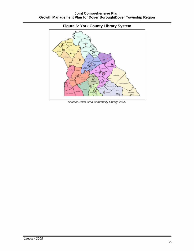
Joint Comprehensive Plan: Growth Management Plan for Dover Borough/Dover Township Region
January 2008
75
Figure 6: York County Library System
Source: Dover Area Community Library, 2005.

Joint Comprehensive Plan: Growth Management Plan for Dover Borough/Dover Township Region
January 2008
76
Economic Development Plan An Economic Development Plan is vital to the development of a self-sustaining community. The appropriate balance between residential and non-residential land uses will result in a community that is self-sustaining with respect to employment, commerce and tax revenues to support basic community services. The following plan addresses a key objective of the plan that is to provide a plan for the promotion of commercial and industrial development to create a sustainable community.
Economic Analysis
The York County Economic Development Corporation (YCEDC) conducted an Industrial Cluster Analysis using data from 1995-2001. This analysis is used by the YCEDC to target limited resources with respect to business retention and new business attraction. The study compares York County with all of Pennsylvania. The study is based upon applying several methodologies including location theory, competitive advantage and clusters and value chains. The study results examine the relative strength of all industries in York County against the performance of state and national competitors. The results identify emerging and declining clusters and provide the basis for economic development strategies with respect to business retention and expansion as well as new start ups. The study identified several clusters and sub-clusters for the region, many of which are consistent with analysis of clusters across the state. Those include the following: Agriculture and Food Productions (Food Processing); Advanced Materials and Diversified Manufacturing (Advanced Technology; Chemicals, Rubber & Plastics; Electronics, Metals and Metal Fabrication; Printing; Vehicles & Vehicle Equipment); Building and Construction; Business and Financial Services; Education; Life Sciences (Bio-Medical; Healthcare); Logistics and Transportation; Lumber Wood and Paper; and, Technology and Information Services. Source: York County Economic Development Corporation – Industrial Cluster Analysis Baseline Report (1995-2001)
York County Economic Development Corporation (YCEDC)
The YCEDC will utilize the results of the previously referenced cluster analysis to target their Business Retention and Expansion Program (BREP). The YCEDC typically visits 146 businesses annually. The BREP program is funded through the Pennsylvania Department of Community and Economic Development. Participating companies are asked to complete a survey. The BREP program results in York County companies receiving assistance for plant expansion, financing for new equipment and implementation of Customized Job Training Programs. Also, some companies can receive technical assistance in areas such as website development and implementation of lean manufacturing processes. The YCEDC continues to target specific industrial clusters for new business development. The YCEDC will be providing training to municipal officials and elected boards for townships and boroughs to improve the understanding of economic development. This program will focus on the relationship between economic development and zoning, code enforcement and infrastructure improvements. Source: York County Economic Development Corporation website – http://ycedc.org/bus_retention.html

Joint Comprehensive Plan: Growth Management Plan for Dover Borough/Dover Township Region
January 2008
77
York County Industrial Development Authority
The York County Commissioners established the York County Industrial Development Authority (YCIDA) under the provisions of the Pennsylvania Industrial and Commercial Development Authority Law, as amended. The YCIDA is a conduit enabling companies to utilize tax-exempt financing as provided under federal law. The YCIDA provides funding through the Industrial Revenue Bond (IRB) program and the Pennsylvania Economic Development Financing Authority (PEDFA). Source: York County Economic Development Corporation website – http://www.york-county.org/gov/AUTH/Economic.html
Economic Development Strategy
Due to location within the Greater Metropolitan area (on the edge of regional development) Dover Township and the Borough have not received a high priority by regional economic development agencies. As lands within the core area of the region around Center City York develop, lands in Dover Township will become highly desirable for future development. The Township has already experienced this trend with the residential market. The plan is to reserve future lands for non-residential development and work with regional economic development agencies to study and market lands for commercial/business and light industrial uses, business park development and mixed use centers along with first floor development of small or niche businesses within Dover Borough. The following are recommendations for further development of this strategy.
Conduct site assessments for lands to be reserved for future non-residential development.
Develop/continue partnerships with current owners.
Identify infrastructure (water, sewer and roadway) improvements necessary to make the sites development ready.
o Coordinate with YAMPO and PennDOT for necessary roadway and intersection improvements.
Partner with the YCEDC and YCIDA to leverage state funds to support studies and analysis of areas identified for commercial/business and industrial and business park development.
Make necessary zoning changes to reserve lands for non-residential development.
o Do not permit residential development to occur on lands identified for non-residential development.
Partner with the realtors to market properties as desired.
Coordinate with rabbittransit for future access to transit.
Consider light manufacturing operations that build upon the existing agricultural industry such as biodeisel and other related industries.
Identify white collar industries and business development that provide local employment as well as opportunities for increasing average household incomes.

Joint Comprehensive Plan: Growth Management Plan for Dover Borough/Dover Township Region
January 2008
78
Future Trail/Greenway, Open Space and Park/Recreation Plan Recommended trial, greenway, open space and park/recreation areas are depicted on the Future Trail/Greenways, Open Space and Recreation Plan Map 5. The following are some specific recommendations to assist with implementation of these amenities.
Improvements along Carlisle Road should include: wide shoulders, bicycle friendly storm drain grates and signage.
Continue the development of the Dover Trolley Line Project to provide non-vehicular access to residential neighborhoods. Establish additional linkages to community facilities in and around the Village Center.
Establish a policy and incentives for conservation of greenways for public access along streams as identified on the plan map. A 15 foot buffer preserved on either side of stream banks for public access (i.e. access to water as well as access for future trail/path development) is suggested. Additional buffer distance may be required to preserve riparian buffers for purposes of water quality.
Continue developer dedication of lands for recreation/open space or offer fee in lieu of dedication of land.
Seek out DCNR grants for acquisition and improvement of public parks, recreation, trails and greenways.
Utilization of Conservation Easement Program to preserve farmlands for future use as parks, open space and recreation facilities.
Additional lands identified for park and recreation/open space should be accessible by both vehicular and non-vehicular modes of transportation.
Standards for Park and Recreation Lands
The following standards have been applied to support development of this plan. The National Recreation and Park Association describes a neighborhood as a population of 2,000 to 10,000 within a radius of one-quarter to one-half mile (typically walking distance). As a general rule for park and recreation lands, the National Recreation and Park Association (NRPA) recommends 21 to 31 acres of park land per thousand residents. And, the Urban Land Institute (ULI) recommends approximately 25.5 acres per thousand residents. The following table represents a comparison of existing public parks, recreation and open space lands to those identified for 2030 in comparison with the NRPA and ULI standards. The difference between existing lands/future land and additional lands needed to meet the recommended national standards is shown in Table 36. The difference provides a target acreage for future lands to be dedicated for trail, greenway, open space and park/recreation lands as development occurs and as additional planning is undertaken to address this topic.
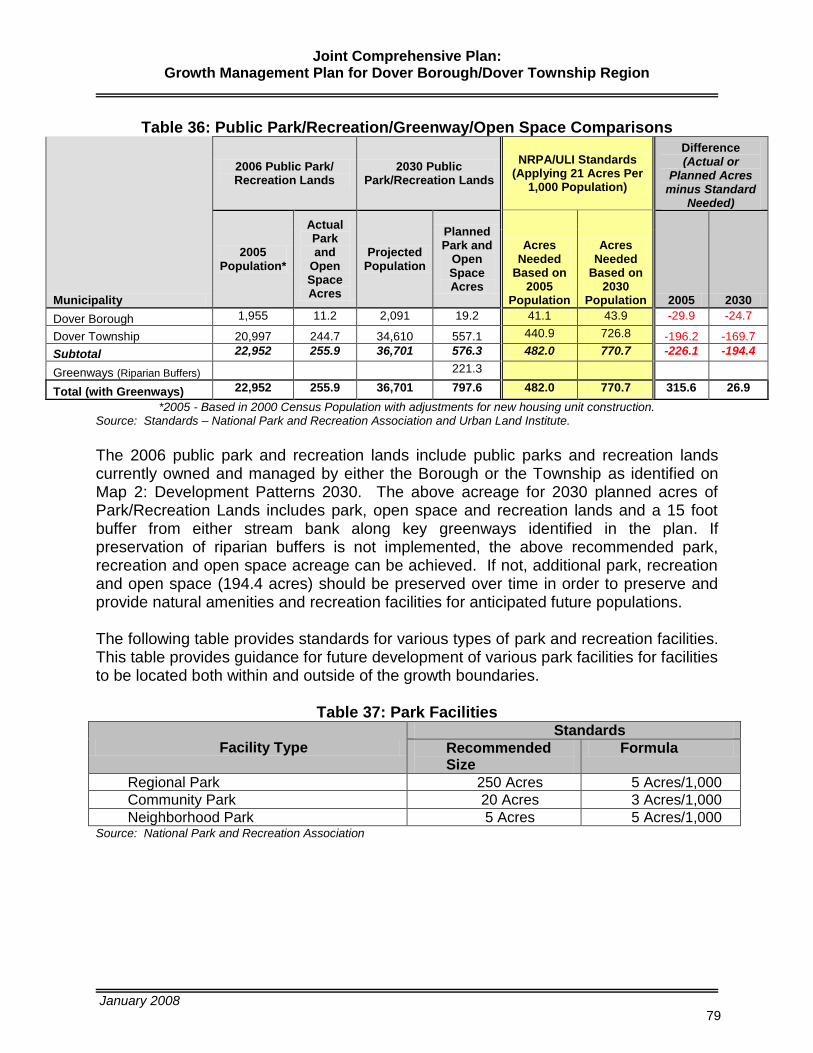
Joint Comprehensive Plan: Growth Management Plan for Dover Borough/Dover Township Region
January 2008
79
Table 36: Public Park/Recreation/Greenway/Open Space Comparisons
Municipality
2006 Public Park/ Recreation Lands
2030 Public Park/Recreation Lands
NRPA/ULI Standards (Applying 21 Acres Per
1,000 Population)
Difference (Actual or
Planned Acres minus Standard
Needed)
2005 Population*
Actual Park and
Open Space Acres
Projected Population
Planned Park and
Open Space Acres
Acres Needed
Based on 2005
Population
Acres Needed
Based on 2030
Population 2005 2030
Dover Borough 1,955 11.2 2,091 19.2 41.1 43.9 -29.9 -24.7
Dover Township 20,997 244.7 34,610 557.1 440.9 726.8 -196.2 -169.7
Subtotal 22,952 255.9 36,701 576.3 482.0 770.7 -226.1 -194.4
Greenways (Riparian Buffers) 221.3
Total (with Greenways) 22,952 255.9 36,701 797.6 482.0 770.7 315.6 26.9
*2005 - Based in 2000 Census Population with adjustments for new housing unit construction. Source: Standards – National Park and Recreation Association and Urban Land Institute.
The 2006 public park and recreation lands include public parks and recreation lands currently owned and managed by either the Borough or the Township as identified on Map 2: Development Patterns 2030. The above acreage for 2030 planned acres of Park/Recreation Lands includes park, open space and recreation lands and a 15 foot buffer from either stream bank along key greenways identified in the plan. If preservation of riparian buffers is not implemented, the above recommended park, recreation and open space acreage can be achieved. If not, additional park, recreation and open space (194.4 acres) should be preserved over time in order to preserve and provide natural amenities and recreation facilities for anticipated future populations. The following table provides standards for various types of park and recreation facilities. This table provides guidance for future development of various park facilities for facilities to be located both within and outside of the growth boundaries.
Table 37: Park Facilities
Facility Type
Standards
Recommended Size
Formula
Regional Park 250 Acres 5 Acres/1,000
Community Park 20 Acres 3 Acres/1,000
Neighborhood Park 5 Acres 5 Acres/1,000 Source: National Park and Recreation Association

Joint Comprehensive Plan: Growth Management Plan for Dover Borough/Dover Township Region
January 2008
80
Interrelationship of Plan Elements Plans for future growth within the Township and revitalization of the Borough were developed considering the following regional planning issues in a holistic manner:
existing development patterns,
the transportation network and the ability to provide future access,
lands available for development and redevelopment,
the need for non-residential development,
the need for mixed uses along main street in the Borough,
existing water services capabilities and the ability to make logical extension of both water and sewer facilities to adequately support future develop,
mobility within the Village Core with emphasis on non-vehicular modes,
preservation of natural resources and prime agricultural lands (adequate public facilities), and
greenway connections and increase of park, recreation and open spaces. This holistic approach to planning for future growth was conducted based upon citizen input, active participation by the JCPAC and technical assistance from York County Planning Commission and a planning consultant. Plan elements were prepared based upon a series of work sessions with the JCPAC, technical analysis and thoughtful planning to integrate various plan elements to achieve a desired growth management strategy for future development of the region. The Future Land Use Plan depicts the distribution, general location and inter-relationship of land use for residential, commercial, industrial, open space, recreation, community facilities and other categories of public and private uses of land. The land use section of the plan contains analysis of inconsistency of existing zoning districts and recommendations for changes in regulations to support future land use patterns depicted on the Future Land Use Plan 2030. The Future Land Use Plan is further supported by the following sections in the manner described below demonstrating the interrelationship of plan elements.
The Future Housing Plan outlines the potential distribution of housing types by zoning district in conjunction with planned growth of residential areas depicted in the Future Land Use Plan.
The Future Community Facilities and Services section of the plan as well as the Build-out Analysis (an Appendix item to this plan) reveals the basis for decisions to support development of a plan that fully integrates all elements.
The Future Transportation Plan identifies vehicular and non-vehicular facilities necessary to provide access and linkages to existing and future land uses with an understanding for connections needed to support residential and non-residential growth and overall projected traffic demands.
The Economic Development Plan identifies target clusters of business types to target business development efforts to areas identified in the Future Land Use Plan for the purpose of establishing employment centers. This element identifies

Joint Comprehensive Plan: Growth Management Plan for Dover Borough/Dover Township Region
January 2008
81
key agencies to assist the Borough and Township in revitalization and development efforts.
The Future Trail/Greenway, Open Space and Park/Recreation Plan identifies the requirements of public spaces based upon projected future populations and desired land use patterns in the Future Land Use Plan as well as provides opportunities for non-vehicular linkages to the Village Core, community facilities, and natural amenities.

Joint Comprehensive Plan: Growth Management Plan for Dover Borough/Dover Township Region
January 2008
82
Plan Consistency
The MPC requires that the existing and proposed development of the Borough and Township be compatible with the existing and proposed development and plans in contiguous municipalities. The MPC also requires identification of measures to provide buffers and transitions in any areas where there may be incompatible land uses along adjoining boundaries. This section addresses plan consistency with respect to the York Comprehensive Plan and York County Growth Management Plan and future land use plans from current comprehensive plans for West Manchester Township, Manchester Township, Conewago Township, Warrington Township, Washington Township, Paradise Township and Jackson Township. Overall, the plan is generally consistent with plans for adjoining municipalities as well as York County. Refer to Map 6: Future Land Use 2030: Development Patterns & Surrounding Municipalities Future Land Uses.
York County Comprehensive Plan
The Plan is generally consistent with the York County Comprehensive Plan and the York County Growth Management Plan (a component of the Comprehensive Plan) with respect to growth occurring outward from concentrated areas of development. The Plan will be an update to the County Plan in accordance with Article III of the MPC with respect to land use and established growth boundaries. The proposed land use patterns are consistent with planning terminology referenced in the MPC and County Plans, and land use patterns are generally consistent with surrounding municipalities.
West Manchester Township Comprehensive Plan
West Manchester Township updated its Comprehensive Plan in 2006. Many of the land uses bordering West Manchester Township are land uses currently in existence. One undeveloped tract identified for future commercial and business/commercial use adjoins lands that are agricultural rural/open space residential. At this location, the Township would require appropriate buffering and screening to minimize impacts of business/commercial development on nearby sites. During the planning process, Dover Township discussed the possibility of age restricted housing along with commercial development frontage at this location along Bull Road. The plan is generally consistent with West Manchester Township’s current land use patterns and future land use plan.
Manchester Township Comprehensive Plan
A very small corner of Manchester Township adjoins Dover Township. Lands currently developed as low density residential within Manchester Township are separated by a public right-of-way (Bull Road) from one undeveloped tract identified for future commercial and business/commercial use adjoining lands that are agricultural rural/open space residential. At this location, Dover Township would require appropriate buffering and screening to minimize impacts of business/commercial development on nearby sites. During the planning process, Dover Township discussed the possibility of age restricted housing along with commercial development frontage at this location along Bull Road. The plan is generally consistent with Manchester Township’s current land use patterns and future land use plan.

Joint Comprehensive Plan: Growth Management Plan for Dover Borough/Dover Township Region
January 2008
83
Conewago Township Comprehensive Plan
A portion of Conewago Township is serviced by the Dover Township’s wastewater treatment plant. Conewago Township’s land use patterns along the eastern boarder of Dover Township are generally consistent along Bull Road from the Little Conewago Creek northward to Canal Road. One undeveloped tract identified for future commercial and business/commercial use adjoins lands that are agricultural rural/open space residential. At this location, Dover Township would require appropriate buffering and screening to minimize impacts of business/commercial development on nearby sites. During the planning process, Dover Township discussed the possibility of age restricted housing along with commercial development frontage at this location along Bull Road. From Canal Road northward to Newberry Township current land use patterns and future land use plans are somewhat consistent with respect to low density residential development with agricultural and conservation of natural resources as well as land/open space. Dover Township is proposing to expand lands available for industrial and Business Park development north of Canal Road running eastward from the existing Industrial Park. This area runs to Bull Road excluding existing low density residential development with frontage along Bull Road. This area adjoins areas with existing low density development and agricultural uses. At this location, Dover Township would require appropriate buffering and screening to minimize impacts of industrial and business park development on nearby sites. The plan is generally consistent with Conewago Township’s current land use patterns and future land use plan.
Warrington Township Comprehensive Plan
Lands adjoining Warrington Township are separated by the Conewago Creek. Areas along this northern boundary are consistent. Both Dover Township and Warrington Township have experienced and planned for predominantly agricultural, low density residential and conservation land uses. This is an area that key locations have been identified by Dover Township for future acquisition of land for public use such as a wastewater treatment plant with park and boat launch and park lands with boat launches. The plan is generally consistent with Warrington Township’s current land use patterns and future land use plan.
Washington Township Comprehensive Plan
Lands adjoining Washington Township like Warrington Township are separated by the Conewago Creek. Both Dover Township and Washington Township have experienced and planned for predominantly agricultural and low density residential land uses. The plan is generally consistent with Washington Township’s current land use patterns and future land use plan.
Paradise Township Comprehensive Plan
Lands to the south of the Township adjoining Paradise Township are rural in nature and have experienced and planned for predominantly agricultural and low density residential development. The plan is generally consistent with Paradise Township’s current land use patterns and future land use plan.

Joint Comprehensive Plan: Growth Management Plan for Dover Borough/Dover Township Region
January 2008
84
Jackson Township Comprehensive Plan
Lands to the south of the Township adjoining Jackson Township are rural in nature and have experienced and planned for predominantly agricultural, low density residential and conservation development. The plan is generally consistent with Jackson Township’s current land use patterns and future land use plan.

Joint Comprehensive Plan: Growth Management Plan for Dover Borough/Dover Township Region
January 2008
85
Implementation Plan Implementing this Growth Management Plan for Dover Borough/Dover Township Region will require collaboration among a broad base of interested parties including the citizens, businesses, local, county and state governments, regional authorities and agencies as well as private property owners and investors. The following recommendations provide projects, programs, studies and changes in policy and regulation to address community issues and concerns, plan goals and objectives, vision statement, village concept and strategies identified throughout the planning process and comprehensive plan elements as outlined in the plan. The recommendations are organized by landscape (urban/village, suburban, rural and natural) to address all plan elements and by remaining plan elements spanning all landscapes (economic development and community facilities and services).

Joint Comprehensive Plan: Growth Management Plan for Dover Borough/Dover Township Region
January 2008
86
Table 38: Landscapes Implementation Plan Growth Management Concept,
Strategy or Landscape Recommendation Lead Agency & Partners Funding Sources Cost Estimate Priority Timing
Urban Landscape (Village)
Develop an Access Management Ordinance (Utilize PennDOT’s Model Ordinance as basis).
Township and Borough County Inter-Municipal Grant Program $10,000 1 2008
Streetscape Improvements within the Main Street Area.(Phased Project)
Borough, County, PennDOT, USDA
PennDOT – Hometown Streets/Safe Routes to Schools (Enhancement Funds) USDA – Community Facilities Program (Low Interest Loan) County CDBG Funds (if meet eligibility)
$80,000 - $90,000 Engineering $700,000 - $800,000 Sidewalk Construction $200,000 - $300,000 Utilities
2-3 2008 -2010
Establish a Main Street Program in the Borough (5 year program).
Borough, PA Downtown Center and DCED
Borough and DCED
$25,000 Grant for Planning $90,000 Borough – Local Match for 5 years. $23,000 DCED/yr. – Administration Additional Grant Monies for projects.
3 2010-2015
Upgrade pedestrian signal at Borough square (exclusive phase).
Borough, County Planning and PennDOT County Planning and PennDOT In-Kind 1 2007
Public space improvements at square and close off driveway access at convenience store.
Borough and Property Owner Community Fund Raiser $15,000 2 2008-2010
Feasibility Study for Borough Hall. Borough DCED $25,000 4 2016
New Borough Hall & Maintenance Facilities.
Borough Capital Funds, Bond Funds To be determined based upon Study results.
Paint cross walks and place silent police approaching non-signalized intersections.
Borough Borough and PennDOT $2,500 - $5,000 1 2007
Evaluate existing park and recreation programs and maintenance.
Borough, Township and Pennsylvania Recreation and Park Society (PRPS)
PRPS Recreation and Parks Technical Assistance Program (RecTAP)
Maximum Grant $1,500 Borough/Township
1 2008
Gateway signage at Borough entranceways.
Borough Community Fund Raiser and Business Sponsors
$15,000 2 2008-2010
Wayfinding signage in Borough. Borough General Fund $2,500 - $5,000 Signs $500 - $1,000 Design
2 2008-2010
Public parking lot improvements. Borough General Funds, Capital Funds, Bond Funds
Property Acquisition Improvements
3 2010-2015
Zoning Ordinance and Map Amendments:
Development mixed use standards to support small scale economic development.
Update sign ordinance.
Infill development standards.
Established definition and standards for age restricted residential development.
TND overlay and standards to guide development patterns.
Borough, Township, County and DCED DCED (Funding secured) $39,000 (part of a joint effort with Borough for Zoning and SALDO updates)
1 2007 - 2008
Evaluate HARB District or architectural standards as part of a TND ordinance through zoning.
Borough, County and DCED DCED (Funding secured) $39,000 (part of a joint effort with Borough for Zoning and SALDO updates)
1 2007 - 2008
Sanitary Sewer Improvements Borough DEP Draw Down Loan $80,000 1 2007-2008
Transportation improvements (refer to Map 3).
Borough, Township and Developers General Funds, Bond Funds, Developer Investment
To be determined based upon development. 1 2007-2030
Official Map (public improvements and lands)
Township and Borough County Inter-Municipal Grant Program $10,000 (coordinated with Access management Ordinance) 1 2008

Joint Comprehensive Plan: Growth Management Plan for Dover Borough/Dover Township Region
January 2008
87
Table 38: Landscapes Implementation Plan Growth Management Concept,
Strategy or Landscape Recommendation Lead Agency & Partners Funding Sources Cost Estimate Priority Timing
Suburban Landscapes
Require curb and sidewalk improvements for all developments (do not waive this requirement).
Township and Developers Developers Varies (based upon development) 1 2007-2030
Make path/trail improvements to connect development with public space/parks, village, shopping centers, employment and other neighborhoods (refer to Map 5 and other identified opportunities).
Township and Developers Developers Varies (based upon development) 1 2007-2030
Zoning Ordinance and Map Amendments:
Cluster development option.
Promote conversion of residential uses to commercial uses along Route 74.
Rezone areas north and east of Borough to allow land use patterns consistent with Future Land Use Plan (Map 1).
Establish TND standards to guide development patterns.
Established definition and standards for age restricted residential development.
Township, County and DCED DCED (Funding secured) $39,000 (part of a joint effort with Borough for Zoning and SALDO updates)
1 2007 - 2008
Conduct necessary studies to provide new water and sewer facilities within the Infrastructure Service Area.
Township and Developers Bond Funds, Developer Investment To be determined based upon development.
1 2007-2030
Stormwater Management Ordinance Amendments
BMPs.
Stream and riparian corridor management techniques.
Township, York County Conservation District, DEP
County $20,000 (full ordinance update) 1 2008-2009
Joint Interceptor Improvements (Hilton Avenue/Carlisle/Tara Lane)
Dover Township Sewer Authority User Fees/Operations $40,000 – Engineering $250,000 – Rehabilitation
1 2007-2009
Sanitary Sewer Maintenance Improvements.
Dover Township Sewer Authority User Fees/Operations $100,000/year 1 2007-2030
Sanitary Sewer monitoring/metering as development occurs.
Dover Township Sewer Authority User Fees/Operations To be determined as growth occurs. 2 2010-2030
WWTP upgrade (existing plant). Dover Township Sewer Authority Bond Funds Tentatively scheduled for bid in 2009. $12 M - Construction
2 2009-2012
WWTP new plant, new location (refer to Map 4).
Dover Township Sewer Authority Bond Funds To be determined. 4 2025-2030
Transportation improvements (refer to Map 3).
Township and Developers General Funds, Bond Funds, Developer Investment
To be determined based upon development.
1 2007-2030
Official Map identifying public space and public improvements including but not limited to parks and roads.
Borough and Township County Inter-Municipal Grant Program $10,000 (coordinated with Access Management Ordinance)
1 2008
Planning Study of feasibility of eastward roadway connection to I-83 to provide access to lands identified for employment centers.
Township, Borough, County, Conewago Township and Manchester Township, PennDOT, YAMPO YAMPO, PennDOT $250,000 - $300,000 2 2010-2015
Upgrade on-lot sewage facilities based upon implementation of Township Sewage Management Program Ordinance.
Township, DEP, PENNVEST and County Permits/Inspection Fees. PENNVEST of York County CDBG Fund for private improvements.
PENNVEST low interest loan up to $15,000. York County CDBG eligible income levels zero interest up to $10,000.
1 2007-2030

Joint Comprehensive Plan: Growth Management Plan for Dover Borough/Dover Township Region
January 2008
88
Table 38: Landscapes Implementation Plan Growth Management Concept,
Strategy or Landscape Recommendation Lead Agency & Partners Funding Sources Cost Estimate Priority Timing
Rural Landscapes
Zoning Ordinance and Map Amendments:
Develop a conservation or environmental zoning overlay (municipal-wide overlay for the Borough and Township).
Cluster development for Agricultural Zone and Conservation Zone.
Evaluate minimum/ maximum lot requirements in Conservation Zone.
Expand agricultural and agri-business uses and provide appropriate level of regulation.
Evaluate floodplains and riparian buffers and restriction of development within these areas.
Restrict development within well-head protection areas.
Promote growth including higher densities and mixed uses in and around the rural villages and rural crossroads.
Township, County and DCED DCED (Funding secured) $39,000 (part of a joint effort with Borough for Zoning and SALDO updates)
1 2007 - 2008
Roadway improvements should include widening and shoulder improvements.
Township and PennDOT General Funds, Liquid Fuels, Capital Funds, PennDOT Funding Programs
Township Annual Allocation PennDOT
1 2007-2030
Intersection Improvements (refer to Map 3)
Township, PennDOT and Developers Township, PennDOT and Developer Refer to Transportation Plan for estimates for specific intersections.
2 2007-2015
Stormwater Management Ordinance Amendments
Nutrient Management BMPs.
Stream and riparian corridor management techniques.
Township, York County Conservation District, DEP
County $20,000 (full ordinance update) 1 2008 -2009
Upgrade on-lot sewage facilities based upon implementation of Township Sewage Management Program Ordinance.
Township, DEP, PENNVEST and County Permits/Inspection Fees. PENNVEST of York County CDBG Fund for private improvements.
PENNVEST low interest loan up to $15,000. York County CDBG eligible income levels zero interest up to $10,000.
1 2007-2030

Joint Comprehensive Plan: Growth Management Plan for Dover Borough/Dover Township Region
January 2008
89
Table 38: Landscapes Implementation Plan Growth Management Concept,
Strategy or Landscape Recommendation Lead Agency & Partners Funding Sources Cost Estimate Priority Timing
Natural Landscapes
Develop fully detailed Trail/Greenways, Open Space and Park/Recreation Plan consistent with the County’s Open Space & Greenways Plan.
Township and DCNR DCNR, Community Conservation Partnerships Program – Planning and Technical Assistance
$25,000 - $30,000 (Township Match required)
2 2010 - 2012
Preserve strategic greenways within Natural Landscapes through acquisition or easement (refer to Map 5).
Township, County and DCNR DCNR, Community Conservation Partnerships Program- Acquisition and Development Projects
To be determined based upon item above.
3 2010-2030
Zoning Ordinance and Map Amendments:
Develop forest preservation regulations within the Zoning Ordinance for development within Conservation Zone.
Develop a conservation or environmental zoning overlay (municipal-wide overlay for the Borough and Township)
Cluster development or sliding scale standards for development within Conservation Zone.
Restrict billboards/off-premise commercial signs.
Evaluate minimum/ maximum lot requirements in Conservation Zone.
Other amendments to ensure consistency with Plan.
Township, County and DCED DCED (Funding secured) $39,000 (part of a joint effort with Borough for Zoning and SALDO updates)
1 2007 - 2008
Identify historic resources and evaluate possibility of establishing a rural historic district.
Township, Historic York and PHMC PHMC $10,000 3 2010-1025
Upgrade on-lot sewage facilities based upon implementation of Township Sewage Management Program Ordinance.
Township, DEP, PENNVEST and County
Permits/Inspection Fees. PENNVEST of York County CDBG Fund for private improvements.
PENNVEST low interest loan up to $15,000. York County CDBG eligible income levels zero interest up to $10,000.
1 2007-2030

Joint Comprehensive Plan: Growth Management Plan for Dover Borough/Dover Township Region
January 2008
90
Table 39: Implementation Plan (Borough & Township-wide) Element Recommendation Lead Agency & Partners Funding Sources Cost Estimate Priority Timing
Economic Development
Foster mixed use development first floor commercial use with second floor residential/living quarters.
Borough, Property Owners and Potential Business Owners
Private Investments and Small Business Loans
Based upon individual opportunity. 1 2007-2030
Conduct detailed Market Analysis of sites identified for employment centers/business parks to determine potential uses, public improvements and development strategies.
Borough, Township, YCEDC, YCIDA, DCED and PEDA
Borough, Township, County (Industrial Revenue Bond Program and Pennsylvania Economic Development Financing Authority), State, USDA and Private Investments
To be determined. 2 2010-2015
Zoning Ordinance and Map Amendments:
Place appropriate zoning protection on lands identified for employment centers so not lost to residential development.
Allow for a variety of agri-businesses in Agricultural Districts.
Township, County and DCED DCED (Funding secured) $39,000 (part of a joint effort with Borough for Zoning and SALDO updates)
1 2007 - 2008
Consider light manufacturing operations that build upon the existing agricultural industry such as biodeisel and other related cluster industries and seek out possible state assistance for those opportunities.
Borough, Township, YCEDC, YCIDA, DCED and PEDA
Borough, Township, County, State and Private Investments
To be determined. 2 2010-2015
Regional roadway improvements such as Canal Road Interchange/Exit 26 studies, plans, design and construction.
Borough, Township, YCEDC, YCIDA, DCED, PEDA, PennDOT, FHWA, YAMPO, County, East Manchester Township, Townships and Private Developers
Borough, Township, YCEDC, YCIDA, DCED, PEDA, PennDOT, FHWA, YAMPO, County, East Manchester Township, other Townships and Private Developers
To be determined based upon additional study.
3 2010-2030
Roadway improvements to lands identified for non-residential development (refer to Map 3).
Borough, Township, YCEDC, YCIDA, DCED, PEDA and Private Developers
Borough, Township, YCEDC, YCIDA, DCED, PEDA and Private Developers
To be determined based upon development.
2 2010-2030
Community Facilities & Services
Discourage the extension of public sewer and water services outside the growth boundaries unless such services are needed in the Rural Resource areas to address health and safety issues.
Township, Private Property Owners and Devlopers, Authority
General Fund, Authority Funds, Private Owners/Developers
Based upon development. 1 2007-2030
Continue to provide adequate police, fire and emergency medical services for Borough and County residents in the most cost effective manner while pursuing cooperative and regional solutions.
Borough and Township General Fund Refer to Annual Budgets/Operations Budgets.
1 2007-2030
Continue to work collaboratively with the School District when considering future planning efforts, expansion of growth boundaries or rezoning of non-residential lands to allow for additional residential development.
Township and School District N/A In-Kind – Staff Coordination. 1 2007-2030
Update the Borough’s 1983 Act 537 Plan to be consistent with this Plan. Update the Township’s 2004 Act 537 Plan to be consistent with this Plan. The Township’s Act 537 Plan should include a nitrates map that can be used to regulate land use.
Township, Borough and DEP Township, Borough and DEP (Act 537 Sewerage Facilities Planning Assistance Grant)
$35,000 - $50,000 2 2010-2012

Joint Comprehensive Plan: Growth Management Plan for Dover Borough/Dover Township Region
January 2008
91
References 2001 Residential Energy Consumptions Survey, United States Department of Energy, Energy Information Administration. 2004 Chapter 94 Update March 2005, Dover Borough, York County, Pennsylvania. Access Management, Model Ordinances for Pennsylvania Municipalities Handbook, Pennsylvania Department of Transportation, Transportation Research Board, April 2005. Architectural Graphic Standards, Tenth Edition, The American Institute of Architects, April 2000. Census of the Population 1950-2000; United States Census Bureau, Summary Files 1A and 3A. Consolidated Plan For York County, Pennsylvania, Fiscal Years 2005-2009, November 2004, York County Planning Commission, Pennsylvania. Enrollment and Projections 2004-2010, Dover Area School District. Dover Borough Building Permits 1999-2005, Dover Borough, York County, Pennsylvania. Dover Borough Comprehensive Plan April 1964, Dover Borough, York County, Pennsylvania. Dover Borough Subdivision & Land Development Ordinance 1979, Dover Borough, York County, Pennsylvania. Dover Borough Zoning Ordinance 1979, Dover Borough, York County, Pennsylvania. Dover Township Building Permits 1999-2005, Dover Township, York County, Pennsylvania. Dover Township 2004 Chapter 94 Municipal Wasteload Management Report, Dover Township, York County, Pennsylvania. Dover Township Water Lines and Well Locations June 2004, Dover Township, York County, Pennsylvania. Dover Township Comprehensive Plan 1987, Dover Township, York County, Pennsylvania. Dover Township Comprehensive Plan Addendum August 1994, Dover Township, York County, Pennsylvania.

Joint Comprehensive Plan: Growth Management Plan for Dover Borough/Dover Township Region
January 2008
92
Dover Township Sub-Division and Land Development Ordinance via website (www.dovertownship.org) [Accessed December 2005]. Dover Township Zoning Map, April 2004, Dover Township, York County, Pennsylvania. Dover Township Zoning Ordinance via website (www.dovertownship.org) [Accessed December 2005]. Draft Conewago Watershed Conservation Plan, Pennsylvania Environmental Council, circa 2006. Economic Census 2002, United States Census Bureau, Economic Census. Engineering News Record, May 9, 1994: Street Design Standards; Engineering News Record. Geologic and Mineral Resource Map of the Greater York Area 1979, York County, Pennsylvania. GIS Department Datasets and Coverages 2003-2006, York County Planning Commission, Pennsylvania. Home Sale Data 2004-2006, Realtors Association of York and Adams Counties, Inc. (RAYAC). Industrial Cluster Analysis 1995-2001, York County Economic Development Corporation, 2004. Influence of Well Construction on Bacterial Contamination, Center for Rural Pennsylvania, May 2004. Long Range Transportation Plan 2003-2023, York Area Metropolitan Planning Organization, York County, Pennsylvania, 2005. National Register Publications, NRB 16A Appendix 4, Glossary of National Register Terms, United States Department of the Interior, Accessed 2004. Northern York County Regional Police Department 2004 Annual Report, York County, Pennsylvania. Pennsylvania Municipalities Planning Code, Act of 1968, P.L. 805, No.247 As reenacted and amended. Commonwealth of Pennsylvania, Department of Community and Economic Development, 18th Edition February 2005.

Joint Comprehensive Plan: Growth Management Plan for Dover Borough/Dover Township Region
January 2008
93
Pennsylvania Greenways: An Action Plan for Creating Connections, 2001, Pennsylvania Department of Conservation and Natural Resources. Population Estimates 2003-2005, United States Census Bureau. Population Projections 2000-2030, York County Planning Commission, Pennsylvania, circa 2003. Roadway Centerline Files (2004-2006), Pennsylvania Department of Transportation. Regional Traffic Impact Study for Dover Township, Dover Township, York County, Pennsylvania. School Aged Population, Pennsylvania State Data Center; Map 2005. Tax Assessment Data 2004-2006, York County Tax Assessment Office, Pennsylvania. Transit Routes, Rabbitransit, York County, Pennsylvania, 2005. Transportation Forecasting Model, 2005, York County Planning Commission, Pennsylvania. Transportation Improvement Program 2003-2006, York Area Metropolitan Planning Organization, York County, Pennsylvania. When City and Country Clash, Farm Foundation, National Policy Education Committee, 1999. York County Act 167 - Watershed Storm Water Management Projects, York County Planning Commission, Pennsylvania, Map 2004. York County Comprehensive Bikeway Study 1997, York County Planning Commission, Pennsylvania. York County Environmental Resources Inventory 2004, York County Planning Commission, Pennsylvania. York County Growth Management Plan as Amended 2004, York County Planning Commission, Pennsylvania. York County Growth Trends 1995, York County Planning Commission, Pennsylvania. York County Natural Areas Inventory as Amended 2004, York County Planning Commission, Pennsylvania.

Joint Comprehensive Plan: Growth Management Plan for Dover Borough/Dover Township Region
January 2008
94
York County Open Space & Greenways Plan 2004, York County Planning Commission, Pennsylvania. York County Transportation Plan, June 2003, York County Planning Commission, Pennsylvania. York County Water Supply Plan, January 1998, York County Planning Commission, Pennsylvania.
Web References CoolTown Studios, Designing the Gen X Urban Village, http://www.cooltownstudios.com/ [Accessed June 2006]. Dover Area Community Library, 3700-3 Davidsburg Road, Dover, Pennsylvania, 17315 http://www.yorklibraries.org/dover/ [Accessed December 2, 2005]. Dover Area School District, 2 School Lane, Dover, Pennsylvania, 17315 http://www.dover.k12.pa.us/doversd/site/default.asp [Accessed December 2, 2005]. Dover Township, http://www.dovertownship.org/ [Accessed December 2, 2005]. Farm and Natural Lands Trust of York County, 156 North George Street, York, PA 17401. http://www.farmtrust.org/ [Accessed December 16, 2005]. United States Census Bureau, Summary File 1, Technical Documentation and Datasets, U.S. Census Bureau, Washington D.C. 20233, http://www.census.gov/prod/cen2000/doc/sf1.pdf, [Accessed December 6, 2005] United States Census Bureau, Summary File 3, Technical Documentation and Datasets, U.S. Census Bureau, Washington D.C. 20233, http://www.census.gov/prod/cen2000/doc/sf3.pdf, [Accessed December 6, 2005]

Joint Comprehensive Plan: Growth Management Plan for Dover Borough/Dover Township Region
January 2008
95
Agencies & Organizations In addition to the agencies and organizations listed under the reference section, the following agencies and organizations also provided data or information which contributed to plan development: Adams Electric Cooperative Inc. Columbia Gas of Pennsylvania: NiSource Inc. Dover Township Volunteer Fire Department Historic York, Inc. Metropolitan Edison: FirstEnergy Corporation National Park Service, National Historic Landmarks Program National Recreation and Park Association Pennsylvania Department of Education, Dover Area School District Pennsylvania Department of Environmental Protection Pennsylvania Department of Labor & Industry, Center for Workforce Information and Analysis Pennsylvania Department of Transportation, District 8-0 Bridge Unit Pennsylvania Emergency Management Agency Pennsylvania Game Commission Pennsylvania Historical and Museum Commission Pennsylvania Spatial Data Access (PASDA) The Greater Dover Historical Society, Inc. Urban Land Institute United States Department of Agriculture, Natural Resource Conservation Services United States Fish and Wildlife Services, National Wetlands Inventory York Area Earned Income Tax Bureau York County Agricultural Land Preservation Board York County Department of Emergency Services, Office of Emergency Operations York County Rail Trail Authority York County Solid Waste Authority

Joint Comprehensive Plan: Growth Management Plan for Dover Borough/Dover Township Region
January 2008
96
Appendices
Appendix 1: Intergovernmental Cooperative Planning Agreement
Appendix 2: Existing Conditions Report
The Existing Conditions Report was the first document prepared in the planning process. The report contains information documenting existing conditions and other topics required to meet MPC Comprehensive Plan elements. The report addresses the following topics: history, regional setting, population, housing, land use, historic preservation, water and sewer, stormwater management, transportation, community facilities and services, economic profile and utilities.
Appendix 3: Summary of Community Input
The Summary of Community Input includes the results of a community survey, prioritization of community issues and/or preferences and results of a visual preference survey. This section also includes the meeting agendas and minutes for the JCPAC, and results of public meetings.
Appendix 4: Build-Out Analysis Report
The Build-Out Analysis Report analyzes impacts of maximum build-out under current zoning and contains analysis to support identification of a preferred build-out scenario to develop the Future Land Use Plan 2030. Impacts measured included tax revenues, water and sewer needs versus capacity, cost of police and fire services, housing capacity analysis and impacts on the school district.
Appendix 5: Zoning Analysis
This analysis includes examination of appeals, definitions and various sections of zoning ordinances for the Borough and the Township to support recommendations in the implementation section of the plan.