journal of the tropical resources instituteenvironment.yale.edu/tri/uploads/tri news 1993(1).pdf ·...
TRANSCRIPT

Journal of the Tropical Resources Institute
Yale University School of Forestry & Environmental Studies Spring, 1993 Vol 12, No.1
TRI INITIATIVE - HUMAN HEALTH AND EFFECTIVE UTILIZATION OF TROPICAL FORESTS
Dr. Florencia Montagnini, Director, TRI Dr. Burton Singer, Chairman of Epidemiology and
Public Health, Yale University Brad Auer, Assistant to the Director, TRI Nuria Muniz-Miret, TRI Project Coordinator
The past 35 years have witnessed a large-scale human migration from the densely settled areas of northeastern and southern Brazil to the Amazon basin. Desiring to escape the problems of population pressure, poverty and skewed land distribution in their home regions, settlers have moved to the Amazon hoping to carve a prosperous existence out of an unfamiliar environment. The result, however, has been extensive deforestation, land degradation, epidemics of vector-borne diseases, agricultural failures and economically non-viable mineral extraction.
In an attempt to address these problems, the Tropical Resources Institute at the Yale School of Forestry and Environmental Studies has been instrumental in the creation of the Center for Human Ecology, Environment and Infectious Disease, the first fully funded research center of the new Yale Institute for Biospheric Studies. The Center will focus on the interactions among social and economic factors, environmental change and infectious human diseases. Initially, research activities will focus on the Amazon River Basin of Brazil and on several insect-transmitted diseases: malaria, leishmaniasis, and arboviral diseases (e.g. yellow fever). Similar studies are projected for areas of Indonesia, India, Nepal, and sub-Saharan Africa.
Dr. Florencia Montagnini, Associate Professor of Tropfcal Ecology and John M. Musser Director of the Tropical Resources Institute, is a collaborating professor with the Center and one of the principal investigators of the first large research project sponsored by the Center. Entitled "A Research and Education Initiative on Human Health and Effective Utilization of Tropical Forests", the project will study the links between deforestation and infectious human diseases in the Amazon Basin of Brazil. The
principal investigators of the project are TRI's Dr. Florencia Montagnini, Dr. Burton Singer, the Chairman of Yale's Epidemiology and Public Health Department, and two Brazilian researchers, Dr. Diana Oya Sawyer of CEDEPLAR and Dr. Jorge Travassos da Rosa of the Instituto Evandro Chagas.
The project researchers are initiating a multi-year study that will examine changes in land use and public health at all stages of development and incursion into the Amazon. The early to later stages of colonization will be studied in order to develop a detailed understanding of the intenelationships between road locations, colonization strategies, deforestation and disease. Project researchers also will focus on vectors of disease transmission and their relationship to land use following the substantial forest degradation that has occuned already in the region. The results of these studies will yield valuable information
F'ores!IY alld Humall Health inBrazil 1 Sustainable Resource Use in Amazonia 3 Varzea Forests of the Peruvian Amazon 4 Enrichment Planting in Argentina 7 Avifauna Diversity in Monteverde, Costa Rica 11 Comparative Streamflow Dynamics in Nepal 14 Aspects of Common Property Resource (]se in India 18 A Time Allocation Study of NTFPsin Sri Lanka 20 Growth Dynamics of Four Tree Species in Sri Lanka 23
Working Papers 26
Literature 28
TRI Notes 31
Cooperator Notes 31
TRI Bulletin Archives Do Not Remove fi'om Office -Thanks!
F
about sustainable land-use practices that are ecologically suited to the prevailing environment and which produce acceptable economic returns, diminish overall health risks, and stabilize human populations by ensuring better standards of living.
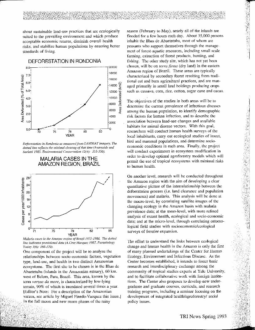
DEFORESTATION IN RONDONIA 8.(},-------------------.20000
ro 7.
~ "ffl 6.
~ '0 5. -;!2. ~ 4. Q)
1ii ~ 3. o 1ii Cl 2. (1j
~ 1.
18000
16000
14000 W ,:.:..
12000 1il 10000 ~
~ 8000 0 (1j
6000 ~ c:(
4000
2000 _ ..... ..-""'" O.n-L-fII""~-___.--___.---_,__--___.-...LO
70 75 78 80 83 YEAR
Deforestation in Rondonia as measured ji'om LANDSAT imagery. Tile dotted line reflects tile minimal clearing o.ftilat time (Feamside and Sar/atti 1985. Environmental Consen'ation 12(4): 355-356).
~ 28
.~
..0 24 co .c. .!: 20 0 0 0 16 ,.... '" (1j
~ 12 Qj 0.. 8 (f) Q)
!{l 4 0
0 71
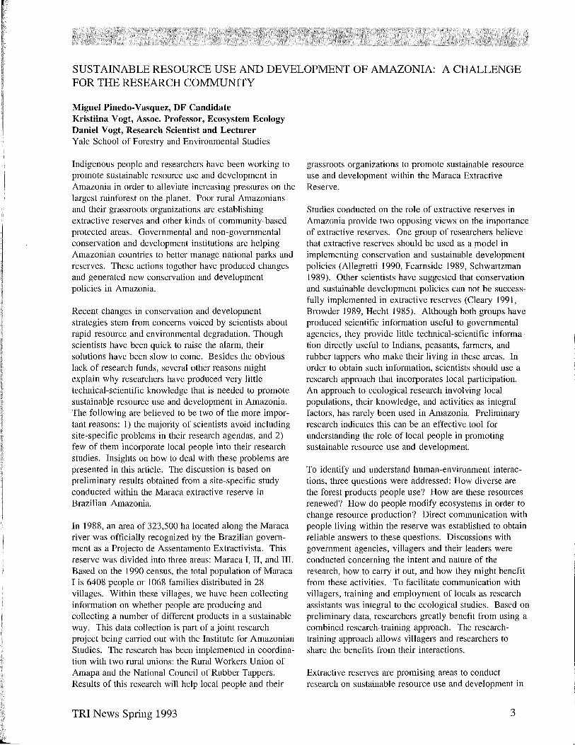
MALARIA CASES IN THE AMAZON REGION, BRAZIL
75 79 82 YEAR
I I
I
86
Malaria cases in tile Amazon region o.f Brazil 1971-1986. Tile dotted line indicates provisional data (A. Cruz Marquez 1987. Parasitology Today 3(6): 166-170).
One component of the project will be to analyze the relationships between socio-economic factors, vegetation type, land-use, and health in two distinct Amazonian ecosystems. The first site to be chosen is in the Ilhas de Abaetetuba (islands in the Amazonian estuary), 60 km. west of Belem, Para, Brazil. This area, known by the term varzea da mare, is characterized by low-lying telTain, 90% of which is inundated several times a year. [Editor's Note: For a description of the Amazonian varzea, see article by Miguel Pinedo-Vazquez this issue.] In the full moon and new moon phases of the rainy
2
season (February to May), nearly all of the islands are flooded for a few hours each day. About 35,000 persons inhabit the Ilhas de Abaetetuba, most of whom are peasants who support themselves through the management of forest-aquatic resources, including small scale farming, extraction of forest products, hunting, and fishing. The other study site, which has not yet been chosen, will be on terra firllla (dry land) in the eastern Amazon region of Brazil. These areas are typically characterized by secondary forest resulting from traditional cut and burn agricultural practices, and are managed primarily in small land holdings producing crops such as cassava, corn, rice, cotton, sugar cane and cacao.
The objectives of the studies in both areas will be to determine the current prevalence of infectious diseases among the human popUlation, to identify demographic risk factors for human infection, and to describe the association between land-use changes and available habitats for animal disease vectors. With this goal, researchers will conduct human health surveys of the local inhabitants, calTY out ecological studies of insect, bird and mammal populations, and determine socioeconomic conditions in each area. Finally, the project will conduct experiments in ecosystem modification in order to develop optimal agroforestry models which will permit the use of tropical ecosystems with minimal risks to human health.
On another level, research will be conducted throughout the Amazon region with the aim of developing a clear quantitative picture of the intelTelationship between the deforestation process (i.e. land clearance and population movements) and malaria. This analysis will be done at the macro-level, by correlating satellite images of the changing ecology in the Amazon basin with malaria prevalence data; at the meso-level, with more refined analysis of extant health, ecological and socio-economic data; and at the micro-level, through cOlTelating entomological field studies with socioeconomic/ecological surveys of frontier expansion.
The effort to understand the links between ecological change and human health in the Amazon is only the first of many planned undertakings of the Center for Human Ecology, Environment and Infectious Disease. As the Center becomes established, it intends to foster basic research and interdisciplinary exchange among the community of tropical studies experts at Yale University, and to facilitate collaborative work with foreign institutions. The Center also proposes to develop new undergraduate and graduate courses, cUlTicula, and research training programs, including a seminar focusing on the development of integrated health/agroforestry/ social policy issues.
TRI News Spring 1993
vn
SUSTAINABLE RESOURCE USE AND DEVELOPMENT OF AMAZONIA: A CHALLENGE FOR THE RESEARCH COMMUNITY
Miguel Pinedo-Vasquez, DF Candidate Kristiina V ogt, Assoc. Professor, Ecosystem Ecology Daniel Vogt, Research Scientist and Lecturer Yale School of Forestry and Environmental Studies
Indigenous people and researchers have been working to promote sustainable resource use and development in Amazonia in order to alleviate increasing pressures on the largest rainforest on the planet. Poor rural Amazonians and their grassroots organizations are establishing extractive reserves and other kinds of community-based protected areas. Governmental and non-governmental conservation and development institutions are helping Amazonian countries to better manage national parks and reserves. These actions together have produced changes and generated new conservation and development policies in Amazonia.
Recent changes in conservation and development strategies stem from concerns voiced by scientists about rapid resource and environmental degradation. Though scientists have been quick to raise the alarm, their solutions have been slow to come. Besides the obvious lack of research funds, several other reasons might explain why researchers have produced very little technical-scientific knowledge that is needed to promote sustainable resource use and development in Amazonia. The following are believed to be two of the more important reasons: I) the majority of scientists avoid including site-specific problems in their research agendas, and 2) few of them incorporate local people into their research studies. Insights on how to deal with these problems are presented in this article. The discussion is based on preliminary results obtained from a site-specific study conducted within the Maraca extractive reserve in Brazilian Amazonia.
In 1988, an area of 323,500 ha located along the Maraca river was officially recognized by the Brazilian government as a Projecto de Assentamento Extractivista. This reserve was divided into three areas: Maraca I, II, and III. Based on the 1990 census, the total popUlation of Maraca I is 6408 people or 1068 families distributed in 28 villages. Within these villages, we have been collecting information on whether people are producing and collecting a number of different products in a sustainable way. This data collection is part of a joint research project being carried out with the Institute for Amazonian Studies. The research has been implemented in cOOl'dination with two rural unions: the Rural Workers Union of Amapa and the National Council of Rubber Tappers. Results of this research will help local people and their
TRI News Spring 1993
grassroots organizations to promote sustainable resource use and development within the Maraca Extractive Reserve.
Studies conducted on the role of extractive reserves in Amazonia provide two opposing views on the importance of extractive reserves. One group of researchers believe that extractive reserves should be used as a model in implementing conservation and sustainable development policies (Allegretti 1990, Fearnside 1989, Schwartzman 1989). Other scientists have suggested that conservation and sustainable development policies can not be successfully implemented in extractive reserves (Cleary 1991, Browder 1989, Hecht 1985). Although both groups have produced scientific information useful to governmental agencies, they provide little technical-scientific information directly useful to Indians, peasants, farmers, and rubber tappers who make their living in these areas. In order to obtain such information, scientists should use a research approach that incorporates local participation. An approach to ecological research involving local populations, their knowledge, and activities as integral factors, has rarely been used in Amazonia. Preliminary research indicates this can be an effective tool for understanding the role of local people in promoting sustainable resource use and development.
To identify and understand human-environment interactions, three questions were addressed: How diverse are the forest products people use? How are these resources renewed? How do people modify ecosystems in order to change resource production? Direct communication with people living within the reserve was established to obtain reliable answers to these questions. Discussions with government agencies, villagers and their leaders were conducted concerning the intent and nature of the research, how to CatTY it out, and how they might benefit from these activities. To facilitate communication with villagers, training and employment of locals as research assistants was integral to the ecological studies. Based on preliminary data, researchers greatly benefit from using a combined research-training approach. The researchtraining approach allows villagers and researchers to share the benefits from their interactions.
Extractive reserves are promising areas to conduct research on sustainable resource use and development in
3
Amazonia. However, these community-based reserves do not always lend themselves to workers interested in pursuing conventional research in and conservation. Due to these perceived limitations, some researchers have concluded that sustainable development cannot be implemented within extractive reserves. We believe, however, that far too little technical-scientific information has been produced to make such statements. The Maraca case study shows that scientists can interact profitably with local people by simultaneously conducting research and training.
REFERENCES
Allegretti, M.H. 1990. Extractive reserves: an alternative for reconciling development and environmental conservation in Amazonia. In A. Anderson (ed.), Alternatives to Deforestation:Steps Towards Sustainable Use of the Amazon Rain forest. Columbia University Press, New York.
Anderson, A. 1990. Deforestation in Amazonia: dynamics, causes and alternatives. In: A. Anderson (ed.), Alternative to Deforestation: Steps Towards Sustainable Use of the Amazon Rain Forest. Columbia University Press, New York.
Browder, J.E. (ed.). 1989. Fragile Lands in Latin America. Boulder, Colorado. Westview Press.
Cleary D. 1991. The "greening" of the Amazon. In: D. Goodman and M. Redclift (eds.), Environment and Development in Latin America. Manchester University Press, Manchester.
Fearnside, P.M. 1989. Extractive reserves in Brazilian Amazonia: an opportunity to maintain tropical rain forest under sustainable use. BioScience 39:6, 387-393.
Hecht, S.B. 1985. Environment, development and politics: capit<)1 accumulation and the livestock sector in Eastern Amazonia. World Development 13:6, 663-684.
Schwartzman, S. 1989. Extractive reserves: the rubber tapper's strategy for sustainable use of the Amazon Rainforest. In: J. Browder (ed.), Fragile Lands of Latin America: Strategies for Sustainable Development. Westview Press.
DIVERSITY AND TRADITIONAL MANAGEMENT OF FOUR AMAZONIAN V ARZEA FORESTS IN THE LOWLAND PERUVIAN AMAZON
Miguel Pinedo-Vasquez, DF Candidate Yale School of Forestry and Environmental Studies
BACKGROUND
Lands within the floodplain or varzea are believed to have the most fertile soils in the Amazon Basin. Intensive agriculture is often considered the most suitable land use for these areas. However, planting many of the most desirable Amazonian crops, such as plantains and manioc in the floodplain, is very risky because annual floods are iIl'egular in timing and unpredictable in height (Chibnik 1986). Because of these risks, as well as other factors, management of varzea forests is an important, and yet rarely discussed alternative to agricultural development.
In varzea areas, several different kinds of forest are predominantly characterized by the abundance of one, two or three tree species. Peters et. al. (1989) identified and described two of these kinds of forests: those dominated by the camu-camu shrub (Myrciaria elubia) and those where the dominant species is the acai palm (Euterpe oleracea). In addition to these two kinds of
4
varzea forest, four more are commonly classified as economically important in the Iquitos region: yarinales, moenales, capinurinales and capironales.
Information about these four kinds of varzea forest is scarce even though they are exploited regularly for both subsistence and commercial production by the rural population. In this paper, I present a general description of these forests, their uses, and traditional management patterns. I conclude with a few remarks about the need for further study if the economic potential of these forests is to be realized.
Y ARINALES, MOENALES, CAPINURINALES AND CAPIRONALES
Yarinales are varzea forests where the yarina palm (Phytelephas spp.) is abundant. Four species of this palm have been reported in the Amazon: P. tUlnacalla, P. schottii, P. macrocmpa, and P. seemannii (Barfod 1988).
TRI News Spring 1993
•
b
The species Phytelephas macrocarpa predominates in the varzea forest near the city of Iquitos.
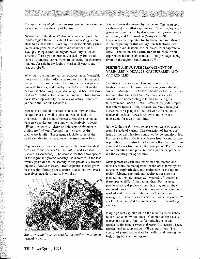
Natural dense stands of Phytelephas macrocmpa in the Iquitos region thrive on natural levees or restingas altas close to ox-bow lakes. Forming less dense stands, yarina palms also grow between old river streambeds and swamps. People from the region have long collected several different yarina products especially fruits and leaves. Immature yarina fruits are collected for consumption and for sale in the Iquitos' market all year round (Padoch 1987).
When its fruits mature, yarina produces tagua (vegetable ivory) which in the 1940's was sold on the international market for the production of buttons, dice, chess pieces, umbrella handles, and jewelry. With the recent world ban on elephant ivory, vegetable ivory has been rediscovered as a substitute for the animal product. This situation presents an opportunity for managing natural stands of yarina in the Peruvian Amazon.
Moenales are found in natural stands on high and low natural levees, as well as close to swamps and old riverbeds. In this kind of varzea forest, the most abundant tree species are those known collectively to local villagers as 11loena. These include trees of the genera Aniba, Endlicheria, Nectandra and Dcotea of the Lauraceae family. These genera include some of the most valuable timber species of the Amazonian forest.
Capinurales are varzea forests where the most abundant trees are of the species Clarisia biflora and Clarisia racemosa (Moraceae). The demand for these two species in the regional plywood industry has increased in the last twenty years due to the scarcity of the previously favored lupuna (Chorisia insignis). Both capinure species grow in the region forming dense natural stands on low levees near river meanders and ox-bow lakes.
Mature yarinafruits are usedfor the production oftagua, vegetable iV01)'.
TRI News Spring 1993
Varzea forests dominated by the genus Calycop/7yllunl (Rubiaceae) are called capironales. Three species of this genus are found in the Iquitos region: C. spruceanum, C. acreanUI11, and C. obovatulIl (Vasquez 1989). Capironales are exploited for fuel wood and roundwood. At the beginning of this century, much fuelwood for powering river steamers was extracted from capironale forest. The commercial extraction of fuel wood from capironales led to establishment of many villages along rivers in the region (San Roman 1975).
PRESENT AND FUTURE MANAGEMENT OF Y ARINALES, MOENALES, CAPINURALES, AND CAPIR,ONALES
Traditional management of natural resources in the lowland Peruvian Amazon has been only superficially studied. Management of swidden-fallows for the production of native fruits and construction materials for subsistence and marketing is known in the region (Denevan and Padoch 1988). Peters et. al. (1989) report that natural forests in the Amazon are rarely managed. However, rural people of the Peruvian Amazon have managed the four varzea forest types more or less intensively for a very long time.
In the Iquitos region rural people either plant or protect natural stands of yarina. The extraction of leaves and fruits of the palm is often controlled by community rules. For instance, the collection of leaves from young yarinas is prohibited. It is also forbidden to collect the four or six youngest leaves from an adult yarina palm. The majority of communities have protected their yarinales, prohibiting their cutting for agriculture.
Management of yarinales differs in both method and intensity from the management of the other forest types: moenales, capinurinales, and capironales in the Iquitos region. Moena, capinuri, and capirona trees are not planted but they are protected. Methods of protecting these species differ from one another. For instance, people select and protect young, healthy, and straightstemmed moena trees. Each tree is cleaned of vines and marked with the name of the family that owns and manages it. These trees are harvested when they reach 25 cm DBH and are sold as timber or are used for making canoes.
People protect capinurales, on the other hand, as stands rather than as individual trees. Capinurales are usually managed by controlling the fast growing emergent species of the genera Ficus and Hura (Moraceae). These species tend to suppress and kill capinuri trees. The control of these trees is done by peeling and burning the bark in the base of their stems.
5

Indigenous people use moena trees for making canoes.
Capinuri seedlings and saplings are also protected from fast growing shrubs species of the genus Inga (Mimosaceae); these shrubs are commonly pruned once or twice until the young capinuris reach the understory.
The most common management practice for capironales is to leave and protect the seedlings that invade old agricultural fields. Roundwood is extracted after two years and fuel wood after four years. Trees with the best stems are sold as roundwood while trees with deformed stems are used as fuelwood. Capironales usually are cut and converted to agricultural fields when they are seven years old or when all usable capironas are exhausted.
CONCLUSION
Local knowledge of management methods of the four varzea forest types represent an important, underutilized resource. Management plans that are based on local knowledge can attract the participation of local people, a key to any kind of successful development in the region.
Yarinales, moen ales, capinurales, and capironales are only four of the most economically important varzea forests in the Iquitos region. Ecological economic studies of these and other kinds of varzea forests need to be conducted. These studies should give us better understanding of their ecology, management, and cunent and potential role in market and subsistence economies, and
. help prevent the destruction or over-exploitation of these Amazonian resources. Conservation and development of these important varzea forests cannot be overlooked for lo~g ..
REFERENCES
Batfod, A. 1988. Natural history and systematics of the subfamily Phytelephantoideae (Arecaceae). Ph.D.
6
Thesis. Botanisk Institut, Aarhus Universitet, Denmark.
Chibnik, M. 1986. New sources of credit in Peruvian Amazonian communities. Paper presented at the Annual Meeting of the American Anthropological Association. Philadelphia, Pennsylvania.
Denevan, W.M. and e. Padoch. 1988. Swidden-fallow agroforestry in the Peruvian Amazon. Advances in Economic Botany, V. 5.
Padoch, e. 1987. The economic importance and marketing of forest and fallow products in the Iquitos region. Advances in Economic Botany, V. 5.
Peters, M.e., Balick, MJ., Kahn, E, and A.B. Anderson. 1989. Oligarchic forest of economic plants in Amazonia: uitlization and conservation of an important tropical resource. Conservation Biology, 3(4).
San Roman, lV. 1975. Perfiles historicos de la Amazonia Peruana. e.E.T.A., Lima, Perf.
Vasquez, RM. 1989. Plantas utilies de la Amazonia Peruana. Mimeo. Iquitos, Perf.
Varzea forests provide highly valued timber.
TRI News Spring 1993
•
EVALUATION OF THE EARLY GROWTH DYNAMICS OF FOUR NATIVE TIMBER SPECIES IN ENRICHMENT PLANTING IN ARGENTINA'S SUBTROPICAL FORESTS
Ada E. Gonzalez, MF Candidate Yale School of Forestry and Environmental Studies
INTRODUCTION
The Selva Misionera, located in northeast Argentina (25°-27° S, 4-55° W), encompasses only I % of the country's land area, but produces 41 % of the nation's timber (IFONA 1985). Approximately half of the nation's lumber demand is met with plantation grown Araucaria, Pinus, Eucalyptus and other exotic species, the remainder coming from virgin or secondary forests (Feneira 1986). In these forests, native tree species have typically been exploited with little regard for seedling regeneration (Maradei 1982). Furthermore, the provincial forestry law sets diameter limits for the highest valued timber species (Grance 1988). A diameter limit permits all trees above a certain size to be cut, leading to the removal of the largest, most valued species.
In the early 1960' s, Argentinean foresters noted the scarcity of native timber and experimented with enrichment planting on degraded forest lands and mixed plantations of native and exotic species (Rieder 1965). Researchers recognized the need for sustainable management of native species and suggested silvicultural techniques to insure adequate natural regeneration (Rieder 1965). Despite these recommendations, application of known principles has not occurred at a large scale (Grance, personal communication).
For private landowners there are few choices. Due to high land taxes, they often seek quick economic return by harvesting all their merchantable timber. Following diameter-limit harvesting, few valuable species remain to regenerate the forest, decreasing the value of the forest lands. Most landowners then plant with exotic timber species or convert to agriculture or pasture (Grance, personal communication). Remaining natural forest areas in Misiones face similar over-exploitation. Foresters and loggers speculate that within two or three years no timber will be available outside protected lands and parks (Grance, Eibl, personal communication).
In an effort to find alternatives to pine and eucalyptus plantations, the National University of Misiones (UN aM) is researching enrichment planting at the Guarani Forest Reserve (Guarani), a 5430 ha area owned and managed by UNaM in central Misiones. Enrichment planting involves the introduction of desired species into woodlands or forest without eliminating useful trees (Weaver
TRI News Spring 1993
1986). The practice has been recommended for secondary forests with low species diversity, for degraded closed forest after intensive logging, or for other conditions where natural regeneration does not occur (Catinot 1969).
In 1989, UNaM began harvesting the timber from GuaranI. A 30 ha area was harvested according to a diameter limit cut to create the typical conditions of harvesting throughout Misiones province. In 1991, UNaM researchers established the enrichment experiment in a one ha area, with one year old seedlings transplanted from the wild. The purpose of UNaM's emichment experiments is to compare the growth of valuable native species in typically degraded forest conditions in order to make recommendations for their use to local farmers. UNaM researchers hope to show that enrichment planting with native species can be economically and ecologically viable and serve as an alternative to reforestation exclusively with exotic species (Grance, personal communication).
My research built upon UNaM's work to describe the early growth dynamics of four timber species in a one year old enrichment experiment. All are early to midsuccessional species and are important in the natural regeneration process. Bastardiopsis densiflora (Malvaceae), locally known as loro blanco, and Ocotea puberula puberula (Lauraceae), called laurel guaica, are considered fast growing, light demanding trees. Cordia tricllOtoma (Boraginaceae), or peterivi, is relatively fast growing and Balfoudendroll riedelianum (Rutaceae), known as guatambu blanco, is a slower growing species (Tortorelli 1956).
To compare the early growth dynamics of the seedlings, I evaluated total height, height increment, root collar diameter, leaf number, and leaf area. The difference in the growth rates between species is hypothesized to correlate with interspecific variation in carbon allocation to total photosynthetic area.
METHODS
The evermoist subtropical forest of Misiones is part of the Parana biogeographic zone. It represents the southernmost portion of the Amazon pluvial forest (Boninsegna 1989). Precipitation is evenly distributed throughout the year with an annual average of 2000 mm (Perticari 1992).
7
Mean temperature of the coldest month (July) is 14°C and of the warmest month (January) is 26°c' Frosts occur an average of seven times per year during June and July. I worked in Guarani during the winter season (JuneAugust).
To characterize the existing vegetation in the enrichment area, I randomly sampled five 250 m2 plots (12.5% of the enrichment area) for percent trees (> 10 cm dbh), tree fems (Alsophila atrovirens (Langsd. et Fich) pres!.), bamboo (Merostachys clallsseni Munro.) and pioneer tree species (primarily SolallulII verbascifoliulIl L.). I evaluated the understory with five 12.5 m2 subplots for number of individuals and estimated percent cover of trees (> 1 0 cm dbh), vines, herbs, bamboo, ferns, pioneer trees and shrubs, commercial tree seedlings, imd noncommercial tree seedlings.
For the enrichment experiment, 20 seedlings of each species were planted along four 100 m long east/west transects, 2 m wide, 25 m apart. Each transect had 4 blocks of 5 seedlings of each species. I evaluated seedling growth based on multiple parameters: height, diameter at the root collar, height increment in one year, leaf number, average leaf area (from a subsample of five leaves per individual) and total leaf area (leaf number * average leaf area). Multiple parameters provide a more accurate indication of seedling performance than any single one because carbon allocation priorities differs between species. Height and height increment are indications of past growth performance. Photosynthetic area and root collar diameter are measures of CUD'ent health conditions and future potential, above ground and below ground, respectively. The ratio of leaf area to cross sectional area at the root collar may be an indicator of hydraulic efficiency (Berlyn, personal communication). The smaller the ratio, the greater water transporting tissue per unit of leaf area. In water stressed environments, greater basal area is needed to sustain foliage (Waring and Schlesinger 1985).
RESULTS
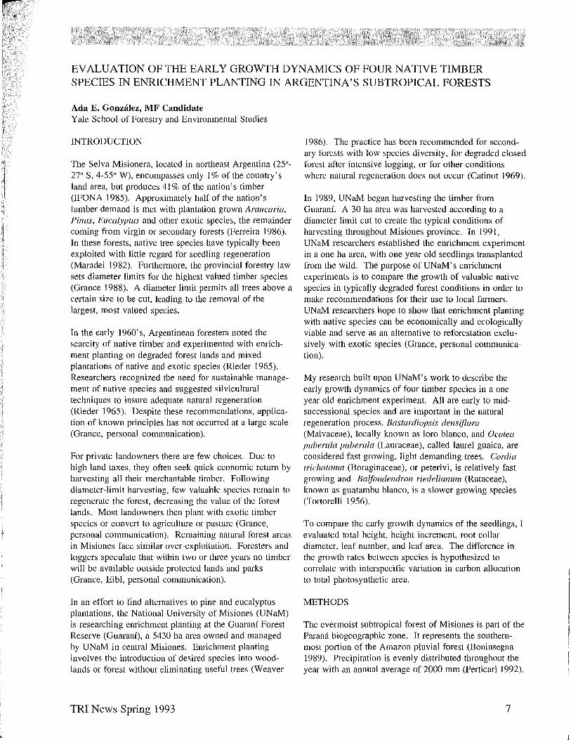
Overstory vegetation is dominated by bamboo (15-85% cover), tree ferns (5-70% cover) and pioneer tree species (5-20% cover) (Table I). There are 88 trees (>10 cm dbh) and 32 palms (Arecrastul7l rol7lanzoffianul7l) per hectare. Correspondingly, in the understory, bamboo (5-35% cover), ferns (5-55% cover) and pioneer trees «5-50% cover) dominate the vegetation (Table 2). Natural regeneration of commercial tree species was estimated at 1120 seedlings/ha. B. riedelianul11 was the only species of the four studied which was present in natural regeneration within the enrichment site (480 seedlings/ha).
8
Table I. Overstory vegetation offive study plots (12.5% of the Ilia area) three years after intensive logging.
Plot #
1
2
3
4
5
Avg
Trees! Bamboo: Tree Fern3
(#/25Om2) (% cover) (% cover)
5 60 20
2 15 70
2 30 5
4 85 10
2 50 10
3 48 23
>10 em dbh Merostachys clausseni Munro. Alsophila atrovirens (Langsd. et Fich) presl. Solanum verbascifolium L
Pioneer Tree4
(% cover)
<5
10
40
50
15
32 .
Intraspecific variation between blocks was evaluated using the Duncan multiple range test which permits unequal sample sizes. O. puberula was significantly different between one block and the other three for all growth parameters except for the ratio of leaf area to basal area. B. densiflora was significantly different between blocks for leaf number. B. riedelianwl1 and C. trichotoma were not significantly different between blocks.
Table 2. Total nUll/bel' of individuals and percent covel' (in parenthesis) ofundeJ;story vegetation (each plot measured 5% of the overstol)' plot area).
Plot Plot Plot Plot Plot Total 1 2 3 4 5 (avg)
Trees -- -- -- I -- 1 (20) (5)
Bamboo 30 50 14 19 5 118 (25) (35) (10) (10) (5) (17)
Pioneer 2 3 2 1 12 20 trees (20) (5) (10) (<5) (10) (10)
Ferns 6 16 5 6 2 35 (25) (55) (15) (10) (5) (22)
Vines 4 4 6 10 7 31 (<5) (<5) (5) (5) (5) (20)
Herbs (<5) (<5) (30) (<5) (15) (10) (% Cover)
Commercial 2 1 2 1 1 7 Seedlings (<5) (<5) (<5) (<5) (<5) (<5)
Non 3 3 2 -- -- 8 Commercial (<5) (<5) (<5) (<5)
Seedlings
TRI News Spring 1993
•

Height, diameter, leaf number, average leaf area and leaf area/basal area were significantly different between all species using the Duncan multiple range test and analysis of variance (Table 3). B. dens(f/ora was significantly greater than the other three in height increment; C. trichotoma, O. puberula and B. riedelianulII did not differ significantly. B. dens(f/ora had significantly greater total leaf area than B. riedelianul1l. B. dens{flora had a significantly greater average leaf area than B. riedelianulIl and C. tricllOtollla, O. puberula had the smallest average leaf area. Similarly, O. pllberula and C. trichotollla had the greatest mean number of leaves, followed by B. dens {flora then B. riedelianulIl. For leaf area/basal area O. puberliia was significantly greater than the other three species.
DISCUSSION
The four species evaluated in this study for enrichment planting showed some variation between blocks, perhaps due to random microsite variation and small sample sizes. Notably, one block of 0. puberula had a larger height increment and more leaves than the other three blocks. B. dens{flora was also found in one block with greater leaf area and leaf number. Both of these blocks were located near a skid trail with more light, perhaps explaining their faster growth.
The measured parameters suggest different growth strategies for the species. B. dens(flora grew quickly and had the largest total leaf area and largest leaves. In most cases, B. dens {flora had a lower ratio of leaf area to basal area, corresponding to species that are well adapted to more stressed conditions requiring greater water transporting tissue per unit leaf area (Waring and Schlesinger 1985). These factors typify early successional trees
which grow quickly by exploiting high light and exposed environments. For the most part, B. riedelianul1l had the smallest height increment, the lowest total leaf area, and a leaf number typical of conservative growth.
C. tricllOtoll1a and O. pliberliia were comparable in growth rate, but differed in their growth allocation. Although, c. trichotollla and O. puberula had comparably sized leaves, C. trichotoma had more leaves. Interestingly, O. puberula had the smallest diameter and the greatest leaf area to basal area ratio. It sustains more foliage per unit of stem wood, suggesting that it is well adapted for lower light intensities. However, this does not cOl).sider other morphological features that aid in water conservation. O. puberula has small cutinous leaves which may permit growth in areas with high light intensities andlor water stress. In addition, O. puberula is one of the few species that naturally regenerates in abandoned pastures (Gonzalez, unpublished data).
A diameter-limit harvest increases light availability to the forest floor. Abundant light favors the growth of bamboo and pioneer trees like S. verbascifoliulll. Bamboo outcompetes seedlings for light and physically obstructs growth by forming patches of densely overhanging vegetation (Deschamps 1987). Without seed sources and with competition from bamboo growth, natural regeneration of commercially valuable woody species is low. Low tree seedling regeneration after harvest leads to the dominance of pioneer vegetation for a long time (Deschamps 1987). The results of this experiment reflect the importance of enrichment planting for the maintainance of native forests. Understanding the different growth strategies of the four species will allow landowners to make more informed decisions for regenerating their harvested or degraded lands.
Table 3. Mean growth measures ofenric/llnent plallfed seedlings. P-vaillesfrolll ANOVA between species for each growth measure. Lowercase letters indicate significant differences (P<O.05) IIsing Dllncanlllllitiple range test.
Balfoudendron Bastardiopsis Cordia Ocotea P value
n 17 15 20 18
Height (em) 34.9(2.6)a 82.5(15.8)b 50.3(S.2)a 39.7(3.9)a .0004
Diameter (mm) 6.0(OA)a 12.8(1.5)b 9.9(0.7)c 5.9(0.6)d .0001
Growth (em) 5A(1.4)a 30.9(12.7)b 22. 1 (4A)a 21.1(4.2)a .0237
Total leaf area (em~ 298(44)a 2012(775)b 1200(346)a 653(193)a .0291
Leaf number 6.6(0.7)a 14.0(3.9)b 29.2(5.8)c 27.8(5.7)c .0020
Avg leaf area (em~ 41.6(5.1)a 86.6(23.0)b 32. 1 (4. 6)a 20A(6.5)c .0004
Leaf area/basal area 107.8(14.1)a 94. 1 (24.5)a 112.2(22.6)a 187.7(15.8)b .0059 (em2/mm2)
TRI News Spring 1993 9
REFERENCES
Ashton, P.M. 1990. Method for the evaluation of advanced regeneration in forest types of south and southeast Asia. For. Ecol. & Man. 36:63-75.
Boninsegna, J.A., R Villalba, L. Amarilla, and J. Ocampo. 1989. Studies on tree rings, growth rates and age size relationships of tropical tree species in Misiones, Argentina. IAWA Bulletin. 10 (2):161-9.
Catinot, R 1969. Results of enrichment planting in the tropics. FAO Committee on Forest Development in the Tropics, Second Session. Special Paper FO:FDT-69/4. FAO: Rome. (cited from Weaver 1986)
Censo de plantaciones forestales de la provincia de Misiones. 1972. Direcci6n general de estadistica de la provincia de Misiones. Posadas.
Deschamps, J.R. and J.R. Ferreira. 1987. Estudios sobre las comunidades postclimaxicas de Misiones: los campos abandonados 0 "capueras." Cuartas Jornadas Tecnicas Bosque Nativos Degrados. UNaM
Eibl B., N. Vera, L. Grance, B. Eibl, D. Maiocco. 1991. Enriquecimiento con especies forestales nativas en Guarani, Misiones. Project Report.
Ferreira, Carlos. 1986. Convenio Mapa Forestal. Superior Gobierno de la provincia de Misiones. Ministerio de Ecologia y Recursos Naturales Renovables. UNaM.
Grance, Luis. 1988. Plan de ordenaci6n de Guarani. UNaM: Eldorado.
IFONA. 1985. Anuario de estadistica forestal 1985.
Mangiere, H.R. 1965. Reconstituci6n de los bosques misioneros y caracteristicas biol6gicas de las principales especies. Primeras jornadas de trabajo del centro de estudio del bosque subtropical. CEBS: Eldorado. pp. 141-145.
Maradei, Daniel. 1982. Cultivo de especies de la Selva Misionera-resena bibliografica, (Cultivation of species of the Misiones Forest-bibliographic review). Actas, primeras jornadas tecnicas sobre bosques implantado en noreste argentino. UNaM: Eldorado. pp. 105-116.
Perticari, c.A. 1992. Proyecto de creaci6n de un reserva biosfera en la provincia de Misiones. Proyecto Yaboti.
Tortorelli, L.A. 1956. Maderas y bosques Argentinos. Editorial Acme: Buenos Aires
10
Waring, RH. and Schlesinger W.H. 1985. Forest Ecosystems: Concepts and Management. Academic Press: Orlando, Florida. 340 pp.
Weaver, Peter L. 1986. Enrichment planting in Tropical America. Management of the forests of Tropical America: prospects alld technologies. Institute of Tropical Forestry, S. For. Exp. Sta. USDA Forest Service. 259-78.
The Hmpy Eagle, Hmpia hmp)ja
TRI News Spring 1993
•
•
---
AN EVALUATION OF THE AVIFAUNA COMMUNITY AT THE MONTEVERDE CLOUD FOREST RESERVE, COSTA RICA
Dean Gibson, MFS Candidate Yale School of Forestry & Environmental Studies
INTRODUCTION
The Monteverde Cloud Forest Reserve straddles the Continental Divide along the Cordillera de Tilat'an at 1500 m in northwestern Costa Rica (Fig. 1 ) (Koptur et al. 1988, Lober 1992). The area contains one of the few remaining remnants of tropical cloud forest and some of the best examples of tropical premontane rain forest in Central America (Cummings 1989).
Monteverde was founded in 1951, by nineteen North American Quaker families from Alabama who bought 1400 ha of land from the Guacimal Land Company of Costa Rica (Gallup 1989). Initially, the reserve was a 554 ha parcel of land set aside by the Quakers for watershed protection (Lober 1992). Twenty-one years later, Dr. G. Powell purchased additional land and secured funding to establish the present Cloud Forest Reserve as protected breeding habitat for the Resplendent Quetzal (Pharomachrus mocil1llo) (Gallup 1989). Today, the 10,000 ha reserve is the most active cloud forest research site worldwide and is managed by the Tropical Science Center, a scientific research organization based in San Jose, Costa Rica (Gallup 1989, Lober 1992).
This paper summarizes the analysis of avifauna inventory reports for the Monteverde Cloud Forest Reserve. Measurements of avifauna diversity and species turnover, baseline information on species abundance, and areas in need of further research are presented.
METHODS
Avifauna abundance and diversity data were obtained from four inventory reports conducted by Dr. G. Powell and other resident ornithologists between the years 1970 and 1988. Two of the reports were published (Fogden et al. 1979, Law & Fogden 1981) and two (dated 1970 & 1988) remain unpublished. Inventories were based on the frequency of incidental daily observations of species in the appropriate habitats at the correct time of year (i.e. not transient due to aberrant migration).
Using the reports, I evaluated species diversity, immigration (new species colonizing the reserve), local extinction (disappearance of species from the reserve), persistence of original species composition (those species recorded in the 1970 inventory that continue to exist in the reserve), and relative changes in population abundance between
TRI News Spring 1993
the years 1970, 1979, 1981 & 1988. The area surveyed for the 1970 inventory was slightly different in size than the area surveyed for the remaining reports. Due to the value of the 1970 inventory for species persistence rates, measurements of species diversity are included in Table 1 for the 1970 inventory, even though they may not provide reliable comparison with later reports.
Species were classified into trophic levels according to diets as described by Stiles and Skutch (1989). Family and trophic level diversity for each year was estimated using the Shannon-Weaver formula: H'= - Pi log Pi' where Pi is the proportion of the i-th species in the community (Pielou 1966, 1975).
Immigration for each inventory report was quantified as the percentage of previously unrecorded species for each family by trophic level. Local extinction was quantified as the percentage of species within a trophic level not recorded after previously having been recorded for each inventory. Original species persistence was quantified as the percentage of all species recorded within each trophic level in 1970 which persisted through 1988. By comparing inventory reports, relative changes in popUlation abundance were quantified as the percentage of species within a family (by trophic level) which increased, decreased or showed no change in abundance.
Those species recorded as accidental and regarded as species not normally occurring within the area were not included in this evaluation.
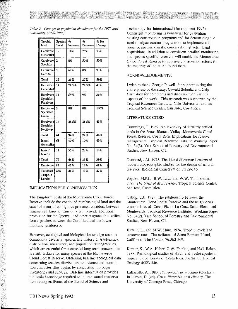
RESULTS
The Monteverde Cloud Forest Reserve experienced an increase in avifaunal diversity between 1970 and 1988 (Table I). The increase in diversity was a result of immigration. Although immigration occurred at alI trophic levels, the insectivore and omnivore trophic levels gained a larger number of new species.
In addition to increased species diversity, community diversity has been maintained due to a high species persistence rate (99%), for the years sampled. The local extinction of two species, one a carnivore specialist and the other a herbivore generalist, resulted in a 1 % loss in species persistence. The Harpy Eagle, (Hm1Jia harpyja), a carnivore specialist, disappeared from the reserve by 1981 and the Yellow Grosbeak (Pheucticlls
11

r
Table 1. Avifallna diversity indices to the Monteverde Clolld Forest Reserve (1979-1988).
Trophic Level 1970 1970 1979 Species It Diversity Species It
Carnivore Total 22 3.02 29
Herbivore Total 41 3.41 53
Insectivore Total 68 4.26 80
Insects/Inverts Total 11 2.33 14
Omnivore Total 91 4.31 124
cllI)'sopeplus), a herbivore generalist, vanished by 1979. The Black-Thighed Grosbeak (P. tibialis), which has persisted since 1979 as a common species in the reserve, may have been misidentified as a Yellow Grosbeak in the 1970 inventory. If misidentification occurred, the original bird community's persistence rate would increase to 99.6%.
Overall, 42% of the original species (those inventoried in 1970), maintained their population levels. Forty-one percent of the species found in 1970 increased in abundance, and 17% declined in abundance. Further analysis of declining populations by trophic levels (Table 2), indicates a decline of 27% in carnivores, 22% for herbivores, 17% for omnivores, and 13% among insectivores.
DISCUSSION
The increase in Monteverde's avifauna diversity coincides with an increase in the size of the reserve from 554 ha in the 1950's to approximately 10,000 ha by the late 1980's. The status of Monteverde's bird community in 1988 indicates that the reserve has been fairly successful with its conservation planning for the years 1970-1988.
In addition to simply maintaining or increasing species diversity, conservationists need to consider components that contribute to the maintenance of diversity such as immigration and extinction. Immigration is primarily determined by reserve size, distance between the reserve and its colonizing species, and species' dispersal abilities (Diamond 1975, Schmiegelow & Nudds 1987). Immigration has occurred at Monteverde at various rates per family for all trophic levels. Maximum immigration rates of 200-250% were achieved by the following families: Fringillidae in the herbivore trophic level, Hirundinidae in the insectivore trophic level, Troglodytidae in the insectivore/invertebrate trophic level and Oxyruncidae in the omnivore trophic level.
While some families experienced very high immigration rates, other families experienced no immigration at all.
12
1979 1981 1981 1988 1988 Diversity Species It Diversity Species It Diversity
3.95 29 3.22 35 3.56
3.88 54 3.89 56 3.82
4.26 91 4.35 93 4.28
2.55 17 2.75 17 2.75
4.58 133 4.59 137 4.72
Families with zero immigration include the Tytonidae, Accipitridae, and Cathartidae in the carnivore trophic level; Turdidae, and Cracidae in the herbivore trophic level; Ardeidae in the insectivore trophic level; Furnariidae in the insect/invertebrate trophic level and the Tinamidae in the omnivore trophic level.
Extinction is determined by refuge area, habitat integrity and species population size (Simberloff 1982, Schmiegelow & Nudds 1987). Although a refuge may contain suitable habitats, extinctions will occur if a species cannot maintain a minimum viable population size (Soule & Simberloff 1986). Therefore, a successful refuge must contain viable population sizes for all of its species. The larger a species' population, the less vulnerable it should be to extinction (Simberloff 1982, Schmiegelow & Nudds 1987).
Large birds at upper trophic levels, such as the Harpy Eagle, which naturally occur at relatively low densities (Hunt & Hunt 1974) and require large amounts of habitat, may be prone to extinction. In this study the carnivore specialist trophic level has exhibited the highest percentage of declining species as well as being the only trophic level to experience an extinction. The reasons for these declines are not clear. Therefore, these species, as well as declining species from other trophic levels, are a priority for immediate research and population evaluation.
In addition to land purchases and habitat protection, research along with population monitoring may be required to initiate conservation efforts to avoid additional extinctions. Species which may be in danger of extinction are those occun·jng at low abundances in all trophic levels, and seasonal and altitudinal migrant species not protected throughout their ranges. For example, the Resplendent Quetzal although protected at Monteverde, covers a 1,000 mile range over elevations of 1,300 - 3,000 meters and is threatened by deforestation and habitat disturbance in parts of its range (LaBastille 1983).
TRI News Spring 1993
o
n
1 L
Table 2. Changes in population abundance for the 1970 bird cOllllllunity (1970-1988).
Trophic Species % % %No level Total Increase Decrease Change
Carnivore 17 18% 29% 53% Generalist
Carnivore 2 0% 50% 50% Specialist
Carnivore 3 67% 0% 33% Carrion
Total 22 23% 27% 50%
Heibivore 14 28.5% 28.5% 43% Generalist
Heibivore 11 55% 9% 36% Specialist Frugivore
Heibivore 2 0% 0% 100% Specialist Gram.
Heibivore 14 28.5% 28.5% 43% Specialist Nectivore
Total 41 34% 22% 44%
Insect 68 47% 10% 43% Generalist
Insect! 11 55% 27% 18% Inverts
Total 79 48% 13% 39%
Omnivore 93 42% 17% 41%
TotaIlAII 235 41% 17% 42% Trophic Levels
IMPLICATIONS FOR CONSERVATION
The long-term goals of the Monteverde Cloud Forest Reserve include the continued purchasing of land and the establishment of contiguous protected corridors between fragmented forests. Corridors will provide additional protection for the Quetzal, and other migrants that utilize forest patches between the Cordillera and the lower montane rainforests.
However, ecological and biological knowledge such as community diversity, species life history characteristics, distribution, abundance, and popUlation demographics, which are essential for successful long-term conservation are still lacking for many species at the Monteverde Cloud Forest Reserve. Obtaining baseline ecological data concerning species distribution, abundance and popUlation characteristics begins by conducting thorough inventories and surveys. Baseline information provides the basic knowledge required to initiate sound conservation strategies (Panel of the Board of Science and
TRI News Spring 1993
Technology for International Development 1992). Consistent monitoring is beneficial for evaluating existing conservation programs and for determining the need to adjust current programs or to implement additional or species specific conservation efforts. Land acquisitions, in addition to consistent detailed monitoring and species specific research will enable the Monteverde Cloud Forest Reserve to improve conservation efforts for the majority of the fauna found there.
ACKNOWLEDGEMENTS:
I wish to thank George Powell, for support during the entire phase of the study, Oswald Schmitz and Chip Darmstadt for comments and discussion on various aspects of the work. This research was supported by the Tropical Resources Institute, Yale University, and the Tropical Science Center, San Jose, Costa Rica.
LITERATURE CITED
Cummings, T. 1989. An inventory of formerly settled lands in the Penas Blancas Valley, Monteverde Cloud Forest Reserve, Costa Rica. Implications for reserve management. Tropical Resource Institute Working Paper No. 34(3). Yale School of Forestry and Environmental Studies, New Haven, CT.
Diamond, J.M. 1975. The island dilemma: Lessons of modern biogeographic studies for the design of natural reserves. Biological Conservation 7: 129-146.
Fogden, M.P.L., B.W. Law, and W.W. Timmerman. 1979. The birds of Monteverde. Tropical Science Center, San Jose, Costa Rica.
Gallup, c.E. 1989. The relationship between the Monteverde Cloud Forest Reserve and the neighboring communities of: Cerro Plano, La Cruz, Santa Elena, and Monteverde. Tropical Resource Institute. Working Paper No. 34(2). Yale School of Forestry and Environmental Studies, New Haven, CT.
Hunt, G.L., and M.W. Hunt. 1974. Trophic levels and turnover rates: The avifauna of Santa Barbara Island, California. The Condor 76:363-369.
Koptur, S., W.A. Haber, G.W. Frankie, and H.G. Baker. 1988. Phenological studies of shrub and treelet species in tropical cloud forests of Costa Rica. Journal of Tropical Ecology 4:323-346.
LaBastille, A. 1983. Pharolllachrus mocil/no (Quetzal). In Janzen, D. (ed). Costa Rican Natural HistOlY. The University of Chicago Press, Chicago.
13
Law, B.W., and M.P.L. Fogden. 1981. The birds of Monteverde. Pension Quetzal, Monteverde, Costa Rica.
Lober, D. 1992. Using forest guards to protect a biological reserve in Costa Rica: One step towards linking parks to people. Journal of Environmental Planning and Management. 35(1): 17-41
Panel of the Board on Science and Technology for International Development, & U.S. National Research Council. 1992. Conserving biodiversity: a research agenda for development agencies. National Academy press, Washington, D.C.
Pielou, E.c. 1966. The measurement of diversity in different types of biological collections. Journal of Theoretical Biology 13:131-144.
Pielou, E.C. 1975. Ecological Diversity. WileyInterscience, John Wiley & Sons, New York.
Schmiegelow, F.K., and Nudds, T.D. 1987. Island biogeography of vertebrates in Georgian Bay Islands National Park. Canadian Journal of Zoology. 65:3041-3043.
Simberloff, D. 1982. Big advantages of small refuges. Natural History 91(4):6-15.
Soule, M.E., and D. Simberloff. 1986. What do genetics and ecology tell us about the design of nature reserves? Biological Conservation 35: 19-40.
Stiles, F.G., and A.F. Skutch. 1989. A Guide To The Birds of Costa Rica. Comstock Publishing Associates, Ithaca, New York.
A COMPARISON OF STREAMFLOW FROM AGRICULTURAL AND FORESTED WATERSHEDS IN THE MIDDLE HILLS, NEPAL
Arjun M. Heimsath, MES Candidate Yale School of Forestry and Environmental Studies
INTRODUCTION
The causes and effects of human influenced environmental degradation in the Himalaya are the source of ongoing debate in research and development institutions around the world. It has been argued that the human activities of the region have caused increased soil erosion and resulted in recurring floods of devastating magnitude. Nevertheless, recent studies warn against placing blame soley on the subsistence farmer and herder (Hamilton 1987, Ives and Messerli 1989, Carson 1992).
The causes of soil erosion from the Himalaya have not been decisively related to land use at the local level. Environmental links between the Himalayan mountains and the plains have been generalized by many scientists and policy analysts. Small streams and tributaries transport sediment as a function of streamflow dynamics, morphology, and the geological conditions of the stream basin. Stream discharges and sediment loads have been studied in mid-latitude areas, from which empirical generalizations of wide applicability have been derived. However, there have been relatively few hydrological studies completed in the tropics, particularly in tropical mountains.
Many of the mechanisms of hilI-slope erosion in the subtropical Himalaya can be understood by examining the
14
hydrological processes occurring on the small, first-order stream scale (Carson 1985). Financial assistance from the Tropical Resources Institute and in-kind contributions from the Yale-Institute of Forestry Project in Pokhara, Nepal made it possible for me to study two first-order streams representing cultivated and forested watersheds of the Middle Hills. I gathered data during the summer monsoon season of 1992 to quantify the streamflow discharge and sediment transport differences between the two watersheds.
SITE DESCRIPTION
I established my research site 4 kilometers south of Gorkha, Nepal. In 1987 the USAID funded Resource Conservation and Utilization Project (RCUP) constructed concrete flumes at the base of two first-order watersheds to use in a natural systems monitoring program which lasted for less than one year. Gorkha (27.57 N, 84.35 E), approximately 100 km northwest of Kathmandu, is in the sub-tropical, Middle Hills region of Nepal. The terrain is hilly, with terraces for agriculture covering much of the land. Forest cover is sparse, yet Shorea robusta (Sal) trees are found along ridgetops and in many gullies between the terraces. Rice, the most important grain crop, is grown to the limits of irrigated (khet) land, above which maize and some upland rice is grown on rainfed (bari) land. Livestock, primarily cattle and goats, play an
TRI News Spring 1993
e
r**, .... Y j
r
...
integral role in the farming system and some households also keep stall-fed buffalo for milk. Mean annual rainfall is 3400 mm, with about 2100 mm falling between the months of June and September, the summer monsoon season. From June 7 to August 7, 1992, however, I measured only 368 mm of rain.
The agricultural watershed drains 49 hectares above the flume site, while the forested watershed drains 50 hectares (Balla 1988). Both streams are perennial and flow into the Bokorlok Khola, which feeds the Ludi Khola, which empties into the Marsyangdi River, approximately 15 kilometers away. Both watersheds face south, but the forested slopes are slightly steeper than the agricultural slopes. The agricultural watershed is ten'aced on all slopes, with rice plan fed on the terraces closest to the stream, followed by highland rice and maize. The headwall gully is bamboo forest, planted to protect the stream for drinking water. Inigation ditches cany water from the stream along contours of the slopes to flood the terraced rice fields. Small fields planted with maize border the homes built along the two ridgelines. Livestock are closely watched and not allowed onto the agricultural land, with the exception of using bullocks for plowing and allowing goats and cattle to graze on harvested fields so their dung fertilizes the fields. The forested watershed is separated from the agricultural watershed by one valley, which is forested on the western side and terraced on the eastern. A watchman, hired by the villagers, is supposed to protect the forest from encroachment. An unexplained fire burned the understory of the forest two weeks before I began measurement, making the forested watershed unsuitable for use as a control against the agricultural watershed.
METHODS
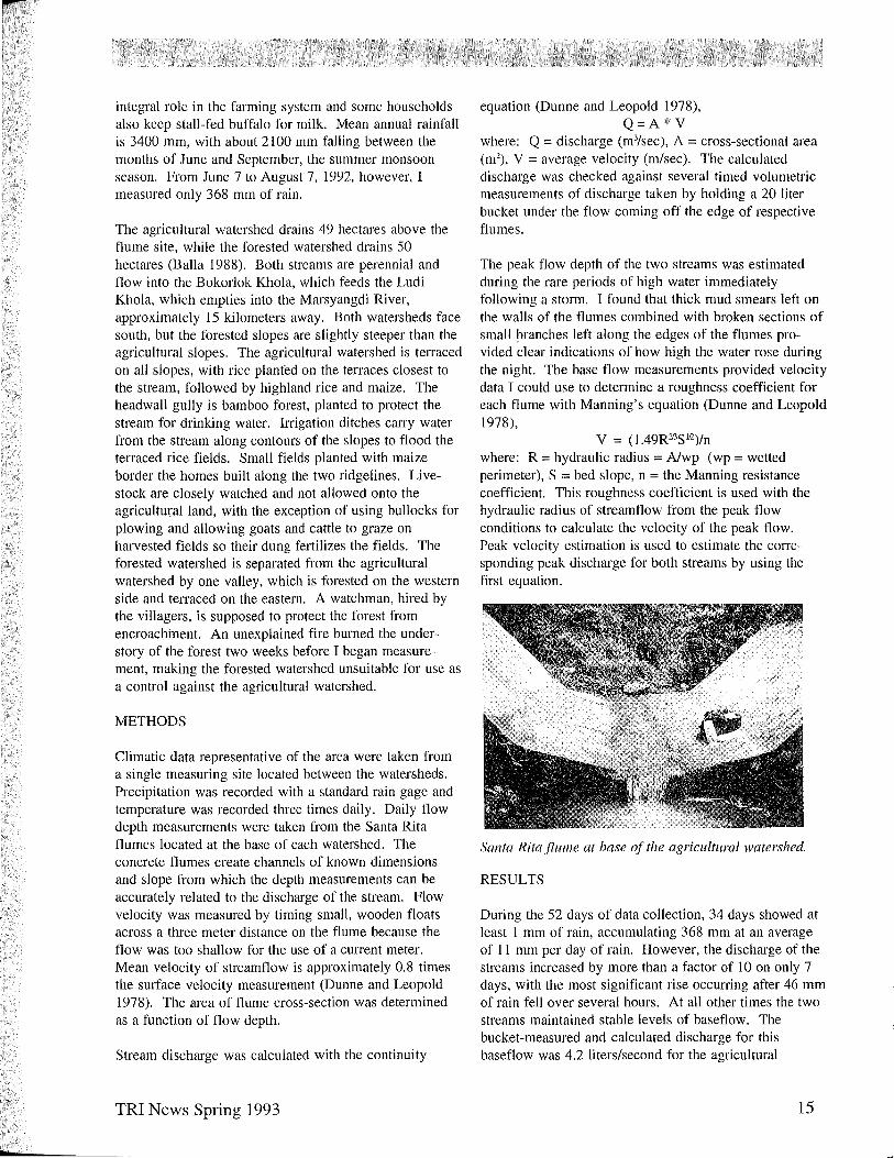
Climatic data representative of the area were taken from a single measuring site located between the watersheds. Precipitation was recorded with a standard rain gage and temperature was recorded three times daily. Daily flow depth measurements were taken from the Santa Rita flumes located at the base of each watershed. The concrete flumes create channels of known dimensions and slope from which the depth measurements can be accurately related to the discharge of the stream. Flow velocity was measured by timing small, wooden floats across a three meter distance on the flume because the flow was too shallow for the use of a current meter. Mean velocity of streamflow is approximately 0.8 times the surface velocity measurement (Dunne and Leopold 1978). The area of flume cross-section was determined as a function of flow depth.
Stream discharge was calculated with the continuity
TRI News Spdng 1993
equation (Dunne and Leopold 1978), Q=A*V
where: Q = discharge (m3/sec), A = cross-sectional area (m2), V = average velocity (m/sec). The calculated discharge was checked against several timed volumetric measurements of discharge taken by holding a 20 liter bucket under the flow coming off the edge of respective flumes.
The peak flow depth of the two streams was estimated during the rare periods of high water immediately following a stOlm. I found that thick mud smears left on the walls of the flumes combined with broken sections of small branches left along the edges of the flumes provided clear indications of how high the water rose during the night. The base flow measurements provided velocity data I could use to determine a roughness coefficient for each flume with Manning's equation (Dunne and Leopold 1978),
V = (l.49RIJ'3SI12)/n where: R = hydraulic radius = Alwp (wp = wetted perimeter), S = bed slope, n = the Manning resistance coefficient. This roughness coefficient is used with the hydraulic radius of streamflow from the peak flow conditions to calculate the velocity of the peak flow. Peak velocity estimation is used to estimate the conesponding peak discharge for both streams by using the first equation.
Santa Rita flume at base of the agricultural watershed.
RESULTS
During the 52 days of data collection, 34 days showed at least 1 mm of rain, accumulating 368 mm at an average of 11 mm per day of rain. However, the discharge of the streams increased by more than a factor of lOon only 7 days, with the most significant rise occuning after 46 mm of rain felI over several hours. At all other times the two streams maintained stable levels of baseflow. The bucket-measured and calculated discharge for this baseflow was 4.2 liters/second for the agricultural
15

p
I CIIIII!iI ppt (rum) ----<>---- forest --- agriculture I 50.00
45.00
40.00
35.00
130.00
~ 25.00
! 20.00
15.00
10.00
5.00
7·1un 14·1un 21·1u1l 28·1un 5·JII[ 12-1ul
Day
10000.00
1000.00
1l' ~
100.00 I!: g &'. .. "
10.00 ~ ~ OJ)
" ~ 1.00
0.10
19-Jul 26·Jul 2-Aug
Figure 1. Daily precipitation and log peak discharge record of the forested and agricultural watersheds (June 7 to August 7. 1992). Precipitation and peak discharge records are ji'olll daily measuremellts, not representing (I continuous record. The left vertical axis shows the magnitude of peak discharge on a log scale.
watershed, and 1.7 liters/second for the forested watershed. In all 7 cases of high flow, the peak flow occurred at some time during the night, when the intensity of rainfall reached its maximum intensity, and was therefore not measured directly as a function of time of rise and fall. I did observe that the forested stream receded to near baseflow levels about 4 to 8 hours after the estimated time of peak flow, while the agricultural stream returned to its baseflow level within 6 to 12 hours.
I used the baseflow conditions to calculate a roughness coefficient for each of the flumes, and found that Manning's 11 was 0.018 for the flume surface on the agricultural site, and 0.012 for the forested watershed's flume. On the morning following the highest flow, evidence of a flood was clear in the forested valley, including the breaching of two irrigation channels and damage to the rice fields at the watershed outlet, while the agricultural site seemed relatively untouched. When I reached the site, the water level had almost returned to base flow levels, and was only mildly cloudy with sediment. I found the agricultural stream carried noticeable suspended sediment following 18 storm events with more than 8 mm of rain, even if the level of flow did not rise noticeably after each storm, while the forested stream was cloudy with sediment on seven of the mornings following storms.
DISCUSSION
From my study I was able to observe the following: (1) the rapid hydrological response of the burned forested watershed to minimal amounts of rainfall; (2) flat, almost
16
constant, levels of baseflow in both streams; (3) noticeably greater amounts of sediment transport in the stream draining the agricultural watershed; (4) an absence of visual signs of erosion on both watersheds typically associated with degraded land; (5) the remarkably stable nature of the agricultural practices on relatively marginal land.
The paired watershed approach generally relies on a forest to serve as a controlled system to compare with a treated watershed. However, because a fire burned the forest two weeks prior to the beginning of my study, the vegetative cover of the control watershed was not typical. The burned understory may help explain the flashy response of the forested stream, but I observed that, despite the forest watchman, villagers encroached on the forest to gather leaf-litter, fodder, and fuel wood. I also observed grazing goats and cattle that "strayed" into the forested area on an almost daily basis. Some of the grazing livestock came from a single farm which is located on the eastern ridge of the forested watershed. The impact of the farm may be limited to about four hectares, but its presence further undermines the use of the forested site as a pristine watershed. My observations of the forested watershed should be qualified by these conditions.
Sediment transport is an important factor of comparison between watersheds and more sediment was carried by the agricultural stream. The sediment loads I observed could have been caused by the increased human activity of the planting season, or by stochastic events corresponding to my sampling time, but data from at least a
TRI News SpIing 1993
') ,)
rr
)
)
continuous year is necessary before I can make any conclusions. Si~i1arly, the lower peak discharges from the agricultural watershed may reflect the storage capacity of the telTaced land, but could also indicate higher irrigation diversions during the particularly dry monsoon season. Dry antecedent conditions, high evapotranspiration of the planting season, and the small storms of my study period could all contribute to the dampened hydrological response of the agricultural watershed. Although the terraces were well maintained, there were minor signs of gullying in areas of heavy human use, especially downslope of trails, but the general lack of visual evidence of erosion on both sites was surprising considering the natural instability of the Middle Hills.
Indigenous techniques of natural resource management often draw criticism from Western visitors viewing the crowded mountains for the first time. My daily data collection treks through the fields and forests of the small villages south of Gorkha brought me close to the people who have been living off the mountainous land for many centuries. Although the pressures of Nepal's rapidly growing population have certainly changed the way people live in the region, it is evident that the fmmers still know how to achieve it sustainable state of agricultural productivity on their limited lands. The hydrological data gathered for this study may show that the telTaced land mitigates the impacts of the flashy mountain floods observed on the forested watershed, but it does not necessarily mean that the forested watershed will always show such flashy responses to mild rainfall. My study also shows that a protected forest is not always as
protected as it is assumed to be and therefore cannot in all cases act as a control watershed for such a paired watershed approach.
LITERATURE CITED
Balla, M.K. 1988. Establishment of a paired watershed study to estimate the impact of cultivating marginal lands on the production of sediments and runoff in Nepal. Unpublished report, Institute of Forestry, Pokhara. 13 pp.
Carson, B. 1985. Erosion and sedimentation processes in the Nepalese Himalaya. ICIMOD Occasional Paper No. 1, Intt<rnational Centre for Integrated Mountain Development, Kathmandu. 40 pp.
Carson, B. 1992. The Land, the farmer, and the future: a soil fertility management strategy for Nepal. ICIMOD Occasional Paper No. 21, International Centre for Integrated Mountain Development, Kathmandu. 74 pp.
Dunne, T. and L. B. Leopold. 1978. Water ill Environmental Planning. W.H. Freeman & Co., San Francisco. 818 pp.
Hamilton, L.S. 1987. What are the impacts of Himalayan deforestation on the Ganges-Brahmaputra lowlands and delta? Assumptions and facts. Mountain Research and Development, 7(3):256-263.
Ives, J.D. and B. Messerli. 1989. The Himalayan Dilemma: Reconciling Development and Conservation. Routledge, New York. 295 pp.
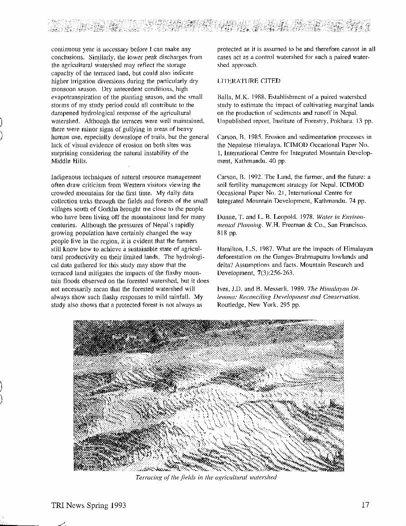
Terracing of the fields in the agricultural watershed
TRI News Spring 1993 17
ASPECTS OF COMMON PROPERTY RESOURCE USE IN INDIA
Jonathan Garen, MES Candidate Yale School of Forestry and Environmental Studies
INTRODUCTION
Common property resources are essential to the livelihoods of most of India's rural population. In fact, about sixty-seven percent of the entire population of India depends directly on common property natural resources to some extent (Chopra et al. 1990). Since the beginning of this century, increasingly strong pressures have been placed on the natural resource base in India. Rapid population growth and technologic;al advancement have both contributed to the severe degradation of much of what was managed as common property by the rural population. Causes of these trends are disputed and complex, with historical roots in India's colonial legacy and government policies. In an effort to stem the freefor-all which seemed to be consuming the country's natural resources, the Government of India attempted to bring most of the natural resource base under either state or private ownership. Although this effort was well intended, it neglected to account for those people who depend on access to natural resources as common property. Furthermore, the policy ignored many of the existing local atTangements for managing natural resources. Lack of enforcement and compliance with the government imposed property regimes meant that de jure private or state property was, in fact, de facto common property or open access. In many cases, this situation led to continued and even increased resource degradation after the transfer of ownership (Arnold and Stewart 1991 ).
Recently, many grass-roots organizations have attempted to take advantage of existing common property management regimes to create sustainable resource use. This study is an attempt to look broadly at the kinds of property regimes that exist to manage different resources, and the efforts that are being made to strengthen or improve upon these regimes.
Property rights can be divided into three general regimes: (1) private property, (2) state property, (3) common property. The case when no active property regime is in place is called open access. Although there are many variations and combinations of these basic categories, they serve as a good starting-point for distinguishing between different ownership arrangements. The most difficult distinction is between common property and open access. Both refer to the management of natural resource commons, where a common resource is available to many independent users. However, a common
18
property regime assigns exclusive access to a defined group of users, anyone of whom may benefit from the resource within the limits of specific rules and duties. Open access is the lack of any functioning regulation in the use of a common resource.
THE STUDY
The bulk of the information collected for this study came from the libraries at the Institute of Rural Management at Anand (IRMA) and the Indian Institute of Management at Ahmedabad (IIMA). I conducted discussions with people involved in establishing common property ownership arrangements in various villages in India and Nepal. The people involved in these projects worked for government and nongovernment organizations including the Aga Kahn Rural SUpp011 Project (AKRSP), the Nehru Foundation, and the Society for the Promotion of Wasteland Development (SPWD). The discussions helped to assess the condition of some common property resources, the effectiveness of the management regime in using the resources sustainably, and the potential for improving management practices.
COMMON PROPERTY LANDS
India has a total geographic area of nearly 329 million ha of which almost 189 million ha (or 57%) is uncultivated, some of which is high mountain terrain or desert. Most of the uncultivated land is either state property or village property and managed by village governments called panchayats. Some of the state lands are not actively managed by the state and are thus often open access or managed by locals as common property. Normally the panchayat lands are used as common property by the villagers. Typical panchayat lands include lands classified as culturable waste (over-used farming lands), permanent pastures and other grazing lands, miscellaneous tree crops and groves, fallow lands, and barren uncultivatable lands.
Arnold and Stewart (1991) categorized the bulk of common property resources in India into three different broad regional classes: (1) semi-arid and arid regions, (2) hill regions, and (3) forested tribal regions. In the semiarid and arid regions, common property resources are less extensive but more closely integrated into the legal and political framework than in other regions. In the hill regions, common property resource use is frequent but ownership rights are often not clearly defined. Many hill
TRI News Spring 1993

regions currently experience rapid deforestation due, in part, to this lack of property rights to the resources. In the forested tribal regions, common property resource use is the most complex of the three. Heavy dependence of tribals members on common property resources for nonagricultural and nontimber products creates a different set of needs from other areas. Difficulty in establishing rights of ownership have led to nominal state ownership, though much of the area remains under common property management. Currently, management and resource use in these parts is ill-defined and rapidly changing.
In many cases, well functioning common property lands in India have been reduced to the status of open access and have become highly degraded. This situation is due in large part to increasing pressures on the land from technological advances and commercialization of the rural sector, which has led to the breakdown of conventional management practices. Although privatization of these lands has been shown to reduce degradation in some cases (Jodha 1989), it excludes many villagers who depend on access to the land. The problem of degradation of these lands was recognized by the Indian government which launched some programs to reverse the trend while maintaining villager control of the resources. Afforestation of village common lands under government sponsored social forestry programs or through the leasing of lands to individuals, tree-growers' cooperatives and nongovernmental organizations (NGOs) have shown some success. The hope is that resource users will form well-functioning common property anangements around the extraction of resources from these lands, such as groundwater and non timber forest products. The most promising approaches are those which attempt to formalize, or somehow legitimize, long standing common prope11y management regimes.
CONCLUSIONS
The degradation of common property lands have severely impacted India's rural community. Many efforts to improve the situation have been undertaken. While the transfer of natural resources to private or state ownership remains a questionable approach, community-based management efforts, which stem from long-standing common property arrangements, have shown potential as a means of reducing degradation and meeting the needs of the rural population. A good example can be found in Nepal where the Nepal-Australia project is acting as a legal liaison between villages and the government to transfer state land near the village to village ownership. The village is required by the state to show that it has created an organization capable of managing the land. However, the initiative to obtain ownership is left entirely
TRI News Spring 1993
to the villagers and only the legal issues are aided by outside organizations, thus helping to ensure that sustainable management practices will be supported by the villagers.
A well functioning common property regime tends to ensure equal access, or access proportional to need, between the users. For people who do not have sufficient means to invest in technology or education, common property provides a means of pooling resources so that investment is possible at a community level. Common property regimes can also complement private property arrangements, and sometimes improve their productivity. For ex~mple, a group of farmers who manage a forest as common property might decide to engage in forestry practices that protect their privately owned farms from erosion due to logging.
In a country such as India, where the day-to-day lives of so many people depend on access to a few scarce resources, common property is one way to give ownership and partial control over resources to those who otherwise have none. The challenge remains to revitalize and strengthen community management by encouraging and formalizing these practices where they have existed for a long time.
ACKNOWLEDGEMENTS
I would to thank professor Katar Singh, professor Tushar Shah and the many others at IRMA that made this work possible.
REFERENCES
Arnold, J.E.M. and W.e. Stewart. 1991. Common Property Resources Management in India. Tropical Forestry Paper No 24, Oxford Forestry Institute, Oxford University, UK
Chopra, K, Kedekodi, G.K and M.N. Murty. 1990. Participatory Development: People and Common Proper(y Resources. Sage Publications, New Delhi, India.
Jodha, N.S. 1989. Management of common property resources in selected areas of India. In Dani, A. and J.G. Campbell (eds.), Local Institutions alld Resource Management, ICIMOD, Kathmandu, Nepal.
19
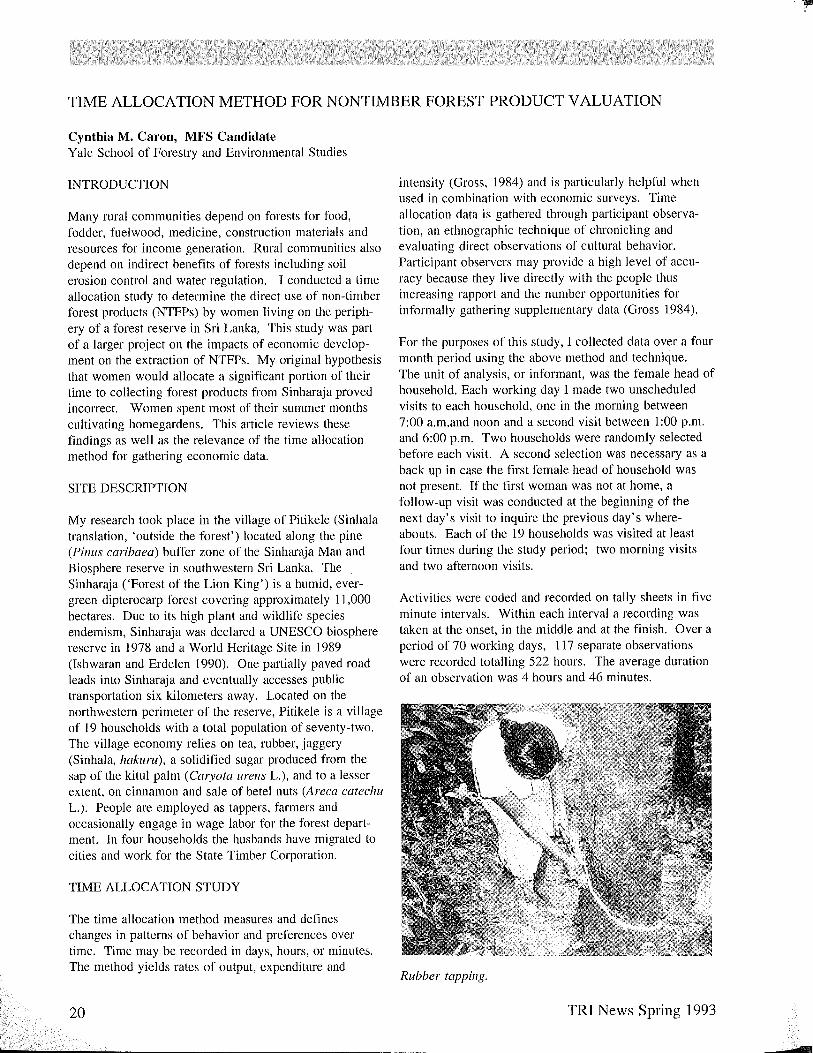
TIME ALLOCATION METHOD FOR NONTIMBER FOREST PRODUCT VALUATION
Cynthia M. Caron, MFS Candidate Yale School of Forestry and Environmental Studies
INTRODUCTION
Many rural communities depend on forests for food, fodder, fuelwood, medicine, construction materials and resources for income generation. Rural communities also depend on indirect benefits of forests including soil erosion control and water regulation. I conducted a time allocation study to determine the direct use of non-timber forest products (NTFPs) by women living on the periphery of a forest reserve in Sri Lanka, This study was part of a larger project on the impacts of economic development on the extraction of NTFPs. My original hypothesis that women would allocate a significant portion of their time to collecting forest products from Sinharaja proved incorrect. Women spent most of their summer months cultivating home gardens. This article reviews these findings as well as the relevance of the time allocation method for gathering economic data.
SITE DESCRIPTION
My research took place in the village of Pitikele (Sinhala translation, 'outside the forest') located along the pine (Pinus caribaea) buffer zone of the Sinharaja Man and Biosphere reserve in southwestern Sri Lanka. The Sinharaja (,Forest of the Lion King') is a humid, evergreen dipterocarp forest covering approximately 11,000 hectares. Due to its high plant and wildlife species endemism, Sinharaja was declared a UNESCO biosphere reserve in 1978 and a World Heritage Site in 1989 (Ishwaran and Erdelen 1990). One partially paved road leads into Sinharaja and eventually accesses public transportation six kilometers away. Located on the northwestern perimeter of the reserve, Pitikele is a village of 19 households with a total population of seventy-two. The village economy relies on tea, rubber, jaggery (Sinhala, hakllrll), a solidified sugar produced from the sap of the kitul palm (Caryota lIrens L.), and to a lesser extent, on cinnamon and sale of betel nuts (Areca catechu L.). People are employed as tappers, farmers and occasionally engage in wage labor for the forest department. In four households the husbands have migrated to cities and work for the State Timber Corporation.
TIME ALLOCATION STUDY
The time allocation method measures and defines changes in patterns of behavior and preferences over time. Time may be recorded in days, hours, or minutes. The method yields rates of output, expenditure and
20
intensity (Gross, 1984) and is particularly helpful when used in combination with economic surveys. Time allocation data is gathered through participant observation, an ethnographic technique of chronicling and evaluating direct observations of cultural behavior. Participant observers may provide a high level of accuracy because they live directly with the people thus increasing rapport and the number opportunities for informally gathering supplementary data (Gross 1984).
For the purposes of this study, I collected data over a four month period using the above method and technique. The unit of analysis, or informant, was the female head of household. Each working day I made two unscheduled visits to each household, one in the morning between 7:00 a.m.and noon and a second visit between 1 :00 p.m. and 6:00 p.m. Two households were randomly selected before each visit. A second selection was necessary as a back up in case the first female head of household was not present. If the first woman was not at home, a follow-up visit was conducted at the beginning of the next day's visit to inquire the previous day's whereabouts. Each of the 19 households was visited at least four times during the study period; two morning visits and two afternoon visits.
Activities were coded and recorded on tally sheets in five minute intervals. Within each interval a recording was taken at the onset, in the middle and at the finish. Over a period of 70 working days, 117 separate observations were recorded totalling 522 hours. The average duration of an observation was 4 hours and 46 minutes.
Rubber tapping.
TRI News Spring 1993
'-.
rl""
PRELIMINARY RESULTS
During my stay in Pitikele, I never observed an informant entering the forest to collect NTFPs. On only two occasions did I observe them entering the buffer zone to collect fallen and dead branches for fuelwood. Female heads of households spent 58 % of their time in nonagricultural non-community activities, and 28.6% of the observed time was allocated to agricultural activities. Community activities such as road building and religious worship consumed 13.4% of the time budget. Table I shows the breakdown within non-agricultural activities. For ease in displaying the data, agricultural activities are subdivided into direct economic activities and indirect economic activities in Tables II and III. Only activities occulTing more than four times during the study period are listed.
The largest amount of time (58% of total) was budgeted in non-agricultural activities, most (14.5% of total) spent visiting with neighbors and relaxing while chewing betel nut (Areca catechu L.). Preparing three meals a day (not including fire tending) consumed nearly 12% of the total budget (Table 1).
TABLE I NON-AGRICULTURAL ACTIVITIES BY FEMALE HEADS OF HOUSEHOLD
ACTIVITY
Childcare Cooking Fire tending Food preparation Eating meals and snacks Housework Leisure time and visiting Personal care and bathing Pounding unhusked rice Washing clothes Winnowing rice House Repair Miscellaneous Total
TIME (min)
1295 914 807
2454 1714 1843 5164 1290 313 558 422 414
5107 16,774
% OF TOTAL TIME BUDGET
3 .. 6 2.6 2.3 7.0 4.8 5.1
14.5 3.6 0.9 1.5 1.2 1.1 9.7
58.0%
Women directly participate in or are solely responsible for agricultural activites that contribute monetarily to the household economy. They are solely responsible for rubber production and occasionally receive help from men and children with tea cultivation. Both men and women take responsibility for jaggery production. Women allocated 22.7 % of the their time directly to economic activities (Table 2).
TRI News Spring 1993
TABLE II DIRECTLY ECONOMIC AGRICULTURAL ACTIVITIES BY FEMALE HEADS OF HOUSEHOLD
ACTIVITY
Boiling kitul palm sap and making jaggery
Collecting rubber latex Establishing tea nurseries Plucking tea Processing rubber Tapping rubber Travel time to gardens and to deliver tea Weeding tea gardens Miscellaneous Total
TIME (min)
803 134 169
1901 118 576
441 901
3067 4602
% OF TOTAL TIME BUDGET
2.2 0.4 0.5 5.3 0.4 1.6
1.2 2.5
M 22.7%
Women spent 5.9% of their time engaged in collecting NTFPs from homegardens and common lands for subsistence needs. The most common of these activities were gathering leaves, roots and flowers for food and collecting fuelwood (Table 3).
TABLE III INDIRECTLY ECONOMIC AGRICULTURAL ACTIVITIES BY FEMALE HEADS OF HOUSEHOLD
ACTIVITY TIME % OF TOTAL (min) TIME BUDGET
Gathering coconuts 126 0.4 Gathering firewood 402 1.1 Gathering leafs/vegetables 448 1.3 Medicinal preparation 170 0.5 Harvesting Paddy 215 0.6 Travel time to collect
firewood 151 0.4 Miscellaneous 568 1.6 Total 2080 5.9%
DISCUSSION
Pitikele gender relations diverge from many rural agricultural communities. The general trend that men are involved with the cash economy and focus primarily on cash crops while women focus on meeting subsistence needs was not evident. Men actively participate in the collection of foodstuffs, firewood and other household security items. Women are the primary caretakers of tea and rubber gardens.
Despite the restrictions associated with the biosphere reserve status, several NTFPs are procured from Sinharaja and play important roles in Pitikele's village economy. Some of the most important products include the sap of the kitul palm (Cmyota urens L.), lianas for
21
tying (Coscinilllll Jenestratul11 and Nepenthes distillatoria), doomala resin (Shorea spp.), rattans for basket weaving, beru leaves for thatching (Agrostistachys eoriacea), and the foodstuffs, thollol nuts and beraliya fruits (Trichadenia zeylanica and Shorea d.veri, respectively). Some of these resources have specific values to men. Men conduct roof repair with leaves and lianas are necessary for the construction of ladders needed for tapping kitul palm, tools and general tying. While women may boil thollol nuts and cook a sweet snack (hellapa) with beraliya fruits, on all occasions these were collected by men. Men would also bring home fallen branches for fuel wood in addition to the previously mentioned foodstuffs when out on their two daily trips to tap kitul palm.
Tapping kitul palm in the forest is allowed by permit, but of the ten households that regularly tap kitul only six tap in the forest and only one man has purchased the Rs. 25 permit (1992: 44 SL.Rs = 1 U.S. dollar) from the Forest Department. Several tappers fear they will be held responsible for any damage done in the forest even if it is not connected to tapping kitul and therefore do not purchase permits. Collection of the other NTFPs is restricted but nevertheless occurs frequently.
A more accurate historical account is necessary to fully appreciate the changes in NTFP cultivation and procurement in homegardens shifting from dependence on the forest resources of Sinharaja. Prior to the planting of the buffer zone in 1978, several of the villagers practiced swidden agriculture on these same slopes. Now, in 11 of the 19 households, women plant several varieties of Cucurbits, chili peppers and beans around their homes. Vegetables are more commonly purchased at weekly markets. Tea cultivation is a recent phenomenon of the past six years. All of these resources are found in homegardens or on common village lands. Homegardens play an important role meeting household subsistence needs and providing income.
LIMITATIONS OF THE TIME ALLOCATION METHOD
The lack of women's direct participation in any NTFP gathering from the forest does not necessarily reflect the value of those NTFPs that are collected from Sinharaja. The time component is a weak valuation technique for NTFP use in this particular situation due to the gender division of labor and changes in the subsistence strategy of villagers living in Pitikele. This particular village behavior may not be replicated in other peripheral villages at Sinharaja. On the southern side of Sinharaja many of the village economies rely heavily on rattan and rattan-based industries. While rattan grows on the opposite side of the buffer zone adjacent to Pitikele, I
22
never saw recently cut cane in the village. In the case of Pitikele, forest collection occurs on a perhaps lower but continuous level.
The actual amount of time allotted to a time allocation study is critical. While the typical duration of a time allocation study is one year, I was limited to four months.
I discovered that fine lines exist in inter-household production. The importance of who is observed, when and how many people are observed cannot be neglected. The number of households, members of each household and the economies of those individual households effect their behavior. I chose not to randomly exclude households. Sampling the entire population inhibited my ability to increase my replications but with the help of an economic survey will allow a comprehensive understanding of this village economy and its component households. Seasonal fluctuations in labor must be considered as well as the work patterns of other household members to achieve a holistic picture of the household economy. Further research among forest resident communities needs to be undertaken to determine how much time and who invests the time in NTFP extraction. The time allocation method is extremely useful in evaluating NTFP values if used among all members of the population.
Statistical analysis correlating household income level, education level, family and land holding size to NTFP use and extraction is forthcoming. These results will act as an initial indicator to the effects of economic development on NTFPs cultivation and procurement patterns of rural economies in transition.
ACKNOWLEDGMENTS
In addition to the Tropical Resources Institute, I thank the Rockefeller Foundation and the Harvard Institute of International Development for project funding. This project would not have been realized without advise and encouragement from Dr. Mark Ashton. I am grateful to Dr. Piyasena Abeygunawardena of the Department of Agricultual Economics and the staff of the Botany Department at the University of Peradeniya for advice and technical support and to Dr. Nancy Peluso and the editors for comments on the draft.
LITERATURE CITED
Gross, D. R. 1984. Time allocation: a tool for the study of cultural behavior. Annual Review of Anthropology. 13:519-558. .
Ishwaran, N. and W. Erdelen. 1990. Conserving Sinharaja - an experiment in sustainable development in Sri Lanka. Ambio, 19(5):237-244.
TRI News Spring 1993

THE DETERMINATION OF AGE AND GROWTH RATE OF FOUR TREE SPECIES IN AN EVERMOIST FOREST IN SOUTHWESTERN SRI LANKA
Patrick Baker, MF Candidate Yale School of Forestry and Environmental Studies
INTRODUCTION
On September 21 and 22, 1938, a massive hurricane swept across Long Island and into southern New England devastating many of the forests in Connecticut. The forests that arose from the destruction were chiefly composed of black birch, red maple, red oak, and eastern hemlock. These tree species grew at different rates and began to vertically stratify. Fifty-five years later red oak is the dominant canopy tree, red maple is a co-dominant, and black birch and eastern hemlock persist in the understory and subcanopy (Oliver 1978). While the trees are all the same age, the average heights of each species differ.
The temporal aspect of tree growth is often overlooked. Through their growth, trees catalog a natural history of moisture conditions, light availability and competition. A knowledge of the past history and the future potential of a forest is necessary for sound ecosystem management. Due to the lack of infOlTIlation about the changes of a forest through time, physical dimensions such as height and diameter have been used to gauge future growth. However, both height and diameter are unsuitable measures. Tree height is a function of site quality and genotype; diameter is related to stocking density (trees/ ha), neither are reliably influenced by age (Oliver and Larson 1990). The forests of Connecticut that developed in the wake of the 1938 hUlTicane illustrate this point. The dominant canopy species, red oak, is much taller than the black birch in the understory. Knowing that the forest is approximately even-aged, we must attribute the difference in size to the rate of growth and the species' genotype, not tree age.
The age of temperate trees can be estimated with reasonable accuracy by annual growth rings. Typically, one ring equals one year; false rings and missing rings provide exceptions to this rule but the elTor is usually small. This relationship is produced in the temperate zone where a distinct seasonality regulates the production of cells in the trees' apical and cambial meristems. Seasonality decreases with latitude and, cOlTespondingly, the regulation of meristematic growth is less prone to climatic influences. In less seasonal and aseasonal environments, false and missing rings are common, making the process of estimating age by growth rings less accurate (Mariaux 1980). Researchers and foresters
TRI News Spring 1993
have sought other approaches to measure the age of trees at low latitudes. The use of radioisotope dating, measuring changes in wood chemistry and wood anatomy, dendrochronology and demography studies, have all been tried but none have proven consistently successful (Bormann and Berlyn 1980). The purpose of this study was to contribute towards the establishment of a methodology f6r estimating the age of trees in evermoist forests. I approached the problem at two levels: the whole tree and the cell.
SITE DESCRIPTION
I conducted the study at the Sinharaja Man and Biosphere Reserve in southwestern Sri Lanka (lat. 6° N, long. 80° E). Between 1972 and 1977 commercial harvesting operations selectively cut the forests of western Sinharaja for plywood lumber. People in the villages adjacent to Sinharaja converted forest edges to cash crops such as tea, cinnamon and rubber. In 1978 UNESCO designated Sinharaja a Man And Biosphere Reserve in an attempt to preserve the species rich forest from further destruction (Ashton 1991). The portion of the reserve that had been logged is regrowing as secondary forest. The trees of the secondary forest are all approximately 15 years old and include early, mid- and late-successional species. I studied four tree species commonly found in association in the forest: Macaranga pettata, a large-leaved pioneer that thrives on the forest edges; Scl1umacheria castanaejolia, an early/mid-successional species that grows in small gaps and along the edges of the forest; Shorea trapeziJolia, a large mid-successional tree that towers above the canopy at maturity; and Shorea megistophylla, a light demanding late successional emergent.
METHODOLOGY
The Whole Tree Level As I mentioned earlier neither height nor diameter are suitable parameters for estimating tree age. However, the change in height and diameter, i.e. the rate of growth, may be extremely useful. By measuring tree growth twice in a short period of time (30-60 days) I could calculate the growth rate of each tree. The four species in the study group are all expected to have different growth rates due to their varied stages in succession.
23
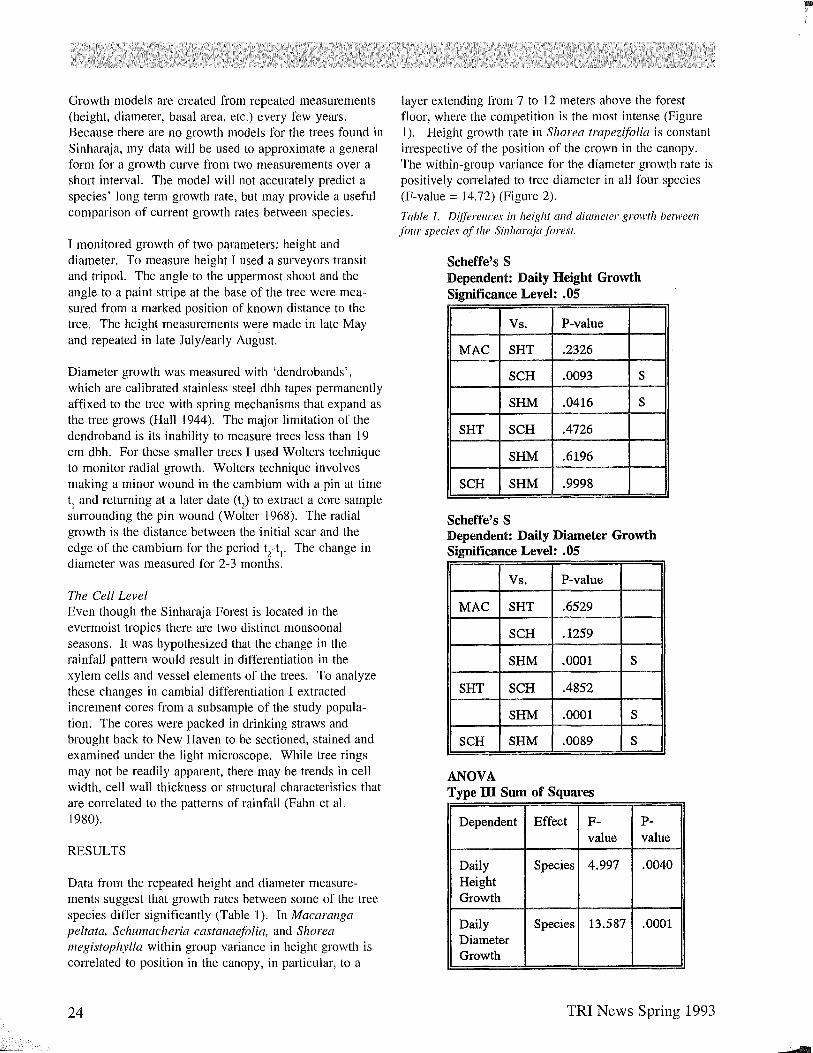
Growth models are created from repeated measurements (height, diameter, basal area, etc.) every few years. Because there are no growth models for the trees found in Sinharaja, my data will be used to approximate a general form for a growth curve from two measurements over a short interval. The model will not accurately predict a species' long term growth rate, but may provide a useful comparison of current growth rates between species.
I monitored growth of two parameters: height and diameter. To measure height I used a surveyors transit and tripod. The angle to the uppermost shoot and the angle to a paint stripe at the base of the tree were measured from a marked position of known distance to the tree. The height measurements were made in late May and repeated in late July/early Aug'ust.
Diameter growth was measured with 'dendrobands', which are calibrated stainless steel dbh tapes permanently affixed to the tree with spring mechanisms that expand as the tree grows (Hall 1944). The major limitation of the dendroband is its inability to measure trees less than 19 cm dbh. For these smaller trees I used Wolters technique to monitor radial growth. Wolters technique involves making a minor wound in the cambium with a pin at time tl and returning at a later date (t
2) to extract a core sample
surrounding the pin wound (Wolter 1968). The radial growth is the distance between the initial scar and the edge of the cambium for the period t
2-t l. The change in
diameter was measured for 2-3 months.
The Cell Level Even though the Sinharaja Forest is located in the evermoist tropics there are two distinct monsoonal seasons. It was hypothesized that the change in the rainfall pattern would result in differentiation in the xylem cells and vessel elements of the trees. To analyze these changes in cambial differentiation I extracted increment cores from a subsample of the study population. The cores were packed in drinking straws and brought back to New Haven to be sectioned, stained and examined under the light microscope. While tree rings may not be readily apparent, there may be trends in cell width, cell wall thickness or structural characteristics that are correlated to the patterns of rainfall (Fahn et al. 1980).
RESULTS
Data from the repeated height and diameter measurements suggest that growth rates between some of the tree species differ significantly (Table 1). In Macarallga peltata, Schulllacheria castanaejolia, and Shorea megistophylla within group variance in height growth is correlated to position in the canopy, in particular, to a
24
layer extending from 7 to 12 meters above the forest floor, where the competition is the most intense (Figure 1). Height growth rate in SIlO rea trapeziJolia is constant irrespective of the position of the crown in the canopy. The within-group variance for the diameter growth rate is positively correlated to tree diameter in all four species (F-value = 14.72) (Figure 2).
Table I. D({ferences in height and diameter growth between fOllr species of the Sinllaraja forest,
Scheffe's S Dependent: Daily Height Growth Significance Level: .05
Vs. P-value
MAC SHT .2326
SCH .0093 S
SHM .0416 S
SHT SCH .4726
SHM .6196
SCH SHM .9998
Scheffe's S Dependent: Daily Diameter Growth Significance Level: .05
Vs. P-value
MAC SHT .6529
SCH .1259
SHM .0001 S
SHT SCH .4852
SHM .0001 S
SCH SHM .0089 S
ANOVA Type ill Sum of Squares
Dependent Effect F- P-value value
Daily Species 4.997 .0040 Height Growth
Daily Species 13.587 .0001 Diameter Growth
TRI News Spring 1993

Preliminary examinations have shown some differentiation in the xylem cells, but quantifying the cell and vessel diameters of the wood sections and comparing them to the rainfall data remains to be done.
Figure 1. Daily height growth.
Effect: Species Dependent: Daily Ht Growth With 95% Confidence error bars .
. 006~--~----------L---------~---------L----~
.005
.004
.003
.002
.001
-.001
-.002 -'------.---------.----------.--------.------'-
MAC SHT
Species
Figure 2. Daily diameter growth.
Interaction Plot Effect: Species Dependent: Daily Dbh Growth With 95% Confidence error bars.
SCH SHM
.002~--L--------~-------~--------~----_r
. 002
.002
.002
. 001
.001
.001
.001
;<S 5.000E-4
2.500E-4
O~--~--------_.---------.--------r----L MAC SHT SCH SHM
Species
DISCUSSION
The techniques for measuring changes in height and diameter over a short period are suitable for distinguishing between growth rates of different species. The higher correlation of diameter growth to species is likely due to the larger sample population. The number of trees that were measured for height growth was much less because an unimpeded line of sight to the tree top was uncommon in the closed canopy of the secondary forest. The next step will be to extrapolate the results backwards and forward in time to approximate a growth model for each tree species.
TRI News Spring 1993
Beyond indicating potential growth of the trees, the significant differences in growth rates between species illustrate the varied life histories of the individual tree species, showing a snapshot of the Sinharaja forest at 15 years old. M. pe/tata has achieved its maximum height growth and has shifted to increasing diameter growth. Shorea megistophylla's height growth is rapid but radial extension is slow. Both species are shade intolerant, but M. peltata, an early-successional species is, after 15 years, approaching senescence. S. megistophylla, a late successional species, is still in the early stages of development; the rapid height growth keeps the crown in the sunlight just above competing vegetation. Schwllacheria castanaefolia has a height and diameter growth pattern similar to Shorea megistophylla, i.e. rapid height growth and slow diameter growth, but is an early to midsuccessional species. Being a shade intolerant species that has not reached its maximum height growth Schumacheria castanaefolia must also keep its crown above other competing vegetation. However, in the primary forest there is no evidence of S. castanaefolia except as buried seed, suggesting that the species exploits small gaps in the forest by quickly establishing itself above other regeneration, where it grows until reproductive maturity, produces a seed crop and dies. Shorea trapezifolia, the mid-successional species, grows in height at a constant rate but is growing faster radially than all of the other species. Environments with under 50% full sunlight are well-suited for the growth of S . trapezifolia (Ashton 1991). As a result, energy that the light demanding species expend on height growth in order to maintain their necessary position above the crown can be spent on diameter growth .
While these results indicate growth trends in the near future and may be able to approximate growth models for individuals, the measurements will need to be repeated in a few years to calculate a more rigorous model. However, the growth rate of the tree species depicts the interactions between species, the potential for growth in the near future and the ability to compete in the present. For foresters and scientists in the evermoist tropics this knowledge will provide a better understanding of the dynamic processes of the forests.
ACKNOWLEDGEMENTS
The project was made possible by grants from the Tropical Resources Institute and the Rockefeller Foundation through the Harvard Institute for International Development. I would like to thank Drs. Savithri and Nimal Gunatilleke for all their support and kindness in Sri Lanka and Dr. Mark Ashton, Dr. Graeme Berlyn, Dr. George Furnival, and Dr. Bruce Larson for their help and guidance throughout the project.
25
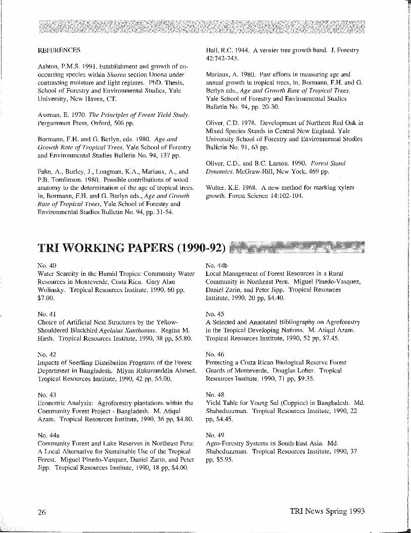
REFERENCES
Ashton, P.M.S. 1991. Establishment and growth of cooccurring species within Shorea section Doona under contrasting moisture and light regimes. PhD. Thesis, School of Forestry and Environmental Studies, Yale University, New Haven, CT.
Assman, E. 1970. The Principles of Forest Yield Study. Pergammon Press, Oxford, 506 pp.
Bormann, F.H. and G. Berlyn, eds. 1980. Age and Growth Rate of Tropical Trees, Yale School of Forestry and Environmental Studies Bulletin No. 94, 137 pp.
Fahn, A, Burley, J., Longman, K:A, Mariaux, A, and P.B. Tomlinson. 1980. Possible contributions of wood anatomy to the determination of the age of tropical trees. in, Bormann, F.R. and G. Berlyn eds., Age and Growth Rate of Tropical Trees, Yale School of Forestry and Environmental Studies Bulletin No. 94, pp. 31-54.
Hall, R.C 1944. A vernier tree growth band. J. Forestry 42:742-743.
Mariaux, A 1980. Past efforts in measuring age and annual growth in tropical trees, in, Bormann, F.H. and G. Berlyn eds., Age and Growth Rate of Tropical Trees, Yale School of Forestry and Environmental Studies Bulletin No. 94, pp. 20-30.
Oliver, CD. 1978. Development of Northern Red Oak in Mixed Species Stands in Central New England. Yale University School of Forestry and Environmental Studies Bulletin No. 91, 63 pp.
Oliver, CD., and B.C Larson. ] 990. Forest Stand Dynamics. McGraw-Hili, New York, 469 pp.
Wolter, K.E. 1968. A new method for marking xylem growth. Forest Science 14: 102-104.
TRI WORKING PAPERS (1990-92) No. 40 Water Scarcity in the Humid Tropics: Community Water Resources in Monteverde, Costa Rica. Gary Alan Wolinsky. Tropical Resources Institute, 1990,60 pp, $7.00.
No. 41 Choice of Artificial Nest Structures by the YellowShouldered Blackbird Agelaius Xanthomus. Regina M. Hirsh. Tropical Resources Institute, 1990,38 pp, $5.80.
No. 42 Impacts of Seedling Distribution Programs of the Forest Department in Bangladesh. Miyan Rukununddin Ahmed. Tropical Resources Institute, 1990, 42 pp, $5.00.
No. 43 Economic Analysis: Agroforestry plantations within the Community Forest Project - Bangladesh. M. Atiqul Azam. Tropical Resources Institute, ]990,36 pp, $4.80.
No.44a Community Forest and Lake Reserves in Northeast Peru: A Local Alternative for Sustainable Use of the Tropical Forest. Miguel Pinedo-Vasquez, Daniel Zarin, and Peter Jipp. Tropical Resources Institute, 1990, 18 pp, $4.00.
26
No.44b Local Management of Forest Resources in a Rural Community in Northeast Peru. Miguel Pinedo-Vasquez, Daniel Zarin, and Peter Jipp. Tropical Resources Institute, 1990, 20 pp, $4.40.
No. 45 A Selected and Annotated Bibliography on Agroforestry in the Tropical Developing Nations. M. Atiqul Azam. Tropical Resources Institute, 1990, 52 pp, $7.45.
No. 46 Protecting a Costa Rican Biological Reserve Forest Guards of Monteverde. Douglas Lober. Tropical Resources Institute, 1990, 7] pp, $9.35.
No. 48 Yield Table for Young Sal (Coppice) in Bangladesh. Md. Shaheduzzman. Tropical Resources Institute, ] 990, 22 pp, $4.45.
No. 49 Agro-Forestry Systems in South-East Asia. Md. Shaheduzzman. Tropical Resources Institute, 1990,37 pp, $5.95.
TRI News Spring 1993
No. 50 Analysis and Evaluation of Agroforestry as an Alternative Environmental and Resources Development Design in Bangladesh. Md. Atiqul Azam. Tropical Resources Institute, 1990, 45 pp, $6.75.
No. 51 Preliminary Study of Rural Primates in Southwestern Puerto Rico. Rosalyn Johnson. Tropical Resources Institute, 1991, 30 pp, $5.25.
No. 52 Production and Conservation in the Cocuy Region, Boyaca, Columbia. Interdisciplinary Approach, Sustainable Development, and Community Participation: Virtues and Difficulties in Field Application. Juan Pablo Ruiz. Tropical Resources Institute, 1991, 54 pp, $9.00.
No. 53 Deforestation and the Rural Farmer: the Potential for Problem Specific Environmental Education in Central America. Case Studies from Costa Rica and Honduras. Alicia P. Grimes and Gwen M. Thomas. Tropical Resources Institute, 1991,66 pp, $8.85.
No. 54 New Perspectives on Culture, Tourism and Economic Development. Providing Planning Alternatives for Punta Ballena, Guanica, Puerto Rico. Christopher T. Rogers. Tropical Resources Institute, 1991, IOJ pp, $10.00.
No. 55 Can Secondary Forest Aid in the Conservation of Brazil's Atlantic Forest Birds? Extacao Pau Brasil, Bahia, Brazil. Margaret J. Cymerys. Tropical Resources Institute, 1991, 72 pp, $9.45.
No. 56 Introduced Animal Species Issues: Cunent Status and Problems, Including a Feasibility Study for the Establishment of a Multi-Disciplinary Introduced Animal Species Center. Peter Schuyler. Tropical Resources Institute, 1991,52 pp, $7.45.
No.56a Appendices for Report on Introduced Animal Species Issues: Cunent Status and Problems, Including a Feasibility Study for the Establishment of a Multi-Disciplinary Introduced Animal Species Center. Peter Schuyler. Tropical Resources Institute, 1991,167 pp, $18.95. (Both Paper and Appendices can be purchased for $25.00.)
TRI News Spring 1993
No. 57 Cultural Significance of Fruit Bats (Pteroplls spp.) to the Chamorro People of Guam: Conservation Implications. Uti Sheeline. Tropical Resources Institute, 1991, 164 pp, $18.50.
No. 58 Regeneration of Shorea Species in Gap and Understory Micro-Sites and the Regeneration Potential of Eusideroxylon Zwageri from Coppice After Selective Cutting in a Lowland Dipterocarp Rain Forest, West Kalimantan, Indonesia. Peter A. Palmiotto. Tropical Resources Institute, 1991, 79 pp, $10.00.
No. 59 Mammalian Predation of Green Sea Turtle (Chelonia mydas) Eggs at Tortuguero, Costa Rica. Laurie Peterson. Tropical Resources Institute, 1992, 32 pp, $6.45.
No. 60 The Design of Conservation Conidors in Monteverde, Costa Rica. John Musinsky. Tropical Resources Institute, 1992,95 pp, $12.75.
No. 61 Lead Contamination of Soils, Agricultural Crops, and Trees (Jacaranda acutifolia and Eucalyptus sp.) in the Metropolitan Zone of Mexico City. Aliza Mizrahi. Tropical Resources Institute, 1992, 28 pp, $6.00.
All working papers may be ordered directly from the Tropical Resources Institute.
27
LITERATURE
Joseph Miller, Librarian and Lecturer Yale School of Forestry and Environmental Studies
GENERAL
Acidification in Southeast Asia: prospects for the coming decades. Rodhe, H.; and others. Ambio; a journal of the human environment, 21(2): 148-149, 1992.
Climatic aspects of urban design in tropical regions. Givoni, B. Atmospheric environment. Part B: Urban atmosphere, 26(3):397-406, 1992~
An empirical study of the economic effects of climate change on world agriculture. Kane, S.; and others. Climatic change, 21(1):17-36,1992.
Environmental considerations of land transport in developing countries. 2. Varma, A.; and others. Transport reviews, 12(3):187-198, 1992.
Environmental impact assessment in Nigeria: current situation and directions for the future. Olokesusi, F. Journal of environmental management, 35(3): 163-172, 1992.
Environmental monitoring for protected areas: review and prospect. Slocombe, D.S. Environmental monitoring and assessment, 21 (1 ):49-78, 1992.
Improving shrimp production by Zambezi River regulation. Gammelsrod, T. Ambio; a journal of the human environment, 21(2):145-147, 1992.
Managing pesticide use in developing countries. Paarlberg, R.L. Environment, 34(4):17-, 1992.
Modelling the effects of albedo change associated with tropical deforestation. Mylne, M.F.; Rowntree, P.R. Climatic change, 21(3):317-, 1992.
A new approach for selecting fully representative reserve networks: addressing efficiency, reserve design, and land suitability with an iterative approach. Bedward, M.; and others. Biological conservation, 62(2): 115-126, 1992.
Optimal extraction of small-scale surface water storage in Asia. Mahendrarajah, S.; and others. Water resources research, 28(5):1207-1220, 1992.
28
Research for nature conservation in South East Asia. Prins, H.H.T.; Wind, l Biological conservation, 63(1):43-46, 1993.
Toxic metal pollution in Africa: review paper. Nriagu, lO. Science of the total environment, 121: 1-38, 1992 Jun. 30.
AGRICULTURE AND WILDLIFE
Are tropical agroforestry home gardens sustainable? Torquebiau, E. Agriculture, ecosystems & environment, 41(2):189-208, 1992.
A conservation plan for the jaguar (Panthera onca) in the Pantanal region of Brazil. Quigley, H.B.; Crawshaw, P.G. Biological conservation, 61 (3): 149-158, 1992.
Contribution of soil organisms to the sustainability and productivity of cropping systems in the tropics. Sanginga, N.; and others. Agriculture, ecosystems & environment, 41(2):135-152, 1992.
The economics of monocropping and intercropping by smallholders: the case of coconuts in Indonesia. Godoy, R.; Bennett, C.P.A. Human ecology, 19(1):83-98, 1992.
Energetics and environmental costs of agriculture in a dry tropical region of India. Singh, V.P.; Singh, J.S. Environmental management, 16(4):495-504, 1992.
Evaluation of plant species for land restoration in central Tunisia. Johnson, D.E.; and others. Journal of arid environments, 22(4):305-322, 1992.
Forest elephants in a rainforest fragment: preliminary findings from a wildlife conservation project in southern Ghana. Dudley, J.P.; and others. African journal of ecology, 30(2):116-126,1992.
The impact of foreign assistance on agricultural growth. Norton, G.W.; and others. Economic development and cultural change, 40(4):775-786, 1992.
Nutritional value of some non-conventional plant foods of India. Duhan, A.; and others. Plant foods for human nutrition, 42(3): 193-200, 1992.
TRI News Spring 1993

Oral evidence in historical environmental impact assessment: soil conservation in Lesotho in the 1930s and 1940s. Showers, K.B.; Malahleha, G.M. Journal of southern African studies, 18(2):276-296, 1992.
Pastoral dairy marketing and household wealth interactions and their implications for calves and humans in Ethiopia. Holden, SJ.; and others. Human ecology, 19(1):35-60, 1992.
The production and export of hides and skins in colonial northern Nigeria, 1900-1945. Adebayo, A.G. Journal of African history, 33(2):273-300, 1992.
Productivity of tropical cattle: a reappraisal. Maule, J. Outlook on agriculture, 21(1):47-56, 1992.
The role of indigenous soil knowledge in agricultural development. Pawluk, RR; and others. Journal of soil and water conservation, 47(4):298-303, 1992.
Upland agriculture, the land frontier, and forest decline in the Philippines. Kummer, D.M. Agroforestry systems, 18(1):31-46, 1992.
Zimbabwe's wildlife conservation regime: rural farmers and the state. Hill, K.A Human ecology, 19(1):19-34, 1992.
FORESTS AND FORESTRY
Carbon storage potential of short rotation tropical tree plantations. Schroeder, P. Forest ecology and management, 50(1-2):31-42, 1992.
Ecological correlates of reproductive traits of Mexican rain forest trees. Ibarra-Manriquez, G.; Oyama, K. American journal of botany, 79(4):383-394, 1992.
Experiments with native trees in Costa Rica and Argentina. Montagnini, F. Agroforestry today, 4(3):4-6, 1992.
Forest ecology on Java: human impact and vegetation of montane forest. Smiet, A.e. Journal of tropical ecology, 8(part 2):129-152, 1992.
Hydrochemical cycles in tropical rainforests: an overview with emphasis on central Amazonia. Forti, M.e.; Neal, e. Journal of hydrology, 134(1-4):103-116, 1992.
Indigenous Kikuyu agroforestry: a case study of Kirinyaga, Kenya. Castro, A.P. Human ecology, 19(1):1-18, 1992.
TRI News Spring 1993
The ironwood problem: (mis)management and development of an extractive resource. Peluso, N.L. Conservation biology, 6(2):210-219, 1992.
Promoting resource degradation in Latin America: tropical deforestation, soil erosion, and coastal ecosystem disturbance in Ecuador. Southgate, D.; Whitaker, M. Economic development and cultural change, 40(4):787-808, 1992.
Regeneration of tropical dry forests in Central America, with examples from Nicaragua. Sabogal, e. Journal of vegetation science, 3(3):407-418, 1992.
The remaining islands with primary rain forest: a global resource. Ingram, G.B. Environmental management, 16(5):585-596, 1992.
The role of plantation forests in rehabilitating degraded tropical ecosystems. Parotta, J.A Agriculture, ecosystems & environment, 41(2):115-134,1992.
The role of scientists and foresters in the wise management of tropical forests. Healey, J. Trends in ecology and evolution, 7(8):249-250, 1992.
A study of logging damage in upland rainforest in north Queensland. Crome, F.HJ.; and others. Forest ecology and management, 49(1-2): 1-30, 1992.
Tree cultivation on private land in the middle hills of Nepal: lessons from some villagers of Dolakha District. Carter, EJ. Mountain research and development, 12(3):241-256, 1992.
The tropical timber trade and sustainable development. Vincent, J.R. Science, 256:1651-1655, 1992, Jun. 19.
Water yield changes after clear-felling tropical rainforest and establishment of forest plantation in Sabah, Malaysia. Maimer, A Journal of hydrology, 134(1-4):77-94, 1992.
SOCIAL AND ECONOMIC
Alternative energy in the Third World: a reappraisal of subsidies. Desai, AV. World development, 20(7):959-966, 1992.
Applications of geochemistry and training programs for indigenous land use planning in the Ecuadorian Amazon. Brown, I.F.; and others. Interciencia, 17(5):284-292, 1992.
29
For more information abont the Tropical Resources Institute contact:
Florencia Montagnini The Tropical Resources Institute Yale School of Forestry and Environmental Studies (203) 432-3660
TRISTAFF
Director Florencia Montagnini
TRI Project Coordinator Nuda Mufiiz-Miret
Assistant to the Director Brad Auer
TROPICAL STUDIES COMMITTEE
Mark Ashton, Michael Balick, Nancy Peluso, Graeme Berlyn, Robert Mendelsohn, Florencia Montagnini, Alison Richard, Thomas Siccama
The Tropical Resources Institute Yale University School of Forestry and Environmental Studies 205 Prospect Street New Haven, CT 06511 USA
TRINEWS
Managing Editor Timothy Wohlg~nant
Assistant Editors·
Literctture Editor. Nseph Millet
Acknowledgements
Logo design by Sujata Guha Logo modified by John Musinsky
Illustrations by Erin Girdler
Non-Profit Org. U.S. Postage Paid
Permit No. 470 New Haven, CT
d