k. waterfront revitalization program - new york city · k. waterfront revitalization program ......
TRANSCRIPT
CEQR MANUAL 3K-1 10/01
K. Waterfront Revitalization Program
100. Definitions
Proposed actions subject to CEQR that aresituated within the designated boundaries of New York City's Coastal Zone must be assessed for their consistency with the City's Local WaterfrontRevitalization Program (LWRP). New York City's LWRP was adopted in 1999 as a 197-a Plan in coordination with local, State, and Federal laws and regulations, including the State's CoastalManagement Program and the Federal CoastalZone Management Act of 1972 (see Section 710,below). The LWRP establishes the City's Coastal Zone and includes 10 policies dealing with: (1)residential and commercial redevelopment; (2)water-dependent and industrial uses; (3)commercial and recreational boating; (4) coastalecological systems; (5) water quality; (6) flooding and erosion; (7) solid waste and hazardoussubstances; (8) public access; (9) scenic resources; and (10) historical and cultural resources. The ten policies are not presented in order of importance and are numbered only for ease of reference.
At the time that this document is going to print the new LWRP is awaiting approval by theDepartment of State and the Department ofCommerce; therefore, applications for permitswhich require New York State approval, such as Department of Environmental Conservationpermits or federal permits from agencies such as the Army Corps of Engineers, require review under the 56 policies of the old LWRP. See the Waterfront Revitalization Program Appendix 1 for a copy of the 56 policies of the old LWRP, WaterfrontRevitalization Program Appendix 2 for a copy of the Procedures for Waterfront RevitalizationProgram Consistency: Local, State and FederalActions, and Waterfront Revitalization ProgramAppendix 3 for a copy of the original questionnaire.
The LWRP consistency review includesconsideration and assessment of other local, state, and federal laws and regulations governingdisturbance and development within the Coastal Zone. Key laws and regulations include thosegoverning wetlands, flood management, andcoastal erosion. Although the consistency review is independent from all other environmental sections and must stand on its own, it is supported and conducted with consideration of all the other
technical analyses performed as part of the action's environmental assessment under CEQR.
The LWRP's policies address 10 basic issues:fish and wildlife, flooding and erosion, waterresources, air quality, and scenic quality; publicaccess and recreation resources; energydevelopment and solid waste disposal; anddevelopment.
110. COASTAL ZONE
As described above, New York City's LWRP establishes Coastal Zone boundaries, within which all discretionary actions must be reviewed forconsistency with Coastal Zone policies. TheCoastal Zone, which is mapped in the City's CoastalZone Boundaries maps, is the geographic area ofNew York City's coastal waters and adjacentshorelands that have a direct and significant effect on coastal waters. It generally extends landward from the pierhead line or property line (whicheveris furthest seaward) to include coastal resourcesand generally at least to the first mapped street.The Coastal Zone generally includes islands, tidal wetlands, beaches, dunes, barrier islands, cliffs,bluffs, intertidal estuaries, flooding- and erosion-prone areas, port facilities, vital built features (such as historic resources), and other coastal locations.Terms and issues important in the determination of the Coastal Zone, and therefore important in aconsideration of an action's effects in that CoastalZone, include those described below.
• Base flood or 100-year flood. The flood having a one percent chance of being equalled orexceeded in any given year. The base flood elevation is the height in relation to mean sea level—expressed in National Geodetic Vertical Datum (NGVD)—expected to be reached by the waters of the base flood as noted on the Flood Insurance Rate Maps (established under the National Flood Insurance Act).
• Erosion. The loss or displacement of land along the coastline because of the action of waves, currents running along the shore, tides, wind, runoff of surface waters, groundwater seepage, wind-driven water or waterborne ice, or other impacts of coastal storms (as established under the State Erosion Hazard Areas Act).
• Erosion hazard areas. Those erosion prone areas of the shore, as defined in State Erosion Hazard Areas Act, that: (a) are determined as likely to
2001
Tec
hnical
Man
ual
Out o
f Dat
e - D
O NOT
USE

CEQR MANUAL 3K-2 10/01
be subject to erosion within a four year period, and; (b) constitute natural protective features (i.e., beaches, dunes, shoals, bars, spits, barrier islands, bluffs, wetlands, and natural protective vegetation).
• Floodplains. The lowlands adjoining thechannel of a river, stream, or watercourse, or ocean, lake, or other body of standing water, which have been or may be inundated byfloodwater (as established by the NationalFlood Insurance Act).
• Bulkhead line. The proposed or actual bulkhead line most recently adopted by the U.S. Army Corps of Engineers and the New York City De-partment of City Planning.
• Pierhead line. The proposed or actual pierhead line most recently adopted by the U. S. Army Corps of Engineers and the New York City De-partment of City Planning.
• Public access. Any area of publicly accessible open space on waterfront property. Publicaccess also includes the pedestrian ways that provide an access route from a waterfrontpublic access area to a public street, publicpark, public place, or public access area.
• Visual corridor. An area that provides a direct and unobstructed view to a waterway from a public vantage point within a public street,public park, or other public place.
• Water-dependent uses. Uses that require direct access to a body of water to function or that use waterways for transport of materials, products, or people.
• Waterfront-enhancing uses. A group of primarily recreational, cultural, entertainment, or retail shopping uses that, when located at the water's edge, add to the public use and enjoyment of the waterfront.
120. COMPREHENSIVE WATERFRONT PLANAND WATERFRONT ZONING TEXT
The Department of City Planning'sComprehensive Waterfront Plan (1992) and reports prepared for each of the five boroughs (1993 and 1994) identify goals and objectives for the City's waterfront. These plans identify four principal
waterfront functional areas: natural, public,working, and redeveloping.
In 1993, to support the ComprehensiveWaterfront Plan and the WaterfrontRevitalization Program, New York Cityadopted the Waterfront Zoning Text (NYCZoning Resolution, Article VI, Chapter 2). The text has the following stated purposes:
To maintain and reestablish physical and visual public access to and along the waterfront;
To promote a greater mix of uses in waterfront developments, in order to attract the public and enliven the waterfront;
To encourage water-dependent uses along the City's waterfront;
To create a desirable relationship betweenwaterfront development and the water's edge,public access areas and adjoining uplandcommunities;
To preserve historic resources along the City’s waterfront; and
To protect natural resources in environmentally sensitive areas along the shore.
The plan and adopted zoning regulationsprovide useful background information; however, LWRP policies are the basis for determining consis-tency.
200. Determining Whether a Waterfront Revitalization Program Assessment isAppropriate
The LWRP applies to all discretionary actions in the designated Coastal Zone. As describedabove (Section 100), this zone is delineated in the Coastal Zone Boundaries maps published by theDepartment of City Planning, and is illustrated in Figure 3K-1. If the proposed action is located in the designated Coastal Zone, assessment of itsconsistency with the LWRP is required. For generic or programmatic actions, the potential locationslikely to be affected within the coastal zoneboundary should be considered.
2001
Tec
hnical
Man
ual
Out o
f Dat
e - D
O NOT
USE

CEQR MANUAL 3K-3 10/01
1.
2001
Tec
hnical
Man
ual
Out o
f Dat
e - D
O NOT
USE

CEQR MANUAL 3K-4 10/01
300. Assessment Methods
Because the LWRP review considers the many laws affecting the coastal area, consideration of an action's consistency with the LWRP typicallyrequires a comprehensive assessment, which also includes synthesis of different technical areasdescribed in this Manual. Therefore, close coor-dination with the other technical areas will beneeded. The analysis of each of these technicalareas—such as natural or air resources, land use and zoning, or historic resources—is summarizedand presented in this chapter as it relates to the LWRP policies. Although much of the detail of each technical chapter can be cross-referenced, it is important that the discussion of each policy be able to stand on its own in this chapter. In some cases, supplemental information to that provided in the technical analyses may be necessary to complete the LWRP consistency evaluation.
310. STUDY AREA/ELEMENTS
The study area for an assessment of the LWRP is generally defined by the site of the proposedaction and those areas and resources within the Coastal Zone boundary that are likely to be affected by the proposed action. The study area may have to be enlarged for certain proposed actions toinclude resources that are part of a largerenvironmental system. For example, both natural drainage areas and potential erosion on downdrift properties may extend beyond the typical study area for a proposed action.
The assessment of an action's consistency with LWRP considers the future with the action incomparison to the No Action condition. Moreinformation on this framework is provided inChapter 2. For example, when considering whether the action would be consistent with the surround-ing land uses in a small harbor area, consider the uses that are expected to exist in the future rather than only the existing uses.
320. ANALYSIS TECHNIQUES
321. Preliminary Assessment
The first step for many actions is a preliminary evaluation of the action's potential for inconsistencywith the LWRP policies. A new ConsistencyAssessment Form, provided at the end of thischapter, was developed by the Department of City Planning to help an applicant identify which
Waterfront Revitalization Program policies apply to a specific action. Questions listed under theheading “C. Coastal Assessment” should beanswered by applicants. (The numbers inparentheses after each question indicate the policy or policies that are the focus of the question). These questions are designed to screen out those policies that would have no bearing on a consistencydetermination for a proposed action.
"Yes" answers to any of the questions indicate that a particular policy or policies of the LWRP may be relevant and would warrant furtherexamination. For any questions that warrant a "yes" answer or for which an answer is ambiguous, an explanation should be prepared to assess the consistency of the proposed action with the noted policy or policies. The policies, along withstandards and criteria, are contained in a booklet titled The New Waterfront Revitalization Program (seeSection 730).
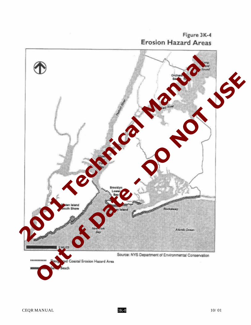
Figures 3K-2 through 3K-6 can also provideassistance to applicants; however, these maps are simplified. For information about more detailed maps, contact the Department of City Planning’s Waterfront and Open Space Division (see Section 730, below).
322. Detailed Analysis
The detailed analysis considers all 10 LWRP policies with their standards and criteria, andassesses consistency with all those that are relevant to the action. This assessment may requireadditional information about the affected site and the action, such as the following:
• Piers, Platforms, or Floating Structures• Mean High Water• Mean Low Water• Pierhead Line• Bulkhead Line• Water-Dependent and Water-Enhanced
Uses• Property Lines• Depth to Water Table• Ownership; Documentation of Lands
Underwater• Existing and Proposed Vegetation• Existing and Proposed Stormwater
Drainage• Existing and Proposed Public Access• Topography• Wetlands (Freshwater and Tidal)
2001
Tec
hnical
Man
ual
Out o
f Dat
e - D
O NOT
USE

CEQR MANUAL 3K-5 10/01
• Coastal Erosion Hazard Area• Beach or Bank Profile• Public Access• Floodplains• Base Flood Elevation• Wildlife
As described below under Section 400, if an action would be inconsistent with a LWRP policy, it is most often appropriate to determine whether it would also forward other policies, so that these conflicting policies can be balanced with regard to appropriate uses for the site in question.
The level of detail of the analysis will depend on the nature of the action and the relevance ofeach policy to the action. Qualitative andquantitative effects may be pertinent. It should be noted, however, that several policies requireadherence to specific minimum standards. Foreach policy relevant to the proposed action, provide a brief description of how it relates to the action, and a statement as to whether or not the action is consistent with the policy. Where a policy relates to other technical analyses performed, the analysis of the LWRP can refer to the other section of theenvironmental assessment.
400. Determining Impact Significance
For any given policy of the LWRP, a proposed action may advance that policy, be neutral to it, or hinder the policy. It is the last category—hindranceof a policy—that may result in an inconsistency and, therefore, requires more scrutiny in the policy assessment.
If the lead agency determines that the action is consistent with the LWRP policies, no furtherassessment is necessary. As stated in Part II.8 of the EAS, the lead agency should include an analysis of LWRP consistency as part of the EAS. For actions determined to be consistent with LWRP policies, the analysis should state that the action would not substantially hinder the achievement of any of the coastal policies.
The LWRP policies represent objectives that may conflict with each other in the context of a given action, and the determination of a potential significant impact should address each of thepolicies individually. In determining significance of inconsistencies, the lead agency may have tobalance the policies that would be furthered by the
action against any impacts that would hinder the policies.
If an action is inconsistent with a policy,consider whether changes to the action could be made so that the action would become consistent.
If such changes are not possible, considerwhether the inconsistency is of such a degree as to be significant. The lead agency may determine that some inconsistencies are not significant. Forexample, a proposed new structure that wouldslightly block a view corridor toward the watermay be found to be insignificant, depending on the existing width of that view corridor and othercircumstances.
For inconsistencies with LWRP policies, thelead agency must be able to certify that thefollowing four requirements are satisfied toapprove an action:
• No reasonable alternatives exist that wouldpermit the action to be taken in a manner that would not substantially hinder theachievement of the policy;
• The action would minimize all adverse effectsrelated to the policy inconsistency to themaximum extent practicable;
• The action would advance one or more of the other coastal policies; and
• The action would result in an overriding local public benefit.
According to the LWRP, the City cannotproceed with an action if there is an LWRPinconsistency and the lead agency cannot makethose findings. To make those findings, the action can be modified as described below in Sections 500 and 600. Even if the four findings can be made, substantial inconsistencies with any of the LWRP policies may result in significant adverse impacts that should be disclosed.
2001
Tec
hnical
Man
ual
Out o
f Dat
e - D
O NOT
USE

CEQR MANUAL 3K-6 10/01
2001
Tec
hnical
Man
ual
Out o
f Dat
e - D
O NOT
USE

CEQR MANUAL 3K-7 10/01
2001
Tec
hnical
Man
ual
Out o
f Dat
e - D
O NOT
USE
CEQR MANUAL 3K-8 10/01
2001
Tec
hnical
Man
ual
Out o
f Dat
e - D
O NOT
USE

CEQR MANUAL 3K-9 10/01
2001
Tec
hnical
Man
ual
Out o
f Dat
e - D
O NOT
USE

CEQR MANUAL 3K-10 10/01
2001
Tec
hnical
Man
ual
Out o
f Dat
e - D
O NOT
USE

CEQR MANUAL 3K-11 10/01
500. Developing Mitigation
When an action would result in significantadverse impacts related to inconsistencies with the LWRP, but those significant impacts are proposed to be mitigated, then the action would be consistent with the LWRP. Appropriate mitigation measures will vary, depending on the particularinconsistency. The measures must either besufficient to address the policy inconsistency, orenable the lead agency to make the four findings described in Section 400. Proposed mitigation mea-sures also must be assessed for consistency with the LWRP to the same degree as the proposed action.Mitigation for a significant adverse impact related to the LWRP may require coordination with other technical analyses.
Mitigation measures may include thosedescribed in Section 500 of the different technical chapters of this Manual. In some cases, thosemeasures may have to be modified to provideappropriate mitigation for impacts related to the LWRP's policies. For example, mitigation forsignificant impacts related to flooding and erosion (Policy 6) is discussed in Chapter 3I, NaturalResources.
In some cases, however, the significant impact will be specific to the assessment of LWRP, and will not have been identified in the analysis of anothertechnical area, such as air quality or hazardousmaterials. For example, a reduction in existing or potential public access to or along coastal waters would be inconsistent with the LWRP (Policy 8), although it might not constitute a significant impact identified in the other technical analyses.
600. Developing Alternatives
Sometimes, a proposed action would result in an inconsistency with policies of the LWRP that can be avoided through changes to the action. Such changes can include alternative uses (for example, water-dependent uses rather than those that are not) or alternative design (e.g., a different site plan to avoid development in the floodplain, or different building heights or site location to avoid a visual impact). Often, these will be the same alternatives used to avoid significant impacts in the othertechnical areas; sometimes, they will be specific to the assessment of consistency with the LWRP.
700. Regulations and Coordination
710. REGULATIONS AND STANDARDS
New York City's Local WaterfrontRevitalization Program was adopted incoordination with local, State, and Federalregulatory programs, and in the assessment,considers the many Federal, State, and local laws affecting the coastal area. For more information on the many rules and regulations affecting cultural resources, coastal erosion, flood management,natural resources, hazardous materials, and airquality, see Section 710 of the appropriate technical chapters of this Manual.
711. Federal Laws and Regulations
Coastal Zone Management Act (P.L. 92-583,16 USC 1451 et seq.). Administrativeresponsibility: U.S. Department ofCommerce, National Oceanic andAtmospheric Administration (NOAA).
The Act established the Federal CoastalZone Management Program to encourageand assist the states in preparing andimplementing management programs to"preserve, protect, develop and, whenever possible, to restore or enhance the resourcesof the nation's Coastal Zone."
Marine Protection, Research, andSanctuaries Act of 1972 (Section 103; 33 USC 1413).
National Flood Insurance Act of 1968. Flood Disaster Protection Act. Water Pollution Control Act. Clean Air Act. Clean Water Act, Section 404 (33 USC 1344). National Environmental Policy Act. Rivers and Harbors Act of 1899, Section 10
(33 USC 403). Fish and Wildlife Coordination Act. Endangered Species Act. National Historic Preservation Act. Deepwater Port Act. National Fishing Enhancement Act of 1984. Marine Mammal Protection Act. Federal Power Act.
712. New York State Laws and Regulations
State Environmental Quality Review,Environmental Conservation Law, Part 617.
—Part 617.11 (e) describes the linkagebetween SEQR and the coastal policies of
2001
Tec
hnical
Man
ual
Out o
f Dat
e - D
O NOT
USE

CEQR MANUAL 3K-12 10/01
Article 42 of the Executive Law, asimplemented by 19 NYCRR 600.5.—Part 617.9 (b)(5)(vi) describes the
inclusion of the State and local coastalpolicies in the preparation and content of Environmental Impact Statements.
Waterfront Revitalization and CoastalResources Act (New York State ExecutiveLaw, 1981; Sections 910 et seq. Article 42; and implementing regulations 19 NYCRR).—Part 600: Policies and Procedures.—Part 601: Local Government WaterfrontRevitalization Programs.—Part 602: Coastal Area Boundary;Significant Fish and Wildlife Habitats;Important Agricultural Lands and ScenicResources of Statewide Significance;Identification, Mapping, and DesignationProcedures.
State Guidelines for Federal Reviews:Procedural Guidelines for Coordinating New York State Department of State and New York City Waterfront Revitalization ProgramConsistency Review of Federal Agency Actions,Coastal Management Program, Department of State, State of New York, 1985.
Guidelines for Notification and Review of State Agency Actions Where Local WaterfrontPrograms Are in Effect, Coastal Management Program, Department of State, State of New York.
Coastal Zone Management Rules andRegulations (6 NYCRR 505).
Coastal Erosion Hazard Areas Act.
Flood Hazard Areas.
Freshwater Wetlands Protection Program.
Tidal Wetlands Protection Program.
Classification of Waters Program.
Endangered and Threatened SpeciesProgram.
Historic Preservation Act.
713. New York City Laws and Regulations
The New Waterfront RevitalizationProgram, approved by the Council of the City of New York, October 13, 1999.
Procedures for the City PlanningCommission, acting as the City CoastalCommission, approved by the City Coastal Commission acting as the City Planning Commission, 1987.
This set of procedures links the Waterfront Revitalization Program with the ULURP process and describes the City Planning Commission's role in the State and Federal actions that otherwise do not require local involvement.
General Limitations on Occupancy andConstruction within Special Flood Hazard Areas—Article 10, New YorkAdministrative Code.
Grading and Drainage Rules—Local Law 7.
720. APPLICABLE COORDINATION
721. City Coastal Commission
Lead agencies conduct their own review of an action's consistency with the LWRP duringenvironmental assessment. If the City Planning Commission is an involved agency because theaction will come before the City PlanningCommission, the City Planning Commission acting as the City Coastal Commission is required to make a LWRP consistency finding. The City CoastalCommission may elect to adopt the consistency determination and environmental findings of the lead agency or adopt different LWRP consistency findings. For this reason, the lead agency may wish to consult with the Department of City Planning, Waterfront and Open Space Division, acting asadvisors to the City Coastal Commission, prior to issuance of its CEQR determination.
The City Coastal Commission's involvement may occur for a variety of Federal and State actions and actions subject to ULURP (Charter section197-c) or Charter section 197-a or 200.
722. Other Agency Coordination
Once a determination is made by a lead agency that an action is consistent with the policies of the
2001
Tec
hnical
Man
ual
Out o
f Dat
e - D
O NOT
USE

CEQR MANUAL 3K-13 10/01
LWRP, the lead agency is responsible for keeping a LWRP file which will ensure a record ofconsistency between the City and the State.
723. Technical Coordination
The assessment of the action's consistency with LWRP relies primarily on information and analyses of the other technical areas discussed in thisManual. Thus, coordination with the otherenvironmental analyses can be very useful.
730. LOCATION OF INFORMATION
New York City Department of CityPlanning
22 Reade Street New York, NY 10007 Waterfront and Open Space Division
New York City Department of CityPlanning
22 Reade StreetNew York, NY 10007
Bookstore and Map Sales Office
—Department of City Planning, CoastalZone Boundary, City of New York.
—Department of City Planning, The New Waterfront Revitalization Program, City ofNew York, 1999.
—Department of City Planning, NewYork City Comprehensive Waterfront Plan:Reclaiming the City's Edge, 1992.
—Department of City Planning, NewYork City Waterfront Symbol, City of New York, 1989.
—New York City Zoning Resolution,Special Regulations Applying in theWaterfront Area (Article VI, Chapter 2).
New York State Department ofEnvironmental Conservation
Region 2 47-40 21st Street Long Island City, NY 11101
—Coastal Erosion Hazard Area Maps.—Tidal Wetland Maps.—Freshwater Wetlands Maps,—Department of EnvironmentalConservation, "Stormwater for New Devel-opment," a memorandum to RegionalWater Engineers, Bureau Directors, Section Chiefs, dated April 1990.
—Department of EnvironmentalConservation, Floodplain Regulation and the National Flood Insurance Program: AHandbook for the New York Communities,Water Division, Flood Protection Bureau,State of New York, 1990.—Significant Coastal Fish and Wildlife
Habitat Designations.
Federal Emergency Management Agency26 Federal PlazaNew York, NY 10278—Federal Emergency Management
Agency, Flood Insurance Rate Maps, Na-tional Flood Insurance Program,.—Federal Emergency Management
Agency, Flood Insurance Study: City of New York, New York, Community Number360497, 1991.
2001
Tec
hnical
Man
ual
Out o
f Dat
e - D
O NOT
USE

CEQR MANUAL 3K-14 10/01
For Internal Use Only:Date Received: _______________________________
WRP no.___________________________________DOS no.____________________________________
NEW YORK CITY WATERFRONT REVITALIZATION PROGRAMConsistency Assessment Form
Proposed action subject to CEQR, ULURP, or other Local, State or Federal Agency Discretionary Actions that are situated within New York City’s designated Coastal Zone Boundary must be reviewed and assessed for their consistency with the New York City Waterfront Revitalization Program (WRP). The WRP was adopted as a 197-a Plan by the Council of the City of New York on October 13, 1999, and approved in coordination with local, state and Federal laws and regulations, including the State’s Coastal Management Program (Executive Law, Article 42) and the Federal Coastal Zone Management Act of 1972 (P.L. 92-583). As a result of these approvals, state and federal discretionary actions within the city’s coastal zone must be consistent to the maximum extent practicable with the WRP policies and the city must be given the opportunity to comment on all state and federal projects within its coastal zone.
This form is intended to assist an applicant in certifying that the proposed activity is consistent with the WRP. It should be completed when the local, state, or federal application is prepared. The completed form and accompanying information will be used by the New York State Department of State, other State Agency or the New York City Department of City Planning in its review of the applicant’s certification of consistency.
A. APPLICANT1. Name:
______________________ ____________________________________________________________________________________2. Address:
__________________________________________________________________________________________________________3. Telephone: _________________________________________ Fax: _______________________________________________
__________________________________________________________________________________________________________E-mail Address:__________________________________________________________________________________________________________
4. Project site owner: ________________________________________________________________________________________________________
B. PROPOSED ACTIVITY1. Brief description of activity: _________________________________________________________________________________
_____________________________________________________________________________________________________________________________________________________________________________________________________________________________________________________________________________________________________________________________________________________________________________________________________________________________________
2. Purpose of activity: ___________________________________________________________________________________________________________________________________________________________________________________________________________________________________________________________________________________________________________________________________________________________________________________________________________________
3. Location of activity: __________________________________________________________ Borough: ____________________Street Address or Site Description: ______________________________________________________________________________________________________________________________________________________________________________________________________________________________________________________________________________________________________________________________
WRP consistency form - May 2001
2001
Tec
hnical
Man
ual
Out o
f Dat
e - D
O NOT
USE

CEQR MANUAL 3K-15 10/01
Proposed Activity Cont’d
4. If a federal or state permit or license was issued or is required for the proposed activity, identify the permit type(s), the authorizing agency and provide the application or permit number(s), if known:____________________________________________________________________________________________________________________________________________________________________________________________________________________
5. Is federal or state funding being used to finance the project? If so, please identify the funding source(s).______________________________________________________________________________________________________________________________________________________________________________________________________________________________________________________________________________________________________________________________
6. Will the proposed project result in any large physical change to a site within the coastal area that will require the preparation of an environmental impact statement? Yes ______________ No ______________If yes, identify Lead Agency: ________________________________________________________________________________
7. Identify City discretionary actions, such as zoning amendment or adoption of an urban renewal plan, required for the proposed project.______________________________________________________________________________________________________________________________________________________________________________________________________________________________________________________________________________________________________________________________
C. COASTAL ASSESSMENT
The following questions represent, in a broad sense, the policy of the WRP. The number in the parentheses after each question indicated the policy or policies that are the focus of the question. A detailed explanation of the Waterfront Revitalization Program and its policies are contained in the publication the New York City Waterfront Revitalization Program.
Check either “Yes” or “No” for each of the following questions. Once the checklist is completed, assess how the proposedproject affects the policy or standards indicated in “( )” after each question with a Yes response. Explain of how the action is consistent with the goals of the policy or standard.
Location Questions: Yes No
1. Is the project site on the waterfront or at the water’s edge?
2. Does the proposed project require a waterfront site?
3. Would the action result in a physical alteration to a waterfront site, including land along the shoreline, land underwater, or coastal waters?
Policy Questions: Yes No
4. Will the proposed project result in revitalization or redevelopment of a deteriorated or under- used waterfront site? (1)
5. Is the project site appropriate for residential or commercial redevelopment? (1.1)
6. Will the action result in a change in scale or character of a neighborhood? (1.2)
7. Will the proposed activity require provision of new public services or infrastructure in undeveloped or sparsely populated sections of the coastal area? (1.3)
WRP consistency form - May 2001
2001
Tec
hnical
Man
ual
Out o
f Dat
e - D
O NOT
USE

CEQR MANUAL 3K-16 10/01
8. Is the action located in one of the designated Significant Maritime and Industrial Areas (SMIA): South Bronx, Newtown Creek, Brooklyn Navy Yard, Red Hook, Sunset Park, or Staten Island? (2)
9. Are there any waterfront structures, such as piers, docks, bulkheads or wharves, located on the project sites? (2)
10. Would the action involve the siting or construction of a facility essential to the generation or transmission of energy, or a natural gas facility, or would it develop new energy resources? (2.1)
11. Does the action involve the siting of a working waterfront use outside of a SMIA? (2.2)
12. Does the proposed project involve infrastructure improvement, such as construction or repair of piers, docks, or bulkheads? (2.3, 3.2)
13. Would the action involve mining, dredging, or dredge disposal, or placement of dredged or fill materials in coastal waters? (2.3, 3.1, 4, 5.3, 6.3)
14. Would the action be located in a commercial or recreational boating center, such as City Island, Sheepshead Bay or Great Kills or an area devoted to water-dependent transportation? (3)
15. Would the proposed project have an adverse effect upon the land or water uses within a commercial or recreation boating center or water-dependent transportation center? (3.1)
16. Would the proposed project create any conflicts between commercial and recreational boating? (3.2)
17. Does the proposed project involve any boating activity that would have an impact on the aquatic environment or surrounding land and water uses? (3.3)
18. Is the action located in one of the designated Special Natural Waterfront Areas (SNWA): Long Island Sound- East River, Jamaica Bay, or Northwest Staten Island? (4 and 9.2)
19. Is the project site in or adjacent to a Significant Coastal Fish and Wildlife Habitats? (4.1)
20. Is the site located within or adjacent to a Recognized Ecological Complex: South Shore of Staten Island or Riverdale Natural Area District? (4.1and 9.2)
21. Would the action involve any activity in or near a tidal or freshwater wetland? (4.2)
22. Does the project site contain a rare ecological community or would the proposed project affect a vulnerable plant, fish, or wildlife species? (4.3)
23. Would the action have any effects on commercial or recreational use of fish resources? (4.4)
24. Would the proposed project in any way affect the water quality classification of nearby waters or be unable to be consistent with that classification? (5)
25. Would the action result in any direct or indirect discharges, including toxins, hazardous substances, or other pollutants, effluent, or waste, into any waterbody? (5.1)
26. Would the action result in the draining of stormwater runoff or sewer overflows into coastal waters? (5.1)
27. Will any activity associated with the project generate nonpoint source pollution? (5.2)
WRP consistency form - May 2001
2001
Tec
hnical
Man
ual
Out o
f Dat
e - D
O NOT
USE

CEQR MANUAL 3K-17 10/01
28. Would the action cause violations of the National or State air quality standards? (5.2)
29. Would the action result in significant amounts of acid rain precursors (nitrates and sulfates)? (5.2C)
30. Will the project involve the excavation or placing of fill in or near navigable waters, marshes, estuaries, tidal marshes or other wetlands? (5.3)
31. Would the proposed action have any effects on surface or ground water supplies? (5.4)
32. Would the action result in any activities within a Federally designated flood hazard area or State designated erosion hazards area? (6)
33. Would the action result in any construction activities that would lead to erosion? (6)
34. Would the action involve construction or reconstruction of flood or erosion control structure? (6.1)
35. Would the action involve any new or increased activity on or near any beach, dune, barrier island, or bluff? (6.1)
36. Does the proposed project involve use of public funds for flood prevention or erosion control? (6.2)
37. Would the proposed project affect a non-renewable source of sand ? (6.3)
38. Would the action result in shipping, handling, or storing of solid wastes; hazardous materials, or other pollutants? (7)
39. Would the action affect any sites that have been used as landfills? (7.1)
40. Would the action result in development of a site that may contain contamination or has a history of underground fuel tanks, oil spills, or other form or petroleum product use or
storage? (7.2)
41. Will the proposed activity result in any transport, storage, treatment, or disposal of solid wastes or hazardous materials, or the siting of a solid or hazardous waste facility? (7.3)
42. Would the action result in a reduction of existing or required access to or along coastal waters, public access areas, or public parks or open spaces? (8)
43. Will the proposed project affect or be located in, on, or adjacent to any federal, state, or city park or other land in public ownership protected for open space preservation? (8)
44. Would the action result in the provision of open space without the provision for its maintenance? (8.1)
45. Would the action result in any development along the shoreline but NOT include new water- enhanced or water dependent recreational space? (8.2)
46. Will the proposed project impede visual access to coastal lands, waters and open space? (8.3)
47. Does the proposed project involve publically owned or acquired land that could accommodate waterfront open space or recreation? (8.4)
48. Does the project site involve lands or waters held in public trust by the state or city? (8.5)
WRP consistency form - May 2001
2001
Tec
hnical
Man
ual
Out o
f Dat
e - D
O NOT
USE

CEQR MANUAL 3K-18 10/01
49. Would the action affect natural or built resources that contribute to the scenic quality of a coastal area? (9)
50. Does the site currently include elements that degrade the area’s scenic quality or block views to the water? (9.1)
51. Would the proposed action have a significant adverse impact on historic, archeological, or cultural resources? (10)
52. Will the proposed activity affect or be located in, on, or adjacent to an historic resource listed on the National or State Register of Historic Places, or designated as a landmark by the City of New York? (10)
WRP consistency form - May 2001
2001
Tec
hnical
Man
ual
Out o
f Dat
e - D
O NOT
USE