local waterfront revitalization plan - one region...
TRANSCRIPT

Local Waterfront Revitalization Plan
Public Review DraftCity of Bu�alo
Mayor Byron W. BrownO�ce of Strategic Planning
Brendan R. Meha�y
BUFFALO’S LWRP | 1
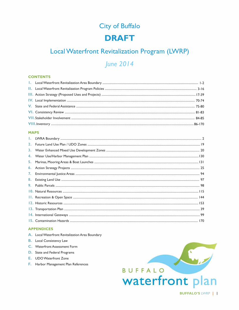
CONTENTS
1. Local Waterfront Revitalization Area Boundary ............................................................................................................................
II. Local Waterfront Revitalization Program Policies .......................................................................................................................
III. Action Strategy (Proposed Uses and Projects) ..........................................................................................................................
IV. Local Implementation ......................................................................................................................................................................
V. State and Federal Assistance ..........................................................................................................................................................
VI. Consistency Review .........................................................................................................................................................................
VII. Stakeholder Involvement ................................................................................................................................................................
VIII.Inventory .........................................................................................................................................................................................
MAPS
1. LWRA Boundary .......................................................................................................................................................................................
2. Future Land Use Plan / UDO Zones ..................................................................................................................................................
3. Water Enhanced Mixed Use Development Zones .........................................................................................................................
4. Water Use/Harbor Management Plan ..............................................................................................................................................
5. Marinas, Mooring Areas & Boat Launches .......................................................................................................................................
6. Action Strategy Projects .......................................................................................................................................................................
7. Environmental Justice Areas .................................................................................................................................................................
8. Existing Land Use ...................................................................................................................................................................................
9. Public Parcels ...........................................................................................................................................................................................
10. Natural Resources ................................................................................................................................................................................
11. Recreation & Open Space ..................................................................................................................................................................
12. Historic Resources ...............................................................................................................................................................................
13. Transportation Plan ................................................................................................................................................................................
14. International Gateways ..........................................................................................................................................................................
15. Contamination Hazards ......................................................................................................................................................................
APPENDICES
A. Local Waterfront Revitalization Area Boundary
B. Local Consistency Law
C. Waterfront Assessment Form
D. State and Federal Programs
E. UDO Waterfront Zone
F. Harbor Management Plan References
City of Buffalo
DRAFTLocal Waterfront Revitalization Program (LWRP)
June 2014
1-2
3-16
17-39
70-74
75-80
81-83
84-85
86-170
2
19
20
130
131
25
94
97
98
115
144
153
39
99
170
BUFFALO’S LWRP | 1FACT SHEET
Over the last 20 years, substantial investments have been made in the City of Buffalo’s public waterfront access infrastructure, including canals, boat launches, marinas, fishing sites, waterfront trails, promenades, active recreation parks and nature preserves. Significant ecological improvements have also been made, including sewer overflow reductions, brownfield cleanups, habitat restoration projects and the Buffalo River sediment remediation project. Together, these efforts have dramatically transformed Buffalo’s former industrial, polluted waterfront – laying the foundation for Buffalo’s waterfront renaissance.
Today, boom cranes dominate the Buffalo waterfront as new investment transforms Canalside, the Riverbend Solar Innovation site, Erie Basin Marina, Erie Freight, Riverworks, SiloCity, the Ford Terminal Complex and Shoreline Apartments.
The City’s Local Waterfront Revitalization Program (LWRP) sets the framework for the next generation of Buffalo’s waterfront revitalization. The LWRP establishes clear coastal policies, identifies future land and water uses within the Local Waterfront Revitalization Area and identifies strategic public projects designed to leverage significant private development investment.
Goals & Policies:
The Buffalo LWRP policies collaborate to safeguard the City’s natural water resources; water based economic development; and community interests. They support the following goals:
�Holistically protect the state’s coastal economic, social, and environmental interests;
� Safeguard the City’s access to clean, Great Lakes fresh water for generations to come;
� Promote water based industry and enterprise;
� Support commercial and recreational boating;
� Promote the City as an international gateway;
� Build great water-enhanced places that enliven the waterfront and attract the public;
� Provide for public water access in support of the public trust;
� Rebuild the Lake Erie/Niagara River food web – recognizing local fish as an important food source;
�Minimize environmental degradation from solid waste and hazardous substances; and
�Maximize coastal resilience.
The LWRA Future Land Use Plan:
� Protects existing water-dependent industrial uses in the lower reaches of the Buffalo River and around the Union Ship Canal through industrial zoning provisions and setback exceptions for water dependent uses;
� Promotes water-enhanced mixed use redevelopment, that exacts a premium for their waterfront location including housing, restaurants and cultural amenities at:
1. Black Rock Harbor;
2. Scajaquada Creek Campus*;
3. Niagara Street (Carolina to Porter and Busti to Forest)*;
4. Cotter Point Maritime Community;
5. Erie Street between Main and Lakeside Boulevard*;
6. Canalside*;
7. Cobblestone* ;
8. Ohio Street*;
9. Freezer Queen*; and
10. City Ship Canal Village*.
Buffalo Local Waterfront Revitalization Program (LWRP) FACT SHEET

2 | BUFFALO’S LWRP FACT SHEET
*indicates a Brownfield Opportunity Area Strategic Site.
� Supports light industrial redevelopment in the LWRA at Silo City, Lakeside Commerce Park, Riverbend (adjacent South Park), Ford Terminal Complex, Elk Street and Niagara Street;
� Protects publicly held water-dependent and water-enhanced recreation and natural resources through openspace zones;
� Protects the numerous ecological functions of shoreline buffer areas through required waterfront setbacks and vegetated buffer requirements outside of redevelopment areas; and
�Minimizes the impacts of non-water dependent or water-enhanced activities such as trucking and junkyard operations, while limiting the introduction of new uses that would be deleterious in a waterfront environment.
The LWRP identifies the following short term public projects to help encourage private investment and promote activity in the City’s waterfront redevelopment areas.
Transportation Projects
T1. Complete the Niagara Street/Great Lakes Seaway Trail National Scenic Byway Reconstruction Project from Niagara Square to Ontario Street;
T2. Finalize the design and implementation of the Scajaquada Expressway boulevard feasibility project;
T3. Improve the Virginia/Carolina I-190 interchange at Niagara Street as a City waterfront gateway;
T4. Implement the Erie Street Extension project from Main Street to Lakeside Boulevard;
T5. Implement the Cars on Main Project from Terrace to South Park; and
T6. Design and implement the Perry Street/Cobblestone Connection, consistent with the Ohio and Niagara Street efforts.
Public Space/Amenity Projects
A1. Implement the Black Rock Canal Park Improvements;
A2. Complete heritage interpretive elements of Broderick Park improvements;
A3. Implement the LaSalle Park/Black Rock Canal shoreline stabilization project;
A4. Coordinate public investments in the Erie Basin Marina, Small Boat Harbor and NYPA First Buffalo Marina docks and boating service facilities to maximize benefit to the boating community;
A5. Implement the Grain Elevator and Waterfront Bridge lighting project; and
A6. Develop a master plan for the City’s parks, open spaces, trails and greenways.
Public Facility Rehabilitation
PF1. Relocate or screen the City’s auto impound to reduce visual blight;
PF2. Repurpose the Cotter Point former army storage building;
PF3. Explore opportunities to utilize the Colonel Ward Pumping Station historic structure for public access and waterfront revitalization activities;
PF4. Phase development of public parcels in Canalside and Erie Basin Marina
PF5. Reactivate the DL&W Station;
PF6. Reactivate the Ford Terminal Complex on the Outer Harbor, including public access along the water’s edge; and
PF7. Secure the City-owned Cargill Pool and Concrete Central grain elevators and study opportunities for reuse and heritage interpretation.
Private Investment Support
� Provide brownfields, asbestos and lead remediation support, as well as façade and landscape improvement incentives for the mixed use and industrial redevelopment areas;
� Support Historic Preservation Tax Credits and energy efficiency funding for private reuse of iconic historic

BUFFALO’S LWRP | 3FACT SHEET
waterfront structures, particularly the Buffalo Smelting Works, Agway Grain Storage Building, Grain Elevators and Freezer Queen; and
� Explore opportunities to further incentivize water dependent business activities (such as tax exemptions for fishing and boating equipment sales) within the LWRA.
While the primary focus of the LWRA revitalization efforts will center on inducing private investment, several other major public initiatives and projects are integral to the long term health of the City’s waterfront revitalization area including:
� Implementation of the Buffalo Sewer Combined Sewer Overflow Long Term Control Plan green and grey infrastructure projects;
� Implementation of the Buffalo and Niagara River Remedial Action Plans including, but not limited to, numerous habitat protection and restoration projects and remediation of contaminated sediments in Scajaquada Creek;
� Restoration of the historic Buffalo Olmsted Park system elements located within the LWRA; and
� Updating the City’s parks, recreation and greenway plans, including the Buffalo River Greenway and Riverwalk Revitalization projects.

BUFFALO’S LWRP | 1PLANNING FOR BUFFALO’S OUTER HARBOR
Buffalo’s Outer Harbor is one of the most visible, important areas of Buffalo’s waterfront with 3 miles of Lake Erie shoreline including Gallagher Beach, the Small Boat Harbor, the Outer Harbor Greenbelt and Seaway Piers. The site’s prominence has inspired many development and open space proposals.
Through the Buffalo Harbor Brownfield Opportunity Area process, a detailed inventory and analysis of the Outer Harbor was prepared. In addition, the consultant team developed three potential development scenarios for public comment and review. Based upon that feedback and the public comments received through the Buffalo Green Code process, a preliminary land use plan for the Outer Harbor has been developed and reflected in the proposed City of Buffalo Unified Development Ordinance (aka UDO or Green Code) and proposed Local Waterfront Revitalization Program.
In 2013, the Niagara Frontier Transportation Authority arranged to transfer most of its Outer Harbor land holdings to Erie Canal Harbor Development Corporation (ECHDC) including:
� 190 acres, including the NFTA-run Small Boat Harbor and Gallagher Beach, will be owned by ECHDC but will be leased to the New York State Office of Parks, Recreation and Historic Preservation to become the first state park in the City of Buffalo;
� 150 acres north of the former Ford Terminal Complex. This site has designated a Waterfront Transition Zone in the City’s proposed Unified Development Ordinance (aka Green Code) with both open space and development areas. Under the proposed Code, any new development on the site will have to meet specific performance criteria and be approved by the Buffalo Common Council.
In May 2014, the NFTA issued a request for proposals for the purchase of its remaining Outer Harbor land holdings. the 50 acre site, has 1,583 feet of frontage along Lake Erie. It featires a 548,000 square foot brick and steel building (a former Ford Motor Company manufacturing plant), a 95,248 square foot warehouse, a 4,468 square foot pre-engineered steel building, a 7,006 square foot building
(“Filbin Building”) and 500 parking spaces. Proposals are due to the NFTA on July 1, 2014. The site is currently zoned M-3 Heavy Industrial. However, the Green Code has designated the site for mixed use (N1-C).
On April 7th, 2014 Erie Canal Harbor Development Corporation hosted the first meeting of a nine member Buffalo Waterfront Development Advisory Committee established to offer recommendations on future development plans for Buffalo’s Outer Harbor have also been announced. The Buffalo Waterfront Development Advisory Committee consists of five members appointed by ECHDC and four members appointed by City of Buffalo Mayor Byron Brown. Robert Gioia, ECHDC Chairman and president of The John R. Oishei Foundation, will serve as chairman of the committee. At its first meeting, the Committee approved a Request for Proposals from to consultants to develop a master “blueprint” of land use and development recommendations for 171 acres on the city’s waterfront.
The City of Buffalo is working closely with ECHDC to coordinate this planning initiative with the final adoption of the Buffalo Harbor Brownfield Opportunity Area Nomination, the Local Waterfront Revitalization Plan, Land Use Plan and Unified Development Ordinance.
The Buffalo Waterfront Development Advisory Committee provided the consultant team with the following guiding principles for the plan:
1. Accessibility
� Activate water edges-for public use
�Maintain scenic views
� Promote year-round public use and access
�Offer a welcoming and safe environment
� Facilitate multiple modes of access (e.g., pedestrian, bike, water taxi, trolley, public transport, etc.)
� Ensure handicap accessibility
2. Diverse Use
Special Note: Planning for Buffalo’s Outer Harbor

2 | BUFFALO’S LWRP PLANNING FOR BUFFALO’S OUTER HARBOR
�Offer multiple things to see and do (e.g., Green space, public places, historical sites, recreational activities, public art activities, etc.)
�Design a destination that attracts out–of-town, regional visitors as well as residents
� Promote a wide variety of land and water activities that complement each other
� Emphasize a mix of land uses
3. Planning and Design
� Lead a comprehensive and collaborative planning process with opportunities for public participation and review
� Create a remarkable and regionally significantly waterfront.
�Design for all seasons
� Ensure green/ sustainable building and site development practices
� Consider investments that improve lake quality, reduce stormwater overflows, save energy and improve traffic flow and safety
� Pursue a phased development strategy
4. Financial Payback
� Pursue long-term economic self-sufficiency
� Attract follow-on private investment
� Focus investment to optimize economic, social and environmental benefits
� Create jobs for local residents
� Pursue economic benefits from tourism
� Ensure Equal Employment Opportunity
� Prioritize development that is complementary to and not in competition with existing downtown development; in line with smart growth principles
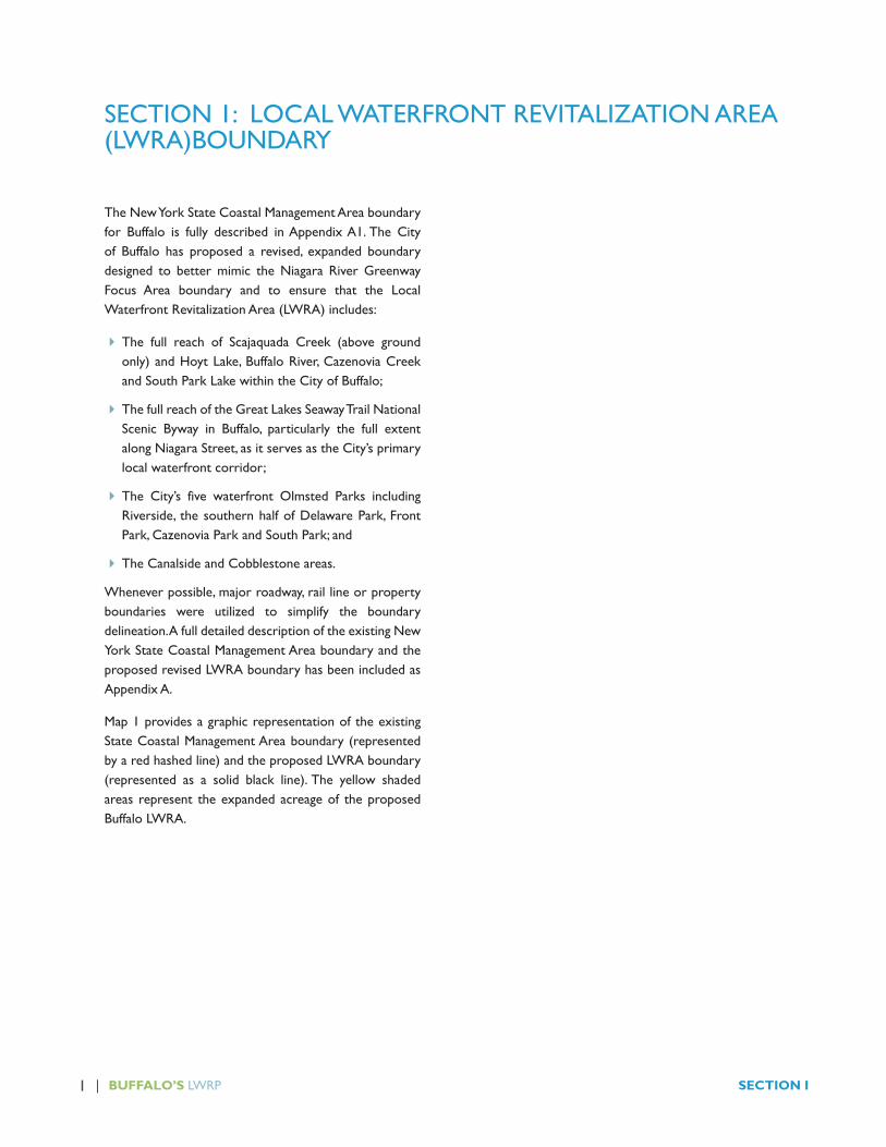
1 | BUFFALO’S LWRP SECTION I
The New York State Coastal Management Area boundary for Buffalo is fully described in Appendix A1. The City of Buffalo has proposed a revised, expanded boundary designed to better mimic the Niagara River Greenway Focus Area boundary and to ensure that the Local Waterfront Revitalization Area (LWRA) includes:
� The full reach of Scajaquada Creek (above ground only) and Hoyt Lake, Buffalo River, Cazenovia Creek and South Park Lake within the City of Buffalo;
� The full reach of the Great Lakes Seaway Trail National Scenic Byway in Buffalo, particularly the full extent along Niagara Street, as it serves as the City’s primary local waterfront corridor;
� The City’s five waterfront Olmsted Parks including Riverside, the southern half of Delaware Park, Front Park, Cazenovia Park and South Park; and
� The Canalside and Cobblestone areas.
Whenever possible, major roadway, rail line or property boundaries were utilized to simplify the boundary delineation. A full detailed description of the existing New York State Coastal Management Area boundary and the proposed revised LWRA boundary has been included as Appendix A.
Map 1 provides a graphic representation of the existing State Coastal Management Area boundary (represented by a red hashed line) and the proposed LWRA boundary (represented as a solid black line). The yellow shaded areas represent the expanded acreage of the proposed Buffalo LWRA.
SECTION 1: LOCAL WATERFRONT REVITALIZATION AREA (LWRA)BOUNDARY

BUFFALO’S LWRP | 2LOCAL WATERFRONT REVITALIZATION AREA (LWRA) BOUNDARY
MAP 1 - LWRA BOUNDARY

BUFFALO’S LWRP | 3LWRP POLICIES
Water is a necessary ingredient for all life in Buffalo. Each year, the City of Buffalo community relies upon 43 inches of rain and snow combined with 22 billion gallons of water drawn from the Niagara River and the Great Lakes. That fresh water is essential for:
�Drinking;
�Growing, producing and cooking food;
� Bathing, cleaning and sanitation;
�Medicine;
� Cooling, heating and energy;
� Construction and manufacturing;
� Tourism;
� Fire fighting, street cleaning;
� •Energy production;
� Sports and recreation including swimming, fishing, boating, hockey and field sports;
� Fish and wildlife; and
� The trees, lawns and landscapes that we call home.
The federal and New York State Coastal Zone Management Programs recognize the importance of water to all New York communities. The programs establish 44 policies that collaborate to safeguard the state’s natural water resources; water based economic development; and community interests. All state and federal actions within the Coastal Zone should be consistent with these policies.
The Local Waterfront Revitalization Program allows Buffalo to:
� organize the policies in a way that can be easily understood by all stakeholders;
� identify key, local factors to be considered during consistency review; and
� propose new policies where necessary to reflect local conditions.
With this LWRP, Buffalo has organized and expanded upon the state’s coastal policies to achieve the following goals:1. Holistically protect the state’s coastal economic,
social, and environmental interests;
2. Safeguard the City’s access to clean, Great Lakes fresh water for generations to come;
3. Promote water based industry and enterprise;
4. Encourage commercial and recreational boating;
5. Build great water-enhanced places that enliven the waterfront and attract the public
6. Promote the City as an international gateway;
7. Protect and rebuild the Lake Erie/Niagara River food web – recognizing local fish as an important food source;
8. Provide for public water access in support of the public trust;
9. Maximize coastal resilience; and
10. Minimize environmental degradation from solid waste and hazardous substances.
GOAL 1. HOLISTIC COASTAL PROGRAM
Many inter-related interests come together within the LWRA. The City’s coastal program takes a holistic approach to waterfront revitalization, working to not only to balance these interests but capitalize upon their inter-dependence to build a sustainable waterfront economy, community and environment.
State Policy: To safeguard the vital economic, social and environmental interests of the state and of its citizens, proposed major actions in the coastal area must give full consideration to those interests, and to the safeguards which the state has established to protect valuable coastal resources.
SECTION II – LWRP POLICIES

4 | BUFFALO’S LWRP SECTION II
GOAL 2. SAFEGUARD ACCESS TO CLEAN, GREAT LAKES FRESH WATER
Buffalo is fortunate to be located on the Great Lakes, home to 20% of the world’s surface fresh water. The entire flow of the upper four Great Lakes travels past the City on its route north to Lake Ontario - 200,000 cubic feet per second of flow - twice the water flowing over Niagara Falls. The City draws its entire drinking water supply from Lake Erie.
Today, Buffalonians take access to clean, fresh water for granted. But this was not always the case. Substantial investment in the Colonel Ward water treatment facility, hazardous waste remediation, industrial and municipal sewage treatment and sediment remediation have dramatically improved the City’s access to clean water. The City has also benefited from long standing bi-national efforts to protect and improve Lake Erie water quality and quantity upstream of the water intakes
Continued local investment in the water supply system, storm water management, combined sewer overflow reduction, sanitary sewer overflow elimination, septic maintenance and industrial pollution prevention are necessary to safeguard water quality for generations to come. In addition, the City will depend upon the continued success of bi-national Great Lakes level efforts to reduce contaminants of concern and address excess nutrients in Lake Erie.
Looking forward, the Great Lakes are also facing emerging water quantity issues as water shortages generate pressure from outside the basin for water withdrawal and climate change threatens to reduce overall lake levels. The Great Lakes Compact provides a framework for managing these demands, but requires all Great Lakes States to implement water conservation measures, helping to ensure that water consumption does not outpace the Lakes’ 1% annual recharge rate.
The following LWRP policies are designed to safeguard the water quality and quantity of Buffalo’s Great Lakes fresh water resources.
State Policies
2A - Municipal, industrial and commercial discharges of pollutants, including but not limited to toxic and hazardous substances, into coastal waters will conform to state and national water quality standards.
SEQRA, site plan and consistency review of policy 2A should consider efforts to improve and protect the City’s waterways such as the Lake Erie Lakewide Management Plan and the bi-national Niagara River Toxics Management Plan.
2B - Best management practices will be used to ensure the control of combined sewer overflows, storm water runoff and nonpoint source pollution, including nutrients, organics and soils, draining into coastal waters.
SEQRA, site plan and consistency review of policy 2B within the Buffalo LWRA should consider
a. Compliance with Buffalo storm water management requirements;
b. the Buffalo Sewer Authority Combined Sewer Overflow (CSO) Long Term Control Plan (LTCP) to address sewer overflows through a balance of traditional “gray” infrastructure, as well as innovative “green” solutions; and
c. Buffalo and the Western New York Stormwater Coalition’s efforts to implement New York State Stormwater Regulations and prevent storm water pollution to local waterways.
2C - State coastal area policies and purposes of approved local waterfront revitalization programs will be considered while reviewing coastal water body classifications and while modifying water quality standards; however, those waters already overburdened with contaminants will be recognized as being a development constraint.
SEQRA, site plan and consistency review of policy 2C within the Buffalo LWRA should consider the Lake Erie Lakewide Management Plan, Buffalo and Niagara River Remedial Action Plan activities and other efforts to improve water quality in support of the City’s waterfront revitalization.

BUFFALO’S LWRP | 5LWRP POLICIES
2D - The quality and quantity of surface waters and groundwater supplies will be conserved and protected, particularly where such waters constitute the primary or sole source of water supply.
SEQRA, site plan and consistency review of policy 2D in the City of Buffalo LWRA should consider:
a. Protection of Lake Erie as the City’s sole source water supply;
b. New York’s implementation of the Great Lakes Compact water quantity management and conservation provisions;
c. Minimizing adverse impacts of Buffalo River Improvement Corporation (BRIC) operational changes on the quality and quantity of flow of the Buffalo River; and
d. Protection of the historic Jubilee Springs and West Side Consolidated Aquifer groundwater resources.
Buffalo Policy
2E - Support Great Lakes and New York State efforts to prevent emerging contaminants of concern such as pharmaceuticals, silicone and microplastics and cyanobacteria from adversely impacting the Lake Erie-Niagara River public water supply and food web.
GOAL 3. PROMOTE WATER BASED INDUSTRY & ENTERPRISE
Access to abundant, fresh water creates unique opportunities for waterborne transport, water dependent industry, enterprise and energy development. By definition, water dependent uses must be located on or adjacent water for success.
The following state policies protect and support Buffalo’s working waterfront.
3A - Encourage the development of the state’s existing major ports of Albany, Buffalo, New York, Ogdensburg and Oswego as centers of commerce and industry, and encourage the siting, in these port areas, including those under jurisdiction
of state public authorities, of land use and development which is essential to or in support of waterborne transportation of cargo and people.
SEQRA, site plan and consistency review policy 3A within the Buffalo LWRA should examine:
a. Waterborne industrial transport associated with the grain elevators, Kelly Island, City Ship Canal, and the Ford Terminal Complex;
b. Opportunities to expand water borne transport; and
c. Recreational and commercial boating throughout the City’s waterfront.
3B - Facilitate the siting of water-dependent uses and facilities on or adjacent to coastal waters
SEQRA, site plan and consistency review of policy 3B within the Buffalo LWRA should consider:
a. Potential adverse impacts or interference with the continued operation of existing water-dependent uses; and
b. Support for the development of new water-dependent uses where:
• The need for dredging is minimized;
• Waterside and landside access, as well as upland space for parking and other facilities, is adequate;
• Necessary infrastructure exists or is easily accessible, including adequate shoreline stabilization structures, roads, water supply and sewage disposal facilities, and vessel waste pump-out and waste disposal facilities;
• Water quality classifications are compatible;
• Impacts to important natural resources, such as wetlands and fish and wildlife habitats, could be avoided or minimized to the greatest extent practicable; and
• Public access to the water’s edge can be maintained, to the greatest extent practicable.

6 | BUFFALO’S LWRP SECTION II
3C - Strengthen the economic base of smaller harbor areas by encouraging the development and enhancement of those traditional uses and activities which have provided such areas with their unique maritime identity.
SEQRA, site plan and consistency review of this policy should examine opportunities to encourage “blue-economy” enterprise and water dependent and related institutions and businesses within the LWRA. Candidate ventures include, but are not limited to, water and Great Lakes research and educational facilities, fish hatcheries, aquaculture, boat manufacturing, boat sales and services, and fishing-related businesses, including fishing charter companies, bait, equipment and license sales shops.
3D - Decisions on the siting and construction of major energy facilities in the coastal area will be based on public energy needs, compatibility of such facilities with the environment and the facility’s need for a shorefront location.
SEQRA, site plan and consistency review of policy 3D should thoroughly examine and document potential adverse impacts to:
a. the environment; and
b. the Buffalo community’s use and enjoyment and access to local waters for recreation, transportation and economic development.
GOAL 4. ENCOURAGE COMMERCIAL AND RECREATIONAL BOATING
Commercial and recreational boating are a critical component of the LWRA economy and community waterfront experience. These activities include, but are not limited to, Great Lakes cruise ships, the Queen City Ferry, excursion boats such as the Miss Buffalo and Moondance and Spirit of Buffalo, floating classrooms Buffalo Outdoor Education Foundation, fishing charters, party boats, motorized and human powered pleasure craft.
Approximately, 24,500 boats were registered in Erie County in 2013. The Great Lakes region ranks first,
accounting for more than a quarter (27 percent) of registered boats in the United States.
A full description of boating facilities in the Buffalo LWRA has been presented in the Inventory Section III regarding Harbor Management. Such activities are compatible with many residential and commercial uses, and can locate throughout the waterfront where market and site conditions permit.
The following LWRP policies are designed to encourage commercial and recreational boating within the Buffalo LWRA:
State Policy
4A - Dredging and dredge spoil disposal in coastal waters will be undertaken in a manner that meets existing state dredging permit requirements, and protects significant fish and wildlife habitats, scenic resources, natural protective features, important agricultural lands and wetlands.
Buffalo Policies
4B - Support the provision of launches and platforms for human powered boating in suitable locations.
SEQRA, site plan and consistency review of policy 4B should consider the following factors in determining a site’s suitability:
a. adjacent upland and in-water uses;
b. avoidance of U.S. Coast Guard designated safety and security zones and sensitive ecological areas;
c. health and safety factors including larger vessel traffic, water quality and presence of detritus;
d. upland attributes including destination and attractions, proximity to parks, boat storage and proximity to public restrooms;
e. water conditions including strength of current, wave and wake action and water depth;
f. upland transportation including proximity to bike networks and greenways, transit; and parking facilities.

BUFFALO’S LWRP | 7LWRP POLICIES
4C - At access points for human-powered boating where safety hazards are high, potential safety hazards should be minimized.
SEQRA, site plan and consistency review of policy 4C should consider the following factors:
a. operational measures to secure the facility to avoid unmonitored use;
b. appropriate training of users;
c. safety measures to avoid conflicts with commercial vessels, including communication with water dependent industrial users;
d. safety measures for avoiding exposure to contaminated water and sediments.
4D - Encourage the design of piers and docks to accommodate multiple water dependent uses, a wide range of users and dynamic water levels.
SEQRA, site plan and consistency review of policy 4D should consider:
a. Potential uses may include recreational boating (motorized and human powered), tie up for historic and educational ship, passenger ferries and charter facilities;
b. Use of universal design to ensure that facilities can be used by virtually everyone, regardless of their ability or disability, is recommended; and
c. The impacts of high winds, seiche and flood events, climate change and long term lake level decline into the planning and design of fixed and floating structures.
4E - Incorporate, where feasible and appropriate, safety features on bulkheads and seawalls to allow emergency access from the waterway onto land. These features should not promote entry into the water where conditions may not be appropriate for recreation.
4F - Minimize conflicts between recreational, commercial, and freight vessels.
SEQRA, site plan and consistency review of policy 4F should consider:
a. Giving priority to commercial vessels when determining rights to navigable waters;
b. Siting recreational boating facilities, particularly those serving vessels with limited power and maneuverability, in waters without heavy concentrations of maritime and industrial, ferry, and commercial vessel activity; and
c. Siting mooring or docking facilities for recreational boats in areas where there is adequate natural protection or where structurally adequate and environmentally sound protection can be created; and
d. Siting facilities for human and wind powered vessels so as to avoid locations with strong currents and those prone to heavy wave or wake action.
4G - Minimize the impact of commercial and recreational boating activities and facilities on the aquatic environment and surrounding land and water uses.
SEQRA, site plan and consistency review of policy 4G for boating facilities, marinas, and boat launches, should consider the following factors:
a. Measures to prevent spillage of petroleum products at refueling stations and to clean up when spillage occurs;
b. The minimization of runoff from boat yards and service areas to prevent invasive species, petroleum products, paints, solvents, and other substances harmful to the environment from entering the aquatic environment;
c. Compliance with vessel waste discharge regulations and the provision of adequate pump out facilities; and
d. Minimization of potential erosion impacts from new or existing marinas on surrounding natural shorelines.
4H - Dredging and harbor operations, including vessel speed limits, should be managed to protect ecological resources, particularly Buffalo River Environmental Dredging project Buffalo River and City Ship Canal in-situ capping and ecological restoration sites.
4I - Three contaminated sediment confined disposal facilities (CDFs) are located within the LWRA: Times Beach, the Small Boat Harbor and at the City’s southern boundary southwest of the
8 | BUFFALO’S LWRP SECTION II
Union Ship Canal. To protect public health and the environment:
a. Reuse of these sites and adjacent lands should consider potential contamination impacts; and
b. Periodic monitoring of water quality in adjacent recreational and habitat area waters is recommended.
GOAL 5. BUILD GREAT WATER-ENHANCED PLACES THAT ENLIVEN THE WATERFRONT AND ATTRACT THE PUBLIC
Where traditional industrial uses have declined or relocated, many coastal areas offer opportunities for commercial and residential development that would revitalize the waterfront. Benefits of redevelopment include providing new housing opportunities, fostering economic growth, and reestablishing the public’s connection to the waterfront. Strategic transportation projects should be implemented to improve multi-modal travel within and between LWRA places and reduce the adverse impacts of LWRA highway facilities. . Redevelopment activities should protect and enhance the unique scenic, historic and cultural elements of the Buffalo LWRA. New activities generated by redevelopment of the coastal area should comply with applicable state and national air quality standards and should be carried out in accordance with zoning regulations for the waterfront.
The following LWRP policies are designed to encourage the development of great, water-enhanced mixed use areas that capitalize upon the water’s ability to define place and enhance quality of life within the Buffalo LWRA:
State Policies
5A - New water enhanced, mixed use development shall be directed to the areas identified in the Action Strategy and identified on Maps 2 and 3. These areas feature access to the water, waterfront parks, trails and views; the presence of adequate shoreline protection structures and utility service; location on strategic waterfront transportation routes; waterfront heritage resources and potential to elevate adjacent neighborhood
property values. These sites are uniquely suited to the development of water-enhanced uses that derive benefit from a waterfront location, but do not require such a location to function, such as a restaurant or residential properties.
5B - Protect, restore and enhance natural and manmade features which are not identified as being of state-wide significance but which contribute to the scenic quality of the coastal areas.
SEQRA, site plan and consistency review of policy 5B within the Buffalo LWRA should examine protection and enhancement of:
a. the Great Lakes Seaway Trail National Scenic Byway in Buffalo through the implementation of the City’s Complete Streets ordinance and incorporation of landscaping, heritage interpretation and pedestrian amenities into roadway improvement projects.
b. marinas, piers, wharfs and mooring areas as unique waterfront landscapes; and
c. Niagara River Globally Significant Important Bird Area viewing sites.
5C - Protect, enhance and restore structures, districts, areas or sites that are of significance in the history, architecture, archeology or culture of the state, its communities or the nation.
In addition to compliance with historic preservation laws, SEQRA, site plan and consistency review of policy 5C within the Buffalo LWRA should consider impacts on the following Buffalo waterfront heritage themes:
a. Native American archeological resources;
b. War of 1812;
c. Erie Canal;
d. Historic waterfront grain elevators;
e. Underground Railroad structures and routes;
f. Waterfront industrial heritage resources;
g. Waterfront Frederick Law Olmsted parks, particularly park features designed to provide views of, and access to, the City’s waterways; and
BUFFALO’S LWRP | 9LWRP POLICIES
h. Historic waterfront lighthouses and bridges.
Buffalo Policies
5D - The following short term waterfront transportation projects should be encouraged within the LWRA:
a. Reinforce the Great Lakes Seaway Trail and Ohio Street as the City’s primary multi-modal local waterfront transportation corridors with streetscape improvements and clear wayfinding signage, particularly between Niagara Street and Ohio Street;
b. Reinforce the Shoreline Trail and Jesse Kregal Creekside Trail multi-modal off-road routes with improved signage and amenities;
c. Minimize the impact of NYS Route 198 on waterfront ecological, historic and public access resources;
d. Minimize the impact of I-190 on waterfront public access and property values in the short term through
• Improved pedestrian connections below Route I-190 in Black Rock/Riverside;
• Improvement of the former Breckenridge Toll Plaza land along Black Rock Canal for public access; and
• Improvements to the parking facilities located beneath the I-190 to maximize parking and provide attractive gateways between the downtown and the water;
• Improvements to the Virginia/Carolina Thruway interchange;
e. Minimize at-grade parking facilities within the LWRA to preserve land for public access along the water’s edge and adjacent in-land commercial development;
f. Minimize waterfront truck traffic to the maximum extent practicable, redirecting through traffic to non-waterfront routes, while supporting truck traffic associated with local business; and
g. Improve the connection between Main Street and the waterfront through the Cars Sharing Main Street Project and improvements to the Erie Street radial.
5E - The following long term waterfront transportation projects should be encouraged within the LWRA:
a. Reduce the footprint of the I-190 and the adverse impacts on Niagara Street redevelopment areas, public access and property values. Options previously considered include improved regional traffic management, relocation of the I-190 in Black Rock/Riverside to the Tonawanda rail corridor and/or the conversion of Route I-190 to a boulevard;
b. Reduce the impact of the I-198/I-190 interchange on Scajaquada Creek, Black Rock Canal and the Scajaquada Harbor redevelopment areas, public access and property values;
c. Develop the Buffalo River Greenway as the southern complement to the Jesse Kregal Creekside Trail system;
d. Construct a connection between the Tifft Street and Route 190 to redirect truck traffic from the waterfront inland and support the redevelopment of the Riverbend Brownfield Opportunity Area; and
e. Remove the Skyway bridge overpass.
5F - Develop coordinated, high quality signage within the LWRA to assist in wayfinding and celebrate unique LWRA cultural, recreational and environmental features.
SEQRA, site plan and consistency review of this policy within the LWRA should review consistency with:
a. The Unified Development Ordinance;
b. federal National Scenic Byway signage regulations; and
c. Niagara River Greenway signage guidelines.
GOAL 6. PROMOTE BUFFALO AS AN INTERNATIONAL GATEWAY
The international border between the US and Canada serves as the western boundary of the Buffalo LWRA. The Buffalo Niagara region serves as the second largest port of entry along the nation’s northern border, home to 15% of all trade between the U.S. and Canada. Within
10 | BUFFALO’S LWRP SECTION II
the City of Buffalo LWRA, the Peace Bridge, International Railroad bridge and the Erie Basin Marina Outlying Area Reporting Station serve as gateways for people, boats and cargo travelling between the US and Canada.
In addition to policy 3A above, the following policies promote the development of the City and LWRA as a high quality international gateway.
Buffalo Policies
6A - Support the location of proposed International Trade Gateway hard and soft infrastructure, within the LWRA
6B - Support the creation of attractive landscapes that welcome travelers from Canada through the
1. Revitalization of former industrial structures and vacant lands along Niagara Street, north of the Peace Bridge to Ferry Street; and
2. Development of landscape gateway features
i. along Route I-190 in LaSalle Park;
ii. between the Hope VI housing project and Route I-190;
iii. at the Carolina/Virginia Thruway interchange;
iv. at Porter Avenue; and
v. at the US Peace Bridge Plaza.
6C - Support improved connections between the US Shoreline Trail and the Niagara River Parkway trail bicycle and pedestrian trail system;
6D - Support cross-border recreational boating and fishing with clearly identified marine border check-in sites;
6E - Promote improve passenger train connections along the waterfront from downtown Buffalo through Niagara Falls to Toronto;
6F - Facilitate and incentivize Buffalo resident enrollment in the Nexus trusted traveler program;
6G - Explore opportunities for cross border interpretation of the War of 1812, Underground
Railroad and bi-national water/energy/ecological management efforts.
6H - Minimize adverse impacts of international gateway functions on the LWRA, particularly vulnerable environmental justice populations.
GOAL 7. PROTECT AND REBUILD THE LAKE ERIE/NIAGARA RIVER FOOD WEB
While no commercial fisheries are known to exist on Lake Erie in New York, Lake Erie remains the largest freshwater commercial fishery in Canada, and one of the most valuable freshwater commercial fisheries in the world. In 2011, the Lake Erie commercial fishing industry caught nearly 22 million pounds of fish worth $28 million, much of which were sold to food stores and restaurants in Ontario, the U.S. and around the world. The total value of Lake Erie’s commercial fishery was $194 million in 2011.
Within the Buffalo LWRA, Lake Erie and Niagara River are home to several sport fishing charter businesses, bait shops, numerous shoreline fishing sites with large numbers of residents, including the City’s growing immigrant communities, relying upon locally caught fish as a source of protein.
In addition, LWRA natural systems host large native deer and turkey communities; several rare, threatened or endangered species; and a globally significant bird corridor. Because hunting is prohibited due to urban site conditions, the City, and the LWRA in particular, serves as an informal regional wildlife preserve.
The following policies will help rebuild the Lake Erie-Niagara River food web, supporting sport and subsistence fishing in the short term and contributing to the long term restoration of sustainable commercial fishing in NY’s Lake Erie waters. These policies will also contribute to the protection of the City’s globally significant bird community and rare, threatened and endangered species.
State Policies

BUFFALO’S LWRP | 11LWRP POLICIES
7A - Expand recreational use of fish and wildlife resources in coastal areas by increasing access to existing resources, supplementing existing stocks and developing new resources. Such efforts shall be made in a manner which ensures the protection of renewable fish and wildlife resources and considers activities dependent on them.
SEQRA, site plan, and consistency review of policy 7A should examine:
a. protection of the local habitat sites, including breeding grounds, identified in the Inventory Section IIC4;
b. protection and management of native stocks and the restoration of sustainable populations of indigenous fish living in Lake Erie, Niagara River, Buffalo River and Scajaquada Creek systems, as discussed in Inventory Section IID; and
c. protection of fishing access sites and wildlife viewing facilities, as identified in Inventory Section IVC5.
7B - Significant coastal fish and wildlife habitats, as identified on the coastal area map, shall be protected, preserved, and where practical, restored so as to maintain their viability as habitats.
Consistency review of policy 7B within the Buffalo LWRA shall consider the Times Beach, North Buffalo Harbor, Small Boat Harbor and Tifft Nature Preserve state-designated Significant Coastal Fish and Wildlife Habitats, as described in Inventory Section II C1.
7C - Preserve and protect tidal and freshwater wetlands and preserve the benefits derived from these areas.
7D - Further develop commercial finfish, shellfish and crustacean resources in the coastal area by: (1) encouraging the construction of new or improvement of existing on shore commercial fishing facilities; (2) increasing marketing of the state’s seafood products; and maintaining adequate stocks and expanding aquaculture facilities. Such efforts shall be made in a manner which ensures the protection of such renewable fish resources and considers other activities.
7E - Effluent discharge from major steam electric generating and industrial facilities into coastal waters will not be unduly injurious to fish and wildlife and shall conform to state water quality standards.
SEQRA, site plan and consistency review of policy 7E should consider the migratory, spawning and nursery patterns of Niagara River and Lake Erie fish and wildlife communities.
Buffalo Policies
7F - Protect, preserve, improve and restore, where practicable, publicly owned local habitat areas identified in the Inventory Section II C1.
7G - Protect, improve and restore naturalized shoreline areas in support of the Buffalo and Niagara River Great Lakes Areas of Concern Delisting Criteria for Beneficial Use Impairment #14, which requires that a minimum of 25% of the shoreline in Areas of Concern be restored to natural slope, shallows and aquatic vegetation.
Consistency review of policy 7G within the Buffalo LWRA should consider the City’s protection of State and Federal wetlands located within the LWRA as open space under the UDO as well as opportunities for constructing wetlands in support of the Buffalo and Niagara River Remedial Action Plan habitat restoration objectives.
7H - Prevent, to the maximum extent practicable, the introduction of aquatic invasive species to the Great Lakes.
7I - Protect public health from contaminated fish
SEQRA, site plan and consistency review of policy 7I should consider:
a. Support Buffalo and Niagara River Remedial Action Plan and Lake Erie Lakewide Area Management Plan efforts identified in the Inventory Section II.E. to reduce contamination and restore local fisheries so that New York State Department of Health Fish Consumption Advisories are no longer required to protect public health.

12 | BUFFALO’S LWRP SECTION II
b. Support efforts to educate local subsistence anglers on New York State Department of Health fish consumption advisory provisions.
7J - Protect and enhance the Niagara River Globally Significant Important Bird Area (IBA) through:
a. Protection and enhancement of bird habitat areas; and
b. Avoidance of disruptions to bird migration to the maximum extent practicable.
GOAL 8. PROVIDE PUBLIC WATER ACCESS IN SUPPORT OF THE PUBLIC TRUST
Throughout the City of Buffalo’s waterfront planning history, there has been a consistent, unwavering call for public access to the City’s shoreline and waterways.
The following policies support public access to the shoreline and waterways.
State Policies
8A - Access to the publicly owned foreshore and to lands immediate adjacent to the foreshore or the water’s edge that are publicly owned shall be provided, and it should be provided in a manner compatible with adjoining uses. Such lands shall be retained in public ownership.
SEQRA, site plan and consistency review of policy 8A within the Buffalo LWRA should examine:
a. protection and enhancement of public access to the water, foreshore and adjacent lands on publicly-held waterfront lands; and
b. protection of public real property interests in waterfront lands
8B - Protect, maintain and increase the levels and types of access to public water-related recreation resources and facilities so that these resources may be fully utilized by all the public in accordance with reasonable anticipated public recreation
needs and the protection of historic and natural resources.
SEQRA, site plan and consistency review of policy 8B within the Buffalo LWRA should examine:
a. Protection, maintenance and improvements to existing public waterfront access and water-dependent recreation facilities, as identified in the Inventory Habitat, Marina and Recreation sections;
b. The development and implementation of a long term parks/recreation/open space master plan for the LWRA and City as a whole, as described in the Action Strategy, that strategically addresses the many opportunities for creating new public water-based recreation access within the context of operations and maintenance constraints and economic development objectives; and
c. Limits on public access and recreational activities where uncontrolled public use would lead to disruption of the environmental cleanup measures, fish and wildlife resources, erosion control or flood protection functions.
8C - Water dependent and enhanced recreation shall be encouraged and facilitated and shall be given priority over non-water-related uses along the coast, provided it is consistent with the preservation and enhancement of other coastal resources and takes into account the demand for such facilities. In facilitating such activities, priority shall be given to areas where access to the recreation opportunities of the coast can be provided by new or existing public transportation services and to those areas where the shore is restricted by existing development.
8D - Development, when located adjacent to the shore, shall provide for water-related recreation, as a multiple use, whenever such recreational use is appropriate in light of reasonable anticipated demand for such activities and the primary purpose of the development.

BUFFALO’S LWRP | 13LWRP POLICIES
GOAL 9. MAXIMIZE COASTAL RESILIENCY
Portions of the LWRA are subject to periodic flooding associated with snow melt, heavy rain, high Lake Erie winds and Lake seiche events. In addition, the release of the Lake Erie ice flow has potential impacts on erosion, sedimentation, waterfront structures and the Niagara Power Project intakes. Both the state and federal government have actively engaged communities in coastal resilience planning, promoting the use of green infrastructure, natural protective features, land use regulation and strategic structural protection.
The following policies are designed to maximize resiliency to high water and wind events in accordance with state and federal Coastal Resiliency guidance. In addition, a periodic review of Ice Boom operations is suggested to fully consider both the protective function of the boom as well as any adverse impacts.
The following policies are designed to maximize resiliency to high water and wind events in accordance with state and federal coastal resiliency guidance. In addition, a period review of Ice Boom operations is suggested to fully consider both the protective function of the boom as well as any adverse impacts.
9A - Activities or development in the coastal area will be undertaken so as to minimize damage to natural resources and property from flooding by protecting natural protective features including beaches, dunes, barrier islands and bluffs. Primary dunes will be protected from all encroachments that could impair their natural protective capacity.
SEQRA, site plan and consistency review of policy 9A within the Buffalo LWRA should consider the protective function of:
a. Times Beach Nature Preserve;
b. Outer Harbor Greenbelt (including the Bell Slip);
c. Tifft Nature Preserve;
d. Gallagher Beach;
e. Cazenovia Park;
f. Stachowski Park;
g. Seneca Bluffs;
h. LaSalle Park;
i. Delaware Park;
j. Jesse Kregal Pathway;
k. Squaw Island;
l. Local habitat areas.
9B - Buildings and other structures will be sited in the coastal areas so as to minimize damage to property and the endangering of human lives caused by flooding and erosion.
SEQRA, site plan and consistency review of policy 9B within the Buffalo LWRA should consider:
a. limiting damage from flooding and erosion by:
• Preserving existing publicly held open space along the City’s waterfront
• Requiring that new development be set back from the high water mark
• Requiring the maintenance of a vegetated riparian buffer; and
• Requiring on site storm water management for most new development.
b. City of Buffalo Charter Article 31 regarding Flood Damage Prevention which regulates land use and development that occurs within the 100-year floodplain.
c. Construction and insurance requirements of the Federal Emergency Management Agency and the US Department of Housing and Urban Development.
d. City of Buffalo, Buffalo Sewer Authority and Western New York Stormwater Coalition efforts to implement storm water management best practices throughout the region to reduce the speed and volume of storm water flow to area waterways during precipitation and snow melt events.
9C - Whenever possible, use nonstructural measures to minimize damage to natural

14 | BUFFALO’S LWRP SECTION II
resources and property from flooding and erosion. Such measures shall include
• the setback of buildings and structures;
• the planting of vegetation and installation of sand fencing and drainage;
• the reshaping of bluffs; and
• the flood proofing of buildings or their elevation above the base flood level.
9D - Activities and development, including construction or reconstruction of erosion protection structures, shall be undertaken so that there will be no measurable increase in erosion or flooding at the site of such activities or development, or at other locations; and there is a reasonable probability of controlling erosion for at least thirty years as demonstrated in design and construction standards and/or assured maintenance or replacement programs.
Public funds shall only be used for erosion protective structures where necessary to protect human life and new development which requires a location within or adjacent to an erosion hazard area to be able to function, or existing development; and only where the public benefits outweigh the long term monetary and other costs including the potential for increasing erosion and adverse effects on natural protective features.
SEQRA, site plan and consistency review of policy 9D within the Buffalo LWRA should consider the protection and maintenance of the following existing shoreline protective features:
a. Bird Island Pier, Buffalo Harbor break walls and the Erie Basin Marina to protect the City shoreline from Lake Erie related flooding and erosion;
b. Erosion control structures that protect the Colonel Ward Pumping Station and Buffalo Sewer Authority Bird Island Treatment Plant;
c. Erosion control structures associated with LWRA remediated sites or confined disposal facilities; and
d. Erosion control structures associated with LWRA waterfront transportation facilities.
9E - Mining, excavation or dredging in coastal waters shall not significantly interfere with the natural coastal processes which supply beach material to land adjacent to such waters and shall be undertaken in a manner which will not cause an increase in erosion of such land.
9F - Ice management practices shall not damage significant fish and wildlife and their habitats, increase shoreline erosion or flooding, or interfere with the production of hydroelectric power
Buffalo Policies
9G - Develop more detailed information regarding the potential impacts of climate change on the Buffalo LWRA that consider Buffalo’s unique location on the Niagara River strait, bi-national water level management agreements, permitted discharge agreements, dredging, ice and flood management activities.
9H - The Niagara River Ice Boom should be periodically reviewed to determine any potential adverse impacts of ice boom operations on:
a. water recreation and industry;
b. the Buffalo microclimate and growing season;
c. Lake Erie evapotranspiration rates and water levels;
d. fish and wildlife and their habitats; and
e. Niagara River erosion and sedimentation patterns.
GOAL 10. MINIMIZE ENVIRONMENTAL DEGRADATION FROM SOLID WASTE AND HAZARDOUS SUBSTANCES
The disposal of solid waste (residential, industrial and commercial waste demolition and construction debris; sledges from air, water pollution control, or resource recovery facilities; and dredge spoils) can affect the use and quality of the city’s waterways and coastal lands.

BUFFALO’S LWRP | 15LWRP POLICIES
Among the concerns associated with the disposal and treatment of solid wastes and hazardous substances are the environmental damage caused by illegal dumping and the potential for contamination of water resources and coastal habitat areas, filling of wetlands and littoral areas, and degradation of scenic resources in the coastal zone.
Projects involving the handling, management, transportation or discharge of solid wastes and hazardous substances need to comply with the applicable state and local laws or their successors. Solid wastes are those materials defined under ECL 27-0701 and 6 NYCRR Part 360-1.2. Hazardous wastes are those materials defined under ECL 27 -0901 and 6 NYCRR Part 371. Substance hazardous to the environment are defined under ECL 37-0101. Toxic pollutants are defined under ECL 17-0105. Radioactive materials are defined under 6 NYCRR Part 380. Pesticides are those substances defined under ECL 330101 and 6 NYCRR Part 325.
In addition to policy 4A, the following policies are designed to minimize environmental degradation from solid waste and hazardous substances.
State Policies
10A - Protect fish and wildlife resources in the coastal area from the introduction of hazardous wastes and other pollutants which bioaccumulate in the food chain or which cause significant sublethal or lethal effects on those resources.
SEQRA, site plan and consistency review of policy 10A within the Buffalo LWRA should consider the ongoing implementation of the Remedial Action Plans (RAPs) for the Buffalo and Niagara River Great Lakes Areas of Concern, the Lake Erie Lakewide Area Management Plan (LAMP) and the Bi-National Niagara River Toxics Management Plan.
10B - Activities related to the shipment and storage of petroleum and other hazardous materials will be conducted in a manner that will prevent or at least minimize spills into coastal waters; all practicable efforts will be taken to expedite the cleanup of such discharges; and restitution for damages will be required when these spills occur.
10C - The transport, storage, treatment and disposal of solid wastes, particularly hazardous wastes, within coastal areas will be conducted in such a manner so as to protect groundwater and surface water supplies, significant fish and wildlife habitats, recreation areas, important agricultural lands and scenic resources.
SEQRA, site plan and consistency review of policy 10C within the Buffalo LWRA should consider compliance with on-site hazardous and solid waste disposal area clean-up performance standards.
Buffalo Policies
10D - Support the Buffalo River Great Lakes Legacy Act Environmental Dredging Project and the strategic removal of contaminated sediments from the Buffalo River.
10E - Support efforts to characterize and address contaminated sediment and/or botulism concerns in Black Rock Canal, Scajaquada Creek, Hoyt Lake, Mirror Lake and South Park Lake.
10F - The location of new petroleum and other hazardous material shipment and storage facilities, junk/salvage yards, recycling facilities, waste transfer facilities shall be prohibited within the LWRA.
10G - All major chemical and petroleum facilities shall submit plans for the prevention and control of petroleum and chemical discharges to the City Emergency Management Services office.
10H - Existing chemical or petroleum storage facilities, including gas stations, and junk and salvage yards located within the LWRA must operate in such a manner as to prevent or reduce water pollution, air pollution, noise pollution, obnoxious odors, litter, vector infestation and other conditions harmful to public health and the environment.
OTHER STATE POLICIES
Policy 24 - Prevent the impairment of scenic resources of statewide significance

16 | BUFFALO’S LWRP SECTION II
Policy 29 - Encourage the development of energy resources on the outer continental shelf, in Lake Erie and in other water bodies and ensure the environmental safety of such activities.
Policy 32 - Encourage the use of alternative or innovative sanitary waste systems in small communities where the costs of conventional facilities are unreasonably high given the size of the existing tax base of these communities.
As per Buffalo Sewer Authority use regulation 10075.4, sanitary sewer facilities for all structures in the City of Buffalo shall be provided in accordance with the Buffalo City Code and shall be connected with the facilities of the Buffalo Sewer Authority.
Policy 42 - Coastal management policies will be considered if the State reclassifies land areas pursuant to the prevention of significant deterioration regulations of the Federal Clean Air Act.
No land areas have been designated under the Federal Clean Art Act to prevent significant deterioration.

BUFFALO’S LWRP | 17ACTION STRATEGY
The vision for the City is to reestablish the waterfront as a thriving and vital part of the community and a destination for tourism and economic activity.
Over the last 20 years, substantial investments have been made in the City’s public waterfront access infrastructure, including canals, boat launches, marinas, fishing sites, waterfront trails, promenades, active recreation parks and nature preserves. Significant ecological improvements have also been made, including sewer overflow reductions, brownfield cleanups, habitat restoration projects and the Buffalo River sediment remediation project. Together, these efforts have dramatically transformed Buffalo’s former industrial, polluted waterfront into a vibrant asset showing real signs of recovery. Opportunities exist to expand and improve upon these improvements but capital and operational funding constraints remain the primary impediment to new investments.
While open space and recreational opportunities have been expanded, year round waterfront entertainment, retail, housing, and employment opportunities remain limited. Recent programming efforts sponsored by Erie Canal Harbor Development Corporation (ECHDC) have generated high-volume visitor activity. There is, however, a need to build self-sustaining mixed uses in the City’s redevelopment focus area. To goal is for the waterfront to be an “exciting urban place, where restaurants, retail, entertainment, recreational activities, and cultural and family destinations - in short, “things to do” - are embedded into an authentic, walkable district”.1.
This City of Buffalo LWRP proposes a waterfront revitalization strategy that activates the City’s built waterfront and develops a long-term funding strategy for the implementation of the Niagara River Greenway open space and heritage preservation vision.
Specifically, the strategy aims to:
� Clearly identify waterfront redevelopment and open space areas in the Unified Development Ordinance(UDO) based upon the Brownfield Opportunity Area and Local Waterfront Revitalization Program inventories and analyses;
�Make strategic public investments in those redevelopment areas to encourage private development investments and generate long-term revenue;
�Develop a mechanism to capture new waterfront revenue for reinvestment in the LWRA; and
� Leverage that waterfront revenue to improve, expand and maintain public boating, fishing, open space, habitat and heritage assets.
I. Proposed Land Uses
Buffalo’s Comprehensive Plan was adopted by the Buffalo Common Council in 2006. The Plan set the agenda for the city’s future by outlining five fundamental principles: fix the basics; build on assets; implement smart growth; embrace sustainability and invest strategically. The LWRP and the Buffalo Harbor, Buffalo River Corridor, South Buffalo and Tonawanda Street Corridor. BOA’s generated a detailed inventory of the City’s waterfront resources. The LWRP’s policies utilize the inventory to tailor State coastal policies to reflect local conditions.
Based upon these guiding documents, the City of Buffalo Land Use Map and UDO:
� Protect existing water-dependent industrial uses in the lower reaches of the Buffalo River, such as General Mills and ADM, and around the Union Ship Canal through industrial zoning provisions and setback exceptions for water dependent uses;
� Promotes water-enhanced uses that get added value from their waterfront location including housing,
SECTION III - ACTION STRATEGY (PROPOSED LAND AND WATER USES AND PROPOSED PROJECTS)
1 Mayor’s Waterfront Forum Summary

18 | BUFFALO’S LWRP SECTION III
restaurants and cultural amenities through zoning that reflects actual conditions;
� Encourages new water-enhanced infill and redevelopment of waterfront vacant land and buildings through mixed use zoning at:
1. Black Rock Harbor;
2. Scajaquada Creek Campus*;v
3. Niagara Street (Elmwood to Porter and Busti to Forest)*;
4. Cotter Point Maritime Community;
5. Erie Street between Main and Lakeside Boulevard*
6. Canalside*;
7. Cobblestone* ;
8. Ohio/Ganson Street including ”Riverworks”and Freight House Landing*;
9. Ford Terminal Complex / Freezer Queen*; and
10. City Ship Canal Village*.
*indicates a Brownfield Opportunity Area Strategic Site.
� Supports light industrial redevelopment in the LWRA at Silo City, Lakeside Commerce Park,, Riverbend (adjacent South Park), Ford Terminal Complex, Elk Street and Niagara Street;
� Protects publicly held water-dependent and water-enhanced recreation and natural resources through open space zones;
� Protects the numerous ecological functions of shoreline buffer areas through required waterfront setbacks and vegetated buffer requirements; and
�Minimizes the impacts of non-water dependent or water-enhanced activities such as trucking and junkyard operations, while limiting the introduction of new uses that would be deleterious in a waterfront environment.
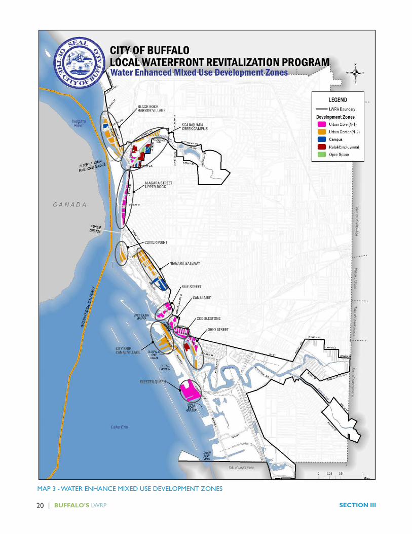
Map 2 illustrates the proposed land uses and zoning for the City’s LWRA. Map 3 indicates the City’s priority mixed use, water enhanced development areas.
II. Proposed Water Enhanced Mixed Use Development Areas
Under the City’s Land Use Plan and Unified Development Ordinance, several major waterfront mixed use nodes are proposed. These areas, highlighted on Map 3, offer access to the water, waterfront parks, trails and views; the presence of adequate utilities and shoreline protection structures; location on strategic waterfront transportation routes; waterfront heritage resources; and the potential to elevate adjacent neighborhood property values. These sites are uniquely suited to the development of water-enhanced uses that derive benefit from a waterfront location, but do not require such a location to function, such as a restaurant or residential properties.

BUFFALO’S LWRP | 19ACTION STRATEGY
MAP 2 - FUTURE LAND USE PLAN / UDO ZONES
20 | BUFFALO’S LWRP SECTION III
MAP 3 - WATER ENHANCE MIXED USE DEVELOPMENT ZONES

BUFFALO’S LWRP | 21ACTION STRATEGY
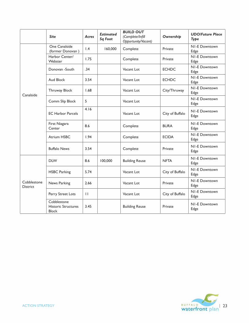
The following table summarizes the major development nodes and sites, the acreage at each site and building square footage where available, whether the site build out is complete or would involve infill, building reuse or construction on a vacant lot, site ownership and the UDO place type that will govern its redevelopment.
Site Acres Estimated Sq Foot
BUILD OUT STATUS (Complete/Infill Opportunity/Vacant)
OwnershipUDO Zone/Future Place Type
Black Rock Harbor Village
Black Rock Canal Park Mixed Use Building Site
.10 Vacant Lot Erie County Open Space
Acqua/West Marine 5.28 Infill Private N2-T Mixed
Use Transition
Watergate and Riverview 7.23 Complete Private
D-R – Residential Campus
Rich Marine 23.55 Smelting Works Building Reuse/Infill Private N2-T Mixed
Use Transition
Niagara Street/”Upper Rock”
Peace Bridge to Forest 1,079,983 Multiple Building
Reuse/Infill/ Private
N-1S Secondary Employment Center
Vacant Lots Vacant Lot
N-1S Secondary Employment Center
Cotter Point Maritime Center 6.67 Cinder Block
Building Reuse/InfillNew York State Open Space

22 | BUFFALO’S LWRP SECTION III
Site Acres Estimated Sq Foot
BUILD OUT (Complete/Infill Opportunity/Vacant)
Ownership UDO/Future Place Type
Waterfront Village/Erie Basin
Lakefront Commons, Harborpoint, The Breakwaters, Rivermist, Admiral’s Walk, Waterfront Place, The Pasquale, Waterfront Circle and Gull Landing
Complete PrivateD-R Residential Campus
240-260 Lakefront Boulevard
2.4 Vacant Lot BURAD-R Residential Campus
100 Lakefront Boulevard 2.77 Vacant Lot BURA D-R Residential
Campus
25,35 and 73 Ojibwa Circle 5.43 Vacant Lot BURA D-R- Residential
Campus
Waterfront Office Buildings 2.67 Complete Private N1-E Downtown
Edge
10 LaRiviere Drive 1.34 Vacant Lot BURA N1-E Downtown Edge
Erie Street Corridor
20 Lakefront Boulevard/Parcel A 2.93 Vacant Lot BURA N1-E Downtown
Edge
Parcel B/F (aka 10 LaRiviere Drive, 20 Wilkeson Way)
7 Vacant Lot Ellicott Development through 2014
N1-E Downtown Edge
Parcel C – Templeton Landing 2 83,074 Complete Private N1-E Downtown
Edge
Parcel G 1.2 Vacant Lot City of Buffalo N1-E Downtown Edge
Parcel E 3.675 Vacant Lot City of Buffalo N1-E Downtown Edge
Parcel D 2.76 Vacant Lot City of Buffalo N1-E Downtown Edge
Marine Drive Apartments 6.44 Complete BMHA D-R Residential
Campus
BUFFALO’S LWRP | 23ACTION STRATEGY
Site Acres Estimated Sq Foot
BUILD OUT (Complete/Infill Opportunity/Vacant)
Ownership UDO/Future Place Type
Canalside
One Canalside (former Donovan )
1.4 160,000 Complete PrivateN1-E Downtown Edge
Harbor Center/Webster
1.75 Complete PrivateN1-E Downtown Edge
Donovan -South .34 Vacant Lot ECHDCN1-E Downtown Edge
Aud Block 3.54 Vacant Lot ECHDCN1-E Downtown Edge
Thruway Block 1.68 Vacant Lot City/ThruwayN1-E Downtown Edge
Comm Slip Block 5 Vacant Lot N1-E Downtown Edge
EC Harbor Parcels4.16
Vacant Lot City of Buffalo N1-E Downtown Edge
First Niagara Center 8.6 Complete BURA N1-E Downtown
Edge
Atrium HSBC 1.94 Complete ECIDA N1-E Downtown Edge
Buffalo News 3.54 Complete Private N1-E Downtown Edge
CobblestoneDistrict
DLW 8.6 100,000 Building Reuse NFTA N1-E Downtown Edge
HSBC Parking 5.74 Vacant Lot City of Buffalo N1-E Downtown Edge
News Parking 2.66 Vacant Lot Private N1-E Downtown Edge
Perry Street Lots 11 Vacant Lot City of Buffalo N1-E Downtown Edge
Cobblestone Historic Structures Block
3.45 Building Reuse Private N1-E Downtown Edge

24 | BUFFALO’S LWRP SECTION III
Site AcresEstimated Sq Foot
BUILD OUT (Complete/Infill Opportunity/Vacant)
OwnershipUDO/Future Place Type
Ohio/Ganson Street/Old First Ward
Ohio Area1 24.62 Building Reuse/Infill PrivateN1-E Downtown Edge N1-E
Erie Freight 3.55 Building Reuse PrivateN1-E Downtown Edge
Kelly Island East
35.51 Vacant Lot PrivateN1-E Downtown Edge
Outer Harbor
Terminal Complex
32 655,222 Building Reuse/Vacant LotNFTA/ECHDC
N1-E Downtown Edge
Freezer Queen
19.77 533,400 Building Reuse/Vacant Lot PrivateN1-E Downtown Edge
ECHDC Parcel OH
5 Vacant Lot ECHDCN2-T Mixed Use Transition
Cargill Pier 7.37 Vacant LotN2-T Mixed Use Transition
NYPA Marina
17.2 Infill NYPAN2-T Mixed Use Transition
RCR Marina
10 Infill PrivateN2-T Mixed Use Transition
For many of the sites above, detailed development concepts have been prepared and are presented below.

25 | BUFFALO’S LWRP SECTION III
MAP 6 - ACTION STRATEGY PROJECTS

BUFFALO’S LWRP | 26ACTION STRATEGY
B. Scajaquada Creek Harbor
This is a Strategic Site within the Tonawanda Street Corridor Brownfield Opportunity Area, located along Scajaquada Creek at the nexus of Buffalo State College, the Niagara River/Black Rock Channel, Black Rock and West Side neighborhoods. The site is also historically significant, having been the location of key War of 1812 events. The proposed redevelopment for the site includes adaptive reuse of abandoned and under utilized industrial lands for a mix of uses, including recreational amenities, office and educational support businesses, and residential uses. The following concept images were prepared in support of the Tonawanda Street Corridor Brownfield Opportunity Area outreach process.
Scajaquada Creek Harbor Concept (Artist’s rendering for illustration purposes only)

BUFFALO’S LWRP | 27ACTION STRATEGY
A. Black Rock Harbor Village
The earlier Horizons Waterfront Action Plan proposed a 45 acre Black Rock Harbor Village concept with mixed-use infill development in the area between Black Rock Canal Park and the US Army Corps of Engineers site in Black Rock. Many of these ideas are still valid today. Proposed public investments include strengthening the neighborhood connections to the water through improvements to Niagara Street, Hertel Avenue, Austin Street, Ontario Street and Hamilton Street (including sidewalks, repaving and landscaping) and sewer and water service to the development sites. Additional support, including brownfield and historic tax credits, may be necessary for the Buffalo Smelting Works. The Black Rock waterfront continues to have strong potential for redevelopment.
Black Rock Harbor Concept (Artist’s rendering for illustration purposes only)
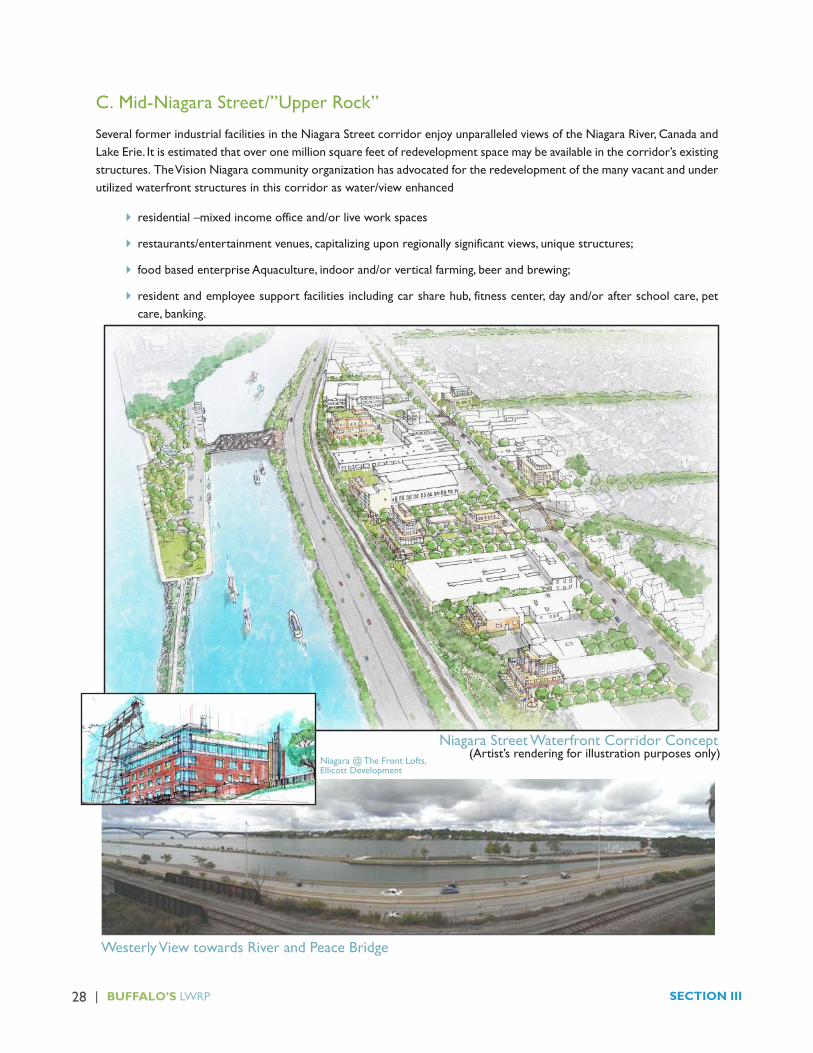
28 | BUFFALO’S LWRP SECTION III
C. Mid-Niagara Street/”Upper Rock”
Several former industrial facilities in the Niagara Street corridor enjoy unparalleled views of the Niagara River, Canada and Lake Erie. It is estimated that over one million square feet of redevelopment space may be available in the corridor’s existing structures. The Vision Niagara community organization has advocated for the redevelopment of the many vacant and under utilized waterfront structures in this corridor as water/view enhanced
� residential –mixed income office and/or live work spaces
� restaurants/entertainment venues, capitalizing upon regionally significant views, unique structures;
� food based enterprise Aquaculture, indoor and/or vertical farming, beer and brewing;
� resident and employee support facilities including car share hub, fitness center, day and/or after school care, pet care, banking.
Niagara @ The Front Lofts, Ellicott Development
Niagara Street Waterfront Corridor Concept
Westerly View towards River and Peace Bridge
(Artist’s rendering for illustration purposes only)

BUFFALO’S LWRP | 29ACTION STRATEGY
D. Cotter Point
Several water related organizations are clustered at the foot of Porter Avenue, including the Colonel Ward Pump Station, Buffalo Yacht Club, Navy Station, State University of New York Great Lakes Research Center, Frank Lloyd Wright Fontana Boathouse, West Side Rowing Club and recently restored historic Chief Petty Officer’s Club. This mixed-use node would build upon these assets to support the area’s cultural tourism efforts, environmental education and lakefront recreation.
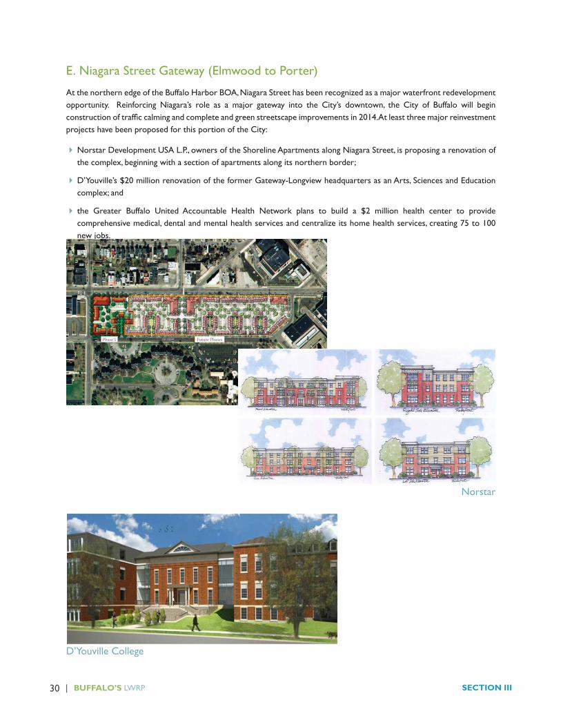
30 | BUFFALO’S LWRP SECTION III
E. Niagara Street Gateway (Elmwood to Porter)
At the northern edge of the Buffalo Harbor BOA, Niagara Street has been recognized as a major waterfront redevelopment opportunity. Reinforcing Niagara’s role as a major gateway into the City’s downtown, the City of Buffalo will begin construction of traffic calming and complete and green streetscape improvements in 2014. At least three major reinvestment projects have been proposed for this portion of the City:
�Norstar Development USA L.P., owners of the Shoreline Apartments along Niagara Street, is proposing a renovation of the complex, beginning with a section of apartments along its northern border;
�D’Youville’s $20 million renovation of the former Gateway-Longview headquarters as an Arts, Sciences and Education complex; and
� the Greater Buffalo United Accountable Health Network plans to build a $2 million health center to provide comprehensive medical, dental and mental health services and centralize its home health services, creating 75 to 100 new jobs.
Norstar
D’Youville College
ILLUSTRATIVE SITE PLAN - OVERALL
7TH STREET
NIAGARA STREET
PROSPECT AVE.
BUSTI AVE.
CA
RO
LIN
A
ST
RE
ET
GE
OR
GIA
S
TR
EE
T
W.
MO
HA
WK
S
T.
W.
HU
RO
N S
TR
EET
S. E
LM
WO
OD
AV
E.
7T
H S
TR
EET
RABIN TERRACE
Future PhasesPhase 1
0 ft. 100 ft. 200 ft. 300 ft. 400 ft.
Norstar Development USA, L.P.torti gallas and partners/ Stieglitz Snyder Architecture Waterfront revitalization
© Torti Gallas and Partners, Inc. | Spring Street, th floor, Silver Spring, Maryland | .. October 2nd, 2013PRELIMINARY Design Set
03

BUFFALO’S LWRP | 31ACTION STRATEGY
F. Erie Street
This Buffalo Harbor BOA project involves the realignment of Erie Street to reopen the connection between Main Street and the waterfront. This effort would re-establish the vista of the waterfront from downtown, recreate the historic Ellicott radial street pattern, improve pedestrian access and safety, and provide new urban development sites to help move the City to the waterfront. This project also provides opportunities to transform bridge underpasses from barriers to gateways through the use of lighting artwork, signage and wayfinding.
G. Canalside
The Canalside project is situated on a 23-acre site on the Inner Harbor, that includes the former War Memorial Auditorium property, the former Donovan office building property and the Webster Block. This project expands upon and incorporates the success of the Erie Canal Harbor Project as a tourist and recreational attraction and will include additional water-dependent and water enhanced elements. When complete, Canalside will offer a combination of commercial, retail, residential, lodging, entertainment and office components including the following projects:

32 | BUFFALO’S LWRP SECTION III
� The former War Memorial Auditorium property at the north end of the site will be redeveloped as a historically accurate re-creation of a portion of the Erie Canal. Public canals (east and west canals) are currently under construction to interpret the original alignment of the Erie Canal and the Commercial Slip. The canals are designed to evoke the character of the historic Canal District and emphasize downtown Buffalo’s connection to the waterfront. New public space will be added north and south of the west canal to offer a setting for four seasons programming, including public ice skating during the winter. Other proposed improvements for this area include a Canalside market for commercial and retail artisans, additional restaurants and cobblestone streets, public art, and a children’s museum.
� The Donovan Building mixed use redevelopment project, known as One Canalside, will include hotel accommodations and office space, with first-floor restaurant and retail space.
� The $172 million HarborCenter development on the Webster Block, the City’s largest ever private development, will house two hockey rinks, a hotel, restaurant, retail space and parking

BUFFALO’S LWRP | 33ACTION STRATEGY
H. Cobblestone
The Cobblestone district located between Canalside and the Seneca Casino on the north side of the Buffalo River is a Buffalo River Corridor Brownfield Opportunity Area (BOA) Strategic Site. The area is proposed for mixed use redevelopment to build on the current investment activity occurring in this area.
Cobblestone District Concept(Artist’s rendering for illustration purposes only)

34 | BUFFALO’S LWRP SECTION III
I. Ohio / Ganson Street Corridor
The Ohio/Ganson Street corridor, from Michigan Avenue to Louisiana, is a Buffalo River Corridor/Buffalo Harbor Brownfield Opportunity Area Strategic Site. The area is proposed for redevelopment as a water-enhanced mixed-use neighborhood. This redevelopment area includes more specific project proposals for the Freight House Landing, The Wharfs on Kelly Island and Silo City. The following images were prepared in support of the BOA community outreach meetings.
Ohio Street Corridor and Riverworks Concept(Artist’s rendering for illustration purposes only)

BUFFALO’S LWRP | 35ACTION STRATEGY
I. Riverworks
This project is a multi-phased redevelopment of a former industrial site. The site was most recently the home of Ontario Specialties Contracting. It contains the remains of a demolished concrete grain silo, an intact grain silo known as the GLF and several single story high bay warehouses. The project will be a combination of adaptive reuse and new construction. The end use will be a multi-purpose, year round, waterfront entertainment venue. The various facilities on the eight-acre parcel will be used as an event center, concert venue, brewery, restaurant, sporting complex, banquet facility and retail establishments. The 800-foot wharf will have docking facilities that will provide utility hookups for local and boaters. On site locker rooms and showers for boaters will be available along with other amenities.
Freight House Landing Rendering
J. Freight House Landing
Located immediately south of the NYS DEC Public Access Fishing Site on Ohio Street, adjacent the Bison City Rod and Gun Club, this project includes deco instruction and salvage of the condemned timber frame Historic Erie Freight House. Erection of a 5-story new-build mixed use project featuring office space and up to 78 market rate apartments is proposed. The project will include a new 25’ setback from the Buffalo River’s edge and water access to promote river use and recreation.

36 | BUFFALO’S LWRP SECTION III
K. Silo City
Silo City is the home to several historic grain elevators, creating a unique industrial landscape. The site is proposed for a mixture of light industrial, office, commercial and residential uses. This project, Silo City – Phase I Improvements will add a public access dock, allowing for access from the Buffalo River, electrical service for lighting and safety, and security measures and restroom facilities.
L. Freezer Queen/Ford Terminal Complex
Several large, vacant industrial structures are located immediately north of the Small Boat Harbor on the Outer Harbor. The Ford Terminal Complex, owned by the Niagara Frontier Transportation Authority and the Freezer Queen manufacturing facility. These facilities offer unique opportunities for water enhanced mixed use development.

BUFFALO’S LWRP | 37ACTION STRATEGY
III. Proposed Water Uses
Reflecting changes in the larger Buffalo economy, industrial waterborne shipping within the Buffalo LWRA has declined dramatically since its peak prior to the opening of the Welland Canal and St. Lawrence Seaway in 1959. Simultaneously, improved water quality and public launch sites, including adaptive launch facilities, have created opportunities for an expanding array of water-based recreation, including paddle boarding, kayaking/canoeing, rowing, windsurfing, sailing, personal watercraft, chartered excursion boats and power boats. A full list of public and private launch, marina and mooring facilities is provided in the Inventory Section III D.
Industrial waterborne transport activities are expected to continue in the Black Rock Channel, City Ship Canal, from the mouth of the Buffalo River to the Blue Tower Turning Basin, in the Buffalo Harbor channel, from the Ford Terminal Complex harbor to the Confined Disposal Facility and Holcim properties at the City’s southern border.
Commercial and recreational boating is expected to continue throughout the LWRA, constrained by existing bridge clearance and/or environmental conditions as follows:
� Vessels with high masts typically do not travel up the Buffalo River past the Michigan Avenue lift bridge due to the delay associated with lift bridge operations;
� Sailboats do not typically travel on the Niagara River, instead using the Black Rock Channel, due to the swift current;
�Only kayaks and canoes travel up the Scajaquada Creek due to low bridge clearances and the need to portage the finger dam; and
�Only kayaks and canoes travel up the Buffalo River past Bailey Avenue and Cazenovia Creek due to low water levels.
Navigational rights-of-way are well established and educational materials are available through the NYS Office of Parks, Recreation and Historic Preservation and/or the US Coast Guard. Navigation security and
emergency response is performed by the US Coast Guard, US Department of Homeland Security, Erie County Sheriff ’s Office and the City of Buffalo Police Department Underwater Recovery Team as described in the Inventory Section III. E.
No swimming beach facilities currently exist in the City of Buffalo. Open water swimming activities are conducted at the risk of the swimmer.
Both sport and subsistence fishing activities are expected to continue throughout the LWRA. The long term development of a sustainable commercial fishery is supported..
IV. Proposed Projects
The City’s short term waterfront revitalization strategy aims to induce private investment in the redevelopment areas stipulated in the UDO. This redevelopment will generate waterfront vibrancy in the form of retail and hospitality services as well as long term tax base and revenue, needed to fully achieve the Niagara River Greenway vision.
The following short term public projects have been specifically identified to help encourage private investment in the City’s waterfront redevelopment areas. More detailed project description information including sponsor, location, graphic, budget and funding information has been provided on individual project profile sheets that follow.
Transportation Projects
T1. Complete the Niagara Street/Great Lakes Seaway Trail National Scenic Byway Reconstruction Project from Niagara Square to Ontario Street, including complete street and transit facilities, high quality landscaping, street furniture and heritage interpretation facilities;
T2. Finalize the design and implementation of the Scajaquada Expressway boulevard feasibility project;
T3. Improve the Virginia/Carolina I-190 interchange at Niagara Street as a City waterfront gateway;

38 | BUFFALO’S LWRP SECTION III
T4. Implement the Erie Street Extension project from Main Street to Lakeside Boulevard;
T5. Implement the Cars on Main Project from Terrace to South Park; and
T6. Design and implement the Perry Street/Cobblestone Connection, consistent with the Ohio and Niagara Street efforts.
Public Space/Amenity Projects
A1. Implement the Black Rock Canal Park Improvements;
A2. Complete heritage interpretive elements of Broderick Park improvements;
A3. Implement the LaSalle Park/Black Rock Canal shoreline stabilization project;
A4. Coordinate public investments in the Erie Basin Marina, Small Boat Harbor and NYPA First Buffalo Marina docks and boating service facilities to maximize benefit to the boating community;
A5. Implement the Grain Elevator and Waterfront Bridge lighting project; and
A6. Develop a master plan for the City’s parks, open spaces, trails and greenways.
Public Facility Rehabilitation
PF1. Relocate or screen the City’s auto impound to reduce visual blight;
PF2. Repurpose the Cotter Point former army storage building;
PF3. Explore opportunities to utilize the Colonel Ward Pumping Station historic structure for public access and waterfront revitalization activities;
PF4. Phase development of public parcels in Canalside and Erie Basin Marina
PF5. Reactivate the DL&W Station;
PF6. Reactivate the Ford Terminal Complex on the Outer Harbor; and
PF7. Secure the City-owned Cargill Pool and Concrete Central grain elevators and study opportunities for reuse and heritage interpretation.
Private Investment Support
� Provide brownfields cleanup and asbestos remediation support, as well as façade and landscape improvement incentives for the mixed use and industrial redevelopment areas;
� Support Historic Preservation Tax Credits and energy efficiency funding for private reuse of iconic historic waterfront structures, particularly the Buffalo Smelting Works, Agway Grain Storage Building, Grain Elevators and Freezer Queen; and
� Explore opportunities to further incentivize water dependent business activities (such as tax exemptions for fishing and boating equipment sales) within the LWRA.
While the primary focus of the LWRA revitalization efforts will center on inducing private investment, several other major public initiatives and projects are integral to the long term health of the City’s waterfront revitalization area including:
� Implementation of the Buffalo Sewer Combined Sewer Overflow Long Term Control Plan green and grey infrastructure projects;
� Implementation of the Buffalo and Niagara River Remedial Action Plans including, but not limited to, numerous habitat protection and restoration projects and remediation of contaminated sediments in Scajaquada Creek;
� Restoration of the historic Buffalo Olmsted Park system elements located within the LWRA; and
� Updating the City’s parks, recreation and greenway plans, including the Buffalo River Greenway and Riverwalk Revitalization projects.

BUFFALO’S LWRP | 39ACTION STRATEGY
MAP 13 - TRANSPORTATION PLAN

40 | BUFFALO’S LWRP PROPOSED PROJECTS
TRANSPORTATION PROJECTS
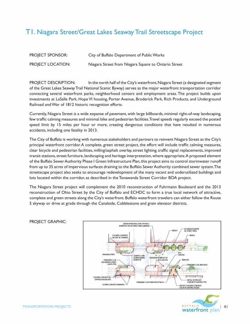
BUFFALO’S LWRP | 41TRANSPORTATION PROJECTS
T1. Niagara Street/Great Lakes Seaway Trail Streetscape Project
PROJECT SPONSOR: City of Buffalo Department of Public Works
PROJECT LOCATION: Niagara Street from Niagara Square to Ontario Street
PROJECT DESCRIPTION: In the north half of the City’s waterfront, Niagara Street (a designated segment of the Great Lakes Seaway Trail National Scenic Byway) serves as the major waterfront transportation corridor connecting several waterfront parks, neighborhood centers and employment areas. The project builds upon investments at LaSalle Park, Hope VI housing, Porter Avenue, Broderick Park, Rich Products, and Underground Railroad and War of 1812 historic recognition efforts.
Currently, Niagara Street is a wide expanse of pavement, with large billboards, minimal right-of-way landscaping, few traffic calming measures and minimal bike and pedestrian facilities. Travel speeds regularly exceed the posted speed limit by 15 miles per hour or more, creating dangerous conditions that have resulted in numerous accidents, including one fatality in 2013.
The City of Buffalo is working with numerous stakeholders and partners to reinvent Niagara Street as the City’s principal waterfront corridor. A complete, green street project, the effort will include traffic calming measures, clear bicycle and pedestrian facilities, milling/asphalt overlay, street lighting, traffic signal replacements, improved transit stations, street furniture, landscaping and heritage interpretation, where appropriate. A proposed element of the Buffalo Sewer Authority Phase I Green Infrastructure Plan, this project aims to control stormwater runoff from up to 35 acres of impervious surfaces draining to the Buffalo Sewer Authority combined sewer system. The streetscape project also seeks to encourage redevelopment of the many vacant and underutilized buildings and lots located within the corridor, as described in the Tonawanda Street Corridor BOA project.
The Niagara Street project will complement the 2010 reconstruction of Fuhrmann Boulevard and the 2013 reconstruction of Ohio Street by the City of Buffalo and ECHDC to form a true local network of attractive, complete and green streets along the City’s waterfront. Buffalo waterfront travelers can either follow the Route 5 skyway or drive at grade through the Canalside, Cobblestone and grain elevator districts.
PROJECT GRAPHIC:

42 | BUFFALO’S LWRP PROPOSED PROJECTS
Project Component
Lead Agency
Location Estimate (D/C)
Design Construction Funded Source
Gateway DPW So. Elmwood to Carolina
$4.7 M 2013 2014 Yes
Gateway Extension
DPW Carolina to Porter
$1.2/$2 M 2013 2014 Yes
Niagara Phase IIA
DPW Porter to Busti
$5.2M 2014 2015 Design
but not ConstructionNiagara Phase III
DPW Busti to Tonawanda Street
$10.2M 2014 2015 Design
but not ConstructionNiagara Phase III
DPW Tonawanda to Ontario
$ 9.4 M 2014 2015 Design
but not ConstructionBus Livability Project
NFTA So. Elmwood to Ontario
$3.6 M 2013 Yes US DOT
Green Infrastructure
BSA Carolina to Porter, Forest to Ontario
$2.3 M 2013-2014
2014-? Yes BSA LTCP
Green Infrastructure
BSA Prospect to Forest
$1 M 2014 2015 Yes EPA

BUFFALO’S LWRP | 43TRANSPORTATION PROJECTS
T2. Scajaquada Expressway Boulevard Project
PROJECT SPONSOR: New York State Department of Transportation
PROJECT LOCATION: NYS 198 Expressway, from Kensington Expressway (NYS Rte 33) to Interstate -190
PROJECT DESCRIPTION: The purpose of this project is to convert Scajaquada Expressway into a principal urban arterial (non-expressway) and landscaped boulevard. The project will feature new at-grade intersections, enhanced pedestrian and bicyclist accommodations, improved aesthetics, and decorative lighting in an effort to reduce operating speeds, improve overall safety, and develop a community gateway.
The Scajaquada Expressway was constructed in the 1950’s through the middle of the historic, Olmsted-designed Delaware Park. Park features on the north side of the expressway, which include the Buffalo Zoological Gardens, Delaware Park Golf Course, Mirror Lake and the Buffalo Historical Museum, are separated from facilities on the south side of the expressway, including the Marcy Casino, Hoyt Lake and the nationally renowned Albright-Knox Art Gallery. Delaware Park, the educational and cultural institutions, and the residences and businesses that surround the Scajaquada corridor also generate numerous pedestrian and bicycle trips within the area. The expressway facility is at odds with the context of the surrounding culturally-rich community resources, acting as a barrier, dividing the park, and hindering the use of these resources by pedestrians and bicyclists.
The goal is to achieve greater harmony with the surrounding community character and natural environment, and coordinate motor vehicle, bicycle, and pedestrian transportation. Furthermore, there is a need to address documented transportation deficiencies including:
� geometric features that do not meet current expressway standards;
� traffic congestion that occurs at one or more locations during peak travel periods;
� vehicular operating speeds that exceed the posted limit and design speed;
� higher than expected accident rates, accident severity, and identifiable accident patterns; and
� deteriorating drainage systems that no longer function as designed and release untreated stormwater into Scajaquada Creek.

44 | BUFFALO’S LWRP PROPOSED PROJECTS
Scajaquada Image Before Scajaquada Image After
PROJECT GRAPHIC:
PROJECT ELEMENTS:
Lead Agency
Location Estimate EIS/ROD Final
Design Construction Funded SourceDOT
Full Corridor 2014 YesDOT Full Corridor $2 M 2015 No TBDDOT Grant $20M 2016 No TBDDOT Elmwood $20M 2017 No TBDDOT Delaware $ 20M 2018 No TBDDOT Parkside $ 20M 2019 No TBD

45 | BUFFALO’S LWRP PROPOSED PROJECTS
T3. Niagara St./Virginia/Carolina I-190 Interchange Gateway Project
PROJECT SPONSOR: New York State Department of Transportation
PROJECT LOCATION: I-190 Interstate Niagara Street On/Off Ramp at Virginia St./Carolina St.
PROJECT DESCRIPTION: Reconstruction of the I-190 interchange at Niagara Street, which includes Virginia and Carolina Streets. The original construction of this interchange impacted the historic urban fabric of the neighborhood; due to heavy traffic flow, it continues to impact the area physically and visually. This project involves removal of the on-ramp from Virginia Street to recapture the land for public use; reconfiguration of the intersection of Niagara, Virginia and Carolina Streets, including the possible use of a round-about to guide traffic onto the I-190; installation of safe pedestrian crossings; and construction of new connections between the neighborhood and the waterfront via Virginia and Carolina Streets.
PROJECT GRAPHIC:
Earlier concept showing grand boulevard connecting Niagara Street to new waterfront parkway and LaSalle Park
Sketch concept alternative

BUFFALO’S LWRP | 46TRANSPORTATION PROJECTS
T4. Erie Street Waterfront Connection
PROJECT SPONSOR: City of Buffalo Department of Public Works
PROJECT LOCATION: Erie Street, from Main to Lakeside Boulevard
PROJECT DESCRIPTION: This project involves the realignment of Erie Street to reopen the connection between Main Street and the waterfront. This effort would re-establish the vista of the waterfront from downtown, recreate the historic Ellicott radial street pattern, improve pedestrian access and safety, and provide new urban development sites to help move the City to the waterfront. This project also provides opportunities to transform bridge underpasses from barriers to gateways through the use of lighting, artwork, signage and wayfinding.
PROJECT GRAPHIC:

47 | BUFFALO’S LWRP PROPOSED PROJECTS
T5. Cars on Main Waterfront Connection
PROJECT SPONSOR: City of Buffalo Department of Public Works
PROJECT LOCATION: Main Street from Exchange to Scott
PROJECT DESCRIPTION: Automobile traffic was removed from Main Street in 1982 when the Metro Rail system, including the pedestrian-transit mall freefare zone on Main Street was built. The Metro Rail system opened in 1984 and has benefited Downtown and our region. However, the pedestrian transit mall, completed two years later, limited access to Main Street and contributed to diminished occupancy and development, especially for first floor store fronts.
The primary objective of the project is to reopen Main Street to two-way vehicular traffic to stimulate economic development in downtown Buffalo, increase multi-modal access options and transit ridership, and improve the quality of life through higher visibility for retail shops, loading zones for shops and residential areas, and parking availability to allow easier access to buildings on Main Street.
PROJECT GRAPHIC:

BUFFALO’S LWRP | 48TRANSPORTATION PROJECTS
T6. Perry Street/Cobblestone Connector
PROJECT SPONSOR: Cobblestone District Connector Initiative –A consortium of private stakeholders including Savarino Companies, Buffalo Sabres, Seneca Gaming Corporation, Buffalo Creek Community Development Fund Advisory Committee and HSBC Bank
PROJECT LOCATION: Perry Street, from Main to Michigan Avenue
PROJECT DESCRIPTION: $3 million Streetscape improvement project along Perry Street to:
� Better connect Seneca Casino, numerous buildings that have been preserved and re-used in the Cobblestone District, HSBC Atrium, First Niagara Center, Webster Block, Canalside;
� Enhance the visual quality and user safety on this heavily-used streetscape;
� Improve the impression made on hundreds of thousands of visitors to Buffalo, as the corridor is the most utilized gateway to Canalside and First Niagara Center; and
�Utilize unique and exciting streetscape elements including pavement treatments, plantings, street furniture, and artistic lighting with active maintenance involvement from proven private entities.
PROJECT GRAPHIC:

BUFFALO’S LWRP | 49PUBLIC SPACE/AMENITY PROJECTS
PUBLIC SPACE/AMENITY PROJECTS

50 | BUFFALO’S LWRP PROPOSED PROJECTS
A1. Black Rock Canal Park Improvements
PROJECT SPONSOR: Erie County Parks
PROJECT LOCATION: Black Rock Canal Park, Ontario and Niagara Street intersection
PROJECT DESCRIPTION: Erie County’s Black Rock Canal Park is 4.25 acres in size. Opportunities to revitalize the park through trail and boat launch/dock improvements, gateway features, improved landscaping and revised parking have been explored in a detailed feasibility study.
Thefirstphaseoftheprojectinreconstructionoftheparkroadwere completed in 2012.
PROJECT GRAPHIC:

BUFFALO’S LWRP | 51PUBLIC SPACE/AMENITY PROJECTS
A2. Broderick Park Heritage Interpretation
PROJECT SPONSOR: City of Buffalo Department of Public Works
PROJECT LOCATION: Broderick Park, Squaw Island at Foot of West Ferry
PROJECT DESCRIPTION: The City of Buffalo has recently invested $1.5 million in the revitalization of Broderick Park, including new entrance features, a small performance amphitheater for educational performances, a waterfront promenade, new shelters and revised parking facilities.
Subsequent phases include renovation of the concession facility to serve as an Underground Railroad heritage interpretationcenter and installation of heritage interpretive features, particularly the Freedom Walk stations.
PROJECT GRAPHIC:

52 | BUFFALO’S LWRP PROPOSED PROJECTS
A3. Broderick and LaSalle Park Shoreline Stabilization
PROJECT SPONSOR: US Army Corps of Engineers
PROJECT LOCATION: Broderick Park/LaSalle Park
PROJECT DESCRIPTION: The US Army Corps of Engineers is preparing three elements of shoreline stabilization and ecological function along the Black Rock Chanel/ Niagara River:
•TheBroderickParkSection103projectaimstoprovideshoreline protection to approximately 4,500 feet of shoreline between the Niagara River and the Erie Canal that has been deteriorating due to continued wave action from the Niagara River.
•TheLaSalleParkSection103projectaimsprovidestormdamage reduction measures and protection to approximately 4,800 feet of shoreline along Lake Erie and the Niagara River that has been deteriorating due to the continued wave action from the lake.
•The Broderick Park Section 401 (Great Lakes Remedial Action Plan) projectaimstodesignforhabitatrestoration,seawallrepair,andEmerald Shiner passage to Lake Erie.
ProjectFactSheetsforeachelementdescribingbudgetsandtimeframesareattached.
PROJECT GRAPHIC:
Need to insert new image

BUFFALO’S LWRP | 53PUBLIC SPACE/AMENITY PROJECTS
A4. Coordinated Public Marina Improvements
PROJECT SPONSOR: City of Buffalo Department of Public Works, New York Power Authority (NYPA), Erie Canal Harbor Development Corporation (ECHDC), and New YorkOfficeofParks,RecreationandHistoricPreservation
PROJECT LOCATION: Erie Basin Marina, First Buffalo Marina, Small Boat Harbor
PROJECTDESCRIPTION: ThreepubliclyheldmarinasnowexistwithintheBuffaloHarborBrownfieldOpportunity Area, including the Erie Basin Marina, NYPA First Buffalo Marina and NFTA/ECHDC/NYS Parks Small Boat Harbor. This situation presents opportunities to coordinate marina facilities to maximize the benefitsofthepublicmarinasonthelocalboatingcommunity,localcommunityandeconomy.Thisprojectwould develop a coordinated public marina master plan, capital improvements priority list and explore options for coordinated service delivery.
PROJECT GRAPHIC:

54 | BUFFALO’S LWRP PROPOSED PROJECTS
A5. GrainElevatorandBridgeLightingProject
PROJECT SPONSOR: Erie Canal Harbor Development Corporation (ECHDC)
PROJECT LOCATION: Inner and Outer Harbor Grain Elevators and Bridges
PROJECT DESCRIPTION: ECHDC has approved a phased master plan for lighting installations to activate andilluminateBuffalo’sgrainelevatorsandbridgeswithlightsandvideoprojections.Phase1includeslightingtheConnecting Terminal, the Ohio Street bridge and the underside of the Skyway, as well as the completion of concept and marketing studies for an approximately 45 minute multimedia show at the Connecting Terminal. The next phase ofthisprojectwillincludefinaldesignandimplementationfortheMichiganStreetbridgeandtheGeneralMillsindustrial complex. Future phases set forth a much grander vision to illuminate 14 grain elevators in all – 13 along the Buffalo River, plus the Pool elevator on Lake Erie. The future plans also include the potential to incorporate 3-D videoprojection,fire,smoke,sound,pyrotechnicsandotherspecialeffectsfortheConnectingTerminal, locatedacross from Canalside, along the north edge of the outer harbor.
Preliminaryestimatesforallfourphasesoftheprojectareupwardof$20million;Phase1hasreceived$5millionin funding from ECHDC. Annual operational costs would range between $700,000 and $1 million. Funding is not currently committed to future phases.
Those elements of the plan that are economically and environmentally sustainable, and offer a positive return on investment should be prioritized.
PROJECT GRAPHIC:

BUFFALO’S LWRP | 55PUBLIC SPACE/AMENITY PROJECTS
A6. Open Space and Recreation Master Plan
PROJECT SPONSOR: City of Buffalo
PROJECT LOCATION: City of Buffalo parks, recreation facilities, right of way, open space lots, schools, community centers and public housing facilities.
PROJECT DESCRIPTION: Develop a City open space and recreation master plan, including a full property survey, facilities inventory, updated parks and open space master plan, capital improvement (including acquisition recommendations where appropriate) plan, operations and maintenance plan, recreational facilities plan. The plan must be based upon the City’s Consolidated Development Framework, extensive community outreach, and detailed analysis of recreation, environmental and economic development needs and opportunities. The plan development process shall include a review of the Olmsted Parks Master Plan, Niagara River Greenway Plan, Buffalo River Greenway & Dell proposals and any habitat restoration plans for the City, developed in support of the Buffalo or Niagara River Remedial Action Plans.
PROJECT GRAPHIC:
Need to insert new image

56 | BUFFALO’S LWRP PROPOSED PROJECTS
FACT SHEET
February 2013
BRODERICK PARK, BUFFALO – NY
Hurricane and Storm Damage Reduction Section 103 of the 1962 Rivers and Harbors Act, as amended
Construction General (Continuing Authorities Program)
Location
• Within the city of Buffalo, Erie County, NY along the Niagara River at the Foot of West Ferry Street
Project Description
• The purpose of the Broderick Park, Buffalo, ErieCounty,NYprojectistoprovideshorelineprotection to approximately 4,500 feet of shoreline between the Niagara River and the Erie Canal that has been deteriorating due to continued wave action from the Niagara River. Broderick Park is a multiple use recreation area that provides access to Bird Island (Nowak) Pier and is home to the city wastewater treatment plant
• First $100k is at 100% Federal expense to determine if federal interest exists
• Feasibility phase is cost-shared 50% Federal and 50% non-Federal
• Design and Implementation is cost-shared 65% Federal and 35% non-Federal
Importance
• Broderick Park includes a portion of the city’s wastewater treatment plant which treats and safely discharges city sewage. Protection will ensure the continued operation of the wastewater treatment plant, its ability to maintain uninterrupted service and safe and sanitary conditions for residents and the environment
Consequence
• If the current shoreline protection fails, the operation of the wastewater treatment plant wouldbejeopardizedandpublicaccesstotheparkand the pier may be curtailed
Project Phase
Est. Fed. Cost of Phase
Federal Funding through FY12
FY13 FY13 Budget
FY14 Requirement
FY14 Budget
TBD $40k $10k $10k $50k $0(1) First $100k is at 100% Federal expense. Design & Implementation costs have not been estimated and will be highly dependentontheactualplanidentifiedforimplementation.
CAP
Current Status
• Determination of Federal Interest efforts will continue based upon the availability of additional funding
ProjectSponsor/Customer
• The city of Buffalo has shown interest in serving as the non-Federal sponsor by letter dated September 2009
Congressional Interests
• Representative Brian Higgins D-NY-26
• Senator Charles Schumer D-NY
• Senator Kirsten Gillibrand D-NY
Issues
• None

BUFFALO’S LWRP | 57PUBLIC SPACE/AMENITY PROJECTS
Project Manager: Mike Draganac (716) 879-4370, [email protected]
CAP

58 | BUFFALO’S LWRP PROPOSED PROJECTS
FACT SHEET
February 2013
LASALLE PARK, BUFFALO – NY Hurricane and Storm Damage Reduction
Section 103 of the 1962 Rivers and Harbors Act, as amended Construction General (Continuing Authorities Program)
Location
• Within the city of Buffalo, Erie County, NY along the Niagara River
Project Description
• The purpose of the LaSalle Park, Buffalo, Erie County,NYprojectistoevaluatethefeasibilityofproviding storm damage reduction measures and protection to approximately 4,800 feet of shoreline along Lake Erie and the Niagara River that has been deteriorating due to the continued wave action from the lake
•TheproductforthisstudyisaDetailedProjectReport (DPR), which will address current conditions and review recommendations for potential new solutions
• Feasibility phase is cost-shared 50% Federal and 50% non-Federal
• Design and Implementation is cost-shared 65% Federal and 35% non-Federal
Importance
• LaSalle Park houses the Colonel F.G. Ward Pumping Station, a historic landmark, and water filtrationplantwhichsupplieswatertotheresidents of the city of Buffalo
•Theconcreteseawall,stonefilledtimbercrib,andtimber pile foundation fronting the pump station andparkhasdeterioratedsignificantlyoverthepast 50 years requiring measures to protect the city’swatersupply,pumpingstationandfiltrationplant, park, and access road
Consequence
• If the current shoreline protection fails, the operationofthepumpingstationandfiltrationplantwouldbejeopardizedandpublicaccesstothe park may be curtailed
Project PhaseEst. Fed. Cost of Phase
Federal Funding through FY12
FY13 FY13 Budget
FY14 Requirement
FY14 Budget
Feasibility1 $600k $130k $0 $0 $0 $0
Design & Implementation
TBD $0 $0 $0 $500k $0
CAP
ProjectSponsor/Customer • City of Buffalo
Congressional Interests • Representative Brian Higgins D-NY-26 • Senator Charles Schumer D-NY • Senator Kirsten Gillibrand D-NY
Current Status • A Feasibility Cost Share Agreement (FCSA) has been signed with the city of Buffalo •TheDraftDetailedProjectReport(DPR)isscheduled to be completed July 2013
Issues
• None

BUFFALO’S LWRP | 59PUBLIC SPACE/AMENITY PROJECTS
Project Manager: Mike Draganac (716) 879-4370,
CAP

60 | BUFFALO’S LWRP PROPOSED PROJECTS
PUBLIC FACILITY REHABILITATION AND ACTIVATION

61 | BUFFALO’S LWRP PROPOSED PROJECTS
PF1. City Auto Impound
PROJECT SPONSOR: City of Buffalo
PROJECT LOCATION: Terminus of Dart Street, immediately south of the Scajaquada Expressway and west of Grant Street
PROJECT DESCRIPTION: The City’s auto impound is located on a site that is highly visible from the Scajaquada Expressway and local streets. This facility is situated in an area associated with the former War of 1812 Naval Yard on Scajaquada Creek. In the short term, the plan is to screen this facility to improve aesthetics in the area. Long term, the facility would be relocated to a more appropriate area away from the waterfront. This site could be restored for mixed use development or integrated into an expanded Buffalo State College Campus as a part of the vision identified under BOA planning for this area.
PROJECT GRAPHIC:

BUFFALO’S LWRP | 62PUBLIC FACILITIES
PF2. Cotter Point Cinder Block Building
PROJECT SPONSOR: SUNY College at Buffalo
PROJECT LOCATION: Cotter Point east of the Great Lakes Center Lab, Foot of Porter Avenue
PROJECT DESCRIPTION: Ownership of this cinder block building, once used for US Army Reserve storage, has been transferred to the State University of New York College at Buffalo. Several proposals exist to renovate the building for use as a boating heritage amenity. The current building’s condition detracts from the high quality architecture of the adjacent Frank Lloyd Wright Fontana Boathouse and recent restoration of the historic Navy Boat House (former CPO Club).
PROJECT GRAPHIC:
Figure 1 Courtesy John Montague
Figure 2 Courtesy John Montague

63 | BUFFALO’S LWRP PROPOSED PROJECTS
PF3. Colonel Ward Pumping Station Heritage Tourism Activation
PROJECT SPONSOR: Buffalo Water Authority
PROJECT LOCATION: Foot of Porter Avenue/LaSalle Park
PROJECT DESCRIPTION: The Colonel Ward Pumping Station features high quality architectural and engineering elements, as well as a prime location on the City’s waterfront. This project would study the facility to determine what, if any, portions of the facility and site could be opened up to tourism activities in light of ongoing operational and homeland security restrictions, and what types of tourism related economic development activities might be feasible.
PROJECT GRAPHIC:
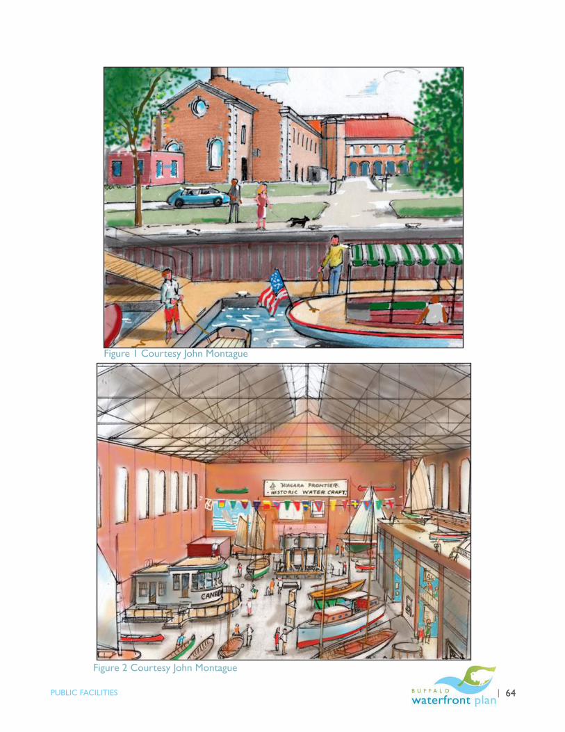
BUFFALO’S LWRP | 64PUBLIC FACILITIES
Figure 1 Courtesy John Montague
Figure 2 Courtesy John Montague

65 | BUFFALO’S LWRP PROPOSED PROJECTS
PF4. City Parcels at Canalside
PROJECT SPONSOR: City of Buffalo
PROJECT LOCATION: West of Main Street at Erie Canal Harbor/Canalside
PROJECT DESCRIPTION: The City owns several small designated development parcels west of Main Street. These parcels shall be strategically marketed for development in accordance with approved 2004 settlement provisions and the most recent Canalside Modified General Project Plans.
PROJECT GRAPHIC:

BUFFALO’S LWRP | 66PUBLIC FACILITIES
Figure 1 Courtesy John Montague
Figure 2 Courtesy John Montague
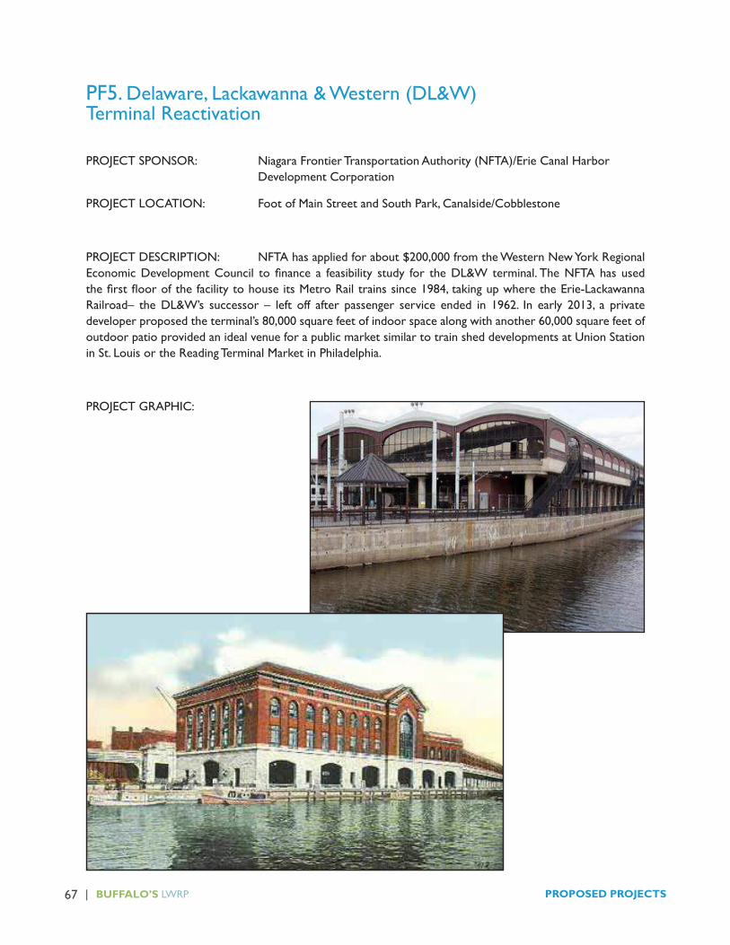
67 | BUFFALO’S LWRP PROPOSED PROJECTS
PF5. Delaware, Lackawanna & Western (DL&W)Terminal Reactivation
PROJECT SPONSOR: Niagara Frontier Transportation Authority (NFTA)/Erie Canal Harbor Development Corporation
PROJECT LOCATION: Foot of Main Street and South Park, Canalside/Cobblestone
PROJECT DESCRIPTION: NFTA has applied for about $200,000 from the Western New York Regional Economic Development Council to finance a feasibility study for the DL&W terminal. The NFTA has used the first floor of the facility to house its Metro Rail trains since 1984, taking up where the Erie-Lackawanna Railroad– the DL&W’s successor – left off after passenger service ended in 1962. In early 2013, a private developer proposed the terminal’s 80,000 square feet of indoor space along with another 60,000 square feet of outdoor patio provided an ideal venue for a public market similar to train shed developments at Union Station in St. Louis or the Reading Terminal Market in Philadelphia.
PROJECT GRAPHIC:
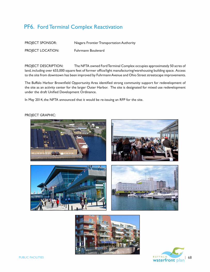
BUFFALO’S LWRP | 68PUBLIC FACILITIES
PF6. Ford Terminal Complex Reactivation
PROJECT SPONSOR: Niagara Frontier Transportation Authority
PROJECT LOCATION: Fuhrmann Boulevard
PROJECT DESCRIPTION: The NFTA owned Ford Terminal Complex occupies approximately 50 acres of land, including over 655,000 square feet of former office/light manufacturing/warehousing building space. Access to the site from downtown has been improved by Fuhrmann Avenue and Ohio Street streetscape improvements.
The Buffalo Harbor Brownfield Opportunity Area identified strong community support for redevelopment of the site as an activity center for the larger Outer Harbor. The site is designated for mixed use redevelopment under the draft Unified Development Ordinance.
In May 2014, the NFTA announced that it would be re-issuing an RFP for the site.
PROJECT GRAPHIC:

69 | BUFFALO’S LWRP PROPOSED PROJECTS
PF7. Cargill Superior and Concrete Central Grain Elevator
PROJECT SPONSOR: City of Buffalo
PROJECT LOCATION: Buffalo River
PROJECT DESCRIPTION: The City of Buffalo owns two major vacant grain elevators on the Buffalo River. The Concrete Central Elevator is listed on the National Register of Historic Places, built between 1915 and 1917 at the height of World War I. Due to it being the largest grain elevator in the world and concern over German sabotage, Concrete Central’s method of construction was top secret. The facility was utilized for grain storage until 1966. Concrete Central stretches along the Buffalo River for almost a quarter of a mile and is the largest elevator ever built in the Buffalo area. When in operation, it had the capacity to handle a total of 4.5 million bushels of grain. The elevator allowed crews to load and unload 20 railroad cars an hour and three marine legs along the Buffalo River could load and unload three massive lake freighters at one time.
The Cargill Superior Elevator has been identified by the State Historic Preservation Office as eligible for listing on the National Register of Historic Places. The Cargill Superior was designed and built by local architect A. E. Baxter in 1914 with section “A” and section “B” added in 1919. A final section, “C”, was added in 1925.
Both structures remain vacant and abandoned. This project would examine the necessary actions to stabilize the sites, as well as opportunities for short term heritage interpretation and long-term adaptive reuse.
PROJECT GRAPHIC:

70 | BUFFALO’S LWRP SECTION IV
A. Proposed Local Laws Necessary to Implement the LWRP
In addition to approving the LWRP itself, the Buffalo Common Council will approve the following actions necessary to implement the LWRP:
� A Comprehensive Land Use Plan, consistent with the LWRP land use plan;
•forbrownfieldopportunityarea(BOA)step 3 nominations;
� AUnifiedDevelopmentOrdinancethat:
• Establishes land uses within the LWRA;
• Establishes waterfront setbacks, vegetated buffer requirements, and façade treatments; and
• Requires site plan and consistency review for projects within the LWRA;
� A local consistency review law to ensure private development activities in the LWRA and local government actions are consistent with the Buffalo LWRP; and
� CreatesTransitionZones fortheOuterHarborandKelly Island. New development in these areas will have tomeetspecificperformancecriteriaandbeapprovedby the Buffalo Common Council.
� Termination of urban renewal areas as specified within the LWRA to eliminate any conflicts with the Unified DevelopmentOrdinance,maximizeclarity,consistencyand efficiency.
These laws have been drafted and shall be simultaneously submitted to the Buffalo Common Council for adoption.
B. Project Development
1. The City of Buffalo will spearhead the following LWRP Action Strategy project efforts:
Transportation
�Niagara Street Reconstruction
� Erie Street connections to Main Street
� CarsSharingMainStreet(ExchangetoScottStreet)
� Cobblestone District Connector
Public Space Amenity Project
� BroderickParkHeritageInterpretation
� CityofBuffaloOpenSpaceandRecreationMasterPlan
Public Facility Activation
� Buffalo Auto Impound Relocation
� Colonel Ward Pumping Station
� City Parcels at Canalside
� Cargill Superior and Concrete Central Grain ElevatorStabilization
In addition,
� The City will serve as the local project sponsor for the LaSalle and Broderick Park Army Corps of Engineers shoreline stabilization and environmental dredgingprojects;
� The Buffalo Sewer Authority will implement its long term control plan for combined sewer overflow abatement; and
� The Buffalo Sewer Authority and City of Buffalo will continue their participation in the WNY Stormwater Coalition and the Buffalo and Niagara River Remedial Action Plan efforts.
2. Erie County will continue to:
�Operate,maintainandimprovethefollowingCountyrecreation sites within the LWRA: Black Rock Canal Park, Tow Path Park, Red Jacket Park, Bailey Peninsula, and Seneca Bluffs Park;
�Operate,maintainand improvetheBuffaloBotanicalGardens and Frank Lloyd Wright Fontana Boathouse Facilities;
SECTIONIV-LOCALIMPLEMENTATION

BUFFALO’SLWRP | 71LOCAL IMPLEMENTATION
� Provide coordination and support services to the WNY Stormwater Coalition; and
� Support the use of the Confined Disposal Facility on CountylandattheCity’ssouthernborder,asnecessary,for the disposal of dredged material from the Buffalo River, Scajaquada Creek and South Park Lake.
C.LandOwnershipandConservation
TheCityofBuffaloanditslocalpartneragencies(BuffaloUrban RenewalAgency and Buffalo Municipal HousingAuthority) own substantial lands within the LWRA,including parks, schools, housing, streets and their rights-of-ways, paper streets,water and sewer facilities,development parcels, vacant open space and Buffalo River underwater lands. The City and its local partner agencies will continue to hold several developed parcels as per long term lease agreements. In addition, the City anticipates mixed use development of additional Cityowned parcels at Erie Basin, Canalside, Cobblestone, Riverbend and Lakeside Commerce Park. The City will explore opportunities to transition the Buffalo AutoImpound into more amenable uses. The City will also explore opportunities for the productive reuse of theCity-ownedgrainelevators.
The City and its local partner agencies will continue to own, operate and maintain City parks, water, sewer, school and public housing facilities within the LWRA.
The remaining City owned vacant public lands will be analyzed through the proposed Parks, Recreation andOpenSpaceplanningprocess.
D.OperationsandMaintenance
1. Funding
As discussed in the LWRP Action Strategy, capital and operational funding constraints remain the primary impediment to new investments in waterfront cultural and recreational amenities. TheactivationofCity-owneddevelopmentparcels
and other publicly held waterfront structures aims to create new activity centers within targeted redevelopment areas and generate much needed revenue. Ultimately, a long term funding source is needed tosupporttheCity’swaterfrontsystem.Asperthe Action Strategy, the City will investigate opportunities,suchastaxincrementfinancing,paymentsinlieuoftaxesand/orspecialdistrictslikeBuffalo Place, to help support improvements within the LWRA.
2. Collaboration
The City of Buffalo owns the vast majority of publicly held waterfront resources in the LWRA. The locationofCounty,Stateandnonprofitfacilitiesandpartners within the LWRA create opportunities for facility operation and maintenance collaboration. In conjunction with the proposed parks, recreation and open space master plan process, these opportunities willbeexplored.Wherepubliccostscanbereducedorbenefitsincreasedforthesameprice,formalizedcollaboration may be recommended.
E. Local Capital Funding
Local funding for capital improvements may be available from three sources, as follows:
1. City of Buffalo Capital Funding
Since 2006, the City of Buffalo has invested over $15.3 million of City bond funding on street, bridge and marina and park improvements within the LWRA as follows:
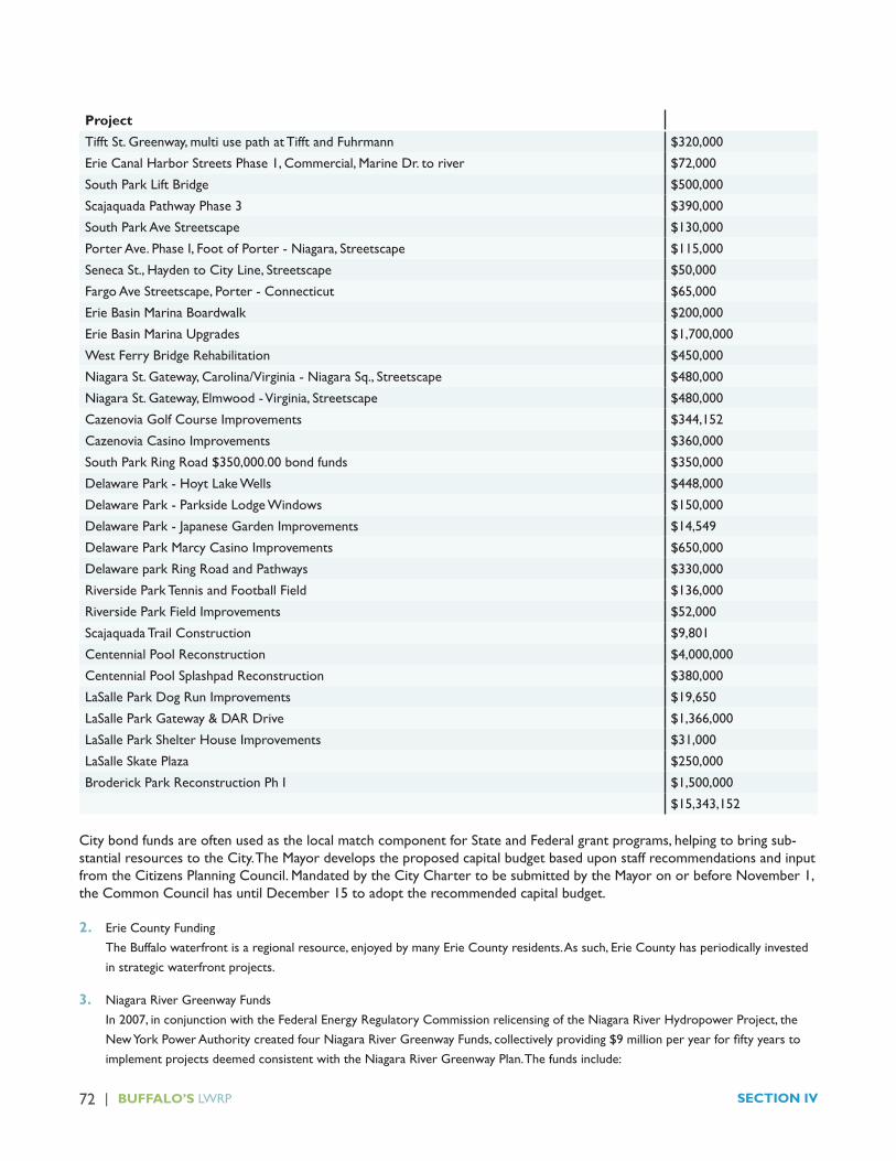
72 | BUFFALO’S LWRP SECTION IV
Project
Tifft St. Greenway, multi use path at Tifft and Fuhrmann $320,000
ErieCanalHarborStreetsPhase1,Commercial,MarineDr.toriver $72,000
South Park Lift Bridge $500,000
Scajaquada Pathway Phase 3 $390,000
South Park Ave Streetscape $130,000
PorterAve.PhaseI,FootofPorter-Niagara,Streetscape $115,000
SenecaSt.,HaydentoCityLine,Streetscape $50,000
FargoAveStreetscape,Porter-Connecticut $65,000
Erie Basin Marina Boardwalk $200,000
Erie Basin Marina Upgrades $1,700,000
West Ferry Bridge Rehabilitation $450,000
NiagaraSt.Gateway,Carolina/Virginia-NiagaraSq.,Streetscape $480,000
NiagaraSt.Gateway,Elmwood-Virginia,Streetscape $480,000
CazenoviaGolfCourseImprovements $344,152
CazenoviaCasinoImprovements $360,000
South Park Ring Road $350,000.00 bond funds $350,000
DelawarePark-HoytLakeWells $448,000
DelawarePark-ParksideLodgeWindows $150,000
DelawarePark-JapaneseGardenImprovements $14,549
Delaware Park Marcy Casino Improvements $650,000
Delaware park Ring Road and Pathways $330,000
Riverside Park Tennis and Football Field $136,000
Riverside Park Field Improvements $52,000
Scajaquada Trail Construction $9,801
Centennial Pool Reconstruction $4,000,000
Centennial Pool Splashpad Reconstruction $380,000
LaSalle Park Dog Run Improvements $19,650
LaSalle Park Gateway & DAR Drive $1,366,000
LaSalleParkShelterHouseImprovements $31,000
LaSalleSkatePlaza $250,000
Broderick Park Reconstruction Ph I $1,500,000
$15,343,152
City bond funds are often used as the local match component for State and Federal grant programs, helping to bring sub-stantial resources to the City. The Mayor develops the proposed capital budget based upon staff recommendations and input fromtheCitizensPlanningCouncil.MandatedbytheCityChartertobesubmittedbytheMayoronorbeforeNovember1,the Common Council has until December 15 to adopt the recommended capital budget.
2. Erie County Funding The Buffalo waterfront is a regional resource, enjoyed by many Erie County residents. As such, Erie County has periodically invested in strategic waterfront projects.
3. Niagara River Greenway Funds In2007,inconjunctionwiththeFederalEnergyRegulatoryCommissionrelicensingoftheNiagaraRiverHydropowerProject,theNewYorkPowerAuthoritycreatedfourNiagaraRiverGreenwayFunds,collectivelyproviding$9millionperyearforfiftyyearstoimplement projects deemed consistent with the Niagara River Greenway Plan. The funds include:

BUFFALO’SLWRP | 73LOCAL IMPLEMENTATION
�HostCommunitiesGreenwayFund($3millionperyear–onlyinNiagaraCounty);
�NewYorkStateParksGreenwayFund($3millionperyear–onlyinStateParks);
� BuffaloandErieCountyGreenwayFund($2millionperyear);and
� EcologicalGreenwayFund($1millionperyear).
Funding through the State Parks Greenway fund is restricted to projects located within a State Park within the Niagara River Greenwayboundaries.ThesefundsmaybeutilizedfornewcapitalinvestmentsassociatedwithStatePark’stakeoveroftheNFTA’sSmallBoatHarborandGallagherBeachfacilitiesontheCity’sOuterHarbor.
The Buffalo and Erie County Greenway funds may be used within the Niagara River Greenway boundaries in Erie County. The funds are considered local funding source for State and Federal grant purposes. Funding applications are solicited once peryearandarereviewedbyacommitteecomprisedoftheCityofBuffalo,ErieCounty,OlmstedParksConservancyandthe New York Power Authority representatives. Since the fund began in 2007, the following projects have been funded within the LWRA.
Buffalo & Erie County Greenway Fund Buffalo LWRA Amount FundedFisherman’sLanding -- $400,482
Shoreline Trail Signage $180,000 $180,000
Scajaquada Creekside Trail $1,210,467 $1,210,467
LaSalle Park $654,830 $654,830
Park Pavilion $866,970 $866,970
Minnow Pools at Riverside Park $305,000 $305,000
Union Ship Canal $385,000 $385,000
Riverside Park Concourse $56,175 $56,175
Land Acquisition Study $100,000 $100,000
LaSalleParkPhase2/PorterAvenue $993,506 $993,506
Riverfest Park $410,000 $410,000
NaturePreserveSustainabilityCenterExpansion $225,000 $225,000
Buffalo Museum of Science $275,000 $275,000
Tifft Street Pier $470,000 $470,000
Fenian Invasion Marker -- $21,108
Adaptive Paddle Sports Launch System -- $75,325
BlackRockHeritageTrailWarof1812Project $105,000 $105,000
Black Rock Canal Park Improvements $900,000 $900,000
River Fest Park Phase II $250,000 $250,000
Fireboat Cotter $60,000 $60,000
Bird Island Pier Project $750,000 $750,000
War of 1812 Bicentennial Signage $15,000 $15,000
TonawandaShorelineStabilizationProposal -- $250,000
Riverrock Gardens -- $220,350
Front Park -- $435,000
Riverfest Park -- $104,000
Scenic Woods Bicentennial -- $164,371
1812 Bicentennial Commemoration -- $128,000
Committee Total $8,99,2406 $10,010,584
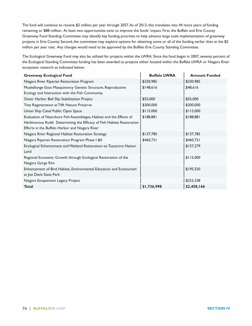
74 | BUFFALO’S LWRP SECTION IV
The fund will continue to receive $2 million per year through 2057. As of 2013, this translates into 44 more years of funding remainingor$88million.Atleasttwoopportunitiesexisttoimprovethefunds’impact.First,theBuffaloandErieCountyGreenway Fund Standing Committee may identify key funding priorities to help advance large scale implementation of greenway projectsinErieCounty.Second,thecommitteemayexploreoptionsforobtainingsomeorallofthefundingearlierthanatthe$2million per year rate. Any changes would need to be approved by the Buffalo Erie County Standing Committee.
TheEcologicalGreenwayFundmayalsobeutilizedforprojectswithintheLWRA.Sincethefundbeganin2007,seventypercentofthe Ecological Standing Committee funding has been awarded to projects either located within the Buffalo LWRA or Niagara River ecosystem research as indicated below:
Greenway Ecological Fund Buffalo LWRA Amount FundedNiagara River Riparian Restoration Program $330,985 $330,985
MuskellungeEsoxMasquinoncyGeneticStructure,ReproductiveEcology and Interaction with the Fish Community
$148,616 $48,616
OuterHarborBellSlipStabilizationProject $55,000 $55,000
Tree Regeneration at Tifft Nature Preserve $300,000 $300,000
UnionShipCanalPublicOpenSpace $115,000 $115,000
EvaluationofNearshoreFishAssemblages,HabitatandtheEffectsofHerbivorousRudd:DeterminingtheEfficacyofFishHabitatRestorationEffortsintheBuffaloHarborandNiagaraRiver
$188,881 $188,881
NiagaraRiverRegionalHabitatRestorationStrategy $137,785 $137,785
Niagara Riparian Restoration Program Phase I &II $460,731 $460,731
Ecological Enhancement and Wetland Restoration on Tuscarora Nation Land
$157,279
Regional Economic Growth through Ecological Restoration of the Niagara Gorge Rim
$115,000
EnhancementofBirdHabitat,EnvironmentalEducationandEcotourismat Joe Davis State Park
$195,550
Niagara Escapement Legacy Project $253,338
Total $1,736,998 $2,458,166
BUFFALO’S LWRP | 1STATE AND FEDERAL IMPLEMENTATION
A. State Actions Needed
The State of New York is an active partner in the revitalization of the Buffalo LWRA. In addition to the ongoing implementation of the programs outlined above, the following proactive State actions are needed to implement the Policies and Action Strategy. This reflects land ownership conditions, the complexities of international boundary management, the limited financial resources of the local community and the regional significance of the Buffalo waterfront.
The New York State Department of State will play a unique role in the execution of the LWRP, coordinating state agency consistency review with the LWRP, as well as the Niagara River Greenway Plan.
It is recognized that a State agency’s ability to undertake such actions is subject to a variety of factors and considerations, that the consistency provisions referred to above may not apply, and that the consistency requirements cannot be used to require a State agency to undertake an action it could not undertake pursuant to other provisions of law.
1. Empire State Development Corporation
a. Partner with the City of Buffalo to encourage private investment in the City’s designated priority water enhanced, mixed uses development areas identified in Policy 5A;
b. Support the City’s major local waterfront investment corridors such as Niagara St. and Ohio St. as per Policy 5B;
c. Develop the City as a high quality international gateway as per Policy 6;
d. Work with State and Federal landowners at Cotter Point to activate the former army storage building and maximize recreation, tourism and economic development opportunities at the site as per the Action Strategy;
e. Partner with the City of Buffalo to facilitate the redevelopment of the City’s Auto Impound Property as per the Action Strategy;
f. Support historic preservation tax credits, brownfield clean up and energy efficiency funding for reuse of iconic waterfront structures, particularly the Buffalo Smelting Works, Agway Grain Storage building, DL&W, Grain Elevators, Ford Terminal Complex and Freezer Queen sites as per the Action Strategy;
g. Explore opportunities to incentivize Buffalo’s blue economy including water based businesses and enterprise activities within the LWRA; and
h. Support City of Buffalo efforts to create a long term revenue stream to support water dependent and enhanced public amenities in the LWRA.
2. Erie Canal Harbor Development Corporation
a. Support the City of Buffalo’s phased development of the City’s Canalside parcels as per Policy 5A;
b. Partner with the City of Buffalo and local stakeholders to design and implement the Cars on Main Street project from Terrace to South Park, Erie Street design improvements and the Perry Street/Cobblestone Connection project as per Policy 5B;
c. Implement those elements of the Grain Elevator and Waterfront Bridge lighting proposal that are economically and environmentally sustainable and offer a positive return on investment as per the Action Strategy; and
d. Upon acquisition of the NFTA’s Outer Harbor land holdings,
� Preserve public ownership to public lands on the Outer Harbor as per Policy 8A and
� Reactivate the Ford Terminal Complex on the Outer Harbor, including public access along the water’s edge to the maximum extent practicable.
SECTION V - STATE AND FEDERAL IMPLEMENTATION

2 | BUFFALO’S LWRP SECTION V
3. Department of Environmental Conservation
a. Monitor the Buffalo Sewer Authority (BSA) implementation of BSA’s Long Term Combined Sewer Overflow Control Plan comprised of both green and grey infrastructure solutions in support of Policies 2A and 2B;
b. Ensure the local implementation of the Clean Water Act stormwater provisions, as per Policy 2B;
c. Work with the Buffalo Water Authority to implement the Great Lakes Compact water quantity and conservation provisions;
d. Fund and provide technical and management assistance for the ongoing implementation of the Remedial Action Plans (RAPs) for the Buffalo and Niagara River Great Lakes Areas of Concern, the Lake Erie Lakewide Area Management Plan (LAMP), the Bi-National Niagara River Toxics Management Plan and the State’s Great Lakes Basin Action Agenda;
e. Fund and provide technical assistance to the Buffalo River Great Lakes Legacy Act Environmental Dredging Project and the strategic removal of contaminated sediments from the Buffalo River;
f. Fund and provide technical assistance for efforts to characterize and address contaminated sediment and/or botulism concerns in` Scajaquada Creek/Hoyt Lake/Mirror Lake and South Park Lake;
g. Provide brownfields clean up and asbestos remediation support for mixed use and industrial redevelopment in the LWRA;
h. Protect and enhance fish and wildlife habitat and populations in accordance with Policy 7;
i. Periodically monitor water quality in areas adjacent to the confined disposal areas within the LWRA;
j. Periodically review ongoing compliance arguments with hazardous waste and brownfield clean up, as well as junkyard provisions, within the LWRA as per Policy 10; and
k. Provide funding and technical assistance to local marinas for vessel pump-out stations and wash down facilities to protect near shore water quality and discourage the transport of aquatic invasive species
4. New York State Department of Transportation
a. Provide technical assistance and funding for the following transportation projects outlined in Policy 5B and the Action Strategy:
�Niagara Street/Great Lakes Seaway Trail National Scenic Byway;
� Scajaquada Expressway;
� Virginia/Carolina I-190 Interchange;
� Erie Street Extension from Main to Lakeside Boulevard;
� Cars on Main from Terrace to South Park; and
� Perry Street/Cobblestone Connection;
b. Work with the City of Buffalo to:
�Minimize waterfront truck traffic to the maximum extent practicable as per Policy 5B;
�Minimize the impact of Route 190 on Niagara Street, waterfront public access and property values; and
� Investigate opportunities to repurpose the former Breckenridge Toll Plaza lands in support of the Niagara River Greenway.
5. New York Power Authority
a. As Per Policy 9H, periodically review the Niagara River ice boom to evaluate the impacts of ice boom

BUFFALO’S LWRP | 3STATE AND FEDERAL IMPLEMENTATION
operations on water recreation and industry, the Buffalo microclimate and growing season, Lake Erie evapotranspiration rates and water levels, fish and wildlife and their habitats, and Niagara River erosion and sedimentation patterns. Potential adverse impacts should be avoided to the maximum extent practicable and mitigated where avoidance is not possible;
b. Coordinate with the Buffalo and Erie County Greenway Steering Committee to maximize the impact of the remaining NYPA greenway expenditures;
c. Coordinate investments in the Erie Basin Marina, Small Boat Harbor and NYPA First Buffalo Marina docks and boating service facilities to maximize their boating, recreation and economic development benefits; and
d. Ensure that efforts to develop energy resources in the LWRA, including but not limited to wind and/or hydrokinetic energy, thoroughly examine and document potential adverse impacts to 1) the environment; 2) the Buffalo community’s use and enjoyment of local waters for recreation, transportation and economic development.
6. Niagara Frontier Transportation Authority
a. Finalize implementation of the Niagara Street Revitalization Project;
b. Actively partner with the City of Buffalo to maximize public transit ridership within the LWRA;
c. Transfer the NFTA’s Outer Harbor Ford Terminal Complex lands to a State agency whose mission and capability aligns with the City Land Use Plan vision for the site (such as ESD/ECHDC and/or State Parks);
d. Partner with the City and the ECHDC to activate the DLW Station as a vital component of the Canalside/Cobblestone revitalization; and
e. Preserve the DLW “Dell” corridor for future passenger rail service and/or greenway open space.
7. NYS Parks, Recreation and Historic Preservation
a. Coordinate investments in the Erie Basin Marina, Small Boat Harbor and NYPA First Buffalo Marina docks and boating service facilities to maximize their boating, recreation and economic development benefits;
b. Provide funding and technical support for the development of a City of Buffalo parks, recreation and open space master plan as per the Action Strategy;
c. Facilitate, through funding and technical support, cross border interpretation of the War of 1812 and Underground Railroad, as per Policy 5E;
d. Provide funding and technical support, including Historic Preservation Tax Credits, for the preservation and enhancement of the privately held historic resources in the LWRA as per the LWRP Action Strategy, particularly the Buffalo Smelting Works, Agway Grain Storage Building, Grain Elevators and Freezer Queen sites;
e. Provide funding and technical support for the preservation and enhancement of the publicly held historic resources in the LWRA as per Policy 5E and the LWRP Action Strategy including
� Lighting of the City’s waterfront grain elevator and bridges;
� Activation of the Colonel Ward Pumping Station for heritage interpretation and economic development;
� Activation of the DL& W Terminal;
� Activation of the Ford Terminal Complex; and
� Provide security for the City-owned Cargill Superior and Concrete Central grain elevators;
f. Provide funding and technical support for the long term restoration of the historic Buffalo Olmsted Park system elements located within the LWRA, as per the LWRP Action Strategy.

4 | BUFFALO’S LWRP SECTION V
8. Department of Health
a. Protect public health from contaminated fish as per Policy 7H; and
b. Partner with the Buffalo Water Authority to eliminate chemicals of concern in drinking water supply as per Policy 2C.
B. Federal Action Needed
The Federal Government is also an active partner in the revitalization of the Buffalo LWRA, driven in part by the unique conditions associated with the City of Buffalo’s location on Great Lakes and the US-Canadian border. In addition to the ongoing implementation of the programs outlined in Appendix D, the following proactive federal actions are needed to implement the City of Buffalo LWRP Policies and Action Strategy.
1. Department of Homeland Security: Customs and Border Patrol
a. Work with the City of Buffalo and New York State Department of Transportation to minimize cross border through-truck traffic within the City of Buffalo LWRA in accordance with Policy 5B;
b. Work with Amtrak, Empire State Development, the City of Buffalo and City of Niagara Falls to improve customs inspections and travel times for passenger train connections along the waterfront from downtown Buffalo through Niagara Falls to Toronto;
c. Work with the City of Buffalo, Erie County and the NYS Department of Motor Vehicles to facilitate and incentivize Buffalo resident enrollment in the Nexus trusted traveler program; and
d. In accordance with Policy 6, develop the City as a high quality international Gateway.
2. Department of Homeland Security: Coast Guard
a. Maintain navigational devices in the inner and outer harbor channels;
b. Manage harbor operations to protect ecological resources as per Policy 7C;
c. Support cross border recreational boating and fishing with clearly identified cross border marine border check in sites;
d. Work with the NYS Department of Motor Vehicles and NYS Office of Parks, Recreation and Historic Preservation to provide safe boating education courses and materials;
e. Continue to minimize the secured, non-public access footprint of the Coast Guard Station; and
f. Maximize public access to the historic lighthouse and surplus Coast Guard lands.
3. Department of Homeland Security: Federal Emergency Management Agency
a. Update the flood mapping for the City of Buffalo utilizing best available data;
b. Work with the City of Buffalo to reduce flood damage risk to established neighborhoods within the revised floodplains; and
c. Support preservation and enhancement of the protective function of the open spaces identified in Policy 9A and the critical protective structures identified in 9D.
4. Environmental Protection Agency
a. Fund and provide technical and management assistance for the ongoing implementation of the Remedial Action Plans (RAPs) for the Buffalo and Niagara River Great Lakes Areas of Concern, the Lake Erie Lakewide Area Management Plan (LAMP), the Bi-National Niagara River Toxics Management Plan and the Great Lakes Restoration Initiative Action Plan;
b. Fund and provide technical assistance to the Buffalo River Great Lakes Legacy Act Environmental Dredging Project and the strategic removal of contaminated sediments from the Buffalo River;

BUFFALO’S LWRP | 5STATE AND FEDERAL IMPLEMENTATION
c. Fund and provide technical assistance for efforts to characterize and address contaminated sediment and/or botulism concerns in` Scajaquada Creek/Hoyt Lake/Mirror Lake and South Park Lake;
d. Provide funding and technical assistance for the implementation of the Buffalo Sewer Authority green and grey infrastructure plan for CSO abatement in support of Policies 2A and 2B;
e. Ensure the local implementation of the Clean Water Act stormwater provisions, as per Policies 2B;
f. Provide funding for brownfield assessment and remediation within the LWRA; and
g. Provide funding and technical assistance to local marinas for vessel pump-out stations and wash down facilities to protect near shore water quality and discourage the transport of aquatic invasive species.
5. US Department of the Interior: Fish and Wildlife Service
a. Actively pursue opportunities to relocate some operations of the Lower Lakes Fisheries Office within the LWRA in support of Buffalo and Niagara River Great Lakes Areas of Concern restoration efforts;
b. Provide funding and technical assistance for the development of a Lake Erie/Niagara River native fisheries restoration plan in accordance with Policy 7I;
c. Protect and enhance fish and wildlife habitat and populations in accordance with Policy 7; and
d. Protect and enhance the Niagara River Globally Significant Bird Area as per Policy 7J.
6. US Department of Interior: Niagara National Heritage Area
a. Provide funding and technical support for Niagara National Heritage Area theme resources within the LWRA; and
b. Provide funding and technical support for both local and cross border interpretation of the heritage resources identified in Policies 5E and 6.
7. Army Corps of Engineers
a. Conduct maintenance dredging of federal navigation channels in accordance with Policies 4 and 10;
b. Fund and provide technical assistance to the Buffalo River Environmental Dredging Project and the strategic removal of contaminated sediments from the Buffalo River;
c. Fund and provide technical assistance for efforts to characterize and address contaminated sediment and/or botulism concerns in Scajaquada Creek/Hoyt Lake/Mirror Lake and South Park Lake;
d. Continue to operate the confined disposal facility at the City’s southern border;
e. Maximize public access to the Black Rock Locks for industrial heritage tourism purposes;
f. Minimize Buffalo District operation disruptions to the Shoreline Trail;
g. Fund and provide technical assistance for shoreline stabilization and habitat enhancement along LaSalle and Broderick Parks;
h. Support preservation and enhancement of the protective function of the open spaces identified in Policy 9A and the critical protective structures identified in Policy 9D;
i. As Per Policy 9H, periodically review the Niagara River ice boom to evaluate the impacts of ice boom operations on water recreation and industry, the Buffalo microclimate and growing season, Lake Erie evapotranspiration rates and water levels, fish and wildlife and their habitats, and Niagara River erosion and sedimentation patterns. Potential adverse impacts should be avoided to the maximum extent practicable and mitigated where avoidance is not possible;

6 | BUFFALO’S LWRP SECTION V
j. As per Policy 7E, work with City of Buffalo to determine opportunities for constructed wetlands and wetland mitigation banking within the LWRA.
8. Federal Highway Administration
a. Provide funding and technical support for enhancement of the Great Lakes Seaway Trail National Scenic Byway in Buffalo in support of Policy 5B including:
� The implementation of traffic calming, pedestrian and bicycle facilities and heritage interpretation amenities along Niagara Street; and
� Review and resolution of National Scenic Byway offsite signage compliance within the LWRA;
b. Provide technical assistance and funding for the following transportation projects outlined in Policy 5B and the Action Strategy:
� Scajaquada Expressway
� Virginia/Carolina I-190 Interchange;
� Erie Street extension from Main Street to Lakeside Boulevard;
� Cars on Main Street from Terrace to South Park; and
� Perry Street/Cobblestone Connection
9. Federal Energy Regulatory Commission
a. Ensure that efforts to develop energy resources in the LWRA, including but not limited to wind and/or hydrokinetic energy, thoroughly examine and document potential adverse impacts to 1) the environment; 2) the Buffalo community’s use and enjoyment of local waters for recreation, transportation and economic development; and 3) homeland security. Potential adverse impacts should be avoided to the maximum extent practicable and mitigated where avoidance is not possible.
b. As Per Policy 9H, periodically review the Niagara River ice boom to determine the impacts of ice boom operations on water recreation and industry, the Buffalo microclimate and growing season, Lake Erie evapotranspiration rates and water levels, fish and
wildlife and their habitats, and Niagara River erosion and sedimentation patterns. Potential adverse impacts should be avoided to the maximum extent practicable and mitigated where avoidance is not possible..

BUFFALO’S LWRP | 1CONSISTENCY REVIEW
A. Consistency Review of Private Development Activities
Under the City of Buffalo Unified Development Ordinance, all private development activities in the LWRA, with the exception of the construction of one to three family dwellings, are subject to major site plan, SEQRA and LWRP consistency review.
Private development proponents shall prepare and file a completed Buffalo Waterfront Assessment Form (BWAF), SEQRA Full Environmental Assessment form, and major site plan review documentation with the Commission of Permits and Inspections for referral to the Director of Zoning and Planning for coordinated review and recommendation to the Planning Board.
Prior to site plan approval, the Planning Board shall review the BWAF submission to determine if the action is consistent with the policies and provisions of the LWRP. The Planning Board shall render its written determination to the department within thirty (30) days following referral of the BWAF from Z & PA unless extended by mutual agreement of the Planning Board and the applicant. The Planning Board’s determination shall indicate whether the proposed action is consistent with or inconsistent with one or more of the LWRP policy standards and shall elaborate in writing the basis for its opinion. The Planning Board shall, along with a consistency determination, make any suggestions to the department concerning modification of the proposed action, including the imposition of conditions, to make it consistent with LWRP policy standards or to greater advance them.
B. Consistency Review of Local Government Actions in the LWRA
The proposed City of Buffalo Local Waterfront Consistency law requires that local government actions, except minor actions, be consistent with the City of Buffalo LWRP.
Local government project proponents shall prepare and file a completed Buffalo Waterfront Assessment Form
(BWAF) and SEQRA Full Environmental Assessment form for coordinated review and recommendation to the Planning Board.
The Planning Board shall review the BWAF submission to determine if the action is consistent with the policies and provisions of the LWRP. The Planning Board shall render its written determination to the department within thirty (30) days following referral of the BWAF from OSP, unless extended by mutual agreement of the Planning Board and the applicant. The Planning Board’s determination shall indicate whether the proposed action is consistent with or inconsistent with one or more of the LWRP policy standards and shall elaborate in writing the basis for its opinion. The Planning Board shall, along with a consistency determination, make any suggestions to the department concerning modification of the proposed action, including the imposition of conditions, to make it consistent with LWRP policy standards or to greater advance them.
C. Review of Erie County or State Actions
Consistency with waterfront policies is a key requirement of the coastal management program established in New York State’s Waterfront Revitalization and Coastal Resource Act of 1981. This Act requires that” ...actions undertaken by State agencies within the coastal area ... shall be consistent with the coastal area policies of this Article (Section 919(1)).”
For purposes of the Act, “actions” are defined as those activities, directly undertaken by state agencies, that would be defined as Type I or unlisted actions under the State’s Environmental Quality Review Act including funding assistance, land transactions and development projects. The state agency with jurisdiction, acting as lead agency, prepares the Long Form Environmental Assessment and the State’s Waterfront Assessment Form, and makes the consistency determination which is filed with the Department of State. To facilitate consistency review with the Buffalo LWRP, state agencies are encouraged to utilize the Buffalo WAF. That determination must be filed with the City of Buffalo for comment.
SECTION VI – CONSISTENCY REVIEW

2 | BUFFALO’S LWRP SECTION VI
D. Review of Federal Actions in the Buffalo LWRA
The purpose of the federal Coastal Zone Management Act of 1972 is to encourage and assist the states in preparing and implementing management programs to “preserve, protect, develop, and where possible, to restore or enhance the resources of the nation’s coastal zone.” The Act stipulates that federal actions and federally funded actions within the coastal zone must be, to the maximum extent feasible, consistent with approved state management programs. This provision includes Army Corps of Engineers permits, and use of federal funds for infrastructure improvement and other projects.
The New York State Department of State administers the state’s coastal management program, and is responsible for determining whether federal actions are consistent with the coastal policies.
When a federal agency is undertaking a direct action under 15 CFR (930)(c), the federal agency prepares a written determination of consistency and submits that determination to the New York State Department of State. To facilitate consistency review with the Buffalo LWRP, federal agencies are encouraged to utilize the Buffalo WAF to guide their determination. Pursuant to the State Waterfront Revitalization of Coastal Areas and Inland Waterways Act (Executive Law, Article 42), the New York Department of State then notifies the City of Buffalo and affected State agencies of those agency actions and programs that are to be undertaken in a manner consistent with approved LWRP’s.
When a federal agency is approving a private funding or licensing application under 15 CFR (930)(d&f), the private applicant prepares a joint Federal Coastal Assessment Form with the approving federal agency and submits the FCAF with the New York Department of State. To facilitate consistency review with the Buffalo LWRP, federal agencies are encouraged to utilize the Buffalo WAF.
NY Department of State has thirty days to determine if the application is complete and 6 months to determine consistency. The Department of State notifies the City
of Buffalo and the City may concur or object to the consistency determination.
E. Consistency Determination Considerations
A proposed action or project is deemed consistent with the LWRP when it will not substantially hinder the achievement of any of the policies and, where practicable, will advance one or more of the policies. In assessing the consistency of proposed actions with LWRP policies, reviewers will be guided by the descriptions, standards and criteria set forth for each policy, as well as any relevant recommendations in adopted plans for areas within the coastal zone such as the City’s Land Use Plan, Comprehensive Plan and Brownfield Opportunity Area plans. Compatibility of the proposed project with its neighboring uses will also be taken into account.
The action must be found consistent with the LWRP before it can be approved. However, a determination of consistency does not itself authorize or require the issuance of any permit, license, certification or other approval of any grant, loan or other funding assistance by the federal, state or local agency having jurisdiction pursuant to other provisions of law.
The LWRP policies set general goals for the city’s waterfront as a whole and specific goals for portions of the waterfront that have notable characteristics. A proposed project is reviewed to determine its consistency with the policies applicable to its specific waterfront location. A policy is considered applicable to a proposed project if its site, surroundings or the action itself involves activities or conditions relevant to that policy.
The program recognizes .that the relevance of each applicable policy may vary depending upon the project type and where it is located. Policies therefore have different weight in a consistency review depending on whether a proposed activity would occur in an area characterized as most appropriate for redevelopment, working waterfront uses, natural resource protection, or public use.

BUFFALO’S LWRP | 3CONSISTENCY REVIEW
When a policy is not applicable or relevant to the proposed project and its location, the policy would not be considered in the consistency review. Examples of inapplicable policies include ecosystem protection in a fully built-up area devoid of natural features, and coastal erosion protection for an project without coastal frontage.
F. Findings of Inconsistency with LWRP Policies
In cases where a project does not appear consistent with one or more of the relevant policy standards and criteria, consideration is given to any practical means of altering the project to maximize its consistency with such standards and criteria. If a project is not so altered and therefore hinders the policies and intent of the LWRP, it may be found inconsistent by the Planning Board or the state agency with jurisdiction.
When a project is not consistent with one or more of the policies and cannot be modified, the state regulations (NYCRR 600.4(b)) allow the project to be found consistent if the Planning Board or state agency certifies that the project satisfies the following four requirements: (1) No reasonable alternatives exist which would permit the action to be taken in a manner which would not substantially hinder the achievement of such policy; (2) the action taken will minimize all adverse effects on such policies to the maximum extent practicable; (3) the action will advance one or more of the other coastal policies; and (4) the action will result in an overriding regional or statewide public benefit. (This provision of the regulations may be altered by the Department of State in conjunction with proposed legislative changes).
G. Related Regulatory Oversight
The New York State Department of Environmental Conservation (DEC) is responsible for management and protection of natural resources and environmental quality. The DEC regulates activities that may have a negative impact on wetlands and water quality. Activities such as draining, filling or building structures within a wetland or its adjacent buffer area may be undertaken
only if DEC has granted a permit. In granting a permit, DEC is empowered to place conditions and restrictions on an activity which can include mitigation measures. .
The Army Corps of Engineers (ACOE) is responsible for the protection and management of the nation’s waterways and wetlands. Like the DEC, ACOE is empowered to review and issue permits for activities occurring in navigable waters and in tidal or freshwater wetlands that meet the national designation criteria. These activities include dredging, filling, bulkheading and placement of structures in the water. A central mandate of the ACOE is to maintain navigable channels and the general functioning of the waterways of commerce. In reviewing projects, the ACOE consults with other federal agencies including the U.S. Fish and Wildlife Service, the Coast Guard and the Environmental Protection Agency.
Much of the development occurring in or near Buffalo’s waterways requires permits from the DEC and the ACOE. To receive permits from either agency, a proposed project must be consistent with the state Coastal Zone Management Program and the Buffalo LWRP.

84 | BUFFALO’S LWRP SECTION VII
A. Historic Engagement Activities
The City of Buffalo has been working on the development of a Local Waterfront Revitalization Program for over 20 years. During that time, a wide variety of stakeholders, including government, not-for-profit agencies, waterfront property owners and business and residents have participated in LWRP specific steering committee meetings, focus groups, public meetings and hearings, waterfront conferences and forums. Further, stakeholders have provided input on projects and programs within the LWRA including, but not limited to the:
� Erie Canal Harbor and Canalside;
� Southtowns Connector;
� Scajaquada Expressway Feasibility;
�Niagara Street Gateway;
� Peace Bridge;
�Harbor Bridge;
�Outer Harbor and Greenbelt;
� Buffalo and Niagara River Remedial Action Plans;
� Scajaquada Watershed Management Plan;
�Niagara River Greenway; and
� Buffalo Sewer Authority CSO Long Term Control Plan.
B. Buffalo Development Framework Engagement Efforts
Since 2010, Buffalo LWRA stakeholders have been actively engaged in the Buffalo Development Framework (BDF) process. The culmination of years of planning, the BDF consists of the following “actions:
� A Land Use Plan that accommodates appropriate uses and urban design and reinforces the existing character of the City;
� A Local Waterfront Revitalization Program (LWRP) that will guide development along the City’s coastal areas;
�Disposition of Urban Renewal Plans (URP), to obtain recommendations on the removal, replacement or modification of these plans to better reflect the City’s community and economic development needs;
� South Buffalo, Buffalo River Corridor, Buffalo Harbor, and Tonawanda Street Corridor Brownfield Opportunity Areas (BOA) Phase 2 Nomination Documents including proposed Land Use and Zoning provisions; and
� Unified Development Ordinance (UDO), including new form based zoning provisions, revised subdivision and sign ordinances and street standards.
Building upon the outreach activities associated with the Comprehensive Plan, the BDF employed numerous tools to engage the full community, reaching out to residents, businesses, community organizations, institutional partners and government agencies.
Outreach tools included project Steering Committees, Citizen Advisory Committees, Technical Advisory Committees, large scale community presentations, including the Mayor’s Citizen Waterfront Forums, Green Code Planning Day, neighborhood focused discussions, special interest group meetings, interviews, surveys, design charettes, scenario planning, mailings, postings, newspaper and local access cable announcements and advertisements, phone calls, and digital media efforts including website, social media sites, crowd sourcing, email notifications/listserve and e-blasts.
For optimal results, outreach activities were held in each affected neighborhood in an effort to hear a range of feedback and address the concerns of those most likely to be affected by the proposed changes. Mayor Brown also hosted special meetings to engage the City’s senior citizen, youth and disabled residents and service providers. Translation services were provided at several public meetings, targeting specific neighborhoods and populations where a need was anticipated. Comments and input were shared among the Green Code, BOA and LWRP teams to maximize responsiveness.
SECTION VII – STAKEHOLDER ENGAGEMENT & CONSULTATION

BUFFALO’S LWRP | 85STAKEHOLDER ENGAGEMENT & CONSULTATION
A final round of public engagement activities will be conducted in Spring 2014. During that period, additional community outreach efforts will include Community Planning Day, neighborhood meetings, special interest group presentations, website and social media efforts.
The draft BDF and DGEIS will also be submitted to the Buffalo Common Council legislative committee and the Planning Board for review during this period.
C. Formal Public Comment Period
The Common Council’s acceptance of the draft BDF and DGEIS, including this LWRP will begin a formal public comment period. The community will be invited to submit formal comment on the draft BCDF and DGEIS through oral testimony at one of the Public Hearings or through formal written comments.
The final BDF and BGEIS submission for Common Council approval will include the draft BDF and DGEIS, including any necessary revisions and supplements; copies or a summary of the substantive comments received and their sources; and the City’s response to the comments.
D. Consultation
Throughout the LWRP process to date, draft documents have been distributed to a number of involved and interested agencies to gather their comments on program findings and recommendations. The agencies that were contacted for their input included the Erie County Department of Environment and Planning, Empire State Development Corporation, Niagara Frontier Transportation Authority, Town of Tonawanda and the City of Lackawanna, which are bordering municipalities.
As part of the formal review period described above, copies of the draft LWRP will be distributed to all applicable Federal agencies, potentially affected State agencies, Erie County, the Town of Tonawanda and the City of Lackawanna. Comments received on the draft LWRP were reviewed by the City and State and changes were made to the program, as required, to reflect the substantive comments.

BUFFALO’S LWRP | 1
CONTENTS
1. Local Waterfront Revitalization Area Boundary ............................................................................................................................
II. Local Waterfront Revitalization Program Policies .......................................................................................................................
III. Action Strategy (Proposed Uses and Projects) ..........................................................................................................................
IV. Local Implementation ......................................................................................................................................................................
V. State and Federal Assistance ..........................................................................................................................................................
VI. Consistency Review .........................................................................................................................................................................
VII. Stakeholder Involvement ................................................................................................................................................................
VIII.Inventory .........................................................................................................................................................................................
MAPS
1. LWRA Boundary .......................................................................................................................................................................................
2. Future Land Use Plan / UDO Zones ..................................................................................................................................................
3. Water Enhanced Mixed Use Development Zones .........................................................................................................................
4. Water Use/Harbor Management Plan ..............................................................................................................................................
5. Marinas, Mooring Areas & Boat Launches .......................................................................................................................................
6. Action Strategy Projects .......................................................................................................................................................................
7. Environmental Justice Areas .................................................................................................................................................................
8. Existing Land Use ...................................................................................................................................................................................
9. Public Parcels ...........................................................................................................................................................................................
10. Natural Resources ................................................................................................................................................................................
11. Recreation & Open Space ..................................................................................................................................................................
12. Historic Resources ...............................................................................................................................................................................
13. Transportation Plan ................................................................................................................................................................................
14. International Gateways ..........................................................................................................................................................................
15. Contamination Hazards ......................................................................................................................................................................
APPENDICES
A. Local Waterfront Revitalization Area Boundary
B. Local Consistency Law
C. Waterfront Assessment Form
D. State and Federal Programs
E. UDO Waterfront Zone
F. Harbor Management Plan References
City of Buffalo
DRAFTLocal Waterfront Revitalization Program (LWRP)
June 2014
1-2
3-16
17-39
70-74
75-80
81-83
84-85
86-170
2
19
20
130
131
25
94
97
98
115
144
153
39
99
170
86 | BUFFALO’S LWRP SECTION VIII
I. Regional Setting and Community Characteristics .............................................................................................................
A. Great Lakes Megaregion/Megalopolis .................................................................................................................................
B. The Golden Horseshoe ..........................................................................................................................................................
C. Western New York/Buffalo Niagara Region ......................................................................................................................
D. Niagara River Greenway .......................................................................................................................................................
E. City of Buffalo ...........................................................................................................................................................................
1. LWRA Residents and Environmental Justice ....................................................................................................
2. The Blue Economy ..................................................................................................................................................
3. Existing Land Use Table & Map ............................................................................................................................
4. Surface Land Ownership Patterns ......................................................................................................................
5. Underwater (Submerged) Land Ownership ..................................................................................................
6. Zoning ....................................................................................................................................................................
II. Natural WATER Infrastructure ..........................................................................................................................................
A. Buffalo’s Surface Waterbodies ...........................................................................................................................................
1. Lake Erie ................................................................................................................................................................
2. The Niagara River ................................................................................................................................................
3. Scajaquada Creek/Jubilee Springs/Hoyt and Mirror Lakes ..........................................................................
4. Buffalo River ..........................................................................................................................................................
5. NYS Waterbody Designations ...........................................................................................................................
6. Surface Water Quality .........................................................................................................................................
B. Active River Area, Wetlands and Floodplains ...................................................................................................................
1. Active River Area ..................................................................................................................................................
2. Federal Wetlands ..................................................................................................................................................
3. State Wetlands ......................................................................................................................................................
4. Floodplains .............................................................................................................................................................
C. Habitat Resources ................................................................................................................................................................
1.NewYorkStateDesignatedSignificantCoastalFishandWildlifeHabitats............................................
SECTION VIII - INVENTORY & ANALYSIS91
91
92
92
93
93
93
95
96
96
100
101
104
104
104
104
106
107
108
110
111
111
113
113
113
114
114
| 87INVENTORY & ANALYSIS
2. Rare or Endangered Species Habitat ................................................................................................................
3.NiagaraRiverGloballySignificantImportantBirdArea...............................................................................
4. Local Habitat Areas and Restoration Sites ......................................................................................................
D. Fish Resources.........................................................................................................................................................................
E. Great Lakes Areas of Concern (AOCs).............................................................................................................................
III. Harbor Management ............................................................................................................................................................
A. “Port of Buffalo” .....................................................................................................................................................................
1. Port Functions .......................................................................................................................................................
2. Port Authority .......................................................................................................................................................
3. Buffalo Harbor Master and Harbor Management .........................................................................................
B. Navigation Channels and Canals ........................................................................................................................................
1. Black Rock Canal & Channel .............................................................................................................................
2. Buffalo Harbor Complex ....................................................................................................................................
3. Buffalo Ship Canal .................................................................................................................................................
4. Buffalo River ...........................................................................................................................................................
5. Channel Maintenance ...........................................................................................................................................
C. Breakwaters ............................................................................................................................................................................
D. Aids to Navigation .................................................................................................................................................................
E. Marinas, Mooring Areas and Boat Launches .....................................................................................................................
1. Public ........................................................................................................................................................................
2. Private ......................................................................................................................................................................
F. Navigation Hazards .................................................................................................................................................................
G. Navigation Security ...............................................................................................................................................................
IV. Water Supply and Wastewater ...........................................................................................................................................
A. Water Supply ..........................................................................................................................................................................
B. Buffalo River Improvement Corporation .........................................................................................................................
C. Municipal Wastewater Disposal .........................................................................................................................................
117
118
119
125
126
129
129
129
129
129
132
132
133
133
134
134
135
135
135
135
136
137
138
139
139
139
139

88 | BUFFALO’S LWRP SECTION VIII
D. Industrial Discharge Permits ...............................................................................................................................................
E. WNY Stormwater Coalition ...............................................................................................................................................
F. Vessel Discharge ......................................................................................................................................................................
V. RECREATION ........................................................................................................................................................................
A. Swimming ................................................................................................................................................................................
B. Boating .....................................................................................................................................................................................
C. Fishing ......................................................................................................................................................................................
1. Boat-Based Sport Fishery ...................................................................................................................................
2. Shoreline Sport Fishery .......................................................................................................................................
3. Angler Effort ...........................................................................................................................................................
4. Fish Consumption Advisories .............................................................................................................................
5. Fishing Facilities .....................................................................................................................................................
D. Water Enhanced Multi-Use Trails .......................................................................................................................................
1. Shoreline Trail ........................................................................................................................................................
2. Jesse Kregal Creekside Trail ...............................................................................................................................
3. Outer Harbor Greenbelt ...................................................................................................................................
4. Fuhrmann Boulevard Greenway ........................................................................................................................
5. Niagara River Parkway and Recreational Trail ...............................................................................................
E. Water Enhanced Parks ..........................................................................................................................................................
1. City of Buffalo Olmsted Parks ..........................................................................................................................
2. City of Buffalo Parks ...........................................................................................................................................
3. Erie County Parks ................................................................................................................................................
4. State (ECHDC/NFTA/ NYPA) Public Access Sites ......................................................................................
5. Other Parks ...........................................................................................................................................................
VI. HISTORIC AND SCENIC RESOURCES ........................................................................................................................
A. Historic Resources ...............................................................................................................................................................
1. Iroquois Confederacy ..........................................................................................................................................
141
142
142
143
143
143
145
145
145
145
145
145
146
146
146
146
147
147
147
147
148
149
150
150
152
152
152
| 89INVENTORY & ANALYSIS
2. Ellicott Radial Street Plan ..........................................................................................................................................
3. War of 1812 .................................................................................................................................................................
4. Erie Canal .....................................................................................................................................................................
5. Buffalo’s Harbor Heritage .........................................................................................................................................
6. Frederick Law Olmsted .............................................................................................................................................
7. Underground Railroad ...............................................................................................................................................
8. Industrial Heritage ......................................................................................................................................................
9. Full Historic Resource Listing ..................................................................................................................................
F. Great Lakes Seaway Trail .............................................................................................................................................................
G. Local Waterfront Scenic Areas .................................................................................................................................................
1. Waterfront Sunsets......................................................................................................................................................
2. Canada ...........................................................................................................................................................................
3. Marinas ..........................................................................................................................................................................
VII. Transportation ............................................................................................................................................................................
A. Great Lakes Seaway Trail ............................................................................................................................................................
B. Neighborhood Connections.......................................................................................................................................................
C. Complete Streets ........................................................................................................................................................................
D. Public Transit .................................................................................................................................................................................
E. Waterfront Highways ...................................................................................................................................................................
1. Scajaquada Expressway Project ................................................................................................................................
2. Outer Harbor Bridge .................................................................................................................................................
3. Tifft Street Arterial ......................................................................................................................................................
4. Former Thruway Toll Plaza ........................................................................................................................................
F. International Crossings ................................................................................................................................................................
1. Peace Bridge .................................................................................................................................................................
2. Passenger Rail to Toronto and Eastern New York ...............................................................................................
3. International Railroad Bridge ....................................................................................................................................
152
154
154
155
156
158
158
158
159
159
159
159
159
160
160
161
161
162
162
162
162
163
163
163
164
164
164
90 | BUFFALO’S LWRP SECTION VIII
G. Rail ............................................................................................................................................................................................
VIII. Energy ...................................................................................................................................................................................
A. Natural Gas..............................................................................................................................................................................
B. Wind ..........................................................................................................................................................................................
IX. Contaminant Hazards .........................................................................................................................................................
Note:
This LWRP has been prepared in conjunction with the Buffalo Development Framework (BDF). To ensure consistency acrosstheBDFplans,asharedCitylevel inventoryhasbeenpreparedand included inthefinalBDFpackageandcrossreferencedwheneverappropriate.Inaddition,thisLWRPspecificinventorydetailsfeaturesofuniqueimportancetotheLWRA and the coastal policies.
165
165
166
166
169

| 91INVENTORY & ANALYSIS
A. Great Lakes Megaregion/Megalopolis
The Great Lakes contain one-fifth the world’s surfacefresh water and have a combined shoreline of 10,210 miles (17,017 km).
The City of Buffalo is located on the eastern shore of the Niagara River between Lake Erie and Lake Ontario.
The America 2050 project has identified elevenMegaregions of the United States, including the Great Lakes Megalopolis. As a separate economy, the Great Lakes are one of the world’s largest economies. The Bi-national Great Lakes Megaregion is estimated to have a 2009 population of 59,781,623. According to America 2050 project, The US Great Lakes Megaregion had a 2010 population of 55,525,296 people, comprising 18% of the United States.
In 2005, the US region had a GDP of 2,072,869,000,000, comprising 17% of the US GDP. The US Great Lakes MegaRegion is expected to grow by 28.3 percent between 2010 and 2050.
B. The Golden Horseshoe
Buffalo is strategically located in a bi-national urban region sometimes known as the “Golden Horseshoe”. It is home to nearly 10 million people and stretches from the Greater Toronto Area, around the western end of Lake Ontario, through the Niagara Peninsula and across Western New York, including the Buffalo and Rochester metropolitan areas.
The Golden Horseshoe is the fourth largest urban region in North America, and with a growth rate of 110,000 people per year, the region is the second fastest growing major urban region on the continent. Most oft he growth is on the Canadian side of this bi-national region, but the future potential for investment and economic growth in the US parts of the region, because of our proximity to our Canadian economic partners, is substantial and should be exploited.
Buffalo
Buffalo`
I. REGIONAL SETTING AND COMMUNITY CHARACTERISTICS

92 | BUFFALO’S LWRP SECTION VIII
C. Western New York/Buffalo Niagara Region
Buffalo serves as the urban center of the Erie and Niagara County region, also known as the Buffalo-Niagara Falls Metropolitan Statistical Area. This “Buffalo Niagara region” is located in the US along the Niagara River between Lake Erie andLakeOntario,servingasakeygatewaybetweenthetwonations.ThisregiondefinesnotonlyaUScensusunit,butthecore of a regional labor market, a media market, a commuter-shed, a transportation planning area, and many other regional functions including ongoing efforts to improve metropolitan governance.
Inallbutthebroadestdefinitionsofthisregion,Buffalohaslongbeenthedominanturbancenter,economically,politically,culturally and demographically. Over the past half century, however, Buffalo’s predominant position in the region has deteriorated as the urban core declined in population and the suburbs grew. In 1950 nearly two-thirds of the people in Erie County lived in the City of Buffalo. By the turn of the century, less than one-third of the population lived there.
D. Niagara River Greenway
In 2004 Governor George Pataki and the New York state legislature created the Niagara River Greenway commission (NRGC) to “implement or cause to be implemented a linear system of parks and conservation areas that will…redefine the Niagara riverfront.”TheNRGC completed the Niagara River Greenway Plan in April 2007, establishing the following vision: “The Niagara River Greenway is a world class corridor of places, parks and landscapes that celebrates and interprets our unique natural, cultural, recreational, scenic and heritage resources and provides access to and connections between these important resources while giving rise to economic opportunities for the region. The plan was adopted by the Buffalo Common Council and every community within its boundaries

| 93INVENTORY & ANALYSIS
The City of Buffalo is the southernmost municipality along the Niagara River Greenway. The City of Buffalo LWRP proposes the re-alignment of the LWRA to maximize consistency with the Niagara River greenway focus area to the greatest extent practicable. In addition, the Buffalo LWRP recommends that interpretive signs in the LWRA are consistent with the Niagara River Greenway signage design guidelines available at http://www2.erie.gov/environment/index.php?q=NRG_Signage.
E. City of Buffalo
The City of Buffalo is also known as the Queen City of the Great Lakes. The largest and most prosperous city along the Great Lakes at the end of the 1800’s, it was at one point the second largest trade port in the North after New York City. The Buffalo waterfront contains approximately 57.7 linear miles of shoreline. Included in this area are the eastern portion of Lake Erie, the southern section of the Niagara River, Squaw Island and the Black Rock Canal, the Buffalo River, and portions of Cazenovia Creek and Scajaquada Creek. The surface water bodies cover approximately 7.5 square miles or 4,825 acres. The upland portion of the Local Waterfront Revitalization Area (LWRA) is nearly equivalent at just under 7 square miles or 4,387 acres.
1. LWRA Residents and Environmental Justice
A detailed description of the overall socio-economic conditions in the City of Buffalo and region are provided in the BDF Shared Inventory referenced at the beginning of this inventory. Of particular note within the LWRA, is the wide range of socio-economic communities within the City’s LWRA. Two communities, located around Delaware Park and the Erie Basin Marina, experience some of the lowest poverty rates in the City, less than 10% and 13%, respectively.
However, the remaining neighborhoods within the LWRA either fall within the NYS DEC guidelines for Potential Environmental Justice Areas due to either the high prevalence of minority residents or poverty levels. Two neighborhoods, Kaisertown (23% poverty) and a
portion of South Buffalo between McKinley Parkway and Cazenovia Creek (20% poverty), fall just below the DEC poverty threshold. Potential environmental justice areas are presented as Map 7.
Environmental justice is defined as the fair treatmentand meaningful involvement of all people regardless of race, color, national origin, or income with respect to the development, implementation, and enforcement of environmental laws, regulations, and policies.
Environmental justice efforts focus on improving the environment in communities, specifically minorityand low-income communities, and addressing disproportionate adverse environmental impacts that may exist in those communities.
Forthosewithoutrobustfinancialresources,protectionof the public trust within the LWRA is critical. Many of the City’s residents, including many immigrants, rely upon subsistence shoreline fishing as a family proteinsource. Shoreline fishing access, affordable license fees,easily understood fish consumption advisories, habitatprotectionandfishpopulationgrowthstrategiessupportthese communities.
For those without financial resources for travel andrecreation, public waterfront parks and natural areas provide important spaces for exercise, play, gatherings of family and friends, scenic views and natural inspiration.

94 | BUFFALO’S LWRP SECTION VIII
MAP 7 - ENVIRONMENTAL JUSTICE AREAS

| 95INVENTORY & ANALYSIS
For those with limited or no access to a car, the implementation of the City’s complete streets program in the LWRA is critical to connecting all residents to the City’s waterways- particularly those who walk, bike or utilize public transit.
For those with literacy and language barriers, clear signage helps to protect residents from hazards such as combinedseweroverflowsanddangerouscurrents.
For vulnerable populations and those with limited access to health care, protection from environmental hazards and contamination in the LWRA help ensure that the waterfront is safe and healthy for all Buffalo residents.
The economic development of the waterfront and the creation of jobs for LWRA residents, empowers employees withthefinancialmeansnecessaryforindependence.
Finally, the open and transparent administration of the Buffalo LWRP consistency review process, is critical to ensuring that all of Buffalo’s residents share in the revitalization of the Buffalo LWRA.
2. The Blue Economy
BrookingsInstituteeconomistJohnAustinhasidentifiedthree traditional, and four emerging, ways that water influencestheeconomy.Traditionally,waterhasservedas:
� a conduit for commerce through freight shipping and warehousing as demonstrated by Buffalo’s Erie Canal shipping and grain elevator prowess;
� an input and resource to grow and make things through agriculture, manufacturing and energy production as demonstrated by the historic proliferation of water intense manufacturing facilities along the Buffalo River as well as modern brewing and food production; and
� a “place-definer and quality of life enhancer”, epitomized by the region’s association with Niagara Falls, its active waterfront event calendar and elevated real estate values for waterfront housing.
Increasingly, water can contribute to Buffalo’s economic revitalization as Buffalo:
� businesses innovate, deploy and manufacture smart and sustainable water use, reuse, efficiency and cleaning technologies;
� serves as a training ground and hub for water and ecosystem restoration research and implementation professionals such as those associated with the Buffalo State College Great Lakes Center, UB Great Lakes program and NYS Pollution Prevention Institute;
� water protection measures, including green infrastructure in key roadway landscape projects, send a value cue indicating Buffalo’s commitment to sustainability and innovation;
� capitalizes upon its Great Lakes location as one of the few places on earth that can provide a sustainable platform for long-term population and economic growth.
Locally, water and the LWRA contribute to many other aspects of the region’s growing economy including:
� commercial boating businesses; marinas; fishing charters, birding and ecotourism enterprises, and related businesses like bait shops; boat building, rental and sale and repair shops generate water dependent business, waterfront activity and tourism revenue;
� Lake Erie locally caught, fish offer a cost effective, low carbon, more sustainable alternative to fish imported from the nation’s coasts and foreign markets. The total value of Lake Erie’s commercial fishery was $194 million in 2011.
� the local, public water supply presents a cost effective, low carbon alternative to imported bottled potable water, saving each resident hundreds, if not thousands, of dollars every year;
� ecosystem restoration activities such as the $75 million Buffalo River sediment clean up and brownfields clean up efforts provide high quality technical and construction jobs. According to research from the Brookings Institute, every $1 invested in restoration generates $2 in economic benefit and up to $4 in economic activity through jobs, development, tourism and property values.

96 | BUFFALO’S LWRP SECTION VIII
� water infrastructure investments, such as the $425 Buffalo Sewer Authority combined sewer long term control plan, create over 16 percent more jobs dollar-fordollar than a payroll tax holiday, nearly 40 percent more jobs than an across-the board tax cut, and over five times as many jobs as temporary business tax cuts;
�Natural protective features and waterfront smart growth minimizes economic losses from flooding and high wind events; and
� Reliable, affordable water supply is essential to almost all building heating and cooling systems, contributing to employee health and productivity; and
� The Buffalo LWRA’s western boundary at the US-Canada border provides numerous opportunities to serve as an International Gateway for people, innovation and goods travelling from Canada.
Collectively, these activities have been dubbed the City’s “blue economy.”
3. Existing Land Use Table & Map
The LWRA comprises 23% of the total parcel acreage in the City of Buffalo and just under 5% of the City’s parcels. As the table below illustrates, the overwhelming portion of parcels in LWRA are either residential (64%) or vacant (23%). However, parks and formal open space comprise nearly 30% of the acreage in the LWRA, with 24% of the acreage as vacant land. Map 8 illustrates existing land use within the LWRA.
City LWRA
Parcels % Acres % Parcels % Acres %
Residential 70,087 75 7,786 41 2,820 64 362 8
Parks/Open Space 228 0 2,055 11 59 1 1,328 30
Commercial 4,912 5 2,448 13 319 7 438 10
Industrial 480 1 1,267 7 98 2 402 9
Transportation/Utilities 1,134 1 2,299 12 116 3 812 19
Vacant 16,374 18 3,254 17 1,019 23 1,045 24
Total 93,215 1 19,109 1 4,431 1 4,387 1
4. Surface Land Ownership Patterns
According to City of Buffalo parcel data, the City owns the largest percentage of land within the LWRA, with almost 2,018 acres comprising 337 parcels. Private owners, including not for profits,comprisethesecondlargestlandownerclass,holdingalmost 1,668 acres on nearly 4,000 parcels. The State of New York is the third largest property owner with 464 acres on 75 parcels (thesefiguresdonot reflect thepending saleof theNFTA’s Port Terminal Complex on the City’s Outer Harbor.) Public land holdings within the LWRA are presented in the table below as well as on Map 9
Acreage % Parcels %
City 2,017.72 46 337 7.6
County 110.68 02 18 0.4
State 463.97 10 75 1.7
Federal 29.28 01 5 0.1
Peace Bridge 20.54 00 14 0.3
Canada 0.03 00 1 0.0
Utilities 53.48 1 28 0.6
Rail 68.38 2 13 0.3
Private 1,667.69 38 3,950 88.9
4,431.77 1 4,441 1

| 97INVENTORY & ANALYSIS
MAP 8 - EXISTING LAND USE
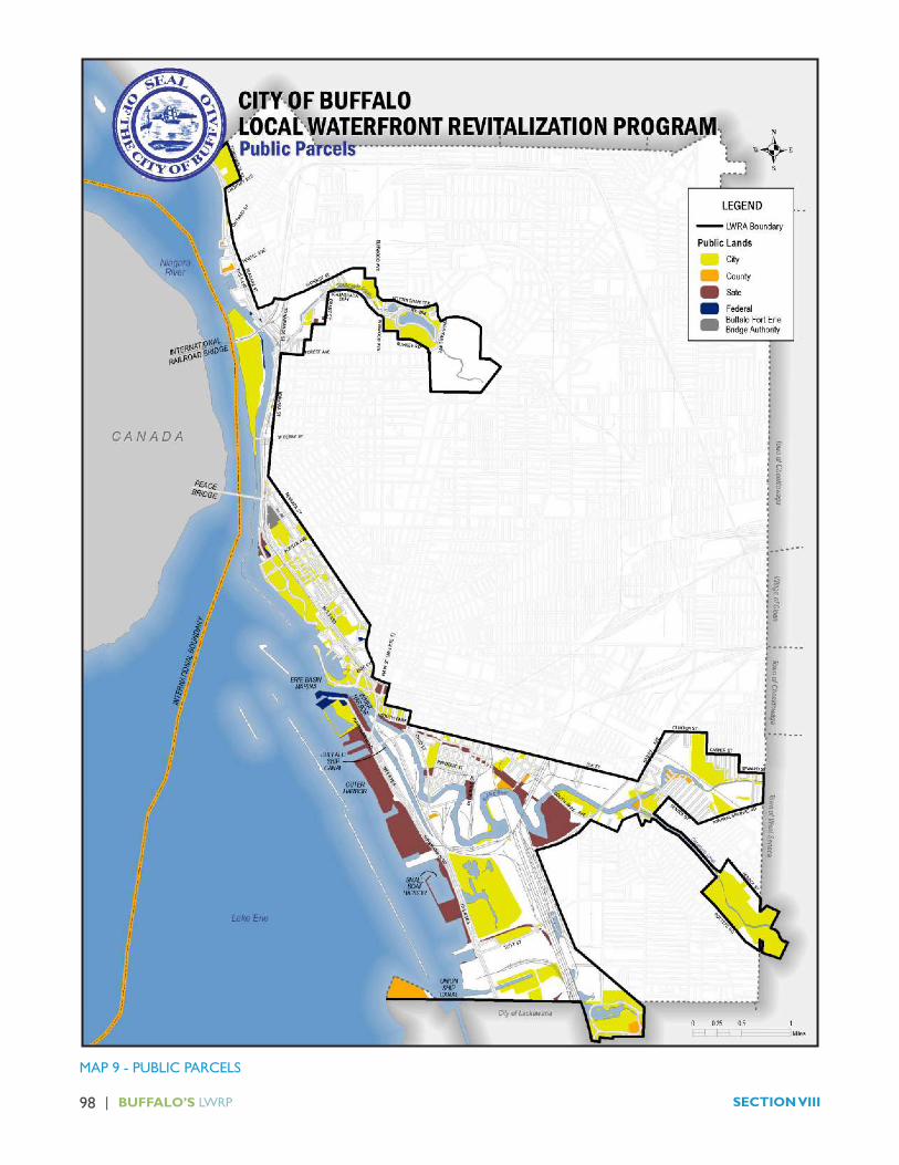
98 | BUFFALO’S LWRP SECTION VIII
MAP 9 - PUBLIC PARCELS

| 99INVENTORY & ANALYSIS
MAP 14 - INTERNATIONAL GATEWAYS

100 | BUFFALO’S LWRP SECTION VIII
5. Underwater (Submerged) Land Ownership
Ownership and jurisdiction of Lake Erie and all submerged lands, including the subsurface lying under the lake within the territorial limits of New York State, is held by the State of New York, unless ownership has been granted to any other person or entity. The beds of the Great Lakes are susceptible of private ownership only for special purposes. The boundary line between State ownership of the lakebed and ownership of the adjacent upland is the low water mark.
State-owned underwater lands are managed by the NewYorkStateOfficeofGeneral Services (OGS).TheOGS issues grants, leases, easements and other interests for these underwater lands. They also investigate encroachments on littoral rights (the right of an upland owner to access the navigable waters of the lake) and make sure there is no interference with navigable channels. The OGS reviews NYSDEC and USACE comments for proposed projects that affect State-owned bottom lands to ensure that the benefits of the public will not bedeprived and that the environment will not be adversely impacted. The OGS strives to achieve satisfaction on the part of all parties involved prior to the issuance of an interest.
For the past few decades, OGS has been issuing licenses for certain structures that exceed the thresholds and, therefore, require State authorization for use of underwater lands. The typical license is issued for 10 years, allowing for the use of State-owned bottom lands. Unlike a grant, the State does not release the real interest in the property. The licensee pays a fee for the “use” of these State-owned underwater lands. Licenses have been issued to the following sites:
�Harbour Place Marina;
� Rich Marine Sales;
� Buffalo Yacht Club;
� Erie Basin Marina;
� First Buffalo Marina;
� RCR Yachts/Skyway Marina; and
�NFTA Boat Harbor.
In 1901 and 1904, the United States acquired certain lands at the north end of the Outer Harbor peninsula. This is the area that is now occupied by the U.S. Coast Guard facility. It is also noted, that Chapter 265 of the Laws of 1900 provided the U.S. Government with the underwater land area for the breakwater that protects the Outer Harbor area.
Chapter 373 of the Laws of 1904 authorized the underwater lands to the United States Government for the construction of the Black Rock Canal. Today the Black Rock Canal is under the jurisdiction of the State Canal Corporation (which is a sub-section of the New York Thruway Authority).
The outer (western) shoreline of Squaw Island was extended toward the Niagara River through a series of underwater land grants (for both commerce and beneficialenjoyment)thatwereconveyedbetween1894and 1926 to the Squaw Island Freight Terminal Company and the Niagara River Hydraulic Company. These land grants established the pier and bulkhead line that exists today and, together with the construction of the Black Rock Canal, are responsible for the present geographic configuration of Squaw Island. The City of Buffaloacquired the land on the southern portion of Squaw Island, which now comprises Broderick Park, pursuant to Chapter 350 of the Laws of 1911. The shoreline of the Niagara River, north of Squaw Island, contains a number of old underwater land grants that were issued to private landowners, between 1863 and 1906, primarily forbeneficialenjoyment.Afewsmallconveyancesweremade to the NYSDOT in 1968 for the construction of the interstate highway (I-190 Expressway). The lands currently occupied by the former Ontario Street boat launch at Black Rock Canal Park, Harbour Place Marina and Rich Marina are former land issuances that have been passed on with the title to these lands.
In 2011, a legal analysis of the ownership of Buffalo River and City Ship Canal underwater lands was submitted to the US Environmental Protection Agency in support of the Buffalo River dredging project. That analysis concluded that the City of Buffalo was the fee owner of the beds of both water courses.

| 101INVENTORY & ANALYSIS
A 1957 Department of Transportation survey of right of way parcels along the NY Route 198 Scajaquada Expressway indicates that, from the former rail right of way at Letchworth Street to the east, the City of Buffalo owns the Creek and adjacent land. West of the rail right of way, the analysis indicated that all parcels were privately owned. The analysis did not indicate who owns the Creek itself west of the rail right of way.1
6. Zoning
A. Existing Zoning
The Zoning Ordinance for the City of Buffalo was adopted in 1953. This Ordinance, known as Chapter 511 of the City of Buffalo Charter and Ordinance, has been revised several times since. Lands within the LWRA presently lie within the following fourteen zoning districts.
� R1 One-Family District
� R2 Dwelling District
� R3 Dwelling District
� R4 Apartment District
� R5 Apartment Hotel District
� C1 Neighborhood Business District
� C2 Community Business District
� C3 Central Business District
� CM General Commercial District
�M1 Light Industrial District
�M2 General Industrial District
�M3 Heavy Industrial District
� PB Porter/Busti Special District
� SS Seneca Street Special District
1Some portion of the Creek in this area was dredged in conjunction with National Fuel Gas and Westwood Squibb clean-up efforts. The clean up documentation is beingresearchedinsupportofthefinalLWRPdraft.
In addition to the aforementioned zoning districts, the following Special Districts, which are deleted in the tables above, coincide within the LWRA boundary:
� Buffalo Coastal Special Review District (Section 511-67 (A))
Any uses that are presently permitted under the existing zoning regulations, which fall within this area, are subject to the issuance of a restricted use permit. Uses exempt from review include:
� residential uses in residential districts;
� development plans duly adopted;
� C1, C2 and CM uses on land ten thousand (10,000) square feet or less;
� public parks, playgrounds and nature preserves;
� educational facilities;
� improvements to properties not exceeding $10,000 in permit value;
� installation of air and water quality improvement equipment;
� demolition of substandard structures; and
� any action needed to comply with requirements of law.
The maximum height of any use seeking to be established or extended within the Buffalo Coastal Special Review District is subject to the restrictions of the underlying zoning and approval of the Buffalo Common Council. Once the LWRP is adopted, this special district will be repealed.
� Buffalo River Open Space Corridor (Section 511-67(B)) Development in this area requires a waterfront yard of not less than 100 feet in depth, as measured from the established dockline (the point distinguishing land from water) or the top of developed bank for all property in the City that falls within 25 feet of the Buffalo River within the Buffalo Coastal Special Review District. No structure or use shall be extended into the yard along the river frontage unless the property owner can demonstrate a physical need to locate said structure or use in this area. The waterfront

102 | BUFFALO’S LWRP SECTION VIII
yard is to be maintained with natural plant materials, wherever possible.
� Buffalo Coastal Special Review District (Section 511-67 (C))
Development in this district requires that a setback from the water’s edge be maintained of not less than 25 feet in depth, as measured from the property line adjacent to the waterfro nt or from the shoreline where the shoreline exceeds the property line. No structures or uses shall extend into the required setback along the Buffalo River frontage. The required setback shall be maintained, where possible, with natural plant material.
�Niagara River Coastal Special Review District (Section 511-68). Any uses that are presently permitted under the existing zoning regulations, which fall within this area, are subject to the issuance of a restricted use permit. Uses exempt from review include:
• residential uses in residential districts;
• development plans duly adopted;
• C1, C2 and CM uses on land (10,000 square feet or less;
• public parks, playgrounds and nature preserves;
• educational facilities;
• improvements to properties not exceeding $10,000 in permit value;
• installation of air and water quality improvement equipment;
• demolition of substandard structures; and
• any action needed to comply with requirements of law.
The maximum height of any use seeking to be established or extended in the Niagara River Coastal Special Review District is subject to the restrictions of the underlying zoning and approval of the Common Council.
The current City Zoning Ordinance was adopted in 1953. The code has been amended numerous times, and numerous overlay districts have been added. This often makes the current zoning ordinance difficult to use,interpret, and enforce.
The current zoning is Euclidian, the primary purpose of which is to segregate uses that are perceived to be incompatible. The current code regulates hundreds of individual uses including ones that are no longer applicable, such as asbestos manufacturing. The traditional land use pattern of the City, with mixed use neighborhoods that include residential and retail or commercial uses surrounded by housing, allowing employees to walk to work, was discouraged or outlawed under the current zoning. The zoning code also developed new lot sizes and setbacks,whichoftenwere inconflictwith theexistingneighborhood character and lot sizes. This created a situation where the reuse of existing buildings was discouraged, new buildings were markedly different in style, and the traditional mixed use nature of areas was discouraged. The zoning also introduced a number of regulations relating to accommodating the automobile, including parking minimums based on size and type of use.
Thiscreatedanumberofconflictsbetweentheexistingbuilt environment and what was allowed by zoning. For example, the minimum lot frontage length for residential development in the current zoning code is 40-feet; however, existing City lots are as narrow as 15-feet. Therefore, if a house was demolished on the 15-foot wide lot, it could not be rebuilt at the same site, without a variance. Minimum front side and rear yard setbacks decreased the percentage of lot area that could be covered by a building and encouraged wider separations between buildings. This is more often associated with suburban development, with decreased population density, and discouraged walkable developments and neighborhoods.
B. Proposed Unified Development Ordinance (UDO)
The City has prepared a UDO that combines zoning, subdivision, sign, street design and approval standards into a single document. The UDO:
� updates the land use designations based upon the Comprehensive Plan, BOAs and LWRP;
� encourages the implementation of development best management practices and consistent, high quality development;
| 103INVENTORY & ANALYSIS
� consolidates approval procedures; and
� eliminates conflicts among related codes.
The proposed UDO is form-based and emphasizes neighborhood character as its basic organizing principle. This approach was chosen because of its unique capacity to help the city adapt to an evolving economy and realize the community’s vision for walkable, green neighborhoods. The proposed zoning ordinance aims to:
� Support walkable, mixed-use development;
� Strengthen the city’s economic centers;
� Protect and enhance Buffalo’s historic character;
� Remove barriers to the creative reuse of vacant land and structures;
� Simplify approvals to encourage investment; and
�Help citizens drive fewer miles, use less energy, and improve environmental quality.
The proposed UDO has a number of graphics intended to allow all users, not just land use specialists, to understand what is allowed in terms of building height, scale, type, placement, function, and other factors in each zone.
C. Waterfront Corridor Zone
Under the proposed UDO, projects within the LWRA are subject to both process and substantive provisions. All projects located within the LWRA, except the construction of one to three family residential structures, will be subject to major site plan review. Further, the code’s Waterfront Corridor Zone establishes minimum setback and vegetative buffer requirements for shoreline properties and restricts certain uses from being located within the LWRA. A full copy of the proposed waterfront zone has been provided as Appendix E.
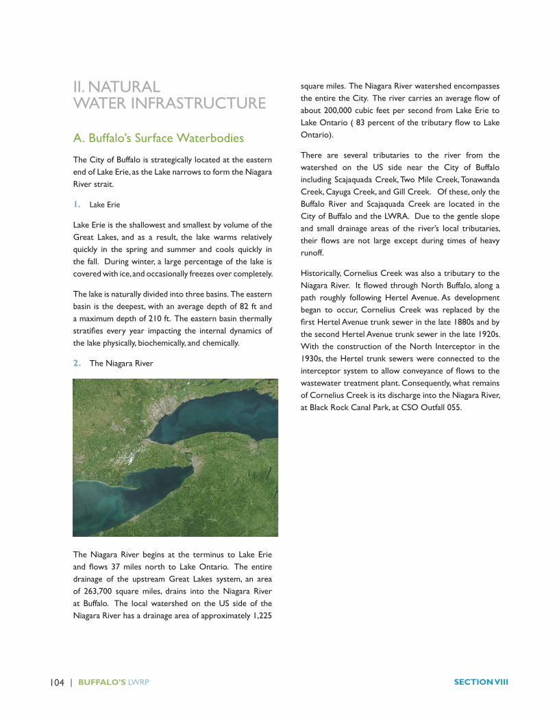
104 | BUFFALO’S LWRP SECTION VIII
II. NATURAL WATER INFRASTRUCTURE
A. Buffalo’s Surface Waterbodies
The City of Buffalo is strategically located at the eastern end of Lake Erie, as the Lake narrows to form the Niagara River strait.
1. Lake Erie
Lake Erie is the shallowest and smallest by volume of the Great Lakes, and as a result, the lake warms relatively quickly in the spring and summer and cools quickly in the fall. During winter, a large percentage of the lake is covered with ice, and occasionally freezes over completely.
The lake is naturally divided into three basins. The eastern basin is the deepest, with an average depth of 82 ft and a maximum depth of 210 ft. The eastern basin thermally stratifies every year impacting the internal dynamicsofthe lake physically, biochemically, and chemically.
2. The Niagara River
The Niagara River begins at the terminus to Lake Erie andflows37miles north to LakeOntario. The entiredrainage of the upstream Great Lakes system, an area of 263,700 square miles, drains into the Niagara River at Buffalo. The local watershed on the US side of the Niagara River has a drainage area of approximately 1,225
square miles. The Niagara River watershed encompasses theentiretheCity.Therivercarriesanaverageflowofabout 200,000 cubic feet per second from Lake Erie to LakeOntario(83percentofthetributaryflowtoLakeOntario).
There are several tributaries to the river from the watershed on the US side near the City of Buffalo including Scajaquada Creek, Two Mile Creek, Tonawanda Creek, Cayuga Creek, and Gill Creek. Of these, only the Buffalo River and Scajaquada Creek are located in the City of Buffalo and the LWRA. Due to the gentle slope and small drainage areas of the river’s local tributaries, their flows are not large except during times of heavyrunoff.
Historically, Cornelius Creek was also a tributary to the NiagaraRiver. ItflowedthroughNorthBuffalo,alongapath roughly following Hertel Avenue. As development began to occur, Cornelius Creek was replaced by the firstHertelAvenuetrunksewerinthelate1880sandbythe second Hertel Avenue trunk sewer in the late 1920s. With the construction of the North Interceptor in the 1930s, the Hertel trunk sewers were connected to the interceptorsystemtoallowconveyanceofflowstothewastewater treatment plant. Consequently, what remains of Cornelius Creek is its discharge into the Niagara River, at Black Rock Canal Park, at CSO Outfall 055.

| 105INVENTORY & ANALYSIS

106 | BUFFALO’S LWRP SECTION VIII
3. Scajaquada Creek/Jubilee Springs/Hoyt and Mirror Lakes
The Scajaquada Creek watershed drains an area of 29 fully urbanized square miles, of which 16 square miles lie outside the city limits. The creek is 15 miles long and has anaveragedailyflowvolumeof32cubicfeetpersecondanda10-yearpeakflowof2,900cubicfeetpersecond.Scajaquada Creek originates in the Town of Lancaster and flowswest through theTownofCheektowaga and theCity of Buffalo to its outfall at the Black Rock Canal. From Pine Ridge Road in Cheektowaga, the creek runs through a 19,000 foot long, 14.75-foot by 29.5-foot rectangular arch called the Scajaquada Drain. A diversion and trash rack structure was built at the downstream end, at Main Street, to direct wet weather flows up to 455 milliongallons per day into the Delavan Avenue trunk sewer to protect Hoyt Lake from pollution and to maintain a base flowinScajaquadaCreek.
Scajaquada Creek daylights in Forest Lawn Cemetery to form the only natural waterfall within the City’s boundary. There are over 30 springs underneath the cemetery, and theyrechargeScajaquadaCreekasitflowsdownstream.The city’s original water supply, called Jubilee Springs, originates here. After a cholera pandemic in 1832, Jubilee Springs Water Works sold the spring’s water in bottles until the 1920s. To protect Hoyt Lake water quality, the Creek was separated from Hoyt Lake and directed into a concreteviaductshortlyafterflowingbeneathDelawareAvenue,flowingbelowgroundandreemergingneartheeastern end of Hoyt Lake. This viaduct is designed to conveyupto455MGDofflow.WhenScajaquadaDrain
flowsinexcessof910MGDtheScajaquadaCreekbasinmayoverflowintoHoytLake.
The southern bank of Mirror Lake, which is located behind the Buffalo History Museum, is physically divided fromthewatersflowingthroughScajaquadaCreekbyaconcrete barrier.

| 107INVENTORY & ANALYSIS
4. Buffalo River
The Buffalo River flows into Lake Erie at the head ofthe Niagara River. The Buffalo River and its three major tributaries drain approximately 446 square miles in Erie, Genesee and Wyoming Counties, about 4% of which is located within the City limits. The river has an average dailyflowvolumeof365cfsanda10-yearpeakflowof29,500 cfs. The gradient of the river is slight, less than onefootpermile.Duringperiodsofmeanorlowflows,the downstream end of the river is influenced by lakelevel variations and has an estuarine character. During the summer months, the river water is warm relative to lake water, and therefore less dense, resulting in the river water flowing on top of the cooler, denser lakewater.Thisresultsinstratificationinthewaterattheconfluenceof the river to the lake. In the fall, the situation can be reversed, with the river water being cooler and denser andflowingbelow the lakewater.Although theBuffaloRiver discharges into the Niagara River at Lake Erie, its plume tends to stay on the eastern shore due to strong currents and a prevailing southwesterly wind, with little cross mixing.
The Buffalo River is a navigable waterway maintained by the US Army Corps of Engineers (USACE) for lake vessel access. The River is dredged from its mouth to a point justdownstreamoftheconfluencebetweentheBuffaloRiver and Cazenovia Creek to a depth of 22 feet below low lake level datum.
The Buffalo River is fed by three tributaries: Cayuga Creek, Cazenovia Creek, and Buffalo Creek. Two of the
tributaries, Buffalo Creek and Cazenovia Creek, flowthrough the City of Buffalo LWRA. Cazenovia Creek joins the Buffalo River approximately 6 miles upstream of Lake Erie, just west of the Bailey Avenue Bridge. The creek drains 138 square miles (less than 1% of the watershed lies within the City of Buffalo limits) and runs through woodlands, small residential communities and recreationa areas. Approximately 2.25 miles of the creek are within the City limits.

108 | BUFFALO’S LWRP SECTION VIII
5. NYS Waterbody Designations
Article 15 of the Environmental Conservation Law (ECL) requires that all waters of the State be provided a class and standard designation based on a determination of their existing or expected best use for each waterway orwaterway segment.This classification is based uponthecharacteristicsofborderinglands,streamflow,water
quality, present and past uses and potential future uses. Waterbodies that are designated as C (T) or higher (i.e., C (TS), B or A) are collectively referred to as “protected streams” and are subject to the stream protection provisions of the Protection of Waters regulations. The NewYork StateDECWaterwayClassifications for theCity of Buffalo are provided in the following table.
Use Class Water Body Description
A (special)
(a) The best usages of Class A-S waters are: a source of water supply for drinking, culinary or food processing purposes; primary and secondary contact recreation; andfishing.Thewatersshallbesuitableforfish,shellfish,andwildlifepropagationandsurvival.(b)Thisclassificationmaybegivento international boundary waters
Niagara River (American side)
Waters from the international boundary to the American shore above line due west from the south end of Bird Island Pier.
Lake ErieMain Lake/ North and northeast shoreline
A 1 The best usages of Class A waters are: a source of water supply for drinking, culinary or food processing purposes; primary and secondary contact recreation; andfishing.Thewatersshallbesuitableforfish,shellfish,andwildlifepropagationandsurvival.
Scajaquada Creek
Reach 2 - From the crossing on Main Street in the City of Buffalo downstream to mouth of Scajaquada Creek at the Niagara River.
B The best usages of Class B waters are primary and secondary contact recreation andfishing.Thesewatersshallbesuitableforfish,shellfish,andwildlifepropagationand survival.
Lake Erie/ Outer Harbor
Waters easterly of old or middle breakwater and south breakwater between the line from the northern end of old or middle breakwater to south pier light at US Coast Guard station and line represented by extension of Tifft Street to south end of south breakwater.
Cazenovia Creek
Reach 1 - From the Cazenovia Street Bridge upstream to the junction of the East and West Branches of Cazenovia Creek.
Delaware Park Hoyt Lake

| 109INVENTORY & ANALYSIS
C The best usage of Class C waters is fishing.Thesewatersshallbesuitableforfish,shellfish,andwildlifepropagationand survival. The water quality shall be suitable for primary and secondary contact recreation, although other factors may limit the use for these purposes.
Buffalo River DownstreamofconfluencewithCayugaCreek to the mouth
Cazenovia Creek
. Reach 2 - From the Cazenovia Street Bridgedownstreamtotheconfluencewith Buffalo River
Scajaquada Creek Reach 1 - From the crossing on Main Street in the City of Buffalo upstream to “tributary 4”, which is in line with continuation of Frederick Drive, Town of Cheektowaga (underground portion).
Black Rock Canal Waters east of Squaw Island and Bird Island Pier between canal locks and a line from the south end of Bird Island Pier to Buffalo Harbor Light #6.
Erie Basin Marina Waters southerly of line from Buffalo Harbor Light #6 to south end of Bird Island Pier; easterly of line from south end of Bird Island Pier to north end of north breakwater; easterly of north breakwater; easterly of line from south end or north breakwater to north end of old or middle breakwater and northerly end of line from north end of old or middle breakwater to south pier light at US Coast Guard Station.
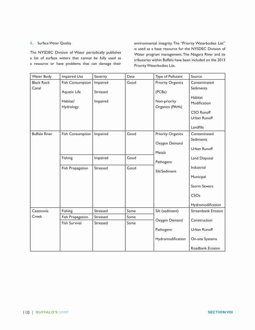
110 | BUFFALO’S LWRP SECTION VIII
6. Surface Water Quality
The NYSDEC Division of Water periodically publishes a list of surface waters that cannot be fully used as a resource or have problems that can damage their
environmental integrity. The “Priority Waterbodies List” is used as a base resource for the NYSDEC Division of Water program management. The Niagara River and its tributaries within Buffalo have been included on the 2013 Priority Waterbodies List.
Water Body Impaired Use Severity Data Type of Pollutant Source
Black Rock Canal
Fish Consumption
Aquatic Life
Habitat/Hydrology
Impaired
Stressed
Impaired
Good Priority Organics
(PCBs)
Non-priority Organics (PAHs)
Contaminated Sediments
Habitat Modification
CSO Runoff Urban Runoff
Landfills
Buffalo River Fish Consumption Impaired Good Priority Organics
Oxygen Demand
Metals
Pathogens
Silt/Sediment
Contaminated Sediments
Urban Runoff
Land Disposal
Industrial
Municipal
Storm Sewers
CSOs
Hydromodification
Fishing Impaired Good
Fish Propagation Stressed Good
Cazenovia Creek
Fishing Stressed Some Silt (sediment)
Oxygen Demand
Pathogens
Hydromodification
Streambank Erosion
Construction
Urban Runoff
On-site Systems
Roadbank Erosion
Fish Propagation Stressed Some
Fish Survival Stressed Some

| 111INVENTORY & ANALYSIS
Water Body Impaired Use Severity Data Type of Pollutant Source
Niagara River Fish Consumption Impaired Good Priority Organics (PCBs, PAHs)
Pesticides
Water Level/Flow
Non-priority Organics
Land Disposal
Contaminated Sediments
Urban Runoff
CSOs
Hydrologic/Habitat Modification
Water Supply Threatened Some
Aquatic Life
Habitat/Hydrology
Stressed
Impaired
Some
Scajaquada Creek
Bathing Precluded Some Aesthetics
Priority Organics
Nutrients
Silt/Sediment
Oxygen Demand
Salts
Pathogens
CSOs
Urban/Stormwater Runoff
Contaminated Sediments
Land Disposal
Chemical Leaks/ Spills
Hydromodification
HabitatModification
Aquatic Life Precluded Some
Habitat/Hydrology Stressed Some
Recreation Impaired Some
Aesthetics Stressed Some
Delaware Park (Hoyt) Lake
Bathing Impaired Good Nutrients
Algae/Weed Growth
Priority Organics (PCBs)
Oxygen Demand
Urban/Stormwater Runoff
Contaminated SedimentsFish Consumption Impaired Good
Recreation Impaired Good
B. Active River Area, Wetlands and Floodplains
1. 1. Active River Area
The Active River Area (ARA) is a conservation framework for rivers and streams that integrates both physical and ecological processes that form, change and maintain a wide array of habitat types and conditions in and along rivers and streams. A draft map of the Niagara River ARA was prepared in connection with the Niagara Regional Habitat Conservation Strategy. The City of Buffalo is located within the low-watershed of the Niagara River. It contains almost 13 % of the 70,553 acres that comprise the Niagara River ARA. Within the City, the ARA includes bothfloodplainandwetlandsareas

112 | BUFFALO’S LWRP SECTION VIII

| 113INVENTORY & ANALYSIS
2. Federal Wetlands
The Federal Government, through the USACE, regulates wetlands regardless of size, in accordance with the Clean Water Act. These areas, mapped by the U.S. Fish and Wildlife Service, are designated as wetlands based upon the presence of three features: hydric soils, wetland vegetationandspecifichydrologicconditions.
A permit must be issued by the USACE if a wetland is disturbed or filled, or development is proposedwithinidentified wetland areas.AWaterQuality Certificationcould also be required from the NYSDEC, based upon the amount of federal wetland to be filled orotherwise disturbed.
The U.S. Fish and Wildlife Service National Wetland InventoryclassifiestheNiagaraRivercorridor,ScajaquadaCreek, North Buffalo Harbor, Buffalo Ship Canal, Buffalo River, and Cazenovia Creek as Federal wetlands. The areas in and around Times Beach Nature Preserve, Tifft Nature Preserve, the southern portion of Gallagher Beach and certain lands in the Buffalo Lakeside Commerce Park (BLCP), are also designated as potential wetland habitats.
3. State Wetlands
Pursuant to the New York Freshwater Wetlands Act, the NYSDEC regulates activity within State-designated freshwater wetland areas and the area immediately adjacent to wetlands (within 100 feet).
The New York Freshwater Wetlands Act assigns classifications to State wetlands ranging from Class I(Highest) to Class IV (lowest). According to the act:
� Class I wetlands are the most significant, providing the most critical benefits and habitat value, a reduction of which is acceptable only in the most unusual of circumstances. A permit will be issued only if it is determined that the proposed activity satisfies a compelling economic or social need that clearly and substantially outweighs the loss of or detriment to the benefit(s) of the Class I wetland.
� Class II wetlands provide important wetland benefits, the loss of which are acceptable only in very limited
circumstances. A permit will be issued only if it is determined that the proposed activity satisfies a pressing economic or social need that clearly outweighs the loss of or detriment to the benefit(s) of the Class II wetland.
Class I and II wetlands have been designated within the City of Buffalo LWRA. NYSDEC controls a small number of freshwater wetlands south of the Buffalo River. They include:
� the Times Beach Class I wetland, which is also underlain by an unconfined aquifer;
� Several Class I wetlands located in Tifft Nature Preserve and BLCP, and wetlands located along the rail corridors; and
� A Class II wetland area located south of Tifft Street, within the BLCP.
Where practicable, upland wetland areas designated in the Buffalo LWRA have been protected in the City’s UDO as open space.
4. Floodplains
TheCityofBuffaloLWRAcontainsfloodzonesthathavebeen designated by the Federal Emergency Management Agency (FEMA) as areas subject to potential floodhazards.TheseareasorfloodzonesaredepictedontheFEMA Flood Insurance Rate Maps (FIRMs) developed for theCity.Thefloodzonesareestablishedbaseduponthedegreetowhichanareaissusceptibletoflooddamage.The two general flood zones that exist within theLWRA include:
� “AE” Zone – (also called the area of special flood hazard), which is the area of land that would primarily experience still water flooding, without significant wave activity, during a 100-year storm; and
� “C” Zone – which are areas of minimal flooding.
Flood zones or plains are flat areas that surroundstreams and are periodically inundated with water due to overbankflow.AsshownonMap10,mostofthesurfacewater bodies found within the LWRA are surrounded by 100-yearfloodplains.
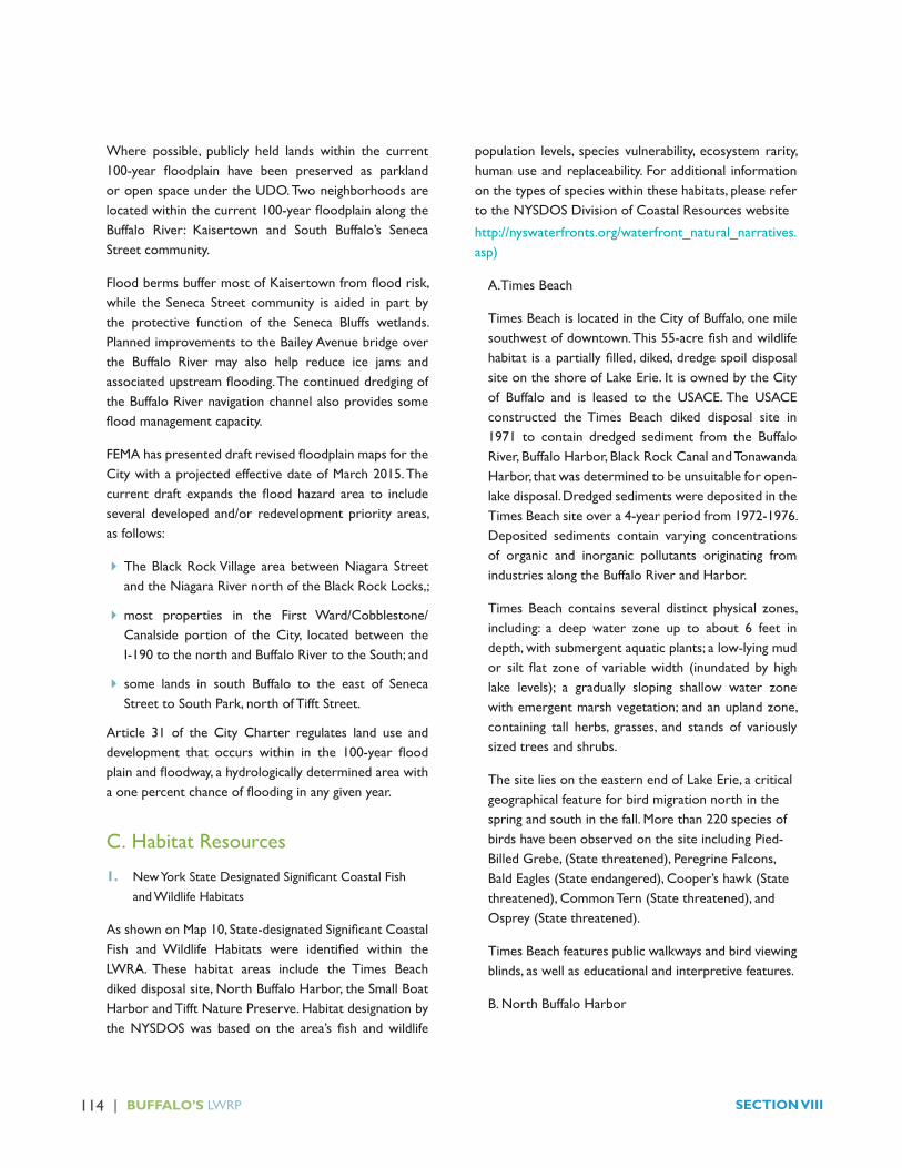
114 | BUFFALO’S LWRP SECTION VIII
Where possible, publicly held lands within the current 100-year floodplain have been preserved as parklandor open space under the UDO. Two neighborhoods are locatedwithinthecurrent100-yearfloodplainalongtheBuffalo River: Kaisertown and South Buffalo’s Seneca Street community.
FloodbermsbuffermostofKaisertownfromfloodrisk,while the Seneca Street community is aided in part by the protective function of the Seneca Bluffs wetlands. Planned improvements to the Bailey Avenue bridge over the Buffalo River may also help reduce ice jams and associatedupstreamflooding.Thecontinueddredgingofthe Buffalo River navigation channel also provides some floodmanagementcapacity.
FEMAhaspresenteddraftrevisedfloodplainmapsfortheCity with a projected effective date of March 2015. The currentdraft expands thefloodhazard area to includeseveral developed and/or redevelopment priority areas, as follows:
� The Black Rock Village area between Niagara Street and the Niagara River north of the Black Rock Locks,;
�most properties in the First Ward/Cobblestone/Canalside portion of the City, located between the I-190 to the north and Buffalo River to the South; and
� some lands in south Buffalo to the east of Seneca Street to South Park, north of Tifft Street.
Article 31 of the City Charter regulates land use and development that occurs within in the 100-year floodplainandfloodway,ahydrologicallydeterminedareawithaonepercentchanceoffloodinginanygivenyear.
C. Habitat Resources
1. NewYorkStateDesignatedSignificantCoastalFishand Wildlife Habitats
AsshownonMap10,State-designatedSignificantCoastalFish andWildlife Habitats were identified within theLWRA. These habitat areas include the Times Beach diked disposal site, North Buffalo Harbor, the Small Boat Harbor and Tifft Nature Preserve. Habitat designation by theNYSDOSwas basedon the area’s fish andwildlife
population levels, species vulnerability, ecosystem rarity, human use and replaceability. For additional information on the types of species within these habitats, please refer to the NYSDOS Division of Coastal Resources website
http://nyswaterfronts.org/waterfront_natural_narratives.asp)
A.Times Beach
Times Beach is located in the City of Buffalo, one mile southwestofdowntown.This55-acrefishandwildlifehabitat isapartiallyfilled,diked,dredgespoildisposalsite on the shore of Lake Erie. It is owned by the City of Buffalo and is leased to the USACE. The USACE constructed the Times Beach diked disposal site in 1971 to contain dredged sediment from the Buffalo River, Buffalo Harbor, Black Rock Canal and Tonawanda Harbor, that was determined to be unsuitable for open-lake disposal. Dredged sediments were deposited in the Times Beach site over a 4-year period from 1972-1976. Deposited sediments contain varying concentrations of organic and inorganic pollutants originating from industries along the Buffalo River and Harbor.
Times Beach contains several distinct physical zones, including: a deep water zone up to about 6 feet in depth, with submergent aquatic plants; a low-lying mud or silt flat zoneof variablewidth (inundatedby highlake levels); a gradually sloping shallow water zone with emergent marsh vegetation; and an upland zone, containing tall herbs, grasses, and stands of variously sized trees and shrubs.
The site lies on the eastern end of Lake Erie, a critical geographical feature for bird migration north in the spring and south in the fall. More than 220 species of birds have been observed on the site including Pied- Billed Grebe, (State threatened), Peregrine Falcons, Bald Eagles (State endangered), Cooper’s hawk (State threatened), Common Tern (State threatened), and Osprey (State threatened).
Times Beach features public walkways and bird viewing blinds, as well as educational and interpretive features.
B. North Buffalo Harbor
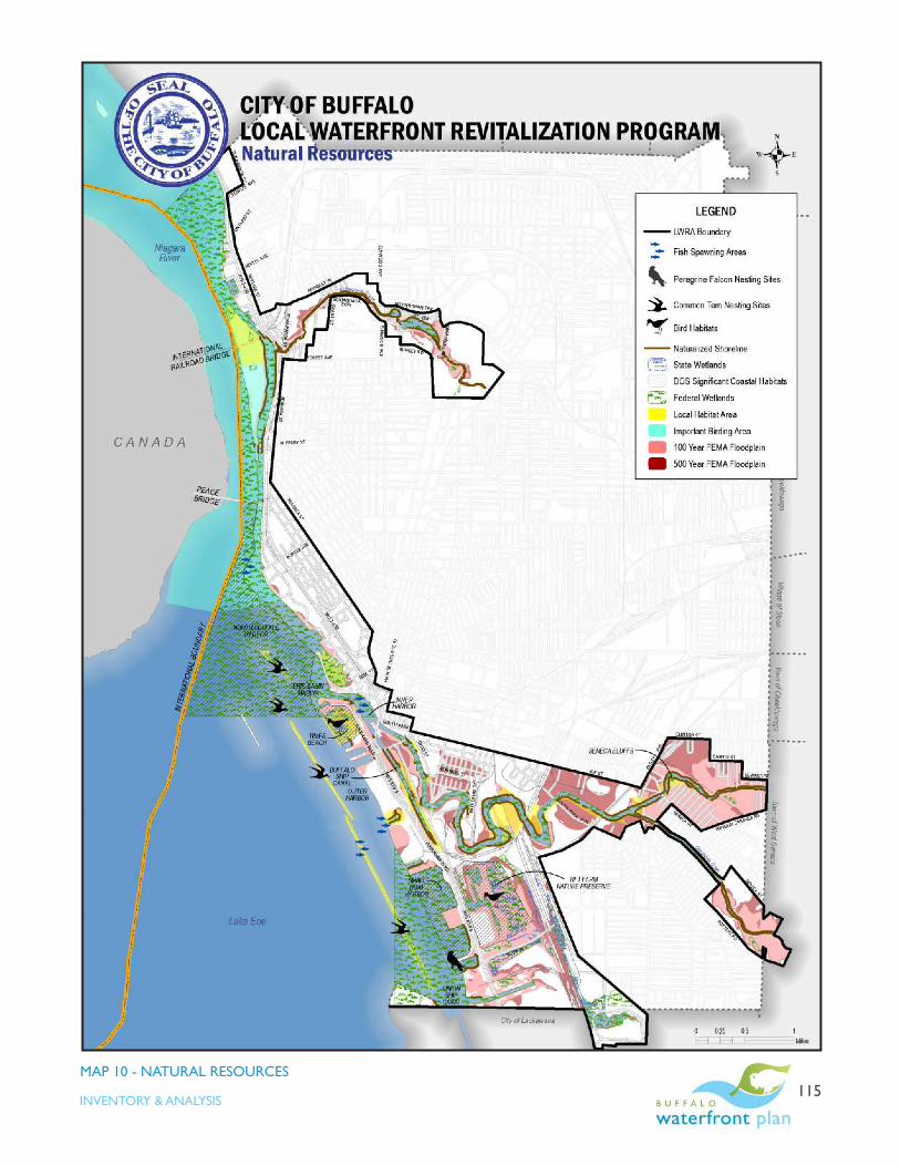
| 115INVENTORY & ANALYSIS
MAP 10 - NATURAL RESOURCES

116 | BUFFALO’S LWRP SECTION VIII
The North Buffalo Harbor is located in the northeast corner of Lake Erie, at the head of the Niagara River. This harbor consists of approximately 800 acres of open Lake water and upper river channel, extending roughly from the mouth of the Buffalo River to the Peace Bridge. Water depths vary from less than six feet over several small reefs to over 20 feet below mean low water. The harbor is home to several important wildlife communities including:
� 150 nesting pairs of Herring Gulls, on the sand and gravel bar located at the north end of Donnelly’s
Wall, their only nesting area between Buffalo and the eastern basin of Lake Ontario.
� 400 nesting pairs of Common Tern on the broken concrete surfaces of three of the breakwalls, including Donnelly’s Wall, the North End Light Breakwater and the abandoned lighthouse near Middle Reef. This is the largest colony of this declining species anywhere in the Great Lakes.
� Concentrations of many waterfowl species including loons and grebes, as well as gulls, and terns, are present in North Buffalo Harbor during spring and fall migrations (March-April and September-November, respectively). Winter waterfowl surveys done by NYSDEC have tallied up to 68,000 ducks in this open area at one time, and weekly surveys done throughout the winter regularly count 20,000 and above. The birds take advantage of the open water created downstream of the Lake Erie ice boom, feeding on the abundant supply of small fish, such as emerald shiners and shellfish.
�Muskellunge is a native apex predator fish species with local populations supported entirely by natural reproduction in the Buffalo Harbor and Upper Niagara River. During the early 1990’s survey work in shallow, vegetated embayments in the Buffalo Harbor indicated that young-of-year muskellunge were present in four of these embayments, indicating that these areas were muskellunge spawning habitats (Culligan et al 1994). More recently, from 2007 to 2009, young-of-year muskellunge have been collected from two embayments: “Ice Boom Bay” (the embayment directly south of the Times Beach Preserve) and the Bell Slip. The numbers of young muskellunge collected at these locations recently are generally much lower than during the early 1990’s.
�North Buffalo Harbor supports a major urban fishery, of regional significance. Predominant fish species occurring in the harbor include rock bass, white bass, smallmouth bass, yellow perch, walleye, northern pike, muskellunge, brown trout, rainbow trout, and coho salmon. Among the most popular fishing spots are near Donnelly’s Wall, and the “fish market” located just outside of the southern portion of Bird Island Pier.
C. Small Boat Harbor
The Small Boat Harbor is located on the Outer Harbor and has an area of approximately 165 acres. The Small Boat Harbor is the only sizable shallow water embayment on Lake Erie in Erie County (generally less than 12 feet deep below mean low water). Sheltered from prevailing winds and wave action by a two-mile long rock breakwall, the harbor is armored on three sides with rip-rap, concrete bulkheads, and gravel-cobble beach; the fourth side (westerly) is open to the Outer Harbor, with an approximate 30-foot deep dredged navigation channel. This protected location has resulted in enhanced sediment deposition and growth of submerged aquatic macrophytes, such as water milfoil, wild celery, and pondweeds. Substrates vary from a mixture of sand, gravel, and cobble, in some nearshore areas, to a dark brown gelatinous type sediment (gyttja).

| 117INVENTORY & ANALYSIS
The harbor supports a highly productive and diverse littoralcommunity,withconcentrationsofmanyfishand wildlife species occurring in the area. Studies of the harbor in 1981 demonstrated that this was a diverse and productivefisherieshabitat.Themajoradultfishesfoundin the area were pumpkinseed, yellow perch, and brown bullhead, along with largemouth bass, muskellunge, carp, and freshwater drum. Icthyoplankton sampling revealed substantial reproduction by centrarchids, shiners, and yellow perch. Carp and drum may also enter the area to spawn. By midsummer, the Small Boat Harbor is ideal forcentrarchidsandbullheadsasmacrophytesfilltheembayment. The Small Boat Harbor is the largest, most obvious nursery area for numerous harbor and lake species on the Erie County shoreline. In addition, the harbor supports a productive macrobenthic community, dominated by snails and clams.
Submerged, rooted macrophytes and their associated invertebratesandfishprovidevaluablefoodresourcesfor many species of waterfowl and other migratory birds. The Small Boat Harbor attracts concentrations of these birds during spring and fall migrations (March-April and September-November, respectively), with some species remaining until the harbor freezes in early to mid-winter. The most abundant birds observed during these periods are the diving ducks, including canvasback, scaups, mergansers, common goldeneye, scoters, mallard, black duck, Canada goose, loons, grebes, and gulls. Hundreds of these birds are regularly found in the area during late fall, with the greatest numbers occurring when open waters on Lake Erie are rough. Prior to ice-up, the Small Boat Harbor serves as a refuge and feeding area for some of the larger concentrations of waterfowl in North Buffalo Harbor. During the summer months, ring-billed gull, herring gull, and common tern may feed in the area, but the extent of their use has not been documented. The concentrations of birds which utilize the harbor, and the availability of good public access and vantage points, makes this a popular birdwatching site during waterfowl migration periods and in early winter.
Theharborprovideshighqualityrecreationalfishingopportunities throughout the year. Anglers from throughout the Buffalo metropolitan area are attracted
tothediversewarmwaterfisheries,andicefishingisespecially popular.
D. Tifft Nature Preserve
TifftNaturePreserveisthelargestcontiguousfishandwildlife habitat area within the City of Buffalo. The 264-acreformerlandfillwasdesignatedapreservein1976and is owned by the City of Buffalo and operated by the Buffalo Museum of Science.
Of special importance is the relatively undisturbed wetland area, which is the largest of its kind along the Lake Erie coastline. The site includes a 75-acre cattail marsh, small freshwater ponds and old canal remnants, oldfields(partlycoveringaformersolidwastetransfer site), forested wetland, and shrubsapling stages of succession.
Birds of 264 species and subspecies have been recorded in and immediately adjacent to its boundary including least bittern, American bittern and and osprey. Tifft is home to white tailed deer, beaver, muskrat, weasel, mink, red and grey fox and coyotes. Reptiles and amphibians include northern water snake, snapping and painted turtles, bullfrog, green frog, northern leopard frog, and Jefferson salamander, which are year-round residents. At least two species of fish, the central mudminnowand brook stickleback, are present. Tifft Preserve also containsapopulationofburrowingcrayfish,oneofonlythree known localities for this species in New York State.
2. Rare or Endangered Species Habitat

118 | BUFFALO’S LWRP SECTION VIII
The New York State Natural Heritage Program had identified rare or endangered species throughoutNewYork State. According to their records, the City of Buffalo LWRA includes ninebark, a rare vascular plant; gull and common tern nesting areas; two rare fishes,mooneye (Hiodon tergisus) and lake sturgeon (Acipenser fulvescens), both New York State threatened species; and peregrine falcons. Lake sturgeon have been caught at the north gap of the Buffalo Harbor within the LWRA. Lake sturgeon are listed as a threatened species in New York; therefore, there is no open season for the fishand possession is prohibited. Anglers are more likely to encounter sturgeon inMay and June when the fishgather to spawn on clean gravel or cobble shoals and in stream rapids.
In 2010, a nesting pair of peregrine falcons, a state endangered species, was discovered on the Cargill Pool grain elevators at the foot of Tifft Street, along Furhmann Boulevard. A New York State threatened species, the common tern, makes its home on the breakwalls in the Buffalo Harbor, as described earlier.
3. NiagaraRiverGloballySignificantImportantBirdArea
The Niagara River has been designated as a Globally Significant Important Bird Area (GSIBA), a raredesignation given by National Audubon to only 71 other sites in the world The eastern end of Lake Erie provides two geographic features that assist in the lake crossing. One is Long Point, Ontario, a peninsula of land that juts 28 miles out into Lake Ontario, greatly narrowing the crossing. Birds “jump off” the end of the peninsula, and greatly reduce the time they spend over water before they reach the opposite shore. The second feature is the isthmus formed where Lake Erie drains into Lake Ontario via the Niagara River. Migratory birds are drawn to these features because most birds do not like to cross expanses of water where they lose the critical thermal updraft provided by warm air rising over land that reduces the metabolic cost of flight.Additionally, if they tire whileflyingoverwater,deathisalmostcertainbecauseinthelarge open waters of Lakes Erie and Ontario, there are no islands on which to land.
According to the Audubon Society of New York, the Niagara River GSIBA annually supports one of the world’s most spectacular concentrations of gulls, with 19 species

| 119INVENTORY & ANALYSIS
recorded and one-day counts of over 100,000 individuals. The site is particularly noteworthy as a migratory stopover and overwintering site for Bonaparte’s Gulls, with one-day counts of 10,000 to 50,000 individuals (2 to10 % of the world population). Herring Gull one-day counts vary from 10,000 to 50,000 and Ring-billed Gull one-day counts vary from 10,000 to 20,000 individuals. The river also hosts a remarkable diversity and abundance of waterfowl. Winter surveys taken by NYSDEC have shown a 22-year average of 2,808 Canvasbacks (32 % of state overwintering population), 7,527 Common Mergansers (31 % of state overwintering population), 2,015 Common Goldeneyes (29 % of state overwintering population), and 2,369 scaup (6 % of state overwintering population). Annual peak numbers for Canvasbacks range from 2,000 to 15,000, for Common Goldeneyes from 2,300 to 3,000, for Common Mergansers from 2,500 to 12,000, and for Greater Scaup from 2,500 to15,000 individuals. The river also supports breeding colonies of Common Terns, Herring Gulls, Ring-billed Gulls, Blackcrowned Night Herons (50 to 60 pairs), Great Blue Herons, Great Egrets, and Doublecrested Cormorants. The habitats along the river edge support an exceptional diversity of migratory songbirds during spring and fall migrations. Manyofthemigratingspeciesfindhabitatandrefugeatthe various open areas and nature preserves that exist in the vicinity of the river, including Times Beach Preserve and Tifft Nature Preserve (which is also designated by the Audubon Society as an IBA).
4. Local Habitat Areas and Restoration Sites
Thefollowinghabitatsiteshavebeenidentifiedthrougheither Buffalo or Niagara River Great Lakes Area of Concern habitat analysis and restoration efforts. Highly detailed information regarding each habitat site on the Buffalo River has been developed in conjunction with the Buffalo River Ecological Restoration Master Plan and Buffalo River Sediment Remediation Feasibility Study.
� Squaw Island
A former City of Buffalo landfill, the north endof Squaw Island was closed and developed as a passive park. According to 2012 Natural Land Cover analyses associated with the Niagara River Habitat
Conservation Strategy development (NRHCS), the north end of the Island and park currently offers pond, emergent wetland, grassland/shrub and woodland habitats. In addition, the eastern edge of Squaw Island, between the International Railroad Bridge and the West Ferry Lift bridge features forest habitat and is often frequented by herons, waterfowl and gulls.
� Scajaquada Creek
According to the 2012 NRHCS, Scajaquada Creek offers woodland open water and grassland/shrub habitat along its course from Forest Lawn Cemetery to the Black Rock Channel. The US Army USACE of Engineers is studying the lower reaches of Scajaquada Creek, including opportunities to improve habitat in the Creek corridor.
� City Ship Canal
The head of the City Ship Canal is owned by CSX railroad and others. According to the Buffalo River

120 | BUFFALO’S LWRP SECTION VIII
FeasibilityStudy, thisareahasbeen identifiedasoneofthe Buffalo River Habitat Opportunity Areas. Although CityShipisanartificialchannel,ithasvalueasahabitatlink between Lake Erie coastal and Buffalo River habitats, especially forwaterfowlandfish inneedofnestingandresting places. Native shoreline and aquatic vegetation has naturalized the western edge of the canal, south of the active industrial area. Buffering, removal of debris and slag piles from the eastern bank and sediment remediation would increase the habitat value of the canal. Numerous fishspecieshavebeenobservedattheheadoftheCityShip Canal, including largemouth bass, rock bass, crappie, bullhead,carp,redhorse,sunfish,andgoldfish.
�Ohio Street/Dead Creek
One of three projects completed under the 1996 Buffalo Fish and Wildlife Habitat Restoration Demonstration Project,thisprojectestablishedfish-spawninghabitatandimprovedpassivefishingaccessatDeadCreekonOhioStreet. The site is owned and managed by the New York State Department of Environmental Conservation and is maintained by the City of Buffalo Parks department.
Fish species observed at this location include largemouth bass, smallmouth bass, rock bass, and sunfish.There isabundantfishingalongthisstretch inareaswithnaturaland unnatural cover/overhanging vegetation.
This remnant “canal” once connected the Buffalo River to what is now “Father Conway Park”. The parcel now still functions as a combined sewer overflow (CSO outfall.Due to river hydrology, this canal collects debris, trees, and litter.
� Katherine Street Peninsula
This 4.8-acre parcel features almost one thousand linear feet of naturalized shoreline with mature vegetation withinthe100-footfloodplain.
Figure 1 - Katherine Street Peninsula
� Blue Tower Turning Basin
The Blue Tower Turning Basin located east of the foot of Katherine Peninsula at the southern end of Concrete Central Peninsula is named for the blue Buffalo River Improvement Corporation (BRIC) water tower located to the south. The shoreline in this area of the River is natural with overhanging vegetation. Due to Buffalo River flow and deposition patterns, significant debrishas accumulated along the eastern shore of the River at thesite.TheNewYorkStateDEChasidentifiedalargefreshwater bryozoan colony, characteristic of unpolluted, unsilted ponds and streams, at the site.
Figure 2 - View south towards Blue BRIC Tower
Turning Basin

| 121INVENTORY & ANALYSIS
� Concrete Central Peninsula (CCP)
Because of its isolation, Concrete Central Peninsula has remained relatively undisturbed. Located within the 100-yearfloodplain,CCPhasbeenidentifiedinBuffaloRivergreenway plans and by USACE as a “refuge for species not generally expected in an urban ecosystem” including peregrine falcon, snapping turtle, painted turtle and leopard frog”.
Figure 3 - Concrete Central Peninsula
� Red Jacket Riverfront Park (also known as the Smith Street Recreation Site)
Red Jacket Riverfront Park is 44 acres of open space located at the end of Smith Street, including 7 acres owned and maintained by Erie County. One of three projects completed under the 1996 Buffalo Fish and Wildlife Habitat Restoration Demonstration Project, wetlands reconstruction, habitat restoration, invasive species management and passive public access facilities were created at Red Jacket Park.
The park was formerly the site of parking areas for the employees of Concrete Central. Bought by Erie County in the 1990s, the site was remediated and turned into the open space park that exists today. The park includes a series of nature trails with benches that guide visitors
through the various ecosystems present within the park. These include marshlands, forests, meadows and the riparian corridor of the Buffalo River. The park also includes murals painted on an old concrete wall along Smith Street, a fishing pier at the terminus of SmithStreet, a canoe/kayak launch area, several parking areas for visitors and river overlook areas.
Figure 4 - Wetland Restoration Project at Smith Street
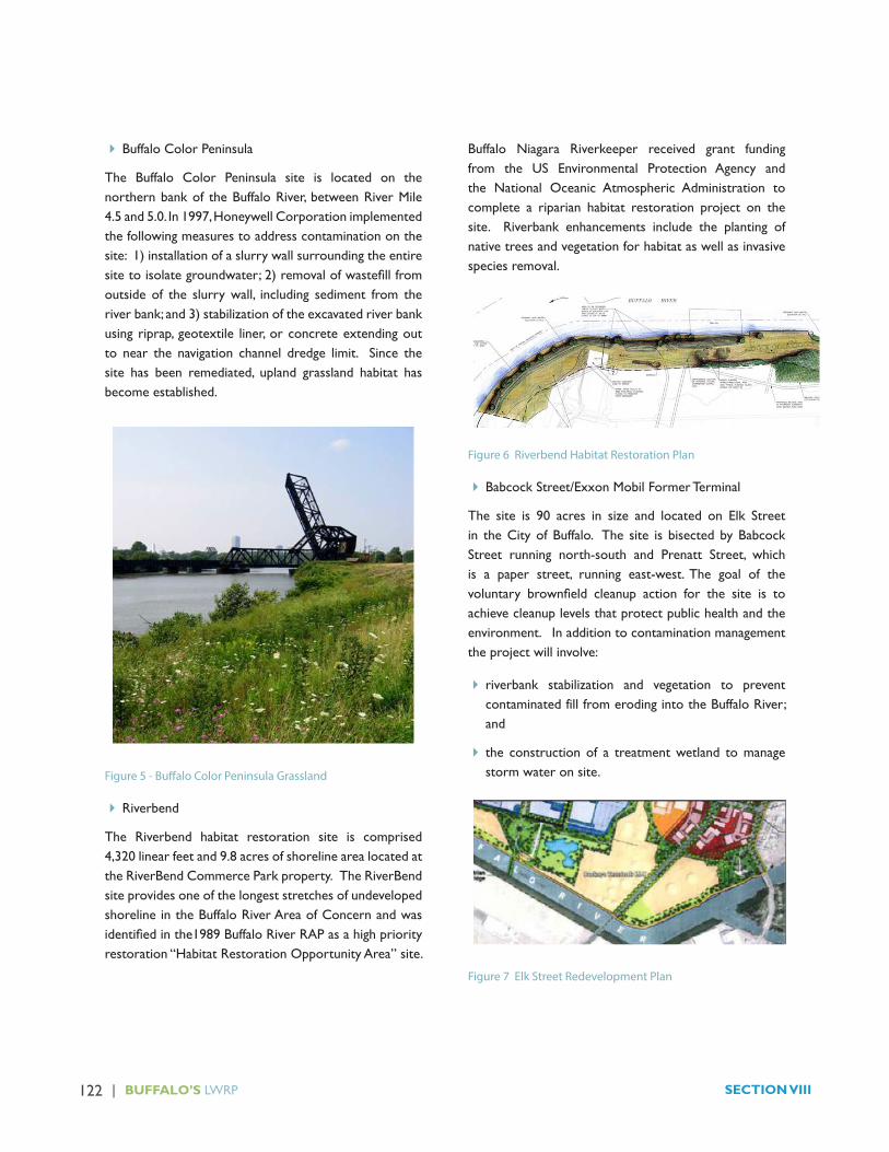
122 | BUFFALO’S LWRP SECTION VIII
� Buffalo Color Peninsula
The Buffalo Color Peninsula site is located on the northern bank of the Buffalo River, between River Mile 4.5 and 5.0. In 1997, Honeywell Corporation implemented the following measures to address contamination on the site: 1) installation of a slurry wall surrounding the entire sitetoisolategroundwater;2)removalofwastefillfromoutside of the slurry wall, including sediment from the river bank; and 3) stabilization of the excavated river bank using riprap, geotextile liner, or concrete extending out to near the navigation channel dredge limit. Since the site has been remediated, upland grassland habitat has become established.
Figure 5 - Buffalo Color Peninsula Grassland
� Riverbend
The Riverbend habitat restoration site is comprised 4,320 linear feet and 9.8 acres of shoreline area located at the RiverBend Commerce Park property. The RiverBend site provides one of the longest stretches of undeveloped shoreline in the Buffalo River Area of Concern and was identifiedinthe1989BuffaloRiverRAPasahighpriorityrestoration “Habitat Restoration Opportunity Area” site.
Buffalo Niagara Riverkeeper received grant funding from the US Environmental Protection Agency and the National Oceanic Atmospheric Administration to complete a riparian habitat restoration project on the site. Riverbank enhancements include the planting of native trees and vegetation for habitat as well as invasive species removal.
Figure 6 Riverbend Habitat Restoration Plan
� Babcock Street/Exxon Mobil Former Terminal
The site is 90 acres in size and located on Elk Street in the City of Buffalo. The site is bisected by Babcock Street running north-south and Prenatt Street, which is a paper street, running east-west. The goal of the voluntary brownfield cleanup action for the site is toachieve cleanup levels that protect public health and the environment. In addition to contamination management the project will involve:
� riverbank stabilization and vegetation to prevent contaminated fill from eroding into the Buffalo River; and
� the construction of a treatment wetland to manage storm water on site.
Figure 7 Elk Street Redevelopment Plan

| 123INVENTORY & ANALYSIS
�Old Bailey Woods
TheOldBaileyWoodssite,neartheconfluenceoftheBuffalo River and Cazenovia Creek, is a large wooded lotthatisusedbylocalresidentsforfishingandpassiverecreation.This3.1-acrelot,whichistheonlyfloodplainforest in the City, was designated as a passive park under a settlement agreement associated with the development of the Iron Mountain Records facility, east of the site. There is an internal dirt path that allows access to this property from either Payson Street or Bailey Avenue.
Figure 8 - Old Bailey Woods Fishing Access
� Bailey Avenue Peninsula (Confluence Point)
One of three projects completed under the 1996 Buffalo Fish and Wildlife Habitat Restoration Demonstration Project , habitat restoration, invasive species management and passive public access facilities were createdatConfluencePointParkattheconfluenceof Cazenovia Creek and the Buffalo River . This 3.8-acre Erie County-owned and maintained site provides walking trails, scenic overlooks of the Buffalo River and interpretivesignage.Thesiteisusedheavilyforfishingby local residents and also offers several scenic vistas with benches.
Figure 9 - Bailey Peninsula/Confuence Point
� Seneca Bluffs
Seneca Bluffs Natural Habitat Park is a designated Erie County wetlands restoration area located at the Seneca Street Bridge, between Elk Street and Avon Place. It consistsof15acresofriparianfloodplainlocatedinaheavily urbanized area along the Buffalo River. Habitat typesincludefloodplainisland,seasonallyfloodedwetland,forestedfloodplain,anduplandmeadow,alongwith 2,500 feet of shoreline. Migratory birds, wading birds and waterfowl make use of this site. Challenges include the domination of approximately 85 percent of the site by invasive and non-native plants and areas of shoreline that are actively eroding.
The City owns a small number of undeveloped street right –of-ways that extend toward the river immediately upstream of Seneca Bluffs. These include Avon Place and the terminus of Leamington Place, Avondale Place and Juniata Place. This area is submerged when melting snow increasestheflowandsubsequentwaterlevelintheBuffalo River.
Figure 10 - Seneca Bluffs

124 | BUFFALO’S LWRP SECTION VIII
�Houghton (Stachowski) Park to City Line
From Bailey Avenue east to the City line, including substantial City-owned acreage at Houghton Park , the north shore of the Buffalo River is characterized by forestedfloodplain,emergentwetlandhabitatanduplandgrassland areas.
Figure 11 - Buffalo River facing east to South Ogden Bridge
� Buffalo School Sites along the Buffalo River
Public school properties at Southside Elementary, Red Jacket Elementary and South Buffalo Charter School are located adjacent the Buffalo River and contain woodland, grassland and important shoreline habitat resources.
� Bell Slip/100 year floodplain/ Outer Harbor Shoreline
The 2,300 linear feet of shoreline at the Outer Harbor Bell Slip was enhanced as part of the $13.5 million Outer Harbor Greenbelt project. Improvements included soil remediation, installation of new stone revetment and slope embankment to prevent erosion, landscaping, constructionofshallowwaterhabitatsupportiveoffishspawning ,and installation of bio-engineered compost to support vegetation and attract wildlife. Substantial portions of the vacant land north of the Ford Terminal Complex on the Outer Harbor are within the 100-year floodplainandserveasnaturalprotectivefeatures.
� Ship Canal Commons
As part of the wildlife habitat improvements at Ship Canal Commons, large tree trunks were weighted and placed on the bottom of the Union Ship Canal and partially buried in an underwater stabilization berm, with the rootsexposed,tocreateartificialreefs.Floatingraftsofwillow logs alsoprovide cover forfish.Aone-half acreportion of the site, adjacent to the northwest corner of the canal, was excavated to create a small marsh where native aquatic plants were placed.

| 125INVENTORY & ANALYSIS
D. Fish Resources
While no commercial fisheries are known to exist onLake Erie in New York, Lake Erie remains the largest freshwater commercial fishery in Canada, and one ofthemostvaluablefreshwatercommercialfisheriesintheworld.In2011,theLakeEriecommercialfishingindustrycaughtnearly22millionpoundsoffishworth$28million,much of which were sold to food stores and restaurants in Ontario, the U.S. and around the world. The total valueofLakeErie’scommercialfisherywas$194millionin 2011.
Within the Buffalo LWRA, Lake Erie and Niagara River are home to several sport fishing charter businesses,bait shops, numerous shoreline fishing sites with largenumbers of residents, including the City’s growing immigrant communities, relyingupon locally caughtfishas a source of protein.
ThereisanabundanceoffisheryresourcesintheLWRA,including both native and non-native species. Native species found in Lake Erie and the Upper Niagara River include: largemouth and smallmouth bass, yellow perch, walleye, northern pike, muskellunge, rock bass, sheepshead, smelt, emerald shiners and lake sturgeon. In general,thepotentialforoverfishingisnotconsideredtobe a problem; however, catches of certain highly-sought species, such as muskellunge, walleye or steelhead, under certain conditions, may pose concerns for anglers and fisheriesmanagers.
NYSDEC’smanagement of Lake Erie fishery resourcesincludes a component focused on providing steelhead and rainbow trout fishing opportunities, particularly inthe major tributaries. Approximately 250,000 steelhead are stocked annually in selected New York tributaries of Lake Erie, including about 45,000 in the Buffalo River system. Steelhead are stocked in early spring, usually April, in Cayuga Creek, Cazenovia Creek and the Buffalo River in order to imprint the young so they will return to these streams when they mature. Since 2005, a portion of steelhead have been stocked into holding pens in the Buffalo River at the Bison City Rod and Gun Club to improve survival and imprinting.The fish are held
for about three weeks, fed, monitored, measured and released by volunteers.
The Buffalo River has a long history of significantenvironmental degradation. There are numerous reports describing a variety of factors related to the degradation, including impacts upon aquatic resources. There have also been substantial improvements in the fish community in recent decades. Many of the fishspecies expected to be found in this type of habitat are present, although abundance of many highly desirable native fish species, such as smallmouth bass, walleye,northern pike, and muskellunge, is low. There are many limitationstoachievingafully-recoveredfishcommunityin the Lower Buffalo River. They include physical factors such as lack of shallow areas, excessively high surface water temperatures, seasonal lowflows, lackofnaturalshoreline, lack of underwater cover, and poor condition of bottom sediments. Important chemical limitations include episodes of dissolved oxygen depletion and contaminated sediments. Reduced areas of aquatic vegetation, associated wetlands and contiguous shoreline vegetationarebiologicalfactorsthathavebeenidentifiedasproblematicforfishpopulations.
During 2003, NYSDEC, in cooperation with an advisory group, initiated a walleye restoration project for the Buffalo River. The objective of the project is to establish a self-sustaining, riverine walleye population in the Buffalo River. This project could potentially develop a seasonal walleyefisheryintheBuffaloRiverandenhancewalleyefishing in the Buffalo Harbor. A successful spawningpopulation of walleye in the Buffalo River would diversify walleye reproduction in Lake Erie, helping to ensure more consistent walleye recruitment in Lake Erie. From 2004 to 2007, approximately 76,000 walleye fingerlings andapproximately 419,000 walleye fry have been stocked into theBuffaloRiver,inanticipationthatstockedfishwouldsurvive and return as adults to spawn. Unfortunately, in 2007, NYSDEC fish disease policy to contain thespread of viral hemorrhagic septicemia (VHS), caused a suspension of the stocking program, and it is hoped that the stocking program can be continued once disease related issues are resolved. In 2008, DEC conducted follow-up walleye sampling activities in the Buffalo River

126 | BUFFALO’S LWRP SECTION VIII
sincethiswasthefirstyearthatbothmalesandfemalesof the 2004 stocking cohort would be fully mature and perhaps detectable as a spawning concentration. No adult walleye were detected during this sampling effort; however, additional effort will be expended in the future to monitor success of the stocking activities.
A most notable aquatic resource in the LWRA is the presence of emerald shiners, a small, silvery minnow found in great abundance on a seasonal basis. Large numbers of shiners, a native species, are found in the Buffalo Harbor, Buffalo River and Upper Niagara during late winter, spring and early summer. The adult emerald shiners migrate in associationwithiceflowsfromLakeErieintotheNiagaraRiver. This species is an important food item for many of thefish-eatingbirds andpredatoryfish found in thesystem. These abundant minnows are also a staple of the localbaitfishindustry.However,theimportanceoflocallycaught shiners has diminished greatly since 2006/2007 when Federal and State fish disease regulations wereimplemented to control the spread of VHS. Prior to that time, large numbers of emerald shiners were commercially dipped from the Niagara River for local sale, as well as transport to other bait dealers in New York and other northeastern states.
Protection of emerald shiners and their migratory corridor is important. Each year during late summer and fall, millions of young shiners migrate upstream, against the current, from the Niagara River to Lake Erie where they grow to adults. In the river, these very small, young minnows have limited swimming capabilities and they swim along the shoreline of the River, taking advantage of areas where current velocities are reduced by rocks and other cover. In the vicinity of the Peace Bridge, where current velocities are very fast, habitats conducive to migrations are very limited, especially where there are long stretches of smooth, vertical concrete or metal structures.
The Buffalo LWRP policies aim to help rebuild the Lake Erie-Niagara River food web, supporting sport and subsistence fishing in the short term and contributingto the long term restoration of sustainable commercial fishinginNY’sLakeEriewaters.
E. Great Lakes Areas of Concern (AOCs)
TheBuffaloandNiagaraRivershavebeenidentifiedastwoof 43 toxic hot spots on the Great Lakes that have been designated by EPA and the International Joint Commission (IJC) as “areas of concern”. An AOC is a place that is so heavily polluted by raw sewage, contaminated sediments, invasive species, and habitat and wetland destruction that the damage threatens the ecosystem, the economy, water quality and the health of the community. The Buffalo and Niagara Rivers, their sediments and nearshore areas have been impaired by over a century of industrial activities and municipal waste discharges. Contamination of the river channels continues today from upstream non-point sources, CSO discharges, and historic contaminates containedinriversedimentsandriverfrontbrownfields.
The Niagara River AOC is located in Erie and Niagara counties in western New York. This AOC extends from Smokes Creek near the southern end of the Buffalo Harbor, north to the mouth of the Niagara River at Lake Ontario. Past municipal and industrial discharges and waste disposal sites have been a source of contaminants to the Niagara River. A long history of development has also changed the original shoreline along much of the river, affectingfishandwildlifehabitat.Habitatdegradationandthe survival of aquatic life in this AOC have been impaired by toxic chemicals, such as PCBs, mirex, chlordane, dioxin, dibenzofuran, hexachlorocyclo-hexane, PAHs, and pesticides. Fish migration from Lake Ontario has an influenceon theNiagaraRiver community, asdoes therelated affects of invasive species. Metals and cyanides in the sediment prevent open lake disposal of bottom sediments dredged from the river. Sources and loadings of pollutants causing use impairments in the Niagara River include these sediments, as well as inactive hazardous waste sites, CSOs, and other point and nonpoint sources. Contamination originating from discharges within Lake Erie’s watershed contributes to effects in the Niagara River and Lake Ontario.
The Buffalo River AOC is located in the City of Buffalo. Theriverflows fromtheeastanddischarges intoLakeErie, near the head of the Niagara River. The Buffalo

| 127INVENTORY & ANALYSIS
River “impact area” extends from the mouth of the Buffalo River to the farthest point upstream at which the backwater condition exists during Lake Erie’s highest monthly average lake level. The impact area is 6.2 miles in length. The AOC also includes the entire 1.4-mile stretch of the Buffalo Ship Canal, located adjacent to the river. The AOC impact area is characterized by historically heavy industrial development in the midst of a large municipality. There are three major streams in the watershed that create the AOC “source area”: Cayuga Creek, Buffalo Creek and Cazenovia Creek. The total drainage area for the Buffalo River watershed is approximately 440 square miles.
To address these problems, NYSDEC, in conjunction with the Buffalo Niagara Riverkeeper and citizen advisory
committees, prepared Remedial Action Plans (RAPs) for the Buffalo River in 1989 and the Niagara River in 1994. TheRAPs,andsubsequentupdates, identifiedBeneficialUse Impairments (BUI) for each river, set forth by the IJC, as well as plans to remediate the impairments. The goal of the Buffalo River RAP is to delist the Buffalo River as an Area of Concern by 2016, thereafter monitoring the river as an Area of Recovery.
IJC’sBeneficialUseImpairments Buffalo River AOC Status (as of 2011)
Known or Likely Cause
Niagara River AOC Status
Known or Likely Cause
1 Restrictions on Fish & Wildlife Consumption
Impaired PCB’s and chlordane in sediments
Impaired PCB’s and chlordane in sediments
2 Tainting of Fish & Wildlife Flavor
Impaired PAHs in sediment Not Impaired -
3 Degradation of Fish & Wildlife Populations
Impaired Low dissolved oxygen, river channelization, and contaminated sediments
Unknown -
4 Fish Tumors and Other Deformities
Impaired Contaminated sediments
Impaired Contaminated sediments
5 Bird or Animal Deformities or Reproductive Problems
Impaired PCBs, DDT, and metabolites in sediments
Impaired -
6 Degradation of Benthos Impaired Contaminated sediments and navigational dredging
Impaired Contaminated sediments
7 Restrictions on Dredging Impaired Contaminated sediments
Impaired Contaminated sediments
8 Eutrophication or Undesirable Algae
Not Impaired - Not Impaired
Buffalo River and Niagara River Areas of Concern, Beneficial Use Impairments
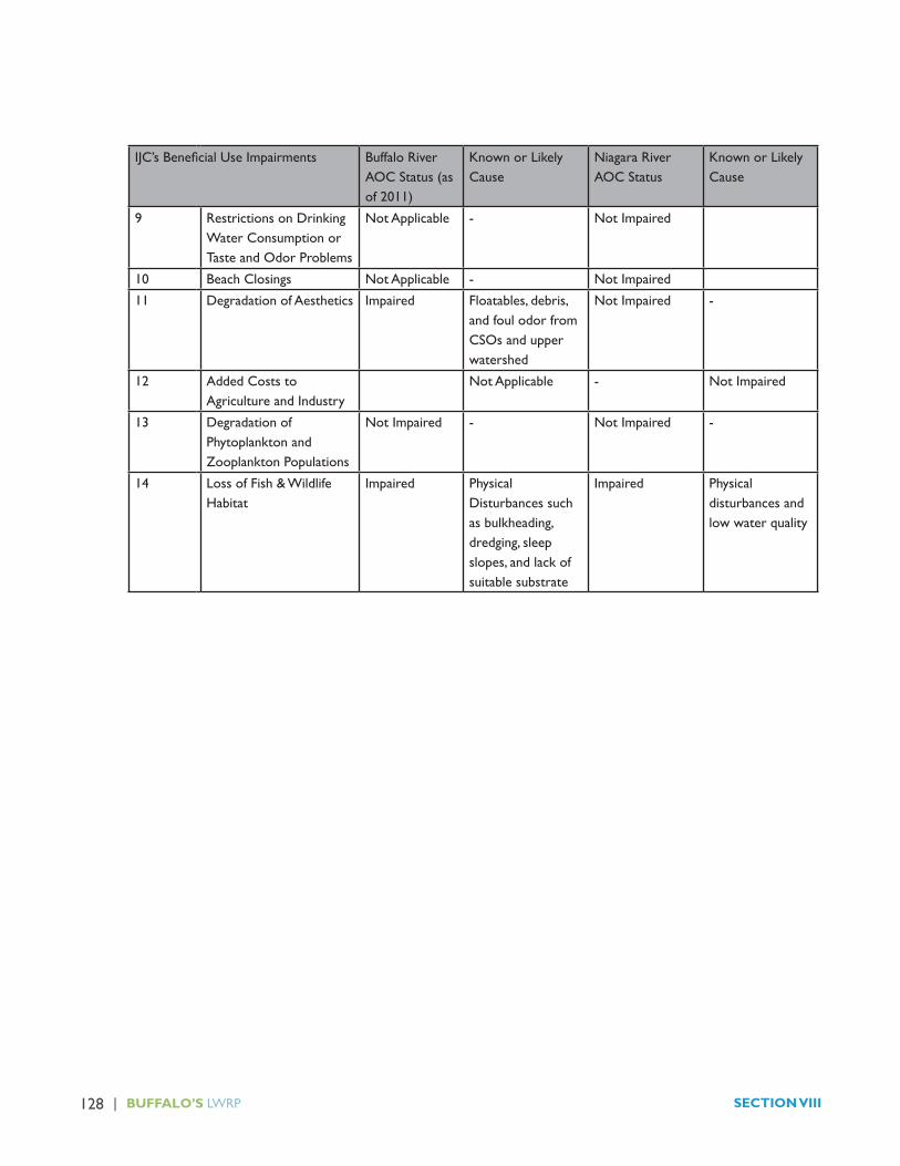
128 | BUFFALO’S LWRP SECTION VIII
IJC’sBeneficialUseImpairments Buffalo River AOC Status (as of 2011)
Known or Likely Cause
Niagara River AOC Status
Known or Likely Cause
9 Restrictions on Drinking Water Consumption or Taste and Odor Problems
Not Applicable - Not Impaired
10 Beach Closings Not Applicable - Not Impaired
11 Degradation of Aesthetics Impaired Floatables, debris, and foul odor from CSOs and upper watershed
Not Impaired -
12 Added Costs to Agriculture and Industry
Not Applicable - Not Impaired
13 Degradation of Phytoplankton and Zooplankton Populations
Not Impaired - Not Impaired -
14 Loss of Fish & Wildlife Habitat
Impaired Physical Disturbances such as bulkheading, dredging, sleep slopes, and lack of suitable substrate
Impaired Physical disturbances and low water quality

129 | BUFFALO’S LWRP SECTION VIII
III. HARBOR MANAGEMENT
A.“Port of Buffalo”
1. Port Functions
NewYork State Coastal Policy #3 identifies Buffalo asone of the state’s existing major ports.
Historically, Buffalo’s location at the terminus of the Erie Canal, extensive railway system and major manufacturing facilities resulted in tremendous port activity. In 1845, almost 100,000 passengers travelled left the City of Buffalo for Detroit, Chicago and other Great Lakes ports.
However, the opening of the St. Lawrence Seaway in 1957, the decline of the City’s manufacturing base and the rise of automobile transportation dramatically reduced Buffalo’s port activities.
Today, within the Buffalo LWRA, remnants of the City’s former cargo port remain as the grain elevators continue to rely upon waterborne cargo. Water-based cargo facilities are also available at the City’s Ford Terminal Complex. Commercial and recreational boating exists throughout the City’s waterfront.
The LWRA continues to serve as an important rail freight hub with major rail facilities located south of the Buffalo River. However, waterborne cargos to rail transfers are limited.
The Department of Homeland Security Customs and Border Patrol also manages three international entry points within the LWRA:
� the Peace Bridge passenger and truck entry;
� the International Railroad Bridge rail freight entry; and
� the Erie Basin Marina Outlying Area Reporting Station for boaters.
2. Port Authority
In 1956, the State of New York and United States Congress created Public Law 834 Chapter 758 to create the Niagara Frontier Port Authority to take over, maintain
and operate the Peace Bridge over the Niagara River. In addition to the Peace Bridge, the Niagara Frontier Port Authority purchased the Ford Terminal Complex on the City of Buffalo Outer Harbor from the Ford Motor Co. in 1962.
In 1967, the Niagara Frontier Transportation Authority was created under Public Authority’s Law to continue, develop and improve transportation services, including marine transportation facilities, within the region. The enabling legislation defined the Niagara Frontier PortAuthority as a subsidiary corporation of the NFTA and all of the Port Authority’s properties were controlled by the NFTA.
In 2013, the NFTA negotiated the sale of its marine transportation facilities in two transactions:
� the Small Boat Harbor and Seaway Piers parcels will be transferred to the Erie Canal Harbor Development Corporation, an Empire State Development Corporation subsidiary; and
� Ford Terminal Complex holdings on the Outer Harbor will be sold to a private manufacturing entity.
The NFTA, and its subsidiary the Niagara Frontier Port Authority, retain continued authorization to develop new marine transportation facilities and services under its enabling legislation.
3. Buffalo Harbor Master and Harbor Management
The City of Buffalo Code Chapter 495 addresses the operation of wharves, harbors and bridges in the City of Buffalo. Chapter 495 Article 2 creates the position of Harbormaster with responsibility to supervise and control harbor operations and enforce the laws of Chapter 495. A full copy of Chapter 495’s provisions has been attached as Appendix F.
Chapter 299 -11 of the Buffalo Code regulates personal conduct in watercraft.
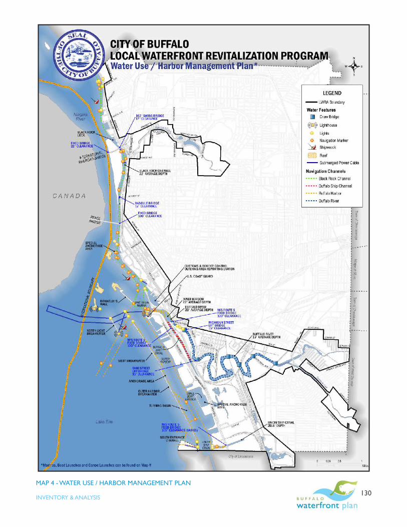
| 130INVENTORY & ANALYSIS
MAP 4 - WATER USE / HARBOR MANAGEMENT PLAN

| 131INVENTORY & ANALYSIS
MAP 5 - MARINAS, MOORING AREAS & BOAT LAUNCHES

132 | BUFFALO’S LWRP SECTION VIII
B. Navigation Channels and Canals
The City of Buffalo LWRA contains four navigation channels, two canals and a river system that essentially comprise the Buffalo Harbor complex (Map 4). These waterways are described below, from north to south.
1. Black Rock Canal & Channel
Due to the strong currents in the Niagara River, the Black Rock Canal was built to allow safe navigation between the Buffalo Harbor and Tonawanda. The Black Rock Canal lies adjacent to the western shoreline of Buffalo and is formed by a breakwater that separates it from the Niagara River. The breakwater ends at the southern tip of Bird Island, which then extends the canal northward to the United States Army Corps of Engineers’ (USACE) lock at the northern end of Squaw Island.
The Black Rock Canal is 3.5 miles long and its navigation channel is at least 200 feet wide at all points. Water levels in the canal are controlled by the lock with an average depth of the 22 feet. The lock and channel accommodate both pleasure and commercial vessels up to 625 feet in length, with drafts up to 21 feet. Flow in the canal can occur in either direction.
The Black Rock Canal entrance channel, which is located just north of the Erie Basin Marina, converges with the entrance channel to the Buffalo River and the northern channel for the Outer Harbor. The canal entrance channel also provides access to the Erie Basin Marina. This entrance channel is about 1,000 feet wide and approximately 23 feet deep at its junction with the other navigation channels.
There is a special anchorage area in the southern portion of the Black Rock Canal, off shore of the Colonel Ward Pumping Station. This anchorage area is afforded protection by the Bird Island breakwater that extends around the entrance to the canal. In the event that two boats wish to use the canal, commercial freighters or other commercial vessels have the right-of way. Smaller recreational vessels can use the anchorage area to maneuver out of the navigation channel and moor temporarily. The water in this special anchorage area is
generally two to four feet deep, with a large volume of silt collecting along the seawall.
There has been a lock at Black Rock since 1833, when the State of New York built one as part of the Erie Canal. The present lock, which was constructed by the USACE between 1908 and 1913, provided the capacity to accommodate large Great Lakes vessels. The lock is 650 feet long and 70 feet wide.
The Black Rock Canal is crossed by two drawbridges andonefixedbridge.TheInternationalRailroadBridgeis located at the northern end of the canal and extends across the canal and the Niagara River. The section that extends over the canal is a swing bridge that carries two railroad tracks, a single travel lane for motor vehicles, and a pedestrian/bicycle pathway. This bridge has a horizontal width of 162 feet and vertical clearance of 17 feet. The portion of the bridge that crosses the Niagara River is fixed,withaverticalclearanceof22feetandahorizontalwidth of 154 feet.
There is a bascule drawbridge located near the southern end of Squaw Island, at the foot of West Ferry Street. The clearance beneath this bridge, when not raised, is 17 feet and the horizontal width is 149 feet. This bridge supports two travel lanes for motor vehicles and a pedestrian/bicycle pathway. The Peace Bridge crosses the canal at the head of the Niagara River. The vertical clearance is 100 feet and the horizontal width is 200 feet on the eastern side of the bridge, over the canal; the western extent along the Canada shoreline has a vertical clearance of 83 feet and a horizontal width of 385 feet.

| 133INVENTORY & ANALYSIS
The Black Rock Canal is heavily used by recreational boaters, and to a lesser extent, commercial shipping vesselsthatdeliverfueloil,coalandgasolinetorefineriesand power plants in Tonawanda. Pleasure craft are required to yield to commercial vessels because of the confinedwatersofthechannel.Thelowleveloffreightertraffic in the canal allows it to be used theWest SideRowing Club and for rowing training and competition programs from March through October.
2. Buffalo Harbor Complex
Buffalo Harbor is a deep draft commercial harbor. It is protected by 4.5 miles of breakwater structures. The harbor complex includes a series of authorized federal navigation channels design and maintained so that deep draft commercial vessels can safely move through the harbor.
The north entrance channel of Buffalo Harbor provides navigable access from the open waters of Lake Erie to the Buffalo Harbor complex and canals. The north entrance channel is located west of the Outer Harbor. It is approximately 750 feet wide and 25 feet in depth. This is the primary means of ingress and egress from Lake Erie to the Buffalo River, the canals and the Outer Harbor channel.
The Inner Harbor is situated between the south end of the Erie Basin Marina and the northern extent of the Outer Harbor and provides access to the Buffalo Ship Canal and the Buffalo River. The Inner Harbor channel varies in width from a minimum of approximately 40 feet to 750 feet; the average channel depth is approximately 22feet.TheNYSRoute5(Skyway)fixedbridgetraversesthe mouths of the Buffalo Ship Canal and Buffalo River, just south of the Inner Harbor channel. The vertical clearance beneath this structure is 100 feet and the horizontal width is 215 feet.
The Outer Harbor has three navigation channels: the north, the middle, and the south channels. The north channel is approximately 40 feet from the shoreline and 1000 feet wide. The Outer Harbor middle channel narrows to a width of 500 feet in two locations to accommodate an anchorage area and the Outer Harbor
turning basin. The channel widens again to 1000 feet along its southern segment, to a point at the end of the Outer Harbor seawall, where it converges with the south entrance opening. This entryway is only 500 feet wide. Directly east of the south entrance is the Union Ship Canal. This 0.7-mile canal is 20.5 feet deep, with a 250 feet wide channel. The canal is crossed by NYS Route 5 via afixedbridgewithaverticalclearanceofapproximately105 feet as well as a lower pedestrian bridge.
Vessel use along these waterways is a combination of commercial freighter traffic and recreational boating.ThemajorityofvesseltrafficenteringtheOuterHarbornavigation channel does so through the south entrance, which is located near the boundary between the City of Buffalo and the City of Lackawanna.
Recreational boaters use this entrance to access Lake Erie and the Seneca Shoal, a very popular fishing spotlocated southwest of the LWRA further out in Lake Erie. Another popular and widely used fishing spot is FishHaven, located due west of the Outer Harbor within theLWRA. The gamefish found in this area include awide range of species native to the Great Lakes, including lake sturgeon, muskellunge, walleye, lake trout, and smallmouth bass.
3. Buffalo Ship Canal
The Buffalo Ship Canal extends 1.3 miles southward from the Inner Harbor channel. It is approximately 250 feet wide and 22 feet deep. This channel provides docking access to the industries and marinas that are located along the shorelines of Kelly Island and the Outer Harbor.
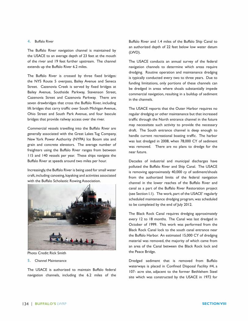
134 | BUFFALO’S LWRP SECTION VIII
4. Buffalo River
The Buffalo River navigation channel is maintained by the USACE to an average depth of 23 feet at the mouth of the river and 19 feet further upstream. The channel extends up the Buffalo River 6.2 miles.
The Buffalo River is crossed by three fixed bridges:the NYS Route 5 overpass, Bailey Avenue and Seneca Street. CazenoviaCreek is served by fixed bridges atBailey Avenue, Southside Parkway, Stevenson Street, Cazenovia Street and Cazenovia Parkway. There are seven drawbridges that cross the Buffalo River, including liftbridgesthatcarrytrafficoverSouthMichiganAvenue,Ohio Street and South Park Avenue, and four bascule bridges that provide railway access over the river.
Commercial vessels travelling into the Buffalo River are generally associated with the Great Lakes Tug Company, New York Power Authority (NYPA) Ice Boom site and grain and concrete elevators. The average number of freighters using the Buffalo River ranges from between 115 and 140 vessels per year. These ships navigate the Buffalo River at speeds around two miles per hour.
Increasingly, the Buffalo River is being used for small water craft, including canoeing, kayaking and activities associated with the Buffalo Scholastic Rowing Association.
5. Channel Maintenance
The USACE is authorized to maintain Buffalo federal navigation channels, including the 6.2 miles of the
Buffalo River and 1.4 miles of the Buffalo Ship Canal to an authorized depth of 22 feet below low water datum (LWD).
The USACE conducts an annual survey of the federal navigation channels to determine which areas require dredging. Routine operation and maintenance dredging is typically conducted every two to three years. Due to funding limitations, only portions of these channels can be dredged in areas where shoals substantially impede commercial navigation, resulting in a buildup of sediment in the channels.
The USACE reports that the Outer Harbor requires no regular dredging or other maintenance but that increased trafficthroughtheNorthentrancechannelinthefuturemay necessitate such activity to provide the necessary draft. The South entrance channel is deep enough to handle current recreational boating traffic. Theharborwas last dredged in 2008, when 78,000 CY of sediment was removed. There are no plans to dredge for the near future.
Decades of industrial and municipal discharges have polluted the Buffalo River and Ship Canal. The USACE is removing approximately 40,000 cy of sediment/shoals from the authorized limits of the federal navigation channel in the lower reaches of the Buffalo River and canal as a part of the Buffalo River Restoration project (see Section I.1). The work, part of the USACE’ regularly scheduled maintenance dredging program, was scheduled to be completed by the end of July 2012.
The Black Rock Canal requires dredging approximately every 12 to 18 months. The Canal was last dredged in October of 1999. This work was performed from the Black Rock Canal lock to the south canal entrance near the Buffalo Harbor. An estimated 15,000 CY of dredging material was removed, the majority of which came from an area of the Canal between the Black Rock lock and the Peace Bridge.
Dredged sediment that is removed from Buffalo waterways is placed inConfinedDisposal Facility#4, a107- acre site, adjacent to the former Bethlehem Steel site which was constructed by the USACE in 1972 for
Photo Credit: Rick Smith

| 135INVENTORY & ANALYSIS
the placement of material that is unsuitable for open-lake placement in Lake Erie. Material dredged by non-USACE entities from other areas is periodically placed in the CDF with USACE approval.
C. Breakwaters
The USACE maintains several breakwaters in the LWRA that provide protection for the Buffalo Harbor and Black Rock Canal. These include:
� Bird Island Pier (also known as Nowak Pier), a one and a half-mile long stone dike that parallels the shoreline separating the Black Rock Canal from the Niagara River. The Pier is constructed of mortared riprap and stone revetment. The Bird Island Pier is replaced by a concrete breakwater, which extends further south beyond the Peace Bridge. This breakwater protects the entrance and southern portion of the Canal;
�Donnelly’s Wall, a half-mile long concrete wall and lighthouse facility located northwest of the mouth of the Buffalo River;
�North End Light breakwater, a 500-foot long concrete wall located due west of the Buffalo River;
�West breakwater, a concrete barrier that is situated further south and west of the North End Light structure; and
�Outer Harbor breakwaters, which consist of two long concrete walls that provide protection for the Outer Harbor navigation channel.
D. Aids to Navigation
The entrance channels and canals in the LWRA are marked by navigational buoys, shoreline lights, a lighthouse and breakwater lights maintained by the Coast Guard (Map 4). Red and green colored buoys mark the length of the Black Rock Canal, from the lock to the Erie Basin Marina. These buoys are placed at close intervals along the mainland side of the Canal. In addition, there are two lightsthatflashatsynchronizedintervalstoalertvesselsof the nearby shore. There is also a navigation light
located on top of the Massachusetts Avenue Pump intake on the Niagara River and a light on top of the Colonel Ward pumping station water intake to alert boaters of their presence. The north and south entrance channels to the Outer Harbor are marked by lights. The Buffalo Main Harbor Lighthouse is located on the breakwater, which is situated west of the north entrance to the Outer Harbor channel.
E. Marinas, Mooring Areas and Boat Launches1
1. Public
a. A public boat launch is located at the terminus of Ontario Street and is open year round, although waters around the launch typically freeze between December and April;
b. The outer shoreline of Squaw Island, facing the Niagara River, has iron bollards along the bulkhead. This bulkhead is no longer used for mooring due to the swift current.
c. In the Black Rock Canal, between the Black Rock Canal lock and the shoreline, there is a single-vessel mooring area where the USACE stores its tugboat during the winter;
d. The Great Lakes Marine Research Center at Cotter Point, administered by the State University of New York College at Buffalo, has a wet side dock and a dry dock for research vessels. The laboratory also utilizes an iron barge, which is secured along the Black Rock Canal shoreline, south of Squaw Island, for vessel docking;
e. The entire shoreline of LaSalle Park, situated on the mainland at the head of the Canal, is protected by a concrete bulkhead that provides iron bollards for docking;
f. Erie Basin Marina is owned by the City of Buffalo, and leased to an operating company that is responsible for maintenance. The Marina operates
1 Presented on Map 5.
136 | BUFFALO’S LWRP SECTION VIII
400, 20 to 40 foot long, boat slips and a boat launch from May through October. This facility has electric and water hook-ups, a pump-out station, fuel dock, fishing supplies and marine hardware, showers, arestaurant and concessions. The basin is also home port for the Miss Buffalo II and the Moondance Catamaran;
g. Buffalo and Erie County Navy and Military Park. This facility includes a museum devoted to Western New York’s contributions to America’s seapower, the U.S.S. Sullivan national historic landmark, the U.S.S. Little Rock, and the U.S.S. Croaker submarine.
h. The Coast Guard maintains a small marina at the north end of theOuterHarbor for officialCoast Guard vessels. There is a small park with a picnic shelter, a walking path and benches that overlook Lake Erie and the entrance channel to the Inner Harbor. There are several scenic and historic monuments, including the Buffalo Main Lighthouse, on the northwestern corner of the station grounds;
i. Erie Canal Harbor Development Corporation (ECHDC)’s Wilkeson Point features a portable pier forfishingandcanoeorkayaklaunching,aswellasasmall transient dock;
j. NYPA Outer Harbor Marina, formerly First Buffalo Marina, has approximately 100 slips, offering marine service, winter storage and transient docking;
k. The Seaway Pier has docking space for 16 vessels. Boaters can also tie up to approximately 50 metal cleats that are installed on the pier bulkhead;
l. The Ford Terminal Complex inlet has corrugated steel and concrete bulkheads that act as wharves for loading andoffloading freight fromcommercialfreighters;
m. The Small Boat Harbor is located on the lakeshore of the Outer Harbor. It contains 1,042 boat slips with a pump-out facility, 12 boat launches and berths for transient docking (which varies between 50 and 100 slips, depending on seasonal sliprentals),restaurant,fueldock,marinestore,afish
cleaning station, public restrooms and showers for slip holders;
n. Gallagher Beach offers 1,500 linear feet of shoreline access, a non-motorized watercraft access ramp to the shore, a separate launch ramp for motorized personal watercraft, a 1,400-foot pedestrianboardwalk,a144-footfishingpierandafloatingdock;
o. The Canalside Central Wharf provides transient dockage and is also home to the Spirit of Buffalo schooner;
p. City of Buffalo docks the Edward M. Cotter fireboat in the slip between the MichiganAvenuebridge at South Park and the NFTA’s DLW Terminal;
q. RiverFest Park features a 90-foot wharf that can accommodateguestboatssuchastugs,fireboats,etc.The park offers 160-linear feet of portable docks for transient boaters and a 20-foot lower dock for kayak use;
r. Ohio Street Park is located on the eastern shore of the Buffalo River at the intersection of South Street and Ohio Street and is home to the NYSDEC Buffalo River Boat Launch. The launch is a designated “hand launch,” enabling visitors to exploreandfishtheBuffaloRiverbycanoe,kayakorrow boat. A small parking area is also located at the park, and is connected to the park through a series of small, unimproved, rock-lined trails;
s. Mutual Riverfront Park is located on the Buffalo River at the intersection of South Street and Hamburg Street. The Park includes a 20-foot kayak and canoe EZ dock. An additional 40-foot boat dock will be installed at the foot of Hamburg to accommodate the Queen City Ferry and transient boaters visiting Mutual Park and the Waterfront Memories and More Museum;
t. NYPA Ice Boom Storage Site. As part of the Niagara Hydropower Relicensing agreement, NYPA relocated its ice boom storage facility to a 10-acre site along Katherine Street in the Old First Ward.

| 137INVENTORY & ANALYSIS
Public access to the ice boom storage facility is prohibited; and
u. RiverBend docking area. The northwest shoreline of the RiverBend property, adjacent to the Concrete Central peninsula, has corrugated steel and concrete bulkheads that can serve as wharves forloadingandoffloadingfreight.
Public ownership and the close geographic proximity of the NYPA Outer Harbor Marina, City Erie Basin Marina and NFTA/ECHDC Small Boat Harbor creates opportunities to optimize local marina facilities and minimize public operational costs in support of the LWRA’s economic development. An opportunities analysis has been proposed as a project in the LWRP Action Strategy.
2. Private
a. The Harbor Place Marina, which is located just south of the terminus of Ontario Street, offers transient dockage; engine, sail, and hull repair; haul out service; marine hardware; electric and water hook ups; a pump-out station; showers and restrooms; and a restaurant;
b. Rich Marina, located at the foot of Hertel Avenue, has 500, 16 to 45-foot long boat slips; transient dockage; engine, sail, and fuselage repair; haul out service; marine hardware; electric and water hook ups; a pump out station; showers and restrooms; winter storage; as well as a launch ramp and marine supplies. Rich Marina has a concrete seawall to protect the docking area, which has iron bollards for boat docking;
c. A small private dock with a boatlift is located on the Black Rock Canal shoreline, near the Scajaquada Expressway / I-190 Expressway interchange;
d. The West Side Rowing Club boathouse is located on the Black Rock Canal shoreline, at Cotter Point, south of the Peace Bridge. This facility provides a launch and storage for rowing shells. Directly adjacent is the Frank Lloyd Wright Boathouse, which also provides storage for rowing shells;
e. The Buffalo Yacht Club, located at the foot of Porter Avenue has 43 boat slips and a boatlift. This private club offers transient dockage, electric and water hook ups, a pump-out station, showers and a restaurant;
f. The Rivermist and Gull Landing residential communities at the Erie Basin Marina offer private dock facilities for residents;
g. Scholastic Rowing Association. The Buffalo River Rowing Center, to be completed in 2014, will provide storage for 36 eights, 24 fours and 16 pair/doubles; equipment, meeting space and indoor trainingfacilitiesand120feetoffloatingdockspace;
h. Bison Rod and Gun Club. This private club offers temporary dock facilities for visiting members;
i. The Great Lakes Tug Company utilizes the inlet on the northwest shoreline of Katherine Peninsula to dock two tugboats;
j. The Mobil Oil Company barge dock, which is located approximately 1,500 feet northeast of the South Park Avenue lift bridge, remains intact, but is no longer used for waterborne transport;
k. RCR Yachts, located along the western shoreline of the Buffalo Ship Canal, provides dockage for 137 boats, transient dockage, electric and water hook-ups, marine hardware, a 20-ton haul out, winter storage, and rigging, sail and engine repair; and
l. The South End Marina, located south of Gallagher Beach, includes 6.5 acres of deep-water access on Lake Erie with a boatlift and dry dock facilities, as well as boat storage area, but does not maintain boat slips.
F. Navigation Hazards
Navigation hazards within the LWRA include areas of shallow water and reefs, water intakes, submerged cables, shipwrecks and steel seawall plates and rocks (see Map 4).
138 | BUFFALO’S LWRP SECTION VIII
The Massachusetts Avenue Pumping Station intake and the Colonel Ward intake are marked by lights, but are still considered hazards since these waters are heavily used by recreational boaters. There is an additional intake located south of Strawberry Island for the Town of Tonawanda Pumping Station and another in the inlet between the former Freezer Queen facility and the NFTA Small Boat Harbor on the Outer Harbor.
A shipwreck is located east of the Strawberry Island intake crib, which is situated only eight feet below the surface. There is also a shipwreck that extends above the water surface, just south of the Black Rock Canal seawall, near LaSalle Park, and another near the west breakwater. A large rock immediately north of the easternmost pier of International Railroad Bridge, also presents a potential hazard
There are a number of shallow reefs located in the vicinity of the intake pipe for the Colonel Ward pumping station. The average depth to these reefs is between one and three feet. An area north of the North Breakwater, known as Horseshoe Reef, presents minimum depths of less than one foot.
G. Navigation Security
The U.S. Coast Guard and the Erie County Sheriff ’s Marine Division are responsible for enforcing navigation laws and vessel regulations within the LWRA. In the event of an underwater rescue, the Buffalo Police Department Underwater Recovery Team assists the Erie County Sheriff ’sOffice.
The Coast Guard maintains a fleet of three boats atits base on the Outer Harbor. These consist of a 47-footmotor lifeboat, a 24-footRHI inflatable, and a 14-foot ice skiff used for ice rescues. There are 19 full-time personnel stationed at this location. The Coast Guard enforces a six-mile per hour speed limit through the Black Rock Canal and the Buffalo River, and a 10-mile per hour speed limit in the Buffalo Harbor area. This harbor speed limit is currently not posted. The Coast Guard is on duty year round to conduct emergency rescue and law enforcement activities. The Buffalo Sector has acquired a
Rescue 21 system that became operational in September of 2011. The Rescue 21 is an advanced command, control anddirectionfindingcommunicationssystemforsearchand rescue missions. Since it went into operation, it has been used for more than 618 search and rescue cases, contributing to the rescue of 131 boaters.
TheErieCountySheriff ’sofficemaintainsafleetofthreepatrol boats that are utilized for the enforcement of navigation law, for search and rescue efforts and accident investigations. The Sheriff ’s Marine Unit patrols Lake Erie, Buffalo Harbor, the Buffalo River, and Black Rock Canal. The Sheriff ’s use a 40-foot Twin-Screw Munsen and a Twin 424 patrol boat, which are docked at the Harbour Place Marina near the Black Rock Canal, and a Grady White with an outboard motor that is docked at the Erie Basin Marina. The Sheriff ’s Marine Division has five to six deputiesassigned to these vessels annually. In addition, there are 15 reserve officerswho use their own boats to assistthe regular patrol boats during special details. Usually only two reserve boats are active at any time. The Erie County Sheriff ’s Marine Division enforces State maritime laws within 100 feet of the shoreline. Vessels within 100 feet of the shore, any dock or pier, or any other anchored vesselmaynotexceedfivemilesperhourorexceedareasonable and prudent operating speed, depending upon weather and traffic conditions. TheDivisionmaintainsregular patrols from mid-April through mid-November, orwhenevervessel trafficbecomesminimal. Theyalsoconduct a dock watch program.
The Buffalo Police Department Underwater Recovery Team consists of 13 professional divers trained in swift water and ice rescues. The Team maintains a 21-foot Boston Whaler patrol boat that is docked at the Erie Basin Marina. The primary responsibility of this team is to assist the Erie County Sheriff ’s Marine Division with rescue operations.

| 139INVENTORY & ANALYSIS
IV. WATER SUPPLY AND WASTEWATER
A. Water Supply
The City of Buffalo Water Authority (BWA) operates a public water supply system treating approximately 22 billion gallons of water per year with an average of 60 million gallons each day. The peak single day volume in fiscal year 2012-2013 was 76 million gallons of watertreated. The City’s total per capita water use was approximately 84 thousand gallons per person per year. The City’s residential only water use was 42,000 gallons per person per year.
The City draws its water from Lake Erie through an intake located in the Emerald Channel at the northeastern end of the Lake where the Lake meets the Niagara River. A back-up intake is located immediately north of the Peace Bridge in the main Niagara River channel. The water flows from the lake through a large conduit tothe Colonel Ward Water pumping station and treatment plant located on Porter Avenue, adjacent to LaSalle Park. The Colonel Ward Water Treatment Plant has a design capacity of 160 million gallons per day (mgd). The BWA owns two storage tanks and three storage towers, as well asa28million-gallonclearwell,locatedbelowfilterbedsclear well, for a total storage capacity of 40 million gallons. Colonel Ward process water is discharged into the Black Rock Canal in accordance with State Permitted Discharge Elimination System (SPDES) permit (NY0032174).
From the plant, treated water is transported throughout the BWA’s 46 square mile distribution area. With the exception of a large parcel bordered by South Park, Abby Street, Fuhrmann Blvd and Tifft Street, the system supplies water to all residents and businesses (Paul Gareis, City of Buffalo Division of Water, September, 2012). The BWA system features 810 miles of pipes, 23,800 valves, 80,000 serviceconnectionsand7,965firehydrants.Amajorityof the distribution lines in the LWRA were installed after World War II. Only Ohio Street, Childs Street, Hamburg Street, Katherine Street, Bailey Avenue and the area north of Seneca and Mineral Springs were installed in the early
1900’s. The water system is primarily comprised of cast iron water mains with some concrete and steel water mains that measure between 4 to 60 inches in diameter. Marginal to fair water pressure currently exists in the northwest section of the City, and good water pressure is available within the remainder of the City.
In 1992, the City sold the water system to the Buffalo Water Board (BWB) which began an accelerated Capital Improvement Program. The program included numerous improvements and enhancements throughout the system including upgrades at the Colonel Water Pump Station, Treatment Plant and the Massachusetts Avenue Pump Station, water storage tanks, and distribution mains.
Thewater system ismanaged by a private utility firm,Veolia Water, under contract with the City’s Division of Water, Department of Public Works.
B. Buffalo River Improvement Corporation
The Buffalo River Improvement Corporation (BRIC) was created in 1967 to provide water for cooling and processing to industrial users along the Buffalo River. The BRICpumpswaterfromLakeErietoaugmentflowsintheBuffalo River. The BRIC has a design capacity of 120 million gallons per day. At its peak operation, BRIC contributed 90percentoftheRiver’sflowduringthedriersummermonths serving several industrial customers including Buffalo Color Corporation, PVS Chemical Corporation, Republic Steel and Allied Chemical Corporation. Today, PVS Chemical is the only active user of the system.
C. Municipal Wastewater Disposal
The Buffalo Sewer Authority (BSA) operates and maintains the city’s public sewage collection and waste water treatment system.
The collection system consists of a mix of separate sanitary sewers, separate storm sewers and combined sewers approximately 850 miles in length, with 10 outlying pump stations and a 17 million gallon capacity stormwater

140 | BUFFALO’S LWRP SECTION VIII
retention basin. The collection system conveys an average daily flowof approximately 150million gallons per day(mgd) to the treatment plant, which includes more than 30 mgd that comes in from outside municipalities that are tributary to the BSA system.
The BSA Bird Island Wastewater Treatment Plant (WWTP), the second largest wastewater treatment plant in New York State, can provide full primary and secondary wastewater treatment for 240 mgd. Planned improvements will increase BSA’s capacity to 340 mgd.
During rain and snow melt events, the actual amount of wastewater (both stormwater and sewage) collected within the combined system at times exceeds WWTP capacity. To protect the treatment plant and private property from flooding (including basements), excessflowisdischargedtolocalwaterwaysthroughcombinedseweroverflow(CSO)points.
The United States Environmental Protection Agency (EPA) CSO Control Policy provides guidance on how communities with combined sewer systems can meet CleanWaterAct goals in as flexible and cost-effectivea manner as possible. Under the CSO Control Policy, communities with CSOs must develop long-term CSO control plans that will ultimately provide for full compliance with the Clean Water Act, including attainment of water quality standards.
In 2014, the US EPA and NYS DEC approved the Buffalo Sewer Authority’s Combined Sewer Overflow LongTerm Control Plan. The strategy will dramatically reduce combinedseweroverfloweventstoourlocalwaterways,improving water quality while helping to promote economic development.
The $425 million, 20 year plan, will result in :
• 97.4% total capture of combined sewer volume;
• 6orfewercombinedseweroverflowsperyear;
• 73%decreaseinoverflowvolumefrom1.89 billion to 504 million gallons per year; and
• 10% reduction in City impervious surfaces, 1315 -1620 acres of stormwater management.
The BSA CSO LTCP includes a combination of system efficiencies, innovative green infrastructure programs,treatment plant upgrades and new storage facilities. The BSA has already completed several “gray infrastructure” projects proposed in the original 2004 Long Term Control Plan and $1 million of green infrastructure.
Green infrastructure uses vegetation, soils, and natural processes to manage water and create healthier urban environments. The Buffalo Sewer Authority plan is the firstinthecountrytoreceiveregulatoryapprovalfortheuseofspecificdemolitionsitesasgreeninfrastructure.Todate the City’s demolition program has created over 350 acres of green stormwater infrastructure. In addition, the BSA is currently working with the City’s Department of Public Works to implement green infrastructure improvements on Ohio Street, Niagara Street, Genesee Street, Carlton Street, Fillmore Avenue and Kenmore Avenue.

| 141INVENTORY & ANALYSIS
D. Industrial Discharge Permits
The following private industries maintain NYS DEC SPDESpermitsfordischargeeffluentintoBuffaloLWRAsurface waters.
PERMIT TYPE PERMITTEE FACILITY RECEIVING WATER
NY0085294 01-StateSignificantIndustrial
LINDE INC 101 KATHERINE STREET
Buffalo River
NY0110043 01-StateSignificantIndustrial
P V S CHEMICALS INC
55 LEE STREET Buffalo River
NY0204668 02-NonSignificantP/C/I
BUFFALO (C) DPW TIFFT FARM PLAYFIELD TEAM BLDG.
0
NY0171042 02-NonSignificantP/C/I
BUFFALO & PITTSBURGH RAILROAD INC.
BUFFALO CREEK YARD, RIDGE RD AND LEHIGH ST
0
NY0002470 03-EPA Major Industrial
BUFFALO COLOR CORP
100LEE ST Buffalo River
NY0000906 03-EPA Major Industrial
NFB CARBON PRODUCTS, LLC
333 GANSON STREET
Niagara River
NY0269743 04-NonSignificantIndustrial
STATE UNIVERSITY COLLEGE AT BUFFALO
7 PORTER AVENUE Black Rock Canal
NY0269905 04-NonSignificantIndustrial
STATE UNIVERSITY COLLEGE AT BUFFALO
HOUSTON GYMNASIUM POOL, 1300 ELMWOOD AVENUE
Scajaquada Creek
NY0000655 04-NonSignificantIndustrial
GENERAL MILLS OPERATIONS, INC.
54 S MICHIGAN AVE Buffalo River and Ship Canal
NY0065170 04-NonSignificantIndustrial
CSX TRANSPORTATION INC
BUFFALO FRONTIER YARD, 1836 BROADWAY
Buffalo River
NY0095346 04-NonSignificantIndustrial
HENKEL CORPORATION
710 OHIO STREET Buffalo River
NY0204480 04-NonSignificantIndustrial
BUCKEYE TERMINALS, LLC
625 ELK STREET Buffalo River
NY0242772 04-NonSignificantIndustrial
GULL LANDING CONDOS
40 WATERFRONT CIRCLE
Lake Erie (Erie Basin)

142 | BUFFALO’S LWRP SECTION VIII
E. WNY Stormwater Coalition
The City of Buffalo and Buffalo Sewer Authority are members of the WNY Stormwater Coalition. The Coalition is a regional collaboration of 42 municipal entities in Erie and Niagara counties that have joined together to develop a stormwater management program to protect our waterways and enhance our quality of life.
The Western New York Stormwater Coalition is a forum for these regulated communities to share resources and work in partnership toward compliance with the United States Environmental Protection Agency (U.S. EPA) Phase II Stormwater requirements.
The overall goal of the Coalition is to utilize regional collaboration to identify existing resources and develop programs to reduce the negative impacts of stormwater pollution. The purpose of the public outreach website is to enhance public knowledge and awareness of stormwater pollution and provide information to individuals and households to prevent stormwater pollution and protect water quality.
F. Vessel Discharge
In October 2012, the NYSDEC, the Environmental Facilities Corporation (EFC) and NYSDOS submitted petitions to the EPA to designate the New York’s portion of Lake Erie and the St. Lawrence River as a “Vessel Waste No Discharge Zone.” This designation means that boaters and shippers are not allowed to discharge their on-board sewage into local surface waters. Instead, they are required to dispose of their sewage at pump-out stations that are available for recreational boater use.
Upon concurrence by EPA, an opportunity for public comment will be announced in the Federal Register. When that concludes, EPA will address comments and determine if there are adequate vessel pump-out stations to support the No Discharge Zone. If EPA concurs, the No Discharge Zone would be enforced by DEC law enforcement, state police, and local authorities.
New York State’s Clean Vessel Assistance Program, which is recognized as one of the nation’s best clean vessel programs, has helped establish and annually supports 37 pump-out facilities on Lake Erie and the St. Lawrence Seaway, providing recreational boaters with convenient access to pump-out stations for the safe disposal of septic waste. The Small Boat Harbor, Erie Basin Marina and Rich Marine offer pump out facilities.

143 | BUFFALO’S LWRP SECTION VIII
V. RECREATION The City of Buffalo LWRA has numerous water dependent and enhanced recreational facilities. Water dependent recreationincludesswimming,boatingandfishing.Waterenhanced recreation includes active recreation park facilities and trail systems.
A. Swimming
There are no swimming beaches or facilities located within the LWRA. However, Erie Canal Harbor Development Corporation (ECHDC) is collaborating with the Niagara Frontier Transportation Authority on a major study to determine the feasibility of a sandy and swimmable Gallagher Beach (the beach area is presently comprised of small stone and gravel). The study is scheduled to begin in September of 2012 and involves the placement of sand in two strategic locations along the beach to determine whether a sand beach would survive the winds and waves of an Outer Harbor winter. If the sand stays in place, the ECHDC will work with other governing agencies to determine how to make Gallagher Beach a swimmable beach.
Similar tests are proposed for Wilkeson Point. However, the ecological significance as muskellunge spawning/nursery habitat may impact swimming beach development (see Section K.2).
B. Boating
Inventory Section IIID outlines the large number of boating, mooring and launch facilities available in the LWRA. In addition to these facilities, several private boat tours and charters including canoe/kayaks, solar powered launch,historic schooners,fishingboats, catamaransandmulti-story tour boats are available on the waterfront.
The Buffalo River Urban Canoe Trail is a self-guided tour of 48 environmental, historical and industrial sites visible from the water. The trail is six miles in length and takes about four hours to complete. This trail was developed by NYSDEC, commencing at the Ohio Street Canoe Launch and terminating at the NYSDEC public access site at Harlem Road in the Town of West Seneca (there is a mid-point access site located at the South Buffalo Pump Station, near the Bailey Avenue Bridge). Parking lots are provided at all three access site for convenience.

| 144INVENTORY & ANALYSIS
MAP 11 - RECREATION & OPEN SPACE

| 145INVENTORY & ANALYSIS
C. Fishing
Inventory Section IID describes the health of the local fisheriesresourceandfisheriesmanagementactivities.
1. Boat-Based Sport Fishery
The boat-based portion of the Lake Erie sport fishery,including the Buffalo Harbor, has been monitored by NYSDEC each year since 1988, and results of annual surveys are published in the NYSDEC Lake Erie Annual Report to the Great Lakes Fishery Commission. Results fromthe2008fishingseasonsurveyindicatedanoverallsportfishingeffort inNewYorkwatersofLakeErieofapproximately314,000anglerhours.Peakfishingactivityin 2008 occurred during July, and the most frequently used access site was the Small Boat Harbor with approximately 88,000anglerhours. Walleyefishingcomprised50%oftheoveralleffortoftheboatfisheryin2008,and27%ofthe effort was directed toward smallmouth bass.
2. Shoreline Sport Fishery
The shoreline based portion of the sport fishery is asignificantportionoftheoverallfishingeffort,especiallyon the upper Niagara River. Results of an angler survey ontheupperNiagaraRiverstatedthatthefishingeffortexpended for the entire shore fishery would easilyexceedtheboatfishingcomponent. Further, theFerryStreet site and a section of the Bird Island Pier accounted formorethanthreetimesthefishingeffortofthenextmostutilizedshorefishinglocationontheupperNiagara.During this study, the section of Bird Island Pier south of the Peace Bridge was not included, thus understating the importance of the Ferry Street-Bird Island Pier complex asafocusoffishingeffort.
There are a number of other public lands that provide shoreline fishing access along theUpperNiagaraRiver,Buffalo Harbor and Buffalo River. These locations include: Ontario Street Boat Launch- Riverwalk, Towpath Park, Squaw Island Park, Lasalle Park, Erie Basin Marina (during off season), Bell Slip, Small Boat Harbor (during off season), Tifft Nature Preserve, Ohio Street Boat Launch, and Bailey Avenue Peninsula.
Property adjoining the Union Ship Canal is currently used asaninformalfishingarea.TheUnionShipCanal landswere remediated as part of the development of the Buffalo Lakeside Commerce Park (BLCP). Restoration plans for the BLCP include the creation of enhanced public access (Lakeside Commons) to the Canal shoreline and aquatic habitat enhancements in theCanal in order to benefitanglers.
3. Angler Effort
NYSDEC conducted a survey of angling activity in seven major Lake Erie steelhead tributaries from 2003 to 2004 and 2004 to 2005. During the two survey periods, a total of approximately 193,000 and 263,000 angler hours, respectively, were reported from the tributaries. During these two periods, a total of approximately 12,000 and 17,000 angler hours, respectively, were reported from Buffalo and Cayuga Creeks combined. All the survey locations in Buffalo and Cayuga Creeks were upstream of the LWRA; however, this illustrates that a substantial steelheadfisheryexists.Manysteelheadmigratethroughthe LWRA on their way upstream from, or downstream to, Lake Erie. Some of the steelhead present in the lower Buffalo River are caught by anglers at LWRA locations where angling access is available and typical steelhead holding habitat is present.
4. Fish Consumption Advisories
The NYS Department of Health has posted a number of healthadvisoriesforcontaminantsinsportandgamefish,primarily PCBs, for the Buffalo River and Buffalo Harbor, Hoyt Lake in Delaware Park, Upper Niagara River and Lake Erie. Buffalo Niagara Riverkeeper has worked to improve the effectiveness of Fish Consumption Advisory educational materials and outreach activities, with a particular focus on environmental justice communities that often rely upon subsistence fishing as a primaryprotein source.
5. Fishing Facilities
ErieCountymaintainsaninventoryofpublicfishingsitesin support of the region’s angling tourism sector. The “Fishing Hot Spot” list in the LWRA includes:

146 | BUFFALO’S LWRP SECTION VIII
a. Niagara River – Black Rock Canal Park (former Ontario Street Boat Launch – Riverwalk)for Largemouth Bass, Rock Bass, Smallmouth Bass, Muskellunge, Yellow Perch, and Steelhead Trout;
b. Niagara River - Towpath Park for Largemouth Bass, Rock Bass, Smallmouth Bass, Muskellunge, Yellow Perch, and Steelhead Trout;
c. Squaw Island Park Ponds for Largemouth Bass, Rock Bass, Smallmouth Bass, BlueGill/Pumpkinseed, Carp, Bullhead, and Perch;
d. Niagara River - Ferry St. - Broderick Park for Smallmouth Bass, White Bass, Yellow Perch, Sheepshead, Smelt, Lake Trout, Steelhead Trout, and Walleye;
e. Niagara River - Bird Island Pier for Largemouth Bass, Smallmouth Bass, White Bass, Muskellunge, Yellow Perch, Northern Pike, Sheepshead, Smelt, Suckers, Steelhead Trout, and Walleye;
f. Niagara River - LaSalle Waterfront Park for Largemouth Bass, Rock Bass, Smallmouth Bass, BlueGill/Pumpkinseed, Carp, and Yellow Perch;
g. Hoyt Lake for Largemouth Bass, Rock Bass, BlueGill/Pumpkinseed, and Carp
h. Buffalo River - Bailey Avenue Peninsula for Largemouth Bass, BlueGill/Pumpkinseed, Bullhead, Suckers, and Steelhead Trout;
i. Lake Erie – Small Boat Harbor for Largemouth Bass, Rock Bass, Smallmouth Bass, BlueGill/Pumpkinseed, Carp, Yellow Perch, Northern Pike, Sheepshead, Smelt, and Rainbow Trout; and
j. Lake Kirsty - Tifft Nature Preserve for Largemouth Bass, Rock Bass, BlueGill/Pumpkinseed, Bullhead, Carp, and Northern Pike.
In addition to the Erie County Hot Spots listed above, shorelineanglersoftenfishat:
a. Black Rock Canal Locks (North End of Squaw Island Park);
b. Scajaquada Creek;
c. DEC’s Ohio Street Access Site;
d. Mutual Riverfront Park;
e. Red Jacket Riverfront (Smith Street) Park;
f. Old Bailey Woods;
g. Seneca Bluffs;
h. City Ship Canal;
i. Erie Basin Marina; and
j. Ship Canal Commons.
TheonlyfishcleaningstationintheLWRAislocatedatthe Small Boat Harbor.
D. Water Enhanced Multi-Use Trails
1. Shoreline Trail
The Shoreline Trail (formerly Riverwalk) is a paved, multi-use pathway, owned by the State of New York and maintained by the City of Buffalo. Approximately 85 percent of the pathway is situated directly adjacent to the Niagara River and Squaw Island shoreline.
2. Jesse Kregal Creekside Trail
Jesse Kregal Creekside Trail (former Scajaquada Pathway) is a 1.8-mile, City-owned and maintained pathway. The trail extends from the confluenceof ScajaquadaCreekand the Black Rock Canal at Niagara Street and eastward to Delaware Park, providing an inland connection to the internal pathway network inside the park.
3. Outer Harbor Greenbelt
The Outer Harbor Greenbelt provides a greenspace corridor, multi-use pathway and shoreline stabilization along the shore. The Greenbelt is linked to the Shoreline Trail system, providing a public connection to the Small Boat Harbor area, the Inner Harbor, Tifft Nature Preserve, and points further along the trail south. The Industrial Heritage of the region’s waterfront is interpreted with

| 147INVENTORY & ANALYSIS
heritage markers that identify historic and contemporary industries.
4. Fuhrmann Boulevard Greenway
The Furhmann Boulevard Greenway includes elements of the Industrial Heritage Trail and the Tifft Street Pier. Located at the western end of Tifft Street, near the Cargill Pool Grain Elevator, the Tifft Street Pier project has been designed to include the namesake pier that extends into the Outer Harbor, a covered pavilion, a boardwalk, a park, benches and dedicated locations for public art installations. The boardwalk and Industrial Heritage Trail provide non-motorized access along the Fuhrmann Boulevard Parkway and includes benches, aesthetic period lighting and landscaping.
5. Niagara River Parkway and Recreational Trail
The Niagara River Parkway and Recreational Trail are a 34-mile long scenic roadway and multi-use pathway system along the Canadian side of the Niagara River shoreline. The system links to the Shoreline Trail via the Peace Bridge crossing at Buffalo. Bi-national activities, including the Niagara Falls International Marathon that typically originates in the City of Buffalo, utilize the parkway route.
E. Water Enhanced Parks
1. City of Buffalo Olmsted Parks
Buffalo is home to a public park system designed by Frederick Law Olmsted. Olmsted is regarded as the greatest American landscape architect, who designed Central Park in New York, the grounds of the U.S. Capitol in Washington, the Niagara Falls Scenic Reservation, and the 1893 World’s Colombian Exposition in Chicago. In 1868, Olmsted was brought to Buffalo, where he implemented a parks plan involving three parks connected to one another by a series of broad, tree-lined residential avenues and parkways. The development of the Buffalo Olmsted parks plan, which was substantially completed by 1876, marked a transitional period during Buffalo’s waterfront history. Olmsted’s plan for Buffalo was presented at the 1876 Centennial Exposition in
Philadelphia, where Olmsted proudly described it as “the mostcompletesystemofrecreationalgrounds.”Thefirstof its kind in the United States, several component parks of thesystemoccupysignificantamountsofwaterfrontland.
Olmsted’s scheme of parks, landscaped circles, parkways and avenues includes Riverside Park and a portion of Delaware Park, Front Park, Cazenovia Park and South Park (five of the six parks that anchor the Olmstedsystem are in the LWRA). The entire Olmsted Parks system is a designated Local Historic District and was listed on the National Register of Historic Places and as a National Historic District in 1982. These parks are owned by the City of Buffalo and managed in partnership with the Buffalo Olmsted Parks Conservancy (BOPC).
a. Riverside Park – This 37-acre park, located at Niagara Street and Vulcan Street, includes playgrounds, baseballfields,afootballfield,picnicfacilities,walkingpaths, an outdoor public pool, an indoor hockey rink, basketball courts, and a pedestrian bridge that crosses the I-190 Thruway, linking the park to the Riverwalk. This park is used on a City-wide basis by sports leagues and locally for summertime youth programming and community events.
The BOPC is working on a design to restore an area of Riverside Park known as the minnow ponds. This project involves the re-establishment of a series of small ponds and waterfalls that were part of the original park design. The new RiverRock Gardens will incorporate extensive plantings that will be installed along the course of this water feature, including a 1,850-foot winding pathway that will be highlighted with a stone pedestrian bridge.
b. Delaware Park- With nearly 350 acres, this is the biggest and most complex park in the Olmsted system and a major regional destination. Delaware Park encompasses Hoyt Lake, which is a focal point of this facility, as well as Mirror Lake. Site amenities in the park include:
� large areas of open space and lakeside pathways, including a portion of the Jesse Kregal Creekside Trail;

148 | BUFFALO’S LWRP SECTION VIII
� the Rose Garden, which includes 33 different flower beds containing many varieties from the All-America Rose Selections;
� the Japanese garden, located alongside Mirror Lake, encompasses six acres with three small islands, numerous plantings and other features common in a traditional Japanese garden landscape;
� boating facilities on Hoyt Lake;
� an 18-hole golf course;
� Parkside Lodge, which houses the offices for the BOPC, the golf course pro shop and a small restaurant; and
�Marcy Casino, which overlooks Hoyt Lake and offers space for conferences, meetings or parties.
The park grounds are home to the Buffalo and Erie County Historical Society, the Buffalo Zoo and the Albright Knox Art Gallery. It is also located immediately adjacent to Forest Lawn Cemetery.
c. Front Park- Originally called the Front, this park encompasses 23 acres, located to the U.S. Toll Plaza to the Peace Bridge, between Busti Avenue and the I-190 Thruway. The park contains a memorial statue, soccer fields, picnic shelters andwalking paths, and is usedfor various recreational sports leagues and numerous community events.
Long term plans include restoring the Terrace with cobblestones, restoring the formal gardens at the edge of the Terrace and replacing the cannons that were once located on the Terrace. The playground and picnic shelter are also proposed to be rebuilt. Other plans include construction of an earthen berm along the I-190 Thruway corridor (which separates the park from the Niagara River) and constructing site walls to reclaim views.
d. Cazenovia Park- This 186-acre park encompasses the Cazenovia Creek corridor and contains several creekside walking paths, a nine-hole golfcourse,balldiamondsandsoccerfields,tennisandbasketball courts, playgrounds and picnic areas, a spray pool and swimming pool and an indoor ice rink. The
park also has an historic casino building and shelter house. Cazenovia Park is heavily used for City-wide events, youth and adult sports leagues, and passive recreation.
e. South Park – The 155-acre South Park was designed in 1894 as an arboretum, with more than 2,300 types of trees, shrubs and plant life, and room for a large conservatory building, now home to the Buffalo & Erie County Botanical Gardens.
2. City of Buffalo Parks
a. Black Rock Park- This 2.4-acre park is located at the foot of Peter Street on the Scajaquada Creek shoreline. Site amenities include a playground and a basketball court. The Jesse Kregal Creekside Trail travels through the park, connecting it with Delaware Park and a local commercial business district. The park is used heavily by local residents for passive recreation and for fishing during the spring whenwater levels in Scajaquada Creek are high. As noted above, park improvements were made at this site as part of the BOPC’s Creekside Trail project.
b. Squaw Island Park - This park, located on 60-acres on the northern portion of Squaw Island, was completed in 2006. Squaw Island Park provides views of the International Railroad Bridge, which passes through the park, the Niagara River and the Canadian shoreline. Squaw Island Park offers passive recreation, picnic areas and bicycle paths. The park is alsoapopularforresidentsthatfishfromtheNiagaraRiver shoreline of Squaw Island and the on-site ponds.
c. Broderick Park- A 3.8-acre park located at the southern end of Squaw Island with excellent views of the Niagara River and the Canadian shoreline. Site amenities include an amphitheater, several historical markers commemorating the historic Underground Railroad, a concession stand, picnic shelters, and a pathway on the Bird Island Pier break wall that extends south, separating the Black Rock Canal and theNiagaraRiver. Thispark isusedforfishing,birdwatching and passive recreation.
| 149INVENTORY & ANALYSIS
d. LaSalle Park- A 89-acre park is located between the Black Rock Canal and the I-190 Thruway overlooking Lake Erie. Site amenities include the Centennial pool and splash pad, a concert bandstand, Bark Yard dog-park, skate plaza, several lighted ball diamonds and soccer playing fields, playground andpicnic facilities. It is also used for fishing and birdwatching. The Riverwalk is situated adjacent to the shoreline as it travels though the Park. A pedestrian walkway provides access across the expressway to the park from the Lakeview neighborhood.
e. Erie Basin Marina - The park portion of the Erie Basin Marina is used year round for passive recreation, with pedestrian access to the shoreline and the harbor lighthouse and views of Lake Erie and the Canadian shoreline. The park includes the Erie Basin Marina Gardens -a test site forfloralandseedcompanies,providingapreviewofmanynewflowersandplants.
f. Father Conway Park - Located along Louisiana Street, just east of Riverfest Park, the 15-acre park has two softball diamonds, used by local recreation leagues in the spring, summer and fall, and several acres of open space. The park also has a fenced in playground, complete with large jungle gym and swing set. A sidewalk lined with landscaped trees connects Father Conway Park with the residential sections of the Old First Ward.
g. Ship Canal Commons- This 22-acre public green space along the perimeter of Union Ship Canal was developed as part of the Buffalo Lakeside Commerce Park brownfield remediation project. Ship CanalCommons features bike and walking trails, over 400 native tree species and a foot bridge that spans 200 linear feet over the Union Ship Canal. The multi-use trails connect pedestrians to the Outer Harbor, Tifft Nature Preserve and the Seaway Trail.
h. Houghton (formerly Stachowski) Park- This 45-acre park is located between the Buffalo River and Clinton Street. Site amenities include two lighted baseball diamonds, several playgrounds, a street hockey rink, a community center, a pool and a large wooded area adjacent to the River. The shoreline portion of
the park is used for dog walking and wildlife viewing, although the river shoreline is physically removed from the park by a railroad corridor.
i. Emerson Young Park - This 35-acre park, located north of Waterfront School, contains several paved sports enclosures, a softball diamond, a paved basketball court, a playground, a small amphitheater and maintained green space.
j. Erie Hills Park & Pedestrian Mall - Erie Hills Park is a small pocket park situated beneath the Buffalo Skyway and the I-190 Thruway, between Franklin Street and Bingham Street. The park contains tree-lined sidewalks that navigate around several small hills. The sidewalks include pedestrian benches along the network of paths.
k. Buffalo and Erie County Naval & Military Park - The Buffalo and Erie County Naval & Military Park is located on approximately one and a half acres along the Buffalo Inner Harbor. The park is home to the several decommissioned World War II United States Naval vessels, including the cruiser USS Little Rock, the destroyer USS The Sullivans and the submarine USS Croaker, which are all moored in the Buffalo River. harbor. The park also contains numerous other military amphibious, air and land vehicles on display.
l. Other parks. The City of Buffalo also owns and operates several smaller park facilities including Rotary Park, Prospect and Columbus Parks, Butler Park, Old Bailey Woods, Market Square Park, Sole Park, the Bluff, Fourth Street Playground and the Hank Nowak Bird Island Fishing Pier.
3. Erie County Parks
In addition to Erie County’s Red Jacket Riverfront Park, BaileyAvenueConfluenceParkandSenecaBluffshabitatparks on the Buffalo River (described in Inventory Section II.D.4.) Erie County also operates two active waterfront recreation sites on the Buffalo waterfront.
a. Black Rock Canal Park (formerly Ontario Street Boat Launch.) This 6.8 acre park is located at the foot of Ontario Street on the Niagara River shoreline. This

150 | BUFFALO’S LWRP SECTION VIII
site is used for launching small watercraft, shoreline fishing, bicycling, and scenic viewing of the NiagaraRiver and Canadian shoreline. The site also includes a Bark Park off leash dog park facility.
b. Towpath Park- Towpath Park is a 5.3-acre park, located at the foot of Hertel Avenue on the Niagara River shoreline. Site amenities include a boardwalk-style viewing area with views of Rich Marina and the Black Rock Locks, benches and walking paths. This park is used for shoreline fishing and passiverecreation.
4. State (ECHDC/NFTA/ NYPA) Public Access Sites
In addition to the Small Boat Harbor and NYS DEC Ohio Streetfishingaccesssites,thefollowingwaterfrontpublicaccess sites have been developed by State entities within the City of Buffalo.
a. Canalside Central Wharf - The Erie Canal Harbor Central Wharf is located along the waterfront immediately south of the Buffalo and Erie County Naval&MilitaryPark.The12.5-acreparcelwasfilledin after the original Erie Canal ceased as a major mode for the transport of goods, and was used for municipal parking until the 1990s. The park is used for many public events including large scale concerts. The site features food and small watercraft vendors, interpretive signage and exhibits, passive green space, colorful Adirondack chairs and transient boat slips.
b. Gallagher Beach/Small Boat Harbor Park – Small Boat Harbor Park is located adjacent to the public Small Boat Harbor marina. The park is primarily comprised of maintained lawn areas used for recreation and picnicking. The park is adjacent to Gallagher Beach, which features 1,200 linear feet of waterfrontage,aboardwalk,fishingpier,aboatlaunch,pavilion structures and a small parking area for cars.
c. Wilkeson Point is comprised of approximately 22 acres of former Cargill and NYPA Ice Boom Lands immediately south of the Times Beach Nature Preserve. The site offers public access along the entire length of the perimeter and water’s edge, pedestrian
paths, volleyball courts, natural playgrounds, wind sculptures and public docking. Six acres of shovel ready land has been reserved in the north east portion of the site for future mixed-use development.
d. Mutual Riverfront Park – When the NYPA relocated the ice boom to Katherine Street, the portion of the property located at the foot of Hamburg Street (at South Street) was designated for the development of Mutual Riverfront Park. This 1.3-acre park includes a brick boathouse, recreational boat launch for kayaks and canoes, boat storage area, a boardwalk promenade, picnic tables, benches and chess tables, landscaping and open lawn area. There is also a building on the site that will house the Waterfront Memories and More Museum. The park provides views of the Buffalo River and historic grain elevators.
5. Other Parks
a. Forest Lawn Cemetery – Forest Lawn Cemetery is a 270-acre facility created by Charles Clark in 1850. The cemetery is recognized both for its core cemetery services as well as its landscape and cultural heritage assets. Forest Lawn is the “permanent residence” for many important localandhistoricfigures,numerousworks of architecture, sculpture and art; more than 3,500 trees, representing 100 different species and the City’s only waterfall created as Scajaquada Creek emerges from underground. Over 240 bird species have been spotted in the Cemetery. The Cemetery’s

| 151INVENTORY & ANALYSIS
roadways are actively utilized for both biking and running.
b. Riverfest Park - Riverfest Park, spearheaded by the efforts of the Valley Community Center, serves as a gateway from the Cobblestone District into the City’s Old First Ward residential neighborhood. The three acre park features six hundred feet of Buffalo River shoreline providing views of historic Kelly Island grain elevators. The park is comprised of green space and plantings, a paved pathway leading to a band shell, a large wooden pergola with bench seating that faces the riverfront, a boardwalk with additional benches, parking area and a floating, seasonal dock. Futureplans for the park include the construction of a brick lodge and restaurant.

152 | BUFFALO’S LWRP SECTION VIII
VI. HISTORIC AND SCENIC RESOURCES
A. Historic Resources
Buffalo’s waterfront has served as the stage for several important elements of the nation’s history including early settlement by the Neutral and Seneca members of the Iroquois Confederacy, the War of 1812, the Erie Canal, urban design as per Joseph Ellicott and Frederick Law Olmsted, the Underground Railroad and the growth and decline of the steel industry.
1. Iroquois Confederacy
Prior to European colonization, Buffalo’s inhabitants were an Iroquois tribe called the Neutrals by French settlers, who found them helpful in mediating disputes with other tribes. The area was later settled by the Senecas.
Historical accounts explain that the city of Buffalo was named after the Buffalo Creek (now known as the Buffalo River), a stream which evidently received its name from the frequent visits of the American bison to a salt spring which welled up about three miles from its mouth, “where the buffalo drinks.”
The Native Americans knew this region as the locality of Teosahwa or Teshuway, “the place of the basswood” for the dense basswood trees lining the creek, and also sisilichanne, “waters sought by the buffaloes.” Historic paintings and engravings found of the Buffalo Creek confluencewiththelakeshowathicklywoodedriparianzone along the river. (This name has also been given to counties in Nebraska, South Dakota, and Wisconsin, and numerous creeks, rivers, towns, and villages.)1
1http://books.google.com/books?pg=PA804&lpg=PA804&dq=buffa
lo%20place%20of%20the%20basswood&sig=FCdV_uxt3deoAqh16
HyQEVtiffk&ei=2gBUTczuLtKRgQfemImICQ&ct=result&sqi=2&id
=rtJMAAAAMAAJ&ots=KZ3hmxXZ6-&output=text;
http://digitalgallery.nypl.org/nypldigital/dgkeysearchdetail.cfm?trg=1
&strucID=118362&imageID=54308&total=1&e=w;
The name for Scajaquada comes from a variation of Kenjockety, after Phillip Kenjockety of the Seneca tribe. The Seneca name for it is Ga-noh’-gwaht-geh, after a particular wild grass that grew along its banks. The word “Niagara,” once thought to mean “thunder of the waters” more probably means, “neck,” to describe the strait.
Mapping from the early 18th century shows development in the Buffalo region with settlements concentrated along the Niagara River and Lake Erie and stretching along the Buffalo River corridor. Buffalo Creek, as it was noted in these early settlement and purchase maps, was notable for the Native American settlements along its shores. A map from 1804 shows historic trails, and ribbons of tributaries that empty into Buffalo Creek. Upstream archeological sites along Buffalo River and Scajaquada Creek are aboriginal in nature including the Seneca House site, the location of a former long house.
2. Ellicott Radial Street Plan
Joseph Ellicott was hired by the Holland Land Company in 1797 to conduct the Great Survey, the surveying and division of 3.3 million acres of land purchased from Robert Morris west of the Genesee River to the shore of LakeErie.Hismissionalsowastodeterminethespecificboundaries of the Seneca Indian reservations.
Impressed by the work of Major Pierre L’Enfant and influencedbyhisbrotherswhowerealsosurveyorsandhad established a radial street plan for Washington D.C., Ellicott applied the same system to Buffalo, with Niagara Square as a hub and a series of streets laid out at acute angles. While most of Ellicott’s radial system remains intact, connections to the water at Erie Street, Court Street and Genesee Street were disrupted with the construction of the NYS Thruway.
http://freepages.history.rootsweb.ancestry.com/~wcarr1/Lossing2/
Chap18.html

| 153INVENTORY & ANALYSIS
MAP 12 - HISTORIC RESOURCES

154 | BUFFALO’S LWRP SECTION VIII
3. War of 1812
The War of 1812 ranged along much of the Great Lakes’ coastline where American, British and Native American forces clashed for control of the heart of the continent.
After destroying much of the Niagara Frontier, the British troopswerefinallyhaltedintheirsouthboundmarchasAmericans set fire to a bridge overTonawandaCreek.The British returned to the Canadian side of the Niagara and marched south, carrying their boats around Niagara Falls. The British crossed the Niagara in the early hours of December 30, 1813, landing approximately two miles downstream of Black Rock. They pressed onward, forcing the retreat of the Americans whom they pursued all the way to the Village of Buffalo. Once in Buffalo, the British and Indians burned nearly all of the buildings and destroyed the navy yard and several ships. They then moved back to Black Rock and torched the town before crossing back to Canada.
4. Erie Canal
The Erie Canal runs 363 miles (584 km) from Albany to Buffalo, completing a navigable water route from the Atlantic Ocean to the Great Lakes. First proposed in 1807, it was under construction from 1817 to 1825 and officiallyopenedonOctober26,1825. Itwas thefirsttransportation system between the eastern seaboard and the western interior of the United States that did not require portage, was faster than carts pulled by draft animals, and cut transport costs by about 95%. The canal fostered a population surge in western New York State and opened regions farther west to settlement.
Today, the Erie Canal is part of the New York State Canal System. In 2000, Congress designated the Erie Canalway National Heritage Corridor to recognize the national significance of the canal system as themost successfulandinfluentialhuman-builtwaterwayandoneofthemostimportant works of civil engineering and construction in North America..
Erie Canal Harbor and the Central Wharf were originally built in 1825 as the western terminus of the Erie Canal. The results of the initial excavation work uncovered the original Commercial Slip of the Buffalo Harbor. The original cobblestone and brick streets were uncovered, the main docking wharf was revealed behind the eastern seawall, and the building foundationof the firstAfricanAmerican- owned business, founded by a freed slave years before the Emancipation Proclamation, was discovered.
According to the Buffalo Preservation Board, the remnants of the Erie Canal, the Commercial Slip, the Prime Slip and the Grand Canal are eligible for listing on the National Register of Historic Places, although no local landmark designation has been made.

| 155INVENTORY & ANALYSIS
The Erie Canal Harbor project features several fully restored facets of the original Erie Canal Harbor, including:
� Commercial Slip, which served as the historic juncture between the Erie Canal and the Great Lakes, and the 40-foot wide, wooden planked Central Wharf (which includes a 400-foot long waterfront floating dock);
� a replica of the Coit-McCutcheon canal era building that houses a Naval museum and restaurant;
� Reconstruction of Commercial Street and three other original cobblestone streets by the City of Buffalo;
�Whipple Truss foot bridge that spans the canal slip and connects the Central Wharf to Commercial Street; and
� Installation of informational signage and various interpretive exhibits and landscaping throughout the site to educate and inform visitors about the importance of the area.
5. Buffalo’s Harbor Heritage
The Erie Canal construction resulted in tremendous growth of the Buffalo Harbor and port. Several elements from Buffalo’s active commercial harbor era remain including:
a. Lighthouses
� Buffalo Main Lighthouse was built in 1833 and is the oldest building on Buffalo’s waterfront, as well as one of the oldest on the Great Lakes. The lighthouse has been recognized by the United States Coast Guard in an effort to preserve the maritime heritage of the US.
� Buffalo North Breakwater South End Light at the Buffalo Harbor
� South Buffalo North End Light on the Outer Harbor
b. Grain Elevators. Invented to maximize loading dock space, the remaining grain elevators that dot Buffalo’s waterfront are a testament to those days when the city was the busiest grain-transfer port in theworld.ThefirstgrainelevatorwasbuiltbyJosephDart, in 1842, in the port of Buffalo. These structures comprise the most outstanding collection of extant grain elevators in the United States. They collectively represent a variety of construction materials, building forms and technological innovations that revolutionized the handling of grain in this country.
The Concrete Central Elevator is listed on the National Register of Historic Places. According to the Buffalo Historic Preservation Board, the following grain elevators along the Buffalo River industrial corridor are eligible for listing on the National Register of Historic Places:
� Cargill Superior � Kellogg
� Connecting Terminal � Agway
� Pillsbury (Great Northern)
� American Exchange
� Perot Malting � Lake and Rail
� Standard �Marine “A”

156 | BUFFALO’S LWRP SECTION VIII
In addition, there are four more elevators within the LWRA including:
� Electric Annex � LaFarge
�GLF-A �GLF- B
� St. Mary’s Cement �Washburn Crosby
� Cargill Pool
Erie Canal Harbor Development Corporation (ECHDC) completed a lighting design study for the waterfront grain elevators and bridges in 2013. The project seeks to highlight the waterfront’s progress, the history of the grain elevators and their impact on the growth and development of the City. ECHDC committed funding for the implementation of the first phase of the project, including lighting of theConnecting Terminal grain elevator, Ohio Street Bridge and the underside of the Skyway. Eventually, the lighting of up to 16 grain elevators as well as the Michigan Avenue bridge is proposed.
c. Freight House Landing. The Erie Freight House is the last extant example of an early (c1868) transshipment facility. In November 2013, the Buffalo Common Council approved the proposed demolition of the local landmark. Preservation Buffalo Niagara, 441 Ohio Street, LLC and its agent Savarino Companies have produced a plan for the evaluation, repurposing and interpretation of the Erie Freight House.
The plan calls for:
• Evaluation of the building’s structural condition (completed)
• Documentation of the building’s historic significancesandintegrity(completed)
• Identification of building’s original salvageablestructural components (completed)
• Deconstruction strategy for the building onsite and subject to DOL oversight
• Identify potential sites suitable for reuse or reconstruction of salvageable elements
• Identify funding and reuse plan for the reconstructed portion of the building
d. Historic Watercraft. The City of Buffalo is home to several historic watercraft including, but not limited to, the Clara Brown Sloop, Cotter Fireboat and Naval Museum ships. The Buffalo Maritime Center also maintains an inventory of historic vessels.
6. Frederick Law Olmsted
As discussed in the recreation section above, Buffalo is home to a public park system that was designed by Frederick Law Olmsted in 1868 and substantially completed by 1876. Olmsted is regarded as the greatest American Landscape Architect. Five of Buffalo’s six major Olmsted park facilities are located within the LWRA.

| 157INVENTORY & ANALYSIS
The following is a 1914 map of the Olmsted system.

158 | BUFFALO’S LWRP SECTION VIII
7. Underground Railroad
BuffalowasasignificantlinkintheUndergroundRailroadforslavesthatescapedfromtheSouthandsoughtrefugeinCanada. During this emancipation era, several buildings and locations along the waterfront were links in the Underground Railroad. Broderick Park, on Squaw Island, has been recognized as a vessel launching point for slaves travelling across the Niagara River to Canada to gain freedom.
c. Ship Canal Commons features interpretive signs, landforms and an iconic steel ladle at the head of the Canal, as discussed in Section V.E. Recreation City Parks.
9. Full Historic Resource Listing
A full listing of local, state and federal historic structures, sites and districts within the City of Buffalo has been provided in the Shared Inventory/GEIS. The inventory indicates each feature that is within the City’s LWRA boundary.
8. Industrial Heritage
Buffalo was home to a booming heavy industrial economy with many areas of the LWRA dedicated to manufacturing. Today, only a few remnants of the City’s industrial heritage remain. However, the City’s industrial legacy is celebrated in at least three projects.
a. The Industrial Heritage Trail tells the story of the Grain Elevators and manufacturing along the Buffalo River and Outer Harbor.
b. The Industrial and Rail Heritage Discovery Center, home to the Western New York Railway Historical Society’s (WNYRHS) railroad museum and the Steel Plant Museum, will display vintage railroad and steel making artifacts. An operational steam locomotive will be on adjacent rail lines next to the building. The Center will occupy 35 acres of the former Buffalo Color site located in South Buffalo along the Buffalo River, bounded by Elk Street, South Park Avenue and Lee Street. The site was used to manufacture dye products for the food and clothing industries. A powerhouse on the site will be incorporated into the project.

| 159INVENTORY & ANALYSIS
F. Great Lakes Seaway Trail
The Great Lakes Seaway Trail is a 518 mile National Scenic Byway that follows the shores of Lake Erie, the Niagara River, Lake Ontario, and the St. Lawrence River. Within the City of Buffalo, the Great Lakes Seaway Trail follows Niagara Street south to Niagara Square, then travels south on Delaware Avenue to Route 5 and south to the City line.
The reconstruction of Ohio Street and Fuhrmann Boulevard creates an opportunity to offer a local Great Lakes Seaway Trail route alternative. Travelers can either follow the Route 5 highway or drive at grade through the Canalside, Cobblestone and grain elevator districts
G. Local Waterfront Scenic Areas
In addition to the historic and cultural assets which serve as Buffalo waterfront landmarks, there are several scenic features associated with the waterfront. These include:
1. Waterfront Sunsets
Located at the eastern end of Lake Erie, Buffalo is the only Great Lakes city to enjoy a view of the sun setting over water.
2. Canada
Buffalo’s location on the opposite shore of Fort Erie in Ontario affords unique views of the Canadian shoreline, including Fort Erie’s beaches, Old Fort Erie and the Niagara River Parkway.
3. Marinas
Buffalo’s marinas are the heart of the community’s engagement with its water. Boats, fishing, shorelinetrails and restaurant facilities create opportunities for residents and visitors to actively utilize the region’s fresh water resources.

160 | BUFFALO’S LWRP SECTION VIII
VII. TRANSPORTATIONNiagara River Greenway Plan Action Plan (Section F) deals extensively with transportation issues.
The transportation facilities that provide access to the Niagara River Greenway are essential to its overall success. Roads can provide access but they can also serve as barriers to public access and enjoyment of the Niagara River. Achieving a balance between providing ease of access to the properties and uses along a transportationrouteand facilitating trafficmovementthroughtheregionisdifficult.Peoplewanttobeableto get to their destinations easily and without delay. However, the focus within the Greenway is to create a climate in which people can comfortably navigate through the system and enjoy all of its assets, activities and attractions, not to promote the rapid movement of vehicles through the area.
The greenway should facilitate alternative transportation along the river corridor, while always respecting environmental sensitivities…
As a general rule, excess pavement should be discouraged, and design should reflect a greateremphasis on pedestrians, bicyclists and other non-motorizedtraffic.
Transportation projects within the Greenway should avoid creation of barriers between the water’s edge and the neighborhoods surrounding it. Interstate 190 in the City of Buffalo cut off physical and visual access to the water’s edge. To the extent that future transportation planning and improvements can mitigate this damage, they should be encouraged. Removal of the I-190 and building an alternative (non-interstate) route away from the Niagara River is obviously a very ambitious, expensive and long-term project. However, if redesign or relocation is able to go forward, it would be an important enhancement to the Greenway
Transportation projects should seek to maximize access to the resources along the River. The realignment of Erie Street as proposed by the City of Buffalo, will re-establish view sheds from downtown Buffalo to the waterfront, recreating a stronger connection between the City and the waterfront that helped create it.
For routes near the water, the focus should be on access by alternate transportation modes, including non-motorizedtraffic,ratherthanasingular focusontheefficientmovementoftraffic.
Transportation projects within the Greenway should also prioritize land use over efficiency of trafficmovement. Where there is overbuilt capacity, there should be a preference for returning excess pavement to another use.
Transportation projects should seek to minimize their intrusiveness. More than ten years of intensive planning for the Peace Bridge expansion project has been complicated and faced with many constraints. Selection of a preferred alternative must be made within the context of a comprehensive evaluation process. However, there should be a preference for an alternative that complements Front Park, that helps restore the connections between the City and the waterfront, and is true to Olmsted’s vision.
A. Great Lakes Seaway Trail
As discussed above in Inventory Section V.F., the Great Lakes Seaway Trail is a 518-mile National Scenic Byway that follows the shores of Lake Erie, the Niagara River, Lake Ontario, and the St. Lawrence River.
In the northern half of the City’s waterfront, Niagara Street (a substantial segment of the Great Lakes Seaway Trail in Buffalo) serves as the major waterfront transportation corridor connecting several waterfront parks, neighborhood centers and employment areas. Currently, Niagara Street is a wide expanse of pavement, with billboards, minimal right-of-way landscaping, few trafficcalmingmeasures,andminimalbikeandpedestrianfacilities. Travel speeds regularly exceed the posted speed limit by 15 miles per hour or more creating dangerous conditions that have resulted in numerous accidents, including one fatality in 2013.
The City of Buffalo is working with stakeholders and partners to reconstruct Niagara Street as a complete, green street with traffic calming measures, clearbicycle and pedestrian facilities, improved transit, street

| 161INVENTORY & ANALYSIS
furniture, landscaping and heritage interpretation, where appropriate.
The Niagara Street project will complement the 2011reconstruction of Fuhrmann Boulevard and the 2014 reconstruction of Ohio Street, to form a true local network of attractive, complete and green streets along the City’s waterfront. Buffalo waterfront travelers can either follow the Route 5 highway or drive at grade through the Canalside, Cobblestone and grain elevator districts.
B. Neighborhood Connections
Limited access highways dominate the Buffalo waterfront, creating visual and access barriers between neighborhoods and the waterfront, consuming substantial waterfront land and generating noise and air pollution. However, the Niagara/Ohio/Fuhrmann/South Park local waterfront roadway system offers several physical and visual access connections between the City’s waterfront and its neighborhoods. These include:
Vulcan Street Ontario Street
Hertel Avenue Austin Street
Amherst Street Forest Avenue
Delevan Avenue Lafayette Avenue
West Ferry Albany Street
Hampshire Massachusetts Avenue
Porter Avenue Hudson Street
Genesee Street (historic) Erie Street
Main Street Michigan Avenue
Louisiana Avenue Hamburg
Katherine Smith/Fillmore
Bailey Avenue Ogden Street
Seneca Street Tifft Street
The Greater Buffalo Niagara Regional Transportation Council (GBNRTC) has included funding for the extension of Erie Street, from Franklin Street to Main Street, as a four lane roadway in its 2035 Long Range Transportation Plan.
C. Complete Streets
A complete street provides for the safe, convenient and comfortable travel by foot, bicycle, transit, vehicle, car and truck. In 2011, the Common Council adopted a Complete Street’s Ordinance that supports the development of a system of bikeways, pedestrian facilities and shared use paths, bicycle parking and safe crossings connecting residences, businesses and public places. The City promotes bicycling and walking for health, environmental sustainability, exercise, transportation and recreation.
Buffalo’s Complete Street ordinance requires that bicycle and pedestrian facilities be provided in all new construction, reconstruction and maintenance projects unless one of the following conditions is met:
� Bicyclists and pedestrians are prohibited by law from using the roadway. In this instance, bicyclists and pedestrians will be accommodated elsewhere within the right-of-way or within the same transportation corridor;
� The cost of establishing bikeways or walkways would be excessively disproportionate to the need or probable use. Disproportionate is defined as exceeding 20% of the cost of the larger project; or
� In cases where the existing right-of-way does not allow for sidewalks, bike lanes, paths or other improvements, potential alternatives will include the appropriate use of paved shoulders, signage, traffic calming and/or enhanced education and enforcement.
Bicycle and pedestrian facilities will be provided and maintained in accordance with guidelines adopted by the

162 | BUFFALO’S LWRP SECTION VIII
United States Department of Transportation (USDOT), New York State Department of Transportation and the American Association of State Highway & Transportation Officials. On county and state maintained roadwayswithin the City, bicycle and pedestrian facilities will be provided in accordance with this policy.
D. Public Transit
Public bus transit service, which is provided by the Niagara Frontier Transportation Authority (NFTA), operates along most of the local roadways within the LWRA. Service is provided seven days a week, with reduced service on non-business days. This bus system uses downtown Buffalo as the major hub where riders can transfer from one bus line to another to move throughout the LWRA. Riders may also transfer from local bus service to access the NFTA light rail line, which runs along Main Street. A rail station is located in the Inner Harbor. The NFTA Bus Terminal serves Greyhound and other regional bus carriers and acts as a transfer station for the local bus system.
The GBNRTC 2035 Long Range Transportation plan includes funding for “High Quality/High Capacity Transit service between LaSalle Station and Tonawanda City along Main and Niagara Street.”
E. Waterfront Highways
Three major limited access highways are located within the Buffalo LWRA including:
� Interstate-190 owned by the New York State Thruway Authority;
�NYS Route 198 (Scajaquada Expressway) owned by the New York State Department of Transportation; and
�NYS Route 5 (Great Lakes Seaway Trail National Scenic Byway) owned by the New York State Department of Transportation.
Two major projects to address waterfront highways are included on both the region’s Transportation Improvement
Program and GBNRTC 2035 Long Range Transportation Plan. In addition, the Tifft Street project is listed on the GBNRTC 2035 Long Range Transportation Plan.
1. Scajaquada Expressway Project
Built in the 1960s and running through Delaware Park, the Scajaquada Expressway is part of the National Highway System. This divided highway with grade separated interchanges carries between 37,600 and 65,000 vehicles per day at speeds at or above 50 miles per hour. It is located between Interstate 190 and New York State Route 33 Kensington Expressway.
The New York State Department of Transportation is exploring options to employ “context sensitive” and “flexibility in highway design” principles, to evaluatethe feasibility of transforming over three miles of the Scajaquada Expressway into a landscaped boulevard. The design could feature new at-grade intersections, enhanced pedestrian and bicyclist accommodation, improved aesthetics, and decorative lighting in an effort to reduce operating speeds, improve overall safety, and develop a community gateway.
More detailed project graphics are provided in the Action Strategy of this LWRP.
2. Outer Harbor Bridge
Buffalo Harbor Bridge Study, developed for Erie Canal Harbor Development Corporation (ECHDC), seeks to determine possible locations and structural options for a rapid access vehicle and pedestrian connector between the Inner and Outer Harbors. The proposed Buffalo Harbor Bridge is intended to replace the capacity of the former South Michigan Avenue Bridge over the City Ship Canal. The former South Michigan Avenue Bridge once passed over the City Ship Canal in the vicinity of the General Mills Plant and connected Michigan Avenue to Fuhrmann Boulevard. It was rendered inoperable and removed by the City of Buffalo in the early 1960s.
The Buffalo Harbor Bridge Study is now in the Draft Environmental Impact Statement stage and ECDHC is working toward a community-preferred alternative. Final design and construction will commence after completion

| 163INVENTORY & ANALYSIS
of the Buffalo Harbor Bridge environmental impact statement and funding is awarded. The Buffalo Harbor Bridge will provide a vital link between Buffalo’s Central Business District, Canalside and developable land on the Outer Harbor.
3. Tifft Street Arterial
The Southtowns Connector project and South Buffalo Brownfields Opportunity Area study analyzedopportunities to develop a direct connection from Tifft Street to the I-190, just north of Seneca Street, to divert traffic from the City’s waterfront and supportthe development of the Riverbend site. The corridor right- of-way has been preserved in the Riverbend BOA planning efforts.
4. Former Thruway Toll Plaza
In 2006, the New York State Thruway Authority ceased the collection of tolls at the Breckenridge Toll Plaza located along the Black Rock Canal. Since that time, the toll facilities have been removed. The site has been identifiedasanopportunityforimprovingpublicaccessto the Black Rock Canal.

164 | BUFFALO’S LWRP SECTION VIII
F. International Crossings
1. Peace Bridge
The Peace Bridge, a major international crossing to Canada, is located within the LWRA.
a. Shared Border Management
The Buffalo and Fort Erie Public Bridge Authority is oneof twoUS-Canadian pilot siteswhereofficialswilldeterminewhether it’smore efficient to inspect cargoheaded for America in Canada rather than the U.S. If the pilotprojectissuccessful,BridgeAuthorityofficialshavesuggested that by 2015 a plan could be in place to move thefirst-line inspectionsofall truckcargotothemuchlarger Peace Bridge property in Fort Erie; which could eliminate the need for additional inspection booths on the American side. The Authority will have to build a new secondary inspection facility in Buffalo for approximately 10percentoftrucktraffic.
b. Plaza Changes
In 2013, the Authority announced plans to:
� Relocate its entry ramp off Porter Avenue, just past Fourth Street, where an entrance to the northbound Niagara Thruway exists, with either a roundabout or signalized intersection;
� Remove the current entry road, restoring Olmsted’s Front Park;
� Create a single plaza exit system with vehicles going
• onto the existing ramp to the southbound I-190; • to a new, direct ramp to the northbound I-190; or • onto Niagara Street.
No final plans have been presented to the public.Thelayout for the proposed changes is illustrated below.
2. Passenger Rail to Toronto and Eastern New York
The VIA Rail/Amtrak’s Maple Leaf line travels from New York City through Buffalo and Niagara Falls to Toronto, Ontario. The Amtrak line in Buffalo runs parallel to Interstate 190. A rail station is located two blocks east of Main Street, near the Inner Harbor. The GBNRTC 2035 Long Range Plan includes funding for the Buffalo/Niagara Falls commuter rail service improvements between Buffalo Exchange Street Amtrak Station and the Niagara Falls Amtrak station.
On weekends and holidays, GO Transit, the regional public transit service for the Greater Toronto and Hamilton Area, provides four rail and one bus round trips supplementing the two VIA Rail daily runs between Toronto and Niagara Falls, Ontario. One of the greatest challenges to a direct Toronto - Niagara Falls - Buffalo connection is the customs inspection process. Presently, after trains cross the border, agents board the train to check passports and visas and inspect luggage. Although the current schedule allows for an hour and fifteenminutes into Canada and almost two hours into the United States to clear the border, these trains can be delayed by passport or customs issues.
3. International Railroad Bridge
Freight trains crossing the Black Rock Canal and the Niagara River into Canada use the International Railroad Bridge. There are no customs facilities located in Buffalo for train inspection.

| 165INVENTORY & ANALYSIS
G. Rail
There are several major rail corridors within the LWRA. These are owned and operated by Norfolk Southern, Canadian National Railroad, CSX and Buffalo Southern. The greatest presence of railroads is in South Buffalo, where several major lines meet at large switching yards, and several local businesses still utilize the railroad for moving freight. The major railroad line from Buffalo to Erie Pennsylvania and destinations in the western United States is located directly east of the Tifft Nature Preserve. This line is operated by CSX. There are major rail spurs that run off of this line throughout the area that serve grain and feed mills, steel fabricators, sand and cement companies, and chemical companies.
There are two major crossings over the Buffalo River located near the South Park Avenue Lift Bridge. The firstbridgemovesfreightfromtheAmtraklinealongtheI-190 to the CSX corridor; the second line moves freight from the CSX lines that travel from Boston, Albany and Syracuse to a western railroad line also operated by CSX.

166 | BUFFALO’S LWRP SECTION VIII
VIII. ENERGY Increasingly, shorelines and aquatic environments have been the subject of interest of energy development projects. Several proposals have been developed for the Buffalo waterfront including district energy facilities, ethanol production, wind turbines, and hydrokinetic proposals.
A. District Energy
District energy systems produce steam, hot water or chilled water at a central plant. The steam, hot water or chilled water is then piped underground to individual buildings for space heating, domestic hot water heating and air conditioning. As a result, individual buildings served by a district energy system don’t need their own boilers or furnaces, chillers or air conditioners. The district energy system does that work for them, providingvaluablebenefitsincluding:
� Improved energy efficiency
� Enhanced environmental protection
� Fuel flexibility
� Ease of operation and maintenance
� Reliability
� Comfort and convenience for customers
�Decreased life-cycle costs
�Decreased building capital costs
� Improved architectural design flexibility
The City of Buffalo has a District Energy system located within the LWRA. The City of Buffalo District Heating Plant is located in the Fire Headquarters, immediately west of City Hall and currently provides heat to the Fire Headquarters, City Court, City Hall, Family Court, CountyOfficeandOldCityHallbuildings.Throughthe City Energy Plan development process, the City is exploring options for expanding the portfolio of buildings utilizing district heat.
B. Wind
1. Upland Wind Development
The U.S. Department of Energy provides an 80-meter (m) height, high-resolution wind resource map for the United States with links to state wind maps. States, utilities, and wind energy developers use utility-scale wind resource maps to locate and quantify the wind resource, identifying potentially windy sites within a fairly large region and determining a potential site’s economic and technical viability. According to these maps, land along the Buffalo shoreline has an average wind speed of 6.5-7 meters per second, meeting the 6.5 meter per second threshold for commercially acceptable wind generation.
According to the National Weather Service of the NOAA, though wind directions vary day by day, the average wind directions are from southwest to west during the winter season, while they are from northwest to north-northwest during the summer. Average wind directions range from southwest to west-northwest during the spring and fall. Average wind speed ranges from 6.9 mph (November) to 12.5 mph (April), according to the data of
City of Buffalo Energy Master Plan
0 0.1 0.2 0.30.05
Miles
K
Prepared By
Legend
Central Heating Plant - 1500' Buffer
Existing Buildings Connected to Heating Plant
Existing COB District Heating Plant

| 167INVENTORY & ANALYSIS
2009. The highest wind speed was recorded at 43 mph in December, according to the 2009 data.
The Buffalo Green Code permits the development of wind farms within the LWRA subject to site plan review.
2. Off-Shore Wind
From 2009 through 2011, the New York Power Authority explored the development of off-shore wind in Lake Erie and Lake Ontario through its Great Lakes Off-shore Wind (FLOW) project. The analysis indicated that there was the potential for off-shore wind in Lake Erie in Western New York.
In March 2011, the Erie County Legislature formally opposed the “exploitation of Lake Erie as a site for a wind farm.”

168 | BUFFALO’S LWRP SECTION VIII
C. Hydrokinetic
In 2008, hydrokinetic developer, Free Flow Power Corp., applied to the Federal Energy Regulatory Commission for a preliminary permit, on behalf of its FFP Niagara Project 1 LLC, to study the 17.5-MW Niagara River hydrokinetic project (No. 13098) above the falls. That project would have utilized 875 Free Flow Power hydrokinetic units grouped in matrices placed along 17.5 miles of the Niagara River from Peace Bridge, within the LWRA, to the lower end of Grand Island, above Niagara Falls. The company later withdrew their proposal.
D. Natural Gas
In 2002, Congress imposed a moratorium on drilling on or directionally beneath the Great Lakes. The ban was made permanent by the Energy Policy Act of 2005.
NYS Environmental Conservation Law (ECL) § 23-1101 (1) restricts the DEC from making a lease for the exploration, development and production of oil in state-owned lands under the waters of Lake Erie or along its shoreline.
NYS ECL § 23-1101 (3) prohibits the development of natural gas wells nearer than one-half mile from the Lake Erie shoreline, two miles from public water supply intakes, and 1,000 feet from any other structure or installation on or in Lake Erie.
In January 2014, Erie County Executive Poloncarz signed into law a prohibition on:
� hydraulic fracturing on land owned by Erie County;
� the storage, disposal, or treatment of natural gas waste and fracturing fluids or solids by any wastewater treatment facility owned or operated by Erie County,
� the purchase or acquisition of such materials by Erie County; and
� he application of any of these products to construct or maintain any road owned or maintained by Erie County.
Chapter 288-4 of the Code of the City of Buffalo prohibits the exploration for or extraction of natural gas within the City of Buffalo.
In December 2006, the Buffalo Sewer Authority prohibited the acceptance of hydraulic fracturing industrial discharges pending regulator review. In March 2011, the BSA Board of Directors authorized the General Manager to “continue its established policy of prohibiting the acceptance of hydraulic fracturing industrial discharges from natural gas well sites.”

| 169INVENTORY & ANALYSIS
IX. CONTAMINANT HAZARDS Contaminant hazards exist in the LWRA in conjunction with both ongoing activities and the City’s industrial past. The shared inventory, GEIS and BOA’s prepared a detailed list of sites containing contaminant hazards including Chemical Bulk Storage Facilities, Petroleum Bulk Storage Facilities, Major Oil Storage Facilities, State Superfund Clean Up Sites, Environmental Restoration Program Clean Up Sites, Volunteer Hazardous Waste Clean Up Sites, Voluntary Brownfield Clean Up Sites, ConfinedDisposalFacilities,formerlandfills,andjunkyards.
The LWRP policies support the cleanup of legacy contamination within the LWRA, including in submerged sediment.
The UDO prohibits many new waterfront uses that have strong potential to introduce contaminant hazards. Instead, these uses are directed to areas of the City where their potential to impact surface waters is limited.

170 | BUFFALO’S LWRP SECTION VIII
MAP 15 - CONTAMINATION HAZARDS