karst geology and hydrology of tinian and rota (luta), cnmi
TRANSCRIPT

KARST GEOLOGY AND HYDROLOGY OF TINIAN
AND ROTA (LUTA), CNMI
A PRELIMINARY REPORT
Kevin W. Stafford John E. Mylroie
J.W. Jenson
Technical Report No. 96
September, 2002

Karst Geology and Hydrology of Tinian and Rota (Luta), CNMI
A Preliminary Report
Kevin W. Stafford John E. Mylroie
& John W. Jenson
Technical Report No. 96
Water & Environmental Research Institute of the Western Pacific University of Guam
September 29, 2002
The work reported herein was funded, in part, by the Department of Interior via the Water Resources Research Institute Program of the U.S. Geological Survey, administered through the Water and Environmental Research Institute of the Western Pacific (WERI) at the University of Guam. The content of this report does not necessarily reflect the views and policies of the Department of Interior, nor does the mention of trade names or commercial products constitute their endorsement by the United States Government.
ABSTRACT
The karst geology and hydrology of Tinian and Rota (Luta), CNMI, are being inventoried and studied in detail for the first time. The work described in this report includes photodocumentation, field survey and mapping, and classification of karst features, in order to characterize karst development and its implications for the aquifer properties of the carbonate units on these islands. Previous work on carbonate islands in the Bahamas, Atlantic, and Mariana Islands (Guam and Saipan), has been used to develop the Carbonate Island Karst Model (CKIM), a conceptual model that describes the fundamental geologic features, including structural and lithologic controls, that control water movement and karst development in eogenetic rock of carbonate islands. This model is being further developed and applied to the karst geology of Tinian and Rota. Karst features have been classified into four general categories, which reflect the karst features that capture, store, transport, and discharge fresh water in the limestone aquifer: epikarst, closed depressions, caves, and discharge features. Tinian and Rota utilize different means for producing potable water from their karst aquifers, each of which presents water managers with unique opportunities and challenges. Tinian utilizes shallow, Maui-type wells to skim water from the top of the freshwater lens aquifer for public use, while Rota relies entirely on natural discharge captured from cave springs at 350 meters elevation. Future research priorities are presented, which include the continuation of the karst inventory, the implementation of a structural inventory, the detailed geologic mapping of limestone/volcanic contacts in order to locate parabasal water, the implementation of long-term meteorological studies, and intense local groundwater investigations (dye traces). This report thus provides basic information for directing continued research on the islands of Tinian and Rota toward lines of inquiry that will provide water managers with an accurate understanding of the unique characteristics of the islands’ karst aquifers. Such understanding is the first prerequisite for developing and implementing effective and reliable water management plans.

ii
TABLE OF CONTENTS ABSTRACT ..................................................................................................................................... i
Table of Contents ............................................................................................................................ ii
List of Figures ................................................................................................................................. ii
Introduction ..................................................................................................................................... 1
Carbonate Island Karst .................................................................................................................... 1
Geographical and Geological Setting .............................................................................................. 4
Tinian .......................................................................................................................................... 5
Rota ............................................................................................................................................. 6
Karst Features of Tinian and Rota................................................................................................... 8
Epikarst ....................................................................................................................................... 8
Closed Depressions ..................................................................................................................... 9
Caves......................................................................................................................................... 11
Discharge Features.................................................................................................................... 14
Water Resources............................................................................................................................ 15
Future Research Priorities ............................................................................................................. 17
References ..................................................................................................................................... 19
Appendix: Field Journal ................................................................................................................ 22
LIST OF FIGURES
Figure 1. Carbonate Island Karst Model (CIKM).............................................................. 2 Figure 2. Tinian and Rota location map............................................................................. 4 Figure 3. Geography of Tinian........................................................................................... 5 Figure 4. Geologic section of Tinian by Doan et al., 1960................................................ 6 Figure 5. Geography of Rota. ............................................................................................ 6 Figure 6. Stratigraphy of Rota. .......................................................................................... 7 Figure 7. Karst features of Tinian. ..................................................................................... 9 Figure 8. Karst features of Rota....................................................................................... 10 Figure 9. Suicide Cliff Cave #1. ...................................................................................... 12 Figure 10. Lasu Recharge Cave. ....................................................................................... 14 Figure 11. Sabana Cave #2. ............................................................................................. 15 Figure 12. Sabana Cave #1. ............................................................................................. 16

Karst Geology and Hydrology of Tinian and Rota (Luta), CNMI A Preliminary Report
INTRODUCTION
This report provides tentative conclusions and observations from initial fieldwork performed on Tinian and Rota as part of ongoing research in the Mariana Islands. This reconnaissance survey, conducted in June 2002, is the first investigation directed at interpreting the karst hydrogeology on these islands. Incorporated into this report are observations from the reconnaissance and a summary of compiled field notes (Appendix 1). The work discussed herein is aimed directly at locating and identifying karst features on these islands, as well as presenting an initial interpretation of the hydrology and karst geology of Tinian and Rota. The majority of potable water for the populations of both islands is either extracted directly from the aquifers or captured from spring discharge. It is therefore imperative that a more comprehensive understanding of the water resources of these islands be developed to provide a basis for successful water management plans. The objective of the field study described in this report was to establish the initial groundwork for more comprehensive studies to be performed in December 2002 and May-June 2003, and for whatever future water resource investigations may follow.
CARBONATE ISLAND KARST This preliminary field work on Tinian and Rota applies insights learned from previous studies of karst geology and hydrology performed on Guam (Mylroie et al., 2001) and in the Caribbean and Atlantic (Frank et al., 1995; Mylroie and Carew 1995; Mylroie et al., 1995). A primary objective of investigations on Tinian and Rota is to advance the understanding of the karst hydrology of these islands, while refining the general Carbonate Island Karst Model (CIKM – figure 1). The CIKM provides a fundamental and systematic framework for describing the development and hydrologic characteristics of island karst. Modern carbonate islands are unique because of the extensive interaction between fresh and saline groundwater within the young, porous, and soluble rock. This interaction produces a geologic and hydrologic history that is uniquely different from that seen in continental settings (Vacher and Mylroie, in press; Mylroie and Jenson, 2002a; Mylroie et al., 2001; Mylroie and Vacher, 1999, and references therein). Karst forming in marine conditions on carbonate coasts and islands can be explained by the Carbonate Island Karst Model (Mylroie and Jenson, 2002a,b). Its main aspects are: • The fresh-water/salt-water boundary creates enhanced (mixing) dissolution, and produces
organic-trapping horizons at both the upper and lower boundaries of the fresh-water lens. • Glacioeustasy has moved the fresh-water lens up and down over 100 m in the Quaternary. • The karst is eogenetic, i.e., it has developed in carbonate rocks that are young and have never
been buried below the range of meteoric diagenesis. • Carbonate islands can be categorized based on basement/sea level relationships:
• Simple carbonate islands (no non-carbonate rocks standing above sea level). • Carbonate cover islands (non-carbonate rocks beneath a carbonate veneer, but standing
above sea level). • Composite islands (carbonate and non-carbonate rocks exposed on the surface). • Complex islands (faulting and interfingering of rock units creating complex
carbonate/non-carbonate relationships). Local tectonism can overprint the glacio-eustatic sea level events, adding complexity.

2
Figure 1. Carbonate Island Karst Model (CIKM).

Stafford, Mylroie & Jenson WERI Technical Report No. 96 September 29, 2002
3
Vacher and Mylroie (in press) define eogenetic karst as “the land surface developing on, and the pore system developing in, rocks undergoing eogenetic, meteoric diagenesis.” In these youthful rocks, which have not undergone compaction and cementation, the rocks tend to exhibit high matrix porosity with ubiquitous vugs at many scales, but low permeability. The matrix porosity will generally decrease with age as secondary cementation fills in the pore space, while permeability increases as preferential flow develops along extensive horizontal routes. As this process continues, the bulk porosity remains nearly constant, but the vertical hydraulic conductivity of the rock decreases while the horizontal hydraulic conductivity increases (Vacher and Mylroie, in press). Due to the proximity of eogenetic karst to marine waters, the end results is sensitive to glacioeustatic changes in sea-level, which force the migration of the fresh-water lens and associated flow routes. The four classifications of carbonate islands are based on island composition (figure 1). Simple carbonate islands are composed of only carbonate rocks at the surface and to sufficient depth to completely contain the fresh water lens (figure 1a). The Bahama Islands are a good example. Carbonate cover islands are composed of only carbonate rocks at the surface, but have non-carbonate rocks that stand above the sea level and through the fresh water lens without being exposed at the surface (figure 1b). Bermuda is a good example. If the elevation of the non-carbonated basement lies within the range of glacioeustatic sea-level fluctuation, carbonate islands can shift between the two models when relative sea level rises or falls. Composite islands are composed of both non-carbonate and carbonate rocks on the surface (figure 1c). Barbados is a good example. The fourth type of carbonate islands are the complex islands, which are characterized as having complex geologies as a result of faulting, the interfingering of different lithologies, and the presence of both carbonate and non-carbonate rocks (figure 1d). Guam and Saipan are excellent examples (Vacher and Mylroie, in press; Mylroie et al., 2001; Mylroie and Vacher 1999). These four categories are not exclusively of one another and can coexist on a given island. Tinian, for example, has more than 95% carbonate surface. It fits the simple carbonate island model around its periphery, and the carbonate-cover island model in the interior, except at a few locations where small outcrops of weathered volcanics peek through. At these locations it fits the composite island model. Each category is thus an idealized end-member that assists in understanding and explaining the different evolutionary pathways in island karst development. Effective water resource management requires an understanding of the respective opportunities and challenges that each environment offers for the development and management of groundwater resources. In traditional continental settings, structural and lithologic controls have been recognized as having a significant influence on karst development. Klimchouk and Ford (2000) state that “Bedding planes, joints, and faults are planar breaks that serve as the principal structural guides for groundwater flow in almost all karstified rocks.” In carbonate island settings the significance of structural and lithologic controls has often been overlooked because of the dominant role of mixing-zone dissolution in the hydrogeologic system and because the original models for island karst were developed on simple carbonate islands in the Bahamas. Jenson et al. (2002) have recently recognized the importance of structural and lithologic controls on carbonate island karst by modifying the CIKM to include the fourth island type, the complex island. This addition enables the effects of deformation and lithology to be accounted for on carbonate islands that are or were tectonically active and/or have intricate interfingering of carbonate and non-carbonate rocks. Lithologic controls include variations in rock composition between and within rock units. Such variations provide routes for preferential dissolution within beds and units of favorable

4
composition, while less favorable beds and units may restrict dissolution and fluid movement. Structural controls include features resulting from both brittle and ductile deformation. Ductile deformation results in the folding of rock bodies, which adds to the complexity of lithologic controls. Brittle deformation introduces joints, fractures, and faults, which are often found in tectonically active carbonate islands where uplift and subsidence also complicate the geology. Joints, fractures, and faults frequently enhance fluid movement, but may also restrict it. Enhanced flow can occur along various planar paths in both lateral and vertical directions increasing fluid flow across lithologic boundaries, which creates greater connectivity within the subsurface. Barriers for fluid movement may result if recrystallization (slickensides) occurs during displacement along faults or if secondary infilling (caliche dikes) develops along the planar surface to form a less permeable zone. Flow restriction may also occur if faulting produces offsets of strata that bring carbonate and non-carbonate rocks into contact, when they were not before (Klimchouk and Ford 2000).
GEOGRAPHICAL AND GEOLOGICAL SETTING The Mariana Islands are located in the western Pacific Ocean (figure 2). The 17 islands in the chain have developed along the Mariana submarine ridge, which is a result of the subduction of the Pacific Plate along the Mariana Trench. Guam is the southern-most island in this chain and the only one that is not part of the CNMI (Commonwealth of the Northern Mariana Islands). The
relative position of the carbonate islands north from Guam in order of increasing distance is:
Figure 2. Tinian and Rota location map.

Stafford, Mylroie & Jenson WERI Technical Report No. 96 September 29, 2002
5
Rota, Agiguan, Tinian, Saipan. The remainder of the island chain is volcanic, and includes some active volcanic islands. Asia is located approximately 3000 kilometers west of the islands of Tinian and Rota. Tinian (Latitude: 15.01oN, Longitude: 145.62oE) has a surface area of 102 square kilometers with 51.2 kilometers of coastline and a maximum elevation of 178 meters. Rota (Latitude: 14.15oN, Longitude: 145.21oE) has a surface area of 95.7 square kilometers with 52.1 kilometers of coastline and a maximum elevation of 491 meters. Both islands have wet-dry tropical climates with a distinct rainy season (July-September) and dry season (February-March). Annual rainfall averages 200 centimeters and temperature ranges from 20 to 32o Celsius (Gingerich and Yeatts, 2000; United States Department of Agriculture, 1994; Doan et al., 1960). Tinian Tinian was subdivided into five physiographic regions by Doan et al. (1960) based on topography and spatial relationships: Northern Lowland, North-Central Highland, Central Plateau, Median Valley and Southeastern Ridge (figure 3). The Northern Lowland composes the broad, flat, nearly horizontal surface that slopes gently upward from the west coast to Sabanettan Chiget. Located above the central plateau and midway between the east and west coasts is the North Central Highland, which forms the highest point in northern Tinian at Laderan Mangpang with an elevation of 162 meters. The Central Plateau is the central portion of the island and is isolated by steep slopes and bounding scarps associated with north-south faults. In the south and east-central regions, the Median Valley expresses little relief, but forms a broad depression bounded by faults. The final region is the Southeastern Ridge, which includes Carolinas Hill, the highest point on Tinian at 178 meters, and is developed on two principal fault blocks (Doan et al., 1960). The U.S. Army mapped the geology of Tinian in detail in the 1950’s with support from the U.S. Geological survey (Doan et al., 1960). This remains the most detailed geologic study of the island. Tinian is composed of volcanic tuffs and breccias covered with coralline limestone (figure 4). Soil profiles on limestone regions are shallow, but thick red plastic clays have developed on the volcanic rocks. Igneous rocks (Tinian pyroclastic) comprise less than three square kilometers and retain only relict structures and textures because of extensive weathering. The pyroclastics were probably ejected from a submerged vent, based
Figure 3. Geography of Tinian.

6
on the presence of foraminifera within the sediments. The limestone units are subdivided into two formations: Tagpochau and Mariana Limestones. The Tagpochau Limestone is early
Miocene in age and composed of three contemporaneously deposited facies: detrital, argillaceous, and sandy. The detrital facies comprises the majority of the formation with a composition primarily of biogenic fragments of calcium carbonate with calcite cement. The other two facies comprise only a small portion of the formation. The Mariana Limestone covers 83% of the surface area of Tinian and was deposited in Pliocene and Pleistocene time. The formation was subdivided based upon the presence of constructional or detrital compositions into seven facies: constructional coralliferous facies, constructional algal facies, detrital coralliferous facies, detrital shelly facies, detrital Halimeda facies, and detrital argillaceous facies. Overlying these deposits in coastal regions are late Quaternary limestones and developing Holocene sands and reefs (Doan et al., 1960). Rota
The 1934 work by Sugiwara remains as the primary geologic interpretation of Rota (Sugiwara, 1934). In his work he classified Rota into six physiographic regions based on the development of terrace levels from highest to lowest: Sabana Terrace, Aburataruga Terrace, Shinaparu Terrace, Lugi Terrace, Taragaja Terrace, and Mirikattan Terrace (figure 5). Sabana Terrace is a wide
plateau above 420 meters elevation and developed around Mt. Manila (492 meters). Aburataruga Terrace, 220-420 meters, is bounded on the east and west sides of the Sabana Terrace by a 50-
Figure 4. Geologic section of Tinian. (Doan et al., 1960.)
Figure 5. Geography of Rota.

Stafford, Mylroie & Jenson WERI Technical Report No. 96 September 29, 2002
7
meter fault scarp. Shinapura Terrace, 150-220 meters, is best developed in the eastern portion of the island with a gently rolling topography. Lugi Terrace, 60-150 meters, adjoins the Shinapura Terrace in the northeastern region and comprises the surface of Taipinkoto Peninsula where it forms an upper terrace of karren topography. Taragaja Terrace, 20-60 meters, surrounds the island and is the location of primary habitation on the island at the town of Songsong. The lowest level is Mirikattan Terrace, 3-20 meters, which includes the regions that adjoin coastal beaches (Sugiwara, 1934). Sugiwara’s (1934) work describes the stratigraphy of Rota as containing ten units: Recent Limestone, Mirikattan Limestone, Raised Beach Deposits, Rota Limestone, Mariana Limestone, Ponia Limestone, Hirippo Limestone, Taihanom Limestone, Mariiru Limestone, and Manila agglomerate (figure 6). Holocene rocks include Recent Limestone and Mirikattan Limestone, which comprises the rocks that are present-day reef flats, beachrock, and the recently raised coralgal limestone up to 3 meters above sea level. Pleistocene rocks include Raised beach deposits, Rota Limestone, and Mariana Limestone, which all contain abundant foraminifera and Halimeda plates. The Raised beach deposits are well-indurated grainstones, the Rota Limestone is a detrital limestone and the Mariana Limestone is a massive, coralgal limestone. Tertiary rocks include the remaining five units. The Ponia Limestone is a stratified, detrital grainstone with abundant Halimeda fragments, foraminifera, coral debris, mollusks, and echinoid spines. The Hirripo Limestone is a detrital grainstone containing foraminifera and coral debris. The Taihanom Limestone is composed of brecciated limestones, calcareous sandstones, and detrital limestones. The Mariiru Limestone is a sandy detrital limestone, which often appears black due to increased levels of manganese. The Manila Agglomerate is composed of pyroclastic rocks (Sugiwara 1934).
Figure 6. Stratigraphy of Rota (Sugiwara, 1934; Weitrzychowski, 1989).

8
Wietrzychowski (1989) recognized Sugiwara’s work, but grouped units differently in greater accordance with the work of Cloud et al. (1956), Doan et al. (1960) and Tracey et al. (1964) on other Mariana Islands. He grouped all Holocene rocks into the Holocene Limestone, all Pleistocene rocks in the Mariana Limestone with facies I, II, III, and IV, and Tertiary rocks were simply classified as Tertiary substrate because they fell outside the range of his study. However, his work showed similarity between Rota, Tinian, Saipan and Guam, which indicates that Rota is probably composed of the same units seen elsewhere in the Southern Mariana Islands. In general, little work has been performed on Tinian and even less on Rota with specific emphasis directed at interpreting the general geology, hydrology and karst geology of the islands (Gingerich and Yeatts, 2000). Along with the work mentioned above, other significant geologic investigations have included the following: Bell (1988) investigated the Holocene reef limestone of Rota; Burke (1953) studied the petrography of the Mariana Limestone on Tinian; Cruz and Kapileo (1972) described the land capability of Rota; and Siegrist (1988) described the Miocene reef carbonates of the Mariana Islands.
KARST FEATURES OF TINIAN AND ROTA Karst features on Tinian and Rota can be classified into four broad categories; epikarst, closed depressions, caves, and discharge features. Identification, classification, and spatial distribution of these different types karst features provides a basis for understanding the hydrology of the region. Throughout the discussion below, locations of features visited in the 2002 field season are identified in figures 7 and 8. Epikarst Epikarst is the zone of dissolutional sculpturing (karren) that is present on the surface and upper few meters of bedrock in carbonate regions. Karren has been described as minor solutional forms, which range from millimeters to meters in scale (White 1988). In general, epikarst is independent of environmental setting, however in coastal regions were salt spray is in active contact with carbonate rocks an environment is created for the production of biokarst (Viles, 1988) or phytokarst (Folk, 1973). The surface of karren is extremely rough and does not support extensive soil profiles; instead soils are generally piped downward into voids and dissolutional cavities within the karst system. Because of the limited development of soils, karst regions select for specific vegetation types based on soil thickness and composition, which affects infiltration rates of water entering the karst system based on its presence, absence or modification (by human development). At depths below karren, dissolutional bedrock debris and soil, the remainder of the epikarst zone is composed of solutional fissures, holes, and shallow small cavities in the bedrock (Mylroie et al., 2001). The epikarst is a primary controlling factor on the quantity of water that enters phreatic storage via vadose paths and it is possible that it may serve as a location of significant water storage (Jocson et al., 2001; Jocson et al., 1999; and Jenson et al., 1997). Epikarst on Tinian and Rota appears identical to that seen on Guam and Saipan as well as other carbonate islands in the Caribbean. Individuals involved in the development of land in karst regions dominated by epikarst should be aware that any modifications to the land surface and epikarst will alter the drainage dynamics of the area. Ponding basins may actually exhibit lower infiltration rates because of high sediment loads. Runoff events and soil erosion may also increase as a result of the modification of the natural landscape.

Stafford, Mylroie & Jenson WERI Technical Report No. 96 September 29, 2002
9
Closed Depressions In carbonate island environments, closed depressions can be classified into three general categories: dissolution, natural construction, and human modification. These can be extremely hard to differentiate based on appearance, and it is possible that any given feature will have been any or all of the three types at some point in its development. In carbonate islands, dissolutionally formed depressions are generally small to moderate in size because of their young age and the nature of autogenic recharge. However, where non-carbonate rocks are exposed at the surface, streams can develop that provide allogenic recharge to the karst system, possibly forming large depressions, such as are seen on Guam (Mylroie et al., 2001). Natural construction depressions are those that formed at the time the rocks were deposited or are the result of subsequent deformational processes. The third type, human modification, is the most common closed depression on carbonate islands. This comes as a result of the alteration of the landscape as part of development, including quarries, landfills, artificial drainage ponds, and storage ponds (Mylroie et al., 1999). It is important to keep in mind that quarries are frequently begun at or near the bottom of a pre-existing natural depression—because the bedrock is accessible and exposed already. Similarly, ponding basins are frequently (perhaps nearly always) installed in pre-existing sinks to concentrate water that otherwise would flood the bottom of the sink during heavy rainfall. Sinkholes and abandoned quarries are also frequently used to dispose of waste, and are sometimes excavated to increase the original volume.
Figure 7. Karst features of Tinian.

10
Tinian and Rota both exhibit dissolution-type closed depressions. These have thus far been seen at the contacts between exposed volcanic outcrops and carbonate outcrops on both islands (figures 7 and 8). On Tinian, four exposures of volcanic rocks are found, three in the north near Sabanetan Mangpang and Bañaderon Lemmai, and one in the south at Laderan Apaka. At these locations, autogenic streams descend into closed depressions in the limestone from off of the adjacent volcanic terrain. An initial field investigation of Bañaderon Lemmai has shown that these features are similar to those on Guam and are providing point source recharge into the karst system. In the south central region near Laderan Apaka, volcanic units are exposed on a north-facing cliff. To the north is a large closed depression that includes the depression in which the Municipal Wells are located (United States Department of the Interior Geological Survey, 1983a). The weathering of volcanic rocks on the slopes may be armoring the limestone underneath, preventing groundwater recharge on the steep cliff slopes, helping to funnel surface recharge to the depression containing the Municipal Well. On Rota, the volcanic exposures are located on the upper plateau (Sabana) and on the southern edge of the plateau, with carbonate rocks separating the two large exposures. Numerous closed depressions are located on the upper plateau along the periphery of the volcanic terrain (United States Department of the Interior Geological Survey, 1983b). At several locations, field investigations have located point source recharge features where the allogenic waters from the non-carbonate exposures enter the karst system. Throughout Tinian and Rota, human modified depressions are common. There are modern and ancient quarries (latte stone), refuse disposal sites, artificial drainage ponds in residential areas, and features associated with World War II. However, initial field investigations suggest that significant natural depressions are only found in association with volcanic outcrops and that large depressions seen elsewhere are generally the result of human development.
Figure 8. Karst features of Rota.

Stafford, Mylroie & Jenson WERI Technical Report No. 96 September 29, 2002
11
Caves Caves are natural openings in the earth that can be characterized based on their size, shape, length and overall geometry. Solution caves, which have been formed by the dissolution of bedrock by circulating groundwater, are present throughout Tinian and Rota. Solution caves on carbonate islands can be grouped into various categories. In the Mariana Islands, five distinct cave types have been documented: banana hole, flank margin cave, fracture cave, pit cave, and stream cave. It is difficult to discern the exact origin and original extent of some caves, especially because of the extensive modification of some features for military purposes during WWII. In addition to human modification, horizontal notches cut into cliff faces create an additional classification problem. Traditionally these have been identified as bioerosion notches, but may also form by lateral corrosion and cliff retreat, or they may be the remnants of caves (Mylroie et al., 1999). Accurate classification of karst features is important for interpreting the history and consequent hydrogeologic properties of island karst. Banana holes are shallow, small chambers that form at the top of the fresh-water lens. They are isolated features with a width to depth ratio greater than 1 (Harris et al., 1995). On Tinian and Rota, no feature has been unequivocally identified as a banana hole. In the Sabana region of Rota, one small point-source recharge feature appears to have the geometry of a small banana hole, but channels allogenic recharge into the subsurface. On Tinian, a feature located several hundred meters to the northwest of the Lasso Shrine appears to have a complex history that could be explained as the stacking of two or more banana hole features vertically on one another as sea level fluctuated. Later, collapse by upward stoping could have then formed the collapsed areas seen in the lower levels of this feature. Flank Margin (FM) caves are the most common cave type on Tinian and Rota. They are formed in the distal margin of the freshwater lens where thinning of the lens and mixing of fresh and saline waters creates dissolutionally aggressive phreatic waters (Mylroie et al., 1995). FM caves are spherical, with a wide range of sizes. They may be connected, but often remain as isolated chambers. FM caves can be used as indicators of previous sea-level stillstands, and thus are potential tools for evaluating differential rates of uplift in tectonically active carbonate islands. Throughout both islands, various FM caves were investigated. On Tinian, the most significant FM cave development observed is in the Suicide Cliffs on the southern end of the island, were numerous entrances can be seen inland while driving the road on the southern coastal terrace. These caves developed along a consistent horizon that reflects a past sea level still stand, but are now located ~50 meters upslope from the lower terrace. The eastern-most cave (figure 9) was surveyed, and is expected to be a typical example of the development in these cliffs. A series of FM caves has also been located along the northern edge of the southern plateau, near Laderan Apaka. This series is less extensive because of more complete erosion and slope retreat. Near Lasso Shrine on northern Tinian, a series of modified FM caves has been located in the eastern cliffs. Along the east coast, FM caves that are at various stages of breaching from cliff retreat and coastal erosion are present near Unai Masalok and Unai Dangkolo. At Unai Dangkolo, the largest FM cave documented on Tinian lies approximately 200 meters inland. This cave is breached on the surface where ceiling collapse has occurred, and it can only be accessed from above via a 10-meter descent. The cave consists of several large chambers that intersect, creating a complex system that is laterally extensive with an estimated 300 meters of cave passage developed around a central chamber approximately 15 meters tall and 35 meters in diameter.
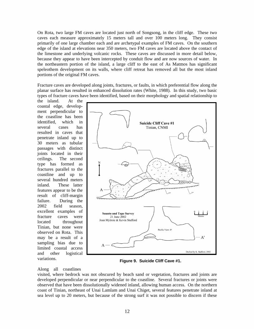
12
On Rota, two large FM caves are located just north of Songsong, in the cliff edge. These two caves each measure approximately 15 meters tall and over 100 meters long. They consist primarily of one large chamber each and are archetypal examples of FM caves. On the southern edge of the island at elevations near 350 meters, two FM caves are located above the contact of the limestone and underlying volcanic rocks. These caves are discussed in more detail below, because they appear to have been intercepted by conduit flow and are now sources of water. In the northeastern portion of the island, a large cliff to the east of As Matmos has significant speleothem development on its walls, where cliff retreat has removed all but the most inland portions of the original FM caves. Fracture caves are developed along joints, fractures, or faults, in which preferential flow along the planar surface has resulted in enhanced dissolution rates (White, 1988). In this study, two basic types of fracture caves have been identified, based on their morphology and spatial relationship to the island. At the coastal edge, develop-ment perpendicular to the coastline has been identified, which in several cases has resulted in caves that penetrate inland up to 30 meters as tubular passages with distinct joints located in their ceilings. The second type has formed as fractures parallel to the coastline and up to several hundred meters inland. These latter features appear to be the result of cliff-margin failure. During the 2002 field season, excellent examples of fracture caves were located throughout Tinian, but none were observed on Rota. This may be a result of a sampling bias due to limited coastal access and other logistical variations. Along all coastlines visited, where bedrock was not obscured by beach sand or vegetation, fractures and joints are developed perpendicular or near perpendicular to the coastline. Several fractures or joints were observed that have been dissolutionally widened inland, allowing human access. On the northern coast of Tinian, northeast of Unai Lamlam and Unai Chiget, several features penetrate inland at sea level up to 20 meters, but because of the strong surf it was not possible to discern if these
Figure 9. Suicide Cliff Cave #1.

Stafford, Mylroie & Jenson WERI Technical Report No. 96 September 29, 2002
13
exhibited any discharge. South of Unai Masalok along the east coast, fracture caves have developed that are currently active spring caves, and are therefore classified as discharge features below. Inland fracture caves have been formed along zones of brittle deformation that were later enhanced by dissolution. Several areas were located on Tinian where fractures and fracture sets are oriented parallel to the coastline and extend from 10’s of meters to 100’s of meters, with widths ranging from centimeters to meters. Depths range accordingly, but are generally five to fifteen meters. The majority of such caves have roofs of collapse blocks that have been stable for a significant amount time, as evidenced by speleothem development. In areas were a roof is absent, former speleothem development is present on the walls, which indicates that these portions of the fracture systems were covered in the past. Three areas of this type were located: Unai Masalok area, Laderon Masalok area, and Puntan Kastiyu area. Approximately 500 meters northwest of Puntan Kastiyu, fracture sets are present, with a primary feature measuring over 100 meters long and 5–10 meters deep with several roofed portions. Immediately south of Unai Dangkolo, a larger feature is present, which has larger expanses that are roofed, and a slightly greater depth and width. The third fracture cave is located between Laderan Masalok and Puntan Masalok. It is over 600 meters long and is unroofed in most places, although extensive speleothem development occurs on many walls. At the southern end of the fracture, a large cave is present, which descends steeply to a depth of approximately 20 meters. All of these features are hydrologically significant because they provide vadose fast flow routes for water entering the subsurface. Pit caves are vertical shafts that have developed by the dissolution of descending meteoric waters. They characteristically have a depth-to-width ratio greater than one. Pit caves often develop as a series of shafts with connecting lateral sections. They thus act as rapid transfer routes for water entering the subsurface, and effectively drain the epikarst (Mylroie and Carew, 1995). Although common in certain settings, only one was identified on Tinian and Rota during the investigation reported here. It is located ten meters from the cliff edge on the south coast of Tinian, and appears to connect to a low-level bench just above sea level. It is approximately 25 meters deep with a width of 3 meters, but because of its location and near-direct connection to the ocean, it has little effect on aquifer recharge. However, its presence suggests the possibility of other similar features in the area, which may be covered at the surface by collapse, but which at shallow depths could be open, acting as vadose fast flow routes. Stream caves are hydrologically active caves fed by allogenic water. They have been documented on Tinian and Rota along contacts between carbonate and non-carbonate rocks. Meteoric water is unable to infiltrate efficiently into the volcanic rocks and as a result forms surface streams, which channel water to the contact where it descends into the carbonate rocks as point source allogenic recharge (Mylroie et al., 2001). On Tinian, volcanic rocks outcrop in four regions. Closed depressions are associated with the periphery of each. Due to time and logistics constraints, only one of these features, located to the east of the largest outcrop at Bañaderon Lemmai, was investigated in the 2002 field season. This site contains a large sinkhole that appears to be armored with volcanic sediments, but on the distal eastern edge, a small cave (figure 10) is present that shows evidence of allogenic recharge during rain events. It is expected that other closed depressions associated with these volcanic outcrops will exhibit similar features with variations dependant on sediment infilling and volume of allogenic recharge that is received.

14
On the upper plateau of Rota, numerous closed depressions surround the periphery of the volcanic outcrop. Of the ones investigated, two stream caves and a third small, point-source recharge feature were located. Directly north of the Peace Memorial Shrine, water flowing over the volcanic rocks descends into two prominent features. One is the banana hole-type feature described previously, which appears to now act as a sediment-choked entrance to a stream cave (figure 11). The second feature is located to the east of the banana hole. It is developed along a joint, along which it descends steeply for a short distance before also becoming choked with sediment (figure 12). Although neither of these features extends a great distance, they are being fed directly by allogenic water and are hydrologically important as point-source recharge features. The third feature is located one kilometer west of the two stream cave entrances and consists of a ten-centimeter diameter open drain in the bottom of a closed depression. Discharge Features Discharge volume and types vary greatly on carbonate islands and spatially within any one island. Three general categories of discharge can be defined: seeps, springs, and submarine freshwater vents. Of these types, seeps reflect diffuse discharge, while the other types are focused discharge points. Seeps occur extensively in coastal areas where calcareous sand covers the bedrock and disperses emerging water over a large area. Springs are locations in which water emerges from the bedrock along preferential flow paths, generally defined by bedding planes or fractures.
Figure 10. Lasu Recharge Cave.

Stafford, Mylroie & Jenson WERI Technical Report No. 96 September 29, 2002
15
Springs may be laterally extensive if controlled by bedding planes or they may be restricted to a single point discharge if controlled by fractures. Submarine freshwater vents are areas where freshwater discharge occurs below tidal level along the island periphery (Jocson et al., 2002; Mylroie et al., 1999).
Seeps have been documented on both Tinian and Rota in coastal regions. Minor seeps are present at Unai Dangkolo and Unai Massalok on Tinian and significant seeps are located at various locations on the northern coast of Rota (Memorial Park, Puntan Sailigai). Springs have been documented in coastal areas on Tinian, and major springs have been seen throughout Rota. On Tinian, fracture caves were discovered along the west coast near Unai Masolak where freshwater could be observed mixing with salt water and discharging from solutionally-widened bedding planes that extend approximately 30 meters inland. Coastal springs developed along bedding planes at or near sea level are located at various points along the entire north coast of Rota, including a location referred by local residents as the “swimming hole.” This feature has developed a small caleta, which Back (1984) defines as a lagoon formed by mixing-zone dissolution from coastal discharge where the roof of an original cave has been removed by solution. On the southern side of the Rota, at approximately 350 meters elevation, several springs are developed at the contact of the volcanic and overlying carbonate rocks. These springs produce significant amounts of water and provide the majority of the island’s potable water (Mattan Hanum and As Onaan). Submarine freshwater vents have not yet been discovered on either Tinian or Rota, but such features are expected to exist, similar to those that have been reported from Guam (Mylroie et al., 2001; Taborosi, 2000; Jenson et al., 1997), where freshwater discharges below sea level.
WATER RESOURCES Island environments have limited water resources with specific problems. Island aquifers contain groundwater in a lens-shaped body formed by the ponding of fresh water on top of seawater.
Figure 11. Sabana Cave #2.

16
Such fresh water lenses generally extend to a depth below sea level forty times thicker than the thickness above sea level. Because of the limited extent of island aquifers, contamination can have severe consequences. Contamination from the surface includes human and animal wastes, fertilizers, detergents, pesticides, herbicides, petroleum spills, and solvent spills. Contamination can also occur at depth from salt-water intrusions, where overpumping draws salt-water into the fresh-water lens (Gingerich and Yeatts, 2000). Therefore, it is important for island communities to effectively manage their water resources in order to continue to produce potable water. In the 1995 census, 2,631 people were listed as living on Tinian, primarily in the Median Valley and parts of the adjacent Central Plateau, which comprises 25% of the total island surface area. Habitation is constrained partially from military use of the northern third of the island, the Northern Lowland, for training purposes, while other regions are difficult to access because of rugged terrain. Of the inhabited region, 60% is an undeveloped, public, rural land. The remaining 40% is residential and commercial lots, which include a casino resort, small businesses, farming, grazing and housing. The residential and commercial lots provide the largest concerns for contamination from surface spills and biological waste disposal. Tinian currently has no sewer facility; instead, human waste is disposed of through septic and seepage tanks, leaching fields or holding tanks, which may not be adequate for preventing groundwater contamination. Other potential sources for contamination include the airport, several quarries and a solid waste disposal dump, of which the latter two may provide routes where contaminated water can possibly travel directly into the aquifer by bypassing the soil surface and epikarst (Gingerich and Yeatts, 2000). On Tinian, USGS investigations show that the maximum lens thickness is 40 feet in the center of the Median Valley, with slight thinning near the Municipal well and Marpi Marsh. The Municipal Well (a Maui-type, infiltration well) supplies the majority of the island’s water needs, at a rate of ~4.5 x 10⁶ liters/day (~1.2 Mgal/day). However, today water produced from the Municipal well has a chloride concentration of 180 mg/L, which is 100 mg/L greater than when the well was constructed in 1945. The USGS monitored the aquifer thickness in relation to rain events in the wet season of 1993, which showed a lens thickening of 90-150 cm (3-5 ft), and in the dry season of 1994, which showed a lens thinning of 30-60 cm (1-2 ft). These results revealed that annual fluctuations are minor and that lens thickness is dependent more upon long-term rainfall patterns instead of annual fluctuations (Gingerich and Yeatts, 2000). This stable
Figure 12. Sabana Cave #1.

Stafford, Mylroie & Jenson WERI Technical Report No. 96 September 29, 2002
17
lens morphology indicates that contamination problems have the potential to produce long-term effects proportional to the residence time for water within the aquifer. Rota is fortunate to have a source of high quality water from a source that is quite different from sources on the other Mariana Islands. Rota’s public water system is supplied by spring water that emerges at the contact between volcanic rocks and overlying carbonate rocks at an elevation of ~350 meters on the south coast of the island. The two primary springs are Matan Hanum, the “Water Cave,” and As Onaan, located in the Talakhya region. The majority of the water comes from Matan Hanum, which produces an average of 6.8 x 10⁶ liters/day (1.8 Mgal/day), with an estimated maximum flow rate of 20.4 x 10⁶ liters/day (5.4 Mgal/day) in the wet season and a minimum of 1.9 x 10⁶ liters/day (0.5 Mgal/day) during the dry season, with great fluctuations in response to rain events. Because of the high elevation of the springs, the island is able to distribute its water resources by means of a gravity-driven flow system, which limits the need for expensive pumps to distribute water throughout the island (United States Department of Agriculture, 1994a; United States Department of Agriculture, 1994b). Primary concerns about water management include inadequate artificial storage and aquifer contamination. Currently, two water tanks with 3.8 million liters (1 million gallons) and 1.9 million liters (0.5 million gallons) respectively, distribute water to the entire island from Songsong and Sinapalo. During the wet season, they often overflow, which makes conservation of water during the dry season problematic because of the public perception of excess water during the wet season. In addition to the inadequate storage, the island’s water distribution system is deteriorating, with water loss estimated at 24% of distribution. Concern over contamination is also growing with the expansion of residential areas, especially in the Sinapalo region. Additional concerns about contamination are associated with the Sabana region, the primary recharge area for the springs that supply public water. Farming and agricultural activity in this area could introduce contaminants from pesticides, herbicides and fertilizers into the groundwater. Burning of grassland in the Talakhaya region is resulting in the destruction of limestone forests, which are being replaced by grasslands. The loss of native cover could result in increased erosion rates that may potentially contaminate the aquifer or reduce the flow rates by plugging the system (United States Department of Agriculture, 1994a; United States Department of Agriculture, 1994b).
FUTURE RESEARCH PRIORITIES The primary research need on Tinian and Rota is the continuation of the karst inventory, including photo-documentation, survey and mapping, and classification of the islands’ caves that was initiated in June 2002. These data are being compiled into a GIS database that will enable the spatial analysis, including the delineation of past fresh-water lens locations. This analysis and classification is essential to the accurate interpretation of the aquifer properties. In addition, this inventory will provide the basis for identifying and classifying significant recharge and discharge regions, including their susceptibility contamination, and corresponding requirements for monitoring and aquifer protection measures. The second priority is a structural geologic inventory of the islands’ faults, fractures and joints. This inventory will be compiled in conjunction with the karst inventory and be used to evaluate the possible relationships between structural features and aquifer characteristics. If statistically valid relationships can be discerned, they will provide useful insights for predicting water movement within the aquifer.

18
These two lines of inquiry will provide the basis for interpretation of aquifer behavior. Additional future research priorities include long-term studies of temporal and spatial rainfall patterns on the islands, and their relationship to determine-rates of aquifer recharge. A project to conduct detailed mapping of the carbonate/non-carbonate (volcanic) contacts should also be implemented, in order to better delineate the extent and location of parabasal waters (Mink and Vacher, 1997) to support installation of future water wells. Based on findings produced from the inventories, dye traces could also be planned to identify specific pathways, residence times and transport rates for water movement within the aquifer. All of these studies are aimed at providing an understanding of the islands’ aquifers, so that they can be properly managed to prevent contamination from surface sources or from salt-water intrusion induced by over-pumping, so that better, sustainable, groundwater management plans can be implemented.

Stafford, Mylroie & Jenson WERI Technical Report No. 96 September 29, 2002
19
REFERENCES Back, W., Hanshaw, B.B., and Van Driel, J.N., 1984. Chapter 12, Role of groundwater in shaping the Eastern Coastline of the Yucatan Peninsula, Mexico. In: LaFleur, R.G. (Editor), Groundwater as a Geomorphic Agent, Allen & Unwin, Inc., Boston, pp. 281-293. Bell, S.C., 1988. Sedimentary History and Early Diagenesis of Holocene Reef Limestone on Rota (Mariana Islands). Graduate thesis, University of Maryland, 82 p. Burke, H. W., 1953. The Petrography of the Mariana Limestone, Tinian, Mariana Islands. Graduate dissertation, Stanford University, 111 p. Cloud, P.E., Jr., Schmidt, R.G., and Burke, H.W., 1956. Geology of Saipan, Mariana Islands, Part 1. General Geology. 280-A, U.S. Geological Survey Professional Paper, U.S. Government Printing Office, Washington, D.C., pp. 126. Cruz, G.D.D., and Kapileo, R.I., 1972. Land Capability Report of Rota, Mariana Islands. Trust Territory of the Pacific Islands Department of Resources and Development Division of Lands and Surveys, pp. 44. Dickinson, W.R., 1999. Hydro-isostatic and tectonic influences on emergent Holocene paleoshorelines in the Mariana Islands, Western Pacific Ocean. Journal of Coastal Research, v. 16, no. 3, pp. 735-746. Doan, D.B., Burke, H.W., May, H.G., Stensland, C.H., and Blumenstock, D.I., 1960. Military Geology of Tinian, Mariana Islands. Chief of Engineers, U.S. Army, 149 p. Folk, R.L., Roberts, H.H., and Moore, C.C., 1973. Black phytokarst from Hell, Cayman Islands, British West Indies. Geological Society of America Bulletin, v. 84, pp. 2351-2360. Frank, E.F., Mylroie, J., Troester, J., Alexander, E.C., and Carew, J.L., 1998. Karst development and speleologenesis, Isla de Mona, Puerto Rico. Journal of Cave and Karst Studies, v. 60, no. 2, pp. 73-83. Gingerich, S.B. and Yeatts, D.S., 2000. Ground-Water Resources of Tinian, Commonwealth of the Northern Mariana Islands, water-resources investigations report 00-4068. U.S. Department of the Interior, 2 sheets. Harris, J.F., Mylroie, J.E. and Carew, J.L., 1995. Banana holes: Unique karst features of the Bahamas. Carbonates and Evaporites, v. 10, no. 2, pp. 215-224. Jenson, J.W., Jocson, J.M.U., and Siegrist, H.G., 1997. Groundwater discharge styles from an uplifted Pleistocene island karst aquifer, Guam, Mariana Islands. In: Beck, B.F. and Stephenson, J.B. (Editors), The Engineering Geology of Karst Terraines, Balkema, Springfield, Missouri.

20
Jenson, J. W., Mylroie, J. E., Mylroie, J. R., and Wexel, C., 2002 (abstract), Revisiting the Carbonate Island Karst Model: Geological Society of America Abstracts with Program, v. 34, no. 6, p. 226.Mylroie, J.E., Jenson, J.W., Taborosi, D., Jocson, J.M.U., Vann, D., and Wexel, C., 2001. Jocson, J.M.U., Jenson, J.W., and Contractor, D.N., 2002. Recharge and aquifer responses: Northern Guam Lens Aquifer, Guam, Mariana Islands. Journal of Hydrology, v. 260, pp. 231-254. Jocson, J.M.U., Jenson, J.W., and Contractor, D.N., 1999. An Integrated Numerical Modeling Study and Field Investigation of the Northern Guam Lens Aquifer. Technical Report #88, Water and Environmental Research Institute of the Western Pacific, University of Guam, Mangilao. Klimchouk, A. and Ford, D., 2000. Chapter 3.2, Lithologic and structural controls of dissolutional cave development. In: Klimchouk, A., Ford, D., Palmer, A., and Dreybrodt, W. (Editors), Speleogenesis: Evolution of Karst Aquifers, pp. 54-64. Mink, J.F. and Vacher, H.L., 1997. Hydrogeology of northern Guam. In: Vacher, H.L. and Quinn, T. (Editors), Geology and Hydrogeology of Carbonate Islands. Developments in Sedimentology 54, Elsevier Science, pp. 743-761. Mylroie, J. E., and Vacher, H. L., in press. Eogenetic karst from the perspective of an equivalent porous medium. Carbonates and Evaporites. Mylroie, J.E., and Jenson, J.W., 2002a. Karst flow systems in young carbonate islands. In: Martin, J.B., Wicks, C.M., and Sasowsky, I.D. (editors), Hydrogeology and biology of post-Paleozoic carbonate aquifers. Karst Waters Institute Special Publication Number 7, pp. 107-110. Mylroie, J.E., Jenson, J.W., Taborosi, D., Jocson, J.M.U., Vann, D., and Wexel, C., 2001. Karst features of Guam in terms of a general model of carbonate island karst. Journal of Cave and Karst Studies, v. 63, no. 1, pp. 9-22. Mylroie, J.E., Jenson, J.W., Jocson, J.M.U. and Lander, M., 1999. Karst Geology and Hydrology of Guam: A Preliminary Report, Technical Report #89, Water and Environmental Institute of the Western Pacific, University of Guam, Mangilao, 32 p. Mylroie, J. E., and Vacher, H. L., 1999. A conceptual view of carbonate island karst. In: Palmer, A. N., Palmer, M. V., and Sasowsky, I. D. (Editors), Karst Modeling, Karst Waters Institute Special Publication 5, pp. 48-57. Mylroie, J.E. and Carew, J.L., 1995. Karst development on carbonate islands. In: Budd, D.A., Harris, P.M., and Staller, A. (Editors), Unconformities and Porosity in Carbonate Strata, American Association of Petroleum Geologists, p. 55-76. Mylroie, J.E., Carew, J.L., and Vacher, H.L., 1995. Karst development in the Bahamas and Bermuda. In: Curran, H.A., White, B. (Editors), Terrestrial and Shallow Marine Geology of the Bahamas and Bermuda, pp. 251-267.

Stafford, Mylroie & Jenson WERI Technical Report No. 96 September 29, 2002
21
Siegrist, H.G., 1988. Miocene reef carbonates of the Mariana Islands. American Association of Petroleum Geologists Bulletin, v. 72, no. 2, pp. 248. Sugiwara, S., 1934. Topography, Geology, and Coral Reefs of Rota Island. Pacific Geological Surveys, Military Branch, United States Geological Survey, 59 p. Taborosi, D.S., 2000. Karst features of Guam [MS thesis]; University of Guam, Mangilao, 196 p. Tracey, J.I., Jr., Schlanger, S.O., Stark, J.T., Doan, D.B., and May, H.G., 1964. General Geology of Guam. 403-A, U.S. Geological Survey Professional Paper, U.S. Government Printing Office, Washington, D.C., pp. 104. United States Department of Agriculture, 1994a. Island Resource Study, Rota, Commonwealth of the Northern Mariana Islands, U.S.D.A. Soil Conservation Service, 48 p. United States Department of Agriculture, 1994b. Talakya/Sabana Water Quality Special Report, Rota, Commonwealth of the Northern Mariana Islands, U.S.D.A. Soil Conservation Service, 14 p. United States Department of the Interior Geological Survey, 1983a. Topographic Map of the Island of Tinian, Commonwealth of the Northern Mariana Islands: U.S. Geological Survey, scale 1:25,000. United States Department of the Interior Geological Survey, 1983b. Topographic Map of the Island of Rota (Luta), Commonwealth of the Northern Mariana Islands: U.S. Geological Survey, scale 1:25,000. Wietrzychowski, M. J., 1989. Depositional Facies Distribution and Diagenetic Variation within Pleistocene Carbonate Sequences on Rota, Mariana Islands. Graduate thesis, University of Maryland, 106 p. White, W.B., 1988. Geomorphology and Hydrology of Karst Terrains. Oxford University Press, New York, 464 p.

22
APPENDIX: FIELD JOURNAL
12-13 June 2002 Dr. John Mylroie, Joan Mylroie and Kevin Stafford departed from Starkville, Mississippi at 3:20 AM (Central Time) for a two-hour drive to Jackson, Mississippi. In Jackson, we caught a 6:30AM (Central Time) flight to Houston, Texas. Here, John and Joan departed for Guam via Honolulu, Hawaii, and Kevin departed for Guam via Tokyo, Japan. We all arrived at the Airport Hotel Mai’Ana in Guam by 6:30 PM and 11:00 PM (Guam time) respectively, having encountered no problems during the Pacific transit. 14 June 2002 Dr. Mylroie, Joan, and Kevin were picked up at the hotel by Mauryn McDonald at 8:00 AM and brought to WERI for meetings and orientations with the project leader, Dr. John Jenson. Before lunch, WERI graduate student Dave Moran presented his thesis work on dye tracing from the Guam International Airport and Harmon Sink. After lunch, WERI graduate student Curt Wexel presented his thesis proposal for a karst inventory of Saipan, CNMI. Later in the evening, Curt departed on a flight to Saipan. 15 June 2002 Dr. Jenson had morning meetings at Anderson Air Force Base, while the remaining members of the group waited and recovered from jet lag. We departed Guam with the addition of Danko Taborosi, former WERI graduate student, and Aubri Jenson, Dr. Jenson’s daughter, at 7:00 PM and traveled to Saipan, where we checked into the Pacific Gardenia Hotel and reunited with Curt. 16 June 2002 We met for breakfast with Lon Bulgrin, Historical Preservation Officer for the CNMI, to discussed work in the region. Afterwards, we took a field trip to San Vicente were several sinks and FM (flank margin) caves were investigated and photographed. We broke for an invited lunch with residents of San Vicente, who then showed us two additional FM caves in the near vicinity that are exposed through upper, collapsed entrances. 17 June 2002 The group started the day with a trip to Marpi Point to visit the El Toro caves. Numerous breached FM caves were observed with complex sediment fills and speleothem development. El Toro I was explored and photographed, while we discussed the development of the cave and the orientation of chambers. Afterwards, we traversed an extremely rough phytokarst region to access an extensive bioerosion notch and El Toro II, which contains smaller chambers than El Toro I. At this point, we returned to the vehicles and broke for lunch. Following lunch, we proceeded to Navy Hill and visited the Swiftlet cave, which is the home to numerous endangered Swiftlets. This is a large FM style cave that is protected to preserve the Swiftlet habitat. In the same area, we visited a small collapsed cave on an upper ridge, before we returned to the hotel for the evening. 18 June 2002 We returned to the north end of Saipan. Initially we investigated the Beehive Cave complex area, where Beehive Cave West was entered and explored. In the cave, three stalagmites were collected from various locations for lab analysis and age dating. We then met Rob Carruth (USGS) for lunch to discuss his work in the CNMI. Following lunch, we visited “The Grotto” to look at the karren field and the contact between the Mariana and Tagpochau Limestones. Curt, Danko, and Kevin continued the field trip to look at Bird Island, Falngun Hanom Cave, and Kalabera Cave, before meeting the others back at the hotel that evening. 19 June 2002 In the morning, we departed for Tinian via the ferry, which provides service between the two islands. Upon arrival, we were met by Joey Charfauros from the Tinian Mayor's Office, and then we continued to the Tinian Casino Hotel. After checking into the hotel and

Stafford, Mylroie & Jenson WERI Technical Report No. 96 September 29, 2002
23
touring the town of San Jose, Dr. Mylroie, Dr. Jenson, Joan, and Aubri met with the Mayor Borja of Tinian and were escorted on a tour of the southern portion of the island in the Suicide Cliffs area. Curt, Danko, and Kevin spent the afternoon snorkeling and investigating sea level caves near the hotel. 20 June 2002 A full day trip to Suicide Cliffs and the upper plateau was planned for the day. Eddy Cabrera, from the Mayor's office, showed us the trail to take to the cliffs in the morning and we followed it upward, which gave us access to the cliffs. We progressed to the top of the cliff and investigated a small FM cave during the assent, which Kevin and Joan surveyed. After having lunch at the cave, we continued across the upper plateau in search of additional karst features. In the southeastern portion of the plateau, a fracture system was discovered, which included a large, solution-widened fracture with a maximum width of 2 meters and depth of 5-10 meters. We then crossed the plateau and descended several kilometers from the insertion point, where we were picked up by Joey. 21 June 2002 In the morning, we visited Unai Massolak and located a small, breached FM cave. We continued south to Laderan Massalok and located the 600-meter fracture that is reported in the literature of the region, which was formed along a fault. At the southern end of the fracture, we investigated a large cave developed in the fracture, but did not completely explore because time was short and we lacked proper equipment. At 1:00 PM, we met with Greg Castro, Director of the CUC (Commonwealth Utilities Corporation), and Edward Quichocho, Water Service Manager of the CUC, and gave a presentation on island karst. After the meeting, Eddy took us to the southern plateau in order to visit Lyang Mohlang, a large cave with a complex morphology. In the evening, we joined Joey for a barbecue at his home. 22 June 2002 Curt departed in the morning. Eddy took the remainder of us to Unai Dangkolo for a visit to a large FM cave, which is composed of numerous chambers, but must be accessed through a ten-meter vertical drop. While the group exited and de-rigged the entrance, Dr. Mylroie discovered a second smaller cave in the near vicinity. We then broke for lunch in town, after which Eddy took us to the Lasso Shrine on the northern half of Tinian, in order to investigate one of the closed depressions that surrounds an exposure of igneous rocks. On the way to the depression, numerous FM caves were seen in the cliff walls. At the distal edge of the depression from the igneous rocks, a small cave was found. Kevin, Danko, and Aubri surveyed the cave before we returned to the shrine and back to the hotel. 23 June 2002 We visited the northern portion of the island during the morning. Here we visited the historically significant tourist stops including bomb pits 1 & 2, airstrips, and beaches White 1 & 2. At North Point, extensive phytokarst development was observed, and a coastal walk performed at Unai Lamlam, which revealed several small FM caves and fracture caves. After lunch, we continued to Unai Chiget, but were unable to conduct coastal walks due to strong waves and surf, so we continued south to Unai Massalok. Here, we conducted a coastal walk to the south, which revealed several pocket beaches with numerous small caves and dissolution features. Further south along the coast, we located two stream caves with discharging fresh water, before returning to Unai Massalok and concluding the day. 24 June 2002 Danko departed in the morning. The remaining group met with Carmen Sanchez, Director of Historical Preservation, at the Mayors office. After lunch, she led the group to a series of four different features. First, she showed us a pit cave on the southern-most coast, which descends ~25 meters to the sea below. Second, she showed us a larger cave closer to town, which contains extensive speleothems and brackish water. Third, she took us to Unai Dangkolo where
24
she showed us a fracture cave above the coastal cliffs that has a maximum width of 3 meters and depth of 10 meters. The forth locality, was also at Unai Dangkolo and included a zone of diffuse coastal discharge and a pocket beach that was the remnant of a FM cave. 25 June 2002 We met Carmen in the morning and prepared for a full day hike along the northern edge of the southern plateau with John Sanchez. The majority of us initially worked our way around the edge of the cliff, while Kevin explored the upper plateau at the cliff edge. Later we rejoined and continued east over the “Lion’s Head”, before descending and traversing back at the base of a lower cliff below the “Lion’s Head.” We did not find any major features, but several small, breached FM caves were located before we descended and exited the field near the Municipal Wells. In the evening, we attended a barbecue with Carmen. 26 June 2002 Carmen met us in the morning and directed us back to the Lasso Shrine area. She led us to the northeast to a cave that is banana-hole-like and consists of several low, wide, connected chambers situated around a central collapse. After an extensive search for continuations in the cave, we visited several fortified FM caves in the cliff to the west of the cave before we returned to the hotel and packed our luggage for an afternoon departure for Rota via Saipan, but by plane this time. At 6:00 PM we departed Tinian and arrived in Rota by 9:00 PM, where they met Junior Duenas who helped us locate and check into a hotel. 27 June 2002 We met Junior for breakfast, and then proceeded with him to the mayor’s office for a morning meeting. At the meeting, we met with Mayor Benjamin Manglona, David Atalig, Director of CUC, and Ignacio “Ike” Mendiola, Director of Tourism Affairs, to discuss their concerns and interests in water management. After the meeting, we traveled to the CUC office and met with Ike and Rob Carruth. From the CUC office, we continued with Rob’s party to the field and visited the Water Cave, which is a FM cave with intercepted stream flow that is used as the island’s primary water supply. After Rob finished his work at the cave, we continued to the Sabana and visited the igneous outcrops, where Dr. Mylroie and Dr. Jenson located two small caves in closed depressions at the limestone/igneous contact. From here, we continued to the south and completed a driving loop around the island before we returned to the hotel for the night. 28 June 2002 Curt rejoined the group in the morning. Dr. Mylroie and Kevin started the day with a presentation on island karst at the CUC, while Dr. Jenson attended a meeting at the Department of Natural Resources. After the meetings, we gathered and traveled to the same area as the Water Cave, where we visited a second spring cave that has water discharging from several small cracks and also contains a FM cave. Next, we visited Tonag Cave, in town, which is a FM cave that contains massive speleothem development. After lunch, we drove along the west coast looking for various discharge features. First, we visited Peace Memorial Park, which has an extensive zone of discharge that is easily seen at low tide. Next, we continued south, and located “the swimming hole,” which is a caleta developed where a larger spring discharges. Farther south, we ended the day at “The Cliffs,” which is an internal cliff line that contains numerous remnant FM caves with extensive speleothem development. These cliffs were noted as being thin bedded and dipping, possibly indicating their original depositional structure. 29 June 2002 We visited the Cave Museum in the morning, which consists of a short passage that intersects a large FM chamber, developed along a joint, but is very smooth-walled and effectively devoid of speleothems. We then continued to the Sinapalo region and visited a religious park that contains several remnant FM caves high on the cliff wall that can be accessed by a staircase. Next, we visited the Bird Sanctuary and a Latte Stone quarry before breaking for lunch. After lunch, we returned to the region of the Sabana we had visited earlier. While there, Kevin surveyed the two small caves that Dr. Mylroie and Dr. Jenson had discovered earlier, while

Stafford, Mylroie & Jenson WERI Technical Report No. 96 September 29, 2002
25
the rest of the group scouted other nearby depressions without finding any new features. This ended the fieldwork portion of the trip, and we returned to the hotel to pack our luggage for the trip back to Guam. 30 June 2002 We departed Rota and returned to Guam, ending the fieldwork portion of the expedition. 01 July 2002 The day was spent reviewing notes from the fieldwork at WERI. 02 July 2002 The Mylroie’s departed on an early flight back to Mississippi. Kevin spent the day at the University of Guam’s libraries obtaining copies of material related to the geology of Tinian and Rota. 03 July 2002 Kevin continued work at library. 04 July 2002 Kevin departed on a return flight to Texas.