kentucky air quality surveillance network 2005
TRANSCRIPT

Kentucky Air Quality
Surveillance Network
2005
Commonwealth of Kentucky Environmental and Public Protection Cabinet
Department for Environmental Protection Division for Air Quality
803 Schenkel Lane Frankfort, Kentucky 40601

1
INTRODUCTION The State Division for Air Quality has operated an air quality-monitoring network in the Commonwealth since July 1967. The Louisville Metro Air Pollution Control District, a local agency, has maintained a subnetwork in its area of jurisdiction since January 1956. Since that time the networks have been expanded in accordance with the U. S. Environmental Protection Agency's regulations to reflect the current overall network of 44 stations, which monitor the major pollutants including those for which national ambient air quality standards have been issued. In October 1975, the U. S. EPA established a work group to critically review and evaluate then current air monitoring activities. This group was named the Standing Air Monitoring Working Group (SAMWG). The SAMWG review indicated several areas where deficiencies existed which needed correction. The principal areas needing correction were: there were more monitoring sites than needed in some areas to assess air quality; existing regulations did not allow for flexibility to conduct special purpose monitoring studies; data reporting was untimely and incomplete and there existed a lack of uniformity in station location and probe siting, sampling methodology, quality assurance practices, and data handling procedures which resulted in data of unknown quality. In August 1978, recommendations developed by SAMWG to remedy the deficiencies in the existing monitoring activities were combined with the requirements of a new Section 319 of the Clean Air Act and included in a proposed revision to the Regulations. Section 319 provided for the development of uniform air quality monitoring criteria and methodology; reporting of a uniform air quality index in major urban areas; and the establishment of an air quality monitoring system nation-wide which utilizes uniform monitoring criteria and provides for monitoring stations in major urban areas that supplement State monitoring. In May 1979 the new regulations were finalized by the Federal Environmental Protection Agency requiring certain modifications and additions be included in the State Implementation Plan for air quality surveillance. These regulations require each state to operate a network of monitoring stations designated as State and Local Air Monitoring Stations (SLAMS) that measure ambient concentrations of air pollutants for which standards have been established. The SLAMS designation contains provisions concerning the conformity to specific siting and monitoring criteria not previously required. Regulations provide for an annual review of the monitoring network to insure objectives are being met and to identify needed modification. Finally, the Air Quality Surveillance Plan content provides for having a SLAMS network description available for public inspection and submission to the U.S. Environmental Protection Agency upon request. The SLAMS network description as provided for in 40 CFR Part 58 must contain the following information for each monitoring station in the network: 1. The Aerometric Information Retrieval System (AIRS) site identification form for existing stations. 2. The proposed location for scheduled stations. 3. The sampling and analysis method used by each monitor.
2
4. The operating schedule for each monitor. 5. The monitoring objective and spatial scale of representativeness for each monitor. The document which follows constitutes the Kentucky SLAMS network description and is organized into three main parts:
(1) Station Description Format: An outline of the designations, parameters, monitoring methods and the basis for site selection.
(2) Network Summaries: Presenting the total number of sites and monitors in each
region and for the state. Also included is a listing of all stations and location.
(3) SLAMS Station Description: Each SLAMS station is described in detail as per the outline in (1) above.
Modification to the network as determined by an annual review process will be made each year to maintain a current up-to-date network description document.

3
TABLE OF CONTENTS
Page INTRODUCTION i STATION DESCRIPTION FORMAT 4
AQS Site Identification Information 4 Monitoring Stations Designations 4 Date Established 5 Site Description 5 Monitoring Methods 5 Area Representativeness 8 Monitoring Objectives 9 Site Approval Status 9 Quality Assurance Status 9 Data Processing and Reporting 9
NETWORK SUMMARIES 10 SLAMS NETWORK DESCRIPTION
AQCR 072 Paducah-Cairo Interstate Air Quality Control Region 11 AQCR 077 Owensboro-Evansville Interstate Air Quality Control Region 18 AQCR 078 Louisville Interstate Air Quality Control Region 24 AQCR 079 Cincinnati Interstate Air Quality Control Region 34 AQCR 101 Appalachian Air Quality Control Region 38 AQCR 102 Bluegrass Air Quality Control Region 43 AQCR 103 Ashland-Huntington Interstate Air Quality Control Region 50 AQCR 104 North Central Air Quality Control Region 55 AQCR 105 South Central Air Quality Control Region 59
APPENDIX A - AIR TOXICS STATIONS 64 APPENDIX B - NATIONAL PARK SERVICE 65 APPENDIX C - INDUSTRIAL MONITORS 66
4
DESCRIPTION FORMAT AQS Site Identification Information
Pertinent, specific siting information for each site and monitor is stored in the U.S. EPA’s AQS data system. This information includes the exact location of the site, local and regional population, a description of the site location, monitor types and monitoring objectives. This site and monitor information is routinely updated whenever there is a change in site characteristics or pollutants monitored.
The network station descriptions contained in this document include the following information. 1. Monitoring Stations Designations
Most stations described in the air quality surveillance network are designated as "SLAMS”. In addition, some of these stations fulfill other requirements, which must be identified. In this description of the network, designations are also made for National Air Monitoring Stations (NAMS), Special Purpose Monitors (SPM), Emergency Episode Monitoring sites and Air Quality Index sites (AQI). The following is the criteria used for each of these designations.
SLAMS: Requirements for air quality surveillance systems provide for the establishment of a network of monitoring stations designated as State and Local Air Monitoring Stations (SLAMS) that measure ambient concentrations of those pollutants for which standards have been established. These stations must meet requirements that relate to four major areas: quality assurance, monitoring methodology, sampling interval and siting of instruments and instrument probes.
NAMS: Within the SLAMS network certain monitors are selected to provide the U.S. EPA with timely data for use in national trends analysis. These NAMS monitors are identified in the summary of network stations.
EMERGENCY EPISODE MONITORING SITES: Regulations provide for the operation of at least one continuous SLAMS monitor for each major pollutant in designated locations for emergency episode monitoring. These monitors are placed in areas of worst air quality and provide continual surveillance during episode conditions.
AIR QUALITY INDEX: Certain stations in the SLAMS network provide data for daily index reporting. Index reporting is required for all urban areas with a population exceeding 200,000. The Division for Air Quality, however, is providing this service to the general public from all areas where monitoring and attending staff are available. The Air Quality Index is a method of reporting that converts concentration levels of pollution to a simple number on a scale of 0-500. Intervals on the Air Quality Index scale are related to potential health effects of the daily measured concentrations of the major pollutants. The Division for Air Quality prepares the Index twice daily for release to the public from the pollutant data

5
reported from the Field Offices.
SPM: Not all monitors and monitoring stations in the air quality surveillance network are included in the SLAMS network. In order to allow the capability of providing monitoring for complaint studies, modeling verification and compliance status, certain monitors are reserved for short-term studies and designated as Special Purpose Monitors (SPM). These monitors are not committed to any one location or for any specified time period. They may be located as separate monitoring stations or be included at SLAMS locations. Monitoring data may be reported providing the monitors and stations conform to all requirements of the SLAMS network.
2. Date Established
The date when each existing monitoring station was established is shown in the description. For those stations, which are proposed, a date is provided when it is expected for the station to be in operation.
3. Site Description
Specific information is provided to show the location of the monitoring equipment at the site and to indicate that monitors and monitor probes conform to the siting criteria.
4. Monitoring Methods
All sampling and analytical procedures used in the air-monitoring network conform to Federal reference (FRM), alternate (FAM) or equivalent (FEM) methods. In case there is no federal method, procedures are described in the Kentucky Air Quality Monitoring and Quality Assurance Manuals.
(a) Particulate Matter 10 microns in size (PM10)
All PM10 samplers operated by the Division for Air Quality are certified as either FRM or FEM samplers and are operated per the requirements set forth in 40 CFR 50. Intermittent samplers collect a 24-hour sample every sixth day on 46.2 mm PTFE filters. The filter is weighed before and after the sample run. The gain in weight in relation to the volume of air sampled is calculated in micrograms per cubic meter (μg/m3). The PTFE filters are to be equilibrated before each weighing for 24 hours at 20-23 degrees C mean temperature and 30-40 % mean humidity. Continuous PM10 samplers provide 24-hour samples daily for Air Quality Index and SLAMS reporting. All samplers are certified as either FRM or FEM. During sampling ambient air passes through an inlet designed to pass only particles smaller than 10 microns in diameter. After exiting the inlet, the sample stream is sent to a mass transducer. Inside the transducer the sample stream passes through a Teflon-coated glass fiber filter. This filter is weighed every two seconds. The difference between the current filter weight and the initial or installed weight gives the total mass of the collected particulate. The mass concentration is computed by dividing

6
the total mass by the flowrate. Data is transmitted by telemetry for entry into the automated central data acquisition system.
(b) Particulate Matter 2.5 microns in size (PM2.5)
All PM2.5 samplers operated by the Division for Air Quality are certified as either FRM or FEM samplers. All samplers are operated per the requirements set forth in 40 CFR 50, Appendix L. Samples are collected on 46.2mm PTFE filters over a 24-hour sampling period. Airflow through the filter is to be maintained at 16.7 liters per minute. The flowrate must not vary more than +/-5% for five minutes over a 24-hour sample period at actual ambient temperature and pressure. Samples must be retrieved within 96 hours of the end of the sample run and must be kept cool (4 degrees C or cooler) during transit to meet the thirty-day limit for re-weighing.
The PTFE filters are to be equilibrated before each weighing for 24 hours at a controlled atmosphere of 20-23 degrees C mean temperature and 30-40% mean humidity. Filters must be used within thirty days of initial weighing. Filters must be re-weighed within thirty days of the end of the sample run and must be kept at 4 degrees C or cooler. The gain in weight in relation to the volume of air sampled is calculated in micrograms per cubic meter (μg/m3).
(c) PM2.5 Speciation sampling and analysis
In addition to operating PM2.5 samplers that determine only PM2.5 mass values, the Division also operates PM2.5 speciation samplers that collect samples that are analyzed to determine the chemical makeup of PM2.5. Samples are collected on a set of three filters over a 24-hour sampling period. The individual filters are composed of different media in order to collect specific types of toxic pollutants. After collection, the samples are shipped in ice chests to an EPA contract laboratory for analysis. At the laboratory the samples are analyzed using optical and electron microscopy, thermal optical analysis, ion chromatography and x-ray fluorescence to determine the presence and level of specific toxic compounds. Sample results are entered in the AQS data system.
(d) Sulfur Dioxide
Instruments used to continuously monitor sulfur dioxide levels in the atmosphere employ the UV fluorescence method. The continuous data output from the instrument is transmitted by telemetry for entry into an automated central data system.
Calibration of these instruments is done dynamically using certified gas mixtures containing a known concentration of sulfur dioxide gas. This gas is then diluted in a specially designed apparatus to give varying known concentrations of sulfur dioxide. These known concentrations are fed to the instruments, which are adjusted so that instrument output corresponds with the specific concentrations. Calibration curves are prepared for each instrument and each datapoint is automatically compared to

7
this curve before entry into the data acquisition system.
(e) Carbon Monoxide
Continuous monitoring for carbon monoxide is performed by use of the non-dispersive infrared correlation method. Data is transmitted by telemetry for entry in an automated central data acquisition system.
Calibration of the instrument is performed periodically by using nitrogen or zero air to establish the zero baseline and NBS or NBS traceable gas mixtures of carbon monoxide in air. The span is checked daily using a certified mixture of compressed gas containing approximately 45 parts per million carbon monoxide.
(f) Ozone
Ozone is monitored using the UV photometry method. The continuous data output from the instrument is transmitted by telemetry for entry into an automated central data acquisition system.
Monitors are calibrated routinely using an ozone generator, which is calibrated using the ultra violet photometry reference method. Calibration curves are prepared for each instrument and each data point is automatically compared to this curve before entry into the data acquisition system.
(g) Nitrogen Dioxide
The chemiluminescence method is used in monitoring the nitrogen dioxide level in the ambient air. The continuous data output from the instrument is transmitted by telemetry for entry into an automated central data acquisition system.
Calibration of these instruments is done dynamically using NBS certified gas mixtures of nitric oxide. Through the use of dilution apparatus, varying concentrations are produced which are fed to the monitors, thus producing a specific calibration curve for each instrument. Each data point is automatically compared to this curve before entry into the data acquisition system.
(h) Lead
Lead concentrations are determined from the analysis of suspended particulate collected by high volume particulate samplers. Particulate samples are ashed to

8
remove organic matter and acid extracted to dissolve the metals. Analysis of the lead content is determined by the atomic absorption spectroscopy method.
5. Area Representativeness
Each station in the monitoring network must be described in terms of the physical dimensions of the air parcel nearest the monitoring station throughout which actual pollutant concentrations are reasonably similar. Area dimensions or scales of representativeness used in the network description are: (a) Micro Scale - defines the concentration in air volumes associated with area
dimensions ranging from several meters up to about 100 meters.
(b) Middle Scale - defines the concentration typical of areas up to several city blocks in size with dimensions ranging from about 100 meters to 0.5 kilometers.
(c) Neighborhood Scale - defines concentrations within an extended area of a city that has relatively uniform land use with dimensions in the 0.5 to 4.0 kilometers.
(d) Urban Scale - defines an overall citywide condition with dimensions on the order
of 4 to 50 kilometers.
(e) Regional Scale - defines air quality levels over areas having dimensions of 50 to hundreds of kilometers.
Closely associated with the area around the monitoring station where pollutant concentrations are reasonably similar are the basic monitoring objectives of the station. There are four basic objectives included in this description:
(a) To determine the highest concentrations expected to occur in the area covered by the
network.
(b) To determine representative concentrations in areas of high population density.
(c) To determine the impact on ambient pollution levels of significant sources or source categories.
(d) To determine general background concentration levels.
The design intent in siting stations is to correctly match the area dimensions represented by the sample of monitored air with the area dimensions most appropriate for the monitoring objective of the station. The following relationship of the four basic objectives and the area of representativeness are appropriate when siting monitoring stations:
Monitoring Objectives Siting Area Scale Highest concentration Micro, middle, neighborhood

9
Population Neighborhood, urban Source impact Micro, middle, neighborhood General/background Neighborhood, regional
6. Monitoring Objectives
The monitoring network was designed to provide information to be used as a basis for the following actions:
(a) To determine compliance with ambient air quality standards and to plan measures to attain these standards.
(b) To activate emergency control procedures in the event of an impending air pollution episode.
(c) To observe pollution trends throughout a region including non-urban areas and report
progress made toward meeting ambient air quality standards.
(d) To provide a database for the evaluation of the effects of air quality on population, land use and transportation planning. To provide a database for the development and evaluation of diffusion models.
7. Site Approval Status
Each monitoring station in the existing network has been reviewed with the purpose of determining whether it meets all design criteria for inclusion in the SLAMS network. Stations that do not meet the criteria will either be relocated in the immediate area or when possible, resited at the present location.
8. Quality Assurance Status
The Division for Air Quality has an extensive quality assurance program to ensure that all air monitoring data collected is accurate and precise. Staff members audit every air monitor quarterly including those operated by the Louisville Metro Air Pollution Control District to ensure that each instrument is in calibration and operating properly. Data validation is performed monthly by verifying the data reported by each instrument is recorded accurately in the computerized database.
9. Data Processing and Reporting
All ambient air quality data are stored in a centralized computer located at the Division for Air Quality headquarters in Frankfort. After each month of data has passed all quality assurance checks it is transmitted via telemetry to the U.S. EPA’s national data storage system known as AIRS (Aerometric Information Retrieval System). Statistical data summaries are generated from this database and compiled to produce Ambient Air Quality

10
Annual Reports. These reports may be accessed at the Division for Air Quality website: http://www.air.ky.gov. The report is located under Public Information.
AIR QUALITY SURVEILLANCE NETWORK
AIR MONITORING STATIONS SUMMARY
NUMBER REGION OF SITES PM2.5 PM10 SO2 NO2 CO O3 MET Paducah-Cairo (072) 6 2 2 2 1 0 2 2 Owensboro-Henderson (077) 5 3 2 3 1 0 5 3 Louisville (078) 9 5 2 2 1 2 3 1 Northern Kentucky (079) 3 2 1 2 1 0 3 2 Appalachian (101) 4 4 4 0 0 0 3 2 Bluegrass (102) 6 4 2 1 1 0 3 1 Ashland-Huntington (103) 4 2 1 2 1 0 3 2 North Central (104) 3 2 2 0 1 0 3 1 South Central (105) 4 1 2 1 1 0 3 1 TOTALS 44 25 18 13 8 2 28 15 SLAMS (NAMS) 37 19 14 (2) 9 (1) 6 2 (1) 17 (3) 0 Special Purpose Monitor 7 6 4 4 2 0 11 15 ________________________________________________
SLAMS - State and Local Air Monitoring Stations (SLAMS) are located in all areas wherethe state and the U.S. EPA Regional Office decide that monitoring is necessary todetermine compliance with National Ambient Air Quality standards.
NAMS - Within the SLAMS network certain monitors are designated as National Air
Monitoring Stations (NAMS) to provide the U.S. EPA with data for use in nationaltrends analysis. The number of NAMS monitors appears in parenthesis next to theSLAMS totals.
SPM - Special Purpose Monitors are oriented toward localized problems, occasionally
prompted by citizen complaints and do not represent overall air quality in cities orcounties. Data from these monitors should not be used for planning purposes.
(Rev. 2/24/05)
11
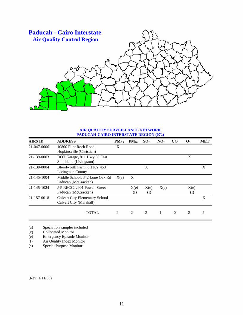
Paducah - Cairo Interstate Air Quality Control Region
AIR QUALITY SURVEILLANCE NETWORK PADUCAH-CAIRO INTERSTATE REGION (072)
AIRS ID ADDRESS PM2.5 PM10 SO2 NO2 CO O3 MET 21-047-0006 10800 Pilot Rock Road X Hopkinsville (Christian) 21-139-0003 DOT Garage, 811 Hwy 60 East X Smithland (Livingston) 21-139-0004 Bloodworth Farm, off KY 453 X X Livingston County 21-145-1004 Middle School, 342 Lone Oak Rd X(a) X Paducah (McCracken) 21-145-1024 J-P RECC, 2901 Powell Street X(e) X(e) X(e) X(e) Paducah (McCracken) (I) (I) (I) 21-157-0018 Calvert City Elementary School X Calvert City (Marshall) TOTAL 2 2 2 1 0 2 2 (a) Speciation sampler included (c) Collocated Monitor (e) Emergency Episode Monitor (I) Air Quality Index Monitor (s) Special Purpose Monitor (Rev. 1/11/05)

12
Kentucky Department for Environmental Protection AIR QUALITY SURVEILLANCE NETWORK _________________________________________________________________________________ LOCATION:
Hopkinsville Christian 10800 Pilot Rock Road (City) (County) (Address)
_________________________________________________________________________________ EPA SITE NO: 21-047-0006 REGION: (072) Paducah-Cairo Interstate MAP LOCATION: UTM ZONE 16 NORTHING 4084.919 EASTING 471.172 ________________________________________________________________________________ DESIGNATION: SLAMS - State and Local Air Monitoring Station _________________________________________________________________________________ DATE ESTABLISHED: January 1, 1999 _________________________________________________________________________________ SITE DESCRIPTION: The monitoring site is on a platform in a field adjacent to a residence. The sample inlet is 10 feet above ground level and 300 feet from the nearest street. _________________________________________________________________________________ MONITORS, (Type, Analysis Method, Frequency of Sampling): A SLAMS PM2.5 particulate sampler operates for 24 hours every third day. Particulates are determined gravimetrically. ________________________________________________________________________________ AREA REPRESENTATIVENESS: The site represents population exposure on a regional scale. _______________________________________________________________________________ MONITORING OBJECTIVES: To determine levels of interstate transport of fine particulate matter. To judge compliance with and/or progress made toward meeting ambient air quality standards. _______________________________________________________________________________ SITE APPROVAL STATUS: Site and monitors meet all design criteria for monitoring network. _______________________________________________________________________________ QUALITY ASSURANCE STATUS: All Quality Assurance procedures have been implemented. _______________________________________________________________________________ (Rev. 3/12/99)

13
Kentucky Department for Environmental Protection AIR QUALITY SURVEILLANCE NETWORK _________________________________________________________________________________ LOCATION:
Smithland Livingston KY DOT Garage, 811 HWY 60 East (City) (County) (Address)
_________________________________________________________________________________ EPA SITE NO: 21-139-0003 REGION: (072) Paducah-Cairo Interstate MAP LOCATION: UTM ZONE 16 NORTHING 4112.835 EASTING 376.310 ________________________________________________________________________________ DESIGNATION: SLAMS - State and Local Air Monitoring Station _________________________________________________________________________________ DATE ESTABLISHED: April 1, 1981 _________________________________________________________________________________ SITE DESCRIPTION: The monitoring site is a trailer located on the grounds of the DOT Highway Garage. The sample inlet is 13 feet above ground level and 1200 feet from the nearest street. _________________________________________________________________________________ MONITORS, (Type, Analysis Method, Frequency of Sampling): A SLAMS ozone analyzer operates continuously using the UV photometric method of analysis. ________________________________________________________________________________ AREA REPRESENTATIVENESS: The site represents maximum concentrations on an urban scale. _______________________________________________________________________________ MONITORING OBJECTIVES: To determine compliance with and/or progress made toward meeting ambient air quality standards. _______________________________________________________________________________ SITE APPROVAL STATUS: Site and monitors meet all design criteria for monitoring network. _______________________________________________________________________________ QUALITY ASSURANCE STATUS: All Quality Assurance procedures have been implemented. _______________________________________________________________________________ (Rev. 12/10/01)

14
Kentucky Department for Environmental Protection AIR QUALITY SURVEILLANCE NETWORK _________________________________________________________________________________ LOCATION:
Livingston County Livingston Bloodworth Road, off KY 453 (City) (County) (Address)
_________________________________________________________________________________ EPA SITE NO: 21-139-0004 REGION: (072) Paducah-Cairo Interstate MAP LOCATION: UTM ZONE 16 NORTHING 4103.359 EASTING 381.395 ________________________________________________________________________________ DESIGNATION: SLAMS - State and Local Air Monitoring Station _________________________________________________________________________________ DATE ESTABLISHED: September 15, 1986 _________________________________________________________________________________ SITE DESCRIPTION: The monitoring site is a trailer located in a field at the end of Bloodworth Road. The sample inlets are 13 feet above ground level and 1200 feet from the nearest street. _________________________________________________________________________________ MONITORS, (Type, Analysis Method, Frequency of Sampling): A SLAMS sulfur dioxide analyzer operates continuously using the UV fluorescent method of analysis. ________________________________________________________________________________ AREA REPRESENTATIVENESS: The site represents maximum concentrations on a neighborhood scale. _______________________________________________________________________________ MONITORING OBJECTIVES: To determine compliance with and/or progress made toward meeting ambient air quality standards. _______________________________________________________________________________ SITE APPROVAL STATUS: Site and monitors meet all design criteria for monitoring network. _______________________________________________________________________________ QUALITY ASSURANCE STATUS: All Quality Assurance procedures have been implemented. _______________________________________________________________________________ (Rev. 9/8/00)
15
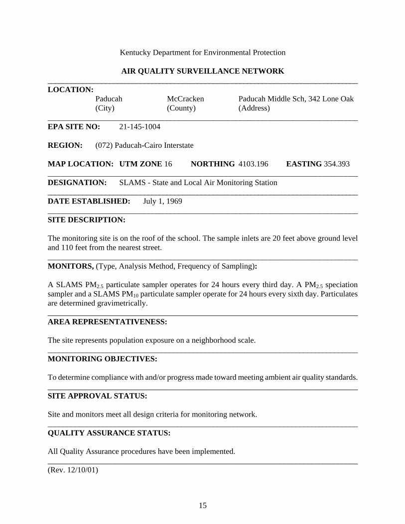
Kentucky Department for Environmental Protection AIR QUALITY SURVEILLANCE NETWORK _________________________________________________________________________________ LOCATION:
Paducah McCracken Paducah Middle Sch, 342 Lone Oak (City) (County) (Address)
_________________________________________________________________________________ EPA SITE NO: 21-145-1004 REGION: (072) Paducah-Cairo Interstate MAP LOCATION: UTM ZONE 16 NORTHING 4103.196 EASTING 354.393 ________________________________________________________________________________ DESIGNATION: SLAMS - State and Local Air Monitoring Station _________________________________________________________________________________ DATE ESTABLISHED: July 1, 1969 _________________________________________________________________________________ SITE DESCRIPTION: The monitoring site is on the roof of the school. The sample inlets are 20 feet above ground level and 110 feet from the nearest street. _________________________________________________________________________________ MONITORS, (Type, Analysis Method, Frequency of Sampling): A SLAMS PM2.5 particulate sampler operates for 24 hours every third day. A PM2.5 speciation sampler and a SLAMS PM10 particulate sampler operate for 24 hours every sixth day. Particulates are determined gravimetrically. ________________________________________________________________________________ AREA REPRESENTATIVENESS: The site represents population exposure on a neighborhood scale. _______________________________________________________________________________ MONITORING OBJECTIVES: To determine compliance with and/or progress made toward meeting ambient air quality standards. _______________________________________________________________________________ SITE APPROVAL STATUS: Site and monitors meet all design criteria for monitoring network. _______________________________________________________________________________ QUALITY ASSURANCE STATUS: All Quality Assurance procedures have been implemented. _______________________________________________________________________________ (Rev. 12/10/01)

16
Kentucky Department for Environmental Protection AIR QUALITY SURVEILLANCE NETWORK _________________________________________________________________________________ LOCATION:
Paducah McCracken Jackson Purchase RECC, 2901 Powell Street (City) (County) (Address)
_________________________________________________________________________________ EPA SITE NO: 21-145-1024 REGION: (072) Paducah-Cairo Interstate MAP LOCATION: UTM ZONE 16 NORTHING 4102.275 EASTING 360.190 ________________________________________________________________________________ DESIGNATION: SLAMS - State and Local Air Monitoring Station
EPISODE - Emergency Episode Monitoring site AQI - Air Quality Index site
_________________________________________________________________________________ DATE ESTABLISHED: August 15, 1980 _________________________________________________________________________________ SITE DESCRIPTION: The monitoring site is a trailer located in an open area at the back of the Jackson Purchase RECC. The sample inlets are 13 feet above ground level and 31 feet from the nearest street. _________________________________________________________________________________ MONITORS, (Type, Analysis Method, Frequency of Sampling): A continuously operating TEOM PM10 sampler provides 24-hour sample values for SLAMS and daily index reporting. SLAMS ozone and sulfur dioxide monitors operate continuously using the UV photometric and UV fluorescent methods of analysis respectively. A SLAMS nitrogen dioxide monitor operates continuously using the chemiluminescence method of analysis. ________________________________________________________________________________ AREA REPRESENTATIVENESS: The site represents population exposure on a neighborhood scale for particulates, sulfur dioxide and ozone and on an urban scale for nitrogen dioxide. _______________________________________________________________________________ MONITORING OBJECTIVES: To determine compliance with and/or progress made toward meeting ambient air quality standards. To detect episode pollution levels for the activation of emergency control procedures. To provide pollution levels for daily index reporting. _______________________________________________________________________________ SITE APPROVAL STATUS: Site and monitors meet all design criteria for monitoring network. _______________________________________________________________________________ QUALITY ASSURANCE STATUS: All Quality Assurance procedures have been implemented. _______________________________________________________________________________ (Rev. 12/10/01)
17
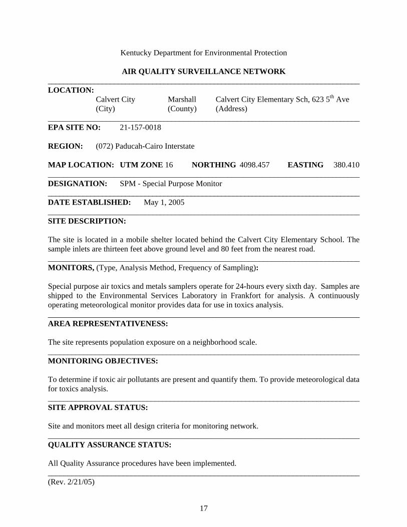
Kentucky Department for Environmental Protection AIR QUALITY SURVEILLANCE NETWORK _________________________________________________________________________________ LOCATION:
Calvert City Marshall Calvert City Elementary Sch, 623 5th Ave (City) (County) (Address)
_________________________________________________________________________________ EPA SITE NO: 21-157-0018 REGION: (072) Paducah-Cairo Interstate MAP LOCATION: UTM ZONE 16 NORTHING 4098.457 EASTING 380.410 ________________________________________________________________________________ DESIGNATION: SPM - Special Purpose Monitor _________________________________________________________________________________ DATE ESTABLISHED: May 1, 2005 _________________________________________________________________________________ SITE DESCRIPTION: The site is located in a mobile shelter located behind the Calvert City Elementary School. The sample inlets are thirteen feet above ground level and 80 feet from the nearest road. _________________________________________________________________________________ MONITORS, (Type, Analysis Method, Frequency of Sampling): Special purpose air toxics and metals samplers operate for 24-hours every sixth day. Samples are shipped to the Environmental Services Laboratory in Frankfort for analysis. A continuously operating meteorological monitor provides data for use in toxics analysis. ________________________________________________________________________________ AREA REPRESENTATIVENESS: The site represents population exposure on a neighborhood scale. _______________________________________________________________________________ MONITORING OBJECTIVES: To determine if toxic air pollutants are present and quantify them. To provide meteorological data for toxics analysis. _______________________________________________________________________________ SITE APPROVAL STATUS: Site and monitors meet all design criteria for monitoring network. _______________________________________________________________________________ QUALITY ASSURANCE STATUS: All Quality Assurance procedures have been implemented. _______________________________________________________________________________ (Rev. 2/21/05)
18
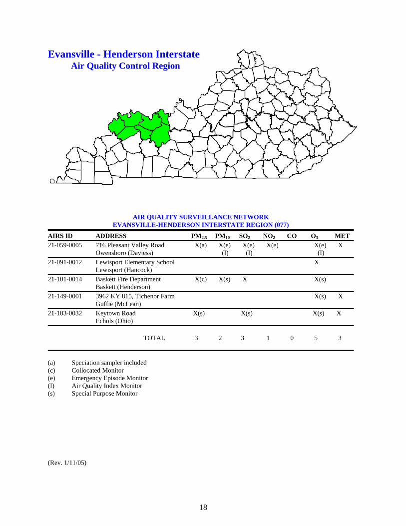
Evansville - Henderson Interstate Air Quality Control Region
AIR QUALITY SURVEILLANCE NETWORK EVANSVILLE-HENDERSON INTERSTATE REGION (077)
AIRS ID ADDRESS PM2.5 PM10 SO2 NO2 CO O3 MET 21-059-0005 716 Pleasant Valley Road X(a) X(e) X(e) X(e) X(e) X Owensboro (Daviess) (I) (I) (I) 21-091-0012 Lewisport Elementary School X Lewisport (Hancock) 21-101-0014 Baskett Fire Department X(c) X(s) X X(s) Baskett (Henderson) 21-149-0001 3962 KY 815, Tichenor Farm X(s) X Guffie (McLean) 21-183-0032 Keytown Road X(s) X(s) X(s) X Echols (Ohio) TOTAL 3 2 3 1 0 5 3 (a) Speciation sampler included (c) Collocated Monitor (e) Emergency Episode Monitor (I) Air Quality Index Monitor (s) Special Purpose Monitor (Rev. 1/11/05)
19
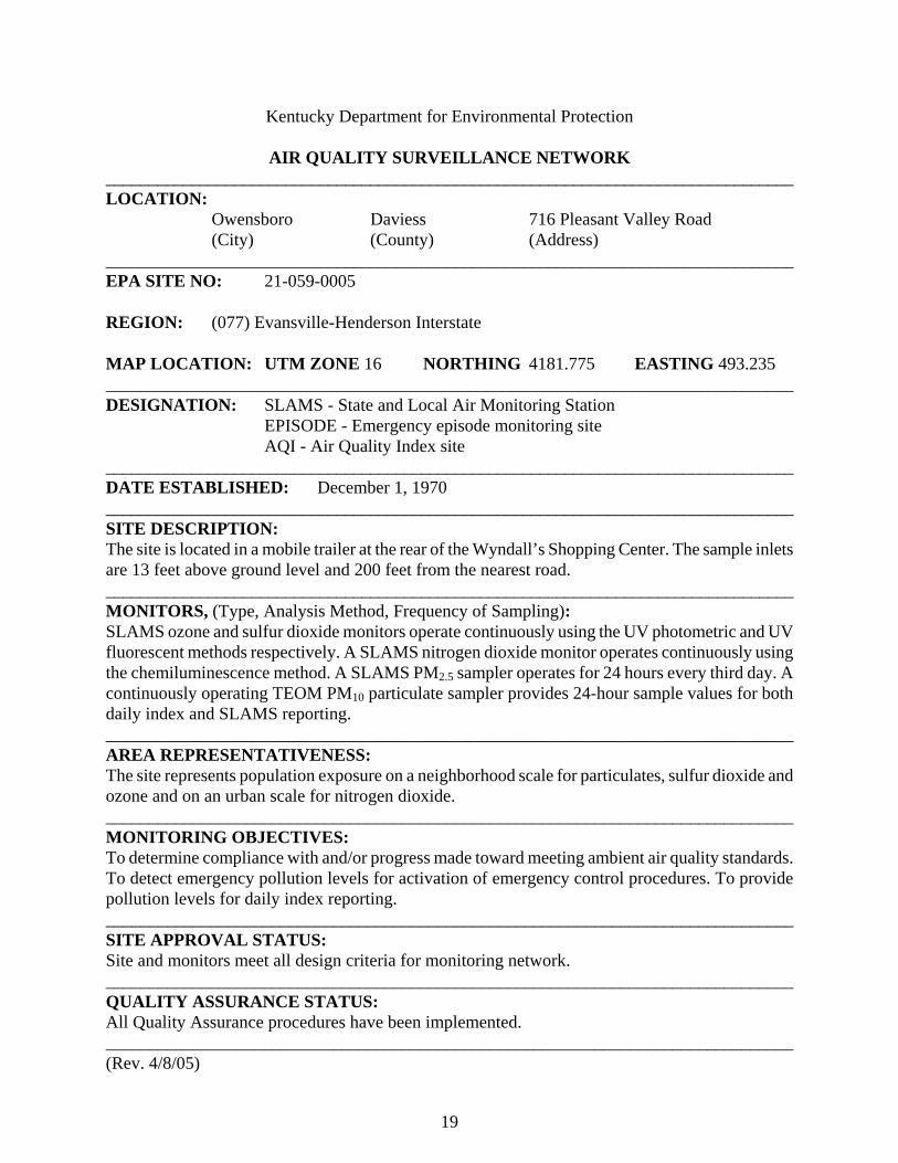
Kentucky Department for Environmental Protection AIR QUALITY SURVEILLANCE NETWORK _________________________________________________________________________________ LOCATION:
Owensboro Daviess 716 Pleasant Valley Road (City) (County) (Address)
_________________________________________________________________________________ EPA SITE NO: 21-059-0005 REGION: (077) Evansville-Henderson Interstate MAP LOCATION: UTM ZONE 16 NORTHING 4181.775 EASTING 493.235 ________________________________________________________________________________ DESIGNATION: SLAMS - State and Local Air Monitoring Station
EPISODE - Emergency episode monitoring site AQI - Air Quality Index site
_________________________________________________________________________________ DATE ESTABLISHED: December 1, 1970 _________________________________________________________________________________ SITE DESCRIPTION: The site is located in a mobile trailer at the rear of the Wyndall’s Shopping Center. The sample inlets are 13 feet above ground level and 200 feet from the nearest road. _________________________________________________________________________________ MONITORS, (Type, Analysis Method, Frequency of Sampling): SLAMS ozone and sulfur dioxide monitors operate continuously using the UV photometric and UV fluorescent methods respectively. A SLAMS nitrogen dioxide monitor operates continuously using the chemiluminescence method. A SLAMS PM2.5 sampler operates for 24 hours every third day. A continuously operating TEOM PM10 particulate sampler provides 24-hour sample values for both daily index and SLAMS reporting. ________________________________________________________________________________ AREA REPRESENTATIVENESS: The site represents population exposure on a neighborhood scale for particulates, sulfur dioxide and ozone and on an urban scale for nitrogen dioxide. _______________________________________________________________________________ MONITORING OBJECTIVES: To determine compliance with and/or progress made toward meeting ambient air quality standards. To detect emergency pollution levels for activation of emergency control procedures. To provide pollution levels for daily index reporting. _______________________________________________________________________________ SITE APPROVAL STATUS: Site and monitors meet all design criteria for monitoring network. _______________________________________________________________________________ QUALITY ASSURANCE STATUS: All Quality Assurance procedures have been implemented. _______________________________________________________________________________ (Rev. 4/8/05)

20
Kentucky Department for Environmental Protection
AIR QUALITY SURVEILLANCE NETWORK _________________________________________________________________________________ LOCATION:
Lewisport Hancock Lewisport Elementary School (City) (County) (Address)
_________________________________________________________________________________ EPA SITE NO: 21-091-0012 REGION: (077) Evansville-Henderson Interstate MAP LOCATION: UTM ZONE 16 NORTHING 4198.815 EASTING 509.055 ________________________________________________________________________________ DESIGNATION: SLAMS - State and Local Air Monitoring Station _________________________________________________________________________________ DATE ESTABLISHED: September 5, 1980 _________________________________________________________________________________ SITE DESCRIPTION: The site is a mobile trailer located at the rear of the school. The sample inlet is eleven feet above ground and 175 feet from the nearest road. _________________________________________________________________________________ MONITORS, (Type, Analysis Method, Frequency of Sampling): A SLAMS ozone monitor operates continuously using the UV photometric method of analysis. ________________________________________________________________________________ AREA REPRESENTATIVENESS: The site represents maximum concentrations on an urban scale for ozone. _______________________________________________________________________________ MONITORING OBJECTIVES: To judge compliance with and/or progress made toward meeting ambient air quality standards. _______________________________________________________________________________ SITE APPROVAL STATUS: Site and monitors meet all design criteria for monitoring network. _______________________________________________________________________________ QUALITY ASSURANCE STATUS: All Quality Assurance procedures have been implemented. _______________________________________________________________________________ (Rev. 1/118/05)
21
Kentucky Department for Environmental Protection
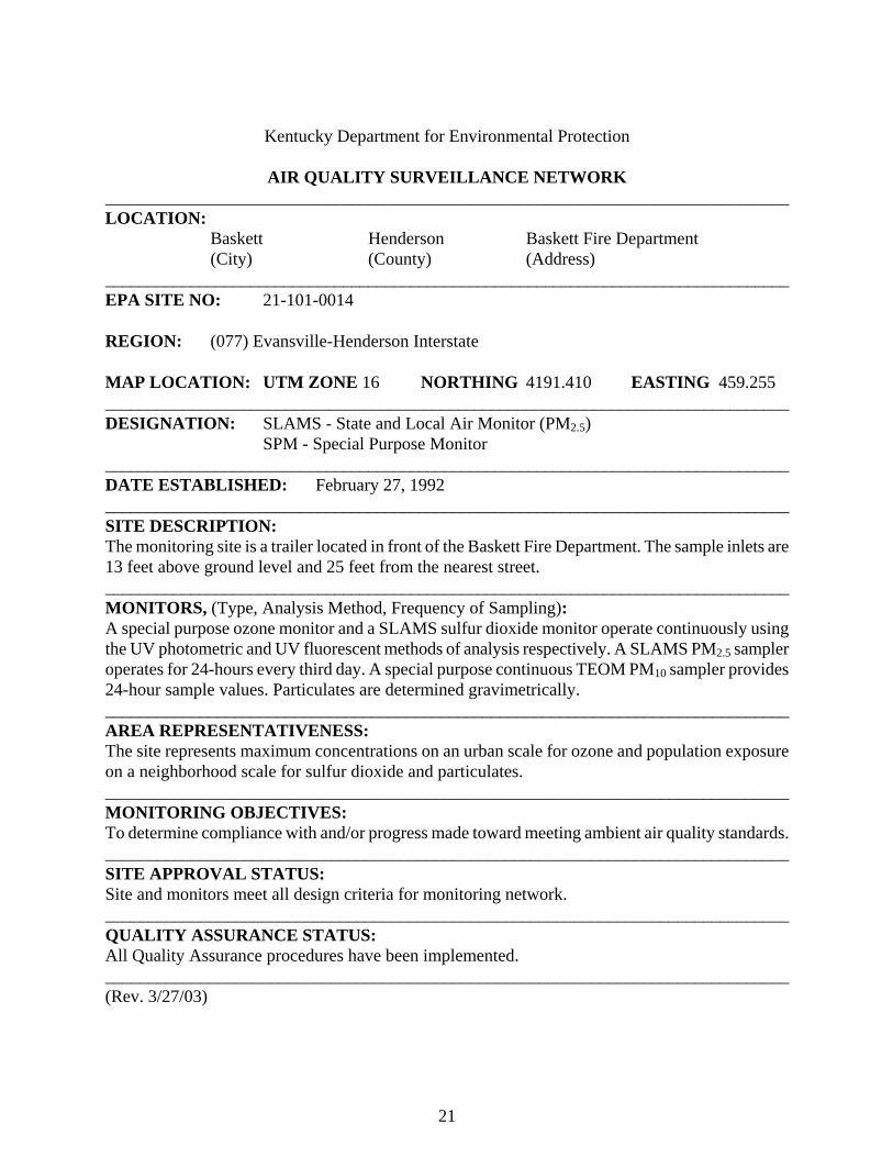
AIR QUALITY SURVEILLANCE NETWORK _________________________________________________________________________________ LOCATION:
Baskett Henderson Baskett Fire Department (City) (County) (Address)
_________________________________________________________________________________ EPA SITE NO: 21-101-0014 REGION: (077) Evansville-Henderson Interstate MAP LOCATION: UTM ZONE 16 NORTHING 4191.410 EASTING 459.255 ________________________________________________________________________________ DESIGNATION: SLAMS - State and Local Air Monitor (PM2.5)
SPM - Special Purpose Monitor _________________________________________________________________________________ DATE ESTABLISHED: February 27, 1992 _________________________________________________________________________________ SITE DESCRIPTION: The monitoring site is a trailer located in front of the Baskett Fire Department. The sample inlets are 13 feet above ground level and 25 feet from the nearest street. _________________________________________________________________________________ MONITORS, (Type, Analysis Method, Frequency of Sampling): A special purpose ozone monitor and a SLAMS sulfur dioxide monitor operate continuously using the UV photometric and UV fluorescent methods of analysis respectively. A SLAMS PM2.5 sampler operates for 24-hours every third day. A special purpose continuous TEOM PM10 sampler provides 24-hour sample values. Particulates are determined gravimetrically. ________________________________________________________________________________ AREA REPRESENTATIVENESS: The site represents maximum concentrations on an urban scale for ozone and population exposure on a neighborhood scale for sulfur dioxide and particulates. _______________________________________________________________________________ MONITORING OBJECTIVES: To determine compliance with and/or progress made toward meeting ambient air quality standards. _______________________________________________________________________________ SITE APPROVAL STATUS: Site and monitors meet all design criteria for monitoring network. _______________________________________________________________________________ QUALITY ASSURANCE STATUS: All Quality Assurance procedures have been implemented. _______________________________________________________________________________ (Rev. 3/27/03)

22
Kentucky Department for Environmental Protection
AIR QUALITY SURVEILLANCE NETWORK _________________________________________________________________________________ LOCATION:
Guffie McLean 3962 KY 815, Tichenor Farm (City) (County) (Address)
_________________________________________________________________________________ EPA SITE NO: 21-149-0001 REGION: (077) Evansville-Henderson Interstate MAP LOCATION: UTM ZONE 16 NORTHING 4161.175 EASTING 477.650 ________________________________________________________________________________ DESIGNATION: SPM - Special Purpose Monitor _________________________________________________________________________________ DATE ESTABLISHED: August 1, 1991 _________________________________________________________________________________ SITE DESCRIPTION: The monitoring site is a trailer located on a lawn near the farmhouse on KY 815. The sample inlet is 13 feet above ground level and 65 feet from the nearest road. _________________________________________________________________________________ MONITORS, (Type, Analysis Method, Frequency of Sampling): A special purpose ozone monitor operates continuously using the UV photometric method of analysis. ________________________________________________________________________________ AREA REPRESENTATIVENESS: The site represents upwind background concentrations on an urban scale. _______________________________________________________________________________ MONITORING OBJECTIVES: To determine compliance with and/or progress made toward meeting ambient air quality standards. To provide ozone data upwind of the Owensboro area. _______________________________________________________________________________ SITE APPROVAL STATUS: Site and monitors meet all design criteria for monitoring network. _______________________________________________________________________________ QUALITY ASSURANCE STATUS: All Quality Assurance procedures have been implemented. _______________________________________________________________________________ (Rev. 11/8/00)

23
Kentucky Department for Environmental Protection
AIR QUALITY SURVEILLANCE NETWORK _______________________________________________________________________________ LOCATION:
Echols Ohio Keytown Road (City) (County) (Address)
_________________________________________________________________________________ EPA SITE NO: 21-183-0032 REGION: (077) Evansville-Henderson MAP LOCATION: UTM ZONE 16 NORTHING 4130.140 EASTING 503.890 ________________________________________________________________________________ DESIGNATION: SPM - Special Purpose Monitoring Station _________________________________________________________________________________ DATE ESTABLISHED: February 1, 2005 _________________________________________________________________________________ SITE DESCRIPTION: The site is in a mobile shelter located in a pasture on Keytown Road near the intersection with Pond Church Road. The sample inlets are 12 feet above ground level and 100 feet from the nearest road. _________________________________________________________________________________ MONITORS, (Type, Analysis Method, Frequency of Sampling): Special purpose intermittent and continuous PM2.5 particulate samplers provide 24-hour sample values. Particulates are determined gravimetrically. Special purpose ozone and sulfur dioxide monitors operate continuously using the UV photometric and UV fluorescent methods of analysis respectively. ________________________________________________________________________________ AREA REPRESENTATIVENESS: The site represents maximum exposure on an urban scale. _______________________________________________________________________________ MONITORING OBJECTIVES: To judge compliance with and/or progress made toward meeting ambient air quality standards. _______________________________________________________________________________ SITE APPROVAL STATUS: Site and monitors meet all design criteria for monitoring network. _______________________________________________________________________________ QUALITY ASSURANCE STATUS: All Quality Assurance procedures have been implemented. _______________________________________________________________________________ (Rev. 2/3/05)
24
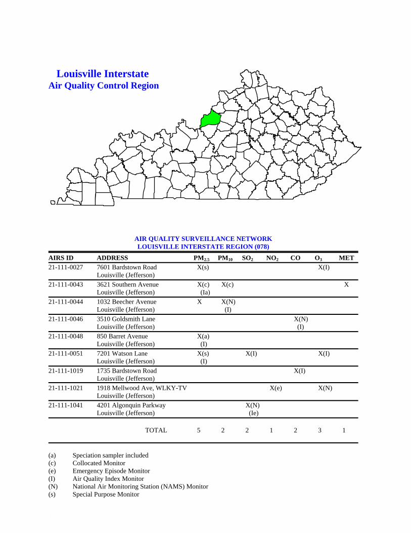
Louisville Interstate Air Quality Control Region
AIR QUALITY SURVEILLANCE NETWORK LOUISVILLE INTERSTATE REGION (078)
AIRS ID ADDRESS PM2.5 PM10 SO2 NO2 CO O3 MET 21-111-0027 7601 Bardstown Road X(s) X(I) Louisville (Jefferson) 21-111-0043 3621 Southern Avenue X(c) X(c) X Louisville (Jefferson) (Ia) 21-111-0044 1032 Beecher Avenue X X(N) Louisville (Jefferson) (I) 21-111-0046 3510 Goldsmith Lane X(N) Louisville (Jefferson) (I) 21-111-0048 850 Barret Avenue X(a) Louisville (Jefferson) (I) 21-111-0051 7201 Watson Lane X(s) X(I) X(I) Louisville (Jefferson) (I) 21-111-1019 1735 Bardstown Road X(I) Louisville (Jefferson) 21-111-1021 1918 Mellwood Ave, WLKY-TV X(e) X(N) Louisville (Jefferson) 21-111-1041 4201 Algonquin Parkway X(N) Louisville (Jefferson) (Ie) TOTAL 5 2 2 1 2 3 1 (a) Speciation sampler included (c) Collocated Monitor (e) Emergency Episode Monitor (I) Air Quality Index Monitor (N) National Air Monitoring Station (NAMS) Monitor (s) Special Purpose Monitor (R 4/8/03)

25
Kentucky Department for Environmental Protection AIR QUALITY SURVEILLANCE NETWORK _________________________________________________________________________________ LOCATION:
Louisville Jefferson Bates Elementary, 7601 Bardstown Rd (City) (County) (Address)
_________________________________________________________________________________ EPA SITE NO: 21-111-0027 REGION: (078) Louisville Interstate MAP LOCATION: UTM ZONE 16 NORTHING 4221.800 EASTING 624.600 ________________________________________________________________________________ DESIGNATION: SLAMS - State and Local Air Monitoring Station
SPM - Special Purpose Monitor (PM2.5) AQI - Air Quality Index site
_________________________________________________________________________________ DATE ESTABLISHED: January 4, 1973 _________________________________________________________________________________ SITE DESCRIPTION: The site is a mobile trailer located on the grounds of Bates Elementary School. The sample inlet is 13 feet above ground level and 1000 feet from the nearest road. _________________________________________________________________________________ MONITORS, (Type, Analysis Method, Frequency of Sampling): A SLAMS ozone analyzer operates continuously using the UV photometric method of analysis. A special purpose PM2.5 sampler operates continuously providing daily 24-hour sample values. Particulates are determined gravimetrically ________________________________________________________________________________ AREA REPRESENTATIVENESS: The site represents population exposure on a neighborhood scale for PM2.5 and on an urban scale for ozone. _______________________________________________________________________________ MONITORING OBJECTIVES: To judge compliance with and/or progress made toward meeting ambient air quality standards. To provide pollution levels for daily index reporting. _______________________________________________________________________________ SITE APPROVAL STATUS: Site and monitors meet all design criteria for monitoring network. _______________________________________________________________________________ QUALITY ASSURANCE STATUS: All Quality Assurance procedures have been implemented. _______________________________________________________________________________ (Rev. 4/28/042)
26
Kentucky Department for Environmental Protection AIR QUALITY SURVEILLANCE NETWORK _________________________________________________________________________________ LOCATION:
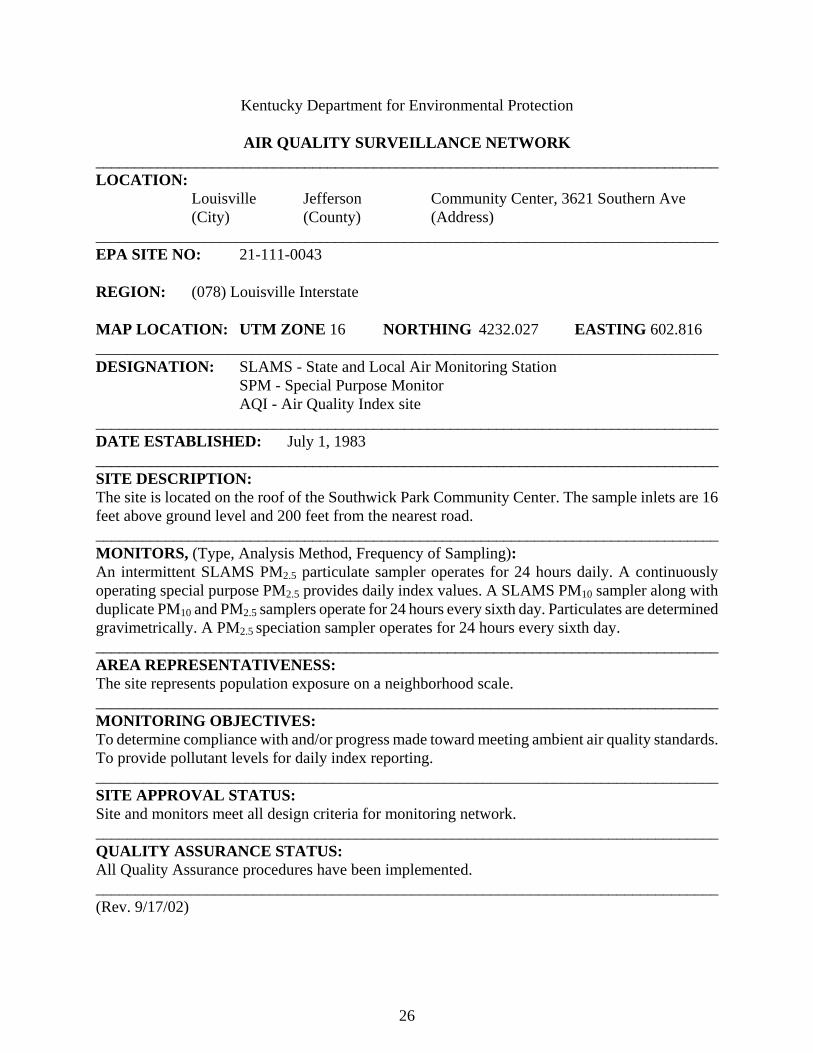
Louisville Jefferson Community Center, 3621 Southern Ave (City) (County) (Address)
_________________________________________________________________________________ EPA SITE NO: 21-111-0043 REGION: (078) Louisville Interstate MAP LOCATION: UTM ZONE 16 NORTHING 4232.027 EASTING 602.816 ________________________________________________________________________________ DESIGNATION: SLAMS - State and Local Air Monitoring Station SPM - Special Purpose Monitor AQI - Air Quality Index site _________________________________________________________________________________ DATE ESTABLISHED: July 1, 1983 _________________________________________________________________________________ SITE DESCRIPTION: The site is located on the roof of the Southwick Park Community Center. The sample inlets are 16 feet above ground level and 200 feet from the nearest road. _________________________________________________________________________________ MONITORS, (Type, Analysis Method, Frequency of Sampling): An intermittent SLAMS PM2.5 particulate sampler operates for 24 hours daily. A continuously operating special purpose PM2.5 provides daily index values. A SLAMS PM10 sampler along with duplicate PM10 and PM2.5 samplers operate for 24 hours every sixth day. Particulates are determined gravimetrically. A PM2.5 speciation sampler operates for 24 hours every sixth day. ________________________________________________________________________________ AREA REPRESENTATIVENESS: The site represents population exposure on a neighborhood scale. _______________________________________________________________________________ MONITORING OBJECTIVES: To determine compliance with and/or progress made toward meeting ambient air quality standards. To provide pollutant levels for daily index reporting. _______________________________________________________________________________ SITE APPROVAL STATUS: Site and monitors meet all design criteria for monitoring network. _______________________________________________________________________________ QUALITY ASSURANCE STATUS: All Quality Assurance procedures have been implemented. _______________________________________________________________________________ (Rev. 9/17/02)

27
Kentucky Department for Environmental Protection AIR QUALITY SURVEILLANCE NETWORK _________________________________________________________________________________ LOCATION:
Louisville Jefferson Wyandotte Park, 1032 Beecher Avenue (City) (County) (Address)
_________________________________________________________________________________ EPA SITE NO: 21-111-0044 REGION: (078) Louisville Interstate MAP LOCATION: UTM ZONE 16 NORTHING 4227.485 EASTING 606.791 ________________________________________________________________________________ DESIGNATION: SLAMS - State and Local Air Monitoring Station
NAMS - National Air Monitoring Station (PM10) AQI - Air Quality Index site
_________________________________________________________________________________ DATE ESTABLISHED: September 1, 1983 _________________________________________________________________________________ SITE DESCRIPTION: The site is located on the roof of the pool house in Wyandotte Park. The sample inlets are 16 feet above ground level and 150 feet from the nearest road. _________________________________________________________________________________ MONITORS, (Type, Analysis Method, Frequency of Sampling): A SLAMS PM2.5 particulate sampler operates for 24 hours daily. A NAMS PM10 particulate sampler operates for 24 hours every sixth day along with a continuously operating special purpose PM10 sampler. Particulates are determined gravimetrically. ________________________________________________________________________________ AREA REPRESENTATIVENESS: The site represents population exposure on a neighborhood scale. _______________________________________________________________________________ MONITORING OBJECTIVES: To determine compliance with and/or progress made toward meeting ambient air quality standards. To observe pollution trends and provide information for national data analysis. To provide pollutant levels for daily index reporting _______________________________________________________________________________ SITE APPROVAL STATUS: Site and monitors meet all design criteria for monitoring network. _______________________________________________________________________________ QUALITY ASSURANCE STATUS: All Quality Assurance procedures have been implemented. _______________________________________________________________________________ (Rev. 12/3/02)

28
Kentucky Department for Environmental Protection AIR QUALITY SURVEILLANCE NETWORK _________________________________________________________________________________ LOCATION:
Louisville Jefferson Seneca High School, Goldsmith Lane (City) (County) (Address)
_________________________________________________________________________________ EPA SITE NO: 21-111-0046 REGION: (078) Louisville Interstate MAP LOCATION: UTM ZONE 16 NORTHING 4229.550 EASTING 617.700 ________________________________________________________________________________ DESIGNATION: SLAMS - State and Local Air Monitoring Station
NAMS - National Air Monitoring Station AQI - Air Quality Index site
_________________________________________________________________________________ DATE ESTABLISHED: April 1, 1987 _________________________________________________________________________________ SITE DESCRIPTION: The monitoring site is located in the school building. The sample inlet is 37 feet above ground level and 600 feet from the nearest road. _________________________________________________________________________________ MONITORS, (Type, Analysis Method, Frequency of Sampling): A NAMS carbon monoxide analyzer operates continuously using the non-dispersive infrared method. ________________________________________________________________________________ AREA REPRESENTATIVENESS: The site represents population exposure on a neighborhood scale. _______________________________________________________________________________ MONITORING OBJECTIVES: To observe pollution trends and provide information for national data analysis. To determine compliance with and/or progress made toward meeting ambient air quality standards. To provide pollutant levels for daily index reporting. _______________________________________________________________________________ SITE APPROVAL STATUS: Site and monitors meet all design criteria for monitoring network. _______________________________________________________________________________ QUALITY ASSURANCE STATUS: All Quality Assurance procedures have been implemented. _______________________________________________________________________________ (Rev. 3/11/99)
29
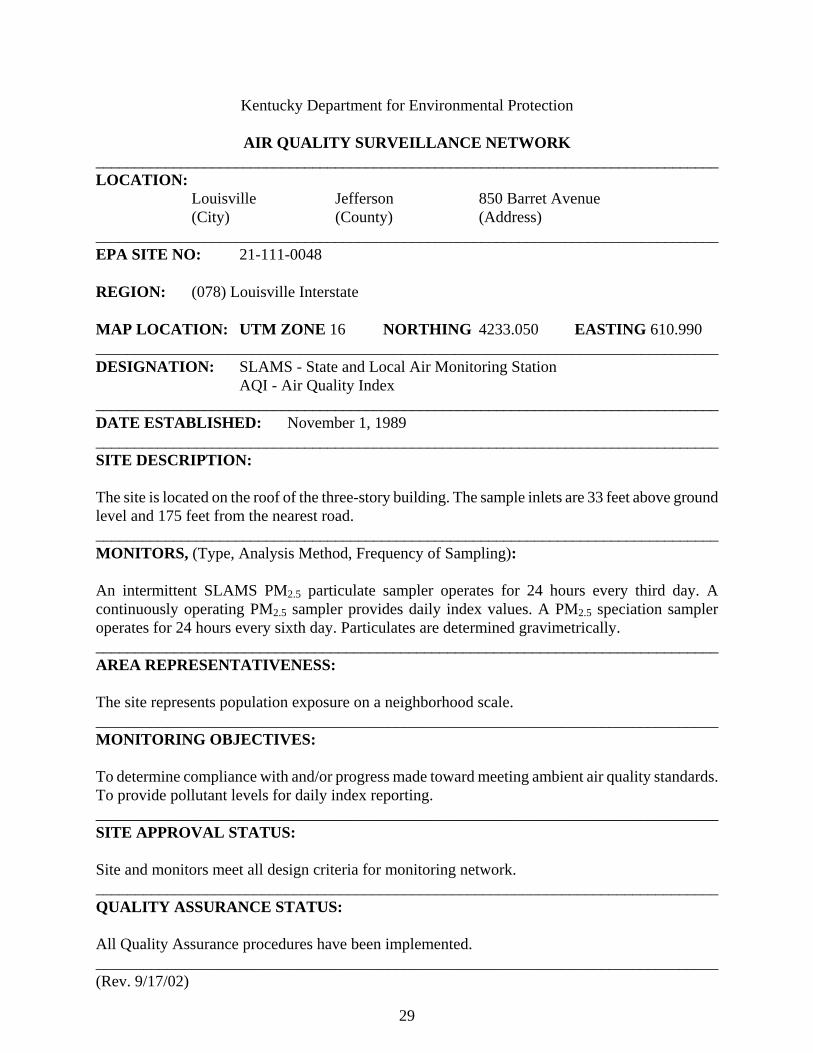
Kentucky Department for Environmental Protection AIR QUALITY SURVEILLANCE NETWORK _________________________________________________________________________________ LOCATION:
Louisville Jefferson 850 Barret Avenue (City) (County) (Address)
_________________________________________________________________________________ EPA SITE NO: 21-111-0048 REGION: (078) Louisville Interstate MAP LOCATION: UTM ZONE 16 NORTHING 4233.050 EASTING 610.990 ________________________________________________________________________________ DESIGNATION: SLAMS - State and Local Air Monitoring Station AQI - Air Quality Index _________________________________________________________________________________ DATE ESTABLISHED: November 1, 1989 _________________________________________________________________________________ SITE DESCRIPTION: The site is located on the roof of the three-story building. The sample inlets are 33 feet above ground level and 175 feet from the nearest road. _________________________________________________________________________________ MONITORS, (Type, Analysis Method, Frequency of Sampling): An intermittent SLAMS PM2.5 particulate sampler operates for 24 hours every third day. A continuously operating PM2.5 sampler provides daily index values. A PM2.5 speciation sampler operates for 24 hours every sixth day. Particulates are determined gravimetrically. ________________________________________________________________________________ AREA REPRESENTATIVENESS: The site represents population exposure on a neighborhood scale. _______________________________________________________________________________ MONITORING OBJECTIVES: To determine compliance with and/or progress made toward meeting ambient air quality standards. To provide pollutant levels for daily index reporting. _______________________________________________________________________________ SITE APPROVAL STATUS: Site and monitors meet all design criteria for monitoring network. _______________________________________________________________________________ QUALITY ASSURANCE STATUS: All Quality Assurance procedures have been implemented. _______________________________________________________________________________ (Rev. 9/17/02)

30
Kentucky Department for Environmental Protection AIR QUALITY SURVEILLANCE NETWORK _________________________________________________________________________________ LOCATION:
Louisville Jefferson Watson Lane School, 7201 Watson Ln (City) (County) (Address)
_________________________________________________________________________________ EPA SITE NO: 21-111-0051 REGION: (078) Louisville Interstate MAP LOCATION: UTM ZONE 16 NORTHING 4212.940 EASTING 596.843 ________________________________________________________________________________ DESIGNATION: SLAMS - State and Local Air Monitoring Station SPM - Special Purpose Monitor (PM2.5) AQI - Air Quality Index site _________________________________________________________________________________ DATE ESTABLISHED: July 16, 1992 _________________________________________________________________________________ SITE DESCRIPTION: The site is a mobile trailer located on the grounds of Watson Lane Elementary School. The sample inlets are 13 feet above ground level and 125 feet from the nearest road. _________________________________________________________________________________ MONITORS, (Type, Analysis Method, Frequency of Sampling): SLAMS sulfur dioxide and ozone analyzers operate continuously using the UV fluorescent and UV photometric methods of analysis respectively. A special purpose PM2.5 particulate sampler operates for 24 hours every sixth day. A continuously operating PM2.5 provides daily sample values for index reporting. Particulates are determined gravimetrically. ________________________________________________________________________________ AREA REPRESENTATIVENESS: The site represents population exposure on a neighborhood scale. _______________________________________________________________________________ MONITORING OBJECTIVES: To determine compliance with and/or progress made toward meeting ambient air quality standards. To provide pollutant levels for daily index reporting. _______________________________________________________________________________ SITE APPROVAL STATUS: Site and monitors meet all design criteria for monitoring network. _______________________________________________________________________________ QUALITY ASSURANCE STATUS: All Quality Assurance procedures have been implemented. _____________________________________________________________________________ (Rev. 9/17/02)
31
Kentucky Department for Environmental Protection AIR QUALITY SURVEILLANCE NETWORK _________________________________________________________________________________ LOCATION:
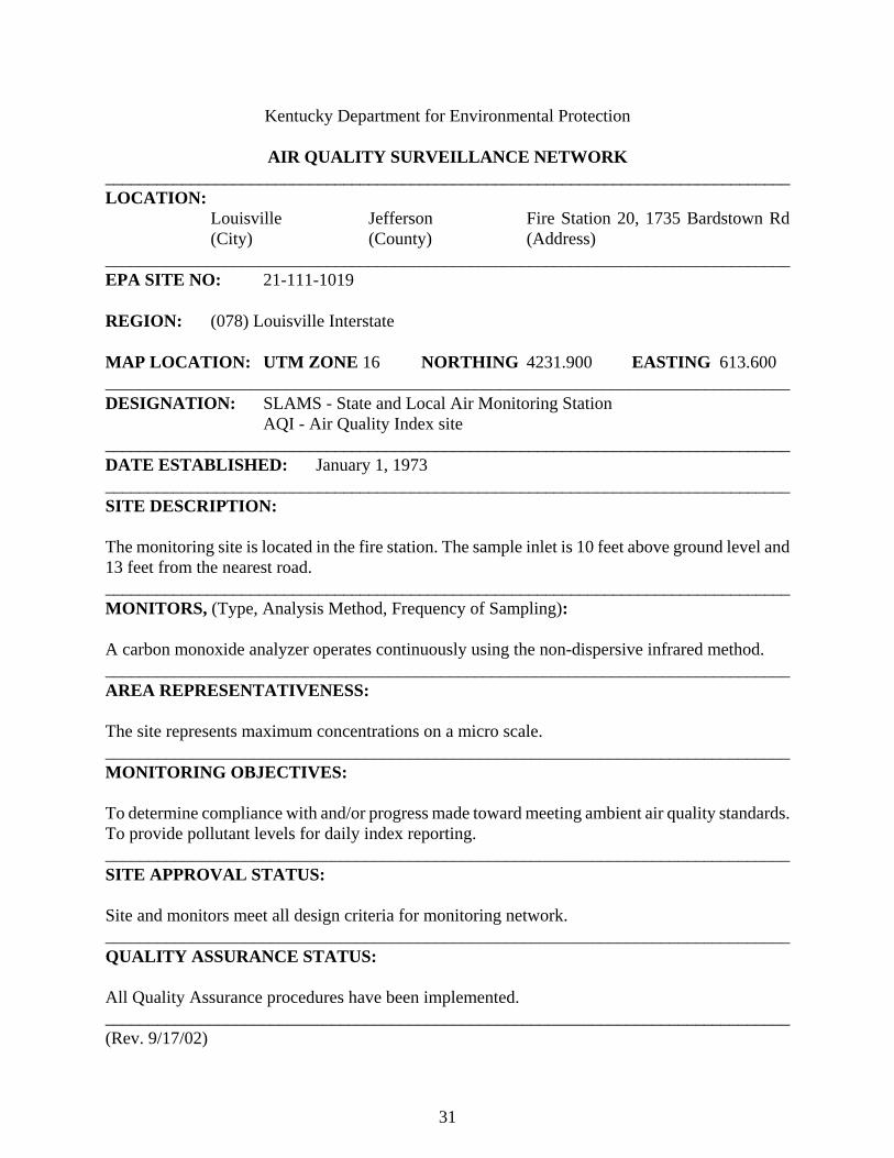
Louisville Jefferson Fire Station 20, 1735 Bardstown Rd (City) (County) (Address)
_________________________________________________________________________________ EPA SITE NO: 21-111-1019 REGION: (078) Louisville Interstate MAP LOCATION: UTM ZONE 16 NORTHING 4231.900 EASTING 613.600 ________________________________________________________________________________ DESIGNATION: SLAMS - State and Local Air Monitoring Station
AQI - Air Quality Index site _________________________________________________________________________________ DATE ESTABLISHED: January 1, 1973 _________________________________________________________________________________ SITE DESCRIPTION: The monitoring site is located in the fire station. The sample inlet is 10 feet above ground level and 13 feet from the nearest road. _________________________________________________________________________________ MONITORS, (Type, Analysis Method, Frequency of Sampling): A carbon monoxide analyzer operates continuously using the non-dispersive infrared method. ________________________________________________________________________________ AREA REPRESENTATIVENESS: The site represents maximum concentrations on a micro scale. _______________________________________________________________________________ MONITORING OBJECTIVES: To determine compliance with and/or progress made toward meeting ambient air quality standards. To provide pollutant levels for daily index reporting. _______________________________________________________________________________ SITE APPROVAL STATUS: Site and monitors meet all design criteria for monitoring network. _______________________________________________________________________________ QUALITY ASSURANCE STATUS: All Quality Assurance procedures have been implemented. _______________________________________________________________________________ (Rev. 9/17/02)
32
Kentucky Department for Environmental Protection AIR QUALITY SURVEILLANCE NETWORK _________________________________________________________________________________ LOCATION:
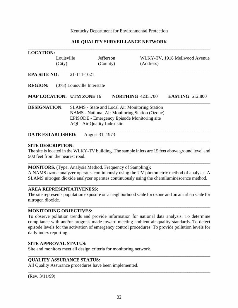
Louisville Jefferson WLKY-TV, 1918 Mellwood Avenue (City) (County) (Address)
_________________________________________________________________________________ EPA SITE NO: 21-111-1021 REGION: (078) Louisville Interstate MAP LOCATION: UTM ZONE 16 NORTHING 4235.700 EASTING 612.800 ________________________________________________________________________________ DESIGNATION: SLAMS - State and Local Air Monitoring Station
NAMS - National Air Monitoring Station (Ozone) EPISODE - Emergency Episode Monitoring site AQI - Air Quality Index site
_________________________________________________________________________________ DATE ESTABLISHED: August 31, 1973 _________________________________________________________________________________ SITE DESCRIPTION: The site is located in the WLKY-TV building. The sample inlets are 15 feet above ground level and 500 feet from the nearest road. _________________________________________________________________________________ MONITORS, (Type, Analysis Method, Frequency of Sampling): A NAMS ozone analyzer operates continuously using the UV photometric method of analysis. A SLAMS nitrogen dioxide analyzer operates continuously using the chemiluminescence method. ________________________________________________________________________________ AREA REPRESENTATIVENESS: The site represents population exposure on a neighborhood scale for ozone and on an urban scale for nitrogen dioxide. _______________________________________________________________________________ MONITORING OBJECTIVES: To observe pollution trends and provide information for national data analysis. To determine compliance with and/or progress made toward meeting ambient air quality standards. To detect episode levels for the activation of emergency control procedures. To provide pollution levels for daily index reporting. _______________________________________________________________________________ SITE APPROVAL STATUS: Site and monitors meet all design criteria for monitoring network. _______________________________________________________________________________ QUALITY ASSURANCE STATUS: All Quality Assurance procedures have been implemented. _______________________________________________________________________________ (Rev. 3/11/99)
33
Kentucky Department for Environmental Protection AIR QUALITY SURVEILLANCE NETWORK _________________________________________________________________________________ LOCATION:
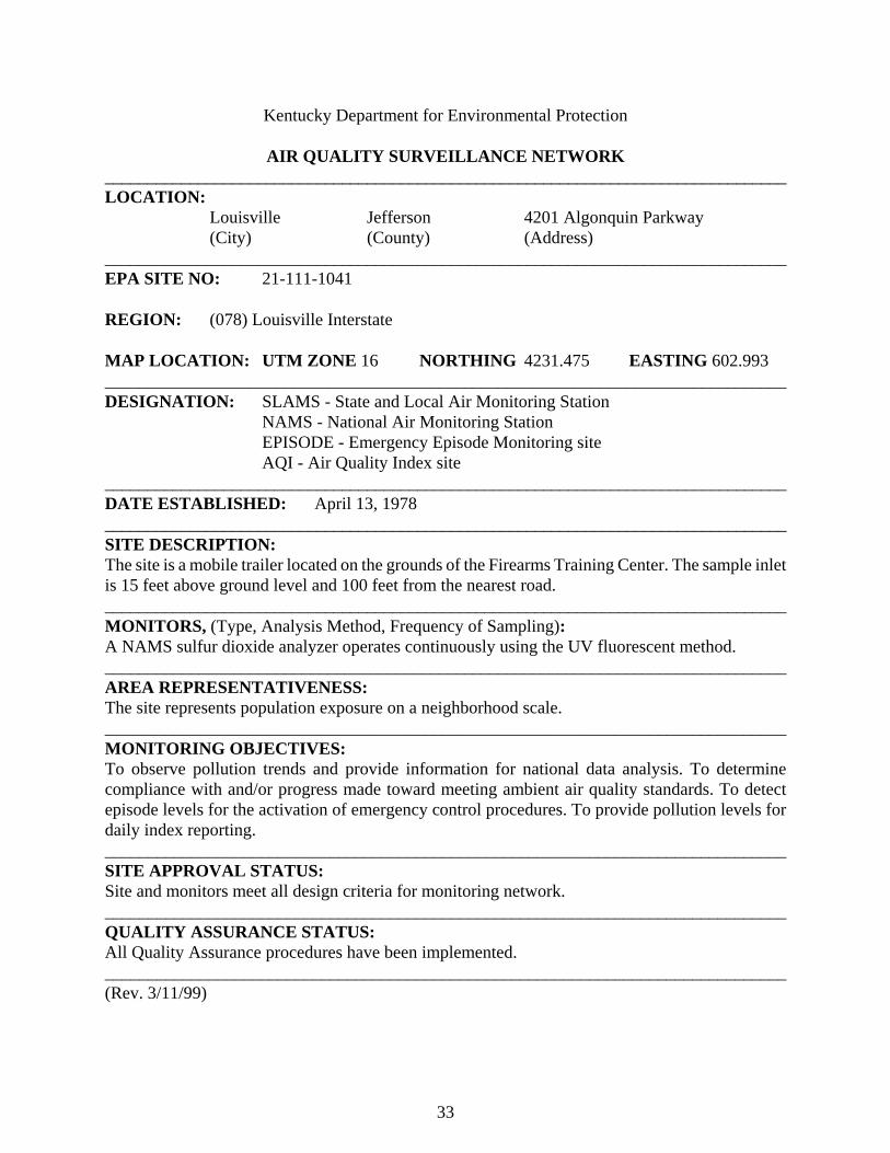
Louisville Jefferson 4201 Algonquin Parkway (City) (County) (Address)
_________________________________________________________________________________ EPA SITE NO: 21-111-1041 REGION: (078) Louisville Interstate MAP LOCATION: UTM ZONE 16 NORTHING 4231.475 EASTING 602.993 ________________________________________________________________________________ DESIGNATION: SLAMS - State and Local Air Monitoring Station
NAMS - National Air Monitoring Station EPISODE - Emergency Episode Monitoring site AQI - Air Quality Index site
_________________________________________________________________________________ DATE ESTABLISHED: April 13, 1978 _________________________________________________________________________________ SITE DESCRIPTION: The site is a mobile trailer located on the grounds of the Firearms Training Center. The sample inlet is 15 feet above ground level and 100 feet from the nearest road. _________________________________________________________________________________ MONITORS, (Type, Analysis Method, Frequency of Sampling): A NAMS sulfur dioxide analyzer operates continuously using the UV fluorescent method. ________________________________________________________________________________ AREA REPRESENTATIVENESS: The site represents population exposure on a neighborhood scale. _______________________________________________________________________________ MONITORING OBJECTIVES: To observe pollution trends and provide information for national data analysis. To determine compliance with and/or progress made toward meeting ambient air quality standards. To detect episode levels for the activation of emergency control procedures. To provide pollution levels for daily index reporting. _______________________________________________________________________________ SITE APPROVAL STATUS: Site and monitors meet all design criteria for monitoring network. _______________________________________________________________________________ QUALITY ASSURANCE STATUS: All Quality Assurance procedures have been implemented. _______________________________________________________________________________ (Rev. 3/11/99)

34
Cincinnati Interstate Air Quality Control Region
AIR QUALITY SURVEILLANCE NETWORK CINCINNATI INTERSTATE REGION (079)
AIRS ID ADDRESS PM2.5 PM10 SO2 NO2 CO O3 MET 21-015-0003 KY 338 & Lower River Road X(s) X X East Bend (Boone) 21-037-0003 700 Alexandria, NKY Water Plant X X(e) X(e) X(e) X(e) Fort Thomas (Campbell) (I) (I) 21-117-0007 1401 Dixie Highway X(a) X X Covington (Kenton) (I) TOTAL 2 1 2 1 0 3 2 (a) Speciation sampler included (e) Emergency Episode Monitor (I) Air Quality Index Monitor (s) Special Purpose Monitor (Rev. 2/24/05) (Rev 4/8/03)
35
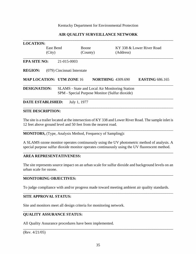
Kentucky Department for Environmental Protection AIR QUALITY SURVEILLANCE NETWORK _________________________________________________________________________________ LOCATION:
East Bend Boone KY 338 & Lower River Road (City) (County) (Address)
_________________________________________________________________________________ EPA SITE NO: 21-015-0003 REGION: (079) Cincinnati Interstate MAP LOCATION: UTM ZONE 16 NORTHING 4309.690 EASTING 686.165 ________________________________________________________________________________ DESIGNATION: SLAMS - State and Local Air Monitoring Station SPM - Special Purpose Monitor (Sulfur dioxide) _________________________________________________________________________________ DATE ESTABLISHED: July 1, 1977 _________________________________________________________________________________ SITE DESCRIPTION: The site is a trailer located at the intersection of KY 338 and Lower River Road. The sample inlet is 12 feet above ground level and 50 feet from the nearest road. _________________________________________________________________________________ MONITORS, (Type, Analysis Method, Frequency of Sampling): A SLAMS ozone monitor operates continuously using the UV photometric method of analysis. A special purpose sulfur dioxide monitor operates continuously using the UV fluorescent method. ________________________________________________________________________________ AREA REPRESENTATIVENESS: The site represents source impact on an urban scale for sulfur dioxide and background levels on an urban scale for ozone. _______________________________________________________________________________ MONITORING OBJECTIVES: To judge compliance with and/or progress made toward meeting ambient air quality standards. _______________________________________________________________________________ SITE APPROVAL STATUS: Site and monitors meet all design criteria for monitoring network. _______________________________________________________________________________ QUALITY ASSURANCE STATUS: All Quality Assurance procedures have been implemented. _______________________________________________________________________________ (Rev. 4/21/05)

36
Kentucky Department for Environmental Protection AIR QUALITY SURVEILLANCE NETWORK _________________________________________________________________________________ LOCATION:
Fort Thomas Campbell NKY Water Plant, 700 Alexandria Pike (City) (County) (Address)
_________________________________________________________________________________ EPA SITE NO: 21-037-0003 REGION: (079) Cincinnati Interstate MAP LOCATION: UTM ZONE 16 NORTHING 4326.880 EASTING 720.395 ________________________________________________________________________________ DESIGNATION: SLAMS - State and Local Air Monitoring Station
EPISODE - Emergency episode monitoring site AQI - Air Quality Index site
_________________________________________________________________________________ DATE ESTABLISHED: January 1, 1999 _________________________________________________________________________________ SITE DESCRIPTION: The site is a trailer located on the grounds of the Northern Kentucky Water District treatment plant. The sample inlets are 13 feet above ground level and 800 feet from the nearest road. _________________________________________________________________________________ MONITORS, (Type, Analysis Method, Frequency of Sampling): A SLAMS PM2.5 particulate sampler operates for 24 hours every third day. A SLAMS PM10 particulate sampler operates continuously providing 24-hour sample values. Particulates are determined gravimetrically. SLAMS ozone and sulfur dioxide monitors operate continuously using the UV photometric and UV fluorescent methods of analysis respectively. A SLAMS nitrogen dioxide monitor operates continuously using the chemiluminescence method. ________________________________________________________________________________ AREA REPRESENTATIVENESS: The site represents population exposure on a neighborhood scale for sulfur dioxide and particulates and on an urban scale for nitrogen dioxide. The site represents maximum exposure on an urban scale for ozone. _______________________________________________________________________________ MONITORING OBJECTIVES: To determine compliance with and/or progress made toward meeting ambient air quality standards. To detect episode levels for the activation of emergency control procedures. To provide pollutant levels for daily index reporting. _______________________________________________________________________________ SITE APPROVAL STATUS: Site and monitors meet all design criteria for monitoring network. _______________________________________________________________________________ QUALITY ASSURANCE STATUS: All Quality Assurance procedures have been implemented. _______________________________________________________________________________ (Rev. 2/22/05)
37
Kentucky Department for Environmental Protection AIR QUALITY SURVEILLANCE NETWORK _________________________________________________________________________________ LOCATION:
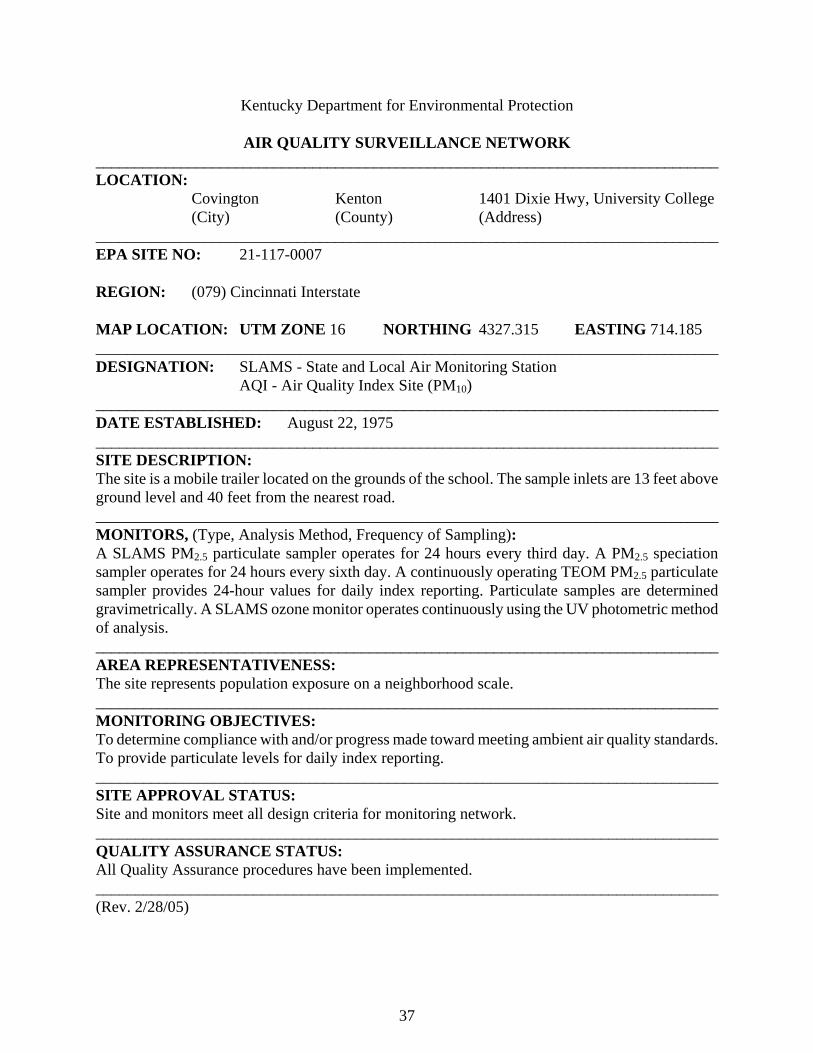
Covington Kenton 1401 Dixie Hwy, University College (City) (County) (Address)
_________________________________________________________________________________ EPA SITE NO: 21-117-0007 REGION: (079) Cincinnati Interstate MAP LOCATION: UTM ZONE 16 NORTHING 4327.315 EASTING 714.185 ________________________________________________________________________________ DESIGNATION: SLAMS - State and Local Air Monitoring Station
AQI - Air Quality Index Site (PM10) _________________________________________________________________________________ DATE ESTABLISHED: August 22, 1975 _________________________________________________________________________________ SITE DESCRIPTION: The site is a mobile trailer located on the grounds of the school. The sample inlets are 13 feet above ground level and 40 feet from the nearest road. _________________________________________________________________________________ MONITORS, (Type, Analysis Method, Frequency of Sampling): A SLAMS PM2.5 particulate sampler operates for 24 hours every third day. A PM2.5 speciation sampler operates for 24 hours every sixth day. A continuously operating TEOM PM2.5 particulate sampler provides 24-hour values for daily index reporting. Particulate samples are determined gravimetrically. A SLAMS ozone monitor operates continuously using the UV photometric method of analysis. ________________________________________________________________________________ AREA REPRESENTATIVENESS: The site represents population exposure on a neighborhood scale. _______________________________________________________________________________ MONITORING OBJECTIVES: To determine compliance with and/or progress made toward meeting ambient air quality standards. To provide particulate levels for daily index reporting. _______________________________________________________________________________ SITE APPROVAL STATUS: Site and monitors meet all design criteria for monitoring network. _______________________________________________________________________________ QUALITY ASSURANCE STATUS: All Quality Assurance procedures have been implemented. _______________________________________________________________________________ (Rev. 2/28/05)

38
Appalachian Air Quality Control Region
AIR QUALITY SURVEILLANCE NETWORK APPALACHIAN REGION (101)
AIRS ID ADDRESS PM2.5 PM10 SO2 NO2 CO O3 MET 21-013-0002 Airport, 34th & Dorchester X(s) X(s) X(s) X Middlesboro (Bell) 21-125-0004 London Airport, 566 Airport Rd X(s) X(s) London (Laurel) (a) 21-193-0003 Perry County Horse Park X(s) X X(s) X Hazard (Perry) (e) 21-195-0002 101 N. Mayo Trail, DOT Office X(c) X(I) X(s) Pikeville (Pike) (e) (I) TOTAL 4 4 0 0 0 3 2 (a) Speciation sampler included (c) Collocated Monitor (I) Air Quality Index Monitor (s) Special Purpose Monitor (Rev. 1/11/05)

39
Kentucky Department for Environmental Protection AIR QUALITY SURVEILLANCE NETWORK _________________________________________________________________________________ LOCATION:
Middlesboro Bell Middlesboro Airport (City) (County) (Address)
_________________________________________________________________________________ EPA SITE NO: 21-013-0002 REGION: (101) Appalachian MAP LOCATION: UTM ZONE 17 NORTHING 4054.730 EASTING 254.269 ________________________________________________________________________________ DESIGNATION: SPM - Special Purpose Monitor _________________________________________________________________________________ DATE ESTABLISHED: February 14, 1992 _________________________________________________________________________________ SITE DESCRIPTION: The monitoring site is a trailer located on the grounds of the Middlesboro Airport. The sample inlets are 13 feet above ground level and 55 feet from the nearest road. _________________________________________________________________________________ MONITORS, (Type, Analysis Method, Frequency of Sampling): Special purpose PM2.5 and PM10 particulate samplers operate for 24 hours every sixth day. Particulates are determined gravimetrically. A special purpose ozone monitor operates continuously using the UV photometric method of analysis. ________________________________________________________________________________ AREA REPRESENTATIVENESS: The site represents population exposure on a neighborhood scale for particulates and transportation levels on a regional scale for ozone. _______________________________________________________________________________ MONITORING OBJECTIVES: To determine compliance with and/or progress made toward meeting ambient air quality standards. To provide information on the transport of ozone into the region. _______________________________________________________________________________ SITE APPROVAL STATUS: Site and monitors meet all design criteria for monitoring network. _______________________________________________________________________________ QUALITY ASSURANCE STATUS: All Quality Assurance procedures have been implemented. _______________________________________________________________________________ (Rev. 12/10/01)

40
Kentucky Department for Environmental Protection AIR QUALITY SURVEILLANCE NETWORK _________________________________________________________________________________ LOCATION:
London Laurel London-Corbin Airport, 566Airport Rd (City) (County) (Address)
_________________________________________________________________________________ EPA SITE NO: 21-125-0004 REGION: (101) Appalachian MAP LOCATION: UTM ZONE 16 NORTHING 4108.375 EASTING 761.035 ________________________________________________________________________________ DESIGNATION: SPM - Special Purpose Monitor _________________________________________________________________________________ DATE ESTABLISHED: January 1, 2002 _________________________________________________________________________________ SITE DESCRIPTION: The monitoring site is a ground level platform located near the terminal building. The sample inlets are 7 feet above ground level and 75 feet from the nearest road. _________________________________________________________________________________ MONITORS, (Type, Analysis Method, Frequency of Sampling): Special purpose PM10 and PM2.5 particulate samplers and a PM2.5 speciation sampler operate for 24 hours every sixth day. Particulate samples are determined gravimetrically. ________________________________________________________________________________ AREA REPRESENTATIVENESS: The site represents population exposure on a neighborhood scale. _______________________________________________________________________________ MONITORING OBJECTIVES: To determine compliance with and/or progress made toward meeting ambient air quality standards. _______________________________________________________________________________ SITE APPROVAL STATUS: Site and monitor meet all design criteria for monitoring network. _______________________________________________________________________________ QUALITY ASSURANCE STATUS: All Quality Assurance procedures have been implemented. _______________________________________________________________________________ (Rev. 9/18/02)

41
Kentucky Department for Environmental Protection AIR QUALITY SURVEILLANCE NETWORK _________________________________________________________________________________ LOCATION:
Hazard Perry Perry County Horse Park (City) (County) (Address)
_________________________________________________________________________________ EPA SITE NO: 21-193-0003 REGION: (101) Appalachian MAP LOCATION: UTM ZONE 17 NORTHING 4128.405 EASTING 303.165 ________________________________________________________________________________ DESIGNATION: SLAMS - State and Local Air Monitoring Station SPM - Special Purpose Monitor (Ozone, PM2.5) EPISODE - Emergency episode monitoring sites _________________________________________________________________________________ DATE ESTABLISHED: April 1, 2000 _________________________________________________________________________________ SITE DESCRIPTION: The monitoring site is a trailer located on the grounds of the Perry County Horse Park. The sample inlet is 15 feet above ground level and 65 feet from the nearest road. _________________________________________________________________________________ MONITORS, (Type, Analysis Method, Frequency of Sampling): A SLAMS PM10 particulate sampler and a special purpose PM2.5 particulate sampler operate for 24 hours every sixth day. A PM2.5 speciation sampler operates for 24 hours every sixth day. Particulate samples are determined gravimetrically. A special purpose ozone monitor operates continuously using the UV photometric method of analysis. ________________________________________________________________________________ AREA REPRESENTATIVENESS: The site represents population exposure on a neighborhood scale. _______________________________________________________________________________ MONITORING OBJECTIVES: To determine compliance with and/or progress made toward meeting ambient air quality standards. To detect elevated pollutant levels for activation of emergency control procedures for ozone. _______________________________________________________________________________ SITE APPROVAL STATUS: Site and monitors meet all design criteria for monitoring network. _______________________________________________________________________________ QUALITY ASSURANCE STATUS: All Quality Assurance procedures have been implemented. _______________________________________________________________________________ (Rev. 12-11-01)

42
Kentucky Department for Environmental Protection AIR QUALITY SURVEILLANCE NETWORK _________________________________________________________________________________ LOCATION:
Pikeville Pike DOT District Office, 101 North Mayo Trail (City) (County) (Address)
_________________________________________________________________________________ EPA SITE NO: 21-195-0002 REGION: (101) Appalachian MAP LOCATION: UTM ZONE 17 NORTHING 4149.325 EASTING 364.270 ________________________________________________________________________________ DESIGNATION: SLAMS - State and Local Air Monitoring Station SPM - Special Purpose Monitor (Ozone) AQI - Air Quality Index Site EPISODE - Emergency episode monitoring site _________________________________________________________________________________ DATE ESTABLISHED: May 1, 1994 _________________________________________________________________________________ SITE DESCRIPTION: The site is a mobile trailer located behind the DOT District Office building. The sample inlets are 13 feet above ground level and 115 feet from the nearest road. _________________________________________________________________________________ MONITORS, (Type, Analysis Method, Frequency of Sampling): A SLAMS PM2.5 particulate sampler operates for 24 hours every third day while a duplicate PM2.5 sampler operates every sixth day. A SLAMS PM10 particulate sampler operates continuously providing daily 24-hour sample values. Particulate samples are determined gravimetrically. A special purpose ozone monitor operates continuously using the UV photometric method of analysis. ________________________________________________________________________________ AREA REPRESENTATIVENESS: The site represents population exposure on a neighborhood scale for particulates and on an urban scale for ozone. _______________________________________________________________________________ MONITORING OBJECTIVES: To determine compliance with and/or progress made toward meeting ambient air quality standards. To provide pollutant levels for daily index reporting. To detect elevated pollutant levels for activation of emergency control procedures for particulates. _______________________________________________________________________________ SITE APPROVAL STATUS: Site and monitors meet all design criteria for monitoring network. _______________________________________________________________________________ QUALITY ASSURANCE STATUS: All Quality Assurance procedures have been implemented. _______________________________________________________________________________ (Rev. 4/28/04)

43
Bluegrass Air Quality Control Region
AIR QUALITY SURVEILLANCE NETWORK BLUEGRASS REGION (102)
AIRS ID ADDRESS PM2.5 PM10 SO2 NO2 CO O3 MET 21-067-0001 Iron Works Pike X(N) Fayette County 21-067-0012 650 Newtown Pike X(a) X(e) X(e) X(N) Lexington (Fayette) (I) (Ie) 21-067-0014 533 South Limestone X X Lexington (Fayette) 21-073-0006 803 Schenkel Lane X Frankfort (Franklin) 21-113-0001 KY DOT Garage, US 27 Bypass X X Nicholasville (Jessamine) 21-151-0003 Mayfield Elementary Sch, Bond St X X Richmond (Madison) TOTAL 4 2 1 1 0 3 1 (a) Speciation sampler included (e) Emergency Episode Monitor (I) Air Quality Index Monitor (N) National Air Monitoring Station (NAMS) monitor (s) Special Purpose Monitor (Rev. 1/11/05)

44
Kentucky Department for Environmental Protection AIR QUALITY SURVEILLANCE NETWORK ________________________________________________________________________________ LOCATION:
Lexington Fayette Ironworks Pike (City) (County) (Address)
_________________________________________________________________________________ EPA SITE NO: 21-067-0001 REGION: (102) Bluegrass MAP LOCATION: UTM ZONE 16 NORTHING 4222.599 EASTING 721.916 ________________________________________________________________________________ DESIGNATION: NAMS - National Air Monitoring Station
SLAMS - State and Local Air Monitoring Station _________________________________________________________________________________ DATE ESTABLISHED: March 30, 1978 _________________________________________________________________________________ SITE DESCRIPTION: The monitoring site is a trailer located on Ironworks Pike, approximately 1.25 miles west of Russell Cave Road. The sample inlet is 13 feet above ground level and 25 feet from the nearest road. _________________________________________________________________________________ MONITORS, (Type, Analysis Method, Frequency of Sampling): A NAMS ozone monitor operates continuously using the UV photometric method of analysis. ________________________________________________________________________________ AREA REPRESENTATIVENESS: The site represents maximum exposure on an urban scale. _______________________________________________________________________________ MONITORING OBJECTIVES: To judge compliance with and/or progress made toward meeting ambient air quality standards. To observe pollution trends and provide information for national data analysis. _______________________________________________________________________________ SITE APPROVAL STATUS: Site and monitors meet all design criteria for monitoring network. _______________________________________________________________________________ QUALITY ASSURANCE STATUS: All Quality Assurance procedures have been implemented. _______________________________________________________________________________ (Rev. 3/8/99)

45
Kentucky Department for Environmental Protection AIR QUALITY SURVEILLANCE NETWORK
________________________________________________________________________________ LOCATION:
Lexington Fayette 650 Newtown Pike (City) (County) (Address)
_________________________________________________________________________________ EPA SITE NO: 21-067-0012 REGION: (102) Bluegrass MAP LOCATION: UTM ZONE 16 NORTHING 4215.775 EASTING 719.325 ________________________________________________________________________________ DESIGNATION: NAMS - National Air Monitoring Station (Ozone)
SLAMS - State and Local Air Monitoring Station Episode - Emergency episode monitoring site AQI - Air Quality Index
_________________________________________________________________________________ DATE ESTABLISHED: November 8, 1979 _________________________________________________________________________________ SITE DESCRIPTION: The monitoring site is a trailer located on the grounds of the Fayette County Health Department. The sample inlets are 13 feet above ground level and 385 feet from the nearest road. _________________________________________________________________________________ MONITORS, (Type, Analysis Method, Frequency of Sampling): A NAMS ozone monitor and a SLAMS sulfur dioxide monitor operate continuously using UV photometric and UV fluorescent methods. A SLAMS continuous nitrogen dioxide monitor operates using the chemiluminescence method. A SLAMS PM2.5 particulate sampler operates for 24 hours every third day. A PM2.5 speciation sampler operates every sixth day. A continuous TEOM PM2.5 sampler provides 24-hour values for index reporting. Particulates are determined gravimetrically. ________________________________________________________________________________ AREA REPRESENTATIVENESS: The site represents population exposure on a neighborhood scale for sulfur dioxide, ozone and particulates and on an urban scale for nitrogen dioxide. _______________________________________________________________________________ MONITORING OBJECTIVES: To judge compliance with and/or progress made toward meeting ambient air quality standards. To detect elevated pollutant levels for activation of emergency control procedures. To provide pollutant levels for daily index reporting. To observe pollution trends for national data analysis for ozone. _______________________________________________________________________________ SITE APPROVAL STATUS: Site and monitors meet all design criteria for monitoring network. _______________________________________________________________________________ QUALITY ASSURANCE STATUS: All Quality Assurance procedures have been implemented. _______________________________________________________________________________ (Rev. 4/30/04)
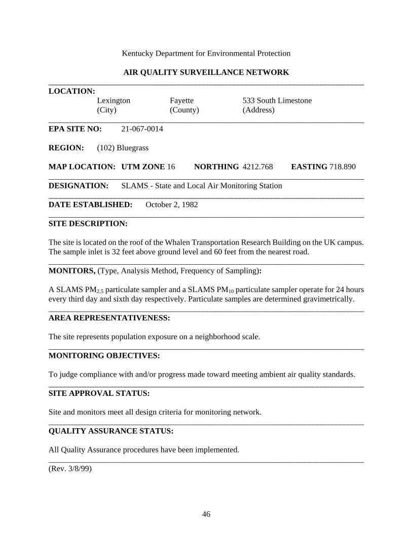
46
Kentucky Department for Environmental Protection AIR QUALITY SURVEILLANCE NETWORK ________________________________________________________________________________ LOCATION:
Lexington Fayette 533 South Limestone (City) (County) (Address)
_________________________________________________________________________________ EPA SITE NO: 21-067-0014 REGION: (102) Bluegrass MAP LOCATION: UTM ZONE 16 NORTHING 4212.768 EASTING 718.890 ________________________________________________________________________________ DESIGNATION: SLAMS - State and Local Air Monitoring Station _________________________________________________________________________________ DATE ESTABLISHED: October 2, 1982 _________________________________________________________________________________ SITE DESCRIPTION: The site is located on the roof of the Whalen Transportation Research Building on the UK campus. The sample inlet is 32 feet above ground level and 60 feet from the nearest road. _________________________________________________________________________________ MONITORS, (Type, Analysis Method, Frequency of Sampling): A SLAMS PM2.5 particulate sampler and a SLAMS PM10 particulate sampler operate for 24 hours every third day and sixth day respectively. Particulate samples are determined gravimetrically. ________________________________________________________________________________ AREA REPRESENTATIVENESS: The site represents population exposure on a neighborhood scale. _______________________________________________________________________________ MONITORING OBJECTIVES: To judge compliance with and/or progress made toward meeting ambient air quality standards. _______________________________________________________________________________ SITE APPROVAL STATUS: Site and monitors meet all design criteria for monitoring network. _______________________________________________________________________________ QUALITY ASSURANCE STATUS: All Quality Assurance procedures have been implemented. _______________________________________________________________________________ (Rev. 3/8/99)

47
Kentucky Department for Environmental Protection AIR QUALITY SURVEILLANCE NETWORK _________________________________________________________________________________ LOCATION:
Frankfort Franklin 803 Schenkel Lane (City) (County) (Address)
_________________________________________________________________________________ EPA SITE NO: 21-073-0006 REGION: (102) Bluegrass MAP LOCATION: UTM ZONE 16 NORTHING 4232.135 EASTING 689.238 ________________________________________________________________________________ DESIGNATION: SLAMS - State and Local Air Monitoring Station _________________________________________________________________________________ DATE ESTABLISHED: January 1, 1999 _________________________________________________________________________________ SITE DESCRIPTION: The site is located on the roof of the Ragland Building. The sample inlet is 18 feet above ground level and 250 feet from the nearest road. _________________________________________________________________________________ MONITORS, (Type, Analysis Method, Frequency of Sampling): A SLAMS PM2.5 particulate sampler operates for 24 hours every third day. Particulate samples are determined gravimetrically. ________________________________________________________________________________ AREA REPRESENTATIVENESS: The site represents population exposure on a neighborhood scale. _______________________________________________________________________________ MONITORING OBJECTIVES: To determine compliance with and/or progress made toward meeting ambient air quality standards. _______________________________________________________________________________ SITE APPROVAL STATUS: Site and monitors meet all design criteria for monitoring network. _______________________________________________________________________________ QUALITY ASSURANCE STATUS: All Quality Assurance procedures have been implemented. _______________________________________________________________________________ (Rev. 3/8/99)
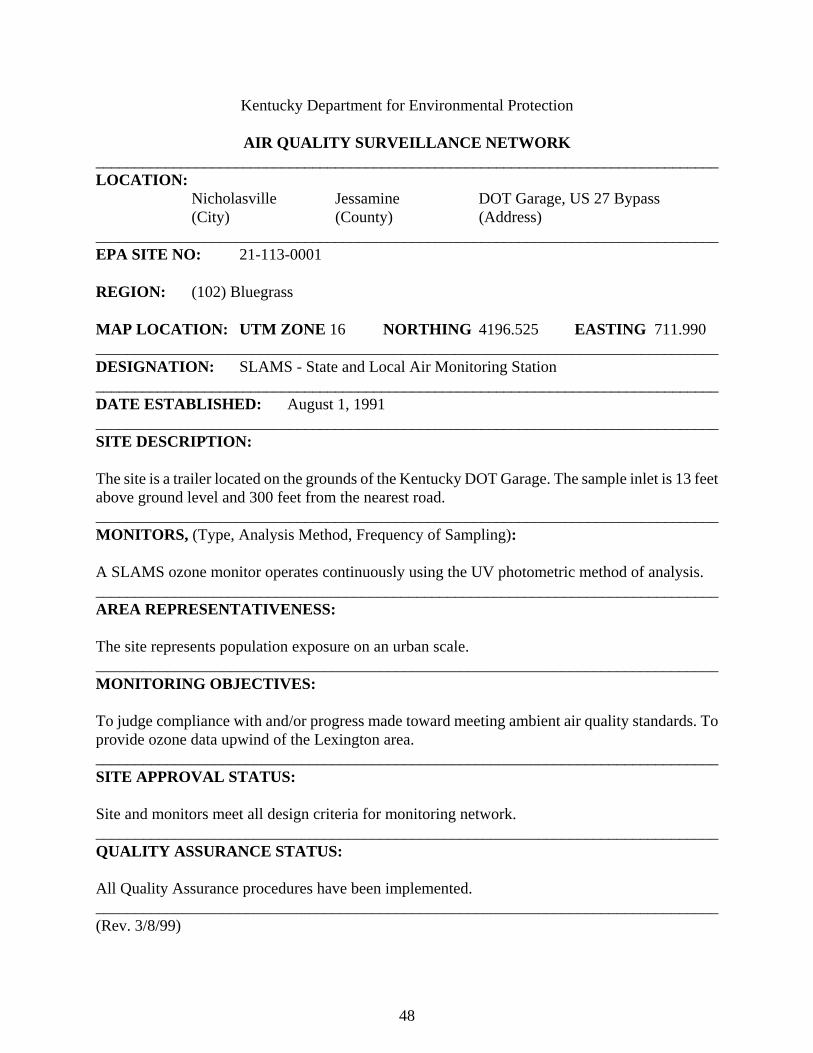
48
Kentucky Department for Environmental Protection AIR QUALITY SURVEILLANCE NETWORK _________________________________________________________________________________ LOCATION:
Nicholasville Jessamine DOT Garage, US 27 Bypass (City) (County) (Address)
_________________________________________________________________________________ EPA SITE NO: 21-113-0001 REGION: (102) Bluegrass MAP LOCATION: UTM ZONE 16 NORTHING 4196.525 EASTING 711.990 ________________________________________________________________________________ DESIGNATION: SLAMS - State and Local Air Monitoring Station _________________________________________________________________________________ DATE ESTABLISHED: August 1, 1991 _________________________________________________________________________________ SITE DESCRIPTION: The site is a trailer located on the grounds of the Kentucky DOT Garage. The sample inlet is 13 feet above ground level and 300 feet from the nearest road. _________________________________________________________________________________ MONITORS, (Type, Analysis Method, Frequency of Sampling): A SLAMS ozone monitor operates continuously using the UV photometric method of analysis. ________________________________________________________________________________ AREA REPRESENTATIVENESS: The site represents population exposure on an urban scale. _______________________________________________________________________________ MONITORING OBJECTIVES: To judge compliance with and/or progress made toward meeting ambient air quality standards. To provide ozone data upwind of the Lexington area. _______________________________________________________________________________ SITE APPROVAL STATUS: Site and monitors meet all design criteria for monitoring network. _______________________________________________________________________________ QUALITY ASSURANCE STATUS: All Quality Assurance procedures have been implemented. _______________________________________________________________________________ (Rev. 3/8/99)

49
Kentucky Department for Environmental Protection AIR QUALITY SURVEILLANCE NETWORK _________________________________________________________________________________ LOCATION:
Richmond Madison Mayfield School, Bond Street (City) (County) (Address)
_________________________________________________________________________________ EPA SITE NO: 21-151-0003 REGION: (102) Bluegrass MAP LOCATION: UTM ZONE 16 NORTHING 4180.025 EASTING 739.195 ________________________________________________________________________________ DESIGNATION: SLAMS - State and Local Air Monitoring Station _________________________________________________________________________________ DATE ESTABLISHED: January 1, 1999 _________________________________________________________________________________ SITE DESCRIPTION: The site is located on the roof at the rear of the Mayfield School. The sample inlet is 15 feet above ground level and 200 feet from the nearest road. _________________________________________________________________________________ MONITORS, (Type, Analysis Method, Frequency of Sampling): A SLAMS PM2.5 particulate sampler along with a SLAMS PM10 particulate sampler operate for 24 hours every third and sixth days respectively. Particulate samples are determined gravimetrically. ________________________________________________________________________________ AREA REPRESENTATIVENESS: The site represents population exposure on a neighborhood scale. _______________________________________________________________________________ MONITORING OBJECTIVES: To determine compliance with and/or progress made toward meeting ambient air quality standards. _______________________________________________________________________________ SITE APPROVAL STATUS: Site and monitors meet all design criteria for monitoring network. _______________________________________________________________________________ QUALITY ASSURANCE STATUS: All Quality Assurance procedures have been implemented. _______________________________________________________________________________ (Rev. 3/8/99)

50
Ashland - Huntington Interstate Air Quality Control Region
AIR QUALITY SURVEILLANCE NETWORK ASHLAND-HUNTINGTON INTERSTATE REGION (103)
AIRS ID ADDRESS PM2.5 PM10 SO2 NO2 CO O3 MET 21-019-0002 21st & Greenup X(N) Ashland (Boyd) (c) 21-019-0017 2924 Holt St, FIVCO Health Dept X(a) X(e) X(e) X(e) X Ashland (Boyd) (I) (I) 21-043-0500 Camp Webb, Grayson Lake X X(s) X Grayson (Carter) 21-089-0007 Water Tower, Scott & Center Sts. X(s) X Worthington (Greenup) TOTAL 2 1 2 1 0 3 2 (a) Speciation sampler included (c) Collocated Monitor (e) Emergency Episode Monitor (I) Air Quality Index Monitor (N) National Air Monitoring Station (NAMS) Monitor (s) Special Purpose Monitor (Rev. 1/11/05)
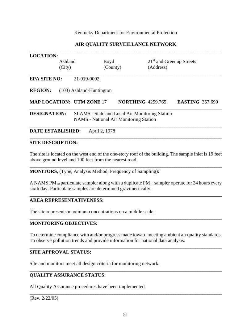
51
Kentucky Department for Environmental Protection
AIR QUALITY SURVEILLANCE NETWORK _________________________________________________________________________________ LOCATION:
Ashland Boyd 21st and Greenup Streets (City) (County) (Address)
_________________________________________________________________________________ EPA SITE NO: 21-019-0002 REGION: (103) Ashland-Huntington MAP LOCATION: UTM ZONE 17 NORTHING 4259.765 EASTING 357.690 ________________________________________________________________________________ DESIGNATION: SLAMS - State and Local Air Monitoring Station
NAMS - National Air Monitoring Station _________________________________________________________________________________ DATE ESTABLISHED: April 2, 1978 _________________________________________________________________________________ SITE DESCRIPTION: The site is located on the west end of the one-story roof of the building. The sample inlet is 19 feet above ground level and 100 feet from the nearest road. _________________________________________________________________________________ MONITORS, (Type, Analysis Method, Frequency of Sampling): A NAMS PM10 particulate sampler along with a duplicate PM10 sampler operate for 24 hours every sixth day. Particulate samples are determined gravimetrically. ________________________________________________________________________________ AREA REPRESENTATIVENESS: The site represents maximum concentrations on a middle scale. _______________________________________________________________________________ MONITORING OBJECTIVES: To determine compliance with and/or progress made toward meeting ambient air quality standards. To observe pollution trends and provide information for national data analysis. _______________________________________________________________________________ SITE APPROVAL STATUS: Site and monitors meet all design criteria for monitoring network. _______________________________________________________________________________ QUALITY ASSURANCE STATUS: All Quality Assurance procedures have been implemented. _______________________________________________________________________________ (Rev. 2/22/05)

52
Kentucky Department for Environmental Protection
AIR QUALITY SURVEILLANCE NETWORK _________________________________________________________________________________ LOCATION:
Ashland Boyd FIVCO Health Dept., 2924 Holt Street (City) (County) (Address)
_________________________________________________________________________________ EPA SITE NO: 21-019-0017 REGION: (103) Ashland-Huntington MAP LOCATION: UTM ZONE 17 NORTHING 4257.830 EASTING 356.855 ________________________________________________________________________________ DESIGNATION: SLAMS - State and Local Air Monitoring Station
EPISODE - Emergency episode monitoring site AQI - Air Quality Index site
_________________________________________________________________________________ DATE ESTABLISHED: January 1, 1999 _________________________________________________________________________________ SITE DESCRIPTION: The site is a mobile shelter located on a grass covered open area behind the health department building. The sample inlets are 13 feet above ground level and 240 feet from the nearest road. _________________________________________________________________________________ MONITORS, (Type, Analysis Method, Frequency of Sampling): SLAMS ozone and sulfur dioxide monitors operate continuously using the UV photometric and UV fluorescent methods of analysis. A SLAMS nitrogen dioxide monitor operates continuously using the chemiluminescence method. A SLAMS PM2.5 particulate sampler operates for 24 hours every third day. A PM2.5 speciation sampler operates 24 hours every sixth day. A continuous TEOM PM2.5 sampler provides daily index values. Particulates are determined gravimetrically. ________________________________________________________________________________ AREA REPRESENTATIVENESS: The site represents population exposure on a neighborhood scale for particulates, sulfur dioxide and ozone and on an urban scale for nitrogen dioxide. _______________________________________________________________________________ MONITORING OBJECTIVES: To determine compliance with and/or progress made toward meeting ambient air quality standards. To detect episode levels for activation of emergency control procedures. To provide pollution levels for daily index reporting. _______________________________________________________________________________ SITE APPROVAL STATUS: Site and monitors meet all design criteria for monitoring network. _______________________________________________________________________________ QUALITY ASSURANCE STATUS: All Quality Assurance procedures have been implemented. _______________________________________________________________________________ (Rev. 2/4/03)

53
Kentucky Department for Environmental Protection AIR QUALITY SURVEILLANCE NETWORK _________________________________________________________________________________ LOCATION:
Grayson Carter Camp Webb, Grayson Lake (City) (County) (Address)
_________________________________________________________________________________ EPA SITE NO: 21-043-0500 REGION: (103) Ashland-Huntington MAP LOCATION: UTM ZONE 17 NORTHING 4233.922 EASTING 325.984 ________________________________________________________________________________ DESIGNATION: SLAMS - State and Local Air Monitoring Station SPM - Special Purpose Monitor (Ozone) _________________________________________________________________________________ DATE ESTABLISHED: May 13, 1981 _________________________________________________________________________________ SITE DESCRIPTION: The site is a mobile shelter in a fenced area located in a remote section of the park. The sample inlets are 13 feet above ground level. A service road is the only roadway near the site. _________________________________________________________________________________ MONITORS, (Type, Analysis Method, Frequency of Sampling): A SLAMS PM2.5 particulate sampler operates for 24 hours every third day. Particulate samples are determined gravimetrically. A special purpose ozone monitor operates continuously using the UV photometric method of analysis. ________________________________________________________________________________ AREA REPRESENTATIVENESS: The site represents background levels on an urban scale. _______________________________________________________________________________ MONITORING OBJECTIVES: To determine background levels of PM2.5. To judge compliance with and/or progress made toward meeting ambient air quality standards. To provide ozone data upwind of the Ashland area. _______________________________________________________________________________ SITE APPROVAL STATUS: Site and monitors meet all design criteria for monitoring network. _______________________________________________________________________________ QUALITY ASSURANCE STATUS: All Quality Assurance procedures have been implemented. _______________________________________________________________________________ (Rev. 12/8/00)

54
Kentucky Department for Environmental Protection AIR QUALITY SURVEILLANCE NETWORK _________________________________________________________________________________ LOCATION:
Worthington Greenup Scott Street & Center Avenue (City) (County) (Address)
_________________________________________________________________________________ EPA SITE NO: 21-089-0007 REGION: (103) Ashland-Huntington MAP LOCATION: UTM ZONE 17 NORTHING 4267.850 EASTING 349.100 ________________________________________________________________________________ DESIGNATION: SLAMS - State and Local Air Monitoring Station SPM - Special Purpose Monitor (Sulfur dioxide) _________________________________________________________________________________ DATE ESTABLISHED: October 12, 1980 _________________________________________________________________________________ SITE DESCRIPTION: The site is located in a mobile trailer at the water tower near the intersection of Scott Street and Center Avenue. The sample inlets are 13 feet above ground level and 57 feet from the nearest road. _________________________________________________________________________________ MONITORS, (Type, Analysis Method, Frequency of Sampling): A SLAMS ozone monitor operates continuously using the UV photometric method of analysis. A special purpose sulfur dioxide monitor operates continuously using the UV fluorescence method. ________________________________________________________________________________ AREA REPRESENTATIVENESS: The site represents population exposure on a neighborhood scale for sulfur dioxide and ozone. _______________________________________________________________________________ MONITORING OBJECTIVES: To determine compliance with and/or progress made toward meeting ambient air quality standards. _______________________________________________________________________________ SITE APPROVAL STATUS: Site and monitors meet all design criteria for monitoring network. _______________________________________________________________________________ QUALITY ASSURANCE STATUS: All Quality Assurance procedures have been implemented. _______________________________________________________________________________ (Rev. 12/8/00)

55
North Central Air Quality Control Region
AIR QUALITY SURVEILLANCE NETWORK NORTH CENTRAL REGION (104)
AIRS ID ADDRESS PM2.5 PM10 SO2 NO2 CO O3 MET 21-029-0006 2nd & Carpenter Streets X X X(s) X X Shepherdsville (Bullitt) 21-093-0006 801 N Miles St, Am Legion Park X X X(s) Elizabethtown (Hardin) 21-185-0004 DOT Garage, 3995 Morgan Rd X Buckner (Oldham) TOTAL 2 2 0 1 0 3 1 (s) Special Purpose Monitor (Rev. 4/8/03)

56
Kentucky Department for Environmental Protection AIR QUALITY SURVEILLANCE NETWORK _______________________________________________________________________________ LOCATION:
Shepherdsville Bullitt Second & Carpenter Streets (City) (County) (Address)
_________________________________________________________________________________ EPA SITE NO: 21-029-0006 REGION: (104) North Central MAP LOCATION: UTM ZONE 16 NORTHING 4204.809 EASTING 613.025 ________________________________________________________________________________ DESIGNATION: SLAMS - State and Local Air Monitoring Station SPM - Special Purpose Monitor (Nitrogen dioxide) _________________________________________________________________________________ DATE ESTABLISHED: January 30, 1992 _________________________________________________________________________________ SITE DESCRIPTION: The site is a shelter located in a fenced area near the intersection of Second and Carpenter Streets. The sample inlets are 13 feet above ground level. The site is 70 feet from the nearest road. _________________________________________________________________________________ MONITORS, (Type, Analysis Method, Frequency of Sampling): A SLAMS ozone monitor operates continuously using the UV photometric method of analysis. SLAMS PM2.5 and PM10 particulate samplers operate for 24 hours every third and sixth days respectively. Particulate samples are determined gravimetrically. A special purpose nitrogen dioxide monitor operates continuously using the chemiluminescence method of analysis. ________________________________________________________________________________ AREA REPRESENTATIVENESS: The site represents population exposure on a neighborhood scale for particulates and on an urban scale for nitrogen dioxide and ozone. _______________________________________________________________________________ MONITORING OBJECTIVES: To determine compliance with and/or progress made toward meeting ambient air quality standards. _______________________________________________________________________________ SITE APPROVAL STATUS: Site and monitors meet all design criteria for monitoring network. _______________________________________________________________________________ QUALITY ASSURANCE STATUS: All Quality Assurance procedures have been implemented. _______________________________________________________________________________ (Rev. 4/3/05)
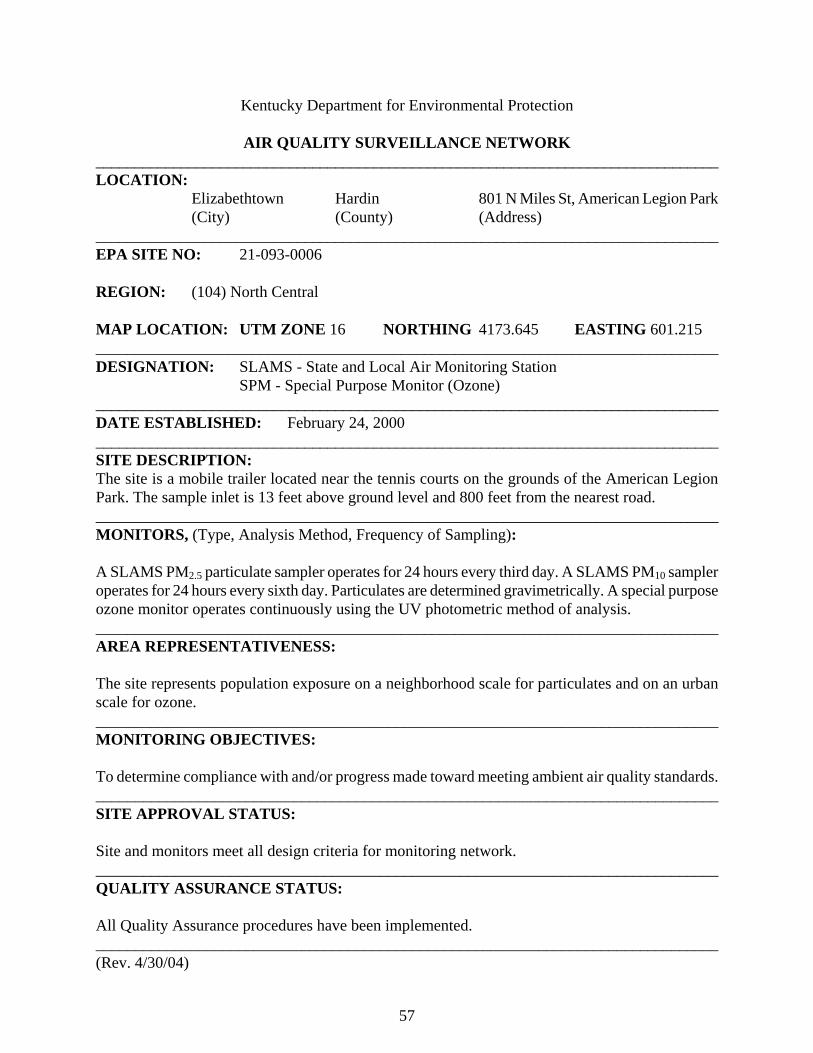
57
Kentucky Department for Environmental Protection AIR QUALITY SURVEILLANCE NETWORK _________________________________________________________________________________ LOCATION:
Elizabethtown Hardin 801 N Miles St, American Legion Park (City) (County) (Address)
_________________________________________________________________________________ EPA SITE NO: 21-093-0006 REGION: (104) North Central MAP LOCATION: UTM ZONE 16 NORTHING 4173.645 EASTING 601.215 ________________________________________________________________________________ DESIGNATION: SLAMS - State and Local Air Monitoring Station SPM - Special Purpose Monitor (Ozone) _________________________________________________________________________________ DATE ESTABLISHED: February 24, 2000 _________________________________________________________________________________ SITE DESCRIPTION: The site is a mobile trailer located near the tennis courts on the grounds of the American Legion Park. The sample inlet is 13 feet above ground level and 800 feet from the nearest road. _________________________________________________________________________________ MONITORS, (Type, Analysis Method, Frequency of Sampling): A SLAMS PM2.5 particulate sampler operates for 24 hours every third day. A SLAMS PM10 sampler operates for 24 hours every sixth day. Particulates are determined gravimetrically. A special purpose ozone monitor operates continuously using the UV photometric method of analysis. ________________________________________________________________________________ AREA REPRESENTATIVENESS: The site represents population exposure on a neighborhood scale for particulates and on an urban scale for ozone. _______________________________________________________________________________ MONITORING OBJECTIVES: To determine compliance with and/or progress made toward meeting ambient air quality standards. _______________________________________________________________________________ SITE APPROVAL STATUS: Site and monitors meet all design criteria for monitoring network. _______________________________________________________________________________ QUALITY ASSURANCE STATUS: All Quality Assurance procedures have been implemented. _______________________________________________________________________________ (Rev. 4/30/04)

58
Kentucky Department for Environmental Protection AIR QUALITY SURVEILLANCE NETWORK _________________________________________________________________________________ LOCATION:
Buckner Oldham 3995 Morgan Rd, DOT Garage (City) (County) (Address)
_________________________________________________________________________________ EPA SITE NO: 21-185-0004 REGION: (104) North Central MAP LOCATION: UTM ZONE 16 NORTHING 4250.990 EASTING 635.928 ________________________________________________________________________________ DESIGNATION: SLAMS - State and Local Air Monitoring Station _________________________________________________________________________________ DATE ESTABLISHED: May 1, 1981 _________________________________________________________________________________ SITE DESCRIPTION: The monitoring site is a trailer located on the grounds of the DOT Highway Garage. The sample inlet is 13 feet above ground level and 250 feet from the nearest street. _________________________________________________________________________________ MONITORS, (Type, Analysis Method, Frequency of Sampling): A SLAMS ozone analyzer operates continuously using the UV photometric method of analysis. ________________________________________________________________________________ AREA REPRESENTATIVENESS: The site represents maximum concentrations on an urban scale. _______________________________________________________________________________ MONITORING OBJECTIVES: To determine compliance with and/or progress made toward meeting ambient air quality standards. _______________________________________________________________________________ SITE APPROVAL STATUS: Site and monitors meet all design criteria for monitoring network. _______________________________________________________________________________ QUALITY ASSURANCE STATUS: All Quality Assurance procedures have been implemented. _______________________________________________________________________________ (Rev. 2/24/00)
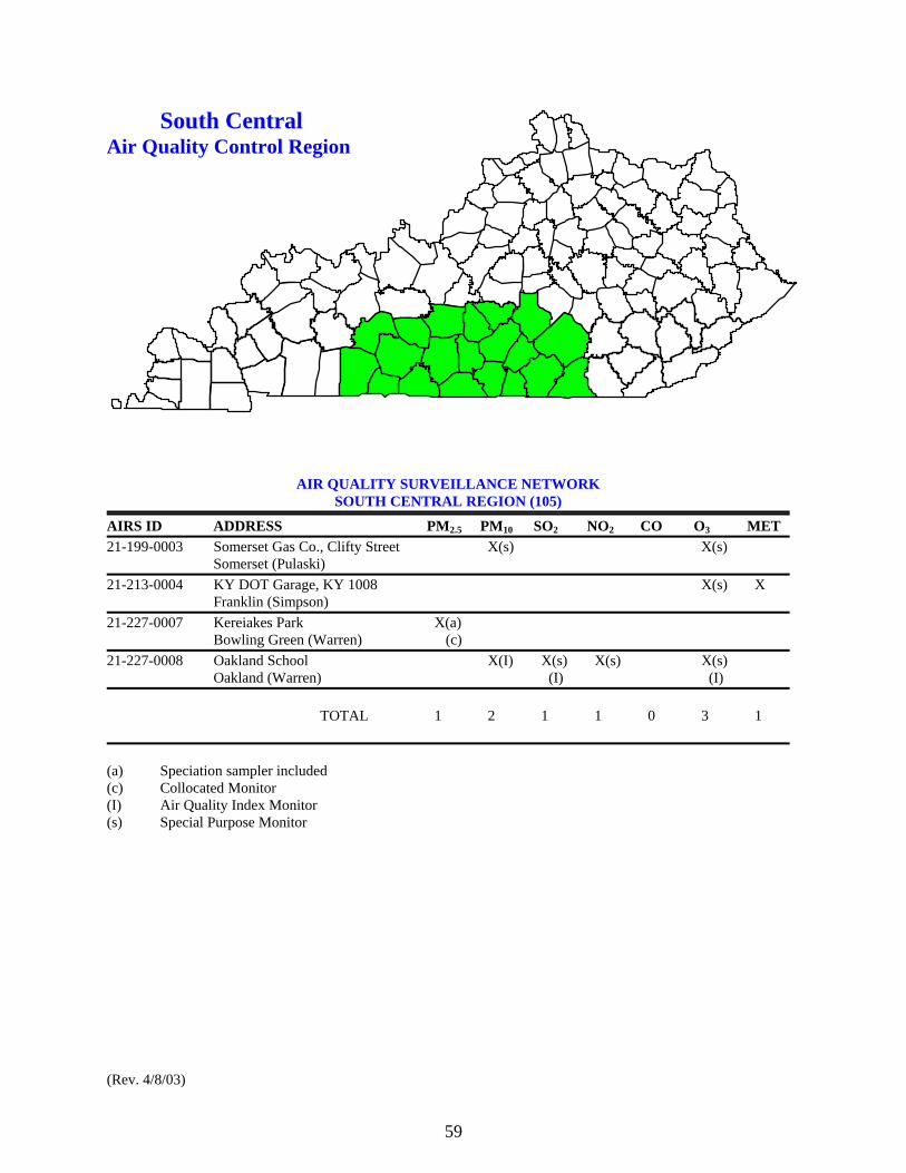
59
South Central Air Quality Control Region
AIR QUALITY SURVEILLANCE NETWORK SOUTH CENTRAL REGION (105)
AIRS ID ADDRESS PM2.5 PM10 SO2 NO2 CO O3 MET 21-199-0003 Somerset Gas Co., Clifty Street X(s) X(s) Somerset (Pulaski) 21-213-0004 KY DOT Garage, KY 1008 X(s) X Franklin (Simpson) 21-227-0007 Kereiakes Park X(a) Bowling Green (Warren) (c) 21-227-0008 Oakland School X(I) X(s) X(s) X(s) Oakland (Warren) (I) (I) TOTAL 1 2 1 1 0 3 1 (a) Speciation sampler included (c) Collocated Monitor (I) Air Quality Index Monitor (s) Special Purpose Monitor (Rev. 4/8/03)

60
Kentucky Department for Environmental Protection AIR QUALITY SURVEILLANCE NETWORK _________________________________________________________________________________ LOCATION:
Somerset Pulaski Somerset Gas Company, Clifty St (City) (County) (Address)
_________________________________________________________________________________ EPA SITE NO: 21-199-0003 REGION: (105) South Central MAP LOCATION: UTM ZONE 16 NORTHING 4108.192 EASTING 711.990 ________________________________________________________________________________ DESIGNATION: SPM - Special Purpose Monitor _________________________________________________________________________________ DATE ESTABLISHED: February 14, 1992 _________________________________________________________________________________ SITE DESCRIPTION: The monitoring site is a trailer located on the grounds of the Somerset Gas Company Warehouse on Clifty Street. The sample inlets are 13 feet above ground level and 35 feet from the nearest road. _________________________________________________________________________________ MONITORS, (Type, Analysis Method, Frequency of Sampling): A special purpose ozone monitor operates continuously using the UV photometric method of analysis. A special purpose PM10 sampler operates for 24 hours every sixth day. Particulates are determined gravimetrically. ________________________________________________________________________________ AREA REPRESENTATIVENESS: The site represents population exposure on a neighborhood scale for particulates and on an urban scale for ozone. _______________________________________________________________________________ MONITORING OBJECTIVES: To judge compliance with and/or progress made toward meeting ambient air quality standards. _______________________________________________________________________________ SITE APPROVAL STATUS: Site and monitors meet all design criteria for monitoring network. _______________________________________________________________________________ QUALITY ASSURANCE STATUS: All Quality Assurance procedures have been implemented. _______________________________________________________________________________ (Rev. 4/30/04)

61
Kentucky Department for Environmental Protection AIR QUALITY SURVEILLANCE NETWORK _________________________________________________________________________________ LOCATION:
Franklin Simpson DOT Garage, KY 1008 (City) (County) (Address)
_________________________________________________________________________________ EPA SITE NO: 21-213-0004 REGION: (105) South Central MAP LOCATION: UTM ZONE 16 NORTHING 4062.295 EASTING 538.595 ________________________________________________________________________________ DESIGNATION: SPM - Special Purpose Monitor _________________________________________________________________________________ DATE ESTABLISHED: June 19, 1991 _________________________________________________________________________________ SITE DESCRIPTION: The monitoring site is a trailer located on the grounds of the DOT Garage on KY1008. The sample inlet is 13 feet above ground level and 200 feet from the nearest road. _________________________________________________________________________________ MONITORS, (Type, Analysis Method, Frequency of Sampling): A special purpose ozone monitor operates continuously using the UV photometric method of analysis. ________________________________________________________________________________ AREA REPRESENTATIVENESS: The site represents population exposure on an urban scale. _______________________________________________________________________________ MONITORING OBJECTIVES: To judge compliance with and/or progress made toward meeting ambient air quality standards. To measure ozone levels upwind of Bowling Green and provide data on interstate ozone transport. _______________________________________________________________________________ SITE APPROVAL STATUS: Site and monitors meet all design criteria for monitoring network. _______________________________________________________________________________ QUALITY ASSURANCE STATUS: All Quality Assurance procedures have been implemented. _______________________________________________________________________________ (Rev. 12/8/00)

62
Kentucky Department for Environmental Protection AIR QUALITY SURVEILLANCE NETWORK _________________________________________________________________________________ LOCATION:
Bowling Green Warren Kereiakes Park, Fairview Avenue (City) (County) (Address)
_________________________________________________________________________________ EPA SITE NO: 21-227-0007 REGION: (105) South Central MAP LOCATION: UTM ZONE 16 NORTHING 4094.095 EASTING 551.762 ________________________________________________________________________________ DESIGNATION: SLAMS - State and Local Air Monitoring Station _________________________________________________________________________________ DATE ESTABLISHED: January 1, 1999 _________________________________________________________________________________ SITE DESCRIPTION: The site is located on a platform behind the tennis courts at Kereiakes Park. The sample inlets are 10 feet above ground level and 400 feet from the nearest road. _________________________________________________________________________________ MONITORS, (Type, Analysis Method, Frequency of Sampling): A SLAMS PM2.5 particulate sampler operates for 24 hours every third day. A duplicate PM2.5 sampler and a PM2.5 speciation sampler operate for 24 hours every sixth day. Particulates are determined gravimetrically. ________________________________________________________________________________ AREA REPRESENTATIVENESS: The site represents population exposure on a neighborhood scale. _______________________________________________________________________________ MONITORING OBJECTIVES: To determine compliance with and/or progress made toward meeting ambient air quality standards. _______________________________________________________________________________ SITE APPROVAL STATUS: Site and monitors meet all design criteria for monitoring network. _______________________________________________________________________________ QUALITY ASSURANCE STATUS: All Quality Assurance procedures have been implemented. _______________________________________________________________________________ (Rev. 9/18/99)
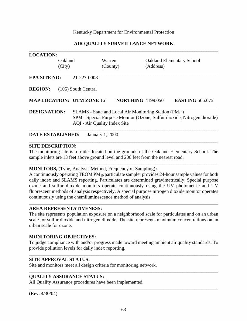
63
Kentucky Department for Environmental Protection AIR QUALITY SURVEILLANCE NETWORK _______________________________________________________________________________ LOCATION:
Oakland Warren Oakland Elementary School (City) (County) (Address)
_________________________________________________________________________________ EPA SITE NO: 21-227-0008 REGION: (105) South Central MAP LOCATION: UTM ZONE 16 NORTHING 4199.050 EASTING 566.675 ________________________________________________________________________________ DESIGNATION: SLAMS - State and Local Air Monitoring Station (PM10) SPM - Special Purpose Monitor (Ozone, Sulfur dioxide, Nitrogen dioxide) AQI - Air Quality Index Site _________________________________________________________________________________ DATE ESTABLISHED: January 1, 2000 _________________________________________________________________________________ SITE DESCRIPTION: The monitoring site is a trailer located on the grounds of the Oakland Elementary School. The sample inlets are 13 feet above ground level and 200 feet from the nearest road. _________________________________________________________________________________ MONITORS, (Type, Analysis Method, Frequency of Sampling): A continuously operating TEOM PM10 particulate sampler provides 24-hour sample values for both daily index and SLAMS reporting. Particulates are determined gravimetrically. Special purpose ozone and sulfur dioxide monitors operate continuously using the UV photometric and UV fluorescent methods of analysis respectively. A special purpose nitrogen dioxide monitor operates continuously using the chemiluminescence method of analysis. ________________________________________________________________________________ AREA REPRESENTATIVENESS: The site represents population exposure on a neighborhood scale for particulates and on an urban scale for sulfur dioxide and nitrogen dioxide. The site represents maximum concentrations on an urban scale for ozone. _______________________________________________________________________________ MONITORING OBJECTIVES: To judge compliance with and/or progress made toward meeting ambient air quality standards. To provide pollution levels for daily index reporting. _______________________________________________________________________________ SITE APPROVAL STATUS: Site and monitors meet all design criteria for monitoring network. _______________________________________________________________________________ QUALITY ASSURANCE STATUS: All Quality Assurance procedures have been implemented. _______________________________________________________________________________ (Rev. 4/30/04)
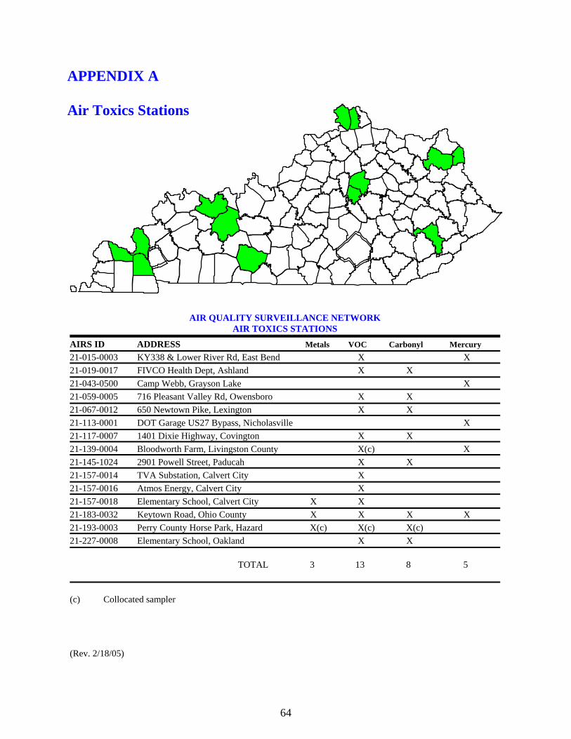
64
APPENDIX A Air Toxics Stations
AIR QUALITY SURVEILLANCE NETWORK AIR TOXICS STATIONS
AIRS ID ADDRESS Metals VOC Carbonyl Mercury 21-015-0003 KY338 & Lower River Rd, East Bend X X 21-019-0017 FIVCO Health Dept, Ashland X X 21-043-0500 Camp Webb, Grayson Lake X 21-059-0005 716 Pleasant Valley Rd, Owensboro X X 21-067-0012 650 Newtown Pike, Lexington X X 21-113-0001 DOT Garage US27 Bypass, Nicholasville X 21-117-0007 1401 Dixie Highway, Covington X X 21-139-0004 Bloodworth Farm, Livingston County X(c) X 21-145-1024 2901 Powell Street, Paducah X X 21-157-0014 TVA Substation, Calvert City X 21-157-0016 Atmos Energy, Calvert City X 21-157-0018 Elementary School, Calvert City X X 21-183-0032 Keytown Road, Ohio County X X X X 21-193-0003 Perry County Horse Park, Hazard X(c) X(c) X(c) 21-227-0008 Elementary School, Oakland X X TOTAL 3 13 8 5 (c) Collocated sampler (Rev. 2/18/05)
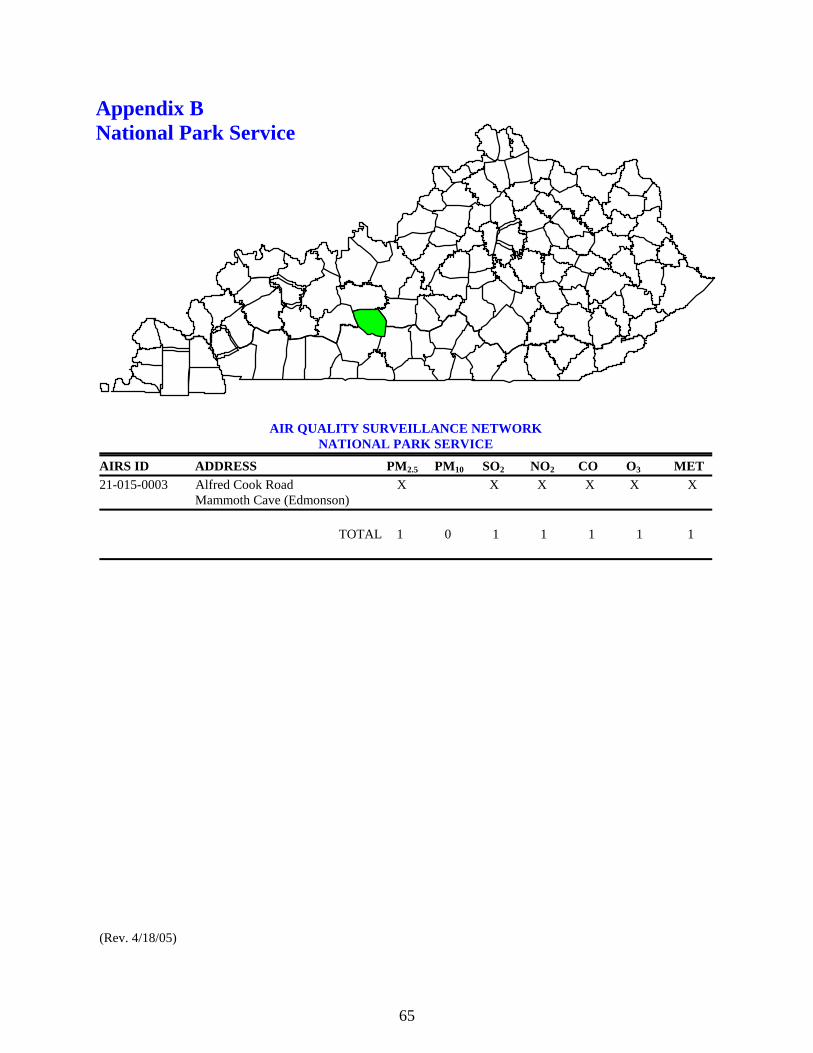
65
Appendix B National Park Service
AIR QUALITY SURVEILLANCE NETWORK NATIONAL PARK SERVICE
AIRS ID ADDRESS PM2.5 PM10 SO2 NO2 CO O3 MET 21-015-0003 Alfred Cook Road X X X X X X
Mammoth Cave (Edmonson) TOTAL 1 0 1 1 1 1 1 (Rev. 4/18/05)
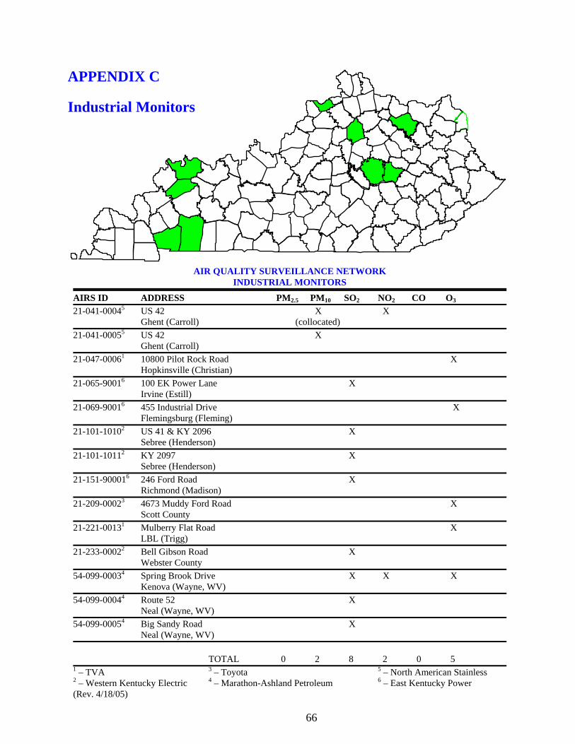
66
APPENDIX C Industrial Monitors
AIR QUALITY SURVEILLANCE NETWORK INDUSTRIAL MONITORS
AIRS ID ADDRESS PM2.5 PM10 SO2 NO2 CO O3 21-041-00045 US 42 X X Ghent (Carroll) (collocated) 21-041-00055 US 42 X Ghent (Carroll) 21-047-00061 10800 Pilot Rock Road X Hopkinsville (Christian) 21-065-90016 100 EK Power Lane X Irvine (Estill) 21-069-90016 455 Industrial Drive X Flemingsburg (Fleming) 21-101-10102 US 41 & KY 2096 X Sebree (Henderson) 21-101-10112 KY 2097 X Sebree (Henderson) 21-151-900016 246 Ford Road X Richmond (Madison) 21-209-00023 4673 Muddy Ford Road X Scott County 21-221-00131 Mulberry Flat Road X LBL (Trigg) 21-233-00022 Bell Gibson Road X Webster County 54-099-00034 Spring Brook Drive X X X Kenova (Wayne, WV) 54-099-00044 Route 52 X Neal (Wayne, WV) 54-099-00054 Big Sandy Road X Neal (Wayne, WV) TOTAL 0 2 8 2 0 5 1 – TVA 3 – Toyota 5 – North American Stainless 2 – Western Kentucky Electric 4 – Marathon-Ashland Petroleum 6 – East Kentucky Power (Rev. 4/18/05)