ku-ring-gai council · draft klep was exhibited from the 25 march – 6 may 2013. submissions to...
TRANSCRIPT
Ku-ring-gai Council PLANNING PROPOSAL
To correct Schedule 5 of the KLEP 2015 November 2017
Updated following agency consultation with OEH
2016/326994

Ku-ring-gai Council Planning Proposal
Contents INTRODUCTION .................................................................................................................................... 1
PART 1 – OBJECTIVE AND INTENDED OUTCOMES ........................................................................ 19
PART 2 – EXPLANATION OF PROVISIONS ....................................................................................... 20
PART 3 - JUSTIFICATION ................................................................................................................... 16
A. Need for the planning proposal .......................................................................................... 16
B. Relationship to strategic planning framework .................................................................... 16
C. Environmental, social and economic impact ...................................................................... 22
D. State and Commonwealth interests ................................................................................... 22
PART 4 - MAPPING ............................................................................................................................. 24
PART 5 – COMMUNITY CONSULTATION .......................................................................................... 33
PART 6 – PROJECT TIMELINE ........................................................................................................... 34 APPENDIX A. Council Report 22 November 2016
APPENDIX B. Council Resolution 22 November 2016
APPENDIX C. State Heritage Inventory Sheet – 36 Carlotta Avenue, Gordon
APPENDIX D. State Heritage Inventory Sheet – 7 Grosvenor Street, Wahroonga
APPENDIX E. State Heritage Inventory Sheet – 17 Bangalla Street, Warrawee
APPENDIX F. State Heritage Inventory Sheet — 14 Warrangi Street, Turramurra
APPENDIX G – Comments from Office of Environment and Heritage

Ku-ring-gai Council Planning Proposal
1
INTRODUCTION This planning proposal contains justification for proposed amendments to Schedule 5 of the Ku-
ring-gai Local Environmental Plan 2015 (KLEP 2015) and the corresponding Heritage Maps to
remove the local heritage listing of four (4) properties across the LGA, due to mistaken or
erroneous listings.
This planning proposal has been prepared in accordance with Section 55 of the Environmental
Planning and Assessment Act 1979 and the NSW Department of Planning and Environment’s “A
Guide to Preparing Planning Proposals”(August 2016).
Council will request the plan making delegation under Section 23 of the Environmental Planning
and Assessment Act 1979 for this planning proposal.
Background Draft KLEP was exhibited from the 25 March – 6 May 2013. Submissions to the Draft KLEP were
considered by Council on the 26 November 2013. A number of properties were affected by
changes to heritage provisions with the introduction of the KLEP 2015, including the listing of
multiple heritage items. The KLEP 2015 came into effect on 2 April 2015.
Public comments received by Council following the gazettal of the KLEP 2015 in regard the merits
of certain heritage listings have resulted in further investigations by Council staff. These
investigations have brought to Council’s attention the need to correct erroneous heritage listings
from Schedule 5 of the KLEP 2015. A report recommending the correction of erroneous heritage
listings by proposing amendments to Schedule 5 of the KLEP 2015 was considered at a Council
meeting on 22 November 2016 (Appendix A). The properties subject to the erroneous listings are:
• 36 Carlotta Avenue, Gordon
• 7 Grosvenor Street, Wahroonga
• 17 Bangalla Street, Warrawee
• 14 Warrangi Street, Turramurra Council adopted the resolution to prepare a Planning Proposal to amend Schedule 5 of the KLEP
2015 to correct four erroneous listings. A copy of the Resolution is included at Appendix B.

Ku-ring-gai Council Planning Proposal
2
In reviewing the four listings Council staff have considered the guidelines for inclusion and
exclusion under Criterion C from the NSW Heritage Office’s Assessing Heritage Significance
(2001) adapted below:
GUIDELINES FOR INCLUSION GUIDELINES FOR EXCLUSION
Shows or is associated with, creative or technical innovation or achievement
Is not a major work by an important designer or artist
Is the inspiration for a creative or technical innovation or achievement
Has lost its design or technical integrity
Is aesthetically distinctive Its positive visual or sensory appeal or landmark and scenic qualities have been more than temporarily degraded
Has landmark qualities Has only a loose association with a creative or technical achievement
Exemplifies a particular taste, style or technology
The four heritage listings often demonstrate the characteristics included in the Guidelines for
Exclusion, in particular a loss of design or technical integrity as well as a permanent degraded
visual or landmark appeal (through modification or developmental change).
Site Descriptions
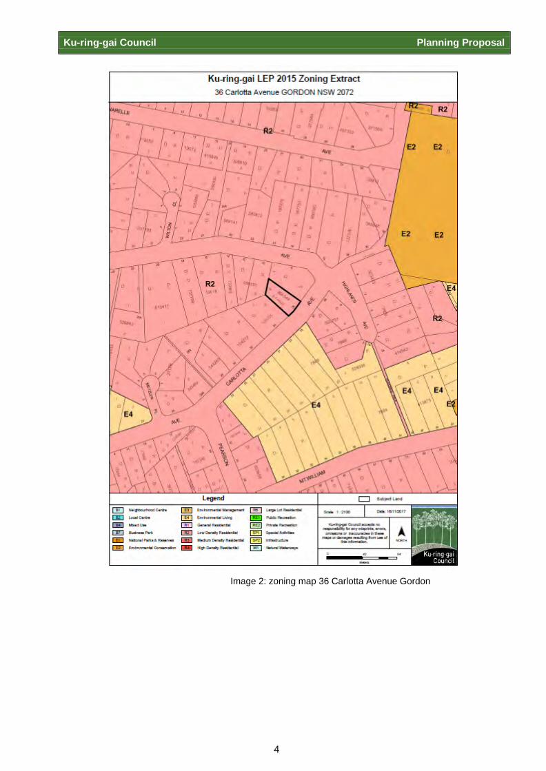
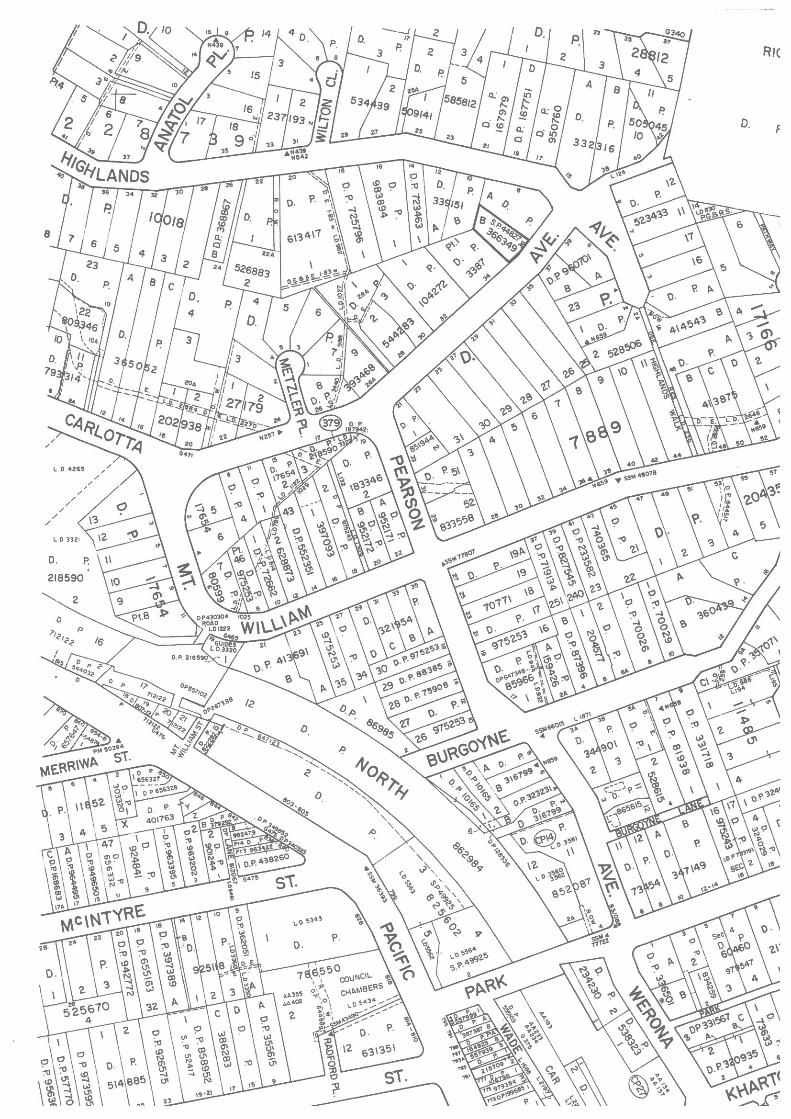
36A and 36B Carlotta Avenue, Gordon
The former 36 Carlotta Avenue, Gordon – now 36A and 36B Carlotta Avenue, Gordon (Lot B
DP366349, SP44827) is located in a residential area to the north and east of Pacific Highway, and
to the east of Mona Vale Road. The site contains a modern dual occupancy built after 1995,
however it was heritage listed in error on 2 April 2015. The site is currently zoned R2 Low Density
Residential under the KLEP 2015.

Ku-ring-gai Council Planning Proposal
3
Image 1: Property Location Map- 36A & 36B Carlotta Ave, Gordon Council received a public enquiry on 7 February 2014 regarding the properties at 36A and 36B
Carlotta Avenue, bringing to the attention of Council staff a likely error on Schedule 5 of the KLEP
2015. After further investigation Council staff have identified the heritage listing was made in
relation to a much earlier “P & O” style dwelling house on the property, demolished after 1995.
This is evident by the information recorded on the State Heritage Inventory sheet for this property,
available at Appendix C. Following demolition of the heritage item, the listing was not removed.
Therefore this Planning Proposal recommends the correction of this error.
Ku-ring-gai Council Planning Proposal
4
Image 2: zoning map 36 Carlotta Avenue Gordon

Ku-ring-gai Council Planning Proposal
5
Image 3: Aerial Photo – 36 Carlotta Ave, Gordon
Image 4: Photo of front façade and driveway – 36 Carlotta Ave, Gordon
Ku-ring-gai Council Planning Proposal
6
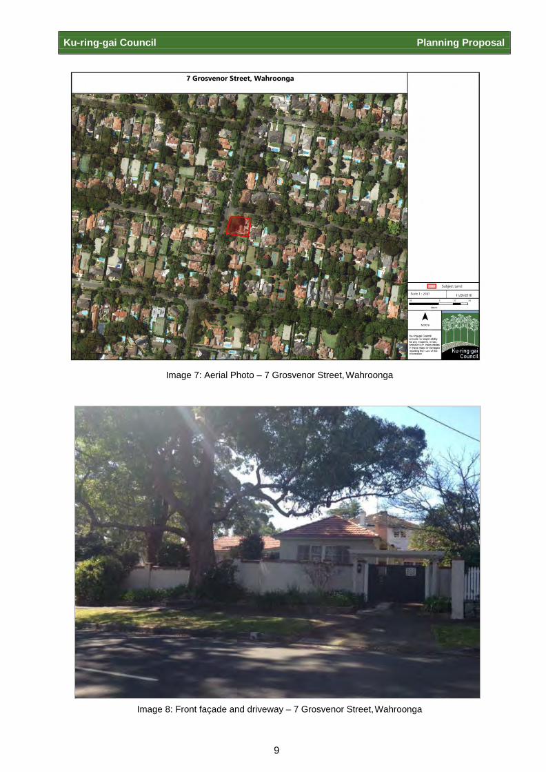
“Edelstein” 7 Grosvenor Street, Wahroonga “Edelstein” at 7 Grosvenor Street, Wahroonga (Lot D, DP 330058) is located north of Pacific
Highway on the corner Grosvenor Street and Braeside Street. The site is currently zoned R2 Low
Density Residential under the KLEP 2015.
The property was first listed on 2 April 2015. The site is located in a local Heritage Conservation
Area called “Wahroonga Conservation Area” (C1). This property has undergone modifications in
1992 and 1986, as well as a later addition of a swimming pool. No original State Heritage Inventory
sheet could be located in Council’s records to justify its inclusion into the KLEP 2015 and no
evidence was found to support an assessment of the property against criteria for significance. It is
possible the listing was made in error, likely being confused with another heritage item with which
appears on Schedule 5 at 7 Grosvenor Road, Lindfield.
The Office of Environment and Heritage (OEH) in response to the mandatory agency consultation (see
Appendix G) noted that “no objection is raised to the removal of the locally listed items provided a
detailed assessment of the heritage significance of the building, and an assessment against the NSW
Heritage Division assessment criteria has been undertaken by a suitably qualified heritage
professional”. In response to this requirement experienced and qualified staff undertook a heritage
assessment of 7 Grosvenor Street Wahroonga. This assessment can be found at Attachment D.
7 Grosvenor Street Wahroonga is located within a heritage conservation area and is considered to
be a contributory building representative of a key development period. Assessment to date does
not support the individual listing of the property as a heritage item. Thus this property should be
considered for removal from Schedule 5.

Ku-ring-gai Council Planning Proposal
7
Image 5: Property Location Map – 7 Grosvenor St, Wahroonga

Ku-ring-gai Council Planning Proposal
8
Image 6: zoning map for 7 Grosvenor Street Wahroonga
Ku-ring-gai Council Planning Proposal
9
Image 7: Aerial Photo – 7 Grosvenor Street, Wahroonga
Image 8: Front façade and driveway – 7 Grosvenor Street, Wahroonga
Ku-ring-gai Council Planning Proposal
10
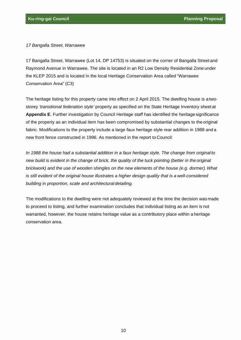
17 Bangalla Street, Warrawee
17 Bangalla Street, Warrawee (Lot 14, DP 14753) is situated on the corner of Bangalla Street and
Raymond Avenue in Warrawee. The site is located in an R2 Low Density Residential Zone under
the KLEP 2015 and is located in the local Heritage Conservation Area called “Warrawee
Conservation Area” (C3)
The heritage listing for this property came into effect on 2 April 2015. The dwelling house is a two-
storey ‘transitional federation style’ property as specified on the State Heritage Inventory sheet at
Appendix E. Further investigation by Council Heritage staff has identified the heritage significance
of the property as an individual item has been compromised by substantial changes to the original
fabric. Modifications to the property include a large faux heritage style rear addition in 1988 and a
new front fence constructed in 1996. As mentioned in the report to Council:
In 1988 the house had a substantial addition in a faux heritage style. The change from original to
new build is evident in the change of brick, the quality of the tuck pointing (better in the original
brickwork) and the use of wooden shingles on the new elements of the house (e.g. dormer). What
is still evident of the original house illustrates a higher design quality that is a well-considered
building in proportion, scale and architectural detailing.
The modifications to the dwelling were not adequately reviewed at the time the decision was made
to proceed to listing, and further examination concludes that individual listing as an item is not
warranted, however, the house retains heritage value as a contributory place within a heritage
conservation area.
Ku-ring-gai Council Planning Proposal
11
Image 9: Property Location Map – 17 Bangalla Street, Warrawee

Ku-ring-gai Council Planning Proposal
12
Image 10: Zoning map for 17 Bangalla Street Warrawee
Ku-ring-gai Council Planning Proposal
13
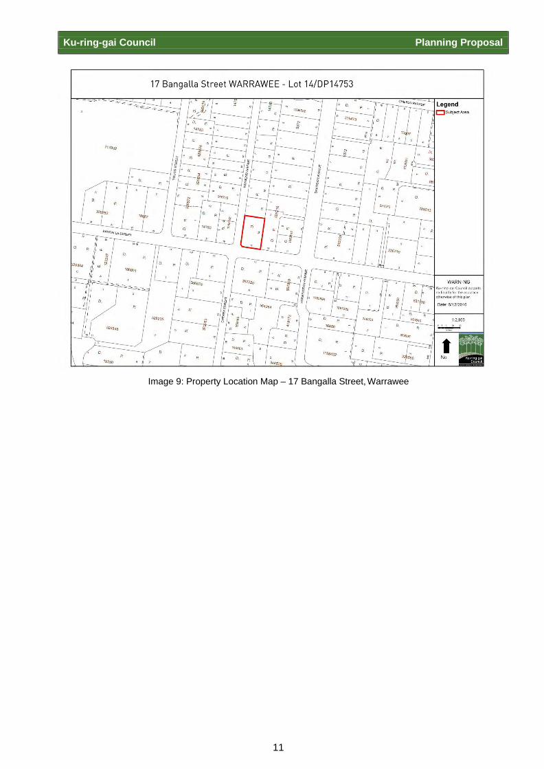
Image 11: Aerial Photo – 17 Bangalla Street, Warrawee

Ku-ring-gai Council Planning Proposal
14
Image 12: Façade and driveway facing Raymond Avenue – 17 Bangalla Street, Warrawee
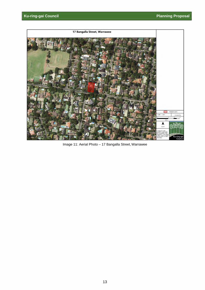
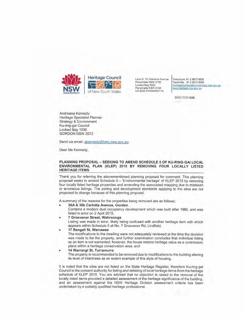
14 Warrangi Street, Turramurra 14 Warrangi Street, Turramurra (Lot 2, DP 542710) is located off Pacific Highway to the north in an
R2 Low Density Residential Zone under the KLEP 2015. The site is located within 20m of a R3
Medium Density Residential Zone and within 35m of an R4 High Density Residential Zone (see
Image 14: Property Zoning Map).
The front section of the house is single storey with a first floor addition to the rear of the property.
The property is described in the State Heritage Inventory sheet (Appendix F) as being of the Inter-
War development style and was listed on 2 April 2015. The site has some mature trees and
plantings at the front of the property and has retained the front grass lawn and original setback
area from the street.
The property has undergone extensive modifications to original fabric from 1986 onwards, as well
as a subdivision of the original lot in the 1970s to create a rear battle-axe block. The property is
considered to be listed in error after modifications occurring in 1986, 1993 and 2000. From the
Council report:
Ku-ring-gai Council Planning Proposal
15
The house was listed due to its significance for its ‘contribution to the streetscape character of the
area and as an intact example of an Inter-War Californian Bungalow with Art Nouveux details.’
The property is recommended to be removed due to modifications to the building altering its level
of intactness as an extant example of this style of housing. Changes to the building have enlarged
the size and scale of the building from its original ‘modest’ form. Modifications include a first floor
addition to the rear of the property that is visible from the street, construction of non-original bay
windows, bathroom renovations and the addition of a swimming pool.
The State Heritage Inventory sheet also cites the dwellings importance to the streetscape
character of the area, however substantial development to surrounding dwellings has occurred,
especially south of the dwelling towards Pacific Highway in areas zoned R3 and R4. In effect, this
change has eroded the aesthetic and historical significance of the immediate area and the
dwelling’s contribution within it.
Image 13: Property Location Map – 14 Warrangi Street, Turramurra

Ku-ring-gai Council Planning Proposal
16
Image 14: Property Zoning Map – 14 Warrangi Street, Turramurra

Ku-ring-gai Council Planning Proposal
17
Image 15: Aerial Photo – 14 Warrangi Street, Turramurra

Ku-ring-gai Council Planning Proposal
18
Image 16: Front façade and driveway – 14 Warrangi Street, Turramurra

Ku-ring-gai Council Planning Proposal
19
PART 1 – OBJECTIVE AND INTENDED OUTCOMES
A statement of the objectives and intended outcomes of the proposed instrument
The objective of this Planning Proposal is to remove the following four properties as items of local heritage significance from the KLEP 2015:
1. 36 Carlotta Avenue, Gordon (Lot B, DP 366349);
2. 7 Grosvenor Street, Wahroonga (Lot D, DP 330058);
3. 17 Bangalla Street, Warrawee (Lot 14, DP 14753);
4. 14 Warrangi Street, Turramurra (Lot 2, DP 542710). The zoning and development standards applying to the site are not proposed to change as a result
of this Planning Proposal.

Ku-ring-gai Council Planning Proposal
20
PART 2 – EXPLANATION OF PROVISIONS
An explanation of the provisions that are to be included in the proposed instrument
This Planning Proposal seeks to amend Schedule 5 Environmental Heritage of the KLEP 2015 by
removing four items from the list, which currently appear as follows:
Suburb Item Name Address Property Description
Significance Item No.
Gordon Dwelling house
36 Carlotta Avenue
Lot B, DP 366349
Local I184
Wahroonga “Edelstein”, dwelling house
7 Grosvenor Street
Lot D, DP 330058
Local I933
Warrawee Dwelling house
17 Bangalla Street
Lot 14, DP 14753
Local I1016
Turramurra Dwelling house
14 Warrangi Street
Lot 2, DP 542710
Local I803
This Planning Proposal will result in the amendment to the following maps:
Ku-ring-gai Local Environmental Plan 2015 – Heritage Map – Sheet HER_006 by removing the
colouring from the subject property at 7 Grosvenor Street, Wahroonga and the subject property at
17 Bangalla Street, Warrawee to indicate these sites are not Items.
Ku-ring-gai Local Environmental Plan 2015 – Heritage Map – Sheet HER_007 by removing the
colouring from the subject property at 14 Warrangi Street, Turramurra to indicate the site is not an
Item.
Ku-ring-gai Local Environmental Plan 2015 – Heritage Map – Sheet HER_013 and
Ku-ring-gai Local Environmental Plan 2015 - Heritage Map - Sheet HER_014 by removing the
colouring from the subject property at 36 Carlotta Avenue, Gordon to indicate the site is not an
item.
Ku-ring-gai Council Planning Proposal
16
PART 3 - JUSTIFICATION
The justification for those objectives, outcomes and the process for their implementation
A. Need for the planning proposal
Q1. Is the planning proposal a result of any strategic study or report?
The four properties erroneously listed in Schedule 5 of the KLEP 2015 have been
investigated by Council staff and considered inadequate against the corresponding
Heritage Inventory Sheets. The Heritage Inventory Sheets for the properties are
included in Appendix C - F.
Q2. Is the planning proposal the best means of achieving the objectives or intended outcomes, or is there a better way?
Yes. A local heritage listing conserves and protects sites that have been assessed as
satisfying the NSW Heritage Council’s Criteria for local heritage significance. These
four properties do not satisfy this criteria and therefore a Planning Proposal is the best
means of removing the listings from Schedule 5 of the KLEP.
B. Relationship to strategic planning framework
Q3. Is the planning proposal consistent with the objectives and actions of the applicable regional or sub-regional strategy (including the Sydney Metropolitan Strategy and exhibited draft strategies)?
The relevant regional strategy is “A Plan for Growing Sydney” (December 2014). The
Planning Proposal is assessed against the four goals contained within the strategy
below:
Goal 1 - A competitive economy with world class services and transport
The Planning Proposal will not adversely impact on the directions and actions identified
in the strategy to achieve a competitive economy and transport system.
Goal 2 – A city of housing choice, with homes that meet our needs and lifestyles
This Planning Proposal will have no impact on Ku-ring-gai’s ability to meet the housing
and employment targets and accordingly, the Planning Proposal is not inconsistent with
this goal.
Goal 3 – A great place to live with communities that are strong, healthy and well-
connected

Ku-ring-gai Council Planning Proposal
17
This Planning Proposal will not adversely impact on the directions and actions
identified in the in the strategy.
Goal 4 – A sustainable and resilient city that protects the natural environment and has
a balanced approach to the use of land and resources
The Planning Proposal will not adversely impact on the directions and actions identified
regarding the natural environment and sustainability.
The relevant draft district plan this planning proposal addresses is both the “Draft North District Plan” (November 2016) and the “Revised Draft North District Plan- connecting communities” (October 2017)
Under the Draft North District Plan, Liveability Priority 7: Conserve heritage and unique
local characteristics, requires relevant planning authorities to protect “aboriginal,
cultural and natural heritage and places, spaces and qualities valued by the local
community”. The planning proposal is not inconsistent with this priority as the 4
properties to be removed from Schedule 5 of the KLEP 2015 as these properties are
not considered to merit heritage listing. This will maintain the integrity of the heritage
listings in Schedule 5 to be those only of true local heritage significance assessed
against criteria from the NSW Heritage Council.
Under the Revised Draft North District Plan Planning Priority N6 “creating and
renewing great places and local centres, and respecting the District’s heritage”. By
ensuring that Ku-ring-gai’s heritage schedule reflects accurately those places
recommended for inclusion on the heritage list this planning proposal reinforces the
Local Environmental Plan as a robust and defendable planning instrument further
strengthening the protection of Ku-ring-gai’s heritage.
Q4. Is the planning proposal consistent with a council’s local strategy or other local strategic plan?
The Ku-ring-gai Community Strategic Plan is called “Our Community. Our Future.
Community Strategy 2030”. The Planning Proposal is consistent with the following
objectives within the community strategic plan:
P1.1 Ku-ring-gai’s unique visual character and identity is maintained
P2.1 A robust planning framework is in place to deliver quality design outcomes and
maintain the identity and character of Ku-ring-gai
P5.1 Ku-ring-gai’s heritage is protected, promoted and responsibly managed
The Planning Proposal is also consistent with the following aims of the KLEP 2015:

Ku-ring-gai Council Planning Proposal
18
(a) To guide the future development of land and the management of environmental,
social, economic, heritage and cultural resources within Ku-ring-gai
(f) To recognise, protect and conserve Ku-ring-gai’s indigenous and non-indigenous
cultural heritage
The planning proposal is not inconsistent with these objectives as the 4 properties to be removed
from Schedule 5 of the KLEP 2015 as these properties are not considered to merit heritage listing.
This will maintain the integrity of the heritage listings in Schedule 5 to be those only of true local
heritage significance assessed against criteria from the NSW Heritage Council.
Ku-ring-gai Council Planning Proposal
19
Q5. Is the planning proposal consistent with applicable State Environmental Planning Policies?
The following table identifies the key applicable SEPPs and outlines this Planning
Proposal’s consistency with those SEPPs.
SEPP Comment on Consistency
SEPP 55 Remediation of Land
Consistent. The planning proposal does not seek to change the permissible land uses on the sites subject to the planning proposal.
SEPP (Housing for Seniors or People with a Disability) – 2004
Consistent. The Planning Proposal is consistent with the aims of the policy.
SEPP Infrastructure 2007 Consistent. The Planning Proposal is consistent with the aims of the policy.
SEPP Affordable Rental Housing 2009
Consistent. The Planning Proposal is consistent with the aims of the policy.
SEPP Exempt and Complying Development Codes 2008
Consistent. The Planning Proposal is consistent with the aims of the policy.
SREPP Comment on Consistency
SYDNEY REP 20 Hawkesbury-Nepean River
Consistent. The Planning Proposal is consistent with the aims of the policy and will have no adverse impacts on the Hawkesbury-Nepean River.
SYDNEY REP (Sydney Harbour Catchment) 2005
Consistent. The Planning Proposal is consistent with the aims of the policy and will have no adverse impacts on the Sydney Harbour Catchment.

Ku-ring-gai Council Planning Proposal
20
Q6. Is the planning proposal consistent with applicable Ministerial Directions (s.117 directions)?
The following table identifies applicable Section 117 Directions and outlines this
Planning Proposal’s consistency with those Directions.
Directions under S117
Objectives
Consistency
2. ENVIRONMENT AND HERITAGE
2.3 Heritage Conservation
The objective of this direction is to conserve items, areas, objects and places of environmental Heritage significance and indigenous heritage significance.
Consistent. The Planning Proposal is consistent with this direction as heritage listings made in error will be corrected, maintaining the integrity of the heritage listings in Schedule 5 to be those only of true local heritage significance assessed against criteria from the NSW Heritage Council.
3. HOUSING, INFRASTRUCTURE AND URBAN DEVELOPMENT
3.1 Residential Zones
The objectives of this direction are: (a) to encourage a
variety and choice of housing types to provide for existing and future housing needs,
(b) to make efficient use of existing infrastructure and services and ensure that new housing has appropriate access to infrastructure and services, and
(c) to minimise the impact of residential development on the environment and resource lands.
Consistent. The Planning Proposal relates to an established dwelling, and in this regard will have no effect on the housing choice, infrastructure or environment.
3.3 Home Occupations
The objective of this direction is to encourage the carrying out of low- impact small businesses in dwelling houses.
Consistent. The Planning Proposal does not preclude the carrying out of a home occupation.
6. LOCAL PLAN MAKING

Ku-ring-gai Council Planning Proposal
21
Directions under S117
Objectives
Consistency
Approval and Referral Requirements
The objective of this direction is to ensure that LEP provisions encourage the efficient and appropriate assessment of development.
Consistent. The Planning Proposal will not result in the requirement for concurrence, consultation or referral of a future development application to a Minister or public authority as a result of the proposed removal of a local heritage listing.
7. METROPOLITAN PLANNING
7.1 Implementation of the Metropolitan Strategy
The objective of this direction is to give legal effect to the vision, land use strategy, policies, outcomes and actions contained in the Metropolitan Strategy.
Consistent. The Planning Proposal will not adversely affect the directions and actions outlined in the strategy to achieve the four goals relating to economy, housing, environment and community.
Ku-ring-gai Council Planning Proposal
22
C. Environmental, social and economic impact
Q7. Is there any likelihood that critical habitat or threatened species, populations or ecological communities, or their habitats, will be adversely affected as a result of the proposal?
The Planning Proposal will not adversely impact any critical habitat, threatened
species, populations or ecological communities, or their habitats as a result of the
removal of the heritage listings.
Q8. Are there any other likely environmental effects as a result of the planning proposal and how are they proposed to be managed?
There are no environmental effects envisaged as a result of the removal of heritage
listings proposed by the Planning Proposal.
Q9. Has the planning proposal adequately addressed any social and economic effects?
The Planning Proposal has no expected social or economic effects.
D. State and Commonwealth interests
Q10. Is there adequate public infrastructure for the planning proposal?
The Planning Proposal relates to the removal of heritage listings of established
buildings. No additional demand for public infrastructure is anticipated as a
consequence.
Q11. What are the views of state and Commonwealth public authorities consulted in accordance with the Gateway determination?
Council will consult with any agencies nominated by the Department of Planning and
Environment as part of the requirements of the Gateway Determination.
Council has already undertaken agency consultation with the Office of Environment and
Heritage (OEH). noted that:
“no objection is raised to the removal of the locally listed items provided a detailed
assessment of the heritage significance of the building, and an assessment against the

Ku-ring-gai Council Planning Proposal
23
NSW Heritage Division assessment criteria has been undertaken by a suitably qualified
heritage professional”. The comments from OEH be seen at Appendix G.
In response to this requirement experienced and qualified staff undertook a heritage
assessment of 7 Grosvenor Street Wahroonga. This assessment can be found at
Attachment D.

Ku-ring-gai Council Planning Proposal
24
PART 4 - MAPPING
Maps, where relevant, to identify the intent of the planning proposal and the area to which it applies
This Planning Proposal will result in the amendment to the following KLEP 2015 map sheets:
• Ku-ring-gai Local Environmental Plan 2015 – Heritage Map – Sheet HER_006 The subject property at 7 Grosvenor Street, Wahroonga and the subject property at 17 Bangalla
Street, Warrawee will have no colouring to indicate these sites are not Items.
Image 17: Existing KLEP 2015 Heritage Map Sheet- Sheet HER_006

Ku-ring-gai Council Planning Proposal
25
Image 18: Proposed KLEP 2015 Heritage Map Sheet- Sheet HER_006

Ku-ring-gai Council Planning Proposal
26
Image 19: Proposed KLEP 2015 Heritage Map Sheet- Sheet HER_006 showing 7 Grosvenor Street Wahroonga not identified as a heritage item
Image 20: Proposed KLEP 2015 Heritage Map Sheet- Sheet HER_006 showing 17 Bangalla Street Warrawee not identified as a heritage item
Ku-ring-gai Council Planning Proposal
27
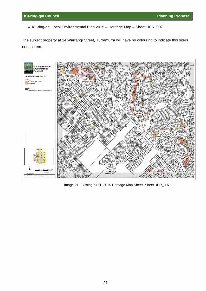
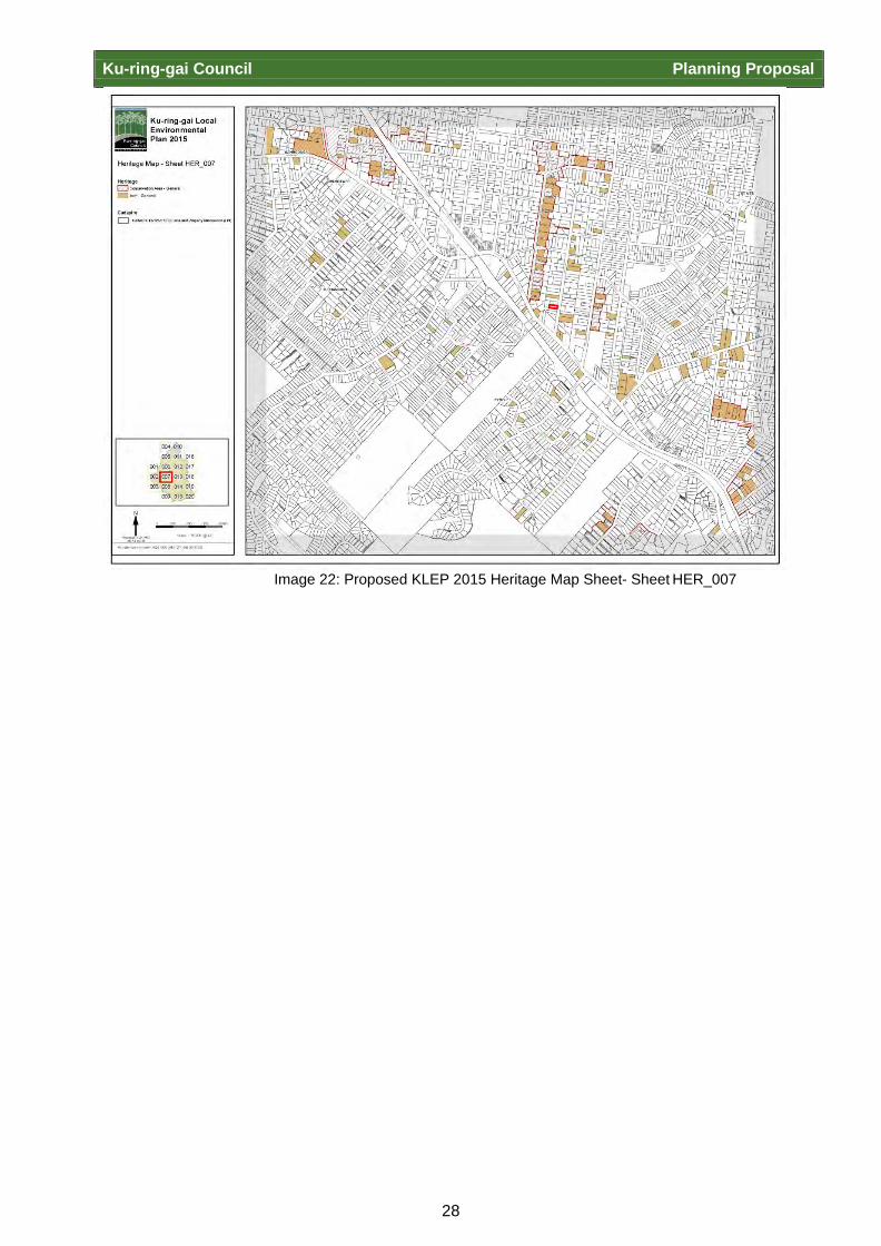
• Ku-ring-gai Local Environmental Plan 2015 – Heritage Map – Sheet HER_007 The subject property at 14 Warrangi Street, Turramurra will have no colouring to indicate this site is
not an Item.
Image 21: Existing KLEP 2015 Heritage Map Sheet- Sheet HER_007
Ku-ring-gai Council Planning Proposal
28
Image 22: Proposed KLEP 2015 Heritage Map Sheet- Sheet HER_007

Ku-ring-gai Council Planning Proposal
29
Image 23: Proposed KLEP 2015 Heritage Map Sheet- Sheet HER_007 showing 14 Warrangi Street Turramurra not identified as a heritage item
• Ku-ring-gai Local Environmental Plan 2015 – Heritage Map – Sheet HER_013 and
• Ku-ring-gai Local Environmental Plan 2015 - Heritage Map - Sheet HER_014 The subject property at 36 Carlotta Avenue, Gordon will have no colouring to indicate the site is not
an Item.

Ku-ring-gai Council Planning Proposal
30
Image 24: Existing KLEP 2015 Heritage Map Sheet- Sheet HER_013
Image 25: Proposed KLEP 2015 Heritage Map Sheet- Sheet HER_013

Ku-ring-gai Council Planning Proposal
31
Image 26: Existing KLEP 2015 Heritage Map Sheet- Sheet HER_014
Image 27: Proposed KLEP 2015 Heritage Map Sheet- Sheet HER_014

Ku-ring-gai Council Planning Proposal
32
Image 28: Proposed KLEP 2015 Heritage Map – Sheet HER_013 and Sheet HER_014 showing 36 Carlotta Avenue Gordon not identified as a heritage item

Ku-ring-gai Council Planning Proposal
33
PART 5 – COMMUNITY CONSULTATION
Details of the community consultation that is to be undertaken on the planning proposal Community Consultation for this Planning Proposal will be consistent with the requirements of the
Gateway Determination and the consultation guidelines contained in the Department of Planning
and Environments “A Guide to Preparing Local Environmental Plans” (August 2016). The Planning
Proposal is considered to be a ‘low impact’ proposal in accordance with the requirements set out in
“A guide to preparing local environmental plans” and should be subject to a 14 day public
exhibition period.
Public exhibition of the Planning Proposal is generally undertaken in the following manner:
• Notification in a newspaper that circulates the area affected by the Planning Proposal
• Notification on Council’s website
• Notification in writing to the affected and adjoining land owners During the exhibition period, the following material is made available for viewing:
• Planning Proposal
• Gateway Determination
• Information relied upon by the Planning Proposal (e.g. reports)
At the conclusion of the public exhibition, a report will be prepared and reported back to Council to
allow for the consideration of any submissions received from the community.
Ku-ring-gai Council Planning Proposal
34
PART 6 – PROJECT TIMELINE
Stage Timing
Anticipated commencement date (date of Gateway determination) December 2017
Timeframe for government agency consultation (pre and post exhibition as required by Gateway determination)
January-February 2018 21 days
- Run concurrently with exhibition period.
Commencement and completion dates for public exhibition period 5 February 2018 – 19 February 2018
14 days
Post exhibition review and reporting March 2018
Council meeting / consideration March 2018
Legal Drafting LEP April 2018
Anticipated date RPA will make the plan (if delegated) May 2018
Notification of Plan on Legislation website May 2018

Ku-ring-gai Council Page 1

31
APPENDIX A – Report to Council - Correction to Schedule 5 of KLEP 2015
Ku-ring-gai Council Planning Proposal

Ordinary Meeting of Council - 22 November 2016 GB.11 / 1
Item GB.11 S10051 26 October 2016
CORRECTION TO SCHEDULE 5 OF KLEP 2015
EXECUTIVE SUMMARY
OF REPORT: For Council to consider amendments to Schedule 5 of the KLEP 2015 to correct erroneous heritage listings.
BACKGROUND:
Local heritage items are identified, assessed and managed by Council and are listed under Schedule 5 of the LEP. Four items on the KLEP 2015 have been identified by Council as not being of local significance due to erroneous listing or through gradual modification over time rendering their heritage significance insufficient to merit their listing.
COMMENTS:
Four Local heritage items have been identified as demonstrating insufficient heritage significance to merit their presence on the local heritage schedule of the KLEP 2015. Some properties have been gradually and extensively altered and modified over time. Subdivision of heritage lots and demolition of original properties are also reasons for heritage items to be removed.
RECOMMENDATION:
That Council prepare a Planning Proposal to amend Schedule 5 of the KLEP 2015 to correct erroneous listings.

Ordinary Meeting of Council - 22 November 2016 GB.11 / 2
Item GB.11 S10051 26 October 2016
PURPOSE OF REPORT For Council to consider amendments to Schedule 5 of the KLEP 2015 to correct erroneous heritage listings.
BACKGROUND
Local heritage items are identified, assessed and managed by Council and are listed under Schedule 5 of the Ku-ring-gai Local Environmental Plan (KLEP) 2015. Four items on the KLEP 2015 have been identified by Council as not being of local significance due to erroneous listing or through gradual developmental change over time.
COMMENTS
Four heritage items on the KLEP 2015 are identified as requiring consideration for removal from Schedule 5 of the KLEP 2015.
Some of these properties have been gradually and extensively altered and modified over time, and should be re-assessed as to their heritage significance. Other heritage properties have undergone subdivision, producing an inaccurate listing on the second lot not containing the listed item. Demolition of original fabric and mapping error are also reasons for heritage items to be removed.
Documentation supporting the removal of these items is included in Attachment A1.
The heritage items to be considered are listed below:
• 36 Carlotta Avenue, Gordon (Lot B, DP 366349) included in Schedule 5 as a heritage item of local significance;
• “Edelstein” 7 Grosvenor Street, Wahroonga (Lot D, DP 330058) included in Schedule 5 as a heritage item of local significance;
• 17 Bangalla Street, Warrawee (Lot 14, DP 14753) included in Schedule 5 as a heritage item of local significance;
• 14 Warrangi Street, Turramurra (Lot 2, DP 542710) included in Schedule 5 as a heritage item of local significance.
Reasons for the removal are supplied in the table below.
Address Discussion
36A and 36B Carlotta Avenue, Gordon
The heritage listing was attributed to an earlier dwelling on this site, however this item was demolished after 1992 and the listing was not removed from the State Register or Councils LEP. See the State Heritage Inventory at Attachment A2. There is currently a modern dual occupancy on this site.
7 Grosvenor Street, Wahroonga No data sheet can be located for this property in Council’s records. This is considered an erroneous listing potentially being confused with the listed 7 Grosvenor Road, Lindfield.

Ordinary Meeting of Council - 22 November 2016 GB.11 / 3
Item GB.11 S10051 26 October 2016
Address Discussion
The house would be considered contributory within a heritage conservation area.
17 Bangalla Street, Warrawee This property was first listed on 2 April 2015 when the KLEP 2015 came into effect. The property was listed after a faux heritage addition to the property had been made in 1988. Further review concludes that the listing is not warranted.
In 1988 the house had a substantial addition in a faux heritage style. The change from original to new build is evident in the change of brick, the quality of the tuck pointing (better in the original brickwork) and the use of wooden shingles on the new elements of the house (e.g. dormer). What is still evident of the original house illustrates a higher design quality that is a well-considered building in proportion, scale and architectural detailing.
The integrity of the fabric and the design have been compromised by changes and it is not considered to have retained its aesthetic significance, see the Heritage Inventory form at Attachment A3.
The house has a level of protection through HCA controls as it is located in the Warrawee Conservation Area (C3).
14 Warrangi Street, Turramurra This property was first listed on 2 April 2015 when the KLEP 2015 came into effect. The property is considered to be listed in error after extensive modifications had occurred in 1986, 1993 and 2000, including a subdivision at the rear of the property in 1970.
The house was listed due to its significance for its ‘contribution to the streetscape character of the area and as an intact example of an Inter- War Californian Bungalow with Art Nouveux details.’ See Attachment A4.
The property is recommended to be removed due to modifications to the building altering its level of intactness as an extant example of this style of housing. Changes to the building have enlarged the size and scale of the building from its original ‘modest’ form. Modifications include a first floor addition to the rear of the property that is visible from the street, construction of non-original bay windows, bathroom renovations and the addition of a swimming pool.
Also, this house is not situated in a HCA, therefore the streetscape character is not considered to be highly significant to Council. Substantial development to surrounding dwellings has occurred in the immediate area, further minimising the aesthetic and historical significance of the streetscape character and the dwelling’s contribution within it.
Ordinary Meeting of Council - 22 November 2016 GB.11 / 4
Item GB.11 S10051 26 October 2016
INTEGRATED PLANNING AND REPORTING
Heritage conservation
Community Strategic Plan Long Term Objective
Delivery Program Term Achievement
Operational Plan Task
Strategies, plans and processes are in place to effectively protect and preserve Ku-ring-gai’s heritage assets
Implement, monitor and review Ku-ring-gai’s heritage planning provisions
Identify gaps in existing strategies and plans
GOVERNANCE MATTERS
Any amendments to a Local Environmental Plan require the preparation of a Planning Proposal in accordance with s55 of the Environmental Planning and Assessment Act, 1979. Once prepared, a gateway determination must be issued under s56 of the Act before the planning proposal can be released for public consultation.
This report addresses the first stage in obtaining a gateway for a planning proposal which seeks to amend Schedule 5 of the KLEP 2015 to remove the erroneous listings. If the planning proposal is supported by the Department, the draft plan will be placed on exhibition seeking further State agency and stakeholder feedback prior to being reported back to Council.
Council will seek the plan-making delegation under Section 23 of the EP&A Act to finalise the Planning Proposal. This involves Council taking on the Director General’s function under s59(1) of the Act in liaising with the Parliamentary Counsel’s Office (PCO) to draft the required local environmental plan to give effect to the Planning Proposal as well the Minister’s function under s59(2) of the Act in making the Plan.
RISK MANAGEMENT
Council is responsible for the identification and management of Ku-ring-gai’s Local Cultural Heritage. Council now is in a position to make a formal determination on whether the planning proposal should be formally submitted to the Department of Planning & Infrastructure requesting a gateway determination for the removal of four local heritage listings.
FINANCIAL CONSIDERATIONS
The costs associated with this matter are covered by the Strategy and Environment Department - Urban Planning and Heritage budget. Additional costs may be incurred for any further heritage assessment of the sites.
SOCIAL CONSIDERATIONS
Ku-ring-gai Council is responsible for the identification and management of Ku-ring-gai’s local cultural heritage. Consideration of this matter will assist in meeting its requirements to identify and protect items of true local cultural heritage significance.

Ordinary Meeting of Council - 22 November 2016 GB.11 / 5
Item GB.11 S10051 26 October 2016
ENVIRONMENTAL CONSIDERATIONS
Ku-ring-gai Council is responsible for the identification and management of Ku-ring-gai’s environmental heritage. Consideration of this matter will assist in meeting its requirements to identify and protect items of local cultural heritage significance.
COMMUNITY CONSULTATION
Should the Planning Proposal receive a favourable Gateway Determination, it will be exhibited in accordance with the Department’s Gateway Determination requirements. This will involve appropriate notification and receipt of submissions on the draft plan from the relevant State agencies and the general community and a further report back to Council.
INTERNAL CONSULTATION
Where relevant the Planning Proposal has been referred to relevant internal sections of Council.
SUMMARY
Four heritage items have been identified as erroneous listing, and demonstrating insufficient heritage significance to merit their presence as Local heritage items on the KLEP 2015. It is recommended that Council consider their removal.
RECOMMENDATION:
A. That a Planning Proposal be prepared, in accordance with section 55 of the Environmental
Planning and Assessment Act, 1979, to amend the Ku-ring-gai Local Environmental Plan 2015 to remove the following properties from Schedule 5:
• 36A and 36B Carlotta Avenue, Gordon (Lot B, DP 366349); • “Edelstein” 7 Grosvenor Street, Wahroonga (Lot D, DP 330058); • 17 Bangalla Street, Warrawee (Lot 14, DP 14753); • 14 Warrangi Street, Turramurra (Lot 2, DP 542710).
B. That the Planning Proposal be submitted to the Department of Planning and
Infrastructure for a Gateway Determination in accordance with Section 56 of the Environmental Planning and Assessment Act, 1979.
C. That Council request the plan-making delegation under Section 23 of the EP&A Act for
this planning proposal. D. That upon receipt of a Gateway Determination, the exhibition and consultation process is
carried out in accordance with the requirements of the Environmental Planning and Assessment Act, 1979 and with the Gateway Determination requirements.
E. That a report be brought back to Council at the end of the exhibition processes.

Andreana Kennedy Heritage Specialist Planner
Antony Fabbro Manager Urban & Heritage Planning
Louisa McMullan Assistant Heritage Planner
Deborah Silva Acting Director Strategy & Environment
Attachments: A1 Removal heritage items from KLEP 2015 - Summary 2016/251362 A2 36 Carlotta Ave Gordon - SHI heritage inventory sheet data form -
Moore and Pike 1989 2014/003546
A3 SHI form - 17 Bangalla Street Warrawee 2016/006767 A4 14 Warrangi Street Turramurra - SHI - Heritage Inventory Sheet -
Perumal Murphy Alessi 2006 2013/232757
APPENDIX B – Council Resolution on 22 November 2016
Ku-ring-gai Council Planning Proposal
312 Correction to Schedule 5 of KLEP 2015
File: S10051 Vide: GB.11
For Council to consider amendments to Schedule 5 of the KLEP 2015 to correct erroneous heritage listings.
Resolved: (Moved: Councillors McDonald/Szatow) A. That a Planning Proposal be prepared, in accordance with section 55 of the
Environmental Planning and Assessment Act, 1979, to amend the Ku-ring-gai Local Environmental Plan 2015 to remove the following properties from Schedule 5: • 36A and 36B Carlotta Avenue, Gordon (Lot B, DP 366349); • “Edelstein” 7 Grosvenor Street, Wahroonga (Lot D, DP 330058); • 17 Bangalla Street, Warrawee (Lot 14, DP 14753); • 14 Warrangi Street, Turramurra (Lot 2, DP 542710).
B. That the Planning Proposal be submitted to the Department of Planning and
Infrastructure for a Gateway Determination in accordance with Section 56 of the Environmental Planning and Assessment Act, 1979.
C. That Council request the plan-making delegation under Section 23 of the EP&A Act for this planning proposal.
D. That upon receipt of a Gateway Determination, the exhibition and consultation
process is carried out in accordance with the requirements of the Environmental Planning and Assessment Act, 1979 and with the Gateway Determination requirements.
E. That a report be brought back to Council at the end of the exhibition processes.
CARRIED UNANIMOUSLY

APPENDIX C – State Heritage Inventory sheet – 36 Carlotta Avenue, Gordon
32
Ku-ring-gai Council Planning Proposal

CJ
HERITAGE STUDY OF THE MUNICIPALITY OF KU-RING-GAI Item Number
Map :,2.. No: ct.z... Address:3 1, CAC-0 TT,,.:J Land Title K.M .C.
( f I Name : J
!owner :/'r
I '-- l
K .M.C. / t,
Description, History K.M.C . Period
O Pre -1900 D 1901-1920 C8 1921-1940 D 1941-1960 D 1961-1986
Context
D Primary Industry CJ .Key Residences
- Suburban Consolidation
D Utilities Infrastructure
PCommercial Development
R-e_f_e_r_e_n_c_e_s community Services D Education
Significance
Reasons for listing in this Study D State Cia Municipal
"CJ historic []archaeological []rarity value Integrity CJ scientific EZJ
cultural c:::l architectural natural
Dgroup value Dlandmark value G2l Substantially
D social D aesthetic Intact r c::J Altered or extended
.t>hotograph Film No. f Neg. No .· /;t syrnpathetically D Altered or extended
unsympathetically
Other Listings
CJ.National Estate NSW Heritage Act
[:JPCO 0ICO D Section 130 DNational Trust Lists D.Local History
Sources DLEP/DCP CJRAIA Dother
Prepared for KU -RING-GA I MUNICIPAL COUNCIL by ROBERT MOORE, PENELOPE PIKE, HELEN PROUDFOOT and ESTER TROPMAN & ASSOCIATES,
Conservation Consultants in Association
Date of Survey: By: Checked: 2·fy..
Ku-ring-gai Council Planning Proposal
12
APPENDIX D – State Heritage Inventory sheet – 7 Grosvenor Street Wahroonga

13
Ku-ring-gai Council Planning Proposal
ITEM DETAILS Name of Item
Edelstein
Other Name/s Former Name/s
Item type (if known)
Built
Item group (if known)
Dwelling
Item category (if known)
Area, Group, or Collection Name
Street number
7
Street name
Grosvenor Street
Suburb/town
Wahroonga Postcode 2076
Local Government Area/s
Ku-ring-gai
Property description
Lot D, DP 330058
Location - Lat/long
Latitude
Longitude
Location - AMG (if no street address)
Zone
Easting Northing
Owner
Private
Current use
Residential
Former Use
Residential
Statement of significance
The house has significance as the work and home of architect Maurice Mandelson. Mandelson worked for the Department of Public Works and the Chief Secretary’s Department as an architect from the 1920s to the 1940s, and served in an advisory capacity on the City of Sydney’s Building Advisory Committee. Edelstein is a representative example of the Inter-war Georgian Revival architecture style.
Level of Significance
State
Local

14
Ku-ring-gai Council Planning Proposal
DESCRIPTION Designer
Maurice Mandelson
Builder/ maker
W Dalley of Lindfield
Physical Description
Small single storey bungalow heavily influenced by the Georgian Revival style. It is a brick house with a rendered finish and hopped terracotta tiled roof. As a corner site the house is designed to present to the intersection Grosvenor Street and Braeside Street with an L-shaped floor plan that has bedrooms on one wing and the living room, dining room and kitchen on the other. The front façade includes multi-paned double hung windows with timber louvered shutters and a projecting flat roofed porch with Doric columns at one end of the house. The front garden path includes a feature circular garden bed which was present on the original plans. The floorplan is generally original with some minor alterations.
Physical condition and Archaeological potential
Good condition, limited archaeological potential
Construction years
Start year Finish year 1938 Circa
Modifications and dates
Modifications to the property (alts & adds) in 1992 and 1986. Addition of a swimming pool Addition of garage. En-suite to the master bedroom added in Other changes include the extension of the kitchen into what was the laundry; removal of a partial wall between the sitting room and the dining room, updating of the bathroom, kitchen and water closet, and raised garden beds around the front of the house.
Further comments
The site is located in a local Heritage Conservation Area called “Wahroonga Conservation Area” (C1).
15
Ku-ring-gai Council Planning Proposal
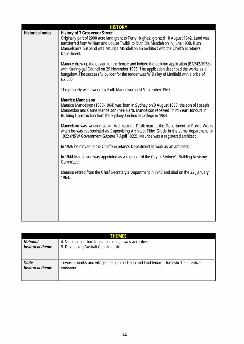
HISTORY Historical notes
History of 7 Grosvenor Street Originally part of 2000 acre land grant to Terry Hughes, granted 18 August 1842. Land was transferred from William and Louise Twibill to Ruth Ida Mandelson in June 1938. Ruth Mandelson’s husband was Maurice Mandelson an architect with the Chief Secretary’s Department. Maurice drew up the design for the house and lodged the building application (BA742/1938) with Ku-ring-gai Council on 29 November 1938. The application described the works as a bungalow. The successful builder for the tender was W Dalley of Lindfield with a price of £2,560. The property was owned by Ruth Mandelson until September 1967. Maurice Mandelson Maurice Mandelson (1883-1964) was born in Sydney on 9 August 1883, the son of Joseph Mandeslon and Carrie Mandelson (nee Hart). Mandelson received Third Year Honours in Building Construction from the Sydney Technical College in 1904. Mandelson was working as an Architectural Draftsman at the Department of Public Works when he was reappointed as Supervising Architect Third Grade in the same department in 1922 (NSW Government Gazette 7 April 1922). Maurice was a registered architect In 1926 he moved to the Chief Secretary’s Department to work as an architect. In 1944 Mandelson was appointed as a member of the City of Sydney’s Building Advisory Committee. Maurice retired from the Chief Secretary’s Department in 1947 and died on the 22 January 1964.
THEMES National historical theme
4. Settlement – building settlements, towns and cities 8. Developing Australia’s cultural life
State historical theme
Towns, suburbs and villages: accommodation and land tenure. Domestic life: creative endeavor
16
Ku-ring-gai Council Planning Proposal
APPLICATION OF CRITERIA
Historical significance SHR criteria (a)
Has minor historical significance for its contribution to understanding the pattern of subdivision and development in Ku-ring-gai.
Historical association significance SHR criteria (b)
The house was designed by architect Maurice Mandelson for himself and his family. The association of this house with the architect and the original design are well documented. Mandelson trained as an architect at the Sydney Technical College graduating in 1904. During his career Maurice worked as a registered architect for the Department of Public Works and the Chief Secretary’s Department. His expertise in the field was recognised in his appointment as an advisor to the City of Sydney’s Building Advisory Committee. Maurice retired from the Chief Secretary’s Department in 1947 and died on the 22 January 1964
Aesthetic significance SHR criteria (c)
Edelstein has aesthetic significance as an architecturally designed representative example of a single storey Inter-war Georgian Revival Style bungalow.
Social significance SHR criteria (d)
May have some minor social significance to local historians and architects as an architecturally designed example of a type.
Technical/Research significance SHR criteria (e)
Does not apply
Rarity SHR criteria (f)
Does not apply
Representativeness SHR criteria (g)
Edelstein is a representative example of a single storey Inter-war Georgian Revival Style bungalow.
Integrity
The overall integrity is good. The design integrity of building is good with only minor changes that are discernible as new.

17
Ku-ring-gai Council Planning Proposal
HERITAGE LISTINGS Heritage listing/s
Currently on schedule 5 of the Ku-ring-gai LEP 2015
INFORMATION SOURCES
Include conservation and/or management plans and other heritage studies. Type Author/Client Title Year Repository Newspaper
SMH, “Technical Education Branch: examination for 1904, first list of passes in Sydney and Country”, 6 January 1905, p.3.
1905 Trove
Newspaper
SMH, “Births” 6 September 1883, p.13.
1883 Trove
Land title
LPI Volume 4648 Folio 81 LPI
Journal
Construction and Local Government Journal – 12 April 1922
1922
Journal
Construction 8 November 1944
1944
RECOMMENDATIONS
Recommendations
Remove No. 7 Grosvenor Street, Wahroonga from the Schedule of Items of Heritage significance, of the Ku-ring-gai LEP 2015.
SOURCE OF THIS INFORMATION
Name of study or report
Planning Proposal to Correct Schedule 5 of the KLEP 20165 Year of study or report
2017
Item number in study or report
Author of study or report
Andreana Kennedy
Inspected by
Andreana Kennedy
NSW Heritage Manual guidelines used?
Yes * No
This form completed by
KMC (AK) Date

18
Ku-ring-gai Council Planning Proposal
IMAGES - 1 per page Please supply images of each elevation, the interior and the setting. Image caption
Front elevation of 7 Grosvenor Street Wahroonga
Image year
Image by Image copyright holder
Realestate.com

19
Ku-ring-gai Council Planning Proposal
IMAGES - 1 per page
Please supply images of each elevation, the interior and the setting. Image caption
Dining room and former study of 7 Grosvenor Street Wahroonga
Image year
Image by Image copyright holder
Realestate.com

20
Ku-ring-gai Council Planning Proposal
IMAGES - 1 per page Please supply images of each elevation, the interior and the setting. Image caption
Lounge of 7 Grosvenor Street Wahroonga
Image year
Image by Image copyright holder
Realestate.com
21
Ku-ring-gai Council Planning Proposal
IMAGES - 1 per page Please supply images of each elevation, the interior and the setting. Image caption
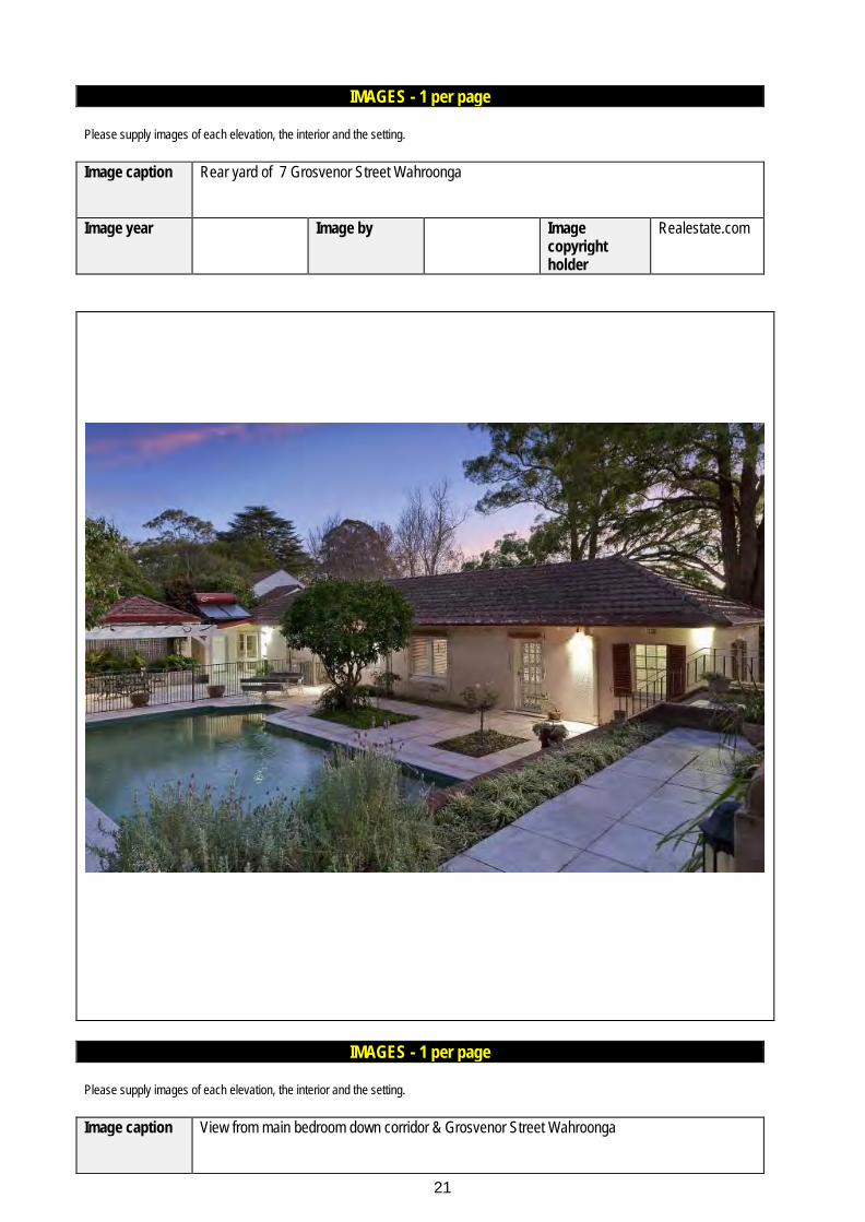
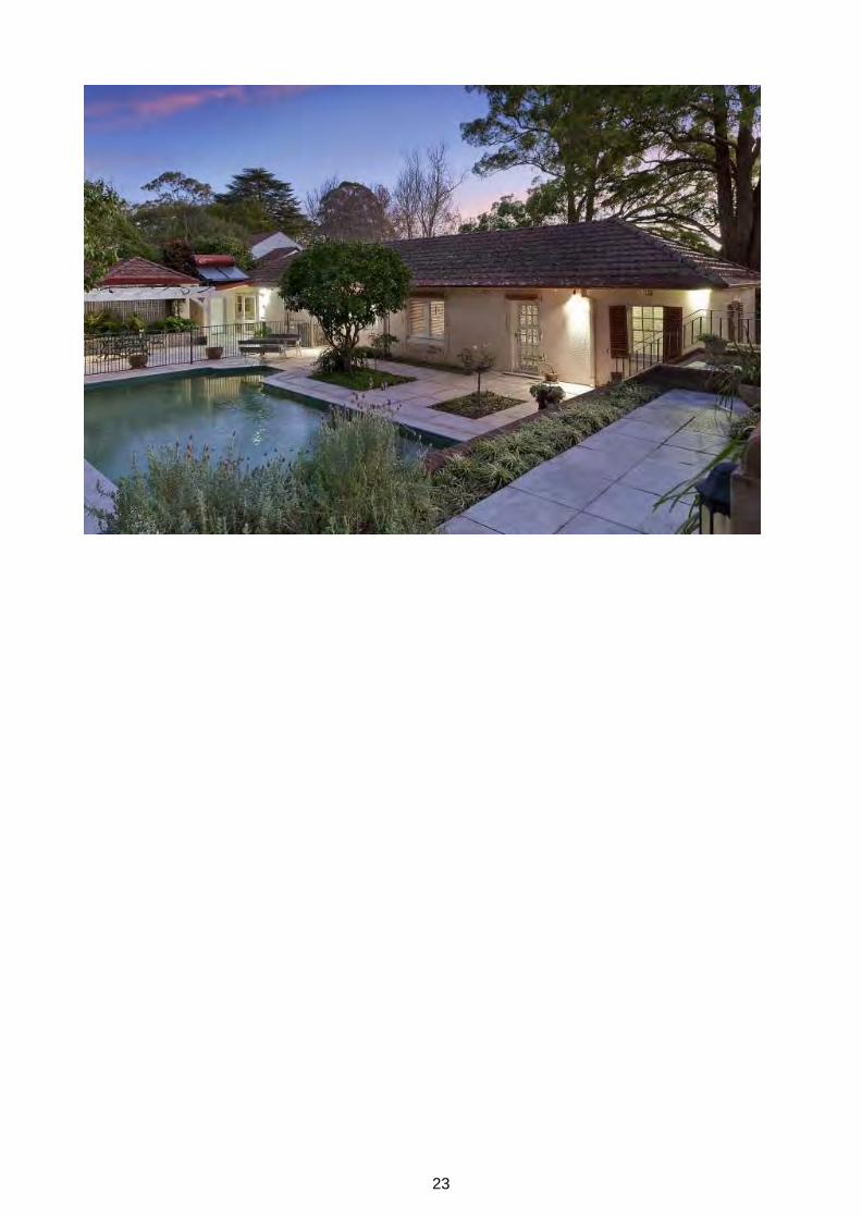
Rear yard of 7 Grosvenor Street Wahroonga
Image year
Image by Image copyright holder
Realestate.com
IMAGES - 1 per page Please supply images of each elevation, the interior and the setting. Image caption
View from main bedroom down corridor & Grosvenor Street Wahroonga

22
Ku-ring-gai Council Planning Proposal
Image year
Image by Image copyright holder
Realestate.com
23
Ku-ring-gai Council Planning Proposal
24
Ku-ring-gai Council Planning Proposal
APPENDIX E – State Heritage Inventory sheet - 17 Bangalla Street, Warrawee
Ku-ring-gai Council Planning Proposal

1
ITEM DETAILS Name of Item Roslyn
Other Name/s Former Name/s
Item type (if known)
Built
Item group (if known)
Item category (if known)
House
Area, Group, or Collection Name
Street number 17
Street name Bangalla Street (formerly Smith Street)
Suburb/town Warrawee (formerly Turramurra) Postcode 2076
Local Government Area/s
Ku-ring-gai
Property description
Lot 14 DP 14753
Location - Lat/long Latitude Longitude
Location - AMG (if no street address)
Zone Easting Northing
Owner Private
Current use Residential
Former Use Residential
Statement of significance
“Roslyn” at 17 Bangalla Street Warrawee has aesthetic significance as representative example of the transitional Federation bungalow style and retains early landscape elements including the curved front garden path.. It is representative of a second phase of subdivision and residential development of the Warrawee.
Level of Significance
State
Local

2
DESCRIPTION Designer Not known
Builder/ maker Not known
Physical Description
Roslyn at 17 Bangalla Street Warrawee was constructed in the Inter-war period but its architectural style is a Federation transitional bungalow with Arts and Craft influence. A sweeping gravel garden path leads to the front door of what was originally a single storey facebrick bungalow. The projecting front room features a gable with rough cast render and simple timber gable detailing, and a projecting tripane timber window frame with a small horizontal awning with exposed eaves. The main roof plane would have been large and simple but now includes a shingle clad dormer. The roof consists of not original terracotta tiles. The external chimney shaft is rough cast render with feature facebricks at the tip and dual terracotta vents pots. The deep, shady front verandah is supported by timber posts with exposed eaves. Another verandah to the side has battering which sweeps down from the base of the gable around the corner of the house.
Physical condition and Archaeological potential
Good condition.
Construction years Start year Finish year Circa
Modifications and dates
In 1988 the house had a substantial addition in a faux heritage style. The change from original to new build is evident in the change of brick, the quality of the tuck pointing (better in the original brickwork) and the use of wooden shingles on the new elements of the house (e.g. dormer). What is still evident of the original house illustrates a higher design quality that is a well-considered building in proportion, scale and architectural detailing. BA88/02793 – alts and adds BA96/012525 -new front fence
Further comments

3
HISTORY Historical notes The following history is summarised from the Ku-ring-gai Urban Conservation Area Study. Godden
Mackay Logan, 2002 and other primary sources.
The site is part of a 220 acre land grant provided to John Hugh Terry in 1942, although there is evidence of the land being used as early as 1815. At least part of this land was leased to Thomas Hyndes. In 1871 Terry’s estate, known as The Big Island Estate, was purchased by a syndicate of parliamentarians; John Fitzgerald Burns, George Withers and Robert Burdett Smith, with the intention of developing it. A portion of the estate, known as the Vanceville Estate (including the subject site) was subdivided for sale as orchard and market garden lots evidenced by a survey of the estate commissioned by Richardson and Wrench for their sale of the estate on the 22nd January 1876. The survey indicated at in 1876 Bangalla Street was known as Smith Street. The name of the street had changed to the present day ‘Bangalla Street’ by 1938 as this name appears on the Waterboard block plans from that date.
The North Shore railway line opened in 1890, however the Warrawee railway station was not constructed until 1900, after continual lobbying by local residents. The delay was due to the commissioners belief that the distance between Warrawee and its neighbouring stations was unjustifiably small.
Warrawee developed as an exclusively residential suburb, even after the arrival of the railway. The reason for the lack of commercial buildings was the resistance of the residents to any such developments. Warrawee has retained this non-commercial residential character through to the present day.
The existing house at 17 Bangalla Street, Warrawee occupies Lot 14 DP 14753. The house itself was built between 1933 and 1938. The range of dates are based upon the Sands register up to 1933 (building not present) and the October 1938 Water Board map which includes the house. The 1940 valuations have the owner as Muriel Edith Hay. Miss Muriel Sainty was listed as the owner of Noorong in the 1927 valuations. Sainty Reserve in Warrawee, between Young Street and Raymond Avenue was originally portion of the Joseph Sainty estate. Joseph Sainty was an early orchardist who established an orchard in Merrivale Road in 1870. His property later extended into Turramurra (what is now Warrawee).
The 1938 Water Board maps for the area show that a house was situated on the site, and the 1943 historical aerial confirms that a house of a similar scale and footprint as that on the 1938 water board plans is present.
State historical theme
THEMES National historical theme

4
APPLICATION OF CRITERIA
Historical significance SHR criteria (a)
Historical association significance SHR criteria (b)
Aesthetic significance SHR criteria (c)
The house has aesthetic significance as an example of the transitional Federation bungalow style.
Social significance SHR criteria (d)
Technical/Research significance SHR criteria (e)
Rarity SHR criteria (f)
Representativeness SHR criteria (g)
Integrity
Fair to poor

5
HERITAGE LISTINGS Heritage listing/s The property is within Warrawee Conservation Area -C3.
INFORMATION SOURCES
Include conservation and/or management plans and other heritage studies. Type Author/Client Title Year Repository
RECOMMENDATIONS
Recommendations
SOURCE OF THIS INFORMATION
Name of study or report
Year of study or report
Item number in study or report
Author of study or report
Inspected by
NSW Heritage Manual guidelines used? Yes No
This form completed by
Original unknown Updated AK - KMC 2015
Date

6
Image caption c1876 survey of Vanceville Estate auctioned off by Richardson & Wrench on the 22nd January 1876. Approximate location of 17 Bangalla Avenue, Warrawee (then known as Smith Street, Turramurra) indicated (Source: National Library of Australia)
Image year 1876 Image by Image copyright holder
IMAGES - 1 per page

7
Image caption Excerpt from Higginbotham and Robinson’s 1983 map of the Parish of Gordon, including what is now 17
Bangalla Street, Warrawee (Source: Ku-ring-gai Local Studies Library Map 994.41/KURI/1893).
Image year 1893 Image by Image copyright holder
KMC

8
Image caption Detail of the October 1938 water board map with the house on 17 Bangalla Street, Warrawee
approximately circled (Source: MWSB (Now Sydney Water)).
Image year 1938 Image by Image copyright holder
KMC

9
Image caption 1943 aerial photograph showing the site 17 Bangalla Street, Warrawee with existing development and surrounding residential context. Item indicated by red circle (Source: SIX Maps).
Image year 1943 Image by LPI Image copyright holder
LPI

10
Image caption 2013 aerial photograph showing the site 17 Bangalla Street, Warrawee with existing development and surrounding residential context. Item indicated by red circle.
Image year 2013 Image by Image copyright holder
KMC

11
Image caption 17 Bangalla Street Warrawee
Image year 2013 Image by KMC Image copyright holder
KMC

12
Image caption 17 Bangalla Street
Image year 2013 Image by KMC Image copyright holder
KMC

35
APPENDIX F – State Heritage Inventory sheet - 14 Warrangi Street, Turramurra
Ku-ring-gai Council Planning Proposal

A
ITEM DETAILS
Name of Item
Other Name/s Former Name/s
“Dell-Casa” (Sands Directory)
Item type (if known)
Built
Item group (if known)
Item category (if known)
House
Area, Group, or Collection Name
Street number 14
Street name Warrangi Street
Suburb/town Turramurra Postcode 2074
Local Government Area/s
Ku-ring-gai
Property descriptio
Lot 2 DP 542710
Location - Lat/long Latitude Longitude
Location - AMG (if no street address)
Zone Easting Northing
Owner Private
Current use Residence
Former Use Residence
Statement of significance
Significant for its contribution to the streetscape character of the immediate area and as a fine and largely intact example of a modest size Inter-War California Bungalow style residence with intact features and Art Nouveau stylistic detail.
The building is representative of the type and scale of dwelling which was the result of the Inter-War subdivision of the area into smaller allotments.
Level of Significance
State
Local
A
DESCRIPTION Designer -
Builder/ maker Assume WJ Brown
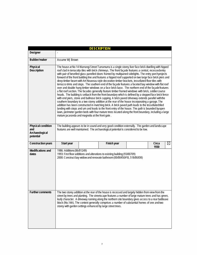
Physical Description
The house at No 14 Warrangi Street Turramurra is a single storey liver face brick dwelling with hipped roof clad in terracotta tiles with brick chimneys. The front façade features a central, recessed entry with pair of bevelled glass panelled doors framed by multipaned sidelights. The entry porch projects forward of the front building line and features a hipped roof supported on two large face brick piers and deep timber beam with Art Nouveau style decorative timber brackets, tessellated floor tiles with terrazzo trims and steps. The southern end of the façade features a faceted bay window with flat roof over and double hung timber windows on a face brick base. The northern end of the façade features a flat roof section. The facades generally feature timber framed windows with brick, soldier course heads. The building is setback from the front boundary which is defined by a stepped face brick fence with end piers, stone and bullnose brick capping. A brick paved driveway extends parallel with the southern boundary to a two storey addition at the rear of the house incorporating a garage. The addition has been constructed in matching brick. A brick paved path leads to the tessellated tiled landing with steps and urn and leads to the front entry of the house. The path is bounded by open lawn, perimeter garden beds with four mature trees located along the front boundary, including a large mature jacaranda and magnolia at the front gate .
Physical condition and Archaeological potential
The building appears to be in sound and very good condition externally. The garden and landscape features are well maintained. The archaeological potential is considered to be low.
Construction years Start year Finish year Circa 1930
Modifications and dates
1986: Additions (86/01249) 1993: First floor additions and alterations to existing building (93/00709) 2000: Construct bay widow and renovate bathroom (00/00450/FB, 518/00/DB)
Further comments The two storey addition at the rear of the house is recessed and largely hidden from view from the street by trees and planting. The streetscape features a number of large mature trees and has green, leafy character. A driveway running along the northern site boundary gives access to a rear battleaxe block (No.14A). The context generally comprises a number of substantial homes of one and two storey with garden settings enhanced by large street trees.
A
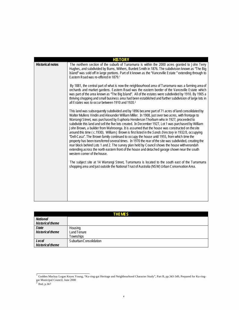
HISTORY Historical notes The northern section of the suburb of Turramurra is within the 2000 acres granted to John Terry
Hughes, and subdivided by Burns, Withers, Burdett Smith in 1876. The subdivision known as “The Big Island” was sold off in large portions. Part of it known as the “Vanceville Estate ” extending through to Eastern Road was re-offered in 1879.1
By 1881, the central part of what is now the neighbourhood area of Turramurra was a farming area of orchards and market gardens. Eastern Road was the eastern border of the Vanceville Estate which was part of the area known as “The Big Island”. All of the estates were subdivided by 1910. By 1905 a thriving shopping and small business area had been established and further subdivision of large lots in all Estates was to occur between 1910 and 1920.2
This land was subsequently subdivided and by 1896 became part of 71 acres of land consolidated by Walter Mullens Vindin and Alexander William Miller. In 1908, just over two acres, with frontage to Warrangi Street, was purchased by Euphoria Henderson Thorburn who in 1927, proceeded to subdivide this land and sell the five lots created. In December 1927, Lot 1 was purchased by William John Brown, a builder from Wahroonga. It is assumed that the house was constructed on the site around this time ( c.1930). William J Brown is first listed in the Sands Directory in 1932/3, occupying “Dell-Casa”. The Brown family continued to occupy the house until 1955, from which time the property has been transferred several times. In 1970 the rear of the site was subdivided, creating the rear block behind Lots 1 and 2. The survey plan held by Council shows the house with verandah extending across the north eastern front of the house and detached garage shown near the south western corner of the house.
The subject site at 14 Warrangi Street, Turramurra is located to the south east of the Turramurra shopping area and just outside the National Trust of Australia (NSW) Urban Conservation Area.
THEMES National historical theme
State historical theme
Housing Land Tenure Townships
Local historical theme
Suburban Consolidation
1 Godden Mackay Logan Keyes Young, “Ku-ring-gai Heritage and Neighbourhood Character Study”, Part B, pp.343-349, Prepared for Ku-ring- gai Municipal Council, June 2000 2 Ibid, p.367

A
APPLICATION OF CRITERIA
Historical significance SHR criteria (a)
Significance for its contribution to the streetscape character of the immediate area for most of the 20th
Century.
Historical association significance SHR criteria (b)
Aesthetic significance SHR criteria (c)
Significant as a good and largely intact example (externally) of an Inter-War California Bungalow style residence constructed as part of the subdivision of the larger holdings in the area. Significant as a contributory item to the variety of Inter-War style residences within the immediate area.
Social significance SHR criteria (d)
Significant as one of the early 20th Century Inter-War style residences in the immediate area and as an example of the type of housing popular with the young families buying into the developing Upper North Shore suburbs in the early decades of the 20th century.
Technical/Research significance SHR criteria (e)
Rarity SHR criteria (f)
Representativeness SHR criteria (g)
Significant as a good example of the general characteristics of Inter-War style housing in the immediate area.
Integrity
Largely intact in style, form and fabric, some additions to the rear but these do not impact on the visual character of the building within the streetscape.
A
HERITAGE LISTINGS Heritage listing/s
INFORMATION SOURCES
Include conservation and/or management plans and other heritage studies. Type Author/Client Title Year Repository Written Godden Mackay Logan Keys
Young Ku-ring-gai Residential Development Strategy Heritage and Neighbourhood Character Study Part B
2000 KMC
Certificate of Title Volume 1186 Folio 86 Volume 1907 Folio 76 Volume 4089 Folio 142 Volume 11356 Folio 136
Land and Property Information
Written Sands Directory 1858-1932/3 Ku-ring-gai Library
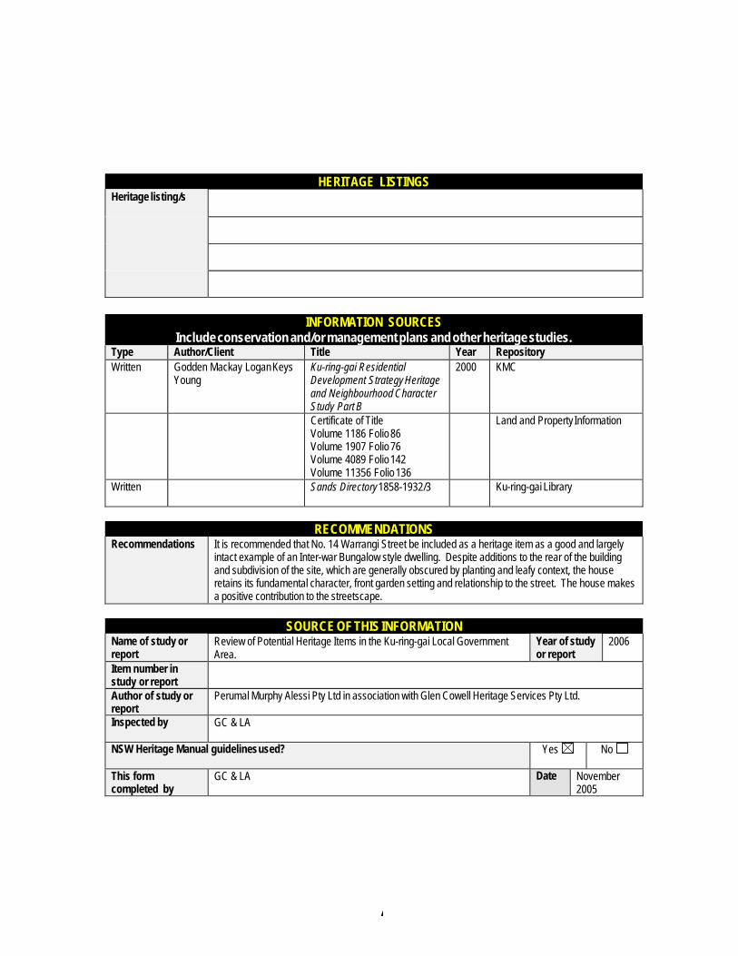
RECOMMENDATIONS
Recommendations It is recommended that No. 14 Warrangi Street be included as a heritage item as a good and largely intact example of an Inter-war Bungalow style dwelling. Despite additions to the rear of the building and subdivision of the site, which are generally obscured by planting and leafy context, the house retains its fundamental character, front garden setting and relationship to the street. The house makes a positive contribution to the streetscape.
SOURCE OF THIS INFORMATION
Name of study or report
Review of Potential Heritage Items in the Ku-ring-gai Local Government Area.
Year of study or report
2006
Item number in study or report
Author of study or report
Perumal Murphy Alessi Pty Ltd in association with Glen Cowell Heritage Services Pty Ltd.
Inspected by GC & LA
NSW Heritage Manual guidelines used? Yes No
This form completed by
GC & LA Date November 2005
A
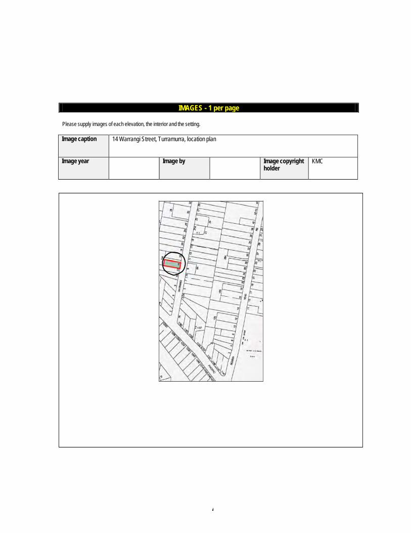
Please supply images of each elevation, the interior and the setting.
Image caption 14 Warrangi Street, Turramurra, location plan
Image year Image by Image copyright holder
KMC
IMAGES - 1 per page
A
Please supply images of each elevation, the interior and the setting.
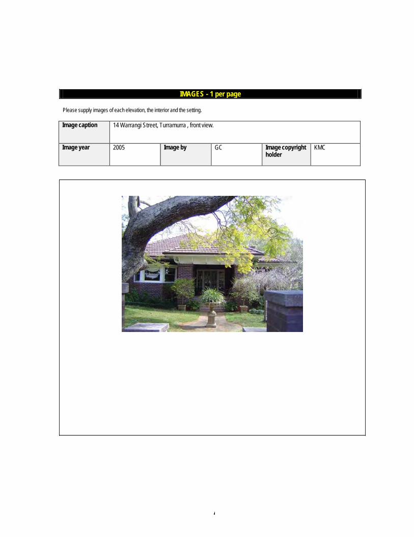
Image caption 14 Warrangi Street, Turramurra , front view.
Image year 2005 Image by GC Image copyright holder
KMC
IMAGES - 1 per page
A
Please supply images of each elevation, the interior and the setting.
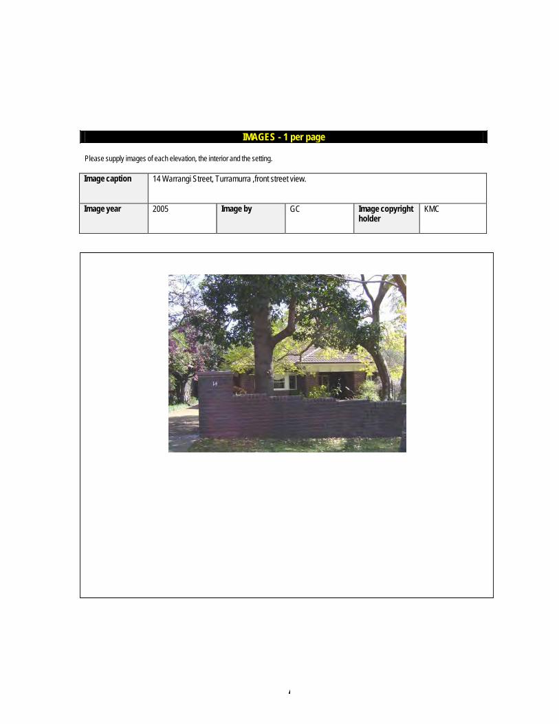
Image caption 14 Warrangi Street, Turramurra ,front street view.
Image year 2005 Image by GC Image copyright holder
KMC
IMAGES - 1 per page

A
Ku-ring-gai Council Planning Proposal
APPENDIX G – Comments from Office of Environment and Heritage
Ku-ring-gai Council Planning Proposal
A
Ku-ring-gai Council Planning Proposal

A
Ku-ring-gai Council Planning Proposal