lakemba station catchment construction works
TRANSCRIPT

Lakemba Station Catchment Construction Works Archaeological Method Statement 2
Prepared for HSEJV May 2021
EMM Sydney
Ground floor, 20 Chandos Street
St Leonards NSW 2065
T 02 9493 9500
www.emmconsulting.com.au

J210114 | RP#1 | v2 2
Lakemba Station Catchment Construction Works Archaeological Method Statement 2
Report Number
J210114 RP#1
Client
HSEJV
Date
27 May 2021
Version
v2 Final
Prepared by Approved by
Pamela Kottaras
Associate, National Technical Leader - Historical Heritage
27 May 2021
Susan Lampard
Associate, Senior Archaeologist
27 May 2021
This report has been prepared in accordance with the brief provided by the client and has relied upon the information collect ed at the time and
under the conditions specified in the report. All findings, conclusions or recommendations contained in the report are based on the
aforementioned circumstances. The report is for the use of the client and no responsibility will be taken for its use by othe r parties. The client
may, at its discretion, use the report to inform regulators and the public.
© Reproduction of this report for educational or other non-commercial purposes is authorised without prior written permission from EMM
provided the source is fully acknowledged. Reproduction of this report for resale or other commercial purposes is prohibited without EMM’s
prior written permission.
J210114 | RP#1 | v2 i
Table of Contents
1 Lakemba Station Catchment and Construction Works 1
1.1 Overview 1
1.2 Background 1
1.2.1 Purpose of this document 1
1.2.2 Project area 2
1.3 Archaeological phases and possible archaeological resources 2
1.3.1 Summary 2
1.3.2 Phase 1 (1788–1880s) 2
1.3.3 Phase 2 (1880s–1909) 3
1.3.4 Phase 3 (1909–1919) 5
1.3.5 Phase 4 (1919 – present) 7
2 Heritage significance 9
2.1 The significance framework 9
2.2 Assessment of sites in the development footprint 9
2.3 Statement of significance 10
3 Proposed works 11
3.1 Impact types 11
3.2 Anticipated impacts 12
3.3 Archaeological management 12
4 Archaeological methods 20
4.1 Background 20
4.2 Heritage inductions 20
4.3 Archaeological test and salvage excavation 20
4.4 Salvage of identified archaeological resources 20
4.5 Recording method 21
4.5.1 Excavation recording 21
4.5.2 Curation of archaeological material 21
4.5.3 Public engagement 22
4.5.4 Reporting 22
4.5.5 Aboriginal archaeological heritage strategy 22
J210114 | RP#1 | v2 ii
4.6 Team and timing 22
5 Research questions 23
5.1 Introduction 23
5.2 Questions 23
6 Archaeological administration 25
6.1 Introduction 25
6.2 Unexpected finds 25
6.3 Heritage inductions 25
References 27
Tables
Table 2.1 NSW heritage assessment criteria 9
Table 2.2 Assessment of significance 10
Table 3.1 Lakemba Station archaeological management 13
Table 3.2 Construction methods 14

J210114 | RP#1 | v2 1
1 Lakemba Station Catchment and Construction Works
1.1 Overview
EMM Consulting Pty Ltd (EMM) has been engaged by Haslin Stephen Edwards Construction Joint Venture (HSEJV) on behalf of Sydney Metro to prepare archaeological method statements (AMS) for proposed excavation works of the Sydney Metro City & Southwest Sydenham to Bankstown project (the project). The Sydney Metro City & Southwest Sydenham to Bankstown project is a Transport for NSW project.
This AMS has been prepared to guide management of archaeological resources (or remains), that may be present in the works corridor on the Lakemba Station Catchment and Construction site (Lakemba site). For the purposes of this report, archaeological resources include ‘relics’, that is, archaeological resources of local or State significance and buried ‘works’, which are historical infrastructure. It is anticipated that the majority of works, if they survive in the study area, will be related to the project area’s rail functions. AMS reports have also been produced for the Marrickville Station and Canterbury Station Catchment sites.
Project details are provided in the table below:
Project Sydney Metro Southwest
Date 27 May 2021
EMM Project J210114
Location Lakemba Station
Work period 27 May 2021 to completion
Authors James McGuinness, EMM Archaeologist and Researcher, Pamela Kottaras EMM National Technical Leader - Historical Heritage
Review Dr Susan Lampard, EMM Associate and Defence Heritage Lead
Excavation Directors N/A Archaeologists will attend if required
Client HSEJV
Client review Georgia Wright, Sydney Metro
1.2 Background
1.2.1 Purpose of this document
This AMS has been prepared to guide the management of archaeological resources in the construction impact. It is a response to the Revised Mitigation Measures document approved by the Department of Planning Industry and Environment (DPIE). Specifically, condition NAH12:
The archaeological research design, including any mitigation measures identified in the Archaeological Assessment and Research Design report, would be implemented (SPIR 2018, p.16.13).

J210114 | RP#1 | v2 2
This AMS covers the management of archaeological resources, including relics and works, that may be affected during the construction activities. The aim of the archaeological program is to identify all archaeological resources and manage them according to this AMS.
The archaeological excavation method in this document forms the framework for the identification and recording of archaeological resources should they be identified during monitoring or outline the methods if test and salvage excavation has been confirmed as the management measure. Additionally, archaeological resources that may not fit the category of relics, but are considered significant, will also be recorded as per this report. An unexpected finds procedure that addresses Aboriginal heritage will also be applied to the work. Recording procedures for each archaeological field activity will remain as detailed in this document.
The methods presented in the AMS are in accordance with the following:
• Artefact Heritage 2018, Sydney Metro City & Southwest Sydenham to Bankstown Upgrade Historical Archaeological Assessment & Research Design (AARD, Section 4.0); which forms part of the
• Submissions and Preferred Infrastructure Report 2018 (SPIR);
• Sydney Metro Integrated Management System (IMS) 2020, Southwest Metro – Marrickville, Canterbury, and Lakemba Station Upgrades Heritage Management Plan; and
• Revised Environmental Mitigation Measures within the Sydney Metro City & Southwest Sydenham to Bankstown Upgrade Submissions and Preferred Infrastructure Report, (DPIE 2018).
1.2.2 Project area
Lakemba Station is located on The Boulevarde, Lakemba, in the Parish of St George, County of Cumberland and sits within the Canterbury-Bankstown local government area. The station area is bounded by Railway Parade to the north and Haldon Street overbridge to the east and can be accessed via either Railway Parade or The Boulevarde to the south.
The Lakemba Station Catchment works are proposed to occur in the boundaries of:
• Lot 2 DP1012364, which includes Lakemba Station and the rail corridor east of the station;
• Lot 1 DP1184734, the Haldon Street overbridge;
• Lot 1 DP937756, the railway corridor north-west of the station; and
• Lot 7 DP4217, the rail corridor west of the station.
The Lakemba Station Catchment works, and construction activities may additionally occur within the boundaries of:
• Lot 8 DP1184406, a narrow corridor separating the rail line and The Boulevarde to the south-west of the station,
• Lot 1 DP1012364, 60A The Boulevarde; and
• Lot 2 DP128316, the railway corridor east of the Haldon Street overbridge.

J210114 | RP#1 | v2 1
Plate 1.1 The Lakemba Catchment project area. Source: Artefact Heritage 2018 Figure 6-1, p.107

J210114 | RP#1 | v2 2
1.3 Archaeological phases and possible archaeological resources
1.3.1 Summary
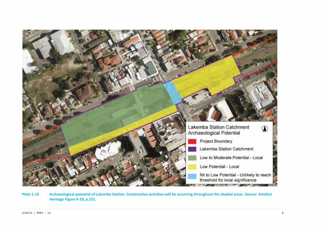
The AARD for the project (Artefact Heritage 2019, pp.142-143) identified potential for the presence of relics and archaeological resources in the proposed Lakemba Station Catchment (see section 6). The project area has been divided into four phases with potential, significance, proposed works and management summarised in Section 1.3. The AARD identified that excavation works associated with the construction of an island platform, retaining wall and service building, new services and utilities and a new security fence along the southern boundary of the rail corridor have been assessed to pose potential impacts to archaeological resources, possibly of local significance, that relate to the four identified historical phases of the site.
1.3.2 Phase 1 (1788–1880s)
John Wall’s 50-acre (20 ha) land grant “Ashford” remained unutilised until it was leased by Ben Taylor in 1881. During these initial years of use, development of Taylor’s lease is likely to have been limited to clearing and agricultural use. Archaeological features commonly present following such land use are:
• evidence of land clearance including tree boles;
• post holes denoting fence lines and sheds;
• field drains; and
• isolated artefacts.
Such features may, though unlikely, meet the criteria for local significance with regard to the early European occupation of Lakemba.
Plate 1.2 John Wall’s land grant (red boundary) where the future Lakemba Station was built - undated but one of the earliest surviving plans. Source: HLRV
J210114 | RP#1 | v2 3
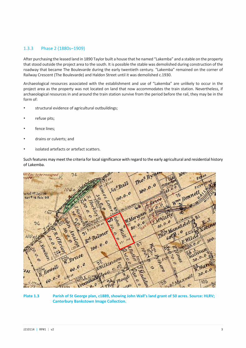
1.3.3 Phase 2 (1880s–1909)
After purchasing the leased land in 1890 Taylor built a house that he named “Lakemba” and a stable on the property that stood outside the project area to the south. It is possible the stable was demolished during construction of the roadway that became The Boulevarde during the early twentieth century. “Lakemba” remained on the corner of Railway Crescent (The Boulevarde) and Haldon Street until it was demolished c.1930.
Archaeological resources associated with the establishment and use of “Lakemba” are unlikely to occur in the project area as the property was not located on land that now accommodates the train station. Nevertheless, if archaeological resources in and around the train station survive from the period before the rail, they may be in the form of:
• structural evidence of agricultural outbuildings;
• refuse pits;
• fence lines;
• drains or culverts; and
• isolated artefacts or artefact scatters.
Such features may meet the criteria for local significance with regard to the early agricultural and residential history of Lakemba.
Plate 1.3 Parish of St George plan, c1889, showing John Wall’s land grant of 50 acres. Source: HLRV; Canterbury Bankstown Image Collection.

J210114 | RP#1 | v2 4
Plate 1.4 The Lakemba Uniting Church during construction in the early 1920s (right), with ‘Lakemba’ in the background. View from Haldon Street to the west. ‘Lakemba’ was not in the project area. Source: Canterbury Bankstown Image Collection.
Plate 1.5 Parish of St George plan, dated to 1903, with later additions, indicated by the presence of Lakemba Railway Station. John Wall’s grant is indicated by the red boundary. Source: HLRV; Canterbury Bankstown Image Collection.

J210114 | RP#1 | v2 5
1.3.4 Phase 3 (1909–1919)
Lakemba Station was opened on the 14 April 1909. The original station at Lakemba had an island platform with entrance steps from the Haldon Street overbridge. A small timber building with a ticket and parcels office was located at the eastern end of the station.
Potential archaeological resources of this phase would be associated with the first timber island platform and initial railway infrastructure and may include:
• timber footings and postholes;
• brick drainage pits;
• stanchion bases;
• electrical conduit/pits;
• gas lines for lamps; and
• sleepers and rail track.
Such features may meet the criteria for local significance with regard to the establishment of the railway and Lakemba Station.
Plate 1.6 Parish of St George plan, dated to 1903 but clearly later as Lakemba Station is present and new streets are being drawn in. Source: HLRV.

J210114 | RP#1 | v2 6
Plate 1.7 Lakemba Railway Station c1909, view south-west with The Boulevarde in the background. Note the platform size and coping. Source: Canterbury Bankstown Image Collection.
Plate 1.8 Lakemba Railway Station platform, c 1910, view south-west. Note the gas lamps on the platform. Source: Canterbury Bankstown Image Collection.
J210114 | RP#1 | v2 7
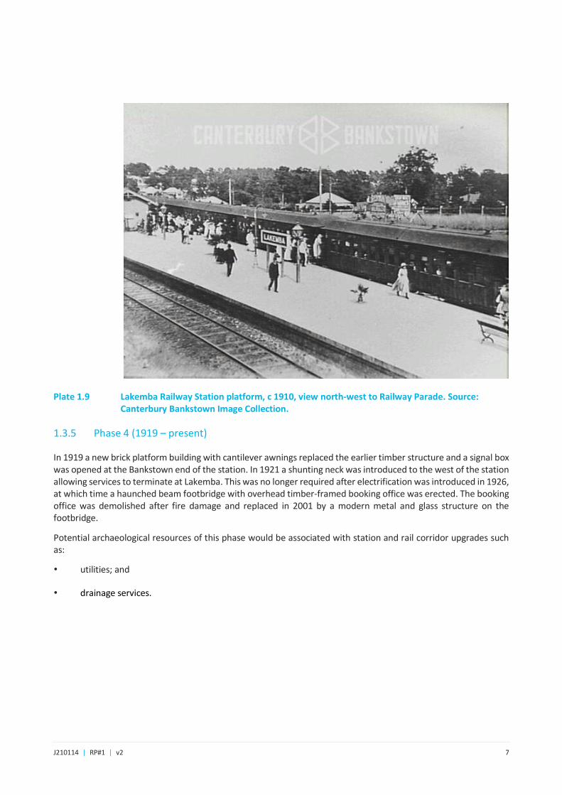
Plate 1.9 Lakemba Railway Station platform, c 1910, view north-west to Railway Parade. Source: Canterbury Bankstown Image Collection.
1.3.5 Phase 4 (1919 – present)
In 1919 a new brick platform building with cantilever awnings replaced the earlier timber structure and a signal box was opened at the Bankstown end of the station. In 1921 a shunting neck was introduced to the west of the station allowing services to terminate at Lakemba. This was no longer required after electrification was introduced in 1926, at which time a haunched beam footbridge with overhead timber-framed booking office was erected. The booking office was demolished after fire damage and replaced in 2001 by a modern metal and glass structure on the footbridge.
Potential archaeological resources of this phase would be associated with station and rail corridor upgrades such as:
• utilities; and
• drainage services.
J210114 | RP#1 | v2 8
Plate 1.10 Archaeological potential of Lakemba Station. Construction activities will be occurring throughout the shaded areas. Source: Artefact Heritage Figure 6-18, p.121.

J210114 | RP#1 | v2 9
2 Heritage significance 2.1 The significance framework
In NSW, historical value is ascribed to buildings, places, archaeological sites and landscapes modified in the Australian historical period for purposes other than traditional Aboriginal use. The assessment of heritage significance is based on the Burra Charter (Australia ICOMOS 2013) and further expanded upon in Assessing Heritage Significance (NSW Heritage Manual Heritage Office 2001). The heritage manual lists seven criteria to identify and assess heritage values that apply when considering if an item is of state or local heritage significance, which are set out in Table 2.1. The result of the assessments of significance may determine that an individual component does not meet the threshold for local or State significance as an individual item, but that it does contribute to the significance of the cultural landscape.
The criteria against which heritage significance have been assessed are reproduced in Table 2.1.. The assessment of archaeological resources is hypothetical as their existence as intact and substantial sites is predicted.
Table 2.1 NSW heritage assessment criteria
Criterion Explanation
a) An item is important in the course or pattern of NSW’s (or the local area’s) cultural or natural history (Historical
Significance).
b) An item has strong or special association with the life or works of a person, or group of persons of importance in
NSW’s (or the local area’s) cultural or natural history (Associative Significance).
c) An item is important in demonstrating aesthetic characteristics and/or a high degree of creative or technical
achievement in NSW (or the local area) (Aesthetic Significance).
d) An item has a strong or special association with a particular community or cultural group in NSW (or the local area)
for social, cultural or spiritual reasons (Social Significance).
e) An item has the potential to yield information that will contribute to an understanding of NSW’s (or the local area’s)
cultural or natural history (Research Significance).
f) An item possesses uncommon, rare or endangered aspects of NSW’s (or the local area’s) cultural or natural history
(Rarity).
g) An item is important in demonstrating the principal characteristics of a class of NSW’s (or the local area’s) cultural
or natural places or environments (Representativeness).
Source: Assessing heritage significance (NSW Heritage Office 2001, p.9).
2.2 Assessment of sites in the development footprint
Lakemba Station is identified as an item of local heritage significance on the Canterbury Local Environmental Plan 2012 (Federation railway station buildings, 120–124 Railway Parade; Lakemba Railway Station Group, Lakemba, I143). The Lakemba Station Group is significant as an extension of the Sydenham to Bankstown Line and the intact platforms and stairs are significant examples of design and technology used by NSW railways in the early twentieth century.
Artefact Heritage (2018, p.119-120) has produced an assessment of significance for the potential archaeological resources of Lakemba Station and the project boundary, which is summarised below in Table 2.2.

J210114 | RP#1 | v2 10
Table 2.2 Assessment of significance
Criterion Assessment
a) Historical The potential archaeological resources may offer information relating to the historical development of
the suburb of Lakemba. The Lakemba station resources also have connections to the development of
Lakemba.
The archaeological resource in the project area does not fulfil this criterion.
b) Associative The archaeological resource in the project area does not fulfil this criterion.
c) Aesthetic The archaeological resource in the project area does not fulfil this criterion.
d) Social The archaeological resource in the project area does not fulfil this criterion.
e) Research The potential archaeological resources associated with the early twentieth century rail infrastructure
would contribute to additional information not readily available through historical sources.
It is unlikely archaeological resources of Phases 1 and 2 will reach the criteria as the phases are likely to
be heavily disturbed.
Phase 3 archaeological resources may reach the threshold for local significance but elements such as
early services are well documented elsewhere.
Early Lakemba Station services do not fulfil this criterion.
Early Lakemba Station structural remains such as evidence of the early platform and platform buildings,
brick or sandstone drains, and other such structures are of local significance for their research value.
f) Rarity Not applicable.
g) Representativeness Not applicable.
2.3 Statement of significance
There is nil to low potential for archaeological remains associated with nineteenth century farming. Potential remains of structures or deposits associated with ‘Lakemba’ may have research and associative value. There is low to moderate potential for archaeological remains of former ‘works’. Though the potential Phase 3 archaeological remains are associated with the historical development of the Bankstown rail line, remains associated with former rail infrastructure are unlikely to reach the threshold for local heritage significance. Remains associated with the 1919 Lakemba Station timber island platform have the potential to demonstrate early development phases within the suburb of Lakemba. Potential remains associated with ‘Lakemba’ and the Lakemba 1909 timber island platform may have local heritage significance.
Artefact Heritage 2018, p.120
No further additions from EMM.
J210114 | RP#1 | v2 11
3 Proposed works 3.1 Impact types
The scope incorporates several activities to complete the project. These activities are listed and then described in this section to provide the parameters for expected impacts, which will inform how those impacts will be managed.
The construction techniques that involve invasive ground impacts have the potential to remove archaeological resources, in some cases, without evidence of those resources existing. Table 3.2 describes the relevant construction methods and briefly discusses how the loss of archaeological information can be managed.
Project activities will be occurring on site during possession weekends, shutdowns and out of possession periods, where the rail corridor is not affected. The impacts described are not in the planned order for the possession periods as the archaeological program must respond if the construction program changes. The nature and extent of these works are shown in , Plate 3.1 and Plate 3.2.
However, where archaeological investigation is required, the archaeological team must be provided with the space, time and plant required to complete the recording to a high standard and in accordance with this report. Refer to Appendix B for the relevant design plans.
Impacts to potential archaeological resources that are anticipated on this project are as follows:
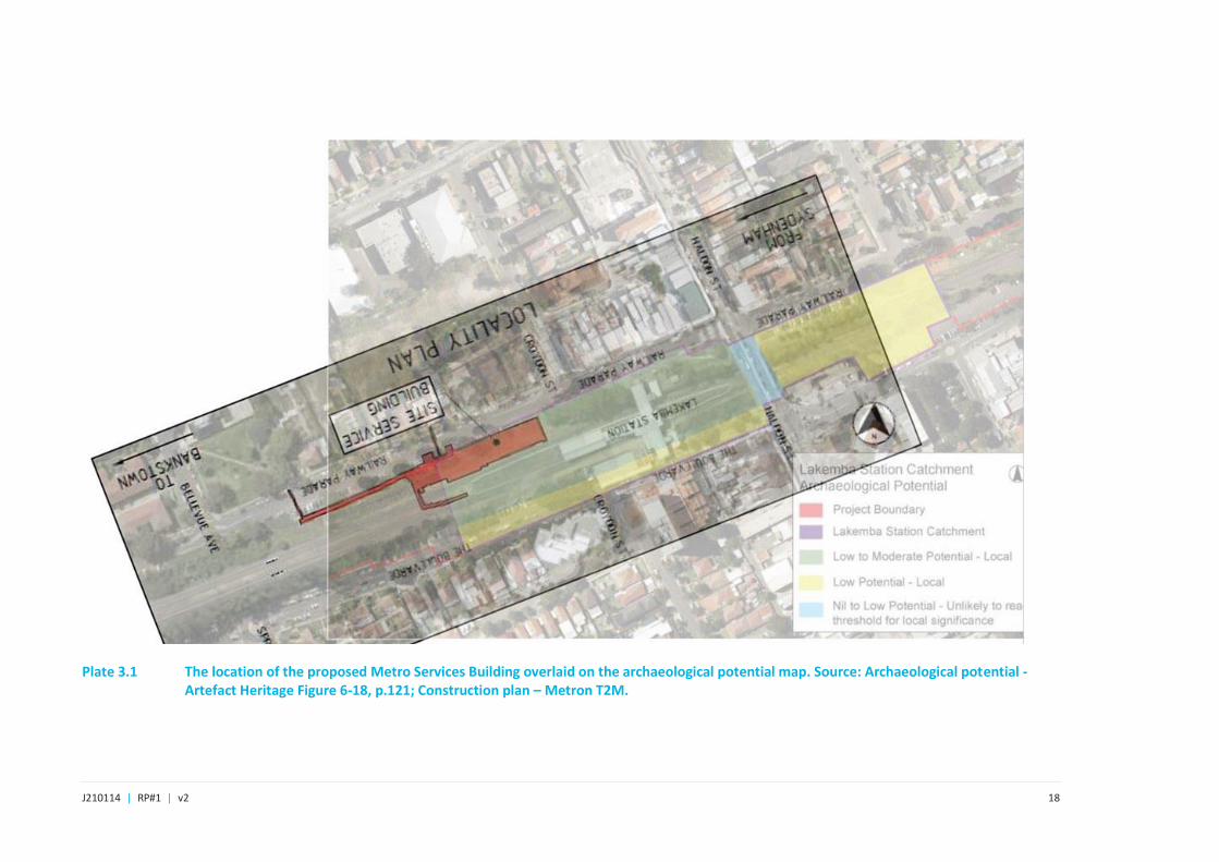
• Metro Services Building (MSB) (Plate 3.1)
- Potholing/investigations to locate services and for contamination testing;
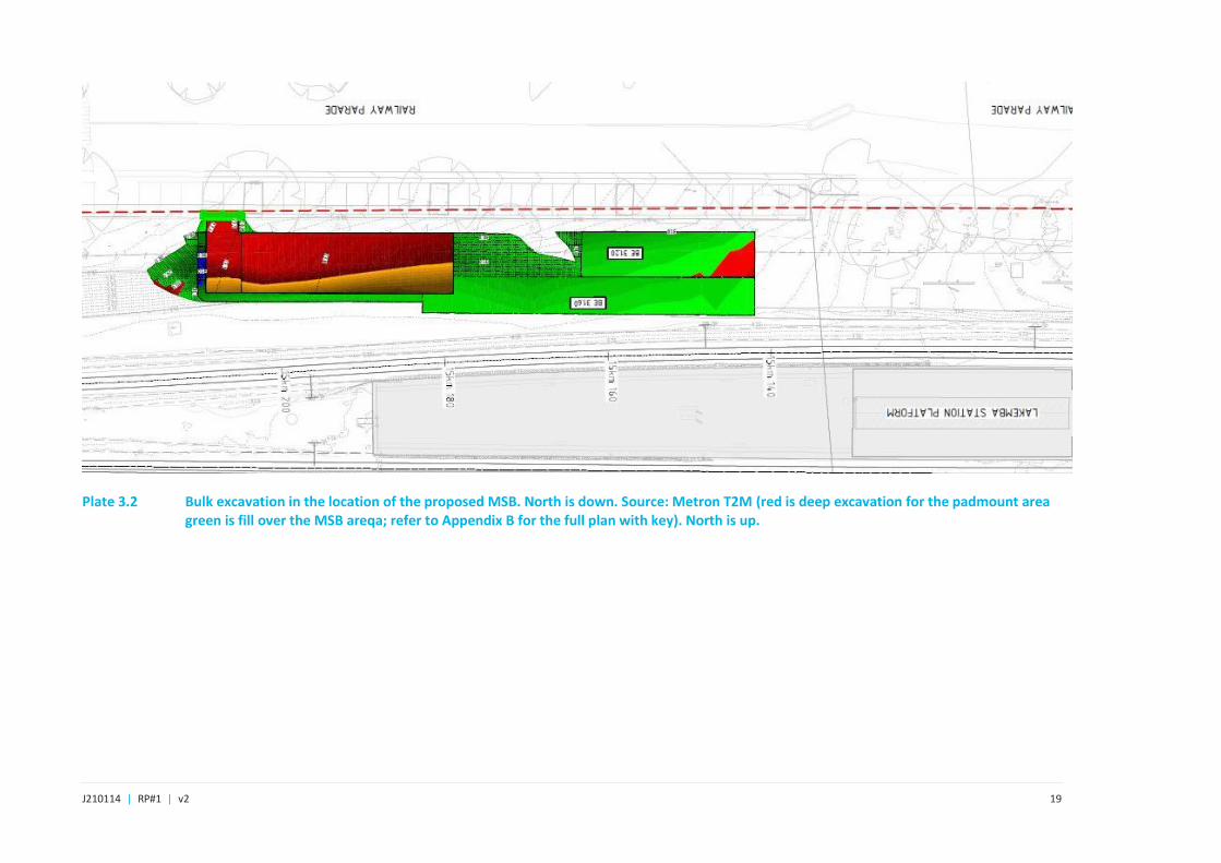
- bulk cut and fill earthworks to a depth of between 2.5 m and 3 m (Plate 3.2);
- detail excavation for the pad footing;
- piling for the radio mask and pile cap;
- soil nail remediation to existing rail embankments; and
- driveway and crossover construction.
• potholing to locate services on station platforms;
• piling on station platforms and in the rail corridor;
• cut and fill to construct drainage inside the rail corridor and cess;
• platform re-levelling to a depth of 500 mm;
• cut and cover to install services;
• post installation for fencing and Galvanised Steel Troughing (GST) support and for trackside infrastructure;
• modifications to the car park;
• landscaping;
J210114 | RP#1 | v2 12
• removal of the brick coping on the platform for regrading; and
• similar activities which would not have an impact on archaeological resources already assessed in this AMS as determined by the Excavation Director.
3.2 Anticipated impacts
The most likely archaeological phase to be affected by the project is Phase 3 (1909–1919), which may retain evidence of the first timber island platform and initial railway infrastructure such as brick drainage pits, stanchion bases, timber footings and postholes, sleepers and rail track (Artefact Heritage 2018, p.123).
The majority of these features are not considered to be archaeologically significant, as information about their manufacture and use is well-known. Recording their presence as rail infrastructure will not add to knowledge of the development of railways in NSW, or the growth of Lakemba.
Significant archaeological resources that will add to knowledge of the early railways are brick drainage pits and the original timber platform. Other significant archaeological resources would be associated with the town of Lakemba, but pre-railway evidence is not anticipated to exist in the project area.
In all areas where archaeological excavation occurs, the level of recording will be to the discretion of the excavation director.
3.3 Archaeological management
The intent of this archaeological method statement is to record those items that have been identified with research significance; that is, structures and/or deposit that will add to information about the past and the development of Sydney more broadly and Lakemba more specifically. The AARD (Artefact Heritage Services, 2018) identified four broad historical phases and the types of evidence that may represent those phases (Table 3.1). Evidence may be in the form of the early timber platform and related buildings; this type of feature is unusual and may add to knowledge about how the early Lakemba Station was built, evidence which is lacking in documents.
Masonry drainage pits, culverts and other water management features, or services conduits are becoming increasingly rare in the archaeological context of Sydney and keeping a record of their construction and form will be a benefit to future research.
The Excavation Director is to be provided with at least two days’ notice prior to work commencing where only the Unexpected Finds Procedure applies; that is, potholing on the station platform, fence installation, work to Station Street, tree planting and other activities where ground impacts are planned but archaeological monitoring is not required.
Archaeological monitoring will occur for impacts to the platform associated with re-levelling. If archaeological resources survive that are associated with the early platform, they will be recorded prior to their removal. The archaeological recording process will be to monitor the works, and record finds prior to their removal.
In other areas, the Unexpected Finds Procedure will apply, except during rail possession periods where a team of two archaeologists will be present to assist in the event that unexpected finds are unearthed.
The archaeological program will be based on construction impacts and timing. The archaeological team will require adequate notice, meaning at least two weeks, to mobilise for field work, except in the case of unexpected finds.
Archaeological management proposed for the site is presented in Table 3.2 alongside the activities that may cause impacts to the resource. The methods for recording are set out in Section 4.5.
J210114 | RP#1 | v2 13
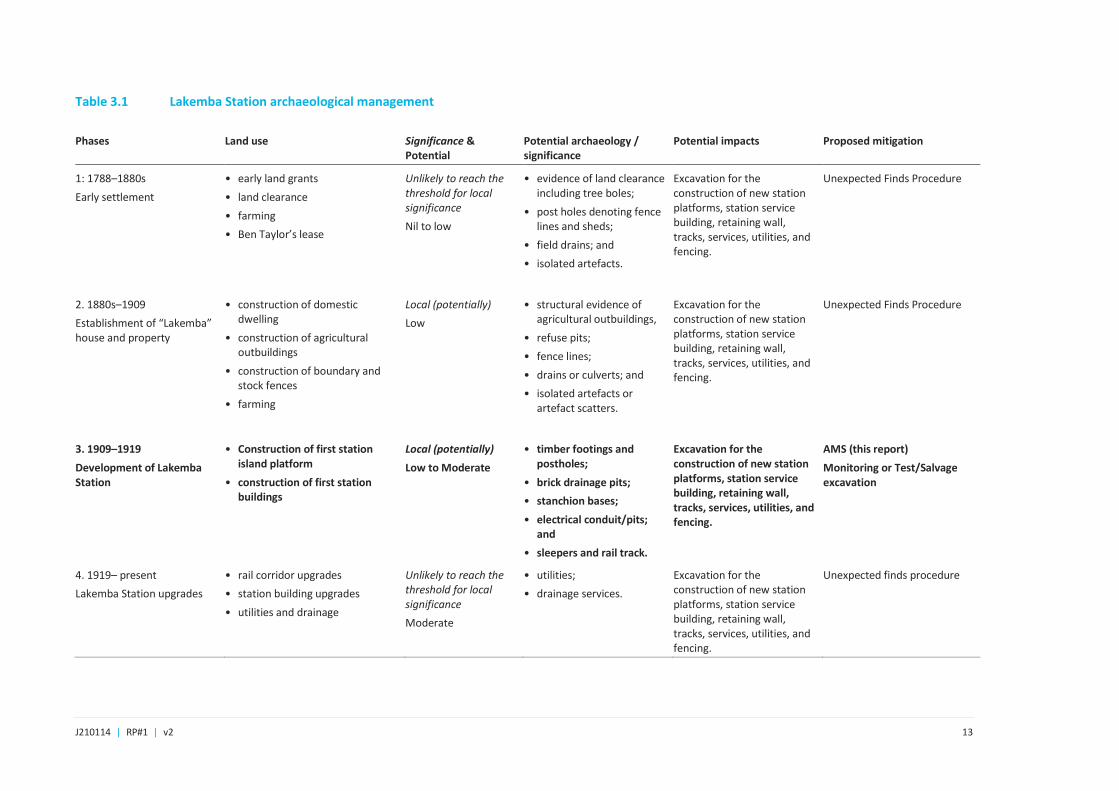
Table 3.1 Lakemba Station archaeological management
Phases Land use Significance & Potential
Potential archaeology / significance
Potential impacts Proposed mitigation
1: 1788–1880s
Early settlement
• early land grants
• land clearance
• farming
• Ben Taylor’s lease
Unlikely to reach the threshold for local significance
Nil to low
• evidence of land clearance including tree boles;
• post holes denoting fence lines and sheds;
• field drains; and
• isolated artefacts.
Excavation for the construction of new station platforms, station service building, retaining wall, tracks, services, utilities, and fencing.
Unexpected Finds Procedure
2. 1880s–1909
Establishment of “Lakemba” house and property
• construction of domestic dwelling
• construction of agricultural outbuildings
• construction of boundary and stock fences
• farming
Local (potentially)
Low
• structural evidence of agricultural outbuildings,
• refuse pits;
• fence lines;
• drains or culverts; and
• isolated artefacts or artefact scatters.
Excavation for the construction of new station platforms, station service building, retaining wall, tracks, services, utilities, and fencing.
Unexpected Finds Procedure
3. 1909–1919
Development of Lakemba Station
• Construction of first station island platform
• construction of first station buildings
Local (potentially)
Low to Moderate
• timber footings and postholes;
• brick drainage pits;
• stanchion bases;
• electrical conduit/pits; and
• sleepers and rail track.
Excavation for the construction of new station platforms, station service building, retaining wall, tracks, services, utilities, and fencing.
AMS (this report)
Monitoring or Test/Salvage excavation
4. 1919– present
Lakemba Station upgrades
• rail corridor upgrades
• station building upgrades
• utilities and drainage
Unlikely to reach the threshold for local significance
Moderate
• utilities;
• drainage services.
Excavation for the construction of new station platforms, station service building, retaining wall, tracks, services, utilities, and fencing.
Unexpected finds procedure
J210114 | RP#1 | v2 14
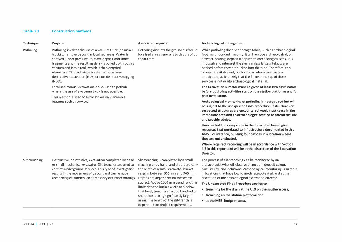
Table 3.2 Construction methods
Technique Purpose Associated impacts Archaeological management
Potholing Potholing involves the use of a vacuum truck (or sucker truck) to remove deposit in localised areas. Water is sprayed, under pressure, to move deposit and stone fragments and the resulting slurry is pulled up through a vacuum and into a tank, which is then emptied elsewhere. This technique is referred to as non-destructive excavation (NDE) or non-destructive digging (NDD).
Localised manual excavation is also used to pothole where the use of a vacuum truck is not possible.
This method is used to avoid strikes on vulnerable features such as services.
Potholing disrupts the ground surface in localised areas generally to depths of up to 500 mm.
While potholing does not damage fabric, such as archaeological footings or bonded masonry, it will remove archaeological, or artefact-bearing, deposit if applied to archaeological sites. It is impossible to interpret the slurry unless large artefacts are noticed before they are sucked into the tube. Therefore, this process is suitable only for locations where services are anticipated, as it is likely that the fill over the top of those services is not in situ archaeological material.
The Excavation Director must be given at least two days’ notice before potholing activities start on the station platforms and for post installation.
Archaeological monitoring of potholing is not required but will be subject to the unexpected finds procedure. If structures or suspected structures are encountered, work must cease in the immediate area and an archaeologist notified to attend the site and provide advice.
Unexpected finds may come in the form of archaeological resources that unrelated to infrastructure documented in this AMS. For instance, building foundations in a location where they are not ancipated.
Where required, recording will be in accordance with Section 4.5 in this report and will be at the discretion of the Excavation Director.
Slit-trenching Destructive, or intrusive, excavation completed by hand or small mechanical excavator. Slit-trenches are used to confirm underground services. This type of investigation results in the movement of deposit and can remove archaeological fabric such as masonry or timber footings.
Slit trenching is completed by a small machine or by hand, and thus is typically the width of a small excavator bucket ranging between 600 mm and 900 mm. Depths are dependent on the search subject. Above 1500 mm trench width is limited to the bucket width and below that level, trenches must be benched or shored disturbing significantly larger areas. The length of the slit-trench is dependent on project requirements.
The process of slit-trenching can be monitored by an archaeologist who will observe changes in deposit colour, consistency, and inclusions. Archaeological monitoring is suitable in locations that have low to moderate potential, and at the discretion of the archaeological excavation director.
The Unexpected Finds Procedure applies to:
• trenching for the drain at the ULX on the southern cess;
• trenching on the station platform; and
• at the MSB footprint area.

J210114 | RP#1 | v2 15
Recording will be in accordance with Section 4.5 in this report and will be at the discretion of the Excavation Director.
Re-levelling Reducing the level of a surface by small machine and/or hand excavation.
Removal of the top of a surface up to the level of re-surfacing. This technique will remove archaeological resources if they exist.
This technique will be applied to the station platforms, which will be reduced by approximately 500 mm before it is built up with engineering fill and graded to design requirements.
Re-levelling will remove archaeological resources if they exist in the activity area.
If archaeological resources exist in an area to be re-levelled, the process will remove them.
Archaeologically, the station platforms may hold evidence of early railway infrastructure such as posts, early platform surfaces and services. Given that railway platforms are expected to retain structures with significance rather than important archaeological deposit, the most effective process may be to use a vacuum truck to remove deposit and record the structures. However, if this is not possible, a small machine can be used under the supervision of the archaeologists who will stop machine excavation to excavate manually where necessary.
Archaeological monitoring of:
• platform relevelling. If elements of the early platform and platform infrastructure are found, the archaeologists will record them before they are removed.
Recording will be in accordance with Section 4.5 in this report and will be at the discretion of the Excavation Director.
Cut and cover The removal of deposit by machine or by hand excavation to create a void, which is then covered over, usually with a concrete slab.
The impact of this type of activity is destructive excavation and will remove archaeological deposit and fabric if excavation is not carefully completed.
The impact area of cut and cover is dependent on the design of the project.
Cut and cover activities will remove archaeological resources if they exist in the activity area. Archaeological management can be through monitoring by archaeologists in areas of low to moderate archaeological potential. However, in areas of moderate to high archaeological potential, monitoring is not an effective method to record archaeological data as works in the area must be stopped so that the archaeologists can work safely and with time to record accurately. Therefore, in locations where archaeological resources are anticipated, the most effective archaeological method is to start the process with test excavation and proceed to salvage if the resource justifies it.
Decisions on the archaeological method are made by the excavation director, who will determine the most appropriate project-specific method to employ as set out in this report.
Archaeological monitoring of:
• platform regrading and reconstruction.
The Unexpected Finds Procedure applies to:

J210114 | RP#1 | v2 16
• the MSB site; and
• trenching for the drain at the ULX on the southern cess.
Recording will be in accordance with Section 4.5 in this report and will be at the discretion of the Excavation Director.
Cut and level This process involves bulk excavation to reduce relative levels and can also involve import of new materials and compaction of the new and existing soil deposits. This process will remove archaeological material including artefact-bearing deposits and fabric such as masonry footings.
The impact of this type of activity is destructive excavation and will remove archaeological deposit and fabric if excavation is not carefully completed.
Where any type of bulk excavation is proposed over areas of archaeological potential, the level of that potential will dictate how the archaeological resource is protected or retrieved. Generally, however, the most efficient method is to undertake test and salvage excavation, with one method directly following the other or separated by time.
Decisions on the archaeological method are made by the excavation director, who will determine the most appropriate project-specific method to employ as set out in this report.
The Unexpected Finds Procedure applies to:
• cut and level to prepare the MSB platform.
Recording will be in accordance with Section 4.5 in this report and will be at the discretion of the Excavation Director.
Piling Used to insert sturdy foundations to considerable depths.
Piling is undertaken by impact driving, auguring or screwing piles into the ground. The destructive effect of piling is that is compresses or removes deposits beneath and around the pile location but does not displace deposit above the ground.
Piling at Lakemba will be undertaken with a 10 t to 20 t piling rig, which will be positioned in the MSB Padmount area.
The destructive effect of piling is that it compresses deposits beneath and around the pile but does not displace deposit above the ground.
Where piles are proposed in an area of archaeological potential, the level of that potential will guide the archaeological methods. Archaeological test excavation may be necessary across the line of piles to capture archaeological data that would otherwise remain invisible because of the method of construction.
Cut and level may be required if a piling rig is used to install the piles. If cut and level is necessary, refer to archaeological management of that activity.
The Unexpected finds protocol applies to:
• piling in the MSB area.
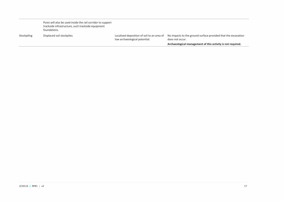
Post installation Post installation is undertaken by driving posts into the ground or by auguring or screwing out deposit. At Lakemba, posts will be installed by auguring, and if the rock is hard enough, a specialised hi-rail piling rig. In the case of the project, fencing is also used as a support for the GST, and Ground Level Troughing (GLT) which are installed above ground.
Where posts are installed inside the rail corridor, a vacuum truck may be used to avoid services strike.
Small, localised impacts to the ground. Where archaeological potential exists, in particular, archaeological resources of rare of high significance, fence installation will be undertaken following the necessary excavations.
Post installation in the rail cutting inside the corridor will not need the supervision of an archaeologist as the area is of low potential.
The Unexpected Finds Procedure applies.
J210114 | RP#1 | v2 17
Posts will also be used inside the rail corridor to support trackside infrastructure, such trackside equipment foundations.
Stockpiling Displaced soil stockpiles. Localised deposition of soil to an area of low archaeological potential.
No impacts to the ground surface provided that the excavation does not occur.
Archaeological management of this activity is not required.
J210114 | RP#1 | v2 18
Plate 3.1 The location of the proposed Metro Services Building overlaid on the archaeological potential map. Source: Archaeological potential -Artefact Heritage Figure 6-18, p.121; Construction plan – Metron T2M.
J210114 | RP#1 | v2 19
Plate 3.2 Bulk excavation in the location of the proposed MSB. North is down. Source: Metron T2M (red is deep excavation for the padmount area green is fill over the MSB areqa; refer to Appendix B for the full plan with key). North is up.

J210114 | RP#1 | v2 20
4 Archaeological methods 4.1 Background
The methods presented in this AMS address and expand upon the requirements of Section 4.6.1. of the AARD (Artefact Heritage 2018, p.84). The level of detail recorded during the archaeological program will be at the discretion of the excavation director, who will judge if sampling is an adequate response to the resource.
These methods will be employed during monitoring or the assessment of unexpected finds.
4.2 Heritage inductions
The site safety induction and/or toolbox talks should include information about the heritage of the study area and highlight that archaeological resources may be present. At a minimum, the induction would include an overview of the project obligations to heritage protection and archaeological management zones and the role of the archaeological team. Unexpected finds, what they are, and the chain of responsibility will also be included in the induction and or/toolbox talks before the start of each working day. The excavation director will present the heritage component of the toolbox talk.
4.3 Archaeological test and salvage excavation
Archaeological test and salvage excavation will occur if archaeological resources are identified during work. The approach to archaeological excavation will be slightly modified due to the nature of the work.
Archaeological excavation process will be generally as follows:
• if the working area is confined and the use of a machine excavator is not feasible, the area will be hand dug using shovels and hoes. It is expected that the contractors will assist the archaeologists and remove overburden under the archaeologists’ supervision. The archaeologist(s) will expose the feature and record the find as per Section 4.5 (below). The site can then be released to the contractors when the archaeologist(s) are satisfied that the feature is not of State significance, an Aboriginal object(s) or human skeleton. In the event that features of State significance, an Aboriginal object(s) or human skeletal material is unearthed, the steps in the unexpected finds procedure (Appendix A) would be followed.
• the excavator will be stopped if archaeological features are identified; if none are detected, machine excavation will continue until the culturally sterile layer is identified or the target construction depth has been reached; and
• if archaeological features or deposits are identified, they will be further clarified by the archaeologist using manual excavation techniques and recorded (see section for recording techniques).
• A sucker truck can also be used on the platform to clear the modern deposit, as it is the structures that are expected to be significant. Hand excavation will be undertaken if early deposit is identified.
4.4 Salvage of identified archaeological resources
The AARD (Artefact Heritage 2018, p.123) has proposed salvage excavation be undertaken to:
Monitoring or test and salvage excavations would be undertaken to investigate and record archaeological remains related to Phase 3.

J210114 | RP#1 | v2 21
Salvage excavation is largely guided by the nature and extent of the archaeological resource. If significant archaeological resources are identified, whether through desktop assessment or monitoring, then further salvage excavation would be required prior to construction. Salvage excavation aims to:
• determine if peripheral or ephemeral and unrelated archaeological resources exist within the construction zone; and
• answer the research questions developed for the project.
4.5 Recording method
4.5.1 Excavation recording
The excavation recording methods are as follows:
• a site datum would be established or an existing one will be used;
• a standard context recording system will be implemented whereby a context number will be applied to each element of each feature, cut and deposit. The feature number, assigned to each feature, will be related to the context number assigned on site;
• archaeological features, deposits and cuts will be photographed (RAW format with photo board and scale), planned to scale and sections drawn prior to, and, depending on the remains, after removal by hand. All in situ artefacts will be collected by context for later analysis; and
• features will be recorded by a qualified surveyor and the resulting plan will be tied into the appropriate datum (on advice from the surveyor). This will include recording reduced levels to establish the varying depths of phases across the sites.
4.5.2 Curation of archaeological material
Curation of archaeological material processes reflect strategies outlined in the Salvage and Storage Strategy of the Sydney Metro Integrated Management System (Transport for NSW 2016a: p.5-6).
• artefacts recovered from the site will be managed by a dedicated artefact manager after retrieval from the site;
• large or redundant materials will have samples collected (eg bricks). Hazardous material will be recorded but will not be collected.
• unprovenanced artefacts and other material assessed as being of low significance or future research potential will be discarded upon delivery of the final report;
• artefacts that are retained will be catalogued by using a system that identifies and allows easy retrieval of the item;
• specialist cataloguers’ will produce reports on the artefacts containing an analysis of artefacts, their deposits, and contexts, as well as outlining issues of importance. Analyses will be supported using tables and photographs;

J210114 | RP#1 | v2 22
• once post-excavation analysis and reporting has been completed, Transport for NSW will be responsible for the management, curation and ongoing care of the collection, including items which require special care (i.e. material prone to deterioration). Artefact management will fall under the project’s salvage strategy; and
• if the artefact collection is to be incorporated into an interpretive public display of artefacts may be subject to material conservation including gluing of pottery or the conservation of important metal or leather materials.
4.5.3 Public engagement
If relics are discovered Heritage NSW can be invited to attend the site. In situ site visits by the public will not occur during the project due to the nature of the construction site and its proximity to the rail corridor.
Significant archaeological findings would be considered for inclusion in the project heritage interpretation as per condition of approval E12.
4.5.4 Reporting
All archaeological activity, including short field work call-outs will be documented in a Preliminary Summary Letter Report. This letter report will include details of the activity conducted, a summary of archaeological resources identified and will be provided within one month of the completion of the work. If archaeological resources are not found, the preliminary report will take the form of a letter of advice that work can continue without any further constraints and that additional reporting is not required unless additional unexpected finds are uncovered.
If salvage excavation is required a detailed final archaeological excavation report will be prepared following the completion of archaeological analyses and within 12 months of the completion of the archaeological work. The report will describe the methods, and results of the archaeological program and present an interpretation of these findings. The report will additionally include artefact analyses and respond to research questions of the AARD. The report will be supported by photographs, tables, and plans. The excavation report is a separate stage to the field program. Artefact Heritage Services. (2018). Sydney Metro City & Southwest Sydenham to Bankstown Upgrade: Historical Archaeological Assessment & Research Design.
If archaeological resources are identified and assessed during the project, a memorandum outlining the results will be prepared at the end of the archaeological works prior to work commencing on the excavation report.
4.5.5 Aboriginal archaeological heritage strategy
Aboriginal cultural heritage such as object, are not anticipated to occur in the project area. The unexpected finds procedure will address such an event.
4.6 Team and timing
The archaeological team will be on call in the event that unexpected finds are uncovered. Attendance for unexpected finds will be by one of the qualified archaeologists at Canterbury or Marrickville: Pamela Kottaras, Fiona Leslie, Susan Lampard or Kerryn Armstrong.

J210114 | RP#1 | v2 23
5 Research questions 5.1 Introduction
The purpose of research questions that are posed on the archaeological resource is to guide the process and to answer questions that can substantively add knowledge to the past and will guide how resources are interpreted while they are being excavated.
The research questions relevant to the archaeological excavation in this document are reproduced from the AARD (Artefact Heritage 2018, in italics). Their purpose is to guide the physical archaeological excavation by adding a theoretical framework to the enquiry.
5.2 Questions
The following research questions should be used to guide archaeological investigation if the need for one arises:
1. What evidence of early land clearing and land modification, if any, is present on the site?
2. What evidence of the pre-station landscape exist within the site? Is there evidence of early subdivision?
3. What evidence of “Lakemba” remains within the study area? Is there evidence of the stables and outbuildings?
4. If evidence associated with “Lakemba” exists, how does this inform early homesteads in the region? Is there evidence of early farming activities?
5. Can the archaeological remains of the outbuildings inform the internal and external layout of the buildings and the use of space?
6. Can the archaeological remains inform changes in building technology, supply of materials and architectural preferences for the period? Do the remains provide evidence of class/status distinction?
7. Does the artefact assemblage provide information on the daily life of the occupants of “Lakemba”?
8. Can gender and class/status be discerned from the archaeological record?
9. Do any refuse deposits indicate a domestic setting? Do refuse deposits inform about daily eating habits?
10. Is there any evidence of former platforms located below or within the present-day station platforms?
11. What similar sites have been investigated within the local or broader context?
12. What evidence of transport developments and changes in transport technology exist on the site?
13. What evidence remains of early services, including early cisterns, tanks, wells, cesspits, in-ground services including sandstone, timber, brick and ceramic drains?
14. Does this provide information about the provision of services and changes in technology?
15. What physical evidence of former activities survives within the site?

J210114 | RP#1 | v2 24
16. What is the integrity of the remains? Have they been truncated by later development or excavation work within the study area?
17. What does the evidence indicate about the development of rail infrastructure and technology?
18. How does the evidence inform the historical development of the Bankstown rail line and Lakemba Station? Sydney Metro City & Southwest Sydenham to Bankstown Upgrade – AARD Page 126
19. Interpret the results in terms of broader themes, posing questions that help to inform the Statement of Significance.
Additional research questions may be posed (and existing questions modified) as the archaeological excavation progresses and the extent and condition of the archaeological resource is revealed. The answers to these questions will inform the revised assessments of significance and public interpretation.
J210114 | RP#1 | v2 25
6 Archaeological administration 6.1 Introduction
6.2 Unexpected finds
For the purposes of this project, unexpected finds at Marrickville Station are archaeological resources that have not been predicted by the AARD and summarised in this report. For example, if the footings of an early dwelling associated with Phase 1 of the site’s history, or a burial, was discovered anywhere on the site these finds would be considered unexpected and the Contractor must follow the Sydney Metro Unexpected Finds Procedure (Appendix A).
Where work is proceeding without the supervision of an archaeologist and it is believed that archaeological resources have been discovered, the process is as follows:
- Work in the immediate vicinity (ie within a three metre radius) of the find must stop immediately.
- The project archaeologist must be notified of the find;
- The project archaeological can then arrange to attend site and assess the find. If the type of find has been identified in this report but not in the specific location it was found, the Excavation Director would determine the most suitable method to record, as the find may not require the unexpected finds procedure to be followed.
The unexpected finds procedure applies to all activities carried out on the project. Refer to Appendix A for details.
6.3 Heritage inductions
The site safety induction and/or toolbox talks should include information about the history of the project area and raise the possibility that archaeological resources may be present. At a minimum, the induction would include an overview of the project obligations to heritage protection and archaeological management zones and the role of the archaeological team. Unexpected finds, what they are, the roles and responsibilities of the Contractor and the proposed management strategy will also be included in the induction and or/toolbox talks before the start of each working day.

J210114 | RP#1 | v2 26

J210114 | RP#1 | v2 27
References Artefact Heritage 2018, Sydney Metro City & Southwest Sydenham to Bankstown Upgrade: Historical Archaeological Assessment & Research Design, report prepared for Transport for New South Wales.
DPIE 2018, Revised Environmental Mitigation Measures, in Sydney Metro City & Southwest Sydenham to Bankstown: Upgrade Submissions and Preferred Infrastructure Report, report prepared for Transport for New South Wales.
Sydney Metro 2020, Southwest Metro – Marrickville, Canterbury and Lakemba Station Upgrades Heritage Management Plan, 16 December 2020, report prepared for Transport for New South Wales.
Sydney Metro 2018, Sydenham to Bankstown: Submissions and Preferred Infrastructure Report 2018, report prepared for Transport for New South Wales.
Historical Plans and Photographs
Department of Lands Sydney, n.d Parish of St George Plan.
c.1889 Parish of St George, County of Cumberland, Metropolitan District, Eastern Division of NSW.
1903 Parish of St George, County of Cumberland, Metropolitan District, Eastern Division of NSW.
no author, Lakemba Railway Station c1909, view south-west with The Boulevarde in the background. Note the platform size and coping, Canterbury Bankstown Image Collection.
Lakemba Railway Station platform, c 1910, view south-west. Note the gas lamps on the platform, Canterbury Bankstown Image Collection.
The Lakemba Uniting Church during construction in the early 1920s (right), with ‘Lakemba’ in the background. View from Haldon Street to the west. ‘Lakemba’ was not in the project area. Canterbury Bankstown Image Collection.

Appendix A Sydney Metro Unexpected finds procedure

A.1 Sydney Metro Unexpected finds procedure

J210114 | RP#1 | v2 B.2
Appendix B Design plans

J210114 | RP#1 | v2 B.3
B.1 Design plans

Appendix C Lakemba Station AARD

J210114 | RP#1 | v2 C.2
C.1 Lakemba Station AARD