land use component bonner county comprehensive plan · non-game animals. wildlife is an ......
TRANSCRIPT
Land Use ComponentBonner County Comprehensive Plan

Land Use ComponentBonner County Comprehensive Plan
Adopted by Resolution of the Bonner County Board of CommissionersDecember 13, 2005
Resolution #05-87
BONNER COUNTYPLANNING DEPARTMENT
127 S. First AvenueSandpoint, Idaho 83864(208) 265-1458

Land Use Component Bonner County Comprehensive Plan Table of Contents - i
TABLE OF CONTENTSCHAPTER 1- Natural Land Types . . . . . . . . . . . . . . . . . . . . . . . . . . . . . . . . . . . . . . . . . . . . . . . CHAPTER 1 - 1
CHAPTER 2 - Existing Land Cover . . . . . . . . . . . . . . . . . . . . . . . . . . . . . . . . . . . . . . . . . . . . . . CHAPTER 2 - 1Section 2.1 - Synopsis of GAP Analysis Program and Land Cover Mapping . . . . . . . . CHAPTER 2 - 1Section 2.2 - Scale and Use of GAP Land Cover Data . . . . . . . . . . . . . . . . . . . . . . . . . . CHAPTER 2 - 1
CHAPTER 3- Existing Land Use . . . . . . . . . . . . . . . . . . . . . . . . . . . . . . . . . . . . . . . . . . . . . . . . CHAPTER 3 - 1
CHAPTER 4- Existing Land Density . . . . . . . . . . . . . . . . . . . . . . . . . . . . . . . . . . . . . . . . . . . . . CHAPTER 4 - 1
CHAPTER 5- Land Suitability . . . . . . . . . . . . . . . . . . . . . . . . . . . . . . . . . . . . . . . . . . . . . . . . . . CHAPTER 5 - 1Section 5.1 - Agriculture . . . . . . . . . . . . . . . . . . . . . . . . . . . . . . . . . . . . . . . . . . . . . . . . . CHAPTER 5 - 1Section 5.2 - Forestry . . . . . . . . . . . . . . . . . . . . . . . . . . . . . . . . . . . . . . . . . . . . . . . . . . . CHAPTER 5 - 2Section 5.3 - Mineral Exploration & Extraction . . . . . . . . . . . . . . . . . . . . . . . . . . . . . . . CHAPTER 5 - 3Section 5.4 - Preservation . . . . . . . . . . . . . . . . . . . . . . . . . . . . . . . . . . . . . . . . . . . . . . . . CHAPTER 5 - 4Section 5.5 - Recreation . . . . . . . . . . . . . . . . . . . . . . . . . . . . . . . . . . . . . . . . . . . . . . . . . CHAPTER 5 - 4Section 5.6 - Housing . . . . . . . . . . . . . . . . . . . . . . . . . . . . . . . . . . . . . . . . . . . . . . . . . . . CHAPTER 5 - 5Section 5.7 - Commerce & Industry . . . . . . . . . . . . . . . . . . . . . . . . . . . . . . . . . . . . . . . . CHAPTER 5 - 6Section 5.8 - Public Facilities . . . . . . . . . . . . . . . . . . . . . . . . . . . . . . . . . . . . . . . . . . . . . CHAPTER 5 - 7
CHAPTER 6- Proposed Land Use . . . . . . . . . . . . . . . . . . . . . . . . . . . . . . . . . . . . . . . . . . . . . . . . CHAPTER 6 - 1Section 6.1 - Proposed Land Use (Matrix/Categories) . . . . . . . . . . . . . . . . . . . . . . . . . . CHAPTER 6 - 3Section 6.2 - Land Use Matrix . . . . . . . . . . . . . . . . . . . . . . . . . . . . . . . . . . . . . . . . . . . . CHAPTER 6 - 5
BIBLIOGRAPHY . . . . . . . . . . . . . . . . . . . . . . . . . . . . . . . . . . . . . . . . . . . . . . . . . . . . . . . . . . . . Bibliography - 1

Land Use ComponentBonner County Comprehensive Plan CHAPTER 1-1
LAND USE COMPONENTThis component includes an analysis of natural land types, existing land covers and uses, and the intrinsic suitabilityof lands for uses such as agriculture, forestry, mineral exploration and extraction, preservation, recreation, housing,commerce, industry, and public facilities. This component includes a map indicating suitable projected land usesfor the jurisdiction.
CHAPTER 1 - NATURAL LAND TYPES
Bonner County is a natural resource-rich county located in the Panhandle of Idaho, about 34 miles southof the Canadian border. Sandpoint is the county seat. About 9.1 percent, or 183 square miles, of BonnerCounty’s total area is surface water, the most of any Idaho county (County Profiles of Idaho, 1999).Bonner County’s Lake Pend Oreille is Idaho’s largest natural lake, covering 90,000 acres and reachingdepths of about 1,200 feet. Priest Lake and Upper Priest Lake in the northwestern portion of the Countyare known for their exceptionally high water quality and natural aesthetics. Lower Priest Lake is the thirdlargest natural lake entirely within Idaho.
The diversity of habitat in Bonner County supports a wide variety of fish, and its fishing resourcesprovide economic, aesthetic, and recreational value to the County. The varied vegetation and topographyof this area also offers diverse habitat for a wide variety of wildlife. The plentiful waters provided by theCounty’s rivers, lakes, and streams are wintering and breeding grounds for hundreds of bald eagles andospreys and thousands of waterfowl. Forested foothills, mountains and broad grass valleys provide habitatfor moose, bear, elk, and deer and countless species of song birds, fur-bearing mammals, predators, andnon-game animals. Wildlife is an important resource to Bonner County in terms of aesthetic values,economics, and recreation.
About 40 percent of Bonner County is private land, while the remainder is held by the federal government(44.4 percent), the state (15.2 percent) and municipalities (1%).
Bonner County’s roughly 1,738 square miles or 1.12 million acres consist of a diverse range of land typesfrom river bottoms at an elevation of 2,062 feet above sea level to mountaintops at 6,600 feet above sealevel and from grizzly bear habitat to the concrete and asphalt travelways of its developed small cities.

Land Use ComponentBonner County Comprehensive Plan CHAPTER 2-1
CHAPTER 2 - EXISTING LAND COVER
With the state and federal government in ownership of the majority of land in Bonner County, it is notsurprising that the vast majority of the land cover is forested. The following map, Current Land Coverof Bonner County, provides a graphic representation of the expanse of forest land in the County. The maprepresents a general overview of land coverage in Bonner County and is not intended for site-specificanalyses. However, the map is useful snapshot of the County. The land coverage data were developedfor the Idaho “Gap Analysis Project” and are based on satellite imagery.
Section 2.1 - A Synopsis of the Gap Analysis Program and Land Cover Mapping
Gap Analysis was developed as a scientific means of assessing the extent to which native animal and plantspecies are being protected. Gap Analysis uses three main data layers: 1) a land cover layer; 2) acomposite layer showing the predicted distributions of vertebrate species; and 3) a third layer showingthe distribution of management areas aimed at maintaining biodiversity. By overlaying these layers ina geographic information system (GIS), it is possible to identify “conservation gaps,” or species and plantcommunities that lack representation on lands managed for conservation.
The base map on which the analysis relies is a layer of current land cover. Projects are conducted at thestate level, though regions use similar classification schemes to facilitate multi-state analyses. Land coveris mapped using Landsat Thematic Mapper satellite imagery (30m resolution) with a minimum mappingunit of 2 hectares (5 acres). Data are produced with an intended application at geographic areas fromseveral hundred thousand to millions of hectares in size. Because of this, the data provide a generalizedview. The data are also based on the USGS 1:100,000 scale of mapping in both detail and precision.
The Idaho Cooperative Fish and Wildlife Research Unit's Landscape Dynamics Lab compiled the IdahoLand Cover Classification from Redmond et al.'s (1996) Current Vegetation Map of Northern Idaho andWestern Montana and Homer's (1998) Idaho/Western Wyoming Land cover Classification. Both sourcesused primarily 1992 and 1993 satellite imagery acquired during the growing season (June-Sept).However, to get a cloud-free coverage, some images from 1991 and 1995 had to be used. Theseclassifications were “crosswalked” and merged to produce a unified land cover map for Idaho. Theresulting land cover data set consists of 82 classes and is the highest resolution, continuous land covermap yet to be produced for Idaho. For the 5 scenes combined to create northern Idaho land cover map,producer’s accuracy ranged from 53.35% to 71.23%
Section 2.2 - Scale and Use of GAP Land Cover DataRecognizing that Gap would be the first, and for many years likely the only, source of statewidebiological GIS maps, the data were created with the expectation that they would be used for otherapplications. The user must determine the appropriate use and scale to which the data may be applied.
Appropriate uses include statewide biodiversity planning, regional (Councils of Government orecoregional) planning, regional habitat conservation planning, county comprehensive planning, and large-

Land Use ComponentBonner County Comprehensive Plan CHAPTER 2-2
area resource management planning. Inappropriate uses include using the data as a "content" map forsmall areas (less than thousands of hectares), typically requiring mapping resolution at 1:24,000 scale,establishing definite occurrence or nonoccurrence of any feature for an exact geographic area, orcombining it with other data finer than 1:100,000 scale to produce new hybrid maps or answer queriesresulting in precise measurements. (National Gap Analysis Program, Idaho Gap Analysis Project.) Table2.1 provides the coverage units and descriptions of each category.
Table 2.1
Idaho Vegetation and Land Cover Classification SystemLand Cover Represented in Bonner County
Land Cover Class Description
1000: Urban & Developed Land Urban (towns and cities), mines, airports, gravel pits, golfcourses.
2000: Agricultural Land Row crops, irrigated pasture and hay fields, dry farmcrops and fallow fields.
3100: Grasslands Areas dominated by grass, grass-like, or forb vegetationwith a tree or shrub component not exceeding 26 % cover.
3200/3300: Upland Shrubland Areas dominated by shrubs that generally exceed 0.5meter in height when mature, with a total canopy cover of26 % or more. A tree canopy cover of 26 % or less may bepresent.
4000 Upland Forest Broadleaf Forest, Needleleaf Forest, MixedNeedleleaf/Broadleaf Forest.
5000: Water Surface water.
6000 Riparian and Wetland Areas Description: Forested Riparian, Non-forested Riparian,and Wetlands.
7000 Barren Land Description: Sand Dune, Vegetated Sand Dune, ExposedRock, Lava, Vegetated Lava, Mixed Barren Land(exposed soil with less than 5% total vegetative cover),Shoreline and Stream Gravel Bars.

Land Use ComponentBonner County Comprehensive Plan CHAPTER 2-3
Land Use ComponentBonner County Comprehensive Plan CHAPTER 3-1
CHAPTER 3 - EXISTING LAND USE
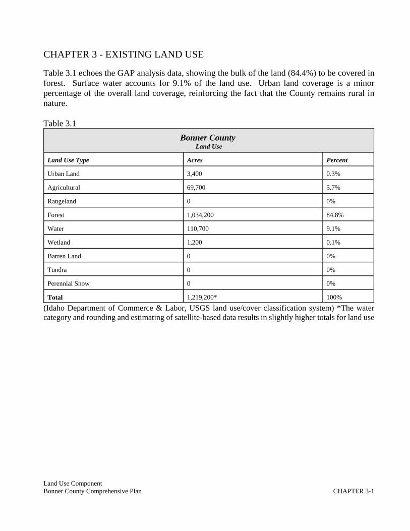
Table 3.1 echoes the GAP analysis data, showing the bulk of the land (84.4%) to be covered inforest. Surface water accounts for 9.1% of the land use. Urban land coverage is a minorpercentage of the overall land coverage, reinforcing the fact that the County remains rural innature.
Table 3.1Bonner County
Land Use
Land Use Type Acres Percent
Urban Land 3,400 0.3%
Agricultural 69,700 5.7%
Rangeland 0 0%
Forest 1,034,200 84.8%
Water 110,700 9.1%
Wetland 1,200 0.1%
Barren Land 0 0%
Tundra 0 0%
Perennial Snow 0 0%
Total 1,219,200* 100%
(Idaho Department of Commerce & Labor, USGS land use/cover classification system) *The watercategory and rounding and estimating of satellite-based data results in slightly higher totals for land use

Land Use ComponentBonner County Comprehensive Plan CHAPTER 4-1
CHAPTER 4 - EXISTING LAND DENSITY
The majority of the land within Bonner County is held in large, consolidated parcels owned either by thestate or federal government. The breakdown of the ownership is: Federal land: 492,593 acres or 44.43%(BLM, 11,162 acres; National Forest, 472,575 acres; Other, 8,856;) State Land: 170,053 or 15.3% (Stateendowment land, 167,640 acres; Fish & Game, 1,415 acres; Parks & Recreation, 803 acres; Universityof Idaho land, 195 acres). County land: 4,521 acres; Municipal land: 4,117 acres; Private land:440,780 or 39.6% (County Profiles of Idaho).
The following parcel density map provides a graphic picture of the developed and subdivided areas ofBonner County. The higher density subdivisions of private land (2.5 acres and less) are centered aroundthe County’s nine incorporated cities and scattered historic townsites (Coolin, Blanchard, Lakeview, etc.)and waterfront developments. Schweitzer Mountain and Sagle, south of Sandpoint, are two other areasof higher density land development.

Land Use ComponentBonner County Comprehensive Plan CHAPTER 4-2
Land Use ComponentBonner County Comprehensive Plan CHAPTER 5-1
CHAPTER 5 - LAND SUITABILITY
Idaho Code §67-65-9(e) requires communities examine the “intrinsic” suitability of lands for uses suchas agriculture, forestry, mineral exploration and extraction, preservation, recreation, housing, commerce,industry and public facilities.
Intrinsic means “belonging to the essential nature or constitution of a thing” (Merriam Webster). Throughthe public meeting process, the County has examined the essential elements necessary to make each ofthe categories of land uses suitable.
Section 5.1 Agriculture
Only about 65,565 acres, or about 6% of the soils studied in Bonner County meet the requirements forprime farmland (Natural Resources component of the Bonner County Comprehensive Plan). This acreageis scattered throughout Bonner County, but most of it is in the southwestern and north-central portionsof the County. About one-third of this prime farmland is used for crops and pasture. The balance iswoodland. The main crops grown on this land are spring wheat, oats, barley, and grass-legume hay. Atotal of 12 soil types are listed as farmland of statewide importance. There are 70,285 acres of land inBonner County which has a soil type considered to be of agricultural importance, though not necessarilylisted as “prime” by the soil survey (Wood).
Bonner County has mirrored the national trends in experiencing a decline in the farm/ranch acreage andfarm-based incomes over the past decades. The total acres in farms dropped from 150,021 acres in 1992to 98,662 in 1997 (County Profiles in Idaho). The number of small farms (up to 49 acres) has risenmodestly over a decade from 1987 to 1997, but the number of individuals who claimed farming as aprincipal occupation dropped from 245 to 217 over this same time frame.
Bonner County’s original Comprehensive Plan of 1978 did not provide for a particularized category ofland use for either agriculture or forestry. The lowest density provided for one dwelling unit per 5 acres,yet a 10-acre minimum “Agricultural” zoning district was formed in 1980 to “preserve, protect andmaintain areas that are rural in character where viable agricultural pursuits can be economically feasible”(Bonner County 1980 zoning code). The 1978 plan acknowledged that farming was “on the decline” inthe decade prior to the adoption of the comprehensive plan. One reason cited was the demand forresidential parcels, which caused larger tracts of land to be subdivided.
During workshops on the update of the comprehensive plan in 2005, members of the agriculturalcommunity met with the Planning & Zoning Commission and urged the County to take steps to preserveagricultural lands. Testimony from the public included concerns that the 10-acre minimums are too smallfor viable agricultural pursuits, with the exception of berry farms, hobby farms or small horse breedingoperations, a letter to the Commission stated (Wood).
Farmers and ranchers have begun to feel the effects of the County’s growth, as “open green spaces oragricultural districts of Bonner County are being sacrificed or destroyed by urban sprawl ordevelopment.” Over the past four years, Bonner County Assessor records show a loss of 6,804 acres of

Land Use ComponentBonner County Comprehensive Plan CHAPTER 5-2
land classified as “agricultural” in a four-year period (Wood).
Members of the agricultural community have urged the County to increase the minimum acreage foragricultural areas to 20 acres. Ten acre parcels are too small to be feasible for viable economicagricultural operations, and often encourage the spread of noxious weeds because they are too small tofarm but too big to adequately care for by the rural residential landowner, they testified (Wood).
The land cover map confirms agricultural lands are generally located in the north-central portion of theCounty, the western border with Washington state, an area north of the city of Priest River and areas southof the Pend Oreille River on the western side of Bonner County. Two large areas in the “Selle” area northof Sandpoint and south of the Pend Oreille River in the Hoodoo/Horn Mountain area coincide with thecurrent Agricultural zoning district.
The prime agricultural land soils were mapped by Bonner County in the Natural Resources componentof the Comprehensive Plan. The County also created an overlay map of the agricultural soils for analysisof the proposed land use. These soils are shown on the Projected Land Use Map in a stippled pattern.
Section 5.2 Forestry
Though forest lands cover nearly 85% of the County’s land base, the 1978 Comprehensive Plan did notdesignate timber production areas or prime forest land in the plan. The plan noted a trend toward“subdividing larger wood lots into five, ten, and twenty acre parcels which effectively takes this part ofthe resource out of production. Timber is Bonner Counties (sic) primary renewable resource. Timberconservation management should be encouraged on both public and private lands” (Bonner County,1978).
The original plan and resulting zoning districts did not specifically acknowledge a forest land designation,despite a recognition that the County’s forest land was being impacted by smaller parcel subdivisions.The Agricultural district specifically permits forestry, but set the density for the district at 10 acres.
A variety of tree species grow in Bonner County, with Douglas fir, lodgepole pine and ponderosa pinepredominating the lower flats and benches. Conifer forests in the Pend Oreille Key Watershed consistof mixed stands, typified by the stands of western red cedar/western hemlock; stands of co-dominantDouglas-fir and ponderosa pine (Pinus ponderosa); and stands of Douglas-fir, western larch (Larixoccidentalis), lodgepole pine (Pinus contorta), and western white pine (Pinus monticola). Dense standsof Douglas fir, larch, and lodgepole are characteristic of slopes with north and east aspects. Relativelyopen stands of Douglas fir and ponderosa pine are typical on the warmer, drier slopes with south and westaspects. (Bonner County, Natural Resources Component).
In the Priest Lake Basin area, western white pine, grand fir, western hemlock, Douglas fir, and westernlarch are the main species, with the Douglas fir and ponderosa pine growing on the drier south and westfacing slopes. Western red cedar grows on the wetter sites, both on the lower slopes and the bottomlandsoils. Patches of old-growth cedar have survived forest fires. This mixed species forest generally islocated at elevations of as much as 5,000 feet. Above 5,000 feet Englemann spruce and subalpine firbecome the predominant tree species (USDA NRCS). Brush fields blanket old burn areas, and rangelands
Land Use ComponentBonner County Comprehensive Plan CHAPTER 5-3
comprise the remainder of the basin’s vegetative cover (Idaho Water Resources Board, 1995).
In the eastern part of the County, where annual precipitation exceeds 35 inches, annual growth rates forwestern white pine and grand fir are the highest. The benches on both sides of the Clark Fork River areexcellent growing sites for mixed species forest. (USDA NRCS)
Bonner County recognizes the enormous impact the forest lands have on its community, with 1 millionacres of land devoted to forest land and forest production. The impact of forest land subdivision andintrusion of smaller-acreage land divisions into federal and state forest lands has been a focal point duringspecial meetings with the Planning & Zoning Commission and U.S. Forest Service and Department ofLands representatives during 2004 and 2005.
Wildland/urban interface management and the “rapid urbanization and subdivision development” of forestlands are key issues that state and federal programs will address together in the next few years (IdahoDepartment of Lands). Idaho’s Forest Legacy program was established to promote forest land protectionand to “ascertain and protect” environmentally important forest areas that are threatened by conversionto non-forest uses. Forest lands are recognized as assets that provide direct economic benefits fromtimber production, grazing land, recreational opportunities, wildlife habitat and aesthetic values.“Unfortunately, the increase in monetary value and the inevitable development of this land threatens allthat makes it attractive, including sustained wildlife, scenic and timber values” (Idaho Forest LegacyProgram). The program recognizes that most forest lands in the country are private, and landowners facegrowing financial pressures to convert lands from the forest base to residential or commercial uses.
5.3 Mineral Exploration & Extraction
Most of Bonner County’s mining activity is limited to sand, rock, gravel and clay exploration andextraction. A map of the sources and active mines has been provided in the Natural ResourcesComponent of the Comprehensive Plan. Sand and gravel deposits are plentiful almost everywhere at thelower elevations in the Bonner County area. There are active mining operations throughout the County,with noted resources in the Colburn, Sagle and Dover areas, the Priest Lake basin, Careywood and southof the Oldtown/Priest River area. Clay sources are located in the Clark Fork and Cabinet Mountainvicinity. A few mining operations extract rock and riverbed stones for decorative uses.
As of 2003, reclamation plans had been filed with the State of Idaho for approximately 2,205 acres of landrepresenting about 95 mining sites in Bonner County. The acreage represents only those operations whichhave filed reclamation plans with the state.
Bonner County zoning regulations require conditional use permits for mining activities to provide areview of potential impacts from dust, traffic, noise, blasting and use of water resources. The suitabilityof sites for mining activities are generally based on where the resources are encountered. Considerationin the location of future mining operations should be given to the proximity of operations to high densityresidential development, sensitive wildlife habitat, surface and ground water and transportation networks.

Land Use ComponentBonner County Comprehensive Plan CHAPTER 5-4
5.4 Preservation
Both public and private entities have taken the initiative to preserve structures and lands that offer uniquecultural or environmental features or provide open space. The “Special Areas or Sites” component of theComprehensive Plan provides information on the various significant archaeological, ecological, wildlife,and scenic sites that have been recognized in Bonner County as unique and important to preserve. Publictestimony has also prompted Bonner County to encourage voluntary conservation easements, land trustsand other private and public land conservation programs as tools to preserve open space and productiveforest and farm lands and to protect sensitive areas such as wetlands, floodplains, or critical wildlifehabitat. Bonner County should also consider avenues to create incentives for land conservation throughits zoning and subdivision laws (Natural Resources policy statement, Bonner County ComprehensivePlan, goals and objectives). Preservation of unique natural and cultural features and ecosystems shouldbe a foundation of the rural community’s land use policies in recognition of the irreplaceable nature ofthese areas. Design standards to encourage preservation of open space as a means of keeping the ruralcharacter of the community should also be a center of Bonner County’s land use codes.
5.5 Recreation
Bonner County has recognized the numerous public and private recreational opportunities that are a majorCounty asset to be protected and encouraged. Many parks, the large tracts of public lands, andcampgrounds adjoin private lands. Vistas, parkways, scenic drives and trails encompass portions of thetravel-ways in the County. Golf resorts and water-related recreation activities, including marinas/boataccess, beaches/public access, fishing, make Bonner County a summer destination for much of the InlandNorthwest; while fall and winter time activities including hunting, downhill skiing and snowmobilingmake Bonner County a fall and winter destination for the Spokane and Coeur d ‘Alene recreationists.
The County has chosen the Alpine and Resort Community land use map designations as a method torecognize existing developments centered around sports, outdoor attractions and recreational uses and toprotect and encourage this important County asset. Existing areas of developed recreational communitiessuch Schweitzer Mountain Resort, and the golf/residential complexes of Hidden Lakes, Stoneridge, andPriest Lake Golf Resort represent the desire of the community to develop areas for recreationalopportunities.
Bonner County seeks to develop a waterways and park access program to preserve and develop accessto public recreational lands and waterways. This program should include retaining access parcels thatmay be acquired from tax sales or private donations. The County has recognized that as the developmentof the area’s waterways continues, public access to public waterways is being eroded.
The County wishes to create “green belts” of opens space and bike and “multi-use” trail and recreationsystems as a “economic bootstrap” for the area to add to the existing attractions and create futureopportunities. Whenever possible, the County desires to interconnect these systems as new developmentoccurs as to not adversely affect existing public recreational accesses and amenities.

Land Use ComponentBonner County Comprehensive Plan CHAPTER 5-5
5.6 Housing
Suitability of land for housing development is tied to the ability to serve future residents adequately withsewer and water provisions, fire protection, schools, police and roads and avoidance of hazardous orsensitive areas. Central to the comprehensive plan discussion by the community and Commission duringworkshops to revise the comprehensive plan has been issues of water quality, adequate public servicesand the desire to focus higher density growth to those areas that can adequately serve the largerpopulations with a good transportation system and urban-level sewer and water services.
Rapid development of the suburban area of Bonner County in recent years has also brought into focus theneed to provide adequate separation between septic drainfield systems and domestic wells, and to assurecontinued groundwater protection as the growth continues. Zoning standards established in 1980 set fortha 9,000 square foot minimum for suburban parcels served by individual wells and septic/drainfields. Theminimums were revised to 1 acre for Suburban, Commercial, Rural Service, Industrial and Recreationparcels not served by “urban” water or sewer services in 1995.
During comprehensive plan workshops, the Planning & Zoning Commission reviewed with the PanhandleHealth District and the Division of Environmental Quality the constraints that individual systems placeon residential homesite development. The Commission had concluded that a 1-acre minimum isinsufficient for adequate separation of individual wells and subsurface sewage disposal systems, and thatthe property rights of adjoining landowners can be affected by the proliferation of 1-acre parcels withindividual wells/septics by limiting the neighbors’ well construction or homesite development.
Water quality is also an issue as growth occurs on unsewered lots. Nitrate is not removed from the soilas wastewater percolates downward (Groundwater Stewardship in Oregon). Risk of transport of nutrientsand pathogens through the soil also present problems, particularly in areas of high water tables and highlypermeable soils. The Natural Resources Component of the Bonner County Comprehensive Plan pointsto septic tanks as a source of water quality degradation of a number of County waterways. The soilschapter of this component also points out the lack of suitable soils in Bonner County for adequatesubsurface sewage disposal. Of the 64 soil units inventoried in the Soil Survey of the Bonner CountyArea, Idaho, only three are rated favorable for the use of subsurface sewage disposal units, while thebalance are classified as “severe,” due to soil properties or site features that are so unfavorable or sodifficult to overcome that special design, significant increases in construction costs, and possiblyincreased maintenance are required.
Kootenai County and the Panhandle Health District studied the effects of septic/drainfields on theRathdrum Aquifer, and found a direct relationship between the growing number of septic systems andhigh soil nitrate levels. The County stopped issuing septic permits on lots of less than 5 acres, but offeredsewer management agreements to allow development of higher density subdivisions to occur while sewertreatment systems were being extended to serve it (American Planning Association). Minimum acreagerequirements in various jurisdictions differ, based on aquifer depths and extent, soil types, growthobjectives, etc.
The Planning & Zoning Commission proposed a minimum 2½-acre site area where neither urban-likewater nor urban-like sewer services is available, and a 1-acre minimum where either urban water or urban

Land Use ComponentBonner County Comprehensive Plan CHAPTER 5-6
sewer services is available. Bonner County Revised Code, Section 12-202, defines urban services as:
URBAN SERVICES. Publicly or privately maintained water supply and distributionsystems; sewage collection, treatment and disposal systems (not to include individualseptic tanks and drainfield systems or community septic tanks and drainfield systemsunless subject to an approved sewer management agreement); electric power andtelephone utilities; and hard-surfaced roads constructed to the standards set forth in Title2 of this Title. (Ord. 278, 3-29-1995)
Bonner County adopted an interim ordinance in February of 2005 establishing a 2½-acre minimumstandard for parcels not served by both urban water and sewer services. Under the ordinance, a parcelserved by a public or private, community water system, but served by individual septic tank/drainfieldsystems could be subdivided into lots of 1 acre each, provided they meet the remaining zoning andsubdivision laws and are approved by Bonner County. Likewise, a parcel served by a public or privatesewer collection, treatment and disposal system but individual wells would be entitled to 1-acreminimums. Service by neither “urban” water or sewer would mean 2½-acre minimums. Public or privatewater systems may include water districts, city water service or private well systems designed andoperated to meet the public standards of the State of Idaho. Urban sewer systems include the sewerdistricts, city sewer systems or treatment systems such as the lagoon/spray irrigation system operated byHuckleberry Bay Co. east of Priest Lake. Large absorption drainfields or other communityseptic/drainfield systems are not considered urban services. The current ordinance offers an opportunityfor a sewer management agreement, similar to the Kootenai County version, in which agreements betweendevelopers and sewer districts and Bonner County may be created to bring sewer treatment to adeveloping area.
In addition to the basic sewer and water services, the community has mapped and adopted within itscomprehensive plan floodplain hazards, steep slopes, sensitive wildlife areas, wetlands, fire districts andtransportation systems. Proposed densities relative to these service and sensitive areas are reflected inthe proposed land use matrix and proposed land use map.
5.7 Commerce and Industry
The 1978 economic development portion of the County’s comprehensive plan calls for commercial andindustrial areas to be located in defined areas and along major roads. When the original comprehensiveplan was adopted in the late 70s, the County’s economic focus was on timber production and related milloperations.
The Economic Development component of the Comprehensive Plan details the evolution of BonnerCounty’s industry and commerce. The component acknowledges the permanent losses of high-payingmill and logging jobs. Other industrial development has offset the lumber industry's job losses with suchnew sources of employment as the retail and catalog business, food manufacturing, medical research,development and services, high-tech and specialized manufacturers of computer parts and tool and metalfabricators.
The 1978 plan established industrial uses in the rural areas of the County for such natural-resource related
Land Use ComponentBonner County Comprehensive Plan CHAPTER 5-7
industries as lumber mills. The plan also encouraged a diversity of industries and called for “certainstandards” to be adopted to minimize adverse impacts on natural resources, existing services and theintegrity of the residential areas. Similar themes were echoed during the 2003 community meetingsconducted by Bonner County as part of the comprehensive plan update. Citizens recognized the need todiversify its economic base and looked to the County to encourage new industries to replace the loss oftimber jobs. But the public also emphasized the need to protect the natural resources and preserve therural character of the community while encouraging commercial and industrial growth. Strip and sprawldevelopment should be avoided, and clustered or concentrated areas of commercial and industrial usesshould be encouraged to preserve the natural areas, retain the free-flowing transportation system andretain the rural setting (Land Use component minute record).
Bonner County currently has about 380 acres of vacant commercial land and 2,755 acres of developedcommercial lands in the unincorporated areas, according to the Bonner County records. These figuresinclude commercially developed recreation sites, but exclude commercial timber or grazing lands. Vacantindustrial land accounts for about 106 acres, while improved industrial acreage totals about 630 acres,excluding ag/industrial uses (Assessor’s Office communication).
5.8 Public Facilities
An entire component of the Comprehensive Plan, “Public Services, Facilities and Utilities” is devoted tothe water, sewer, transportation, electric and gas services of this community and the public facilitieswhich serve it. Suitability of lands for public facilities are based on service boundaries, community needs,proximity to sources of water, gas or electrical transmission lines and other resource needs. Considerationmust be given to avoiding hazardous areas and avoiding the potential to create hazards when siting publicfacilities.
Model flood damage prevention ordinances, which Bonner County has adopted, require sewer, water andgas utilities be designed to minimize the infiltration of flood waters into the systems and the dischargeof sewage into flood waters. On-site waste disposal systems are to be located to avoid impairment duringa flood and contamination from them in the event of flooding (Bonner County Revised Code, Chapter 16).The Federal Emergency Management Agency (FEMA) also cautions communities to establish emergencyresponse and critical facilities away from floodplains so that communications, equipment, shelters andpersonnel are not at risk in flood events.

Land Use ComponentBonner County Comprehensive Plan CHAPTER 6-1
CHAPTER 6 - PROPOSED LAND USE
The existing 1978 comprehensive plan map and matrix created five major map designations and providedfor a density range of 12,000 square feet to 5 acres. An approximate 1-mile swath of the County’swaterways were designed “Recreation,” and provided for a range of activities from higher densityresidential development, commercial and industrial uses, recreational vehicle parks and mobile homeparks. Generally most of these area designed for the most intense, highest density uses did not haveurban-like water or sewer services and in many cases lacked good transportation networks. Examples arethe remote Lakeview townsite, on the eastern side of Lake Pend Oreille, which is nearly inaccessible inwinter over the 26-mile Forest Service road system, and the upper stretches of the Priest Lake and UpperPriest Lake, which are served by limited state or federal roads.
The majority of the County was designated “rural,” with 5-acre minimums in the 1978 plan. Almost allof the federal and state lands and surrounding large holdings of private timber lands were designatedRural, even though many of these areas are remote and service-less.
After developing an extensive set of resource maps detailing the sewer and water service areas,transportation networks, surface water, slopes, hazard areas, wetlands and wildlife habitat, Bonner Countydetermined that the 1978 land use map needed to be completely revised, and a new map adopted. Thefocus of the revisions was placing higher density development in areas that can be served by good roadsystems and public services that are centered in the city areas of impact. Bonner County recognized thatit needs to encourage development in areas where services are located and to protect its productive timberand agricultural lands. Slopes also factored into the future land use analysis. Areas of steeper slopes(30% and greater) are recognized as poor areas for residential development because of the need forexcessive road building, exposure to wildland fire, erosion potentials and challenges to adequatelyserving these areas with fire and emergency services. More than 40% of the woodland acreage is onsteep, erodible soils. More than half of the 64 soils units classified in Bonner County are listed as poorlysuited for homesite development due to slope. (Soil Survey).
Bonner County proposed to establish the following density ranges:0-2.5 acres for areas served by urban-like water and sewer services and goodtransportation networks and fire protection districts. These areas are generally locatedwithin the areas of city impact, where urban services are available or can be extended, orwhere taxing districts have been formed to provide sewer and water services as historicneighborhoods have arisen and expanded. Generally, these areas have little to moderateslopes. Within certain areas of city impact, sewer and water services are not available andsteeper slopes prevail. These areas have been designated for lower densities. Included inthis 0-2.5-acre density range are the County’s recreation communities with full services,such as Schweitzer Mountain ski resort and the Hidden Lakes and Stoneridge golf andresidential complexes.1-5 acres for areas on or near the fringes of city impact, which may be within fire districtsand sewer or water districts, adjoining higher density, developed areas with public right-of-way access. Slopes are generally level to moderate (0-10%). Expectations are for theseareas to be served or annexed by nearby cities.

Land Use ComponentBonner County Comprehensive Plan CHAPTER 6-2
5 to 10 acres for areas outside the sewer districts, but in areas where subsurface sewagedisposal can be achieved without adverse impact to surface or ground water. These areareas outside the prime agricultural lands. Slopes are level to moderate. Access may beprivate or public roads. Sites are away from the city centers, but generally accessible bynearby transportation networks. Excludes areas of steeper slopes. These areas includecritical wildlife habitat areas identified by resource mapping.10 to 20 acres Included in this would be agricultural lands, forest land, sites on steeperslopes, where generally there is limited transportation networks. Certain critical wildlifehabitat and wetlands may be present. Steeper slopes (30% and greater) are predominate.20 acres and larger Roadless, remote, service-less private lands and areas reserved for theprime timber and agricultural lands and certain municipal watersheds. Slopes may varyfrom level to steep and transportation systems also vary, since the primary focus of thisdesignation is to preserve prime forest and agricultural lands.40 acres and larger State and federal holdings within roadless, remote, service-less areason steeper slopes devoted to timber production and management or public recreationaluses. Included in these areas are some municipal watersheds.
Bonner County’s 1978 comprehensive plan “Proposed Land Use” component called for five general landuse classifications. The revised “Project Land Use Map” calls for 10 land use designations noted in thematrix below.
The 1978 designations and their descriptions were: Recreation: The Recreation classification is intended to allow for urban residentialdensities in remote and scenic areas of the County centered around winter sports, lakes andrivers. If seasonal recreation areas can be developed without requiring year-round publicservices, the cost to taxpayers of servicing these remote areas can be minimized.Rural: The Rural classification makes up the majority of the County. These areas areaway from existing population and service centers with a residential density of one unitper five acres. Natural resource oriented industry and manufacturing are permitted as aconditional use.Suburban: The Suburban classification designates the neighborhood or residential areasof the County. Land use includes neighborhood businesses, home occupations, andresidential density of one unit per acre. Multi-family housing and mobile home parks arepermitted as a conditional use.Transition: The Transition classification provides for land uses similar to the urban areaswith the exception of slightly less residential density per acre and heavy industry beingpermitted as a conditional use. The transition classification allows for cities and existinggrowth centers to expand without totally committing the land as an industrial area.Urban: The Urban classification is designed so the most intense type of land use occursaround the largest cities and towns, where existing services can best handle the growingdemand. Land use in the urban area includes industry and commerce, multi-familyhousing and mobile home parks, and small-lot single family residential.

Land Use ComponentBonner County Comprehensive Plan CHAPTER 6-3
6.1 Proposed Land Use (Matrix/Categories)
The proposed land use matrix below lists general uses and characteristics of each of the map designations.Since the map covers 1.1 million acres, the map is generally in nature, and it is recognized that some areasmay have more moderate slopes or include transportation features that cannot be mapped on this scale.
Map Designations
1.Transition: The Transition classification is reserved for those areas of the County where a mixture ofland uses can occur which may include higher density residential uses, commercial, industrial and lightindustrial uses. Due to the intensity of land use, these areas require primary transportation routes, urban-like water and sewer services, fire and police services.
2. Neighborhood Commercial The Neighborhood Commercial area is designed to provide lightcommercial uses to serve the needs of the rural communities and tourist trade without adversely affectingresidential neighborhoods. Urban services and primary transportation systems, such as the state highwaysor major/minor collector roads are required.
3. Urban Growth Areas The Urban Growth Areas are designed to recognize the historic developments ofcommunities and neighborhoods which are served by either urban water or sewer services or are locatedwithin the fringes of incorporated cities where such services have or can be extended to serve these areas.These areas are general level to moderately slopes and serve by a network of primary transportationsystems.
4. Resort Community The Resort Community provides for urban-like densities for areas centered aroundthe recreational areas developed for winter and water sports, golf and hiking, where urban services areprovided.
5. Alpine Community The Alpine Community is established to recognize the challenges of higher densitydevelopment in higher elevations of Bonner County generally above 3,500 feet elevation, where urbanservices are provided, but a range of road types developed in mountainous conditions serve the area.Specific design standards to address steeper slopes and heavy snowfall will govern these areas.
6. Suburban Growth Area The Suburban Growth Area is located on the edges of the incorporated citiesor higher density developed communities or areas, where urban sewer and water services may not beavailable or are not likely to be extended. Access to primary transportation routes and a system of hard-surfaced roads are expected.
7. Rural Residential The Rural Residential area provides for residential development in areas where urbanservices are not available and slopes may vary up to 30%. These areas include hazard areas and criticalwildlife habitats, where lower densities reduce potential impacts to resources and exposures to loss ofproperty or lives. Small-scale agricultural uses and residential development are permitted.
8. Ag/Forest Land The Ag/Forest Land designation recognizes areas where steeper slopes prevail (30%

Land Use ComponentBonner County Comprehensive Plan CHAPTER 6-4
or greater) and transportation is provided by private roads or U.S. Forest Service or state roads. Urbanservices are not available and residential development challenges are present due to slope, poor soilconditions, hazard areas and lack of police or fire services.
9. Prime Ag/Forest Land The prime agricultural/forest land is designed to preserve the productive farmand ranch land and timber land to promote its important economic and environmental contributions to theCounty. This area may have a range of road systems serving it and is generally served by individualsewer and water systems. These areas generally have prime agricultural land soils and soils of recognizedstate importance and active farm and ranch operations.
10. Remote Ag/Forest Land The remote Ag/forest land is located on mountaintops and remote areas ofthe County where few or no access roads have been constructed. Included in these areas are most of thestate and federal lands, which are managed for forest production or recreation.

Land Use ComponentBonner County Comprehensive Plan CHAPTER 6-5
BONNER COUNTY PROPOSED LAND USE MATRIX - Criteria
DES
IGNA
TIO
N
DEN
SITY
SER
VIC
ES
TRAN
SPO
RTA
TIO
N SLO
PE
USE
Transition 0-2.5 acres Urban 1 0-10% Commercial/Industrial/Mix
Neighborhood Commercial 0-2.5 acres Urban 1 0-10% Rural/Commercial/Mix
Urban Growth Area 0-2.5 acres Urban/Partial 1 0-10% Higher density residential
Resort Community 0-2.5 Urban 1 0-10% Waterfront residential/recreation
Alpine Community 0-2.5 acres Urban 1-3 N/A Recreation/Residential/Mix
Suburban Growth Area 1-5 acres Individual 2 0-15% Residential & associated uses
Rural Residential 5-10 acres Individual 3 0-30% Rural/small-acreage farms/residential
Ag/Forest Land 10-20 acres Individual 3-4 $30% Ag/residential/forest land
Prime Forest/Ag Land $20 acres Individual 2-4 0-30% Prime Ag/forest land
Remote Forest/Ag Land $40 acres Individual 5 $30% Remote forest/Ag landGeneral transportation criteria:
1: Hard-surfaced road. (Major/minor collector - frontage road, U.S. highway, principal arterial.) (Higher density residential needs hard-surfaced road, but notnecessarily highway/frontage. etc.) Public right-of-way.2: Public right-of-way; paved3: Public right-of-way, paved or gravel/private easement, International Fire Code standard4: USFS, DOL or private road systems adjoining county or state public transportation systems.5: Roadless, primitive, trail system or unimproved.

Land Use ComponentBonner County Comprehensive Plan Bibliography - 1
BIBLIOGRAPHY
American Planning Association., Planning Practice, Liquid Gold, May 1997
Bonner County Assessor’s Office, e-mail communication, personal communication, November, 2005.
Bonner County Zoning Code, Ordinance #140, 1/11/80.
Bonner County Comprehensive Plan, 1978.
http://www.idoc.state.id.us/idcomm/profiles/pdfs/Bonner.pdf
(National Gap Analysis Program, and land cover mapping efforts, please refer to the following websites:National Gap Analysis Program - http://www.gap.uidaho.edu/
Idaho Gap Analysis Project - http://www.gap.uidaho.edu/idgap/
Idaho Department of Lands, State & Private Forestry Fact Sheet, March 2004.
Idaho Forest Legacy Program, www2.state.id.us/lands/forest_legacy/legacy-1.htm
Groundwater Stewardship in Oregon
Soil Survey of the Bonner County Area, Idaho. November, 1982.