land use plan of cochin port 2012-2042
TRANSCRIPT

LAND USE PLAN OF COCHIN PORT -2012-2042 Page 1
April 2012
Land Use Plan of Cochin Port 2012-2042
COCHIN PORT TRUST WILLINGDON ISLAND
COCHIN-682009

LAND USE PLAN OF COCHIN PORT -2012-2042 Page - 1 -
TABLE OF CONTENTS
1. Introduction...............................................................................................: 3
2. Existing Land Use Plan of Port Area.....................................................: 4
2.1. Existing Land Use Plan of Willingdon Island.......................................: 4
2.1.1. Land Lease Details....................................................................................: 7
2.1.2. Height Restrictions due to Flying Funnel restrictions.........................: 9
2.1.3. Coastal Regulation Zone Restrictions....................................................: 11
2.2. Existing Land Usage of Other Areas Outside Willingdon Island.....: 12
2.2.1. At Vallarpadam..........................................................................................: 12
2.2.2. At Puthuvypeen.........................................................................................: 12
2.2.3. At Bolghatty................................................................................................: 13
2.2.4. At Ernakulam.............................................................................................: 13
2.2.5. At Palluruthy..............................................................................................: 13
2.2.6. At Fort Cochin............................................................................................: 13
3. Proposed Land Use Plan...........................................................................: 1 3
3.1 Proposed Land Usage Plan of WIllingdon Island.................................: 14
3.1.1. Proposed Port Side Land Usage..............................................................: 15
3.1.2. South End Land Use Plan.........................................................................: 18
3.2. Proposed Land Usage Plan of Other Areas outside Willingdon Island.: 21
3.2.1. At Vallarpadam..........................................................................................: 21
3.2.2. At Puthuvypeen.........................................................................................: 21
3.2.3 At Bolghatty...............................................................................................: 22
3.2.4 At Ernakulam.............................................................................................: 22
3.2.5 At Palluruthy..............................................................................................: 22
3.2.6 At Fort Cochin............................................................................................: 22
3.2.7. Future Development..................................................................................: 22

LAND USE PLAN OF COCHIN PORT -2012-2042 Page - 2 -
LIST OF FIGURES
Figure 1 Port Area in Cochin Port......................................................................... : 4
Figure 2 Existing Layout of Willington Island.................................................... : 5
Figure 3 Willington island Area Breakup............................................................ : 6
Figure 4 Land Area based on Lease Expiry (Northern End)............................. : 7
Figure 5 Land area based on lease expiry (Northern End)…………………... : 8
Figure 6 Flying Funnel and Height Restriction on Northern Part of Island... : 9
Figure 7 Flying Funnel and Height Restrictions on Southern end of Island.. : 10
Figure 8 Height Restrictions for Core Port operations...................................... : 10
Figure 9 Height Restriction at South End Reclamation Area............................ : 11
Figure 10 Proposed Land Usage Plan.................................................................... : 14
Figure 11 Backup Area for Port Operations : 15
Figure 12 Location of the Proposed Logistics Park and port User’s Complex. : 16
Figure 13 Area Statement- proposed Business District....................................... : 19
Figure 14 Land Use Plan 2012 – 2042…………………………………………….. : 24

LAND USE PLAN OF COCHIN PORT -2012-2042 Page - 3 -
1 . Introduction
In pursuance of the Guidelines of the Ministry of Shipping (MoS) vide letter
No. PT-11033/4/2009-PT dated 13th January, 2011, the Perspective Land Use
Plan of Cochin Port Trust for the period of 2012–2027 has been revised. The
guidelines issued vide earlier communications from the Ministry have also
been taken into account; to the extent they are consistent with the current
policy guidelines.
The land use plan forms the matrix for the balanced development of the Port
by planned distribution of the land area for various activities. The
requirement of land for future expansion projects of the Port, requirement of
land for trade that add to the cargo and vessel volumes, area that are required
for Port Users for creation of allied facilities/ additional facilities and services
to be provided to the existing lessees, etc. has been considered while working
out the land use plan.
The area requirement for various purposes has been identified considering
the projected traffic volume as per Master Plan of the Port. The development
proposals for the Port during the XIIth plan period and also the requirement
of major port user organizations of the hinterland have been considered and
matched with the local conditions, wherever necessary. The method adopted
is at best only a fairly approximate one since the activities are also in the
proposal/ planning stage.
Allowances have also been made for accommodating the variations to a
certain extent. Further, the dynamics of international trade does not permit a
rigid planning, as the fluctuations in the business will have an impact on the
land utilization by the Port users. This would also vary in accordance with
the trade cycle, market conditions and the economic reform policies of the
Government. Ecological and environmental considerations have also been
taken in to account while finalizing the plan. Thus, it can be seen that the
entire land/ water area under the jurisdiction of Cochin Port has been
judiciously distributed to obtain maximum utility/ production and without
adversely affecting the delicate ecology or hampering the natural beauty of
Cochin backwaters, which have to be conserved in the overall interest of the
country.
While finalizing the Land Use Plan the fact that the land resource is only a
means towards achieving the end objective of efficient cargo/ vessel handling
has been taken into cognizance. Accordingly, the proposed land utilization is
objectively focused towards maximizing revenue returns by putting them
into judicious and productive use.

LAND USE PLAN OF COCHIN PORT -2012-2042 Page - 4 -
The Land Use Plan of Cochin Port is divided into two sessions viz. (a) Land
Use Plan of Willingdon Island and (b) Land Use Plan of other areas and both
are discussed below.
2 . Existing Land Use Plan of Port Area
Cochin Port Trust has under its jurisdiction approx. 886.046 hectares of land
at various locations in Kochi including Willingdon Island (385.82 Ha.),
Bolghatty (16.670 Ha.), Vallarpadam (163.637 Ha), Puthuvypeen (308.552
Ha.), Ernakulam (5.447 Ha.), Fort Kochi (2.06 Ha.), and Palluruthy (3.86 Ha.).
Figure 1: Port Area in Cochin Port
Location Areas (Hectares)
A. Willingdon Island 385.82
1. Land in North Area of Island 233.44
2. South End Reclamation Area 152.38
B. On Ernakulam Mainland 5.447
1. North & South Tanker Jetties 1.130
2. At Thevara 0.587
3. Adjacent to GIDA land 3.510
4. In front of Chathiyath church 0.220
C. On Fort Cochin Headland 2.060
1. Fort Cochin Wharf 0.940
2. Old Workshop 0.300
3. Fort Cochin Jetty area 0.140
4. Area Occupied by Quarters 0.230
5. Beach Bungalow 0.450
D. Vallarpadam 163.637
E. Puthuvypeen 308.552
F. Bolghatty 16.670
G. Palluruthy 3.860
T O T A L 886.046
2.1 Existing Land Use Plan of Willingdon Island
Most of the Port activities are based on Willingdon Island, which consists of
reclaimed area of 233.44 hectares and an area of 152.38 hectares of land at
south end of Willingdon Island partially reclaimed. The land area on
Willingdon Island is almost completely developed barring the south end area.
The reclaimed south end area cannot be used for core port operations as
presence of rail and road bridges across the channel make it un-navigable for
ships in both the Ernakulam and Mattancherry channels southwards beyond
the Naval jetties and Cochin Port workshop respectively.

LAND USE PLAN OF COCHIN PORT -2012-2042 Page - 5 -
The existing layout shows the berth areas and the corresponding facilities
available on the island. The distinction between the naval area and the area
under the Cochin Port Trust is clearly visible. The entire land mass of
WIllingdon Island is shared between CoPT and the Indian Navy.
2.1.1 Land Usage
Willingdon Island consists of reclaimed area of 233.44 Hectares and an area of
152.38 Hectares of land at south end of Willingdon Island which is partially
reclaimed.
The general pattern of present land utilization of area on Willingdon Island
and the split up of the developed land under different category of use in
various locations are as given below. Out of the total land area of 385.82
Hectares on Willingdon Island, Cochin Port has leased 76.53 hectares of land
to Government/Quasi-government and Private organizations for Port
connected activities.
Figure 2 Existing Layout of Willingdon Island

LAND USE PLAN OF COCHIN PORT -2012-2042 Page - 6 -
Location Area (Hectares)
Land in North Area of Willigdon Island 233.44
Leased to Government Agencies 11.64
Leased to Quasi-Government Agencies 17.27
Leased to Private agencies 47.62
Port operation, including backup area, workshop, dry dock etc. 56.72
Railways (area handed over to railways in 09/2000) 29.32
Roads 27.95
Port residences and other non-operational purposes 37.13
Vacant land 5.77
Land Available at South End Reclamation Area 152.38
Vacant land at South End (partially reclaimed/being reclaimed) 141.60
Leased land at South End Reclamation Area 10.79
Total 385.82
The total proposed backup area, as per the revised master plan, required for
the future Port operations at Willingdon Island is approximately 80.12
hectares. The existing land area being used for core operations of Willingdon
Island is approximately 56.62 hectares.
Additionally, CoPT has approximately 37.13 hectares of land housing port
residences and used for non-operational purposes and vacant land of 5.77
hectares. Thus the total land area, that has not been leased out, available with
the port is approximately 99.52 hectares.
Hence, CoPT will be able to create infrastructure for proposed scale of
operations by realigning the existing land being used for core operations as
well as non-operational purposes based on the new land use plan. The
existing lease tenure of land with third parties has been taken into account so
that there is minimum disruption to existing tenancy and the proposed
development may be carried out in a phased manner.
Figure 3: Willingdon Island Area Breakup

LAND USE PLAN OF COCHIN PORT -2012-2042 Page - 7 -
2.1.2 Land Lease Details
The above diagram provides a layout plan detailing the land area based on
lease expiry. The colour coded layout of the land area of Willingdon Island
gives an idea of the land available to the port in the coming years. The areas
marked in red belong to the port and have not been leased out. The other
areas are colour-coded as per the legend based on their lease expiry dates.
Figure 4 Land Area based on Lease Expiry ( Northern End)

LAND USE PLAN OF COCHIN PORT -2012-2042 Page - 8 -
The breakup of land area by lease tenure is as given below:
Lease Expiry
Land Area ( Hectares) Percentage
2006-2010 0.64 1.19%
2011-2015 24.26 45.48%
2016-2020 11.41 21.39%
2021-2025 8.80 16.49%
2026-2030 0.96 1.80%
2031-2035 4.51 8.46%
2036-2040 1.55 2.91%
2041-2080 1.21 2.28%
Total 53.34 100.00%
Approximately 46.67% of the total area under the port trust’s jurisdiction in
the northern end is likely to be free of any lease or tenements beyond FY15,
provided Cochin Port Trust does not extend the lease contracts with the
existing lessees. Beyond 2020, about 68.06% of the area on the northern end of
Willingdon Island will be available for development as per the existing lease
agreements. Remaining lessees can be suitably relocated to other parts of the
island or may be allowed to continue their tenancy as per the port’s
developmental plans.
The entire area on the south end reclaimed land is available for development.
Land parcel measuring 4.046 hectares has been allotted to the Indian
Maritime University for setting up a campus. An area admeasuring 1.62
hectares has been allotted to the Indian Navy.
Figure 5 Land area based on lease expiry (Northern End)

LAND USE PLAN OF COCHIN PORT -2012-2042 Page - 9 -
2.1.3 Height Restrictions due to Flying Funnel restrictions
i) Area under flying funnel
Figure 6 Flying Funnel and Height restriction on northern part of island
Willingdon Island is also home to an airstrip that is used by Indian Navy.
Hence a significant portion of the port land falls under the flying funnel
because of which there are height restrictions for built-up development. The
flying funnel and height restrictions are detailed in the diagrams

LAND USE PLAN OF COCHIN PORT -2012-2042 Page - 10 -
Figure 7 Flying Funnel and Height restrictions on southern end of island
The details of height restriction at various proposed berths in the port area in Willingdon Island are as follows:
Figure 8 Height restrictions for core port operations

LAND USE PLAN OF COCHIN PORT -2012-2042 Page - 11 -
The details of height restriction at various proposed facilities in the south end
reclamation area are as follows:
Sl. No.
Plot ID
Proposed Usage Area Height Restrictions due to Flying Funnel
1 A15 Commercial Area 1.82 Ha Partially Applicable (G+6/7)
2 A16 Commercial Area 5.5 Ha Applicable, only small portion can be built with (G+0) Structures
3 A17 FTWZ 41.27 Ha Mostly applicable ( G+1/2/3/4/5/6/7/8/9)
4 A18 Business District 7.88 Ha Partially Applicable (G+3/4/5/6/7/8/9)
5 A19 Hospitality Node & Business District 22.38 Ha Applicable (G+5/6/7/8)
6
Maritime University 4.05 Ha Partially Applicable (G+4/5)
*Not Applicable implies that the area does not fall under any of the flying funnels
ii) Area not under flying funnel
The height restriction for built-up development in land parcels that do not fall
under the flying funnel restrictions has been assumed to be 17.3 m,
considering the height achieved by infrastructure at Vallarpadam ICTT and
restrictions imposed by Indian Navy, which occupies considerable portion of
the island.
2.1.4 Coastal Regulation Zone Restrictions
As per the CRZ notification, the CRZ areas of Kerala including the
backwaters and backwater islands requiring special consideration for the
purpose of protecting the critical coastal environment needs to be taken into
consideration by CoPT. As per the Coastal Zone Regulation for Kerala, entire
Non port activity area of the Willingdon Island is covered under the CRZ
notification and hence has 50 meters width from the High Tide Line on the
landward side as the CRZ area where no new construction is permitted.
However, facilities such as fishing jetty, fish drying yards, net mending yard,
fishing processing by traditional methods, boat building yards, ice plant, boat
repairs and the like, may be taken up within 50 meters width from HTL of
these backwater islands.
Figure 9 Height restriction at south end reclamation area

LAND USE PLAN OF COCHIN PORT -2012-2042 Page - 12 -
2.2 Existing Land Usage of Other Areas Outside Willingdon Island
2.2.1 At Vallarpadam
Cochin Port Trust is developing a Special Economic Zone at Vallarpadam in a
land area of 115 Ha, out of the 163.637 ha. available. This will be the first port-
based Special Economic Zones in the country. M/s Dubai Port World (DPW)
is the Co-developer of the Vallarpadam SEZ
i) International Container Transshipment Terminal (ICTT)
A land area of 115 Ha. has been earmarked for the ICTT and land is allotting
in phases. The ICTT project envisages development of facilities for handling
mother container ships of 8000+ TEU capacities. This is a State of the Art
Terminal with 1800m berth in the final stage with supporting handling
equipment to have an annual throughput of 3 million TEUs. The project is
executed on BOT basis by M/s. India Gateway Terminal Pvt. Ltd (IGT), a
subsidiary of M/s Dubai Port World (DPW). The anticipated investment of
the BOT Operator is Rs. 2118 Crores.
The License Agreement contemplates the development of the terminal in
phases. Phase-I of ICTT consisting of construction of 600m berth and
development of stacking area and other allied facilities has been partly
commissioned on 11th February 2011.
Phase I B and Phase II for Extension of berth by 300m & 900m respectively
and providing related facilities will be taken up for Implementation by BOT
operator, based on traffic build up.
ii) Other Areas
At Vallarpadam 2.58 ha. and 7.59ha. of land area have been leased to
M/s.Distipark Ltd. And M/s.M.I.V Logistics Ltd respectively for developing
Container Freight stations.
2.2.2 At Puthuvypeen
Cochin Port Trust is developing a Special Economic Zone at Puthuvypeen in
a land area of 285.8413 Ha.. M/s. BPCL-KR, Petronet LNG Ltd. and IOCL are
the Co-developers of the Puthuvypeen SEZ. The SPM project of M/s.BPCL
KR has already commissioned.
i) LNG Re-gasification Terminal
A land area of 33.4 ha. has been allotted to M/s.Petronet LNG Ltd. for setting
up of re-gasification plant of LNG Re-gasification Terminal. The LNG
terminal will consist of a jetty for LNG vessels up to a length of 280 m and
draft of 12.5m.

LAND USE PLAN OF COCHIN PORT -2012-2042 Page - 13 -
ii) LPG Import Terminal
M/s Indian Oil Corporation Ltd (IOCL) is intend to set up 0.6 MTPA capacity
LPG import terminal at Cochin Port to feed the markets of Kerala and South
West Tamil Nadu. Cochin Port has already leased 15 Ha. of land at
Puthuvypeen SEZ for providing facilities for pressurized storage of LPG and
the ships with LPG will be berthed at the Multi-User Liquid Terminal
proposed to be set up at Puthuvypeen SEZ under Cochin Port.
2.2.3 At Bolghatty
At Bolghatty 0.81 Ha. has been leased to Kerala Tourism Development
Corporation for their Marina, 0.50 Ha. to IWAI for their Inland waterway
terminal and 10.59 Ha. to M/s.Lulu Convention Centre for setting up of
hospitality complex. Apart from this, the water area lying adjacent to the
Vallarpadam NH connectivity can be developed later.
2.2.4 At Ernakulam
i) Land near GIDA area and Chathiyath
3.51 Ha. of land near GIDA area and 0.22 Ha. of land at Chathiyath are lying
vacant.
ii) Ernakulum Tanker Berths
At Ernakulam tanker berths an area of 1.13 Ha. is already occupied for South
and North tanker berths.
iii) At Thevara
At Thevara 0.587 Ha. area is available to be leased out for development.
2.2.5 At Palluruthy
At Palluruthy 3.86 Ha. area is available to be leased out for development.
2.2.6 At Fort Cochin
At Fort Cochin 0.16 Ha. has been leased to Kerala State Police for their
Coastal Police Station, 0.053 Ha. to Acquatic club and 0.267 ha. to M/s.Suvira
Energy.
3 . Proposed Land Use Plan
A drawing showing the proposed land usage of the whole area coming under
Cochin Port Trust is attached as Figure - 14.
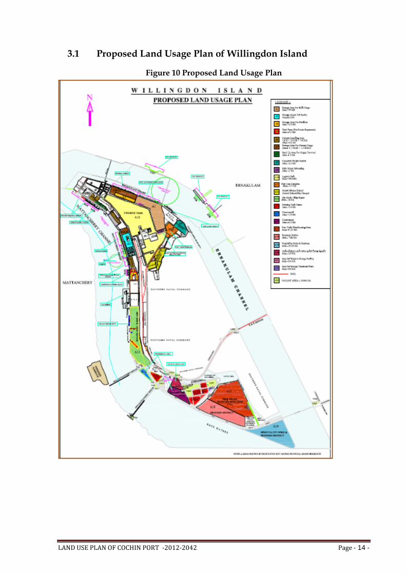
LAND USE PLAN OF COCHIN PORT -2012-2042 Page - 14 -
3.1 Proposed Land Usage Plan of Willingdon Island
Figure 10 Proposed Land Usage Plan

LAND USE PLAN OF COCHIN PORT -2012-2042 Page - 15 -
3.1.1 Proposed Port Side Land Usage
The proposed port side layout plan requires an area of approximately 40.9
hectares of land for port operations which includes the backup area for dry
bulk cargo terminal, backup area for cruise terminal, storage area for Ro-Ro
berth and tank farms for liquid cargo.
The backup area for the port operations is presented in the table below:
Figure 11 Backup area for port operations
Sl. No.
Proposed Usage Location Proposed
Backup Area
1 Cruise Terminal
Operations
BTP 1.3 Hectare
2 Bulk Cargo Storage Q8, Q9 14.0 Hectare
3 General Cargo Storage Q5, Q6, Q7 6.4 Hectare
4 Fertilizer Storage Q10 2.4 Hectare
5 Cement Handling Q1, NCB 4.3 Hectare
6 Ro-Ro Storage Q2, Q3 6.0 Hectare
7 Liquid Tank Farms Q4, SCB 3.0 Hectare
8 Container Freight Station CFS 3.5 Hectare
In addition to the above the following land requirements totaling to 104.07
Hectares is also envisaged as a part of redevelopment of the Willingdon
Island.
Logistics Park – 44.8 Hectares
Ship Repair yard – 18 Hectares
FTWZ – 41.27 Hectares
Barring the FTWZ, which is proposed to be located on the Southern end of
the Island all the other facilities will need to be developed on the Northern
end. Hence the total land requirement for direct and indirect port operations
on the northern part of the island is around 103.08 Hectares.
i) Logistics Park
A logistics park spread across approximately 44.8 hectares to the north of
Willingdon Island is proposed to be created. The identified land parcel for
logistic park is being occupied by various port users and related entities. The
lease agreements of the existing tenants need to be evaluated in detail prior to
any extension and the relocation must be planned in a phased manner. The
area will be acquired and developed in a phased manner based on the expiry
of existing lease agreements.

LAND USE PLAN OF COCHIN PORT -2012-2042 Page - 16 -
The logistics park is proposed to abut the coal stack yard to the east and will
be close to the port user’s complex. A portion of the proposed logistics park
may be allotted for storage of cargo such as coal, timber, etc. depending on
the future traffic. Adequate measures will have to be implemented to avoid
contamination and pollution from the coal stack yard.
The area measuring 10.12 hectares to the west of the proposed Port User’s
complex is being used for CFS operations. It is proposed to continue handling
of containers at this location and may be used as an alternate CFS catering to
the ICTT at Vallarpadam. ICTT has a no-compete clause as per which CoPT
cannot undertake any container operations till ICTT has achieved 2.5 million
TEUs for three successive years of operations. Handling of container traffic
beyond this stage may be evaluated at this CFS area at a future date.
The area identified for Port Users Complex of 3.7 Ha, functionally is also a
part of Logistic Park and hence activities planned in this area as well as the
Logistic Park are interchangeable based on demand and constraints existing
under Flying Funnel restrictions.
Figure 12 Location of the proposed Logistics Park and Port User’s Complex

LAND USE PLAN OF COCHIN PORT -2012-2042 Page - 17 -
ii) Ship Repair yard
A land area of approximately 18 Hectares, located to the east of the
Mattancherry Channel has been earmarked for the ship repair yard. This area
includes the existing dry dock, departmental ship repair facility, the land
surrendered by F.C.I and the existing Timber Yard. The new facility will be
developed with minimum dislocation of the existing workshop and the repair
yard which is currently in operational condition. The proposed plan suggests
widening the arterial road to 10 meters and extension of the roads.
Other proposals include:
1.03 hectares of green area
Relocation of the two existing general store buildings
Open Storage area in front of the general store buildings
Two ELL cranes to service the dry dock replacing existing steam crane
and diesel crane
The Repair Jetty has been proposed to be enlarged in length to 185 m (as
against present length of 86.0 m) to be able to service Handy Size vessels
up to 25,000 DWT, in tune with the capacity of the proposed new dry
dock.
The available space has been optimized to create three facilities: Dry Dock
(size 180m x 32m x 9m), container repair yard and a supply base for
commercial ships. These facilities will be in addition to the existing dry dock
which will continue to remain operational.
The proposed land use plan will require freeing up of land presently leased
out to various tenants who may or may not be involved in direct or indirect
port related operations. This needs to be carried out in a phased manner so as
to create minimum disturbance to the ongoing operations and with due
considerations to the needs of the existing users. It is thereby suggested that a
port user’s complex be developed on priority wherein the existing port users
can relocate their office spaces. The port user’s complex will accommodate
the offices of shipping agents, banks, stevedores, shipping lines and any other
maritime related service provider.
The proposed land use plan also takes into account various administrative
needs and amenities that are required on Willingdon Island. The proposed
layout incorporates the existing infrastructure such as Cochin Port Trust
administrative building, hospitals, schools, and hotels such as Taj Malabar,
Trident, Casino and ATS Willingdon Island. The building housing the
Bristow School has been declared as a heritage structure. Therefore, this
school is proposed to be relocated at the plot adjoining the Kendriya

LAND USE PLAN OF COCHIN PORT -2012-2042 Page - 18 -
Vidyalaya and the playground, south of the logistics park. This will ensure
clustering of the educational institutes and playground for children at a single
locality and also free up the heritage Robert Bristow building within the
proposed logistics park.
To cater to the water requirements of the port, a rain water harvesting facility
in 1 hectare land is proposed near the southern end of the Bulk cargo storage
facility. The water from the facility could be either used for firefighting or
dust suppression system at the Bulk cargo terminal and stackyard.
The Land Use Plan has earmarked the land on Willingdon Island for activities
directly aiding and augmenting throughput of the Port. It is recommended
that there should be a Minimum Guarantee Tonnage (MGT) /Minimum
Guarantee Revenue (MGR) attached to each allotment in general. The MGT or
MGR is recommended to safeguard ports financial risk while renting its
facility to a BOT operator. The MGR for a particular period could be an
average of the forecasted revenue that the BOT operator is expected to earn
from cargo operations over the period. Similarly, MGT for a particular period
could be an average of the forecasted volumes that the BOT operator is
expected to handle over the period.
It recognizes that built up space would be required for activities incidental to
running of a port, but in view of the differential between the rents charged by
lessees from sub-lessees and the share passed on by the lessees to the Port, it
is recommended that allotments of land for providing office space on sub-
lease may be done by offering land on tender for putting up office complexes
for sub-lease, so that the Port may benefit from the revenue fetched by the
lessees in the form of the upfront premium in the tender.
3.1.2 South End Land Use Plan
The land identified for the proposal for the development of Business District
area is beyond the bridges which connect to the island. Hence the area cannot
be used for primary port activities and is about 85.32 hectares at South End of
Willingdon Island consisting of the following:
Land parcel A15 on western part of the island spread in 1.82 hectares of land.
Land parcel A16 area on west to existing tank farms spread in 5.5 hectares of land.
Land parcel A17,A18 adjacent to Indian Maritime University and spread into 49.15 Hectares of Land
Land parcel A19 at south end of the island spread into 22.38 hectares of land.

LAND USE PLAN OF COCHIN PORT -2012-2042 Page - 19 -
Land area measuring approx. 4.05 hectares abutting A17 on the western side and A18 on the south eastern side, for Indian Maritime University (IMU) campus
Land area measuring approx. 1.62 hectares, situated to the north of A19 and to the east of the proposed IMU campus, considered for allotment for use of Indian Navy
Land area, A21 measuring 0.4 hectares for Waste to energy facility
Land area, A22 measuring 0.4 hectares for Sewage Treatment Plant.
The canal abutting this portion of the land is currently being used by the
Indian Navy for conducting drills and training exercises. Options to make use
of the canal for providing water connectivity between the proposed FTWZ
and the container terminal or the Inland Waterways may be evaluated. The
area statement for the proposed business district is as follows:
Cochin being a preferred tourist destination and considering the unique and
exclusive nature of the location; star hotel facilities, convention centers are
proposed (A19 area) which can attract many domestic and international
tourists. The clustering of tourism functions such as five star hotels,
convention centre, commercial areas, offices, public spaces including
children’s play areas, Chinese fishing net, open food plazas and activities
such as “Kochi Haat” are proposed in the south end reclamation area(A19
area).
Considering the shift in shopping habits of Keralites towards organized
retailing and their requirement for associated entertainment, the commercial
projects are proposed (A15 area). Further, the planned reallocation of office
Land Parcel
No Proposal Suggested Functional Configuration
Total Area
Area under CRZ
A19
Business District and Hospitality
Node
Five star hotel, convention centre, commercial complexes, budgeted hotel, an open shopping area with a concept of
“Kochin Haat” and public spaces in the CRZ belt
22.38 Ha
7.36 Ha
A17 Free Trade
Warehousing Zone (FTWZ)
General Warehousing, Sea Food, Cashew, Tea, Shipping Ancillary, Empty Container Yard, Open Storage, Rain Water
Harvesting and Roads and Green Areas.
41.27 Ha
None
A18 Business District
Commercial Complex, office building, and public space. 7.88 Ha
A16 Commercial Offices 5.5 Ha
None
A15 Commercial Shopping complex 1.82 Ha
1.36 Ha
Total
78.85 Ha
8.72 Ha
Figure 13 Area Statement - Proposed Business District

LAND USE PLAN OF COCHIN PORT -2012-2042 Page - 20 -
space in Willingdon Island will create a definite demand for office spaces in
the proposed project (A16 & A18 area).
Hospitality Node and Business District (A19): The proposed development at
the south end of Willingdon Island will create a self-sustained investment
grade Central Business District (CBD) including hospitality components such
as star hotels and convention/ MICE (Meetings, Incentives, Conference and
Exhibition) centers. The CBD will cater to the growing need of corporate for
high quality built-up space for offices, meetings, events, conferences etc.
FTWZ and Business District (A17 & A18): A Free Trade Warehouse Zone with
a processing area of 41.27 hectares and Business district of 7.88 hectares will
be part of the development at the south end reclamation area. The processing
area will house warehousing operations and will provide necessary enabling
infrastructure for various logistics players to setup base and operate out of
the area. The Business District will act as enabler to the processing area and
will contain supporting infrastructure and amenities such as housing, banks
and financial institutions, public utilities, parks/ green areas, convenience
stores etc.
Commercial space (for offices – A16): This land parcel lies within the flying
funnel of the naval air strip and hence is constrained by the height of built-up
space that can be developed. The land parcel also abuts the liquid tank farms
on the eastern side due to which a 100 m buffer area has to be left vacant on
the eastern side of the plot. The land parcel is proposed to be leased out to
third parties for office space requirements.
Commercial space (for shopping and entertainment – A15): The area at A15 is
accessible by NH47A which connects it to the western part of Cochin i.e. Fort
Kochi area. The triangular site covers an area of 1.82 hectare. One of the main
constraints for development at the site is that a major part of the area falls
under Coastal Regulation Zone (almost 75% of the total site area of 1.36
hectares). Hence the site area available for development is reduced to 0.46
hectares. Despite this constraint, this area offers a great opportunity to
develop the land for commercial use due to its connectivity, visibility aspect
of the site (i.e. once developed the area can become a visible landmark along
the water edge. The site can be easily spotted from New Mattancherry as well
as old Mattancherry Bridge) and that the old Mattancherry bridge is
proposed to be converted to a heritage bridge for tourism. Public space
utilizing CRZ area with open air restaurant, small scale boating jetty facility,
walkways along the water-front, children’s play area can be planned in the
area falling under CRZ regulation. The development can be envisioned as
commercial development with urban plaza opening out along the water

LAND USE PLAN OF COCHIN PORT -2012-2042 Page - 21 -
front. The commercial activities such as shopping complex clubbed with the
public space designed along the waterfront will mark the area as active public
zone in the city.
3.2 Proposed Land Usage Plan of Other Areas Outside Willingdon
Island
3.2.1 At Vallarpadam
i) International Container Transshipment Terminal (ICTT)
The License Agreement for ICTT with M/s Dubai Port World (DPW)
contemplates the development of the terminal in phases. Phase-I of ICTT
consisting of construction of 600m berth and development of stacking area
and other allied facilities has been partly commissioned on 11th February
2011.
Phase I B and Phase II for Extension of berth by 300m & 900m respectively
and providing related facilities will be taken up for Implementation by BOT
operator, based on traffic build up.
ii) Other Areas
The remaining area is earmarked for setting up of MT depots, Container
freight stations and value services, Distribution parks closely related to
container logistic activities etc..
3.2.2 At Puthuvypeen
i) LNG Re-gasification Terminal
The LNG terminal along with re-gasification plant is expected to be
commissioned by the end of 2012. On commissioning of the terminal a lot of
processing units using the byproducts generated on LNG regasification are
expected to come up in the vicinity of LNG regasification terminal.
ii) LPG Import Terminal
M/s Indian Oil Corporation Ltd (IOCL) is setting up 0.6 MTPA capacity LPG
import terminal at Cochin Port to feed the markets of Kerala and South West
Tamil Nadu on the 15 Ha. of land leased at Puthuvypeen SEZ for providing
facilities for pressurised storage of LPG and the ships with LPG will be
berthed at the Multi-User Liquid Terminal proposed to be set up at
Puthuvypeen SEZ under Cochin Port.
iii) Multi – User Liquid Terminal
The Multi – User Liquid Terminal is proposed to be set up at Puthuvypeen,
near the entrance to Cochin Harbour. Services proposed to be provided at the

LAND USE PLAN OF COCHIN PORT -2012-2042 Page - 22 -
terminal include LPG handling, Bunkering, re-export of crude oil to refineries
in Mumbai by M/s. BPCL-KR etc. The terminal will be located within the
Special Economic Zone promoted by the Cochin Port Trust.
iv) Other Areas
The remaining areas available are earmarked for setting up of facilities for
handling energy related cargoes.
3.2.3 At Bolghatty
At Bolghatty most of the area has been already leased out. Apart from this,
the water area lying adjacent to the Vallarpadam NH connectivity can be
reclaimed later. After developing, this area can be utilized for way side
parking, setting up of gas stations and other wayside amenities.
3.2.4 At Ernakulam
i) Land near GIDA area and Chathiyath
3.73 ha of land area available is proposed for the commercial development
considering the potential of this area in the heart of city and also the similar
developments taking place in the vicinity.
ii) Ernakulum Tanker Berths
No land area is available at Ernakulam tanker berths for leasing.
iii) At Thevara
At Thevara 0.587 Ha. land area available is proposed to be leased out for
commercial / non-port related development.
3.2.5 At Palluruthy
At Palluruthy 3.86 Ha. area is available to be leased out, which is also
proposed for non port related development.
3.2.6 At Fort Cochin
Out of the 2.06 Ha. land at Fort Cochin 0.48 ha. area has already laesed to
various parties and balance area is proposed for commercial/ non port based
development.
3.2.7 Future Development
Land accreted / developed in future within the limits of Cochin Port shall be
used appropriately for port related/ non-port related/ commercial
development.

LAND USE PLAN OF COCHIN PORT -2012-2042 Page - 23 -
iii) Phasing of Land Use
The phasing of the various facilities at Willingdon Island is as follows:
Area Area
Requirement (Hectare)
Status Development
Period Commencement
of Operation
Dry Bulk Stock Yard - A1 14 Backup area of 14 ha available for immediate development 2013-2015 2015
Storage Area - Fertilizer - A3 2.3 Backup area of 2.4 ha available for immediate development 2013-2015 2015
Storage Area for Ro-Ro - A2 6 Storage Area available for immediate development 2013-2014 2014
Tank Farm - A4 3 Area available immediately 2013-2014 2014
Storage Area for Cement - A5 (i) 1.3 Backup area of 1.3 ha available for immediate development 2013-2014 2014
Storage Area for Cement - A5 (ii) 1.4 Backup area of 1.4 ha available for immediate development 2013-2015 2015
Storage Area for Cement - A5 (iii) 1.6 Backup area of 1.6 ha available for immediate development 2013-2014 2014
Storage Area for General Cargo -A6(i)
5.1 Backup area of 5.1 ha available for immediate development 2013-2015 2015
Storage Area for General Cargo -A6(ii)
1.3 Backup area of 1.3 ha available for immediate development 2013-2014 2014
Backup Area - Cruise Terminal - A7 1.3 Backup area of 1.3 ha available for immediate development 2013-2014 2014
Container Freight Station - A8 3.5 Backup area of 3.5 ha available for immediate development 2013-2014 2014
Rain Water Harvesting - A9 1 Backup area of 1 ha available for immediate development 2013-2014 2014
Logistics Park - A10
44.8 Around 20 ha of land will be available after 2015 and remaining 24.8 ha after 2020
Phase 1 - 2016-2017 Phase 1 – 2017
Phase 2 - 2020-2021 Phase 2 - 2021
Port Users Complex - A11 3.7
Around 1 ha of land available for immediate development, 1.5 ha available after 2015 and remaining 1.2 ha available after 2040
Phase 1 - 2013-2014 Phase 1 – 2014
Phase 2 - 2016-2017 Phase 2 – 2017
Phase 3 - 2041 -2042 Phase 3 - 2042
Dry Dock/ Ship Repair - A13 18 Backup area of 18 ha available for immediate development 2013-2015 2015
Commercial Area - A15 1.8 Area for development available only after 2015 2016-2017 2017
Commercial Area - A16 5.5 Area for development available only after 2020 2021-2022 2022
FTWZ - A17 41.27 Area for development available only after 2015 2016-2017 2017
Business District -A18 7.88 Area for development available only after 2015 2016-2017 2017
Hospitality Node and Business Area - A19
22.38 Area for development available only after 2015 2016-2017 2017

LAND USE PLAN OF COCHIN PORT -2012-2042 Page - 24 -