landscapes of property author(s): nicholas blomley...
TRANSCRIPT

Wiley and Law and Society Association are collaborating with JSTOR to digitize, preserve and extend access to Law & Society Review.
http://www.jstor.org
Landscapes of Property Author(s): Nicholas Blomley Source: Law & Society Review, Vol. 32, No. 3 (1998), pp. 567-612Published by: on behalf of the Wiley Law and Society AssociationStable URL: http://www.jstor.org/stable/827757Accessed: 14-09-2015 00:28 UTC
Your use of the JSTOR archive indicates your acceptance of the Terms & Conditions of Use, available at http://www.jstor.org/page/ info/about/policies/terms.jsp
JSTOR is a not-for-profit service that helps scholars, researchers, and students discover, use, and build upon a wide range of content in a trusted digital archive. We use information technology and tools to increase productivity and facilitate new forms of scholarship. For more information about JSTOR, please contact [email protected].
This content downloaded from 142.103.160.110 on Mon, 14 Sep 2015 00:28:25 UTCAll use subject to JSTOR Terms and Conditions

567
Landscapes of Property
Nicholas Blomley
If we want to explore the social dimensions of property, we need to think of it not only historically but also geographically, entailing both practices in and representations of social space. The concept of landscape is a useful bridg- ing device here, given its double meaning as both a material space and as a particular way of seeing space. Landscapes, in both senses, can serve to reify and naturalize dominant property relations but can also serve as spaces of con- testation. Such landscapes, however, cannot be disentangled from the places in which they are positioned. I use this framework to make sense of resistance to gentrification in the Downtown Eastside of Vancouver, Canada, a poor neigh- borhood with a rich history of activism. A collective property claim by the poor has been staked out through the material use, production, and representation of an urban landscape. Such local meanings and practices, however, are threatened by "outsiders," who are seen to map and use this landscape in very different ways.
we resist person by person square foot by square foot room by room
building by building block by block
-Bud Osborn (1998:288)
Raising Shit
Bud Osborn is a street poet and activist, living and working in Vancouver's Downtown Eastside, the city's poorest neighbor- hood. In the poem quoted from above, he relates changes in his neighborhood to global processes of displacement that have driven the poor "from land they have occupied/in common/and
I would like to thankJeff Sommers, Eric Clark, Neil Smith andJohn Shayler for their comments on an earlier draft. This article has been in process for a long time; several reviewers, on two occasions, made invaluable criticisms. Versions of the article were presented at a workshop on New Forms of Governance: Theory, Research and Practice, held at the Centre of Criminology, University of Toronto, 24-24 October 1996, and at a seminar at the Department of Geography, University of Washington: I appreciate com- ments made at both places. Thanks also to the insightful comments of Bill Pake, Adrienne Burk, and Cameron Muir, participants in my graduate seminar on Law, Space and the City. My research was made possible by a SSHRC grant (401-94-1734). Address correspon- dence to Nicholas Blomley, Department of Geography, Simon Fraser University, Burnaby, BC, Canada V5A 1S6 (email [email protected]).
Law & Society Review, Volume 32, Number 3 (1998) ? 1998 by The Law and Society Association. All rights reserved.
This content downloaded from 142.103.160.110 on Mon, 14 Sep 2015 00:28:25 UTCAll use subject to JSTOR Terms and Conditions

568 Landscapes of Property
in community/for many years" (p. 280). Locally, the threat of gentrification-induced displacement has become critical: "they have taken away our lands/until we find ourselves fugitives va- grants and strangers/in our own community" (p. 282). Yet there is something to celebrate and defend at the same time in this "unique vulnerable troubled life-giving and death attacked com- munity" (p. 288). The title of Bud's poem, "raise shit," speaks to a local opposition to gentrification that has only one weapon-the word: "words against the power/of money and law and politics and media/words against a global economic system . . . our words defiant as streetkids in a cop's face" (pp. 281, 283). "To raise shit," Bud notes, "is to actively resist/and we resist with our presence/with our words/with our love/with our courage" (p. 288).
In this article I want to think about those words of resistance to gentrification. In particular, I want to reveal the ways in which those who "raise shit" in the Downtown Eastside make some sig- nificant arguments about real property, by drawing on a case study of one development project in the area. I suggest that claims about property figure both negatively and positively; that is, the characterization of dominant forms of property as oppres- sive relies on a positive claim to community entitlements. In mak-
ing sense of the ways in which such claims are advanced in the Downtown Eastside, I point to the significance of landscape, meant both as a physical environment and as a particular way of seeing a space. Thus, although "the word" is perhaps the only weapon that Downtown Eastside activists have, I argue that these words are not free floating but are worked out ("square foot by square foot") in a material and discursive landscape. Moreover, I shall argue such propertied landscapes, and related claims to
property, are also localized within places. I begin with a few comments on property, particularly in so-
cial context, arguing that sociolegal scholars need to think not
only about the histories of property but also about the geogra- phies. I also claim that struggles over property are at once repre- sentational and material. I try to bring these two claims together in the concept of landscape, which directs us to questions of
space, both as a material assemblage and as a way of representing and positioning the sociospatial world. Landscape is analytically useful, moreover, because in Western societies it has been histori-
cally implicated in a number of important local struggles relating to property in land.
Spatializing Property
A number of theorists of property-particularly those inter- ested in the ways in which contests over property play themselves out in particular social contexts-have evoked narrative as a cen-
This content downloaded from 142.103.160.110 on Mon, 14 Sep 2015 00:28:25 UTCAll use subject to JSTOR Terms and Conditions

Blomley 569
tral framework. "[P]roperty needs a tale, a story, a post hoc ex- planation," suggests Carol Rose (1994:38). Thus, for example, Neal Milner (1993) reveals how popular struggles over ownership in Hawai'i involve the recounting of stories of identity, settle- ment, and struggle, offering accounts of "the way people de- scribe a proper life and the role that they think rights should play in helping them maintain that life" (p. 251).
Narrative, of course, is an intensely persuasive medium. As such, it is inevitable that narratives often speak the stories of the powerful, emplotting and naturalizing some contingent and po- tentially oppressive ways of construing the world (cf. Rose 1994).1 But as noted, it is not only the powerful who tell stories. Property narratives can be retold, with oppositional beginnings, different plots, and subversive endings. Not only might they contest domi- nant narratives, but they may also draw on alternative claims to possession and entitlement.
But however important the narrative form is to a critical un- derstanding of property, I argue here that it is partial. The prob- lem perhaps rests in the degree to which narrative allows us to explore the "histories" of property, while perhaps deflecting us from its "geographies." I think a case can be made for the cen- trality of the historical imagination to much social theory, includ- ing that concerned with law (cf. Gordon 1984; Blomley 1994). While incisive, the effect can be to make a geographically in- formed analysis difficult. "An already-made geography sets the stage," from this perspective, "while the wilful making of history dictates the action and defines the story line" (Soja 1990:14).
But this is changing. If we accept the saliency of the "spatial turn" within much social theory, such geographies are conse- quential to the construction of social identities and the working out of social relations (see, e.g., Lefebvre 1991; Soja 1990; T. Mitchell 1991; Gregory 1994; G. Rose 1993; Harvey 1996). In par- ticular, I call on the argument that associates space with power, arguing that socially produced space is saturated with power rela- tions. The spatial environments we move in-the homes, work- places, streets, neighborhood, shops, and so on-can serve to re- flect and reinforce social relations of power, through complex and layered spatial processes and practices that code, exclude, enable, stage, locate, and so on. The effects are complex, entail- ing
the assignment of a particular ... meaning to lines and spaces in order to control, at first glance, determinable segments of the physical world. Upon further reflection, however, it is clear that the objects of control are social relationships and the ac- tions and experiences of people. (Delaney 1997:6)
1 On legal narratives more generally, see Brooks & Gewirtz 1996; Ewick & Silbey 1995.
This content downloaded from 142.103.160.110 on Mon, 14 Sep 2015 00:28:25 UTCAll use subject to JSTOR Terms and Conditions
570 Landscapes of Property
Whenever we cross state borders, enter private homes, engage in protests in city parks, take game on public land, and so on, we encounter such geographies. That they are often taken for granted makes them, I think, even more important. Different people can confront such geographies in different ways. Ac- counts of racism and segregation written from inside South Cen- tral Los Angeles are likely to be very different than those written from the perspective of, say, the LAPD. Moreover, people can take on different, layered identities as they traverse such a polit- ical terrain. I become a different political subject as I cross into the United States from Canada (from citizen to alien) or move from "work" to "home" (from employee to homeowner).
Clearly, legal practices and discourses can structure such "lines and spaces."2 In particular, property seems to be vital, as Delaney (1997) notes. The codes of access and exclusion that structure the uses of space are saturated by conceptions of prop- erty. Such conceptions can be quite formal-consider the issue of public access to semi-privatized spaces, such as shopping malls-or they can be somewhat less formal-such as my "right" to a parking spot on the street outside my house. The geogra- phies of property, in these senses, are also implicated in "wider" networks of power relations, such as a capitalist land market or processes of colonization, as well as perhaps serving as a site for the contestation of such networks.
Jeremy Waldron (1991) offers one insightful example of the linkage between property and space, in his treatment of the legal regulation of homelessness:
Everything that is done has to be done somewhere. No one is free to perform an action unless there is somewhere he is free to perform it.... One of the functions of property rules ... is to provide a basis for determining who is allowed to be where.... The rules of property give us a way of determining, in the case of each place, who is allowed to be in that place and who is not. (P. 296) However, regulations that restrict the use of public space in
many North American cities-such as forbidding sleeping in
public parks-have, despite appearances of impartiality, essen- tially punished homeless people, given that they are de facto ex- cluded from private property:
Since private places and public places between them exhaust all the places that there are, there is nowhere that these actions [such as sleeping] may be performed by the homeless person. And since freedom to perform a concrete actions requires free- dom to perform it at some place, it follows that the homeless person does not have the freedom to perform them. (P. 315)
2 For more general treatments of the relations between law, space, and power see, e.g., Blomley 1994; Chouinard 1994; Santos 1995; Cooper 1996; Delaney 1997; Engel 1990; Ford 1994; Shamir 1996.
This content downloaded from 142.103.160.110 on Mon, 14 Sep 2015 00:28:25 UTCAll use subject to JSTOR Terms and Conditions

Blomley 571
Such geographies, of course, are necessarily historical. The divisions of space into public and private realms of which Wal- dron writes are clearly explicable only with reference to the his- tory of liberal thought. That said, if we look only to the narratives that people tell when making sense of and struggling over the meanings of property in particular social contexts, I think we are in danger of missing the critical importance of space to legal re- lations. Let me be clear: I do not wish to displace the historical imagination in legal analysis but rather to spatialize it (compare with Soja 1990).
When we attend more carefully to many struggles over prop- erty, I think we can begin to see that while they undoubtedly in- volve the recounting of stories, they can also concern descrip- tions of particular spaces and places. In a provocative reading of struggles over gentrification in Cincinnati, for example, John Da- vis (1991) notes the saliency of differing clusters of ideas that not only offer particular accounts of the history of a neighborhood but also entail its geography-its buildings, socioeconomic diver- sity, and so on-in particular and consequential ways. Such op- posing historical geographies (Davis calls them accounts of "property and place") entail contending readings of community, pluralism, the market, home ownership, and low-income hous- ing. For example, the concept of "community" is construed by pro-gentrification interests as a physical inventory of local heri- tage buildings, threatened by the inappropriate forms of prop- erty use by low-income residents who appear not to value heri- tage as a good. The fear is that "[u]nless something is done immediately, this structural 'community' of aesthetic and historic significance will be irretrievably lost" (p. 245). Conversely, the "community" of anti-gentrifiers is understood not as a disaggre- gated bundle of physical artifacts but as a localized set of rela- tions that is
conceived exclusively in terms of social interaction and affec- tive bonds among the indigenous population.... Buildings are important, but only as a means of securing a cherished future, where reciprocity and mutual aid are made possible by an abundance of social property. The built environment . . . presents an opportunity to preserve the last remnants of a social community ripped apart by urban renewal and threatened with extinction by gentrification. (P. 245; emphasis in original)
When thinking about local struggles over the meanings and rights attached to property, Davis reminds us of the importance of thinking not only about the contesting "stories" that are told but also of the ways in which a particular place is represented and used. The histories and geographies of property seem com- mingled.
Holding to one side the former, how then can we think about the geographies of property? As a beginning, if we accept Davis's
This content downloaded from 142.103.160.110 on Mon, 14 Sep 2015 00:28:25 UTCAll use subject to JSTOR Terms and Conditions
572 Landscapes of Property
arguments, as well as others, it would seem that the representation of space is a critical question in any struggle over property. This seems reasonable: We need only think about the ways in which colonial governments portray territory as "empty" or as, at best, marginally populated by indigenous groups who leave only "faint scratches on the land" (Pratt 1992). Conversely, indigenous populations across the world continue to argue that such repre- sentations of space deny the rich and complex means by which traditional territories have been claimed by their original owners. John Borrows (1997), for example, decries the ways in which in- digenous knowledge and practices are "lost in (legal) space," given the ways in which the
culture of the common law has imposed a conceptual grid over both space and time which divides, parcels, registers, and bounds peoples and places.... The law has put a culturally exclusive vision of geography at its service, which severs the re- lationship between local Indigenous use of the natural environ- ment and democratic institutions. (Pp. 430-31) Clearly, representations of space seems important. However,
they do not seem to be sufficient. I agree with Chouinard's argu- ment that "texts are not enough" (1994:420) for the critical study of law, but must be supplemented by a careful attention to the material grounding of those "texts" in lived relations of power, oppression, and resistance. As Brigham and Gordon (1996) ar- gue in their study of New York's Lower East Side, property can be made both discursively and materially present. Contests over real
property can have undeniably material consequences (eviction, arrest, and homelessness, for example):
The legal distinction between ownership and opportunity for use is constantly at issue on the Lower East Side. Walking (down the sidewalk usually), one is made aware of what is pub- lic and what is not. For a homeless person sleeping, tentatively, on the steps of the 10th Street public library, the possibilities contained in the laws of property become behaviors. Ownership is presented in material ways (locks, fences, razor wire) and more dis-
cursively (in language that says "Get out," "Where is the rent," "Come in"). (Pp. 277-78; my emphasis)
There is a long-standing and understandable reluctance to think about property in material terms, however. A notion of property as "thing-ownership" is contrary to the central argument within
legal and political theory that, as McPherson (1978a:2) puts it, "property is not things, but rights, rights in or to things." ForJer- emy Bentham ([1843] 1978:51):
There is no image, no painting, no visible trait, which can ex- press the relation that constitutes property. It is not material, it is metaphysical; it is a mere conception of the mind. To have a thing in our hands, to keep it, to make it, to sell it, to work it up
This content downloaded from 142.103.160.110 on Mon, 14 Sep 2015 00:28:25 UTCAll use subject to JSTOR Terms and Conditions
Blomley 573
into something else; to use it-none of these physical circum- stances, nor all united, convey the idea of property.
Grunebaum (1987:3-4) "banishes" the word "property" from his treatment for this reason, arguing that "there is nothing in the object owned which marks it off as mine, yours, or ours."
There are at least two dangers with this, however. First, if we abolish the material from a critical examination of property, we lose sight of the ways in which propertied practices and represen- tations are often caught up in some very practical, embodied ac- tivities. Human labor, it has long been argued, is central to prop- erty. For Locke, of course, a property claim depended on the mixing of land with labor, and the "taming" of nature.3 As Peluso (1996:525) notes, such a doctrine of property as a reward to use- ful labor seems to have purchase "in both Western and Eastern societies and has correlates in both ancient and contemporary property systems." Moreover, for Milner (1993), such forms of propertied labor not only entail an initial act of "conversion" of wild nature but also require continuing acts of settlement, pre- mised upon the continued "working" of the land, to the extent that "[i] t is not so much possession of the legal title that legiti- mates this land ownership but rather the amount of work that went into changing the land by overcoming the obstacles of na- ture and economy" (p. 241).
Second, dominant representations of property often reify property as a thing. This can be ideologically consequential, ac- cording to a number of commentators, directing collective atten- tion away from the politics and oppressions of dominant modes of property (cf. Cohen 1927). Planning is a case in point. Donald Krueckeberg (1995) considers the manner in which planning thinks of itself as concerned with "land use," with its presumption of neutrality. The problem, he holds, is that planning interven- tions concern not land, as a reified and objective category, but property relations, with their inherently more fluid and con- tested meanings: "To ask 'Where do things belong?"' he notes, "simply sanitizes the essential query 'To whom do things be- long?"' (p. 308).4
3 "[T]he turfs my servant has cut; and the core I have digged in my place . . . be- comes my property.... The labour that was mine, removing them out of the common state they were in, hath fixed my property in them." Locke [1690] (1980:sec. 28; emphasis in original).
4 Constance Perin (1977) has also noted the manner in which planning is not so much about the regulation of land use (of parcels of property, if you like) but about the regulation of social relations as they relate, in part, to property: "Land use planning, zoning, and development practices are a shorthand of the unstated rules governing what are widely regarded as correct social categories and relationships-that is, not only how land uses should be arranged, but how land users, as social categories, are to be related to one another .... [T] he land use systems [is] a moral system that both reflects and assures social order" (pp. 3, 4). Property relations, she also notes, are seen as one component of that moral system. See also Cooper 1996.
This content downloaded from 142.103.160.110 on Mon, 14 Sep 2015 00:28:25 UTCAll use subject to JSTOR Terms and Conditions
574 Landscapes of Property
Social struggles over property, I suggest, can be approached not only by careful attention to the historical narratives that are deployed but also by thinking through the geographical claims that are made. Such geographies, I have also argued, might in- volve both material practices and representations. How, then, can we recognize the simultaneous importance of the material and the discursive in the geographies of property? I suggest the concept of landscape as one useful point of entry.
Landscape
One of the reasons that the concept of landscape is beginning to prove so useful is that it is a concept in between.
-Murphy 1993:205
Landscape is a term that can carry at least two meanings. On the one hand, it can be used to denote an area made up of a distinctive bundle of material forms. Thus, when we walk through urban landscapes, we encounter a material assemblage of roads, hotels, parks, community centers, stores, and people; a lived landscape, "on the ground." In a seminal paper written in 1925, the American cultural geographer Carl Sauer described the landscape as "the sum of its morphological components ... a material, physical form that wedded Nature to Culture ... which could be read to divine the values, needs, desires and levels of development of a people" (D. Mitchell 1996:24-25). However, the term can also carry an apparently different meaning. A land- scape is also a representation of the world. That which was "mor- phology" here becomes "scenery," to be viewed from a particular, often aestheticized detachment. Landscape, then, can be both "site" and "sight."5
Writers on landscape have gone some way to explore both aspects of landscape. Thus, for example, a writer like David Har- vey (1996) can reveal the ways in which the urban built environ- ment is fashioned as a material palimpsest, as different waves of capital investment and disinvestment fashion contradictory mate- rial forms, "erected as permanences within the flux and flow of capital circulation" (p. 295). "Whatever else it may entail," he ar- gues, "the urban process implies the creation of a material physi- cal infrastructure for production, circulation, exchange, and con- sumption" (1989:71-72). Landscapes, Harvey reminds us, are "worked" spaces. Although caught up in webs of local and global relations, and mobilized by divisions of labor, embodied human labor produces a material form. For Henri Lefebvre (1991:143), this is a critical point: Social space is not produced "in order to be read and grasped, but rather in order to be lived by people
5 I am indebted to the arguments of Don Mitchell (1996) for this association.
This content downloaded from 142.103.160.110 on Mon, 14 Sep 2015 00:28:25 UTCAll use subject to JSTOR Terms and Conditions
Blomley 575
with bodies and lives in their own particular... context" (em- phasis in original).
Conversely, another body of scholarship concerns itself with the manner in which space is represented, usually by powerful groups. "Landscape is not merely the world we see, it is a con- struction, a composition of that world. Landscape is a way of see- ing the world" (Cosgrove 1984:13). Such a "way of seeing," it has been argued, is a culturally specific one, drawing on Renaissance humanism, with its particular understandings of space, expressed most famously in the rediscovery and refinement of linear per- spective (Edgerton 1975). Such techniques radically transformed art, surveying, architecture, garden design, engineering, warfare, and many other social practices. Central to recent scholarship concerning such "ways of seeing" has been the claim that such visualizations are immensely important not only for how we see the social and natural world but also for how we position our- selves relative to that world.6 Landscape, for Cosgrove, is a "visual ideology" (1985:54). Such scopic enframings, it has been argued, are complicit not only with particular forms of surveillance and domination but also presuppose and sustain particular subject positions. Most important, perhaps, is the degree to which per- spectivalism, and the landscapes it makes possible, both depends on and helps constitute an apparent divide between the "sover- eign eye" of the observer and the space of the "external world": "visually space is rendered the property of the individual de- tached observer, from whose divine location it is a dependent, appropriated object.... Landscape distances us from the world in critical ways" (Cosgrove 1985:49, 55: cf. Jay 1992).
Such a visual distancing is epistemic. Timothy Mitchell (1991) notes the ways in which Western ways of seeing serve to present the world as set before and logically prior to a disem- bodied viewer. The effect, as he puts it, is to "enframe" an a pri- ori material world of objects. At the same time as power relations are internalized, they appear to take the form of an external structure. Abstract space helps makes a world that exists not as a set of social practices but as a binary order: individuals and their practices set against an inert a priori structure. Space is marked and divided into places where people are put. Yet at the same time, enframing conceals the processes through which it works as an ordering device. The effect is to create a framework that ap- pears prior to the objects distributed.
Such a binary separation, then, sets material "landscapes" apart from "visual" landscapes. However, I would agree with those who argue that such a separation is as analytically untena- ble as it is politically perilous. In his exploration of California
6 The "we" is provisional not only in cultural terms. For Gillian Rose (1993:103), the landscape gaze is "white, heterosexual, masculine . . . torn between pleasure and its re- pression."
This content downloaded from 142.103.160.110 on Mon, 14 Sep 2015 00:28:25 UTCAll use subject to JSTOR Terms and Conditions

576 Landscapes of Property
labor history, Don Mitchell (1996:8) notes that "one cannot un- derstand a landscape independent of how it has been repre- sented. . . . But neither can one understand a landscape in-
dependent of its material form on the ground (and thus independent of how it was made)." Espousing a dialectical analy- sis of their interrelation, he argues that morphological land- scapes can be generalized in landscape views, even as those ways of seeing structure the social relationships that produce those material landscapes. In both these senses, landscape is continu- ally in a state of contestatory becoming.
For example, in a reading of "anti-homeless" laws in the United States that draws on Waldron's (1991) "geography of pos- session," noted above, Don Mitchell (1997:316) suggests that a central motivation has been to enhance "the exchangeability of the urban landscape in a global economy of largely equivalent places"; in other words, to ensure that the homeless population does not threaten the exchange values concretized in the mate- rial landscape. However, this intervention is simultaneously an aesthetic one, as urban spaces are rendered in particular ways (as dangerous, threatening and "dark," prior to a "cleanup" of the homeless, for example).7
Property as Landscape
If struggles around property concern, in part, contested ma- terial spaces, and the representation of space, the polysemic qualities of landscape seem a useful point of entry. However, a closer attention to the term also reveals that "landscape," whether understood as "morphology" or "representation," can be shot through with contesting claims to property. To the extent that "landscape" alerts us to the materiality of property, it seems useful. Land as both a ideologically reified surface and a social site for embodied practices is important to property relations. But the concept of landscape invites us to also think about the ways in which "land" is represented. Such representations, I shall suggest, are ineluctably caught up with contending claims to property.
An etymology of landscape reveals the significance of prop- erty. As Barbara Bender (1993a:2) notes, "landscape" can be de- rived from the Germanic form landschaft. The original meaning
7 Rasmussen (1996) offers another take on the recursive links between the material and representational landscapes of property, in a fascinating analysis of the significance of the nomadic tent to the Tuareg of northern Niger. Spatial representations and prac- tices relating to the tent seem inseparable from a web of shifting power relations and social identities, and are particularly important in terms of prevailing gender roles and relations. As a space, the tent cannot be understood absent an analysis of property rela- tions; yet those property relations are inseparable from the material spatial practices and spatial representations that relate to the tent. Indeed, to separate the two is to engage in a culturally specific epistemological enframing.
This content downloaded from 142.103.160.110 on Mon, 14 Sep 2015 00:28:25 UTCAll use subject to JSTOR Terms and Conditions

Blomley 577
of the term was "a patch of cultivated ground, something small- scale that corresponded to a peasant's perception, a mere frag- ment of a feudal estate, an inset in a Breugel landscape." Only in the 17th and 18th centuries did the term emerge as a "way of
seeing," "a particular experience either in pictures or practice." The inscription of emergent conceptions of property in these
"landscapes," as we shall see below, are central to this visualiza- tion.
As the Ur-meaning of landscape implies, the living and labor-
ing that occurs can entail the inscription of certain claims to, and
understandings of, property. Such inscriptions, not surprisingly, speak to both powerful and oppositional claims to property. Thus, feudal conceptions of property in rural England, for exam-
ple, are still manifest in the physical layout of villages, fields, and common lands, although these have been overlaid and often ef- faced by an emergent landscape of capitalist enclosure. Forest
landscapes in Indonesia, predicated on traditional property rights, are shaped by government interventions as well as local mobilizations. For one observer, the emergent forested land-
scapes "can be seen as physical evidence of local resistance to, and counter-appropriation of, ... management and property rights" (Peluso 1996:543).8 While some work has been done on such propertied landscapes in rural and Third World settings, I
suggest that the urban landscapes of the First World can materi- alize both dominant and marginalized claims to property.
However, to say that landscapes are produced is not to deny that they are read. The ways in which landscapes are visualized and represented are also caught up in the politics of property. In a careful reading of the emergence of the meaning of visualized
"landscape" in early modern Europe, Cosgrove (1984) insists on the importance of a particular "way of seeing" in emergent capi- talist property relations.9 Landscape views, in this account, were
implicated in the process by which landed property was detached from the localized worlds of feudalism and inserted into increas-
ingly mobile and commodified circuits of exchange. From this perspective, the resulting representational land-
scapes, such as the Palladian parks of Inigo Jones or the rural
paintings of John Constable, are treated as complex enframings of a social world that is
8 In her exploration of European conquests in the Americas, Patricia Seed (1995) explores the culturally diverse ways in which the space of the New World was possessed. English claims to territory, she shows, were very much dependent on apparently "mun- dane activity" (p. 19), where the placement of objects-houses, fences, gardens-signi- fied ownership: "Englishmen occupying the New World initially inscribed their possession ... by affixing their own powerful cultural symbols of ownership-houses and fences- upon the landscape" (p. 25).
9 The term was first coined byJohn Berger (1972).
This content downloaded from 142.103.160.110 on Mon, 14 Sep 2015 00:28:25 UTCAll use subject to JSTOR Terms and Conditions

578 Landscapes of Property
inextricably bound to the hypercommodification of land that came with the capitalist transformation in Europe. The devel- opment of perspectival views, in gardens and parklands and on canvasses and maps, allowed ownership to become explicit and abstract; and it rendered peasants and other workers invisible or relegated them to part of the "natural" scene. Landscape represented in perspectival view, as Raymond Williams and John Barrell have explained, lends the countryside the appear- ance of being unworked, a part of the order of nature, precisely at the time when the social relationships of human labor and life were remade in the image of an incipient capitalism. (D. Mitchell 1996:26) Such representations of property were not-are not-uncon-
tested. Kenneth Olwig (1996) reminds us of the ways in which the representation of traditional feudal spaces distinguished by, and dependent on, the autonomy of their customary law
emerged as a pressing political issue in 16th- and 17th-century Northern Europe. For example, the growing political cleavages between "country" and "court" in England revolved around con-
testing historical geographies of land and property. Under such conditions, antiquarian studies that revealed and implicitly cele- brated local feudal particularities of law-most of which revolved around property-could be rightly seen as subversive of court claims to authority and power (Helgerson 1992).
That contested maps-often literal-of land, property, and nature were central to these political contests (Blomley 1994; Helgerson 1992) alerts us to the significance of vision to the
landscapes of property. Carol Rose has made the claim that
"sight, both real and metaphoric, dominates the persuasive and rhetorical aspects of property" and that "visibility runs through property law as perhaps no other legal area" (Rose 1994:267, 269; emphasis in original). She is particularly concerned with the manner in which property claims are communicated through vis- ual cues. The picket fence, for example, constitutes a visual claim to space.
One central medium-one that privileges sight over all other senses-is the map. The functional association between maps and property is a deep-rooted one, whereby the apparent objec- tivity and certainty of the formalized cartographic projection lends certainty to the definition of property claims. As Olwig (1996:638) notes in his history of landscape, "the science of sur-
veying and the profession of the scenographer overlapped" in some significant ways. The ability to "map" one's property- whether as a householder or a First Nation-is a prerequisite for
quiet possession.10 But the role of maps is a more complex one.
Map making and maplike visualizations play a central role in
10 "First Nation" is the term used in Canada to describe indigenous populations.
This content downloaded from 142.103.160.110 on Mon, 14 Sep 2015 00:28:25 UTCAll use subject to JSTOR Terms and Conditions
Blomley 579
power relations and the construction of space, property, and so- cial identity (Harley 1988).
But the ways in which property maps "work," then and now, demands more careful thought. For the moment, let me return to Timothy Mitchell's comments above, that the very abstraction of the map entails an enframing of the social world that sets the "world" before the detached viewer. One important implication of this division is to help make possible the very idea of "space" as an abstract category, separate from the processes by which it is portrayed.1" To the extent that space is so rendered, it can be- come the reified "object" of property. Dominant forms of map- ping, arguably, "create . .. a geometrical, divisible, and hence saleable space by making parcels of property out of lands that had previously been defined according to rights of custom and demarcated by landmarks and topographical features" (Olwig 1996:638). Such maps, as Timothy Mitchell suggests, are im- mensely persuasive, relying as they do on deeply engrained cul- tural assumptions of rationality, detachment, and Kantian space. Moreover, they can be used to legitimize dominant conceptions of property.
Once set before the viewer as a "space," property must be bounded and named. Spatial naming as a means of ordering is of immense political significance. The naming of our immediate environment provides a way of "entering into relationships with those places, of making them our own, of creating a home" (Forbes 1995:70). Under these conditions, the denial or efface- ment of names can be seen as an erasure of alternative forms of property, as many colonial subjects can attest. As Forbes notes, "when we are forced to live in places according to boundaries, maps and names that are created elsewhere, we in turn become alienated from those places" (ibid.).
But the temptation is to suppose that such landscapes and their embedded property relations speak only the language of the powerful. Certainly, to the extent that individualized, com- modified conceptions of property dominate under the sign of the capitalist economy, such a claim is plausible. Maps reify. Names are erased. Perspectivalism presents space as the visual property of the detached observer. Material landscapes speak to the domination of powerful landed interests. However, I have also been suggesting that landscape, like property, is a site for a struggle that is simultaneously material and representational.
To document the hegemony of dominant spatializations of property, in other words, is not to suppose its ubiquity. There is also striking evidence of other understandings of property. Inter- estingly, such divergent and sometimes oppositional understand-
11 Note that I am not saying that such maps objectively achieve such a separation between space and the sovereign eye. Below I argue that Cartesian maps are material in many ways. However, the appearance of detachment is critical.
This content downloaded from 142.103.160.110 on Mon, 14 Sep 2015 00:28:25 UTCAll use subject to JSTOR Terms and Conditions

580 Landscapes of Property
ings of property can entail very different spatial representations and practices. Land is not mapped as an alienable abstraction but is seen as dialectically inseparable from local identities and hierarchies. Such alternative landscapes of property, to that ex- tent, are consciously grounded in local lived experience: The di- vide between abstract representations and grounded materiality collapses.
Placing Landscape
We must be cautious about imputing autonomy to these op- positional conceptions of property. To divide domination from resistance is to create a duality from that which is, arguably, more of a dialectical dualism. Resistance should not be thought as an autonomous space, exterior to Power. At the very least, opposi- tional forms of property can be shot through with instances of hierarchy and oppression. Rather than positing some divide, we need to recognize the ways in which property, and more specifi- cally the landscapes of property, are mutually constituted through social struggle. That process of struggle, I would suggest, has a geography. It is realized and structured both by the landscape itself and by the specific places within which it unfolds. The ef- fect is to complicate the simple dualism of power/resistance.
Don Mitchell (1996) draws on Bruno Latour to argue that landscape is "enacted in the process of struggle" (p. 32). Land- scape is a social embodiment of the relations and struggles that went into building it. Such struggles are relational; that is, they are not so much between two autonomous political positions as
they are constituted by articulations, flows, and heterogeneity. However, Mitchell notes, although the landscape is "always in a state of becoming," powerful social actors continually seek to rep- resent the landscape as "a fixed, total, and naturalized entity-as a unitary thing" (p. 30). Contemporary representations of the
English rural landscape, with their static evocations of "heritage" and subsequent denial of the generations of struggle and dispos- session, are an obvious example. But such essentializations can be challenged; contestatory landscapes can be produced that often rely on other temporary "fixings." Clearly, the definition and policing of boundaries between "us" and "them"-between demonized yuppies from "outside" and heroic hotel tenants who live "here," to foreshadow my later discussion-are constantly in- voked. The landscape is one site in which those essentializations can be expressed. The landscape, in other words, is not a back-
drop to such struggles but is itself created through that contest, serving in turn to become a vital symbolic and practical compo- nent in future contestations.
Such struggles over landscape are both material and repre- sentational. They can entail embodied practices-such as the es-
This content downloaded from 142.103.160.110 on Mon, 14 Sep 2015 00:28:25 UTCAll use subject to JSTOR Terms and Conditions
Blomley 581
tablishment of road and rail blockades by First Nations in British Columbia seeking to defend resources against logging compa- nies claimed as part of traditional territories (Blomley 1996), and they can involve struggles over the symbolic meanings, bound- ings, and namings of property (Rocheleau, Thomas-Stayter, & Edmunds 1995). However, we must again be cautious about im- puting some "sedentarist metaphysics," as Moore (1997:95) puts it, to such "remappings." In his study of struggles over land rights in Zimbabwe's Eastern Highlands, Moore notes that while ten- ants' assertions of rights to ancestral territory did rely on a linkage of "ethnic essence to the local landscape" (ibid.), these claims were not only tactical but were also crosscut by a more ambiguous set of political relations, such as gender, that compli- cated such essentialisms.
But, as Moore notes, there is another reason to be cautious about "placing" resistance as "outside" power. For the spaces of power are not simply metaphoric (Smith & Katz 1993). The land- scapes of property are not free floating (although they can be made to appear abstracted) but are inseparable from particular places. Both as a site and a sight, struggles in and over property obviously occur in particular locations, such as the Indonesian rainforest, the English countryside, or New York's Lower East Side. However, that "location" is more than obvious. I argue that place matters.
To say that struggles over property occur in particular places seems obvious and, perhaps, rather uninteresting. Like land- scape, place seems to connote inertia, closure, and passivity rather than politics and relationality. In part, again, the problem can be traced to the dualistic thinking that sets a passive geogra- phy against an aggressive history.12 However, recent scholarship in geography would suggest that place can best be understood in other ways. Rather than a passive stage on which the histories of social life unfold, place, like space, is actively constructed through a constellation of material and discursive practices. In historical terms, consequently, we should think of places not as static entities but, like landscape, as in a constant process of be- coming. In spatial terms, they are constituted by networks of lo- cal and extralocal relations. The distinction between space and place, in this sense, is one between flows and temporary perma- nences. Better to think of places not "as areas with boundaries around" but as "articulated moments in networks of social rela- tions and understandings .... [E]ach place is the focus of a dis-
12 There seems a presumption that any linkage of place and property is, at best, vestigial. The rise of a liberal property regime has brought about the erasure of place- bound understandings of property. The localized meanings of property, in other words, have been decoupled from local sites and vested in extralocal institutions, such as the judiciary, or the nation-state (Biddick 1990). For a more general discussion and critique of what I term the "centralization narrative," see Blomley 1994:106-49.
This content downloaded from 142.103.160.110 on Mon, 14 Sep 2015 00:28:25 UTCAll use subject to JSTOR Terms and Conditions
582 Landscapes of Property
tinct mixture of wider and more local social relations" (Massey 1994:154, 156). According to this literature, then, place emerges as analytically important and interesting. A place is not inert but produced. A place is not closed but an "articulated moment," embedded in localized and extralocal networks. A place is not passive but is a site for political struggle that can, moreover, have extralocal implications.
In summary, both landscape and place can appear static and naturalized. However, we should not lose sight of the ways in which both are constantly produced through social struggle. To suggest that the landscapes of property are enacted in place is thus to argue that such places are more than stages on which property relations are worked out. Rather, it is to suggest that struggles in and over the landscapes of property, as both a mate- rial and representational space, are both constitutive of, and con- stituted by, the places within which they are located.13
Let me summarize the overall argument so far. I have argued that, given the apparent significance of space to social relations, it is appropriate that sociolegal scholars interested in property consider its geographies. The concept of landscape offers one means of doing so, given that it alerts us to both the discursive and practical qualities of property. The association of landscape and property is more than heuristic, however, as revealed by its history. Struggles in and over property have been at once about spatial practices and representations. Such struggles, moreover, are implicated in and constitutive of particular places. Let me now turn to the spatial politics of property in one such place. I aim to reveal the significance of property relations to this contest and to demonstrate the complicated ways in which property was defined and contested in and through local landscapes.
The Landscapes of Property in Vancouver's Downtown Eastside
[T]he dialectic of... material production and symbolic pro- duction can only be declared; solely in the practice of historical reconstruction and interpretation, based on empirical evidence but informed by theory, can it be revealed.
-Cosgrove 1984:58 The place that is now Vancouver's Downtown Eastside, just to
the east of the city's downtown core, represents a complicated 13 For examples from the developing world of the link between landscapes of prop-
erty and place, see Pred & Watts (1992) and Bruce, Fortmann, & Nhira (1993). See also Choko & Harris (1990), who identify the importance of what they label local cultures of property in Montreal and Toronto, in terms of specific patterns of urban property owner- ship and use. Katharyne Mitchell (1993, 1996) explores recent struggles around the globalizing property market in Vancouver, alerting us to the ways in which, for example, local understandings of race and racism were caught up in dominant and oppositional narratives of property development.
This content downloaded from 142.103.160.110 on Mon, 14 Sep 2015 00:28:25 UTCAll use subject to JSTOR Terms and Conditions
Blomley 583
and fractured geologic layering of material and representational processes, implicated in local and increasingly globalized net- works. From its very inception, competing narratives of the spaces of property have been evident in this richly layered land- scape. That local property talk, caught up in a whole series of local entanglements with race, gender, and class, has been powerfully shaped by the evolving geographic context within which it is spoken. Powerful dynamics that center both on the commodification of land and the structuring of dominant forms of ownership have been critical, shaping a material and represen- tational landscape.
The cadastral grid of blocks and lots laid down by early sur- veyors that provided the framing for urban development in the 1870s and 1880s effaced the preexistent propertied landscape of the First Nations. Musqueam, Squamish, and Burrard peoples had moved through the area that was to be renamed the Down- town Eastside since "the beginning of time," establishing summer camps, villages, and fishing settlements, naming, using, and claiming the landscape in specific ways. The transformation of the landscape-"from the local worlds of fishing, hunting and gathering peoples to a modern corner of the world economy"- occurred with remarkable rapidity, as Cole Harris (1992:38) notes. However, this erasure was not absolute. Not only did a sig- nificant First Nations population come to congregate in the area, but cultural memories of dispossession came to crystallize into a political and legal movement around land claims through the province as the 20th century wore on. "Crown" lands-those "owned" by the state-have become particularly contentious in these contests. As we shall see, such struggles cast complicated shadows over contemporary contests over property and land.
As a material space, the Downtown Eastside was (and contin- ues to be) produced in part through successive rounds of capital investment and disinvestment in urban real estate. The area itself served as the original nucleus for European settlement in the 1870s. The fairly scrambled geographies of the frontier city quickly crystallized into discrete residential and commercial spaces, cross cut by class, "race," and gender, as investment capi- tal facilitated the separation of a middle- and upper-class west side from a working-class east side that contained a large, white, immigrant population, as well as a marginalized and racialized Chinese-Canadian district. A shift of capital to the emergent cen- tral business district to the west ensured that much of the built form laid down in the early years of the century-the frame houses of Strathcona, the residential hotels of Hastings Street, the brick warehouses of Water Street-was left largely un- touched.
In the prewar era, the area was known as the "East Side," and as such it remained the center of warehousing and transporta-
This content downloaded from 142.103.160.110 on Mon, 14 Sep 2015 00:28:25 UTCAll use subject to JSTOR Terms and Conditions

584 Landscapes of Property
tion, as well as shopping for the city's predominantly working class. Loggers, miners, railroad, and other seasonal workers con-
gregated here between jobs, and people new to the city could find inexpensive rental accommodation in the dollar-a-day hotels in the area. The era of migrant workers drew to a close after World War II, however, as shifts in corporate interests, and unionization stabilized demand for mobile labor.
This landscape, however, was notjust built of bricks and mor- tar but by representations as well. The landscape has simultane-
ously been discursively produced by powerful interests since its
very inception. Long coded as a place of dubious morality, racial otherness, and masculine failure, after World War II the area be- came coded as Vancouver's "skid road," a pathological space of moral and physical blight and decay.14 However, while skid road
representations still prevail, as the material production of the area shifts, the representations have begun to be replaced by other accounts of the area. Years of underinvestment and capital flight have depressed land values in the area. However, this
cheap land, zoned for high densities, in combination with the central city location, an overheated property market, planning policy that encourages the "densification" of downtown space, and the changing function of the central city within the interna- tional division of labor, has begun to attract development capital. The property industry has increasingly begun to delineate one of its "hotter markets."15
These changes in the land market have prompted a heated debate around the future of the area. Some interests seem pre- pared to acquiesce at the "disappearance" of the poor residents of the area, while others actively promote their displacement. Planners and politicians vacillate between attempts at retaining affordable housing and policies that seem to facilitate gentrifica- tion. To that extent, there is potentially an elective affinity be- tween the production of both a material and a discursive land-
scape in the area, so that, for example, representations of the area as occupied by "transients" without any obvious stake in the area facilitate the material conversion of that landscape.16
However, this landscape has also been materially produced and discursively represented in other ways, often intentionally oppositional. The effect has been to inscribe differing concep- tions of land and ownership. That movement between the two
readings-as commodified and alienable, or as charged with
meaning and validated through use and struggle (cf. Cosgrove 1984:64)-is central to an understanding of resistance to gen-
14 For one influential treatment of part of the area that focuses on the link between racialization and space, see Anderson 1987. Sommers (1998) is more concerned with
gendered characterizations of the area-particularly with reference to men. 15 Area realtor, cited in Vancouver Sun (1997). 16 I explore some of these dominant conceptions elsewhere (Blomley 1997).
This content downloaded from 142.103.160.110 on Mon, 14 Sep 2015 00:28:25 UTCAll use subject to JSTOR Terms and Conditions

Blomley 585
trification. As I shall suggest, an exploration of the "landscape" of the Downtown Eastside is critical to an understanding of social- ized property relations. The dual meaning of landscape as a ma- terial space and a representation of a space is useful here. Land- scapes, I suggest, allow us to think through the material production of a space, while recognizing the manner in which that space is visualized and represented. Struggles over the mean- ings and use of property in the Downtown Eastside, I argue, are caught up in this particular place. Oppositional readings, for ex- ample, rely on local histories of occupation and use and often involve certain essentializations, marking out a fairly rigid bound- ary between insiders and outsiders.
"Is It Real, or Is It a Mirage?"17
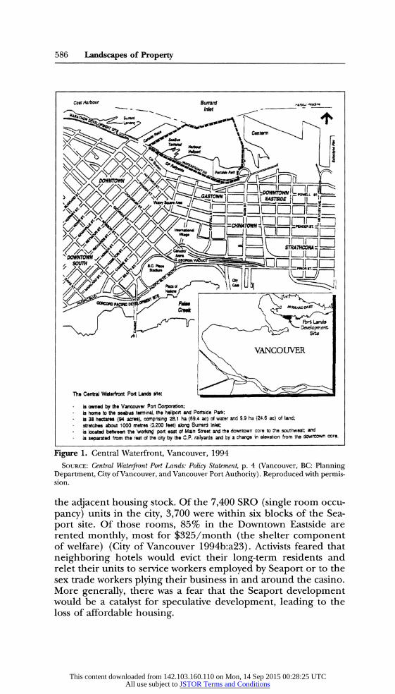
The saliency of these oppositional landscapes, with their dif- ferent readings of property, has been evident throughout the his- tory of the Downtown Eastside. For the moment, I am focusing on local opposition to a proposed development project in 1994. For several months, the Vancouver Port Corporation (VPC), a federal agency responsible for Greater Vancouver's docklands, had been engaged in discussions over the development of its cen- tral waterfront lands.18 The 94-acre central waterfront site is lo- cated on a prime piece of undeveloped waterfront, running east from Downtown, past the fast-gentrifying Gastown district, termi- nating at the foot of Main Street, which bisects the Downtown Eastside (see Fig. 1).
In a surprise announcement, VPC announced its "Seaport Centre" plan in February 1994, which entailed a cruise ship facil- ity, a hotel, and-most contentiously-a for-profit casino. A con- sortium including Mirage Resorts Inc. (a Las Vegas-based casino developer) and local developer VLC Properties Ltd. was estab- lished, and the developers launched a million-dollar propaganda campaign. Quickly, a coalition developed within the Downtown Eastside to oppose it. Because of the skill of this local group, combined with citywide opposition to the casino, the provincial government ultimately killed the project later in 1994, after re- fusing to allow the expansion of for-profit gambling.19
The Seaport proposal caused grave concern amongst Down- town Eastside activists, particularly about the possible effect on
17 A phrase used in opposition to the plans of Mirage Resorts. 18 The Vancouver Port Corporation is an autonomous federal Crown corporation
that is required to operate without public subsidy. As a result, it has been forced to raise revenues to finance operating expenses and any capital expansion projects. This ambigu- ous position as a quasi-private public agency, operating on federal land (claimed by local First Nations), became, as is shown below, an issue for many local activists.
19 The casino was defeated. However, the issue, like many others in the area, has not gone away. VPC and VLC will be developing a convention center on the site, which many locals fear will also cause displacement.
This content downloaded from 142.103.160.110 on Mon, 14 Sep 2015 00:28:25 UTCAll use subject to JSTOR Terms and Conditions
586 Landscapes of Property
Coralt Buard 8 I'_l
_- _ _ I - lkt
Mt^<r ~Idwn
The Centra Warfrt Port Lands ite:
is owned by the Vacouve Port Coporat; is home to he saabus tminal, the heliport and Portside Park; is 38 hectar (94 acres), comprising 28.1 ha (69.4 ac) of watr and 9.9 ha (24.6 ac) of and; strtches about 1000 metres (3.200 fet) along Burrard Inlet is locatd etween the'woing' port east o Main Street and the downtown cre to the southwest a i separated from tht ret ot the city by the C.P. railyards and by a change in elevation from the downtown core.
Figure 1. Central Waterfront, Vancouver, 1994
SOURCE: Central Waterfront Port Lands: Policy Statement, p. 4 (Vancouver, BC: Planning Department, City of Vancouver, and Vancouver Port Authority). Reproduced with permis- sion.
the adjacent housing stock. Of the 7,400 SRO (single room occu-
pancy) units in the city, 3,700 were within six blocks of the Sea- port site. Of those rooms, 85% in the Downtown Eastside are rented monthly, most for $325/month (the shelter component of welfare) (City of Vancouver 1994b:a23). Activists feared that
neighboring hotels would evict their long-term residents and relet their units to service workers employed by Seaport or to the sex trade workers plying their business in and around the casino. More generally, there was a fear that the Seaport development would be a catalyst for speculative development, leading to the loss of affordable housing.
This content downloaded from 142.103.160.110 on Mon, 14 Sep 2015 00:28:25 UTCAll use subject to JSTOR Terms and Conditions

Blomley 587
What interests me about the way in which the struggle around the Seaport proposal played itself out, particularly in the Downtown Eastside, is how certain understandings of property were deployed and contested by the protagonists, particularly ac- tivists in the neighborhood, who engaged in a fierce and well-
organized campaign against the casino.20
Landscapes of Displacement
The Seaport proposal was challenged by Downtown Eastside activists largely because they feared that it would cause a loss of affordable housing within the area. Simply stated, this seems un-
surprising. However, such an opposition is more layered. Not
only was the particular saliency of this claim inseparable from the
place in which it was deployed (and which it served to consti- tute), but it also relied on a specific set of representations con-
cerning a material landscape. Most immediately, the threat of displacement in the Down-
town Eastside had a particular meaning, given past histories. In
mobilizing area residents, the formative experience of Vancou- ver's Expo '86 World's Fair, which saw the mass displacement of about a thousand hotel residents as hotel owners prepared for the expected influx of tourists, was drawn on time and again as an example of the likely effect of the Seaport proposal on the
neighborhood.21 The "Expo evictions" have become a political touchstone within the Downtown Eastside.22 They seem to serve several functions. First, they configure dominant property rela- tions in a particular moral light, evoking the language of "slum landlords," interested only in a quick economic return. This can feed into a more general critique of capitalist property relations as individualized and fungible. Second, for many local commen- tators the Expo World's Fair marked a geographic watershed, as Vancouver became increasingly integrated into global capitalist networks, many of them centering on downtown property devel-
opment. For Downtown Eastside activists, not surprisingly, those
globalized processes are also cast in a largely negative light. Asso-
20 My observations are based on an analysis of media reports, planning documents, and other relevant publications; personal involvement in local organizing against the de- velopment in the Downtown Eastside in 1994; and a series of extended interviews con- ducted in 1996 with a number of activists, developers, planners. and politicians. I have not attempted to undertake a survey of residents of the Downtown Eastside, nor do I claim to speak for them. Rather, my analysis of popular conceptions of property in the area is based mostly on the arguments of activists as well as on my own direct observations.
21 "If we see the kind of evictions we saw at Expo, it will mean people will have no place to go and there will be more deaths" (Jeff Sommers, DES activist, quoted in Lee 1994).
22 "Expo was certainly the cardinal event in the Downtown Eastside in the last 80 years, I would say nothing else has touched it like that, the Depression and nothing else has been as catastrophic" (interview, Jim Green, 27 June 1996).
This content downloaded from 142.103.160.110 on Mon, 14 Sep 2015 00:28:25 UTCAll use subject to JSTOR Terms and Conditions

588 Landscapes of Property
ciating Seaport with Expo, therefore, is to position the Seaport developers as "bad outsiders."
The story of one long-term resident-Olaf Solheim-has en- tered the collective history of the community. A retired logger, he had lived in the same hotel room for 30 years, only to be dis- placed in preparation for Expo. Although he found new accom- modation, he died soon after. This narrative was told again and again, in relation to Seaport, reminding listeners that one uncou- ples people from their "home landscape"-albeit an often de- graded hotel room-at a cost:23
Do you remember Olaf Solheim? Olaf was an 87 year old for- mer logger who had lived in the Patricia Hotel for more than 40 years. It was his home, but his long tenure didn't save him. Like a thousand other low-income residents, he was evicted from his home to make way for the rich tourists during Expo 86.... We must never let that kind of tragedy happen again. But there is a new, even more ominous threat-the proposed casino/destination resort on our waterfront. This development would destroy our community.24
"Our Community": The Collective Property Claim
The Solheim narrative also entails a mapping in which "our community" is carefully juxtaposed against an outside threat. In this mapping, property discourse is shifted to a new terrain. For activists, the injustices wrought by gentrification and displace- ment extended beyond the denial of the property rights of indi- vidual residents to the use of their hotel rooms. The collective effect of Seaport, in combination with other development pres- sures, was the denial of the collective entitlement of poor com- munity members to the use and occupation of the neighborhood as a whole.
If the rights of Downtown Eastside residents are recognized at all by outsiders, the common tendency is to focus on the need to preserve individual units of property. At an extreme, it is the number of units that is critical rather than their location. Thus some business interests, intent on the area's "revitalisation," have suggested that given the value of inner city land, policy would be better served if poor residents were simply relocated to periph- eral areas where land was cheap. The argument made by many activists is that this ignores the collective constitution of the "community" and its moral right not only to continue as an entity
23 Evoking the figure of Olaf Solheim, and other retired resource workers, also speaks to a conscious attempt to contest negative representations of the residents of the area from outside, discussed in Sommers (1998). It is interesting to speculate on the connections between the patriarchal underpinnings of dominant property narratives and the local evocation of dignified, white, masculine workers who have overcome the wilder- ness and mixed their labor with the land.
24 Carnegie Newsletter, 15 June 1994, pp. 1-2.
This content downloaded from 142.103.160.110 on Mon, 14 Sep 2015 00:28:25 UTCAll use subject to JSTOR Terms and Conditions

Blomley 589
but to remain in situ. The streets of the Downtown Eastside may be mean and degraded to many, but they are also "home." It is the people of the area and the shared histories and material ex- periences that constitute the neighborhood: "It was your life's history, your community's history, and it's an organic thing."25
Such a collective claim implies a specific conception of the relation between individuals and the "objects" of property. Ra- din's (1993) distinction between fungible and personal property, where personal property entails specific categories in the exter- nal world in which "holders can become justifiably self-invested, so that their individuality and selfhood become intertwined with a particular object," is useful here (p. 81). While she focuses on the degree to which the rights of individual in situ renters may take priority over individual claims of landlords, because of their different and morally preferential sense of personal property, area activists invoke a sense of collective moral "investment" in the landscape of the Downtown Eastside.
The physical landscape of the Downtown Eastside is locally owned, it is argued, in at least two, practical ways. First, collective "investment" in the physical landscape has occurred through his- tories of copresent use and habitation. For example, to say that the Grand Union, a local SRO, is owned by M & C Reserve Invest- ments, Ltd., from this perspective, is to deny the generations of people who have lived there, died there, suffered there, loved there, survived there.26 Second, the landscape has been locally produced through collective action and political struggle. The re- sources that were won for the neighborhood-such as the social services, the housing, or the Carnegie Community Centre, which not coincidentally served as a focus for opposition to Seaport- were achieved through grassroots organizing by local people and the overcoming of external hostility.
For example, the Downtown Eastside Residents Association (DERA) has managed to build a significant amount of social (public) and co-op housing in the neighborhood over the years. The naming of these buildings, as well as their mere existence, is locally significant. DERA's Solheim Place commemorates Olaf Solheim, both as a martyr to displacement and as an expression of resistance and local ownership. The physical landscape itself speaks to property relations both negatively, as a reminder of op- pressive property relations, and positively, by inscribing a collec- tive claim to ownership in the landscape.
25 Both these comments come from an interview with an anonymous activist on 23 March 1996.
26 An interesting extension of this argument sometimes made is that the local com- munity has some claim over the private hotels of the area, given the fact that the vast majority of residents are on welfare. Over the years, local residents have "bought" the hotels many times over.
This content downloaded from 142.103.160.110 on Mon, 14 Sep 2015 00:28:25 UTCAll use subject to JSTOR Terms and Conditions

590 Landscapes of Property
There are several other sites that serve to map out a
politicized claim to place. The Four Sisters housing co-op, for
example, also built by DERA at the time of Expo, makes refer- ence to the sister cities of Vancouver in a conscious attempt to counter the discourses of globalization and economic linkage. Again, it is not simply the buildings that are important but their
political meanings. It would be pushing things to point to a labor
theory of possession; however, the claim that the space of the
neighborhood is "owned" by the community because it was pro- duced by the community is implicitly ever present.
Such community "landscapes" are also drawn on as concrete
examples of local agency, countering the political fatalism and discourses of inevitability that characterize dominant narratives of gentrification and redevelopment. Writing a few months after the defeat of Seaport, one activist made the connection explicit:
It's not time to give up, but to fight for what is right. Not too many years ago, residents of the DES [Downtown Eastside] were told that they would get no part of the old Carnegie Li- brary..... People in the neighbourhood did not want a hand- out, some crumbs, and fought for what they thought was right. The Carnegie Community Centre stands as a monument to that spirit.... Sometimes the Downtown Eastside seems like a place of impossibilities. But all we have to do is look around and see what is possible when determined people work to- gether.... We are being invited to give up and buy in. Let's stand up and speak out. (Shayler 1995:5) The landscape, activists argue, is not silent but speaks to a
history of struggle, occupation, and use. This representation of
space is far removed from the tendency of some external inter- ests to treat the Downtown Eastside as a tabula rasa, devoid of any viable claim to place. Activists, of course, see this as facilitating the reoccupation of the area by frontier-minded developers and residents, echoing Simon Ryan's (1996) discussion of the close links between the "blank spaces" on colonial Australian maps and the processes of dispossession and land expropriation.
In the erasure of land, not only is prior ... occupation and ownership ignored, but the land itself is inserted into a particu- lar narrativisation of history. A blank sheet, of course, intimates that there has been no previous history, but also constructs the future as a place/time for writing. (P. 125)
While the communicative markers by which local residents map their collective "property claim" are invisible to outsiders, they are integral to the local geography of possession:
[T]he condo industry acts as if no one else is living in the neighbourhood, and they are homesteading an urban wilder- ness.... [T]his is already a vital community. It was made that way by residents, not by developers or others who patronise and insult poor people. Carnegie Centre, Crab park, the network of decent and affordable social housing, improved safety in the
This content downloaded from 142.103.160.110 on Mon, 14 Sep 2015 00:28:25 UTCAll use subject to JSTOR Terms and Conditions

Blomley 591
hotels, the drugs driven out of Oppenheimer Park-these are the real signs of revitalisation. (Doinel 1995) The problem, of course, is that a building such as the Car-
negie Centre can also be interpreted as an alienable space to those not versed in the local historical geography of possession. Landscapes, then, can be represented and used in the "wrong" way. For those moving into the neighborhood will not only con- tribute to the material displacement of many residents. It is feared that they will also facilitate the poor's cultural disposses- sion. As one activist noted, "there is more than one way to lose a neighbourhood. You can lose it through homelessness, but you can also lose it by just outnumbering people, just pouring in."
Area hotels, which speak to a complex history of working- class marginalization, struggle, and survival, could easily be con- verted into private lofts, displacing history by "heritage," and re- placing one narrative with that of "highest and best use." One activist poignantly suggested the perils of effacement through this communicative translation when she postulated that the Car- negie Community Centre-often referred to as the neighbor- hood's front room-could easily become a yuppy coffee bar if gentrification continues.27 This point is made powerfully in a car- toon in community newsletter, showing former residents of DERA's Four Sisters Co-op being bused out to suburban Surrey (Fig. 2). It is not only the physical displacement that is objection- able, in other words, but the cultural effacement of a collective and locally embedded entitlement.
Collective "ownership" also implies a very different vision of the rules by which "property" is shared. A number of local activ- ists make reference to a very specific local tradition of reciproc- ity. One activist, centrally involved in the fight against the casino, speaks of a local tradition of inclusivity and sharing, born of ad- versity:
The Downtown Eastside is tolerant and quite inclusive, and I think that's why they rail against the private developer who's saying "this is my sandbox and I'm going to do anything I want here," where people will say "I don't have much to offer, but do you want a share of it?" You see it with cigarettes, you see it with lots of things in the community, where people are social, and they meet and share things, and it might be a bottle, it might be anything.... It's their area, it's where they live. And I think that's why private property and the rights of private property are as foolish to them as it is to me. Because it doesn't make any sense, because it's exclusive.... I don't think it's even necessar-
27 Interview with author Muggs Sigurgeirson, 23 March 1996. Sack (1980) notes the consequences of a speculative posture toward land, where the value of property rests on the future activities that could occur on or near it. "In such cases, the economic system makes us think of land as though it were empty, void of substances that have value, and of substances as though they were a-spatial entities existing abstractly somewhere but not on the land" (p. 185).
This content downloaded from 142.103.160.110 on Mon, 14 Sep 2015 00:28:25 UTCAll use subject to JSTOR Terms and Conditions

592 Landscapes of Property
Figure 2. Cultural erasure in the Downtown Eastside, Vancouver.
SOURCE: Carnegie Newsletter, 1994. Reproduced with permission.
ily a politic; it's a philosophy of life that has meaning with peo- ple.28
In part, perhaps, this is why commonly circulated fears at the "yuppy invasion" attendant upon the casino and gentrification generally have such local purchase: The yuppy is presented as an outsider, with no sense of the collective history of shared coexis- tence, supposedly interested only in speculation, exclusion, and the "quick buck."
28 Interview with John Shayler, 16 March 1996; my emphasis.
This content downloaded from 142.103.160.110 on Mon, 14 Sep 2015 00:28:25 UTCAll use subject to JSTOR Terms and Conditions

Blomley 593
Spaces of Possession: CRAB Park
But the material landscape, produced, used, and hence "owned" by local residents, is differentiated. Many sites evoke bit- tersweet memories, given commingled histories of propertied op- pression and community appropriation. The hotels are a case in point. One activist described his attachment to one hotel:
I'd be going to the Patricia Hotel for beer every day since 1971, to 1986. I knew every person in the pub. I knew every person that lived upstairs. I lived [there]. ... It was like being in a union hall, you know. And then Expo evicted everybody from it.... I have not been in the door of that place in 10 years.... If I knew anyone that would've had, I wouldn't speak to them again as long as I live.29 Other sites within the landscape are regarded more favora-
bly, particularly when they are seen as the direct product of com- munity organizing. One such "community space" of particular sa- liency to the casino debate in the Downtown Eastside was "CRAB Park," just to the east of the proposed site. This green space, it was felt, was threatened by the proposal in a number of ways. However, this was no ordinary park as far as the neighborhood was concerned.
To some outsiders, there was little redeeming in the Central Waterfront. For some, the land was derelict and abandoned; for others, the park was simply a haven for depravity and moral de- cay. However, for many local activists, CRAB Park was space to which the community had a special claim, given not only its loca- tion but the process by which it was created. Seeking waterfront access on what had been semi-derelict industrial land, a number of activists rallied behind the slogan "Create a Real Available Beach" in 1982. From the beginning, this was to be no ordinary park: the CRAB committee called for a large, natural green space, with planning input from the community. The park was envisioned as "noncommercial," that is, as consciously different from other proposals for the land, some of which included pri- vate "improvements." Formal pressure failed, prompting direct action, including a extended occupation (or "camp-out") on the site over the summer of 1985. Grudgingly, the Port finally pro- vided a lease for the development of the park.
Interestingly, the occupation of the waterfront in 1985 and earlier community events made ironic reference to the language of possession. For example, photos of protestors referred to them as "crabbers" staking out their "beach claim" (Carnegie Cres- cent, Nov. 1982, p. 11). Fake development permits ("claiming the area as CRAB BEACH") were posted: an ironic reference to the
29 Interview with Jim Green, 27 June 1996.
This content downloaded from 142.103.160.110 on Mon, 14 Sep 2015 00:28:25 UTCAll use subject to JSTOR Terms and Conditions
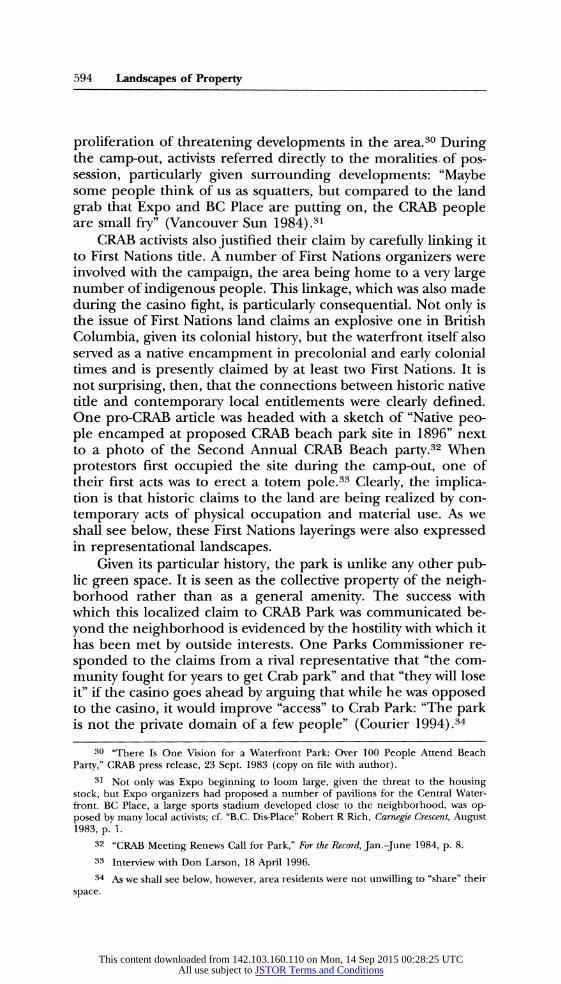
594 Landscapes of Property
proliferation of threatening developments in the area.30 During the camp-out, activists referred directly to the moralities of pos- session, particularly given surrounding developments: "Maybe some people think of us as squatters, but compared to the land
grab that Expo and BC Place are putting on, the CRAB people are small fry" (Vancouver Sun 1984).31
CRAB activists also justified their claim by carefully linking it to First Nations title. A number of First Nations organizers were involved with the campaign, the area being home to a very large number of indigenous people. This linkage, which was also made
during the casino fight, is particularly consequential. Not only is the issue of First Nations land claims an explosive one in British Columbia, given its colonial history, but the waterfront itself also served as a native encampment in precolonial and early colonial times and is presently claimed by at least two First Nations. It is not surprising, then, that the connections between historic native title and contemporary local entitlements were clearly defined. One pro-CRAB article was headed with a sketch of "Native peo- ple encamped at proposed CRAB beach park site in 1896" next to a photo of the Second Annual CRAB Beach party.32 When
protestors first occupied the site during the camp-out, one of their first acts was to erect a totem pole.33 Clearly, the implica- tion is that historic claims to the land are being realized by con-
temporary acts of physical occupation and material use. As we shall see below, these First Nations layerings were also expressed in representational landscapes.
Given its particular history, the park is unlike any other pub- lic green space. It is seen as the collective property of the neigh- borhood rather than as a general amenity. The success with which this localized claim to CRAB Park was communicated be-
yond the neighborhood is evidenced by the hostility with which it has been met by outside interests. One Parks Commissioner re-
sponded to the claims from a rival representative that "the com-
munity fought for years to get Crab park" and that "they will lose it" if the casino goes ahead by arguing that while he was opposed to the casino, it would improve "access" to Crab Park: "The park is not the private domain of a few people" (Courier 1994).34
30 "There Is One Vision for a Waterfront Park: Over 100 People Attend Beach Party," CRAB press release, 23 Sept. 1983 (copy on file with author).
31 Not only was Expo beginning to loom large, given the threat to the housing stock, but Expo organizers had proposed a number of pavilions for the Central Water- front. BC Place, a large sports stadium developed close to the neighborhood, was op- posed by many local activists; cf. "B.C. Dis-Place" Robert R Rich, Carnegie Crescent, August 1983, p. 1.
32 "CRAB Meeting Renews Call for Park," For the Record, Jan.-June 1984, p. 8. 33 Interview with Don Larson, 18 April 1996. 34 As we shall see below, however, area residents were not unwilling to "share" their
space.
This content downloaded from 142.103.160.110 on Mon, 14 Sep 2015 00:28:25 UTCAll use subject to JSTOR Terms and Conditions

Blomley 595
The particular historical geography of the site made a priva- tized, nonneighborhood development like Seaport all the more controversial. Security officers would drive away low-income park users, it was argued, to ensure that cruise ship passengers and high-rolling gamblers would not have to encounter them. "I think that our people would feel uncomfortable and there would be people uncomfortable with us. If development takes the shape that creates that kind of class difference, it could dilute the com- munity's hold on the park (Dunphy 1994; my emphasis). This was even more an issue given two other original rationales for the park: first, a perceived inequality between East and West Side (that is, rich and poor) green space allocation,35 and, second, the park's supposed deployment as a counterweight to external development pressures, with the hope that it would "provide community stability in the face of . . . numerous, big buck
Megaprojects" (Carnegie Crescent, July 1984, p. 6).36
The Political Geographies of the Map
There can be little doubt that visualized landscapes played a central role in the Seaport struggle. However, landscape was deployed in specific and varying ways by competing interests. This is particularly evident in relation to the "cartographic" tac- tics of various groups. Maps and "counter-maps" played an im- portant function. In part, the varying visualizations of space re- lied on and help constitute very different visions of the spaces of property.
The Seaport consortium deployed the standard repertoire of glossy maps, photos, and diagrams of the proposed development and the site. Prior to the Seaport proposal, the planning authori- ties had been concerned with the Central Waterfront. The pro- posal ushered in another round of documents, which, as is com- monplace, presented material in cartographic form. The urge to map and to fix by the planning authorities seems almost unstop- pable. A brief policy document on the Central Waterfront con- tains no fewer than 15 prominent maps and displays an anno- tated aerial photo on its cover. Maps serve not only to display information but to mark out specific spaces into which activities
35 The park continues to be a site of conflict: there is restricted access because of an intervening rail line, which is particularly problematic for the many physically challenged residents. In response, the CRAB acronym has now become "Create a Real Accessible Beach." Hostility has been directed at the City and Gastown "yuppies" who are accused by some activists of conniving to deny access to the site. The park remains, as one put it, "a very bittersweet thing because it's there but you can't get at it, you know. Its just always a reminder of how the neighborhood gets screwed and continues to be screwed" (interview with an anonymous activist, 23 March 1996).
36 Lefebvre (1991:319) notes that "the meanings conveyed by abstract space are more often prohibitions than solicitations or stimuli.... Prohibition is the reverse side and the carapace of property, of the negative appropriation of space under the reign of private property."
This content downloaded from 142.103.160.110 on Mon, 14 Sep 2015 00:28:25 UTCAll use subject to JSTOR Terms and Conditions

596 Landscapes of Property
BURkRAt# IMLt$r
Figure 3. Planning zones on the Central Waterfront, Vancouver, 1994.
SOURCE: Central Waterfront Port Lands: Policy Statement, p. 7 (Vancouver, BC: Planning Department, City of Vancouver, and Vancouver Port Authority). Reproduced with per- mission.
are to be located. With the central mandate of seeking to "rein- force key port, regional, civic, and community functions and re- quirements, while sensitively integrating all new development with its diverse neighbours," planners mapped out three zones where separate activities could be regionalized and supposedly "integrated" (see Fig. 3). A "downtown-oriented" area to the west would become "a preeminent civic destination . . . characterized
by intensity, diversity, [and] vibrancy," while a "community-ori- ented area" to the east would be "an attractive and comfortable
place to go for neighbourhood people," with a "transition area" between the two that will enable the former two zones to "de- velop their own identity and synergy, while allowing them to co- exist side by side" (City of Vancouver 1994b:5). Having thus spa- tialized the issue, the task then appears to be that of the correct
positioning of material objects by, for example, locating any higher buildings on the "west part of the site, stepping down in
significant transitions toward the east" (p. 15). Interestingly, many of the potential conflicts and planning tensions are fixed
by the map in visual terms. The effect of any development on
"sight corridors," for example, is traced via a intricate network of mapped flows, arrows, and trajectories37 (Fig. 4).
In asking what functions such mappings serve as "landscapes" of the area, we need to be cautious of idealism: that is, of suppos- ing that such maps "work" independent of social and political
37 Many maps also localize the site, excluding the adjacent neighborhood. As is often the case, the salient issues as far as the planning authorities are concerned relate to the site itself, with secondary attention given to the immediate surroundings. Air photos were also used on occasion: one of these, included in a brochure from the developers, is taken from the southeast. While this may be coincidental, the effect is to again exclude the Downtown Eastside and to position the site in relation to Downtown and the tourist landscape of Stanley Park and the waterfront.
This content downloaded from 142.103.160.110 on Mon, 14 Sep 2015 00:28:25 UTCAll use subject to JSTOR Terms and Conditions
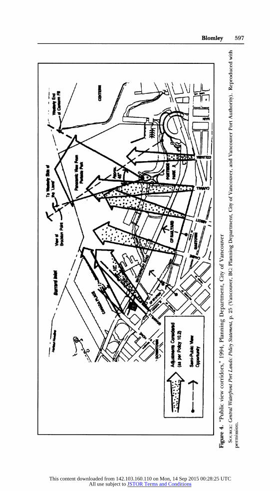
,<x^3<~X) ^r _3. IL i.-.W r ? Figure 4. "Public view corridors," 1994, Planning Department, City of Vancouver
SOURCE: Central Waterfront Port Lands: Policy Statement, p. 25 (Vancouver, BC: Planning Department, City of Vancouver, and Vancouver Port Authority). Reproduced with permission.
This content downloaded from 142.103.160.110 on Mon, 14 Sep 2015 00:28:25 UTCAll use subject to JSTOR Terms and Conditions

598 Landscapes of Property
context. Area maps were clearly put to work within particular political contexts, whether in the glossy brochures mailed to
every Vancouver household by the developers, in the maps pro- duced by planners, or, as we explore below, in the intentionally oppositional maps and other landscape views produced by area activists. More generally, such representations of space did not work alone, but must be seen as moments in the much more
systematic dominance of what Lefebvre (1991) has called "ab- stract space."
With this caution in mind, I think a few points can usefully be made concerning property and dominant landscape views. First, dominant maps speak the language of authority and expertise precisely by virtue of their detachment. The authority of Carte- sian projections, of course, is largely taken as a given. However, as rhetorical devices, they can serve to legitimate varying claims. Lefebvre (1991) speaks of the currency of such "representations of space" as the "conceptualised space, the space of scientists, planners, urbanists, technocratic subdividers and social engi- neers, ... all of whom identify what is lived and what is perceived with what is conceived" (p. 38). Such representations, he argues, are "tied to the relations of production and to the 'order' which those relations impose" (p. 33).
Second, they offer an enframing of space, as discussed ear- lier, that helps make possible the very idea of "space" as an exter- nal category. This, I think, is of critical importance in relation to
property, which is thus concerned with spaces-as "things"- rather than political relations. The issue is first and foremost that of the correct placement of buildings-of land use-rather than the just organization of spatialized property relations. Indeed, to the extent that the map directs us to the former, the latter be- come more opaque. Timothy Mitchell (1991:79) notes:
The act of distributing and fixing in place, repeated again and again in a sequence of exact and equal intervals, creates the impression that the intervals themselves are what exist, rather than the practices of distribution .... The appearance of order means the disappearance of power. Power is to operate more and more in a manner that is slow, uninterrupted and without external manifestation.
This is not to say, however, that the maps move in some pure realm of representation. Not only were they produced through some intensely practical and embodied processes, both "on the
ground" and on the drafting table, but they help produce an "ac- tionable" space that can be intervened in. However, they speak the implicit language of detachment, relying on several hundred
years of perspectivalism. Third, such a space seems empty and transparent. There are
no "hidden spaces," but all appears open to visual inspection. Cartographic space is emptied of the complexities and particular-
This content downloaded from 142.103.160.110 on Mon, 14 Sep 2015 00:28:25 UTCAll use subject to JSTOR Terms and Conditions

Blomley 599
ities that give it meaning on the ground and is presented as an
isotropic surface. "Through a variety of abstract codes and con- ventions ... [maps] shut out the city's noise and confusion, its energy and incessant movement, and transform its messy inco- herences into a fixed graphic representation" (Pinder 1996:407). Emptied from the map, of course, are the complex historical
layerings, such as the First Nations presence, and the human la- bor by which material landscapes, such as CRAB Park, are pro- duced. Indeed, "nature" itself is erased. The "Port Lands" deline- ated on city maps are actually mostly water.
Fourth, while abstract space is emptied, it is of necessity au-
thoritatively bounded and named. Official documents produced both by the developer and by the city often labeled CRAB Park "Portside Park"-the official designation approved by the Port
Authority-effacing any local "beach claim."38 On a number of
maps, the Downtown Eastside is crowded out by other designated areas, such as Gastown and Chinatown. On some projections, the Downtown Eastside disappears completely.39 Figure 1 (see p. 586), which is derived from Planning Department maps, reveals this graphically.
As noted earlier, the politics of naming, not surprisingly, has become an issue of particular concern to local activists. The au- thoritative production of space through dominant maps, they note, has long been used to dispossess: The line between carto- graphic dispossession and material displacement is a thin one.40 An analysis in the Newsletter of the Carnegie Community Action Project (Nov. 1995, pp. 1, 2) said:
There's an old saying that the best way to make people power- less is to make them invisible. Maps are a good way of doing this. When Europeans first came to North America, they made Indians invisible by leaving large blank spaces on maps... That way they were able to rationalise stealing other people's
38 In an interview, the chairman of VPC upbraided me for using the former term, noting that "round here, we don't use that word." Interestingly, city officials tend to switch between the two terms, depending on the audience. For one discussion of the politics of spatial naming, see Myers 1996.
39 One point of contention has been the tendency to identify areas-such as Gas- town-as separate neighborhoods rather than as subsumed within the Downtown East- side, as area activists insist. Ultimately, the Downtown Eastside appears as a balkanized "leftover." For a more general treatment of the politics of mapping in this context, see Blomley & Sommers (forthcoming).
40 Writes Doinel (1995): What's happening is a systematic attempt to define the Downtown Eastside out of existence, to chop it up into disconnected sections and crowd it out by other "neighbourhoods" that are dominated by business interests and developers and upscale new settlers. If that were to happen, the people of the Downtown East- side would lose their unified voice and their power to resist the changes that are so harmful to them.
The residents are the people who actually live here, long term. And our neighbourhood is not just a bunch of lines drawn on a map by planners or developers.
This content downloaded from 142.103.160.110 on Mon, 14 Sep 2015 00:28:25 UTCAll use subject to JSTOR Terms and Conditions

600 Landscapes of Property
land.... the City insists that the Downtown Eastside must be gentrified. . . . One way they can do it is by eliminating the Downtown Eastside from city maps. By leaving a community off a map, they erase the people who live there and make them invisible. That way, the neighbourhood is left open for whatever changes they have ... in store.
The response to the Seaport proposal from within the Downtown Eastside drew, in part, on a visual and, perhaps, a cartographic imaginary. However, the nature of that visualization was differ- ent. While the claims and assertions of the "dominant" maps were implicit and unexamined, the counter-mapping that oc- curred within the neighborhood was avowedly politicized. Not
only does the language of these maps-the geographic names, texts, and so on-advance the claims to local entitlements, but the representations of space itself attempt to both destabilize the
enframings of the dominant map-with their perspectival dis- tance between space and the detached, expert viewer-and re- frame space in ways that speak to local histories of use and enti- tlement. All four issues-expertise, detachment, spatial emptying, and naming/bounding-are at issue in these alterna- tive maps. Two particularly powerful cases are worthy of note.
At a community gathering in August 1994, mockups of Sea-
port Centre were presented with the Centre superimposed over the sight line from the park. The intent was to reveal the massive bulk of the proposed development, with the suggestion that it would "rob Crab park of its sunset" (Vancouver Sun 1994a). The
Seaport proposal is clearly situated in the localized grounded re- alities of area residents, with a conscious dismissal of the abstrac- tions of the dominant cartographic image (Fig. 5). An undated announcement produced by the Carnegie Centre (headed "see-
ing is believing") notes:
[I]t is hard to picture the unprecedented scale of this project because the Mirage/VLC media machine has only released glossy bird's-eye-view drawings showing it nestling comfortably among the other downtown towers. To really grasp what a mas- sive intrusion Seaport Centre would be on the fragile environ- ment around it. .. you have to see it from ground-level, the level where it would be experienced every day by people, not just by birds or developers artists.
In a media interview, the artist responsible noted that "we always look at things from either a plan or a bird's eye view. . . . We never get to look at things from the community view" (Vancouver Sun 1994a:a3). This mapping is all the more significant given the context within which it was produced. The mockups were un- veiled at a community demonstration and celebration held at CRAB Park. Participants were physically obliged to "look at
things from the community view." Rather than showing the ap- parently disembodied maps of dominant interests, what was
This content downloaded from 142.103.160.110 on Mon, 14 Sep 2015 00:28:25 UTCAll use subject to JSTOR Terms and Conditions

Blomley 601
...
Figure 5. "Orthnographic drawing of Seaport Centre, as seen from Crab Park" (Artists Michael Banwell and Lawrence Lowe, 1994).
SOURCE: Carnegie Action Project Newsletter, p. August 1994. Reproduced with permission.
shown now were maps with direct reference to the grounded bodies and localized spaces of the "community." Thus, perhaps, the physical occupation of the site also echoed the earlier camp- out.
But rather than being purely reactive, community activists also sought alternative visions for the Central Waterfront through a whole series of locally based "community planning" exercises. Area residents were encouraged to imaginatively regain control of the site from the developer and construct their own landscapes, based on their own lived experiences and felt needs. With the help of an artist, these individual images were combined into a series of sketches (Fig. 6). The results are strik- ing on a number of grounds, as noted by the accompanying text:
The four large colorful community creations are neighbourhood works in progress. These drawings are the ideas, inspirations and vision of some residents of what the Central Waterfront might look like as a public space (not a cor- porate space). But these visions are not only about the water- front. They are about our neighbourhood-the Downtown Eastside. They are about history, people, belonging, sharing, and the spirit that has built a community and keeps it go- ing. . . . IMAGINE: a place that celebrates our past, present, and doesn't block our view of the future. Imagine a public space that is safe and welcoming for residents and visitors alike .... We are the ex- perts! We know what the neighbourhood needs and what works well. After all, the residents have a long history of deciding what is best for the community. We just have to look at the Carnegie Centre, CRAB park, the social housing, the Four Cor- ners Community Savings, the neighbourhood based programs,
ak
This content downloaded from 142.103.160.110 on Mon, 14 Sep 2015 00:28:25 UTCAll use subject to JSTOR Terms and Conditions

PICTURE: a pedestrian overpass at Columbia Street: a community inpired, creativey designed gateway linking the neigbourbood to a larger CRAB Park, with a protected marsh, tidal po, a longer pier and even more access to tbe water's edge....
lMAGINE: more green space, more rees, commnity gardens, maybe amula botaniclM garden....
ow moving west fiom CRAB we enter the Community Area. Picture a group of low-rise
buildings that don't block the view to the water. They are surrounded by greenspace and contain: ? a multi-purpose recreation centre with an indoor
pool, ice rink, meeting places, a gymnnshin, and .......(You fill it in).
* a chdildcare and family centre which includes daycare, afrschool care, children% programs, a family recretion centre- and just ouside, a small rem tion and picnic area....
* a community health centre.... * a full recyling depot...
JO:5; envision Downtown Eastside residents hired and tained to work in these centres
s we leave the Community Area, we travel west again to n active Transition Area. This
area is also accessible by pedestrian overpass, and has at its centre: * A Public Market. This market of many shops has
a creitive design that brings it right down to the water.
This area is a sea of colour and activity, and includes- *a public square, perhaps with an elders circle and
speakers comer.... * a centre for theatres and cultral activities that
keeps the area open and active at night... a* rtist studios and areas for the display of
public art.... an educational centre with a focus on skills upgrading and training....
A PUJUC PACE a place for work opportunities. A place to see and meet people, m relax, and to be close to the water.
A fter a short rest, we continue west, leaving this open area, and enering the most western part
of the site. Here the buildings are higher, but still kept to the human scale of Gastown and the Downtown Eastside. And it is here that we find: * Fust Nations Historical and Culnral Centre,
uniquely designed sand built with traditional matrials and form.... Vancouver Historical Centre with a libray and gallery with materials of the Citys history....
* AMaritime Museum..
* Maybe even a Ibwn Hall with community planning facilities and meeting spaces.
Once again, open and well litre wlkways run between the buildings and facilities. It is very dose to a new Integrated Tnspomion Facility I which brings together the Sky Train, Sea Bus, and the new Commuter Rail yem.
EASYTO GE TO: The whole watefront is accesible by foot, bike, wheelchair, and public trasportation. Car access is limited.
LiAGINE: a place that celebrates our parr, present, and doesn't block our view of tbe future. Imagine a public space tbat is safe and wekomingfor residents and viitors alike. Now put yourseif n the picrure of tbhir model of gnique and creative community planning. On,v witb you will this and other viionsfor the Doamrtorn Easrid co true.
$5r9 uuS"' 5 u.eels keW Us de I
c.rsssns Irastsrd.--
C0 C,
? a-
n .9 eb ro 0
IV Wt
0
v
This content downloaded from 142.103.160.110 on Mon, 14 Sep 2015 00:28:25 UTCAll use subject to JSTOR Terms and Conditions

Hc IS1t t 1oendofSrqBpter t4 W f
CENTRAL WATERFRONT A WaE Cam CNITY VISKO
- LM.'Kl64
Figure 6. "Picture This": Community-based landscapes SOURCE: Picture This: Drawings Created by Downtown Eastside Residents, 1994 (copy on file with author). Reproduced with permission.
o
00
This content downloaded from 142.103.160.110 on Mon, 14 Sep 2015 00:28:25 UTCAll use subject to JSTOR Terms and Conditions
604 Landscapes of Property
and much more to see what we can do when we work to- gether.41
Although clearly an optimistic, even insolent countervailing pro- posal to the planned use of the site, this proposal encourages residents to "imagine the impossible" based on a past experience of successful intervention into the built landscape. A collective property claim is thus figuratively staked out. The Central Water- front is presented not as a separate space but functionally, histor- ically, and politically as part of the neighborhood. Rather than being like the abstract maps of the developers and the planning department, these "bird's-eye" sketches clearly situate the Central Waterfront as the neighborhood's "front yard." The Central Wa- terfront is visually positioned and functionally integrated with the Downtown Eastside. At the same time, the sketches pose a direct challenge to the claims to expertise embedded in domi- nant maps.
The allusion to the history of the site in the context of the broader neighborhood is also instructive. Implicit here, I think, is the desire to fill the empty cadastral spaces of the Cartesian map with a thick history of occupation and use, both by native peoples and by working-class activity. Many of the proposed de- velopments of the community map, such as a maritime museum, speak to the rich layering of human activity and human struggle that has gone on in and around this site, formerly part of Van- couver's working waterfront. In historicizing that space, it not only becomes positioned as inextricably linked to the Downtown Eastside but also appears as a "place" rather than as an empty speculative platform.42
Interestingly, the community proposals also included refer- ence to First Nations' history and contemporary needs, with el- ders' circles, sweat lodges, and other curative spaces proposed to reflect not only the needs of many of the community but also to refer to the original owners of the land itself. One proposal, for example, entailed a cruise ship facility designed to resemble a native longboat-an ironic colonial counterpoint to Canada Place, the Port-owned convention center to the west, built during Expo to echo the sails of a European tall ship.
The "community vision," as it is called, does allow for three areas, echoing the planning zones noted above. Even the (un- named) western area allows for higher buildings; yet they are "still kept to the human scale of Gastown and the Downtown Eastside" (see note 41). Moreover, inclusive uses-including
41 Picture This: Drawings Created by Downtown Eastside Residents, 1994 (copy on file with author; emphasis in original.
42 For an interesting example of such a layering, see Greg Curnoe's (1995:198) "journal/collage that traces the occupancy of... one small plot of land hundreds of years back into aboriginal times when land ... was not plotted according to the laws of geome- try."
This content downloaded from 142.103.160.110 on Mon, 14 Sep 2015 00:28:25 UTCAll use subject to JSTOR Terms and Conditions

Blomley 605
those that would appeal to outsiders-are proposed. However, they speak to local aspirations and specificities rather than presenting the supposed emptiness of a "destination resort ca- sino" with its simulacra of other places and other times. Propos- als include, for example, a "First Nations Historical and Cultural Centre, uniquely designed and built with traditional materials and form" and a proposed "Vancouver Historical Centre with a library and materials of the City's history" (ibid.).
We must be cautious in supposing that such remappings were somehow intrinsically more contextual and practical, whilst "dominant" maps were somehow necessarily abstracted. As noted, the latter are also material, both in their production and use. However, they implicitly made claims to abstraction, and as such, oppositional maps were able to turn their claims of exper- tise and detachment against themselves. Expertise, and the asso- ciated entitlements to space, was predicated on local histories of landscape production and occupation.43
Conclusions
As hotel tenants, most Downtown Eastside residents have only minimal property rights in the formal sense. However, as Razzaz (1993) notes, "property relations which are endowed with the protection of legal rights and duties are only a subset of the universe of property relations" (p. 341). Property relations, he notes, do not necessarily require state sanction in order to have a popular purchase.
In the Downtown Eastside, I have argued, competing under- standings of property are very much at issue in relation to strug- gles over gentrification. For local activists, property relations were simultaneously the threat and that which was threatened. On the one hand, dominant property relations were cast as op- pressive and individualized. At the same time, however, a form of collective property claim was articulated, based on historical ge- ographies of struggle, local use, and the creation and representa- tion of the built form.
One can begin to make sense of the salience of property in the Downtown Eastside by attending to the narratives of compet- ing factions. Thus, perhaps, one could juxtapose teleological ac- counts of Vancouver's rise to world class status with community stories of dispossession and struggle. However, I have argued for the need to think through the geographies of property, as well as the histories. Local resistance to Seaport relied on a claim to the collective appropriation of neighborhood space that drew from
43 Lefebvre's recognition (1991:40) that the distinction between perceived, con- ceived and lived space is not absolute but entails a dialectic mingling so that "the individ- ual member of a given social group . . . may move from one to another without confu- sion" is useful here.
This content downloaded from 142.103.160.110 on Mon, 14 Sep 2015 00:28:25 UTCAll use subject to JSTOR Terms and Conditions

606 Landscapes of Property
histories of use and co-production. Such claims were at once practical and discursive. Maps and visual description rubbed shoulders with camp-outs and street protests. In recognizing the simultaneity of property claims-as embodied labor and de- tached abstraction-I have found the notion of landscape useful, given its dual (and related) meanings. A "practical" landscape was represented in particular ways, as witnessed by the maps and images produced of the Central Waterfront. Such landscapes ap- peared to be central to political mobilization. Past histories of successful resistance, as well as the experience of dispossession and displacement, are physically evident in the co-ops, parks, ho- tels, and streets of the Downtown Eastside. The threat of dis- placement, moreover, was seen not only as one of physical expul- sion but also that of the cultural erasure of that physical landscape. In fighting that threat, maps and other visual media played an important role by encouraging area residents to imag- ine the impossible. Such local maps also must be juxtaposed with dominant enframings of space that rendered property in particu- lar ways. The manner in which space was projected, bounded, and named, I have tried to suggest, can be consequential for the ways in which property relations are understood. All told, the landscapes of property are a nexus of political struggle in the Downtown Eastside.
But in thinking geographically, I have also tried to begin to explore the links between such propertied landscapes and the place within which they can be found. I think a case can be made for a distinct "culture of property" within the Downtown Eastside. Past experiences of dispossession, as well as creative means by which forms of collective entitlement are made manifest in the physical environment, all help give form to that local culture and the local working-class culture, First Nations histories, the partic- ular form of the built environment, and many other factors. However, we need to recognize that the Downtown Eastside, like any place, is both in a constant state of evolution and should be seen as constituted by both local and extralocal processes. Local landscapes of property are similarly in a complex state of "be- coming." Global shifts in investment capital and the changing position of Vancouver within the international division of labor, for example, lay behind the Seaport project.
However, this is not to say that propertied landscapes are not presented in static and naturalized ways. It is clear, for example, that positive portrayals of community life and its members can often entail a form of "strategic essentialism," a savvy choice, given the constant barrage of negative imagery in the media and elsewhere.44 That essentialism necessarily can entail exclusions. Activists do not always feel comfortable including sex trade work-
44 I have tried to explore some of these questions elsewhere. See Blomley 1997.
This content downloaded from 142.103.160.110 on Mon, 14 Sep 2015 00:28:25 UTCAll use subject to JSTOR Terms and Conditions

Blomley 607
ers, drug dealers, or even First Nations people in the "commu- nity" of collective ownership within the Downtown Eastside. Homeowners in the area-some of whom may have lived there for generations-are sometimes positioned as beyond the pale. Hotel tenants clash with residents of housing co-ops. Loft buyers resent the label "yuppy," particularly as many of them are rela- tively poor, struggling to make mortgage payments. We also are not justified in presenting the Downtown Eastside as a coherent and united community, characterized by a unitary vision of space, place, and entitlement.45 There are "community mem- bers," for example, who would welcome gentrification and revi- talization, who feel that anything would be preferable to the daily barrage of drugs and destitution. Although community leaders were united in their opposition to the Seaport proposal, there is also plenty of evidence of internal in-fighting and mutual suspi- cion.
But the case study presented here does suggest that property and its landscapes can be a site of struggle. "Law," Sarat and Kearns (1995:61) argue, "plays a constitutive role in the world of the everyday, yet it is also available as a tool to people as they seek to maintain or alter their daily lives." For progressives, property has been often thought of largely in instrumental and oppressive terms, in terms both of the workings of the land market and of a liberal property regime. Certainly, this is the case in Vancouver, where the workings of the land market, and the meanings as- signed to it, can work in marginalizing and punitive ways, particu- larly for the poor. However, I have also tried to suggest that claims and practices relating to property can also be used to mo- bilize the poor and to advance powerful claims about entitle- ments-both individual and collective.
At the very least, it seems useful to explore the progressive meanings of property. Some scholars have begun such an explo- ration. Margaret Radin, for example, makes the case for a par- tially noncommodified form of personal property, expressed in the relation that a tenant, for example, might have to her home. Drawing from a Hegelian conception of the relation between ownership and the self, she sees such a concept of personal prop- erty, as opposed to the abstractions and instrumentalisms of fun- gible property, as reflecting a philosophy of persons as "concrete selves whose situation- in an environment of objects and other persons is constitutive" (1993:81-82). Patricia Williams (1991) goes further, calling for a radical expansion of property and pri- vacy rights so that "property regains its ancient connotation of being a reflection of the universal self. The task is to expand pri-
45 Gillian Rose's (1990) treatment of the inner-city London neighborhood of Pop- lar as an "imagined community," fraught with internal tensions and the mobilization of certain unifying myths, is useful here.
This content downloaded from 142.103.160.110 on Mon, 14 Sep 2015 00:28:25 UTCAll use subject to JSTOR Terms and Conditions

608 Landscapes of Property
vate property rights into a conception of civil rights, into the right to expect civility from others" (pp. 164-65).46
More generally, I want to underscore the need to think more carefully about property relations in the constitution of social life. As a legal form, property seems remarkably important and pervasive, structuring a range of social issues, whether they be the constitution of the self, relations to nature, urban struggles, gender relations, colonial projects, or so on. With some notable exceptions, to my knowledge, relatively little empirical work has been done on this question. Some work has emerged from an- thropology based on shifting conceptions of property in the Third World, often related to the importation of Western con- ceptions of land and ownership. While such studies are valuable, I would call now for sociolegal scholars to think through the ways in which understandings of property are actually at work in the West.
I have tried here to attend to the ways in which property is constituted in and constitutive of everyday social and political re- lations in one particular urban context.47 I have tried to suggest that property is present but in some complex spatialized ways. My aim has also been to show the ways in which property is much more than Property Law, in the traditional legal sense, but is caught up in lived social relations in some surprising ways. If we wish to understand either-social relations or property-we need to think about both simultaneously. Anne Bottomley (1996:115) describes her surprise at the common resistance on the part of her land law students to the possibility that their sub- ject can be concretely related to "the world in which in we live; as constitutive of, as well as being constituted by, the visible land- scape within which we live our lives." Like her, I would like to find ways to erode that resistance.
This is a challenging task. In thinking through some of these complexities concerning property, then, we need an analytical framework that is sensitive to a number of issues. These include the dialectic between power and resistance, the manner in which property entails both practice and representation, the complex politics of place and the historical narratives and spatial map- pings that underwrite property claims. I do not want to claim that a critical geographic perspective-one that begins with the cen- tral question of the social production of space-alone can pro- vide such insights. However, I do want to insist that a careful at- tention to space, place, and landscape is, at the very least, a
46 For a more general attempt to develop progressive readings of property, see Rob- ertson 1997.
47 See Sarat & Kearns (1995) for a useful set of discussions concerning the relation between law and everyday life. I agree with their claim that to make sense of the connec- tions between law and everyday life, "it is necessary to begin with the detailed observation of concrete relations, or transactions, with what has been called the 'practice of everyday life"' (p. 59, citing Michael de Certeau).
This content downloaded from 142.103.160.110 on Mon, 14 Sep 2015 00:28:25 UTCAll use subject to JSTOR Terms and Conditions
Blomley 609
necessary and important part of such a project. "Giving body to law," Bottomley (1996:124) writes, "land to land law, landscape to text, are strategies for not simply trying to make sense of our world but of seeking to imagine, to image, other landscapes of possibility."
References
Anderson, K.J. (1987) "The Idea of Chinatown: The Power of Place and Institu- tional Practice in the Making of a Racial Category," 77 Annals of the Associa- tion of American Geographers 580-98.
Bender, Barbara (1993a) "Landscape-Meaning and Action," in Bender, ed. 1993b.
,ed. (1993b) Landscape: Politics and Perspectives. Providence, RI: Berg Publishers.
Bentham, Jeremy [1843] (1978) "Security and Equality of Property," in C. B. McPherson, ed. 1978b.
Berger, John (1972) Ways of Seeing. London: Penguin Books. Biddick, K. (1990) "People and Things: Power in Early English Development,"
32 Comparative Studies in Society & History 3-23. Blomley, Nicholas K. (1994) Law, Space, and the Geographies of Power. New York:
Guilford Press. (1996) "'Shut the Province Down': First Nations Blockades in British
Columbia, 1984-1995," 3 B.C. Studies 5-35. (1997) "Property, Pluralism and the Gentrification Frontier," 12 Cana-
dian J. of Law & Society 187-218. Blomley, Nicholas K., & Jeff Sommers (forthcoming) "Mapping Urban Space:
Governmentality and Cartographic Struggles in Inner-City Vancouver," in R. Smandych, ed., Governable Places: Readings on Governmentality and Crime Control. Aldershot, Eng.: Dartmouth Publishing.
Borrows,John (1997) "Living between Water and Rocks: First Nations, Environ- mental Planning and Democracy," 47 Univ. of Toronto LawJ. 417-68.
Bottomley, Anne (1996) "Figures in a Landscape: Feminist Perspectives on Law, Land and Landscape," in A. Bottomley, ed., Feminist Perspectives on the Foun- dational Subjects of Law. London: Cavendish Publishing.
Brigham, John, & Diana R. Gordon (1996) "Law in Politics: Struggles over Property and Public Space on New York City's Lower East Side," 21 Law & Social Inquiry 265-83.
Brooks, Peter, & Paul Gewirtz, eds. (1996) Law's Stories: Narrative and Rhetoric in the Law. New Haven, CT: Yale Univ. Press.
Bruce, John, Louise Fortmann, & Calvin Nhira (1993) "Tenures in Transition, Tenures in Conflict: Examples from the Zimbabwe Social Forest," 58 Rural Sociology 626-42.
Choko, Marc, & Richard Harris (1990) "The Local Culture of Property: A Com- parative History of Housing Tenure in Montreal and Toronto," 80 Annals of the Association of American Geographers 73-95.
Chouinard, Vera (1994) "Geography, Law and Legal Struggles: Which Ways Ahead?" 11 Progress in Human Geography 415-40.
City of Vancouver (1994a) City of Vancouver Casino Review: A Discussion Paper. Vancouver, BC: City of Vancouver.
(1994b) Central Waterfront Port Lands: Policy Statement. Vancouver, BC: Planning Department, Vancouver, & Vancouver Port Corp.
Cohen, Morris R. (1927) "Property and Sovereignty," 13 Cornell Law Q. 8-30. Cooper, Davina (1996) "Talmudic Territory? Space, Law and Modernist Dis-
course," 23 J. of Law & Society 529-58.
This content downloaded from 142.103.160.110 on Mon, 14 Sep 2015 00:28:25 UTCAll use subject to JSTOR Terms and Conditions

610 Landscapes of Property
Cosgrove, Dennis E. (1984) Social Formation and Symbolic Landscape. London: Croom Helm.
(1985) "Prospect, Perspective and the Evolution of the Landscape Idea," 10 Transactions, Institute of British Geographers, n.s., 45-62.
Courier (1994) "Cope Commissioner Opposes Casino Plan," Courier, 12 June 1994, p. 2.
Curnoe, Greg (1995) Deeds/Abstracts: The History of a London Lot. ed. F. Davey. London, Ont.: Brick Books.
Davis, John Emmeus (1991) Contested Ground: Collective Action and the Urban Neighborhood. Ithaca, NY: Cornell Univ. Press.
Delaney, David (1997) Race, Place, and the Law, 1836-1948. Austin: Univ. of Texas Press.
Doinel, Antoine (1995) "The Incredible Shrinking Neighbourhood," Carnegie Newsletter, 1 March, pp. 2-3.
Dunphy, Martin (1994) "Vancouver's Big Gamble," Georgia Straight, 25 March-1 April, pp. 7-8.
Edgerton, Samuel Y. (1975) The Renaissance Rediscovery of Linear Perspective. New York: Basic Books.
Engel, David M. (1990) "Litigation across Space and Time: Courts, Conflict, and Social Change," 24 Law & Society Rev. 333-44.
Ewick, Patricia, & Susan Silbey (1995) "Subversive Stories and Hegemonic Tales: Toward a Sociology of Narrative," 29 Law & Society Rev. 197-226.
Forbes, Ann A. (1995) "Heirs to the Land: Mapping the Future of the Makalu- Barun," Cultural Survival Q., Winter, pp. 69-71.
Ford, Richard T. (1994) "The Boundaries of Race: Political Geography in Legal Analysis," 107 Harvard Law Rev. 1841-1921.
Gordon, Robert W. (1984) "Critical Legal Histories," 36 Stanford Law Rev. 57-125.
Gregory, Derek (1994) Geographical Imaginations. Cambridge, MA: Blackwell. Grunebaum, James 0. (1987) Private Ownership. London: Routledge & Kegan
Paul. Harley, J. Brian (1988) "Maps, Knowledge and Power," in D. Cosgrove & S.
Daniels, eds., The Iconography of Landscape: Essays on the Symbolic Representa- tion, Design and Use of Past Environments. New York: Cambridge Univ. Press.
Harris, Cole (1992) "The Lower Mainland, 1820-81," in G. Wynn & T. Oke, eds., Vancouver and Its Region. Vancouver: Univ. of British Columbia Press.
Harvey, David (1989) The Urban Experience. Cambridge, MA: Basil Blackwell. (1996) Justice, Nature and the Geography of Difference. Cambridge, MA:
Blackwell. Helgerson, Richard (1992) Forms of Nationhood: The Elizabethan Writing of Eng-
land. Chicago: Univ. of Chicago Press.
Jay, Martin (1992) "Scopic Regimes of Modernity," in S. Lash & J. Friedmann, eds., Modernity and Identity. Cambridge, MA: Blackwell.
Keith, Michael, & Steve Pile, eds. (1993) Place and the Politics of Identity. New York: Routledge.
Krueckeberg, Donald A. (1995) "The Difficult Character of Property: To Whom Do Things Belong?" 61 J. of the American Planning Association 301-9.
Lee, Jeff (1994) "Dislocation of Poor Downtown Residents Feared," Vancouver Sun, 23 April, p. a5.
Lefebvre, Henri (1991) The Production of Space, trans. D. Nicholson-Smith. Cam- bridge, MA: Blackwell.
Locke, John [ 1690] (1980) Second Treatise of Government. Indianapolis: Hackett Publishing Co.
Massey, Doreen (1994) Space, Place, and Gender. Minneapolis: Univ. of Minne- sota Press.
McPherson, C. B. (1978a) "The Meaning of Property," in McPherson, ed. 1978b.
This content downloaded from 142.103.160.110 on Mon, 14 Sep 2015 00:28:25 UTCAll use subject to JSTOR Terms and Conditions

Blomley 611
, ed. (1978b) Property: Mainstream and Critical Positions. Toronto: Univ. of Toronto Press.
Milner, Neal (1993) "Ownership Rights and Rites of Ownership," 18 Law & Social Inquiry 227-53.
Mitchell, Don (1996) The Lie of the Land: Migrant Workers in the Californian Land- scape. Minneapolis: Univ. of Minnesota Press.
(1997) "The Annihilation of Space by Law: The Roots and Implications of Anti-Homeless Law in the United States," 29 Antipode 303-35.
Mitchell, Katharyne (1993) Multiculturalism, or the United Colours of Capital- ism? 25 Antipode 263-94.
(1996) "Visions of Vancouver: Ideology, Democracy and the Future of Urban Development," 17 Urban Geography 478-501.
Mitchell, Timothy (1991) Colonising Egypt. Berkeley: Univ. of California Press. Moore, Donald S. (1997) "Remapping Resistance: 'Ground for Struggle' and
the Politics of Place," in S. Pile & M. Keith, eds., Geographies of Resistance. New York: Routledge.
Murphy, Howard (1993) "Colonialism, History and the Construction of Place: The Politics of Landscape in Northern Australia," in Bender, ed. 1993b.
Myers, G. (1996) "Naming and Placing the Other: Power and the Urban Land- scape in Zanzibar," 87 Tijdschrift voor economische en sociale Geografie 237-46.
Olwig, Kenneth R. (1996) "Recovering the Substantive Nature of Landscape," 86 Annals of the Association of American Geographers 630-53.
Osborn, Bud (1998) "Editorial: 'Raise Shit: Downtown Eastside Poem of Resist- ance,'" 16 (3) Environment & Planning D: Society and Space 280-88.
Peluso, Nancy Lee (1996) "Fruit Trees and Family Trees in an Anthropogenic Forest: Ethics of Access, Property Zones, and Environmental Change in In- donesia," 38 Comparative Studies in Society & History 510-48.
Perin, Constance (1977) Everything in Its Place: Social Order and Land Use in America. Princeton, NJ: Princeton Univ. Press.
Pinder, D. (1996) "Subverting Cartography: The Situationists and Maps of the City," 28 Environment & Planning A 405-27.
Pratt, Mary L. (1992) Imperial Eyes: Travel Writing and Transculturation. New York: Routledge.
Pred, Allan, & Michael John Watts (1992) Reworking Modernity: Capitalisms and Symbolic Discontent. New Brunswick, NJ: Rutgers Univ. Press.
Radin, Margaret J. (1993) Reinterpreting Property. Chicago: Univ. of Chicago Press.
Rasmussen, Susan (1996) "The Tent as Cultural Symbol and Field Site: Social and Symbolic Space, 'Topos,' and Authority in a Tuareg Community," 69 Anthropological Q. 14-26.
Razzaz, Omar M. (1993) Examining Property Rights and Investment in Infor- mal Settlements: The Case of Jordan," 69 Land Economics 341-55.
Robertson, Michael (1997) "Reconceiving Private Property," 24J. of Law & Soci- ety 465-85.
Rocheleau, Diane, B. Thomas-Stayter, & D. Edmunds (1995) "Gendered Re- source Mapping: Focusing on Women's Spaces in the Landscapes," Cul- tural Survival Q., Winter, pp. 62-68.
Rose, Carol M. (1994) Property as Persuasion. Boulder, CO: Westview Press. Rose, Gillian (1990) "Imagining Poplar in the 1920s: Contested Concepts of
Community," 16 J. of Historical Geography 425-37. (1993) Feminism and Geography: The Limits of Geographical Knowledge. Min-
neapolis: Univ. of Minnesota Press. Ryan, Simon (1996) The Cartographic Eye: How Explorers Saw Australia. New York:
Cambridge Univ. Press. Sack, Robert D. (1980) Conceptions of Space in Social Thought. London: Macmil-
lan.
This content downloaded from 142.103.160.110 on Mon, 14 Sep 2015 00:28:25 UTCAll use subject to JSTOR Terms and Conditions

612 Landscapes of Property
Santos, Boaventura da Sousa (1995) Toward a New Common Sense: Law, Science, and Politics in the Paradigmatic Transition. New York: Routledge
Sarat, Austin, & Thomas R. Kearns (1995) "Beyond the Great Divide: Forms of Legal Scholarship and Everyday Life," in A. Sarat & T. R. Kearns, eds., Law in Everyday Life. Ann Arbor: Univ. of Michigan Press.
Seed, Patricia (1995) Ceremonies of Possession in Europe's Conquest of the New World, 1492, 1640. New York: Cambridge Univ. Press.
Shamir, Ronen (1996) "Suspended in Space: Bedouins under the Law of Israel," 30 Law & Society Rev. 231-57.
Shayler, John (1995) "Woodwards: Give Up or Buy In?" Carnegie Newsletter, 15 April, pp. 4-5.
Sigurgeirson, Muggs (1994) "Waterfront Casino: An Open Letter," Carnegie Newsletter, May 1.
Smith, Neil, & Cindi Katz (1993) "Grounding Metaphor: Towards a Spatialized Politics," in Keith & Pile, eds. 1993.
Soja, Edward W. (1990) Postmodern Geographies: The Reassertion of Space in Critical Social Theory. New York: Verso.
Sommers,Jeff (1998) "Men at the Margin: Masculinity and Space in Downtown Vancouver, 1950-1986," 19 (4) Urban Geography 287-310.
Vancouver Port Corporation (1994) Central Waterfront Profile. Vancouver: Port Corporation.
Vancouver Sun (1984) "CRAB People Invade Waterfront," Vancouver Sun, 20 Aug., p. al5.
(1994a) "Crab Park's Views in Doubt If Waterfront Casino Built," Van- couver Sun, 8 Aug, p. a3.
(1997) "Real Estate Boom Looms for Hastings Street," Vancouver Sun, 5 March, p. A10.
Waldron, Jeremy (1991) "Homelessness and the Issue of Freedom," 39 UCLA Law Rev. 295-324.
Williams, PatriciaJ. (1991) The Alchemy of Race and Rights. Cambridge: Harvard Univ. Press.
This content downloaded from 142.103.160.110 on Mon, 14 Sep 2015 00:28:25 UTCAll use subject to JSTOR Terms and Conditions