landslide loss reduction - fema.gov · federal emergency management agency landslide loss...
TRANSCRIPT
FEDERAL EMERGENCY MANAGEMENT AGENCY
Landslide Loss Reduction:A Guide for State and LocalGovernment Planning
EARTHQUAKE HAZARDS REDUCTION SERIES 52
Issued by FEMA in furtherance of the Decade for Natural Disaster Reduction.
FEMA 182/August 198&9
A % A ~ A A A A A A A A A A A A 'A
I I I I I I I I I I .: A A. A A AAIA AAAAAAAA SAAA .A A A A A A A A A A A A A A A A A ~~~~~~~, A A A AAAAAz
DISCLAIMERThis document has been reviewed by the Federal Emergency
Management Agency and approved for publication. Thecontents do not necessarily reflect the views and policies of
the Federal Emergency Management Agency.
FEDERAL EMERGENCY MANAGEMENT AGENCY
Landslide Loss Reduction:A Guide for State and LocalGovernment Planning
by:,Robert L. Wold, Jr.Colorado Division of Disaster Emergency ServicesandCandace L. JochimColorado Geological Survey

ii
II
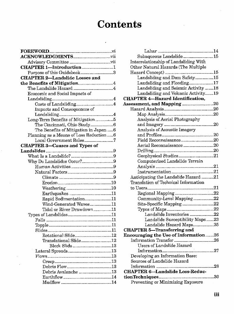
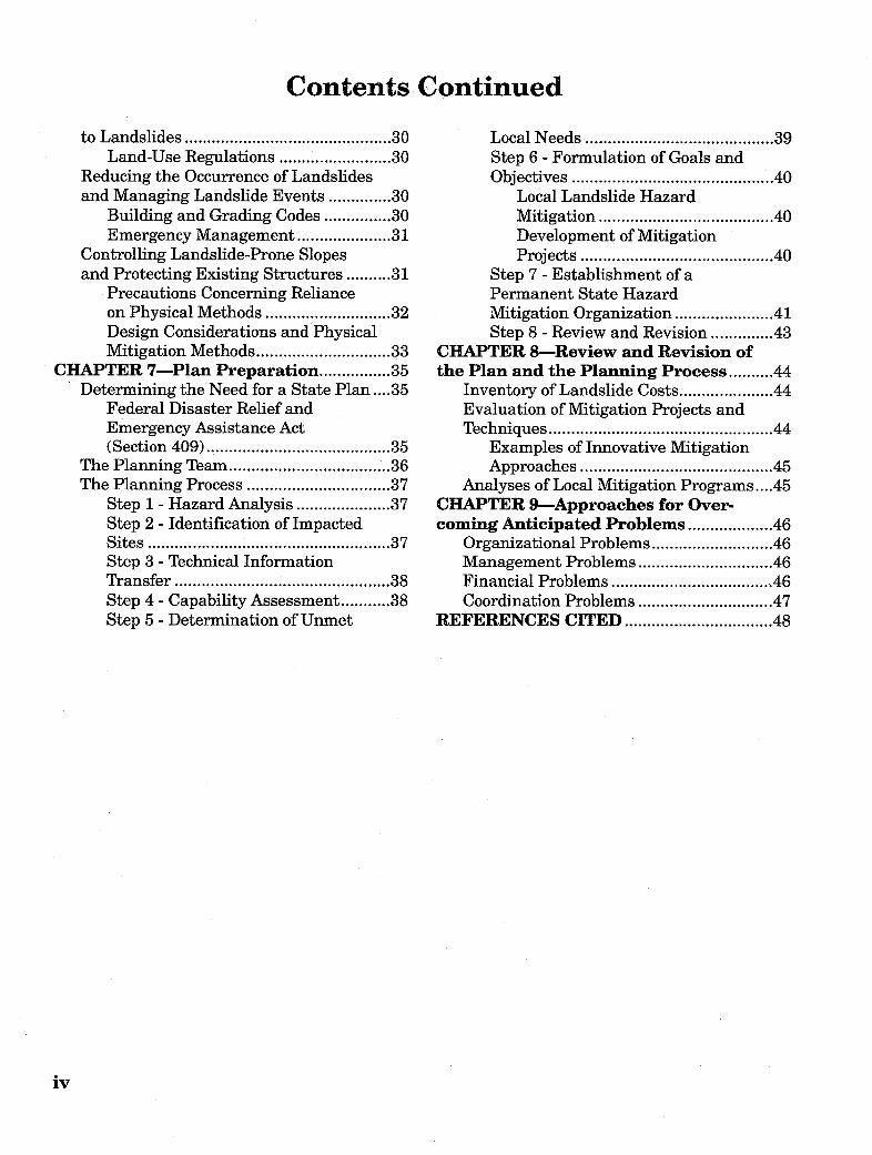
Contents
FOREWORD .n............................... 7iACKNOWLEDGIMENTS ............................... vii
Advisory Committee ................................ viiCHAPTER 1-Introduction .......................... 1
Purpose of this Guidebook ........................... 3CHAPTER 2-Landslide Losses andthe Benefits of Mitigation ............................. 4
The Landslide Hazard ................................. 4Econoamic and Social Impacts ofLandsliding ................................. 4
Costs of Landslidling ............................... 4Impacts and 'Consequences ofLandsliding ................................. 4
Long-Term Benefits of Mitigation ..........- 5The Cincinnati, Ohio Study ................... 6The Benefits of Mitigation in Japan ..... 6 6
Pla nning as a Means of Loss Reduetion.....6Local Government Roles ........................ 7
CHAPTER 3-Causes and Types ofLandslides ................................. 9
What Is a Landslide7 ................................. 9Why Do Landslides Occur7 .......................... 9
Human Activities ................................. 9Natural Factors ................................ .9
Climate ................................ . 9Erosion ................................ 10Weathering ................................ 10Earthquakes ................................ 11Rapid Sedimentation ...................... 11Wind-Generated Waves ................... 11Tidal or River Drawdown ............... 11
Types of Landslides ................................ 11Falls ................................ 11Toopple ................................ 11Slides ................................ 11
Rotational Slide .............................. 12Translational Slide ......................... 12
Block Slide ................................ 13Lateral Spreads ................................ 13Flows ................................ 13
Creep ................................ 13Debris Flow ................................ 13Debris Avalanche ........................... 13Earthflow ................................ 14Mudflow ................................ 14
Lahar .............................. 14Subaqueous Landslide .......................... 15
Interrelationship of Landsliding WithOther Natural Hazards (The MultipleHazard Concept) ............................... 15
Landsliding and lDam Safety ............... 15Landsliding and Flooding .................... 17Landsliding and Seismic Activity ....... 18Landsliding and Volcanic Activity ....... 19
CHAPTER 4-Hazard Identification,Assessment, and Mapping .......................... 20
Hazard Analysis .............................. 20Map Analysis ............................... 20Analysis of Aerial Photographyand Imagery ............................... 20Analysis of Acoustic Imageryand Profiles ............................... 20Field Reconnaissance ........................... 20Aerial Reconnaissance ......................... 20Drilling .............................. 20Geophysical Studies ............................. 21Computerized Landslide TerrainAnalysis .............................. 21Instrumentation .............................. 21
Anticipating the Landslide Hazard .......... 21Tlranslation of Technical Informationto Users .............................. 21
Regional Mapping .............................. 22Commrunity-Level Mapping ................. 22Site-Specifie Mapping .......................... 22Types of Maps .............................. 22
Landslide Inventories .................... 22Landslide Susceptibility Maps ...... 23Landslide Hazard Maps ................. 25
CHAPTER 5-Transferring andEncouraging the Use of Information ....... 26
Information Transfer ............................... 26Users of Landslide HazardInformation ............................... 27
Developing an Information Base:Sources of Landslide HazardInformation .............................. 28
CHAPTER 6-Landslide Loss-Reduc-tionTechniques .............................. 30
Preventing or Minimizing Exposure
fli
Contents Continued
to Landslides ................................ 30Land-Use Regulations ......................... 30
Reducing the Occurrence of Landslidesand Managing Landslide Events .............. 30
Building and Grading Codes ............... 30Emergency Management ..................... 31
Controlling Landslide-Prone Slopesand Protecting Existing Structures .......... 31
Precautions Concerning Relianceon Physical Methods ............................ 32Design Considerations and PhysicalMitigation Methods .............................. 33
CHAPTER 7-Plan Preparation ................ 35Determining the Need for a State Plan ... . 35
Federal Disaster Relief andEmergency Assistance Act(Section 409) ................................ 35
The Planning Team ................................ 36The Planning Process ................................ 37
Step 1 - Hazard Analysis ..................... 37Step 2 - Identification of ImpactedSites ................................ 37Step 3 - Technical InformationTransfer ................................ 38Step 4 - Capability Assessment ........... 38Step 5 - Determination of Unmet
Local Needs ............................... 39Step 6 - Formulation of Goals andObjectives ............................... 40
Local Landslide HazardMitigation ............................... 40Development of MitigationProjects ............................... 40
Step 7 - Establishment of aPermanent State HazardMitigation Organization ...................... 41Step 8 - Review and Revision .............. 43
CHAPTER 8-Review and Revision ofthe Plan and the Planning Process .......... 44
Inventory of Landslide Costs ..................... 44Evaluation of Mitigation Projects andTechniques ............................... 44
Examples of Innovative MitigationApproaches ............................... 45
Analyses of Local Mitigation Programs .... 45CHAPTER 9-Approaches for Over-coming Anticipated Problems ................... 46
Organizational Problems ........................... 46Management Problems .............................. 46Financial Problems ............................... 46Coordination Problems .............................. 47
REFERENCES CITED ............................... 48
iv

Figures
la. Map showing relative potential ofdifferent parts of the conterminousUnited States to landsliding .................... 1
lb. Potential landslide hazard inMaine ............................. 2
2. Major damage from debris flow,Farmington,Utah ............................ 6 5
3. "Bucket brigade," Farmington, Utah ....... 54. Landslide losses in Japan 1938-1981 ...... 65. The relationship of people, landslides,
and disasters ............................ . 76. Aerial view of the Savage Island
landslide, Washington state .................. 107. Ruins of home destroyed in Kanawha
City, West Virginia ............................ 108a. Rockfall .118b. Rockfiall on U.S. Highway 6,
Colorado .119a. Topple .129b. Topple, western 'Colorado . 12lOa. Rotational slide .12lb. Rotational slide, Golden, Colorado . 1311. Translational slide .1312. Block slide .113a. Lateral spread .1413b. Lateral spread, Cortez, Colorado. 1414a. Creep .1414b. Creep, Mt. Vernon Canyon, Colorado .... 14
15. Debris fan formed by debris flows .......... 1516a. Earthiflow ................................. 1516b. Roan Creek Eartlilow, DeBeque,
Colorado ................................ 1517. Damage from Slide Mountain
landslide, Nevada ................................ 1618. Jackson Springs landslide,
Franklin D.Roosevelt Lake,Washington state ................................. 17
1L9. Aerial view of the Thistle landslide,Utah ................................ 18
20. Landslide inventory map, Durango,Colorado ................................. 23
21. Landslide inventory map, La Honda,California ................................. 24
22. Landslide susceptibility map, KingCounty, Washington ................................ 24
23. Earthquake landslide hazard map,San Mateo County, California ................ 25
24. Hazardous area warning sign ................ 3125. Warning system schematic ..................... 3226. Rudd Creek debris basin, Farmington,
Utah ................................ 3227. Retaining wall, Interstate 70,
Colorado ................................ 3328. Executive Order establishing
Colorado Natural Hazards MitigationCouncil .... 42
Tables
1. Estimates of minimum landslidedamage in the United States,1973-1983 ............................. 2
2. Techniques for reducing landslidehazards .............................. 8
3. Examples of resources available for-obtaining/transferring landslide
information ....................................... 26.4. Potential users of landslide hazard
information .............................. 275. Examples of producers and providers
of landslide hazard information ............... 296. Physical mitigation methods ..................... 337. Capability assessment checklist ............... 38
V
Foreword
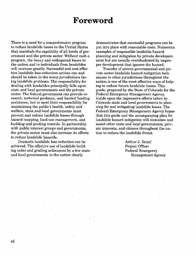
There is a need for a comprehensive programto reduce landslide losses in the United Statesthat marshals the capability of all levels of gov-ernment and the private sector. Without such aprogram, the heavy and widespread losses tothe nation and to individuals from landslideswill increase greatly. Successful and cost-effec-tive landslide loss-reduction actions can andshould be taken in the many jurisdictions fac-ing landslide problems. The responsibility fordealing with landslides principally falls uponstate and local governments and the privatesector. The federal government can provide re-search, technical guidance, and limited fundingassistance, but to meet their responsibility formaintaining the public's health, safety andwelfare, state and local governments mustprevent and reduce landslide losses throughhazard mapping, land-use management, andbuilding and grading controls. In partnershipwith public interest groups and governments,the private sector must also increase its effortsto reduce landslide hazards.
Dramatic landslide loss reduction can beachieved. The effective use of landslide build-ing codes and grading ordinances by a few stateand local governments in the nation clearly
demonstrates that successful programs can beput into place with reasonable costs. Numerousexamples of responsible landslide hazardplanning and mitigation by private developersexist but are usually overshadowed by impro-per development that ignores the hazard.
Transfer of proven governmental and pri-vate sector landslide hazard mitigation tech-niques to other jurisdictions throughout thenation is one of the most effective ways of help-ing to reduce future landslide losses. Thisguide, prepared by the State of Colorado for theFederal Emergency Management Agency,builds upon the impressive efforts taken byColorado state and local governments in plan-ning for and mitigating landslide losses. TheFederal Emergency Management Agency hopesthat this guide and the accompanying plan forlandslide hazard mitigation will stimulate andassist other state and local governments, priv-ate interests, and citizens throughout the na-tion to reduce the landslide threat.
Arthur J. ZeizelProject OfficerFederal Emergency
Management Agency
vi
Acknowledgments
This project was funded in part by the FederalEmergency Management Agency TFEMA), theColorado Division of Disaster Emergency Serv-ices (DODES), the Colorado Geological Survey(CGS), and the U.S. Geological Survey (GrantNo. 14-08-0001-A0420).
The document was written and preparedby Robert L. Wold, Jr. (DODES) and Can-dace L. Jochim (CGS). Staffl contributorsincluded: William P. Rogers, Irwin M. Glass-man, and John 0. frulby. Additional contri-
butors included: David B. Prior of the CoastalStudies Institute of Louisiana State Universityand William J. Kockelman of the U.S. Geo-logical Survey. Project management was pro-vided by Arthur Zeizel (FEMA) and IrwinGlassman (DODES).
Other essential project personnel included:Cheryl Brchan (drafting and layout), NoraRimando (word processing), and DavidButler (editing).
Advisory Committee
John Beaulieu, Deputy State Geologist, Oregon
John P. Byrne, Director, Disaster Emergency Services,Colorado
William J. Kockelman, Planner, U.&. GeologicalSurvey, California
Peter Lessing, Environmental Geologist, WestVirginia Geological Survey
George Mader, President, William Spangle andAssociates, California
Dr. Robert L. Schuster, U.S. Geological Survey,Colorado
Dr. James E. Slosson, Chief Engineering Geologist,Slosson. and Associates, California
Darrell WalIer, State Coordinator, Bureau of DisasterServices, Idaho
vii

viii
Introduction
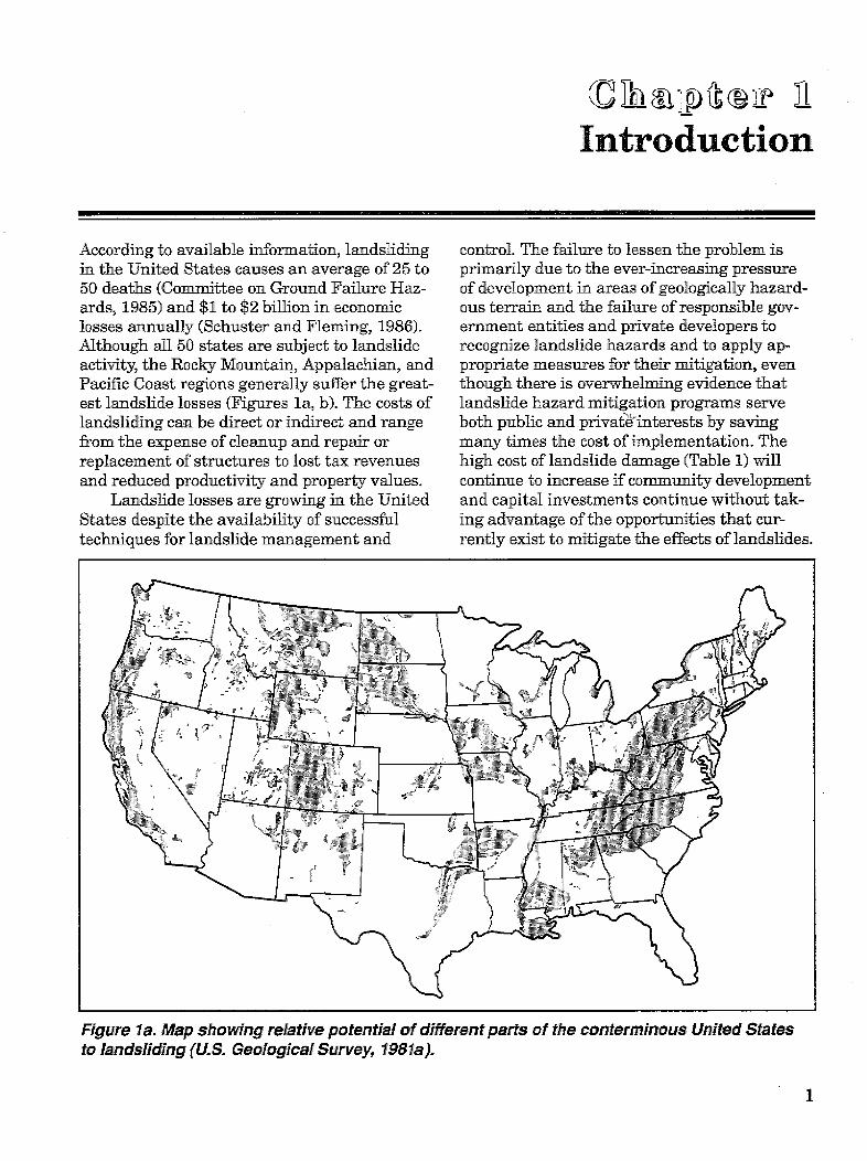
According to available information, landslidingin the United States causes an average of 25 to50 deaths (Committee on Ground Failure Haz-ards, 1985) and $1 to $2 billion in economiclosses annually (Schuster and Fleming, 1986).Although all 50 states are subject to landslideactivity, the Rocky Mountain, Appalachian, andPacific Coast regions generally suffer the great-est landslide losses (Figures la, b). The costs oflandsliding can be direct or indirect and rangefrom the expense of cleanup and repair orreplacement of structures to lost tax revenuesand reduced productivity and property values.
Landslide losses are growing in the UnitedStates despite the availability of successfultechniques for landslide management and
control. The failure to lessen the problem isprimarily due to the ever-increasing pressureof development in areas of geologically hazard-ous terrain and the failure of responsible gov-ernment entities and private developers torecognize landslide hazards and to apply ap-propriate measures for their mitigation, eventhough there is overwhelming evidence thatlandslide hazard mitigation programs serveboth public and privatPinterests by savingmany times the cost of implementation. Thehigh cost of landslide damage (Table 1) willcontinue to increase if community developmentand capital investments continue without tak-ing advantage of the opportunities that cur-rently exist to mitigate the effects of landslides.
Figure la. Map showing relative potential of different parts of the conterminous United Statesto landsliding (U.S. Geological Survey, 198 la).
1

Table 1. Estimates of minimum amounts oflandslide damage in the United States,1973-1983, in millions of dollars. All figuresare estimates. Figures queried are veryrough estimates (adapted from Brabb, 1984).
Damage 1973-1983State Priv. Ann.
Roads Prop. Total Avg.State ($M) ($M) ($M) ($M)
AlabamaAlaskaArizonaArkansasCaliforniaColoradoConnecticutDelawareDist. of ColumbiaFloridaGeorgiaHawaiiIdahoIllinoisIndianaIowaKansasKentuckyLouisianaMaineMarylandMassachusettsMichiganMinnesotaMississippiMissouriMontanaNebraskaNevadaNew HampshireNew JerseyNew MexicoNew YorkNorth CarolinaNorth DakotaOhioOklahomaOregonPennsylvaniaRhode IslandSouth CarolinaSouth DakotaTennesseeTexasUtahVermontVirginiaWashingtonWest VirginiaWisconsinWyoming
10.010.02.02.0
800.0?20.0
0.02.00.10.01.0?4.0
10.0?1.0
10.01.01.0
180.02.00.3
20.00.30.17.03.02.0?
10.0?0.42.0?
10.03.03.0
20.045.0
4.060.0?
2.0?30.050.0
0.00.0
16.0100.0
8.0200.0?
3.011.070.0?
270.00.24.0
0.50.00.00.0
200.0?50.0
0.00.00.10.00.00.51.0?1.0?1.00.30.3?
10.0?0.30.30.00.00.00.00.51.0?1.0?0.4?0.50.03.01.0
50.0?0.50.0
40.00.0
10.010.0?0.00.02.0
10.0?0.0
10.0?0.51.0
30.0?5.00.50.0
10.510.0
2.02.0
1000.0?70.0
0.02.00.010.01.0?4.5
11.0?2.0?
11.01.31.3?
190.0?2.30.6
20.00.30.17.03.53.0?
11.0?0.8?2.5?
10.06.04.0
70.0?45.54.0
100.0?2.0?
40.060.0?
0.00.0
18.0110.0?
8.0210.0?
3.512.0
100.0?275.0
0.74.0
1.051.00.20.2
100.0 ?7.00.00.20.80.00.1 ?0.451.1 ?0.2 ?1.10.130.13
19.0?0.230.062.00.030.010.70.350.3 ?1.1 ?0.08?0.25?1.00.60.47.0 ?4.550.4
10.00.2?4.06.00.00.01.8
11.0 ?0.8
21.0 ?0.351.2
10.0?27.50.070.4
EXPLANATION* High
' RMedium
m Low ?
D Low
w wJ Figure lb.Potential landslidehazard in Maine(Wiggins et al., 1978).
The widespread occurrence of landsliding,together with the potential for catastrophicstatewide and regional impacts, emphasizesthe need for cooperation among federal, state,and local governments and the private sector.Although annual landslide losses in the U.S.are extremely high, significant reductions infuture losses can be achieved through a comb-ination of landslide hazard mitigation andemergency management.
Landslide hazard mitigation consists ofthose activities that reduce the likelihood ofoccurrence of damaging landslides and mini-mize the effects of the landslides that do occur.The goal of emergency management is to mini-mize loss of life and property damage throughthe timely and efficient commitment of avail-able resources.
Despite their common goals, emergencymanagement and hazard mitigation activitieshave historically been carried out independ-ently. The integration of these two efforts ismost often demonstrated in the recovery phasefollowing a disaster, when decisions about re-construction and future land uses in the com-munity are made.
Emergency management, if well executed,can do much to minimize the loss and sufferingassociated with a particular disaster. However,unless it is guided by the goals of preventing orreducing long-term hazard losses, it is unlikelyto reduce the adverse impact of future disasters
2
Total (U.S.) 2010.3 442.2 2452.5 245.25
significantly. This is where mitigation becomesimportant (Advisory Board on the Built Envir-onment, 1983, p. 9).
Purpose of this GuidebookAs mentioned above, the development and im-plementation of landslide loss-reduction strate-gies requires the cooperation of many publicand private institutions, all levels of govern-ment, and private citizens. Coordinated andcomprehensive systems for landslide hazardmitigation do not currently exist in most statesand communities faced with the problem. Inmost states, local governments often take thelead by identiyring goals and objectives, con-trolling land use, providing hazard informationand technical assistance to property ownersand developers, and implementing mitigationprojects as resources allow. State and federalagencies play supporting roles-primarilyfinancial,, technical, and administrative. Insome cases, however, legislation originating atthe state or federal level is the sole impetus forstimulating effective local mitigation activity.
In many states there remains a need to de-velop long-term organizational systems at stateand local levels to deal with landslide hazardmitigation in a coordinated and systematicmanner. The development of a landslide hazardmitigation plan can be the initial step in theestablishment of state and local programs thatpromote long-term landslide loss reduction.
The purpose of this guidebook is to providea practical, politically feasible guide for stateand local officials involved in landslide hazardmitigation. The guidebook presents conceptsand a framework for the preparation of stateand local landslide hazard mitigation plans. Itoutlines a basic methodology, provides informa-tion on available resources, and offers suggest-ions on the formation of an interdisciplinarymitigation planning team and a permanentstate natural hazards mitigation organization.Individual states and local jurisdictions canadapt the suggestions in this book to meettheir own unique needs.
Because of its involvement in identifyingand mitigating landslide hazards, the state ofColorado was selected by the Federal Emer-gency Management Agency (FEMA) to producea prototype state landslide hazard mitigationplan. The technical information contained inthe plan was designed to be transferable toother states and local jurisdictions and suit-able for incorporation into other plans. Theplanning process can also serve as an exampleto other states and localities dealing with land-slide problems. The materials contained in theColorado Landslide Hazard Mitigation Plan(Colorado Geological Survey et al., 1988) wereintended to complement the information pre-sented in this guidebook. In an effort to pro-mote landslide hazard mitigation nationally,.FEMA has provided for the distribution ofthese two documents to all states. L
3

Landslide Losses andthe Benefits of Mitigation
The Landslide Hazar,Landsliding is a natural process whicand recurs in certain geologic settingEcertain conditions. The rising costs ofdamages are a direct consequence of tcreasing vulnerability of people and s-to the hazard. In most regions, the ovof occurrence and severity of naturallylandslides has not increased. What hied is the extent of human occupation,lands and the impact of human activithe environment. Many landslide danhave occurred might have been prevelavoided if accurate landslide hazard ition had been available and used.
Economic and Social Imlof Landsliding
Costs of LandslidingThe most commonly cited figures on Ilosses are $1 to $2 billion in economicand 25 to 50 deaths annually. HowevEfigures are probably conservative bec,were generated in the late 1970s. Sinitime, the use of marginally suitable lEincreased, as has inflation. Furthermiare no exhaustive compilations of lanidata for the United States, so these figbasically extrapolations of the availal
The high losses from landsliding;trated in Table 1. Surveys indicate thuto private property accounts for 30 tocent of the total costs (U.S. Geological1982). Examples of costs associated wdual landslide events from representsareas across the country include:
ALASKA-It has been estimated1978) that 60 percent of the $300 millage from the 1964 Alaska earthquakedirect result of landslides.
d; CALIFORNIA-In 1982 in the San Fran-
h occurs cisco Bay Region, 616 mm (24.3 in.) of rain fellh under in 34 hours causing thousands of landslideslandslide \ which killed 25 people and caused more than
the in- $66 million in damage (Keefer et al., 1987).tructures : TEXAS-In Dallas in the 1960s, a toppl-erall rate ing failure occurred in a vertical exposure of ay caused ; geological formation known as the Austinas increas- Chalk. This closed two lanes of a major down-of these town thoroughfare for eight months. Costs ofties on construction of remedial measures and con-nages that struction delays amounted to about $2.8 mil-
nited or lion (Allen and Flanigan, 1986).informa- V UTAH-In 1983, a massive landslide dam-
med Spanish Fork Canyon, creating a lake.The landslide buried sections of the Denver andRio Grande Western Railroad and U.S. High-
aacts ways 6, 50, and 89 and inundated the town ofThistle. The estimated total losses and recon-struction costs due to this one landslide rangefrom $200 million (University of Utah, Bureau
andslide of Economic and Business Research, 1984) tolosses $600 million (Kaliser and Slosson, 1988).
or, these WEST VIRGINIA-In 1975, landslideiuse they movements in colluvial soil damaged 56 housesce that in McMechen, West Virginia, located on a hill-ind has side above the Ohio River. This landslide wasore, there attributed to above normal precipitation. Mit-islide loss igation was accomplished by grading andgures are surface and subsurface drainage (Gray and)le data. Gardner, 1977).are illus-atdamage Impacts and Consequences50 per- of Landslidingl Survey, Economic losses due to landsliding include bothith indivi- direct and indirect costs. Schuster and FlemingLtive (1986) define direct costs as the costs of re-
placement, repair, or maintenance due to dam-I (Youd, age to property or facilities within the actualion dam- boundaries of a landslide (Figure 2). Suchwas the facilities include highways, railroads, irrigation
canals, underwater communication cables,
4
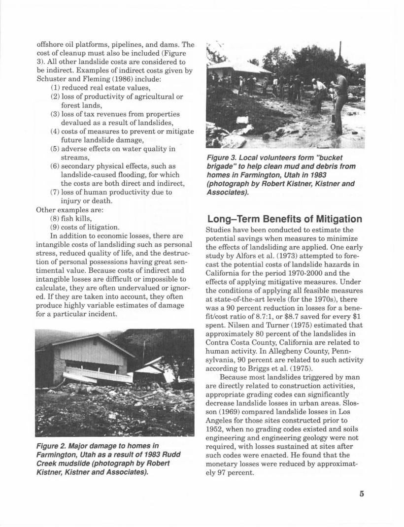
offshore oil platforms, pipelines, and dams. The cost of cleanup must also be included (Figure 3). All other landslide costs are considered to be indirect. Examples of indirect costs given by Schuster and Fleming (1986) include:
(1) reduced real estate values, (2) loss of productivity of agricultural or
forest lands, (3) loss of tax revenues from properties
devalued as a result of landslides, (4) costs of measures to prevent or mitigate
future landslide damage, (5) adverse effects on water quality in
streams, (6) secondary physical effects, such as
landslide-caused flooding, for which the costs are both direct and indirect,
injury or death. (7) loss of human productivity due to
Other examples are: (8) fish kills, (9) costs of litigation. In addition to economic losses, there are
intangible costs of landsliding such as personal stress, reduced quality of life, and the destruc- tion of personal possessions having great sen- timental value. Because costs of indirect and intangible losses are difficult or impossible to calculate, they are often undervalued or ignor- ed. If they are taken into account, they often produce highly variable estimates of damage for a particular incident.
Figure 2. Major damage to homes in Farmington, Utah as a result of 1983 Rudd Creek mudslide (photograph by Robert Kistner, Kistner and Associates).
Figure 3. Local volunteers form "bucket brigade" to help clean mud and debris from homes in Farmington, Utah in 1983 (photograph by Robert Kistner, Kistner and Associates).
Long-Term Benefits of Mitigation Studies have been conducted to estimate the potential savings when measures to minimize the effects of landsliding are applied. One early study by Alfors et al. (1973) attempted to fore- cast the potential costs of landslide hazards in California for the period 1970-2000 and the effects of applying mitigative measures. Under the conditions of applying all feasible measures at state-of-the-art levels (for the 1970s), there was a 90 percent reduction in losses for a bene- fit/cost ratio of 8.7:1, or $8.7 saved for every $1 spent. Nilsen and Turner (1975) estimated that approximately 80 percent of the landslides in Contra Costa County, California are related to human activity. In Allegheny County, Penn- sylvania, 90 percent are related to such activity according to Briggs et al. (1975).
are directly related to construction activities, appropriate grading codes can significantly decrease landslide losses in urban areas. Slos- son (1969) compared landslide losses in Los Angeles for those sites constructed prior to 1952, when no grading codes existed and soils engineering and engineering geology were not required, with losses sustained at sites after such codes were enacted. He found that the monetary losses were reduced by approximat- ely 97 percent.
Because most landslides triggered by man
5
The Cincinnati, Ohio StudyIn 1985, the U.S. Geological Survey, in cooper-ation with the Federal Emergency ManagamentAgency, conducted a geologic/economic develop-ment study in the Cincinnati, Ohio area. Thisstudy developed a systematic approach toquantitative forecasting of probable landslideactivity. Landslide probabilities derived from areproducible procedure were combined withproperty value data to forecast the potentialeconomic losses in scenarios for proposeddevelopment and to quantitatively identify thepotential benefits of mitigation activities.
The study area was divided into 14,255grid cells of 100-square meters each. Informa-tion calculated for each cell included: probabil-ity of landslide occurrence, economic loss in theevent of a landslide, cost of mitigation, andeconomic benefit of mitigation. This informa-tion was used to develop a mitigation strategy.In areas where both slope and shear strengthinformation were available, the optimum strat-egy required mitigation in those cells withslopes steeper than 14 degrees or where mater-ials had effective residual stress friction anglesof less than 26 degrees. This strategy yielded$1.7 million in estimated annualized net bene-fits for the community. In areas where onlyslope information was used, the best strategyrequired mitigation in those cells where slopeswere greater than 8 degrees. This yielded anestimated annualized net benefit of $1.4 mil-lion. Therefore, using regional geologic inform-ation in addition to slope information resultedin an additional $300,000 net benefit. TheCincinnati study cost only $20,000 to prepare(Bernknopf et al., 1985).
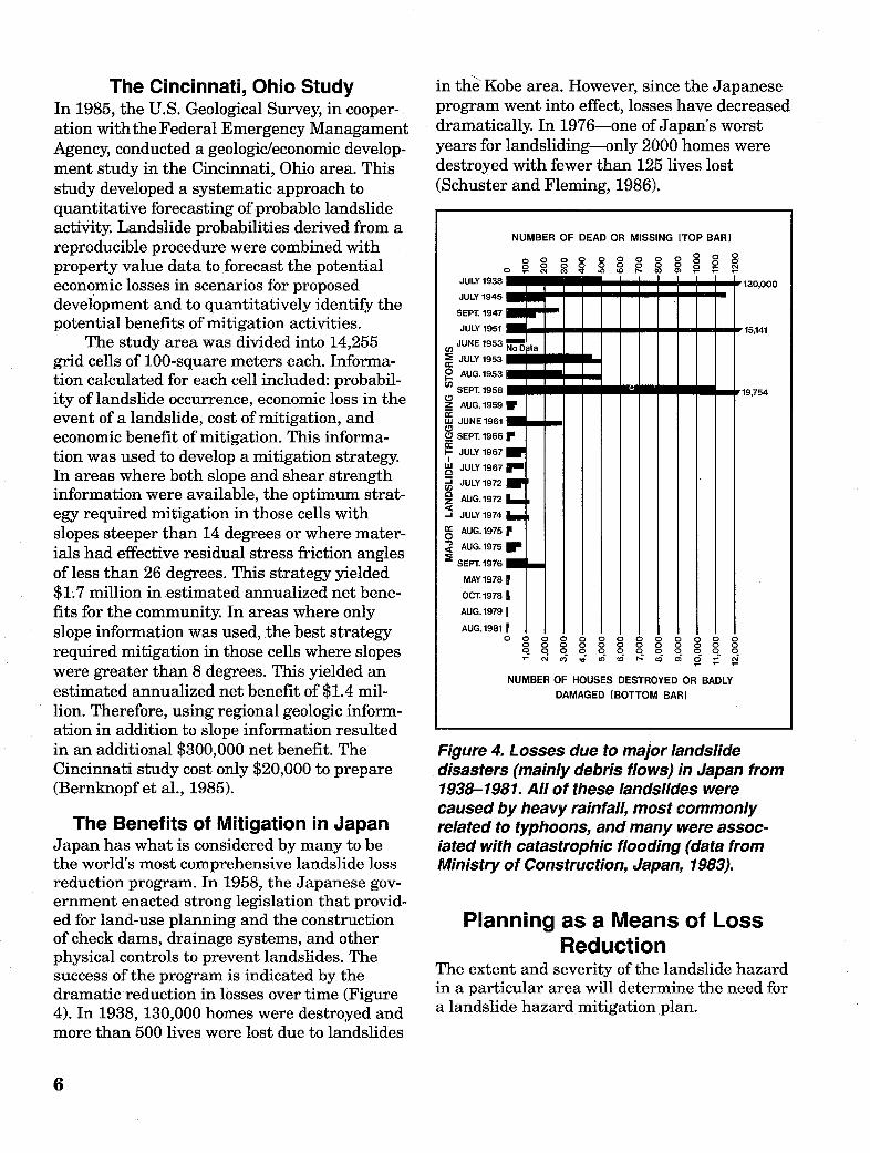
The Benefits of Mitigation in JapanJapan has what is considered by many to bethe world's most comprehensive landslide lossreduction program. In 1958, the Japanese gov-ernment enacted strong legislation that provid-ed for land-use planning and the constructionof check dams, drainage systems, and otherphysical controls to prevent landslides. Thesuccess of the program is indicated by thedramatic reduction in losses over time (Figure4). In 1938, 130,000 homes were destroyed andmore than 500 lives were lost due to landslides
in the Kobe area. However, since the Japaneseprogram went into effect, losses have decreaseddramatically. In 1976-one of Japan's worstyears for landsliding-only 2000 homes weredestroyed with fewer than 125 lives lost(Schuster and Fleming, 1986).
NUMBER OF DEAD OR
0 0 0 0 C C 000o
JULY 1938
JULY 1945
SEPT. 1947
JULY 1951
JUNE 1953
E JULY 1953
o AUG.1953
0 SEPT. 1958
Z AUG. 1959
Ln JUNE 1961
C0 SEPT. 1966
1 JULY 1967
Ad JULY 1967
-) JULY1972
z AUG.1972
-I JULY 1974
= AUG.19750e AUG.1975
SEPT.1976
MAY1978
OCT.1978
AUG.1979
AUG.1981
MISSING [TOP BAR)
-CD > 0 - - -
_ U U U U - - - - - -II'130,000
r _ _ _ _--- I - _ _ ,15,141
* _ _ _ U em U .. _ r19.754W
r
I-
r
I
- 0 0 0 N 0 0 0 0; CM CO 0 e N rcc 0 R o
NUMBER OF HOUSES DESTROYED OR BADLYDAMAGED [BOTTOM BAR]
Figure 4. Losses due to major landslidedisasters (mainly debris flows) in Japan from1938-1981. All of these landslides werecaused by heavy rainfall, most commonlyrelated to typhoons, and many were assoc-iated with catastrophic flooding (data fromMinistry of Construction, Japan, 1983).
Planning as a Means of LossReduction
The extent and severity of the landslide hazardin a particular area will determine the need fora landslide hazard mitigation plan.
6
1111

Communities that have landslide prob-lems are encouraged to assess the costs ofdamage to public and private property andweighl those costs against the costs of a land-slide reduction program. The prevention of asingle major landslide in a community maymore than compensate for the effort and cost ofimplementing a control program (Fleming andTaylor, 1980, p. 20).
Avoiding the costs of litigation is an addi-tional incentive to undertaking a local programof landslide hazard mitigation.
When landslide disasters do occur, the ex-istence of a program for loss reduction shouldhelp ensure that redevelopment planning takesexisting geologic hazards into account.
In the U.S., only a few communities haveestablished successful landslide loss reductionprograms. The most notable is Los Angeles,where, as mentioned above, loss reductions of97 percent have been achieved for new con-struction since the implementation of moderngrading regulations (Slosson and Krohn, 1982).
In communities that have achieved lossreductions, decisions about building codes,zoning, and land use take into account identi-fied landslide hazards. The U.S. GeologicalSurvey (1982) has found that these conuni-ties have in conmnon four preconditions leadingto successful mitigation programs: (1) anadequate base of technical information aboutthe local landslide problem, (2) an "able andconcerned" local government, (3) a technicalcommunity able to apply and add to the tech-nical planning base, and (4) an informed pop-ulation that supports mitigation program ob-jectives. While the technical expertise to reducelandslide losses is currently available in moststates, in many cases it is not being utilized.Still, the success of loss reduction measuresclearly depends upon the will of leaders topromote and support mitigation initiatives.
Local Government RolesAt the local government level, hazard mitiga-tion is often a controversial issue. Staff andelected officials of local governments areusually subjected to diverse and sometimesconflicting pressures regarding land use anddevelopment. Local officials, as well as build-ers, realtors, and other parties in the develop-ment process, are increasingly being held liable
for actions, or failures to act, that are deter-mined to contribute to personal injuries andproperty damages caused by natural hazards.Consequently, a model community landslidehazard management planning process shouldencourage citizen participation and review inorder to identity and address the perspectivesand concerns of the various community groupsaffected by landslide hazards.
Because most landslide damages are relat-ed to human activity-mainly the constructionof roads, utilities, homes, and businesses-thebest opportunities for reducing landslidehazards are found in land-use planning andthe .administration and enforcement of codesand ordinances.
The vulnerability of people to natural haz-ards is determined by the relationship betweenthe occurrences of extreme events, the proximi-ty of people to these occurrences, and thedegree to which the people are prepared to copewith these extremes of nature. The concept of ahazard as the intersection of the human sys-tem and the physical system, is illustrated inFigure 5. Only when these two systems are inconflict, does a landslide represent a hazard topublic health and safety.
Figure 5 The relationship of people, land-slides, and hazards (modified from ColoradoWater Conservation Board et a., 1985).
The effectiveness of local landslide mitiga-tion programs is generally tied to the abilityand determination of local officials to apply themitigation techniques available to them tolimit and guide growth in hazardous areas. Alist of 27 techniques that planners and mana-
7

gers may use to reduce landslide hazards intheir communities is presented in Table 2. Thekey to achieving loss reduction is the identifica-tion and implementation of specific mitigationinitiatives, as agreed upon and set forth in alocal or state landslide hazard mitigation plan.
Table 2. Techniques for reducing landslidehazards (Kockelman, 1986).
Discouraging new developments in hazardousareas by:
Disclosing the hazard to real-estate buyersPosting warnings of potential hazardsAdopting utility and public-facility
service-area policiesInforming and educating the publicMaking a public record of hazards
Removing or converting existing developmentthrough:
Acquiring or exchanging hazardousproperties
Discontinuing nonconforming usesReconstructing damaged areas after
landslidesRemoving unsafe structuresClearing and redeveloping blighted areas
before landslides
Providing financial incentives or disincentivesby:
Conditioning federal and state financialassistance
Clarifying the legal liability of propertyowners
Adopting lending policies that reflect riskof loss
Requiring insurance related to level ofhazard
Providing tax credits or lower assessmentsto property owners
Regulating new development in hazardousareas by:
Enacting grading ordinancesAdopting hillside-development regulationsAmending land-use zoning districts and
regulationsEnacting sanitary ordinancesCreating special hazard-reduction zones
and regulationsEnacting subdivision ordinancesPlacing moratoriums on rebuilding
Protecting existing development by:Controlling landslides and slumpsControlling mudflows and debris-flowsControlling rockfallsCreating improvement districts that
assess costs to beneficiariesOperating monitoring, warning, and
evacuating systems
Although certain opportunities forreducing landslide losses exist at the stategovernment level (selection of sites for schools,hospitals, prisons, and other public facilities;public works projects that protect highwaysand state property), the greatest potential formitigation is in the routine operations of localgovernment: the adoption and enforcement ofgrading and construction codes and ordinances,the development of land-use and open-spaceplans, elimination of nonconforming uses,limitation of the extension of public utilities,etc. For this reason, state mitigation plansshould emphasize mitigation activities thatwill essentially encourage and support localefforts. Local mitigation plans should provideguidelines and schedules for accomplishinglocal mitigation projects, as well as identifyprojects beyond local capability that should beconsidered in the state plan. U
8
Causes and Types of Landslides
What is a Landslide?The term "landslide" is used to describe a widevariety of processes that result in the percept-ible downward and outward movement of soil,rock, and vegetation under gravitational influ-ence. The materials may move by: falling, top-pling, sliding, spreading, or flowing.
Although landslides are primarily associ-ated with steep slopes, they also can occur inareas of generally low relief. In these areaslandslides occur as cut-and-fill failures (high-way and building excavations), river bluff fail-ures, lateral spreading landslides, the collapseof mine-waste piles (especially coal), and a widevariety of slope failures associated with quar-ries and open-pit mines. Underwater landslideson the floors of lakes or reservoirs, or inoffshore marine settings, also usually involveareas of low relief and small slope gradients.
Why Do Landslides Occur?Landslides can be triggered by both naturaland man-induced changes in the environment.The geologic history of an area, as well asactivities associated with human occupation,directly determines, or contributes to the con-ditions that lead to slope failure. The basiccauses of slope instability are fairly well known.They can be inherent, such as weaknesses inthe composition or structure of the rock or soil;variable, such as heavy rain, snowmelt, andchanges in ground-water level; transient, suchas seismic or volcanic activity; or due to newenvironmental conditions, such as thoseimposed by construction activity (Varnes andthe International Association of EngineeringGeology, 1984).
Human ActivitiesHuman activities triggering landslides aremainly associated with construction and invol-ve changes in slope and in surface-water and
ground-water regimes. Changes in slope resultfrom terracing for agriculture, cut-and-fillconstruction for highways, the construction -ofbuildings and railroads, and mining operations.If these activities and facilities are ill-conceiv-ed, or improperly designed or constructed, theycan increase slope angle, decrease toe or lateralsupport, or load the head of an existing or pot-ential landslide. Changes in irrigation or sur-face runoff can cause changes in surface drain-age and can increase erosion or contribute toloading a slope or raising the ground-watertable (Figure 6). The ground-water table canalso be raised by lawn watering, waste-watereffluent from leach fields or cesspools, leakingwater pipes, swimming pools or ponds, andapplication or conveyance of irrigation water. Ahigh ground-water level results in increasedpore-water pressure and decreased shearstrength, thus facilitating slope failure. Con-versely, the lowering of the ground-water tableas a result of rapid drawdown by water supplywells, or the lowering -of a lake or reservoir, canalso cause slope failure as the buoyancy pro-vided by the water decreases and seepagegradients steepen.
Natural FactorsThere are a number of natural factors that cancause slope failure. Some of these, such aslong-term or cyclic climate changes, are not dis-cernible without instrumentation and/orlong-term record-keeping.
ClimateLong-term climate changes can have a signifi-cant impact on slope stability. An overall de-crease in precipitation results in a lowering ofthe water table, as well as a decrease in theweight of the soil mass, decreased solution ofmaterials, and less intense freeze-thaw activity.An increase in precipitation or ground satura-tion will raise the level of the ground-water
.9

table, reduce shear strength, increase the weight of the soil mass, and may increase erosion and freeze -thaw activity. Periodic high-intensity precipitation and rapid snow- melt can signifcantly increase slope instability temporarily (Figure 7).
Erosion Erosion by intermittent running water (gully
Figure 7. The remains of a
house where three children died in a
mudflow in Kanawha City, West Virginia. The movement was triggered by heavy
rainfall from a cloud- burst on July 9, 1973 (Lessing et al., 1976).
Figure 6. Aerial view of the Savage Island land- slide on the east shore of the Columbia River, Washington, 1981. This landslide was caused by irrigation water (photograph by Robert L. Schuster, U.S. Geological Survey).
ing), streams, rivers, waves or currents, wind, and ice removes toe and lateral slope support of potential landslides.
Weathering Weathering is the natural process of rock deter- ioration which produces weak, landslide-prone materials. I t is caused by the chemical action of air, water, plants, and bacteria and the physical
10

action brought on by changes in temperature (expansion and shrinkage), the freeze-thaw cycle, and the burrowing activity of animals.
Earthquakes Earthquakes not only trigger landslides, but, over time, the tectonic activity causing them can create steep and potentially unstable slopes.
Rapid sedimentation Rivers supply very large amounts of sediment to deltas in lakes and coastal areas. The rapid- ly deposited sediments are frequently under- consolidated, and have excess pore-water pressures and low strengths. Such deltaic sediments are often prone to underwater delta-front landsliding, especially where the sediments are rich in clay and/or contain gas from organic decomposition.
Wind-generated waves Storm waves in coastal areas are known to trigger underwater landsliding in deltas by cyclically loading weak bottom sediments.
Tidal or river drawdown Rapid lowering of water level in coastal areas or along river banks due to tides or river dis- charge fluctuations can cause underwater land- sliding. The process in which weak river bank or deltaic sediments are left unsupported as the water level drops is known as "drawdown."
Types of Landslides The most common types of landslides are des- cribed below. These definitions are based mainly on the work of Varnes (1978).
Falls Falls are abrupt movements of masses of geologic materials that become detached from steep slopes or cliffs (Figures 8a, b). Movement occurs by free-fall, bouncing, and rolling. De- pending on the type of earth materials invol- ved, the result is a rockfall, soilfall, debris fall, earth fall, boulder fall, and so on. All types of falls are promoted by undercutting, differential weathering, excavation, or stream erosion.
Topple A topple is a block of rock that tilts or rotates forward on a pivot or hinge point and then
~
I FIRM BEDDED ROCK
Figure 8a. Rockfall (Colorado Geological Survey et al., 1988).
Figure 86. Rockfall on US. Highway 6, Colorado (photograph by Colorado Geological Survey).
separates from the main mass, falling to the slope below, and subsequently bouncing or rolling down the slope (Figures 9a, b).
Slides Although many types of mass movement are included in the general term "landslide," the more restrictive use of the term refers to move- ments of soil or rock along a distinct surface of rupture which separates the slide material from more stable underlying material. The two major types of landslides are rotational slides and translational slides.
11
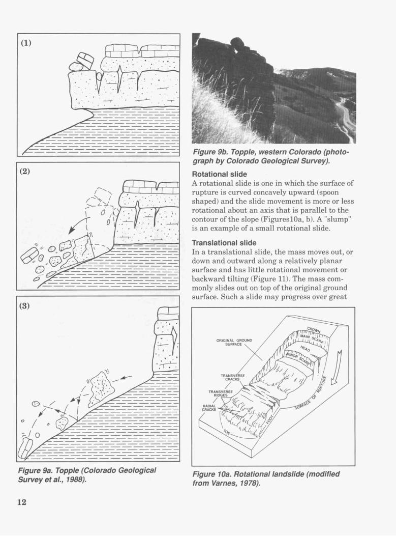
Figure 9a. Topple (Colorado Geological Survey et al., 1988).
Figure 9b. Topple, western Colorado (photo- graph by Colorado Geological Survey).
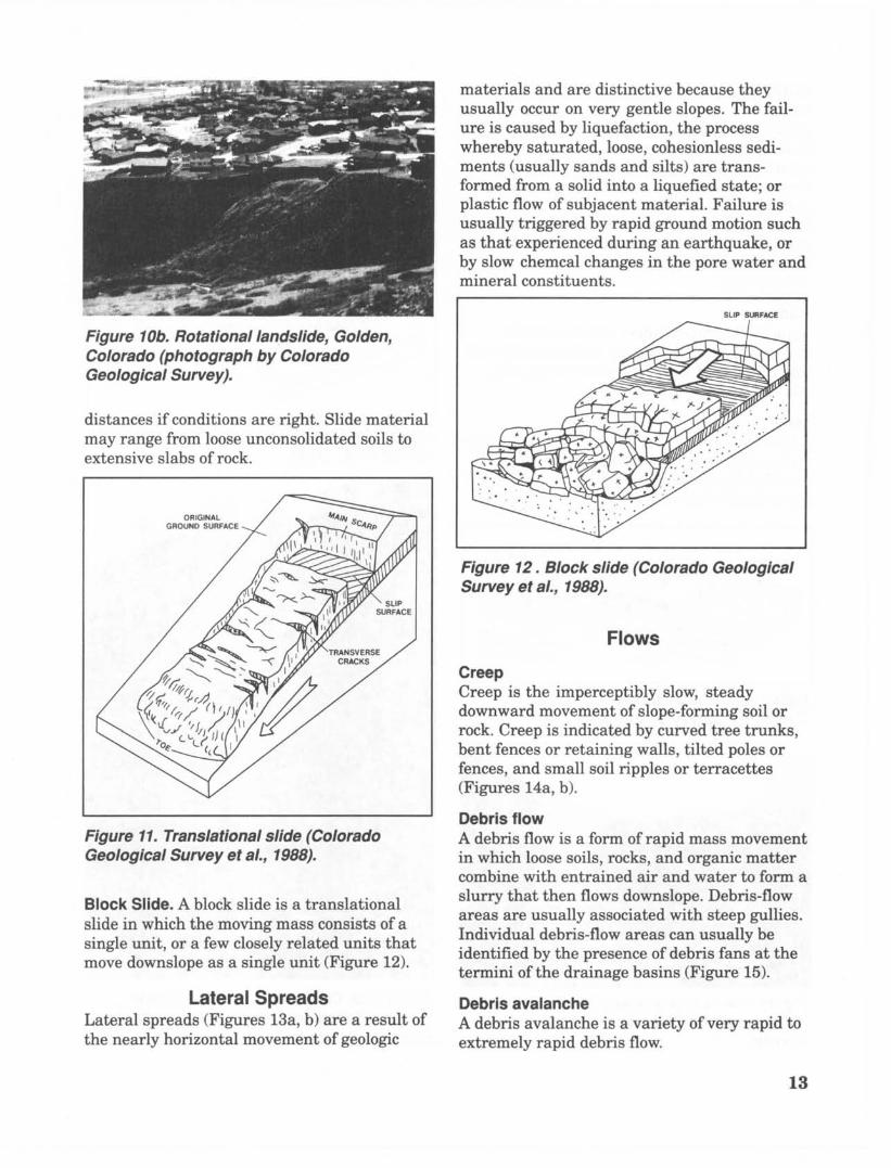
Rotational slide A rotational slide is one in which the surface of rupture is curved concavely upward (spoon shaped) and the slide movement is more or less rotational about an axis that is parallel to the contour of the slope (FigureslOa, b). A "slump" is an example of a small rotational slide.
Translational slide In a translational slide, the mass moves out, or down and outward along a relatively planar surface and has little rotational movement or backward tilting (Figure 11). The mass com- monly slides out on top of the original ground surface. Such a slide may progress over great
Figure 1 Oa. Rotational landslide (modified from Varnes, 1978).
12
I$ " m A
Figure 1 Ob. Rotational landslide, Golden, Colorado (photograph by Colorado Geological Survey).
distances if conditions are right. Slide material may range from loose unconsolidated soils to extensive slabs of rock.
GROUND SURFACE
Figure 11. Translational slide (Colorado Geological Survey et a/., 1988).
Block Slide. A block slide is a translational slide in which the moving mass consists of a single unit, or a few closely related units that move downslope as a single unit (Figure 12).
Lateral Spreads Lateral spreads (Figures 13a, b) are a result of the nearly horizontal movement of geologic
materials and are distinctive because they usually occur on very gentle slopes. The fail- ure is caused by liquefaction, the process whereby saturated, loose, cohesionless sedi- ments (usually sands and silts) are trans- formed from a solid into a liquefied state; or plastic flow of subjacent material. Failure is usually triggered by rapid ground motion such as that experienced during an earthquake, or by slow chemcal changes in the pore water and mineral constituents.
SLIP SURFACE
Figure 12. Block slide (Colorado Geological Survey et al., 1988).
Flows
Creep Creep is the imperceptibly slow, steady downward movement of slope-forming soil or rock. Creep is indicated by curved tree trunks, bent fences or retaining walls, tilted poles or fences, and small soil ripples or terracettes (Figures 14a, b).
Debris flow A debris flow is a form of rapid mass movement in which loose soils, rocks, and organic matter combine with entrained air and water to form a slurry that then flows downslope. Debris-flow areas are usually associated with steep gullies. Individual debris-flow areas can usually be identified by the presence of debris fans a t the termini of the drainage basins (Figure 15).
Debris avalanche A debris avalanche is a variety of very rapid to extremely rapid debris flow.
13

Earthf low Earthflows have a characteristic "hourglass" shape (Figures 16a, b). A bowl or depression forms a t the head where the unstable material collects and flows out. The central area is narrow and usually becomes wider as it reach- es the valley floor. Flows generally occur in fine-grained materials or clay-bearing rocks on moderate slopes and with saturated conditions. However, dry flows of granular material are also possible.
Mudflow A mudflow is an earthflow that consists of material that is wet enough to flow rapidly and that contains at least 50 percent sand-, silt-, and clay-sized particles.
Lahar A lahar is a mudflow or debris flow that origin- ates on the slope of a volcano. Lahars are usually triggered by such things as heavy rain- fall eroding volcanic deposits; sudden melting
Figure 13a. Lateral spread (Colorado Geological Survey et al., 1988).
Figure 136. Lateral spread, Cortez, Colorado. (Photograph by Colorado Geological Survey).
of snow and ice due to heat from volcanic vents; or by the breakout of water from glaciers, crat- er lakes, or lakes dammed by volcanic eruptions.
SPREADING
OUT OF ALIGNMENT
Figure 14a. Creep (Colorado Geological Survey et al., 1988).
Figure 146. Creep, vicinity of Mt. Vernon Canyon, Jefferson County, Colorado (photo- graph by Colorado Geological Survey).
14
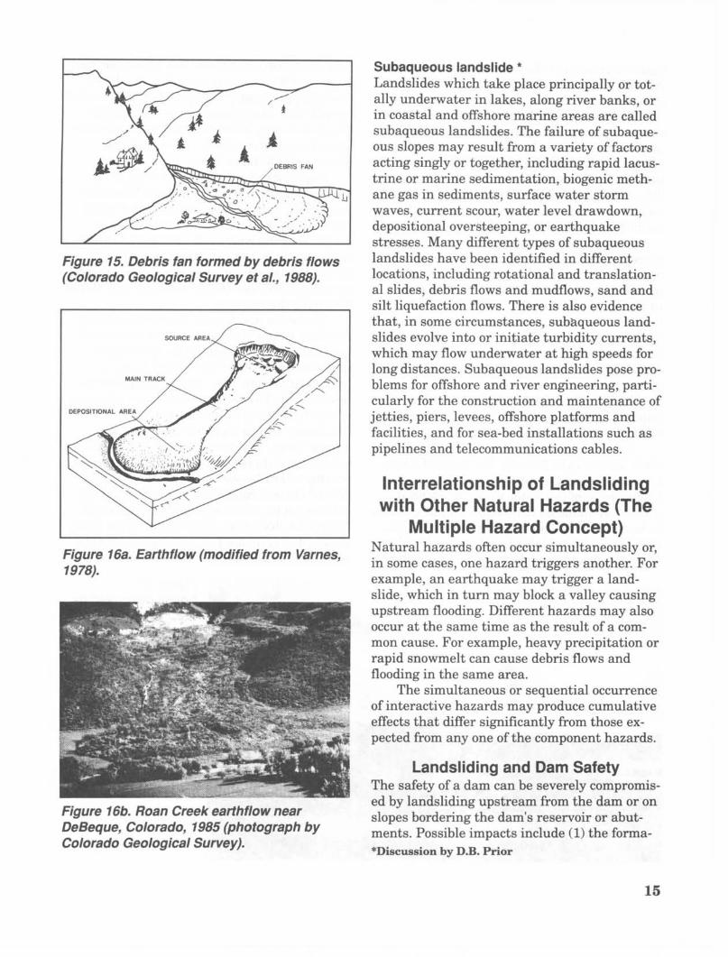
Figure 15. Debris fan formed by debris flows (Colorado Geological Survey et al., 1988).
7gure 16a. Earth flow (modified from Varnes, 19 78).
Figure 166. Roan Creek earthflow near DeBeque, Colorado, 1985 (photograph by Colorado Geological Survey).
Subaqueous landslide * Landslides which take place principally or tot- ally underwater in lakes, along river banks, or in coastal and offshore marine areas are called subaqueous landslides. The failure of subaque- ous slopes may result from a variety of factors acting singly or together, including rapid lacus- trine or marine sedimentation, biogenic meth- ane gas in sediments, surface water storm waves, current scour, water level drawdown, depositional oversteeping, or earthquake stresses. Many different types of subaqueous landslides have been identified in different locations, including rotational and translation- al slides, debris flows and mudflows, sand and silt liquefaction flows. There is also evidence that, in some circumstances, subaqueous land- slides evolve into or initiate turbidity currents, which may flow underwater a t high speeds for long distances. Subaqueous landslides pose pro- blems for offshore and river engineering, parti- cularly for the construction and maintenance of jetties, piers, levees, offshore platforms and facilities, and for sea-bed installations such as pipelines and telecommunications cables.
Inter relations h i p of La ndsl id i ng with Other Natural Hazards (The
Multiple Hazard Concept) Natural hazards often occur simultaneously or, in some cases, one hazard triggers another. For example, an earthquake may trigger a land- slide, which in turn may block a valley causing upstream flooding. Different hazards may also occur at the same time as the result of a com- mon cause. For example, heavy precipitation or rapid snowmelt can cause debris flows and flooding in the same area.
The simultaneous or sequential occurrence of interactive hazards may produce cumulative effects that differ significantly from those ex- pected from any one of the component hazards.
Landsliding and Dam Safety The safety of a dam can be severely compromis- ed by landsliding upstream from the dam or on slopes bordering the dam's reservoir or abut- ments. Possible impacts include (1) the forma- *Discussion by D.B. Prior
15

tion of wave surges that can overtop the dam, (2) increased sedimentation with resulting loss of storage, and (3) dam failure.
Flood surges can be generated either by the sudden detachment of large masses of earth into the reservoir, or by the formation and subsequent failure of a landslide dam across an upstream tributary stream channel. Waves formed by such failures can overtop the dam and cause serious downstream flooding without actually causing structural failure of the dam.
Landsliding into upstream areas or reser- voirs can greatly increase the amount of sedi- ment that is deposited in the reservoir, ulti- mately reducing storage capacity. This increas- es the likelihood that the dam will be over- topped during periods of excessive runoff, caus- ing downstream flooding. Excessive sedimenta- tion can also damage pumps and intake valves associated with water systems and hydroelec- tric plants.
Actual dam failure could be caused by landsliding at or near the abutments or in the embankments of earthen dams.
Slide Mountain in Nevada. The mass slid into Upper Price Lake, an irrigation reservoir, dis- placing most of the water which overtopped and breached the dam, flowing into Lower Price Lake. This lake's dam was also breached. The water flowed into Ophir Creek where it collect- ed large amounts of debris and became a debris
In 1983 a large mass of rock detached from
flow. After traveling about four kilometers and dropping 600 meters in elevation, the debris flow emerged from the canyon onto the alluvial fan of Ophir Creek (total time-15 minutes). One person was killed, four injured, and num- erous houses and vehicles were destroyed (Figure 17) (Watters, 1988).
Rapid changes in the water level of res- ervoirs can also trigger landslides. When the water level in the reservoir is lowered (rapid drawdown), the subsequent loss of support provided by the water and increased seepage pressure can initiate sliding (Figure 18). Al- ternatively, the increase in saturation caused by rising water can trigger landslides on slopes bordering the reservoir.
Eisbacher and Clague (1984) describe an excellent example of the potential impacts of landsliding on dam safety: the 1963 Vaiont dam disaster in Italy. The Vaiont Dam, a hydroelectric dam, was completed in 1960 to impound the Vaiont Torrent, a major tributary of the Piave River in the southern Alps of Italy. The dam is 261 m high and spans a steep narrow gorge. The southern wall of the valley behind the dam is a steep dip slope. Within two months after the reservoir was filled, a 0.7 x 10⁶ m3 mass of rock slumped away along the submerged toe of the southern embankment. Over time, deep-seated movement of the slope occurred in response to changing levels of the reservoir. As a result of these movements,
Figure 17. House destroyed by 1983 Slide Mountain, Nevada landslide (photograph by Robert J. Watters, University of Nevada, Reno).
16
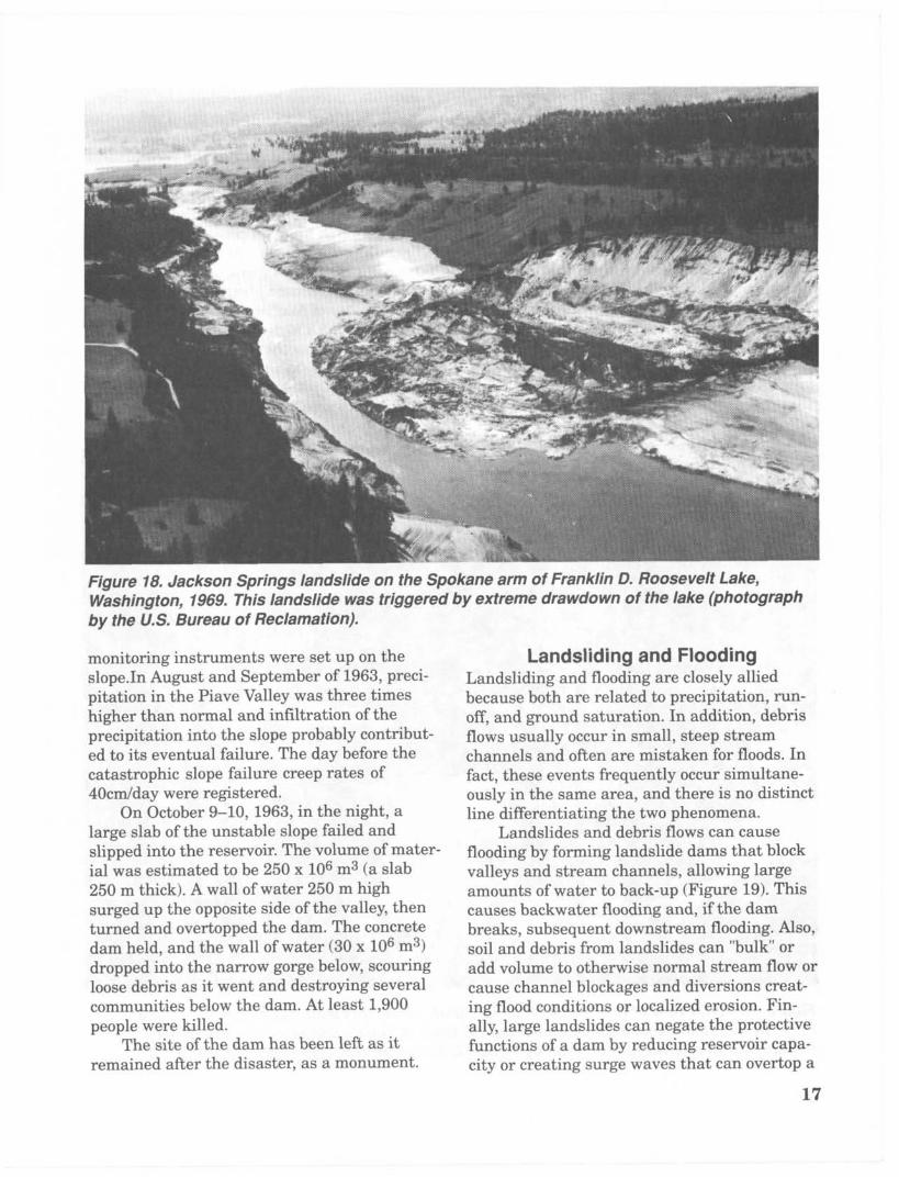
Figure 18. Jackson Springs landslide on the Spokane arm of Franklin D. Roosevelt Lake, Washington, 1969. This landslide was triggered by extreme drawdown of the lake (photograph by the U S . Bureau of Reclamation).
monitoring instruments were set up on the slope.In August and September of 1963, preci- pitation in the Piave Valley was three times higher than normal and infiltration of the precipitation into the slope probably contribut- ed to its eventual failure. The day before the catastrophic slope failure creep rates of 40cdday were registered.
On October 9-10, 1963, in the night, a large slab of the unstable slope failed and slipped into the reservoir. The volume of mater- ial was estimated to be 250 x 106 m3 (a slab 250 m thick). A wall of water 250 m high surged up the opposite side of the valley, then turned and overtopped the dam. The concrete dam held, and the wall of water (30 x lo6 m3) dropped into the narrow gorge below, scouring loose debris as it went and destroying several communities below the dam. At least 1,900 people were killed.
remained after the disaster, as a monument. The site of the dam has been left as it
Landsliding and Flooding Landsliding and flooding are closely allied because both are related to precipitation, run- off, and ground saturation. In addition, debris flows usually occur in small, steep stream channels and often are mistaken for floods. In fact, these events frequently occur simultane- ously in the same area, and there is no distinct line differentiating the two phenomena.
Landslides and debris flows can cause flooding by forming landslide dams that block valleys and stream channels, allowing large amounts of water to back-up (Figure 19). This causes backwater flooding and, if the dam breaks, subsequent downstream flooding. Also, soil and debris from landslides can "bulk" or add volume to otherwise normal stream flow or cause channel blockages and diversions crest- ing flood conditions or localized erosion. Fin- ally, large landslides can negate the protective functions of a dam by reducing reservoir capa- city or creating surge waves that can overtop a
17

dam, resulting in downstream flooding (asdescribed above).
In turn, flooding can cause landsliding.Erosion, due to rapidly moving flood waters,often undercuts slopes or cliffs. Once support isremoved from the base of saturated slopes,landsliding often ensues.
Landsliding and Seismic ActivityMost of the mountainous areas that are vul-nerable to landslides have also experienced atleast moderate seismicity in historic times.The occurrence of earthquakes in steeplandslide-prone areas greatly increases thelikelihood that landslides will occur and in-creases the risk of serious damage far beyondthat posed individually by the two processes.
Landslide materials can be dilated by seismicactivity and thus be subject to rapid infiltrationduring rainfall and snowmelt. Some areas ofhigh seismic potential such as the New MadridSeismic Zone of the lower Mississippi Rivervalley may be subject to liquefaction and relat-ed ground failure.The Great Alaska Earth-quake of March 27, 1964 caused an estimated$300 million in damages. As mentioned eariler,60 percent of this was due to ground failure.Five landslides caused about $50 million dam-age in the city of Anchorage. Lateral spreadfailures damaged highways, railroads, andbridges, costing another $50 million. Flow fail-ures in three Alaskan ports carried awaydocks, warehouses, and adjacent transporta-tion facilities accounting for another $15
Figure 19. Aerial view of the Thistle landslide, Utah, 1983. This landslide dammed the SpanishFork River creating a lake which inundated the town of Thistle and severed three majortransportation arteries (photograph by Robert L. Schuster, U.S. Geological Survey).
18

million. Much of the landsliding was a directresult of the effect of the severe ground shak-ing on the Bootlegger Cove Formation. Theshaking caused loss of strength in clays andliquefaction in sand and silt lenses (U.S.Geological Survey, 1981a).
Landsliding and Volcanic ActivityThe May 18, 1980 eruption of Mount St. Helensin Washington state triggered a massive land-slide on the north flank of the mountain. Thevolume of material moved was estimated to be2.73 km 3. The landslide effectively depressur-ized the interior of the volcano; superheated
waters turned into steam and magmatic gasesalso expanded, resulting in a giant explosion(U.S. Geological Survey, 1981b).
Because human activity had been restrict-ed in the Mount St. Helens area due to pre-dictions of an eruption, loss of life was mini-mized. However, the eruption devastated landas far as 29 km from the volcano. The resultinglateral blast, landslides, debris avalanches,debris flows, and flooding took 57 lives andcaused an estimated $860 million in damage(Advisory Committee on the InternationalDecade for Natural Hazard Reduction, 1987). 0
19