latest status and developments by eumets at - report …
TRANSCRIPT

CGMS-45-EUM-WP-20 v1B, 7 June 2017
Prepared by EUMETSAT Agenda Item: D.3 For information to Plenary
LATEST STATUS AND DEVELOPMENTS BY EUMETSAT - REPORT TO CGMS-45
This document summarises the status of EUMETSAT current and future LEO and GEO satellite systems. The reporting period for current satellite operations is 1 April 2016 to 31 March 2017. For future satellites, progress to date at the time of writing is included. Current satellite programmes cover status of the spacecraft, ground segment, data transmission, projects and services, user statistics. Future satellite programmes cover the mission objectives (spacecraft, payload, instruments, products) and programme status (space, system and ground segments). CGMS is invited to take note.

CGMS-45-EUM-WP-20 v1B, 7 June 2017
Page 2 of 33
Latest status and developments by EUMETSAT - report to CGMS-45
1 INTRODUCTION This paper reports on the EUMETSAT latest status and developments. The reporting period for current satellite operations is 1 April 2016 to 31 March 2017. For future satellites, progress to date at the time of writing is included.
2 CURRENT SATELLITE SYSTEMS EUMETSAT Current GEO satellites
Sector
Satellites in orbit P=pre-operational Op=operational B=back-up L=limited availability
Location Launch date Details on near real time access to L0/L1 data (links) Environmental payload and status
East Atlantic (36°W-36°E)
Meteosat-9 (Op) 9.5°E 21/12/2005
Service Status Data access Level 1 data info
Rapid Scanning Service, GERB not operational.
Meteosat-10 (Op) 0°W 05/07/2012 12-channel SEVIRI imager, DCS operational. Prime GERB
service. Data disseminated via EUMETCAST and LRIT
Meteosat-11 (in-orbit storage) 3.40W 15/07/2015 Spacecraft configured for In-Orbit-Storage
Indian Ocean (36°E-108°E)
Meteosat-8 (Op) 41.5°E 28/08/2002
Has been repositioned to perform Indian Ocean Data Coverage (IODC) due to the end-of-life re-orbiting of Meteosat-7 which was finalised in early April 2017. SEVIRI, GERB and DCS (for Tsunami warning) operational.

CGMS-45-EUM-WP-20 v1B, 7 June 2017
Page 3 of 33
EUMETSAT Current LEO satellites
Orbit type ECT=Equator Crossing Time (for
sun-synchronous orbits)
Satellites in orbit P=pre-operational
Op=operational B=back-up, secondary L=limited availability
Equator Crossing Time (ECT)
Ascending Node
Mean Altitude Launch date Details on near real time access to L0/L1
data (links)
Instrument payload and status
Sun-synchronous "Morning" orbit
ECT between 19:00-24:00 and between 07:00-12:00
Metop-A (B)
21:30
837 km
19/10/2006
Data access L1 data info
AVHRR/3, HIRS/4, AMSU-A, MHS, IASI, GRAS, ASCAT, GOME-2, SEM, A-DCS (prime ARGOS-3 service) , SARSAT, (HRPT partly functional)
Dissemination via EUMETCast
Sun-synchronous "Morning" orbit
ECT between 19:00-24:00 and between 07:00-12:00
Metop-B (Op) 21:30 837 km 17/09/2012 Data access L1 data info
AVHRR/3, HIRS/4, AMSU-A, MHS, IASI, GRAS, ASCAT, GOME-2, SEM, DCS (ARGOS-2 service only), SARSAT, (HRPT fully functional).
Dissemination via EUMETCast
Sun-synchronous "Morning" orbit
ECT between 19:00-24:00 and between 07:00-12:00
Sentinel-3A (Op) 22:00 814.5 km 16/02/2016 Data access L1 data info
OLCI, SRAL, SLSTR, MWR, POD

CGMS-45-EUM-WP-20 v1B, 7 June 2017
Page 4 of 33
2.1 Status of current GEO satellite systems 2.1.1 Mission objectives, payload/instruments, products The Meteosat system is designed to support nowcasting, short-range forecasting, numerical weather forecasting and climate applications. The system currently comprises three operational satellites of the Meteosat Second Generation (MSG) (Meteosat 10, 9 and 8) providing the core services over Europe, Africa and over the Indian Ocean. The Meteosat-10 satellite is currently providing the core service from 0-deg, Meteosat-9 is providing a rapid scan service over Europe from 9.5-deg East, while Meteosat-8 located at 41.5-deg East provides the Indian Ocean Data Collection (IODC) services and also provides DCS (for Tsunami warning) over the Indian Ocean. Meteosat-11 launched in July-2015 is in an In-Orbit-Storage configuration. Meteosat-7 imaging dissemination to users stopped on 31 March 2017 and the satellite re-orbiting successfully conducted in the first half of April-2017. Meteosat Second Generation (MSG) consists of a series of four geostationary meteorological satellites, along with ground-based infrastructure, that will operate consecutively beyond 2020. The core mission of the MSG satellites is provided by the Spinning Enhanced Visible and InfraRed Imager (SEVIRI), which has the capacity to observe the Earth in 12 spectral channels and provide impressive high quality image data which is at the heart of the operational forecasting needs, and the Geostationary Earth Radiation Budget (GERB) instrument supporting long term climate studies. Each Meteosat satellite is designed to remain in orbit, in an operable condition for at least seven years, but the actual performance of the satellites in orbit has exceeded this limit. The current policy is to keep two operable satellites in orbit over Europe and to launch a new satellite based upon a service availability analysis. In the case of Meteosat-11, the last satellite of the series, in view of the on-ground storage limitation being reached, an approach was selected to store the satellite in-obit, following launch and an initial commissioning phase, as long as the in orbit status will allow. Towards the end of the MSG lifetime, there will be a follow-on series in geostationary orbit - Meteosat Third Generation. 2.1.2 Status of spacecraft During the period from 1 April 2015 to 31 March 2016, the Meteosat Transition Programme (MTP) and Meteosat Second Generation (MSG) space segments have performed well. MTP (Meteosat-7) was successfully re-orbited in early April 2017. The MSG system has been stable. Meteosat-8 Meteosat-8, launched on 28 August 2002, was moved from 3.5°E to 41.5°E arriving on station end-September-2017. The satellite assumed prime mission over the Indian Ocean from Meteosat-7 on 1-February-2017. Meteosat-8 is nominally configured in Full Earth Scan (FES) imaging mode with the images being archived, not disseminated, GERB is operating, Search and Rescue is

CGMS-45-EUM-WP-20 v1B, 7 June 2017
Page 5 of 33
switched-off and the Data Collection Platform (DCP) transponder is switched-on (supporting Tsunami Warning and other regional Data Collection Services). Prior to the move to 41.5°E, Meteosat-8 at 3.5°E was rapidly re-tasked to conduct Rapid Scanning covering for the 31-March-to-04-April Meteosat-9 safe mode outage. This re-tasking was performed by dynamically moving up a scheduled Meteosat-8 gap filling rapid scanning for Meteosat-9 by one week. Meteosat-9 Meteosat-9, launched on 21 December 2005, is on station at 9.5°E since 5 February 2013 and supports the Rapid Scanning Service (RSS) since 9 April 2013. The spacecraft is in RSS imaging mode. The Search and Rescue transponder is switched-on (as requested by COSPAS-SARSAT) and the DCP transponder is switched-off. From 12-January-to-9-February 2017 the Meteosat-9 Rapid Scanning Service stopped per schedule, in order to perform SEVIRI health and safety activity (to prolong SEVIRI life). The spacecraft experienced a safe mode on 31 March 2016 due to deep space radiation and was restored to service on 4 April 2016. Meteosat-9 was rapidly re-tasked to conduct Full Earth Scanning for the periods covering 15 to 17 October 2016. This re-tasking was performed by dynamically moving up a scheduled Meteosat-9 48-hour health and safety pause by a few days. The GERB instrument currently is switched OFF due to degraded performance. Meteosat-10 Meteosat-10, launched on 5 July 2012, following January 2013 relocations, has been the prime Meteosat satellite for the 0° service since 21 January 2013. The spacecraft is currently in imaging mode, fully configured including DCP and Search and Rescue transponders. The spacecraft experienced a safe mode on 15 October 2016 and was restored to service on 17 October 2016. Since end-April-2015 the Meteosat-10 GERB has been the prime GERB instrument, taking over from the Meteosat-9 GERB. Meteosat-11 Meteosat-11, launched on 15-July-2015, is configured in an In-Orbit-Storage (IOS) configuration at 3.40W.

CGMS-45-EUM-WP-20 v1B, 7 June 2017
Page 6 of 33
Meteosat-11 spacecraft experienced a safe mode on 11 October 2017 and was restored to the IOS configuration the following day. Following launch was a successful LEOP and Commissioning, lasting until 7 December 2015 when the satellite started its in-orbit storage phase. It is planned to store Meteosat-11 in orbit until end of year 2017. 2.1.3 Ground segment matters The availability of the Meteosat (first and second generation) ground segments was nominal in the reporting period. During the period the MSG Ground Segment completed the transition to the MSG Computer Infrastructure Cluster (MCIC), a virtualised system which is now fully operational at EUMETSAT. The equivalent implementation for the Back-up Spacecraft Control Centre (BSCC) is now being prepared for installation on site during Q3 2017. Following a successful study and ITT during 2015 / 16, the evolution of the GEO Control room infrastructure will start during 2017. The dismantling of Antenna 20 (Usingen) began in Feb 17, with its removal from the operational baseline. This will be installed and integrated in Fucino in Q3 2017. Antenna 2 (Fucino) upgrades for MSG were completed in Q1 2017. 2.1.4 Data transmission EUMETSAT’s data dissemination systems via EUMETCast, GTS/RMDCN, internet and Direct Dissemination on Meteosat were working nominally. The EUMETCast Americas service was terminated in December 2016. A set of Meteosat products for South America are being transferred to GEONETCast Americas for further dissemination. A second transponder supporting the EUMETCast Europe High Volume service went operational in February, with GOES-16 data being the first stream to go live.

CGMS-45-EUM-WP-20 v1B, 7 June 2017
Page 7 of 33
2.1.5 Third Party Data Services
Service Date and Event during reporting period
Third-Party GEO Data Services
GOES and Himawari Data Nominal service.
FY-2G, F, D & E Data Nominal service.
Third-Party LEO Data Services
MODIS Data Nominal service
FY-3B & C Global Data FY-3B: available data from MWHS and IRAS. FY-3C: available data from MWHS-2, IRAS, MWRI. MWTS-2 on FY-3C failed in February 2015.
SSMI/S Nominal service
SARAL Nominal service, although the satellite is in a drifting orbit since July 2016 due to a reaction wheel anomaly.
Megha-Tropiques Data Nominal service
GCOM-W1 Nominal service
NOAA 15and 18 Nominal service
Third-Party Data and Products
DWDSAT and RETIM Nominal service
BMD and MDD Service Nominal service
SMOS Data Nominal service
EU Copernicus/FP7 Projects Nominal service
MESA Nominal service
Other Projects
In the GEONETCast context the dissemination of products from NOAA NESDIS, US-EPA, NASA for South America was terminated with the end of EUMETCast Americas. RANET is currently unavailable. Vegetation data for Africa, provided by VITO, and Rainfall Estimates, provided by Tamsat / University of Reading, were nominal.

CGMS-45-EUM-WP-20 v1B, 7 June 2017
Page 8 of 33
2.1.6 User statistics EUMETCast The status of EUMETCast registrations up to 31 December 2016 is provided in Figure 2. Note that Total number of registered Users on 31 March 2017 was 2793 (users may have more than one station). The drop in user figures in 2016 was due to the termination of some EUMETCast services (Americas service and RETIM-Europe).
Figure 1: EUMETCast Registrations
The availability of the EUMETCast dissemination system has already been provided in Section 2.1.5. The EUMETSAT Data Centre EUMETSAT’s Data Centre archives all payload data acquired from EUMETSAT’s operational satellites and most of the products derived from that data. The Data Centre allows registered users to request data and products from the archive by use of its online ‘self-service’ ordering mechanism and supplies the requested items via physical media and the Internet. The development of orders and deliveries from Jan 2016 up to and including April 2017 is provided in Fig. 3 below. 2016 saw a peak in the volume of ordering in the

CGMS-45-EUM-WP-20 v1B, 7 June 2017
Page 9 of 33
history of the Data Centre. 2 TB of data was processed to deliver over 520 TB of data in 12.3 Mio files to users, an increase of ca. 10% to the previous high.
Figure 2: Data Centre Retrieval and Delivery of User Ordering The netCDF format provided for many Data Centre products has been upgraded in January 2017 to a newer version (Unidata netcdf-4 classic model format). The upgrade offers performance benefits, particularly a size reduction of products in the order of 30-70% depending on product type, while still offering compatibility with existing open source netCDF-4 tools. The FTP Push delivery of the Data Centre which sends ordered data directly to the user has been removed from ordering profiles at the end of 2016 due to many observed problems with user ftp sites and the resulting negative impacts on the Data Centre. The preferred way to deliver data online is the download from a EUMETSAT controlled server via the http protocol. Several mechanisms are available to make the download simple and convenient. A web service has been set up which provides access under “pics.eumetsat.int” to over 30 years of Meteosat imagery. The service includes a web viewer application and an extension of the data range on a monthly basis.

CGMS-45-EUM-WP-20 v1B, 7 June 2017
Page 10 of 33
2.2 Status of current LEO satellite systems 2.2.1 Mission objectives, payload/instruments, products The prime objective of the EUMETSAT Polar System (EPS) Metop mission series is to provide continuous, long-term datasets, in support of operational meteorological and environmental forecasting and global climate monitoring. The EPS programme baseline consists of a series of three polar orbiting Metop satellites, to be flown successively for more than 14 years, from 2006, supported by the relevant ground facilities. However, with the continuing good health of Metop-A and following the successful entry into operations of Metop-B, it has been decided to continue a dual-Metop operational service as long as this provides added user value and is compatible with the Metop-A end-of-life constraints due to the space debris mitigation guidelines. Furthermore, a revised lifetime extension scenario for Metop-A has been agreed such that it may continue to operate in an orbit with drifting local solar time and potentially enable a tri-Metop operational service for a period of several years following the launch of Metop-C, foreseen for Q4 2018. The local time at the descending node will drift from 09:30 to around 07:20 during this period of time. Metop-A was launched on 19 October 2006 and Metop-B was launched on 17 September 2012. Metop carries a set of 'heritage' instruments provided by the United States and a new generation of European instruments that offer improved remote sensing capabilities to both meteorologists and climatologists. The new instruments augment the accuracy of temperature humidity measurements, readings of wind speed and direction, and atmospheric ozone profiles. Under the Initial Joint Polar System (IJPS) and Joint Transition Activities (JTA) agreement, EUMETSAT and NOAA have agreed to provide instruments for each other's satellites; exchange all data in real time, and assist each other with backup services. NOAA, with the support of NASA and the US National Science Foundation also provide an Antarctica Data Acquisition (ADA) service providing global data acquisition and real-time transmission to the EUMETSAT processing facilities in order to reduce data dissemination latency. This service is currently providing Metop-B data from most orbits. Full details of the satellite, its instruments and access to the related data and products can be found on www.eumetsat.int . 2.2.2 2.2.3 Status of spacecraft The Metop-B satellite took over from Metop-A as the primary operational Metop satellite on 24 April 2013. Metop-A continues full service provision in parallel, as the secondary Metop satellite.

CGMS-45-EUM-WP-20 v1B, 7 June 2017
Page 11 of 33
Both Metop satellites continued to perform well over the reporting period, although signs of ageing are present on some instruments on Metop-A, in particular HIRS and AMSU-A. Otherwise, no significant outages have occurred. In accordance with the revised lifetime extensions scenario for Metop-A, no further inclination manoeuvres are planned and the satellite is expected to drift below over 2 minutes below its nominal local time of descending node (09:30) by June 2017. 2.2.4 Ground segment matters The EPS Ground Segment has generally performed very well, supporting both EPS (dual-Metop) and NOAA operations. The EPS Computer Infrastructure Upgrade Project (ECIUP) was completed successfully in Jan 2017, and operations transitioned smoothly to the EPS Computer Infrastructure Cluster (ECIC). The Back-Up Control Centre (BUCC) has now been upgraded, and declared operational in April 2017. Antenna Control System upgrades to the two Svalbard CDAs were completed successfully in April and Sep 2016. Preparatory activities for EPS-SG CDAs began jn Q4 2016. 2.2.5 Data transmission LEO satellite product dissemination is made via EUMETCast, GTS/RMDCN and Direct Readout from the METOP satellites. These systems provide global data and the regional data acquired by EARS stations. The dissemination availability was nominal for all systems. 2.2.6 Projects, Services Suomi NPP Global and Regional Service Projects The Suomi NPP (S-NPP) satellite was successfully launched on 28 October 2011 and is now operated under NOAA responsibility. It ensures continuity of Afternoon Orbit operational data services within the IJPS. S-NPP has taken over the role as the primary operational satellite in this orbit. NOAA-19 will continue as the NOAA Prime Services Mission for the afternoon orbits. Global Data EUMETSAT is providing global data from Suomi NPP to its user community via EUMETCast and the GTS/RMDCN for routine operational use since 31 July 2012. EUMETSAT’s Suomi NPP related activities encompass: • The acquisition of global data from the CrIS, ATMS and VIIRS instruments from
NOAA; • The tailoring of these data according to the requirements of the user
community; • The dissemination of the tailored products to the user community.

CGMS-45-EUM-WP-20 v1B, 7 June 2017
Page 12 of 33
EUMETSAT supports global and regional Suomi-NPP data services within the scope of IJPS and in the framework of Copernicus (SNPP4C). Regional Data The core European EARS stations have been upgraded to support Suomi NPP and to establish operational regional services for ATMS, CrIS and VIIRS instrument data. All core EARS stations now have the new X/L-band reception systems operational and are receiving Suomi NPP data on a routine basis. The product processing for the ATMS, CrIS and VIIRS instrument data is based on the CSPP processing package provided by University of Wisconsin-Madison. The EARS-ATMS, EARS-CrIS and EARS-VIIRS services are all operational using the core stations at Svalbard, Lannion, Maspalomas, Athens, Kangerlussuaq and Moscow . Jason-2 Data Processing and Dissemination Service This service delivers the ‘Operation Geophysical Data Record’ (OGDR) products, derived from the altimetry data acquired from the Jason-2 satellite. Jason-2 is operated in cooperation between EUMETSAT, NOAA, CNES and NASA in the frame of the Ocean Surface Topography Mission (OSTM). EUMETSAT and NOAA process the data from the Jason-2 satellite in near real-time and archive and disseminate the products. The Jason-2 Service for Near Real Time (NRT) products became operational on 15 December 2008. Between 2-13 October 2016 a series of Jason-2 manoeuvres to reach the Interleaved Orbit with Jason-3 successfully took place. The altimeter was put in stand-by mode during the maneuvers. The product outage affected 140 passes altogether. On 15 and 22 March 2017 the Jason-2 satellite underwent two Safe Hold Modes, caused by an anomaly of the Gyro1, possibly due to radiation on the electronics. Routine operations resumed on 30 March 2017 using Gyro2 and Gyro3. The spacecraft then went into Safe Hold Mode on 18 May, triggered by a Gyro2 anomaly. The current hypothesis is too much radiation accumulated over the years on the electronics controlling the motor of Gyro2. The same type of anomaly is attributed to the SHM in March, triggered by Gyro1. On 30 May, after a few hours of functional tests with Gyro2, the anomaly which caused the SHM was reproduced. The anomaly is more likely to happen when the temperature is higher than 25 degrees Celsius and the latitude is over 60 degrees. During nominal operations, the gyros are expected to support temperatures between 20 and 30 degrees Celsius. Therefore, with the current status of Gyro1 and Gyro2, CNES expects that the anomaly would be regularly reproduced when the gyro temperatures are in the upper range i.e. between 25 and 30 degrees Celsius. CNES now recommends not initiating any recovery before the week of 26 June, which is the beginning of the next yaw-steering cycle. Until then, the conditions will be such that the gyros would reach high temperatures, increasing the risk of another SHM. Afterwards, the conditions will

CGMS-45-EUM-WP-20 v1B, 7 June 2017
Page 13 of 33
favour lower gyro temperatures, decreasing the risk of another SHM. There are several ongoing actions at CNES and TAS, investigating different options for resuming the mission. As an example, one possibility could consist of controlling the attitude of the satellite during operations in order to protect the gyros from the Sun, keeping their temperature low. As the different available options are not yet consolidated and, awaiting some more conclusive results from the ongoing analysis, CNES proposed to postpone any further decision until the end of June. As a consequence of the data outage corresponding to the Jason-2 manoeuvres to reach Interleaved Orbit and the Safe Hold Modes mean that the timeliness statistics of the NRT product dissemination via EUMETCast were affected. The Jason-2 ground segment continue operating nominally with no major anomalies to report. MODIS Data Dissemination Service EUMETSAT receives the following MODIS data from NASA for redistribution via EUMETCast: • Level 1 calibrated radiances (MOD02, MYD02); • Fire product (MOD14, MYD14); • MODIS chlorophyll Alpha.
EUMETSAT also receives MODIS direct broadcast polar winds from the Cooperative Institute for Meteorological Satellite Studies (CIMSS) for redistribution via EUMETCast. The level 1 calibrated radiances and geo-location data are processed at EUMETSAT in order to retain only those data over the geographical region north of 25° North between 60° West and 45° East, and north of 65° North elsewhere. Furthermore, the level 1 radiance data are further reduced by retaining only measurements from 18 spectral channels (1, 2, 5, 6, 8, 9, 10, 12, 15, 20, 23, 26, 27, 28, 29, 31, 32 and 33). Agreed MODIS products are disseminated unchanged on EUMETCast. Level 1 Calibrated Radiances products (MOD02) are processed before dissemination, comprising a spatially thinned sub-set of channels. MODIS precipitable water products (MOD05 and MYD05) are processed by EUMETSAT in order to retain only near infrared measurements over land during daytime. The worst-case dissemination delay generally stays below 30 min. FY-3B&C Data Dissemination Service Level 1 products from FY-3B and FY-3C are provided by CMA, and are made available to EUMETSAT Member States via EUMETCast. MWRI from FY-3B are also redistributed via EUMETCast. SSMIS Data Dissemination Service ENV, IMA, LAS and UAS products are disseminated on EUMETCast in BUFR format.
CGMS-45-EUM-WP-20 v1B, 7 June 2017
Page 14 of 33
SARAL Data Processing and Dissemination Service SARAL (Satellite with ARgos and ALtika) is a joint CNES/ISRO programme. The role of EUMETSAT is analogous to the support provided for Jason-2: • NRT processing of AltiKa payload instrument data; • Encoding the SARAL products in BUFR; • NRT dissemination of the SARAL products via EUMETCast and GTS/RMDCN; • Archiving of the SARAL products in the Data Centre; and • Coordination with CNES for the set-up, validation and operations of the SARAL
ground segment at EUMETSAT. The SARAL NRT altimetry products are distributed via EUMETCast since 16 September 2013 and via the GTS since 10 October 2013. Since July 2016 the SARAL satellite is in a drifting orbit due to an anomaly with the reaction wheel. However, the timeliness of the NRT OGDR products continues being nominal. For the reporting period 99% of the products were made available to users within 3 hours (the target is 75%) and also within 5 hours (the target is 95%). Megha-Tropiques Data Dissemination Service Based on the requirements for Level 1A2 data from the SAPHIR, MADRAS, ScaRaB and ROSA instruments and the tripartite cooperation agreement between ISRO, EUMETSAT, and CNES, a data transfer mechanism was agreed which uses a procured data line directly from ISRO to EUMETSAT. The initial service started on 27 May 2014 with data from the SAPHIR instrument reformatted to BUFR. The ROSA data is not available, and the MADRAS instrument has failed and so no products from MADRAS will be available for forwarding. SMOS Data Dissemination Service A BUFR version of the SMOS Level 1c near real time light product received from ESA via the Met Office (UK), is being distributed by EUMETSAT since February 2013. GCOM-W1 GCOM-W1 AMSR2 data is redistributed to EUMETSAT Member State NMHSs and ECMWF via EUMETCast. NOAA 15 and 18 Operational dissemination of NRT data from the ATOVS instruments onboard the non-IJPS NOAA satellites (since the loss of NOAA-16, now limited to NOAA-15 and NOAA-18) began on 25 November 2014. More precisely, L1B data from HIRS, AMSU-A, AMSU-B and MHS, received from NOAA DDS, are processed to L1C and reformatted to BUFR using the AAPP software. 2.2.7 User statistics Overall user statistics applicable to these services are provided in Section 2.1.6.

CGMS-45-EUM-WP-20 v1B, 7 June 2017
Page 15 of 33
2.3 Status of Copernicus Missions This section presents the status of the missions operated by EUMETSAT on behalf of the European Commission. 2.3.1 Overview 2.3.2 Jason-3
The Jason-3 satellite was successfully launched on 17 January 2016. For the reporting period, the following main milestones were achieved: • After the successfully System In-Flight Assessment Review and a formal hand
over review held by the four programme implementation partners, flight operations of Jason-3 were handed over from CNES to NOAA on 1 June 2016;
• After a successful first Verification Workshop the Jason-3 OGDR (Operational Geophysical Data Records) Near Real Time product and the Short Time Critical IGDR (Interim Geophysical Data Records) product were released to all users on 1 July by EUMETSAT and CNES, respectively;
• After the Jason-3 final Verification Workshop held during the OSTST Congress
(Ocean Surface Topography Science Team) from 1 to 4 November 2016, the Non Time Critical Jason-3 GDR (Geophysical Data Records) products, i.e. the most accurate ocean surface topography product used inter alia for mean sea level monitoring, was released via the CNES AVISO system to all users on 16 November 2016.
With the release of the GDR products, all Jason-3 product services reached full operational status. In the meantime, all criteria agreed in the Jason-3 calibration and validation plan for qualifying Jason-3 as the reference high precision ocean altimetry (HPOA) mission for mean sea level monitoring and cross calibration of other altimeter missions including Sentinel-3A had been met, and Jason-3 took over the reference mission from Jason-2 on 2 October 2016. From 2 to 14 October a series of Jason-2 manoeuvres put an end to the trailing formation with Jason-3, placing the Jason-2 satellite on the so-called interleaved orbit. This ensured additional spatial and temporal sampling of ocean variability by Jason-2 and the Copernicus Jason-3 and Sentinel-3A marine missions (see EUMETSAT website). 2.3.3 Sentinel-3A The Sentinel-3A satellite was launched on 16th February 2016, following a successful LEOP and Commissioning phase, confirmed via the In-Orbit Commissioning Review, the responsibility for operations of the Sentinel-3A Spacecraft were transferred from ESA to EUMETSAT on 13th July 2016.

CGMS-45-EUM-WP-20 v1B, 7 June 2017
Page 16 of 33
Due to a number of reasons the responsibility for the Marine Payload Data Ground Segment was not transferred at the IOCR as planned but was delayed being finally successfully handed over from ESA to EUMETSAT on 10th October. Activities are ongoing to build up to full operations prior to the Sentinel-3A Routine Operations Readiness Review scheduled on the 3rd July. EUMETSAT plays a key role providing data for the oceanographic and atmospheric user communities; providing marine data both in near real time (sensing + 3h) and off-line (sensing + 48h, sensing + 1m) and later atmospheric data in near real time NRT (sensing + 3h) products. EUMETSAT’s responsibilities are: • Monitoring and controlling of the S3 spacecraft and flight operations segment; • Product generation, archiving and dissemination of all Sentinel-3 products
routinely required by the marine user community and the related downstream services and later the atmospheric community;
• Serving the offline requests of the marine and later atmospheric user community for Sentinel-3 products.
2.3.4 Status of spacecraft 2.3.5 Jason-3 The status of the Jason-3 spacecraft is nominal, without any significant anomalies to report.
Figure 3: Jason-3 Space Segment Availability (note: AMR reported from Jan 17)

CGMS-45-EUM-WP-20 v1B, 7 June 2017
Page 17 of 33
2.3.6 Sentinel-3A Following the formal handover from ESA in mid-July 2016 nominal operations have continued smoothly with all nominal and ad-hoc spacecraft activities performed successfully, e.g. manoeuvres (in-plane and Out-of-Plane), security key changes and regular calibration activities. All Sentinel-3A topography instruments are performing well. Both Sentinel-3A optical instruments are performing nominally with the exception of the close out actions from IOCR, one anomaly on OLCI (December 2016) and multiple re-occurrences of one anomaly on SLSTR (June 2016, July 2016, September 2016, February 2017, March 2017). The space segment availability figures for the last 6 months are shown below.
Figure 4: Sentinel-3A Space Segment Availability 2.3.7 Ground Segment Matters 2.3.8 Jason-3 Jason-3 flight operations performed by NOAA have been nominal since the handover from CNES and the same applies to the operations of the Jason-3 ground segment performed by NOAA, NASA, CNES and EUMETSAT, with no significant anomalies to report.

CGMS-45-EUM-WP-20 v1B, 7 June 2017
Page 18 of 33
2.3.9 Sentinel-3A Flight operations of the Sentinel-3A satellite were handed over to EUMETSAT on 13 July, one day after the successful In Orbit Commissioning Review (IOCR), the Flight Operations Segment continues to operate well with no significant anomalies to be reported. The Marine PDGS was handed over to EUMETSAT on 10 October 2016. 2.3.10 Data Dissemination Jason-3 Near-Real-Time OGDR products are delivered by EUMETSAT via EUMETCast. For the reporting period 95% of the products were made available to users within 3 hours (the target is 75%), while almost 100% of the products were made available to users within 5 hours (the target is 95%). The Jason-3 IGDR and GDR products are delivered by CNES via AVISO.
Figure 5: Jason-3 Product Availability from EUMETCast / AVISO As recommended by the OSTST (Ocean Surface Topography Science Team) in November 2016, the timeliness requirement for the production of Jason-3 (and Jason-2) GDR products was relaxed from 60 to 90 days to allow additional time to include the results from the calibration of the radiometer, thus increasing the product accuracy. Sentinel-3 Products are available at a number of different timelinesses and via a number of different mechanisms which are illustrated in the figure below together with the current production status:
• EUMETCast; • Online Data Access/Copernicus Online Data Access (pull services); • EUMETSAT Data Centre.

CGMS-45-EUM-WP-20 v1B, 7 June 2017
Page 19 of 33
Figure 6: Status of S3A products and data access mechanisms
The following graphs show the availability figures for EUMETCast and ODA/CODA for those products declared as operational.
Figure 7: Availability figures for EUMETCast

CGMS-45-EUM-WP-20 v1B, 7 June 2017
Page 20 of 33
Figure 8: Availability figures for Online Data Access
2.3.11 User Statistics The following graphs show the number of users for EUMETCast, the Copernicus Online Data Access services and the Data Centre.

CGMS-45-EUM-WP-20 v1B, 7 June 2017
Page 21 of 33
Figure 9: # Copernicus Users of EUMETCast (per mission)
Figure 10: # Copernicus Users for Online Data Access Mechanisms (S3 only)
Figure 11: # Copernicus Users of the Data Centre
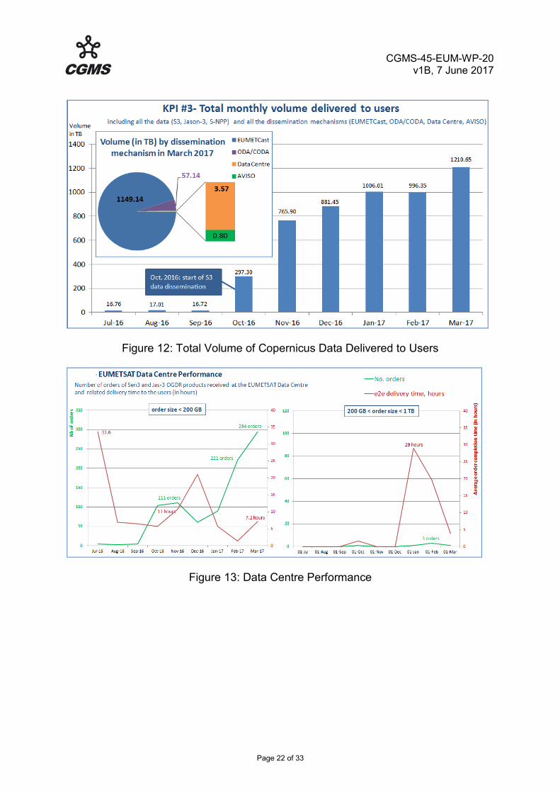
The following graphs show the amount of data delivered to the Copernicus Users and the Data Centre performances.
CGMS-45-EUM-WP-20 v1B, 7 June 2017
Page 22 of 33
Figure 12: Total Volume of Copernicus Data Delivered to Users
Figure 13: Data Centre Performance

CGMS-45-EUM-WP-20 v1B, 7 June 2017
Page 23 of 33
3 FUTURE SATELLITE SYSTEMS EUMETSAT Future GEO Satellites
Sector Satellites in orbit P=pre-operational Op=operational B=back-up L=limited availability
Location
Launch date Details on near real time access
to L0/L1 data (Links )
Environmental payload and status
East Atlantic (36°W -36°E)
MTG I11 9.5°E Q3 2021 Meteosat Third Generation/ Imaging (FCI, LI)
MTG S1 0° Q1 2023 Meteosat Third Generation/ Sounding (IRS, UVN)
MTG I2 9.5°E Q1 2025 Meteosat Third Generation/ Imaging (FCI, LI)
MTG I3 9.5°E Q3 2029 Meteosat Third Generation/ Imaging (FCI, LI)
MTG S2 0° Q3 2031 Meteosat Third Generation/ Sounding (IRS, UVN)
MTG I4 9.5°E Q1 2033 Meteosat Third Generation/ Imaging (FCI, LI)
1 Operational Scenario for the MTG Imaging Mission will be provided by one satellite at 0 deg and one satellite at 9,5 deg East, providing the Full Disc (FD) imaging service and the Rapid Scan Service (RSS)

CGMS-45-EUM-WP-20 v1B, 7 June 2017
Page 24 of 33
EUMETSAT Future LEO Satellites
Orbit type ECT=Equator Crossing Time (for sun-synchronous orbits)
Satellites in orbit P=pre-operational Op=operational B=back-up, secondary L=limited availability
Equator Crossing Time
(ECT) Ascending
Node
Mean Altitude
Launch date Details on near real time access to L0/L1
data (links)
Instrument payload and status
Sun-synchronous "Morning" orbit
ECT between 19:00-24:00 and between 07:00-12:00
Sentinel-3B 22:00 814,5 November 2017 OLCI, SRAL, SLSTR, MWR, POD
Metop-C (Metop-3)
21:30 837 km October 2018 AVHRR, MHS,AMSU-A, IASI, ASCAT,GRAS GOME, SEM,
A-DCS
Sentinel-6A (Jason-CS1)
December 2020 POS4 RA, AMR-C, POD, RO
Metop-SG 1A 21:30 837 September 2021 METimage, IASI-NG, MWS, Sentinel-5, 3MI, RO
Metop-SG-1B 21:30 837 December 2022 SCA, MWI, ICI, RO, ARGOS-4

CGMS-45-EUM-WP-20 v1B, 7 June 2017
Page 25 of 33
Sentinel-6B (Jason-CS2)
2026
Metop-SG 2A 21:30 837 2028 METimage, IASI-NG, MWS, Sentinel-5, 3MI, RO
Metop-SG-2B 21:30 837 2029 SCA, MWI, ICI, RO, ARGOS-4
Metop-SG 3A 21:30 837 2035 METimage, IASI-NG, MWS, Sentinel-5, 3MI, RO
Metop-SG-3B 21:30 837 2036 SCA, MWI, ICI, RO

CGMS-45-EUM-WP-20 v1B, 7 June 2017
Page 26 of 33
3.1 Status of future GEO satellite systems 3.1.1 MTG 3.1.1.1 Mission objectives, spacecraft, payload/instruments, products The MTG mission encompasses the following observation missions: • Flexible Combined Imager (FCI) mission, allows scanning of either the global
scales, full disc, in 16 channels every 10 minutes with a spatial sampling distance in the range 1-2km (Full Disc High Spectral resolution Imagery (FDHSI) in support of the Full Disc Scanning Service (FCI-FDSS)) or a local scales, a quarter of the Earth, with a dissemination to users of 4 channels every 2.5 minutes with a improvement in resolution by a factor of two High spatial Resolution Fast Imagery (HRFI) in support of the Rapid Scanning Service (FCI-RSS)).
• InfraRed Sounding (IRS) mission will deliver unprecedented information on
horizontal and vertical gradients of moisture, wind and temperature from the geostationary orbit, providing hyperspectral sounding information in two bands, a Long Wave InfraRed (LWIR: 700 - 1210 cm-1) and Mid Wave InfraRed (MWIR: 1600 - 2175 cm-1) band spatial resolution of 4 km. 4 Local Area Coverage (LAC) zones have been defined South to North; the LAC covering Europe has a repeat cycle of 30 minutes.
• Lightning Imagery (LI) mission, providing the main benefit from the Geostationary
Orbit: the homogeneous and continuous observations with delivering information on location and strength of lightning flashes to the end-users with high timeliness of 30 seconds at around 10km spatial resolution.
• Ultraviolet, Visible & Near-infrared (UVN) sounding mission, covering Europe
every hour taking measurements in three spectral bands (UV: 290 - 400 nm; VIS: 400 - 500 nm, NIR: 755 - 775 nm) with a spatial sampling distance better than 10km. This mission will be implemented with the Copernicus (formerly GMES) Sentinel-4 instrument which will be accommodated on two of the MTG Satellites, the so called MTG -S satellites.
Complementary to the direct observation missions summarised above and essential to satisfy key user needs, the following mission objectives also need to be fulfilled by MTG: • Level 2 product generation and dissemination; • Data Collection System (DCS), for collecting and transmitting observations and
data from surface, buoy, ship, balloon or airborne Data Collection Platforms (DCP);
• Search And Rescue (SAR) relay service. Similarly to MSG, the MTG System will accommodate a Geostationary Search and Rescue (GEOSAR) transponder, enabling the operations of the mission under the aegis of the COSPAS-SARSAT System.

CGMS-45-EUM-WP-20 v1B, 7 June 2017
Page 27 of 33
• Near Real Time Data Dissemination & Relay services to users, including Foreign Satellite Data (FSD) collection and distribution (data from other EUMETSAT and Third Party satellite systems for calibration and global applications):
- EUMETCast & High Rate dissemination services (including relay of FSD); - Regional Meteorological Data Communication Network (RMDCN) dissemination
service. (RMDCN provides a computer network infrastructure for the meteorological community in World Meteorological Organization (WMO) Region VI (Europe) and has expanded to sites in WMO Region II (Asia)). It is integrated with the Global Telecommunication System (GTS) established by the WMO.
- Internet dissemination services; - Data stewardship and reprocessing support; - Off-line data delivery; on-line services to the Users; Data exploitation support,
reach-out, training and help desk. Archived dataset retrieval services will continue to be provided as part of the multi-mission EUMETSAT Data Centre services, and User support services will be enhanced to address the additional needs with MTG. 3.1.1.2 Programme status
3.1.1.2.1 Overall status, and space segment From April 2016 to March 2017 Programme Management focussed on the preparation and conduct of the System Implementation Review (SIR) Part #1 which confirmed EUMETSAT’s readiness for the integration of the MTG-I ground segment (GS) and the first System Validation Tests (SVT) with the platform common to both satellites. The SIR part #1 also validated the revised logic and plan adopted for the development of the overall MTG system. The Flight Acceptance Reviews (FAR) for MTG-I1 and for MTG-S1 in December 2020 and August 2022 respectively. The development of the platform common to both satellites progressed significantly towards its Critical Design Review planned in the September/October 2017 timeframe. The successful Thermal Vacuum/Thermal Balance test of the Structural Thermal Model demonstrated the adequacy of the thermal design. In parallel, the integration of the Engineering Model (EM) proceeded and the integration of the Prototype Flight Model for MTG-I1 started. In addition, a version of the Satellite Control Software (SCSW) was delivered to EUMETSAT as part of the Satellite Simulator, in time for the preparation of the first System Validation Test. The Preliminary Mission Analysis Review (PMAR) is scheduled in Q1 2018 for MTG-I and in Q3 2018 for MTG-S, in line with the satellite schedule. The LEOP service preparations are ongoing.

CGMS-45-EUM-WP-20 v1B, 7 June 2017
Page 28 of 33
3.1.1.2.2 Ground Segment and scientific activities The realignment of the ground segment development with the space segment development required the introduction of a new delivery of the Instrument Data Processing Facility (IDPF-I) for Imagery Mission and the realignment of future deliveries of the Mission Operations Facility to allow continued progress of the development, integration and verification. As regards the data processing chain, the Processing Infrastructure of the IDPF-I was tested at EUMETSAT. Its robustness is at a point where it was integrated and tested with the Payload Data Generator (PDG) at the maximum data rates. The Preliminary Design Review of the Level 2 Processing Facility (L2PF) was closed in December. The installation of the Mission Data Acquisition (MDA) ground stations has progressed at Lario, Italy, and Leuk, Switzerland, and both stations should be ready for acceptance end of 2017. The antennas of the Telemetry Tracking and Control (TT&C) station have been manufactured and will be available in Fucino to support MSG operations from early 2018. The first delivery of the Mission Operations Facility (MOF), primarily a mission control system (MCS), happened and was integrated with the satellite simulator, the satellite database. IT is now being integrated with the front end of the Telemetry, Tracking and Control station and other system tools required to support the first System validation test (SVT-I1-v0) involving the satellite platform in Industry Premises. The InfraRed Sounder (IRS), the Level 1 Algorithm Theoretical Baseline Documents (ATBD) and Processing Specifications were consolidated after a peer review organised in September 2016. All conditions are now met for the release of the ITT facility in May2017 covering the sounding mission (IRS and UVN). Reference processors have been further developed and simulated observations have been generated to deliver more representative test data to support the verification of the operational processing chains developed by Industry, the Satellite Application Facilities, and to familiarise users. The cooperation of the EUMETSAT community with NOAA is very active to gain experience from the calibration and validation of the Advanced Baseline Imager (ABI) and Geostationary Lightning Mapper (GLM) data from GOES-16. For user preparedness, the MTG IRS Near Real Time demonstration project is continuing. A Meteosat Third Generation User Preparedness Project (MTGUP) has been initiated to familiarise Member State NMHSs and the North African Users in the footprint of EUMETCast Europe with the advanced data, products and services expected from the three instruments onboard MTG satellites, taking into account the WMO/CGMS guidelines on user preparation for future satellites services. The next key milestone is the System Implementation Review Part #2 planned in autumn 2017 as an intermediate step towards the System CDR for the MTG-I mission, foreseen mid 2019.

CGMS-45-EUM-WP-20 v1B, 7 June 2017
Page 29 of 33
3.2 Status of future LEO satellite systems This section covers Metop-C, EPS-SG; Jason CS; and Sentinel 3. 3.2.1 Metop-C The Payload Module successfully passed the Thermal Vacuum (TV) testing and will be integrated with the Service Module end of June 2017. The Service Module has been de-stored and successfully TV tested. Following further alignment checks and testing of the propulsion system it will be integrated with the Payload module and the Solar Arrays. GOME-2 has been fully re-stored and will undergo a re-calibration activity at TNO, Delft. Degradations of the MHS required investigations and potential repair. Both instruments will be re-integrated latest in Feb. 2018. All S/C AIT activities are progressing well for readiness in the announced launch period from 1st October 2018 to 31st December 2018. 3.2.2 EPS-SG
3.2.2.1 Mission objectives, spacecraft, payload/instruments, products The EPS-SG encompasses the following observation missions: • The Infra-red Atmospheric Sounding mission (IAS), to provide temperature and
humidity profiles, as well as observations of ozone and various trace gases, through a wide swath of hyper-spectral infra-red soundings in four bands from 3.62 to 15.5 µm, with radiometric and spectral resolutions improved by factor 2 vs. IASI and consistent spatial sampling of about 25 km.
• The Microwave Sounding mission (MWS), to provide all-weather atmospheric
temperature and humidity profiles, as well as cloud liquid water columns, over a wide swath in the spectral region between 23.4 and 229 GHz, with footprints from 40 down to 17 km at the highest frequencies.
• The Scatterometry mission (SCA), to provide ocean surface wind vectors and land surface soil moisture by measurement of back-scattered signals at 5.3 GHz with spatial resolution of 25 km.
• The Visible/Infra-red Imaging mission (VII), for providing information on clouds, cloud cover, land surface properties, sea, ice and land surface temperatures, among other observations, by moderate-resolution optical imaging, in 20 spectral channels ranging from 0.443 to 13.345 µm, with a spatial sampling of 500 m (250 m in two channels).

CGMS-45-EUM-WP-20 v1B, 7 June 2017
Page 30 of 33
• The Microwave Imaging mission (MWI), for precipitation and cloud imaging through measurements in the spectral range from 18.7 to 183 GHz with footprints from 10 to 50 km (for the highest to lowest frequency respectively).
• The Ice Cloud Imaging mission (ICI), to provide ice-cloud and water-vapour imaging in 11 channels (2 of which being dual-polarisation)by exploiting sub-millimetre-wave observations from 183 to 664 GHz with footprints of 15 km.
• The Radio Occultation mission (RO), for atmospheric all-weather soundings of temperature and humidity at high vertical resolution, and additionally ionospheric electron content in support of space weather, by tracking signals from global navigation satellites, GPS and Galileo at least.
• The Nadir-viewing Ultraviolet, Visible, Near-infra-red, Short-wave-infra-red Sounding mission (UVNS), to provide ozone profiles, monitor various trace gases, monitor air quality and support climate monitoring by means of hyper-spectral soundings with a spectral resolution from 0.05 to 1 nm in the wavelength range from 0.27 to 2.385 μm, at a spatial sampling of 7 km for channels above 0.3 μm.
• The Multi-viewing, Multi-channel, Multi-polarisation Imaging mission (3MI), for aerosol observations by moderate resolution optical imaging in 12 spectral channels from the ultra-violet (0.410 µm) to the short-wave infra-red (2.13 µm), at a spatial sampling of 4 km.
• The IAS, MWS, SCA, VII, RO and UVNS missions provide continuity and improvements to missions currently provided with the Metop satellites. The MWI, ICI and 3MI are new missions with respect to Metop first generation, drawing from the experience with other experimental or operational missions.
• In addition to the above observation missions, EPS-SG satellites will embark payload to provide the following service in the frame of a relevant cooperation and in continuity to EPS:
• ARGOS Advanced Data Collection Service (A-DCS), for the worldwide collection
from in-situ platforms of oceanographic and meteorological data and their transmission to the user community.
There will be a series of three spacecraft of type Metop-SG A and B, with a 7.5-year design lifetime of each satellite covering at least 21 years of operations for each series of satellites. 3.2.1.2 Programme status
3.2.1.2.1 Overall status, and space segment EPS-SG development activities are progressing in Phase C/D. The ESA space segment development activities continued to progress rapidly for both Metop-SG satellites with almost all Preliminary Design Reviews (PDR’s) at

CGMS-45-EUM-WP-20 v1B, 7 June 2017
Page 31 of 33
subsystem and unit levels completed. The Metop-SG A CDR will take place from April to June 2018 and the Metop-SG B CDR will follow one year later, from March to May 2019. The space segment is complemented by the following instruments METimage, IASI-NG, and ARGOS4 provided by DLR and CNES, respectively and Sentinel-5 provided by the European Union. The launch dates remain September 2021 for Metop-SG A1 - with a three-month slippage due to METimage - and December 2022 for Metop-SG B1. Recurrent satellites are planned to be launch in 2028 and 2030 (Metop-SG A2 and B2) and in 2035 and 2036 timeframe (Metop-SG A3 and B3).
3.2.2.1.2 Ground Segment and scientific activities The system activities focussed on the preparation of the processing documentation required to support the development of the ground segment and on consolidating the system design taking into account the progress achieved in the design and development of the satellites, instruments and ground segment. A successful internal System Engineering Check Point (SECP) was held in March 2017. At this point, based on the current design and predicted performances of the instruments, the assessment of end-to-end instrument chain performances confirms that most performances are expected to be compliant with system requirements. The Payload data Acquisition and Processing (PDAP) PDR is planned for summer 2017. The preparation of the Svalbard site infrastructure is nearing completion, and its readiness for hosting the PDAP Ka band antennas and the MCO S band antenna will be formally verified in May 2017. The project development of Multi Mission Elements (MMEs) for data dissemination, archive, etc. is on track. 3.2.3 Jason CS The Sentinel-6/Jason-CS primary mission objective is to provide continuity of ocean topography measurements beyond the TOPEX/Poseidon, Jason, OSTM/Jason-2, and Jason-3 cooperative missions, for determining sea surface height, ocean circulation, and sea level. Accordingly, the Sentinel-6/Jason-CS Mission will utilise the legacy TOPEX/Poseidon precision altimetry orbit. As a secondary mission objective, it will collect high-resolution vertical profiles of atmospheric temperature, using the GNSS-RO sounding technique, to assess temperature changes in the troposphere and the stratosphere and to support numerical weather prediction.

CGMS-45-EUM-WP-20 v1B, 7 June 2017
Page 32 of 33
The Sentinel-6/Jason-CS cooperative mission will be implemented by two identical Sentinel-6/Jason-CS Satellites launched in sequence, each with a nominal 5.5 year lifetime. In order to provide continuity, the launch of the Sentinel-6/Jason-CS A satellite is planned for November 2020 and the launch of the Sentinel-6/Jason-CS B satellite is planned for 2025. The Memorandum of Understanding formalising the cooperation between NOAA/NASA, ESA and EUMETSAT was approved and signed in 2016. The NASA project is in phase C since April 13th. At satellite level, also including the European instruments, the satellite CDR that has been kicked off on 29th March 2017. Regarding user and science activities, the Sentinel-6/Jason-CS Mission Advisory Group (MAG) will meet on 12/13th June 2017. 3.2.4 Sentinel-3B Overall Status and Background Following the successful launch and transition to operations of Sentinel-3A, see section 2.3 for further details the focus of activities has now moved to the preparation for the launch of Sentinel-3B which is expected in late 2017. Ground Segment Status Preparations are well underway for the campaigns to test the Flight Operations Segment readiness to support both S3A and S3B. The FOS was already delivered with sufficient capacity and the configuration to support two satellites and a number of tests for this dual satellite capability were already performed at the time of S3A. These tests will be further developed and adapted to confirm that the systems including the recent updates performed due to S3A based anomalies or evolutions are ready. Status and impact of recently agreed or proposed changes It has been agreed to adjust the phasing between S3A and S3B from 180º to 140º degrees, and the preparations for the implementation of this change are now in progress. The S3B Routine Operations Readiness Review is planned for L+9m with a commissioning phase of seven months, and the formal handover of the spacecraft operations to EUMETSAT planned at L+7 months.

CGMS-45-EUM-WP-20 v1B, 7 June 2017
Page 33 of 33
4 CONCLUSIONS This document summarises the EUMETSAT latest status and developments. CGMS is invited to take note.