lavaca neighborhood plan
TRANSCRIPT


i
TABLE OF CONTENTS
Lavaca Neighborhood History 1 Plan Basics 4 Plan Summary 8 Heart of the Neighborhood 17 Land Use Plan 35 Getting Around Town 43 Rebuilding Our Infrastructure 55 Places Where We Play, Gather and Learn 65 Former Victoria Courts Redevelopment 91 Taking Action 109 Measuring Success 113 Appendices A. Acknowledgements A-2 B. Meeting Schedules A-6 C. Neighborhood Demographics A-8 D. Historic and Neighborhood Conservation Districts A-14 E. Historic Homeownership Assistance Act A-21 F. Directory of Affordable Housing Programs A-23 G. Application for Underground Utility Conversion A-26
H. Resource Directory A-30 I. Educational Resources A-35 J. Public Improvement Projects A-37 L. Zoning / Land Use Conversion Matrix A-40 M. Glossary A-42 N. Letters of Support A-49
TABLE OF CONTENTS (Continued)
ii
Maps Strengths, Weaknesses, Opportunities and Threats Map 15 Heart of the Neighborhood Concept Map 33 Existing Land Use Map 39 Proposed Land Use Map 41 Transportation / Infrastructure Concept Plan 63 Community Places Where We Play, Gather and Learn Concept Plan 89 Age of Structures Map A-20a Public Improvements Map A-37

The Lavaca Neighborhood is one of the oldest remaining intact residential areas in San Antonio. The boundaries of the existing neighborhood are generally:
Durango Boulevard, to the north S. St. Mary’s Street, to the west IH-37, to the east, and Missouri-Kansas Railroad Line, to the south.
Beginning in the early 1870s, vernacular houses, built primarily by working class families, began to define the Lavaca Neighborhood. This was approximately the same time that the affluent San Antonians were building much larger homes several blocks away in the King William neighbor-hood. Lavaca Neighborhood’s original residents included carpenters, stonemasons, shopkeep-ers, clerks, tailors, bartenders, teamsters and butchers.
The area was originally part of the Labor de Afuera, the farmlands of Mission San Antonio de Va-lero (the Alamo) which were watered by the Acequia Madre, an 18th century irrigation ditch built by the Spanish. The mission lands were subdivided into suertes (arbitrary division of land based on a lottery system) in the early 19th century, and individuals owned the property. By the middle 19th century, land speculators, including Thomas J. Define and Sam Maverick, had purchased large tracts in the Lavaca area.
When the Augustus Koch Bird’s Eye View map of San Antonio was published in 1873, develop-ment in the Lavaca neighborhood was well underway, with construction along Lavaca and Barrera Streets. The later 1886 Bird’s Eye View map documents further development in the area. Subdivisions of land made in 1877 on Barrera and Camargo Streets, and in 1888 on Cal-laghan Avenue, indicate the area’s ongoing development. In the 1890s, Robert and Sarah Eager and William Leigh subdivided land south of Callaghan Avenue and along Leigh Street. Along the western boundary of the neighborhood on South Alamo Street, a firehouse, meat markets and beer gardens stood alongside residences. In the early 20th century, one and two story commer-cial buildings were constructed. The first City Directory for San Antonio was published in 1877, and at that time, Lavaca Street
1
LAVACA NEIGBORHOOD HISTORY

“In the past several years, the profile of the new Lavaca resident has begun to change. Many individuals and families from outside San Antonio have moved into the neighborhood, finding its affordability, convenience to downtown and historic quality an ideal setting for living.”
2
residents included families with German, Polish, and Hispanic surnames. Of those listed, Ger-mans were by far the predominant group. African Americans also resided in the area, primarily at the eastern end of the neighborhood that came to be known as Baptist Settlement, named for the New Light and Mount Zion Baptists churches, both founded there. In 1941, the housing in that portion of the neighborhood was razed for construction of the Victoria Courts public housing project. In the past decades, the Lavaca neighborhood has experienced many changes. The housing stock, for the most part, has remained intact with a large percentage of the homes being handed down through the generations. This has contributed to the longstanding social stability within the neighborhood. However, the socioeconomic climate has prevented the comprehensive reha-bilitation efforts found just across S. St. Mary’s Street, in the King William neighborhood, and the lack of any formal historic designation has allowed the neighborhood to approach rehabilitation efforts in a haphazard manner. The general “small-scale” housing type and lack of general ser-vices in the area have provided some degree of protection from escalating property values and “gentrification.” In the past several years, the profile of the new Lavaca resident has begun to change. Many in-dividuals and families from outside San Antonio have moved into the neighborhood, finding its af-fordability, convenience to downtown and historic quality an ideal setting for living. In addition, there have been former neighborhood residents who moved to other locations within San Anto-nio, and have returned to Lavaca to spend their retirement years. With the recent decision to demolish the Victoria Courts public housing site, the neighborhood citizens rallied to effect a positive change for the new development. They voiced their opinions against large-scale commercial interests being developed on the site, and argued that mixed in-come housing with neighborhood-scale services was appropriate as an integrated development solution adjacent to the existing Lavaca neighborhood. Without the barrier of the more tradition-ally expected “not in my backyard” syndrome to contend with, the Lavaca neighborhood stands poised to set the stage for a modern day San Antonio model of a successful, mixed income hous-
LAVACA NEIGHBORHOOD HISTORY

ing development.
Above text reprinted with permission from The Lavaca Neighborhood Design Guidelines Written by Sue Ann Pemberton-Haugh, AIA; Mainstreet Architects Inc.
3
LAVACA NEIGHBORHOOD HISTORY

4
The Lavaca Neighborhood Plan is the result of a joint effort of the Lavaca Neighborhood and the City of San Antonio’s Planning Department. The nine-month planning process represents a com-prehensive effort from the Planning Team, concerned residents, property owners, business own-ers, and church members to help ensure a healthy future for the Lavaca Neighborhood. While, there is no financial commitment from the City of San Antonio or any partnering organizations identified in the plan, the Lavaca Neighborhood Plan will be used as a guide for development and decision making in the future. The Planning Area is defined by Durango Blvd. to the north from S. St. Mary’s St. to IH-37; IH-37 to the east from Durango Blvd. to the intersection of IH-37 and the Union Pacific Railroad line; the railroad line to the south from the interstate highway to S. St. Mary’s St.; and S. St. Mary’s St. on the west.
Beginnings The Lavaca Neighborhood had undertaken a number of planning efforts in the past including par-ticipation in the Downtown Neighborhood Planning process, and a neighborhood plan that was never adopted by the City of San Antonio. Residents felt that in order to assist with their efforts to improve the neighborhood as a whole and plan for future development, a recognized plan would help achieve their vision for the future. The Lavaca Neighborhood successfully submitted a 1998-99 application for planning services to the City’s Planning Department. Subsequently, the Planning Department selected the Lavaca Neighborhood to receive planning services and began meeting with the Planning Team in August 2000. The Planning Team (See Appendix A-2) was composed of residents, business owners and representatives from business and governmental agencies with a stake in the future of the neighborhood.
The Community-Based Planning Process The Planning Team and members of the City’s Planning Department staff then worked together organize the First Public Meeting for the Lavaca Neighborhood Plan. At this meeting, which was held on August 10, 2000, citizens were given the opportunity to discuss strengths, weaknesses,
PLAN BASICS
Lavaca planning area boundary map

opportunities and threats facing the neighborhood. Several residents also volunteered to host “kitchen table discussions”, where neighbors who were unable to attend the First Public Meet-ing, were invited to discuss the strengths and weaknesses of the neighborhood in the kitchens and living rooms of their neighbors. All of the participants’ comments from the First Public Meeting and the “kitchen table discussions” were compiled and presented to the community at the Second Public Meeting held on August 24, 2000. This offered residents another opportunity to refine ideas and comment on the strengths, weaknesses, opportunities and threats identified in the previous meeting and discussions (See Strengths, Weaknesses, Opportunities and Threats Map). These issues identified by the residents would serve as a guide for developing goals, objectives and action steps for the plan document. At this meeting, interested citizens were encouraged to volunteer their time to developing the goals, objectives and action steps for the plan by signing up for citizen work groups. The citizen work groups were divided into three groups, each concentrating on a specific set of issues identified by neighbors in the two public meetings and kitchen table discussions. The three workgroups were: The Heart of the Neighborhood, which covered housing issues and economic development; Getting Around Town and Rebuilding Our Infrastructure, which ad-dressed transportation systems and infrastructure issues in the neighborhood; and Places Where We Play, Gather and Learn, which addressed issues related to schools, community safety and community appearance. Each work group met numerous times during the months of September, October and November 2000 to develop the goals, objectives and action steps identified in this document as vital tasks for revitalizing the Lavaca Neighborhood. During this process, the citizen work groups met with Planning Department staff, staff from various City departments, representatives from other governmental agencies such as the San Antonio De-velopment Agency and VIA Metropolitan Transit to form new partnerships and begin developing strategies to improve conditions in the neighborhood. The work groups completed their strat-egy development in early November 2000, however their work was not complete. Together, the City’s Planning Department and all three workgroups met in November 2000 to devise a comprehensive land use plan. The Land Use Plan (see page 35) is a comprehensive plan for the desired future use of the land within the planning area and is based on existing
5
PLAN BASICS
6
land use patterns and the citizens’ vision for the future of the Lavaca Neighborhood. While, the Land Use Plan does not affect any property’s use or zoning and does not establish zoning desig-nations, the plan will be used a guide by City staff and elected officials for determining appropri-ateness of proposed zoning changes in the future. The timing of this planning process also coincided with a major redevelopment effort in the area. The recent closure and demolition of the Victoria Courts, a World War II era public housing pro-ject, was an excellent opportunity for the San Antonio Housing Authority, the site developer, de-signers and residents to focus their efforts on gaining consensus on development and design concepts that would not only be functional and aesthetically pleasing, but well integrated with the rest of the neighborhood. A consolidated workgroup met three times during the months of November and December 2000 and came to a consensus with the development/design team on the conceptual re-design of the site (See Victoria Courts Redevelopment section). An ad-hoc committee was also formed to provide neighborhood input during the design process of buildings as it occurs. During March 2000, City departments and other governmental agencies had the opportunity to review the plan for consistency with City regulations and policies. All of the organizations listed as lead partners and proposed partners were asked to review and support the relevant goals, ob-jectives and actions steps in the plan. A final draft of the plan was presented to the community at the Final Public Meeting in March 2001 and was the final opportunity for the neighborhood to make changes to the plan document prior to consideration by the Planning Commission and City Council. Community Outreach The City’s Planning Department, Lavaca Neighborhood, and Southtown Urban Main Street Pro-gram worked extensively to encourage community-wide participation. Along with a mailing list that included property owners, tenants, businesses, and stakeholders, the Lavaca neighborhood distributed flyers door-to-door and distributed flyers to local businesses to publicize meetings. In
PLAN BASICS

addition meeting notices were published in the San Antonio Express News, the Lavaca Neighborhood Association’s newsletter and the King William Association’s newsletter. Consistency with Other Plan Documents The Lavaca Neighborhood Plan was developed following the guidelines established in the Com-munity Building and Neighborhood Planning Program (approved by City Council in October 1998. The plan is consistent with the Downtown Neighborhood Plan, the 1978 Major Thor-oughfare Plan, the 1999 Parks System Plan, the 1998 CRAG Final Report, and the 2000 CRAG Report. The Lavaca Neighborhood Plan is consistent with the 1997 Master Plan and is sup-ported by the following goal found in the 1997 Master Plan document: Neighborhoods, Goal 2: Strengthen the use of the Neighborhood Planning Process and neighborhood plans.
7
PLAN BASICS
8
The Lavaca Neighborhood Plan is divided into five major sections, each addressing specific com-munity concerns that were identified by the community at the First and Second Public Meetings, as well as the Kitchen Table Discussions held at volunteer residents’ homes (See Appendices, Meeting Schedules, pg. A-6) . These explicit concerns were documented as strengths, weak-nesses, opportunities and threats to the neighborhood. These Strengths, Weaknesses, Opportu-nities and Threats (SWOT’s) were then identified in a graphic map form to show geographically the locations and extent of the neighborhood’s concerns and issues (See Strengths, Weaknesses, Opportunities and Threats Map, pg. 15). The SWOT’s were then segregated into four distinct categories: Heart of the Neighborhood, Getting Around Town and Rebuilding Our Infrastructure, Places Where We Play, Gather and Learn, and Victoria Courts Redevelopment. The SWOT’s served as guide for discussion and devising goals, objectives and action steps for the Lavaca Neighborhood Plan The Heart of the Neighborhood section focuses directly on neighborhood housing issues and eco-nomic development along S. St Mary’s St. and S. Presa Street. Residents’ primary concerns with housing in the area centered on conservation of the historic character ranging from regulating in-fill development to finding methods of bringing code compliance problems to the forefront. The section also covers the desired future land use for the planning area. Together with businesses and representatives from Southtown Urban Main Street Program and Presa Real, residents de-vised several strategies to promote continued business growth and reinvestment in S. Presa Street and S. St. Mary’s Street. The Getting Around Town and Rebuilding Our Infrastructure section of the plan addresses trans-portation networks, transportation needs and problems, as well as the improvement of the neighborhood’s infrastructure. Street, sidewalk and drainage deficiencies were high on the list of priorities for the entire neighborhood. Building on the existing transportation networks was also cited as a major initiative to be undertaken by the neighborhood. Developing parks, creating new educational opportunities and improving overall appearance and safety throughout the neighborhood is discussed in the Places Where We Play, Gather and Learn. Exploration of the future use of Herff (formerly Burnet) Elementary School and devel-
PLAN SUMMARY

9
PLAN SUMMARY
oping park space within the neighborhood were key issues addressed in this section. As discussed earlier, the timing of this planning effort was extraordinarily opportune as it coin-cided with the redevelopment of the former Victoria Courts site. During the process, Lavaca resi-dents, architects and the site developer were able to begin formulating design concepts that all agreed would integrate well with the existing character of the neighborhood, as well as help cre-ate well-designed mixed-income, mixed density housing in the neighborhood. The Victoria Courts Redevelopment section is more of a narrative of desired features in street layout and de-sign, building-street relationships and open space dedication. Through the meeting process, all sides agreed that an oversight committee should be formed to continue discussions on building design and function as the project progresses. The following text is a brief synopsis of the goals and objectives of the Lavaca Neighborhood Plan:
Heart of the Neighborhood
Goal 1: Economic Development Improve the overall economic health of the neighborhood through the enhancement of existing businesses and services, and the promotion of small business development.
Objective 1.1: Small Business Development
Encourage the redevelopment of neighborhood commercial establishments through enforcement of code compliance, improvement of business appearances, reinstitution of neighborhood clean ups, utilization of vacant buildings and attraction of new neighborhood businesses.
Objective 1.2: Neighborhood Supermarket
Explore potential for attracting a new neighborhood supermarket or redevelopment / improve-ment of the existing grocery store.

10
Goal 2: Housing Improve the overall quality of housing while maintaining the historic character within the Lavaca Neighborhood.
Objective 2.1: Housing Character
Maintain the existing character of the historic residential buildings and encourage compatible infill housing within the neighborhood.
Objective 2.2: Housing Improvement/Maintenance
Improve the quality of the existing neighborhood housing stock by encouraging property owners to maintain and upgrade residential structures and properties.
Getting Around Town and Rebuilding Our Infrastructure
Goal 1: Multi-Modal Transportation System Work with the City of San Antonio and local transportation providers to ensure a balance between automobile traffic, originating both inside and outside of the neighborhood, while increasing the level of safety and accessibility for pedestrians, bicyclists, and transit riders.
Objective 1.1: Bicycle and Pedestrian Network Develop a system of bicycle paths that connect the neighborhood to nearby destinations, such as HemisFair Plaza, the Mission Trail, downtown, and the San Antonio River, while also enhancing the aesthetics and safety of existing pedestrian corridors.
Objective 1.2: Transit Enhance public transit options to increase safety and/or maximize community residents’ accessibil-ity/usage.
Objective 1.3: Automobile Traffic
Maximize traffic flow efficiency, through a reduction in the volume of speeding and cut-through traffic, while increasing the safety of neighborhood residents.
PLAN SUMMARY
Objective 1.4: Interstate Highway 37 Explore ways to limit neighborhood impact created by IH-37 traffic.
Objective 1.5: Noise Abatement
Investigate ways to mitigate traffic (highway, commercial truck, and railroad) noise that impacts the neighborhood.
Objective 1.6: Parking
Investigate ways to mitigate parking problems generated by residents, visitors, and local employ-ers.
Goal 2: Address Insufficient Infrastructure
Enhance and/or preserve the character and safety of the Lavaca neighborhood, through the neighborhood-wide, aesthetically appealing reconstruction of street, sidewalk, and drainage systems.
Objective 2.1: Infrastructure reconstruction and collateral damage repair
Objective 2.2: Establish priorities for street reconstruction, sidewalks, lighting, and drainage.
Objective 2.3: Aesthetics/Streetscaping
Improve the neighborhood’s appearance by preserving green space, by maintaining public and private areas along streets, and by adding physical enhancements that are in accordance with the existing character of the neighborhood.
Places Where We Play, Gather and Learn
Goal 1: Open Space, Recreation Facilities and Programs
Establish a comprehensive effort to improve community programs and events, increase open space, provide neighborhood educational exchange and maximize tourism poten-tial.
11
PLAN SUMMARY

12
Objective 1.1: Lavaca Neighborhood Office & Visitors Center Provide clearinghouse to serve as Lavaca Neighborhood Assn. Office, Visitors Center, and Cultural/Historical/Informational depository.
Objective 1.2: Park Development
Develop park and open space in Lavaca.
Objective 1.3: Community Events (Flea Market/Green Grocer, etc.) Develop weekend and/or special event marketplace.
Objective 1.4: Walking Tours
Develop neighborhood historical iconography and landscaping programs.
Objective 1.5: Intergenerational Community Exchange & Learning Center Acquire the use or joint use of the 400 Labor Street San Antonio Housing Authority (SAHA) build-ing for a multi-faceted, intergenerational, community learning and activity center.
Objective 1.6: 21st Century Resource/Technology Center
Acquire the SAISD structure (Burnet/Herff Elementary School) to house a high-tech resource and business center.
Objective 1.7: #7 Fire Station Building & Vicinity
Monitor relocation and design issues for new station, and assist in planning for improvements, marketing plan and parking issues for future Firefighting Museum.
Goal 2: COMMUNITY APPEARANCE:
Provide safe and attractive streetscapes that reflect the historic conditions of the neighborhood.
Objective 2.1: Improve neighborhood overall appearance
Empower property owners with information to work with City agencies and other or- ganizations to initiate neighborhood clean-up programs, enforce code compliance penalties, and offer information on rehabilitation.
PLAN SUMMARY

Goal 3: SAFETY:
Provide a neighborhood environment that is safe for school age pedestrians, and free from environmental hazards.
Objective 3.1: Children’s Crossings Develop safe pedestrian crossings for Brackenridge High School and Page Middle and Bonham Elementary School students.
Objective 3.2: Environmental Nuisances Monitor existing environmental nuisances within neighborhood.
Goal 4: NEIGHBORHOOD RELATIONSHIPS:
Improve the neighborhood relationships and level of participation of residents, busi-nesses, and community organizations.
Objective 4.1: Community Participation and Interaction Encourage participation and improve interaction in community activities among neighborhood churches, organizations and clubs.
13
PLAN SUMMARY

14
THIS PAGE INTENTIONALLY LEFT BLANK
PLAN SUMMARY

15
STRENGTHS, WEAKNESS, OPPORTUNITIES AND THREATS MAP
PLAN SUMMARY

Heart of the Neighborhood
New commercial development along S. Presa St.
Introduction
The Lavaca Neighborhood contains a rich mixture of historic housing and opportunities for economic development offering the neighborhood a unique opportunity to main-tain its historic character and revitalize its business corridor.
The goals, objectives, and action steps devel-oped through the planning process brought the issues of housing conservation, mainte-nance and infill development to the forefront of the neighborhood’s vision for the future. Additionally, building on the successes of ex-isting businesses and attracting new destina-tion and neighborhood service businesses were clearly defined priorities for the future.
Key to accomplishing this new vision for the future, is the development of partnerships between residents, businesses, community organizations, government agencies, financial institutions and others, which are clearly identified in the actions steps developed in this section of the text.
Encompassing all the identified issues is a comprehensive land use plan designed to il-lustrate the desire future use of the land in the Lavaca Neighborhood.
17
Existing neighborhood homes

Lead Partner: Lavaca NA Partnerships: Southtown, District 1 Council Office, COSA (Code Compliance, Neighbor-hood Action Dept.- Neighborhood Sweep Program), Business/commercial property owners Timeline: Immediate (under 1 year) Funding Sources: No funding needed
18
Action Steps: 1.1.1 Conduct a survey of commercial properties with
suspected code compliance violations in an effort to 1) decrease the number of hazardous struc-tures, 2) improve the overall appearance of exist-ing neighborhood businesses and vacant proper-ties, and 3) clean up vacant buildings/properties, so that they are more attractive to potential neighborhood business owners.
• The survey should identify each property, its suspected violations and its priority in relation to area properties.
• Contact should also be initiated with the City’s Code Compliance Department and District 1 City Council Office to assist with code compliance in order to improve ap-pearance and safety of commercial proper-ties.
Improve the overall economic health of the neighborhood through the en-hancement of existing businesses and services, and the promotion of small business development.
Objective 1.1: Small Business Development Encourage the redevelopment of neighborhood commercial establishments through
enforcement of code compliance, improvement of business appearances, reinstitu-tion of neighborhood clean ups, utilization of vacant buildings and attraction of new neighborhood businesses.
Goal 1: ECONOMIC DEVELOPMENT
Existing neighborhood business development along S. Presa St.
Existing neighborhood restaurant

1.1.2 Explore the potential for creating a Neighborhood Conservation District (NCD) along S. Presa St. and S. St. Mary’s St. to protect and enhance the existing building and streetscape character on these commercial corridors. (See Appendix A-14)
• The NCD could be used to a) conserve the
existing commercial building character and streetscape, b) stabilize commercial prop-erty values, c) encourage compatible infill development, d) the optimize usage of va-cant properties/buildings and e) develop new neighborhood businesses.
• The commercial corridor could be an inde-pendent NCD or a section of a larger NCD within the neighborhood.
1.1.3 Discourage future development of bars and en-
courage better operation and management of ex-isting bars within the neighborhood.
• Encourage existing bars to dispense alco-
holic beverages responsibly and in accor-dance with local and state laws.
• Increase efforts to report illegal activities that occur at establishments serving alco-hol.
• Monitor the quality control and health standards for food products sold at estab-lishments.
• Establish relationship with SAISD legal rep-resentatives to identify neighborhood posi-tions on management of existing and fu-ture bars.
Lead Partner: Lavaca NA Partnerships: COSA (Planning Dept.), Southtown Ur-ban Main Street Program, King William Assn., SA Conservation Society, Busi-ness/property owners Timeline: Immediate (under 1 year) Funding Sources: Little to no funds required Lead Partner: Lavaca Cellular On Patrol Partnerships: COSA (SAPD, SAFFE Officer, Code Compliance, Metropolitan Health Dis-trict), Texas Alcoholic Beverage Com-mission, Bar owners, Bar owners’ asso-ciation, Lavaca NA, King William Assn., Southtown, SAISD (Brackenridge HS, Bonham ES) Timeline: Short (1-3 years) Funding Sources: Little to no funds required
19
“Neighborhood Conservation District designation protects and strengthens the desirable and unique physical features, design characteristics, and rec-ognized identity, charm and flavor of neighborhoods.” - NCD Q&A Brochure

Lead Partner: Victoria Courts Redevelopment Team, Neighborhood Plan Implementation Team Partnerships: Lavaca NA, King William Assn., COSA (San Antonio Business Assistance Fo-cus Center), UTSA Small Business De-velopment Center Timeline: Short – Long (1-10 years) Funding Sources: Local financial institutions, local busi-ness Lead Partner: Neighborhood Plan Implementation Team Partnerships: Southtown Urban Main Street Program-Lavaca NA, King William Assn., COSA (Economic Development, San Antonio Business Assistance Focus Center), UTSA Small Business Development Center Timeline: Short – Long (1-10 years) Funding Sources: Local financial institutions, local busi-ness chains, local/state/federal small business funding programs
20
1.1.4 Encourage a limited amount of small-scale neighborhood commercial development within the Victoria Courts redevelopment area and along the Labor Street corridor.
• Commercial development should be small-scale establishments such as a: gift shop, flower shop, hair salon, bakery, conven-ience store, video rental store or small res-taurant.
• New neighborhood commercial develop-ment should accommodate no more than 10,000 square feet.
• Redevelopment and improvement of exist-ing commercial properties is encouraged along Labor Street, however additional commercial development is discouraged.
1.1.5 Encourage reinvestment on the existing commer-cial corridors (S. Presa St. and S. St. Mary’s St.) in the Lavaca planning area. Small, neighbor-hood scale destination commercial development or mixed uses, such as live/work units, are highly desired to improve economic health of the neighborhood and provide a wider range of ser-vices for residents.
• Small family-owned businesses are highly desirable to provide new services such as: dry cleaning, bakery, small fast food estab-lishments, book store, barber shop, small neighborhood theater, pharmacy, coffee shop, etc.
• Specific properties should be targeted for
Residential structure adapted to a commercial use.

reinvestment, especially those that are va-cant and/or in need of improvement as identified in the survey of commercial properties. (Action Step 1.1.1)
• Begin fostering relationships with financial institutions that will help provide funds for business development, infrastructure de-velopment, building façade improvements, and design enhancements (i.e. public art).
1.1.6 Establish a working relationship with the General Services Administration to provide community in put for the future design of a new Federal Courts System building, which may be located in the ex- isting Federal Courts System parking lot. The ob- jective of this relationship would be to promote a building design that integrates well with the scale and character of the neighborhood.
1.1.7 Conduct a marketing/recruitment campaign to at-tract more businesses into the Lavaca neighbor-hood. The campaign focus should:
• Target businesses that are compatible with
the neighborhood and consistent with the existing Southtown Urban Main Street Mar-ket Study.
• Address strategic advantages/disadvantages of attracting different types of businesses.
Lead Partner: Lavaca NA Partnerships: General Services Administration (US Gov’t), COSA (Planning Dept.), Texas Historical Commission, SA Conserva-tion Society, Southtown Urban Main Street Program, Victoria Courts Rede-velopment Team Timeline: Short (1-3 years) Funding Sources: No funding needed Lead Partner: Neighborhood Plan Implementation Team
Partnerships: Southtown Urban Main Street Program, COSA (Economic Develop-ment), Financial Institutions, Realtors, Lavaca NA, King William Assn. Timeline: Mid – Long (3-10 years)
21

Funding Sources: Local financial institutions, local busi-ness chains, local/state/federal small business funding programs, fundrais-ers, City Council District 1 discretionary funds. Lead Partner: Neighborhood Plan Implementation Team, Business owners, Southtown Urban Main Street Program
Partnerships: Lavaca NA, , COSA (Public Wks. Neighborhood Action Dept. (NCR Pro-gram), City Public Service, King William Assn., District 1 Council Office, SA Conservation Society, Financial institu-tions
Timeline: Mid (3-5 years)
Funding Sources: Southtown Urban Main Street Pro-gram, District 1 Council Office, Finan-cial institutions, COSA Bonds/General Operating Budget Lead Partner: Neighborhood Plan Implementation Team, Business Owners
Partnerships: Lavaca NA, Southtown Urban Main Street Program, King William Assn., SAISD, SADA, COSA (Planning-Historic Preservation Office, District 1 Council Off., Public Works Dept.)
22
• Market existing successful neighborhood businesses.
• Implement a window display program for vacant building storefronts.
• Work with commercial property owners and realtor to set rental rates that will at-tract new tenant businesses to develop in the commercial areas of the neighborhood.
1.1.8 Encourage more efficient street lighting and light-
ing of individual commercial structures along S. Presa and S. St. Mary’s Streets.
• A program to provide funds for commercial lighting improvements should be included in the improvement effort.
• The “perception” of inadequate safety can be addressed with an improved lighting plan.
• Improvement of street lighting from Du-rango Blvd. south along S. Alamo St. is a priority.
1.1.9 Support better off-street parking design and shared parking programs between businesses along S. Presa, S. St. Mary’s, and S. Alamo Sts. and other institutions in the neighborhood.
• Research parking needs and requirements for businesses through the new Unified Development Code and Southtown Market

Study & Revitalization Plan. • Encourage parking areas to be located to
the rear of buildings for new construction. • Explore trade-off issues between new infill
development and additional parking in or-der to encourage the best use of available land
1.1.10 Improve the pedestrian environment and us-
age of neighborhood businesses and services by improving the pedestrian linkages between down-town and the Lavaca Neighborhood. Durango Blvd. and Labor St. (if re-opened to Durango Blvd.) could eliminate much of the perceived physical and visual barriers between downtown and the Lavaca neighborhood, and provide an en-hanced environment to encourage patronage of local businesses by downtown residents and visi-tors.
• Improvement of streetscapes and land-scaping along the commercial corridors and across Durango Blvd. should be a focus to draw people from downtown.
• Wayfinding elements/signage should be explored to complement both streetscape improvements and the planned Mission Trails signage program.
• Improvements should be coordinated with the marketing campaign (see 1.1.6).
1.1.11 Limit further development of industrial uses
within the neighborhood in order to preempt ad-ditional environmental nuisances.
Timeline: Mid (3-5 years) Funding Sources: District 1 Council Office, Private devel-opers, SAISD, SADA Lead Partner: Neighborhood Plan Implementation Team Partnerships: Southtown Urban Main Street Pro-gram, COSA (Economic Dev. Dept., Convention and Visitors Bureau, Ala-modome Dept., Public Works Dept.), Lavaca NA, King William Assn., Com-munity business owners, Downtown Residents Assn. Timeline: Short – Long (1-10 years) Funding Sources: City of San Antonio, San Antonio Hous-ing Authority
Lead Partner: Neighborhood Plan Implementation Team
23

Partnerships: Southtown Urban Main Street Program, COSA (Economic Dev. Dept.), SADA (Environmental Dept.), Real Estate community, Lavaca NA, King William Assn.
Timeline: Mid – Long (3-10 years)
Funding Sources: Property owners
Lead Partner: Neighborhood Plan Implementation Team Partnerships: Lavaca NA, King William Association, Southtown Urban Mainstreet Program, Major grocery chains Timeline: Mid (3-5 years) Funding Sources: Little to no funds needed
Lead Partner: Neighborhood Plan Implementation Team
Partnerships: Lavaca NA, King William Assn., South-town, Handy Andy store owner/manager; (continued)
24
• Existing environmental nuisances are to be explored (See Places Where We Play, Gather & Learn, Objective 3.2). Owners of existing businesses that are industrial in nature should be encouraged to relocate businesses to more environmentally appro-priate and/or industrial zone sites.
Action Steps: 1.2.1 Explore the possibilities for attracting a new su-
permarket into the neighborhood, preferably a store from a major grocery chain. Encourage the development of a new store to be at an appropri-ate scale and building character to compliment the neighborhood.
• Many neighborhood residents do not own vehicles, and rely on pedestrian/bicycle ac-cess to grocery service. It is important to maintain continuous grocery service and access availability with regard to future de-velopments.
1.2.2 Encourage the owners of the existing grocery store to improve the appearance, cleanliness and overall appearance of the facility and the produce and merchandise offered.
Objective 1.2: Neighborhood supermarket Explore potential for attracting a new neighborhood supermarket or re- development/improvement of the existing grocery store.
Action Steps: 2.1.1 Preserve the character of the historic housing stock in the Lavaca Neighborhood.
• Continue process of local historic district designation through City of San Antonio.
• Investigate the potential for developing ei-ther a larger historic district or neighbor-hood conservation district. The advan-tages and disadvantages of these districts should be explored by the neighborhood with the City of San Antonio Planning De-partment (Historic Preservation Office; Neighborhood and Urban Design Division), the Texas Historical Commission and resi-dents of other historic/conservation dis-tricts.
Partnerships: (Cont. from 1.2.2) COSA (Metropolitan Health District, Code Compliance), Texas Department of Health
Timeline: Immediate (Under 1 year)
Funding Sources: Little to no funds required
Lead Partner: Lavaca NA Partnerships: COSA (Planning Dept. Housing and Community Development, Neighbor-hood Action Depts.), Texas Historical Commission, SA Conservation Society, residential property owners Timeline: Immediate (Under 1 year) Funding Sources: No funds needed
25
Improve the overall quality of housing within the Lavaca Neighborhood.
Objective 2.1: Housing Character Maintain the existing character of the historic residential buildings and encourage compatible infill housing within the neighborhood.
Goal 2: HOUSING
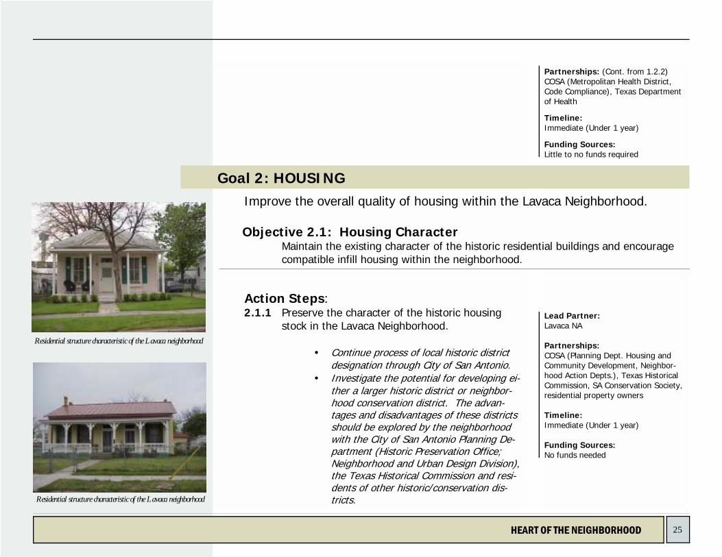
Residential structure characteristic of the Lavaca neighborhood
Residential structure characteristic of the Lavaca neighborhood

Lead Partner: Neighborhood Plan Implementation Team Partnerships: Lavaca NA, COSA ( Housing and Com-munity Development Dept., Neighbor-hood Action Dept.), Non-profit housing corporations Timeline: Short to Long (1-10 years) Funding Sources: City of San Antonio, Non-profit housing corporations
Lead Partners: Residents, Business/Commercial property owners
Partnerships: Lavaca NA, King William Assn., Southtown, COSA (Code Compli-ance, Planning-Historic Preserva-tion Office, Neighborhood Action
26
• Investigations into these designations should also include the use of the existing Lavaca Neighborhood Design Guidelines.
2.1.2 Encourage compatible infill housing on vacant
parcels throughout the neighborhood. Compatible housing will maintain the historical and architec-tural integrity of the neighborhood and help to better utilize vacant and/or unkempt properties.
• A survey of successful infill housing pro-jects in the neighborhood and around San Antonio should be produced to serve as a guide for future housing development.
• The Lavaca Neighborhood Design Guide-lines should be used as a guide for com-patible infill housing.
• Fostering relationships with agencies that can provide infill housing should be a pri-ority to help with the process of utilizing vacant residential parcels and improving the quality of housing in the planning area.
• Identification of available funding sources for rehabilitation of homes along the 500 block of Leigh Street (across street from former Victoria Courts), will assist in the future complementary development on the north side of Leigh Street.
2.1.3 New, infill housing may be accommodated by
linking persons seeking viable housing with com-mercial property owners, whom for business ex-pansion and improvement potential, intend to re-move their originally “residential” structures from the commercial corridors. Property owners
should be encouraged to relocate their buildings to vacant lots within the neighborhood, if they do not to adaptively re-use the existing structure(s).
2.1.4 Encourage property owners to utilize responsible realtor and property management businesses to improve housing conditions through increased resident retention, stabilized property values, and improved rental property maintenance.
• A session attended by Neighborhood Associa-tion leaders, Southtown and members of the real estate community who provide or desire to provide services in the neighborhood, could serve as an informational tool for accu-rately marketing or maintaining properties in the neighborhood.
2.1.5 Explore the potential for creating a model housing
block development within the planning area.
Dept., Neighborhood Conservation Districts staff, Development Services), City Public Service, SAWS, San Antonio Housing Authority, House moving busi-nesses
Timeline: Mid (3-5 years)
Funding Sources: Home and business owners, developers
Lead Partner: Real estate management companies Partnerships: Residential property owners, contrac-tors, tenants
Timeline: Short (1-3 years)
Funding Sources: No funds needed Lead Partner: Neighborhood Plan Implementation Team
Partnerships: Lavaca NA, residential property own-ers, COSA (Neighborhood Action Dept./Project Renew, Housing & Com-munity Development Dept.), Non-profit housing corporations
Timeline: Short (1-3 years)
Funding Sources: Non-profit housing organizations
27

Lead Partner: Lavaca NA
Partnership: Vacant property owners, COSA (Neighborhood Action Dept.), Non-profit housing corporations, SAWS, SA Chapter of the American Institute of Architects
Timeline: Mid (3-5 years)
Funding Sources: SAWS, Product Manufacturers
Lead Partner: Lavaca NA Partnerships: COSA (Neighborhood Action Dept., Code Compliance, Housing and Com-munity Development Dept.) Timeline: Immediate (ongoing) Funding Sources: Little to no funds required
28
2.1.6 Explore use of green building and/or sustainable building techniques and solar systems when iden-tifying infill or new development opportunities.
Action Steps: 2.2.1 Encourage landlords to improve the appearance
and quality of rental properties in the neighbor-hood.
• An educational program should be initiated
to inform landlords about the advantages of improving their properties, as well as the potential for improving rental proper-ties and selling them to new homeowners.
• Increased efforts will be necessary to con-tact and educate rental property owners that do not live in the area or the city.
• Renters should also be encouraged to help with the upkeep of residential rental prop-erties.
Objective 2.2: Housing Improvement/Maintenance
Improve the quality of the existing neighborhood housing stock by encouraging property owners to maintain and upgrade residential structures and properties.

2.2.2 Enforce current yard parking ordinance (Part II, Chapter 19, Article VI, Division 2, Section 19-194), and fine structure owners, and en- courage alternative parking surfaces.
2.2.3 Address severe code compliance issues of
“problem rental properties”.
• Encourage owners of problem rental prop-erties to apply to the Rental Rehabilitation Program (RRP). The RRP offers rental-property owners low-interest financing for up to 50% of the repair costs on a prop-erty with major structural damage to at least one major building component.
• Monitor the development of the “Incentive Tool Kit” to learn more about proposals to provide tax abatement incentives for rental rehabilitation.
• Support efforts to create stricter enforce-ment of code and zoning violations.
2.2.4 Increase funding for housing rehabilitation and new construction.
• Sponsor applications for HOME funds. • Support efforts to increase HOME funding
amounts to address increasing costs for property acquisition and repair.
Lead Partners: COSA (Code Compliance) Partnerships: Lavaca Neighborhood Association Timeline: Immediate (Ongoing) Funding Sources: No funding needed Lead Partners: Lavaca NA Partnerships: COSA (Neighborhood Action Dept., Code Compliance Dept. Housing and Community Development Dept.)) Timeline: Immediate (Ongoing) Funding Sources: Little to no funds required
Lead Partners: Lavaca NA, Non-profit housing corpo-rations,
Partnerships: San Antonio Alternative Housing Corporation, COSA (Housing & Com-munity Development Dept., City Manager’s Office, Neighborhood Action Dept.), Private Lenders, Homeowners
29
Neighborhood home in need of repair and rehabilitation.

Timeline: Immediate (Ongoing) Funding Sources: HOME Funds, CDBG Funds Lead Partner: Lavaca NA
Partnerships: Southtown, District 1 Council Office, Business/Commercial property owners, COSA (Planning, Building Insp.-Arborist Office), San Antonio Trees, Alamo Area Council on Government (AACOG)
Timeline: Immediate (under 1 year)
Funding Sources: Neighborhood Improvement Challenge Program, San Antonio Trees, Alamo Area Council on Government (AACOG)
Lead Partner: Lavaca NA Partnerships: District 1 Council Office, COSA (Code Compliance, Neighborhood Action Dept.- Neighborhood Sweep Program), Property owners
30
• Encourage private investment in neighbor-hood housing.
• Develop incentives to encourage low and middle-income homeowners to initiate and complete home improvement projects. Increasing residents’ awareness of housing repair and rehabilitation assistance pro-grams will be essential to inform residents of opportunities to improve their properties
• Utilize targeted incentives to stimulate housing repair.
2.2.5 Increase the quantity and quality of trees and landscaping throughout the neighborhood to cre-ate a more natural and green streetscape.
• Conduct a survey throughout the neighborhood to identify areas (both com-mercial and residential) that need land-scaping and street trees
• Apply to the Neighborhood Improvement Challenge Program for funding of new trees and landscaping projects
• Request tree planting assistance from San Antonio Trees
2.2.6 Conduct a survey of residential properties with suspected code compliance violations in an effort to 1) decrease the number of hazardous struc-tures, 2) decrease number of grossly over-crowded living structures, and 3) improve the overall appearance of vacant buildings to make more attractive to potential owners.
Well landscaped property along Martinez St.

• The survey should identify each property, its suspected violations and its priority in relation to other area properties.
• Contact should also be initiated with the City’s Code Compliance Department and District 1 City Council Office to correct vio-lations in order to improve appearance and safety of residential properties.
• Careful consideration of the historical value of each structure should be given in the survey so as not to eliminate structures with significant historical character and value for the neighborhood.
Timeline: Immediate (under 1 year) Funding Sources: No funding needed
31

32
THIS PAGE INTENTIONALLY LEFT BLANK
33
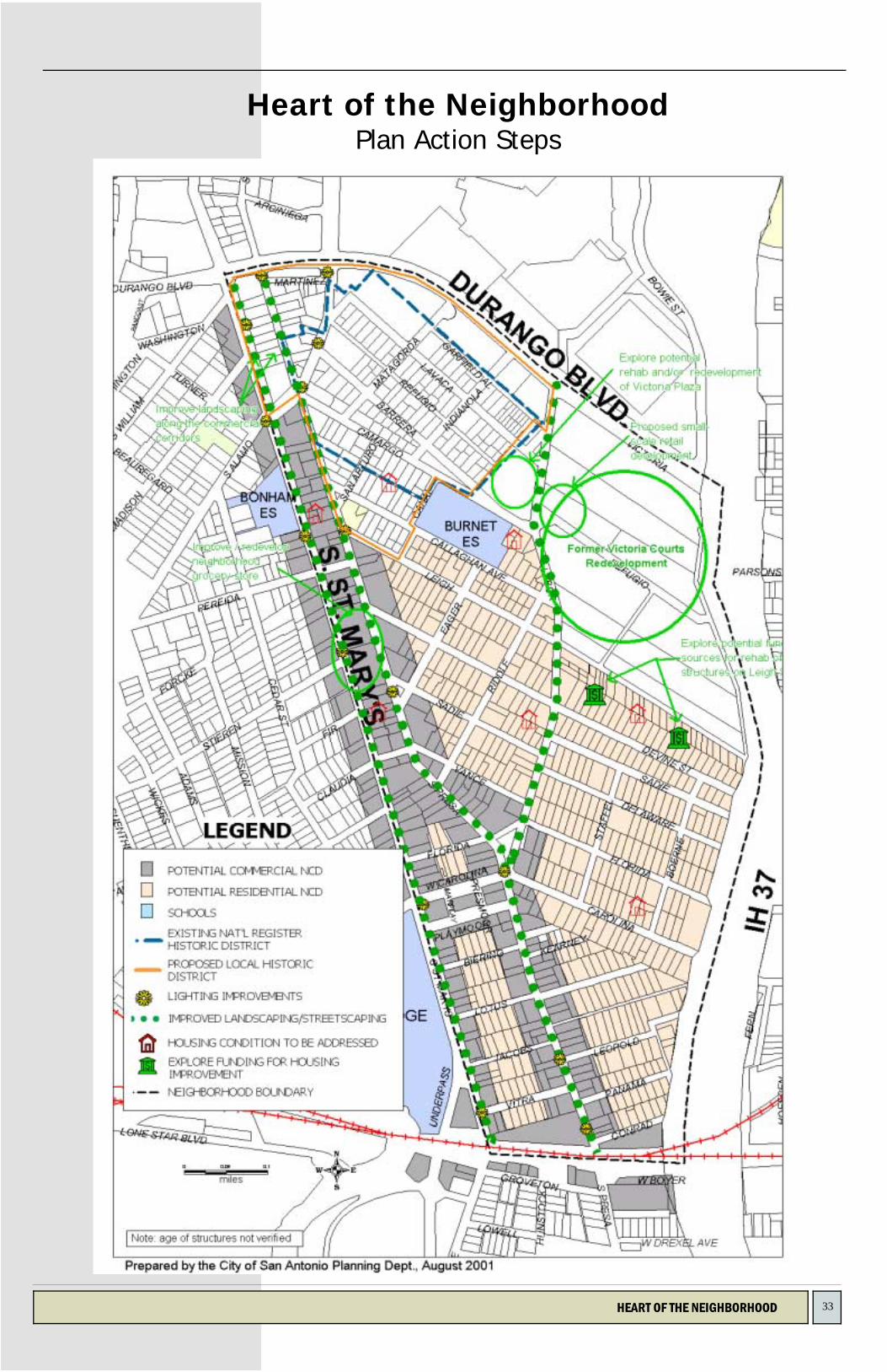
Heart of the Neighborhood Plan Action Steps

35
Land Use Plan
Land Use Concepts Low Density Residential uses are found primarily on the central and eastern portions of the planning area, with a small area of single-family residential parcels located in the southern portion of the commercial corridor bounded by S. Presa St. and S. St. Mary’s St. The Proposed Land Use Plan places an emphasis on maintaining the existing low-density housing pattern in the majority of the area between Interstate Highway 37 and S. Presa St. and containing commercial develop-ment to S. St. Mary’s St. and S. Presa St. Existing com-mercial uses are desired in the interior of the neighbor-hood, however expansion of these uses are not desirable in the established low to moderate density areas. Though the community’s desire is to prevent commercial intrusion to residential areas, a mixture of uses including single-family residential are desired within the desig-nated mixed-use / neighborhood commercial area. The proposed Victoria Courts Redevelopment will consist of high-density, moderate-density and low density resi-dential areas which digress in scale from north to south. The development will also include a substantial green space on the eastern edge of the neighborhood adjacent to Interstate Highway 37. The following land use definitions and examples further explain the desired future uses of the land within the Lavaca Neighborhood.

Description Low-density residential uses include single-family houses on individual lots. Low-density residential also includes du-plexes and granny flats or garage apartments. Existing three and four family dwellings are desired within the geo-graphic area of this classification (See Proposed Land Use Plan Map). However, new three and four family dwellings, including conversion of large single-family homes are not de-sired. Medium-density residential uses include small apartment buildings, town homes, and converted single-family homes. Low-density residential uses also can be found within this classification. High-density residential uses include large apartment buildings. Medium and low-density residential uses also can be found within this classification.
36
Land Use Classifications Low-Density Residential
Medium-Density Resi-dential
High-Density Residen-tial
The Land Use Plan will identify the preferred land development pattern for the Lavaca Planning Area. The location of different land uses is based on existing uses, neighborhood discussions and existing policies from the City’s Master Plan. Each land use classification is described in the following table.
After City Council approval of the Lavaca Neighborhood Plan, the Planning Department will con-sult the Land Use Plan as a guide for developing staff recommendations on individual zoning cases.
Land Use Plan

Mixed Use: Neighborhood Com-mercial/Office/Residential Public/Institutional
Mixed Use includes small offices (dentists, insurance, profes-sionals, non-profits, etc), small retail establishments (coffee shops, cafes, shoe repair shops, gift shops, antique stores, spe-cialty retail shops, hair salons, day care, drug stores), nursing homes, convalescent centers, assisted living and small churches. Residential uses can be in the same building with retail and of-fice uses. This includes live/work units, small apartment build-ings, residential above retail, and townhouses. The scale of these uses should be compatible and consistent with that of the existing commercial/residential development along the commer-cial corridors of the neighborhood.
Appropriate buffering is required if this use abuts a residential use.
Neighborhood commercial includes moderate-intensity con-venience retail or service uses, generally serving the neighbor-hood area. Uses include those in the Mixed-Use category as well as grocery stores, restaurants that serve alcohol, drive-in restaurants, dry cleaners, car washes, and small retail plant nurseries.
Appropriate buffering is required if this use abuts a residential use.
Intense uses, even at a small scale, such as industrial manufac-turing, car body repair, product distribution centers, service-oriented vehicle marshaling yards and equipment/material stor-age yards are explicitly undesired in the use category. * Public, quasi-public, utility company and institutional uses, such as schools, government facilities and libraries are in-cluded in this classification.
37

Parks include existing city, county or national recreational lands or open spaces that are available for active use, pas-sive enjoyment or environmental protection, including walk-ing and biking trails. *Additional description of the desired uses can be found in the Heart of the Neighborhood Section of the Lavaca Neighborhood Plan. The desired uses are explicit and further define the scale of the uses that are consistent with that of the neighborhood.
38
Parks

39
Lavaca Neighborhood Existing Land Use

41
Lavaca Neighborhood Land Use Plan

Getting Around Town and Rebuilding Our Infrastructure
Introduction
The Lavaca Neighborhood is confronted with a wide range of transportation and infrastructure related issues largely due to its location near downtown. Close proximity to the central business district, coupled with a high level of socio-economic diversity equates to a demon-strated need for good public transit service. While the neighborhood’s location allows for a unique mix of cultural opportunities it also puts an added strain on the neighborhood. By virtue of the fact that Lavaca is bounded by a busy inner-city arterial street to the north (Durango Blvd.), an interstate highway to the east (IH-37), the railroad to the south, and a busy north-south arterial to the west, the neighborhood accommodates particularly high volumes of traffic for a residential area. As a result, the Lavaca community has many oppor-tunities for improved infrastructure in the ar-eas of streets, sidewalks, and drainage. Lavaca faces the challenge of balancing its ex-istence as a quiet, historic inner-city neighbor-hood with increasing downtown traffic issues.
43
View of downtown from Alamo Street
A VIA trolley along South Alamo Street

1.1.2 Develop a bike path/lane along Labor St. to con-nect the southern end of the neighborhood, the Victoria Courts redevelopment, the Mission Trails system and HemisFair Plaza.
1.1.3 Enhance pedestrian/bicycle access throughout the
neighborhood, by means of sidewalk improve-ments, landscaping, and traffic-calming measures, specifically along South Presa and Camargo Streets and at the Durango Blvd. intersections of South St. Mary’s, South Alamo, Indianola and Labor Streets, to help remove the perception of this corridor as a physical and psychological pedestrian barrier.
• Traffic-Calming (see 1.3.1) • Complete sidewalk reconstruction through-
out the neighborhood (see 2.2.4). • Lighting (see 2.2.6) • Landscaping/tree planting (see 2.3) • Open passage to cross Durango Blvd. at S.
Presa Street.
Lead Partner: Neighborhood Plan Implementation Team
Partnerships: COSA (Parks and Rec., Public Works Depts.), Southtown Urban Mainstreet Program, MPO Bike and Pedestrian Mobility Task Forces Timeline: Short (1-3 years)
Funding Sources: MPO Transportation Improvement Projects (TIP), TEA-21 Federal funds Lead Partner: Neighborhood Plan Implementation Team
Partnerships: COSA (Public Works), Southtown Ur-ban Mainstreet Program Timeline: Short-Mid (under one year-5 years) Funding Sources: MPO Transportation Improvement Projects (TIP), TEA-21 Federal funds
45
Objective 1.2: Transit
Enhance public transit options to increase safety and/or maximize community resi-dents’ accessibility/usage.
Diagram showing separation of rights-of-way for automobile, bicycle, and pedestrian traffic
Example: separated bike line

Lead Partner: Lavaca NA Partnerships: VIA Metropolitan Transit, SAISD (Brackenridge H.S. Administration, Po-lice Dept.), COSA (Public Works, SAPD, Cultural Affairs), Lavaca COP Timeline: Immediately (within one year) Funding Sources: VIA Metropolitan Transit, SAISD, and volunteer time from residents
Pocket park at Labor, Florida, and Carolina Streets
46
Action Steps: 1.2.1 Evaluate transit access options along Carolina
and Florida Streets.
• The existing VIA route #32 bus stop on the south side of Carolina Street at Eagle’s Nest Café is chronically plagued by loitering, severe vandalism, fighting, etc. from Brackenridge High School stu-dents during the after-school hours.
1) Explore the possibility of rerouting/moving the existing bus stop to the planned pocket park bounded by S. Presa, Florida and Labor Streets. This option would:
a) require opening up Labor St. to two-way traffic between Florida and Carolina Streets,
b) reroute the existing northbound one-way traffic along Labor Street to a southbound direction, or
c) create a “bus only” lane, along Labor Street, between Carolina and Florida Streets,
d) eliminate convenient on-street parking for a local church, and
e) may increase the risk for pedestrians trav-eling to the stop.
2) Explore other options for reducing loitering/vandalism by:
a) holding regular events aimed at youth at the funded pocket park pavilion across from the current bus stop on Labor
b) developing a stronger relationship with Brackenridge High School administration to
Bus stop at the corner of Carolina and Labor Streets

ensure that they stay informed about the bus stop situation and can use their juris-dictional power to discourage criminal ac-tivity by their students,
c) increased involvement of SAPD, SAISD Po-lice Department, and the local Cellular On Patrol (COP) chapter to discourage criminal activity at bus stops, and
d) building a bus shelter decorated with public art that reflects the unique character of the neighborhood.
1.2.2 Examine all existing VIA bus service within the
neighborhood (specifically reviewing route #32), to determine most efficient routes to provide service, particularly for disabled and elderly patrons, without noticeably increasing bus traffic in the neighborhood.
1.2.3 Downtown Trolley
Advocate for a downtown trolley route along S. Presa and S. St. Mary’s Streets as a way to increase the market size for local businesses and to provide for an alternative form of tran-sit for local residents to the downtown area. (Note: VIA does not have the funding for such a route at this time. The addition of streetcar service would not improve access, compared to other modes of VIA transportation.)
• Investigate the possibility of rerouting the existing blue trolley line that currently ser-vices S. Alamo St. through the King William neighborhood, to include Presa and St. Mary’s Streets.
Lead Partner: Lavaca NA
Partnerships: COSA (Public Works), VIA Metropolitan Transit
Timeline: Short (1-3 yrs)
Funding Sources: COSA (Public Works), VIA Lead Partner: Lavaca NA, local businesses Partnerships: VIA Metropolitan Transit (Customer Service Needs Assessment Service), San Antonio Chamber of Commerce, King William Assn., Downtown Alli-ance, Southtown Urban Mainstreet Program Timeline: Long (5+ years) Funding Sources: VIA Metropolitan Transit, COSA
47
VIA trolley from the Blue line that serves the King William District
VIA bus along route 32

Lead Partner: Lavaca NA
Partnerships: VIA Metropolitan Transit, Southtown Urban Mainstreet Program, SAHA, Mis-sion Trail Rotary Club, Churches, Busi-ness owners within and outside the neighborhood
Timeline: Short (1-3 years)
Funding Sources: varies: none (maintenance only) pur-chase of bench and/or shelter by or-ganizations
Lead Partner: Lavaca NA Partnerships: COSA (Public Works) Timeline: Short-Mid (1-5 years, in phases) Funding Sources: City Council District 1 contingency fund, COSA Capital Improvements Budget
48
• Inquire about establishing a circulator bus route that would serve as a connector between the neighborhood and downtown.
• Investigate the possibility of rerouting the existing purple route down Labor St.
1.2.4 Work with various community organizations
and VIA to implement an “adopt-a-shelter” program for bus shelters.
Action Steps: 1.3.1 Investigate the installation of traffic-calming
measures, as needed throughout the neighbor-hood, such as traffic circles, speed humps, and speed lumps.
Note: (For speed humps: residents on eligible streets must submit a written request to the COSA Public Works Depart-ment. If determined eligible, submission of a petition with at least two-thirds of street residents is required. Interstate 37 is not eligible for TxDOT Hazard Elimination program for Non-Interstate Highways. Funding for speed hump instal-lation is available from various sources including,
Objective 1.3: Automobile Traffic Maximize traffic flow efficiency, through a reduction in the volume of speeding and cut-through traffic, while increasing the safety of neighborhood residents.
Speed cushions are positioned to fit the wheel base on fire trucks.
Nice example of a VIA bus shelter
the Neighborhood Accessibility and Mobility Program (NAMP) fund, CDBG funds, etc.) !"Explore the possibility of installing speed limit
signs on the southbound IH-37 ramp before the proposed lights at Florida and Carolina Sts., to impede speeding traffic in route to and from the interstate.
(TxDOT does not place speed limit signs on free-way acceleration or deceleration ramps.)
• Investigate the possible traffic calming meas-ures along both Carolina and Florida Sts.
• Investigate maintenance issues associated with the installation of new traffic calming measures and the City’s Adopt a Median Pro-gram.
1.3.2 Investigate the request for installation of traffic signs as needed throughout the neighborhood.
• Potential for two-way stop signs at the inter-sections of Florida and Staffel Sts, and Flor-ida and Boerne Sts.
• Install stop sign on Florida St. (north side), east of Labor St.
• Install one-way street signs on the south side of Florida Street at the intersections of Staffel and Boerne.
• Install one-way street signs on the south side of Carolina Street at the intersections of Staffel and Boerne.
1.3.3 Examine requests for alternative detours that can
safely and efficiently accommodate “Arterial Type B” detour traffic.
• During the Mission Trails construction along St. Mary’s St., a detour route will be created.
Lead Partner: Lavaca NA Partnerships: COSA (Public Works) Timeline: Immediate (under 1 yr) Funding Sources: TxDOT (HESP), COSA (Public Works) Lead Partner: Lavaca NA Partnerships: COSA (Public Works) Timeline: Immediate (under 1 yr) Funding Sources: COSA
49
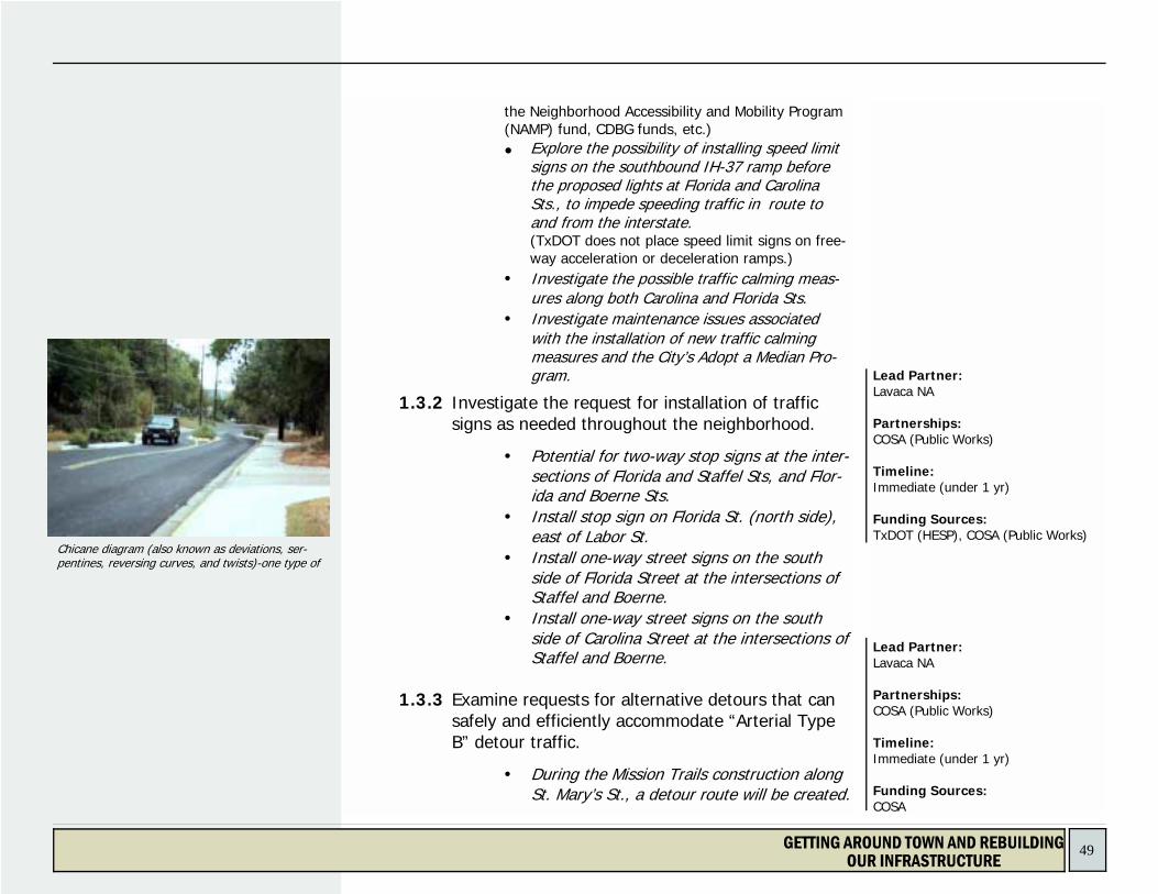
Chicane diagram (also known as deviations, ser-pentines, reversing curves, and twists)-one type of

Lead Partner: Lavaca NA Partnerships: City Council District 1 office, COSA (Public Works) Timeline: Immediate (under 1 yr) Funding Sources: COSA (Public Works), City Council Dis-trict 1 contingency fund
Lead Partner: Lavaca NA Partnerships: VIA Metropolitan Transit (Suggestion/comment line: 362-2020) Timeline: Immediate (under 1 yr) Funding Sources: Little to no funds required
Labor Street closed off at Durango Blvd.
50
Currently, traffic signals have been in-stalled (but not yet placed in service) on S. St. Mary’s St. at Jacobs St. (one of the nar-rowest local streets in Lavaca) with the in-tention of detouring traffic onto this street.
1.3.4 Reroute commercial and industrial truck traffic outside the neighborhood.
• Currently, Florida and Carolina Sts. are both heavily used for truck routes.
• When origin and destination points are outside the neighborhood, require trucks to use Durango Blvd., or other multi-lane arterial streets, whenever possible.
• Install signs directing truck traffic outside the neighborhood to multi-lane arterial streets.
1.3.5 Eliminate unlawful VIA bus detours that use the
neighborhood as a bypass.
• Convene with VIA officials about VIA buses that avoid train delays at railroad crossings by detouring through the neighborhood at Jacobs and Vitra Streets.
(Note: Standard operating procedure for bus operators at train crossings is to wait for a moving train to pass. If a train has stopped, operators must obtain permission from dis patcher to detour.) • Continue to document bus numbers, times,
and dates of violations and encourage VIA to take disciplinary action against opera-tors who consistently violate these rules.
Traffic circle along McCullough Ave.

1.3.6 Open up Labor Street to Durango Boulevard, by means of a curb cut, possible median cut, and necessary traffic-calming features, so it can serve as the primary connector street to Durango Blvd.
• Considering the projected traffic volume increase that the Victoria Courts redevelop-ment will generate, an additional point of access to Durango Blvd. maybe needed.
• Traffic-calming along Labor Street would be best served by a traffic circle at Labor, Refugio, and Camargo Streets.
• Reduction of outside through traffic can be accomplished by temporarily closing Labor Street during large events at the Alamo-dome and/or at HemisFair Plaza. (TheLavaca neighborhood will need to contact the Public Works Dept., Traffic Engineering section regarding street closures and obtain the proper permits in advance of the street closure.)
Action Steps: 1.4.1 Explore the possibility of extending the IH-37
southbound frontage road from Carolina St., south to an alternative roadway, to divert traffic from Florida and Carolina Sts. A feasibility study of the surrounding area would be required to identify various options and their associated costs.
(Note: TxDOT funding and support for interstate frontage road construction is unavailable at this time.)
• The feasibility study would also identify op-tions related to the development of a hike/
Lead Partner: Neighborhood Plan Implementation Team, Victoria Courts Redevelopment Team Partnerships: COSA (Public Works), Lifshutz Companies, Institute of Texan Cultures, SAPD
Timeline: Immediate (under 1 yr)
Funding Sources: COSA (Public Works), Council District 1 discretionary/contingency fund
Lead Partner: Lavaca NA Partnerships: COSA (Planning Dept.), Union Pacific Railroad, MPO Timeline: Feasibility study: Short (1-3 yrs), Road extension: Long (5+ yrs) Funding Sources: Unified Planning Work Program (UPWP), TxDOT TEA-21 funds, MPO
51
Objective 1.4: Interstate Highway 37
Explore ways to limit neighborhood impact created by IH-37 traffic.
Traffic island at Labor, Refugio, and Camargo streets identified as a potential traffic circle to accompany the Victoria Courts redevelopment
Traffic circle diagram

Lead Partner: Lavaca NA Partnerships: TxDOT, COSA (Public Works), South-town Urban Mainstreet Program Timeline: Short (1-3 years) Funding Sources: TxDOT (HESP), COSA (Public Works)
Lead Partner: Lavaca NA Partnerships: TxDOT, COSA (Public Works- Land-scape Maintenance Agreements), Bexar County Master Gardeners, SA Trees, Keep San Antonio Beautiful, Victoria Courts Citizen Task Force, Residents Timeline: Short (1-3 years) Funding Sources: COSA (Public Works), CDBG, TxDOT TEA-21
Noise generated by traffic on IH-37 has resulted in the need for some type of noise abatement or buffer.
52
bike trail along the railroad tracks south of the neighborhood, between IH-37, Brackenridge High School and the Mission Trails.
1.4.2 Install traffic signals off the southbound IH-37
access road, at the intersections of Carolina and Florida Sts., to slow traffic in route to and from the interstate.
(Note: A request forwarded to David Balli, TxDOT Area En-gineer for South SA, would initiate the process to conduct a feasibility study ; Traffic signals must be warrante din accordance to the Manual of Uniform Traffic Control De-vices.)
Action Steps: 1.5.1 Develop a noise barrier along IH-37 that a) ad- dresses mitigating noise levels from the highway and b) implements it in a way that is aesthetically desirable. (Note: TxDOT does not retrofit barriers for existing highways, with no planned capacity improvements; there are no planned TxDOT capacity improvements for IH-37).
• Explore the opportunity to plant trees in a dense configuration between the highway and the neighborhood. This would require continued maintenance by the neighbor-hood, the City’s Public Works is not ade-quately staffed to maintain additional large areas, such as this.
Objective 1.5: Noise Abatement
Investigate ways to mitigate traffic (highway, commercial truck, and railroad) noise that impacts the neighborhood.
Frontage road along IH-37 could be ex-tended southward to provide for a bypass around the neighborhood.

1.5.2 Investigate ways to reduce truck traffic and noise from light industrial businesses in the neighborhood.
• Explore possibility of erecting sound retar-
dant fencing where appropriate. • Encourage businesses to relocate in the
“Warehouse District” on the eastern side of IH-37; neighborhood employees would fea-sibly still be able to walk to work.
1.5.3 Investigate noise reduction strategies for Union Pacific trains.
• Prevent train engineers from blowing train
horns beyond minimum requirements. (Note: Federal law requires four horn blows when approaching a public crossing)
• Investigate the possibility of a noise buffer between the railroad and the neighbor-hood.
• Explore the possibility of tree planting in areas between the neighborhood and the railroad tracks.
• Incorporate buffer into the proposed hike/bike trail connecting the Mission Trails/Brackenridge High School to the residential neighborhood east of IH-37 (see 1.1.1).
Lead Partner: Neighborhood Plan Implementation Team Partnerships: Lavaca NA, Southtown Urban Main-street Program Timeline: Immediate (under 1 yr) Funding Sources: CDBG, City Council District 1 contin-gency funds Lead Partner: Neighborhood Plan Implementation Team Partnerships: Lavaca NA, Union Pacific RR, King Wil-liam NA, Southtown Urban Mainstreet Program, COSA (Planning Dept., Public Works Dept.), SAISD Timeline: Immediate (under 1 yr) Funding Sources: COSA Planning Dept. (Neighborhood Improvement Challenge Program), CDBG funds
53
Objective 1.6: Parking Investigate ways to mitigate parking problems generated by residents and local employers.
Union Pacific freight train
Lead Partner: Lavaca NA Partnerships: COSA (Public Works, SAPD) Timeline: Immediate (under 1 yr) Funding Sources: COSA (Public Works) Lead Partner: Lavaca NA Partnerships: COSA (Public Works) Timeline: Immediate (under 1 yr) Funding: No funds required
54
Action Steps: 1.6.1 Explore installation of signage to prevent illegal
parking and coordinate with area employers to limit the amount of nonresidential on-street parking.
• Investigate streets where illegal on-street parking is most prevalent (such as at St. Mary’s, etc.).
• Prevent parking in the neighborhood dur-ing special events at the Alamodome and at HemisFair Plaza, through the use of the existing barricade and SAPD decal system. (see barricade removal – Places Where We…Action Step 2.1.7)
1.6.2 Discover source of overflow on-street parking
along Lavaca Street and Matagorda Street and address it accordingly. Consider returning to designated parking on the south side only of the 100 and 200 blocks of Lavaca Street.
• SAISD has sufficient parking space for its employees and guests, however, existing SAISD parking lot signs appear threaten-ing, and may discourage appropriate SAISD guest parking.
• There currently exists additional parking concerns over the use of residential streets for parking of COSA contracted construc-tion company employees.
• Work with COSA Asset Mgmt. to determine parking needs for employees of construc-tion companies contracted through COSA.

The redevelopment of Victoria Courts will inevitably damage some of the area’s in-frastructure from heavy construction traffic.
1.6.3 Encourage the south side of Durango Boulevard property owners to develop and/or improve their properties in a manner that is compatible with the a) abutting residential uses of the Lavaca Neighborhood, b) Lavaca Historic District and Neighborhood Plan, and c) Downtown Neighbor-hood Plan.
• There currently exists federally owned parking lots along Durango Blvd. that severely impact the aesthetic quality of the entire boulevard.
• The Downtown Neighborhood Plan has identified the desired character and scale for future development along Durango Blvd.
REBUILDING OUR INFRASTRUCTURE
Action Steps: 2.1.1 Monitor the issues involving the replacement of
public infrastructure damaged during construction of the multi phase Victoria Courts redevelopment. Work with COSA Public Works, Victoria Courts re-
Lead Partner: Lavaca NA Partnerships: U.S. Govt. (General Services Admini-stration), COSA (Asset Mgmt., Planning Dept.) Timeline: Mid - Long (3-5 yrs) Funding Sources: U.S. Govt. General Services Agency, COSA
Lead Partner: Lavaca NA
Partnerships: Lifshutz Cos./Carleton Constr., San An-tonio Housing Authority, COSA (PublicWorks)
55
Enhance and/or preserve the character and safety of the Lavaca neighbor-hood, through the neighborhood-wide, aesthetically appealing reconstruc-tion of street, sidewalk, and drainage systems.
Objective 2.1: Infrastructure reconstruction and collateral damage repair
Goal 2: Address insufficient infrastructure

Timeline: Immediate (under 1 yr) Funding Sources: Lifshutz Cos./Carleton Constr., SAHA
Lead Partner: Lavaca NA Partnerships: COSA (Planning Dept.); neighborhood volunteers Timeline: Immediate (under 1 yr) Funding Sources: COSA Capital Improvement Program, MPO, TxDOT – TEA21 Enhancement Program
Lead Partner: Lavaca NA Partnerships: COSA (Public Works)
A typical example of street surfaces throughout the neighborhood
56
development developers, and the SA Housing Au-thority to determine responsible parties for any damages.
• Due to the comprehensive nature of the infrastructure construction that will take place on and adjacent to the former Victo-ria Courts site, there exists the opportunity for much of the infrastructure to be dam-aged or have inconsistent transition to the existing neighborhood.
• This step requires monitoring and inspection by City Engineer's and Right of Way Management Offices.
Action Steps: 2.2.1 Conduct a comprehensive infrastructure (streets,
sidewalks, drainage, lighting, etc.) survey of the neighborhood.
2.2.2 Streets Use existing survey information, and data previ-ously acquired during the workgroup process to identify priorities for street reconstruction, and classify as short term (pothole repair) or long term (complete street reconstruction).
Objective 2.2: Establish priorities for street reconstruction, side-walks, lighting, and drainage.

• Previous data includes short term repairs needed on: S. St. Mary’s Street, across from Bonham Elementary School, which has been completed.
• Previous data includes long term recon-struction needed on: Conrad St., Jacobs St., Devine St., Vitra Place, Lotus St., Leigh St., Labor St., (due to anticipated truck traffic from Victoria Courts construction), and S. St. Mary’s St. from Alamo to Pereida Sts. (reconstruction schedule delayed – advertisement: 6/2001) Some street have been scheduled for street maintenance/rehabilitation. Others will be evaluated over the next 60 days.
2.2.3 Ensure that street reconstruction is viewed as a comprehensive system, accompanied by drain-age and sidewalk construction or improvements. It should be determined that where one of the three is in need of repair, the other two should be evaluated for repair.
• Reconstruction on streets that accommo-date bus routes should take into considera-tion the increased wear and tear caused by bus traffic.
• All streets should be constructed using ma-terials and techniques that withstand the long-term wear created by bus travel.
• Increased preventive street maintenance: proactive rather than reactive mainte-nance.
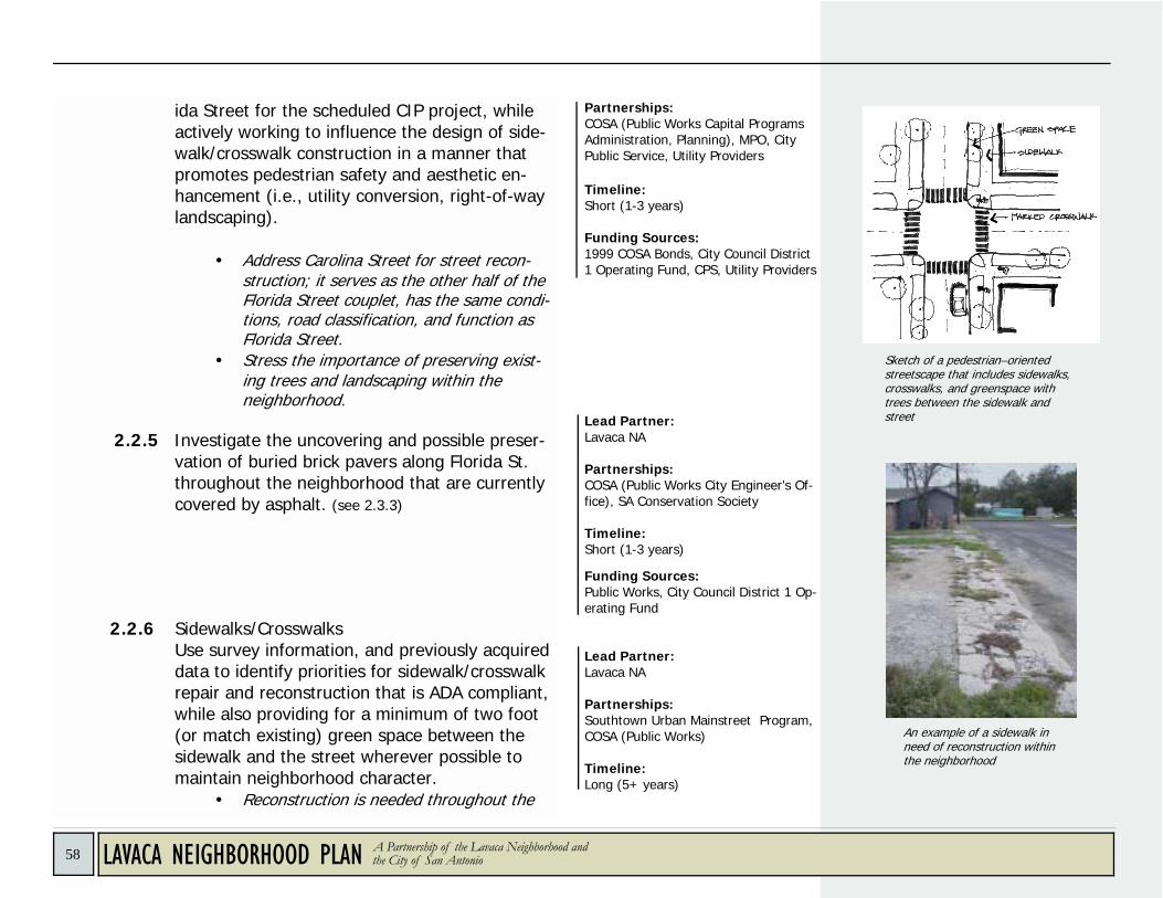
2.2.4 Florida Street Reconstruction Maintain a minimum street width of 27’ on Flor-
Timeline: Short (1-3 years, in phases) Funding Sources: Public Works, City Council District 1 discretionary or operating funds Lead Partner: Lavaca NA Partnerships: VIA Metropolitan Transit, COSA (Public Works) Timeline: Short (1-3 years) Funding Sources: VIA Local Assistance Program (controlled by COSA) Lead Partner: Lavaca NA
57
South St. Mary’s Street is currently under con-struction.
Partnerships: COSA (Public Works Capital Programs Administration, Planning), MPO, City Public Service, Utility Providers Timeline: Short (1-3 years) Funding Sources: 1999 COSA Bonds, City Council District 1 Operating Fund, CPS, Utility Providers
Lead Partner: Lavaca NA Partnerships: COSA (Public Works City Engineer’s Of-fice), SA Conservation Society Timeline: Short (1-3 years)
Funding Sources: Public Works, City Council District 1 Op-erating Fund Lead Partner: Lavaca NA Partnerships: Southtown Urban Mainstreet Program, COSA (Public Works) Timeline: Long (5+ years)
Sketch of a pedestrian–oriented streetscape that includes sidewalks, crosswalks, and greenspace with trees between the sidewalk and street
An example of a sidewalk in need of reconstruction within the neighborhood
58
ida Street for the scheduled CIP project, while actively working to influence the design of side-walk/crosswalk construction in a manner that promotes pedestrian safety and aesthetic en-hancement (i.e., utility conversion, right-of-way landscaping).
• Address Carolina Street for street recon-
struction; it serves as the other half of the Florida Street couplet, has the same condi-tions, road classification, and function as Florida Street.
• Stress the importance of preserving exist-ing trees and landscaping within the neighborhood.
2.2.5 Investigate the uncovering and possible preser-
vation of buried brick pavers along Florida St. throughout the neighborhood that are currently covered by asphalt. (see 2.3.3)
2.2.6 Sidewalks/Crosswalks
Use survey information, and previously acquired data to identify priorities for sidewalk/crosswalk repair and reconstruction that is ADA compliant, while also providing for a minimum of two foot (or match existing) green space between the sidewalk and the street wherever possible to maintain neighborhood character.
• Reconstruction is needed throughout the

neighborhood, but previous data includes specific reconstruction needs on:
Carolina St., South Presa St., Labor St., Cal-laghan Ave. (beyond that of the new con-struction), St. Mary’s St. (east side), and Camargo St. between Indianola and Labor Sts.
• When and if feasible, utilities should be bur-ied underground, prior to sidewalk construc-tion.
• For Presa and Labor Streets, explore the possibility of constructing wider sidewalks for tree planting and increased lighting to en-courage pedestrian activity.
• Crosswalks at major intersections should be constructed in an aesthetically pleasing man-ner, and coordinated with/complement the Mission Trails project.
Note: The Metropolitan Planning Organization’s Pedestrian Mobility Task Force is available to guide and assist in the implementation of pedestrian facilities. New sidewalk installation may be funded through the Neighborhood Accessibility and Mobility Program (NAMP).
Note: The COSA Public Works Department’s Street Maintenance Division will perform an evaluation of the reconstruction/repair needs of sidewalks and cross walks over the next 150 days.
Note: Maintenance issues of additional greenspace between side-walk and curbs should be discussed with the Public Works Dept.
2.2.7 Drainage Use survey information, and previously acquired data to identify priorities for drainage system re-pair, cleaning and construction. Drainage engi-neering should accompany all street and drainage system construction.
• Previous data includes repair/cleaning needs on: Boerne St., Florida St., Delaware St., S. Presa St., S. St. Mary’s St. (across from Bonham Elem. School), East Lotus St. (between Presa and IH-37), Biering St., Jacobs St. and Vitra
Funding Sources: COSA (Public Wks-Florida Street Capi-tal Improvement Project, Program and Neighborhood Access and Mobility Pro-gram (NAMP), CDBG, City Council Dis-trict 1 contingency fund) Lead Partner: Lavaca NA Partnerships: COSA (Public Works—Storm Water Utility, City Engineer’s Office) Timeline: Mid (3-5 years) Funding Sources: Future bond issues
59
Typical drainage problems in the south-ern portion of the Lavaca Neighborhood

Lead Partner: Lavaca NA, Citizens on Patrol. (COP) Partnerships: COSA (Public Works), CPS Timeline: Mid (3-5 years) Funding Sources: COSA (Public Works), future Bond Is-sues, CPS
Lead Partner: Lavaca NA Partnerships: Keep San Antonio Beautiful, San Anto-nio Trees, COSA (City Arborist, Plan-ning), St. Philip’s College Irrigation class, Master Gardeners Timeline: short (1-3 years) Funding Sources: COSA (Planning Dept.- Neighborhood Improvement Challenge Program)
60
2.2.8 Lighting Use existing survey information, and previously acquired data to identify priorities for street lighting improvements.
• Previous data includes additional lighting needs on:
S. Presa St., Garfield Alley, Labor St., Refugio St. (between Indianola and Matagorda Sts.), Camargo St., San Arturo St. and Sadie Alley (Note: Cur-rent COSA policy dictates that street light-ing criteria is based on traffic safety. Street lights are not intended for personal security.)
Action Steps: 2.3.1 Survey/Tree Planting
• Complete a neighborhood-wide survey of existing trees, street lamps, metal grates and sidewalk greenscaping, noting areas that could best be served by additional tree planting and/or lighting.
• Plant native trees that best meet criteria established by the neighborhood, such as amount of shade, longevity, and mainte-nance.
• Tree planting along IH-37 (see 1.5.1.)
Objective 2.3: Aesthetics/Streetscaping Improve the neighborhood’s appearance by preserving green space, by maintain-ing public and private areas along streets, and by adding physical enhancements that are in accordance with the existing character of the neighborhood.
An example of a nice streetscape in Lavaca

Lead Partner: Lavaca NA Partnerships: COSA (Public Works-City Engineers Office) Timeline: Mid (3-5 years)
Funding Sources: COSA Public Works, Planning Dept. (Neighborhood Improvement Chal-lenge Program) Lead Partner: Lavaca NA Partnerships: COSA (Public Works, City Engineer’s Office), San Antonio Trees Timeline: Short-Mid (1-5 years) Funding Sources: COSA (Public Works), Lavaca NA Lead Partner: Lavaca NA Partnerships: COSA (Public Works), Property owners Timeline: Immediate (under 1 yr) Funding Sources: COSA (Public Works), Property owners
2.3.2 Install street lamps and metal grates around tree trunk bases in right-of-way.
Note: Maintenance of tree grates has historically been an issue for
the Public Works. Maintenance and long term growth of trees should be discussed prior to installation of tree grates within the neighbor-hood.
2.3.3 Include greenscaping as part of sidewalk con-struction to maintain a green buffer between pedestrians and the street. Include tree planting within these green spaces wherever possible.
Note: Landscaping along public roadways needs to be done such that the safety of pedestrians, bicyclists, and motorists is not endan-gered through the creation of visual obstructions and/or through the establishment of roadside hazards that are too close to the moving traffic. Coordination with COSA Public Works and residents will be necessary ensure safety and proper maintenance occurs at proposed locations.
2.3.4 Encourage increased trash and brush mainte-nance.
• Work with COSA Public Works Dept. to es-
tablish a consistent brush pick-up schedule. • Advertise dates for pick-up at NA meetings
and by posting update notices at area com-mercial and community facilities.
• Advertise Dial-a-Trailer services.
61
A creative use of the greenspace between street and sidewalk for planting trees
Piles of brush that accumulated over time

62
THIS PAGE INTENTIONALLY LEFT BLANK

Places Where We Play, Gather and Learn
Introduction
Within the diverse population of one of San Antonio’s oldest neighborhoods, quality living and its associated basic services, forms the essence of this Plan chapter on community 1) open space, recreation, facilities, programs, 2) appearance, 3) safety and 4) relationships. As an inner city community adjacent to the Central Business District, the history of the Lavaca Neighborhood plays an important role in its quest to establish a safe, attractive envi-ronment, with many desired learning opportu-nities. A focus on the cultural and historical aspects of the neighborhood sets the tone for programming and service levels. The equally important emphasis on pedestrian and environmental safety is indicative of the many forces that contribute to the “inner-city” equation of balanced service levels and qual-ity of life. The nurturing of relationships among neighbors, businesses and associations has also been given recognition in this Plan in the effort to heal, support and advance interac-tion among the very diverse components of this special community.
65

Lead Partner: Lavaca NA
Partnerships: United Way, COSA (Convention and Visitors Bureau -Visitor Information Center)
Timeline: Short (12-18 Months)
Funding: San Antonio Conservation Society (SACS) Grants, Lavaca Neighborhood Association Membership Dues
Lead Partner: Lavaca NA
Partnerships: SACS
Timeline: Short (12-18 Months)
Funding: SACS grants, Foundation grants, Lavaca Neighborhood Association Membership Dues
Establish a comprehensive effort to improve community programs and events, increase open space, provide neighborhood educational exchange and maxi-mize tourism potential.
Objective 1.1: Lavaca Neighborhood Office & Visitors Center Provide a clearinghouse to serve as Lavaca Neighborhood Association Office, Visi-tors Center, and Cultural/Historical/Informational depository.
Goal 1: OPEN SPACE, RECREATION, FACILITIES AND PROGRAMS:
66
Action Steps: 1.1.1 Explore leasing options for a variety of commer-
cial structures/office space that could serve as a neighborhood clearinghouse.
• The developments, which have affected the
Lavaca Neighborhood over the past few years, have necessitated a permanent loca-tion to house the Neighborhood Association.
• The 126 Lavaca St. structure, a City Historic Landmark owned by the United Way of Bexar County, has been vacant since its ex-terior rehabilitation.
1.1.2 Explore potential of rehabilitation funds with the San Antonio Conservation Society (SACS) and other organizations for use on Lavaca Neighbor-hood Association future clearinghouse office.
City Historic Landmark structure on Lavaca Street

1.1.3 Work with the King William Association and Southtown to develop volunteer program for:
a) Office staffing for Lavaca Neighborhood Association
b) Neighborhood residents to serve as neighborhood and Visitors Center docents
• A 50% increase in the number of Lavaca
residents over the next five years, due to the new development at Victoria Courts, further necessitates a permanent Neighborhood As-sociation office.
• Increases in number of visitors to the Lavaca
Neighborhood, due to the Mission Trails pro-ject, the proposed Firefighting Museum and the proposed Historical Walking and Land-scape Tours (see Objective 1.4) will warrant a clearinghouse for visitor information.
1.1.4 Secure non-profit status with IRS, in order to es-tablish a non-profit Community Development Corporation (CDC) to:
• Address infrastructure issues between Lavaca and former Victoria Courts site
• Procure public funds for housing initiative • Implement a neighborhood association
public relations program to solicit funding
Lead Partner: Lavaca NA Partnerships: COSA (CVB-Visitor Information Center). King William Assn., Southtown Urban Mainstreet Program Timeline: Short-Mid (1-2 years) Funding: Grants, Lavaca Membership Dues Lead Partner: Victoria Courts Redevelopment Citizens Task Force, Lavaca NA Partnerships: King William Assn., Southtown Urban Mainstreet Program (information only), Housing funding organizations Timeline: Short-Mid (1-2 years) Funding: Lavaca Neighborhood Association (minimal required)
67

Lead Partner: Lavaca NA, King William Assn. Partnerships: COSA (Parks and Recreation, Public Works Depts.), Southtown Urban Main-street Program, Metropolitan Planning Organization (MPO) Bike and Pedes-trian Mobility Task Forces Timeline: Short (1-3 years) Funding Sources: MPO Transportation Improvement Pro-jects (TIP), TXDOT for TEA-21 Federal funds
Mural along the Mission Trails on South St. Mary’s Street
44
Action Steps: 1.1.1 Incorporate bicycle paths into the Mission Trails.
• Work with the City explore a connecting path to the Phase IV trail down Presa St., south of Carolina St. (The path currently extends south to Carolina St., turning west on Eagleland Dr.).
• Examine potential for developing a hike/bike trail connecting the Mission Trails/Brackenridge High School area to the resi-dential neighborhood east of IH-37 (see 1.4.1).
Note: Specific streets named in this action step must be studied thoroughly, so as not to conflict with a city-wide bicycle plan.
Work with the City of San Antonio and local transportation providers to en-sure a balance between automobile traffic, originating both inside and out-side of the neighborhood, while increasing the level of safety and accessi-bility for pedestrians, bicyclists, and transit riders.
Objective 1.1: Bicycle and Pedestrian Network Develop a system of bicycle paths that connect the neighborhood to nearby desti-
nations, such as HemisFair Plaza, the Mission Trails, downtown, and the San Anto-nio River, while also enhancing the aesthetics and safety of existing pedestrian cor-ridors.
GOAL 1: MULTI-MODAL TRANSPORTATION SYSTEM

Lead Partner: Lavaca NA Partnerships: COSA Community Initiatives Dept, SAISD, Continuing Ed. Service agencies Timeline: Short-Mid (1-2 years) Funding: COSA Community Initiatives, Grants
Lead Partner: Lavaca NA Partnerships: Mission Trail Rotary Club, King William Assn., Southtown Urban Main Street Program, COSA Office ofCultural Affairs Timeline: Short-Mid (1-3 Years) Funding: Lavaca NA, COSA Office of Cultural Af-fairs, Arts Foundations
Florida Street Pocket Park
68
1.1.5 Provide clearinghouse information in English & Spanish, identifying access to and location of community services, such as:
• Day care facilities • Instructional classes/schools (ESL, etc.) • Medical resources (family planning, immuniza-
tions, etc.) • Social service resources (WIC, etc.) • Religious institutions and resources
Action Steps: 1.2.1 Produce informational packet identifying all exist-
ing and proposed Lavaca projects (see Objective 4.1)
• The Lavaca neighborhood has many projects in process and potential opportunities for park and open space projects. These open space opportunities include:
1) Public Pocket Parks • Florida @ Labor Streets (COSA funded
Challenge Grant Gazebo) • Marlow Pk.- Sadie @ Eager Sts. (Mission
Trail Rotary Club) • S. Presa @ San Arturo Sts. (Neighborhood
Heritage Initiative grant)
2) Private Pocket Parks • Barrera & Camargo Sts. (SADA) • Green space at IH-37 frontage road @
Florida/Carolina Sts.
3) Public Traffic Island • S. Alamo St. between Durango Blvd. &
Martinez St.
Objective 1.2: Park Development Develop parks and open space in Lavaca Neighborhood planning area.
Initial construction—COSA funded Challenge Grant neighborhood gazebo

4) Other potential open space sites • Railroad Parkway (see Action Step 3.1.3) • Burnet Elementary schoolyard (see Ac-
tion Step 1.6.1) • Future development at former Victoria
Courts site • “Triangular” ROW across from Bracken-
ridge HS on S. St. Mary’s St. (outside Lavaca boundary)
1.2.2 Contact owner of 701 Indianola Street to deter-
mine plans for vacant “triangular” piece of private property. Work with owner to request possible use or donation of land as neighborhood Pocket Park.
1.2.3 Explore possibilities of obtaining a water source and continuous funding to pay utilities for gazebo (funded through COSA Challenge Grant project) landscap-ing at the Florida/Labor Streets Pocket Park.
1.2.4 Work with SAISD to determine future planning for Burnet/Herff campus open space (see Action Step 1.6.1).
Lead Partner: Lavaca NA,
Partnerships: COSA (Planning Dept., Asset Manage-ment Dept.), Property Owner
Timeline: Immediate (Under 1 Year)
Funding: No funding required
Lead Partner: Lavaca NA, District 1 City Council of-fice, Neighborhood Residents
Partnerships: SAWS, COSA Public Works
Timeline: Immediate (Under 1 Year)
Funding: No funding required
Lead Partner: Lavaca NA, Victoria Courts Redevelop-ment Citizens Task Force
Partnerships: SAISD, COSA Planning, Positive Begin-nings, Inc.
Timeline: Immediate (Under 1 Year)
Funding: Lavaca NA
69

Lead Partner: Lavaca NA
Partnerships: Mission Trail Rotary, Southtown Urban Main Street Program, Victoria Courts Developer, Full Gospel Church, Central Baptist & St. Anthony’s churches, Prop-erty owners, Positive Beginnings
Timeline: Short-Mid (6 mo – 2 yrs)
Funding: Lavaca NA Lead Partner: Lavaca NA
Partnerships: Southtown Urban Main Street Program, Victoria Courts Developer, COSA Parks & Recreation Dept., Positive Begin-nings, Inc.
Timeline: Mid (3-5 years)
Funding: none required Lead Partner: Lavaca NA
Partnerships: COSA Asset Management, City Attor-ney’s Office, Parks & Recreation Dept., Private Property owners
Timeline: Mid (3-5 years)
Funding: COSA
70
1.2.5 Work with neighborhood residents and business owners on pocket park development, and con-tinue periodic update of Lavaca park projects through Neighborhood Assn. newsletter.
1.2.6 Work with residents and developers of former Victoria Courts site to program activities and open space that will occur on the proposed site, in particular, the linear park area that abuts
IH-37. Identify location for public-access physical activity resources, such as a track.
1.2.7 Work with City (as consultant), agencies and pri-vate property owners of vacant or unused prop-erty to acquire park space. Explore use of con-demnation powers with appropriate agencies as an alternative for unsuccessful negotiation of land acquisition.

Potential opens space for market
Action Steps: 1.3.1 Request the use of the traffic island (between Du-
rango Blvd. and Martinez Street at S. Alamo St.) during the annual King William Fair, to operate a flea market.
• Durango Boulevard is perceived as a physical and psychological barrier for visitors and other residents.
• The Lavaca Neighborhood Association desires a source of revenue stream to maintain its op-eration.
• The King William Fair draws more than 100,000 visitors to the vicinity.
1.3.2 Evaluate existing community events, target audi-
ences along commercial corridors, and identify impacts on neighborhood. Develop and expand positive aspects of community events, including possible consideration of:
(a) extending the monthly S. Alamo St. First Friday event, north of Durango St. to HemisFair Plaza;
(b) creating a Second Saturday marketing event; and
(c) involving the participation of other civic organizations.
• Negative aspects of community events
(parking, noise, trash, vandalism, public in-toxication) affect residential and commercial
Lead Partner: Lavaca NA Partnerships: COSA Parks & Recreation Dept., King William Assoc., Southtown Urban Main Street Program Timeline: Immediate (Annually in April – King William Fair) Funding: none required Lead Partner: Lavaca NA Partnerships: Southtown Urban Main Street Program, First Friday, COSA Parks & Recreation Facilities (Beethoven Hall, Magic Thea-ter, HemisFair), Womens CoC, Hotels, HemisFair, Mission City CoC Timeline: Immediate (Under 1 Year) Funding: none required
71
Objective 1.3: Community Events (Flea Market, Green Grocer, etc.) Develop weekend and/or special event marketplace.

Lead Partner: Lavaca NA Partnerships: COSA (Parks & Recreation Dept.), property owners, SAISD, Southtown Urban Main Street Timeline: Immediate (Under 1 Year) Funding: Research: None Rental fees, Maintenance: Lavaca NA Lead Partner: Lavaca NA
Partnerships: National information on markets, gro-cers, and vendors; Southtown Urban Main Street
Timeline: Immediate (Under 1 Year)
Funding: none required
Potential Neighborhood Weekend Market venue
72
properties adjacent to or on commercial corri-dors.
• Marketing of commercial enterprises through community events with appropriately consid-ered target audiences can benefit residents and business owners.
1.3.3 As a source of revenue for the Lavaca Neighbor-
hood Association, research and identify potential neighborhood locations to conduct a weekend flea market and/or community gardens, includ-ing, but not limited to:
a) Parking lot at S. Presa St./Camargo St.; b) Carolina St./Playmoor St. Square; c) Traffic island between Durango Blvd. and
Martinez St.; d) “Triangular” vacant property at Barrera/
Camargo Sts.; e) Burnet Elementary School grounds; f) Handy Andy grocery store parking lot.
(Note: COSA Parks & Recreation may assist in loca-tion assistance, however, all construction/maintenance would be under responsibility of Lavaca Neighborhood Association.)
• The neighborhood surrounding Lavaca has es-
tablished a need for fresh produce and week-end flea market.
• Lavaca Neighborhood Association desires a revenue stream source to maintain operations.
1.3.4 Research farmer’s markets/green grocer logistics, and identify potential grocer vendors for partici-pation in neighborhood market events.

1.3.5 Conduct survey of neighborhood grocery and vending needs, in order to target farmer’s mar-ket/green grocer vendors for participation in neighborhood market events.
1.3.6 Work with potential small business incubators at
desired Burnet Technology Center (see Objective 1.6). Develop venues for small business proprie-tors. Explore social service support opportunities for proprietors.
• There exists a need for small business oppor-tunities without excessive start-up capital.
• There exists a need for social service support of potential proprietors, such as mentoring, child care, skills training, financial literacy, business courses, etc.
Action Steps: 1.4.1 Collect available research on Lavaca history and
folklore, and how it relates to the city of San An-tonio and the state of Texas, and develop an ico-nography system that is based upon notable facts and lore.
• The Lavaca neighborhood is one of the oldest intact neighborhoods in San Antonio. Much re-search and folklore currently exists.
Lead Partner: Lavaca NA
Partnerships: Southtown, Presa Real
Timeline: Short (1-3 years)
Funding: none required Lead Partner: Lavaca NA
Partnerships: COSA (Economic Development Dept., Community Initiatives Dept.), SAISD, Welfare to Work programs
Timeline: Mid (3-5 Years)
Funding: Lavaca NA, Small business grants COSA Community Initiatives
Lead Partner: Lavaca NA
Partnerships: COSA (Planning-HPO, CVB-Visitors Information Center), local schools, businesses, property owners, UTSA (Inst. of Texan Cultures), SA Conser-vation Society, local preservation organizations, Southtown
Timeline: Short (1-3 Years)
Funding: Cultural Arts/Humanities Grants
73
Objective 1.4: Walking Tours Develop neighborhood historical iconography and landscaping programs.
Neighborhood Farmer’s Market produce

Lead Partner: Lavaca NA
Partnerships: Nat’l Endowment for the Arts, COSA Cultural Affairs Dept., Local Schools, Local artists, UTSA Institute Of Texan Cultures, Southtown Urban Main Street Program
Timeline: Mid (1-3 Years) Funding: Historic Pres./Humanities Grants Lead Partner: Lavaca NA
Partnerships: COSA Public Works, Property owners, Master Gardeners, SAWS, Metropolitan Planning Organization
Timeline: Mid (1-3 Years) Funding: Open Space, Landscaping Grants, SAWS
Example of landscaping for residential properties
74
• Multi-generational interaction can be encour-aged through oral histories of long time resi-dents, and through the development of the icons by youth, assisted by local artisans.
1.4.2 Work with local artists in the community to de-velop descriptive historical markers referencing neighborhood histories. Translate histories into public art pieces (figurative statuary, sculpture), for placement throughout the neighborhood.
• There is a history of strong artisan presence and cultural programming in the neighbor-hood.
1.4.3 Work with residential and commercial property owners to identify potential landscaping schemes for individual properties.
• The Lavaca neighborhood currently has many residential and commercial property owners who take pride in landscaping their properties.
• There are planned sidewalk improvement pro-jects that should be coordinated with landscap-ing efforts.
• There are many existing and potential open space/pocket park developments within the neighborhood in need of beautification.
• The Lavaca neighborhood is a winner of the 2000 SAWS Neighborhood Xeriscape Award, and therefore, has many good examples of low main-tenance landscaping.

1.4.4 Develop walking tours and accompanying bro-chures to be displayed in Lavaca Visitor’s Center and future Firefighting Museum (see Objective 7.1), highlighting the neighborhood’s proximity to downtown, neighborhood iconography, places of interest, public art, landscaping/open space & pocket parks.
Work with media to encourage marketing of
Lavaca resources within proximity to CBD.
• The Lavaca neighborhood is adjacent to the Central Business District and will serve as a pe-destrian link to the Mission Trails.
• The Mission Trails Bike Trail project will follow S. Presa Street, and public art can enhance that which is currently planned along S. Alamo Street and Durango Blvd.
• There is one existing museum (TX Highway Pa-trol) and one planned museum (Firefighting) within neighborhood boundaries.
• The Lavaca Neighborhood is in close proximity to the Institute of Texan Cultures, Hemisphere, Convention Center and the Riverwalk.
Lead Partner: Lavaca NA Partnerships: TxDOT, COSA (CVB-Visitors Informa-tion Center), Metropolitan Planning Organization, Local Schools, Businesses, Property owners, Local artists, UTSA Institute Of Texan Cul-tures, Southtown Urban Main Street Program, Media sources (print, radio, television) Timeline: Mid (1-3 Years) Funding: COSA (Office of Cultural Affairs)
75
Objective 1.5: Intergenerational Community Exchange & Learning Center
Acquire the full or joint use of the 400 Labor Street San Antonio Housing Authority (SAHA) building for a multi-faceted, intergenerational, commu-nity learning and activity center.
Future site of Firefighting Museum

Lead Partner: Lavaca NA
Partnerships: SAHA (Asset Mgmt.), COSA (Asset Mgmt., Comm. Initiatives), Victoria Courts Developer (Lifshutz Companies), Positive Beginnings, Inc.
Timeline: Mid (1-3 Years)
Funding: COSA (Parks & Recreation Dept, Com-munity Initiatives ), Community Dev. Grants Lead Partner: Lavaca NA, Positive Beginnings, Victo-ria Courts Developer (Lifshutz Compa-nies)
Partnerships: SAHA (Asset Mgmt.), COSA (Parks & Rec., Asset Mgmt., Library, Comm. Ini-tiatives, Econ. Dev.), Victoria Cts. De-veloper (Lifshutz Companies), South-town Urban Mainstreet Program, YM/WCA, Positive Beginnings, Inc.
Timeline: Mid (3-5 Years)
Funding: COSA (Parks & Recreation, Community Initiatives), Grants
Lead Partner: Lavaca NA
Partnerships: Santonio Housing Authority Asset Mgmt., COSA (Parks & Rec., Asset Mgmt.), Victoria Courts Developer (Lifshutz Companies), Southtown Urban
76
Action Steps: 1.5.1 Determine current use of SAHA building at 400
Labor Street. Explore full or joint use of building with SAHA, as a community center.
• The community center should be available for all Lavaca vicinity residents.
1.5.2 Work with developers of former Victoria Courts
site to develop quality programming for the exist-ing Community Center. Explore possibility of for-mal reading room and COSA Library branch or Bookmobile service.
• Existing programs operated in the center should be coordinated with future programming needs to provide efficient, quality programs.
• Multi-generational instructional (continuing edu-cation, arts, sports activities, after-school pro-grams, ESL, Young at Heart, etc.) should be ac-commodated within center.
1.5.3 Explore COSA and alternative sources for poten-tial capital improvement funding and acquisition potential.
Existing San Antonio Housing Authority Building at 400 Labor St.

1.5.4 Survey existing community programs and sites within close proximity of the Lavaca neighbor hood, to determine most efficient means of mar- keting existing programs or adding new programs to neighborhood resource base.
Action Steps: 1.6.1 Determine future SAISD use of Burnet Elemen-
tary School and playground, beyond School Year 2001-2002. Explore COSA lease, purchase or land swap agreements with SAISD or SAHA to es-tablish high-tech resource/technology center.
• The technology center should function as a place of instruction, learning and practice for all San Antonio residents (i.e., GED, non-profit and “think tanks”).
• Open space on property should be preserved to accommodate child and adult development and care activities.
Mainstreet Program
Timeline: Mid (3-5 Years)
Funding: COSA (Parks & Recreation Dept., Com-munity Initiatives), SAHA, Grants Lead Partner: Lavaca NA
Partnerships: SAISD, COSA Community Initiatives, Positive Beginnings, Inc.
Timeline: Mid (1-3 Years)
Funding: COSA (Parks & Recreation Dept., Com-munity Initiatives Dept.)
Lead Partner: Lavaca NA
Partnerships: SAISD, COSA (Parks & Recreation Dept., Asset Mgmt., Library, Commu-nity Initiatives), Southtown Urban Mainstreet Program, UTSA, Positive Beginnings, Inc., ACCD, Corporate and other technology companies, other non-profits
Timeline: Mid (1-3 Years)
Funding: COSA (Parks & Recreation Dept, Community Initiatives., Asset Mgmt), Grants, Donations
77
Objective 1.6: 21st Century Resource/Technology Center
Acquire SAISD structure (Burnet/Herff Elementary School) to house high-tech resource and business center.
Burnet Elementary School

Lead Partner: Lavaca NA
Partnerships: SAISD, COSA (Community Initiatives, Economic Development), Southtown Urban Main Street Program, UTSA, Positive Beginnings, Inc., ACCD, Corpo-rate Technology Companies
Timeline: Mid (1-3 Years)
Funding: COSA (Parks & Recreation Dept., Com-munity Initiatives Dept.), Grants, Dona-tions Lead Partner: Lavaca NA
Partnerships: SAISD, COSA (Library, Community Ini-tiatives, Economic Development), SBA, Southtown Urban Main Street Program, UTSA, Positive Beginnings, Inc., ACCD, Technology companies
Timeline: Mid (3-5 Years)
Funding: COSA (Parks & Recreation Dept, Com-munity Initiatives, Asset Management), Grants, Donations
78
1.6.2 Explore existing technology and youth develop ment programs within higher education institu- tions, corporations and non-profits to determine logical means of partnership opportunities.
1.6.3 Explore corporate and foundation funding for programming and instruction, and equipment do-nation for community center.
• Business, arts and technology instruction
should be incorporated with practical appli-cation small business and non-profit incu-bator settings.

Action Steps: 1.7.1 Contact COSA Fire Department to:
1) Determine #7 Station relocation plans, 2) Work with community, COSA (Planning,
NAD) and Southtown to review station design standards, prior to contract let, and 3) Work with community to develop program-
ming, marketing plan (highlighting museum as neighborhood anchor) and parking plan for the future Firefighting Museum.
• Fire Station #7 (S. Alamo St. @ Durango Blvd) is
scheduled for relocation to the S. St. Mary’s/S. Presa St. corridors.
• Plans for the use of the existing station have
noted a Firefighting Museum. The location of the existing station is ideal to serve as a visual icon and link between downtown and Lavaca. Parking requirements for the future Museum use may ad-versely affect the surrounding residential areas.
• Urban scale design standards are being devel-
oped for the S. St. Mary’s and S. Presa Street corridors.
Lead Partner: Lavaca NA Partnerships: COSA (Fire Dept., Public Works, Asset Management), Southtown Urban Main Street Program Timeline: Short - Mid (1-3 years) Funding: None required
79
Objective 1.7: #7 Fire Station Building & Vicinity Monitor relocation and design issues for new station, and assist in plan-ning for improvements, marketing plan and parking issues for future Firefighting Museum.
Fire Station No. 7 located at S. Alamo St. and Durango Blvd.

Lead Partner: Lavaca NA, SAISD
Partnerships: COSA (Fire Dept., Public Works Dept., Building Inspections Dept.), Southtown Urban Main Street Program
Timeline: Mid (1-3 years)
Funding: None required Lead Partner: Lavaca NA
Partnerships: COSA (Public Works Dept.), City Public Service, San Antonio Water System
Timeline: Immediate (Under 1 Year)
Funding: None required
Lead Partner: Lavaca NA
Partnerships: COSA (Fire Dept., Police Dept.)
Timeline: Mid (3-5 years)
Funding: No additional funding to SAFD station development
80
1.7.2 Work with SAISD to determine parking needs at SAISD headquarters building, located adjacent to existing #7 Fire Station.
• On-street parking at the current #7 location,
which is adjacent to the SAISD headquarters building, is a concern.
1.7.3 Work with COSA Department Directors that contract construction companies to determine parking needs and accommodations for employ- ees of construction companies.
• The expansive use of residential streets for
long-term parking of COSA contracted con-struction company employees is concern.
1.7.4 Work with COSA Fire Department to determine whether a small office could be constructed within the con- fines of the new fire station to accommodate a SAFFE officer while servicing the Lavaca Neighborhood.
• The need for a more immediate presence of the SAPD exists.
(Note: The SAPD has planned for existing substation expansion @ 4000sf/ea. The Lavaca Neighborhood would continue to be served out of the Central Substation at 515 Frio Street.)

Action Steps: 2.1.1 Address Code Compliance issues through educa-
tion and Lavaca Code Compliance Officer, specifi-cally, the following violations/locations:
1) Large scale alley dumping a) examine each alley in neighborhood b) provide regular alley clean up
2) Litter – Devine street. 3) Building conditions throughout neighbor- hood that do not meet minimum building codes, e.g., NW corner—Sadie/Labor Sts. 4) Graffiti – throughout neighborhood, e.g., Carolina/Labor Sts. – Eagle’s Nest Cafe 5) Front yard parking. 6) Overgrown vacant lots. 7) Overflowing restaurant grease traps.
2.1.2 Address lack of Code Compliance enforcement for the following violations:
1) Illegal dumping on Sadie St. alley 2) Height of front yard fencing 3) Graffiti 4) Building code violations 5) Businesses operating without Certificate of
Occupancy
Lead Partner: Lavaca NA Partnerships: COSA (Code Compliance, Police Dept.) Timeline: Immediate (Under 1 Year) Funding: None required
Lead Partner: Lavaca NA
Partnerships: COSA (Code Compliance, District 1 City Council Office, City Attorney’s Office)
Timeline: Immediate (Under 1 Year)
Funding: None required
81
Provide safe and attractive streetscapes that reflect the historic conditions of the neighborhood. Objective 2.1: Improve overall appearance of neighborhood
Empower property owners with information to work with City agencies and other organizations to initiate neighborhood clean-up programs, enforce code compliance penalties, and offer information on rehabilitation.
Goal 2: COMMUNITY APPEARANCE:
Example code compliance problem in the neighborhood
Example code compliance problem in the neighborhood
Example code compliance problem in the neighborhood

Lead Partner: Lavaca NA Partnerships: COSA (Public Works, Police Depart-ment), Southtown Urban Main Street Program, SAHA Timeline: Short (1-3 Years) Funding: None required
Lead Partner: Lavaca NA
Partnerships: COSA Neighborhood Action Dept., Presa Real
Timeline: Immediate (Under 1 Year)
Funding: None required Lead Partner: Lavaca NA
Partnerships: COSA (Police Dept., Community Initia-tives), Non-profit organizations
Timeline: Mid (3-5 yrs) Funding: None required
82
2.1.3 Work with various entities to address security of neighborhood and vicinity:
1) Address lighting issues throughout neighborhood
a) streets, b) alleys, c) Martinez St. traffic island, d) Proposed Firefighting Museum at
SAFD Station #7 2) Perform lighting surveys 3) One-way signs for Florida & Carolina Sts. at Staffel & Boerne Sts. 4) Address security of interim open
space created by demolition of Victoria Courts
2.1.4 Work with Presa Real and COSA Neighborhood
Action Department to effect Neighborhood Sweep through application process. Continue long term efforts of Sweep process through the education of neighbors.
2.1.5 Work with SAPD, Community Initiatives and other non-profits to help identify, relocate and
rehabilitate homeless and vagrant populations.
Poor lighting found conditions throughout neighborhood
2.1.6 Develop building rehabilitation education system for property owners by:
1) outlining cost effective ways to achieve a positive neighborhood aesthetic, such as:
a) alternatives to chain link fencing b) roofing, siding materials
2) distributing copies of the Lavaca Neighbor-hood Design Guidelines, accompanied by letter of explanation, to all Lavaca property owners
2.1.7 Investigate procedures for removing street barri-cades from all public right-of-way when not in use.
• A barricade system currently exists to eliminate through traffic access in the neighborhood dur-ing Alamodome and HemisFair events.
• Barricades are also used while neighborhood street construction is in operation.
• The unsightly barricades are placed on adja-cent right-of-way when not in use, or for long term storage, and have a detrimental affect on the aesthetic character of the neighborhood.
Action Steps:
Lead Partner: Lavaca NA
Partnerships: COSA (Planning-HPO, Neighborhoods & Urban Design, Neighborhood Action Dept., Housing & Community Develop-ment Dept.)
Timeline: Short (1-3 yrs)
Funding: None required Lead Partner: Lavaca NA
Partnerships: COSA (Public Works, Police Dept.), TxDOT
Timeline: Immediate (Under 1 Year)
Funding: None required
83
Provide a neighborhood environment that is safe for school age pedestri-ans, and free from environmental nuisances.
Objective 3.1: Children’s Crossings Develop safe pedestrian crossings for Brackenridge High, Page Middle and Bonham Elementary School students.
Goal 3: SAFETY:

Lead Partner: Lavaca NA
Partnerships: COSA (Public Works, Police Dept.), TxDOT Timeline: Immediate (Under 1 Year)
Funding: COSA (Public Works) Lead Partner: Lavaca NA
Partnerships: SAISD, Union Pacific, COSA (Public Works, Police Dept.), TxDoT, South-town Urban Main Street Program, Presa Real Timeline: Immediate (Under 1 Year)
Funding: COSA (Public Works), Union Pacific Railroad Lead Partner: Lavaca NA
Partnerships: SAISD, Union Pacific Railroad, COSA (Public Works, Police Dept.), South-town Urban Main Street Program, Presa Real Timeline: Short (1-3 Years)
Funding: COSA (Public Works), Union Pacific Railroad, Rails To Trails, TEA-21 En-hancements
84
3.1.1 Perform safety pedestrian/vehicular safety analy-sis for area surrounding Florida Street, Carolina Street at IH-37, Labor Street, and S. Presa Street, by addressing the following:
3.1.2 Obtain information on property and right-of-way ownership of area surrounding railroad track, from S. Presa St., under IH-37 to Page Middle School, and research crime statistics for immedi-ate area.
• The track right-of-way is located such that a perimeter pedestrian loop could be created around Lavaca.
• The right-of-way is dangerous for children and aesthetically unpleasing.
3.1.3 Work with SAISD, Brackenridge and Page Schools, and SAPD to develop plan for safe linear pedestrian parkway (either along obsolete track or other location) addressing existing operational track as barrier.
• The railroad right-of-way set of tracks along the southern boundary of Lavaca currently serves as an unsafe pedestrian path for stu-dents travelling to/from Page Middle School and Brackenridge High School.
• One of the tracks is obsolete.
Existing conditions along Union Pacific Railroad

3.1.4 Research current SAISD school bus and VIA safety standards for loading/disembarking along:
1) Florida Street In the early morning hours at IH-37, there exists a combination of speeding traffic along Florida and Carolina Streets, as well as truck fleets queuing along the IH-37 frontage road and Florida Street, to fuel their gas tanks. This creates a physical barrier for children who are walking to and from Page and Brackenridge schools.
2) Labor Street At Labor Street, children disembark along the north side of Florida, which requires them to cross Florida Street with high speeds of oncoming traffic during the morning hours.
3.1.5 Work with Southtown and Presa Real to address:
1) Pedestrian plan along railroad right-of-way, 2) Potential acquisition of property along exist- ing railroad right-of-way for commercial ac- tivity space and pedestrian path.
3.1.6 Explore possibility of working with Union Pacific
to obtain train car for small-scale commercial use (refreshment stand, etc.) to provide activity area along railroad right-of-way.
Lead Partner: Lavaca NA
Partnerships: SAISD, COSA Police Dept, Property Owners
Timeline: Immediate (Under 1 Year) Funding: No funds required
Lead Partner: Lavaca NA
Partnerships: COSA (Neighborhood Action Dept., Asset Management Dept.), Southtown Urban Main Street Program, Presa Real, Union Pacific Railroad
Timeline: Short (1-3 yrs)
Funding: COSA, Union Pacific Railroad
Lead Partner: Lavaca NA
Partnerships: Union Pacific Railroad
Timeline: Short (1-3 yrs)
Funding: COSA, Union Pacific Railroad
85
Existing conditions along Union Pacific Railroad

Lead Partner: Lavaca NA
Partnerships: SAISD (Central Office, Bonham Elem.), COSA (Public Works Dept., SAPD), Metropolitan Planning Organization, TxDOT, Southtown Urban Main Street Program, Coastal Datafleet
Timeline: Immediate (Under 1 Year)
Funding: Metropolitan Planning Organiza-tion, TxDOT
Lead Partner: Lavaca NA Partnerships: COSA (Building Inspections Dept., Fire Dept., Public Works-Environmental Services, Neighborhood Action Dept, Texas Natural Resources Conservation Commission (TNRCC), Environmental Protection Agency (EPA), Property Owners Timeline: Immediate (Under 1 Year) Funding: None required
Unmanned fueling station on Florida/Carolina Sts. at IH-37
86
3.1.7 Work with SAISD and Mission Trails development to establish safe school crossings along both sides of S. St. Mary’s St. at Bonham Elem., for children in school buses and private vehicles, ad-dressing chidl off-loading measures and promo-tion of safety flashers.
Note: The school zone around Bonham Elementary School is sched-uled to receive flashing beacons with the S. St. Mary’s St. reconstruc-tion project.
Action Steps: 3.2.1 Research and obtain specific environmental infor-
mation on and pursue regulatory conformance through the appropriate agencies for:
Fuels, Chemicals: 1) Fueling Station at IH-37 between Florida & Caro-
lina Sts. a) Code compliance (Certificates of Occupancy) b) National, State, Local conformance standards c) Examination of fuel runoff, vent stack issues
2) Uniform Cleaning plant between S. St. Mary’s & S. Presa Sts. a) National, State, Local conformance standards,
regarding cleaning chemicals (use, disposal) b) Seepage c) Air quality
3) Gas Station @ Presa/Vance Streets a) National, State, Local conformance standards b) Examination of fuel runoff issues
Objective 3.2: Environmental Nuisances Encourage appropriate regulatory authority monitor and ensure abatement of envi-ronmental nuisances within neighborhood.

4) Area Eating Establishments a) Ensure proper disposal of cleaning materials
and grease trap contents 3.2.2 Noise
Research, identify and determine appropriate agencies to address buffering solutions for issues associated with a) IH-37 noise, and b) running motor bus and truck noise from the Florida/Carolina Streets 24 hour fueling station.
3.2.3 Railroad Safety Concerns:
Research appropriate agencies to address confor-mance to railroad safety and noise regulations, and requirements for railroad crossing arms.
3.2.4 Victoria Courts:
At the former site of Victoria Courts, work with SAHA to research and pursue opportunities to eliminate:
1) increased rodent population in Lavaca, due to Victoria Courts demolition; 2) stray cat packs; 3) vicious dog packs; 4) demolition dust; 5) tree destruction.
Lead Partner: Lavaca NA
Partnerships: COSA (Building Inspections Dept., Fire Dept.), TxDOT, TNRCC, Property Own-ers, Union Pacific Railroad
Timeline: Immediate (Under 1 Year)
Funding: None required
Lead Partner: Lavaca NA
Partnerships: COSA (Traffic Eng.), Union Pacific Rail-road, Property Owners, Southtown Ur-ban Mainstreet Program, TxDOT, Fed-eral Railroad Administration
Timeline: Short (1-3 Yrs)
Funding: None required Lead Partner: Lavaca NA
Partnerships: COSA (Building Inspections Dept., Metropolitan Health Dept.), TNRCC, EPA, TxDOT, Property Owners, Union Pacific, Southtown Urban Mainstreet Program, San Antonio Housing Author-ity, Positive Beginnings, Inc.
Timeline: Immediate (Under 1 Year)
Funding: None required
87
Former Victoria Courts demolitions

Lead Partner: Lavaca NA
Partnerships: Southtown Urban Main Street Program, Neighborhood Churches, United Way, Presa Real, Neighborhood Organiza-tions, SAHA
Timeline: Short (1-3 years) Funding: Lavaca NA
Lead Partner: Lavaca NA
Partnerships: Southtown Urban Main Street Program, King William, Presa Real, United Way, SAHA, Local Realty Community
Timeline: Short (1-3 years) Funding: None required
88
Action Steps: 4.1.1 Continue distribution of neighborhood informa-
tion and/or newsletter to all community organiza-tions, clubs and churches.
4.1.2 Improve communication among new community residents and the Lavaca, King William, South-town, Presa Real and other service organizations.
Improve the neighborhood relationships and level of participation of resi-dents, businesses, and community organizations.
Objective 4.1: Community Participation and Interaction Encourage participation and improve interaction in community activities among neighborhood churches, organizations and clubs.
Goal 4: NEIGHBORHOOD RELATIONSHIPS:

89
Places Where We Play, Gather and Learn Plan Action Steps

Victoria Courts Redevelopment
Introduction
The redevelopment of the a former Victoria Courts site, a 1940s, 36+ acre , post World War II era public housing complex, will inevitably change the complexion of the surrounding Lavaca Neighborhood. The potential for positive change in terms of increased neighborhood-scale services and improved infrastructure has a significant portion of the neighborhood’s resident population optimistic about the future. The development effort is a public/private venture between private developers Lifshutz Companies of San Antonio/Carleton Properties of Dallas and the San Antonio Housing Authority (SAHA), who owns the former Victoria Courts property. A primary objective of the development team has been to utilize the Lavaca Neighborhood formal planning process as a mechanism for collecting public input and for generating dialogue between the neighborhood residents and the development team. As a result, a series of public meetings were held and development plan concepts were presented to residents to give them an opportunity to ask questions and make comments about specific aspects of the proposed development. The first of four public meetings was held on September 5, 2000 at which a general description of the redevelopment process was presented.
91

92
VICTORIA COURTS REDEVELOPMENT
Introduction (continued) The Lavaca neighborhood residents, City of San Antonio Planning Department staff, and the devel-opment team agreed to have a series of additional meetings as part of the neighborhood planning “workgroup” process to increase the depth of public involvement. The three meetings took place on the following dates: November 21, November 28 and December 5, 2000.
The citizen workgroups began a dialogue with Alamo Architects, (a local design firm contracted to do a portion of the design for the project), to discuss proposed ideas relating to housing densities, street configuration, the amount and type of proposed new commercial development, as well as a variety of other proposed design elements. The design team presented examples of similar devel-opments in other cities to generate discussion on several design related issues and to gauge interest in some of the proposed design elements. The residents and the development team have agreed to continue working together to create the best design solutions for the redevelopment effort and the neighborhood residents as the design process progresses.
Objectives In their efforts to design a residential development that could set the standard for future mixed-used, mixed income/mixed density projects in the region, while also successfully integrating the de-velopment into the existing scale and character of the Lavaca Neighborhood, the development team made substantial strides to include public input into the project. While the focus of the project is set on to creating a model for mixed density / mixed income housing, both residents and the devel-opment team mutually agreed that increased pedestrian accessibility and improved traffic safety for the entire neighborhood are primary goals. Moreover, the potential "spill-over" benefits from the Victoria Courts redevelopment was cited as one way to initiate positive change for the whole neighborhood. Site Plan Description The plan calls for a mix of housing densities, ranging from one-story single family to moderate den-sity townhouses to four-story multi-family rental structures. Originally, the development team pro-posed a defined division between the different housing densities. Single-family homeownership units are to be located in the southern end of the development, with densities increasing toward the

northernmost section of the development. The proposed development is to contain 850 total units. The development will include the creation of new streets, as well as address the functionality of ex-isting streets at the perimeter of the site. Other features will include substantial green space, a small neighborhood commercial use element, and a concerted effort to preserve as many of the ex-isting site trees and landscape elements currently found on the site. Development Concepts The development team presented a variety of conceptual ideas during through a visual preference exercise to help gauge preferences of various design options related to housing development, streets design, commercial development, park / open space, and pedestrian environment and link-ages. The following commentary describes proposed development concepts that were discussed and issues that are still not addressed and/or remain unresolved:
Housing Development • It is desired to develop primarily one-story single-family homes, with some two-story homes,
along Leigh Street at the southern end of the site. Densities would gradually increase to three and four-stories apartment buildings that line Durango Blvd. Approximately twenty percent of the housing units are proposed as public housing. The housing types will be ap-proximately distributed as follows: (See Conceptual Site Plan):
- 675 units of high density apartments - 175 units of low density: · single family units with garage “granny flat” apartments, · duplexes, · townhouses, and · vacant lots
• Housing lots will have a variety of dimensions, tailored for the conditions of the housing type, housing density and street edge, etc.
• The developers agreed to explore the use of energy efficient materials as well as the use of HUD-encouraged PATH (Partnership for Advancing Technology in Housing) technologies to improve the quality, affordability, durability, energy efficiency and environmental perform-ance of homes.
• To ensure long-term integrity of the neighborhood, the for-sale units will be sold with a combination of conditions, covenants, and restrictions in order to ensure compatible design,
93

94
materials, maintenance and long-term use. • The importance of maintaining a compatible scale of buildings on opposite sides of the site’s
internal and perimeter streets , as well as, streets adjacent to the rest of the neighborhood was stressed throughout the discussions.
• The development team and neighborhood agreed they would prefer not to have absolute separations between density and housing types.
• Single family homes will range in size from 1400 square feet one-story to 2600 square feet two-story houses, preferably with a front porch space.
• Single-family homes with garage apartments will also a have some sort of alley access to ga-rage apartments..
• Placement of structures on lots throughout the neighborhood may have a mix of perpendicu-lar and angled approaches to the street, consistent with historic precedent.
• Unit Ownership: - SAHA will retain ownership of all of the rental units, which includes most of what
lies to the north of Refugio Street. - Most units that lie south of Refugio Street will be sold to individual owners. - Some of the “for-sale units” will be subsidized to buy down construction costs and
reduce mortgage costs.
High Density Housing Development along Durango Boulevard
• The new development will reflect the historical block sizes in the area. • Durango Blvd. building massings are proposed to accommodate parking (hidden from view of
the street) within the building footprint of mid-rise apartments and to reflect the historical block sizes in the area. Parking areas would not be visible from the street.
• Several examples of 12’-18’ building setbacks were presented to residents to illustrate urban design options and building / street relationships.
• Concerns by Lavaca residents regarding the residential units on the ground floor facing Du-rango Blvd. will be addressed by one or a combination of the following:
- Pedestrian friendly environments outside the building envelope will be incorporated into the development, while maintaining “ private space” for the residents.
- Claiming private space along Durango Blvd., such as porches, walls, level changes (apt. units elevated above grade with storage on lower levels or backside units). and backside storage. Primary residential unit entrances could face away from Du-rango Blvd.
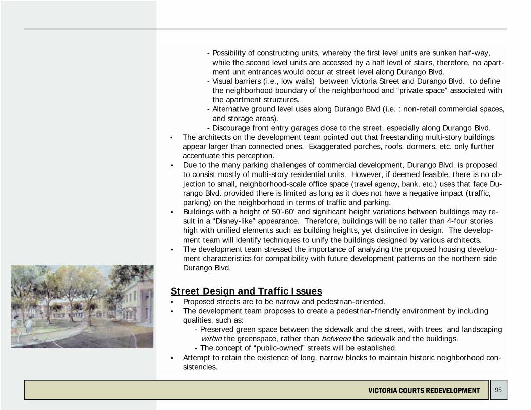
- Possibility of constructing units, whereby the first level units are sunken half-way, while the second level units are accessed by a half level of stairs, therefore, no apart-ment unit entrances would occur at street level along Durango Blvd.
- Visual barriers (i.e., low walls) between Victoria Street and Durango Blvd. to define the neighborhood boundary of the neighborhood and “private space” associated with the apartment structures.
- Alternative ground level uses along Durango Blvd (i.e. : non-retail commercial spaces, and storage areas).
- Discourage front entry garages close to the street, especially along Durango Blvd. • The architects on the development team pointed out that freestanding multi-story buildings
appear larger than connected ones. Exaggerated porches, roofs, dormers, etc. only further accentuate this perception.
• Due to the many parking challenges of commercial development, Durango Blvd. is proposed to consist mostly of multi-story residential units. However, if deemed feasible, there is no ob-jection to small, neighborhood-scale office space (travel agency, bank, etc.) uses that face Du-rango Blvd. provided there is limited as long as it does not have a negative impact (traffic, parking) on the neighborhood in terms of traffic and parking.
• Buildings with a height of 50’-60’ and significant height variations between buildings may re-sult in a “Disney-like” appearance. Therefore, buildings will be no taller than 4-four stories high with unified elements such as building heights, yet distinctive in design. The develop-ment team will identify techniques to unify the buildings designed by various architects.
• The development team stressed the importance of analyzing the proposed housing develop-ment characteristics for compatibility with future development patterns on the northern side Durango Blvd.
Street Design and Traffic Issues • Proposed streets are to be narrow and pedestrian-oriented. • The development team proposes to create a pedestrian-friendly environment by including
qualities, such as: - Preserved green space between the sidewalk and the street, with trees and landscaping
within the greenspace, rather than between the sidewalk and the buildings. - The concept of “public-owned” streets will be established.
• Attempt to retain the existence of long, narrow blocks to maintain historic neighborhood con-sistencies.
95

96
• Leigh and Callaghan Streets historically extended east across Labor Street, while Barrera Street did not. The proposed development will most likely not be able to accommodate the original alignment.
• Proposed block face lengths between approximately 340 and 670 feet. • Changes in the alignment along Labor Street are proposed as a traffic-calming strategy, with
a proposed re-opening of Labor St. to Durango Blvd.. • At the Labor/Camargo/Barrera Sts. traffic island, public art, fountain, etc. – representative of
neighborhood character is proposed. • The development team has concluded that the trees remaining from the old Victoria Courts
were all planted in rows, and all about the same time. Streets will be aligned in a way that maximizes the preservation of the existing trees throughout the neighborhood.
Leigh Street (See Street Diagrams) • Leigh Street will remain a two-way street and access to existing homes will be unaffected. • An alley is proposed between Leigh and Barrera Streets. It will be a one-way, (12’ right-of-
way with ample shoulder space on either side) alley, targeted for garage access and garage apartment use by residents; garage apartments could front the northern side of the pro-posed alley.
• The proposal includes preserving the trees in this area.
Secondary Streets (See Street Diagrams) • Although initially proposed at a 76’ width building-to-building (20’ building to curb, 36’ pave-
ment, -20’ curb to building) [comparison: downtown San Antonio’s Houston Street is slightly narrower], the development team has revised its plan to provide for narrower streets.
• Narrow street widths are desired in the new development to mirror the relatively narrow width of the current Lavaca and adjacent neighborhoods street pattern and other neighbor-hoods, such as King William.
Leigh Street (See Street Diagrams) • Leigh Street will remain a two-way street and the existing homes will be unaffected. • An alley is proposed between Leigh and Barrera Streets. The street just to the north of
Leigh Street is currently proposed as a a one-way, (12’ right-of-way with ample shoulder space on either side) alley street, targeted for garage access use by residents; garage apart-
ments could front the northern side of the proposed alley. Victoria Street (See Street Diagrams) • Victoria St. could serve as one of several pedestrian access ways through the neighborhood.
It has been suggested this street could serve as a linkage from the Lavaca Neighborhood to the east side of IH-37 or as a pedestrian-oriented greenway.
• Victoria St. could accommodate parking, slow-moving cars, pedestrians, and bicycles, all within the same right-of-way.
Intersection of Labor Street and Durango Boulevard • A curb cut and median cut should be created to open Labor Street to Durango Blvd. • An improved pedestrian crossing with a some sort of visual connection should accompany
these improvements to allow neighborhood access to HemisFair Park and other amenities north of the Lavaca Neighborhood.
Parking • Labor Street and any other access points to Durango Blvd. from the neighborhood should be
barricaded during special events (at the Alamodome, HemisFair, La Villita, etc.) to prevent spectator parking in the neighborhood by spectators. Parking decal system information should be readily available to Lavaca residents and the general public. (see Getting Around Town, Objective 1.6).
Intersection of Labor, Camargo, and Barrera Streets • This intersection, with a combination of residential and commercial uses, community space,
and green space will be transformed into a major focal point for the new development, as well as the entire neighborhood.
• Labor Street should maintain its existing alignment with some angular changes in the path for traffic-calming purposes.
• Labor Street roughly follows the path of a former Spanish acequia. Residents suggested, and developers agreed that its presence there should be formally interpreted.
Open Space / Parks • The neighborhood expressed a preference for a variety of park space sizes (pocket parks to
97

98
larger green spaces) within the entire neighborhood, to accommodate a variety of gathering sizes and activities.
• Higher levels of residential densities could dictate the need allow for increased areas of green space.
• The residential buildings on the eastern side of the development will overlook a long, narrow linear park.
• Park space is intended to serve more as focal point for the entire neighborhood, rather than viewed as “leftover” space.
Park Space near IH-37 (See Conceptual Site Plan) • Residents expressed a desire to have useable park space strategically located within the
community, in contrast to open space designed as decoration. • This park space is meant to serve as a viable public space for the whole community-a tool for
uniting the area. Careful attention to the specific recreational uses offered must be given so as not to generate a volume of users that the neighborhood cannot support (i.e. limited parking space for users).
• Residents generally agreed with the developer concept, in which the recreational park should be on the eastern edge of the neighborhood near the interstate, while the more centrally lo-cated park should maintain the character of an urban park, similar to the King William Park.
• Park security: The constant flow of traffic along IH-37 would act as be a deterrent for crime, however; real crime prevention maybe dependent upon how the park is managed. The park space benefits far outweigh the potential costs and issues related to crime.
The park space will have a physical barrier along IH-37 to define a boundary; however, the park will be open to the public. • While the neighborhood would like to have a free community pool as part of the redevelop-
ment, the presence of an entrance-fee pool was also considered desirable. A public pool has been established as a very unlikely scenario, however, an entrance fee pool, incorporated into the apartment building structure(s), may develop as a possible option.
Commercial Development • The neighborhood accepts the idea of some new commercial development on the northern
end of Labor Street (Durango Blvd. to Camargo St.) at approximately 10,000 square feet. New commercial development along the other parts of Labor Street within the existing Lavaca Neighborhood is not desired and is explicitly stated. (see Heart of the Neighborhood 1.1.4)

• Along the small commercial corridor of Labor Street, it is desired to have wide sidewalks to al-low for small café tables and chairs, etc.
• Residents confirmed desires about directing any new large-scale commercial development to occur on S. Presa St. or S. St. Mary’s Streets with neighborhood connections through im-proved pedestrian-oriented streetscapes (see Heart of the Neighborhood 1.1.5) .
Issues Not Addressed / Unresolved
• How much additional traffic will the new development generate? • What kind of specific traffic-calming measures will the development have? • What kind of “spill-over” effects, positive and negative, can be expected from the new devel-
opment into the existing neighborhood? • How can we protect the existing Lavaca Neighborhood from the economic market factors (i.e.
gentrification) of the projected new development “success”? • Who will be responsible for damage to infrastructure along the perimeter of the site that re-
sults from the new development construction of the new development? • What other building elements can be incorporated into the development to help maintain a
pedestrian friendly environment, specifically in the areas especially around the more massive higher density apartment buildings?
Time-frame • Expected beginning of housing construction will commence in about one to one and one-half
years or about 6 months after re-platting is completed. When will re-platting begin? • Housing construction should be completed within another three to three-and-a-half years af-
ter it has begun. Is this a realistic timeframe for completion? How does the lack of Hope VI funding affect this overall timeframe?
Next Steps
• Form a working subcommittee to continue providing feedback throughout the multi-phased development.
99

100
THIS PAGE INTENTIONALLY LEFT BLANK

101
CONCEPTUAL SITE PLAN

102
CONCEPTUAL SITE PLAN

103
STREET DIAGRAMS

104
STREET DIAGRAMS

105
STREET DIAGRAMS

106
STREET DIAGRAMS

107
STREET DIAGRAMS
108
THIS PAGE INTENTIONALLY LEFT BLANK

Taking Action
109
Introduction
This section of the Lavaca Neighborhood Plan focuses on the development of an organiza-tional element within the neighborhood to concentrate efforts on implementing the goals, objectives and actions steps outlined in this plan. While the Neighborhood Association is listed as a lead partner of many of the actions steps found throughout this plan, there is a need to develop a sub-component of the association that will combine members of the existing neighborhood association and community members not formally affiliated with the asso-ciation. The new organizational component will work in tandem with the neighborhood association on the implementation of the ideas found in this plan. In addition, an ad hoc committee has been formed to provide oversight and to contribute to the design and construction process for the redevelopment of the former Victoria Courts Site. The formalization of this group will also de addressed in this section.

Demolition at the former Victoria Courts site.
110
Goal 1: TAKING ACTION
Lead Partner: Lavaca NA Partnerships: Southtown Urban Main Street Pro-gram, District 1 Council Office, Resi-dents, Community institutions, Busi-ness/commercial property owners Timeline: Immediate (under 1 year) Funding Sources: No funding needed Lead Partners: Existing ad hoc oversight committee, Lifshutz Companies, Inc., San Antonio Housing Authority
Action Steps: 1.1.1 Organize a sub-component of the Lavaca
Neighborhood Association to work exclusively on the implementation of the Lavaca Neighborhood. This organization should:
• Include residents, business owners, prop-erty owners, institutional representatives that are not formally affiliated with the Lavaca Neighborhood Association.
• Coordinate implementation efforts with the neighborhood association so as not create redundancies in effort and to ensure a comprehensive effort of implementation occurs.
• Ensure issues are addressed according to the priorities of the community-at-large.
1.1.2 Formalize the existing ad hoc oversight commit tee into the Victoria Courts Redevelopment Task Force to continue providing oversight and input to the developer and design teams throughout
Including as many community partners as possible, work proactively and with a unified effort to implement the goals, objectives and action steps delineated in the Lavaca Neighborhood Plan.
Objective 1.1: Implementation Inform, organize and encourage the community to support and act on
the ideas found in the Lavaca Neighborhood Plan.

111
the redevelopment activities at the former Victoria Courts Re-development site.
Partnerships: Lavaca Neighborhood Association, King William Association, COSA (Planning Dept.), Southtown Urban Main Street Program, SA Conservation Society, Business/property owners, Architects/designers Timeline: Immediate (under 1 year) Funding Sources: No funds required
Completed demolition at the former Victoria Courts site.

112
THIS PAGE INTENTIONALLY LEFT BLANK

113
Measuring Success Introduction
This section of the Lavaca Neighborhood Plan focuses on finding ways to measure a level of progress towards goals and objectives of this plan. This focus on indicators will assist with several aspects of measuring the success of the neighborhood plan’s implementation. National examples of indicators include the gross national product index, the incidence of specific diseases per capita or the national unemployment rate. Indicators can be used to measure progress towards achieving com-munity goals, generate attention to neighbor-hood issues, guide decision-making, and identify trends or patterns. Studying indica-tors can result in identifying success in imple-menting a set of goals, objectives and action steps or discover issues that need to be ad-dressed in the community. An example of this scenario could be that the neighborhood pub-licize the implementation successes based on measurements identified through the indica-tors or identify issues that need attention by showing a lack of change in a specific nega-tive condition in the community.

114
HEART OF THE NEIGHBORHOOD
Indicator 1: Number of Businesses Measuring the number of new desired busi-
nesses within the planning area will accurately gauge the level of progress towards the eco- nomic development goals of the neighborhood.
Indicator 2: Number of Restored or Rehabili-tated Homes
Improvement of owner-occupied and rental properties is a major objective found in this plan. Measuring the overall improvement of the quality of the housing stock could be used to attract new residents, retain current resi-dents, as well as, generate a greater sense of personal responsibility and pride in maintaining one’s living space in the community.
Baseline: Number of Existing Businesses (00-01)
Desired Future Outcome: 10% Net Increase in the Number of Businesses over 5 years
Data Source: COSA Development Services De-partment—Certificates of Occu-pancy; Southtown Urban Main Street Program
Frequency of Review: Annually
Baseline: Current Number (00-01) of Build-ing Permits for housing improve-ment and/or additions
Desired Future Outcome: Net percentage increase of re-stored or rehabilitated homes a year; Net increase of amount of dollars invested in personal proper-ties in a year
Data Source: COSA Development Services De-partment— Building Permits
Frequency of Review: Annually

Indicator 3: Number of Structures Designated as Historic Landmarks, Located in Historic Districts or Conservation Districts
Historic preservation and conservation of the neighborhood character is a major effort within the Lavaca Neighborhood. This indicator will help measure the efforts to maintain the neighborhood’s historic character and housing quality.
Indicator 1: Number of streets and yardage of streets including sidewalks repaired and/or reconstructed in a five-year period.
Poor street conditions remain a substantial problem, however there are a number of street improvement projects currently underway. Measuring improvements qualitatively can re-flect the neighborhood’s ability to affect change in the overall condition of streets within the neighborhood.
115
Baseline: Number of locally designated structures as of August 2001
Desired Future Outcome: Increased Number of Designated Structures
Data Source: COSA Planning Dept., Historic Preservation Division, Neighbor-hood & Urban Design Division
Frequency of Review: Annually
Baseline: Total number and yardage of streets in the planning area; Number of street currently under construction or repairs Desired Future Outcome: Net increase of distances repaired and improved every year during the five-year period. Data Source: COSA Public Works Dept.
Frequency of Review: Annually
GETTING AROUND TOWN AND REBUILDING OUR INFRASTRUCTURE

116
Indicator 2: Involvement in all Major Infrastruc-ture Projects (ex: roads, sidewalks, drainage, sewers, utilities, alleys, etc.) from Concept Initiation through Implementation
Neighborhood involvement in infrastructure will help increase awareness of the amount of in-vestment in the infrastructure, as well as help ensure the area receives infrastructure im-provements that are sensible and improve the overall quality of the neighborhood.
Indicator 1: Number of Community Programs Held Within the Planning Area
Providing additional community programs could potentially improve some of the sociological cir-cumstances within the neighborhood. As an end result, increasing the participation in new pro-grams could lead to improvements such as lower incidence of crime, improved levels of education or increased levels of homeowner-ship.
PLACES WHERE WE PLAY, GATHER AND LEARN
Baseline: (will be developed for future projects) Number of meetings where resi-dents can actively participate Desired Future Outcome: Number of neighborhood design goals incorporated into the final design(s) Data Source: Dependant upon project, Lavaca Neighborhood Plan How Often Reviewed? Dependant upon project Baseline: Number of Community Programs currently held within the Planning Area
Desired Future Outcome: Increased Number of Community Programs
Data Source: Various Institutional, Religious and Civic Organizations; Lavaca NA should develop a definition and listing of available programs
How Often Reviewed? Annually

Indicator 2: Gross acreage of recreational / open space within the neighborhood
Lack of open and recreational space has been a constant issue for the Lavaca Neighborhood, however the neighborhood association has made great strides to utilize historically underutilized areas for the purpose providing outdoor ameni-ties for the community at-large. Though avail-able land for use as park space is extremely lim-ited, there remains a few opportunities for the neighborhood to add recreational space to its in-ventory of amenities.
117
Baseline: Current acreage of recreational / open space within the Planning Area
Desired Future Outcome: Increased gross acreage of dedi-cated recreational / open space
Data Source: COSA Planning Dept., Neighbor-hood & Urban Design Division; COSA Parks & Recreation Dept.
Frequency of Review: Annually

118
THIS PAGE INTENTIONALLY LEFT BLANK

Appendices
Introduction
The following section was assembled to pro-vide additional information about the plan-ning process, as well as, provide a resource guide for plan implementation. This section lists points of contact from various City or-ganizations, other government agencies, community resources and basic data and in-formation about the Lavaca Neighborhood. This guide is ultimately intended to give the Lavaca residents a starting point from which to begin the real work of neighborhood plan-ning, plan implementation.
A-1

City Officials Mayor Howard W. Peak City Council Bobby Perez, District 1 John H. Sanders, District 2 Antoniette (Toni) Moore-house, District 3 Enrique (Kike) Martin, District 4 David A. Garcia, District 5 Enrique M. Barrera, District 6 Julian Castro, District 7 Bonnie Conner, District 8 Carroll Schubert, District 9 David Carpenter, District 10
A-2
Planning Team
R. Michael Berrier Penelope Boyer Bob Carabin Brian Henkel Gloria Hernandez Tanya Kulhanek James Lifshutz Adela Martinez Albert McKnight Darryle Ohlenbush William Mealy Jamie Maybin Roger Stephens Ruby Tristan Irma Vargas
ACKNOWLEDGEMENTS
City of San Antonio Planning Department Emil R. Moncivais, AICP, AIA Planning Director Nina Nixon-Mendez, AICP Planning Manager W. Dwayne Jones, AICP Planning Manager (former) Christopher Garcia, Project Manager Christine Viña, Project Planner Brian Chandler, Project Planner Kara Norman, AICP Carol Haywood Gregory Baker Andrew Spurgin Christopher Kennedy

Places Where We Play, Gather and Learn R. Michael Berrier
Penelope Boyer
Annie Collins
Adela Martinez
Lynette Miller
Susan Warner
A-3
ACKNOWLEDGEMENTS
Getting Around Town and Re-building Our Infrastructure Margaret Adams
Ronee Anderson
Frankie Foutopolous
Brian L. Henkel
Darryl Ohlenbusch
Alex Perez
Rosalie Reyna
Molly W. Robbins
Josie Salazar
Minnie Sloan
Roger Stephens
Edith Stockhardt
Ruby Tristan
Heart of the Neighborhood Ralph Bishop
Bob Carabin
Phillip Covington
Martha Escobedo
Margaret Flores
Gloria Hernandez
Julia Kirkland
Tanya Kulhanek
Joseph Kulhanek
Mary J. Limon
Marie Navarro
Tony Navarro
Michael Oakes
Trinidad Resendez
Mary Trujillo
Irma Vargas
Work Group Participants
Getting Around Town and Re-building Our Infrastructure Todd Hemingson, VIA Metropolitan Transit Planning Department, 362-2166 Christina Ybanez, VIA Metropolitan Transit Planning Department, 362-2166 Ernie Sweet, VIA Metropolitan Transit Customer Service, 362-2166 Scott Erickson, Metropolitan Planning Organi-zation (MPO), 227-8651 David R. Balli, Texas Department of Trans-portation, 633-1401 Rocky Aranda, COSA Public Works Depart-ment, 359-3100 Bill Thorpe, COSA Public Works Department, 207-8020 Kathleen Buckalew, COSA Public Works De-partment, 207-7720
A-4
Heart of the Neighborhood Ralph Zendejas, San Antonio Development Agency 225-6833 Phillip Covington, San Antonio Development Agency; 225-6833 Roy C. Lopez, San Antonio Development Agency 225-6833 Steve Avery, San Antonio Development Agency 225-6833 Places Where We Play, Gather and Learn Officer Ron Strothma, San Antonio Police De-partment SAFFE Officer, 207-7413
ACKNOWLEDGEMENTS
Work Group Consulting Experts

Victoria Courts Redevelopment Discussions Richard Martinez San Antonio Housing Authority James Lifshutz The Lifshutz Companies David Kelly Carleton Residential Properties Printice L. Gary Carleton Residential Properties Irby Hightower, Architect Alamo Architects, Inc. Mike McGlone, Architect Alamo Architects, Inc. Nicki Mellado, Intern Architect Alamo Architects, Inc. Armando Juarez, Intern Architect Alamo Architects, Inc.
A-5
ACKNOWLEDGEMENTS
Work Group Consulting Experts

A-6
First Public Meeting Thursday, August 10, 2000 7:00 pm – 9:00 pm Victoria Plaza, Community Room 411 Barrera St. Kitchen Table Discussions Thursday, August 17, 2000 6:30 pm – 8:30 pm Penny Boyer’s house 127 Callaghan Ave. Thursday, August 17, 2000 7:00 pm – 9:00 pm Bob & Joan Carabin’s house 210 Lavaca St. Friday, August 18, 2000 7:00 pm – 9:00 pm Joseph & Tanya Kulhanek’s house 111 Delaware Tuesday, August 22, 2000 7:00 pm – 9:00 pm Ruby & Jimmy Tristan’s house 124 Jacobs
MEETING SCHEDULES
Second Public Meeting Thursday, August 24, 2000 7:00 pm – 9:00 pm Victoria Plaza, Community Room 411 Barrera St.
Victoria Courts Redevelopment Meeting Tuesday, September 4, 2000 7:00 pm – 9:00 pm Victoria Plaza, Community Room 411 Barrera St.
Business Community Meeting Thursday, December 7, 2000 Taco Haven 1032 S. Presa St.
Third Public Meeting Wednesday, December 13, 2000 7:00 pm – 9:00 pm Herff (Burnet) Elementary School 406 Barrera St.
Open House Tuesday, March 27, 2001 7:00 pm – 9:00 pm Herf (Burnet) Elementary School 406 Barrera St.

Workgroup Meetings
Heart of the Neighborhood Thurs., Sept. 7, 2000, 7:00 pm Victoria Plaza, Community Rm. Thurs., Sept. 14, 2000, 7:00 pm Victoria Plaza, Community Rm Thurs., Sept. 28, 2000, 7:00 pm Victoria Plaza, Community Rm Thurs., Oct. 12, 2000, 7:00 pm Herff (Burnet) ES Thurs., Oct. 28, 2000, 7:00 pm Herff (Burnet) ES Thurs., Nov. 2, 2000, 7:00 pm Herff (Burnet) ES Thurs., Nov. 9, 2000, 7:00 pm Herff (Burnet) ES Thurs., Nov. 15, 2000, 7:00 pm Herff (Burnet) ES
A-7
Getting Around Town & Re-building Our Infrastructure Thurs., Sept. 7, 2000, 7:00 pm Victoria Plaza, Community Rm. Thurs., Sept. 14, 2000, 7:00 pm Victoria Plaza, Community Rm Thurs., Sept. 28, 2000, 7:00 pm Victoria Plaza, Community Rm Thurs., Oct. 12, 2000, 7:00 pm Herff (Burnet) ES Thurs., Oct. 28, 2000, 7:00 pm Herff (Burnet) ES Thurs., Nov. 2, 2000, 7:00 pm Herff (Burnet) ES Thurs., Nov. 9, 2000, 7:00 pm Herff (Burnet) ES Thurs., Nov. 15, 2000, 7:00 pm Herff (Burnet) ES
Community Places Where We Play, Gather and Learn Thurs., Sept. 7, 2000, 7:00 pm Victoria Plaza, Community Rm. Thurs., Sept. 14, 2000, 7:00 pm Victoria Plaza, Community Rm Thurs., Sept. 28, 2000, 7:00 pm Victoria Plaza, Community Rm Thurs., Oct. 12, 2000, 7:00 pm Herff (Burnet) ES Thurs., Oct. 28, 2000, 7:00 pm Herff (Burnet) ES Thurs., Nov. 2, 2000, 7:00 pm Herff (Burnet) ES Thurs., Nov. 7, 2000, 7:00 pm Herff (Burnet) ES Thurs., Nov. 15, 2000, 7:00 pm Herff (Burnet) ES
MEETING SCHEDULES
Victoria Courts Redevelopment Meetings: All three workgroups consolidated to meet with the Victoria Courts Redevelopment Team, includ-ing the developer and design professionals on: November 21, November 28, and December 5, 2000 at Victoria Plaza, Community Room.

A-8
POPULATION (1990 census)*
RACE / ETHNICITY*
NEIGHBORHOOD AGE BREAKDOWN*
NEIGHBORHOOD DEMOGRAPHICS
Housing Units Population
Neighborhood 1142 2659
City 365,414 935,933
Neighborhood
Hispanic 2341 88% 520,282 56%
African-American 0 0% 65,884 7%
White 303 11% 335,761 36%
Other 15 1% 14,006 1%
City
Age Group Under 5 5-17 18-24 25-44 45-64 65 plus
# 240 501 312 657 464 485
% 9% 19% 12% 25% 17% 18%

INCOME LEVEL*
HOUSING*
* Data shown for neighborhood is based on 1990 Census data and does not include the former Victoria Courts Site Source: 1990 Census of Population & Housing
A-9
NEIGHBORHOOD DEMOGRAPHICS
Annual Median Household Income
Neighborhood $10,400
City $23,584
Neighborhood
Owner-occupied 309 27% 176,422 48%
Renter-occupied 628 55% 150,339 41%
TOTAL occupied units 937 82% 326,761 89%
Vacant Housing 205 18% 38,653 11%
City
TOTAL housing units 1142 100% 365,414 100%
Neighborhood City
Median Housing Value $38,010 $49,700
Median Housing Age 1944 1969

A-10
POPULATION COMPARISON
ETHNICITY COMPARISON--HISPANIC
ETHNICITY COMPARISON--ANGLO
NEIGHBORHOOD DEMOGRAPHICS
YEAR LAVACA % CHANGE CITY % CHANGE # RATIO
1980 3,160 ---- 786,023 ---- 0.4%
1990 2,659 -16% 935,933 19% 0.3%
1999 2,763 4% 1,192,300 27% 0.2%
2004 2,890 5% 1,297,100 9% 0.2%
YEAR LAVACA % CHANGE CITY % CHANGE # RATIO
1980 2,679 ---- 421,954 ---- 0.6%
1990 2,306 -14% 520,282 23% 0.4%
1999 2,532 10% 679,507 31% 0.4%
2004 2,665 5% 768,776 13% 0.3%
YEAR LAVACA % CHANGE CITY % CHANGE # RATIO
1980 377 ---- 299,357 ---- 0.1%
1990 285 -24% 339,115 13% 0.1%
1999 144 -49% 310,760 -8% 0.0%
2004 143 -1% 292,759 -6% 0.0%

ETHNICITY COMPARISON--BLACK
ETHNICITY COMPARISON--OTHER
HOUSING UNIT COMPARISON
A-11
NEIGHBORHOOD DEMOGRAPHICS
YEAR LAVACA % CHANGE CITY % CHANGE # RATIO
1980 53 ---- 57,700 ---- 0.1%
1990 33 -38% 63,260 10% 0.1%
1999 44 33% 66,945 6% 0.1%
2004 50 14% 68,387 2% 0.1%
YEAR LAVACA % CHANGE CITY % CHANGE # RATIO
1980 51 ---- 6,869 ---- 0.7%
1990 35 -31% 13,276 93% 0.3%
1999 43 23% 18,980 43% 0.2%
2004 32 -26% 22,203 17% 0.1%
YEAR LAVACA % CHANGE CITY % CHANGE # RATIO
1980 1,329 ---- 291,560 ---- 0.5%
1990 1,142 -14% 365,414 25% 0.3%
1999 1,202 5% 415,790 14% 0.3%
2004 1,284 7% 454,619 9% 0.3%

A-12
HOUSEHOLD COMPARISON
FAMILY HOUSEHOLDS
AVERAGE HOUSEHOLD SIZE
NEIGHBORHOOD DEMOGRAPHICS
YEAR LAVACA % CHANGE CITY % CHANGE # RATIO
1980 1,146 ---- 271,278 ---- 0.4%
1990 937 -18% 326,761 20% 0.3%
1999 1,087 16% 392,573 20% 0.3%
2004 1,161 7% 429,271 9% 0.3%
YEAR LAVACA % CHANGE CITY % CHANGE # RATIO
1980 651 ---- 204,356 ---- 0.3%
1990 548 -16% 230,604 13% 0.2%
1999 594 8% 270,493 17% 0.2%
2004 622 5% 291,906 8% 0.2%
YEAR LAVACA % CHANGE CITY % CHANGE # RATIO
1980 2.72 ---- 2.97 ---- 92%
1990 2.64 -3% 2.80 -6% 94%
1999 2.53 -4% 2.69 -4% 94%
2004 2.48 -2% 2.63 -2% 94%
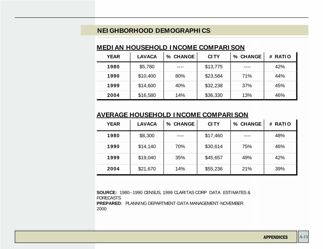
MEDIAN HOUSEHOLD INCOME COMPARISON
AVERAGE HOUSEHOLD INCOME COMPARISON
SOURCE: 1980--1990 CENSUS, 1999 CLARITAS CORP DATA ESTIMATES & FORECASTS PREPARED: PLANNING DEPARTMENT-DATA MANAGEMENT-NOVEMBER 2000
A-13
NEIGHBORHOOD DEMOGRAPHICS
YEAR LAVACA % CHANGE CITY % CHANGE # RATIO
1980 $5,780 ---- $13,775 ---- 42%
1990 $10,400 80% $23,584 71% 44%
1999 $14,600 40% $32,238 37% 45%
2004 $16,580 14% $36,330 13% 46%
YEAR LAVACA % CHANGE CITY % CHANGE # RATIO
1980 $8,300 ---- $17,460 ---- 48%
1990 $14,140 70% $30,614 75% 46%
1999 $19,040 35% $45,657 49% 42%
2004 $21,670 14% $55,236 21% 39%

A-14
Local Historic Districts, National Register Historic Districts and Neighborhood Conservation Districts A portion of the Lavaca Neighborhood (the northern three blocks above the Camargo St./Callaghan Ave. alley) was listed in the National Register of Historic Places, as a Historic District, on July 5, 2000. Simultaneously, the Lavaca neighborhood initiated an effort to designate a lar-ger portion of the neighborhood (generally that above Leigh Street, west of Labor St.) as a local historic district. The local designation will occur in the Winter of 2001/2002. The Heart of the Neighborhood Chapter of the plan has identified research on historic and neighborhood conservation districts as a proactive tool to help preserve the integrity of the Lavaca neighborhood. These zoning overlay designations are planning tools that can be used in a neighborhood in a manner that provides for a degree of development predictability for both property owners and the development community. Either designation, if deemed appropriate, would be formulated in the context of a public proc-ess. The following questions and answers and comparison chart provide information on local historic district and neighborhood conservation district designations, in addition to information on the results of a National Register listing: Local Historic Districts Will designation affect the use of my property?
NO. Use of property is regulated by the City’s Zoning ordinance. Uses that are permit-ted by the base property zoning are not affected by historic district designation. His-toric district designation is concerned with the aesthetics, not the uses of the property.
Does district designation require me to “retrofit” my property to a more “historic” character?
NO. Historic district designation will not require retrofitting. If a property owner elects
HISTORIC AND NEIGHBORHOOD CONSERVATION DISTRICTS

A-15
to make an addition or an improvement to his or her property after designation, the ad-dition or improvement will need architectural review and approval by the Historic and Design Review Commission (HDRC).
Does district designation affect changes to the interior of a property? NO. Historic district designation does not regulate interior changes to a property.
Will I always need to hire an architect? NO. A minor change to a property probably would not need the services of an architect. However, just as in undesignated areas, a property owner would probably elect to hire an architect or other professional to assist in plans for a major change to his or her property.
Can I pick my own paint colors? YES. HDRC will review changes in paint colors, but ordinarily the property owner’s choice will be respected unless the colors are completely out of character. If colors are determined inappropriate, the Historic Preservation Officer can assist the property owner in color selection.
Will my Taxes go up? NO. Historic designation in itself does not increase taxes. Taxes will increase if the as-sessed valuation of a property increases or the tax rate is increased by a political entity.
National Register Listing In addition to honorific recognition, listing in the National Register results in the fol-lowing for historic properties:
• Consideration in planning for Federal, federally licensed, and federally assisted projects;
Section 106 of the National Historic Preservation Act of 1966 requires that Federal agencies al-low the Advisory Council on Historic Preservation an opportunity to comment on all projects af-fecting historic properties either listed in or determined eligible for listing in the National Regis-ter. The Advisory Council oversees and ensures the consideration of historic properties in the

A-16
Federal planning process.
• Eligibility for certain tax provisions; Owners of properties listed in the National Register may be eligible for a 20% investment tax credit for the certified rehabilitation of income-producing certified historic structures such as commercial, industrial, or rental residential buildings. This credit can be combined with a straight-line depreciation period of 27.5 years for residential property and 31.5 years for non-residential property for the depreciable basis of the rehabilitated building reduced by the amount of the tax credit claimed. Federal tax deductions are also available for charitable contri-butions for conservation purposes of partial interests in historically important land areas or structures.
• Consideration of historic values in the decision to issue a surface mining permit where coal is located in accordance with the Surface Mining Control Act of 1977; and
• Qualification for Federal grants for historic preservation, when funds are avail-able.
Conservation Districts Neighborhood Conservation Districts are zoning overlay designations, used as manage-ment tools to address the appropriateness of new and infill construction in both residen-tial and commercial neighborhoods.
The development of Neighborhood Conservation Districts (NCD) in San Antonio is a response to the 1997 Master Plan and 1998 Community Action Revitalization Group (CRAG) recommenda-tions. The NCD also addresses neighborhood concerns about protection of architectural integrity and neighborhood character for new residential and commercial construction. Neighborhood Conservation Districts identify geographic areas in the context of a broader street-scape. Neighborhood defining elements are more than just the age of structures. Local identity and perception, enhanced through neighborhood-based design standards, prove to be as impor-tant as architectural style and character.

Neighborhood Conservation District designation, whether used to protect distinctive architecture or natural features, stabilize property values, or deter incompatible development, is a neighborhood re-vitalization planning tool that provides:
• a more predictable course of development, • an efficient building permit process without the necessity of a Commission review, and • a means of self-determination for residential and commercial neighborhood organizations.
What are the benefits of NCD designation? Neighborhood Conservation District designation protects and strengthens the desirable and unique physical features, design characteristics, and recognized identity, charm and flavor of neighborhoods. It offers a level of “protection” for property values, helping to prevent blight caused by incompatible, insensitive development.
Does a NCD affect my taxes? NO. Neighborhood character within a NCD will generally maintain a higher level of stabil-ity; however, NCD designation does not initiate tax increases. This is handled through the Bexar Appraisal District.
Does a NCD affect the use of my property? NO. A Neighborhood Conservation District is an “overlay” zoning designation, and as such, does not affect the use of property. The underlying base zoning remains intact. (example: in an R-2 (NCD) zoning classification, the R-2 regulates zoning use)
Is a NCD for residential or commercial properties? Both. The boundaries may include:
• residential properties • commercial properties, or • residential & commercial properties
How do I know if my neighborhood or commercial district is eligible for a NCD? Generally, the criteria for designation includes: • a minimum of one blockface, and • at least 75% of the structures in the area are at least 25 years old, and • at least 75% of the area is presently improved, and
A-17

A-18
• the area possesses distinctive features that create a cohesive, identifiable setting, character or association.
Who is able to initiate a NCD? There are several ways to initiate the process. Property owners may initiate the process through a petition of either: • property owners representing 51% of the land area within the district, or • 51% of the property owners within the district. The City’s Planning Department can also initiate the process if: • a Neighborhood or Community Plan has already identified the NCD as a preferred option, or • a City or community targeted revitalization program has identified a NCD need.
Is my neighborhood already designated? San Antonio has many neighborhoods that are designated as either local historic districts, or are listed on the National Register of Historic Places. These designations are different than a NCD designation, and maintain different standards.
If my neighborhood is eligible for Historic District status, should we consider a NCD designation? NO. If a neighborhood maintains the necessary architectural or historical integrity to be eligible for a historic district, it would be encouraged to pursue historic district designation, rather than a NCD designation. However, the neighborhood property owners would generally make that deci-sion.
Are there design standards required for NCD designation? YES. One of the most important components of the NCD designation is a set of established de-sign standards. The standards, however, are developed by property owners, unique to each NCD, and determined as part of the application process.
What are design standards? Required design standards include characteristics such as building height, size, massing, principal elevation features, lot size/coverage, parking, setbacks, roof line/pitch and paving. Optional standards might include features such as signage, building materials, landscaping and natural features, fences/walls, building orientation, driveway and sidewalk location.

Who decides what design standards are important for my neighborhood? The property owners located within the NCD determine the “character-defining” elements that are important to them.
Do the design standards apply to new construction or rehabilitation of existing prop-erties? Both. Although the design standards primarily affect those properties where new construction will occur. Rehabilitation projects (beyond ordinary maintenance and repair) that affect the street facade, will also be required to adhere to the design standards.
If my property is in a NCD, will I have to rehabilitate my property to conform to the design standards? No. Property owners are not required to rehabilitate their property upon designation. However, if they elect to rehabilitate their property, they would be required to conform to the NCD stan-dards.
What if I can‘t afford the requirements of the design standards? The standards are determined by the same property owners who will be using them, therefore, the local aesthetic and economic conditions become part of the determining factors for the de-sign standards. With the exception of specific “character-defining” building materials determined unique to the neighborhood, the design standards generally address the broader elements that define the streetscape.
Will the design standards address paint color? NO. Repainting is considered ordinary maintenance and repair, and is not regulated.
Is demolition allowed in a NCD? Unless a structure already maintains a protected status, a demolition permit application will be processed in the same manner as any other demolition permit application.
Once a NCD is established, how do I get my project approved? Is a commission pres-entation required? The NCD review process is an administrative process, with no commission review. A project may be forwarded to the NCD staff via the standard building permit process, or an applicant may bring the project plans directly to the NCD staff. A Certificate of Compliance (CoC) is issued if
A-19

A-20
the project conforms to the design standards. If not, the applicant is issued a Notification of Non-Compliance, and may reapply after conforming to the standards, or appeal the administra-tive decision to the Board of Adjustment.
How long does administrative review take? The NCD review process provides for an efficient turnaround period. However, if project plans change after the CoC is issued, it is voided, and the review process would be initiated again.
Is there a charge for NCD project review? NO. There is no additional charge for NCD review.

A-20a
Lavaca Neighborhood Plan Age of Structures Map

Historic Homeownership Assistance Act (HR 1172 and S 664) The following information was developed by Preservation Action (www.preservationaction.org) and is used with their permission. Also see the National Trust for Historic Preservation (www.nationaltrust.org) for additional information on this act. The historic homeownership rehabilitation tax credit was first introduced in Congress in 1995. The 20 percent federal income tax credit would be attractive to first-time homeowners, long-time residents and fixer-uppers alike, representing a broad spectrum of income levels. Qualifying Properties: Single-family and multi-family residences, condominiums and cooperatives listed on the Na-tional Register of Historic Places, state or local registers, contributing buildings in historic dis-tricts and the portion of a qualified building used as a principal residence. Amount of Allowable Credit: Twenty percent of qualified rehabilitation expenditures credited against a homeowner’s federal income tax liability up to $40,000 ($200,000 of qualified rehab) for each principal residence. Expenditures must equal or exceed $5,000 or the adjusted basis, whichever is greater. Excep-tions: buildings in census tracts targeted as distressed, Enterprise Zones or Empowerment Zones require a minimum investment of $5,000. Five percent must be spent on the exterior. Credit can be applied to tax liability over a number of years. If the residence is vacated or sold before five years, the credit is subject to recapture. “Pass Through” Feature A developer may rehabilitate a qualifying property and sell it to a homeowner with the credit. Lower Income Families Can Afford Rehabilitated Historic Housing Taxpayers with little tax liability may convert the credit into a mortgage credit certificate to re-duce the costs of homeownership (see below).
A-21
PROPOSED HISTORIC HOMEOWNERSHIP ASSISTANCE ACT

A-22
Standards for Rehab All rehabilitation must meet The Secretary of the Interior’s Standards for the Rehabilitation of Historic Properties. Final certification will consider location in a “targeted area’, Enterprise Zone or Empowerment Zone. The tax credit can be used in three ways: 1. Reduction of a taxpayer’s federal income tax, 2. Conversion of the credit to a mortgage certificate which enables a receiving lending institu-
tion to apply the credit to its own tax liability. In return, the lending institution compensates the homeowner through an equivalent reduction of interest on his/her mortgage.
3. In a distressed census tract only, the mortgage certificate can be transferred to a lending in-stitution which, as above, can apply the credit toward the reduction of its federal tax liability. In return, the lender can make the credit amount available in cash to be applied to the pur-chase price of the residence. This feature assists citizens to meet the down payment require-ments and effectively reduce the appraisal gap.
In all cases, a developer can rehabilitate and sell the property, passing the credit to a qualified owner. To date this act has not been enacted into federal law.

A-23
DIRECTORY OF AFFORDABLE HOUSING PROGRAMS
AGENCY ASSISTANCE TERMS SOURCE OF FUNDS
ELIGIBILITY
REPAIR
Home Improvement Program
City of San Antonio – NAD 207-7881
Financing to make necessary repairs (qualify for deferred payment if income below 80%, and age is 65 or older, or you or Head of House-hold is physically handicapped, or able to finance 50% of repairs)
Lien against property @ 6% for 10 years for $1,500 to $35,000
CDBG, HOME, General Funds (Council Dist. 6 & 7)
80% or below AMFI, living within city limits or up to 120% of AMFI, living within revitalization area or SHTA and property claimed as homestead, satis-factory credit, current property taxes, and clear title. No Applications cur-rently being accepted due to closed waiting list.
Owner-Occupied Home Repair
UUHAC 731-8203
Advises on work; finds and qualifies contractors; owner-financing and 10-yr deferred loans
Deferred payment and low interest loans available de-pendent on income
HOME ’99, Broadway Bank
Homes needing repair in Beacon Hill, Five Points and Alta Vista Areas. Broadway Bank loans with UUHAC available in District 1.
Buy-Repair-Sale Pro-gram
UUHAC 731-8203
Buy, repair, sale homes
Private Low – moderate income families

A-24
TYPE OF PROGRAM AGENCY ASSISTANCE TERMS SOURCE OF FUNDS
ELIGIBILITY
FINANCIAL INCEN-TIVES
Residential Rehabilitation Tax Exemption
City of San Anto-nio – Planning Dept. 207-7925
Zero (0) City of San Antonio property taxes for five (5) years and five (5) years requir-ing payment of fifty (50%) percent of the total assessed ad valorem taxes.
10 years Substantial rehabilitation of a historic residential property that is designated as an individual land-mark or is located in a designated historic dis-trict.
Historic District Designa-tion Tax Exemption
City of San Anto-nio – Planning Dept. 207-7925
All properties located within a newly designated historic dis-trict receive a twenty (20%) credit off of the assessed City ad valorem tax total for ten years.
10 years Located within a new historic district; applies to all properties.
Long-time Resident Tax Exemption
City of San Anto-nio – Planning Dept. 207-7925
Five (5) year extension of the twenty (20%) percent credit for all property owners that can show proof of ownership and residence within the his-toric district boundaries prior to its designation.
5 years Proof of residence and property ownership for the entire initial ten-year period of new historic district.
Low-income Rental Tax Exemption
City of San Anto-nio – Planning Dept. 207-7925
For owners of property of an individually designated land-mark or within a local desig-nated historic district that sub-stantially rehabilitate their property and then lease forty (40%) or greater of available rental units at “affordable” rates. Ten years of zero as-sessed City ad valorem taxes.
10 years Rent cannot exceed thirty (30%) percent of the “low-income” sliding scale values from HUD; ad-justed for number of family members. Scale based on the median family income for San An-tonio, as listed in a one-year period.
Community Grant Pro-gram
San Antonio Con-servation Society
224-6163
Two funding rounds yearly (Oct 1, Mar 1). Owner must contribute to repairs. Grant amounts vary per application.
Reimbursement Grant
Private Funds Structure must be 50 years old. Restoration of a house exterior or stabilization of a structure that has historic value. Work must be in accordance with “Secretary of the Interior’s Standards.” Limit of $15,000; most grants in $5000 range.

TYPE OF PROGRAM AGENCY ASSISTANCE TERMS SOURCE OF FUNDS
ELIGIBILITY
COUNSELING
Homebuyers’ Club City of San Antonio – NAD 207-7881
Pre-Post purchase coun-seling program – re-quired for down pay-ment assistance (families referred by lenders and realtors)
Private Funds, Lenders, Texas Dept. of Housing & Community Affairs
General public
Home Ownership Counseling
SAAHC 224-2349
Pre/Post home owner-ship counseling pro-gram; after obtaining home, monthly sessions for 3 years
Homebuyers Counsel-ing (in conjunction with other programs)
NHS 533-6673
Mandatory prior to loan closing
8 hrs Private Mandatory prior to loan closing
Home Improvement Classes
UUHAC 731-8203
Must take for any UU-HAC loans.
6 sessions NCDI, SAHT, En-terprise, Fannie-Mae, CCSA
Owner-Occupied Home Repair Program participants with UUHAC
A-25

A-26
Conversion Project Suggestion Form
The purpose of this form is to initiate discussion on a project involving the conversion of utility service. Provide as much information as possible (if you need more room, attach-ments--especially maps and drawings--are encouraged).
For Staff Use Only
Project Number: ____________________________________________ Project Name: ______________________________________________
Please Print or Type
Initiated By: ________________________________________________ Name ______________________________________________________ Address ______________________________________________________ City, State, Zip Phone:___________________Fax:__________________________ E-Mail: _______________________________________________
APPLICATION FOR UNDERGROUND UTILITY CONVERSION

Do you represent a group? If so, group name is: ________________________ _______________________________________________________________ Conversion Type: (i.e. overhead to undeground\relocate overhead\etc.)_______________________________________________________________ _______________________________________________________________ _______________________________________________________________ _______________________________________________________________ Threshold Status: Is this project linked to a public improvement project, i.e. a street wid-ening project; or is it of a unique city-wide significance, or is it strongly supported by the affected property owners, most of whom would sign a petition requesting the project? Please explain: ______________________________________________________________ ______________________________________________________________ ______________________________________________________________ ______________________________________________________________. Project Boundaries (e.g. San Pedro from Basse to Jackson-Keller) :
A-27

A-28
______________________________________________________________ ______________________________________________________________ ______________________________________________________________ ____________________________________________________________. Proposed Improvements Summary (Describe what you want the project to accomplish): ______________________________________________________________ ______________________________________________________________ ______________________________________________________________ ______________________________________________________________ ______________________________________________________________ _____________________________________________________________. Other Comments: ______________________________________________________________ ______________________________________________________________ ______________________________________________________________ ______________________________________________________________

______________________________________________________________ ______________________________________________________________ ______________________________________________________________. Send To: Dave Pasley, Special Projects Coordinator Department of Public Works PO Box 839966 San Antonio, Texas 78283-3966 Phone: 210-207-3398 Fax: 210-207-4406 E-Mail: [email protected]
A-29

A-30
Neighborhood Services Directory The following tables are provided to illustrate neighborhood services for residents and visitors to utilize. These tables can also be used to help prioritize needed business or services within the planning area.
Resource Directory
ANTIQUES ART GALLERIES ARTIST STUDIOS FLORAL DESIGN OFFICE SUPPLY SPECIALTY THRIFT STORES
Archaic Treasures IV Design Art Space Katie Pell Riverwalk Floral Design
School Mart Dos Carolinas La Chica
Southtown Empo-rium
Peter Zubiate Rustic Finds
20th Century Southtown
Oscar Alvarado The Clothes Vine
Cups, Crosses & Candles, Etc.
Marie’s Treasures
CHILD CARE EMERGENCY SVC SCHOOLS NEIGHBORHOOD ASSN.
NON-PROFIT ORG.
UNIONS MUSEUMS
Positive Beginnings, Inc.
Fire Station No. 7 Bonham Elemen-tary (out of area)
Lavaca Neighbor-hood Assn.
Southtown Main-street Alliance
American Postal Workers
Texas Highway Pa-trol Museum
Burnet Elementary (Herff)
King William Asso-ciation
United Way of San Antonio
TX United Tmstrs Un Local 1110
Brackenridge High
Page Middle (out of area)
SAISD Headquar-ters
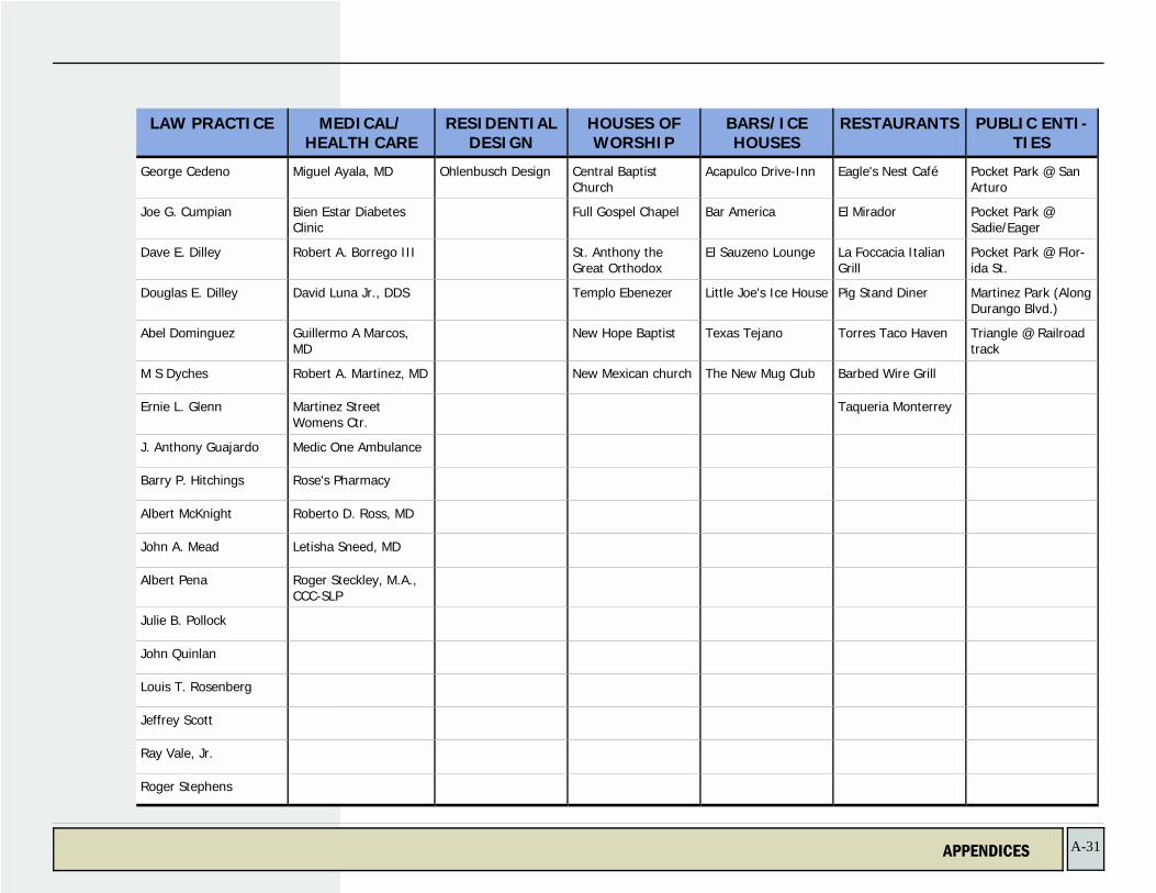
A-31
LAW PRACTICE MEDICAL/HEALTH CARE
RESIDENTIAL DESIGN
HOUSES OF WORSHIP
BARS/ICE HOUSES
RESTAURANTS PUBLIC ENTI-TIES
George Cedeno Miguel Ayala, MD Ohlenbusch Design Central Baptist Church
Acapulco Drive-Inn Eagle's Nest Café Pocket Park @ San Arturo
Joe G. Cumpian Bien Estar Diabetes Clinic
Full Gospel Chapel Bar America El Mirador Pocket Park @ Sadie/Eager
Dave E. Dilley Robert A. Borrego III St. Anthony the Great Orthodox
El Sauzeno Lounge La Foccacia Italian Grill
Pocket Park @ Flor-ida St.
Douglas E. Dilley David Luna Jr., DDS Templo Ebenezer Little Joe's Ice House Pig Stand Diner Martinez Park (Along Durango Blvd.)
Abel Dominguez Guillermo A Marcos, MD
New Hope Baptist Texas Tejano Torres Taco Haven Triangle @ Railroad track
M S Dyches Robert A. Martinez, MD New Mexican church The New Mug Club Barbed Wire Grill
Ernie L. Glenn Martinez Street Womens Ctr.
Taqueria Monterrey
J. Anthony Guajardo Medic One Ambulance
Barry P. Hitchings Rose's Pharmacy
Albert McKnight Roberto D. Ross, MD
John A. Mead Letisha Sneed, MD
Albert Pena Roger Steckley, M.A., CCC-SLP
Julie B. Pollock
John Quinlan
Louis T. Rosenberg
Jeffrey Scott
Ray Vale, Jr.
Roger Stephens

A-32
AUTO SERVICE BEAUTY SA-LONS
BUILDING SERVICE
COMPUTER SERVICE
CONVENIENCE STORE
GROCERY INSTRUCTION LAUNDRY
Alanis Body Repair/Towing
Carmen's Hair De-signs
Allen Electric Co. A-Plus Computer Services
Felipe's Grocery Store
Handy Andy Super-market
Inst. Of Professional Studies
Kwik Wash Laun-ders
Clay's Auto Parts/Machine Shop
Connie's Coiffures Monday Construc-tion
Solrac Computer Specialties
Labor Food Market Karavan Studio
Coastal No. 7 Gas Station
Sandy's Beauty Sa-lon
Pik Nik Foods
Davila's Bug Ser-vice
S. Presa Drive-Thru
Dr. Leo MB Auto Clinic
Shop-in-Go
Goodyear Tire Cen-ter
Victoria Food Mar-ket
Mario's Automotive
Tires Plus Inc.
W&W Diesel Auto-motive
LOCKSMITH MANUFACTUR-ING
PHOTOGRAPHY PRINTING REALTORS SERVICES TAILOR UPHOLSTERY
R.L. Locksmith Arias Enterprises Salazar Studios Photography
Quality Offset Printing
Bailey Street Prop-erties
AAA Freight Sal-vage
ABC Tailor Fashion Uphol-stery & Furn.
Continental Iron-works
Cintas Uniform Corp.
Dos Carolinas
Danny's Appliance Sls&Svc.
Loomis Armored Inc.
Luna Glass Works
Reynosa Electron-ics Repair

Unsafe Structures 207-7230 Vacant Lot Clean Up Requests 207-7230 COSA Economic Development Department General Information 207-8080 San Antonio Business Assistance Focus 207-3900 Center COSA Fire Department (SAFD/EMS) General Information 207-8400 Emergency 911 COSA Housing and Community Development Department HOME Funds, CDBG Funds, etc. 207-6600 COSA Neighborhood Action Department Neighborhood Sweeps Program 207-7881 Neighborhood Commercial Revitalization 207-7881 COSA Metropolitan Health Department General 207-8790 Animal Control 207-6650 Vector Control (Pests in public places) 207-8853 Water Testing 207-8887 COSA Parks and Recreation Department Park Design and Project Services 207-2879 Youth Athletics/Recreation 207-3038 Volunteer Services 207-8452 COSA Planning Department Historic Preservation Office 207-7900
The City of San Antonio and area agencies listed as partners in the action steps of this plan have many departments that serve citizens. The follow-ing directory can used to help solve neighborhood problems and obtain information about various programs and services. Alamo Community College District Community Liaison 220-1680 City Public Service Street Light Repairs 353-4357 Purchasing & Small Business 353-2153 Development COSA Asset Management Department General Information 207-4032 COSA Department of Community Initiatives Child Care Assistance 246-5240 Fair Housing 207-7821 Literacy Services 225-READ Youth Services 207-7190 COSA Department of Building Inspections Building Permits 207-4252 Tree Preservation—City Arborist 207-8053 Central Records 207-6378 COSA Code Compliance Department General Code Compliance Complaints 207-7230 Illegal Dumping 207-3867 Noise Complaints 207-7230
A-33
RESOURCE DIRECTORY

A-34
Neighborhood and Urban Design Division 207-7873 Zoning Division 207-7900 COSA Police Department (SAPD) General Information 207-7484 Central Substation 207-7410 SAFFE Officer Central Area 207-7413 Gang Hotline 224-4264 Emergency 911 COSA Public Works Department Brush / Rubbish Pick Up Info 207-6400 Potholes / Drainage Repair 359-3110 Dead Animal Collection 207-6400 Recycling Complaints / Requests 207-6400 Speed Hump Requests 207-7720 Street Light Installation Requests 207-8075 Streets / Drainage Problems 359-3110 Traffic Signal / Sign Problems 207-7765 COSA Library Department General Information 207-2500 District 1 City Council Office 207-7279 Downtown Residents Association Available Upon Request From COSA Planning Dept. King William Association Available Upon Request From COSA Planning Dept. Lavaca Neighborhood Association Available Upon Request From COSA Planning Dept.
Presa Real 534-5533 San Antonio Conservation Society 224-6163 San Antonio Housing Authority 220-3200 San Antonio Independent 299-5500 School District San Antonio Water System Main Office 704-7297 Water Emergency / Sewer Maintenance 227-6143 /Water Waste / Water Main Leaks Southtown Urban Main Street 226-0888 Program University of Texas at 224-2460 San Antonio, Small Business Development Center Texas Alcoholic Beverage Commission Enforcement and Compliance Division 736-4466 Texas Department of Health General Information 949-2000 Texas Historical Commission 512-463-6100
RESOURCE DIRECTORY

225-READ Central Referral Center
Provides client and volunteer referrals to approximately 215 literacy services pro-vider sites located throughout the San Antonio metropolitan area.
225-READ Central Referral Center 1502 Fitch Street, 78211 (210) 225-7323 Hours: 8:15 a.m. - 5:00 p.m. Monday – Friday Fr. Albert J. Benavides Learning and Leadership Development Center 515 Castroville Rd., 78237 (210) 435-2352 or 435-2353 Hours: 7:45 a.m. - 9:00 p.m. Monday-Thursday 7:45 a.m. - 4:30 p.m. Friday Bob & Jeanne Billa Learning & Leadership Development Center 1033 Ada, 78223 (210) 534-9905 Hours: 7:45 a.m. - 9:00 p.m. Monday-Thursday 7:45 a.m. - 4:30 p.m. Friday Columbia Heights Learning and Leadership Development Center 1502 Fitch Street, 78211 (210) 977-8464 or 977-8465 Hours: 7:45 a.m. - 9:00 p.m. Monday-Thursday 7:45 a.m. - 4:30 p.m. Friday
A-35
EDUCATIONAL RESOURCES

A-36
Margarita R. Huantes Learning and Leadership Development Center 1411 Guadalupe, 78207 (210) 225-0174 or 225-0175 Hours: 7:45 a.m. - 9:00 p.m. Monday-Thursday 7:45 a.m. - 4:30 p.m. Friday St. Mary’s Learning and Leadership Development Center 3141 Culebra Rd., 78228 (210) 436-7633 Hours: 7:45 a.m. - 8:30 p.m. Monday - Thursday 7:45 a.m. - 4:30 p.m. Friday
St. Philip’s Learning and Leadership Development Center 101 Meerscheidt St., 78203 (210) 531-4852 or 531-4853 Hours: 7:45 a.m. - 8:30 p.m. Monday -Thursday 7:45 a.m. - 4:30 p.m. Friday Willie C. Velasquez Learning & Leadership Development Center 1302 N. Zarzamora, 78207 (210) 733-9355 or 733-0101 Hours: 7:45 a.m. – 9:00 p.m. Monday-Friday 7:45 a.m. – 4:30 p.m. Friday OPENING SOON: Regional LLDC
EDUCATIONAL RESOURCES

A-37
Lavaca Neighborhood Plan Public Improvements Map

A-38
THIS PAGE INTENTIONALLY LEFT BLANK
PUBLIC IMPROVEMENT PROJECTS

Community Facilities – Services or conveniences provided for or available to a community. Ex-amples include parks, libraries, fire/police stations, etc.
A-39
PUBLIC IMPROVEMENT PROJECTS Agency/ Department Location Project Status Estim. Date of Construct. Estimated Cost
1 Housing & Community Dev. Barrera (Alamo-Labor); Sidewalks Completed $ 78,711.00
2 Housing & Community Dev. Camargo (Presa-Labor) Sidewalks Completed (included in figure above)
3 Housing & Community Dev. see project #6 $ 317,906.00
4 Housing & Community Dev. Alamo Street (Durango-Cedar) Reconstruct Alamo St. to include new curbs, 4' sidewalks at the curb, drive-way approaches and necessary drainage, as well as bike lanes from Du-rango to Presa
MPO for construc-tion
under final design $ 895,396.00
5 Public Works Florida IH-37 to St. Mary's Reconstruct Florida from IH-37 to St. Mary's: provide for 3 lanes, sidewalks, & drainage
Under design Jan-02 $ 1,450,300.00
6 Public Works Indianola: Garfield to Camargo Reconstruction of Indianola from Garfield to Camargo to a 30' width to in-clude curbs, sidewalks, driveway approaches, and necessary drainage
Under construction Oct-00 $ 281,669.00
7 Public Works Mission Trails Parkway: Phase IV S. St. Mary's road reconstruction, including sidewalks and drainage; Bike lanes from Durango to Presa on Alamo, including curbs, sidewalks and drain-age
Under design Nov-00 $ 1,912,680.00
8 Public Works Mission Trails Parkway: Phase V Includes increased signage Under design 2001 $ 1,000,000.00
9 Public Works St. Mary's: Alamo to Pereida Reconstruction of St. Mary's from Alamo to Pereida to include a center turn lane, as well as drainage and sidewalks
Under design Jun-01 $ 341,900.00
10 Public Works St. Mary's: Pereida to Roosevelt Reconstruction of St. Mary's from Pereida to Roosevelt including widening to 4-lanes
Under construction Oct-00 $ 4,167,500.00
11 Public Works S. Presa: Durango to the railroad Routine street maintenance (repaving) not available not available not available
12 Public Works Labor: Durango to Carolina Routine street maintenance (repaving) not available not available not available
13 SAHA Victoria Courts 432 units in elevator buildings (including 70 affordable and 20 public) not available not available (the $90,000,000 total listed below was not broken down by phase, land use, etc.)
14 SAHA Victoria Courts 231 units in walk-up buildings (including 25 affordable and 20 public) not available not available see below
15 SAHA Victoria Courts 100 row homes (including 26 replacement public housing units) not available not available see below
16 SAHA Victoria Courts 32 homeownership duplexes (including 16 affordable and 2 replace. public) not available not available see below
17 SAHA Victoria Courts 32 single-family homeownership houses (including 16 affordable and 4 re-place. public)
not available not available see below
18 SAHA Victoria Courts 13, 000 sq. ft.of office and neighborhood retail not available not available see below
19 SAHA Victoria Courts 10,000 sq. ft. of community and administrative space not available not available $ 90,000,000.00
20 SAISD Bonham Elementary P.E. Building construction Feb-01 Feb-01 $ 984,552.00
21 SAISD Burnet Elementary Bond Program On hold-pending Victoria Crt. rede-velopment
not available $ 4,704,658.00
22 SA Water Systems From IH-37 along Durango, to Labor, to Garfield, to Durango, & over to Alamo
Water systems improvements not available not available not available
23 COSA Pocket Park Development Funded by Neighborhood Improvement Challenge Program pending Dec-00 $ 5,000.00
24 VIA Various Replacement of Allied benches and placement of shelters TBD not available not available
25 US Gov’t—General Services Durango Blvd. at Indianola Potential new Federal Courts System Bldg. TBD FY04 $ 119,000,000.00
TOTAL $225,140,272

A-40
The following comparison is meant to serve a guide, not an exact conversion of desired future land use to new zoning categories, that compares the Land Use Plan classifications found in the Land Use Section of this document with Zoning Districts found in the Unified Development Code. The proposed land use plan found in this document and the following conversion matrix will not constitute zoning regulations or establish zoning districts*. Rather the proposed land use plan and the accompanying land use and zoning information is a guide for long-range development of a neighborhood or community and for the establishment of desired development patterns within the community. *(Local Government Code, Chapter 219.001-005). The Land Use Plan Category Column refers to the designated desired future use found in the Lavaca Neighborhood Land Use Plan, pages 38-40. The Potential Zoning Districts refer to the zoning districts found in the Unified Development Code. The Allowable / Desired Uses are spe-cific citation of the explicit desired future uses determined by the residents and stakeholders of that participated in the planning process.
ZONING / LAND USE CONVERSION MATRIX

ZONING / LAND USE CONVERSION MATRIX
A-41
Land Use Plan Category Potential Zoning Districts Allowable / Preferred Uses
Low-Density Residential R-4, Single-family Residential R-5, Single-family Residential R-6, Single-family Residential NP-8, Neighborhood Preservation District NP-10, Neighborhood Preservation District NP-15, Neighborhood Preservation District RM-4, Mixed Residential* RM-5, Mixed Residential* RM-6, Mixed Residential* *(For Single-family residential with accessory dwelling units only)
Single-family homes; Single-family homes with ac-cessory dwelling units
Medium Density Residential RM-4, Mixed Residential RM-5, Mixed Residential RM-6, Mixed Residential And less intense residential zoning districts
Single-family homes; Single-family homes with ac-cessory dwelling units, duplexes, three and four fam-ily dwellings, cottage, cottage homes and town homes
High Density Residential MF-25, Multi-family Residential MF-33, Multi-family Residential MF-40, Multi-family Residential MF-50, Multi-family Residential And less intense residential zoning districts
Apartments and less intense residential uses
Mixed Used / Neighborhood Com-mercial
MXD, Mixed Use Commercial TOD, Transit-oriented Development C-1, Commercial C-2, Commercial O-1, Office District (And less intense residential zoning districts)
Mixed uses within the same building or development, transit supported mixed use development, gift shops, offices, restaurants, beauty parlors, small neighbor-hood groceries or markets, coffee shops, shoe sales and repair shops, medical clinics and offices, spe-cialty retail sales shops, live/work units, limited num-ber of apartments and multi-family structures and less intense residential zoning districts

A-42
Accessory Detached Dwelling Unit - A Dwelling Unit that is accessory, supplementary, and sec-ondary to the Principal Dwelling that may be constructed as an addition to the principal structure or as an accessory to the principal structure. An Accessory Dwelling Unit is detached from the Principal Dwelling. Alley - A minor public right-of-way not intended to provide the primary means of access to the abutting lots, which is used for vehicular service access to the back or sides of properties other-wise abutting on a public street. Capital improvements - Public facilities which have a life expectancy of three (3) or more years that are owned and operated by the city, and are treated as capitalized expenses according to generally accepted accounting principles. This definition does not include costs associated with the operation, administration, maintenance, or replacement of capital improvements. COSA – City of San Antonio - The City of San Antonio or any agency, bureau, department, divi-sion or commission of the City of San Antonio and any department, agency, board, commission or governing body of the City of San Antonio and its capacity of providing services to the com-munity at large Charrette – is a brainstorming exercise that results in a quick visual presentation of the gener-ated ideas. Commercial property - A building, site, or structure whose use after rehabilitation or restoration (for ad valorem tax exemption) will be for other than residential use, i.e., for a single family, du-plex, three or four family dwelling. Conservation District – is a “zoning overlay” (a specific geographic area identified as an “overlay” to the base zoning, but does not change the zoning designation use) that includes the application of neighborhood based design standards, individually tailored to address specific redevelopment issues. Design Guidelines – Design guidelines are intended to provide a framework of design criteria within which physical planning can take place. The guidelines provide suggestions for the design
GLOSSARY

of new homes/businesses and repair/rehabilitation of existing homes/businesses in order to maintain the overall character of the neighborhood. Generally, character-defining elements such as front porches, roof slopes, etc. are emphasized in residential guidelines while setbacks, canopies and signage may be emphasized in commercial guidelines. Detached structure - A structure having no party wall or common wall with another structure unless it is an accessory structure. Economic Base – The foundation on which a neighborhood relies for economic sustainability. Façade – the exterior wall of a building exposed to public view. District - A geographically definable area, urban or rural, possessing a significant concentra-tion, linkage, or continuity of buildings, objects, sites, or structures united by past events or aesthetically by plan or physical development which may also comprise individual elements separated geographically but thematically linked by association or history. Historic district - An area, urban or rural, defined as an historic district by city council, state, or federal authority and which may contain within definable geographic boundaries one or more buildings, objects, sites or structures designated as exceptional or significant historic landmarks or clusters, as defined herein, including their accessory buildings, fences and other appurte-nances, and natural resources having historical, architectural, archaeological, and cultural sig-nificance, and which may have within its boundaries other buildings, objects, sites, or struc-tures, that, while not of such historical, architectural, archaeological or cultural significance as to be designated landmarks, nevertheless contribute to the overall visual setting of or charac-teristics of the landmark or landmarks located within the district. Historic Structure - Any structure that is: (a) Listed individually in the National Register of Historic Places (a listing maintained by the Department of Interior) or preliminarily determined by the Secretary or the Interior as meeting the requirements for individual listing on the National Register; (b) Certified or preliminarily determined by the Secretary of the Interior as contributing to the historical significance of a registered historic district or a district preliminarily determined by the
A-43

A-44
Secretary to qualify as a registered historic district; (c) Individually listed on a state inventory of historic places in states with historic preservation programs which have been approved by the Secretary of Interior; or (d) Individually listed on a local inventory or historic places in communities with historic preser-vation programs that have been certified either: 1. By an approved state program as determined by the Secretary of the Interior or; 2. Directly by the Secretary of the Interior in states without approved programs. Historic Tax Credits – Ad Valorem tax (property tax) exemption is available to City of San Antonio home and commercial property owners who substantially restore or renovate their historic proper-ties. If a commercial property is listed on the National Register of Historic Properties or a contribut-ing structure in a National Register Historic District, commercial property owners may be eligible for a federal income tax credit for completing a restoration or renovation of the historic property. Infill Housing – New housing constructed on vacant lots in an area that is predominantly devel-oped. The new housing can include: single-family, duplexes, townhouses, apartments, senior housing, etc. Land Use – The manner in which land is used. For example, low-density residential land uses primarily include single-family houses. Landscaping Ordinance – Implemented in 1994, the primary purpose of the City’s Landscaping Ordinance is to create commercial land uses that not only are attractive but add value to the property. Landscaping includes preservation of existing trees, understory plants, and natural ar-eas in addition to installing new trees and plants. Linear Parks– Provides a physical link between two or more areas. Linear park trails can accom-modate bicycling, hiking, jogging, and walking. The width of a linear park system is important because the amount of land included in the corridor is intended to reflect a park-like environ-ment. Livable Wage – An income sufficient to meet a family’s basic needs.

Live/Work Units – Living units which also are zoned to allow small businesses to operate from a portion of the structure, generally identified by small retail or service oriented businesses or art-ist studies. Major thoroughfare - Street routes that are identified as major thoroughfares as set forth in the major thoroughfare plan, and as may from time to time be amended. Major thoroughfares are devoted to moving large volumes of traffic over long distances. Marketing Studies – A detailed study of the potential consumers in a certain area. This type of study helps businesses determine whether or not it would be beneficial to them to locate to, develop in, or service an area. Master Plan – The City’s Master Plan Policies were adopted May 1997. The Master Plan Policies are intended to provide guidance in the evaluation of future decisions on land use, infrastruc-ture improvements, transportation, and other issues, and ordinances that are proposed and considered after the adoption of the Master Plan Policies. It should be consistent with the rele-vant goals and policies contained in the Plan. The primary objectives of master plans are to co-ordinate public and private investment; minimize conflict between land uses; influence and manage the development of the community; increase both the benefits and cost effectiveness of public investment; predict infrastructure and service needs in advance of demand; and en-sure that community facilities are located to best serve the community. Microenterprise – Small business entities, usually employing less than five persons. Mixed Use Building - A building which contains two or more of the following major use types: residential, office, or retail. Municipal Management District – A defined geographic area which established a separate taxing entity to provide funds for improvements within that area. Examples are TIFs (Tax Increment Financing districts) and PIDs (Public Improvement Districts). Node – A center of activity or development, often located at a major intersection. Office - A building used primarily for conducting the affairs of a business, profession, service,
A-45

A-46
industry, or government, or like activity, that may include ancillary services for office workers such as a restaurant, coffee shop, newspaper or candy stand. Overlay Zoning – is a zoning classification which defines an addition set of requirements over and above the base zoning requirements. Park —Land and facilities, such as playgrounds, fountains, or swimming pools, used or to be used as a Neighborhood Park, Community Park, Large Urban Park, Sports Complex, Special Use Facility, or Urban Space as defined in the Parks and Recreation System Plan, regardless of loca-tion, including both the acquisition of such land, the construction of improvements thereon and the expenditure of funds incidental thereto, including but not necessarily limited to planning, en-gineering and design of the park and improvements, utility relocation, provision of improve-ments, utility relocation, provision of pedestrian and vehicular access thereto and purchase of equipment, the need for which are attributable to new residential development. Planning Commission / City Council Recognition – The Planning Commission reviews community plans to ensure the document is inclusive, consistent with city policies and an accurate reflection of the community’s values. After Planning Commission recognition, the plan is forwarded to City Council for adoption as a component of the City’s Comprehensive Master Plan. An approved plan is used by city departments, boards and commissions as a guide for decision-making. Public Improvement District – see Municipal Management District Right-of-way - Property that is publicly owned or upon which a governmental entity has an ex-press or implied property interest (e.g. fee title, easement, etc.) held for a public purpose. Exam-ples of such public purpose include, by way of example and not limitation, a highway, a street, sidewalks, drainage facilities, sewerage and water facilities. Sign Ordinance – Rules and regulations that govern the posting of signs in a city. Streetscape –A design term referring to all the elements that constitute the physical makeup of a street and that, as a group, define its character, including building frontage, street paving, street furniture, landscaping, awnings, marquees, signs, and lighting.

Scale - The relationship of a building or structure to its surroundings with regard to its size, height, bulk, and/or intensity. School - An institution or place for instruction or education, such as kindergarten, elementary, middle or junior high school, high school, college or university. Street tree - A tree planted along a street or roadway behind the right-of-way line or between a sidewalk and the edge of the paved surface of a roadway. Streetscape - The general appearance of a block or group of blocks with respect to the struc-tures, setbacks from public rights-of-way, open space and the number and proportion of trees and other vegetation. Zoning – Regulates density and land use. Zoning is a key tool for carrying out planning policy. Zoning Ordinance – Rules and regulations that govern the way land is zoned (separated accord-ing to land uses) in a city.
A-47

A-48
THIS PAGE INTENTIONALLY LEFT BLANK

A-49
Letters of Support