legal information wps for factory site location analysis2010.foss4g.org/papers/3233.pdf · legal...
TRANSCRIPT

Legal information WPS for factory site location analysis
Kim, Byung-Jo1, Yom, Jae-Hong2
1Geoinformation Engineering, Sejong University , Seoul, Korea, [email protected] Engineering, Sejong University , Seoul, Korea, [email protected] (corresponding author)
AbstractIn local government's urban management system, factory construction approval is based on various
standards and complex legal information. The characteristics of legal information are its huge quantity
of the legal aspects to consider and constant updates for this information. Therefore reducing the cost
and time in choosing the right legal information in site selecting process is necessary for the public.
In this research, Web Processing Service (WPS), an Open Geospatial Consortium (OGC) standard, is
used in decision making for the selection of factory sites through spatial analysis algorithms regarding
legal information. By using WPS on legal information process regarding factory site selection many
remote users have easy access to legal-based process with spatial insights.
1. Introduction to factory site location analysis Locating a factory site involves many geospatial factors besides return on capital investment which
may be the initial interest of the investors. Automobile factory site location analysis process was
analyzed in two phases; legal perspective and site specific perspective. The site location analysis model
for automobile factory was based on a publication from Byun. (Byun, Dae-ho et al, 1998). The word
“factory” in this paper refers to production facilities of automobile parts, petrol stations, junkyards and
auto repair shops.
After identifying the related processes, only analytical processes with geospatial characteristics were
selected and implemented as WPS of OGC(Peter Schut, 2007). Prior to the implementation of WPS,
database tables were designed and then, relevant data from existing database were extracted and loaded
to the newly created tables.
2. Design of database for factory site location analysisIn this system, there was already an existing spatial data warehouse and a number of scattered
individual GIS systems within the municipality. Some of the existing seven GIS systems are
construction management system, disaster management system, environment management system, land
information system (Figure 1). For the implementation of WPS, land use zoning table and the parcel

table were extracted from the land information systems. The fields for the land use zoning table are
identifier, land use zoning, price of land, lot number and geometry. The fields for the parcel table are
identifier, lot number and geometry. Initial query test with these two tables showed some problems in
retrieval time, as there were about 102,000 records and the file size was about 140 megabytes.
Retrieving records with simple queries took over 30 minutes. 6 separate tables were created as shown
in Figure 2 to speed up the retrieval time to less than 30 seconds.
Figure 1. Extraction of database from existing GIS for WPS implementation
Gas_station
+ID+price of land+land use zone+geometry
Car parts factory
+ID+price of land+land use zone+geometry
Car repair factory
+ID+price of land+land use zone+geometry
Car storage facility
+ID+price of land+land use zone+geometry
Parking
+ID+price of land+land use zone+geometry
J unkyard
+ID+price of land+land use zone+geometry
Figure 2. Redesigned table design to accelerate retrieval time
3. WPS profiling for factory site location analysis3.1 Workflow analysis for process design
The work flow for factory construction involves three phases of locating, approval and construction
and is as shown in Figure 3. The WPS in this study targeted only the first phase of locating (Korea
Industrial Complex Corp, 2010)

Figure 3. Work flow for construction of factory
Locating a factory site involves first globally identifying candidate sites within a region of interest
where it is legally possible to construct a factory. Of course a region of interest must first be selected
manually, such as within the boundary of a city limit or county. After identifying the candidate sites,
each candidate has to be evaluated and graded after which the best candidate could be further evaluated
in more detail. Identifying the candidate factory site type (01.Identify factory site type in Figure 3.)
involves investigating compliances with zoning regulations and other planning regulations. The second
phase of evaluating each candidate involves evaluating various business oriented factors (02.Site
investigation in Figure 3.). Four geospatial evaluation criteria were selected from various business
oriented factors suggested by Byun (Byun, Dae-ho et al, 1998); size of factory site area, proximity to
market, proximity to materials, and cost of land acquisition. After computing the evaluation factors a
selection process to decide on the best candidate should follow. Byun suggested an AHP model for this
process but simple weighting model could also prove to be useful. This study did not implement the
final best candidate selection process. The selection process is shown in Figure 4.

Figure 4. Work flow for selection of best candidate for factory locating
3.2 WPS profiling of factory locating
Based on the work flow model of factory locating, four basic WPS processes are identified (Figure
5). For reviewing compliance with planning regulations, a process titled GetUseZoning was designed
and three other WPSs’; GetArea, Distance and GetValueOfLand, were designed to evaluate each
candidate site.
Figure 5. WPS process scheme for location analysis

Using the scheme of Figure 5, WPS profiling is documented following the publication by Nash
(Edward Nash, 2008). Table 1 shows the result of WPS profiling where each process is described by a
row. Each process has a URN (Uniform Resource Name) identifier value, a title and the Input and
Output definitions. The profiling process was carried out considering the implementation WPS server,
especially considering the input and output data type which were supported by the WPS server.
Table 1. Factory site WPS profile
Process Identifier / Title
(sejong:wps:factorySiteLocationAnalysis :*)
Input Output
Name Type Name Type
database :useZoning / GetUseZoning Factory type Double Parcel MULTYPOLYGON(WKT)
spatialAnalysis:getArea / GetArea Target parcel POLYGON(WKT) Area Double
spatialAnalysis:distance / DistanceParcel
Point
POLYGON(WKT)
POINT(WKT)Distance Double
database:getValueOfLand / GetValueLand Target parcel POLYGON(WKT) Value of land Double
4. WPS implementation and resultUsing the WPS profile, WPS client was implemented using the uDig SDK 1.1 (uDig, 2010), and
GeoServer 1.7 (GeoServer, 2010) as the WPS server. The database tables were managed by PostGIS
1.4.2 (PostGIS, 2010; Postgresql, 2010). Figure 6 shows the implemented system.
Figure 6. Implementation schema of factory locating WPS
Figure 7 and 8 show the result of the implementation following a scenario of locating an automobile

factory site in a city at the southern part of Korea. The GUI (Graphical User interface) was designed
with 4 main sections.
1 Data View where the region of interest is selected and viewed.
2 WPS request view where the result of GetCapabilities request is shown.
3 Analysis View where input data is keyed in for each process .
4 Result View where the computation result (area, distance, cost) for each candidate is displayed .
Figure 7. Client GUI for WPS
Figure 8. shows the result of GetUseZoning process which filters the candidate regions for
compliance with zoning regulations. The result polygon is superimposed onto a digital orthomap. The
result of other 3 WPS processes are shown in the result view and this is arranged again in Table 2.
4 Result view
3 Data view
2 WPS request view
1 Analysis view
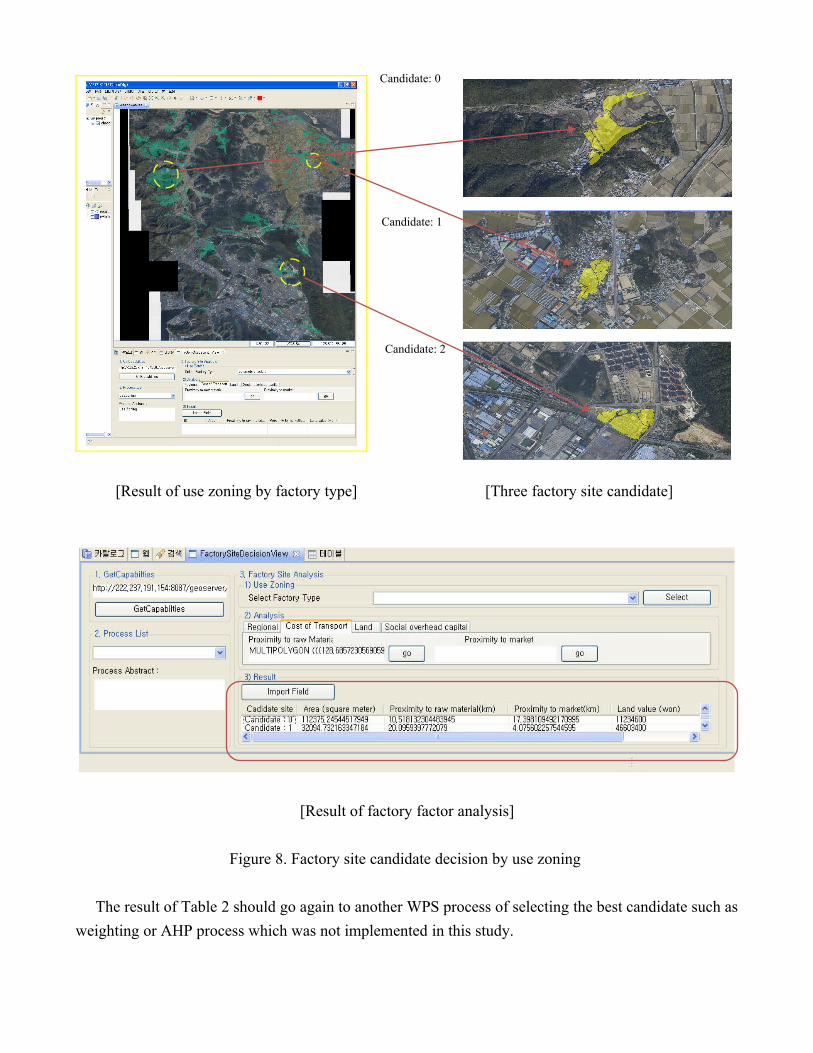
[Result of use zoning by factory type] [Three factory site candidate]
[Result of factory factor analysis]
Figure 8. Factory site candidate decision by use zoning
The result of Table 2 should go again to another WPS process of selecting the best candidate such as
weighting or AHP process which was not implemented in this study.
Candidate: 0
Candidate: 1
Candidate: 2

Table 2. Result of computing evaluation factor for each candidate siteCandidat
eArea (m2) proximity to raw
material (km)proximity to market
(km)Land Value
(won)Candidate
1 112375.245 10.518 17.398 11,234,600
Candidate2
32094.732 20.095 4.075 46,603,400
Candidate3 113021.598 15.642 9.734 257,517,800
5. DiscussionA prototype of a WPS for factory locating has been presented introducing various phases of building
a WPS. The implementation started with a factory location analysis model from a domain expert, and
then geospatial factors were extracted from this model and transformed to WPS. WPS such as the one
in this study could serve its specific purpose in the real world, if it is further refined and complemented
with other functionalities with relatively little extra effort.
But considering the fact that WPS should be a distributed service on the web, the reusability of the
atomic processes of the WPS and the coupling (chaining) of these atomic processes to accomplish a
specific domain task remains a critical issue. Assuming that the atomic geospatial processes are well
defined and “standardized” and are readily available on the web, the maintenance and governance of
the atomic processes would still be necessary. Any WPS server will have to comply with this
standardized atomic process supporting the defined input and output data types. This is not the case at
present where a WPS client works with only certain WPS servers which supports the same input and
output data types as expected by the client.
Chaining of atomic processes to perform specific task remains another tough challenge. Although
chaining is technically possible, discovery of the necessary atomic processes would be a problem, and
even when the correct process to be included to the chain has been discovered, the physical location of
the process server may be a serious problem when considering the huge data that has to navigate
through the web. Deploying the atomic process in a cloud computing environment could be a solution
to this problem as it is likely that the data and the process reside in nearby servers within the cloud
computing environment. But if the data and the process exist in different computing clouds, enabling
sets of standardized atomic processes to be readily and easily deployed to any multiple WPS servers
could help the situation.
AcknowledgementThis research work has been conducted through funding from the Seoul R&BD program (10540).

References
Byun, Dae-ho 1998, ' AHP model for selecting an automobile factory site ', Journal of Management Science, vol.
7, pp. 15-30.
Edward Nash 2008, ‘WPS Application Profiles for Generic and Specialised Processes’, Geographic Information
Days, vol. 32, pp. 69-79.
GeoServer 2010, viewed 12 May 2010, < http://docs.geoserver.org/latest/en/developer/programming-
guide/wps/index.html>.
Korea Industrial Complex Corp 2010, Guro-dong, Guro-gu, Seoul, Korea FEMIS, viewed 4 April 2010,
<http://www.femis.go.kr>.
Peter Schut 2007, OpenGIS Web Processing Service, 1.0.0, viewed 22 March 2009,
<http://www.opengeospatial.org/standards/wps>.
PostGIS 2010, viewed 5 may 2010, <http://postgis.refractions.net/documentation>.
Postgresql 2010, viewed 3 July 2010, <http://www.postgresql.org/docs/manuals>.
uDig 2010, viewed 20 April 2010, <http://udig.refractions.net/confluence/display/DEV/1+SDK+Quickstart>.