leica icon robot 60w3.leica-geosystems.com/downloads123/zz/tps/icon_robot60...leica icon robot 60...
TRANSCRIPT
Leica iCON robot 60 Product information
i n t e l l i g e n t C Ons t r uc t i o n
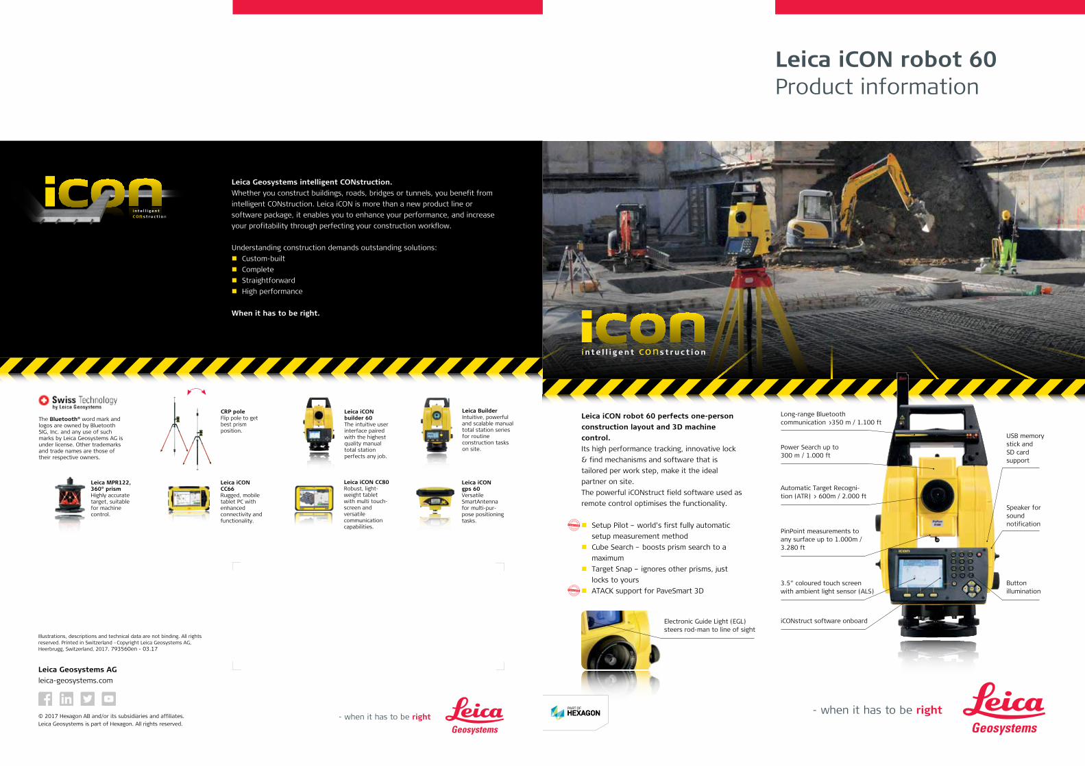
Leica iCON robot 60 perfects one-person construction layout and 3D machine control. Its high performance tracking, innovative lock & find mechanisms and software that is tailored per work step, make it the ideal partner on site.The powerful iCONstruct field software used as remote control optimises the functionality.
Setup Pilot – world’s first fully automatic setup measurement method
Cube Search – boosts prism search to a maximum
Target Snap – ignores other prisms, just locks to yours
ATACK support for PaveSmart 3D
Long-range Bluetooth communication >350 m / 1.100 ft
Power Search up to 300 m / 1.000 ft
Automatic Target Recogni-tion (ATR) > 600m / 2.000 ft
PinPoint measurements to any surface up to 1.000m / 3.280 ft
3.5” coloured touch screen with ambient light sensor (ALS)
iCONstruct software onboard
USB memory stick and SD card support
Buttonillumination
Speaker for sound notification
Electronic Guide Light (EGL) steers rod-man to line of sight
* I
ntellectual * * Property *
Protected By
* I
ntellectual * * Property *
Protected By
Leica Geosystems intelligent CONstruction.Whether you construct buildings, roads, bridges or tunnels, you benefit from intelligent CONstruction. Leica iCON is more than a new product line or software package, it enables you to enhance your performance, and increase your profitability through perfecting your construction workflow.
Understanding construction demands outstanding solutions:Custom-builtComplete Straightforward High performance
When it has to be right.
i n t e l l i g e n tC On s t r u c t i o n
The Bluetooth® word mark and logos are owned by Bluetooth SIG, Inc. and any use of such marks by Leica Geosystems AG is under license. Other trademarks and trade names are those of their respective owners.
Leica BuilderIntuitive, powerful and scalable manual total station series for routine construction tasks on site.
Leica iCON builder 60 The intuitive user interface paired with the highest quality manual total station perfects any job.
Leica iCON CC66Rugged, mobile tablet PC with enhanced connectivity and functionality.
Leica MPR122, 360° prismHighly accurate target, suitable for machine control.
Leica iCON gps 60Versatile SmartAntenna for multi-pur-pose positioning tasks.
CRP poleFlip pole to get best prism position.
Leica iCON CC80Robust, light-weight tablet with multi touch-screen and versatile communication capabilities.
Leica Geosystems AGleica-geosystems.com
© 2017 Hexagon AB and/or its subsidiaries and affiliates. Leica Geosystems is part of Hexagon. All rights reserved.
Illustrations, descriptions and technical data are not binding. All rights reserved. Printed in Switzerland –Copyright Leica Geosystems AG, Heerbrugg, Switzerland, 2017. 793560en - 03.17
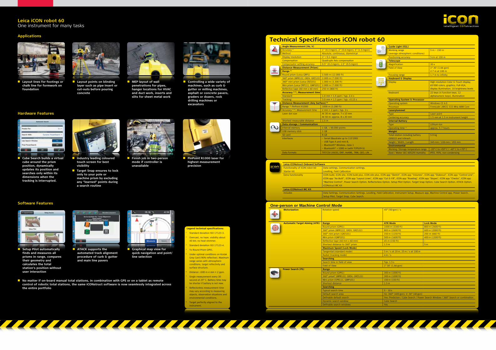
Leica iCON robot 60One instrument for many tasks i n t e l l i g e n t C Ons t r uc t i o n
Technical Specifications iCON robot 60Angle Measurement (Hz, V)Accuracy 1) 1’’ (0.3 mgon), 2’’ (0.6 mgon), 5’’ (1.5 mgon)Method Absolute, continuous, diametricalDisplay resolution 1” / 0.1 mgon Compensation Quadruple Axis compensationCompensator setting accuracy 0.5’’ (0.2 mgon), 1.5’’ (0.5 mgon)Distance Measurement (Prism)Range 2) Round prism (Leica GRP1) 3.500 m (12.000 ft)360° prism (MPR122, GRZ4, GRZ122) 2.000 m (7.000 ft)360° mini prism (Leica CRZ101) 1.000 m (3.300 ft)Mini prism (Leica CRP111, GMP101) 2.000 m (7.000 ft)Reflective tape (60 mm x 60 mm) 250 m (800 ft)Accuracy 3) 4), Measurement timeStandard: 1.0 mm + 1.5 ppm / typ. 2.4 s Tracking: 3.0 mm + 1.5 ppm / typ. <0.15 sDistance Measurement (Any Surface) 8)
Range 5) PinPoint R1000 1000 m (3.280 ft)Accuracy 3) 6), Measurement time 2 mm + 2 ppm / typ. 3 sLaser dot size At 30 m: approx. 7 x 10 mm
At 50 m: approx. 8 x 20 mmShortest measurable distance 1.5 mData storage / CommunicationInternal memory 1 GB, > 50.000 pointsUSB memory stick 1 GB SD card 8 GBInterfaces – Serial (Baudrate up to 115’200)
– USB Type A and mini B, – Bluetooth® Wireless, class 1 – Bluetooth® > 1000 m (with TCPS29-S)
Data formats TXT/CSV (ASCII), DXF, HeXML, TRM, GEO, LIN
Guide Light (EGL)Working range (average atmospheric conditions)
5 m – 150 m
Positioning accuracy 5 cm at 100 mTelescopeMagnification 30 xField of View 1° 30’ (1.66 gon)
2.7 m at 100 mFocusing range 1.7 m to infinityKeyboard & DisplayDisplay High resolution Color & Touch display,
65’000 colors, graphics, Full-VGA, display illumination, 10 brightness levels
Keyboard 22 keys (4 function keys, 12 alphanumeric keys), illumination
Operating System & ProcessorOperating system Windows CE 6.0Processor Freescale i.MX31 533 MHz ARM CoreLaserplummetType Laser pointCentering accuracy 1.5 mm at 1.5 m Instrument heightInternal BatteryType Lithium-IonOperating time 7) approx. 5-7 hoursWeightTotal station including battery GEB222 and tribrach
5.9 kg
Height / Width / Length 345 mm / 226 mm / 203 mmEnvironmentalWorking / Storage temperature range -20° C to +50° C / -40° C to +70° CDust / Water (IEC 60529) Humidity IP55, 95%, non condensing
i n t e l l i g e n t C Ons t r uc t i o n
Leica iCONstruct Onboard SoftwareFunctionality of iCON robot 60Starter Kit
Data settings, Communication settings, Levelling, Field Calibration
Extra functionality iCON build, iCON site, iCON build plus, iCON site plus, iCON app "Sketch", iCON app "Volumes", iCON app "Stakeout", iCON app “Control Line”, iCON app “As-Built”, iCON app "Layout Lines", iCON app "Cut & Fill", iCON app "Roading", iCON app "Slopes", iCON app "Checks", iCON app “Machine Control”, Power Search Option, Reflectorless Option, Setup Pilot Option, Target Snap Option, Cube Search Option, ATACK Option, iCONstruct MC Kit
Leica iCONstruct MC KitIncludes Data Settings, Communication Settings, Levelling, Field Calibration, Instrument Setup, Measure app, Machine Control app, Power Search,
Setup Pilot, Target Snap, Cube Search.
Legend technical specifications:1 Standard deviation ISO 17123-3.2 Overcast, no haze, visibility about
40 km; no heat shimmer.3 Standard deviation ISO 17123-4.4 To Round Prism GPR1.5 Under optimal conditions on Kodak
Grey Card (90% reflective). Maximum range varies with atmospheric conditions, target reflectivity and surface structure.
6 Distance >500 m 4 mm + 2 ppm.7 Single measurement every 30
second at 25° C. Battery time may be shorter if battery is not new.
8 Reflectorless measurement time may vary according to measuring objects, observation situations and environmental conditions.
9 Target perfectly aligned to the instrument.
Applications
Layout lines for footings or chalk line for formwork on foundation
Layout points on blinding layer such as pipe insert or cut-outs before pouring concrete
Hardware Features
Cube Search builds a virtual cube around the prism position, dynamically updates its position and searches only within its dimensions when the tracking is interrupted.
Industry leading coloured touch screen for best visibility
Target Snap ensures to lock only to your pole or machine prism by excluding any “learned” points during a search routine
Finish job in two-person mode if controller is unavailable
PinPoint R1000 laser for highest measurement precision
Software Features
Setup Pilot automatically finds and measures all prisms in range, compares their geometry and calculates the total station’s position without user interaction
ATACK supports the automated track alignment procedure of curb & gutter and main line pavers
Graphical map view for quick navigation and point/line selection
No matter if on-board manual total stations, in combination with GPS or on a tablet as remote control of robotic total stations, the same iCONstruct software is now seamlessly integrated across the entire portfolio
MEP layout of wall penetrations for pipes, hanger locations for HVAC and duct work, inserts and slits for sheet metal work
Controlling a wide variety of machines, such as curb & gutter or milling machines, asphalt or concrete pavers, graders or dozers, rock drilling machines or excavators
Motorization Rotation speed 45° (50 gon) / s
Automatic Target Aiming (ATR) Range ATR Mode Lock ModeRound prism (GPR1) 1000 m (3300 ft) 800 m (2600 ft)360° prism (MPR122, GRZ4, GRZ122) 800 m (2600 ft) 600 m (2000 ft)360° mini prism (GRZ101) 350 m (1150 ft) 200 m (660 ft)Mini prism (GMP101) 500 m (1600 ft) 400 m (1300 ft)Reflective tape (60 mm x 60 mm) 45 m (150 ft) –Shortest distance to 360° prism 1.5 m 5 mMaximum Speed (Lock Mode)Tangential (standard mode) 5 m / s at 20 m, 25 m / s at 100 mRadial (tracking mode) 4 m / sSearchingSearch time in field of view Typ. 1.5 sField of View 1° 30’ (1.66 gon)
Power Search (PS) RangeRound prism (GPR1) 300 m (1000 ft)360° prism9 (MPR122, GRZ4, GRZ122) 300 m (1000 ft)Mini prism (CPR111, GMP101) 100 m (330 ft)Shortest distance 1.5 mSearchingTypical search time 5 – 10 sDefault search area Hz: 360° (400 gon), V: 36° (40 gon)Definable default search Yes: Prediction / Cube Search / Power Search Window / 360° Search or combinationDynamic search window Cube SearchDefinable search windows Yes
One-person or Machine Control Mode