Lesson 2: Tracking Albatross Migrations - Oikonos...Albatross were also tracked from a migration “hotspot” off central California, Cordell Bank. Albatross do not nest off Califor\൮ia
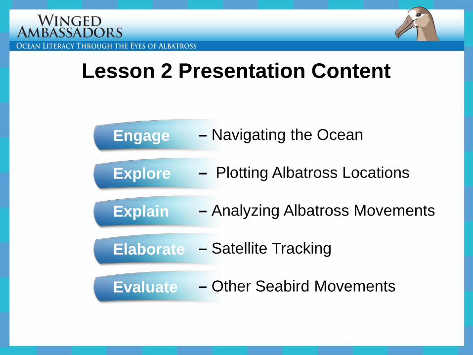
– Navigating the Ocean – Plotting Albatross Locations – Analyzing Albatross Movements – Satellite Tracking – Other Seabird Movements
Engage Navigating the Ocean
A crucial skill for ocean exploration is to map your location, often with no landmarks.
Skilled sailors are able to navigate using the stars, sun, ocean conditions (wind, waves), and other natural cues (such as seabirds and clouds).
Painting by Herb Kawainui Kane
Presenter
Presentation Notes
Discuss with students the challenges and specialized skills needed to traverse the Oceans without electronic navigational equipment, e.g., GPS and radar. This painting shows a traditional double-hulled voyaging canoe used historically and today in Hawai‘i.
Oceanographers navigate the ocean using a variety of technological tools such as radar, sonar, and satellite communication.
Presenter
Presentation Notes
Discuss with students the features and capabilities of modern research vessels (e.g., navigation: notice antennas; propulsion, notice chimneys; research equipment, notice a-frame and winches to deploy / retrieve nets and instruments; and safety equipment, notice safety-rings, fire extinguishers in red boxes, and safety inflatable boat),
Satellites are important in the scientific study of the oceans and marine life
Presenter
Presentation Notes
Technologies used in science vary widely. Satellites, such as the one shown here, have become incredibly important tools for remote sensing of the Earth, communication and data transmission to / from vessels (including satellite tracking of animals).
Seabirds, especially albatross, spend most of their lives at sea.
Presenter
Presentation Notes
Scientists have long wondered where albatross travel.
Where do they go?
Presenter
Presentation Notes
We can visit islands where they raise chicks to learn about their life on land, but they travel too fast and too far to follow by boat or plane in the ocean – where albatross spend the majority of their life.
The Hypothesis . . .
From many years of boat observations, scientists knew that Hawaiian albatross visited the west coast of North America.
Presenter
Presentation Notes
Scientists collect various data from research vessels such as the number of whales and seabirds seen, the temperature of the ocean at different depths, and the amount of fish in a trawl sample.
The first albatross ever tracked from Hawai‘i confirmed this migration route
Presenter
Presentation Notes
The first birds ever Black-footed Albatross tracked from Hawai‘i– in 1998 by Dave Anderson from Wake Forest University (http://www.wfu.edu/biology/albatross/) - confirmed this migration route. Birds travelled over 9000 km, from their colony to California and back, to feed for their chicks.
Do albatross from other Hawaiian Atolls travel to the same places?
Presenter
Presentation Notes
In 2008, scientists tracked more Black-footed Albatross from Kure Atoll, the oldest and westernmost coral atoll in the Northwestern Hawaiian chain. Each different colored line indicates a single migration path of an individual Black-footed Albatross. Notice that the two original tracks from Tern Island are also shown. Do the birds from the two colonies visit the same places?
Reminds us of a few critical aspects about science: • Scientific knowledge is subject to change.
• Technology and human creativity aid science.
• Hypotheses not supported by data are just as important as hypotheses that are… they both advance our understanding.
A great discovery!
• Scientists used satellite tracking to follow the birds’ movements. • A satellite tag was attached to a few feathers with tape. •The scientists can determine the animals’locations after they are released.
How do we know?
More details on this technology later...
Albatross Wearing a Transmitter
Presenter
Presentation Notes
Technology has enabled us to follow them. Notice the small transmitter taped to this bird’s back feathers and the tiny antenna sticking out. This transmitter send information to a satellite in space.
Explore Plotting Albatross Locations
Now it’s your turn
Use coordinates to track positions of individual albatross on a map of the Pacific Ocean.
Presenter
Presentation Notes
Use coordinates to track positions of individual albatross on a map of the Pacific Ocean.
Plot Albatross Routes from 3 Tagging Sites
Presenter
Presentation Notes
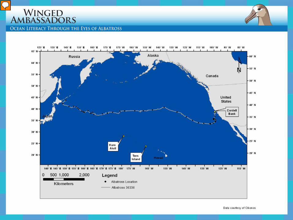
This is the tracking map that students will be using. Point out the three sites where albatross were tagged and other recognizable places to help them orient themselves. Students will be given the latitude and longitude of a series of points, which represent the actual locations of satellite-tracked albatross.
Tagging Site: Kure Atoll Seabird Sanctuary
Presenter
Presentation Notes
Students will learn about birds tracked from the Kure Atoll breeding colony, the most western Hawaiian atoll above sea level. It is a Seabird Sanctuary managed by the State of Hawai‘i in the Papahānaumokuākea Marine National Monument .
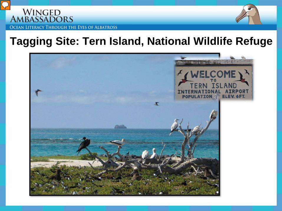
Tagging Site: Tern Island, National Wildlife Refuge
Presenter
Presentation Notes
Students will learn about birds tracked from Tern Island breeding colony, part of French Frigate Shoals, a U.S. National Wildlife Refuge managed by US Fish and Wildlife Service in the Papahānaumokuākea Marine National Monument .
Tagging Site: Waters over Cordell Bank
Presenter
Presentation Notes
Albatross were also tracked from a migration “hotspot” off central California, Cordell Bank. Albatross do not nest off California but many Black-footed Albatross travel there to feed throughout the year, particularly in the late summer after their chicks have grown. Left Photo: Oikonos biologists on a NOAA vessel over Cordell Bank with Black-footed Albatross in the background. The birds were attracted to the boat with squid and fish oil. Right Photo: Oikonos biologist gently holds a Black-footed Albatross on the deck of the research vessel after attaching the tag with sticky tape and glue on a few back feathers between the wings. The tag falls off when the tape wears out or when the bird replaces its feathers in a few months.
A Quick Review - Latitude
• Measured in degrees north or south of the equator (line of 0 °latitude).
• Lines of latitude run
parallel to the equator.
A Quick Review - Longitude
• Measured in degrees east or west of the Prime Meridian (line of 0 °longitude).
• Lines of longitude
meet at the north and the south poles.
Presenter
Presentation Notes
Unlike lines of latitude, longitude meridians are not parallel to each other.
Explain Analyzing Albatross Movements
Presenter
Presentation Notes
Example of a Black-footed Albatross that was tagged in Tern island (Hawai‘i), crossed the entire North Pacific Ocean to visit California, and returned to its colony. This bird was breeding and returned home to feed its chick. Remember: each day’s noon position is labeled with a black dot. When consecutive dots are closer together, the bird is travelling more slowly. When consecutive dots are farther apart, the bird is travelling faster.
Presenter
Presentation Notes
Example of three Black-footed Albatross that were tagged in Kure Atoll (Hawai‘i), went to the northwest and returned to their colony. These birds were breeding and returned home to feed their chicks. Ask the class to consider: why did none of these birds go to California?
Presenter
Presentation Notes
Example of a Black-footed Albatross that was tagged in Kure Atoll (Hawai‘i), crossed the North Pacific Ocean and ended up off Japan. This bird bred in Kure and then migrated to Japan, where it spent the summer foraging. Remember: each day’s noon position is labeled with a black dot. When consecutive dots are closer together, the bird is travelling more slowly. When consecutive dots are farther apart, the bird is travelling faster.
Presenter
Presentation Notes
Another example of a Black-footed Albatross that was tagged in Kure Atoll (Hawai‘i), crossed the North Pacific Ocean and ended up in the Gulf of Alaska. This bird bred in Kure and then migrated to Alaska, where it spent the summer foraging. Remember: each day’s noon position is labeled with a black dot. When consecutive dots are closer together, the bird is travelling more slowly. When consecutive dots are farther apart, the bird is travelling faster.
Presenter
Presentation Notes
Another example of a Black-footed Albatross that was tagged in Kure Atoll (Hawai‘i), crossed the North Pacific Ocean and ended up in the Gulf of Alaska. This bird bred in Kure and migrated to Alaska, and moved around a great deal, even coming down to Canada and Washington State. Remember: each day’s noon position is labeled with a black dot. When consecutive dots are closer together, the bird is travelling more slowly. When consecutive dots are farther apart, the bird is travelling faster.
Presenter
Presentation Notes
Example of a Black-footed Albatross that was tagged in Cordell Bank (California), crossed the entire North Pacific Ocean and ended up off Japan. This bird was tagged at a feeding area during summer and was free to travel across the entire ocean because it did not have a chick waiting to be fed at the colony.
Presenter
Presentation Notes
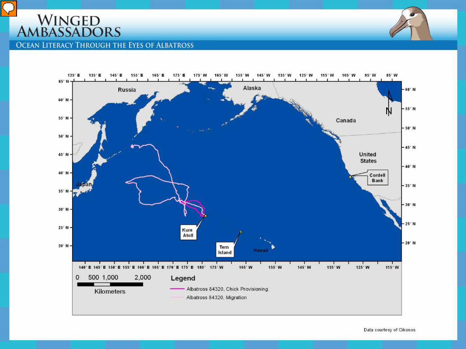
Example of movements of the same Black-footed Albatross tagged in Kure Atoll (Hawai‘i). This bird went to the northwest to forage and returned to the colony to feed the chick one last time. Then, the bird started its post-breeding migration and was free to travel far away, without having to return to the colony. Ask the class to consider: why did this bird not go to California?
12 Albatross Mapped – by Tag ID
Presenter
Presentation Notes
This is a map of all 12 albatross tracks in the Lesson 2 Handout. Each Tag ID is listed in the legend and individually colored.
Elaborate Satellite Tracking
Radio Tracking
Presenter
Presentation Notes
For many years biologist have used tags that send out a radio signal. This required a person, stationed on a mountain top or a plane, to be patiently listening with headphones for a “ping”. Here a biologist in Antarctica is listening with a radio antenna for penguins tagged with a radio transmitter to return home.
Satellite Tracking
Graphic from The Albatross Project, Wake Forest University
Presenter
Presentation Notes
Satellites can “hear” or receive the signal from satellite tags (if the batteries are still working) and send the data to a processing center, where they are decoded and sent to your computer by email. This technology is better than radio tracking for learning about far ranging animals because it can cover the entire world, but it is much more expensive.
Evaluate Other Seabird Movements
The Pink-footed Shearwater nests in Chile and migrates to ?
The Pink-footed Shearwater raises chicks on islands off Chile. One colony is on the famous Robinson Crusoe Island. How far do these birds migrate?
Presenter
Presentation Notes
The Pink-footed Shearwater raises chicks on islands off Chile. One colony is on the famous Robinson Crusoe Island.� �A track of this shearwater is provided that was captured and tagged at sea off southern California . Will this bird return to its breeding colony in Chile?
Use Agreement This presentation was developed for Cordell Bank National Marine Sanctuary and Papahānaumokuākea Marine National Monument by Meghan Marrero of Mercy College and Oikonos - Ecosystem Knowledge. Teachers, educators, researchers and students may incorporate these materials into their lesson plans, presentations, and worksheets in hard copy and digital format for internal educational use only, not into any publication for external distribution. All photos, art, video and data have been contributed free of charge to create this product for educational use. Content may be copyrighted and/or owned by individuals and entities other than, and in addition to, NOAA and Oikonos. Credits for all the media are embedded or included, please retain credits when reproducing. No organization or person (whether an educational body or not) may incorporate this material into any media for promotional or commercial purpose whatsoever. Please contact Oikonos or NOAA to request further use of any images, art, video, data or text included in this presentation – we will contact contributing authors.
All resources for this curriculum are available at :
www.cordellbank.noaa/gov/education/teachers.html
www.papahanaumokuakea.gov/education/wa.html
www.oikonos.org/education
Presenter
Presentation Notes
Use Agreement This presentation was developed for Cordell Bank National Marine Sanctuary and Papahānaumokuākea Marine National Monument by Meghan Marrero of Mercy College and Oikonos - Ecosystem Knowledge. �Teachers, educators, researchers and students may incorporate these materials into their lesson plans, presentations, and worksheets in hard copy and digital format for internal educational use only, not into any publication for external distribution. ��All photos, art, video and data have been contributed free of charge to create this product for educational use. Content may be copyrighted and/or owned by individuals and entities other than, and in addition to, NOAA and Oikonos. Credits for all the media are embedded or included, please retain credits when reproducing.��No organization or person (whether an educational body or not) may incorporate this material into any media for promotional or commercial purpose whatsoever. ��Please contact Oikonos or NOAA to request further use of any images, art, video, data or text included in this presentation – we will contact contributing authors. Contact: [email protected] �All resources for this curriculum are available at : www.cordellbank.noaa/gov/education/teachers.html www.papahanaumokuakea.gov/education/wa.html� www.oikonos.org/education
Engage – Navigating the Ocean 1. Navigation without Landmarks 2. Navigating by natural cues 3. Navigating by various technologies 4. Satellite Technology is Important to Ocean Science 5. Soaring Albatross 6. Observing Wildlife From a Boat 7. Map of First Albatross Tracks 8. Map of New Albatross Tracks 9. A Great Discovery 10. How Birds are Tracked 11. Albatross with a Transmitter
Explore – Plotting Albatross Locations
1. Map of One Albatross – Your Turn to Plot 2. 3 Tagging Sites on the Blank Student Map 3. Kure Atoll site 4. Tern Island site 5. Cordell Bank site 6. Latitude Illustration 7. Longitude Illustration
Explain – Analyzing Albatross Movements 1. 6 Maps of Individual Albatross Plotted by the
Students 2. Map comparing the tracks of an Albatross migrating
vs. feeding a chick 3. All 12 tracks in Student Handout
Elaborate – Satellite Tagging
1. Radio Tracking 2. Satellite Tagging Evaluate – Other Seabird Movements 1. Pink-footed Shearwater 2. Breeding Colony in Chile