lewis county field trip - lanslides
DESCRIPTION
Landslide site visitsTRANSCRIPT
Landslide Field Trip to Morton, Glenoma, and Randle, Lewis County,
Washington
NA
TU
RA
LR
ES
OU
RC
ES
by Isabelle Y. Sarikhan and Trevor A. Contreras
WASHINGTON DIVISION OF GEOLOGY
AND EARTH RESOURCESOpen File Report 2009-1
January 2009
Washington State Section of the Association of Environmental & Engineering Geologists

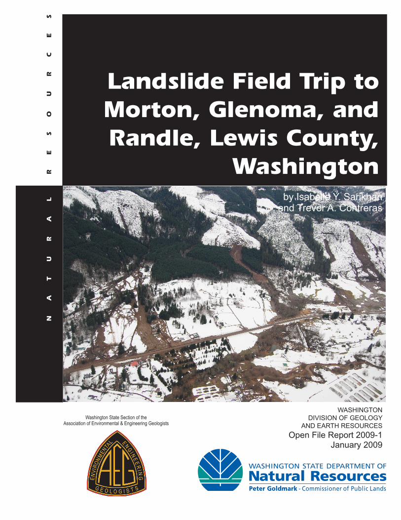
Cover Photo: Aerial photo of Stop 4, about 8 miles west of Randle, showing numerous debris fl ow covering US12 with hyperconcentrated fl ows. Taken by DNR geologists on January 10, 2009.
Landslide Field Trip to Morton, Glenoma, and Randle, Lewis County,
Washingtonby Isabelle Y. Sarikhan and Trevor A. Contreras
WASHINGTONDIVISION OF GEOLOGY
AND EARTH RESOURCESOpen File Report 2009-1
January 2009
This report has not been edited or reviewed for conformity withDivision of Geology and Earth Resources standards and nomenclature
Washington State Section of theAssociation of Environmental & Engineering Geologists
DISCLAIMERNeither the State of Washington, nor any agency thereof, nor any of their employees, makes any warranty, express or implied, or assumes any legal liability or responsibility for the accuracy, completeness, or usefulness of any information, apparatus, product, or process disclosed, or represents that its use would not infringe privately owned rights. Reference herein to any specifi c commercial product, process, or service by trade name, trademark, manufacturer, or otherwise, does not necessarily constitute or imply its endorsement, recommendation, or favoring by the State of Washington or any agency thereof. The views and opinions of authors expressed herein do not necessarily state or refl ect those of the State of Washington or any agency thereof.
WASHINGTON DEPARTMENT OF NATURAL RESOURCESPeter Goldmark—Commissioner of Public Lands
DIVISION OF GEOLOGY AND EARTH RESOURCESDavid K. Norman—State GeologistJohn P. Bromley—Assistant State Geologist
Washington Department of Natural ResourcesDivision of Geology and Earth Resources
Mailing Address: Street Address:PO Box 47007 1111 Washington St SEOlympia, WA 98504-7007 Natural Resources Bldg, Rm 148 Olympia, WA 98501Phone: 360-902-1450Fax: 360-902-1785E-mail: [email protected]: http://www.dnr.wa.gov/AboutDNR/Divisions/GER/
This and other DGER publications are available online at:http://www.dnr.wa.gov/ResearchScience/Topics/GeologyPublicationsLibrary/Pages/pubs.aspx
The bibliography of the Washington Geology Library is at: http://www.dnr.wa. gov/ResearchScience/Topics/GeologyPublicationsLibrary/Pages/washbib.aspx
Published in the United States of America© 2009 Washington Division of Geology and Earth Resources
1
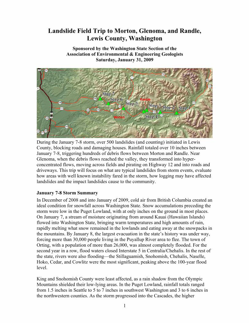
Landslide Field Trip to Morton, Glenoma, and Randle, Lewis County, Washington
Sponsored by the Washington State Section of the Association of Environmental & Engineering Geologists
Saturday, January 31, 2009
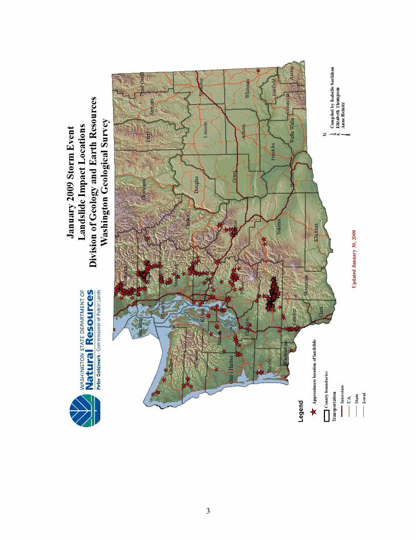
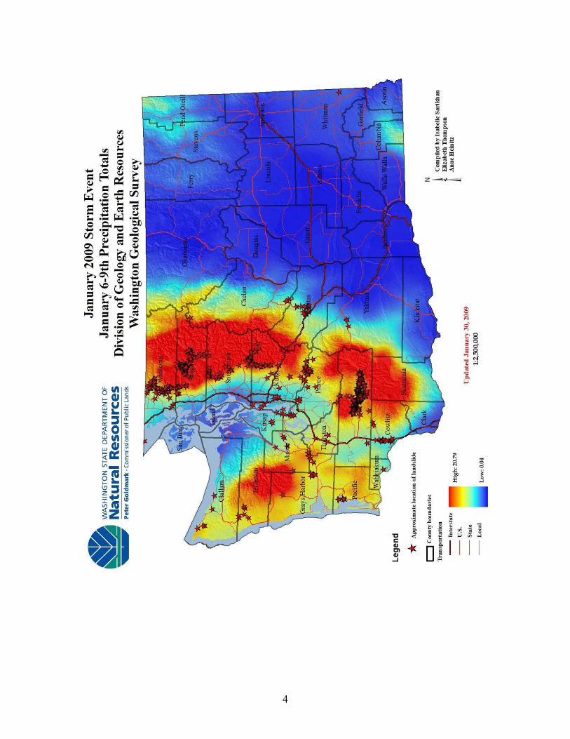
During the January 7-8 storm, over 500 landslides (and counting) initiated in Lewis County, blocking roads and damaging houses. Rainfall totaled over 10 inches between January 7-8, triggering hundreds of debris flows between Morton and Randle. Near Glenoma, when the debris flows reached the valley, they transformed into hyper- concentrated flows, moving across fields and pirating on Highway 12 and into roads and driveways. This trip will focus on what are typical landslides from storm events, evaluate how areas with well known instability fared in the storm, how logging may have affected landslides and the impact landslides cause to the community. January 7-8 Storm Summary In December of 2008 and into January of 2009, cold air from British Columbia created an ideal condition for snowfall across Washington State. Snow accumulations preceding the storm were low in the Puget Lowland, with at only inches on the ground in most places. On January 7, a stream of moisture originating from around Kauai (Hawaiian Islands) flowed into Washington State, bringing warm temperatures and high amounts of rain, rapidly melting what snow remained in the lowlands and eating away at the snowpacks in the mountains. By January 8, the largest evacuation in the state’s history was under way, forcing more than 30,000 people living in the Puyallup River area to flee. The town of Orting, with a population of more than 26,000, was almost completely flooded. For the second year in a row, flood waters closed Interstate 5 in Centralia/Chehalis. In the rest of the state, rivers were also flooding—the Stillaguamish, Snohomish, Chehalis, Naselle, Hoko, Cedar, and Cowlitz were the most significant, peaking above the 100-year flood level. King and Snohomish County were least affected, as a rain shadow from the Olympic Mountains shielded their low-lying areas. In the Puget Lowland, rainfall totals ranged from 1.5 inches in Seattle to 5 to 7 inches in southwest Washington and 3 to 6 inches in the northwestern counties. As the storm progressed into the Cascades, the higher
2
elevation forced the clouds to release water as they moved over the mountains, leaving more than 20 inches of rain in two days. The rainfall saturated slopes, many already wet from melting snow, triggering debris flows and debris avalanches throughout most of western Washington. Areas sensitive to high-intensity storms, such as Glenoma, Concrete, and Van Zandt, were the site of numerous large debris flows, blocking roads, limiting emergency response, and destroying homes. In the end, more than 1,500 landslides were reported or recorded from Washington Division of Geology and Earth Resources (DGER) field and aerial surveys. During the storm, DGER geologists were in the field investigating and documenting landslides, with the public safety as the main objective. In addition, DGER worked with citizens, cities, counties, and state agencies to centralize data and supply real-time landslide data to emergency operations to help manage the disaster. Our “Report a Landslide” website allowed citizens to report imminent or ongoing landslide danger to houses and infrastructure or from impoundments in streams and rivers.
3
4
5
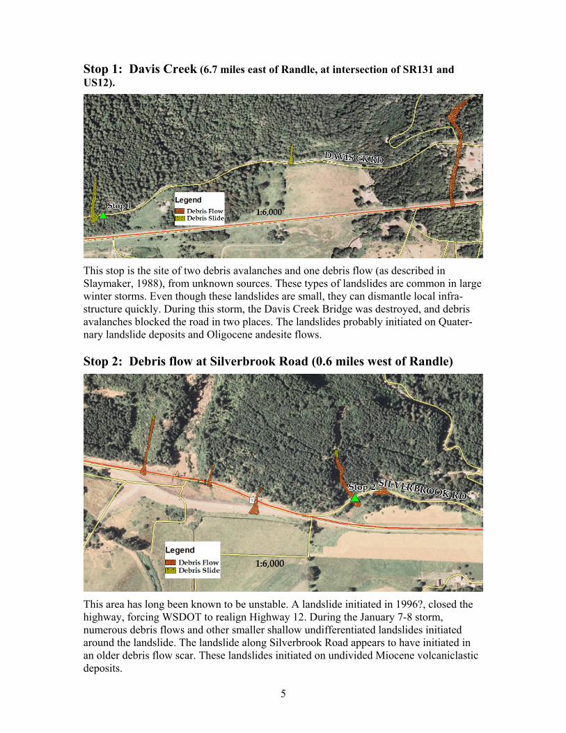
Stop 1: Davis Creek (6.7 miles east of Randle, at intersection of SR131 and US12).
This stop is the site of two debris avalanches and one debris flow (as described in Slaymaker, 1988), from unknown sources. These types of landslides are common in large winter storms. Even though these landslides are small, they can dismantle local infra- structure quickly. During this storm, the Davis Creek Bridge was destroyed, and debris avalanches blocked the road in two places. The landslides probably initiated on Quater- nary landslide deposits and Oligocene andesite flows. Stop 2: Debris flow at Silverbrook Road (0.6 miles west of Randle)
This area has long been known to be unstable. A landslide initiated in 1996?, closed the highway, forcing WSDOT to realign Highway 12. During the January 7-8 storm, numerous debris flows and other smaller shallow undifferentiated landslides initiated around the landslide. The landslide along Silverbrook Road appears to have initiated in an older debris flow scar. These landslides initiated on undivided Miocene volcaniclastic deposits.
6
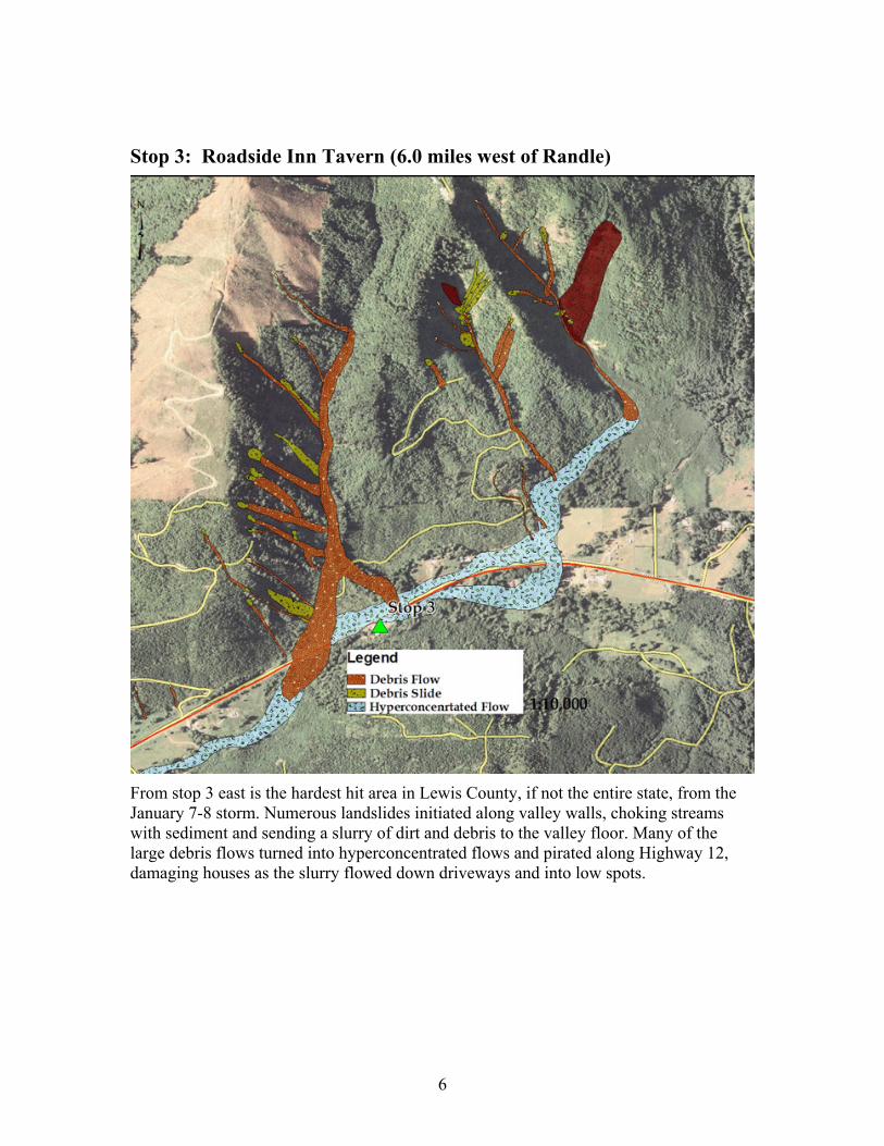
Stop 3: Roadside Inn Tavern (6.0 miles west of Randle)
From stop 3 east is the hardest hit area in Lewis County, if not the entire state, from the January 7-8 storm. Numerous landslides initiated along valley walls, choking streams with sediment and sending a slurry of dirt and debris to the valley floor. Many of the large debris flows turned into hyperconcentrated flows and pirated along Highway 12, damaging houses as the slurry flowed down driveways and into low spots.
7
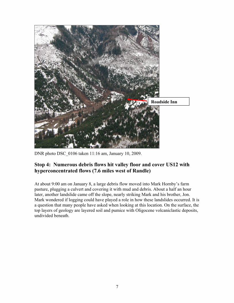
DNR photo DSC_0106 taken 11:16 am, January 10, 2009. Stop 4: Numerous debris flows hit valley floor and cover US12 with hyperconcentrated flows (7.6 miles west of Randle) At about 9:00 am on January 8, a large debris flow moved into Mark Hornby’s farm pasture, plugging a culvert and covering it with mud and debris. About a half an hour later, another landslide came off the slope, nearly striking Mark and his brother, Jon. Mark wondered if logging could have played a role in how these landslides occurred. It is a question that many people have asked when looking at this location. On the surface, the top layers of geology are layered soil and pumice with Oligocene volcaniclastic deposits, undivided beneath.
Roadside Inn
8
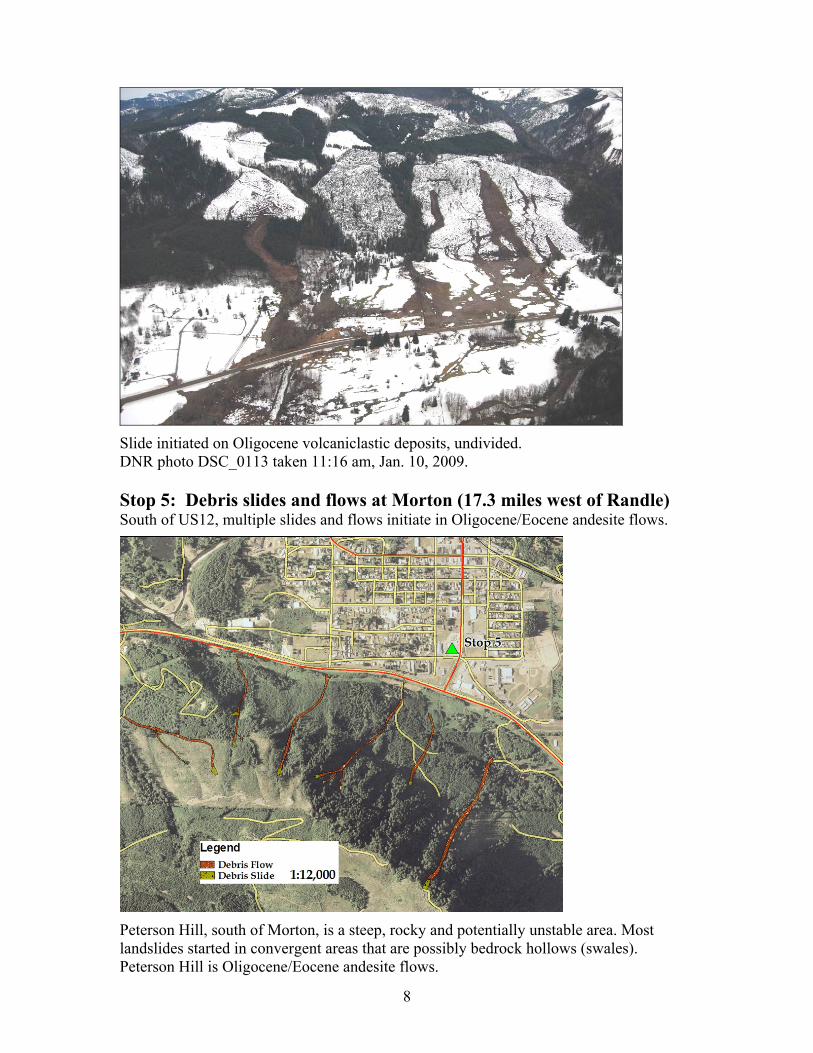
Slide initiated on Oligocene volcaniclastic deposits, undivided. DNR photo DSC_0113 taken 11:16 am, Jan. 10, 2009. Stop 5: Debris slides and flows at Morton (17.3 miles west of Randle) South of US12, multiple slides and flows initiate in Oligocene/Eocene andesite flows.
Peterson Hill, south of Morton, is a steep, rocky and potentially unstable area. Most landslides started in convergent areas that are possibly bedrock hollows (swales). Peterson Hill is Oligocene/Eocene andesite flows.
9
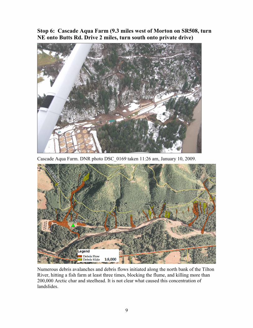
Stop 6: Cascade Aqua Farm (9.3 miles west of Morton on SR508, turn NE onto Butts Rd. Drive 2 miles, turn south onto private drive)
Cascade Aqua Farm. DNR photo DSC_0169 taken 11:26 am, January 10, 2009.
Numerous debris avalanches and debris flows initiated along the north bank of the Tilton River, hitting a fish farm at least three times, blocking the flume, and killing more than 200,000 Arctic char and steelhead. It is not clear what caused this concentration of landslides.
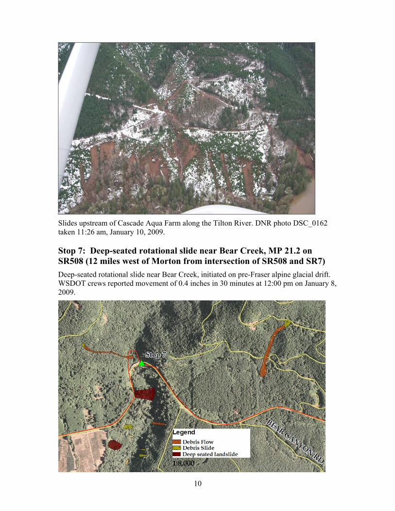
10
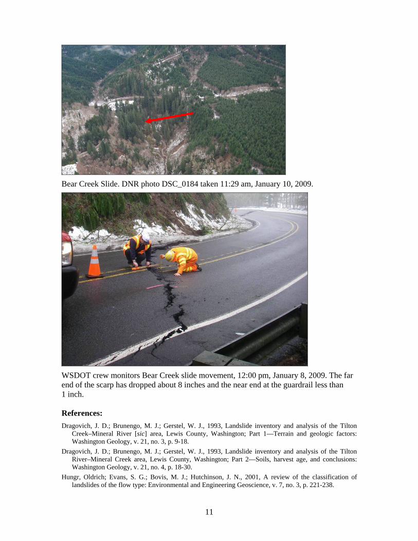
Slides upstream of Cascade Aqua Farm along the Tilton River. DNR photo DSC_0162 taken 11:26 am, January 10, 2009. Stop 7: Deep-seated rotational slide near Bear Creek, MP 21.2 on SR508 (12 miles west of Morton from intersection of SR508 and SR7) Deep-seated rotational slide near Bear Creek, initiated on pre-Fraser alpine glacial drift. WSDOT crews reported movement of 0.4 inches in 30 minutes at 12:00 pm on January 8, 2009.
11
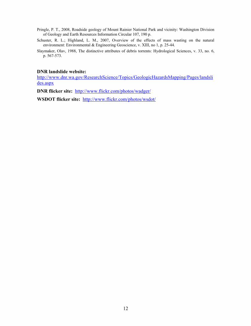
Bear Creek Slide. DNR photo DSC_0184 taken 11:29 am, January 10, 2009.
WSDOT crew monitors Bear Creek slide movement, 12:00 pm, January 8, 2009. The far end of the scarp has dropped about 8 inches and the near end at the guardrail less than 1 inch. References: Dragovich, J. D.; Brunengo, M. J.; Gerstel, W. J., 1993, Landslide inventory and analysis of the Tilton
Creek–Mineral River [sic] area, Lewis County, Washington; Part 1—Terrain and geologic factors: Washington Geology, v. 21, no. 3, p. 9-18.
Dragovich, J. D.; Brunengo, M. J.; Gerstel, W. J., 1993, Landslide inventory and analysis of the Tilton River–Mineral Creek area, Lewis County, Washington; Part 2—Soils, harvest age, and conclusions: Washington Geology, v. 21, no. 4, p. 18-30.
Hungr, Oldrich; Evans, S. G.; Bovis, M. J.; Hutchinson, J. N., 2001, A review of the classification of landslides of the flow type: Environmental and Engineering Geoscience, v. 7, no. 3, p. 221-238.
12
Pringle, P. T., 2008, Roadside geology of Mount Rainier National Park and vicinity: Washington Division of Geology and Earth Resources Information Circular 107, 190 p.
Schuster, R. L.; Highland, L. M., 2007, Overview of the effects of mass wasting on the natural environment: Environmental & Engineering Geoscience, v. XIII, no 1, p. 25-44.
Slaymaker, Olav, 1988, The distinctive attributes of debris torrents: Hydrological Sciences, v. 33, no. 6, p. 567-573.
DNR landslide website: http://www.dnr.wa.gov/ResearchScience/Topics/GeologicHazardsMapping/Pages/landslides.aspx
DNR flicker site: http://www.flickr.com/photos/wadger/
WSDOT flicker site: http://www.flickr.com/photos/wsdot/
13
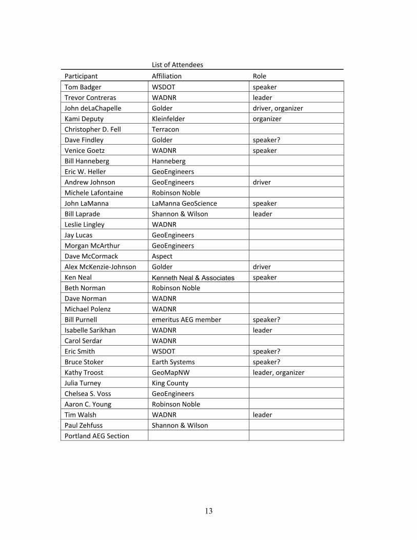
List of Attendees
Participant Affiliation Role
Tom Badger WSDOT speaker Trevor Contreras WADNR leader John deLaChapelle Golder driver, organizer Kami Deputy Kleinfelder organizer Christopher D. Fell Terracon Dave Findley Golder speaker? Venice Goetz WADNR speaker Bill Hanneberg Hanneberg Eric W. Heller GeoEngineers Andrew Johnson GeoEngineers driver Michele Lafontaine Robinson Noble John LaManna LaManna GeoScience speaker Bill Laprade Shannon & Wilson leader Leslie Lingley WADNR Jay Lucas GeoEngineers Morgan McArthur GeoEngineers Dave McCormack Aspect Alex McKenzie‐Johnson Golder driver Ken Neal Kenneth Neal & Associates speaker Beth Norman Robinson Noble Dave Norman WADNR Michael Polenz WADNR Bill Purnell emeritus AEG member speaker? Isabelle Sarikhan WADNR leader Carol Serdar WADNR Eric Smith WSDOT speaker? Bruce Stoker Earth Systems speaker? Kathy Troost GeoMapNW leader, organizer Julia Turney King County Chelsea S. Voss GeoEngineers Aaron C. Young Robinson Noble Tim Walsh WADNR leader Paul Zehfuss Shannon & Wilson Portland AEG Section