living shoreline design - virginia institute of marine … · providing sediment for new habitat,...
TRANSCRIPT

Conference Proceedings
�
Living Shoreline Design
Pho
to c
redi
t: K
aren
Duh
ring
, VIM
S

Living Shoreline Summit
�

Conference Proceedings
�
Integrating Habitat and Shoreline Dynamics Into Living Shoreline Applications
Kevin M. Smith
Riparian and Wetland Restoration, Maryland Department of Natural Resources, Annapolis, MD ���0�, [email protected]
ABSTRACTThe installation of successful living shoreline projects will consider the ecological importance of the
biological and physical processes in maintaining healthy ecosystems along the shoreline. The enhance-ment of habitat along the shoreline and in the nearshore area in mid to high energy environments often requires the incorporation of structural (generally rock) components. The level of habitat improvement is typically dependent on the maintenance of biologic and physical processes and the appropriate integra-tion of structural components.
INTRODUCTIONProtecting shorelines from erosion is a well-studied science and societies have been employing different
methods of shore erosion protection for centuries. In the United States, the Army Corps of Engineers and other organizations have been actively studying different shoreline protection methods for decades. There is substantial information available on the effectiveness of bulkheads and revetments and other highly structural methods in controlling erosion collected by groups such as the U.S. Army Corps of Engineers Coastal and Hydraulics Laboratory in Vicksburg, the Virginia Institute of Marine Science, and the Surf-rider Foundation. When it comes to protecting shorelines from the erosive forces of wind, wave, and tide, there is sufficient knowledge to assure fairly consistent success in limiting impacts.
There are other options now, with considerable interest in Living Shorelines. The use of “Living Shore-line” techniques is an evolving science. There has not been as much study of the different techniques involved in the living shoreline approach in contrast to armored shoreline techniques. Nor has there been much development of guidance to the types of approaches that work best within different ecological set-tings. Therefore, as we move forward to determine what techniques most effectively reduce erosion and provide habitat, we need to also consider how these techniques fit into and work with the natural environ-ment where they will be constructed.
It is important to emphasize that most shoreline property owners are primarily concerned about shore erosion. Contractors and others who provide consultation on shoreline matters are typically only asked to visit a shoreline when there is an erosion “problem.” In many cases, there is no “problem” at all. For the most part, erosion is a natural process and one that is critical to the ecological health of estuarine areas, providing sediment for new habitat, creating new habitat in eroded shores, and if not accelerated through anthropogenic activity, useful in transporting accumulated nutrients and organisms downstream. How-ever, erosion is certainly considered a problem by shoreline property owners who may be losing large areas of property to wave and tidal energies.
Hence, the erosion issue is a critical part in developing a living shoreline project. As a relatively new approach, living shorelines need property owner acceptance and even a few failures can severely impede adoption by other owners for a fledgling erosion strategy. Many owners are skeptical of living shoreline practices and may only be interested if they see that these methods work elsewhere; only then will the methods be employed.
There are many different concepts that define a living shorelines approach. The definition used in this presentation is the following: Living shorelines is a concept based on an understanding and appreciation

Living Shoreline Summit
�0
of the dynamic and inherent ecological value that our natural shorelines provide. Living shoreline projects apply these natural principles in the design and construction of shorelines in order to enhance habitat and maintain shoreline processes.
The important aspects of this definition are: dynamic, function, habitat, and processes. Dynamic implies variable and changing; function is aggregated in inherent ecological value, that includes wave-sediment-flora-fauna interactions at the shore and offshore and downstream of the eroding area; habitat includes the water-land interface (sediment size, water exchange, flora and faunal interactions) that per-mit use of the shore by a suite of bay plants and animals; and processes refers to the hydrology, chemistry, and biotic activities that typify this fluid water-land interface. These are the principles that need to be integrated into the development of living shoreline projects if they are to control erosion and function as sustainable living shorelines.
SITE-SPECIFIC APPROACHESIntegrating these concepts into shoreline protection projects in low energy wave environments can
normally be accomplished without much difficulty. However, developing living shoreline solutions for eroding shorelines in medium and high energy wave environments can be a much more difficult task.
Certain shore erosion strategies will require a higher level of protection than others. Using large rocks can provide a very high level of protection against certain wave climates and specific storm events. Very reliable design structures that are practical in some instances to withstand explicit storm occurrences have been developed; the engineering principles for these are well known and well-tested. However, integrat-ing other variables such as habitat enhancement into these applications may lead to less effective erosion control for these established engineered systems, with the net effect that the established engineering prin-ciples become less reliable. Therefore, developing living shoreline approaches in medium and high energy wave environments can be a balancing act of maintaining a certain level of protection while, at the same time, providing for viable habitat and continuation of natural land-water exchange and processes.
LIVING SHORELINE SUBSTRATESRock, other natural materials, and fibers are often used in living shoreline projects. Rock can be placed
in specific locations and oriented to the winds and waves to dampen wave energies and allow for the maintenance or development of marsh and beach features. In many living shoreline projects, rock is often placed offshore as breakwaters or sills to create marsh or beach between the existing shore and the added rock. This combination of rock and marsh in higher energy wave environments (or other biotic consider-ations) is often referred to as a “hybrid” design. Sills of rock placed parallel to the shore to dampen wave energy can be an effective hybrid approach. Marsh or beach is typically created landward of the sill struc-ture, creating habitat for Bay flora and fauna. However, if not designed and installed correctly, shoreward marsh (and its habitat value) may not develop and the beach may still erode.
The use of gaps, also called windows or tidal gates, in sills have been hypothesized to be effective in providing for habitat and maintenance of shoreline processes if designed and installed correctly. The sill breaks enhance tidal flushing and connectivity and should be maximized, though to date no quantify gate effectiveness studies have been done. If exchange is not facilitated, the areas landward of the sill may be-come ’dead’ zones for aquatic species that cannot exit as the tide ebbs. Appropriate window locations and sizes should be governed by the suite of aquatic organisms likely to utilize the area as well as wind, wave, and tidal conditions specific to each site. More work to establish specific guidance based on ecological and engineering needs is needed in window design.
The skill in designing and building functional living shorelines often has to do with determining the fine line between adequate structural placements (e.g., rock, reefs, sills) balanced with desired habitat area.
Living shorelines may not provide the same level of erosion protection as other more structural practic-es. However, living shoreline techniques should provide for mobility of shoreline and nearshore sediments which may cause seasonal changes to shoreline configuration. As a result, there may be more of a marsh area or beach in one time of the year than another. The systems are dynamic by nature and appropriate

Conference Proceedings
��
living shoreline applications will act as part of the natural system, not against it. Stability in these living shorelines should be viewed much like the ebb and flood of tides or as a seasonal progression of sedimen-tary processes and accompanying habitat forms.
LIVING SHORELINES AND PROPERTY OWNER OBJECTIVES Those opting for Living Shoreline approaches to reducing erosion and enhancing habitat must con-
sider several factors such as:
1. What does the owner hope to achieve; and2. What is the owner willing to do to get it? Or, phrased another way, how much effort is the owner
willing to put into the shoreline?
Effort typically equates to time or money. Highly structural applications can be very successful in stopping immediate, non-event erosion but can also have a similarly high cost. On the other hand, living shoreline approaches may not stop erosion altogether, but, if successful, will reduce erosion to an accept-able degree, enhance habitat, and may be substantially less expensive that high armored endeavors.
As living shoreline methods continue to evolve, guidance needs to be developed that defines when and where specific applications are most effective and applicable and how they can best be constructed to provide environmental benefits.

Living Shoreline Summit
��

Conference Proceedings
��
Overview of Living Shoreline Design Options for Erosion Protection on Tidal Shorelines
Karen A. Duhring
Center for Coastal Resources Management, Virginia Institute of Marine Science, PO Box ����, Gloucester Point, Virginia ��0��-����, [email protected]
ABSTRACTThe term “living shoreline” was recently associated with particular types of shoreline stabilization
methods that emphasize the use of natural habitat features such as deeply rooted riparian vegetation, vegetated wetlands, and sand beaches. This overview of living shoreline design options for tidal tributar-ies describes six nonstructural and four “hybrid” or structural methods for erosion protection. Structures are included with living shoreline design options to make habitat restoration or creation possible without substantial impacts to tidal exchange or habitat functions. The use and effectiveness of other methods not included in this summary are still under investigation, such as oyster shell reefs and pre-cast concrete structures.
INTRODUCTIONErosion Protection MethodsThere are a variety of erosion control methods for tidal shorelines of the Chesapeake Bay depending
on the expected wave climate of a particular shoreline location. The term “shoreline armoring” refers to the practice of installing protective structures such as bulkheads and rock revetments. Erosion protection is the primary purpose for these structures and the permanent loss of natural shoreline habitats tends to be unavoidable where they are installed (1).
Nonstructural methods will stabilize bank erosion and restore wetland habitat in protected, low energy settings. Natural erosion buffers are integral, such as riparian buffers with deeply rooted vegetation, wide tidal marshes, and sand beaches. Successfully using planted tidal marshes and other nonstructural tech-niques depends on the shoreline location and wave climate (2,3). The fetch or distance across open water should be short, the erosion trend moderate, and the water depth near the shoreline should be shallow (4). Plenty of sunlight and existing marshes in the general vicinity also indicate suitable growing conditions for vegetative treatments.
“Hybrid” designs combine advantages of both nonstructural and structural methods. The strategic placement of structures makes restoration or creation of natural erosion buffers possible. In addition to erosion protection, this provides water quality and habitat benefits usually displaced by extensive shore-line armoring (1,5).
What is a “Living Shoreline” Method? The term “living shoreline” is associated with options in the nonstructural and hybrid categories of
stabilization methods. This approach advocates the restoration and enhancement of natural habitat fea-tures that are increasingly needed in developed watersheds (1,6). If functioning riparian buffer and tidal wetland habitats can be sustained instead of replaced by stabilization projects, they will reduce non-point source pollution by filtering ground and surface water runoff and trapping sediment.
Various agencies and organizations have their own working definitions of living shoreline methods to advocate their use (6-8). This concept was previously referred to as the “natural,” “soft,” or “nonstruc-tural” approach. Common themes in these definitions include strategies for managing shoreline erosion

Living Shoreline Summit
��
while also preserving and improving valuable ecosystem services, such as providing habitat for terrestrial and aquatic species and maintaining water quality.
Another shared concept is integrating three distinct yet ecologically connected shoreline habitats - the riparian buffer, tidal wetland, and subtidal area. There is also a consistent reference to gradual slopes to provide optimal growing conditions for vegetation. The strategic placement of structures and other mate-rials such as sand fill and wetland plants should only minimally disrupt normal coastal processes, such as tidal exchange and sediment transport.
Guidelines are available for non-tidal stream bank stabilization using similar methods, but these de-sign options are not readily transferred to estuarine settings (9). The same principles for enhancing natu-ral erosion buffers still apply, but different applications and design specifications are needed to include estuarine habitats. Living shoreline treatments for tidal tributaries must also be able to withstand tidal currents, wind, and wave climates not present in non-tidal settings.
METHODSThe following description of living
shoreline design options for tidal shore-lines includes six nonstructural and four “hybrid” methods commonly used in the Chesapeake Bay region (Table 1). Each description includes the primary design features and the most suitable site characteristics where it can be ap-plied effectively. This information was compiled from existing descriptions and findings from recent studies.
RESULTSNonstructural Design OptionsRiparian Vegetation ManagementActivities to enhance the density or species diversity of stabilizing bank vegetation are referred to col-
lectively as riparian vegetation management. These actions include trimming tree branches overhanging a marsh to increase sunlight, selectively choosing desirable plants for natural regeneration, or planting ad-ditional landscape material to increase cover or diversity. Using vegetation buffers to intercept stormwater runoff from developed areas and controlling invasive species that degrade habitat quality and stabilization effectiveness are also included. Most tidal shorelines are suitable for some type of riparian vegetation management and enhancement activities.
Beach Nourishment and Dune RestorationBeach nourishment is the addition of sand to a beach to raise its elevation and increase its width to
enhance its ability to buffer the upland from wave action. Dune restoration is the process of reshaping and stabilizing a dune with appropriate plants usually after a beach nourishment event. Common plant species for Chesapeake Bay beaches and dunes include Ammophila breviligulata, Panicum amarum, and Spar-tina patens.
These actions are best suited for gently sloping, sandy beach shorelines with low erosion. Beach and bank erosion may still occur during storms. Periodic replenishment is usually needed to maintain the desired beach profile. This method may not provide sufficient protection where no beach currently exists or where tidal currents and wave action remove sand rapidly.
Table 1. Living shoreline design options are divided into nonstruc-tural and “hybrid” methods that include structures to support habitat restoration or creation.
Nonstructural HybridRiparian vegetation
managementMarsh toe revetment
Beach nourishment & dune restoration
Marsh sill
Tidal marsh enhancement Marsh with groinsTidal marsh creation Offshore breakwater system
Bank gradingFiber logs

Conference Proceedings
�5
Tidal Marsh EnhancementTidal marsh enhancement includes adding new marsh plants to barren or sparsely vegetated marsh
areas. Sand fill can be added to a marsh surface to maintain its position in the tide range or to increase its width for more protection. Replacing marsh plants washed out during storms also fits into this category. Less mowing of wetland vegetation can also enhance the stabilizing and habitat features of a tidal marsh.
Shorelines with existing marshes or where marshes are known to have occurred in the recent past may be suitable for this treatment. Water depth and the amount of sunlight available are key factors to con-sider. A wide, gently sloping intertidal area with minimal wave action also indicates suitability.
Tidal Marsh CreationTidal marsh creation can be applied where a natural marsh does not exist. Non-vegetated intertidal
areas can be converted to a tidal marsh by planting on the existing substrate. Because a wide marsh is needed for effective stabilization, this method normally requires either grading the riparian area landward or filling channelward into the subtidal area for a wider intertidal zone. The plant species will depend on the local salinity range plus the depth and duration of tidal flooding. Two common tidal marsh grasses used for this purpose are Spartina alterniflora and S. patens.
The most suitable shorelines for tidal marsh creation have wide, gradual slopes from the upland bank to the subtidal waters, a sandy substrate without anaerobic conditions, and plenty of sunlight. Extensive tree removal in the riparian buffer just to create suitable growing conditions for a tidal marsh should be avoided, especially if the forested bank is relatively stable. Salt marsh plants have a limited tolerance for wave action (10). The wave climate and the frequency and size of boat wakes must also be considered (2,10).
Bank GradingBank grading is a land disturbance activity that physically alters the slope of a shoreline segment,
particularly shorelines with near vertical slopes. A dense cover of deeply rooted vegetation on the graded bank acts as a buffer for upland runoff and groundwater seepage. Stabilization in the wave strike zone can be provided with dense vegetation on the lower portion of the graded bank. Bank grading can also be combined with planted tidal marshes and beach nourishment.
Low eroding banks with only partial or no vegetative cover are particularly suited for bank grading. Confining layers in the bank material and the transition to adjacent shorelines may dictate the extent of possible grading. Surface and groundwater management measures may be needed.
Fiber LogsFiber logs are also known as coir logs or bio-
logs. These biodegradable logs come in a vari-ety of sizes and grades for different applications. They must be aggressively staked into place to prevent them from being lifted and moved by tidal currents and wave action. Fiber logs are particularly useful to temporarily contain sand fill and reduce wave action at planted marsh sites (Fig. 1).
Fiber logs decay in five years or less. They may need to be replaced if the planted marsh does not stabilize before the logs break down. They have also been placed along undercut banks where excessive shading prevents the growth of marsh vegetation. The effectiveness of using fiber logs to reduce the undercutting effect of tidal currents and boat wakes is still under in-vestigation, but it is assumed that they must be inspected regularly and replaced periodically.
Figure 1. Fiber logs provide temporary soil containment and protection for planted marshes until the root system becomes established.

Living Shoreline Summit
��
Hybrid Design Options Marsh Toe RevetmentMarsh toe revetments are low profile structures placed at the eroding edge of an existing tidal marsh.
This approach is also known as marsh edge stabilization. They are typically constructed with quarry stone. If the structure height will exceed the mean high water elevation due to the expected wave height or the target shoreline requires a long continuous structure, then gaps may be needed to facilitate tidal exchange. The most suitable sites for this treatment have existing tidal marshes wide enough to provide upland erosion protection but with an eroding edge and a trend for landward retreat.
Marsh SillMarsh sills are a
similar type of low stone structure, but they are used where no existing marsh is present. Sills are usu-ally located near the low tide line, then backfilled with clean sand to create a suit-able elevation and slope for planted tid-al marsh vegetation (Fig. 2). Like marsh toe revetments, the height of the sill should be near the mean high water el-evation to minimize interruption of tidal exchange.
Eroding banks without a tidal marsh present are candidate sites for marsh sills, particularly if marshes exist in the general vicinity. However, the physical alterations needed to create suitable planting eleva-tions and growing conditions should not require major disturbance to desirable shoreline habitats, such as mature forested riparian buffers or valuable shallow water habitats (e.g., shellfish beds, submerged aquatic vegetation). If bank grading is appropriate to create target slopes, then the bank material can possibly be used to backfill a marsh sill if it is mostly coarse-grained sand. Sand fill can also be imported from an upland source.
Marsh with GroinsUsing short stone groins to support a planted marsh is a similar approach to a marsh sill, except these
structures are placed perpendicular rather than parallel to the shoreline. The groins can be used to con-tain sand fill within the project site. This method is suitable for lower energy shorelines where erosion of the unprotected marsh edge is expected to be minimal, while sills can be used where direct wave action and boat wakes need to be reduced. However, the potential effects on sediment transport and downdrift shorelines need to be considered.
Offshore Breakwater SystemAn offshore breakwater system is a series of freestanding trapezoidal structures strategically positioned
offshore to create a stable beach profile with embayments. Even though they tend to be large and costly projects, offshore breakwater systems are commonly included as a living shoreline approach because they
Figure 2. A typical cross-section for a marsh sill with sand fill and planted tidal marsh vegetation. Marsh toe revetments are similar structures adjacent to natural tidal marshes.

Conference Proceedings
��
include a dynamic, natural beach feature in the design. Non-vegetated beach areas within breakwater systems also provide habitat for terrestrial and aquatic wildlife, including shorebirds, turtles, terrapins, and the northeastern beach tiger beetle. Oysters, mussels, algae, and other reef-dwelling organisms may colonize the shallow water structures.
Suitable sites for offshore breakwater systems are medium and high-energy sand beaches, banks, and bluffs without adequate sand for erosion protection and an historic trend for landward retreat. Like groins, offshore breakwater systems can interrupt longshore sediment transport and adversely affect downdrift shorelines. Beach nourishment and stabilizing beach and tidal marsh vegetation are usually included rather than allowing for natural accretion of sand.
DISCUSSIONThis brief summary includes methods for erosion protection and habitat restoration collectively re-
ferred to as the “living shoreline” approach for tidal shorelines. If shoreline erosion must be stabilized, then choosing the least intrusive yet effective method is the main objective. Nonstructural methods that emphasize the use of dense riparian and wetland vegetation can be applied to many low energy shorelines with minimal wave action or boat wakes. They can also be combined with hybrid methods, such as a marsh sill combined with bank grading and a planted marsh.
The hybrid types of living shoreline design options have several characteristics in common. The struc-tures should be necessary to support habitat enhancement, restoration, or creation. Important coastal processes are also minimally disrupted by properly designed hybrid projects, particularly tidal exchange and sediment transport. Effective hybrid projects provide enough protection without the need for erosion control structures at the riparian-wetland habitat interface if possible. This allows for the landward re-treat of tidal marshes and sand beaches in response to rising sea levels. Connections between riparian and wetland habitats can enhance bank stability in the wave strike zone while also providing wildlife habitat value with food, cover, and vegetated corridors.
Some methods were not included in this summary of living shoreline design options because they are not widely practiced and their effectiveness is still under investigation. Oyster shell reefs can be designed to mimic marsh toe revetments or marsh sills, but it is not clear if uncontained oyster shell is sufficiently resistant to wave action and tidal currents. The placement of oyster shell adjacent to existing or planted marshes to support native oyster restoration efforts is most likely suitable even with limited erosion pro-tection benefits.
Pre-cast concrete structures in various shapes have also been deployed in intertidal and subtidal areas to provide wave dissipation as well as habitat for shellfish and other reef dwellers. “Living walls” for steep bank stabilization is another method commonly applied to upland slopes, but only recently installed on tidal shorelines in Virginia. This engineered system of support structures with planted vegetation is in-tended to provide stabilization without extensive land disturbance and bank grading.
Selecting the most appropriate erosion protection method depends on the level of protection that is desired. Nonstructural and hybrid methods may not provide enough protection in some circumstances. Rock revetments and other defensive structures may be more suitable than a living shoreline approach where upland improvements are at significant risk (e.g., buildings, roads, utilities, septic drain fields, etc.), or where it is necessary to protect public health and safety. Limited construction access for installation and maintenance may also limit possible alternatives.
Depending on the level of protection that is needed, nonstructural and hybrid methods may not al-ways be easier, less costly, or require less maintenance than rock revetments and bulkheads. While this may be the case with tidal marsh enhancement and creation projects, professional design and engineering assistance is usually required. Local knowledge or predictions of tide range, predominant wind direction, and wave height are required for effective designs. The amount of sand fill needed for sills, groins, and breakwater systems has to be accurately calculated to prevent adverse downdrift effects. Predicting how banks should be graded to achieve stable slopes and determining if the bank material is suitable for back-fill also requires professional expertise.

Living Shoreline Summit
��
Wider acceptance of the living shoreline approach with its inherent limitations could shift the current trend for shoreline armoring, particularly in very low energy settings. The guiding principles presented here can assist with the selection of possible alternatives, but site-specific design considerations are also required. Contacting local, state, and federal regulatory agencies for permit requirements is also advisable before any shoreline work is performed.
ACKNOWLEDGMENTSThe author would like to acknowledge David Burke of Burke Environmental Associates, Inc. and Scott
Hardaway from the Virginia Institute of Marine Science (VIMS) for providing treatment descriptions; Carl Hershner, Pam Mason, Kirk Havens, Marcia Berman, and Karen Reay with the VIMS Center for Coastal Resources Management (CCRM) for including these design options in related outreach publica-tions and web sites. Photograph by author. Marsh sill graphic courtesy of Karen Reay, CCRM.
REFERENCES1. National Research Council. 2007. Mitigating Shore Erosion on Sheltered Coasts. The National
Academies Press, Washington DC. 174 pp.
2. Garbisch, E.W. and J.L. Garbisch. 1994. Control of Upland Bank Erosion Through Tidal Marsh Construction on Restored Shores: Application in the Maryland Portion of Chesapeake Bay. Environ. Manage. 18(5):677-691.
3. Hardaway, C. S. Jr. and R.J. Byrne. 1999. Shoreline Management in Chesapeake Bay. Special Report in Applied Marine Science and Ocean Engineering Number 356, Virginia Sea Grant Publication VSG-99-11. October 1999. 54 pp.
4. Luscher, A. and C. Hollingsworth. 2005. Shore Erosion Control: The Natural Approach. Maryland Coastal Zone Management Program, Department of Natural Resources. 12 pp.
5. Burke, D.G., E.W. Koch, and J.C. Stevenson. 2005. Assessment of Hybrid Type Shore Erosion Control Projects in Maryland’s Chesapeake Bay – Phases I & II. Final Report for Chesapeake Bay Trust, Annapolis, Maryland. March 2005. 69 pp.
6. Center for Coastal Resources Management. 2006. Rivers & Coast Newsletter. Winter 2006, Vol. 1, No. 2. 8 pp.
7. Longwood University. 2006. Lower Machodoc Creek Erosion Control Options. www. longwood.edu/ hullspringsfarm/environment/shoreline.htm.
8. Virginia Coastal Zone Management Program Living Shorelines Fact Sheet: www.deq.state.va.us/coastal/documents/lsfactsheet.pdf.
9. Virginia Department of Conservation and Recreation. 2004. The Virginia Stream Restoration and Stabilization Best Management Practices Guide. 211 pp.
10. Perry, J.E., T.A. Barnard, Jr., J.G. Bradshaw, C.T. Friedrichs, K.J. Havens, P.A. Mason, W.I. Priest, III, and G.M. Silberhorn. 2001. Creating Tidal Salt Marshes in the Chesapeake Bay. J. Coast. Res. SI(27):170-191.

Conference Proceedings
��
Recommending Appropriate Shoreline Stabilization Methods for Different Estuarine Shoreline Types
in North Carolina
Bonnie Bendell and The North Carolina Biological and Physical Processes Work Group
NC Division of Coastal Management, ���� Mail Service Center, Raleigh, NC �����, [email protected]
ABSTRACTEstuarine shorelines are dynamic features that experience continued erosion by short and long term
processes. As coastal populations encroach on estuarine shorelines, coastal states have begun to formulate new management strategies for estuarine shoreline erosion. These strategies try to strike a balance be-tween the need to provide property owners with options to protect their investments from coastal hazards and the need to maintain the integrity of the natural system. The North Carolina Division of Coastal Management (NCDCM) concluded that more research and discussion was needed between managers and researchers to effectively address and understand the impact of shoreline stabilization methods on the habitats and productivity of estuarine systems. The NCDCM formed the Estuarine Biological and Physi-cal Processes Work Group to develop recommendations for appropriate shoreline stabilization methods for different shoreline types. The Work Group relied on prior research and best scientific judgment in developing recommendations. The Work Group evaluated the ecological functions and values of the dif-ferent North Carolina shoreline types and the habitat changes due to the physical impacts associated with each shoreline stabilization method. The recommendations of shoreline stabilization methods are based upon the Work Group’s goal of maintaining the current shoreline type and continuation of the current ecological functions and values. The final report has been submitted to the NC Coastal Resources Com-mission Estuarine Shoreline Stabilization Subcommittee to help guide the development of new estuarine shoreline stabilization rules.
INTRODUCTIONEstuarine shorelines are dynamic features that experience continued erosion. Land is lost by short-
term processes, such as erosion by storms, boat wakes, and tidal currents occurring within the long-term process of rising sea level. Rising sea level by itself does not cause loss of land; rather it changes the re-lationship between sea level and land elevation, and is effective in moving the shoreline only where land elevations are quite low. As coastal populations encroach on estuarine shorelines, coastal states have be-gun to formulate new policies and management strategies to address estuarine shoreline erosion. These strategies try to strike a balance between the need to provide property owners with options to protect their investments from coastal hazards and the need to maintain the integrity of the natural system. Various estuarine shoreline-armoring strategies have been examined by coastal states, culminating in the revision of new estuarine shoreline stabilization permitting guidelines.
To protect coastal property, North Carolina has permitted homeowners to armor the waterward bound-ary of their property with vertical and sloped structures such as bulkheads and revetments. These meth-ods are effective, but due to the shoreline-type-specific habitats and structure impacts, it is becoming ap-parent that some stabilization methods are not necessarily appropriate for all shoreline types. The North Carolina Division of Coastal Management (NCDCM) concluded that more research and discussion was needed to more fully address and understand the impact of shoreline stabilization methods on the habi-

Living Shoreline Summit
�0
tats and productivity of estuarine systems. This conclusion was the main motivation for the formation of the Estuarine Biological and Physical Processes Work Group.
The Work Group is a science-based panel specifically charged with the task of developing recommen-dations for an existing array of shoreline stabilization methods for different shoreline types. The members were selected based on research experience and knowledge of the estuarine system. The Work Group re-lied on prior research and best scientific judgment in developing recommendations. Beyond classification and measurement of shoreline recession rates, there has been little research that applies directly to shore-line stabilization methods in North Carolina. The final report includes recommendations that take into account the dynamic nature of the estuarine system and consider the benefits and impacts of shoreline stabilization methods on the biological communities and physical processes. The Estuarine Biological and Physical Processes Work Group Members consisted of:
• Dr. Mark Brinson, East Carolina University, Wetland Ecology/Sea Level Rise• Dr. Martin Posey, University of North Carolina at Wilmington, Benthic Ecology• Tracy Skrabal, North Carolina Coastal Federation, Coastal Erosion• Spencer Rogers, North Carolina Sea Grant, Erosion Control • Dr. Stanley Riggs, East Carolina University, Geology and Estuarine Physical Processes• Anne Deaton, North Carolina Division of Marine Fisheries, Fisheries Biology • David Moye, North Carolina Division of Coastal Management, Rules and Permitting Practices • Bonnie Divito, North Carolina Division of Coastal Management, Coastal Engineer and Work
Group Coordinator
MATERIALS AND METHODSNorth Carolina Estuarine Shoreline TypesShorelines are highly variable in the estuarine system and range from gently sloping land colonized
by hydrophytic vegetation to steeply incised cliffs composed of older sedimentary and rock material (1). The waterline (line of intersection on the land) is not constant and changes due to astronomical and wind tides, creating a shore zone.
The Work Group found that the estuarine shoreline is composed of a diverse array of shoreline types, ranging from organic and sediment bank shorelines to combination shorelines. Combination shorelines, which are a composite of two or more shoreline types, are representative of most of the estuarine shore-lines in North Carolina. This diversity in shoreline types led the Work Group to conclude that a “one rule fits all” strategy is not appropriate. The Work Group decided to approach discussions of impacts/benefits through a list of representative shoreline types according to the classification scheme developed by Riggs (1,2). Using Riggs’ shoreline classification as a guide, eleven shorelines were determined to exist in North Carolina:
• Swamp Forest• Marsh• Marsh with Oysters• Marsh with Mud Flats• Low Sediment Bank with Marsh • Low Sediment Bank with Swamp Forest• Low Sediment Bank with Oysters/SAV (submerged aquatic vegetation)• Low Sediment Bank with Woody Debris• Low Sediment Bank with Sand • High Sediment Bank• Overwash Barrier/Inlet Areas

Conference Proceedings
��
Shoreline Stabilization MethodsBelow is a list of the shoreline stabilization methods (3) and their main purposes considered by the
Work Group. Each of the methods can be constructed using an array of possible materials. Each struc-ture’s main purpose and specific design varies slightly for different geographic regions.
• Land Planning – development projects that incorporate existing or future erosion without the use of any stabilization structure in the development plans.
• Vegetation Control – the use of wetland vegetation plantings to control erosion and dissipate wave energy.
• Beach Fill – placing sand on the shoreline to act as a sacrificial erosive barrier.
• Sill – a coast-parallel rock or sheet pile structure that is designed to protect existing or newly plant-ed wetland vegetation.
• Groin – a coast-perpendicular structure designed to trap sand carried by long shore transport either built singly or in a series.
• Breakwater – a coast-parallel structure that is designed to trap sand and to attenuate wave energy.
• Sloped Structure – a shore-parallel, watertight, or porous structure constructed against a bank to protect the bank from erosion. A sloped structure may also be placed at the toe of wetland vegeta-tion, waterward of the vegetation, for protection against erosion.
• Vertical Structure – a seawall or bulkhead designed to prevent overtopping, flooding, or sliding of the land.
Ecological Assessment Each unique shoreline type differs somewhat in the beneficial ecological functions that it provides. To
assist in the evaluation of the impacts/benefits of the implementation of shoreline management options to the shoreline’s ecological functions, a functional assessment of each shoreline type was completed. This exercise provided a baseline for understanding the importance of individual shoreline types to the estua-rine system. Given that a list of functions was not available specifically for estuarine shorelines, the Work Group drew on the functions of riverine wetlands (4) as a starting point for the list. The definitions were modified to apply to estuarine shorelines and shore zones of North Carolina.
The resulting matrix (Table 1) was scored using three discrete values. The three values were minimal (0), moderate (1), or exceptional (2) functional importance to the estuarine ecosystems. It should be rec-ognized that scores only reflect natural functions and do not imply ecologically superior or inferior condi-tions. Conditions altered by human activities are treated as physical impacts and were evaluated in the physical assessment. To create the matrix, the Work Group applied best scientific judgment and research experience without specific reference to the published research literature.
Physical AssessmentThe physical impact assessment is intended to demonstrate likely results of modifying and altering
natural shorelines and shore zones. The Work Group constructed a table (Table 2) based on scientific judgment and research experience, consisting of the impacts of the different shoreline stabilization struc-tures. This process helped lead to a ranking of the severity of impacts relative to the condition of maintain-ing the natural shoreline types.
RESULTS AND DISCUSSIONThe following rankings (Table 3) are based upon the Work Group’s stated goals of 1) maintaining
the current shoreline type and 2) continuation of current ecological functions and values. Based on these

Living Shoreline Summit
��
Shoreline Types
Hydrologic Functions Biogeochemical Functions
Plant and Animal Community Functions
Sur
face
Wat
er S
tora
ge
Sto
rm B
uffe
r/
Ene
rgy
Dis
sipa
tion
Filtr
atio
n of
P
artic
ulat
es/ B
affli
ng
Gro
undw
ater
Sto
rage
Nut
rient
Ret
entio
n/
Cyc
ling
Bio
tic P
rodu
ctiv
ity
(in s
itu)
Det
rital
Exp
ort/
R
eten
tion
Bio
dive
rsity
/ C
omm
unity
Stru
ctur
e
Hab
itat S
truct
ure/
R
efug
e
Filte
ring
(act
ive)
Fora
ging
/ Nur
sery
Hab
itat D
iver
sity
/ C
onne
ctiv
ity
Uni
que
Hab
itat
High Sediment Bank 0 2 0 2 1 0 0 0 0 0 1 1 2 Swamp Forest 2 2 2 0 2 2 2 2 2 1 2 2 0Marsh 2 2 2 0 2 2 2 2 2 2 2 2 0Marsh with Oysters 2 2 2 0 2 2 2 2 2 2 2 2 0Low Sediment Bank with Swamp
2 2 2 0 2 2 2 2 2 1 2 2 0
Low Sediment Bank with Marsh
2 2 2 0 2 2 2 2 2 1 2 2 0
Low Sediment Bank with Oyster/SAV
0 1 1/2 0 2 2 2 2 2 2 2 2 0
Low Sediment Bank with Woody Debris
0 1 1 0 1 1 1 2 2 0 2 2 0
Low Sediment Bank with Sand
0 1 0 0 1 1 0 1 0 0 1 1 0
Marsh with Mudflats 0 1 1 0 2 2 1 2 1 1 2 1 0Overwash Barrier/Inlet Areas
0 1 0 0 1 1 0 1 0 0 1 1 2
Table 1. Functions of natural shoreline types: (0)=minimal, (�)=moderate, and (�)=exceptional functional impor-tance to estuarine ecosystems.
criteria, the lists of stabilization measures for each shoreline type represent a ranking of options, from the option with the least potential adverse impact to the existing system (ranking of 1), to the option with the greatest potential adverse impact. Since rankings could vary for specific sites or were equal in adverse impacts, some stabilization methods are listed on the same ranking level.
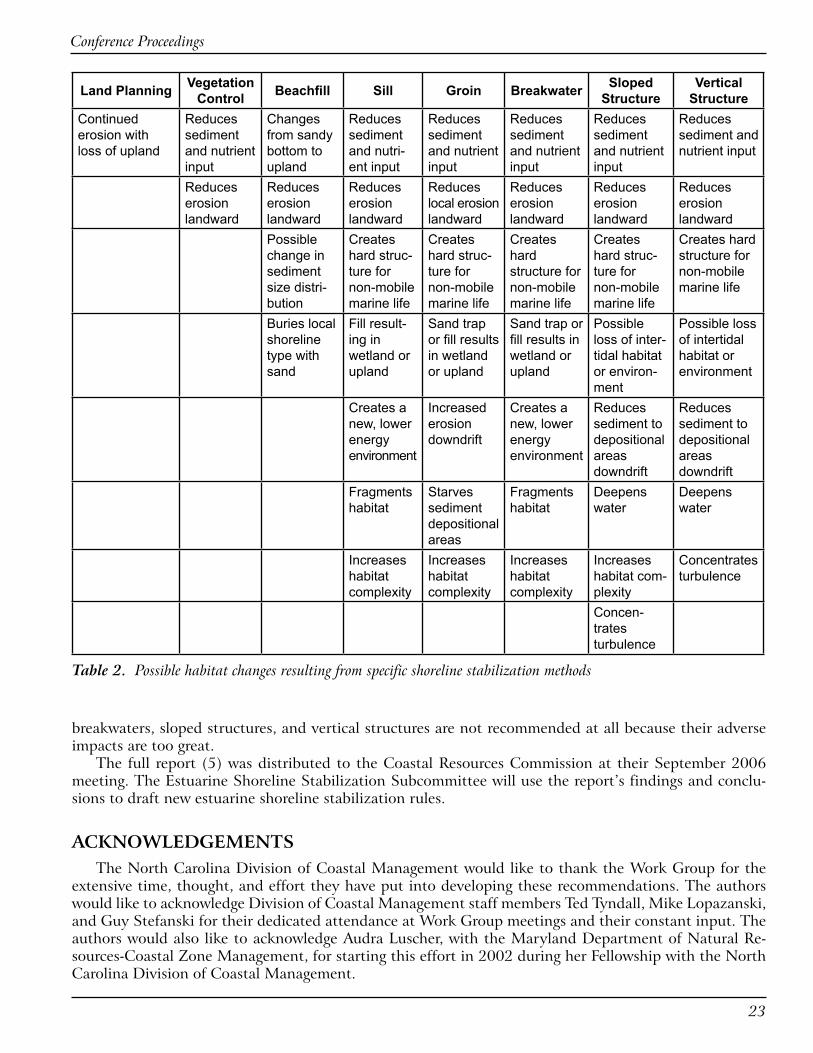
CONCLUSIONSThe recommendations for each of the shoreline types are different with a few consistent similarities.
The number one recommendation for all estuarine shoreline types is land planning (i.e., planning or de-veloping the property around current or possible future erosion of the shoreline). The second recommen-dation is typically vegetation control as a natural and environmentally beneficial stabilization method. Beach fill is usually the third recommended action because of its nonstructural, non-hardening features, but only when it maintains the current shoreline type. Generally speaking, when shoreline-hardening stabilization methods are proposed, the Work Group ranks sills as the most preferred option. In North Carolina, sills are small structures that are always constructed to support wetland plantings, or the conser-vation of existing wetland vegetation. Groins, breakwaters, sloped structures, and vertical structures vary in ranking and were determined to be shoreline-type and site specific. On some shoreline types, groins,
Conference Proceedings
��
Land Planning Vegetation Control Beachfill Sill Groin Breakwater Sloped
StructureVertical
StructureContinued erosion with loss of upland
Reduces sediment and nutrient input
Changes from sandy bottom to upland
Reduces sediment and nutri-ent input
Reduces sediment and nutrient input
Reduces sediment and nutrient input
Reduces sediment and nutrient input
Reduces sediment and nutrient input
Reduces erosion landward
Reduces erosion landward
Reduces erosion landward
Reduces local erosion landward
Reduces erosion landward
Reduces erosion landward
Reduces erosion landward
Possible change in sediment size distri-bution
Creates hard struc-ture for non-mobile marine life
Creates hard struc-ture for non-mobile marine life
Creates hard structure for non-mobile marine life
Creates hard struc-ture for non-mobile marine life
Creates hard structure for non-mobile marine life
Buries local shoreline type with sand
Fill result-ing in wetland or upland
Sand trap or fill results in wetland or upland
Sand trap or fill results in wetland or upland
Possible loss of inter-tidal habitat or environ-ment
Possible loss of intertidal habitat or environment
Creates a new, lower energy environment
Increased erosion downdrift
Creates a new, lower energy environment
Reduces sediment to depositional areas downdrift
Reduces sediment to depositional areas downdrift
Fragments habitat
Starves sediment depositional areas
Fragments habitat
Deepens water
Deepens water
Increases habitat complexity
Increases habitat complexity
Increases habitat complexity
Increases habitat com-plexity
Concentrates turbulence
Concen-trates turbulence
Table 2. Possible habitat changes resulting from specific shoreline stabilization methods
breakwaters, sloped structures, and vertical structures are not recommended at all because their adverse impacts are too great.
The full report (5) was distributed to the Coastal Resources Commission at their September 2006 meeting. The Estuarine Shoreline Stabilization Subcommittee will use the report’s findings and conclu-sions to draft new estuarine shoreline stabilization rules.
ACKNOWLEDGEMENTSThe North Carolina Division of Coastal Management would like to thank the Work Group for the
extensive time, thought, and effort they have put into developing these recommendations. The authors would like to acknowledge Division of Coastal Management staff members Ted Tyndall, Mike Lopazanski, and Guy Stefanski for their dedicated attendance at Work Group meetings and their constant input. The authors would also like to acknowledge Audra Luscher, with the Maryland Department of Natural Re-sources-Coastal Zone Management, for starting this effort in 2002 during her Fellowship with the North Carolina Division of Coastal Management.

Living Shoreline Summit
��
REFERENCES1. Riggs, S.R. 2001. Shoreline Erosion in North Carolina Estuaries. The Soundfront Series. North
Carolina Sea Grant.
2. Riggs, S.R. and D.V. Ames. 2003. Drowning the North Carolina Coast: Sea Level Rise and Estuarine Dynamics. North Carolina Sea Grant.
3. Burcharth, H. and S.A. Hughes. 2002. Types and Functions of Coastal Structures. In: S. Hughes, Coastal Engineering Manual, Part VI, Design of Coastal Project Elements, Chapter VI-2 , Engineer Manual 1110-2-1100, U.S. Army Corps of Engineers, Washington, DC.
4. Brinson, M.M., F.R. Hauer, L.C. Lee, W.L. Nutter, R.D. Rheinhardt, R.D. Smith, and D. Whigham. 1995. Guidebook for Application of Hydrogeomorphic Assessments to Riverine Wetlands. Technical Report TR-WRP DE-11, Waterways Experiment Station, Army Corps of Engineers, Vicksburg, Mississippi. http://el.erdc.usace.army.mil/wetlands/guidebooks.html
5. Bendell, B.M. and The NC Estuarine Biological and Physical Processes Work Group. 2006. Recommendations for Appropriate Shoreline Stabilization Methods for the Different North Carolina Shoreline Types. North Carolina Division of Coastal Management.
Table 3. Summary of ranking of stabilization methods
Swamp Forest or Marsh
Marsh with Oysters or Mudflats
Low Sediment Bank with Marsh or Swamp Forest
Low Sediment Bank with
Woody Debris, Oysters or SAV
Overwash Barrier/Inlet
Areas
Low Sediment Bank with Sand
or High Sediment Bank
1 Land Planning Land Planning Land Planning Land Planning Land Planning Land Planning2 Vegetation
ControlVegetation
ControlVegetation
ControlVegetation
Control
Vegetation Control,
Beach FillBeach Fill
3Beach Fill
Sill, Toe Protection,
Sloped Structure
Sill, Toe Protection,
Sloped Structure Sill Groin Vegetation
Control
4 Sill, Toe Protection,
Sloped StructureGroin
Groin, Break-water, Sloped
Structure, Vertical Structure
Sloped Structure Sill Groin
5 Groin Vertical Structure Breakwater Sill6 Breakwater Sloped Structure Breakwater7 Vertical Structure Sloped Structure8 Vertical Structure

Conference Proceedings
�5
Design Criteria for Tidal Wetlands
Walter I. Priest, III
IM Systems Group, NOAA Restoration Center, Gloucester Point, VA ��0��, [email protected]
ABSTRACTThe design and construction of tidal wetlands can often be a perplexing, mystifying process. Many
of the techniques are solely the domain of practicing professionals which leaves many individuals and organizations at a loss when contemplating a project. This paper attempts to present practical guidelines that can be used by the lay person as well as restoration practitioners for the successful construction of tidal wetlands. These include screening criteria for site selection that will help avoid inherent problems with a particular site and design criteria to guide the development of wetland hydrology and the successful establishment of wetland vegetation.
INTRODUCTIONDuring the course of a number of wetland construction projects over the years, a number of guiding
principles have emerged. Incorporation of these guiding principles or design criteria into a project can have a profound/major impact on the success of a particular project. These principles are applicable to Living Shorelines as well as other wetland restoration situations.
Development of general guidelines for Living Shorelines has been a joint effort of numerous practitio-ners such as Edward Garbisch with Environmental Concern in Maryland (1,2), Stephen Broome at North Carolina State University (3), and others who have pioneered the science of wetlands restoration. They have shared their successes and failures in numerous publications that have benefited many others in the field. James Perry (4) and C. Scott Hardaway (5) at the Virginia Institute of Marine Science (VIMS) have freely shared their experiences as well.
When embarking on a wetland construction project, it is critically important to focus on the objective of the project whether it is shoreline protection, habitat development, restoration, mitigation, or stormwa-ter treatment. Each of these objectives involves slightly different features or approaches that can drive the design. For example, if one’s goal is stormwater treatment, emphasis might be on stormwater residence time while a habitat restoration project might emphasize community diversity and fish access. These characteristics would likely result in different wetland configurations and landscape positions. Living Shorelines designed predominantly to provide erosion protection while also providing desirable ecological functions and values might have increased width and height of the fringing marsh for erosion protection and also habitat for fish and crabs.
I have organized these criteria into a number of categories that should be considered when planning any type of wetland including screening (considered prior to design) and design (addressed during design and construction) criteria. This paper is not intended to be an exhaustive treatise, but rather a detailed checklist of the most important considerations necessary when designing a tidal wetland. Furthermore, it has been my intent to present the information in terms that will be useful to the experienced practitioner as well as the novice.
SCREENING CRITERIAThe first step in the design is a general evaluation to ensure that a project is possible at the site in
general, and no undue impacts will occur as a result of the project.

Living Shoreline Summit
��
• Are there contamination issues at the site?• Are endangered species an issue?• Are cultural resources an issue?• In urban areas, are underground or aerial utilities an issue?• Is there adequate construction access to the site?• Will valuable existing habitat, such as a mature hardwood forest, have to be destroyed to construct
the wetland?
All of these questions need to addressed and resolved prior to proceeding with any detailed design.
DESIGN CRITERIALandscape PositionThe most important aspect of this criterion is fetch, a measure of the exposure of the site to wave ac-
tion. Generally when the fetch exceeds one mile, the chances of success without some type of structural protection are limited. Between one and 0.5 miles, chances improve but some minimal structure, such as biologs, is advisable to help the marsh become established. When the fetch is <0.5 mile, chances of suc-cess without structural toe protection, such as a rock sill, are good. If water quality improvement is part of the restoration objective, it is important that the runoff from the adjacent watershed be directed into or through the wetland as opposed to a simple excavated basin with a limited watershed.
ElevationThe critical elevations for tidal wetlands establishment are mean low water (MLW), the average low
water at the site, mean high water (MHW), the average high water level at the site, mean tide level (MTL), roughly halfway between MLW and MHW, and the upper limit of wetlands (ULW), approximately 1.5 times the mean tide range at the site. These are the important elevations that will dictate the various planting zones within the new marsh.
Design elevations need to be based on a tidal datum such as the National Ocean Service (NOS) MLW and not strictly on a geodetic datum like the North American Vertical Datum of 1988 (NAVD 88). Tidal datums are based on water level observations over a 19 year period (a tidal epoch) where all of the high tides and low tides are averaged to determine MHW and MLW. NAVD 88 is based on the elevation of a fixed point in Canada and is not directly related to tidal elevations. Relationships between tidal and geodetic datums have been established for many locations but can vary widely. The NOS MLW datum used should also be based on the 1983-2001 tidal epoch to help ensure recent sea level rise has been taken into account. More information on tidal elevations and datums can be found at http://tidesandcurrents.noaa.gov/.
Biological benchmarks (BBM) are elevations established by surveying the elevations of representa-tive plant communities in an adjacent reference marsh. These elevations can then be corroborated with the tidal datum to cross reference the design elevations for the wetland. The advantage of incorporating biological benchmarks into the design is that these elevations integrate any vagaries in the local hydrology that might influence the distribution of plant zonation. For example, if there is a hydrologic constriction that prevents the area from draining completely, it can result in a perched mean low water and a concomi-tant compression of the tide range that will affect the success of the plantings.
SlopeFlat slopes in the new marsh are important because they help maximize the plantable area within the
intertidal zone and, where applicable, help dissipate wave energy and reduce erosion potential. Very of-ten the slopes will be dictated by the size of the site, but, where possible they should at least 10:1 (H:V), preferably flatter if possible. In some situations, the intertidal area can be maximized by creating a bench between the creek and the upland that is very flat from MTL to MHW followed by a steeper slope from

Conference Proceedings
��
MHW to the adjacent upland. The slope of this transition zone should also be kept as flat as site condi-tions will allow. In higher wave energy sites where there is steep upland transition, some type of structure may be necessary to stabilize this slope. It is also important for the slopes to provide positive drainage for the site at low tide. If the site does not drain completely and there are large areas of standing water within the area to be planted, plant survival can be compromised. I generally recommend that areas of standing water greater than 100 square feet be avoided unless they are an intentional feature of the design to increase habitat diversity.
HydrologyHydrology is the most important factor in successfully establishing a wetland. Several of the other
important factors, e.g., elevation and slope, can have a direct influence on hydrology as well. To put it simply, to effect wetland hydrology in a tidal wetland, the area must be under water at high tide and dry at low tide. This may sound overly simplistic but it is the essence of tidal wetland hydrology. It is also the easiest way to explain the grading plan to an equipment operator.
Being dry at low tide is just as important as being wet at high tide. The reason that vegetation only grows down to MTL instead of MLW is that the roots need to breathe at low tide in order to survive. The dominant salt marsh plants do not grow well in permanently standing water. If the elevations and drain-age, i.e. hydrology, in your planted marsh mimic the hydrology in the connecting waterway, the plants will adjust accordingly.
If the tidal connection to your site is highly convoluted or culverted, it can produce a phase lag in the hydrology. A phase lag usually results from having too much friction in the discharge channel which does not allow the site to drain effectively. Imagine a typical tidal cycle. At high tide because of the force of the incoming tide, the water levels within your site and those of the connecting waterway are equal. As the tide ebbs, it ebbs more slowly within the site because friction slows down the flow of water to the creek. Consequently, when it is low tide in the creek, there might still be a considerable amount of water waiting to drain from the site. As the tide begins to flood in the creek, it will rise to the level of the still ebbing water from the marsh. This level effectively determines the low water elevation because, from this point, the water begins to rise again within the marsh. The ultimate result of this situation is a higher MLW and a compressed tide range in the new marsh. This can have a dramatic impact on the survivability of the plants if the tidal levels from the adjacent creek, and not the site itself, are the main determinants for the planting elevations. In this regard, projects that involve pipes, tide gates, or other plumbing devices should be carefully evaluated.
SubstrateWhen constructing a new marsh you need to think of the substrate, first and foremost, as the medium
for growing plants. There are other factors such as the amount of organic carbon in the soil that govern functions, like denitrification. However, in the beginning, it is more important to establish the vegeta-tion as rapidly as possible. To do this, the best medium is sand. It provides a good anchor for the plants, allows for rapid root growth and effective drainage. In exposed conditions, coarser sand should be used to minimize transport by wave action. Silt-clay and peat can work but they make planting more difficult and are not as effective at anchoring the plants. Heavy plastic clays should be avoided because of plant-ing difficulties and the impediments to root growth. Likewise, organic amendments, topsoil, and mulch should be avoided in brackish tidal marshes. Once they become wet, they are difficult to plant because they often do not effectively anchor the plants which naturally float and tend to be dislodged by tidal and wave action.
When excavating a new marsh from upland, it is critical that borings be made to the proposed planting elevation to identify the type of substrate that will be exposed for planting. If the substrate at grade is not suitable because of plastic clay, rubble, or Phragmites roots, it will be necessary to over-excavate the site and bring in at least a foot of good clean sand to bring the site back up to the desired elevation.

Living Shoreline Summit
��
ShadeMost wetland plants require a minimum of six hours of direct sun during the growing season. They
require large amounts of energy to cope with the stress of salinity and inundation twice a day. When planting fringing areas, this may require the judicious pruning of the lower branches of adjacent trees to allow for additional sunlight. Trees should only be removed when absolutely necessary. The design should also take into consideration shading from nearby structures and north facing shorelines which can induce unwanted shade. North facing shorelines, particularly forested, tend to receive less sunlight because of the low angle of the sun during the winter, spring, and fall.
Salinity ConsiderationsSite selection should also include an analysis of the local salinity regime. Consideration needs to be
given to annual variation from lower spring to higher summer salinities. Do not depend on a single salin-ity measurement to be indicative of a site unless you are intimately familiar with the area. Also, be mind-ful of flashiness in the system, particularly in head water areas that are susceptible to freshwater pulses following major rain events. Plant selection must be reflective of this salinity regime. Natural vegetation in adjacent similarly situated marshes should be used as a guide to recommend species most likely to be successful. It is also important that the nursery stock to be planted is conditioned to site salinity levels. Plants grown in freshwater at the nursery and planted in high salinity areas can have a difficult time ad-justing, delaying effective establishment of the stand. It can also lead to failure of the planting.
Zonation and Salinity RegimesA general overview of planting zones and
salinity tolerances for some of the more com-monly planted species is provided in Table 1. This is neither exhaustive nor definitive and should be only used as a guide to be tempered by local conditions. Almost anyone will be able to find exceptions to these recommenda-tions, but they will work in a vast majority of situations. It is critical to the success of a project to effectively match plant material, planting zones, and salinity regimes.
Planting Materials and MethodsThe preferred method of planting is nurs-
ery grown plants. These plants are readily available and have an excellent success record. The plants are typically grown in plastic cell packs with 72 plants per flat. The leaves should be a uniform green color with roots that are white and appear to be actively growing. Depending on the age of the plant, it may appear pot bound which is acceptable. Sometimes when the plants are received, the leaves have all been clipped to a uniform height. This is usually done on older plants to facilitate transport. It can also help with plant establishment by reducing initial demands on the root system. When planting, it is important to get the bottom of the plant at least 4 inches deep to effectively anchor the plant. The plants should also be firmly compacted into the soil to eliminate any air pockets. When explaining the planting process to volunteers, it is important to empha-size that the plants are not delicate and cannot be planted too deep or packed down too hard.
Transplants from an existing marsh can be used but are not generally recommended except for small projects with a viable donor marsh. Transplant excavation is a very labor intensive operation because of the dense root system of most plants. When excavating transplants, care must be taken to spread out the plugs removed so as to not unduly impact the donor marsh.
Table 1. Zonation and salinity levels for common wetland plants (see text for zone abbreviations).
Species Inundation Zone Salinity RangeSpartina alterniflora MTL – MHW 5 – 30 pptSpartina patens MHW – ULW 5 – 30 pptSpartina cynosuroides MHW – ULW 0 – 5 pptDistichlis spicata MHW – ULW 10 – 30 pptScirpus americanus MHW – ULW 0 – 15 pptJuncus roemarianus above MHW 10 – 25 pptIva frutescens near ULW 5 – 30 pptBaccharis halimifolia near ULW 0 – 30 pptPanicum virgatum above ULW 0 – 25 pptMyrica cerifera above ULW 0 – 30 ppt
Conference Proceedings
��
Seeding of brackish marshes can be a viable option under the right circumstances. It requires a knowl-edgeable contractor, a very protected site, and a substrate firm enough to support planting vehicles and implements. In tidal freshwater systems, the seed bank of the existing marsh substrate can be a highly effective seed source. In this case, marsh sediments are salvaged during construction, for example from an entrance channel. Once grading is complete, these sediments and seed bank can be incorporated into the new substrate as a means of revegetation.
Volunteers can often be used to do the planting. This works best when working in firm sand and is less successful in soft mucky conditions. The key is the demonstration of the proper planting technique and adequate supervision.
FertilizerIt is very important to get the planted vegetation established as quickly as possible. The faster it be-
comes established, the sooner it can begin functioning within the system. Consequently, the limited use of high nitrogen, slow release fertilizer is typically recommended, e.g., Osmocote 18-6-12. These fertil-izers are placed in the planting hole at the time of planting. Normally, an application of one-half ounce (one tablespoon) per plant is sufficient to establish the plant. Time release is temperature and moisture dependent and different release periods are available. Timing should be based on the amount of growing season remaining, e.g., nine month release for spring planting, six for summer, and three for fall.
Planting TimesThe best time for planting is spring because the plants have the entire growing season to get estab-
lished. But as with any planting, there is always a measure of risk. When planting in the early spring (March), the plants tend to be smaller unless they have been carried over from the previous year. Also, there is a greater chance a spring storm could dislodge the plants. April, May, and June typically are the lowest risk times. Planting in the summer, July, August and much of September, can be risky for high marsh plants with irregular inundation, if there is insufficient rainfall to sustain the plantings and irriga-tion is not available. Low marsh plants should do well except for a slightly shorter growing season. Fall plantings, September and October, are typically successful in protected settings but take longer to achieve complete cover. Plantings in late fall and winter, November, December, January, and February, can also be successful in protected settings, but the risk of damage from storms and winter ice can be significant. The planting of large shrubs and trees should be done in the fall and winter to minimize transpiration stress. Smaller size shrubs typically do better in spring than summer. In short, tidal wetlands can be established during most of the year, but the degree of risk varies substantially. If using optimum planting, fertilizing (see above), spacing, and maintenance (see below) techniques, plants can become established quickly (e.g., Fig. 1a,b).
Spacing1. 1 foot centers – very rapid cover2. 1.5 foot centers - rapid cover3. 2 foot centers – average conditions4. 3 foot centers – large areas5. Alternate species in transition areas6. Plant above and below predicted elevations
Typical plant spacing for restoration projects is 2’ on center. This will usually give complete cover in two full growing seasons. Mitigation projects or those requiring faster cover are normally planted on 1.5’ centers. Closer spacing is seldom necessary and rarely recommended. When planting large areas where rapid cover is not necessary or when cost is a significant issue, a 3’ on center spacing can be effectively used with a resulting delay in reaching full cover.
When planting in transitional areas, like in the vicinity of MHW or ULW, it is advisable to alternate species along the rows both above and below the juncture. This allows the right plants to be available to

Living Shoreline Summit
�0
help accommodate minor variations in topography at critical breaks in slope and community transi-tions.
MaintenanceMany maintenance issues and problems can be
very complex and require the services of wetland professionals. These are beyond the scope of this paper. The use of water control structures, pipes, weirs, tide gates, etc. should be avoided unless ab-solutely necessary. Wetlands should be designed as self-sustaining natural systems. This simplicity is compromised anytime a structure is required that needs maintenance to function properly. Notable exceptions are forebays which are small settling ba-sins typically located where high volume discharges from adjacent watersheds enter a constructed wet-land. These structures can help contain large sedi-ment loads and help modulate flows. However, they do need to be maintained to function effectively.
It is very important to maintain effective ero-sion control in newly established wetlands due to wave action or upland erosion. The effects of a storm event on a newly planted marsh can easily be mitigated with additional plantings. Significant upland erosion that deposits large amount of sedi-ments into a new established wetland can smother plantings. It can also cause hydrological modifica-tions and alter elevations within the wetland that would alter vegetative communities and, perhaps facilitate the invasion of Phragmites.
In areas with populations of the common reed Phragmites australis, extraordinary measures are of-ten necessary to eliminate existing stands and pre-vent recolonization. While there are no guaran-tees, there are a number of techniques which can help limit the risk. Whenever possible, existing stands should be sprayed with an appropriate herbicide prior to construction. During construction, every effort should be made to excavate and remove from the site as much of the Phragmites as possible. This should include over-excavation of at least a foot of material and backfill with clean sand. It is also important to design the majority of the site below MHW. In areas of moderate to high salinity, this can be a very effective deterrent. The creation of a subtidal ditch around the perimeter of the site can also help deter recolonization by rhizomes from adjacent stands. Phragmites control is an issue that requires continuing vigilance including at least semi-annual inspections and a comprehensive plan to treat future infestations. This is a very complex issue and consultation with a wetland professional is highly recommended.
Herbivory or the unwanted consumption of newly planted marshes is an emerging problem due to the burgeoning populations of resident Canada geese. These animals relish new stands of Spartina alterniflora and can quickly devastate plantings. They can, however, be effectively excluded by intensive fencing prac-tices. They are not a threat to be underestimated, and again, a wetland professional should be consulted if geese are perceived as a threat.
The accumulation of debris, flotsam and jetsam, as well as wrack material, Spartina stems, and eelgrass leaves, can smother and devastate newly planted marshes. Care needs to be taken on any windward shore,
Figure 1. Living shoreline using a segmented sill design at the Hermitage site in Virginia (a) immediately after planting (May �00�) and (b) the following summer (August �00�).
A
B

Conference Proceedings
��
particularly in coves facing the dominant wind direction. The only remedy is constant surveillance and judicious removal.
CONCLUSIONThe purpose of this paper has been to outline some of the critical elements in the design of tidal
wetlands. Due to the nature of this paper, the treatment of some elements has been necessarily cursory. Hopefully, though, it will precipitate intelligent questions during the design process and lead to better designed marshes that can effectively function as productive components of the estuarine system.
REFERENCES1. Garbisch, E.W. 2002. The Dos and Don’ts of Wetland Construction. Environmental Concern, Inc.,
St. Michaels, MD. 180 pp.
2. Garbisch, E.W. and J.L. Garbisch. 1994. Control of Upland Bank Erosion Through Tidal Marsh on Restored Shores: Application in the Maryland Portion of Chesapeake Bay. Environ. Management 18:677-691.
3. Broome, S.W. 1990. Creation and Restoration of Tidal Wetlands of the Southeastern United States. In: J.A. Kusler and M. E. Kentula, (eds.). Wetland Creation and Restoration: The Status of the Science. Island Press, Washington, DC. pp. 37-72.
4. Perry, J.E., T.A. Barnard, J.G. Bradshaw, C.T. Friedrichs, K.J. Havens, P.A. Mason, W.I. Priest and G.M. Silberhorn. 2001. Creating Tidal Salt Marshes in the Chesapeake Bay. J. Coastal Res. Spec. Issue 27:170-191.
5. Hardaway, Jr., C. S. and R.J. Byrne. 1999. Shoreline Management in Chesapeake Bay. Virginia Sea Grant Publication 99-11. Virginia Institute of Marine Science, Gloucester Point, VA 23062. 54 pp.

Living Shoreline Summit
��