long-term instrument-based monitoring for assessing
TRANSCRIPT

LONG-TERM INSTRUMENT-BASED MONITORING FOR ASSESSING COMPLIANCE WITH WATER QUALITY STANDARDS New England Water Environment Association
January 22, 2018

© Arcadis 2017
Overview • Water Quality Monitoring Approaches • Benefits and Limitations of LTIBM • Can LTIBM Work for You? • Equipment Selection and Installation • Monitoring Workplan • Data Review and QA/QC • Case Study • Conclusions • Q&A

© Arcadis 2017
Water Quality Monitoring Approaches Traditional Approach • Grab or composite samples
– Collect samples and analyze in laboratory – Hand-held instruments for real-time data
Enhanced Approach • Long-Term Instrument-based Monitoring
– Deployed instruments collect real-time data
Combined Approach • Traditional + Enhanced

© Arcadis 2017
Benefits of LTIBM • Cost-effective
– Reduced analytical costs – Reduced labor costs
• Instantaneous data – No turnaround time
• Monitor water quality continuously – Water quality modeling
• Accepted by regulatory and scientific community

© Arcadis 2017
Limitations of LTIBM • Parameter limitations
• Requires periodic maintenance
• Potential for loss of data
• Instruments require protection from damage/tampering

© Arcadis 2017
Can LTIBM Work for You? Full evaluation of project needs must be performed: • Identify Driving Force and Project Goals • Identify Regulatory Agencies and Stakeholders • Determine Data Needs • Gather and Review Existing Information

© Arcadis 2017
Identify Drive Force and Project Goals Driving Force: Why am I measuring WQ?
• WQ Standards not being met • Permit modification • New discharge
Project Goal: What do I hope to accomplish?
• Assess WQ/Compliance with WQ Standards • Establish/Modify WQ Standards • Develop TMDL
© Arcadis 2017
Identify Regulatory Agencies and Stakeholders • Who has has jurisdiction over the study area?
– Local or National Agency
• Agency approval is paramount (no approval, no program)
– Agency may dictate program details
• Who is affected by the program (Stakeholders)? – While Stakeholder acceptance is not required, it is preferred.

© Arcadis 2017
Determine Data Needs • Ultimately dictated by the needs of the end-user(s)
• Based on several factors: – Parameters of Concern
• Some parameters susceptible to diurnal fluctuations – Monitoring Frequency/Locations – Regulatory Standards
• Compliance Requirements (e.g. at all times, daily average)
– Physical conditions of waterbody • Tidal may require more data • More point sources, more monitoring locations

© Arcadis 2017
Gather and Review Existing Information
Has direct impact on equipment and monitoring location selection
• Existing/historical data may supplement/reduce program – Reduced costs (Free data: NOAA, USGS) – Identify data gaps
• Understand waterbody
– Configuration – Deep and/or wide waterbodies may require multiple depths, cross-sections
– Tidal or Non-Tidal – Tidal cycle may require more frequent monitoring
– Saline or Fresh - Saline water requires more robust materials – Inputs – Point sources into study area may need to be monitored
separately

© Arcadis 2017
Equipment Selection • Equipment selected based on findings from
previous steps – Parameters to be monitored – Minimum Level of Detection – Monitoring Frequency – Physical conditions of waterway
• Three types of monitoring configurations

© Arcadis 2017
Equipment Selection Cont. Type 1 – Flow-through sensors • Water pumped to sensors • Advantages:
– Sensors can be kept safely in a housed structure – Easiest to install
• Disadvantages: – Limited pumping distance – Requires power source for pump

© Arcadis 2017
Equipment Selection Cont. Type 1 Configuration
Shoreline flow through setup (Courtesy of the USGS)

© Arcadis 2017
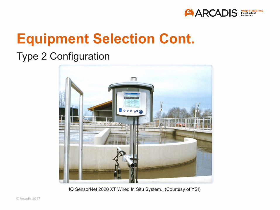
Equipment Selection Cont. Type 2 – Wired In-situ sensors • Sensors placed directly in waterbody • Data wire extends to collection system onshore • Advantages:
– Data can be downloaded without retrieving sensor – No external power source required
• Disadvantages: – Requires sensor retrieval for maintenance/calibration – Data wire must be protected
© Arcadis 2017
Equipment Selection Cont. Type 2 Configuration
IQ SensorNet 2020 XT Wired In Situ System. (Courtesy of YSI)

© Arcadis 2017
Equipment Selection Cont. Type 3 – Wireless In-situ sondes
– Sondes placed directly in waterbody – Sondes contains internal memory source – Advantages:
• Can be installed anywhere • No external power source required
– Disadvantages: • Requires retrieval for maintenance
and calibration • Expensive

© Arcadis 2017
Equipment Selection Cont. • Sondes have 8 slots for up to 8 probes
– Common probes: Temperature/Conductivity, pH, DO, Turbidity
– Larger probes (i.e. DO) occupy two slots – Some probes act as surrogates: Temperature/
Conductivity probe used for salinity
• Various manufacturers – YSI, OTT Hydromet (HACH) – Choice of manufacturer should be based on
probe availability and level of accuracy

© Arcadis 2017
Equipment Installation Considerations • Waterbody information (e.g. depth, width) • Site Reconnaissance • Permission required before installation (e.g. Coast Guard) • Availability of waterway structures (e.g. bulkheads, dolphins) • Uses of study area
– Barge/Boat traffic: Protect from being hit – Recreational: Protect from vandalism/tampering
• Length of deployment • Type of access (land vs. water)
© Arcadis 2017
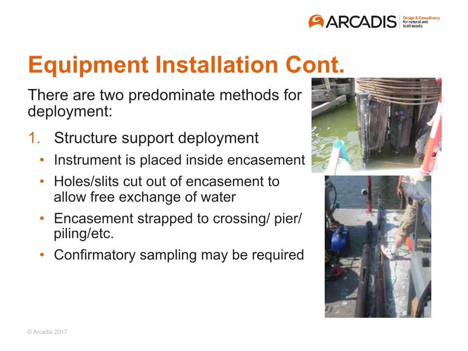
Equipment Installation Cont. There are two predominate methods for deployment:
1. Structure support deployment • Instrument is placed inside encasement • Holes/slits cut out of encasement to
allow free exchange of water • Encasement strapped to crossing/ pier/
piling/etc. • Confirmatory sampling may be required

© Arcadis 2017
Equipment Installation Cont. 2. Bottom/tether-mounted deployment
• Instrument is tethered to a weight which sits on waterway bottom
• Top of instrument tethered to buoy (above or below surface)

© Arcadis 2017
Equipment Installation Cont. Pro Con
Easier to access Greater possibility of vandalism
Easier to install and maintain Structure may not be in the ideal location
Typically safe from local boat traffic Difficult to follow variations in tide height
Structure Support Deployment
Bottom-mounted Deployment
Pro Con Systems can be placed where needed Can be vulnerable to ship traffic Typically safe from vandalism Harder to install and maintain
Can be designed to follow the variations in the tide height

© Arcadis 2017
Monitoring Workplan • Details entire monitoring program • Must be approved before implementation
– Failure to comply with plan can compromise data acceptance
• Specifies maintenance schedule for instruments – Instruments should be calibrated/serviced every 1-2 weeks
regardless of medium
• Specifies supplemental water quality sampling – Grab samples collected to provide additional data not
supported by instruments – Validate instrument data

© Arcadis 2017
Data Review & QA/QC • Enormous amounts of data can be collected depending
on duration of study
• Data should be reviewed after each download – May decide to change location – May determine data frequency insufficient
• End-user should be kept abreast of initial data findings
• QA/QC starts with initial calibration of instruments – Instruments should be calibrated weekly and verified each time
with secondary instrument

© Arcadis 2017
Data Review & QA/QC Cont. • Be cognizant of affect surrogate data has on other data
– If temperature probe fails, pH and DO data may not be acceptable
• Record good notes during servicing to justify erratic data (e.g. bubble observed in DO membrane)
• When measuring multiple depths, inconsistent data may be recoverable/normalized

© Arcadis 2017
Data Review & QA/QC Cont.

Case Study

© Arcadis 2017
Case Study • Approach implemented for LTIBM for a river estuary not
meeting DO quality
• Took over a year for Workplan approval
• Program included: – LTIBM of six (6) parameters at multiple locations and depths – Weekly servicing and in situ monitoring – Tide and current monitoring – Supplemental weekly sampling

© Arcadis 2017
Case Study Cont. • Driving Force: Understand assimilative capacity of waterway
not meeting DO standards
• Project goal: Develop baseline conditions for model
• Project team: Arcadis, marine subcontractor and modelers
• Regulatory Agencies: local DEP, USEPA
• Parameter of Concern: DO
• Equipment Selection: Type 3 – Wireless in situ sensors
• Installation methodology: Structure support structure deployment

© Arcadis 2017
Case Study Cont. Instrument Calibrations
• All sondes cleaned, serviced, and calibrated on a weekly basis
– 3-point pH Calibration – 2-point Turbidity Calibration – DO calibration confirmed via Winkler test
• ADCPs retrieved, cleaned, and calibrated once each month

© Arcadis 2017
Case Study Cont. Takeaways • Communication is key! • Review data weekly • Tides are strong
– Tide ripped support off structure; resulted in loss of instrument
• Fouling is unavoidable • Programmed amassed:
– Over 1,000,000 data points – Over 1,200 WQ samples
• Study currently in negotiation stage

© Arcadis 2017
Case Study Cont.

© Arcadis 2017
Case Study Cont.

© Arcadis 2017
Conclusions Pros Cons
Monitor water quality continuously Requires periodic maintenance and calibrations checks
Data collection interval can be specified in internal memory
Limited list of parameters
Reliable, proven instruments available
Requires protection from environment and tampering
Cost effective Potential for data loss dependent Accepted by regulatory and scientific community

© Arcadis 2017
Acknowledgements Dominic L. DiSalvo, P.E., BCEE
• Formerly Arcadis, currently Director of Engineering at the Bergen County Utilities Authority
Mark Kosakowski
• VP at Alpine Ocean Seismic Survey

© Arcadis 2017
Thank you!
January 23, 2018 35
o 914-641-2805 c 917-301-2259 e [email protected]
ALEX J. SANTOS Project Chemical Engineer