loudoun county public schools · web viewresearch earth science agenda may 17, wednesday: a daytake...
TRANSCRIPT

Research Earth Science AgendaMay 17, Wednesday: A Day
Take out your agenda and Homework from Thursday, May 15 (Assessment) WRITE YOUR NAME on your corrections sheet and turn it in with the answer sheet if
you did NOT do this last class
WARM-UPS:1. Review of May 15 – surface water (check your Assessment)2. Vocabulary Review (attached to MY agenda!! - end)
OBJECTIVES:1. NOTES:
a. Surface and Groundwater i. Stream evolution – review animation
http://geology-guy.com/teaching/iac/animations/stream_processes.htm
http://www.teachertube.com/video/river-and-stream-development-92329 (if time)
https://prezi.com/yrq_eaq21rwr/stages-of-stream-development/ (Prezi review)
2. NOTES: Groundwater Zones (attached)a. Notes Review
3. Relative vs. Absolute Timea. If you like puzzles, you will LOVE this!
HOMEWORK:1. Be sure I have your Rocks/Minerals TEST corrections – use correct format2. PRACTICE SOL material (my website and your SOL review facts
sheet)3. NOTES review – surface and groundwater4. AFTER you view the Project Power Point, Create your OWN data sheet and graph.
a. SAVE YOUR WORK!!!
LAST PROJECT: Carbon dioxide in the atmosphere: using Excel to graph trends Go to the above site. Click on videos: carbon dioxide in the atmosphere using EXCELLGo through the POWER POINT (be sure you can hear the audio)

REVIEW:CH#14: Water Moving Underground & Review of the Water Cycle
Label the Groundwater Zones.
Identify the following locations on the diagram:
______ 1. Capillary fringe
______ 2. Dry section
______3. Soil water storage
______4. Water table
______5. Zone of aeration
______6. Zone of saturation
B
D
A
E
D
C
f
D
E
C

Identify which of the following affect the depth of the water table. If it is a factor, choose “a” = “yes”. If it is not a factor, choose “b” = “no”.
______7 Season a = Yes b = No
______8 Climate
______9 Condensation
______10 Type of impermeable rock (under the zone of saturation)
______11 Soil thickness
______12 Slope
______13 Which of the following best represents the relationship between depth of water table and well-water levels?A B C
Water table rises, well level Water table lowers or rises, Water table rises, well levelDecreases; Water table sinks, Well water level remains rises; Water table falls, well Well level rises the same. Level decreases
______14 Which of the following best represents groundwater near wells after usage?
A B C D
____________________39 Term used
____________________15 Term used to describe permeable rocks or deposits (sediments) that transmit and carry water in sufficient quantities to supply wells.
______16 Which diagram represents a water table well? (Choose from A & B below)
______17 Which diagram represents an artesian well? (Choose from A & B below)
A B

18 -19 Which description best fits the groundwater in the following locations (Choose from A, B, C):
a. Warm all yearb. Warm in summer, cool in winterc. Average annual temperature for the region
Drawing NOT to scale:
Surface
_____ 18
_____19
____________________ 20 What type of bedrock is found in Karst topography?
________________________________________21 List one other feature of Karst topography.
Diagram the cave formations in the space provided:
a. Column or pillar
b. Stalactite
c. Stalagmite
Phase Changes, Water Cycle, & “All the World’s Water”
_____25. The majority of Earth’s water is located in/as
a. Atmospheric waterb. Inland lakes, rivers, streamsc. In Ice Caps & Glaciersd. Groundwatere. Oceans
_____26. The majority of Earth’s fresh water is located in/as
a. Atmospheric waterb. Inland lakes, rivers, streamsc. In Ice Caps & Glaciersd. Groundwatere. Oceans
18 (0 – 20 meters)
19 (1,000+ meters)

_____27. The majority of Earth’s useable fresh water (Where we get the majority of our freshwater).
a. Atmospheric waterb. Inland lakes, rivers, streamsc. In Ice Caps & Glaciersd. Groundwatere. Oceans
_____28. The hydrosphere involves water located in which of the following?
a. Atmosphereb. Geospherec. Both a & b
Phase change diagram
Carefully examine the phase change diagram and use the information to answer the following:
29 30.
32 31
33
_________________________29 (Phase change)
_________________________30
_________________________31
_________________________32
_________________________33
_____34. The cooling processes include
a. 29 & 30b. 29 & 32c. 31 & 32
Solid Liquid Gas

The Water Cycle: Label the diagram of the water cycle.
\2010 International Water Law Project
a. Condensationb. Evaporationc. Infiltrationd. Precipitatione. Run-offf. Transpiration
37
35
36
40
38
39
37

Groundwater Zones & Karst TopographyWater Cycle in ACTION Or “When it Rains, it Pours
EENS 1110:Pysical Geology Tulane University Prof. Stephen A. Nelson
INFILTRATION & GROUNDWATER ZONES:
Rain that falls on the surface seeps down through the soil and into a zone called the zone of aeration or unsaturated zone where most of the pore spaces are filled with air. As it penetrates deeper it eventually enters a zone where all pore spaces and fractures are filled with water. This zone is called the saturated zone. The surface below which all openings in the rock are filled with water (the top of the saturated zone) is called the water table.
The water table occurs everywhere beneath the Earth's surface. In desert regions it is always present, but rarely intersects the surface. In more humid regions, it reaches the surface at streams and lakes, and generally tends to follow surface topography. The depth to the water table may change, however, as the amount of water flowing into and out of the saturated zone changes. During DRY seasons, the depth to the water table increases. During WET season, the depth to the water table decreases.
.
Movement of Groundwater
Groundwater is in constant motion, although the rate at which it moves is generally slower than it would move in a stream because it must pass through the intricate passageways between free space in the rock. First the groundwater moves downward due to the pull of gravity. But it can also move upward because it will flow from higher pressure areas to lower pressure areas, as

can be seen by a simple experiment illustrated below. Imagine that we have a "U"-shaped tube filled with water. If we put pressure on one side of the tube, the water level on the other side rises, thus the water moves from high pressure zones to low pressure zones.
The same thing happens beneath the surface of the Earth, where pressure is higher beneath the hills and lower beneath the valleys
The rate of groundwater flow is controlled by two properties of the rock: porosity and permeability. Porosity is the percentage of the volume of the rock that is open space (pore space). This
determines the amount of water that a rock can contain. o In sediments or sedimentary rocks the porosity depends on grain size, the shapes of
the grains, and the degree of sorting, and the degree of cementation.
Well-rounded coarse-grained sediments usually have higher porosity than fine-grained sediments, because the grains do not fit together well.

Poorly sorted sediments usually have lower porosity because the fine-grained fragments tend to fill in the open space.
Since cements tend to fill in the pore space, highly cemented sedimentary rocks have lower porosity.
o In igneous and metamorphic rocks porosity is usually low because the minerals tend to be intergrown, leaving little free space. Highly fractured igneous and metamorphic rocks, however, could have high porosity
Permeability is a measure of the degree to which the pore spaces are interconnected, and the size of the interconnections. Low porosity usually results in low permeability, but high porosity does not necessarily imply high permeability. It is possible to have a highly porous rock with little or no interconnections between pores. A good example of a rock with high porosity and low permeability is a vesicular volcanic rock, where the bubbles that once contained gas give the rock a high porosity, but since these holes are not connected to one another the rock has low permeability.
A thin layer of water will always be attracted to mineral grains due to the unsatisfied ionic charge on the surface. This is called the force of molecular attraction. If the size of interconnections is not as large as the zone of molecular attraction, the water can't move. Thus, coarse-grained rocks are usually more permeable than fine-grained rocks, and sands are more permeable than clays.

Movement in the Zone of AerationRainwater soaks into the soil where some of it is evaporated, some of it adheres to grains in the soil by molecular attraction, some is absorbed by plant roots, and some seeps down into the saturated zone. During long periods without rain the zone of aeration may remain dry.
Movement in the Saturated ZoneIn the saturated zone (below the water table) water percolates through the interconnected pore spaces, moving downward by the force of gravity, and upward toward zones of lower pressure. Where the water table intersects the surface, such as at a surface stream, lake, or swamp, the groundwater returns to the surface.
Recharge Areas and Discharge Areas The Earth's surface can be divided into areas where some of the water falling on the surface seeps into the saturated zone and other areas where water flows out of the saturated zone onto the surface. Areas where water enters the saturated zone are called recharge areas, because the saturated zone is recharged with groundwater beneath these areas. Areas where groundwater reaches the surface (lakes, streams, swamps, & springs) are called discharge areas, because the water is discharged from the saturated zone. Generally, recharge areas are greater than discharge areas.
Discharge and Velocity

The rate at which groundwater moves through the saturated zone depends on the permeability of the rock and the hydraulic gradient. The hydraulic gradient is defined as the difference in elevation divided by the distance between two points on the water table. Hydraulic gradient is commensurate to SLOPE
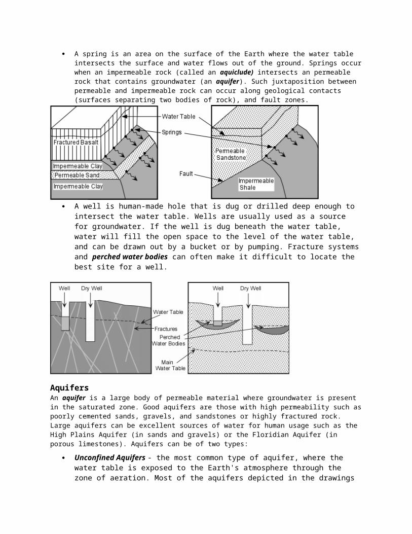
Springs, Wells, Karst Topography:Springs and Wells
A spring is an area on the surface of the Earth where the water table intersects the surface and water flows out of the ground. Springs occur when an impermeable rock (called an aquiclude) intersects an permeable rock that contains groundwater (an aquifer). Such juxtaposition between permeable and impermeable rock can occur along geological contacts (surfaces separating two bodies of rock), and fault zones.
A well is human-made hole that is dug or drilled deep enough to intersect the water table. Wells are usually used as a source for groundwater. If the well is dug beneath the water table, water will fill the open space to the level of the water table, and can be drawn out by a bucket or by pumping. Fracture systems and perched water bodies can often make it difficult to locate the best site for a well.

AquifersAn aquifer is a large body of permeable material where groundwater is present in the saturated zone. Good aquifers are those with high permeability such as poorly cemented sands, gravels, and sandstones or highly fractured rock. Large aquifers can be excellent sources of water for human usage such as the High Plains Aquifer (in sands and gravels) or the Floridian Aquifer (in porous limestones). Aquifers can be of two types:
Unconfined Aquifers - the most common type of aquifer, where the water table is exposed to the Earth's atmosphere through the zone of aeration. Most of the aquifers depicted in the drawings so far have been unconfined aquifers.
Confined Aquifers - these are less common, but occur when an aquifer is confined between layers of impermeable strata. A special kind of confined aquifer is an artesian system, shown below. Artesian systems are desirable because they result in free flowing artesian springs and artesian wells.
Changes in the Groundwater SystemWhen discharge of groundwater exceeds recharge of the system, several adverse effects can occur. Most common is lowering of the water table, resulting in springs drying up and wells having to be dug to deeper levels. If water is pumped out of an aquifer, pore pressure can be reduced in the aquifer that could result in compaction of the now dry aquifer and result in land subsidence. In some cases withdrawal of groundwater exceeds recharge by natural processes, and thus groundwater should be considered a non-renewable natural resource.
Water Quality and Groundwater ContaminationWater quality refers to such things as the temperature of the water, the amount of dissolved solids, and lack of toxic and biological pollutants. Water that contains a high amount of dissolved material through the action of chemical weathering can have a bitter taste, and is commonly referred to as hard water. Hot water can occur if water comes from a deep source or encounters a cooling magma body on its traverse through the groundwater system. Such hot water may desirable for bath houses or geothermal energy, but is not usually desirable for human consumption or agricultural purposes. Most pollution of groundwater is the result of biological activity, much of it human. Among the sources of contamination are:
Sewers and septic tanks

Waste dumps (both industrial and residential) Gasoline Tanks (like occur beneath all service stations) Biological waste products - Biological contaminants can be removed from the groundwater by natural
processes if the aquifer has interconnections between pores that are smaller than the microbes. For example a sandy aquifer may act as a filter for biological contaminants.
Agricultural pollutants such as fertilizers and pesticides. Salt water contamination - results from excessive discharge of fresh groundwater in coastal areas.
Geologic Activity of Groundwater Dissolution - Recall that water is the main agent of chemical weathering. Groundwater is an
active weathering agent and can leach ions from rock, and, in the case of carbonate rocks like limestone, can completely dissolve the rock.
Chemical Cementation and Replacement - Water is also the main agent acting during diagenesis. It carries in dissolved ions which can precipitate to form chemical cements that hold sedimentary rocks together. Groundwater can also replace other molecules in matter on a molecule by molecule basis, often preserving the original structure such as in fossilization or petrified wood.
Caves and Caverns - If large areas of limestone underground are dissolved by the action of groundwater these cavities can become caves or caverns (caves with many interconnected chambers) once the water table is lowered. Once a cave forms, it is open to the atmosphere and water percolating in can precipitate new material such as the common cave decorations like stalactites (hang from the ceiling), stalagmites (grow from the floor upward), and dripstones, and flowstones.
Sinkholes - If the roof of a cave or cavern collapses, this results in a sinkhole. Sinkholes, likes caves, are common in areas underlain by limestones. For example, in Florida, which is underlain by limestones, a new sinkhole forms about once each year, gobbling up cars and houses in process.
Karst Topography - In an area where the main type of weathering is dissolution (like in limestone terrains), the formation of caves and sinkholes, and their collapse and coalescence may result in a highly irregular topography called karst topography
Karst Topography and Sinkholes By Matt Rosenberg , The underground water of karst topography carves our impressive channels and caves that are susceptible to collapse from the surface. When enough limestone is eroded from underground, a sinkhole (also called a doline) may develop. Sinkholes are depressions that form when a portion of the lithosphere below is eroded away. Sinkholes can range in size from a few feet or meters to over 100 meters (300 feet) deep. They've been known to "swallow" cars, homes, businesses, and other structures. Sinkholes are common in Florida where they're often caused by the loss of groundwater from pumping. A sinkhole can even collapse through the roof of an underground cavern and form what's known as a collapse sinkhole, which can become a portal into a deep underground cavern. While there are caverns located around the world, not all have been explored. Many still elude spelunkers as there is no opening to the cave from the earth's surface. Inside karst caves, one might find a wide range of speleothems - structures created by the deposition of slowly dripping calcium carbonate solutions. Dripstones provide the point where slowly dripping water turns into stalactites (those structures which hang from the ceilings of caverns), over thousands of years which drip onto the ground, slowly forming stalagmites. When stalactites and stalagmites meet, they forum cohesive columns of rock. Tourists flock to caverns where beautiful displays of stalactites, stalagmites, columns, and other stunning images of karst topography can be seen.
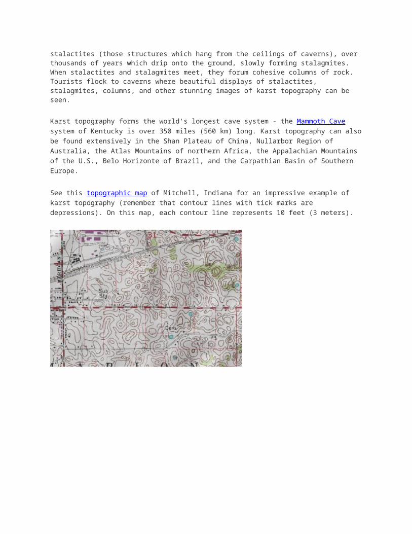
Karst topography forms the world's longest cave system - the Mammoth Cave system of Kentucky is over 350 miles (560 km) long. Karst topography can also be found extensively in the Shan Plateau of China, Nullarbor Region of Australia, the Atlas Mountains of northern Africa, the Appalachian Mountains of the U.S., Belo Horizonte of Brazil, and the Carpathian Basin of Southern Europe.
See this topographic map of Mitchell, Indiana for an impressive example of karst topography (remember that contour lines with tick marks are depressions). On this map, each contour line represents 10 feet (3 meters).

CH#13 Vocabulary Review (Why do you think I made the title blue?)
(Review of Recognition Game Terms)
We played this last class! But I added some terms!
1. Do NOT talk during this activity

2. Take out a sheet of paper and a writing instrument
3. After viewing each slide, write the appropriate term on your paper – be sure to number your responses!
4. KEEP YOUR PAPER COVERED! High score could reap major rewards!!!
Methods of Sediment Transport

Identify the 3 main methods of sediment transport
Identify the energy needed for each method of sediment transport (how the
21
3
Dissolved
stream moves sediment) from the previous slide:
4. Energy level that corresponds to method #1
5. Energy level corresponding to method #2
6. Energy level corresponding to method #3
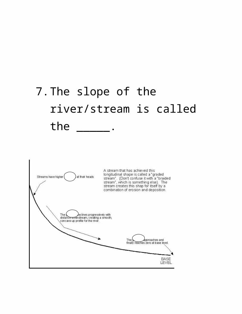
7. The slope of the river/stream is called the _____.


98 Describe the speed of the water represented by the arrow
10 The Curve of the stream

11 Name that feature!
11

12. What type of map do you need to locate feature #11 (previous slide)?
13. SPECIFICALLY, WHAT are you looking for on this map?
17. The overall picture (all the land between the dashed, purple lines)
14
16
15 flat land

18 What occurs here?

20. JUST the rivers and branches (the BLUE!)

21 No need to explain!

Superposition & Cross-cutting Relationships
James Hutton – the “Father of Geology” , developed the Law of Uniformitarianism = the Present is the key to the Past or the processes acting in the present to form the rocks & physical features of the Earth are the same processes that formed the rocks and physical features of the Earth in the past. Previously, people believed that mountains, canyons, and other features were the result of cataclysmic events.
Relative Time: A comparison based on age of rock layers. Relative time is measured as “older” or “younger”. Absolute time is more exact – age is measured in specific units of time (thousands or millions of years old). Law of Superposition – A measure of relative time = in undisturbed, sedimentary rock layers, the older rocks are on the bottom, and younger layers are on top. Law of Cross-cutting relationships – also a measure of relative time = Layers that cut through pre-existing layers (igneous intrusions) are younger than the layers they cut through. (If you have an “intruder” in a building, the building has to be there BEFORE the person can go INTO it).Faults – faults are younger than the pre-existing layers
Law of InclusionsThe Law of Inclusions was also described by James
Hutton and stated that if a rock body (Rock B) contained fragments of another rock body (Rock A), it must be younger than the fragments of rock it contained. The intruding rock (Rock A) must have been there first to provide the fragments.

http://legacy.belmont.sd62.bc.ca/teacher/geology12/assignments/Chapter%208%20WS%201%20-%20KEY.pdf
Absolute Time
Parent
Daughter t1/2 Useful Range Type of Material
238U 206Pb 4.5 b.y
>10 million years
Igneous Rocks and Minerals
235U 207Pb 710 m.y
232Th 208Pb 14 b.y
40K40Ar & 40Ca
1.3 b.y >10,000 years
87Rb 87Sr 47 b.y >10 million years

14C 14N 5,730 y 100 - 70,000 years Organic Material
