lower kananaskis river – barrier lake redevelopment bow valley ... · table 1: project planning...
TRANSCRIPT

Lower Kananaskis River – Barrier Lake Redevelopment Bow Valley Provincial Park
Draft Plan for Public Consultation
August 21, 2017
Where water recreation meets
nature conservation

Table of Contents 1.0 Introduction ............................................................................................................................................. 5
1.1 Project Area Vision and Planning Principles ....................................................................................... 5
1.1.1 Mission Statement ....................................................................................................................... 6
1.1.2 Management Characteristics ....................................................................................................... 6
1.1.3 Planning and Management Principles ......................................................................................... 6
1.1.4 Strategic Area Objectives ............................................................................................................ 7
2.0 Rationale ................................................................................................................................................. 9
3.0 Location and Existing Facilities ............................................................................................................ 10
Attachment 3.0.1: Project Area ATS ................................................................................................... 12
Attachment 3.0.2: Regional Project Map ............................................................................................ 13
4.0 Project Details ....................................................................................................................................... 14
4.1 Alternatives ....................................................................................................................................... 16
Attachment 4.0.1: Proposed Area Zoning Changes ........................................................................... 17
4.2 Canoe Meadows Day Use Area and Group Camp ........................................................................... 18
4.2.1 Current Situation and Proposed Changes ................................................................................. 18
4.2.2 Specific Recommendations ....................................................................................................... 19
Attachment 4.2.1: Canoe Meadows Proposed Changes ................................................................... 29
4.3 Kananaskis Visitor Information Centre and Day Use Area ............................................................... 30
4.3.1 Current Situation and Proposed Changes ................................................................................. 30
4.3.2 Specific Recommendations ....................................................................................................... 30
Attachment 4.3.1: Kananaskis Visitor Centre Proposed Changes ..................................................... 35
4.4 Widowmaker Day Use Area .............................................................................................................. 36
4.4.1 Current Situation and Proposed Changes ................................................................................. 36
4.4.2 Specific Recommendations ....................................................................................................... 36
Attachment 4.4.1: Widowmaker Proposed Changes ......................................................................... 38
4.5 Barrier Lake (Reservoir) Day Use Areas ............................................................................................ 39
4.5.1 Current Situation and Proposed Changes ................................................................................. 39
4.5.2 Specific Recommendations ....................................................................................................... 40
Attachment 4.5.1: Barrier Lake (Reservoir) Day Use Areas Proposed Changes ................................ 47
4.3 Project Schedule ............................................................................................................................... 48
5.0 Background ........................................................................................................................................... 48
5.1 Legislation and Policy ....................................................................................................................... 48
5.2 Dispositions and Adjacent Land Use ................................................................................................ 50

5.3 Socio-Economic Considerations ...................................................................................................... 50
5.4 Environmental Considerations .......................................................................................................... 55
5.5 Historical Resources ......................................................................................................................... 59
Attachment 5.5.1: Historical and Archaeological Resources ............................................................. 62
5. 6 Evaluation and Monitoring ............................................................................................................... 63
5. 7 Future Considerations ...................................................................................................................... 63
6.0 Involving Albertans ................................................................................................................................ 63
6.1 Targeted Stakeholder Input .............................................................................................................. 64
7.0 References ............................................................................................................................................ 65

List of Tables Table 1: Project Planning and Management Principles and Associated Objectives ................................... 7
Table 2: Alternatives Considered ................................................................................................................ 16
Table 3: Comfort Camping Options and their Challenges and Opportunities ........................................... 43
Table 4: Legislation and Policy ................................................................................................................... 48
Table 5: Potential Effects and Mitigations .................................................................................................. 59
Table 6: Known archeological sites in the project area .............................................................................. 60

5
1.0 Introduction Alberta Parks is proposing to redevelop several day use areas and a group campsite along Highway 40 between Canoe Meadows and Barrier Lake. These upgrades will address concerns regarding user conflict, ecological impacts, traffic congestion, and increased accessibility to this important water-recreation destination. By planning at the landscape scale, this Project will also provide opportunities to address the diversity of uses in this area and work with stakeholders to ensure facilities meet user needs effectively. This plan has been created to represent the build-out of this area for the foreseeable future. Alberta Parks recognizes that given current ecological sensitivities and social carrying capacity, future facility development beyond this plan is not recommended.
In 2011, the Lower Kananaskis River Redevelopment Plan was presented to the Alberta public for consultation. Significant areas of controversy surrounded some of the components of that plan; this current plan considers the results of that previous public consultation process as well as the environmental review. The current plan provides updates to better reflect the ecological sensitivities of this landscape. The current proposed project plan includes Canoe Meadows day use and group camping area, Kananaskis Visitor Centre day use area, and the Widowmaker day use area. Unlike the 2011 project, this plan also includes the Barrier Lake day use areas. This landscape scale approach to planning facilitates addressing ecological values and water-based recreation values at a more appropriate scale. The Barrier Dam day use area was considered during the planning process; however, the proposed changes to that area were not significantly different from what was proposed in 2011. Thus, Barrier Dam day use area upgrades are contained in a separate project plan.
This planning document is extensive in scope and detail. Information is presented for the area on a whole and then for each site individually. Sections have been written to be integrated but also independent of each other; pertinent attachments are contained at the end of each section rather than the end of the document.
1.1 Project Area Vision and Planning Principles Given the popularity of the LKR area and its ecological importance, Alberta Parks created an overall guiding vision that could help define a long-term management strategy and intent for the entire area from Canoe Meadows to Barrier Lake. The vision and planning principles were designed through conversations with representative Alberta Parks staff from visitor services, ecology, trails, conservation officers, education, permitting, and facilities management. Through these conversations, it was recommended that Barrier Lake’s name be changed to Barrier Reservoir to better reflect this water body’s function (herein referred to as Barrier Lake [Reservoir] until formally renamed). The vision and planning principles are stated to define management strategy and intent for the next 50 years.
Project Area Vision
The Lower Kananaskis River – Barrier area in Bow Valley Provincial Park supports an important wildlife movement corridor, rare habitat types, and other important ecological values; it is a unique destination in the Alberta Parks system where visitors from around the world come to appreciate and enjoy world-class whitewater and lake-based recreation activities in a natural parks setting.

6
1.1.1 Mission Statement Using science-based decision making, Alberta Parks will enhance visitor experience and protect the Lower Kananaskis River – Barrier area to provide ecologically sustainable recreation for current and future generations.
1.1.2 Management Characteristics The characteristics defined here are embodied by Alberta Parks staff and the stakeholders who manage or directly influence the visitor experience and ecological integrity of the Lower Kananaskis River (LKR) – Barrier project area. These characteristics guide our work in addressing the subsequent management principles and focus areas.
1. Equality of user groups There are a variety of user groups interested in water-based recreation activities in the project area. All user groups should have equal access to their chosen recreational activity, and no user group will be considered a higher priority than another.
2. Critical thinking The project area is complex from social, ecological, and economic perspectives. Finding ways to balance these needs is essential to meet project objectives. Planning and management decisions should be holistic and based on the best available social and ecological scientific information.
3. Collaboration and respect With the diversity of user demands and ecological sensitivities of the project area, managers and stakeholders will practice good listening skills and show consideration of each other’s perspectives and needs.
4. Flexible and adaptable Water levels in Barrier Reservoir and the LKR are subject to large fluctuations due to flood and drought mitigation measures, climate change and other processes. In addition, ecological and social science data are continually evolving and changing our understanding of the landscape. Planners, managers, and stakeholders should be flexible and adaptable to these changing conditions in both the short and long term.
1.1.3 Planning and Management Principles Planning and management principles provide a foundation for the overall recreation management strategy and bring a high degree of consistency to the decision-making process. Principles are designed to help achieve the vision and integrate recreation planning efforts with other management priorities throughout the project area. The below principles align with the existing Bow Valley Provincial Park management plan (Bow Valley Protected Areas Management Plan, 2002) and its direct reference to the LKR and Barrier area.
1. Enhancing ecological integrity Local wildlife corridors provide north-south connectivity adjacent to Highway 40 and east-west connectivity from Mt. Baldy across the Widowmaker area to Bow Valley Wildland Provincial Park. These corridors connect important and rare habitat patches and serve as vital movement routes for multiple species. Planning and management of the LKR-Barrier area will prioritize the long-term sustainability and effectiveness of wildlife habitat and connectivity. All recreational
7
activity planning will be considered within the context of the ecological sensitivities of this landscape.
2. Public safety on trails and in the water Ensuring public safety in this area is paramount both from the visitor and Alberta Parks perspectives. Recreation planning and management will consider the specialized skill set required for recreation on the Lower Kananaskis River and the risks associated with cold-water recreation. Trails connecting sites will be planned to ensure user safety and enjoyment.
3. Sustainable recreational opportunities for diverse user groups The current Bow Valley Provincial Park management plan states the need to integrate the recreational needs of commercial guiding and instructional groups, non-profit clubs, and educational groups with general public recreation needs. A diversity of recreational activities are offered in this area and ensuring Albertans and commercial operators have adequate, sustainable access to their activity of choice without interfering with the needs of others is an important component of management and planning.
4. Improved communication With the diversity of recreational activities available, planning in the LKR-Barrier area will endeavor to reduce user conflict through signage designating activities to specific areas. Communicating project plan outcomes (e.g., through signage, websites, or the Kananaskis Visitor Information Centre) will be integral to providing quality visitor experiences. In addition, the Kananaskis Visitor Information Centre day will act as an information hub for the Kananaskis Region.
5. Working with stakeholders and First Nations Alberta Parks is committed to working with TransAlta Utilities, concerned stakeholders (e.g., LKRUA, commercial operators), and First Nations to ensure that planning and management activities consider all interests in a fair, open, consultative decision-making process.
1.1.4 Strategic Area Objectives The objectives presented here are intended to provide management direction within the context of the Planning and Management Principles for the entire project area. Objectives will contribute to meeting the area vision.
Table 1: Project Planning and Management Principles and Associated Objectives
Planning and Management Principle
Objective
Enhancing ecological integrity
Ensure wildlife corridor effectiveness
Decrease wildlife-vehicle collisions by reducing speed or installing deceleration lanes on Highway 40 Maintain ecological integrity of habitat patches by ensuring impacts associated with recreational activities are kept to a minimum
Reclaim the banks of the Lower Kananaskis River to reduce erosion; explore possibility of reestablishing ground cover
Ensure trails in the area avoid sensitive habitat and are planned to reduce recreational impacts to ecological resources
Design facilities to have a minimal ecological footprint and retain the natural setting characteristic of provincial parks
Public safety on trails and in the water
Build trails to avoid cliffs or steep slopes that may present a risk to public safety
Install better signage communicating the risks of cold water recreation and LKR water release schedule

8
Sustainable recreation opportunities for diverse user groups
Design and construct facilities that appeal to specific user groups in appropriate locations
Plan facilities that reduce user conflict by separating users and allowing all groups to have their space
Increase user friendliness by modernizing facilities and increasing parking capacity
Provide change room and ample washroom facilities at day use sites Improve camping options and facilities at Canoe Meadows that are more appropriate for the paddling community and reduce potential user conflict Install bicycle-specific storage facilities at day use areas and provide a safe cycling route through the project area
Improved communications
Change signage and online materials to better reflect the diversity of recreational activities and where they are most appropriate
Establish the Kananaskis Visitor Information Centre and day use area as a hub for information pertaining to the Kananaskis Region
Develop interpretive signage sharing watershed stewardship and conservation messaging at all sites Plan for the addition of interpretive signage sharing watershed stewardship messaging at the start/end point of connector trails
Develop a sense of place for visitors to understand they are in the Kananaskis protected area system Market Barrier Lake (Reservoir) as a non-motorized, as well as motorized, reservoir recreation site
Engaging with Stakeholders and First Nations
Continue working with Alberta Environment and TransAlta to ensure water levels in Barrier Lake (Reservoir) and the LKR meet various objectives and commitments (e.g., water flow commitments, stabilization of water levels)
Involve stakeholders (e.g., LKRUA) in the planning and management processes. Work with Treaty 7 First Nations to incorporate traditional uses, knowledge, and concerns in planning and management.
The project plan presented here contains the following improvements:
1. Entire Project Area – improved signage, bike path from Canoe Meadows to Barrier Lake (Reservoir) along the highway, zoning changes to better define facility and natural area zones
2. Canoe Meadows Day Use Area and Group Camp– expanded and formalized parking, a new camping loop with individually bookable sites, a training and meeting centre, upgrades to the group campground, and an accessible trail and river put-in.
3. Kananaskis Visitor Centre and Day Use Area – expanded parking, a river surfer staging area. 4. Widowmaker Day Use Area– formalized public parking, and a new commercial operator put-in. 5. Barrier Lake (to be renamed Reservoir) Day Use Area – a new hand boat-launch and associated
road access, a water sports equipment rental hut, expanded parking, comfort camping, and significant changes to recreational trails.
This project area has reached a social carrying capacity associated with the diversity and number of users on the LKR and Barrier Reservoir. The ecological sensitivities of this area have been well documented in terms of wildlife movement and habitat use. The best way to effectively balance ecological and social needs in this area is to place limits on future development. This plan has been designed as the final development of this area from Canoe Meadows to Barrier Lake (Reservoir).
The LKR is a recreation destination largely due to the constructed rock and cement structures in the river bed that channel water to create white-water features. These features have undergone extensive review by Water Act prior to construction and contribute to improving the overall recreation experience. The proliferation of these features has increased use on the LKR, which has in turn increased human use of the landscape and river bank adjacent to the river. Alberta Parks is concerned about the impacts this increased human use has on the ecological attributes of the area. This current plan will result in significant changes to staging areas and river access points. To monitor the effectiveness of these

9
changes and how they impact human use patterns of the LKR area, Alberta Parks recommends implementing a moratorium on future development of river features for a period of 5 years.
2.0 Rationale In 2011, the Alberta Government released the Lower Kananaskis River Facility Redevelopment Proposal. This redevelopment plan proposed the following changes:
• Canoe Meadows – upgrades to group camping facilities, better separation of day users and group camping, improvements to accommodate special events, parking expansion, trail improvements, and a new campground.
• Kananaskis Visitor Centre – construction of a campground on either side of visitor centre with 75 new sites, and expansion of the day use parking lot.
• Widowmaker – construction of a new campground with 109 sites, 3 group use sites, a new staging area for water entry, and a new group use area with a campground.
• Barrier Dam – expanded parking, installation of a boat launch, and a disc golf course.
The subsequent comprehensive ecological review conducted by Alberta Parks ecology team raised significant concerns with the scope of the plan. Ecological concerns were centered on the potential impacts to wildlife movement through the area, increased human-wildlife conflict associated with the proliferation of campgrounds, and the loss of rare habitats in the area. The results of the public consultation process in 2011 showed a high level of public support for facility upgrades and improvement but less unanimous support for the proposed extent of campgrounds and the disc golf course. Based on the results of public and stakeholder consultation conducted in 2011 and the ecological review conducted by Alberta Parks, the following aspects are no longer being considered in this redevelopment plan:
• Campgrounds and expansion of parking lot at Widowmaker • Campgrounds at Kananaskis Visitor Centre • Disc golf course at Barrier Dam
The reasons for developing the 2011 plan are largely still relevant. There is a need to improve the visitor experience through the expansion and modernization of recreational facilities in an environmentally sensitive manner. The area has already been recognized for its river-based recreational opportunities, but in the past years has also become increasingly popular as a picnic and lake-side recreation destination. There is a growing diversity of users in this area, not only on the LKR but at Barrier Lake (Reservoir) as well. User groups include white-water paddlers of all kinds, river surfers, flat water paddlers, beach goers, picnickers, stand-up paddle boarders, and various commercial operators offering all of the above.
Many of the facilities in this area were built in the 1980s when Alberta was home to a smaller population who engaged in different styles of recreation. With Alberta’s growing population and improvements in outdoor recreation equipment, the number of visitors to the LKR-Barrier area has increased and their expectations regarding provided services have changed. Current facilities and associated parking lots are frequently over-capacity and out of date, thus failing to meet the needs of changing demographics. Enhancing facilities to better meet user expectations will improve the visitor experience in the area. With these facility upgrades, there is an opportunity to increase the accessibility of the river and lake-based

10
recreation for Albertans with reduced mobility. Planning for facility enhancements and directing human use also provides Alberta Parks an opportunity to reduce ecological impacts.
One of the key issues with this area is parking capacity. Current parking lots are not designed to effectively maximize existing space and are sometimes too small; this plan will involve the expansion of parking lots in the area. Another key issue is growing user conflict, particularly at Canoe Meadows where group camp and day users are frequently attempting to use the same space at the same time. This is particularly challenging when a wedding or other special event has booked the day use area and is interrupted by day users. There is a lack of camping capacity in Kananaskis Country and this plan explores additional camping opportunities in the Lower Kananaskis River-Barrier Lake (Reservoir) area.
Positioning the Lower Kananaskis River as a world-class white water paddling destination requires productive partnerships with members of the Lower Kananaskis River User Association (LKRUA). LKRUA has been engaged throughout this planning process and their perspectives are incorporated throughout to ensure the plan meets their needs to offer a world-class recreation destination.
More current and extensive ecological data demonstrates the importance of this area for wildlife movement and habitat. Planning to increase the effectiveness of movement pathways and improve habitat security is an essential component to this plan. The LKR-Barrier project area represents an opportunity to increase ecological integrity and improve visitor experience.
3.0 Location and Existing Facilities The project area spans 6 km in length from Canoe Meadows day use area to Barrier Lake (Reservoir) day use areas. The day use sites of Canoe Meadows, Kananaskis Visitor Centre, and Widowmaker border the Lower Kananaskis River, which starts just below the Barrier Dam. The Barrier Lake day use areas are on the south-eastern shores of Barrier Reservoir, above the dam. The project area is bordered by Canoe Meadows at the north end, Barrier Lake (Reservoir) day use area on the south end, the Lower Kananaskis River and Barrier Reservoir on the west side and Highway 40 on the east. While the project area is quite narrow, all developments were considered in the context of the surrounding landscape from an ecological and social perspective.
The legal area description of each day use area is (Attachment 3.0.1: ATS Map): • Canoe Meadows – section 23-024-08 W5M • Kananaskis Visitor Centre – section 14-024-08 W5M • Widowmaker – section 15-024-08 W5M • Barrier Lake (lower portion of day use area) – section 9-024-08 W5M • Barrier Lake (upper portion of day use area) – section 5-024-08 W5M
The project area is located less than 5 km from the Stoney Nation Reserve on its northern end and is the first part of Kananaskis Country encountered when traveling south on Highway 40 from the TransCanada Highway (Attachment 3.0.2: Regional Map). These day use areas serve as the gateways to the Kananaskis Country protected areas system from the north end, largely because of their proximity to the boundary of Bow Valley Provincial Park and the TransCanada Highway. As such, these areas attract a variety of day users ranging from experienced white-water athletes to casual picnickers and everyone in between. The area is also one of the only places in Kananaskis Country with highly accessible and diverse water-based recreation opportunities. As a result of its location and recreational characteristics, the project area is very busy.

11
The length of Highway 40 from Nakiska ski area to Highway 1 acts as a wildlife corridor, particularly for grizzly and black bears. This wildlife corridor connects habitat in the Nakiska ski hill area to the Bow Valley Habitat Patch north west of Barrier Reservoir and adjacent to Canoe Meadows area. Throughout this project area are critical aspen forest habitat patches, which comprise only 3% of the landscape within Kananaskis Country protected areas and the Bow Valley. These aspen forests provide critical ungulate habitat, particularly in the winter. Avoiding these critical habitats is important in design and site construction. There are several species at risk found in the project area, including harlequin ducks, grizzly bears, and rare plants. Ensuring their habitats are protected is essential to plan success.
There are several existing facilities throughout the project area. Canoe Meadows has an array of facilities associated with paddling, including trails and river access points. There is also a group camp at Canoe Meadows, largely used by the paddling community and for special events; the group camp is managed by the Alberta Whitewater Association through a Facility Operating Agreement. The Kananaskis Visitor Centre is the information hub for Kananaskis Country and provides picnic tables and a trailer sanitation station. Widowmaker is largely used as a put-in for paddlers on the Lower Kananaskis River; facilities are limited to a parking lot, river access, and washroom. Lower Barrier Lake Day Use area provides the only motorized boat launch in the area, several picnic opportunities, and an array of trails. All of these day use areas have several commercial operating and guiding permits associated with them for paddling and water-based recreational activities. The river and reservoir denote the boundary from Bow Valley Provincial Park to Bow Valley Wildland Provincial Park where a few hiking and mountain biking trails are available. The east side of Highway 40 is on Alberta public lands.

12
Attachment 3.0.1: Project Area ATS

13
Attachment 3.0.2: Regional Project Map

14
4.0 Project Details The following section provides recommendations at the project area scale; site-specific recommendations follow in sub-sections. Given the scope of this project, the site-specific sections have been written to be independent of each other in their own sections with conceptual lay-outs, recommendations, and attachments.
Several aspects of the proposed changes are required at all sites or across the project area:
1. Improved signage Alberta Parks proposes to update signage at all day use areas in the project area to increase clarity and provide consistency regarding which activities are most suitable at each day use area. Signage will reflect a consistent look and messaging between sites, which will help create a sense of place for visitors to the area. Branding the area as unique in the Kananaskis system will be important throughout plan implementation. Common signage will focus on watershed stewardship, cold water recreation safety, as well as current wildlife movement data and its application in the planning process. All common signage will contain the project area vision statement and tagline: where water recreation meets nature conservation. Signs associated with the LKR day use sites will also state the river class and what that means from a recreation perspective to discourage inexperienced paddlers from recreating on this river. This signage will also communicate alternatives for picnicking and more casual water recreation at Barrier Reservoir. Signage at the LKR day use sites will also communicate the TransAlta Barrier Dam release schedule with photographs displaying the river at low and high flow times.
2. Install paddling specific storage at day-use areas With the focus on water-based recreation, all day use sites will contain a selection of drying racks and boat/surf board racks for day use. The provision of these amenities will contribute to establishing this area as a water-based recreation destination through visual cues. These storage racks will also be installed in areas where paddlers gather and in areas that are already disturbed.
3. Improve bike related infrastructure and accessibility Part of this plan involves the construction of a paved bike route from Canoe Meadows day use to Barrier Lake (Reservoir) day use, paralleling Highway 40. It is recommended that this bike route be a widening of the Highway 40 shoulder. This will provide safer access for the increasing numbers of road cyclists using Highway 40 and for paddlers shuttling between Canoe Meadows and Widowmaker. Signage along the highway should reflect that the shoulder is a shared route. This is discussed more in Section 5.6: Transportation and Utilities. Bike racks are recommended at several sites.
4. The use of renewable energy sources with no running potable water The project proposes several facilities that would normally require electricity, but the project location makes the provision of traditional power challenging. The only day use site with access to power is the Kananaskis Visitor Centre. In addition, the Alberta Government is interested in using renewable energy sources and reducing greenhouse gas emissions. Alberta Parks proposes that all facilities explore the use of solar generated power. Any solar power generation used in this plan needs to incorporate the installation of batteries to store power and be

15
designed to reduce overall power demand. For larger facilities, a back-up generator or other power source may be required.
Running potable water is not available at any of these new facilities because no additional water licenses for the LKR are available; installation of water pumps or cisterns is possible. All proposed facilities should retain a rustic nature without running potable water.
5. Zoning changes Currently, Facility Zoning surrounds all day use areas, the area between Canoe Meadows and the Kananaskis Visitor Centre, and much of the Barrier Lake (Reservoir) area peninsula. The remainder of the project area is zoned as Natural Area. The current management plan commits to refining these zones to better reflect the development footprint once a plan has been finalized. The zoning changes proposed better reflect human use and current wildlife movement and habitat data. The Facility Zones at Canoe Meadows, Kananaskis Visitor Centre, and Barrier Lake (Reservoir) should be restricted to the extent of development. All other areas should be zoned as Preservation Zones (Attachment 4.0.1: Proposed Area Zoning Changes). The facility zone around Widowmaker can remain unchanged. Zoning changes will better compliment other existing zoning and contain future development. Zoning changes require legal designation and as such must follow legal boundaries, such as the ATS boundaries. For the Kananaskis Visitor Centre and Barrier Lake (Reservoir) day use areas, following ATS boundaries would result in designating part of the Wildland Park as a Facility Zone. For these day use areas, a Facility Zone should be designated with data from a surveying process.

16
4.1 Alternatives There are several alternatives for the overall project plan that were considered prior to defining the site-specific details and associated decisions (Table 2: Alternatives Considered).
Table 2: Alternatives Considered
Alternative Description Considerations
Do nothing Leave all existing facilities at day use areas.
• Does not address growing demand and lack of capacity. • Does not incorporate current ecological data in area use and facility planning. • The diversity of recreational uses could be better planned on a site-specific basis. • Current parking lots and facility design do not address vehicle and user congestion.
Option 1 – Implement 2011 LKR Redevelopment plan
Implement the 2011 Lower Kananaskis River Redevelopment Plan as proposed
• Plan has already been the subject of extensive public and stakeholder consultation. • Extensive work was completed to create this draft plan and it is critical that these
efforts are not duplicated. • Plan was created prior to an extensive environmental review. Current ecological and
wildlife data should be used when planning at this scale; the 2011 plan contains components that are no longer considered ecologically appropriate.
• New recreational uses have arisen since the creation of this plan (e.g., river surfing). • The extent of camping proposed in this plan is not appropriate to achieve ecological
and public safety related objectives. Option 2 – Current Plan Proposal
The current proposal: Lower Kananaskis River – Barrier Lake Redevelopment Plan
• Updates 2011 plan based on current ecological data. • Engaged with stakeholders throughout planning process. • Recommends planning measures for the larger landscape, including Barrier Lake
(Reservoir). • Proposes more appropriate developments in the context of public safety and
ecological issues. • Proposes a long-term, comprehensive recreation management plan for the project
area. • Addresses new forms of recreation and increases in use.
The following sections outline the proposed Project components, conceptual lay-out, alternatives considered, recommendations, and options for decision at the site specific level.

17
Attachment 4.0.1: Proposed Area Zoning Changes

18
4.2 Canoe Meadows Day Use Area and Group Camp Canoe Meadows is a triangular shaped area bordered by the Lower Kananaskis River on two sides and Highway 40 on its eastern edge. This is the first day use area people encounter when arriving in Kananaskis Country; it is the most popular staging area for paddlers in the LKR-Barrier project area. As a result it experiences very high use levels and requires substantial changes and upgrades. A significant contributor to its popularity is the proliferation of human constructed white water features in this portion of the LKR, including a white-water slalom course used by athletes and for special events (e.g., races) regularly. The Canoe Meadows group camp, operated by the Alberta Whitewater Association (AWA), is currently used as a staging area for special events and group camping.
With the changes being proposed to this area, Alberta Parks recommends considering the entire Canoe Meadows area as one facility rather than a separate day use and group camp area. This will assist with operations and management of the facility, which is discussed at the end of this section in more detail.
4.2.1 Current Situation and Proposed Changes The AWA and the Alberta Slalom Canoe Kayak (ASCK) have constructed a gate system for a kayak slalom course on the LKR adjacent to Canoe Meadows. This course compliments the white water river features constructed by AWA between Widowmaker and Canoe Meadows over the past several years. Together these features make the LKR and Canoe Meadows a destination of international significance for the white-water paddling community. This facility has hosted an array of regional, national, and international competitions and events. Canoe Meadows is considered the provincial training facility for the sport of kayaking.
The existing gravel parking lot can accommodate approximately 70 vehicles with one vault toilet and garbage facilities. The group camp area is located next to the main parking area and currently shares the one vault toilet. The group area is not well defined or separated from the day use area; this can lead to conflict between day users and those who have paid to book the group use area.
In addition to user conflict, the current Canoe Meadows parking lot does not have capacity to satisfy user demand. Redesigning the group camp could address changing demand from recreationists and help alleviate user conflict. The construction of a training facility will help position this area as a world-class white-water destination.
There are many components to the changes being proposed for Canoe Meadows. To reduce operational complexity, Alberta Parks is proposing that the Canoe Meadows area be marketed as a White-water Facility and be managed as one unit under one Facility Operator Agreement (FOA) or lease. This will be further explored once the plan for this area has been finalized and operational plans are made. The area will still contain day use and overnight use facilities, which should be separated to reduce user conflict.
Alberta Parks proposes to make the following changes to day use at Canoe Meadows:
• Work with stakeholder groups to construct a white-water training facility • Construct an accessible trail and accessible river put-in • Expand and pave the parking lot increase capacity and efficiency • Install several drying racks and canoe/kayak storage racks • Install a change room

19
Alberta Parks proposes to make the following changes to overnight use at Canoe Meadows:
• Install several tent pads along the eastern forest edge of the meadow • Upgrade the existing group shelter • Install three rustic comfort camping stations • Install a small loop road with vehicle accessible tent sites • Install additional vault toilets and a change room specific to the camping area • Install gates to separate the overnight use from day use areas • Install several gear drying racks and canoe/kayak storage racks for campers
In addition, Alberta Parks proposes to amend the Facility Zone to more closely surround the human use area. The shore of the river is not entirely included in this new Facility Zone boundary, which should limit the development of additional features along the shoreline. Everything outside of this Facility Zone should be designated as Natural Area or Preservation Zone because of this area’s importance for wildlife connectivity. The proposed Facility Zone boundary allows for a maximum available width of the wildlife corridor that follows Highway 40.
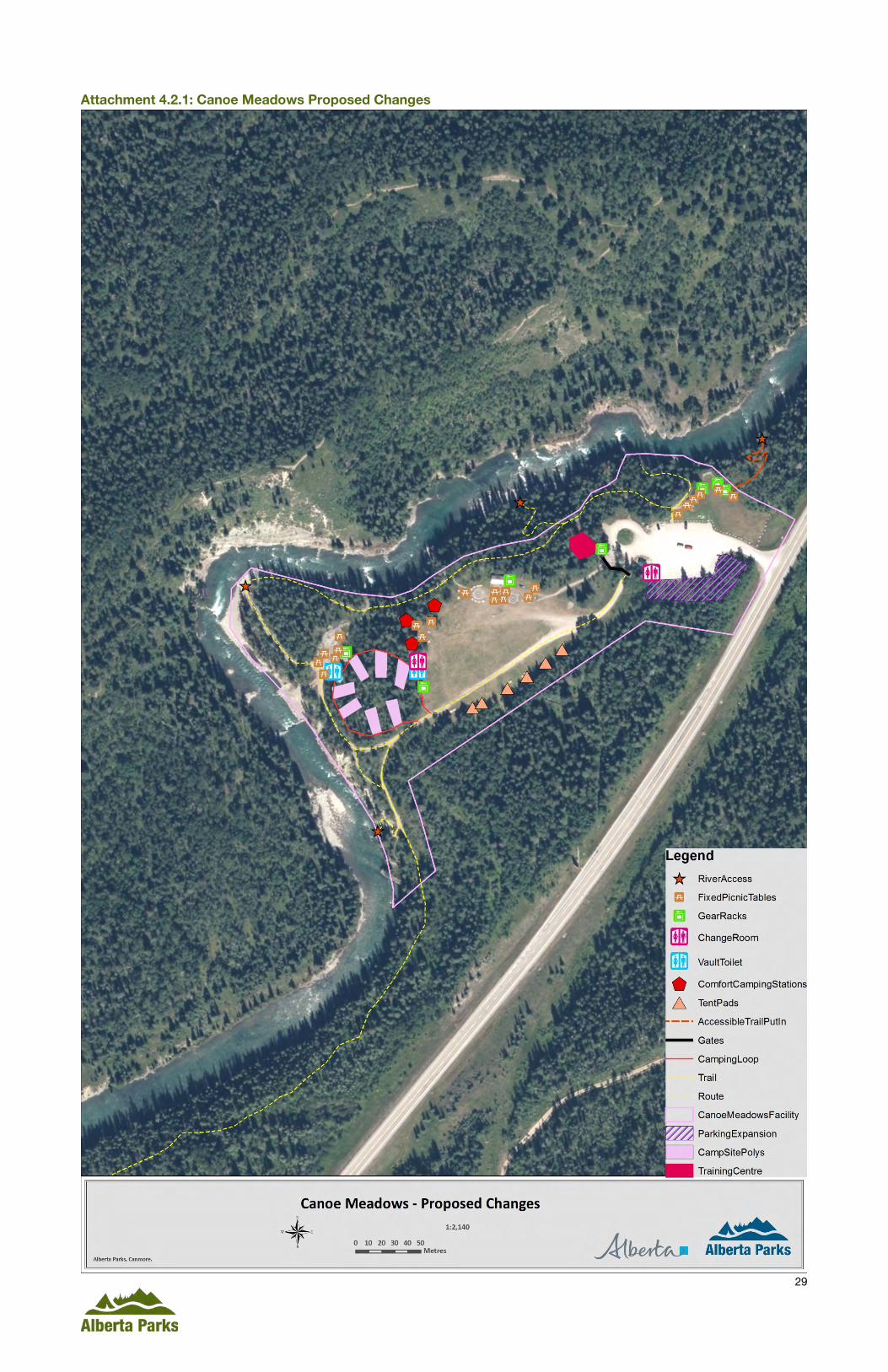
Attachment 4.2.1: Canoe Meadows Proposed Changes details the changes to facilities and zoning at this site.
4.2.2 Specific Recommendations This section describes the proposed recommendations for the Canoe Meadows portion of the Project area. Additional considerations to support the following recommendations are provided in Section 5.0: Background.
Upgrade facilities associated with day use The Parking Lot The current parking lot is too small to accommodate the number of users to this area. The parking lot requires expansion; formalizing and designating spaces in the parking lot would also increase its capacity. This plan proposes the parking lot be expanded by an additional 1400m2, which could account for an additional 65 spaces. This expansion would make the total parking lot 3,826m2, which could provide space for approximately 150 vehicles if designed efficiently. To accommodate this many vehicles may require relocating the vault toilet. Given its popularity, this parking lot should be paved with painted lines to designate spaces for vehicles. The parking lot should contain at least six pull-through sites to accommodate boat trailers and three spots for buses. Alberta Transportation intends to upgrade Highway 40 from 2018-2021; paving of this parking lot could be done in partnership with Alberta Transportation during scheduled highway upgrades. The turn-around at the west edge of the parking lot should be signed as “no parking”, and the small parking area at the south end of the turn-around should be signed as a “loading zone” for the training centre (described below). Another loading zone should be designated adjacent to the meadow so that users with rafts and other large boats can unload gear into the meadow before parking.
Change Room Installation One of the issues that has been raised by stakeholders is the lack of a facility to change in to their paddling gear. This is also an issue for other day users as most paddlers change in the parking lot, which can be awkward for other visitors. This plan proposes the installation of a change room near the existing vault toilet. As the river is paddled and surfed during the winter months, this change room should be heated using solar panels and an electric heater mounted to the wall. Given the popularity of

20
this day use area, Alberta Parks may consider having cameras installed to monitor this parking area. Heated change rooms would greatly improve the visitor experience and contribute to Canoe Meadows’ winter accessibility, thus contributing to its world-class paddling training facility reputation.
The change room could be designed to resemble the vault toilet. In the interior and exterior, some paddling specific details could contribute to the sense of place of this area as a paddling destination. Relatively simple towel racks and chairs such as in the pictures below can accomplish this. The change room should also have a floor drain to ensure water does not accumulate on the floor. Any accessories to help establish a sense of place should be designed for easy maintenance and repair in the event they are vandalized. Accessories could be painted or stenciled on walls and permanent hooks hung on top of them.
Gear Racks and Storage There are several ways to create a sense of place and visual cues are a significant contributor to that. The plan for Canoe Meadows is to create of a sense of place that this Facility is a paddling destination. This is accomplished through signage, facility design, and other visual cues associated with the kinds of activities people engage in on site. With logistical and financial constraints, it is also important that all visual cues meet a functional demand. This plan proposes the installation of several gear storage racks and units. This would improve the visitor experience and contribute to creating visual cues regarding the main purpose of this area as a paddling destination. The plan proposes three gear storage racks on the edge of the meadow next to the main parking lot, which is the main area where paddlers prepare their gear for the river. Examples of storage racks are provided in the pictures below. Racks should accommodate paddles, kayaks/canoes, PFDs, and surf boards. Picnic tables should also be placed around the edges of the meadow. With picnic tables and gear racks, this meadow would be positioned as a good lunch spot or rest for paddlers to dry their gear and hang out. Racks should be designed to be low maintenance in terms of weathering and potential vandalism. Materials used should be robust and long-lasting. The photos below are examples of design. Alberta Parks' logos should be added to all storage and drying racks to further contribute to the branding of this area.
Paddling themed change room details such as towel racks and hooks can help establish Canoe Meadows as a paddling focused area.

21
A simple boat rack (left) and paddle rack (right) can provide users with valuable gear racks and help establish a sense of place.
White-water Training Centre The original redevelopment plan in 2011 recommended the construction of a training and meeting centre to accommodate the growing demand from white-water athletes, the AWA and other stakeholders hosting special events. The size and scope of this facility is limited due to the lack of power and running potable water at Canoe Meadows. Constructing the training centre is possible, however, and could help establish Canoe Meadows as a year-round white-water training facility for provincial athletes. In order for this area to become a world-class white-water training and recreation destination, this facility would need to be open year round. The construction and operation of this building could go out for a lease as a private business opportunity. Alberta Parks will conduct an economic feasibility analysis to investigate this possibility further after the public consultation period is closed.
This facility should be located adjacent to the main parking lot so it is easily seen and accessed. The entire facility should not exceed 1,500 sq. ft.; the footprint of the training centre in the map attached includes the covered outdoor storage area. This training centre should contain four components: 1) equipment storage; 2) meeting room/classroom; 3) small concession and; 4) covered gear storage area. The equipment storage and covered gear storage area would not require heating, but may require lighting for the winter months. Designing and constructing this building to meet LEED green building
Boat racks can take several forms depending on how many boats need to be stored. For Canoe Meadows, one larger rack (above) is recommended for the large meadow. A small surf board rack (right) is also recommended.

22
standards would demonstrate to Albertans that Alberta Parks is a leader in building facilities that are modern, functional, and have minimal environmental impacts.
The equipment storage room should resemble a garage and be used to store slalom gates, the mower and other group camp or special events maintenance equipment.
The meeting room/classroom and concession would take up the entirety of the indoor space provided; it could be approximately 800-900 sq. ft. Ideally, this space would accommodate 30-50 people. This portion of the facility could be portioned to contain a small office for the area operator, if required. This room will require heating and power. This room could also serve as registration for special events and as an indoor meeting room for other small functions. The concession would also be part of this main building. Given the inability to acquire additional water licenses, the concession will need to be simple and cannot contain a full kitchen. This concession can be used to generate funds for the operator or for special events. The covered gear storage area should be large enough to accommodate a lockable boat storage cage and several structures to hang and dry gear.
LEED Building Standards
Leadership in Energy and Environmental Design (LEED) is an internationally recognized environmental program. LEED building strategies are: sustainable site development, water savings, energy efficiency, materials selection, and indoor environmental quality.
There are four different levels of certification that a developer can attain for a building: certified, silver, gold, and platinum. The level of certification is dependent on the number of points accumulated in the design and construction phases of the project.
More information about LEED and the application process can be found at:
The Canada Green Building Council
LEED Canada Reference Guide for Green Building Design and Construction 2009
Storage of boats and PFDs can be simple racks and pegs and can be installed on either the exterior or interior of the building.

23
Design of the training centre should also visually demonstrate the area’s paddling and water recreation focus. This can be done through building design, architecture, and decoration. Photos of other paddling centres below highlight some examples of how external boat storage, art work, and simple building decorations can be used to provide visual cues of a paddling facility. This in turn helps establish sense of place and communicate to visitors that this is a paddling area.
With the addition of gear storage racks, signage, and a training facility, this plan is proposing to change the atmosphere of Canoe Meadows from a generic day use area to an area of paddling focus. When visitors enter the Canoe Meadows Paddling Facility, it should be obvious to them what the primary form of recreation on site is. This will not only establish a sense of place for paddlers, but also help to reduce user conflict because visitors who are not interested in paddling will seek other options (e.g., picnicking at Barrier Dam instead of Canoe Meadows).

24
Training and meeting centres from other paddling centre in North America. Architecture can be used to reflect a boat-theme (top left), or the exterior of the building can be used to store boats (top right) or showcase water based artwork (middle right). The simple installation of surf boards (middle left) or boat storage on the exterior of the building (bottom left) can also create a similar atmosphere.

25
Signage The main reasons to improve signage at the Canoe Meadows day use area are to: 1) help position Canoe Meadows as a paddling destination within the context of the larger area water-based recreation landscape, 2) communicate cold-water recreation safety requirements, and 3) improve consistency in messaging and signage appearance.
Signage can be used to communicate the theme of this area before people even reach Canoe Meadows. A sign on the highway should detail all sites in the area and visually communicate the types of recreation they provide. This may help visitors to select the best day use area for the activities they are most interested in. Another important component of this plan is to ensure consistency in signage and messaging amongst all day use areas. Each day use area’s main trail kiosk should have a sign that displays an area map of the overall LKR-Barrier area with areas of ecological concern, and a site-specific map that shows designated water access points and trails. Another sign should communicate safety messaging about cold-water recreation and how river flow levels are controlled by TransAlta’s work with the Barrier dam. Standard bear safety and human use on designated trails only messaging should also be part of the trail kiosk signage.
Currently, several small signs at river access trailheads communicate that water levels in the LKR can change rapidly with a web link to the TransAlta dam release schedule. There is not consistency in sign appearance. A standard sign communicating the river fluctuation levels should be created and installed at all river access points and trailheads at Canoe Meadows and Kananaskis Visitor Centre. This sign should also contain pictures of the river during low flow and high flow. The link to the TransAlta dam schedule should be provided and a link to the Alberta Rivers: Data and Advisories Application, which has real time river flow rates and can be downloaded to any smart phone device. Etiquette messaging should also highlight that the LKR is an extremely busy river with many different kinds of users.
Trails and River Access The current trail that runs the length of the riverbank at Canoe Meadows is popular and well used. The trail itself requires little more than regular maintenance. Multiple railing and viewpoints associated with this trail, however, require repair and upgrading as they do present a risk to visitor safety. This is particularly evident along the east side of the current group use area where the trail overlooks the slalom course. In addition, a more robust viewing platform could be constructed in front of the small clearing on the east side of the group use area. This viewing platform could be elevated to afford a better view of the length of the river for filming and photographing athletes in competition. If this clearing contained several picnic tables, a vault toilet, gear storage racks, and a good viewpoint it could be a good gathering area for special events and for campers.
This plan also proposes an accessible trail and water put-in at the north end of the day use area. There are currently two river access points from the north end of the day use area. This plan proposes creating one accessible trail and river put in, the other access should be decommissioned. Currently, a trail at the north end of the day use area meadow leads down to the river. This trail follows a fairly accessible route but would require upgrades to meet accessibility standards. The trail empties on to a large, flat rock, which could be used to construct the accessible put-in. Providing accessible access to the water would provide an inclusive experience for people with limited mobility.
Upgrades to overnight use The biggest issue brought forth by stakeholders regarding the group camp area at Canoe Meadows is the user conflict that arises when day users enter the group camp area and begin using its facilities. It is

26
therefore important to visually and operationally separate the group camp area from the day use area. This plan proposes to put up two gates at entrances to the group use area. Another issue brought forth by stakeholders is the need for individually bookable sites as there are currently no options for paddlers travelling with their family or solo. This plan provides for an array of camping options from the group camp to individually bookable auto-accessible tent sites and rustic comfort camping. In addition to these significant changes, the plan also proposes the addition of vault toilets, a change room, and replacement of the existing group camp shelter.
Separating the group camp from the day use area This is easily accomplished by the installation of gates at the two main entrance points to the camping area. Signage accompanying the gates should state clearly that the area is reserved for overnight users with a reservation. The only day use permitted is to walk through the site on the main trail to access the river. There is the option of leveling out the main meadow associated with this area to improve the visitor experience. With the variety of camping options proposed and the number of users that may be interested in booking overnight stays, these gates should be locked with a combination code.
Diversifying camping options There are several opportunities to diversify the camping option at Canoe Meadows and make the area more than a group campground. The best way to operate the camping area would be through a Facility Operating Agreement (FOA) that manages all of the overnight options. The area could still function as a group camp, but the management should be such that private campers would not be camping at the same time as group campers. A group camp booking, which is usually for a special event, would reserve the entire area. Group camp bookings could be available in advance (e.g., 3 months) of private, individual site bookings (e.g., 6 weeks).
This current plan proposes the addition of three kinds of individually reservable camping options. The first is a new loop off the main group camp access road with vehicle-accessible tent sites. These sites should be relatively small (less than 20m long) and equipped with a fire pit and picnic table. At the edge or centre of the loop should be a covered, open air gear rack for drying PFDs, kayaks, wetsuits, and other gear. The current plan proposes seven tent sites be constructed around this loop but this number could change with the detailed design process. In the event the road construction of the loop proves not feasible, these could become walk-in tent sites with a small parking lot at the edge of the large meadow. The advantage of having a loop is that people could bring a small trailer to the site; this loop will not be feasible for RVs or large equipment. In addition, no power or water will be added to these sites. A vault toilet and change room (for all users of the group use area) can be placed at the edge of the meadow. Another vault toilet can be placed in the small clearing to the east of the tenting loop. This vault toilet will serve a picnic area and the tenting loop. The ATCO trailer in this clearing should be removed and the clearing cleaned up. A second option is to designate walk-in tent pads on the eastern edge of the large meadow; users for these sites would park in the main parking lot.
The plan also proposes the construction of three rustic comfort camping accommodations, such as yurts, canvas tents, or small A-frame cabins (in photos below). With no running water and solar powered electricity, these comfort camping structures would be very rustic. On the interior, beds, a table and chairs, and propane powered stove could be provided. Heat can be provided through a wood burning stove; lighting would be solar powered. The Facility Operator would be responsible for the maintenance of the comfort camping structures and keeping them clean between guests. Guests would be responsible for supplying their own bedding and dishes as laundry and dish washing would be difficult to provide.
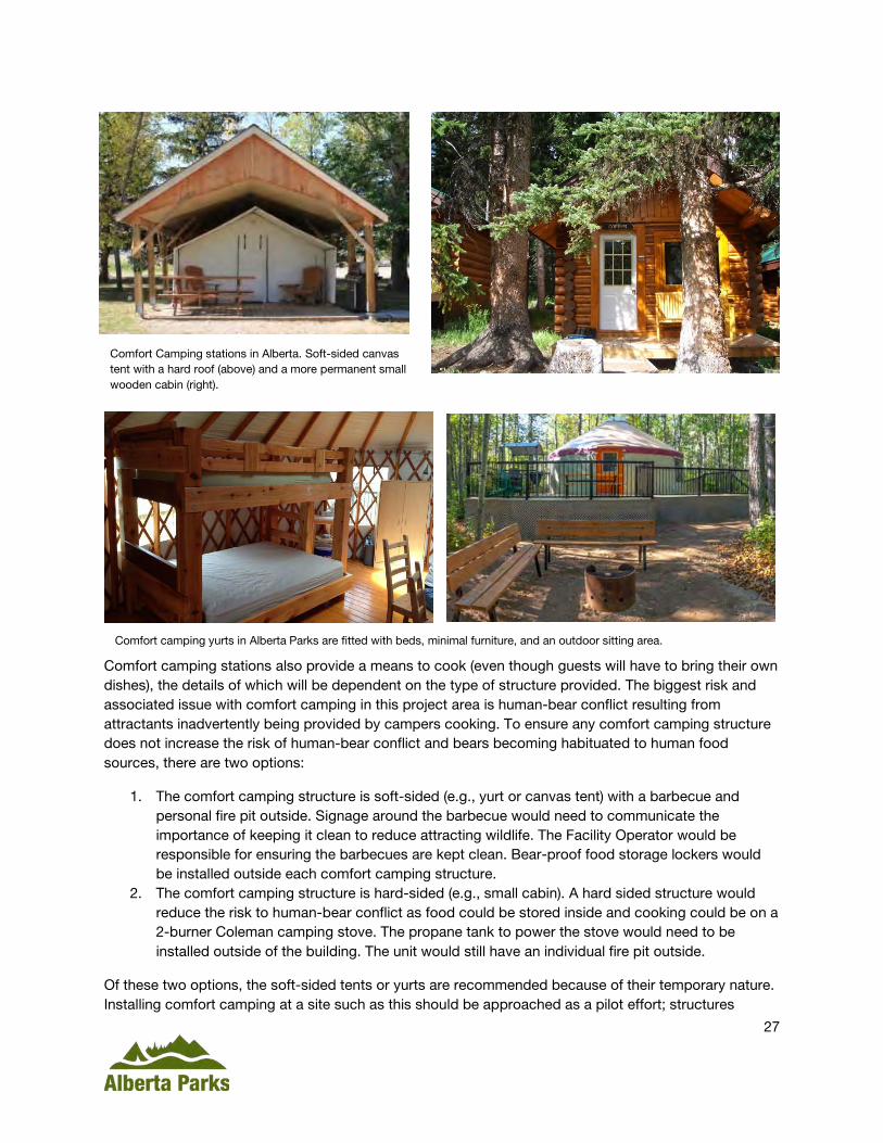
27
Comfort camping stations also provide a means to cook (even though guests will have to bring their own dishes), the details of which will be dependent on the type of structure provided. The biggest risk and associated issue with comfort camping in this project area is human-bear conflict resulting from attractants inadvertently being provided by campers cooking. To ensure any comfort camping structure does not increase the risk of human-bear conflict and bears becoming habituated to human food sources, there are two options:
1. The comfort camping structure is soft-sided (e.g., yurt or canvas tent) with a barbecue and personal fire pit outside. Signage around the barbecue would need to communicate the importance of keeping it clean to reduce attracting wildlife. The Facility Operator would be responsible for ensuring the barbecues are kept clean. Bear-proof food storage lockers would be installed outside each comfort camping structure.
2. The comfort camping structure is hard-sided (e.g., small cabin). A hard sided structure would reduce the risk to human-bear conflict as food could be stored inside and cooking could be on a 2-burner Coleman camping stove. The propane tank to power the stove would need to be installed outside of the building. The unit would still have an individual fire pit outside.
Of these two options, the soft-sided tents or yurts are recommended because of their temporary nature. Installing comfort camping at a site such as this should be approached as a pilot effort; structures
Comfort Camping stations in Alberta. Soft-sided canvas tent with a hard roof (above) and a more permanent small wooden cabin (right).
Comfort camping yurts in Alberta Parks are fitted with beds, minimal furniture, and an outdoor sitting area.

28
should be easily removed if human-wildlife conflict or maintenance proves to be issues. Another vault toilet should be added in the area between the comfort camping stations and the tenting loop.
Another issue with comfort camping in this area is grey water disposal. Each structure should be equipped with a wash basin. Grey water from dishes could be disposed of near the vault toilet proposed for the camping area. A similar structure as the one in the photo to the right could be designed to empty in to the adjacent vault toilet tank; grey water would be emptied at the same time as the vault toilets. If required, a screen could be placed over the drain to minimize hard food particles from entering the vault toilet. The screen could be cleaned by the Facility Operator or the camper.
Upgrades to the group camp itself There are several facility upgrades to the group camp that are required to modernize this facility. The existing group shelter is outdated and in fairly rough condition. This existing shelter should be removed and replaced with a shelter more paddling specific. The shelter should contain an indoor, lockable portion and a covered outdoor area with gear hanging racks/pegs and picnic tables (such as the photo below). The new shelter should have power generated by solar panels, if possible, to power any fridges and lighting in the shelter. Should solar power be used, batteries and a converter would be required. There are concerns with vandalism and theft associated with the amount of solar panels and batteries required to make this feasible. If it is not feasible, then generators can be used to power the shelter during special events or when the group camp is fully booked. The shelter should be heated with a wood burning stove.
One of the concerns raised by stakeholders is that the meadow of the group camp is uneven and finding a flat spot to put a tent can be challenging. The group camp area should have designated tent pads along the forest edge on the east side. These tent pads will reduce the impact of people setting up tents in the forest of the wildlife corridor. Tent pads can be individually bookable as walk-in tent sites as well. Alberta Parks recommends these tent pads be raised, marked with small signs, and surfaced with grass. The current plan proposes six tent sites. Current picnic tables and the fire pits are in various states of disrepair. All of these need repair or replacement.
Grey water disposal mechanisms can take many forms. This is a basic form where people pour dirty water in to the top and it drained in to an underground receptacle. When close to an outhouse, the grey water can drain in to an outhouse and be drained when the outhouse is serviced.
29
Attachment 4.2.1: Canoe Meadows Proposed Changes

30
4.3 Kananaskis Visitor Information Centre and Day Use Area The Kananaskis Information Centre is the first major facility in Bow Valley Provincial Park for visitors heading south on Highway 40 and is the main visitor centre for Kananaskis Country. On average, the visitor centre sees 15,000 visitors per month during July and August, 8,000 in June and September, and 3,000-5,000 during the winter months. This visitation reflects the importance of this visitor centre in the overall Kananaskis experience. Associated with the visitor centre is a day use area that is used by picnickers and river surfers, and a sani-dump station. There are a variety of people who use the visitor centre and they stay for varying amounts of time from several minutes to all day.
4.3.1 Current Situation and Proposed Changes The current parking lot is too small to accommodate all of the people who come to the visitor centre and its associated day use area. The day use area, behind the main parking lot for the visitor centre is small and underused. In addition, this day use area is only open during the summer months, but river surfers access the LKR throughout the year. The Visitor Centre is popular with people requiring information as well as people meeting to carpool to various trails in down Highway 40. As such, people stay in the parking lot for varying time frames from a few minutes to all day. The forest on the northern end of the parking lot currently contains several dead or dying trees, which present a potential safety hazard to picnickers and day users. River surfers currently stage from both Canoe Meadows and the Visitor Centre as the surf waves are at a mid-way point between the two areas.
Alberta Parks proposes the following changes to the Kananaskis Visitor Centre and day use area:
• Parking lot expansions and formalized designation – one parking lot for Visitor Centre users, one for day users, and one for car poolers.
• Improvements to the day use area through the installation of a heated change room, water-gear drying racks, and better picnic sites.
• Formalization of river access trails and surfer staging/viewing areas. This will involve a significant trail re-routing for safety and visitor experience.
• Designation of a “surf zone” on the Lower Kananaskis River
Attachment 4a: Kananaskis Visitor Centre Proposed Changes details the changes to facilities at this site.
Similar to Canoe Meadows, Alberta Parks proposes to amend the Facility Zone to more closely surround the human use area. The river surfer staging areas along the riverbank are not included in the Facility Zone, but should be designated as Natural Area Zone. This is to prevent the river bank from becoming over developed in the future.
4.3.2 Specific Recommendations This section describes the proposed recommendations for the Kananaskis Visitor Centre portion of the Project.
Recommendation 1: Parking lot expansions
The Project plan proposes three separate parking areas for specific purposes. The first parking lot, to the north of the entrance to the visitor centre is the largest parking area and should be designated for carpoolers. The current recommended area of this proposed parking lot is 2500m2, which should accommodate approximately 110 vehicles. The recommended location of this parking lot has been selected based on where a large portion of hazard trees are located; the exact shape and extent of this

31
parking lot could be altered to better remove hazard trees and ensure visitor safety. Of the 110 parking spaces, a minimum of 10 should be pull-through spots for truck/trailer and RV units.
A small extension of the Visitor Centre parking lot is recommended for the west edge of the current parking lot. This parking lot should be designated as 2-hour parking and designed for people going to the Visitor Centre for information or picnicking. The recommended area of expansion is 1600m2, which should accommodate an additional 50 to 60 vehicles. Again, several spots should be pull-through truck/trailer and RV compatible.
The third parking lot expansion is associated with the day use area behind the visitor centre towards the river. This parking lot expansion should essentially connect the two small pull-out parking lots currently located at either end of the picnic area. This expansion is 450m2 and could accommodate an additional 20 to 25 vehicles. This parking lot would be for day use, particularly surfers.
Signage along the entrance road should clearly direct traffic to the appropriate parking lot for their needs. Improved signage could also increase use of the day use area behind the visitor centre.
Recommendation 2: Improvements to the day use area
With the number of and diversity of users seeking water-based recreational opportunities in the LKR-Barrier area, one of the principles of this plan is to ensure adequate, sustainable access to all activity choices without interfering with the needs of other users. To achieve this principle, this plan is being designed to provide facilities specific to different user groups at each day use area. This plan proposes that the day use area behind the Kananaskis Visitor Centre be designed as the main staging area for river surfers. This would entail the installation of a heated change room, which would be solar-powered such as the ones in Canoe Meadows, a gear-drying rack for wetsuits, and a surf board rack. Without a heated change room, surfers change in the Visitor Centre washroom which creates some user conflict. In addition, a day use shelter for surfers to escape the rain while taking a break from the river could be installed. Examples of surf racks are provided in the images below.
One of the current issues related to surfing is the number of people sitting and gathering along the river bank while watching other people surf. This has led to bank erosion and the destruction of undergrowth vegetation. Part of this plan will be to expand and formalize these gathering areas along the river bank.
Two types of surf board racks from Hawaii.
32
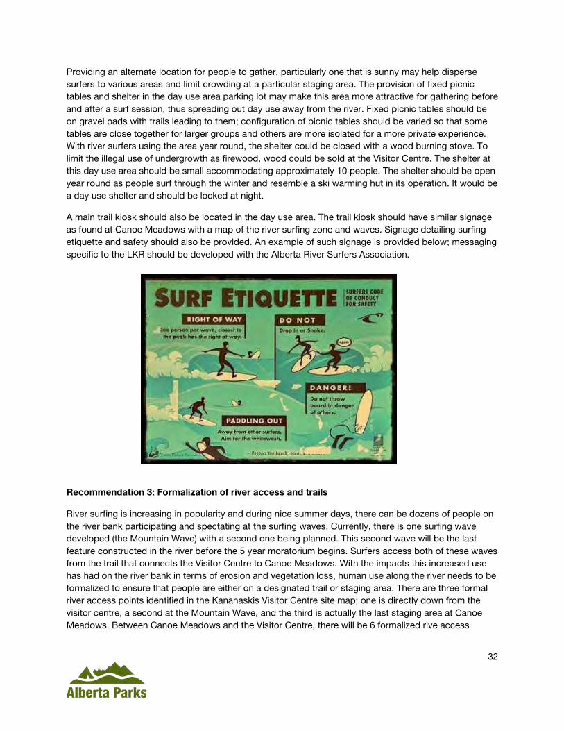
Providing an alternate location for people to gather, particularly one that is sunny may help disperse surfers to various areas and limit crowding at a particular staging area. The provision of fixed picnic tables and shelter in the day use area parking lot may make this area more attractive for gathering before and after a surf session, thus spreading out day use away from the river. Fixed picnic tables should be on gravel pads with trails leading to them; configuration of picnic tables should be varied so that some tables are close together for larger groups and others are more isolated for a more private experience. With river surfers using the area year round, the shelter could be closed with a wood burning stove. To limit the illegal use of undergrowth as firewood, wood could be sold at the Visitor Centre. The shelter at this day use area should be small accommodating approximately 10 people. The shelter should be open year round as people surf through the winter and resemble a ski warming hut in its operation. It would be a day use shelter and should be locked at night.
A main trail kiosk should also be located in the day use area. The trail kiosk should have similar signage as found at Canoe Meadows with a map of the river surfing zone and waves. Signage detailing surfing etiquette and safety should also be provided. An example of such signage is provided below; messaging specific to the LKR should be developed with the Alberta River Surfers Association.
Recommendation 3: Formalization of river access and trails
River surfing is increasing in popularity and during nice summer days, there can be dozens of people on the river bank participating and spectating at the surfing waves. Currently, there is one surfing wave developed (the Mountain Wave) with a second one being planned. This second wave will be the last feature constructed in the river before the 5 year moratorium begins. Surfers access both of these waves from the trail that connects the Visitor Centre to Canoe Meadows. With the impacts this increased use has had on the river bank in terms of erosion and vegetation loss, human use along the river needs to be formalized to ensure that people are either on a designated trail or staging area. There are three formal river access points identified in the Kananaskis Visitor Centre site map; one is directly down from the visitor centre, a second at the Mountain Wave, and the third is actually the last staging area at Canoe Meadows. Between Canoe Meadows and the Visitor Centre, there will be 6 formalized rive access

33
Current trail leading down to staging area at the Mountain Wave.
points. All other areas should be reclaimed either actively through re-seeding of native plants, or passively with signage prohibiting human access for reclamation or using brush to impede human use.
There is currently one temporary staging area built at the Mountain Wave, which is a place for people to spectate and wait their turn to surf the wave. The Alberta River Surfing Association (ARSA) currently has a proposal going through Water Act approval that will repair portions of the first surf wave and expand the current staging area on to the river bank. Alberta Parks will work to make the current staging area more permanent and robust, but not expand its size. The small access trail to the staging platform from the main trail should be formalized and improved, which may involve the construction of stairs. Stairs accessing the river from the staging area should be made more permanent and designed to withstand ice during the winter and high water levels caused by potential future flood events.
ARSA is currently working to propose a second wave further downstream close to Canoe Meadows. After discussions with Alberta Parks, ARSA has agreed that this wave will be constructed in an area where a staging area currently exists or can easily be constructed. The current proposed location is at the south end of Canoe Meadows before the slalom course. This wave would then use the same staging and viewing area as special events at Canoe Meadows. This viewpoint will require upgrades to railings, benches, and Alberta Parks should consider constructing a platform to improve the viewing experience. This would serve surfing and special events spectators.
The current designated trail that goes from the Visitor Centre to Canoe Meadows is in need of repair and relocation. The current route goes through a section of forest that is dying and falling trees present a significant potential hazard. In addition, a large portion of the trail is not very close to the river and does not see as much as use as the unofficial trail that follows the water’s edge. This plan proposes that approximately 230m of this trail be decommissioned and that the unofficial trail along the water’s edge become formalized and designated. This will require the construction of boardwalks across wet areas, trail widening, and measures to reduce trail braiding. Access points to the river will be restricted to
Current surfing staging area at the Mountain Wave

34
designated areas only; river access will be directed to these areas with signage. A set of stairs should be constructed at the river access point closest to the Visitor Centre.
Recommendation 4: Designation of a “surf zone”
With the regulated flow rates of the Lower Kananaskis River, river use is restricted to high water flow times. This can result in a scenario where everyone wants to recreate on the river at the same time, which can lead to congestion and user conflict. Unlike other users, river surfers are stationary on the river and use one particular feature for an extended period of time. This can increase collision risk as paddlers come down the river. River etiquette dictates that it is the surfer’s responsibility to yield to the people coming down the river. To date, this has not been a significant issue. With the increase in this sport’s popularity and the number of inexperienced paddlers using the river, Alberta Parks proposes to increase awareness of surfers being on waves through the designation of a “surf zone” on the LKR. Signs can be posted along the river so they are visible to other paddlers at the first river access point from the visitor centre and after the second wave. These signs can be simple with a picture of a surfer and messaging such as: “caution surfers ahead” and “exiting surf zone”. This designation is not legally binding but will serve a role for public communication and awareness.

35
Attachment 4.3.1: Kananaskis Visitor Centre Proposed Changes

36
4.4 Widowmaker Day Use Area The Widowmaker day use area is the main put-in for white-water recreation on the LKR; people put-in at Widowmaker and take-out at Canoe Meadows or Seebe. Widowmaker is not a day use area where people gather or spend copious amounts of time, but it is a parking area where people load in to the LKR and leave their vehicles while paddling down to Canoe Meadows. The current gravel parking lot contains a trail kiosk and a vault toilet. A wide trail leads from the parking lot to two main river access points, one access point is above the Widowmaker river feature and the other is below. At the access point below the feature, a set of stairs leads people to the water. Ecologically, the Widowmaker area provides important habitat for ungulates and serves as an important wildlife habitat linkage from Mt. Baldy to the west to the Bow Valley Habitat Patch to the east. To maintain the integrity of this critical habitat and wildlife corridor, development here will be limited.
4.4.1 Current Situation and Proposed Changes The Widowmaker is the main put-in for commercial white-water tourism operations, particularly rafting companies. Rafting companies arrive at this day use area with a large bus towing a trailer with rafts. These vehicles take up a large amount of the existing parking lot and require substantial space to turn around. This leads to congestion when all 5 rafting companies with permits and the public attempt to access the river at the same time. User conflict results when independent paddlers from the public cannot access the river because they are either unable to find parking or get stuck behind commercial operators walking rafts to the river. The existing put-in with the stairs is sufficient for public needs but is small for commercial rafters to use comfortably.
To address congestion and user conflict at this site, Alberta Parks proposes to:
• Upgrade and formalize the existing parking lot • Upgrade and repair the stairs accessing the river below the Widowmaker feature • Relocate the trail kiosk to the trail head and add bike racks to the same area • Construct a road and turn around with a formalized river access for commercial operators. This
put-in will be located just upstream from the Widowmaker feature.
Attachment 4.4.1: Widowmaker day use area proposed changes details changes to this area.
4.4.2 Specific Recommendations Of all the day use areas in this project, changes to Widowmaker are the least substantial. The main reason for this is its current use is focused on it being the starting point on the river and its importance as an ecological habitat patch and movement pathway for wildlife (see 5.4 Ecological Considerations portion of this document). The main purpose of the recommendations for the Widowmaker day use area is to separate the commercial operators from other users to reduce congestion and user conflict.
Recommendation 1: Upgrade and formalize the existing parking lot
The existing parking lot is large and has the capacity to handle all public traffic, aside from the commercial operators. A loading zone should be signed and formalized in the east corner of the parking lot. The trail kiosk should be moved to the loading zone/trailhead area so it is more easily visible. Signage at the trail kiosk needs to be improved and a general sign package installed. To achieve maximum effectiveness, the parking lot should be paved and have formalized spaces (e.g., painted lines). Parking lot paving should be designed to channel run-off away from the river. A change room

37
should be added next to the current vault toilet. The pull-out half way down the access road should be reclaimed as it is no longer used.
Recommendation 2: Upgrade river access for the public
From the parking lot, an old road serves as the trail to access the river put-in for the public. Just downstream from the Widowmaker feature is a set of stairs to the river. This staircase needs to be repaired after years of use. The staircase is narrow for commercial rafting companies. As these stairs will be used for the public only, its dimensions are sufficient.
Recommendation 3: Construct a commercial operator put-in
This is the most substantial change to the Widowmaker day use area as it involves the creation of a new road, turn around loop, and river access point. The location of the turnaround has been selected to minimize the human footprint in the area while still providing a separate access for commercial operators upstream from the Widowmaker feature in the river. This new commercial access road should exit left off the Widowmaker access road. The turnaround loop itself should be large enough to accommodate 5 school buses pulling raft trailers, which would park in single file on the river side of the loop. Commercial operators only use the Widowmaker area to drop off clients and rafts. They then go to Seebe and pick them up at the end of their run. Therefore, a long term parking lot is not required for this user group. A loop road with a loading zone will suffice. The loop road should be gated and locked to ensure it is used for commercial operators only. The river access from the loop road should be a widened trail with stairs. The trail should be wide enough for people to carry a raft comfortably (approximately 5m).

38
Attachment 4.4.1: Widowmaker Proposed Changes

39
4.5 Barrier Lake (Reservoir) Day Use Areas There are two day use areas on a large outcropping of land at the southern end of Barrier Reservoir; these are the upper and lower Barrier Lake day use areas. This plan recommends the day use area be renamed to Barrier Reservoir to better reflect the function of this waterbody. The Lower day use area is accessed by a loop road and contains the only motorized boat launch in the project area. As with most day use areas in this plan, parking is an issue. The Upper day use area is underused and serves as a trailhead to a viewpoint over Barrier Reservoir. These day use areas are being included in this plan as they are part of the same water-based recreation destination and the same important wildlife corridor.
4.5.1 Current Situation and Proposed Changes This plan proposes significant changes to the Barrier Lake (Reservoir) day use areas to improve the visitor experience and provide diverse opportunities. As with other day use areas in the project area, one of the main issues with the Lower day use area is a lack of parking capacity caused partially by ineffective parking lot design. It is common on a summer days to see people parking along the access road to the boat launch. As the access road is designed as a one-way loop road, people parking along the side can cause significant congestion to the site. The current access road to Barrier Lake (Reservoir) day use area is a loop road with several parking pullouts along its length; each pullout hosts a picnic table in the forest. These pullouts are rarely used as picnicking areas as they are tucked in the forest and the majority of users are more interested in lakeshore recreation. As a result, the loop road is awkward and ineffective. In addition, people parking along the road side can increase vegetation trampling and other ecological impacts as they walk from their parking space to the lakeshore on non-designated trails.
The current trail that connects the Lower and Upper day use areas is underused partially because of its lack of viewpoints. This trail will be rerouted to be more pleasurable and provide a loop option, which would improve the visitor experience. The current management plan also speaks directly to creating a concession and overnight accommodations in this area, both of which are explored in this plan.
Alberta Parks proposes a name change for both of these day use areas to reduce confusion by having three day use areas with similar names (e.g., Barrier Dam, Barrier Lake Lower, and Barrier Lake Upper). Both the upper and lower day use areas should have name changes to improve marketing and communications and make it easier for users to identify where they are. One potential name for the lower day use area is Baldy Beach since the lake is at the foot of Mt. Baldy. One potential name for the upper day use area is Tokyapebi (or Nakoda) Lookout as Mt. Baldy was used by scouts from the Stoney Nakoda Nation as a lookout when traveling through the area.
To address parking capacity and improve overall visitor experience, this plan proposes to:
1. Lower Barrier Lake (Reservoir) Day Use Area: a. Decommission half of the loop road and widen the remaining half to accommodate 2-
way traffic, unused parking pullouts along the existing loop road should also be decommissioned
b. Construct an access road with loading zone, and small parking lot associated with two of the existing pull-outs leading to a hand boat launch
c. Expand the current parking lot at the motorized boat launch d. Install a hand-boat launch e. Install a water sport equipment rental hut. This is a private sector opportunity that will go
through a Request for Proposal process.

40
f. Install several additional picnic locations associated with the hand-launch area g. Add a staircase to access the beach from the picnic sites located next to the boat
launch to reduce bank erosion h. Decommission several unused trails
2. Upper Barrier Lake (Reservoir) Day Use Area: a. Construct a different loop trail that connects to the trail accessing the Lower day use
area b. Install an accessible trail that leads to a “Connection Corner”
3. Comfort Camping: a. Two different locations are proposed for a small and rustic comfort camping operation.
This is a private sector opportunity that will go out through a Request for Proposal process.
4. Zoning changes a. Currently, the entire area is a Facility Zone. As with the other day use areas in this plan,
this is anticipated to be the last major build out for this area. With the wildlife corridor essentially running through this area, the zoning should be changed to reflect the importance of this area to wildlife.
4.5.2 Specific Recommendations The Barrier Lake (Reservoir) day use areas require significant changes to improve visitor flow of use and recreational opportunities for diverse user groups. There is tremendous potential in this area to provide an innovative, unique visitor experience while simultaneously improving the wildlife habitat security associated with the Highway 40 wildlife corridor. The Upper day use area, which is currently underused, can be designed to offer a unique experience as a quiet recreation area. This could attract a new user base and increase use of this area.
Attachment 4.5.1: Barrier Lake Facility Changes shows proposed change to Barrier Lake day use areas.
Recommendation 1: Changes to the Lower Barrier Lake (Reservoir) day use area
Loop road upgrades The current loop road for access to the boat launch was designed with smaller pull-outs along the length of the road for people to have picnics in the forest. This design does not reflect current usage patterns and therefore these picnic spots are not used. This plan proposes to remove all of the individual pull-outs along the loop road and reclaim them. Reclamation could entail the removal of asphalt and aerating, which will promote aspen tree growth. The east half of the loop road should be decommissioned and the west half should be widened to allow for 2-way traffic. This will make access to the main parking lot more efficient but will also effectively widen the wildlife corridor coming along Highway 40. Currently, wildlife needs to move through this loop road to access important habitat along the lakeshore. Decommissioning half of the loop road will provide a better separation for people and wildlife moving through the area. Concrete barriers or large rocks should be placed at either end of the decommissioned loop with signage similar to that found around Canmore stating that the area is closed for reclamation and to serve as a wildlife corridor. Trails going across the loop road can also be decommissioned. Signage could also be placed along the widened part of the loop road asking people to save the area to the east for wildlife movement and habitat use. A small wooden fence (approximately 1m high) should be placed along the edge of the access road and parking lot to reinforce this separation of people from the wildlife corridor.

41
The two pullouts located on the north end of the current loop road could be joined to create a smaller, secondary parking lot. This parking lot could serve as access for people with non-motorized boats. The proposed parking lot area is 1,984m2, which could accommodate 25-27 cars. This parking lot would only be for cars and is meant as supplementary parking. People with trailers or larger vehicles would still park in the larger parking lot.
From this secondary parking lot, a short one-way road could be built towards the smaller bay west of the motorized boat launch. This smaller bay is currently popular as a beach and could be used to as a hand-launch boat area for people with non-motorized water vessels. A one-way road accessing this area would go from the west side of the secondary parking lot to a loading zone along the lake shore. The loading zone should be large enough to accommodate 4-5 accessible parking spaces as well as a loading area for people with hand-launch vessels. The one-way road would then loop back up to the secondary parking lot. The hand-launch area is described in more detail below.
The single vault toilet at the top of the loop road would either be relocated to the secondary parking lot or removed entirely. If it is removed, a new vault toilet at the secondary parking area will be required. A change room should also be included at the main parking lot.
Main parking lot expansion The main parking lot at Lower Barrier Lake (Reservoir) day use area requires expansion and improved formalization of spots to achieve maximum capacity. The current parking lot contains 10 truck-trailer pull through parking spaces. These are poorly signed and not always used, therefore leading to complicated parking situations where 3 vehicles park in one pull-through spot leaving someone “boxed-in”. A new parking lot design should plan for 6-8 pull-through spots to accommodate a truck pulling a boat trailer. The rest of the parking lot should be designed to accommodate private passenger vehicles. The current parking lot turn around at the north end should remain as is. The proposed expansion is 1,781m2, making the parking lot a total of 3,311m2. A parking lot this size could accommodate between 80 and 100 vehicles depending on design and the number of pull-through spots. Ideally, this parking lot should fit 100 vehicles. It is possible during the detailed design stage of project planning to widen the proposed expansion to the other side of the trail, but this would not be ideal. A second vault toilet and change room should be added to this expanded parking lot.
Install a hand-boat launch and water sport equipment rental hut The Bow Valley Provincial Park Management Plan (2002) refers to the development of accommodation and other day use components at the Barrier Lake day use area. Accommodation options are discussed further below; this portion of the plan proposes day use components to improve the visitor experience and increase the diversity of recreation and tourism opportunities offered.
As mentioned above, the smaller secondary parking lot would be designed to accommodate people using a hand-boat launch. A small one-way road would lead from this parking lot to the bay where the hand-launch would be located. A loading zone for people to unload canoes, paddle boards, or other small non-motorized water vessels would be located adjacent to the bay. A small hut with rentals (e.g., kayaks, canoes, stand-up paddle boards) and snacks may also be located adjacent to this loading zone parking lot. Stairs and a ramp will lead from this loading zone to the beach and water. The operation, and management of this water sport equipment rental hut would go through a Request for Proposal (RFP) process to solicit a private sector business opportunity in partnership with Alberta Parks.

42
At the base of the stairs and ramp leading from the loading zone parking area would be a modular, floating dock. A modular floating dock is made of high quality plastic blocks that piece together in whatever custom shape and size is required. As an example, Candock (www.candock.com) has constructed several similar docks for Parks Canada (photos below) and for Alberta Parks at the Ghost Reservoir Provincial Recreation Area. These docks require no maintenance, are easy to use and reliable. The docks contain no metal parts and are easily assembled, thus it would be possible to remove the dock during the winter months. This dock should be designed to meet accessibility standards (further described below).
The water levels of Barrier Reservoir are subject to large changes based on TransAlta’s operation of Barrier Dam. Currently, TransAlta is committed to keeping water levels low during the spring and summer until a new spillway can be constructed, which is not likely to take place until or after 2022. The docks are made of high density polyethylene resin, which does not oxidize or deteriorate and is resistant to all weather patterns. The dock would require anchoring to the reservoir shore with a flexible anchor that would respond to changing water levels. As the water levels go down, the dock would go further out in to the lake. As the water levels rise, the dock would float closer to the shoreline. A cement ramp will be required to connect the beach and high water line to the low water line. This area should also include a boat slip for Alberta Parks' conservation officers, which would facilitate their response for rescues.
One of the advantages of using this bay as a hand-launch area is its gentle slope, which may increase the feasibility of the modular floating dock and area being designed to accessibility standards. This will require access to the floating dock via a ramp from the shore. The dock can be a standard width (1.5-2m). Edge protection should be provided along the dock if possible to a maximum height of 10cm, which should be broken up by one clear continuous opening of at least 16cm every 30.5cm. These specifications were pulled from the Americans with Disabilities Act.
Decommission unused trails With the changes to the loop road and parking areas, it would be beneficial to decommission two trails leading from the newly decommissioned pull-out parking lots. One of these trails goes across the centre of the loop road from the south side to the north side of the loop. Decommissioning this trail will be particularly important if the area south and west of the loop is to be prioritized for wildlife movement. Signage should be in place discouraging people from entering. The second trail to be decommissioned
Examples of modular floating docks used by Parks Canada in a marine park (left) and an eastern lake based park (right).

43
connects the west-side pull out to the main trail that leads to the upper day use area. This trail will no longer be useful once those pull-outs are decommissioned.
Recommendation 2: Install a rustic comfort camping area The current Bow Valley Provincial Park Management Plan (2002) speaks to the Barrier Lake day use area as appropriate for future overnight accommodation development as identified in the Kananaskis Recreation Policy (1999). Development could consist of fixed roof accommodation, camping, restaurants and day use components. Once this area is developed, the Management Plan suggests altering the boundaries of the Facility Zone to more accurately reflect development boundaries. An RFP for an overnight accommodation development was released in 2007 but no responses were received. Upon further enquiry, Alberta Parks learned that prospective respondents thought the site had limited capabilities relative to development and profit generation because it was too isolated, there were no utilities and no more water licenses available. As with Canoe Meadows, there are no more available water licenses for Barrier Lake (Reservoir) day use area, thus any new development cannot incorporate running water. The nearest power source is across the reservoir, which makes obtaining power costly and prohibitive. To increase interest from the commercial sector in this development potential, any development in this area should be designed to be off the grid without running water. An eco-style, rustic accommodation with solar power and where water is brought in or hand-pumped from underground may be more appropriate. This is a unique opportunity that may appeal to sustainable tourism development businesses.
The rustic comfort camping opportunity in this plan proposes:
• Individual units that are approximately 350 sq. feet in size; • A shared vault toilet(s); • Renewable, sustainable power sources (e.g., solar); • Water storage; • Indoor heating through a wood-burning stove or electric heater running on solar power; • Furniture (beds, table, chairs) and bedding; • Kitchen supplies without running water (e.g., pots/pans, utensils, a basin for washing); • A means for cooking, whether a barbecue or a 2-burner propane stove; and • Bike related storage (lockers and racks)
As with the comfort camping at Canoe Meadows, ensuring facility design does not contribute to increased human-wildlife conflict is paramount. Thus all units should also have a means of bear-proof food storage and be kept very clean to reduce attractants. There are two options presented in the Barrier Reservoir map (Attachment 4.5.1) for the location of a comfort camping area. Each option and its considerations are presented in Table 3: Comfort camping options.
Table 3: Comfort Camping Options and their Challenges and Opportunities
Comfort Camping Option
Overall Description Challenges Opportunities
1 – Hand boat launch and bay
This comfort camping station is located west of the proposed hand-launch bay and rental hut on the other side of the bay. There is a relatively flat section of forest near the water. The proposed
- Would require the construction of an additional length of road from the hand-launch and rental hut area for access. Road construction may prove challenging given local topography and wet areas.
- Does not fit as many sites and
- Is located lake side and out of the wind. It would be a beautiful and more private spot to camp.
- Is away from the day use area, thus reducing user conflict. But is also close enough to the day use area to provide easy access to water recreation.

44
area is 2,302m2 with space for 10-11 units.
does not have the opportunity for expansion due to topography and surrounding old aspen forest.
- Is located close to the trail connecting the two day use areas.
- Is away from the wildlife corridor and important bear habitat and just outside the aspen forest rare habitat patch characteristic of this area.
2 – Upper day use area
This comfort camping station is located at the upper day use area parking lot on a relatively flat patch of conifer forest. The current proposed area is 5,046m2 with space for 12 units.
- Is located away from the lakeshore, thus pumping water may be difficult.
- Is located next to the upper day use area, thus user conflict may result.
- Has limited room for expansion due to topography.
- Is located on the windy side of the area. Design would need to ensure tree breaks to reduce wind.
- The area is currently used several times a year by filming crews. User conflict may be an issue.
- The area is located close to the Connection Corner, which may impact the available solitude of this trail.
- Is located away from the main day use areas that are the busiest, so user conflict may not be as important an issue.
- Is located at the base of several hiking options, including the Connection Corner.
- It has great views of Barrier Lake that are easily accessible.
- Is close to an existing parking lot and road access.
- Is away from the main wildlife corridor and important habitat patches.
Once an area(s) is selected as a potential location, Alberta Parks will put the opportunity out for construction, operation, and management of this facility through a Request for Proposal (RFP) process. Should no businesses be interested in this opportunity, no comfort camping will be constructed.
Of the above options, Alberta Parks currently recommends exploring Comfort Camping Option 1 or a combination of 1 and 2 under the banner of one facility. There is an opportunity to market the lower comfort camping area as a lakeshore experience and the upper comfort camping area as a quieter experience with more solitude. The proposed improvements to the Upper day use area in this plan will increase use of the area, but this area will always be away from the crowding and high use levels associated with the beach and lake. The upper comfort camping option also offers the most diverse for hiking and walking, including access to the newly constructed Connection Corner. In addition, this location is appropriate from a human-wildlife conflict perspective, providing all efforts are taken to minimize attractants in the area. As wildlife move along Highway 40, they navigate a pinch point along the road and Mt. Baldy. This location is away from that pinch point in elevation and away from important lakeside habitat. This location also has the greatest area for potential development, thus permitting the highest number of units. The lower comfort camping location will be closer to other facilities and provide a different water-recreation based experience. Construction of a road and parking area will be required in association with the lower comfort camping area.
Recommendation 3: Upgrades to the Barrier Lake (Reservoir) Upper day use area
The upper day use area at Barrier Lake (Reservoir) is underused, but full of potential. With its separation from the busy beach area, this area could be designed and marketed to provide a quieter, more relaxed experience where users are encouraged to appreciate and connect to the natural environment in the area. There is an amazing view over Barrier Reservoir to the west and a parking lot with capacity for 30 vehicles. Currently, there are two trails that start at this parking lot: one goes down to the lower day use area and the other goes steeply up to a viewpoint. The trail to the viewpoint has interpretive signage along its length that is outdated and in need of removal; the viewpoint at the top is ill defined and there is

45
no infrastructure at the top. This plan proposes to replace the interpretive signage along this trail but leave the trail intact. It also proposes the construction of two new trails.
Construct a new trail connecting the upper and lower day use areas The current trail connecting the two day use areas is not used to its potential partially because of its route, which goes through an extent of forest with few views over the lake and surrounding mountains. This plan proposes to decommission a large portion of this trail and create a new loop trail that can be accessible from either the lower day use area or upper day use area. This trail would loop across the summit of the area, provide multiple viewpoints over the reservoir, and increase the length and options of trails in the area. The new loop trail would start and end at the upper day use area and would be approximately 1800m long. Towards its easternmost point, it would connect to the original trail leading to the lower day use area; the connector would be approximately 100m long. Connecting this new trail to the existing trail would use approximately 500m of the existing trail and connect to the lower day use area. The last 330m of the existing trail to the upper day use area would be decommissioned.
Construct an accessible trail to a Connection Corner Recent social research shows that visitors to parks and protected do not require infrastructure or constructed facilities to connect to parks in a meaningful way or to have a positive experience. Rather, visitors require quiet spaces to reflect in order to feel connected to a protected area. This is discussed more below in Social Considerations. Quiet areas to sit and reflect are relatively easy to find in the back country, but not in the front country where visitation is higher. This plan proposes a new, innovative idea for Alberta Parks to attempt to provide such an area in the front country. Barrier Lake (Reservoir) Upper day use area lends itself to this idea as it is less used and away from the popular gathering area associated with the beach. This plan proposes to construct a short (270m) accessible trail from the upper parking lot, around the corner to a small viewpoint over the lake. This area is naturally fairly flat and open, providing easy access and great views without much elevation gain. In addition, the area is on the edge of an aspen forest, which is full of songbirds during the summer months.
Through trailhead signage, people will be invited to experience this short, accessible trail in silence. At the end of the trail will be several (5-6) scattered single chairs that only seat one person. There is an opportunity for Alberta Parks to engage with local artists to build these chairs out of natural and native materials, which would increase the experience as well. Some examples of chairs by Alberta artists are provided in the images below. Chairs should be made out of materials that can be easily maintained and not easily vandalized; chairs will need to be fixed to the ground to prevent theft.
If this space is created to foster a connection to Kananaskis Country and the Alberta Park system, it is important that it is marketed as a quiet space not a social space. Ensuring the chairs are spaced apart and that each can only fit one person would be an important component of that. This would be the first area of its kind in Alberta Parks and possibly in Canada. It would set Alberta Parks apart and could be used as a pilot project. If well received and successful, other Connection Corners could be constructed in other front country areas across the Parks system.
Day use area improvements If the creation of a comfort camping development in this upper day use area is not feasible, then general day use features could be improved. The area on the map showing the potential location of the comfort camping could be used to increase, quiet picnic opportunities. Picnic tables in the forest, and trails leading to them would provide an interesting forest picnic opportunity. This area could be designed as a bookable day use area for activities that promote connection to the park, such as yoga classes or

46
meditation retreats. This would involve the designation of flat areas for yoga mats or cushions that users would bring with them. If Alberta Parks pursues this avenue, the final version of this plan will reflect this direction.
Adirondack Art Project – Airdrie http://creativeairdrie.ca/causes/airdirondack-gala/
Deep Forest Log Furniture – Qualicum beach, BC http://www.deepforestlogfurniture.com/tree-chair-pics.html
Wood You Believe and More – Calgary, AB http://woodyoubelieveandmore.com/teak-root-furniture.html
Black Diamond Gallery – Black Diamond, AB http://www.blackdiamondgallery.com/teak-root-furniture.html

47
Attachment 4.5.1: Barrier Lake (Reservoir) Day Use Areas Proposed Changes

48
4.3 Project Schedule With several sites involved, this redevelopment will occur in phases. Alberta Parks is proposing to finalize the plan by the end of 2017 and to start redevelopment activities in 2018 continuing through to 2020.
2017 Draft Plan Public and First Nations Consultation Final Plan 2018 Conceptual and Detailed Design 2018- Phased Construction and Regulatory Approvals 2020 1) Canoe Meadows Day Use Area and Group Camp
2) Barrier Visitor Centre and Widowmaker Day Use Areas 3) Barrier Lake (Reservoir) Day Use Areas and RFPs
5.0 Background This section provides inter-disciplinary background information for consideration of the Project.
5.1 Legislation and Policy Development and use within Alberta Parks is guided by a number of over-arching frameworks for decision-making including legislation, regulations, policy, strategy, and management plans. Table 4: Legislation and Policy contains guiding direction pertinent to the Project.
Table 4: Legislation and Policy
Item Considerations Project
Provincial Parks Act
Under the Provincial Parks Act, parks are established and maintained to protect natural diversity and intact habitat for supporting biodiversity; and to support a range of recreation and tourism experiences.
As this project is being designed at the landscape scale, there are multiple objectives that fit within the Provincial Parks Act. Efforts to improve the effectiveness of the Highway 40 wildlife corridor, such as rezoning the Natural Area Zones and creating focused development nodes, support biodiversity. The diversity of water recreation facilities provides a range of recreation and tourism experiences. Expansion of parking lots addresses the need for increased capacity. The provision of a comfort camping area also diversifies the recreation and tourism offer in this area.
Bow Valley Protected Areas Management Plan
Recognizes the important elk habitat and movement corridors in the Kananaskis Valley and the significant paddling opportunities on the Lower Kananaskis River. Management objectives in order of priority are: preservation, heritage appreciation, outdoor recreation, heritage tourism.
These characteristics form the area vision and planning and management principles. This plan has prioritized ecological preservation at a primary objective throughout. Locations of facilities and expansions have been selected to avoid sensitive or critical habitats and wildlife corridors. Current ecological data has been used in these assessments. Heritage appreciation is being addressed through the possibility of interpretive trails, increasing accessibility to water recreation for people with limited mobility, and the creation of a connection corner at Barrier Lake. Outdoor recreation opportunities are being address through the expansion of parking areas and facilities focusing on a diversity of water-based recreation opportunities from professional athlete training facilities to casual beach-side picnickers. Heritage tourism is being addressed through the provision of a new rustic comfort camping

49
The facility zone at Barrier Day Use will allow future overnight accommodation and development. Development could consist of fixed rood, camping, restaurants and day use components. A new road may be constructed to access these new facilities. Visitor information will be provided at the Barrier Lake Visitor Centre. Rafting, canoeing, and kayaking on the Kananaskis River will be addressed in consultation with the Lower Kananaskis River Users Group.
station at Barrier Lake. The plan proposes the development of several new day use facilities at Barrier Lake, such as a hand-boat launch and concession. The plan also proposes the development of a rustic comfort camping development at Barrier Lake, providing some overnight accommodation. The plan provides for the construction of a new road segment to access the new day use area. This plan recommends parking expansion at the Barrier Visitor Centre to accommodate increasing use. Segregation of parking lots based on user needs will improve the user experience and address potential congestion in the visitor centre parking lot. The LKRUA has been engaged in the creation of the draft plan and will be sought for input once a final plan is ready for public consultation.
Plan for Parks The Plan for Parks (Tourism, Parks and Recreation, 2009) identifies desired outcomes whereby parks provide recreational opportunities while conserving Alberta’s natural heritage and supporting and long-term sustainability of park ecosystems.
Strategy #1: Involve Albertans This plan has committed to engaging with targeted stakeholders throughout the drafting phase. A complete public consultation will be launched once a final has been approved internally. The plan is largely based on the outcomes of the 2011 public consultation process. This plan fits within other Government plans and policies that were the subject of comprehensive public consultation, including the SSRP. Strategy #2: Offer modern facilities and programs This plan involves the modernization of all day use sites within the project area to better reflect current usage patterns and needs. Expanding parking lots, providing better training facilities, and better day use facilities will improve the visitor experience. Strategy #3: Provide recreation opportunities All day use areas are being structured to provide an array of recreation opportunities that are dependent on the natural features available. By providing activity-specific infrastructure, Alberta Parks can help a diversity of users develop a sense of place. Strategy #4: Conserve landscapes This plan has prioritized sensitive habitats and wildlife corridors throughout. Ensuring increasing recreation demand does not affect ecological integrity is at the core of this plan’s facility design and layout.
South Saskatchewan Regional Plan (SSRP)
Outcome: Biodiversity and ecosystem function are sustained through shared stewardship. Outcome: The quality of life of residents is enhanced through increased opportunities for outdoor recreation and the preservation of the region’s unique cultural and natural heritage.
Through partnerships with the Lower Kananaskis River Users Association, Alberta Parks is able to prioritize ecological integrity while providing for a high quality water recreation experience. This partnership is essential for shared stewardship of the LKR and the surrounding landscape. This plan provides for the diversification of water-based recreation opportunities and an increase in the number of accessible options for people with limited mobility. Preservation of the area’s natural and cultural resources is planned for through the creation of facilities associated with these recreation options as well as through partnerships with stakeholders.
AEP Business Plan
Outcome 1: Environment and ecosystem health and integrity Outcome 2: Sustainable economic diversification
Development of modern park facilities that are in line with preserving ecological integrity of Parks is an essential component of this plan and part of the area’s overall vision. The construction of a bike path along Highway 40 allows for the reduction of CO2 emissions by providing a means for people to navigate the area with alternative forms of transportation. One of the strategies with this outcome is to implement energy efficient initiatives. All facilities in this plan are designed to be

50
Outcome 3: Social well being
solar powered and off the grid. Thus, this plan provides for optimal energy efficiency and supports Alberta’s movement towards a green economy. The plan also provides for additional job opportunities in parks with the creation of a rustic comfort camping facility and concession at Barrier Lake. These facilities can be operated by businesses external to Alberta Parks. Continuing the commitment to provide modern facilities and high quality recreation experiences is a core component of this plan, as is enabling Albertans of all ages and abilities to appreciate water-based recreation opportunities associated with the LKR-Barrier Lake area.
5.2 Dispositions and Adjacent Land Use The project area runs along the east boundary of Bow Valley Provincial Park. The east side of Highway 40 is largely public land with a few small parcels of Provincial Park around the Stoney Group Campground and the Lusk Creek Provincial Recreation Area (along Highway 68). There are disposition holders in the area all of which are located on public lands on the east side of Highway 40.
The Tim Horton’s Children’s Camp, located across the highway from the Kananaskis Visitor Centre, opened in 1991. This children’s camp exposes participants to outdoor activities such as horseback riding, rock climbing, and white water rafting on the Lower Kananaskis River. The Tim Horton’s Children’s Camp is a member of the Lower Kananaskis River Users Association and as such has been engaged throughout this planning process.
The University of Calgary has a research station located across Highway 40 near the Widowmaker day use area. Their operations do not interfere with the project area and this plan is not anticipated to impact the research station.
5.3 Socio-Economic Considerations The Alberta Rocky Mountain Region, which includes Kananaskis Country, receives over 4 million visits annually; approximately half of these are day visits. The vast majority (72%) of visitors to the region are from Alberta and nearly half of those are residents of Calgary (Alberta Tourism, 2016). Visitors to Alberta from other parts of Canada are more active than the average Canadian pleasure traveller; they are more likely to participate in educational, participatory activities. Visitors to Alberta are also very active in outdoor activities while on trips, especially nature-oriented activities, and are more likely to stay in wilderness settings. They prefer visits that provide physical challenge, intellectual stimulation, novelty, and learning opportunities (Lang Research Inc, 2008).
There is increasing interest in parks and protected areas in creating structures or means to help people connect to nature and parks. People who feel more connected to nature tend spend more time outdoors, exhibit ecologically aware attitudes and behaviours, and are happier. Some managers believe that fostering this connection to parks will increase support for parks on a larger scale and help create a culture of ecological conservation. There is debate, however, as to how to foster these meaningful connections to our protected areas. A recent report by the Canadian Parks and Wilderness Society, called Building a Culture of Conservation, explores this topic more thoroughly. Many park agencies have specific objectives to increase visitation to Parks through diversifying the visitor experiences offered in parks and attracting more diverse cultural groups to visit parks. This plan works to accomplish both of those objectives but also strives to ensure that visitors have the opportunity for a deep and meaningful experience in nature. Some research suggests that wilderness, as opposed to developed or

51
domesticated natural settings, is more strongly related to building a connection to nature. It has been suggested that park visitation is based on the number and type of facilities offered, but research shows that the lack of facilities is not a constraint to park visits. In addition, the longer people spend in nature the greater this connection becomes. This burgeoning area of recreation research was the impetus behind the creation of the Connection Corner – an area with limited facilities where people can sit and enjoy the purity of nature in a front country setting. Placing the Connection Corner in a day use area designed for quiet activities may increase the effectiveness of this innovative idea.
This project is largely stemming from a social need to better address new forms of recreational activity and the increased interest in water-based recreation. There are no other areas in Kananaskis where a lake, a beach, and white-water river are easily accessible and in such close proximity to each other. At the same time, this area has great ecological significance and planning for this human use in a way that will improve the visitor experience without negatively impacting ecological processes is important. To more effectively address connectivity for wildlife and for visitors, these day use areas have been combined in to one large plan. As many users move through the area on water, providing connectivity for people between sites is important. Integrating connectivity through widening the Highway 40 shoulder and providing bike related infrastructure at the sites is important for an overall visitor experience; it demonstrates to visitors that these sites are part of a larger landscape and offers an efficient way to move between sites while enjoying the area in a new way.
Canoe Meadows to Widowmaker provide access to the Lower Kananaskis River, which is becoming increasingly popular for all forms of white water including canoeing, rafting, kayaking, river surfing, and stand-up paddle boarding. People recreate on the LKR as professional athletes, recreational public paddlers, members of groups or associations, or participants on a guided tour. As river flow levels are controlled by TransAlta’s operation of the Barrier Dam, demand on the river is high when flow levels are high and literally everyone is trying to use to river at the same time. This creates congestion, user conflict, and potentially unsafe situations. While Alberta Parks is not responsible for managing or approving activities on the river itself, Alberta Parks is responsible for managing the land base alongside the river, which includes all staging and viewing areas.
Barrier Lake (Reservoir) is a popular area for activities on land and in the water. People go to Barrier Lake (Reservoir) for picnicking and to enjoy the beach. Barrier Lake (Reservoir) also has the only motorized boat launch in the area and as such is a destination for casual boating, paddle-boarding, and canoeing. The current motorized boat launch is very steep and difficult to use if hand launching a canoe or other non-motorized water craft. With TransAlta Utilities managing the water levels of Barrier Reservoir to be low throughout the spring and summer, it can also be challenging to launch a water vessel when the water level is over 100m from the boat launch edge. Finding a more appropriate location for a hand-launch that will provide less steep access to the water will make it easier for non-motorized boat recreationists.
Recreation Several forms of water-based recreation have been addressed in this plan; each is addressed below in turn.
White water paddling – This form of recreation occurs solely on the Lower Kananaskis River. Amateur and professional athletes use the slalom course at Canoe Meadows to train for competitions and events. The provision of a training centre at Canoe Meadows will help these athletes grow and improve by providing a place on site to learn from training runs. A training centre will also provide Alberta Parks an

52
opportunity to provide a meaningful facility associated with paddling sports; facilities accomplishing this objective are under-represented across the Alberta Protected Areas system. The proposed improvements to the Canoe Meadows group camp will provide an opportunity for members of the public not associated with a group or an event the opportunity to camp close to the area they are recreating in. Proposed changes will also help address the user conflict that occurs between day and overnight users. Providing a separate commercial put-in at Widowmaker will address congestion and user conflict at this site as all users attempt to enter the river at the same spot in the same time frame.
River surfing – The rise of river surfing in this area has become very apparent in the past few years. River surfing has been covered in various local media articles, including the Calgary Herald (Making waves: Calgary’s river surfing ambition swells with new projects. May 21, 2016), CBC News Calgary (River surfers invade Alberta’s Rocky Mountains. November 10, 2015.), the Calgary Journal (Bringing the seas to the fir trees: Surfing on Alberta’s rivers. August 7, 2014), and the Rocky Mountain Outlook (Shredding the Kananaskis, November 24, 2016). The only specific facility in place for the river surfing community is a small staging area built across from the first wave, which was constructed by the Alberta River Surfing Association. With the increase in participation, impacts of many people scattered along the shores of the Kananaskis River (both spectating and participating) led to the degradation of shoreline vegetation and erosion. This was addressed through the construction of the current staging area, which may not be sufficiently large to address the growing interest in this sport. Staging areas for river surfing are required to minimize the ecological impacts of people gathering along the shoreline and to improve the surfer experience. This plan allows for the creation of a second surf wave downstream from the Mountain Wave in an area with an existing staging and viewing area.
Motorized boating – Barrier Lake (Reservoir) day use area hosts the only motorized boat launch in Bow Valley Provincial Park and as such is a popular day use destination. With the low water levels of Barrier Reservoir in the past few years, this activity has declined in popularity. It is often difficult launch a motorized boat in Barrier Reservoir prior to late August or September. The water levels of Barrier Reservoir will not change over the next 5 years until TransAlta Utilities builds a spillway for the Barrier Dam. As such, it is more appropriate to improve the other aspects of recreation at Barrier Reservoir, specifically the picnicking, hiking, and land-launch activities.
Lake paddling – Both canoeing and stand-up paddle boarding are popular on Barrier Reservoir. Currently, these recreationists attempt to launch their boat from the designated boat launch, which is steep and often far from the water. To the east of the boat launch is a popular beach in a small bay. Creating an equipment rental hut and hand boat launch in this bay would improve the visitor experience by making this bay a destination point.
Hiking – The hiking trails in this area are relatively short; none take more than an hour to complete. These trails are great for people who want a short hike in a natural environment without the physical requirements for a long day hike. Trails connecting the day use sites can provide access to new areas and allow people to explore an interesting, diverse park landscape. The new viewpoint trail at Barrier Reservoir will provide users with a more pleasant experience and connect two day use areas. The Connection Corner allows for users to have a quiet experience in the front country without having to seek the solitude of the back country. This provides an opportunity for everyone to connect to Alberta Parks in a new and more meaningful way.
Biking – The interest in road cycling is on the rise in Alberta. Riding a bike is a relatively low-impact activity that can meet fitness goals and allow a user to explore a new area over many kilometers

53
(Exploring Alberta’s Highways by Bike. The Gauntlet, May 30, 2013). Cyclists are frequently seen riding along Highway 40 during the summer months. As the number of cyclists increases, the risk for conflict between cyclists and vehicles on the highway increases. Providing a wider shoulder for cycling will give additional space and increase safety for park users already engaging in this activity. In addition, providing a bike trail that connects Canoe Meadows to Widowmaker allows for paddlers to easily shuttle themselves between put-in/take-out points to pick up vehicles. This plan proposes a should widening of Highway 40 from Canoe Meadows to Barrier Reservoir day use area, which will provide a good road cycling pathway and connectivity for cyclists between day use sites. The provision of this pathway communicates to Albertans that Alberta Parks is committed to providing infrastructure for alternative modes of transportation, particularly those that reduce greenhouse gas emissions. It also allows for people to explore this portion of the park in a different way. The legacy trail connecting Canmore and Banff is 22km long and is ridden by over 100,000 people annually. The social, economic, transportation and tourism benefits to the local communities are evident in the number of people who are attracted to the Rocky Mountains to ride this trail. Providing bike racks at the day use areas will also appeal to park users who wish to engage in multiple activities, such as biking from Canoe Meadows to Barrier Reservoir for a swim, or biking from Barrier Dam to Canoe Meadows to watch a paddling event.
Special Events Currently, the only significant special events in this area are associated with the white-water kayak slalom course at Canoe Meadows. Attendance to these events often uses the entire Canoe Meadows day use area and group camp. Retaining the meadow in Canoe Meadows is important to the success of these events as there is typically a large tent, stage for awards, speakers, and event food stations provided. Upgrades to the group shelter will also be useful and improve the visitor experience. Canoe Meadows hosts several training camps and competitions for provincial and national athletes each year, particularly in the spring. There is also Kanfest, a major paddling festival, held for a weekend in August. Kanfest is a fun weekend for white water paddlers to enjoy events, clinics, and friendly competition. It is attended by several hundred paddlers and their families each year.
Tourism There are an array of tourism connections and opportunities associated with this project. Planning for all these day use areas together and marketing them as one landscape will help create a water-based recreation destination within Bow Valley Provincial Park and Kananaskis Country on a whole. Using consistent signage, messaging, and branding throughout the area will help create a sense of place for users in this area and is a fundamental component of this plan. The emphasis on bike related infrastructure and transportation contributes to Alberta’s larger goals of reducing greenhouse gas emissions.
Partially due to the inability to garner new water licenses and the difficulty in securing power to these sites, all buildings should be designed and constructed to be off the grid and to not have running water. This part of the design also contributes to Alberta’s initiative of greening the economy – companies that design and sell renewable energy or LEED certified buildings will be involved in the construction at these sites.
The training centre at Canoe Meadows, and the equipment rental hut and rustic comfort camping options at Barrier Lake (Reservoir) offer a unique opportunity for local businesses to offer a product to park users in a naturally beautiful setting. These businesses will be environmentally sustainable in their design and economically sustainable due to the popularity of these sites. These businesses could profit from being located in an area with a great, and already popular, beach or water recreation destination.
54
The rustic comfort camping station offers a new opportunity for a business with innovative approaches to accommodations in parks. The unique experience offered would help set this business and Bow Valley Provincial Park apart from other protected areas in Alberta.
There are currently several businesses with permits to operate in these day use areas. Currently, on Barrier Reservoir, there are 17 different operators offering 9 different activities. Many of these same operators are ones who have permits to operate on the LKR as well. There are currently 5 permits for rafting companies to offer tours on the LKR. All of these permits offer water-based activities. It is feasible that any of these businesses would be interested in submitting proposals to run the concession or rustic comfort camping. The addition of bike infrastructure could attract more businesses to apply for operating permits.
Education and Interpretation Currently, there is an interpretive trail at the upper Barrier Lake (Reservoir) day use area. While the trail is in fair condition, the interpretive signage is outdated and difficult to read due to fading and age. These interpretive signs should be removed and replaced with modern signage sharing the message of watershed stewardship from First Nations traditional uses to modern uses. There is an opportunity to provide improved and modern interpretive signage on the Connection Corner trail; the messaging on these signs should be simple and encourage users to look, listen, and connect to their surroundings rather than a traditional educational message.
The biggest opportunity for interpretive signage is in the signage associated with each day use area that carries the consistent branding and message regarding watershed stewardship and enjoyment. In working with the Alberta Parks education team, a tagline for these signs was crafted and some mock signage is included in Attachment 4.2.3: Mock area signage. The currently proposed tagline for these signs is: “The Lower Kananaskis River – Barrier Reservoir: Where water recreation meets nature conservation”. This tagline was selected because if conveys the balance between recreation and conservation that is so integral to this plan. Signage throughout the area should contain this tagline to reinforce the connectedness of these sites.
The Kananaskis Visitor Centre is clearly a hub for educational information dissemination. While this plan does not directly address any improvements to the visitor centre itself, making the area more amenable to extended parking and comfortable could lead to increased traffic in the Visitor Centre.
Inclusion This plan demonstrates inclusivity throughout. Each day use area has components associated with it that demonstrate Alberta Parks’ commitment to inclusiveness. The accessible trail and hand launch at Canoe Meadows, the accessible trail to Connection Corner, and the accessible hand-launch at Barrier Lake will provide people limited mobility the opportunity to engage in various water-based recreation activities and connect to Bow Valley Provincial Park. The provision of a surfer specific staging area at the Barrier Visitor Centre demonstrates Alberta Parks’ commitment to including all types of recreation in planning and management.
Level of Service The level of service at these areas will be rustic, but will demonstrate an innovative approach in providing for the visitor’s needs without requiring power or running water. The buildings will be modern, infrastructure will be creative, and all structures will be designed to meet specific needs of users. The general level of service will be standard front country services – vault toilets, picnic tables, and trail

55
kiosks with information. The Canoe Meadows group camp will retain the water hand pump and one should be installed at Barrier Lake where the comfort camping station is constructed.
5.4 Environmental Considerations Bow Valley Provincial Park is representative of the Montane Natural Region; at least fifteen Level 2 Natural History Themes are found in this park including Douglas Fir, aspen and other forest types are mixed with open grasslands as well as several ponds and springs (Government of Alberta, 2002). Bow Valley Provincial Park contains provincially significant natural landscapes and features, including important elk habitat and wildlife movement corridors to the Bow and Kananaskis Valleys. The LKR is considered critical habitat for a variety of species because of its low elevation, longer growing season, long snow-free season, lower snow pack, and high percentage of aspen and mixed wood forest.
The presence of Barrier dam has dramatically and permanently altered the ecological characteristics of this project area, but the fact remains that Barrier Lake is in the middle of a larger area of ecological significance from the south end of Barrier Lake north to Highway 1. There are two main factors contributing to the ecological significance of this area: the presence of relatively rare aspen forest habitat and the presence of an important N-S wildlife corridor along Highway 40.
Wet areas mapping shows that there is a pattern of seepage in an east-west direction across highway 40 towards the LKR. These wet areas definitely have the potential to impact trail design and facility construction; wet areas should be avoided if possible. There are some wet areas in the Barrier Lake day use areas, but they are not as much of a concern here due to the topography of the area.
After the proposed Lower Kananaskis River Redevelopment plan was released in 2011, a comprehensive Environmental Review was conducted by Alberta Parks ecologists. Information from that review is discussed in the subsections below along with information gleaned from current data and the current Bow Valley Provincial Park management plan. Areas of ecological significance are shown in Attachment 3.0.2: Regional Map.
Soils and Landforms Underlying bedrock is primarily Mississippian limestone and shale along with Denovian dolomite and sandstone. Bedrock exposures occur along the west end of the park and on the north and east shore of Barrier Lake. Around Barrier Dam, there are several areas of exposed bedrock; bedrock may present challenges to construction and should be avoided during the detailed design phase of this project. Soils north of Barrier reservoir along the LKR are dominated by Regosols with some Brunisols resulting from fluvial deposits.
Vegetation Open forests mixed with grasslands characterize the montane natural region. Limber pine can be found on exposed outcrops in the south west corner of the park; limber pine is found around Barrier Reservoir day use areas. Aspen are commonly found on terraces throughout the project area. Aspen forests are relatively rare in the montane natural region of the Rocky Mountains covering only 3% of the landscape in protected areas in Kananaskis Country and the Bow Valley. The importance of the aspen community to wildlife is disproportional to its abundance. Aspen and aspen-mixed wood forest offer important habitat diversity for a wide array of species such as migratory birds and foraging ungulates. This is discussed more below in the wildlife section. The understory consists of grasses and forbs, with a shrub layer of rose and buffalo berry in drier areas, and mountain alder, willow and Labrador tea in wetter areas.

56
The ACIMS database has documented presence of several non-sensitive element occurrences at Barrier reservoir, including Porsild’s draba, several species of cliff break, limber pine, smooth woodsia, and moss. The Widowmaker area also has several species of moss, cliff break, and leather lichen that are classified as non-sensitive element occurrences. There is short-toothed hump moss at the intersection between the LKR and Lusk Creek, mosses and lichens around the Barrier Visitor Centre.
Connectivity The area between Widowmaker and Canoe Meadows on the east side of the Kananaskis River is an important multi-species wildlife movement corridor. Due to significant natural and anthropogenic fragmentation of this area, animals moving on the east side of the Kananaskis Valley have limited space to move north and south between the Kananaskis and Bow valleys. Steep slopes and unpredictable river levels create challenges to river crossings between the Barrier Dam and Canoe Meadows areas. The entire length of the project area essentially acts as a bottleneck where animal movement is constrained by steep slopes and human development. In the south end of the project area, a natural pinch point exists between the slopes of Mt. Baldy and the hill associated with the Barrier Lake (Reservoir) day use areas. North of Barrier Reservoir animal movement is constrained to the west side of highway 40 by steep slopes to the LKR on the east. These constraints lead to a situation where animals must zig-zag from one side of the highway to the other to find the best way to move through the area while simultaneously avoiding people.
This corridor offers the only wildlife linkage on east side of the Kananaskis River, connecting the Bow Valley with the Kananaskis and Sibbald Valleys. The only other local alternative for wildlife is to use the corridor on the west side of the Kananaskis River which requires animals to either cross Barrier Dam or the Kananaskis River south of Barrier Reservoir. Both of these are difficult options for wildlife and do not address movement needs between the Sibbald and Bow Valleys via the Kananaskis Valley. Depending on the scope of future development at the Barrier Dam, wildlife movement opportunities at and below the dam may be further reduced.
The identified wildlife corridor extends from Highway 68 to just north of Canoe Meadows and is bounded between the Kananaskis River and steeper topography to the east. It is approximately 2200m in length and ranges in width between approximately 450 and 700m, although fragmentation within this corridor reduces travel routes to as narrow as 75m in width in places. Within the corridor, sources of fragmentation include Highway 40, Canoe Meadows, Kananaskis Visitor Centre, Widowmaker driveway and parking lot, Tim Horton’s Children’s Ranch, and several trails. Research data shows that the corridor is used year-round by a wide variety of species including grizzly bear, black bear, coyote, red fox, cougar, lynx, bobcat, moose, elk, white-tailed deer and mule deer.
Wildlife Big brown bats, long-eared bats, little brown bats and long-legged bats have all been documented in the general area surrounding the project area; one observation of a long-eared bat was documented in the Widowmaker area. Although other owl species may occur in this area, northern pygmy owl is the only recorded species of owl documented in the general area according to the FWIMS dataset. The observation occurred approximately 2 km southeast of the proposed upper Widowmaker campground loop, outside of the project area.
Within the project area, the largest area of relatively undisturbed habitat is between Widowmaker and Barrier Dam. This large mixed wood forest also serves as an east-west corridor connection from Mt. Baldy to the west side of the LKR. With its low levels of human use, abundance of aspen, and

57
connectivity potential, this small habitat patch is integral to myriad species and should remain as undisturbed as possible. Everything from song birds to grizzly bears rely on the habitat provided in this area. An extensive series of beaver dams has been observed off of the access loop road at Barrier Lake (Reservoir) day use area; decommissioning half of the loop road will increase habitat security for the beavers in this complex. A series of remote cameras set up at Canoe Meadows, Kananaskis Visitor Centre and between Widowmaker and Barrier Dam photographed an array of animals moving through this area. The majority of camera captures were of white-tailed and mule deer. Black bears and coyotes were captured at all camera sites as well. A black bear den was detected between the Kananaskis Visitor Centre and Canoe Meadows in the winter of 2010/11. Bobcats were the most common cat captured on remote cameras in this area; they used both the Canoe Meadows and Widowmaker area throughout the year. Cameras showed cougar use in all areas throughout the year. The results from these camera traps show the diversity of animals using the project area and the importance of the secure wildlife habitat between Barrier Reservoir and Widowmaker.
Grizzly bears use habitat throughout the project area. In particular the thin strip of treed habitat between the Kananaskis Visitor Centre and Canoe Meadows acts as an essential relatively secure wildlife movement route on the west side of Highway 40. This habitat use is reflected in the GPS and telemetry data. The grizzly bear telemetry and GPS data show that bears move along the highway 40 corridor from south of Barrier Reservoir to Canoe Meadows. A cluster of points, showing potential habitat use, occur at Barrier Lake (Reservoir) lower day use area. This cluster of points may reflect bears moving away from the road as the topography widens and bears are able to travel along the lake shore. It is also likely reflective of bears foraging on the Shepherdia bushes along the lakeshore just north and through the aspen forests associated with the area. This habitat use was the main reason for recommending decommissioning half of the loop road and keeping human use to south of the access road, leaving all areas to the north of the access road available for bears to move through. According to the Resource Selection Function (RSF) models, much of the project area can be classified as Primary or Secondary sink habitat. These are habitats where mortality risk is high even though habitat quality may be high. This is largely due to its proximity to human use areas and roads. A patch of Primary Habitat, where habitat quality is high and human use levels low does exist between Widowmaker and Barrier Dam and on the south slopes of the area associated with the Barrier Lake (Reservoir) day use areas. Ecologically, one of the objectives of this plan should be to retain primary habitat and to help recover sink habitat over the long term by reducing mortality risk.
Aversive conditioning data show that the majority of incidences were associated with Highway 40 and the shores of Barrier Reservoir from the lower day use area north. Eliminating human use in this area would reduce the number of incidences. A hot spot analysis conducted in ArcGIS showed that these aversive conditioning incidences were not related to each other; there is not a pattern in aversive conditioning where a particular area has more related incidences than another. This is a positive result because it means there is not a particular area where bears consistently getting into conflict with people. These results suggest that efforts to reduce attractants should be spread across the project area at all sites to have the greatest results in decreasing human-wildlife conflict.
With its extent of aspen forests, the project area provides important year-round habitat for ungulates. Elk were captures on remote cameras around the Widowmaker area throughout the year. The current Bow Valley Provincial Park Management Plan commits to the protection of elk and their habitat, including wintering range, important aspen/grassland forest, and general grasslands. Moose were also observed in the project area, largely during the spring and summer.

58
One of the most important ecological roles played by an aspen forest is habitat for migratory song birds; song bird diversity is high in this area. The removal of aspen forests should be avoided to reduce impact to important wintering elk habitat and song bird habitat.
Aquatics The main water bodies in the project area are Barrier Reservoir and the Lower Kananaskis River, although there are several wet areas created by water seeping across the highway to the lake or river. The LKR is home to brook trout, brown trout, and mountain whitefish. Rainbow trout, cutthroat trout, lake trout, and bull trout may exist in smaller numbers. In general, fish species in the LKR occur at reduced levels than in the neighbouring Bow River as heavy flow regulation of this watercourse has decreased its habitat value for aquatic species. Barrier Reservoir contains the same fish species but a very high density of suckers. The reservoir fluctuates considerably throughout the year, which has limited the production of food and cover for fish. Given the amount of human use in shaping and directly influencing flow levels and paths of water in this system, ecologically pertinent aquatic values are low. Increasing human use on shore, however, can increase erosion and sedimentation and further impact aquatic habitat in this area.
Environmental Review The environmental review conducted in 2011 addressed many of the wildlife, aquatic, and vegetation issues referred to above. Another component it also addressed is wildlife-vehicle collisions and resulting wildlife mortality. From Canoe Meadows to Widowmaker, a 3.2km stretch of Highway 40, 32 animals died as the result of vehicle collisions from 1998 to 2010. This is likely an underestimate of animals killed since many deaths go unreported. With increasing use in this area, the risk of collisions has likely increase. For this reason and to improve visitor safety, Alberta Parks is recommending decelerations lanes at Canoe Meadows and Barrier Dam. Alberta Parks should also work with Alberta Transportation to investigate the possibility of reducing the speed limit from Canoe Meadows to Barrier Lake from 90 km/h to 70 km/h. Alberta Transportation will be upgrading the stretch of Highway 40 that goes through the project area in 2021; deceleration lanes and speed limit reductions may be part of this upgrade.
Another potential impact discussed in the environmental review is the risk of increasing wildlife conflict with increasing human use. It is not only the volume of people visiting an area that can lead to increased conflict, but how people visit an area. For example, an area going from day use to overnight use can have a large impact as animals less tolerant of human use adjust. Visitation to the project area has already increased over the past several years. The changes to the camping area at Canoe Meadows and the provision of comfort camping at Barrier Reservoir could increase the risk of human-wildlife conflict. The locations of facilities proposed in this plan have been selected in ways to help reduce this risk. Ensuring the detailed design of these overnight facilities helps reduce the risk of human-wildlife conflict is paramount to their success. The levels of human-wildlife conflict should be monitoring and if increases are observed operational management of these facilities should be adjusted.
There has not been an Environmental Review conducted for Barrier Reservoir day use areas and this area was not included in the ER for Canoe Meadows to Widowmaker conducted in 2011. A Level 1 Environmental Review for the Barrier Reservoir portion of the planning area is included in Appendix 2. Ecologically, the Barrier Reservoir day use areas closely resemble the other day use areas. Given the extent of the new environmental footprint being proposed for Barrier Reservoir day use area, however, a level 2 ER is recommended.

59
Table 5 provides information on potential effects and mitigation measures identified in the Environmental Review.
Table 5: Potential Effects and Mitigations
Potential Effect Mitigation
Reduction of biodiversity caused by reduction of aspen habitat
• Avoid removal of aspen trees during construction and design • Avoid extensive aspen habitats for development location during the design
phase of the project
Reduced effectiveness of the Highway 40 wildlife corridor caused by increased human use and development
• Wildlife movement should be incorporated in the plan to ensure that movement pathways persist and wildlife are not funnelled in to human use areas
• Developments should not further fragment the corridor • Designate preservation zones outside of facility zones once areas have
been built Increased human-wildlife conflict risk
• Attempt to separate human use areas from wildlife movement pathways and habitat patches, particularly at Barrier Lake day use areas
• Ensure all comfort camping stations are designed to reduce attractants and human-wildlife conflict risk
Road mortality • Add deceleration lanes on Highway 40 to Canoe Meadows and Barrier Dam
• Reduce the speed limit on Highway 40 from Canoe Meadows to Barrier Lake
Habitat loss • Avoid constructing any human use facilities between Widowmaker and Barrier Dam to leave this area as a patch of habitat without human influence
• Minimize footprint of new infrastructure and buildings • Decommission half of the loop road to the Barrier Lake day use area • Leave aspen forests intact to avoid loss of migratory bird habitat
Hydrology and water quality • Wet areas should be avoided during construction and planning • Facility design should not increase risk of erosion and sedimentation
Staging areas, particularly for river surfing, should be designed to reduce erosion and sedimentation caused by spectators
Soils, sedimentation, and erosion
• Human use should be limited to designated trails only. Signage should be used to direct people to designated trails. These trails should be designed to avoid wet areas and reduce environmental impact
5.5 Historical Resources There are historic resource sites in the planning area. Ten archaeological investigations have been conducted across portions of the Barrier Lake planning area between 1972 and 2014. A historical resources assessment was conducted in conjunction with the 2011 planning process; Canoe Meadows, the Barrier Visitor Centre, Widowmaker, and Barrier dam were assessed as part of this process. All of which contained some areas of historical significance. Barrier lake day use areas are not currently listed as containing historical resources. Overall, 16 archaeological sites have been identified in the planning area and on lands adjacent. Attachment 5.5.1: Historical and Archaeological Resources show where these sites are located.
Although the studies have been biased by their limitation to proposed development footprints, the sites found to date have largely been observed near alluvial fans and on terrace and valley edges overlooking Lusk Creek and the Kananaskis River. They are represented by moderate to dense scatters of stone flakes and tools, fire broken rock and bone fragments that represent cultural occupations that have occurred in the region during the last 7500 years. In six cases, the sites were either found in disturbed contexts or were noted to have small assemblages of cultural material that limited their interpretive potential. For this reason, they have been assigned an HRV of “0” indicating that their lack of interpretive potential means that no further archaeological work is required for these sites.

60
The remaining 11 archaeological sites that are known in the planning area have been assigned HRV ratings of “4” denoting the need for either protecting them from development impacts, or the need for conducting further archaeological investigation before Historical Resources Act approval will be granted to allow them to be impacted. These sites tend to represent campsite locations that contain larger amounts and varieties of cultural materials, evidence of having been occupied repeatedly through time, or artifacts that diagnostically represent specific early time periods. All of the currently known HRV 4 sites in the planning area were identified as the result of baseline archaeological resource investigations commissioned by Alberta Parks (Permits 10-158, 11-154, 12-247) for the purpose of planning future development initiatives. Table 6: Known archeological sites in the project area displays the details associated with each site.
Table 6: Known archeological sites in the project area
SITE PERIOD TYPE PERMIT HRV DESCRIPTION
EgPs-5 prehistoric campsite 1972, 1973 0 Scatter of artifacts, butchered bison bone and fire broken rock.
EgPs-6 prehistoric; historic; contemporary
campsite, stone feature
1972, 1973, 10-158, 11-154, 12-247
4 Fire broken rock and butchered bison bone observed in a cleared right-of-way. Detailed excavation of the site revealed that at least one component at the site dates to the period 5500 to 6000 years ago.
EgPs-7 prehistoric; historic
campsite, settlement
1972, 1973 10-158, 11-154, 12-247
4 Fire broken rock, stone artifacts and butchered bison bone observed in a cleared right-of-way. Detailed excavation of the site indicates that it may contain evidence of multiple occupations from the last 3500 years.
EgPs-8 prehistoric campsite 1972, 1973 0 Widely scattered butchered bison bone and fire broken rock observed in a cleared right-of-way.
EgPs-9 prehistoric campsite 1972, 1973 10-158
4 Fire broken rock, bone fragments and stone artifacts scattered across a disturbed surface near a terrace edge.
EgPs-10 prehistoric campsite, workshop
1972, 1972 10-158
4 Fire broken rock observed in a disturbed right-of-way.
EgPs-93 prehistoric campsite 10-158 0 Fire broken rock and a single bison bone recovered from a shallowly buried, intact deposit.
EgPs-94 prehistoric campsite 10-158 0 Fire broken rock and bone fragments recovered from a shallowly buried, intact context.
EgPs-95 prehistoric campsite 10-158 4 Fire broken rock, stone tools and bone fragments recovered from a shallow buried, intact context.
EgPs-96 prehistoric campsite 10-158 4 A site with multiple occupations represented by bone, fire broken rock and stone artifacts in a shallowly to moderately buried intact context.
EgPs-97 prehistoric campsite, workshop
10-158 4 Fire broken rock and stone artifacts representing a single occupation recovered from a shallowly buried intact context.
EgPs-98 historic settlement 10-158 4 Four depressions and the remains of a collapsed structure associated with fragments of glass bottles, metal containers, batteries, glass plates, leather and rubber boots and a corral. Some of the material has been disturbed by a trail.
EgPs-99 historic; contemporary
homestead 10-158 0 A depression associated with modern drinking cans; possibly not archaeological.
EgPs-100
prehistoric; historic
campsite 10-158 4 A site with multiple occupations represented by stone artifacts, bone and fire broken rock. Some materials were identified eroding from a trail; the remainder were from intact buried contexts. Historic or contemporary presence at the site was represented by the presence of a meat-drying rack.
EgPs-103
prehistoric; contemporary
campsite 10-158 4 A site with multiple occupations represented by bone, fire broken rock and stone artifacts, as well as historic period artifacts. The materials were recovered from a

61
moderately buried intact context. EgPs-105
prehistoric campsite 10-158 0 Fire broken rock and bone recovered from a shallowly buried intact context.
Canoe Meadows contains the following sites: EgPs-6, EgPs-7, EgPs-94, and EgPs-95. They can easily be avoided during construction to meet conditions laid out by the Archaeological Research Permit 2010-158. In the Kananaskis Visitor Centre area EgPs-8 and EgPs-99 have been identified. These sites require no further requirements. There were several sites between the Visitor Centre and Widowmaker recorded – EgPs-9, EgPs-10, EgPs-103, EgPs-100, EgPs-97, EgPs-105, and EgPs-104 at Widowmaker itself. These sites are classed as HRV 4 and should be avoided. This should not present an issue, however, as all of these sites are not within the current proposed development footprint.

62
Attachment 5.5.1: Historical and Archaeological Resources

63
5. 6 Evaluation and Monitoring Even though this plan involves significant changes to 5 different day use sites, a formal monitoring plan is not required for the Canoe Meadows to Widowmaker section for following reasons:
• The proposed developments are not intended to increase human use in this area. Rather they are intended to better direct human use, which if done appropriately should reduce environmental impact.
• None of the proposed development changes involve introducing new activities or user groups to this area.
• Existing databases and sources (i.e., aversive conditioning incidences, bear sightings, enforcement incidences, FOA campsite bookings and registrations) can be used to monitor human use over time and its impact on wildlife.
The proposed developments at the Barrier Lake (Reservoir) day use areas involve significant changes to that area and do require a more formal monitoring plan. This monitoring plan does not need to be extensive in terms of Alberta Parks staff capacity, and should be implemented for 3-5 years once construction is complete and all facilities are operational. This monitoring plan should attempt to answer the following questions:
1. Did decommissioning the loop road reduce the number of aversive conditioning or human-bear conflict incidences?
2. Has the construction of a comfort camping station led to increases in human-wildlife conflict? 3. Has the construction of a water equipment rental hut and hand-launch area changed the number
of nesting song birds in the aspen forests in the area?
These questions can be answered by relatively simple field assessment of song bird nests in the spring and several remote cameras set up in the designated corridor on the north-east side of the access road. Five remote cameras were installed in July 2017 to monitor wildlife use prior to construction. Other questions can be answered by assembling the aversive conditioning, bear conflict incidence and sighting data, and information from Conservation Office enforcement incidences. Gathering this data and analysing it should be done annually. Human use facilities and use patterns should be subject to amendment pending the results of this monitoring plan.
5. 7 Future Considerations There are two main future considerations that fit within the context of this plan: regional transportation and electronic highway signage. The Barrier Dam day use area and the Canoe Meadows parking lot expansions allow space for buses, which could be used by regional transportation buses in the future. Another possibility is to have electronic signage close to the Visitor Centre that shows the vacancy levels of campgrounds along Highway 40. This would help visitors that do not have a reservation to select a campground with existing space before driving the length of highway 40.
6.0 Involving Albertans There are many public stakeholders and user groups who will be interested and potentially impacted by this project. The majority of impacts to stakeholders and user groups should be positive as the bulk of proposed changes provide for an improved user experience and address concerns brought forward by stakeholders in the previous public consultation process in 2011. The main stakeholders are the

64
members of the Lower Kananaskis River Users Association (LKRUA). There are also public user groups, such as paddling and cycling groups out of Canmore or Calgary that could also be impacted by this development.
In addition to the media articles highlighted above regarding the growth of river surfing, this area has received media coverage associated with KanFest (Alberta Summer Festivals, Huffington Post, July 20, 2016; Kanfest Reaches 20th Anniversary on Kananaskis, Rocky Mountain Outlook, August 22, 2013), and the proposed development in 2011 (Path Blazed for More K-Country Campsites, Toronto Sun, June 11, 2011).
Engaging and consulting with stakeholders and the public is essential for this plan’s success. Stakeholders have been engaged throughout this process.
6.1 Targeted Stakeholder Input Engagement with the LKRUA stakeholders began early on in the planning process. Soliciting input and understanding the perspectives of these stakeholders is important because they are the main users of the area and the majority of them have a financial stake in the success of this area. Those with a financial stake include the commercial operators and the FOA, the Alberta Whitewater Association. Project success and implementation will directly affect their ability to conduct business and train athletes. In addition, LKRUA members are passionate about this landscape and want to see it achieve its full potential as a world-class water-based recreation destination. Two site visits, one with AWA and the other with the Alberta River Surfers Association, were conducted in April to examine specific recommendations for this plan. A workshop was held with LKRUA members at the end of the April, 2017 to gather their input, suggestions, perspectives, and vision for the project area.

65
7.0 References Alberta Parks. 2002. Bow Valley Protected Areas Management Plan. Website: http://www.albertaparks.ca/media/123493/bowvalleymanagementplan.pdf. Accessed: April 2016.
Canadian Parks and Wilderness Society. 2014. Building a Culture of Conservation. Website: http://cpaws.org/uploads/buildingacultureofconservation-web.pdf. Accessed: June 2017.
Government of Alberta. 1999. Kananaskis Country Recreation Policy. Edmonton, Alberta. ISBN: 0-7785-0625-8. Pp.8
Government of Alberta. 2014. South Saskatchewan Regional Plan 2014 – 2024, An Alberta Land-use Framework Integrated Plan. Website: https://landuse.alberta.ca/LandUse%20Documents/South%20Saskatchewan%20Regional%20Plan_2014-07.pdf. Accessed: April 2016.
Tourism, Parks and Recreation. 2009. Plan for Parks 2009 – 2019. Website: http://www.albertaparks.ca/media/123436/p4p.pdf. Accessed: April 2016