mackinac breccia - michigan · publication 44, geological series 37 – page 42 of 82 mackinac...
TRANSCRIPT

Publication 44, Geological Series 37 – Page 42 of 82
MACKINAC BRECCIA The Mackinac breccia is composed of masses of rock from many of the described formations. It is not a stratigraphic unit representing a distinct episode of deposition, but is a record of events that involved the fracture and displacement of sedimentary rocks. The geologic processes which compose this record and a detailed description of the breccia are given in Chapter III. 1Bigsby, J. J., Geological and Mineralogical Observation on the Northwest Portion of Lake Huron, Amer. Jour. Sci., Vol. 3, 1821. Notes on Geography and Geology of Lake Huron, Trans. Geol. Soc. London, 2nd ser., Vol. 1, 1824. 2Houghton, Douglass, Third Annual Report of the State Geologist. Documents accompanying Jour., House of Representatives, State of Michigan, Vol. 2, no. 27, 1840. Third Annual Report of the State Geologist accompanying the Journal of the Senate, State of Michigan, Vol. 2, No. 2, pp. 74-82. 3Houghton, Douglass, Annual Report (Fourth) of the State Geologist. Documents accompanying Jour. Sen. State of Michigan, Vol. I, Senate and House, Dec. 11, 1841. 4Hall, James, Geology of New York, Pt. IV, Survey Fourth Geological District; Nat. Hist. New York, Pt. IV, Geology 1843. 5Hall, James, Geological Reports published in Pt. V of Foster and Whitney report on Geology of the Lake Superior Land District, U. S. Senate, Spec. Ses., March, 1851, Ex. Doc. No. 4. 6See footnote 19. 7Winchell, Alexander, First Biennial Report of the Progress of the Geological Survey of Michigan, Embracing Observations on the Geology, Zoology and Botany of the Lower Peninsula, 1860, Lansing, Michigan, 1861. 8Logan, W. E. and others, Report on the Geology of Canada: Geol. Surv. Canada, Rept. Prog, to 1863, 1863. 9Logan, W. E., and others, Maps and Sections to accompany Report on Geology of Canada: Geol. Surv. Canada, Rep’t. Prog. 4 maps, sections 4 and 15, 1865. 10Winchell, N. H., The Economical Geology of the Region of Cheboygan and Old Mackinac in the counties of Presque Isle, Cheboygan and Emmet, State of Michigan: 12th Ann. Rep't. Sec'y. State Bd. Ag. Michigan for 1873, 1875. 11Rominger, C. L., Geology of the Upper Peninsula: Geol. Surv. Michigan, Vol. 1, pt. 3, 1873. 12Rominger, C. L., Geology of the Lower Peninsula. Geol. Surv. Michigan, Vol. 3, pt. 1, 1876. 13Wadsworth, M. E., Report of the State Geologist for 1891-1892: Rept. Bd. Geol. Surv. Michigan for 1891 and 1892, 1893. 14Lane, A. C., The Geology of the Lower Peninsula with references to Deep Borings: Geol. Surv. Michigan, Vol. V, pt. 2, 1895. 15Lane, A. C., Water resources of the Lower Peninsula of Michigan: U. S. Geol. Survey, Water Supply Paper 30, 1899a. 16Lane, A. C., Lower Michigan Mineral Waters: U. S. Geol. Survey, Water Supply Paper 31, 1899b. 17Sherzer, W. H., Geological report on Monroe County, Michigan: Geol. Surv. Michigan, Vol. 7, pt. 1, 1900. 18Lane, A. C., Prosser, C. R., Sherzer, W. H., and Grabau, A. W., Nomenclature and subdivision of the upper Siluric strata of Michigan, Ohio and Western New York. Bull. Geol. Soc. Amer., Vol. 19, 1909. 19Although the original name of the group was "Bass Islands," the singular "Bass Island" was also used by Lane, Sherzer and Grabau and by M. Y. Williams in his reclassification of the "Monroe". Bass Island has been in use almost exclusively since 1910 and is therefore
considered by the Michigan Geological Survey to be not only more euphonious but also to be "in use" according to the rules of nomenclature. G. M. Ehlers is not in accord with this decision and protested the change from "Islands" to "Island" in his manuscript. Editor. 20Stauffer, C. R., Relative age of the Detroit River Series; Geol. Soc. Amer. Vol. 27, 1916. 21Williams, M. Y., The Silurian Geology and faunas of Ontario Peninsula, Manitoulin and adjacent islands: Canada Dept. Mines and Geol. Survey, Mem. 111. 22Carman, J. E., The Monroe Division of rocks in Ohio: Jour. Geol., Vol. 35, No. 6, 1929. 23Carman, J. E., Sylvania Sandstone of Northwestern Ohio: Bull. Geol. Soc. Amer., Vol. 47, 1 pl., 5 figs., 1936. 23Lane, A. C., Deep wells and prospects for oil and gas. Geol. Surv. Michigan. 3rd Ann. Rep't. St. Geologist to Bd., Geol. Surv. 1902. 24Grimsley, G. P., The gypsum of Michigan and the plaster industry: Geol. Surv. Michigan, Vol. 9, pt. 2, 1904. 25RusselI, I. C., A geological reconnaissance along the north shore of lakes Michigan and Huron: Geol. Surv. Michigan, Ann. Rep't 1904, map 1905. 26Lane, A. C., Notes on the geological section of Michigan. Pt. II from the St. Peter Up.: Geol. Surv. Michigan, 10th Ann. Rep't. State Geologist for 1908. 1909. 27Grabau, A. W., Discovery of the Schoharie fauna in Michigan Science new ser., Vol. 23, No. 586, 1906; Bull. Geol. Soc. Amer., Vol. 17, 1907, and Am. New York Acad. Sci., Vol. 18, No. 7, Pt. 2, 1908. 28Smith, R. A., The occurrence of oil and gas in Michigan. Michigan Geol. and Biol. Surv., Pub. 14, G. S. 11, 1914. 29Smith, R. A., Limestones of Michigan. Michigan Geol. and Biol. Surv., Pub. 21, G. S. 17, 1916. 30Newcombe, R. B., Oil and gas fields of Michigan, a discussion of depositional and structural features of the Michigan Basin—Michigan Dept. Cons., Geol., Surv. Div., Pub. 38, G. S. 32, 1932. 31Grabau, A. W., Preliminary Report on the Dundee limestone of Southern Michigan in Sherzer Geology of Wayne County, Michigan Geol. and Biol. Survey, Pub. 12, G, S, 9, Ch. 10, 1913. 32Michigan Dept. Cons., Geol. Surv. Div., Pub. 39, Geol. Ser. 33, 1936. 33Ehlers, G. M., and Radabaugh, R. E. The Rogers City limestone, and a new Middle Devonian formation in Michigan. Michigan Acad. Sci., Papers, Vol. 23. 34Swartz, C. K., and others, Correlation of the Silurian formations of North America. Bull. Geol. Soc. Amer., Vol. 53, Chart 3, 1942. 35Cooper, G. A., and others, Correlation of Devonian Sedimentary formations of North America. Bull. Geol. Soc. Amer., Vol. 53, Chart 4, 1942. 36Goldring, Winifred, Handbook of paleontology for beginners and amateurs, pt. 2. New York State Museum Handbook 10, pp. 336-341, 384, 1931. 37Newland, D. H., The gypsum resources and gypsum industry of New York, New York State Mus. Bull. No. 283, pp. 38-45, 1929. 38Grabau, A. W., and Sherzer, W. H., The Monroe formation of Southern Michigan and adjoining regions: Michigan Geol. and Biol. Survey, Pub. 2, G. S. 1, pp. 26-7, 215-234, 1910. 39Foerste, A. F., Silurian fossils from the Kokomo West Union and Alger horizons of Indiana, Ohio, and Kentucky. Jour. Cincinnati Soc. Nat. Hist. Vol. 2, No. 1, p. 18, 1909. 40Cumings, E. R., and Shrock, R. R., The Geology of the Silurian rocks of northern Indiana. Indiana Dept. Cons., Div. of Geol. Pub. 75, pp. 123, 191, 1928.
Publication 44, Geological Series 37 – Page 43 of 82
41Cumings, E. R., and Shrock, R. R., The Silurian coral reefs of northern Indiana and their associated strata: Proc. Indiana Acad. Sci., vol. 36, 1926. 42Stauffer, C. R., The Devonian of Southwestern Ontario: Canada Dent Mines Geol Surv. Mem. 34, pp. 5, 132-135, 1915. 43Orton, Edward, The geology of Ohio considered in its relation to petroleum and natural gas: Ohio Geol. Surv., Vol. 6, ch. 1, 1888. 44Sherzer, W. H., and Grabau, A. W., New Upper Siluric Fauna from Southern Michigan: Bul. Geol. Soc. Amer., vol. 19, 1909. 45Carman, J. E., The Monroe Division of Rocks in Ohio: Jour. Geol., vol. 35, No. 6, 1929. 46_____, Sylvania Sandstone of Northwestern Ohio: Bull. Geol. Soc. Amer., vol. 47, 1 pl., 5 figs., 1936. 47Bassett, C. F., Stratigraphy and Paleontology of the Dundee limestone of Southeastern Michigan. Bull. Geol. Soc. Amer., vol. 46, 1935. 48Hunt, T. S., The Goderich Salt Region. Geol. Surv. of Canada, Rept. of Prog, for 1876-1877, 1878.
Chapter III. MACKINAC BRECCIA K. K. LANDES
Douglass Houghton, first State Geologist of Michigan, named the rocks of Mackinac Island and Straits the "Mackinac Limestone." In his handwritten journal1 Houghton states: "For a distance of about half a mile west from Goose Island the bottom of the lake was seen to be composed of water-worn masses of white (Mackinac) Limestone."2 A few pages farther, referring to the shore line a short distance west of St. Ignace: "A naked point of Mackinaw limestone was noticed which attained an estimated altitude of about 180 feet."3 The opposite page (179) contains a map of the "North Side of Lake Michigan" on which "Mackinaw L. Rock" is written across the St. Ignace Peninsula.
Apparently the first published reference to the Mackinac formation is in the Fourth Annual Report of the State Geologist published in 1841.4 Here, in tabular form, is a "Section illustrative of the order of super-position of the Rocks of the Upper Peninsula." Below No. 9 "Tertiary clays and sands," and above No. 7 "Lower Limerock and shales," is group No. 8: "Upper Limerock Group (embracing as members, the Drummond Island and Mackinaw limestones)." A brief description of the Mackinac Limestone is given on page 548 of the same report in the section by C. C. Douglass, Assistant Geologist. It is interesting to note that Houghton in his first use of the word in his journal spelled it "Mackinac," but elsewhere in the journal, and in his annual report, the spelling "Mackinaw" is used. Douglass, on the other hand, consistently wrote "Mackinac," the accepted spelling today.
Since the time of Houghton the calcareous rocks of the Straits region have been referred to as either the "Monroe" or the "Mackinac" formation. The present study has shown that this "formation" includes not only breccia but also sedimentary beds which range in age from Silurian to Mid-Devonian; and that plug-like
extensions of the breccias penetrate rocks of varying ages. New formation names have been given to the sedimentary units. It is desirable to retain the term "Mackinac" (one of the oldest and best known Michigan rock names) but the writers suggest that it be redefined to apply exclusively to the breccias of the Straits region. The most prominent rock in the Mackinac Straits region is the Mackinac breccia. Whereas one has to search for stratified rocks, no one can pass through the Straits region without noticing the breccia pillars or stacks.
DISTRIBUTION: The Mackinac breccia is at the surface on both sides of the Straits and on the adjacent islands (fig. 14). It is the principal rock that crops out on the St. Ignace Peninsula and on Mackinac Island. It is also found in several places in the northern part of the Southern Peninsula, on Round and Bois Blanc Islands, and in a few small areas in the Beaver Islands. Breccia occurs in Monroe County in the southeast corner of Michigan; in Lucas County, Ohio; on the islands at the western end of Lake Erie; and perhaps also in southwestern Ontario. The discussion on breccia in this report is confined to the breccia in the Mackinac Straits area.
The brecciated rocks range in age from within the Pointe aux Chenes formation through the St. Ignace, Bois Blanc, and Detroit River formations. The Niagaran and lowermost Pointe aux Chenes rocks are not brecciated, nor are the Dundee and younger formations. Evidence of brecciation is found throughout the Straits region where post-Lower Pointe aux Chenes and pre-Dundee rocks lie at or close to the surface.
CLASSIFICATION: Although several types of breccia were found in the Mackinac region during the course of this investigation, all belong to the "founder" classification in the nomenclature of breccia proposed by Norton.5
Three types of breccia are recognized in the Mackinac Straits area. These we term megabreccia, intra-formational breccia, and trans-formational breccia. The trans-formational breccia is divided into the indurated and non-indurated types.
MEGABRECCIA: As the name implies, megabreccia is produced by brecciation on a very large scale. Great blocks of sedimentary rock are the "fragments" in megabreccia. These blocks are invariably tilted at angles from 6° to 25°. Orientation is entirely at random. The horizontal dimensions of the blocks range from a few feet to hundreds of feet. Only in the smaller blocks are the natural or artificial exposures sufficient to permit tracing a block from one side to the other. The top of the tilted blocks in the megabreccia is the top of the bed rock except where the uncomformably overlying Dundee is present. In no place is the base of a tilted block visible. It is thought that the base lies well within the Pointe aux Chenes formation. The lateral boundaries of the tilted blocks are marked by faults and slickensided surfaces.
Good examples of the megabreccia can be seen at a number of places. An interesting exposure can be seen
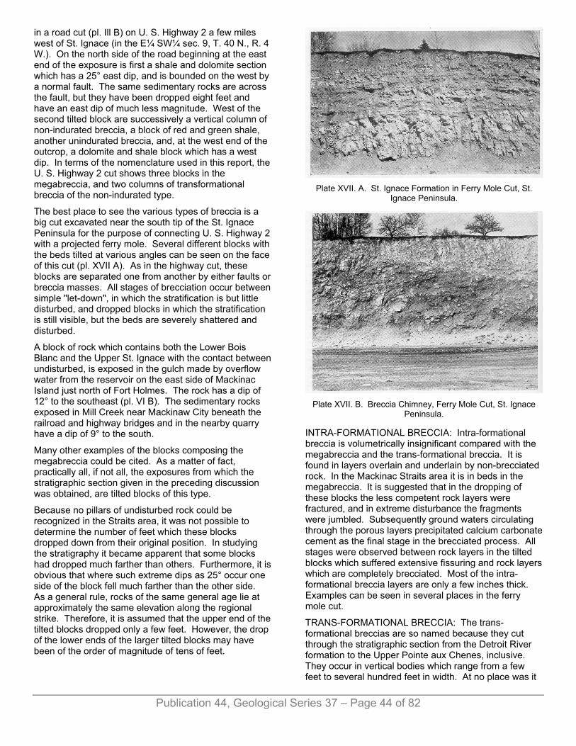
in a road cut (pl. Ill B) on U. S. Highway 2 a few miles west of St. Ignace (in the E¼ SW¼ sec. 9, T. 40 N., R. 4 W.). On the north side of the road beginning at the east end of the exposure is first a shale and dolomite section which has a 25° east dip, and is bounded on the west by a normal fault. The same sedimentary rocks are across the fault, but they have been dropped eight feet and have an east dip of much less magnitude. West of the second tilted block are successively a vertical column of non-indurated breccia, a block of red and green shale, another unindurated breccia, and, at the west end of the outcrop, a dolomite and shale block which has a west dip. In terms of the nomenclature used in this report, the U. S. Highway 2 cut shows three blocks in the megabreccia, and two columns of transformational breccia of the non-indurated type.
The best place to see the various types of breccia is a big cut excavated near the south tip of the St. Ignace Peninsula for the purpose of connecting U. S. Highway 2 with a projected ferry mole. Several different blocks with the beds tilted at various angles can be seen on the face of this cut (pl. XVII A). As in the highway cut, these blocks are separated one from another by either faults or breccia masses. All stages of brecciation occur between simple "let-down", in which the stratification is but little disturbed, and dropped blocks in which the stratification is still visible, but the beds are severely shattered and disturbed.
A block of rock which contains both the Lower Bois Blanc and the Upper St. Ignace with the contact between undisturbed, is exposed in the gulch made by overflow water from the reservoir on the east side of Mackinac Island just north of Fort Holmes. The rock has a dip of 12° to the southeast (pl. VI B). The sedimentary rocks exposed in Mill Creek near Mackinaw City beneath the railroad and highway bridges and in the nearby quarry have a dip of 9° to the south.
Many other examples of the blocks composing the megabreccia could be cited. As a matter of fact, practically all, if not all, the exposures from which the stratigraphic section given in the preceding discussion was obtained, are tilted blocks of this type.
Because no pillars of undisturbed rock could be recognized in the Straits area, it was not possible to determine the number of feet which these blocks dropped down from their original position. In studying the stratigraphy it became apparent that some blocks had dropped much farther than others. Furthermore, it is obvious that where such extreme dips as 25° occur one side of the block fell much farther than the other side. As a general rule, rocks of the same general age lie at approximately the same elevation along the regional strike. Therefore, it is assumed that the upper end of the tilted blocks dropped only a few feet. However, the drop of the lower ends of the larger tilted blocks may have been of the order of magnitude of tens of feet.
Plate XVII. A. St. Ignace Formation in Ferry Mole Cut, St.
Ignace Peninsula.
Plate XVII. B. Breccia Chimney, Ferry Mole Cut, St. Ignace
Peninsula.
INTRA-FORMATIONAL BRECCIA: Intra-formational breccia is volumetrically insignificant compared with the megabreccia and the trans-formational breccia. It is found in layers overlain and underlain by non-brecciated rock. In the Mackinac Straits area it is in beds in the megabreccia. It is suggested that in the dropping of these blocks the less competent rock layers were fractured, and in extreme disturbance the fragments were jumbled. Subsequently ground waters circulating through the porous layers precipitated calcium carbonate cement as the final stage in the brecciated process. All stages were observed between rock layers in the tilted blocks which suffered extensive fissuring and rock layers which are completely brecciated. Most of the intra-formational breccia layers are only a few inches thick. Examples can be seen in several places in the ferry mole cut.
TRANS-FORMATIONAL BRECCIA: The trans-formational breccias are so named because they cut through the stratigraphic section from the Detroit River formation to the Upper Pointe aux Chenes, inclusive. They occur in vertical bodies which range from a few feet to several hundred feet in width. At no place was it
Publication 44, Geological Series 37 – Page 44 of 82
possible to find the bottom of one of these breccia columns. In several places (as at the exposure south of Dwightwood Spring on the east side of Mackinac Island) the breccia was observed high on the side of a cliff with bedded rocks apparently lying beneath. However, excavation with pick and shovel proved that the breccia continues downward with near vertical walls, and the bedded rocks lower on the cliff abut against the breccia. Sedimentary rocks were not found directly overlying breccia, except in the Calcite quarry at Rogers City, where the overlying bedded rocks are of Dundee age, and on Round Island, an exceptional condition described on page 152.
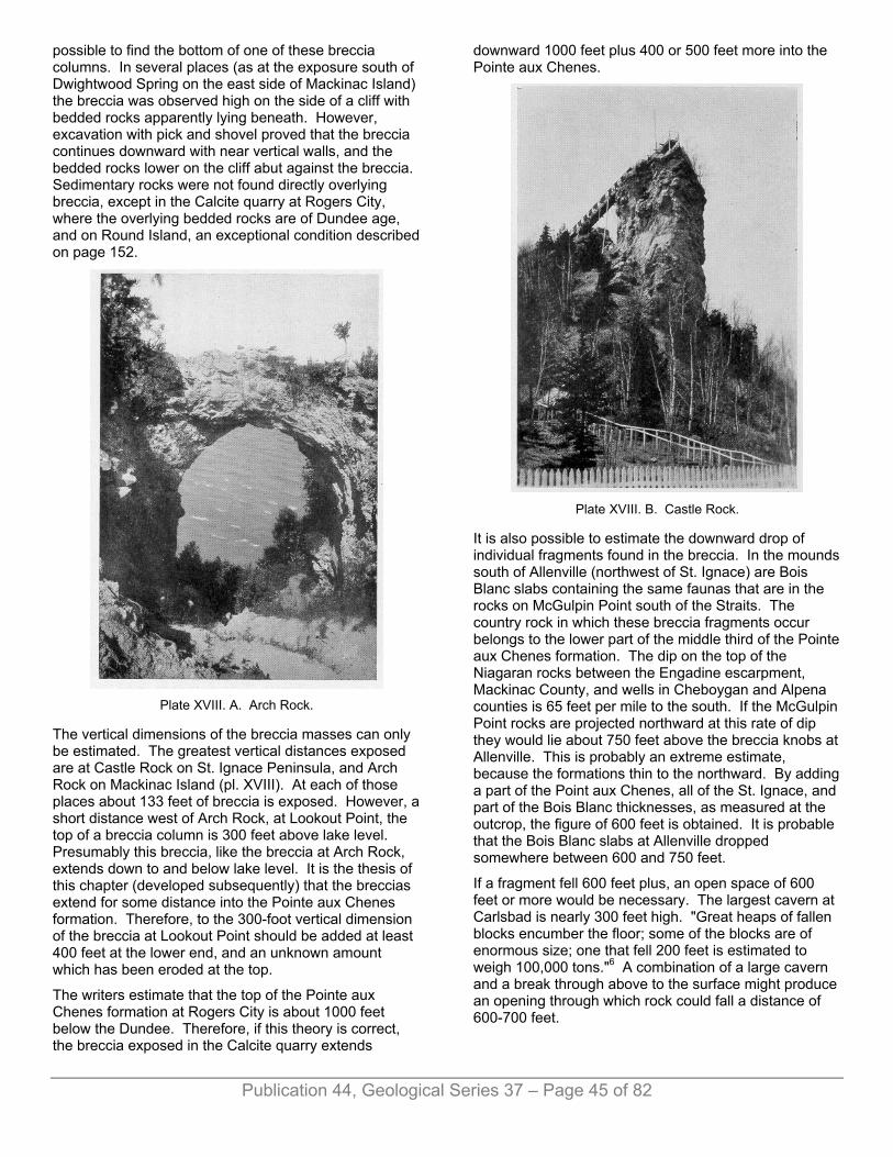
Plate XVIII. A. Arch Rock.
The vertical dimensions of the breccia masses can only be estimated. The greatest vertical distances exposed are at Castle Rock on St. Ignace Peninsula, and Arch Rock on Mackinac Island (pl. XVIII). At each of those places about 133 feet of breccia is exposed. However, a short distance west of Arch Rock, at Lookout Point, the top of a breccia column is 300 feet above lake level. Presumably this breccia, like the breccia at Arch Rock, extends down to and below lake level. It is the thesis of this chapter (developed subsequently) that the breccias extend for some distance into the Pointe aux Chenes formation. Therefore, to the 300-foot vertical dimension of the breccia at Lookout Point should be added at least 400 feet at the lower end, and an unknown amount which has been eroded at the top.
The writers estimate that the top of the Pointe aux Chenes formation at Rogers City is about 1000 feet below the Dundee. Therefore, if this theory is correct, the breccia exposed in the Calcite quarry extends
downward 1000 feet plus 400 or 500 feet more into the Pointe aux Chenes.
Plate XVIII. B. Castle Rock.
It is also possible to estimate the downward drop of individual fragments found in the breccia. In the mounds south of Allenville (northwest of St. Ignace) are Bois Blanc slabs containing the same faunas that are in the rocks on McGulpin Point south of the Straits. The country rock in which these breccia fragments occur belongs to the lower part of the middle third of the Pointe aux Chenes formation. The dip on the top of the Niagaran rocks between the Engadine escarpment, Mackinac County, and wells in Cheboygan and Alpena counties is 65 feet per mile to the south. If the McGulpin Point rocks are projected northward at this rate of dip they would lie about 750 feet above the breccia knobs at Allenville. This is probably an extreme estimate, because the formations thin to the northward. By adding a part of the Point aux Chenes, all of the St. Ignace, and part of the Bois Blanc thicknesses, as measured at the outcrop, the figure of 600 feet is obtained. It is probable that the Bois Blanc slabs at Allenville dropped somewhere between 600 and 750 feet.
If a fragment fell 600 feet plus, an open space of 600 feet or more would be necessary. The largest cavern at Carlsbad is nearly 300 feet high. "Great heaps of fallen blocks encumber the floor; some of the blocks are of enormous size; one that fell 200 feet is estimated to weigh 100,000 tons."6 A combination of a large cavern and a break through above to the surface might produce an opening through which rock could fall a distance of 600-700 feet.
Publication 44, Geological Series 37 – Page 45 of 82
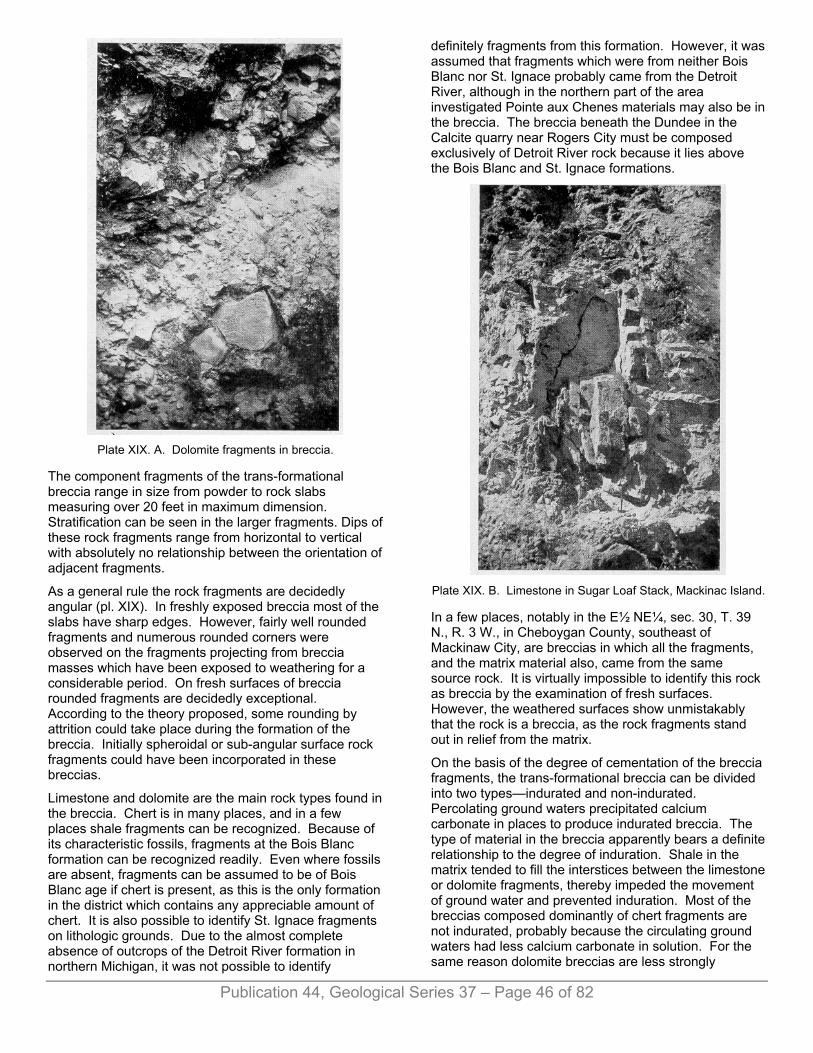
Plate XIX. A. Dolomite fragments in breccia.
The component fragments of the trans-formational breccia range in size from powder to rock slabs measuring over 20 feet in maximum dimension. Stratification can be seen in the larger fragments. Dips of these rock fragments range from horizontal to vertical with absolutely no relationship between the orientation of adjacent fragments.
As a general rule the rock fragments are decidedly angular (pl. XIX). In freshly exposed breccia most of the slabs have sharp edges. However, fairly well rounded fragments and numerous rounded corners were observed on the fragments projecting from breccia masses which have been exposed to weathering for a considerable period. On fresh surfaces of breccia rounded fragments are decidedly exceptional. According to the theory proposed, some rounding by attrition could take place during the formation of the breccia. Initially spheroidal or sub-angular surface rock fragments could have been incorporated in these breccias.
Limestone and dolomite are the main rock types found in the breccia. Chert is in many places, and in a few places shale fragments can be recognized. Because of its characteristic fossils, fragments at the Bois Blanc formation can be recognized readily. Even where fossils are absent, fragments can be assumed to be of Bois Blanc age if chert is present, as this is the only formation in the district which contains any appreciable amount of chert. It is also possible to identify St. Ignace fragments on lithologic grounds. Due to the almost complete absence of outcrops of the Detroit River formation in northern Michigan, it was not possible to identify
definitely fragments from this formation. However, it was assumed that fragments which were from neither Bois Blanc nor St. Ignace probably came from the Detroit River, although in the northern part of the area investigated Pointe aux Chenes materials may also be in the breccia. The breccia beneath the Dundee in the Calcite quarry near Rogers City must be composed exclusively of Detroit River rock because it lies above the Bois Blanc and St. Ignace formations.
Plate XIX. B. Limestone in Sugar Loaf Stack, Mackinac Island.
In a few places, notably in the E½ NE¼, sec. 30, T. 39 N., R. 3 W., in Cheboygan County, southeast of Mackinaw City, are breccias in which all the fragments, and the matrix material also, came from the same source rock. It is virtually impossible to identify this rock as breccia by the examination of fresh surfaces. However, the weathered surfaces show unmistakably that the rock is a breccia, as the rock fragments stand out in relief from the matrix.
On the basis of the degree of cementation of the breccia fragments, the trans-formational breccia can be divided into two types—indurated and non-indurated. Percolating ground waters precipitated calcium carbonate in places to produce indurated breccia. The type of material in the breccia apparently bears a definite relationship to the degree of induration. Shale in the matrix tended to fill the interstices between the limestone or dolomite fragments, thereby impeded the movement of ground water and prevented induration. Most of the breccias composed dominantly of chert fragments are not indurated, probably because the circulating ground waters had less calcium carbonate in solution. For the same reason dolomite breccias are less strongly
Publication 44, Geological Series 37 – Page 46 of 82
indurated than breccias which consist largely of limestone fragments.
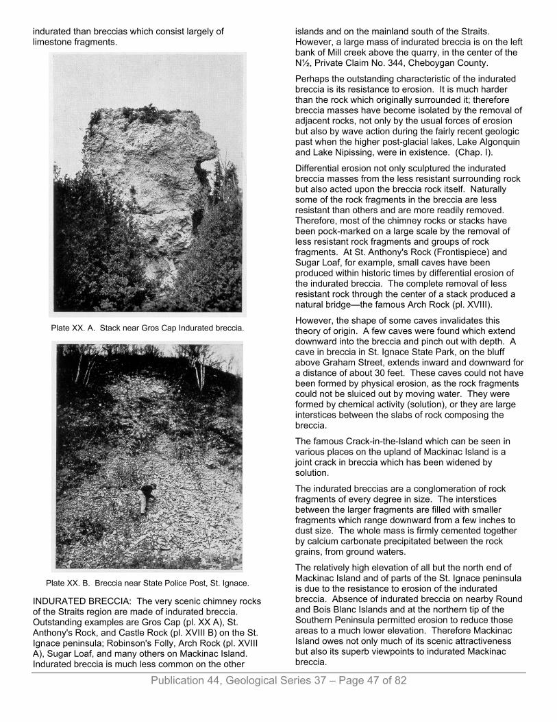
Plate XX. A. Stack near Gros Cap Indurated breccia.
Plate XX. B. Breccia near State Police Post, St. Ignace.
INDURATED BRECCIA: The very scenic chimney rocks of the Straits region are made of indurated breccia. Outstanding examples are Gros Cap (pl. XX A), St. Anthony's Rock, and Castle Rock (pl. XVIII B) on the St. Ignace peninsula; Robinson's Folly, Arch Rock (pl. XVIII A), Sugar Loaf, and many others on Mackinac Island. Indurated breccia is much less common on the other
islands and on the mainland south of the Straits. However, a large mass of indurated breccia is on the left bank of Mill creek above the quarry, in the center of the N½, Private Claim No. 344, Cheboygan County.
Perhaps the outstanding characteristic of the indurated breccia is its resistance to erosion. It is much harder than the rock which originally surrounded it; therefore breccia masses have become isolated by the removal of adjacent rocks, not only by the usual forces of erosion but also by wave action during the fairly recent geologic past when the higher post-glacial lakes, Lake Algonquin and Lake Nipissing, were in existence. (Chap. I).
Differential erosion not only sculptured the indurated breccia masses from the less resistant surrounding rock but also acted upon the breccia rock itself. Naturally some of the rock fragments in the breccia are less resistant than others and are more readily removed. Therefore, most of the chimney rocks or stacks have been pock-marked on a large scale by the removal of less resistant rock fragments and groups of rock fragments. At St. Anthony's Rock (Frontispiece) and Sugar Loaf, for example, small caves have been produced within historic times by differential erosion of the indurated breccia. The complete removal of less resistant rock through the center of a stack produced a natural bridge—the famous Arch Rock (pl. XVIII).
However, the shape of some caves invalidates this theory of origin. A few caves were found which extend downward into the breccia and pinch out with depth. A cave in breccia in St. Ignace State Park, on the bluff above Graham Street, extends inward and downward for a distance of about 30 feet. These caves could not have been formed by physical erosion, as the rock fragments could not be sluiced out by moving water. They were formed by chemical activity (solution), or they are large interstices between the slabs of rock composing the breccia.
The famous Crack-in-the-Island which can be seen in various places on the upland of Mackinac Island is a joint crack in breccia which has been widened by solution.
The indurated breccias are a conglomeration of rock fragments of every degree in size. The interstices between the larger fragments are filled with smaller fragments which range downward from a few inches to dust size. The whole mass is firmly cemented together by calcium carbonate precipitated between the rock grains, from ground waters.
The relatively high elevation of all but the north end of Mackinac Island and of parts of the St. Ignace peninsula is due to the resistance to erosion of the indurated breccia. Absence of indurated breccia on nearby Round and Bois Blanc Islands and at the northern tip of the Southern Peninsula permitted erosion to reduce those areas to a much lower elevation. Therefore Mackinac Island owes not only much of its scenic attractiveness but also its superb viewpoints to indurated Mackinac breccia.
Publication 44, Geological Series 37 – Page 47 of 82

Publication 44, Geological Series 37 – Page 48 of 82
NON-INDURATED BRECCIA: The non-indurated breccia is quantitatively much more important than the indurated. Its total volume is enormous. In spite of this fact, it apparently was not recognized as breccia by earlier geologic investigators in this area. Most of the non-indurated breccia is porous and no doubt was penetrated by percolating waters, but these waters did not carry sufficient calcium carbonate to cement the rock firmly together. As a matter of fact, partial induration occurred in many places and various gradations can be found between completely incoherent material and indurated breccia. In this discussion breccia which is not sufficiently cemented to stand out as a resistant rock is classified as non-indurated.7
Another type of non-indurated breccia is composed of dolomite fragments imbedded in a matrix of shale. The amount of shale is sufficient to make the rock relatively impermeable. An illustration of this type of breccia is at the south end of the ferry mole cut where the sides of the excavation are much less steep than they are to the north. The material composing the walls looks like mantle rock, but when dug into is found to consist of dolomite in fragments of varying shape and size in a shale matrix. Another good illustration is at the shale quarry one-half mile south of British Landing, on the west side of Mackinac Island. Exposed in different parts of that quarry are: (1) about seven feet of undisturbed red and green shale at the north end of the quarry face; (2) highly disturbed shale with no bedding discernable; (3) the same shale but having a few blocks of dolomite two feet across scattered through it; and (4) typical breccia, with smaller dolomite fragments in a shale matrix.
Elsewhere in the ferry mole cut, between blocks of the mega-breccia, masses of trans-formational breccia show various degrees of induration. Farther north, along U. S. Highway 2, between St. Ignace and West Moran Bay, the low banks beside the highway contain poorly indurated cherty breccia. Much farther to the north, in the vicinity of Allenville, where the greenish shale of the Pointe aux Chenes is the normal country rock, "haystacks" of poorly indurated breccia dot the fields and pastures over several sections. These rock mounds consist of slabs of varying size of limestone and dolomite. Many are highly fossiliferous Bois Blanc fragments.
RELATIONSHIP OF BRECCIAS TO EACH OTHER: The intra-formational breccia always occurs in blocks in the megabreccia. Sufficient examples have been described of the juxtaposition of megabreccia blocks to trans-formational breccia to emphasize the point that they are invariably associated together, and without doubt they originated from the same cause and through allied processes. Mackinac Island and the entire St. Ignace peninsula south of the approximate latitude of Allenville (figs. 1, 2) are built of a mixture of megabreccia and trans-formational breccia. On Round and Bois Blanc islands, however, and on the south side of the Straits in the Southern Peninsula the trans-
formational breccia is decidedly subordinate to the megabreccia.
The megabreccia and the trans-formational breccia can be viewed together in the ferry mole cut, at Castle Rock, on St. Ignace Peninsula, and south of Dwightwood Spring on the east side of Mackinac Island. Castle Rock itself is indurated trans-formational breccia, but, the upland immediately to the west, on which the lower end of the viewpoint gangway is footed, is composed of megabreccia. The block nearest Castle Rock has a dip to the west of 17° but where it abuts against the indurated breccia the dip increases to 45° and the rock at the end of the abutting layers is brecciated in places. The evidence at this locality points toward the dropping of the megabreccia block after the trans-formational breccia was in place, with the bedded rock dragging along the contact.
At the cliff south of Dwightwood Spring on Mackinac Island, the bedded rocks which lie in front of, and abut onto, indurated breccia have a dip of 19° to the southwest and obviously belong to a block in the megabreccia. Although no drag was found where these massive beds approach the indurated breccia, a tendency to brecciation in the contact zone was observed.
AGE OF BRECCIATION Obviously the brecciation took place after lithifaction of the rocks involved. In no other way can the angular blocks of bedded rock of widely varying age be explained. Because Bois Blanc rocks are recognized in practically all of the breccia examined, it can be concluded that brecciation was at least post-Bois Blanc. However, Detroit River rocks are thought to be in the Bois Blanc-containing breccias of the St. Ignace district, and the occurrence of Detroit River rock in the breccia near Rogers City cannot be doubted. In the north end of the quarry of the Michigan Limestone and Chemical Company at Calcite the Dundee has been completely removed. At this place a large pit has been excavated in the floor of the quarry, and breccia consisting of dolomite fragments of varying size in a blue clay shale matrix is exposed. Although this pit is almost filled with water, the uncomformable contact between the flat-lying bedded Dundee limestone and the underlying breccia can be seen and examined a short distance above water level on the west side of the pit. A large dolomite mass weighing many tons, and smaller dolomite fragments, have been dredged out of the harbor slip at the port of Calcite. Company officials report that these dolomite masses are likewise embedded in blue clay in the lake bottom. Furthermore R. A. Smith8 states that in 1914 breccia was exposed on the beach at Calcite in the area now covered by the plant's tailings pile. This site has the same elevation as the upper surface of the breccia in the deep pit, which is three or four feet above the lake level. Smith also reports that he visited a core test well drilled in 1914 southwest of the quarry which was 800 feet

Publication 44, Geological Series 37 – Page 49 of 82
deep and had penetrated a large amount of breccia beneath the Dundee.
The age of the brecciation at Rogers City is undoubtedly post-Detroit River and pre-Dundee. It is likely that the brecciation in the immediate vicinity of the Mackinac Straits is of the same age, but it is admitted that the process of brecciation could have been a continuing one over a considerable period of time and that some of the brecciation might have taken place earlier.
ORIGIN OF MACKINAC BRECCIA Naturally the breccia deposits of the Straits region have excited the curiosity of all geologists who have visited the area. The rocks of Mackinac Island have been most discussed, not only because of the good breccia exposures but also because this island has long been a stop-over point for travelers on the lakes. Many hypotheses have been advanced to answer the problem of the breccia. A theory of its origin reached after field studies (1942-1944) of recent and old exposures is herewith presented.
PREVIOUS HYPOTHESES At least nine geologists have described the Mackinac breccia in print, and eight have ventured explanations regarding its origin. John J. Bigsby, British army doctor by vocation and geologist by avocation, who visited Mackinac (then called "Michilimackinac") Island in 1819 and again in 1820, first described the rocks as follows (1821):
"The rocks are calcareous; and the clear idea of their nature is afforded by the south-east extremity of the north-east precipice which may be described as follows: A few soft strata, very thin, white and horizontal, shew themselves at the top; but below this the limestone becomes yellow and ragged. Much of it is compact, but it is more usually occupied by vesicles (as from bubbles of air) encrusted with crystals of quartz in botryoidal clusters. A few of them are three or four feet in diameter, and contain smaller cavities in several series. Other parts contiguous to this, are an aggregate of angular fragments of slaty limestone cemented as if by semifusion, and with interstices lined with quartzose crystallizations. The size of the fragments varies from one to eight inches. They also are of an ochry yellow. The bottom of the cliff is in horizontal strata, which are moderately thick, very soft, even so as to write, and of a white, or bluish color. I have been thus minute, on this spot, as the herbage does not permit an examination at any other except in small patches where similar appearances were noticed.
"The north-west half of this long side of the Island declines in height very gradually and consists of debris excepting a few schistose strata at the top. Not far from the end a road is making up the steep (1810). Here the limestone contains a few blue and white striped flints, which are remarkable for being broken, small, and angular. . . .
"The other long side possesses the same geological features as the one described. The breccia perhaps abounds more here. The slaty portions are found at every level and at one place in strata two feet thick. About the middle there is a cave, about three yards in its greatest depth, formed by the concurrence of several of the cavernous bowl-shaped hollows, thus creating one of great dimensions; whose interior is subdivided into smaller cavities seriatim.
"The beach is covered almost exclusively with limestones, slaty, vesicular, and brecciated. . . .
"Two, if not three eras and modes of formation are here clearly distinguishable. The first and oldest is the slate, which is seen to floor the lake for miles around. Upon it are supported two calcareous masses which mingle with each other and with short slips of the schist in the greatest disorder; and having a few of the broken flints interspersed. In all probability they are veins of strata which have been overwhelmed by a sudden violent force.
"Heat may have been the means of raising, comminuting, and partially melting this bed of limestone. Steam, a principal agent, may have insinuated itself into the more yielding portions; and the whole, has finally consolidated.”9
It is curious that in a slightly later but very similar paper Bigsby10 omitted the concluding paragraph, in which a possible mode of origin is suggested. He does, however, in the later paper, compare the "cavernous and brecciated" limestone of Mackinac with the magnesium breccia of Bristol and other parts of England.
The second annual report (1839) of the first State Geologist, Douglass Houghton, contains some keen observations on the Mackinac breccia and a conclusion as to its possible mode of formation:
"The shattered and deranged condition of the rock upon the island of Mackinac, and its vicinity, gives the whole mass a peculiarly complicated structure, and has led to what is conceived to be an error respecting it. Thus the rock has been described as a conglomerate, destitute of stratification, a conclusion which would appear to have been drawn without proper consideration of the facts connected with the subject. That the fragmentary masses, composing the main portions of the rock, have not been transported, is conclusively shown by the fact that the most delicate angles are preserved, a circumstance which could not have taken place had they been subjected to the action of water, before being cemented. A careful examination has shown that portions of the rock still remain, in which the relative position of the original lines of stratification are preserved for an extent of several rods; and on Round Island the line of stratification was traced for a distance of nearly half a mile.
"The rock in question, no doubt occupies very nearly its original relative situation, and its present condition may be ascribed to an uplift of the strata, subsequent to the complete induration of the rock; a cause which is amply sufficient to account for the present appearances. The fragments thus separated have been imperfectly cemented by the gradual infiltration of calcareous matter, thus re-uniting the complete mass."11
Twelve years later James Hall, noted New York State Geologist, described the breccia in a paper published in the Government report prepared by J. W. Foster and J.

Publication 44, Geological Series 37 – Page 50 of 82
D. Whitney. Hall tentatively suggested one method of formation in his description, and, in a footnote, by analogy, suggested another method.
"Returning, for a moment, to the island of Mackinac and the more elevated positions of Pointe St. Ignace and Gros Cap, we find the marly beds succeeded by a brecciated limestone, composed of what appears to be thin argillo-calcareous beds, or laminae, which often partially, or entirely, indurated, have been broken up and mingled with a softer argillo-calcareous mud. It may be very appropriately termed a brecciated limestone.* This brecciated mass, in its lower parts, is composed of broken, thin-bedded limestone, like the higher layers of the Onondaga salt group, of the thinly laminated beds connected with the gypsum deposits of New York and Canada West, which have been recemented by a calcareous mud. The fragments are presented in every possible attitude, as if broken up by the action of conflicting currents, though I was unable to detect the effects of anything like wearing action upon their edges."12
*The aspect of this rock is very similar to what may be seen, on a small scale, in countries where calcareous springs are abundant. The thinly-laminated and shaly limestone mingled with others of a more massive character, being broken up, becomes cemented together by the calcareous deposit from the springs, and forms a mass not unlike some portions of this limestone.
The second State Geologist, Alexander Winchell, visited Mackinac Island in 1860. He described the breccia as follows:
"The well characterized limestones of the Upper Helderberg Group, to the thickness of 250 feet, exist in a confusedly brecciated condition. The individual fragments of the mass are angular and seem to have been but little moved from their original places. It appears as if the whole formation had been shattered by sudden vibrations and unequal uplifts, and afterwards a thin calcareous mud poured over the broken mass, percolating through all the interstices, and re-cementing the fragments.”13
The first completely detailed observations on the Mackinac breccia were published by the third State Geologist, Carl L. Rominger,14 in 1873. He recognized the breccia as composed of "a great variety of calcareous, dolomitic, cherty, and calcareo-argillaceous rock fragments, mixed and thrown about through the re-cemented rock mass." Rominger was the first geologist to call attention to the regional nature of the breccia, noting that rocks of similar age are brecciated on several of the islands in Lake Erie.
With most of Rominger's observations the writers have no arguments. But we cannot agree with his statement that layered dolomites underlie the breccia, inasmuch as we have found that layered rocks lie at a lower elevation than some cliff breccia exposures, but are in front of, and are truncated by, the near-vertical breccia masses. The writers also differ with two points in Rominger's interpretation. Rominger believed the breccia to be composed in part of the fractured beds of the immediately underlying formation and that the large vertical slabs of higher rocks in the breccia tumbled into clefts during the present erosion cycle. However, the latest discovered evidence indicates that the source rocks were from upper formations and the writers found
that large vertical blocks are an integral part of the breccia.
It is surprising to note that, in spite of his detailed observations, Rominger did not offer any explanation of the genesis of the breccia in his published reports.
Twenty-two years later A. C. Lane, later State Geologist, proposed a theory to explain both the breccia and the salt deposits:
"The period of the Monroe beds is that of the Salina and Lower Helderberg. At that time Michigan was covered by an excessively salt sea which stretched from Wisconsin to New York, was bounded by a continent on the north and east, on the west by low land in Wisconsin (the edge of the Helderberg is found barely extending to just north of Milwaukee), and on the south by a great bar, or reef, or flat in Ohio, which seems to have been just awash. This is indicated by the prevalence in the Ohio Helderberg, not only of ripple-marks, but also of mud cracks and of brecciated and conglomeratic layers. If we imagine tides like those of the Bay of Fundy rushing over this flat, producing this breccia and conglomerate and bringing fresh supplies of water to the enclosed sea, and furthermore that the sea was exposed to a hot sun and received but little accession of fresh water from rivers—this latter is shown to be true by the scarcity of mud and sand—we have the conditions of the Helderberg or Monroe deposits, conditions which are evidently favorable to the formation of a sea charged with salts."15
According to such an hypothesis, horizontal rather than vertical breccia deposits would be produced. It must be noted that Lane was primarily discussing the Monroe County breccias, not the breccias of the Mackinac Straits region.
I. C. Russell published a report in 1905 on a reconnaissance trip made the preceding year along the north shore of Lakes Michigan and Huron. Although primarily interested in the Pleistocene and recent history of the shoreline areas, Russell observed the breccia and developed a logical hypothesis for its origin:
"The rock, mostly impure limestone, at the top of the gypsum bearing formation and marking the passage into the overlying formation, is peculiar, inasmuch as it consists of angular fragments of limestone inclined in all directions and cemented into a compact mass by carbonate of lime which has been deposited in the cracks and crevices between them. This breccia is well exposed in the rocky ridges in the western portion of the town of St. Ignace, and at the Sugar Loaf and other localities on Mackinac Island. An explanation of the origin of the breccia, so far as I am aware, has not been offered, although Hall directed attention to it and judging from the statements made in his report, seemed to consider it as evidence of an unconformity, that is, the occurrence of an interval during which the lower formation was exposed to the air and broken and eroded before the rocks resting on it were deposited. The fragments of limestone in the breccia, however, are sharply angular and not rounded as is nearly always the case with stones that have been weathered, or removed and re-deposited by water. The nature of the breccia and its occurrence above strata containing easily soluble beds of gypsum,—and of anhydrite which in the presence of water is prone to change to a hydrous

Publication 44, Geological Series 37 – Page 51 of 82
condition, accompanied by an increase in volume—suggests that the fracturing and displacement of the rocks may be due to the removal of material in solution, and to changes in volume caused by the hydration of the anhydrite. Remembering that the present surface of the St. Ignace Peninsula, etc., has been exposed owing to the removal of very considerable depths and probably many hundreds of feet of rock, it is evident that the solution of beds of gypsum or the alteration of the anhydrite, at any time subsequent to the consolidation of the formation resting on it, would lead to movements, and particularly the settling and fracturing of the rocks above the gypsum-bearing layers, which would become broken, and displaced and if re-cemented would form a breccia. The above suggestion may perhaps lead future visitors to the region about Mackinac to examine the rocks attentively with the view of discovering evidence which will sustain or disprove the hypothesis here proposed."16
This was the first expression of the possibility of brecciation by collapse. It will be shown later that leaching of salt is a more probable cause than the solution of gypsum.
An odd hypothesis was presented by Grabau in 1913: "THE MACKINAC LIMESTONE BRECCIA. This is a remarkable example of a breccia made up of large and small angular fragments of finely bedded upper Siluric (Monroan) limestones and dolomites, derived from a still intact cliff of this limestone near St. Ignace in the Upper Peninsula. The deposit is best seen in the cliffs of Mackinac Island, nearly the entire mass of which seems to be composed of this rock, which must here have a thickness of between 200 and 300 feet or more. The fragments are of all sizes from that of a pinhead to blocks ten feet or more in diameter, and their position in the breccia is such that the stratification lines of the individual blocks dip in all directions. The distance to which these blocks have been carried from the parent ledges is many miles, and the width of this ancient stream is unknown. At St. Ignace the high ground behind the beach consists of the Monroe dolomites in undisturbed horizontal position, but in front of these at a level represented in the cliffs by bedded strata are erosion stacks of the brecciated rock, carved from the cliff during a period of higher level of the lakes. The position is such as to indicate that these stacks are evidently a part of the rock stream, while the cliffs behind the stacks are a part of the original cliff. In one part of Mackinac Island the breccia is found to be underlain by shales and thin limestones of Monroan (or Salinan?) age.
"That the rock stream represented a subaerial flow of the rocks is shown by its character. Fine, rounded quartz grains, blown from a distance, are incorporated in the mass. The age of this stream is Lower Devonic, the Middle Devonic Onondaga strata enveloping and enclosing it and partly incorporating it as a somewhat reworked product."17
The writers take decided issue with Grabau's statement that shales and thin limestones underlie the breccia on Mackinac Island, as excavation has proved that the sedimentary rocks abut against the breccia. We disagree with his description of dolomites in "undisturbed horizontal position" in the cliff at St. Ignace, since careful examination proves that the cliff back of St. Anthony's Rock at St. Ignace does not contain "undisturbed"
dolomite—it consists of both unindurated breccia and tilted slabs of megabreccia.
In the writer's opinion the first plausible hypothesis on the origin of the Mackinac breccia was developed by Hindshaw and reported by Smith in 1914:
"During the past few years Mr. Henry H. Hindshaw, former assistant State geologist of New York, has made an extensive study of the limestone deposits of possible commercial value in Alpena and Presque Isle counties. He observed the abnormal dips, local fractures, and the brecciation of the Dundee limestone, which near Rogers City, is so great that drilling with a core drill is very difficult.
"In the Salina, in Alpena and Presque Isle counties, the salt beds aggregate 300 to 800 feet in thickness. According to the upward rise of this formation toward the northeast and east, it should form the bottom of the Lake Huron basin. Thin salt beds occur at Manistee and Ludington, and here too are to be observed abnormal local dips and a Vesicular dolomite above the salt which caves in the drillings, and is very probably brecciated. The brecciation in the Dundee and the Monroe in the Frankfort well appears to be undoubted.
"In limestone areas, much of the drainage is underground. In the limestone belt of northern Michigan there are relatively few streams as most of the surface waters drain into the numerous sinks. The Dundee, especially near its base, and the Monroe beds are very heavily water bearing, being filled with crevices, fissures, caverns, and underground water channels. The water channel struck in the Detroit salt shaft was more than five feet across. In many instances drill tools suddenly drop four or five feet into cavities. Again, in drillings, beds of dolomitic sand are struck in the Monroe which flow into the drill holes like thin mud. Such sands and oozes may be the residuum of other beds carried away by solution.
"Mr. Hindshaw related these facts—the abnormal dips, the brecciation of the Dundee and the Monroe beds, the large underground water circulation, the oozes, the relation of the margin of the Salina formation to the basins of Lakes Huron and Michigan, and conceived the idea that these lake depressions are due in part to the ablation, or solution of the salt in the Salina and that the brecciation was caused by the slumping incident to the removal of the salt beds below. While the validity of all of the evidence has not been investigated, the theory as advanced contains elements of plausibility and is worthy of consideration.
"It is obvious that if the salt in the outer edges of the formation should be removed by solution, there would be slumping in the beds above, which might very possibly cause brecciation in rocks like dolomites and limestones. The slumping would also explain the abnormal dips, observed near the lake shores."18
Since Hindshaw's time quarrying operations in the Calcite quarry of the Michigan Limestone and Chemical Company have exposed the unconformable contact between the Dundee formation and the underlying breccia. Brecciation does not extend into the Dundee; the irregularities in the Dundee rocks can be explained by post-Dundee settling. The collapsing which produced the breccia must have taken place before the Dundee formation was deposited.

Publication 44, Geological Series 37 – Page 52 of 82
Norton5 classified the Mackinac breccia as "founder" breccia, based on personal observation which he found supported the theory of Hindshaw. An additional observational fact reported by Norton is the presence of small chimneys of breccia penetrating the shales at the foot of the cliffs on Mackinac Island.
Newcombe, in his monograph on the Michigan Basin, mentions salt leaching as a factor in modifying structural features:
"Faulting which is caused by the dissolving of salt beds is probably a widespread type of displacement in the rocks of the State. The margins of the Detroit River and Salina salt basins . . . are general belts of extensive solution and slumping resulting from that cause."19
SUGGESTED THEORY The theory developed by the writer of this report is in its main essentials the same as the theory advanced by Hindshaw. The observations made in the field and in the study of the well samples strongly support this theory.
The first stage in the sequence leading to the formation of breccia was the deposition of the rocks belonging to the Point aux Chenes formation. The land surface, floored with rocks of Niagaran age, was submerged beneath the Pointe aux Chenes sea. While this submergence was in effect, several hundreds of feet of shale, dolomite, salt, and gypsum were deposited. According to well records, salt of Pointe aux Chenes age underlies the Southern Peninsula of Michigan excepting beneath the northern tip and the southern and southwestern parts. It is also in southwestern Ontario. The thickest salt deposits, over 1600 feet, are found immediately west of Saginaw Bay, but as much as 1200 feet is found as far north as northwestern Alpena County. According to the theory, salt was originally deposited in the Pointe aux Chenes rocks farther north than the present northern boundary of the salt so that the present St. Ignace peninsula was also underlain by salt. It is also possible that the salt beds in the southeastern corner of the State originally extended into northern Ohio.
During times of subsequent submergences of the land in the Straits area, the St. Ignace dolomites, the Bois Blanc dolomites, cherts, and limestones, and the early Detroit River dolomites and limestones were deposited in successive layers above the Pointe aux Chenes salt-bearing rocks.
This sequence of deposition was followed by emergence. Perhaps during earlier emergences, but certainly during the time following the early Detroit River limestone and dolomite deposition, percolating underground waters leached great quantities of salt from around the rim of the salt basin. A vast series of caves and caverns were produced where the Pointe aux Chenes salt lay above the ground water table. Presumably the water below the ground water table level was so saturated that further solution was not possible. Because of the basinward dip of the sediments in the
Southern Peninsula, the salt available for leaching was only around the edges of the basin.
Naturally the formation of large caves underground created a condition of instability leading to the collapse of the cavern roof. The field evidence strongly suggests that this collapse was of two types. In one type the collapse was local and probably sudden. The overlying shale, dolomite, limestone, and chert broke into fragments of varying size and fell and slid downward. Naturally the individual fragments when they stopped falling were in random orientation and fragments from different rock layers were jumbled together. In this way the transformational breccia was formed. The probable result of local collapse was a sink at the surface.
The other type of collapse occurred between the areas of local and complete collapse. In these larger areas roof failure on a regional scale caused great blocks of sedimentary rocks to drop downward. Invariably one end of the block fell farther than the opposite end, producing a tilt. In this way the megabreccia was produced. Two observations suggest that the dropping of the large blocks took place after adjacent local collapse (p. 152). However, in other places the order could have been reversed, or the collapsing could have taken place simultaneously. Also, the let-down blocks may have dropped by stages, successive collapses occurring as additional amounts of salt were leached. It is suggested that most of the collapsing took place during the general period of emergence following Detroit River deposition and preceding Dundee deposition. However, the writer does not intend to imply that collapse was simultaneous throughout the entire area. When a roof cavern could no longer support the load of overlying material it collapsed and no doubt long periods of time intervened between the time of the first and the last collapse.
During and after the collapsing, the forces of erosion operating at the surface smoothed that surface into a peneplane and the surface inequalities resulting from the sink hole or karst topography and the larger depressions resulting from the sinking blocks were destroyed. Eventually in another period of submergence the Dundee sea came in and the limestones of Dundee time were deposited on the eroded surface of the older sediments, which, around the rim of the basin, had suffered considerable collapse. No doubt some additional settling continued to take place even after the Dundee limestones were lithified as shown by the fractures and minor structures in the Dundee in the quarry of the Michigan Limestone and Chemical Company near Rogers City. Also subsequent to the collapse, ground waters percolating through the jumbled rock fragments in the sink holes gradually cemented much of this material, producing the indurated breccia.
The final chapters in this history include: deposition of younger sediments, the relatively recent erosion history which brought about the exhumation of the collapsed rocks, and partial isolation of indurated breccia masses by differential erosion.
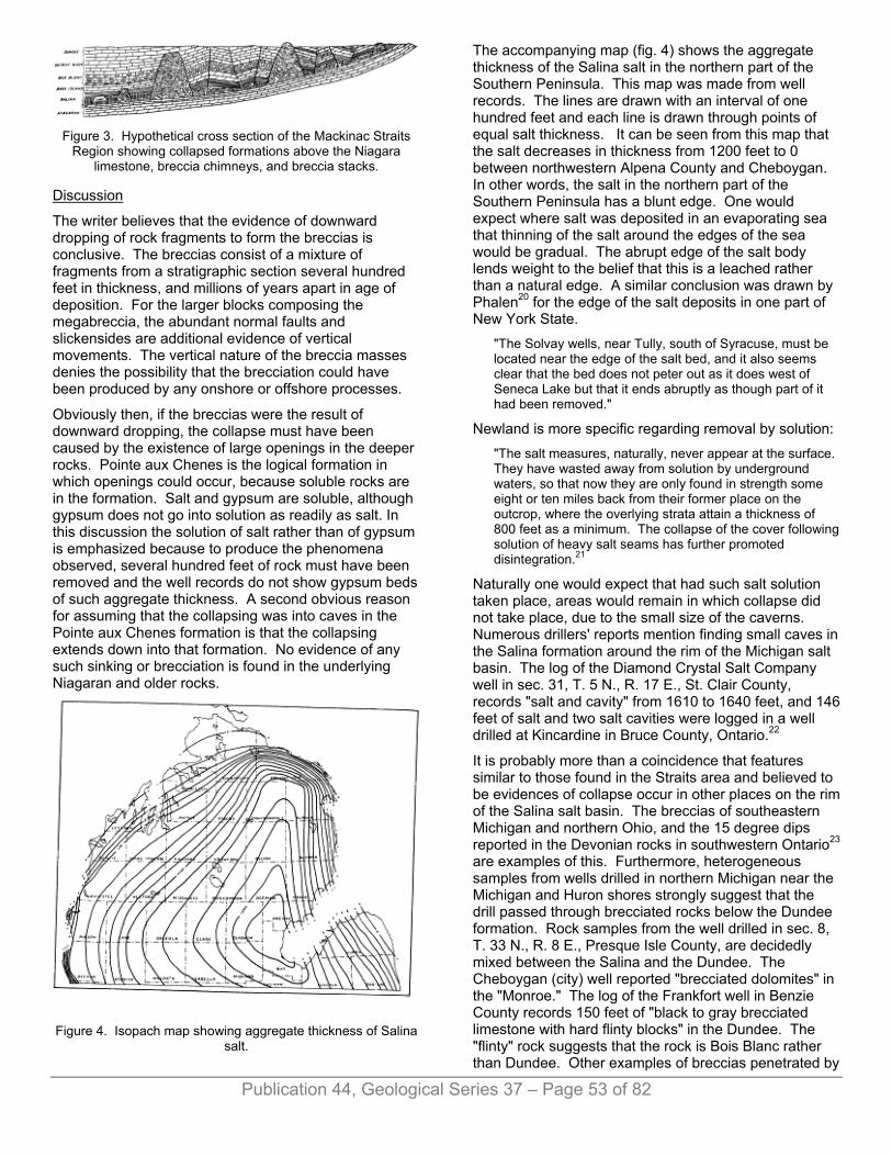
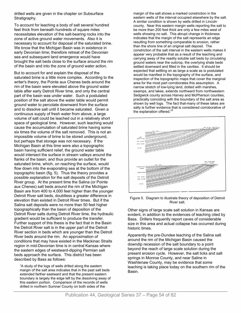
Figure 3. Hypothetical cross section of the Mackinac Straits
Region showing collapsed formations above the Niagara limestone, breccia chimneys, and breccia stacks.
Discussion
The writer believes that the evidence of downward dropping of rock fragments to form the breccias is conclusive. The breccias consist of a mixture of fragments from a stratigraphic section several hundred feet in thickness, and millions of years apart in age of deposition. For the larger blocks composing the megabreccia, the abundant normal faults and slickensides are additional evidence of vertical movements. The vertical nature of the breccia masses denies the possibility that the brecciation could have been produced by any onshore or offshore processes.
Obviously then, if the breccias were the result of downward dropping, the collapse must have been caused by the existence of large openings in the deeper rocks. Pointe aux Chenes is the logical formation in which openings could occur, because soluble rocks are in the formation. Salt and gypsum are soluble, although gypsum does not go into solution as readily as salt. In this discussion the solution of salt rather than of gypsum is emphasized because to produce the phenomena observed, several hundred feet of rock must have been removed and the well records do not show gypsum beds of such aggregate thickness. A second obvious reason for assuming that the collapsing was into caves in the Pointe aux Chenes formation is that the collapsing extends down into that formation. No evidence of any such sinking or brecciation is found in the underlying Niagaran and older rocks.
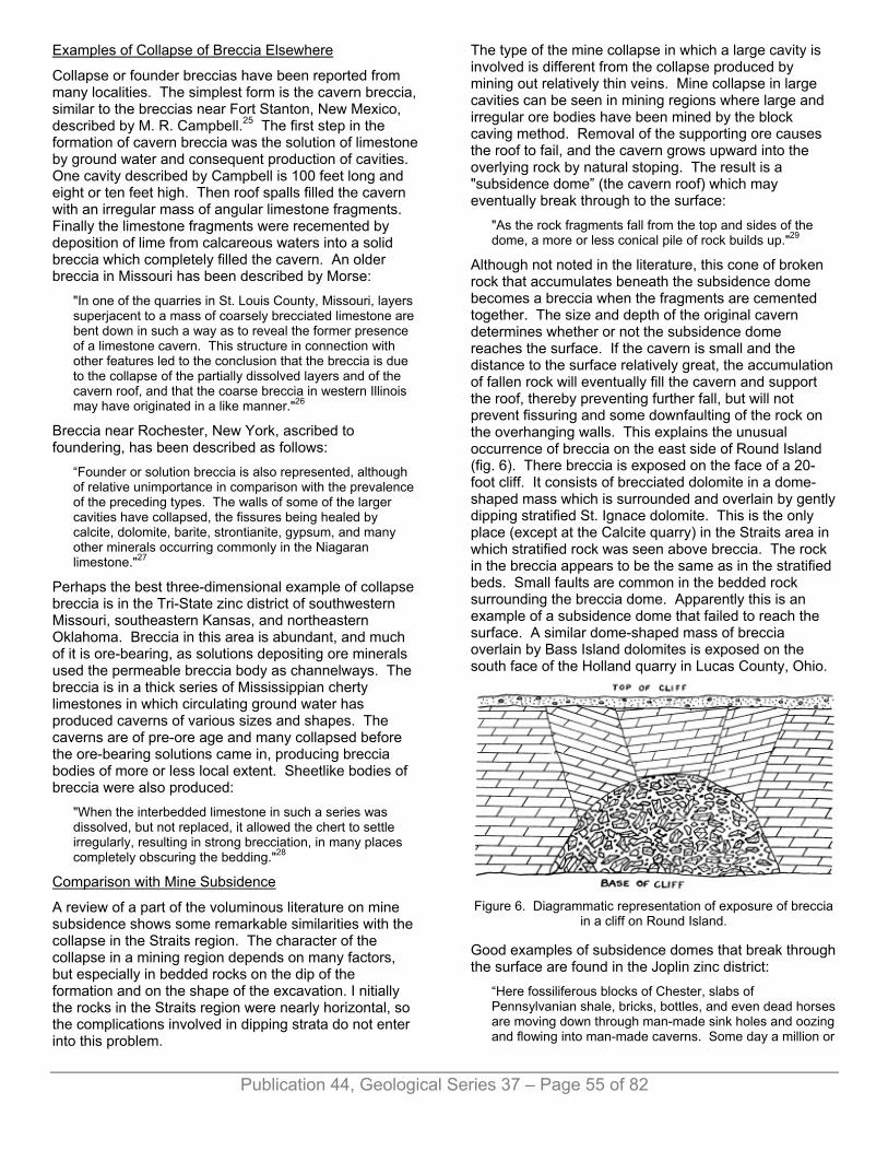
Figure 4. Isopach map showing aggregate thickness of Salina
salt.
The accompanying map (fig. 4) shows the aggregate thickness of the Salina salt in the northern part of the Southern Peninsula. This map was made from well records. The lines are drawn with an interval of one hundred feet and each line is drawn through points of equal salt thickness. It can be seen from this map that the salt decreases in thickness from 1200 feet to 0 between northwestern Alpena County and Cheboygan. In other words, the salt in the northern part of the Southern Peninsula has a blunt edge. One would expect where salt was deposited in an evaporating sea that thinning of the salt around the edges of the sea would be gradual. The abrupt edge of the salt body lends weight to the belief that this is a leached rather than a natural edge. A similar conclusion was drawn by Phalen20 for the edge of the salt deposits in one part of New York State.
"The Solvay wells, near Tully, south of Syracuse, must be located near the edge of the salt bed, and it also seems clear that the bed does not peter out as it does west of Seneca Lake but that it ends abruptly as though part of it had been removed."
Newland is more specific regarding removal by solution: "The salt measures, naturally, never appear at the surface. They have wasted away from solution by underground waters, so that now they are only found in strength some eight or ten miles back from their former place on the outcrop, where the overlying strata attain a thickness of 800 feet as a minimum. The collapse of the cover following solution of heavy salt seams has further promoted disintegration.21
Naturally one would expect that had such salt solution taken place, areas would remain in which collapse did not take place, due to the small size of the caverns. Numerous drillers' reports mention finding small caves in the Salina formation around the rim of the Michigan salt basin. The log of the Diamond Crystal Salt Company well in sec. 31, T. 5 N., R. 17 E., St. Clair County, records "salt and cavity" from 1610 to 1640 feet, and 146 feet of salt and two salt cavities were logged in a well drilled at Kincardine in Bruce County, Ontario.22
It is probably more than a coincidence that features similar to those found in the Straits area and believed to be evidences of collapse occur in other places on the rim of the Salina salt basin. The breccias of southeastern Michigan and northern Ohio, and the 15 degree dips reported in the Devonian rocks in southwestern Ontario23 are examples of this. Furthermore, heterogeneous samples from wells drilled in northern Michigan near the Michigan and Huron shores strongly suggest that the drill passed through brecciated rocks below the Dundee formation. Rock samples from the well drilled in sec. 8, T. 33 N., R. 8 E., Presque Isle County, are decidedly mixed between the Salina and the Dundee. The Cheboygan (city) well reported "brecciated dolomites" in the "Monroe." The log of the Frankfort well in Benzie County records 150 feet of "black to gray brecciated limestone with hard flinty blocks" in the Dundee. The "flinty" rock suggests that the rock is Bois Blanc rather than Dundee. Other examples of breccias penetrated by
Publication 44, Geological Series 37 – Page 53 of 82
drilled wells are given in the chapter on Subsurface Stratigraphy.
To account for leaching a body of salt several hundred feet thick from beneath hundreds of square miles necessitates elevation of the salt-bearing rocks into the zone of active ground water movements. Also it is necessary to account for disposal of the saturated brine. We know that the Michigan Basin was in existence in early Devonian time; therefore retreat of the Devonian sea and subsequent land emergence would have brought the salt beds close to the surface around the rim of the basin and into the zone of ground water action.
But to account for and explain the disposal of the saturated brine is a little more complex. According to the writer's theory, the Pointe aux Chenes beds around the rim of the basin were elevated above the ground water table after early Detroit River time, and only the central part of the basin was under water. Such a postulated position of the salt above the water table would permit ground water to percolate downward from the surface and to dissolve salt until it became saturated. Given a continuous supply of fresh water from above, a large volume of salt could be leached out in a relatively short space of geological time. However, such leaching would cause the accumulation of saturated brine having some six times the volume of the salt removed. This is not an impossible volume of brine to be stored underground, but perhaps that storage was not necessary. If the Michigan Basin at this time were also a topographic basin having sufficient relief, the ground water table would intersect the surface in stream valleys around the flanks of the basin; and thus provide an outlet for the saturated brine, which, on reaching the surface, would flow down into the evaporating sea at the bottom of the topographic basin (fig. 5). Thus the theory provides a possible explanation for the salt deposits of the Detroit River group. At the present time the Salina (or Pointe aux Chenes) salt beds around the rim of the Michigan Basin are from 400 to 4,000 feet higher than the younger Detroit River salt beds, doubtless a greater difference in elevation than existed in Detroit River times. But if the Salina salt deposits were no more than 50 feet higher topographically than the basin of deposition of the Detroit River salts during Detroit River time, the hydraulic gradient would be sufficient to produce the transfer. Further support of this thesis is the fact that in the Basin the Detroit River salt is in the upper part of the Detroit River section in beds which are younger than the Detroit River beds around the rim. An approximation of conditions that may have existed in the Mackinac Straits region in mid-Devonian time is in central Kansas where the eastern edges of westward-dipping Permian salt beds approach the surface. This district has been described by Bass as follows:
“A study of the logs of wells drilled along the eastern margin of the salt area indicates that in the past salt beds extended farther eastward and that the present eastern boundary is largely the edge left by the dissolving away of this eastern portion. Comparison of the records of wells drilled in northern Sumner County on both sides of the
margin of the salt shows a marked constriction in the eastern wells of the interval occupied elsewhere by the salt. A similar condition is shown by wells drilled in Lincoln county. Near this eastern margin wells reporting the salt to be more than 200 feet thick are only a few miles west of wells showing no salt. This abrupt change in thickness indicates that the margin of the salt represents an edge resulting from something comparable to erosion, rather than the shore line of an original salt deposit. The constriction of the salt interval in the eastern wells makes it appear very probable that as a result of the leaching and carrying away of the readily soluble salt beds by circulating ground waters near the outcrop, the overlying shale beds settled downward and filled in the cavities. It should be expected that settling on as large a scale as is postulated would be manifest in the topography of the surface, and inspection of the topographic maps that cover the marginal area for the most part corroborates this assumption. A narrow stretch of low-lying land, dotted with marshes, swamps, and lakes, extends northward from northwestern Sedgwick county across Harvey and McPherson counties, practically coinciding with the boundary of the salt area as shown by well logs. The fact that-many of these lakes are salty is further evidence that is considered corroborative of the explanation offered.24
Figure 5. Diagram to illustrate theory of deposition of Detroit
River salt.
Other signs of large scale salt solution in Kansas are evident, in addition to the evidences of leaching cited by Bass. Drillers frequently report caves of considerable size in this area and actual collapse has occurred during historic times.
Apparently the pre-Dundee leaching of the Salina salt around the rim of the Michigan Basin caused the downdip recession of the salt boundary to a point beyond the reach of large scale solution during the present erosion cycle. However, the salt licks and salt springs in Monroe County, and near Saline in Washtenaw County, may be evidence that some leaching is taking place today on the southern rim of the Basin.
Publication 44, Geological Series 37 – Page 54 of 82
Examples of Collapse of Breccia Elsewhere
Collapse or founder breccias have been reported from many localities. The simplest form is the cavern breccia, similar to the breccias near Fort Stanton, New Mexico, described by M. R. Campbell.25 The first step in the formation of cavern breccia was the solution of limestone by ground water and consequent production of cavities. One cavity described by Campbell is 100 feet long and eight or ten feet high. Then roof spalls filled the cavern with an irregular mass of angular limestone fragments. Finally the limestone fragments were recemented by deposition of lime from calcareous waters into a solid breccia which completely filled the cavern. An older breccia in Missouri has been described by Morse:
"In one of the quarries in St. Louis County, Missouri, layers superjacent to a mass of coarsely brecciated limestone are bent down in such a way as to reveal the former presence of a limestone cavern. This structure in connection with other features led to the conclusion that the breccia is due to the collapse of the partially dissolved layers and of the cavern roof, and that the coarse breccia in western Illinois may have originated in a like manner."26
Breccia near Rochester, New York, ascribed to foundering, has been described as follows:
“Founder or solution breccia is also represented, although of relative unimportance in comparison with the prevalence of the preceding types. The walls of some of the larger cavities have collapsed, the fissures being healed by calcite, dolomite, barite, strontianite, gypsum, and many other minerals occurring commonly in the Niagaran limestone."27
Perhaps the best three-dimensional example of collapse breccia is in the Tri-State zinc district of southwestern Missouri, southeastern Kansas, and northeastern Oklahoma. Breccia in this area is abundant, and much of it is ore-bearing, as solutions depositing ore minerals used the permeable breccia body as channelways. The breccia is in a thick series of Mississippian cherty limestones in which circulating ground water has produced caverns of various sizes and shapes. The caverns are of pre-ore age and many collapsed before the ore-bearing solutions came in, producing breccia bodies of more or less local extent. Sheetlike bodies of breccia were also produced:
"When the interbedded limestone in such a series was dissolved, but not replaced, it allowed the chert to settle irregularly, resulting in strong brecciation, in many places completely obscuring the bedding."28
Comparison with Mine Subsidence
A review of a part of the voluminous literature on mine subsidence shows some remarkable similarities with the collapse in the Straits region. The character of the collapse in a mining region depends on many factors, but especially in bedded rocks on the dip of the formation and on the shape of the excavation. I nitially the rocks in the Straits region were nearly horizontal, so the complications involved in dipping strata do not enter into this problem.
The type of the mine collapse in which a large cavity is involved is different from the collapse produced by mining out relatively thin veins. Mine collapse in large cavities can be seen in mining regions where large and irregular ore bodies have been mined by the block caving method. Removal of the supporting ore causes the roof to fail, and the cavern grows upward into the overlying rock by natural stoping. The result is a "subsidence dome” (the cavern roof) which may eventually break through to the surface:
"As the rock fragments fall from the top and sides of the dome, a more or less conical pile of rock builds up."29
Although not noted in the literature, this cone of broken rock that accumulates beneath the subsidence dome becomes a breccia when the fragments are cemented together. The size and depth of the original cavern determines whether or not the subsidence dome reaches the surface. If the cavern is small and the distance to the surface relatively great, the accumulation of fallen rock will eventually fill the cavern and support the roof, thereby preventing further fall, but will not prevent fissuring and some downfaulting of the rock on the overhanging walls. This explains the unusual occurrence of breccia on the east side of Round Island (fig. 6). There breccia is exposed on the face of a 20-foot cliff. It consists of brecciated dolomite in a dome-shaped mass which is surrounded and overlain by gently dipping stratified St. Ignace dolomite. This is the only place (except at the Calcite quarry) in the Straits area in which stratified rock was seen above breccia. The rock in the breccia appears to be the same as in the stratified beds. Small faults are common in the bedded rock surrounding the breccia dome. Apparently this is an example of a subsidence dome that failed to reach the surface. A similar dome-shaped mass of breccia overlain by Bass Island dolomites is exposed on the south face of the Holland quarry in Lucas County, Ohio.
Figure 6. Diagrammatic representation of exposure of breccia
in a cliff on Round Island.
Good examples of subsidence domes that break through the surface are found in the Joplin zinc district:
“Here fossiliferous blocks of Chester, slabs of Pennsylvanian shale, bricks, bottles, and even dead horses are moving down through man-made sink holes and oozing and flowing into man-made caverns. Some day a million or
Publication 44, Geological Series 37 – Page 55 of 82
a billion years from now a cross-section of these holes will give some geologist something to think about."30
A body of breccia resulting from accumulation beneath a subsidence dome should have a considerable vertical extent and should increase in diameter with depth, which seems to be the condition of the indurated breccia in the Straits region. The non-indurated breccia masses probably have the same origin and the same shape, but because of their incoherent character the walls of such bodies are not exposed over any great vertical distance; therefore it is not possible to check on their shape.
Collapse in an area where a horizontal coal bed has been mined out is quite different. Because most coal veins in collapsed areas are only six or eight feet in thickness, the vertical dimension of the open space is relatively insignificant. It is interesting that collapse occurs not only into the rooms but also in the areas of the pillars due to the failure of the pillars to hold up the roof over any prolonged period of time. Application of this fact effectively cleared up one of the puzzles in the Straits region. It was assumed by the writer that leaching did not completely remove the salt and natural rock pillars remained standing between collapsed areas. Under such conditions the rock above the pillars should be undisturbed, and the writer was perplexed by failure to find any exposures of undisturbed rock anywhere in the collapse district. If coal pillars fail in time, it seems even more likely that salt, with its well-known tendency to flow under pressure, would not long withstand the weight of the overlying rock.
The result of collapse in a mine where a flat horizontal seam is worked by the room and pillar method is a zone of brecciation in the room itself, due to the fragmentation of the rock in falling, but the higher beds may be "let down" with some fragmentation but without complete loss of orientation. It has been noted in a number of coal districts that after the pillars of a coal bed have been robbed and the immediately overlying rock has subsided, higher coal beds, although tilted and fractured and otherwise disturbed, were mineable.
Publication 44, Geological Series 37 – Page 56 of 82
This type of collapse produces what the writer has termed mega-breccia. It is presumed that where the salt caves were largest in horizontal dimensions, collapse produced letdown and tilted blocks, but where the caves were of considerable vertical extent, the subsidence dome type of collapse took place. It is possible that both types of collapse might be produced by the solution of a single salt bed—that the first cave leached out might grow upward into the overlying rock by natural stoping and trans-formational breccia be produced, and that while this was going on, ground waters would continue leaching out the salt bed in all directions, and so make horizontal caverns which in turn would collapse and produce megabreccia.
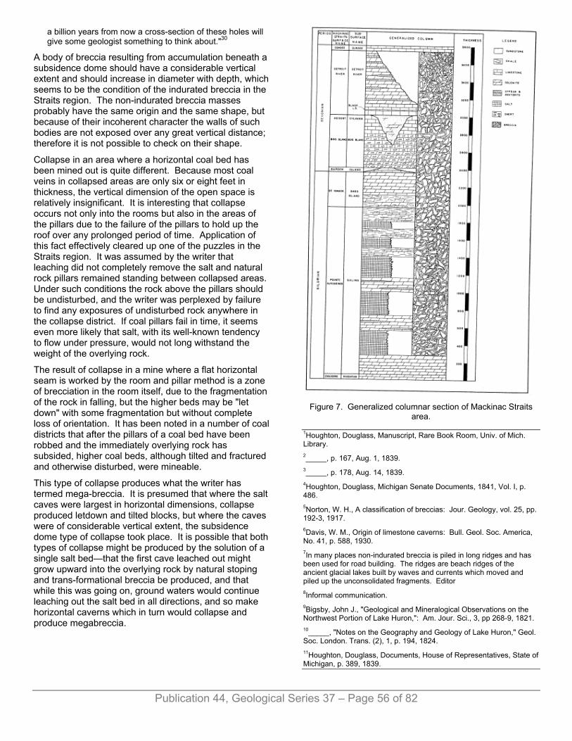
Figure 7. Generalized columnar section of Mackinac Straits
area.
1Houghton, Douglass, Manuscript, Rare Book Room, Univ. of Mich. Library. 2_____, p. 167, Aug. 1, 1839. 3_____, p. 178, Aug. 14, 1839. 4Houghton, Douglass, Michigan Senate Documents, 1841, Vol. I, p. 486. 5Norton, W. H., A classification of breccias: Jour. Geology, vol. 25, pp. 192-3, 1917. 6Davis, W. M., Origin of limestone caverns: Bull. Geol. Soc. America, No. 41, p. 588, 1930. 7In many places non-indurated breccia is piled in long ridges and has been used for road building. The ridges are beach ridges of the ancient glacial lakes built by waves and currents which moved and piled up the unconsolidated fragments. Editor 8Informal communication. 9Bigsby, John J., "Geological and Mineralogical Observations on the Northwest Portion of Lake Huron,": Am. Jour. Sci., 3, pp 268-9, 1821. 10_____, "Notes on the Geography and Geology of Lake Huron," Geol. Soc. London. Trans. (2), 1, p. 194, 1824. 11Houghton, Douglass, Documents, House of Representatives, State of Michigan, p. 389, 1839.
12Hall, James, Upper Silurian and Devonian Series: Geology of the Lake Superior Land District, Pt. II, U. S. 32 Cong. Spec. Sess. Ex. Doc. 4, p. 162, 1851.
Publication 44, Geological Series 37 – Page 57 of 82
13Winchell, Alexander, First biennial report of the progress of the geological survey of Michigan, Lansing, 1861, p. 61. 14Rominger, Carl, Paleozoic rocks (Upper Peninsula); Michigan Geol. Survey, vol. I, pt. 3, pp. 22-28, 1873. 15Lane, A. C., The Geology of Lower Michigan: Michigan Geol. Survey, Vol. V, pt. 2, p. 27, 1895. 16Russell, I. C., A geological Reconnaissance along the North Shore of Lakes Huron and Michigan; Report of the State Board of Geological Survey of Michigan for the year 1904, pp. 44-45, 1905. 17Grabau, A. W., Principles of Stratigraphy, New York, 1913, pp. 547-8. Abstract in Science, n. s., 25, 295-6, 1907. 18Smith, R. A., The occurrence of oil and gas in Michigan: Michigan Geol. Survey, Pub. 14, pp. 206-7, 1914. 19Newcombe, R. B., Oil and gas fields of Michigan: Michigan Geol. Survey, Pub. 38, 1933, p. 118. 20Phalen, W. C., Salt resources of the United States: U. S. Geol. Survey Bull. 669, 1919, p. 21. 21Newland, D. H., The gypsum resources and gypsum industry of New York: N. Y. State Museum Bull. No. 283, 38, 1929. 22Harkness, R. B., Natural Gas in 1929: Ontario Dept. of Mines, Ann. Rept., Vol. XXXIX, pt. v, 1930, p. 20, 1930. 23Stauffer, C. R., The Devonian of southwestern Ontario: Canada Dept. Mines, Geol. Survey, Mem. No. 34, p. 23, 1915. 24Bass, N. W., Structure and limits of the Kansas salt beds: Kansas Geol. Survey, Bull. II, part 4, p. 93, 1926. 25Campbell, M. R., The origin of limestone breccias (abstract): Science n. s., vol. 27, p. 348, 1908. 26Morse, William C., The origin of coarse breccia in the St. Louis limestone: Sci. n. s. vol. 43pp. 399-400, March 17, 1916. 27Giles, A W., Brecciation in the Niagaran limestone at Rochester, New York, Amer. Jour, Sci., vol. 197, p. 353, 1919. 28Siebenthal, C. E., Mineral resources of northeastern Oklahoma. U. S. Geol. Survey, Bull. 340, p. 200, 1908. 29Rice, George S., Some problems in ground movement and subsidence: Amer. Inst. Min. and Met. Eng. Trans., vol. 69, p. 389, 1923. 30Addison, Carl C. Letter dated Oct. 13, 1944.
Chapter IV. SUBSURFACE STRATIGRAPHY K. K. LANDES
In discussion of the subsurface stratigraphy of the Mackinac Straits area it should be remembered that the area is the northern rim of a structural basin which was also a basin of subsidence during Paleozoic time, that at times the area was a marine embayment but at other times it was almost cut off from the sea and then became a dessicating lagoon.
SALINA GROUP The Salina strata of the subsurface correlates with the poorly exposed Pointe aux Chenes formation of the St. Ignace peninsula. They directly overlie the Niagaran
dolomites and are everywhere beneath the surface in the Southern Peninsula of Michigan.
The Salina group is of Silurian age. It probably connects beneath the surface with the New York State Salina by way of the Ontario Peninsula and northeastern Ohio.
The subsurface records of the Salina rocks on the St. Ignace peninsula are poor. Several wells have been drilled in the area and at least two went through the Salina group and into the Niagaran, but evidently no samples were saved from any of these wells. Furthermore, the peninsula south of the approximate latitude of Allenville is all in the collapse zone, and therefore the few well records which are available are confusing. The well drilled in 1887 on the property of the Mackinaw Lumber Company in St. Ignace reported the Niagaran top at a depth of 504 feet, at the base of a 489-foot section of red and blue "slate" with a vein of salt. It is probable, however, that the basal Salinan dolomites were erroneously identified as Niagaran, and the actual Niagaran top is some feet lower than shown by log.
A second well in the St. Ignace vicinity was drilled two miles north of the Mackinaw Lumber Company well. Incomplete samples below 384 feet are available from this well. Between 384 and 600 feet the samples appear to be a mixture of Bois Blanc chert and dolomite, Bass Island dolomite, and Salina dolomite, dolomitic shale, and anhydrite. Fourteen feet of chert and dolomite assumed to have come from the Bois Blanc formation, lies near the base of this breccia mass. Below 600 feet the rock is light colored Niagaran dolomite.
Figure 8. Cross sections of north half of Southern Peninsula.
Wells drilled for water in the vicinity of Castle Rock and elsewhere in the southern part of the St. Ignace peninsula penetrated approximately 400 feet of green shale and "white stuff" according to drillers' reports. The "white stuff" is perhaps gypsum, but may be dolomite.
Better records of the subsurface Salina section are to be found in the Southern Peninsula, but not at the northern end. The northernmost deep well in the Southern Peninsula was drilled for salt by the McArthur brothers in Cheboygan in 1899-1901. Some samples are available from this well, but intervals in the section for which no samples exist, are of considerable magnitude. The log

Publication 44, Geological Series 37 – Page 58 of 82
is also incomplete. Enough data are available, however, to make it obvious that this well is situated in the zone of collapse. The log reports "brecciated dolomites with slit cavities" and caved down to 750 feet. Probably the Salina formation is about 700 feet thick, extending from a depth of 850 to 1550 feet, to the top of the Niagaran dolomite. The samples are missing from 700 to 1300 feet, and from 1300 to 1360 feet, but a single sample of red and green shale is available. The samples from 1362 to 1550 are dolomite. The well log reports salt at 1400 feet, but no salt was in the samples. The next well to the south that penetrated the Salina formation is the Presque Isle Development Company Chandler (Onaway) well in sec. 5, T. 34 N., R. 2 E., Presque Isle County. The surface elevation at this point is 830 feet. Samples from the Chandler well are incomplete, but a graphic log, probably prepared by H. H. Hindshaw, was given the writers by the Michigan Limestone and Chemical Company. According to the records the Salina formation is 1175 feet thick in this well, extending from a depth of 1625 feet to 2800 feet. The beds are undisturbed, showing that the well is outside the area of collapse. About 830 feet of the total Salina thickness is salt. The salt is in several beds of which the thickest, at the base of the salt series, is 225 feet, and the next thickest is a 145-foot bed lying at the top of the formation. The intervening beds are red and grey shales in the upper half of the section and dolomites and anhydrites in the lower half.
Also in Presque Isle County is the Alpena Land Company well No. 1, Lot 1, sec. 8, T. 33 N., R. 8 E. (Grand Lake well). The surface elevation of this well is about 608 feet. The well did not go to the Niagaran but stopped in "dolomite and anhydrite" beds of the Salina group at a total depth of 1712 feet, about 428 feet below the top of the Salina. Of the 428 feet of Salina penetrated about 275 feet is salt, the rest is practically all dolomite and anhydrite. From the mixed character of the samples it is evident that collapsing extended down to a depth of 1360 feet. This well is near the rim of the basin where collapse should be expected. Comparing the Grand Lake well with the Onaway well one finds that the upper salt and shale zone of the Onaway well is largely missing in the Grand Lake well. This zone, 450 feet thick in the Onaway well and containing 320 feet of salt, is represented in the Grand Lake well by 70 feet of mixed rock, mostly dolomite with a little salt. Leaching of 300 feet of salt in the uppermost part of the Salina formation in the Grand Lake area produced the collapse which is evident in the brecciated samples.
A stratigraphically deep test well on the west side of the Southern Peninsula in Antrim County is the Ohio-Chamberlain No. 1, sec. 14, T. 31 N., R. 8 W. This well was drilled by rotary. The Salina section lying between depths of 2750 and 4605 feet, is 1855 feet thick, and has about 430 feet of salt. The basal part of the Salina section is a brown dolomite about 125 feet thick. Above the dolomite is a 1400-foot section which contains 8 beds of salt, of which the thickest bed (160 feet) is immediately above the basal dolomite. Between the salt
beds are beds of red and green shale and dolomite. Shale predominates in the upper half of the section and dolomite in the lower. Above the salt section to the top of the Salina formation is 320 feet of rock which consists predominantly of shale with some beds of brown dolomite.
Southwest of the Chamberlain well is the Copeland and Barton, Overby No. 1 well in sec. 5, T. 29 N., R. 12 W., Leelanau County. This is also a rotary well and the samples contain no salt, but about 170 feet of salt is listed in the log. According to the log, 1217 feet of Salina is present, extending from a depth of 2878 feet to 4095 feet, with a 140-foot brown dolomite series at the base. This well is probably in the collapse zone because: the samples above the Salina are mixed to an even greater extent than samples from a rotary well are normally mixed; the salt at the top of the Salina is thin, and the well is near the rim of the basin.
The best record of the Salina formation in northern Michigan is found in the samples obtained from the C. W. Teater Nevins No. 1 well in sec. 18, T. 32 N., R. 16 E., Alpena County. This well was completed in 1936. The surface elevation is 803 feet. The rock strata drilled are undisturbed, therefore, the edge of the disturbed zone lies between this well and the Grand Lake well about 14 miles to the northeast. The Salina formation extends from a depth of 2035 feet to 4115 feet. Of this 2080-foot thickness, salt beds aggregate about 1200 feet. Above the highest salt bed is 97 feet of grey, green and red shale and brown dolomite very similar in appearance to the shale and dolomite found at the surface on St. Ignace Peninsula and on Mackinac Island. Some subsurface stratigraphers extend the Bass Island group down to the top of the first Salina salt, but the correlation of this shale and dolomite series with the surface rocks is good evidence of the Salina age of these rocks.
Below the lowest bed of salt in the Nevins well is a 165-foot section of grey limestone, which is perhaps the equivalent of the dolomite in the lower Salina which outcrops along Carp River, Mackinac County. Between the lower dolomite and upper shale and dolomite the salt is in a series of beds which are from a few inches to 300 feet in thickness. Thick beds of dolomite with a little anhydrite occupy the intervals between the salt beds in the lower part of the formation, but variegated shales are in the upper half. The shale beds are as much as 100 feet thick in the lower part of the upper section but are much thinner above.
The only complete record of the Salina group in the center of the state was obtained from the log of the Gulf Bateson No. 1 well drilled in sec. 2, T. 14 N., R. 4 E., Bay County. This well penetrated the Salina from 5384 to 8270 feet—a total thickness for the formation of 2886 feet with approximately 1600 feet of salt. Above the top salt is 96 feet of brown dolomite and green shale similar to the dolomite and shale in the Nevins well and in the outcrop area, but only 10 feet of dolomite and anhydrite is below the basal salt, much less than elsewhere in the
Publication 44, Geological Series 37 – Page 59 of 82
northern part of the basin. The basal salt bed is the thickest in the series having a total thickness of 442 feet. Some ten beds of salt which in general, decrease in thickness upwards to the top of the series are higher in the section. In the upper half of the salt series the rocks between the salt beds are mainly greenish gray shale with anhydrite. In the lower half of the section brown dolomite and anhydrite occupy the intervals between the salt beds.
SUMMARY. The Salina formation crops out in the St. Ignace peninsula but is at a depth of nearly 5400 feet in Bay County. The upper beds are variegated shales and thin brown dolomites that overlie the salt series in which as much as 1600 feet of salt is in a number of beds. The salt is thin along the northwest and northeast coasts of the Southern Peninsula where the upper beds have been leached and it is absent altogether in the Northern Peninsula where complete removal has taken place. Shales predominate between the salt beds in the upper part of the salt series, and dolomite beds predominate in the lower half. Nearly everywhere a basal dolomite section is below the lowest salt. The total thickness of the Salina (outside of the collapse zone) ranges from 1175 feet, in western Presque Isle County, to 2886 feet in Bay County.
BASS ISLAND FORMATION The Bass Island strata are named from a group of islands near the western end of Lake Erie. The name has been applied to a series of dolomites cropping out in northern Ohio and Monroe County, Michigan. Subsurface stratigraphers applied the name to strata underground as drilling progressed from southeastern Michigan into the Michigan Basin. As now used the name is applied to a series of dolomitic beds lying above the Salina and below the Sylvania. The Bass Island at the surface in Michigan and Ohio is upper Silurian in age.
The subsurface Bass Island beds correlate with the St. Ignace formation. The Bass Island overlies the Salina formation everywhere beneath the surface in the Southern Peninsula. In different parts of this area it is variously overlain by Garden Island (?), Bois Blanc, Sylvania, and Detroit River rocks.
Near the southern tip of the St. Ignace peninsula test hole No. 13 of the Michigan State Highway Department was drilled during the course of an investigation to determine the feasibility of a bridge across the Straits of Mackinac. This well was drilled to a depth of 212 feet and, without doubt, went through the Bass Island (St. Ignace) formation and the uppermost Salina rocks. However, this area is one of excessive brecciation, and mixed with the Bass Island dolomite are samples of cherty limestones of Bois Blanc age, recognizable breccia, shale, and, in the lowest 40 feet of the well, gypsum fragments. This heterogeneous mixture of rock is almost valueless for geological correlation.
The same Southern Peninsula wells, excepting the Cheboygan well, discussed in the description of the Salina rocks supply data regarding the Bass Island strata. In addition, the Lobdell-Emery Myers No. 1 well in sec. 26, T. 35 N., R. 2 E., Presque Isle County, penetrated 108 feet of Bass Island sediments before being abandoned, and the Lupher Wilce Farm and Orchard No. 1 well in sec. 34, T. 28 N., R. 14 W., Leelanau County, penetrated the Bass Island and was bottomed in the salt section of the Salina group.
These records show that except in Bay County the thickness of the Bass Island is remarkably accordant. In Presque Isle, Antrim, Alpena and Leelanau Counties each of four wells logged from 325 to 348 feet of Bass Island rocks. In the Basin, in Bay County, the thickness is 574 feet. Apparently only the central part of the Michigan Basin sagged downward during Bass Island time. However, later sinking, mainly in Detroit River time, produced a wide variation in the elevation of the top of the Bass Island formation in northern Michigan. In the Chandler well in Presque Isle County the top of the Bass Island is 470 feet below sea level. Farther south, in Alpena County, it drops to nearly 900 feet below sea level and near the center of the Basin in Bay County to 4211 feet. On the west side of the state the top of the Bass Island is 1538 feet below sea level in Leelanau County and 1664 feet below sea level in Antrim County. The top and base of the Bass Island group are invariably a light brown dolomite. The light brown to tan dolomite at the top of the formation is especially distinctive. Therefore, the top of the formation is easily identified, no matter which one of three or four different formations may lie above. Most of the section in the Bass Island formation between the top and bottom dolomites is also brown dolomite, but with greenish-grey dolomitic shales inter-bedded, especially in the lower half of the section. In fact, the lower half of the subsurface Bass Island section is very similar to the section exposed in the ferry mole cut near St. Ignace and probably correlates with it. The upper mass of dolomite probably correlates with the Hombach quarry rock in south St. Ignace. Some anhydrite is in the Bass Island section of the Chamberlain well in Antrim County, and is abundant in the Bateson well in Bay County. Apparently some dessication took place in the central part of the basin during Bass Island time. However, no salt beds have been found in the Bass Island, so evaporation did not proceed through the salt precipitation stage.
SUMMARY. The Bass Island strata of the subsurface correlate with the St. Ignace formation. They consist of light brown to tan dolomite, with greenish-grey dolomitic shales in the lower part of the section. Anhydrite is in the Bass Island rocks in the Michigan Basin.
The Bass Island section is about 335 feet thick in northern Michigan and 574 feet thick in Bay County.
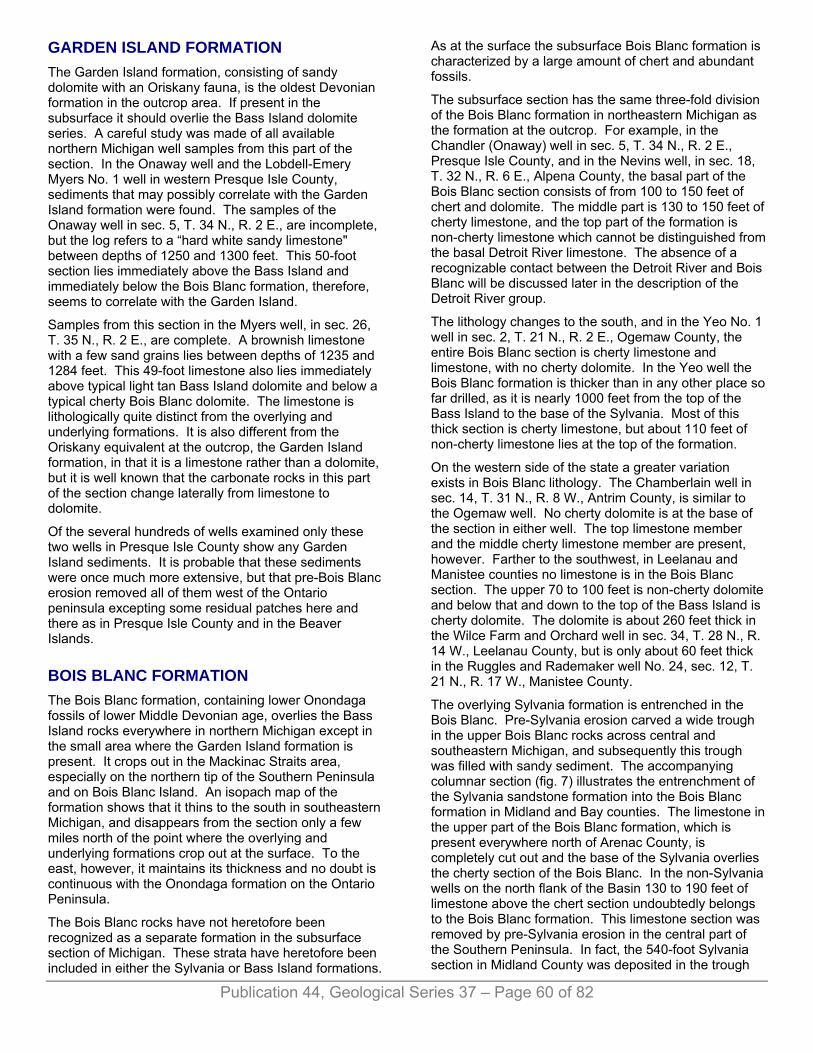
Publication 44, Geological Series 37 – Page 60 of 82
GARDEN ISLAND FORMATION The Garden Island formation, consisting of sandy dolomite with an Oriskany fauna, is the oldest Devonian formation in the outcrop area. If present in the subsurface it should overlie the Bass Island dolomite series. A careful study was made of all available northern Michigan well samples from this part of the section. In the Onaway well and the Lobdell-Emery Myers No. 1 well in western Presque Isle County, sediments that may possibly correlate with the Garden Island formation were found. The samples of the Onaway well in sec. 5, T. 34 N., R. 2 E., are incomplete, but the log refers to a “hard white sandy limestone" between depths of 1250 and 1300 feet. This 50-foot section lies immediately above the Bass Island and immediately below the Bois Blanc formation, therefore, seems to correlate with the Garden Island.
Samples from this section in the Myers well, in sec. 26, T. 35 N., R. 2 E., are complete. A brownish limestone with a few sand grains lies between depths of 1235 and 1284 feet. This 49-foot limestone also lies immediately above typical light tan Bass Island dolomite and below a typical cherty Bois Blanc dolomite. The limestone is lithologically quite distinct from the overlying and underlying formations. It is also different from the Oriskany equivalent at the outcrop, the Garden Island formation, in that it is a limestone rather than a dolomite, but it is well known that the carbonate rocks in this part of the section change laterally from limestone to dolomite.
Of the several hundreds of wells examined only these two wells in Presque Isle County show any Garden Island sediments. It is probable that these sediments were once much more extensive, but that pre-Bois Blanc erosion removed all of them west of the Ontario peninsula excepting some residual patches here and there as in Presque Isle County and in the Beaver Islands.
BOIS BLANC FORMATION The Bois Blanc formation, containing lower Onondaga fossils of lower Middle Devonian age, overlies the Bass Island rocks everywhere in northern Michigan except in the small area where the Garden Island formation is present. It crops out in the Mackinac Straits area, especially on the northern tip of the Southern Peninsula and on Bois Blanc Island. An isopach map of the formation shows that it thins to the south in southeastern Michigan, and disappears from the section only a few miles north of the point where the overlying and underlying formations crop out at the surface. To the east, however, it maintains its thickness and no doubt is continuous with the Onondaga formation on the Ontario Peninsula.
The Bois Blanc rocks have not heretofore been recognized as a separate formation in the subsurface section of Michigan. These strata have heretofore been included in either the Sylvania or Bass Island formations.
As at the surface the subsurface Bois Blanc formation is characterized by a large amount of chert and abundant fossils.
The subsurface section has the same three-fold division of the Bois Blanc formation in northeastern Michigan as the formation at the outcrop. For example, in the Chandler (Onaway) well in sec. 5, T. 34 N., R. 2 E., Presque Isle County, and in the Nevins well, in sec. 18, T. 32 N., R. 6 E., Alpena County, the basal part of the Bois Blanc section consists of from 100 to 150 feet of chert and dolomite. The middle part is 130 to 150 feet of cherty limestone, and the top part of the formation is non-cherty limestone which cannot be distinguished from the basal Detroit River limestone. The absence of a recognizable contact between the Detroit River and Bois Blanc will be discussed later in the description of the Detroit River group.
The lithology changes to the south, and in the Yeo No. 1 well in sec. 2, T. 21 N., R. 2 E., Ogemaw County, the entire Bois Blanc section is cherty limestone and limestone, with no cherty dolomite. In the Yeo well the Bois Blanc formation is thicker than in any other place so far drilled, as it is nearly 1000 feet from the top of the Bass Island to the base of the Sylvania. Most of this thick section is cherty limestone, but about 110 feet of non-cherty limestone lies at the top of the formation.
On the western side of the state a greater variation exists in Bois Blanc lithology. The Chamberlain well in sec. 14, T. 31 N., R. 8 W., Antrim County, is similar to the Ogemaw well. No cherty dolomite is at the base of the section in either well. The top limestone member and the middle cherty limestone member are present, however. Farther to the southwest, in Leelanau and Manistee counties no limestone is in the Bois Blanc section. The upper 70 to 100 feet is non-cherty dolomite and below that and down to the top of the Bass Island is cherty dolomite. The dolomite is about 260 feet thick in the Wilce Farm and Orchard well in sec. 34, T. 28 N., R. 14 W., Leelanau County, but is only about 60 feet thick in the Ruggles and Rademaker well No. 24, sec. 12, T. 21 N., R. 17 W., Manistee County.
The overlying Sylvania formation is entrenched in the Bois Blanc. Pre-Sylvania erosion carved a wide trough in the upper Bois Blanc rocks across central and southeastern Michigan, and subsequently this trough was filled with sandy sediment. The accompanying columnar section (fig. 7) illustrates the entrenchment of the Sylvania sandstone formation into the Bois Blanc formation in Midland and Bay counties. The limestone in the upper part of the Bois Blanc formation, which is present everywhere north of Arenac County, is completely cut out and the base of the Sylvania overlies the cherty section of the Bois Blanc. In the non-Sylvania wells on the north flank of the Basin 130 to 190 feet of limestone above the chert section undoubtedly belongs to the Bois Blanc formation. This limestone section was removed by pre-Sylvania erosion in the central part of the Southern Peninsula. In fact, the 540-foot Sylvania section in Midland County was deposited in the trough
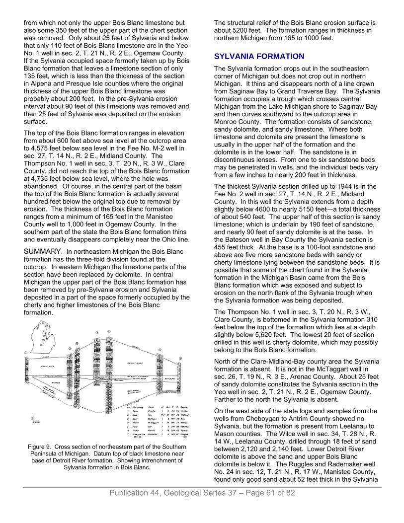
from which not only the upper Bois Blanc limestone but also some 350 feet of the upper part of the chert section was removed. Only about 25 feet of Sylvania and below that only 110 feet of Bois Blanc limestone are in the Yeo No. 1 well in sec. 2, T. 21 N., R. 2 E., Ogemaw County. If the Sylvania occupied space formerly taken up by Bois Blanc formation that leaves a limestone section of only 135 feet, which is less than the thickness of the section in Alpena and Presque Isle counties where the original thickness of the upper Bois Blanc limestone was probably about 200 feet. In the pre-Sylvania erosion interval about 90 feet of this limestone was removed and then 25 feet of Sylvania was deposited on the erosion surface.
The top of the Bois Blanc formation ranges in elevation from about 600 feet above sea level at the outcrop area to 4,575 feet below sea level in the Fee No. M-2 well in sec. 27, T. 14 N., R. 2 E., Midland County. The Thompson No. 1 well in sec. 3, T. 20 N., R. 3 W., Clare County, did not reach the top of the Bois Blanc formation at 4,735 feet below sea level, where the hole was abandoned. Of course, in the central part of the basin the top of the Bois Blanc formation is actually several hundred feet below the original top due to removal by erosion. The thickness of the Bois Blanc formation ranges from a minimum of 165 feet in the Manistee County well to 1,000 feet in Ogemaw County. In the southern part of the state the Bois Blanc formation thins and eventually disappears completely near the Ohio line.
SUMMARY. In northeastern Michigan the Bois Blanc formation has the three-fold division found at the outcrop. In western Michigan the limestone parts of the section have been replaced by dolomite. In central Michigan the upper part of the Bois Blanc formation has been removed by pre-Sylvania erosion and Sylvania deposited in a part of the space formerly occupied by the cherty and higher limestones of the Bois Blanc formation.
Figure 9. Cross section of northeastern part of the Southern Peninsula of Michigan. Datum top of black limestone near base of Detroit River formation. Showing intrenchment of
Sylvania formation in Bois Blanc.
The structural relief of the Bois Blanc erosion surface is about 5200 feet. The formation ranges in thickness in northern Michigan from 165 to 1000 feet.
SYLVANIA FORMATION The Sylvania formation crops out in the southeastern corner of Michigan but does not crop out in northern Michigan. It thins and disappears north of a line drawn from Saginaw Bay to Grand Traverse Bay. The Sylvania formation occupies a trough which crosses central Michigan from the Lake Michigan shore to Saginaw Bay and then curves southward to the outcrop area in Monroe County. The formation consists of sandstone, sandy dolomite, and sandy limestone. Where both limestone and dolomite are present the limestone is usually in the upper half of the formation and the dolomite is in the lower half. The sandstone is in discontinuous lenses. From one to six sandstone beds may be penetrated in wells, and the individual beds vary from a few inches to nearly 200 feet in thickness.
The thickest Sylvania section drilled up to 1944 is in the Fee No. 2 well in sec. 27, T. 14 N., R. 2 E., Midland County. In this well the Sylvania extends from a depth slightly below 4600 to nearly 5150 feet—a total thickness of about 540 feet. The upper half of this section is sandy limestone; which is underlain by 190 feet of sandstone, and nearly 90 feet of sandy dolomite is at the base. In the Bateson well in Bay County the Sylvania section is 455 feet thick. At the base is a 100-foot sandstone and above are five more sandstone beds with sandy or cherty limestone lying between the sandstone beds. It is possible that some of the chert found in the Sylvania formation in the Michigan Basin came from the Bois Blanc formation which was exposed and subject to erosion on the north flank of the Sylvania trough when the Sylvania formation was being deposited.
The Thompson No. 1 well in sec. 3, T. 20 N., R. 3 W., Clare County, is bottomed in the Sylvania formation 310 feet below the top of the formation which lies at a depth slightly below 5,620 feet. The lowest 20 feet of section drilled in this well is cherty dolomite, which may possibly belong to the Bois Blanc formation.
North of the Clare-Midland-Bay county area the Sylvania formation is absent. It is not in the McTaggart well in sec. 26, T. 19 N., R. 3 E., Arenac County. About 25 feet of sandy dolomite constitutes the Sylvania section in the Yeo well in sec. 2, T. 21 N., R. 2 E., Ogemaw County. Farther to the north the Sylvania is absent.
On the west side of the state logs and samples from the wells from Cheboygan to Antrim County showed no Sylvania, but the formation is present from Leelanau to Mason counties. The Wilce well in sec. 34, T. 28 N., R. 14 W., Leelanau County, drilled through 18 feet of sand between 2,120 and 2,140 feet. Lower Detroit River dolomite is above the sand and upper Bois Blanc dolomite is below it. The Ruggles and Rademaker well No. 24 in sec. 12, T. 21 N., R. 17 W., Manistee County, found only good sand about 52 feet thick in the Sylvania
Publication 44, Geological Series 37 – Page 61 of 82

Publication 44, Geological Series 37 – Page 62 of 82
formation. The Campbell No. 1 well in sec. 16, T. 17 N., R. 15 W., Mason County, had about 20 feet of dolomitic sand underlain by 20 feet of good sand in the Sylvania.
SUMMARY. Sandstone, sandy dolomite, and sandy limestone of the Sylvania formation, occupy a trough carved out of older rocks in central and southeastern Michigan. The formation is absent in northern Michigan. The sandstone beds are large lenses. Chert, perhaps derived from the Bois Blanc, is in some wells. The total thickness of the Sylvania ranges from a few feet to 540 feet.
DETROIT RIVER GROUP1
The type locality of the Detroit River is in southeastern Michigan along the Detroit River where exposures gave the group its name. The Detroit River group extends northward across the Michigan Basin but is very poorly exposed in the Mackinac Straits area. One exposure of limestone, probably basal Detroit River in age, southwest of Mackinaw City, is described in the section on surface stratigraphy. Between this outcrop and the approximate latitude of Cheboygan the Detroit River rocks no doubt underlie the glacial drift over a wide belt, but the drift is very thick and no exposures are known. The beach shingle on North Fox Island contains a black argillaceous dolomite which may correlate with the black limestone or dolomite found in well samples in northern Michigan. Also the pale buff dolomite found on the beach on Isle Le Galet probably came from lower Detroit River outcrops. The Detroit River formation is Middle Devonian in age.
In northern Michigan the Detroit River rocks are underlain by the Bois Blanc formation and in central Michigan by the Sylvania sandstone formation. Where the Sylvania is present the base of the Detroit River can be determined but in most areas where the Detroit River directly overlies the Bois Blanc it is impossible to determine the boundary between the two. The Bois Blanc deposition closed with limestone and the Detroit River phase started with limestone deposition. No color changes, sand grains, detrital zones, or other evidences of an unconformity have been found in the section. However, the lower Detroit River does contain a marker which can be used in correlation and the top of which was used as a datum plane in making the cross section (fig. 9) used to illustrate the entrenchment of the Sylvania into the Bois Blanc. This marker bed is a dark brown to black limestone, except in Mason, Manistee, and Leelanau counties, where it is a dolomite. The top of the black bed makes a distinct reference point, but in many places the lower boundary is indistinct due to a gradual lightening of color. The top of the black limestone is from 50 to 90 feet above the Sylvania (where present) in the eastern part of the Michigan Basin, and from 20 to 60 feet above in the western part of the Basin. Because the black limestone is above the Sylvania sandstone, it must belong in the Detroit River formation and, therefore, does not mark the boundary between the Detroit River and Bois Blanc formations.
However, where the Sylvania sandstone is absent the limestone does give a clue as to the approximate boundary between the two formations.
The lithology of the Detroit River formation is most variable. Around the rim of the basin, in wells in the northern part of the Southern Peninsula and in the outcrop area along the Detroit River, the formation consists of massive limestones and dolomites. Out in the Basin the formation increases greatly in thickness and contains thick evaporite deposits of rock salt, gypsum or anhydrite. However, the basal part of the formation is invariably carbonate rock containing no evaporites. It is limestone except in the western edge of central Michigan where it is dolomite. This basal zone of carbonate rock includes the black limestone which nearly everywhere is from 50 to 100 feet below the top.
The evaporite series is above the basal carbonate rock zone everywhere except on the north rim of the basin. In the Chandler (Onaway) well in sec. 5, T. 34 N., R. 2 E., Presque Isle County, the entire Detroit River section is limestone. However, farther south, the Nevins well in sec. 18, T. 32 N., R. 6 E., in Alpena County, penetrated nearly 600 feet of alternating dolomite and anhydrite between the base of the Dundee and the top of the basal limestone zone. Still farther south in the Yeo well in sec. 2, T. 21 N., R. 2 E., Ogemaw County, the evaporite series is 1,145 feet thick—the greatest thickness yet found in wells drilled in the Southern Peninsula. In the Yeo well salt is also found in the section. Wells drilled in Arenac, Bay, and Midland counties have a similar but thinner section of dolomite, salt and anhydrite. The Fee No. M-2 well in sec. 27, T. 14 N., R. 2 E., Midland County, however, has limestone instead of dolomite in the lower half of the evaporite section.
The evaporite section, including salt, is 600 to 700 feet thick on the west side of the Basin in Leelanau, Manistee, and Mason counties. Figures 10, 11, 12, 132 show the aggregate thickness of the Detroit River salt, and the regional structure of the Dundee-Detroit River contact.
The structural relief on the base of the Detroit River formation is considerable. Between the outcrop area of northern Michigan, where the elevation of the basal Detroit River is over 600 feet above sea level, to the Thompson well in sec. 3, T. 20 N., R. 3 W., Clare County, this stratigraphic boundary drops over 5,000 feet to a below sea level elevation of -4430. Because of the basinward thickening of the Detroit River section, the structural relief of the top of the formation is much less (fig. 13).
Obviously the first sea that spread over the Southern Peninsula of Michigan in early Detroit River time was a normal lime depositing sea. During this time the sediments that became the basal limestone were deposited throughout the area. Subsequently the limestone became dolomitized on the western side of the peninsula. The basin began to sink during this early period, as shown by the greater thickness, 190 feet, of