mag and vlf sur swan lk prop - ontario · t j m ^b^. fig. 2. property status the property consists...
TRANSCRIPT

41085SE0813 2.M364 SHERRATT010
Magnetic and VLF Electromagnetic Survey
on the
Swan Lake Property
Sherratt TownshipSault Ste. Marie Mining Division
Ontario
OWNERS: Scott FrostadMargarette Bell
September 4, 1991 S.R. Frostad, B.Se.
2*14364

4ioessEeei3 a.14364 SHSRRATT
CONTENTS010C
INTRODUCTION
LOCATION AND ACCESS
PROPERTY STATUS
METHOD
RESULTS
RECOMMENDATIONS
FIELD PERSONNEL
OFFICE PERSONNEL
EXPENSE SUMMARY
CERTIFICATION
REFERENCES
PAGE
l
1
2
2
3
4
5
5
5
7
8
FIGURES
FIGURE l
FIGURE 2;
PROPERTY LOCATION MAP
PROPERTY CLAIM MAP
1:1,000,000
1:20,000
MAP l :
MAP 2 :
MAP 3 :
MAPS
MAGNETIC SURVEY
VLF SURVEY READINGS
VLF SURVEY DATA PROFILES
1:2,500
1:2,500
1:2,500

INTRODUCTION
A work program of linecutting, a total field magnetic survey
and a electromagnetic survey were carried out on the Swan Lake
Claim Group near Chapleau, Ontario. The program was conducted
in May 1991 at a total cost of
Six conductive horizons were located by the VLF survey. The
magnetic survey outlined a northwest trending diabase dyke swarm
covering the eastern half of the claim group.
The accompanying maps outline the area surveyed and the
results obtained.
LOCATION AND ACCESS
The property is located within the northeast corner of
Sherratt Township, Sault Ste. Marie Mining Division, some 55
kilometres south-southwest of Chapleau, Ontario (Fig. 1).
Access to the property is from Chapleau via the Pineal Lake
logging roads. The route is approximately 30 kilometres south
from the junction of Highways 101 and 129 to the Pineal Lake
mill, then continuing 30 kilometres south to Verse Lake where the
road ends. A traverse of 1.5 kilometres is required to reach the
northwest corner of the property.
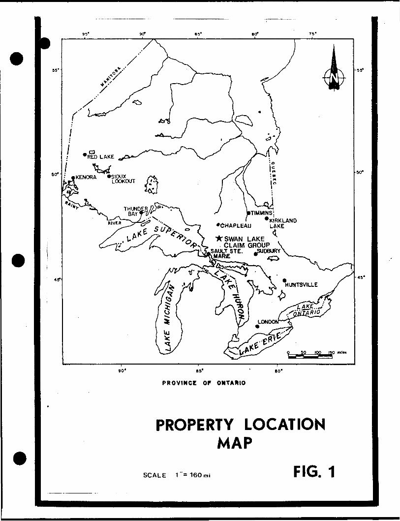
*SWAN LAKE CLAIM GROUP
SAULT STE. JSU06URY 'MARIE *
PROVINCE OF ONTARIO
PROPERTY LOCATION MAP
FIG. 1SCALE l s 160 mi

PROPERTY CLAIMt J M ^B^.
MAP
FIG. 2

PROPERTY STATUS
The property consists of nineteen contiguous claims (Fig.
2). -All the claims are in the name Margarette Bell of Banff,
Alberta and are jointly owned with Scott Frostad of Grimsby ,
O/ifftn'o. The claims were recorded May 30, 1990 and the
tag numbers are listed below:
1098417
1098418
1098419
1098420
1098421
1098422
1098423
1098424
1098425
1098426
1098427
1098428
1098429
1098430
1098431
1098432
1098433
1098434
1098435
METHOD
The magnetic survey was completed using a Geonics proton
magnetometer. Diurnal variations were corrected manually. All
readings were corrected to the initial reading taken from the
baseline, station 100+OOE. The readings were posted and
contoured (Map 1).
The VLF electromagnetic survey was carried out using a
Geonics EM-16 receiver. The transmitter station used was Cutler,
Maine. The inphase and quadrature readings were posted (Map 2)
and profiled (Map 3).

RESULTS
The magnetic survey outlines the eastern portion of the
claim group with numerous northwest trending lineaments. These
probably reflect a diabase dyke swarm known to exist in the
surrounding area. The western portion of the property has a
relatively flat magnetic response.
The VLF survey outlined 6 east-west trending conductive
horizons. A list of their locations follow.
Conductor "A" is a strong open-ended horizon at least 0.6
kilometres in length.
Conductor "B" is a weak conductor closed to the west but
open to the east. It is coincident with a swampy area.
Conductor "C" is a moderate conductor which begins at the
east side of Margarette Lake and is open to the east. It is
coincident with a swampy area.
Conductors "D" and "E" are indefinite conductors along the
same strike. These short conductors are coincident with swampy
areas.
Conductor "F" is a moderate to strong, open ended conductor
at least 1.0 kilometres in length. The symmetrical shape of the
inphase and quadrature profiles suggests a good, deep conductor.

VLF CONDUCTORS
Conductor
"A"
"B"
"C"
"D"
"E"
"P"
Location
L 100+OOE, 100+75N to L 104+OOE, 98+75N
L 112+OOE, 106+OON to L 114+OOE, 107+OON
L 116+OOE, 104+OON to L 118+OOE, 105+OON
L 110+OOE, 99+50N to L 112+OOE, 100+25N
L 118+OOE, 103+50N
L 110+OOE, 98+OON to L 118+OOE, 102+25N
RECOMMENDATIONS
It is likely that the magnetic survey outlined a swarm of
diabase dykes in the eastern portion of the property. The VLF
conductors are mainly located in swampy areas and may suggest
surficial conductivity. It is highly recommended that geological
mapping and prospecting be conducted over the entire property.
This will hopefully determine the sources of the VLF conductors
and delineate new exploration targets. Further exploration
programs would be contingent on the results of this work.
Respectfully Submitted,
Scott Frostad, B.Se. Consulting Geologist

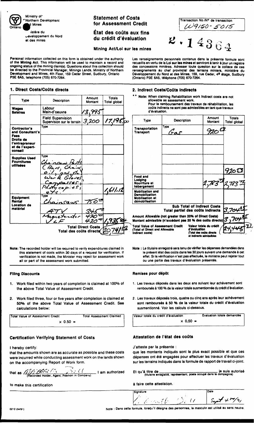
Indirect Costs
Gasoline S 920.53
Food and Lodging S 2,783.72
Total Indirect Costs S 3,704.25
Total Costs $24,445.37

FIELD PERSONNEL (April 30 to May 12, 1991)
Scott Frostad, geologist
Micheal Sieb, geologist
Margarette Bell, labourer
David Jeffery, labourer
Geoffrey Frostad, labpurer
Catherine Langdon, labourer
lan Moar, labourer
Peter Christiansen, labourer
OFFICE PERSONNEL
Scott Frostad, Aug. 31 to Sept. 4
Geoff Frostad, Aug. 31
13 days 9 $200/day
1.3. days 9 3 165/day
13 days @ $150/day
13 days @ S 150/day
13 days 9 $ 150/day
13 days @ $ 150/day
13 days @ ̂ ISO/day
13 days 9 $ 150/day
3 days $200/day
l day 9 5 150/day
EXPENSE SUMMARY
Direct Costs
Labour
Field Supervision S Report
Suppli es(chainsaw parts, work gloves, etc.)
. Chainsaw Rentals
ATV Rental
Magnetometer Rental
VLF Rental
Total Direct Costs
*13,995.-00
$ 3,200.00
$ 1,611.12
$ ' 750.00
$ 345.00
5 420.00
S 420.00
S20,V41. 12

CERTIFICATION
I, Sc.ott Frostad of the city of Vancouver, British Columbia, do
hereby certify that:
(1) I am a graduate of the University of Western Ontario with a
B.Se. in Geology, 1984.
(2) I am a member of the Prospectors and Developers Association
of Canada.
(3) I have practised my profession as a geologist continuously
since May 1984.
(4) I personally supervised the work outlined within this report
and this data is accurately represented to the best of my
knowledge.
Scott R. Frostad, B.Se,
Consulting Geologist
Vancouver, B.C.
September 4, 1991

REFERENCES
Coster, I.1986: Geological and Geochemical Report on the Verse Lake
Property; Assessment Report, Glen Auden Resources and Verse Lake Mining and Exploration Ltd., Assessment Files, Sault Ste. Marie.
Fraser, D.C.1986: Digem III Survey of the Verse Lake Area; Assessment Report,
Glen Auden Resources and Verse Lake Mining and ExplorationLtd., Assessment Files, Sault Ste. Marie
Grunsky, B.C.1987: Precambrian Geology of the Batchawana Synoptic Project . .
Area, Bulley Lake Sheet, Districts fo Sudbury and Algoma, Ontario Geological Survey, Map P. 3061, Geological Series Preliminary Map, 1:50,000, Geology 1981-1984
1983: Batchawana Synoptic Project p.54-58 in Summary of Field Work, 1983, by the Ontario .Geological Survey, edited by John Wood, Owen L. White, R.B. Barlow and A.C. Colvine, O.G.S., Miscellaneous Paper 116, 313 p.
Mountj oy, J.E.1984: Geological Survey on the Neill #2-83 Group of Hollinger
Argus Ltd., Assessment Report, Hollinger Argus Ltd.,Assessement Files, Sault Ste. Marie
Ontario Department of Mines/Geological Survey of Canada1963: Cow River, Algoma and Sudbury Districts, Aeromagnetic Map 2216 G, l"*l mile
Ontario Geological Survey1990: Airborne electromagnetic and total intensity magnetic
survey, Batchawana area, Ontario Geological Survey, Map81438, 1:20,000
Racic, L.1989: Magnetic and VLF Electromagnetic Survey, Verse Lake Option,
Assessment Report, Placer Dome Inc., Assessment Files,Sault Ste. Marie
Zeeman, M.1988: Diamond Drill Report for Joint Venture Verse Lake Property,
Assessment Report, Wray Resources Inc. and Glen Auden Resources Ltd., Assessment Files, Sault Ste. Marie

PROPERTY CLAIM MAP
Ontario4io05seeai3 2.14354 SHERRATT 300
Ministry of Ministere duNorthern Development Developpement du Nordand Mines et des Mines
Geoscience Approvals SectionMining Lands Branch159 Cedar Street, 4th FloorSudbury, OntarioP3E 6A5
Toll Free: 1-800-465-3880Telephone: (705) 670-7264Fax: (705) 670-7262
Our File: 2. 14364 Transaction #: W9150. 5015
April 16, 1992
Mining RecorderMinistry of Norther Developmentand Mines60 Church StreetSault Ste. Marie, OntarioP6A 3H3
Dear Sir/Madam:
RE: APPROVAL OF ASSESSMENT WORK ON MINING CLAIMS SSM 1098417 ET AL. IN SHERRATT TOWNSHIP.
The Assessment Credits for the Geophysical surveys, section 14 of the Mining Act Regulations, as listed on the attached Assessment Work Credit Form, have been approved as of MARCH 30, 1992.
Please indicate this approval on your record sheets.
If you have any questions please Call Clive Stephenson at (705) 670-7251.
Yours sincerely,
Ron C. GashinskiSenior Manager, Mining Lands BranchMines and Minerals Division
CDS/j l Enclosures:
cc: Resident GeologistSault Ste. Marie, Ontario
Assessment Files Office Toronto, Ontario

CLAIM NUMBERVALUE OP ASSESSMENT WORK DONE ON THIS CLAIM
VALUE APPLIED TO THIS CLAIM
VALUE ASSIGNED PROM THIS CLAIM
SSMSSMSSMSSMSSMSSMSSMSSMSSMSSMSSMSSMSSMSSMSSMSSMSSMSSMSSM
1098417109841810984191098420109842110984221098423109842410984251098426109842710984281098429109843010984311098432109843310984341098435
S$$$$$$$$$$Ss0$ss$$
1100. 00700. 00850. 00100. 00900. 00650. 00
1200. 002100. 001750. 001950. 00900. 00100. 00250. 00525. 00650. 00650. 00
1000. 001641. 001350. 00
$$$s$$$$s$5S$$$$$$g
880.880.880.880.880.880.880.880.
1280.1280.1280.880.880.880.880.880.880.880.
1326.
00000000000000000000000000000000000000
s$$$$^$$$$$$s$$$s$$
220. 000. 000. 000. 00
20. 000. 00
320. 001220. 00470. 00670. 00
0. 000. 000. 000. 000. 000. 00
120. 00761. 0024. 00
TOTALS: $ 18, 366. 00 18, 366. 00 $ 3, 825. 00

Ministry of.Northern Development
id MinesOntario 1
Report of Work Conducted After Recording Claim
Mining Act
Transaction Number
/t 4 7 fPersonal information collected on this form is obtained under the authority of the Mining Act. t this collection should be directed to the Provincial Manager, Mining Lands. Ministry of Noi Sudbury, Ontario. P3E 6A5, telephone (705) 670-7264.
ernpali ve
correspondence. Questions about Ines. ^ourfftfioor, 159 Cedar Street,
OInstructions: - Please type or print and submit in duplicate.
- Refer to the Mining Act and Regulations for requirements of filing assessment work or consult the Mining Recorder.
- A separate copy of this form must be completed for each Work Group.- Technical reports and maps must accompany this form in duplicate.- A sketch, showing the claims the work is assigned to, must accompany this form.
litRecorded Holders) Client No; /ot, y f f
^ 2.0*)Q2L Z-R.A1Telephone No
762.
Address
Mining DMsion Township/Area
TVO?.M or Q Plan No.
Dates Work Performed
From: tA^y. \ To: miWork Performed (Check One Work Group Only)
y
Work Group
'Geotechnical Survey
Physical Work, Including Drilling
Rehabilitation
Other Authorized Work
Assays
Assignment fromReserve
Mfxoyvi^o^sX^j- ^"-t-vK-Yi l
^V^vx\ 0-^- ^Vvx. "^^SAULT STE. MARIE MINING DIVISION
RECEIVED
Mi 19NOV1991 p||Ainw* n r. -ift " w 1 O 4 A , d, d7|b|y|W|ii|12ili*iO|4|a|b
..., i.. ,, ,.
Type
\H.WvjL. j \JVJF
A^^ , XH.^Vw
- RECORDED.
MOV 1 9 1991
Reeeirt ̂1 -*4
^to-W *v \O ."T \CviL,.
v. C^t-"\dV"kOe^
t~?,^+Z-*-
Total Assessment Work Claimed on the Attached Statement of Costs $
Note: The Minister may reject for assessment work credit all or part of the assessment work submitted if the recorded holder cannot verify expenditures claimed in the statement of costs within 30 days of a request for verification.
Persons and Survey Company Who Performed the Work (Give Name and Address of Author of Report)
(attach a schedule If necessary)
Certification of Beneficial Interest * See Note No. 1 on reverse side
l certify that at the time the work was performed, the claims covered in this work report were recorded in the current holder's name or held under a beneficial interest by the current recorded holder.
Date Recorded Holder or Agent (Signature)
Certification of Work Reportl certify that l have a personal knowledge of the facts set forth in this Work report, having performed the work or witnessed same during and/or after its completion and annexed report is true. ___________________________________________
of lrson^rejs of lar
Telepo^ne-y/
Certified By (Signature)**J v**iy****iw/ ,
^Z5f^^C*/For Office Use Only
iAfllE MININGToUI Value Cr. Recorded
, y v'S"Dal* Recorded
Approval Date
Dal* Nooc* lor Amendment* se
Mining
Date Approved
seal A
CEIVED
m 1 1 SEP 1991 pM 7|8,9|10,11|12,1)2,3,4,5|6
si.
i

i i ;I l
' 5 ^ -0
0
On
P J
CP d
i^ rt
IP
IP
0
0rO
J*
(P
00
-c
-c(/
* tp
0)
JV
0
J*
^
t^
0 oO oo
0
0
CO j: r0 -0
o QO
0 CD
rt
0 JO cG
(T
O
00 ^r
R1
0
J& rf)
0 60
S N
0 cfi
j:
O
CO 0
^ 0 ft cO
^, 0 ^
,'- u 00 J
Wortt
Ftopoft
NtifTibor
tof
Applying
Reserve fi
fi
zIl*|
i irA
PO
S 0S
0o 0
N
O
Oo 0
N o O
0 oN 0
Q
O 0
Value
ftMSs Work
D
n this
i irJ
OK
C^
S oN 8
o O
i Cre
dits
you
are
cla
imin
g in
thi
s re
port
may
be
cut
back
. In
ord
er to
min
imiz
e th
e ad
vers
e ef
fect
s of
suc
h de
letio
ns,
plea
se i
ndic
ate
from
w
hich
cla
ims
you
wis
h to
prio
rize
the
dele
tion
of c
redi
ts.
Ple
ase
mar
k (s
) on
e of
the
fol
low
ing:
1.
D C
redi
ts a
re t
o be
cut
bac
k st
artin
g w
ith t
he c
laim
lis
ted
last
, w
orki
ng b
ackw
ards
.
2.
O C
redi
ts a
re t
o be
cut
bac
k eq
ually
ove
r al
l cl
aim
s co
ntai
ned
in t
his
repo
rt of
wor
k.
3.
K}
Cre
dits
are
to
be c
ut b
ack
as p
rioriz
ed o
n th
e at
tach
ed a
ppen
dix.
In t
he e
vent
tha
t yo
u ha
ve n
ot s
peci
fied
your
cho
ice
of p
riorit
y, o
ptio
n on
e w
ill b
e im
plem
ente
d.
No
tt 1
: Ex
ampl
es o
f ben
efic
ial I
nter
est a
re u
nrec
orde
d tr
ansf
ers,
opt
ion
agre
emen
ts, m
emor
andu
m o
f agr
eem
ents
, etc
., w
ith re
spec
t to
the
min
ing
clai
ms.
Not
e 2:
If
wor
k ha
s be
en p
erfo
rmed
on
pate
nted
or
leas
ed l
and,
ple
ase
com
plet
e th
e fo
llow
ing:
l cer
tify
that
the
rec
orde
d ho
lder
had
a b
enef
icia
l int
eres
t in
the
pat
ente
d or
leas
ed l
and
at t
he l
ime
the
wor
k w
as p
erfo
rmed
.
Sig
natu
reD
ate
Nurn
tro d
e ra
ppor
t •u
r to*
trav
aux
exec
utes
po
ur ('
affe
ctatio
n de
la re
serv
e
Num
ero
de c
laim
*
Nom
bre
d'un
ites
——
——
——
^ t ^ ] 0 •l
——
— { f j u f
— ̂ CN fV ^N *'
j 1N
ombr
e to
tal
de c
laim
sVa
tour
l tr
avau
x ex
ecut
e*
x
^
n O
G O
\ IN R
u.
O'
^ rr i ^^
\ l* i k
^ ^ e T: O
qul a
*te
aff
ect*
*
Ontario
M-'nistry of' Northern Development
Mines
lislere du u-Aveloppement du Nord et des mines
Statement of Costs for Assessment Creditlitat des couts aux fins du credit devaluation
Mining Act/Loi sur les mines
Transaction No./N* de transaction- 3~6 /S'
4364Personal information collected on this form is obtained under the authority of the Mining Act. This information will be used to maintain a record and ongoing status of the mining claim(s). Questions about this collection should b* directed to the Provincial Manager, Minings Lands, Ministry of Northern Development and Mines, 4th Floor, 159 Cedar Street, Sudbury, Ontario P3E 6A5, telephone (705) 670-7264.
Les renseignements personnels contenus dans la presente formule son) recueillis en vertu de la Lot sur les mines et serviront a tenir a Jour un registre des concessions minieres. Adresser toute quesiton sur la collece de ces renseignements au chef provincial des terrains minlers, ministere du Oeveloppement du Nord et des Mines, 159, rue Cedar, 4* etage, Sudbury (Ontario) P3E 6A5, telephone (705) 670-7264.
1. Direct Costs/CoQts directs 2. Indirect Costs/CoOts indirects
Type
Wages Salaires
Contractor's and Consultant's Fee* Droitsde ('entrepreneur et de ('expert- Cornell
Supplies Used Foumltures utlllsees
Equipment Rental Location de materiel
Description
Labour Main-d'oeuvreField Supervision Supervision sur le terrain
Type
Type
^ '?"j"f) ^~"^G , f j tp **^"i "*-
rirlyS^*^*y*-'* f lType
s4*ri/^2^-^^
Amount Montant
/3jW3 -floo
^
-Kg*
•"^•//*"*S
wu?*Total Direct Cost* ,
Total des coOts directV
Totals Total global
/7 ffif,
/}6tJ.tl
/f93f*
M7W
00
*-
2
* Note: When claiming Rehabilitation work Indirect costs are not allowable as assessment work. Pour le remboursement des travaux de rehabilitation, les couts indirects ne sont pas admissibles en tant que travaux d'evaluation.
Type
Transportation Transport
Food and Lodging Nourrtture et nebergementMobilization and Demobilization Mobilisation et demobilisation
Description
TVPfl̂ ?^r
Amount Montant
ipy*
Sub Total of Indirect Costs Total partial des coOts Indirects
Amount Allowable (not greater than 20H of Direct Costs) Montant admissible (n'excedant pas 20 H des coOts directs)Totsl Vslue of Assessment Credit Valeur totale du credit / (Total of Direct and Allowable devaluation f Indirect eoitil fTotal del coott dlredt l -
Totals Total global
l
92oZ3
tf 'T&'Z? ^AjAT^
^70^3)70***
Mfttg
^
tr*
r3
Note: The recorded holder will be required to verify expenditures claimed in this statement of costs within 30 days of a request for verification. If verification is not made, the Minister may reject for assessment work all or part of the assessment work submitted.
Note : Le titulaire enregistre sera tenu de verifier les depenses demandees dans le present etat des couts dans les 30 jours suivant une demande a cet effet. Si la verification n'est pas effectuee, le minlstre peut rejeter tout ou une partie des travaux devaluation presentes.
Filing Discounts
1. Work filed within two years of completion is claimed at 10007o of the above Total Value of Assessment Credit.
2. Work filed three, four or five years after completion is claimed at 50*Vb of the above Total Value of Assessment Credit. See calculations below:
Total Value of Assessment Credit Total Assessment Claimed
x 0.50
Remises pour depot
1. Les travaux deposes dans les deux ans suivant leur achievement sont rembourses a 100 "to de la valeur totale susmenttonnee du credit d'evaluation.
2. Les travaux deposes trois, quatre ou cinq ans apres leur achievement sont rembourses a 50 H de la valeur totale du credit d'evaluation susmentionne. Voir les calculs ci-dessous.
Valeur totale du credit devaluationx 0,50 -
Evaluation totale demanded
Certification Verifying Statement of Costs
l hereby certify:that the amounts shown are as accurate as possible and these costs were incurred while conducting assessment work on the lands shown on the accompanying Report of Work form.
that as(Recorded Holder, Agent, Posrton in Company)
to make this certification
Attestation de I'etat des coOts
J'atteste par la presente :que les montants indiques sont le plus exact possible et que ces depenses ont ete engagees pour effectuer les travaux d'evaluation sur les terrains indiques dans la formule de rapport de travail ci-joint.
' am authorized Et qu'a tltrede je suis autorise(titulaire enrcgistre, representant, poste occup* dans la compagnle)
a faire cette attestation.
Signature
/' /' ,* ' —————
•-.'. ( i- , \ '^ < tf
Date
0212(04/91) Nota : Dans cane formule, lorequ'il designe des personnes, le masculin est utilisi au sens neutre.

•" •Z*
*iS*
2ZZt
*~'
' ' ^
—^^
r*1*'
-
1II
III1
IIII
11
II1
I1II
II1
II1
IMII
1II
41Q05SE0013 2.14364 SHERRATT
Min
istr
y of
Nat
ural
Res
ourc
es
Min
istry
of
Nor
ther
n De
velo
pmen
tan
d M
ines
Ont
ario
IND
EX
TO
LA
ND
DIS
PO
SIT
ION
PIA
N
G-3
074
TOW
NSHI
P
SH
ER
RA
TT
M.N
.R, A
DM
mU
TWlV
E D
OT
Kt
SA
ULT
ST
E. M
AR
IE
SA
ULT
ST
E. M
AR
IELA
ND T
HU
S/R
EG
ISTR
Y D
IVIS
ION
SU
DB
UR
Y
Se
al*
1:2
0 0
00
1W
t1
00
*20
0*
1000
1000
2000
3000
4000
WO
O 0
00
70
00M
OO
90
00
1000
0•i
- j
- ~
t
F**l
Co
nto
ur
Inte
rval
10
Me
tre
*
AR
EA
S W
ITH
DR
AW
N F
RO
M D
ISP
OS
ITIO
N
MR
Or
Min
ing
Rig
hts
Onl
y S
BO
- Su
rfac
e R
ight
s O
nry
Min
ing
and
Surfa
ce R
ight
s
SYM
BOLS
Dm
crip
Ho
nO
nta
rH*.
D
M*
Bou
ndar
y
Tow
nshi
p, M
erid
ian,
Bas
elin
e.
Road
allo
wan
ce;
surv
eyed
, sh
orel
ine.
Lot/C
once
ssio
n;
surv
eyed
, un
surv
eyed
Parc
el;
surv
eyed
unsu
rvey
ed
Rig
ht-o
f-way
; roa
dra
ilway
utility
,...
....
....
......
....
......
Res
erva
tion
Clif
f, Pi
t, Pi
le
Con
tour
In
terp
olat
ed
Appr
oxim
ate
Dep
ress
ion.
Con
trol p
oint
(hor
izon
tal)
Floo
ded la
nd....................
....
......
......
.. ^
^HHH
HHH^
CM
ine
head
fram
e ..
....
....
....
....
....
....
....
....
....
....
....
a
Pip
elin
e (a
bove
gro
und)
...........
......
....
.,....
. —
——
—
——
Rai
lway
; si
ngle
track........................ -
....
.. "
——
'——
i-do
ubte
tra
ck..
....
,...
....
....
....
....
....
-*—
—M—
—*-
aba
ndo
ne
d....
......
........
....
......
...
-— —
-— —
l-
Roa
d; h
ighw
ay, c
ount
y, to
wns
hip
.................... =
==
acce
ss .
.................................... -
S3a—
====
trail,
bush.......... .........
........
......
.. —
——
——
— —
Shor
elin
e (o
rig
ina
l)..
....
....
....
....
......
......
...
•--"
"" '•
••--
-..
Tran
smis
sion
lin
e..
....
....
....
....
..,.
....
....
....
—*~
——
'—
Vto
oded
are
a.
NO
TE -
THIS
TO
WN
SHIP
FA
LLS
WIT
HIN
TH
E R
ANG
ER L
AK
E
FOR
EST
MA
NA
GE
ME
NT
UN
IT A
ND
MAY
BE
SU
BJE
CT
TO F
OR
ESTR
Y O
PER
ATIO
NS.
TIM
BER
MAN
AGEM
ENT
PLA
NS
AR
E A
VA
ILA
BLE
FO
R PU
BLIC
VIE
WIN
G A
T TH
E M
NR O
FFIC
E.
87
5 Q
UEE
N
ST.
E.
SAU
LT S
TE.
MA
RE
.
TOWB
SHIP
SUBJE
CTTO
FORE
STRY
OPE
RATIO
NS
DISP
OSI
TIO
N OF
CRO
WN
LAND
SPa
tent
Surfa
ce S
Min
ing
Rig
hts
Sur
face
Rig
hts
Onl
y
Min
ing
Rig
hts
Onl
y
Leas
eSu
rface
A M
inin
g R
ight
s Su
rface
Rig
hts
Onl
y M
inin
g R
ight
s O
nly
Lice
nce
of O
ccup
atio
n
Ord
er-in
-Cou
ncil
Can
celle
d
Res
erva
tion
San
d 4
Gra
vel.
.e .Q .m y
..OC
TH
E
INF
OR
MA
TIO
N
THA
T A
PP
EA
RS
O
N
TH
IS
MA
P
HA
S
BE
EN
C
OM
PIL
ED
F
RO
M V
AR
IOU
S S
OU
RC
ES
, A
ND
A
CC
UR
AC
Y
IS
NO
T
GU
AR
AN
TE
ED
. T
HO
SE
W
ISH
ING
TO
S
TAK
E
MIN
IN
G C
LA
IMS
SH
OU
LD
CO
N
SU
LT
WIT
H
TH
E
MIN
ING
R
EC
OR
DE
R,
MIN
IST
RY
Q
F
NO
RT
HE
RN
D
EV
EL
OP
M
EN
T A
ND
MIN
ES
, FO
R A
D
DIT
ION
AL
IN
FO
RM
AT
ION
O
N
TH
E
STA
TUS
O
F, T
HE
L
AN
DS
SH
OW
N
Th
*
19
ftp
pr
ox
7 .
c B
ea
rin
g
Anr
xu a
l C
^ a n
Map
bas
e an
d la
nd d
ispo
sitio
n dr
aftin
g by
Sur
veys
and
Map
ping
Br
anch
, Min
istry
of N
atur
al R
esou
rces
.Th
e di
spos
ition
of l
and,
loca
tion
of lo
t fab
ric a
nd p
arce
l bou
ndar
ies
on
this
inde
x w
as c
ompi
led
for a
dmin
istra
tive
purp
oses
onl
y.
O)
X m H -l (D
i CM
O

/O 7
* C
OM
SU
/IA
J
AR
.G-A
RE
1.A
KE
L
/O''-"V
i f?
-
SW
sS ^ \
5
1*4V
s. .^
. Jif.
KiA
TO
PO
MS
x^
x^
^ f
T—fi G
r/J
E' U
k ^V
-is r
TT
* i/
*
y
i/
w B V
^ ^
41
00
5S
Ea
ai3
2.1
1364
SH
ER
RA
TT210

f."
-. /Og+
oo \J
/06+
OO
A
/
2-1
43
64
-i
41
Oe
SS
E0
01
3
2.1
4364
SH
ER
RA
TT

x
ci
0 t**
^
^rf* -r^
^t
i *^
^-1-
o
*̂V
, td
1 1
-ri
' *t
-*5j*
fc
49
\*S
^,i
*t
\0
v
0 t*
\ -\
*4
\ V \ \ -'b
rt
-M
**
^
^5
-Ir
*5
^
tt'X
^
*1
\
^
^ \
/^
\
^^
- \^
*
\6
\
^^
/^
V
-^
*5
.^'
^
-6
\
^ -*
4*
' \\
.^ ^
I
^
^
^
^
W
1.1
*n—
:.-a
;^ -
™^-
..x^.
.r
.. :'.
...r.
.*
* 3
3 *
t ^ \
S\
. i
, '
\ i
'1 'J -f .1 -a -4 J*
-7 ^ -n ^ -i -i ^i ^ -^
^y -1 -^
*^ -^ :
Ai
^ ;
c? o *^ + 1
*~l- ^\ c? o O 0 -ri
** ^ *^
^ *A + IO *\* -t*\
^ i\
1 10
u'W
^ M
5t
1
\0a?u^
^*
•i -^
-3
*^
e-
4 i
-3o
o
•x-A
v/
^ *^
*l\
-t *-
-**
1: J'
^^
-S
j. 5
--4
-^
-vto
^n ^
'10
-4
-1
-10
-f43!
^ ID
^ ^
^io
: -*-.i
^*o
*-Ki^^
r
?o-r
\
*~-H
- f
JT&
-9O
LA
KE
. L
Y * W
\
•"?\
o•,.
v.';',
--^
y o o o o
O
O 1- N o \ -J
UJ,
vj O t-
oO O
V, V,' -t-
X
kj O O i V)
8O Q •j. O
e co
HJ OV T O
c
k/ C O 0 Oo-J
-si
7 f
- 00
41005SE0013 2.14364 SHERRATT
23
0