mag line-cutting rpt pardo clement twps - … · pierre of vancouver, british columbia conducted...
TRANSCRIPT
ASSESSEMENT REPORT:
Results of Magnetometer Survey and Report of Physical Work (Linecutting) Completed August, 2009 on the Pardo Property, Pardo and Clement Townships,
Sudbury Mining Division, Ontario
by
Mount Logan Resources 102-957 Cambrian Heights Dr. Sudbury, Ontario P3C 5S5
Submitted by:
Danniel Oosterman Contract Geologist Val Caron, Ontario
RECEIVED SEP 0 1 Z009
Q 0 CI NCE AS E SMSNT C
September 1, 2009

1. 2. 3. 4. 5. 6. 7. 8. 9. 10.
Table of Contents
Introduction Location, Access and Physiography Property Claim Summary General Geologic Setting Property Geology Previous Work Magnetometer Survey Methodology Survey Results Cost Statement References
List of Tables
1. Table of Pardo Reef Project Claims and Status
Page
3 3 6 6 8 9 12 13 13 15
2. Claims Subject to Option with Endurance Gold Corporation
1. 2. 3.
3. Allotment of Expenditures on Pardo Claims
Property Location Map Property Claim Map Grid Map
List of Figures
List of Appendices
1. 1: 15000 Total Magnetic Field Map
Follows Page
5 7 14
2

1. Introduction
During the period August 1 through August 27,200951 line-kilometres of linecutting was completed on the Pardo property, followed by a walking magnetometer survey conducted from August 20 to August 27, 2009 was completed on claims 3011982, 3009441, 3011983, 3011984, 3011999 on the Pardo Property. linecutting was completed by crews working under Larry Salo of Timmins, Ontario. The magnetometer work was contracted to Monica Proudfoot, P.Geo, out of Val Caron, Ontario. Martin St. Pierre of Vancouver, British Columbia conducted interpretation, interpolation of data and data processing. The costs allotted to the claims are shown on the following table:
Township/ Area Claim Line
Work Performed Rental/Processing Totals/Claim Number Km
Linecutting Magnetometer Interp/Rental -PARDO 3011982 0.9 $585.00 $135.00 $1,187.20 $1,907.20
PARDO 3011983 13 $8,450.00 $1,950.00 $1,187.20 $11,587.20
PARDO 3011984 20 $13,000.00 $3,000.00 $1,187.20 $17,187.20
PARDO 3011999 15 $9,750.00 $2,250.00 $1,187.20 $13,187.20
PARDO 3009441 2.1 $1,365.00 $315.00 $1,187.20 $2,867.20
Totals: 51 $33,150 $7,650 $5,936 $46,736.00
2. Location, Access and Physiography
The Pardo Property is located approximately 65 kilometres northeast of Sudbury, Ontario (see Figure 1), in the Sudbury Mining Division of east-central Ontario. The approximate geographic centre of the property is located at 46 Degrees, 47 Minutes north latitude, and 80 Degrees, 15 Minutes west longitude (or, alternatively, at UTM NAD 83 Co-ordinates 5180000 North and 555500 East). The property is primarily located in the northwest quadrant of Pardo Township, extending north into Clement and MacBeth Townships, east into Hobbs Township and west into McNish Township.
Access to the property can be made from Sudbury, the Trans Canada Highway runs east to the town of Warren, from which paved Highway 539 runs north to the small community of River Valley. From there, paved Highway 539A and all-weather gravel Highway 805 run north approximately 30 kilometres, crossing the western portion of the claim block. A network of logging roads run east from Highway 805, providing additional access to much of the property.
The property lies at an elevation of between 240 and 350 metres ASL, and while locally can be rugged, is generally one of modest relief. Approximately 15% of the claim block is outcrop, with the remainder a mixture of thin soil development through to thick fluvial sand plains and in places boulder till sheets of significant thickness. Vegetation is comprised of, in places, stands of virgin red and white pine, through to second growth mixed forests of pine, spruce, and poplar.
Infrastructure surrounding the project area is also excellent. Water is plentiful, with numerous lakes on the property, and the Sturgeon River runs south very close to the
3
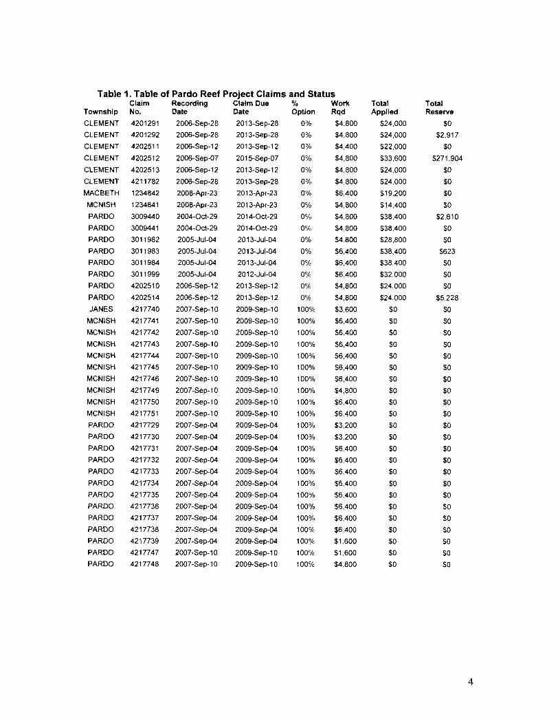
Table 1. Table of Pardo Reef Project Claims and Status Claim Recording Claim Due % Work
Township No. Date Date Option Rqd
CLEMENT 4201291 2006-Sep-28 2013-Sep-28 0% $4,800
CLEMENT 4201292 2006-Sep-28 2013-Sep-28 0% $4.800
CLEMENT 4202511
CLEMENT 4202512
CLEMENT 4202513
CLEMENT 4211782
MACBETH 1234842
MCNISH 1234841
PARDO 3009440
PARDO 3009441
PARDO 3011982
PARDO
PARDO
PARDO
PARDO
PARDO
JANES
MCNISH
MCNISH
MCNISH
MCNISH
MCNISH
MCNISH
MCNISH
MCNISH
MCNISH
PARDO
PARDO
PARDO
PARDO
PARDO
PARDO
PARDO
PARDO
PARDO
PARDO
PARDO
PARDO
PARDO
3011983
3011984
3011999
4202510
4202514
4217740
4217741
4217742
4217743
4217744
4217745
4217746
4217749
4217750
4217751
4217729
4217730
4217731
4217732
4217733
4217734
4217735
4217736
4217737
4217738
4217739
4217747
4217748
2006-Sep-12
2006-Sep-07
2006-Sep-12
2006-Sep-28
2008-Apr-23
2008-Apr-23
2004-0ct-29
2004-0ct-29
2005-Jul-04
2005-Jul-04
2005-Jul-04
2005-Jul-04
2006-Sep-12
2006-Sep-12
2007-Sep-10
2007 -Sep-1 0
2007 -Sep-1 0
2007 -Sep-1 0
2007 -Sep-1 0
2007 -Sep-1 0
2007-Sep-10
2007-Sep-10
2007-Sep-10
2007-Sep-10
2007 -Sep-04
2007-Sep-04
2007-Sep-04
2007-Sep-04
2007 -Sep-04
2007 -Sep-04
2007-Sep-04
2007-Sep-04
2007-Sep-04
2007-Sep-04
2007 -Sep-04
2007-Sep-10
2007 -Sep-1 0
2013-Sep-12
2015-Sep-07
2013-Sep-12
2013-Sep-28
2013-Apr-23
2013-Apr-23
2014-0ct-29
2014-0ct-Z9
2013-Jul-04
2013-Jul-04
2013-Jul-04
2012-Jul-04
2013-Sep-12
2013-Sep-12
2009-Sep-10
2009-Sep-10
2009-Sep-10
2009-Sep-10
2009-Sep-10
Z009-Sep-10
2009-Sep-10
2009-Sep-1 0
2009-Sep-10
2009-Sep-10
2009-Sep-04
2009-Sep-04
2009-Sep-04
Z009-Sep-04
2009-Sep-04
2009-Sep-04
2009-Sep-04
2009-Sep-04
2009-Sep-04
2009-Sep-04
2009-Sep-04
2009-Sep-10
2009-Sep-1 0
0%
0%
0%
0%
0%
0%
0%
0%
0%
0%
0%
0%
0%
0%
100%
100%
100%
100%
100%
100%
100%
100%
100%
100%
100%
100%
100%
100%
100%
100%
100%
100%
100%
100%
100%
100%
100%
$4,400
$4.800
$4,800
$4,800
$6,400
$4,800
$4,800
$4,800
$4,800
$6,400
$6,400
$6,400
$4,800
$4,800
$3,600
$6,400
$6,400
$6,400
$6,400
$6,400
$6,400
$4,800
$6,400
$6,400
$3,200
$3,200
$6,400
$6,400
$6,400
$6,400
$6,400
$6,400
$6,400
$6,400
$1,600
$1,600
$4,800
Total Applied
$24,000
$24,000
$22,000
$33,600
$24,000
$24,000
$19,200
$14,400
$38,400
$38,400
$28,800
$38,400
$38,400
$32,000
$24,000
$24,000
$0
$0
$0
$0
$0
$0
$0
$0
$0
$0
$0
$0
$0
$0
$0
$0
$0
$0
$0
$0
$0
$0
$0
Total Reserve
$0
$2,917
$0
$271,904
$0
$0
$0
$0
$2,610
$0
$0
$623
$0
$0
$0
$5,228
$0
$0
$0
$0
$0
$0
$0
$0
$0
$0
$0
$0
$0
$0
$0
$0
$0
$0
$0
$0
$0
$0
$0
4

Table 2. Claims Subject to Option with Endurance Gold Corporation Claim Recording Claim Due % Work Total Total
Township No. Date Date Option Rqd Applied Reserve
CLEMENT 4201291 2006-Sep-28 2013-Sep-28 0% $4,800 $24,000 $0
CLEMENT 4201292 2006-Sep-28 2013-Sep·28 0% $4,800 $24,000 $2,917
CLEMENT 4202511 2006-Sep-12 2013-Sep-12 0% $4,400 $22,000 $0
CLEMENT 4202512 2006-Sep-07 2015-Sep-07 0% $4,800 $33,600 $271,904
CLEMENT 4202513 2006-Sep-12 2013-Sep-12 0% $4,800 $24,000 $0
CLEMENT 4211782 2006-Sep-28 2013-Sep-23 0% $4,800 $24,000 $0
MACBETH 1234842 2008-Apr-23 2013-Apr-23 0% $6,400 $19,200 $0
MCNISH 1234841 2008-Apr-23 2013-Apr-23 0% $4,800 $14,400 $0
PARDO 3009440 2004-0ct-29 2014-0ct-29 0% $4,800 $38,400 $2,610
PARDO 3009441 2004-0ct-29 2014-0ct-29 0% $4,800 $38,400 $0
PARDO 3011982 2005-Jul-04 2013-Jul-04 0% $4,800 $28,800 $0
PARDO 3011983 2005-Jul-04 2013-Jul-04 0% $6,400 $38,400 $623
PARDO 3011984 2005-Jul-04 2013-Jul-04 0% $6,400 $38,400 $0
PARDO 3011999 2005-Jul-04 2012-Jul-04· 0% $6,400 $32,000 $0
PARDO 4202510 2006-Sep-12 2013-Sep-12 0% $4,800 $24,000 $0
PARDO 4202514 2006-Sep-12 2013-Sep-12 0% $4,800 $24,000 $5,228
N~~~''-~ ------------------------~-O~-C-E---J-----7r~-,--.-,~--------~~------~-r------------~~------__,
"NI" I FlHl AYSON
, ' I PotNT IIcKt'es' SrIJflG f O l'f ~.
Camp - R .... en
~~.~illirfd m
4)
s N H mlsc3ming
'8
" " - , ALGONQUI
M~es 20 I
Milies 20 R R Y
81 80 79'
Figure 1. Location of the Pardo Project in Ontario Canada, Sudbury Mining District.
5

western limit of the claim block. Grid power is available in River Valley. All amenities for any exploration or mine development programs are available in the world class mining centre of Sudbury, and the towns of Sturgeon Falls and North Bay, all within a ninety minute drive of the property. provide additional support services.
3. Property Claim Summary
As at the date of this report, the Pardo Reef Property is comprised of 39 claims totaling 520 units, or 8,332 hectares. The claims are shown in Table 1.Claims listed in Table 2 (and included in Table 1) have title to Endurance Gold Corporation, and are subject to an option agreement between Mount Logan Resources and Endurance Gold whereby Mount Logan can earn an initial 55% of the property by spending $1 M in exploration expenditures and making cash payments of $200k over a three year period.
On completion of its 55% earn-in, Mount Logan has a one-time option to increase its ownership interest to 70%, by completing an additional $1,000,000 in exploration, and making a further cash payment of $250,000 to Endurance.
On completion of either its 55% or 70% earn-in, Mount Logan will form a joint venture with Endurance to continue the exploration and development of the project. In the event either party dilutes to a 10% or less joint venture interest, that interest will convert to a 1.5% Net Smelter Royalty, and a one time cash payment of $500,000 on the commencement of commercial production.
Figure 2 illustrates the location of the respective claims comprising the property.
4. General Geologic Setting
The regional geologic setting is described by Dressler (1979) as follows;
The area is underlain by Precambrian rocks, which are locally covered by Pleistocene and Recent unconsolidated sediments.
Early Precambrian metavolcanics, metasediments, granitic rocks, and mafic intrusive rocks are the oldest in the area. The metavolcanics and metasediments were intruded by granitic rocks, emplaced approximately 2500 m.y. ago (Van Schmus 1965, Fairburn et al 1960). Early Precambrian mafic dykes also intruded the metasediments and metavolcanics and are believed to be younger than the granitic intrusions.
Middle Precambrian rocks of the Huronian Supergroup unconformably overlie the older rocks. They were deposited between 2150 to 2400 m.y. ago (Van Schmus, 1976), an age bracket which corresponds to the Aphebian of C. H. Stockwell (1964). Rocks of the Mississagi Formation, the Gowganda Formation, and the Lorrain Formation occur in the area. The Mississagi Formation consists of conglomerate, sandstone, greywacke and argillite. The Gowganda Formation is comprised of greywacke, conglomerate, arkosic wacke, and subarkose. The Lorrain Formation is primarily comprised of quartzite, sandstone, and minor silty wacke. Nipissing intrusive rocks (approximately 2150 m.y. old), mostly gabbros, intrude all other older formations. A late Precambrian olivine diabase dyke outcrops in northwestern Janes Township, immediately south of Pardo
6

MOUNT LOGAN ResDurces
P.~RDO RITr PROJECT Slid bur:. DinriC1. O.1.3rico
Claim "Dd Pro".~· Bound"ry Key:\L1p
:\Iounl Logan Claims (100% lin R.tl B<mnda.,· EndUJ""llco Gold Option Chims in Ydlow Bound .. ,-
Figure 2. Map showing Mt. Logan Claims and Optioned Claims for Pardo Project in and around Pardo Township
7

Township. All of the above lithologies occur north of the Grenville Front Boundary Fault, in the Southern Structural Province of the Canadian Shield.
South of the Grenville Front Boundary Fault, in the Grenville Structural Province, rocks consist of biotite-plagioclase gneiss, biotite-hornblende-plagioclase gneiss, feldspathic gneiss, amphibolite, gabbro, anorthosite, migmatite, olivine diabase, and ultramafic rocks.
5. Property Geology
Clark (1998) describes the property geology as follows;
The claim block is predominantly underlain by rocks of the Huronian Supergroup, and specifically by conglomerates, sandstones, siltstones and greywackes of the basal Mississagi Formation up through the Gowganda and Lorrain Formations. The northwest corner of the property, in Clement Township, hosts an intermediate to mafic intrusive believed to be Nippising gabbro.
The northern two thirds of the property show a series of roughly north-south trending units of conglomerate and siltstone-sandstone. MacVeigh (1956) concluded the formations form a syncline trending north 20 degrees east and plunging 5 degrees to the southwest. While very few field observations of strikes and dips have been made, those few that have been observed confirm that the sediments do form narrow, north south trending localized basins, perhaps filling paleotroughs in the Archean basement. The overall thickness of the Proterozoic sequence ranges from nil, where Archean greywackes are observed in outcrop on surface, to in excess of 100 metres, as documented by the 1956 diamond drilling completed by Pickle Crow Gold Mines in the vicinity of Apple Lake (see subsequent section).
Where observed, the basal conglomerate is generally matrix supported, with a highly variable clast size ranging from a few centimeters to in excess of 1 metre. Sorting in the conglomerate is generally very poor, suggesting the basal conglomerate may have a glacial origin as opposed to a fluvial genesis. Clast lithologies are also highly variable, but in decreasing abundance are quartz, siltstone/shale, chert, granite, diorite, and lesser varied rock types.
Gold mineralization defined to date on the property is intimately associated with pyrite content in the matrix of the basal conglomerate, and also appears to be related to proximity to the Archean unconformity. A more detailed description of the mineralization appears in the subsequent section of this report.
6. Previous Work
The first recorded work in the area is from 1932 (Bruce, 1932) when a small quartz vein was located immediately south of the current property boundary. The vein was stripped and sampled, but yielded very low gold values.
Between 1932 and 1956, there is no recorded work in the area. Between 1956 and 1957, much of the current property was held by Pickle Crow Gold Mines Limited, who were investigating the basal conglomerates for their uranium potential. That company
8

completed two rounds of diamond drilling totaling 16 holes and 7,489 feet. Figure 4 illustrates the location of the Pickle Crow drill holes, as reported by MacVeigh (1956) and Thompson (1960). While the holes were routinely assayed for uranium, yielding only low and uneconomic values, only sporadic gold assays were reported, to a high of 0.055 opt over 10 feet.
From the 1974 to 1996, the area comprising the property was withdrawn from staking, as part of the Bear Island Indian Caution. No exploration activity was allowed or reported during that period, though a limited Cobalt Embayment wide sampling program by the Ontario Geological Survey in 1980 sampled quartz pebble conglomerates located on the south shore of Tee Lake, and returned anomalous gold values to 165 ppb Au.
In 1996, the property was staked by Vancouver based junior Tenajon Resources Corporation. In 1997, the company completed a two phase exploration program on the property, comprised of an initial 1 :20,000 reconnaissance scale mapping and sampling program (see Figure 3), followed by a mechanized stripping and channel sampling program on the property. That work resulted in the discovery of two significant gold showings known as the "Northern" and Southern" Occurrences.
At the Northern Occurrence, stripping revealed a thin veneer of basal conglomerate resting unconformably on basement Archean greywackes. The basement rocks trend approximately east-west and are vertical, while the basal conglomerate is flat lying and "pancaked" onto the basement. In several locations, the conglomerate is strongly ironoxide stained, and carries up to 3-5% fine disseminated pyrite in the matrix. Grab values to 9.94 gpt gold were returned from the area, while channel samples returned a contjguous 12 metre interval grading 0.966 gpt gold.
At the Southern Occurrence, only the basal conglomerate is exposed, and again, pyritic portions returned grab samples to 2.47 gpt Au, and channel samples to 1.75 gpt Au over 3 metres.
During the same year, Tenajon also completed orientation humus sampling and scintillometer surveys over the North Showing, to determine the applicability of those two exploration techniques to identify additional gold occurrences. The scintillometer survey failed to detect any anomalous radioactivity associated with the gold occurrence. The humus sampling detected several anomalies immediately over the showing area, and 100 metres north and south of the showing, with individual sample tenures to 62 ppb Au.
In 1998, the property was optioned to Triex Resources Inc., who earned a 60% interest in the project by completing $125,000 of exploration work during the 1998-1999 field seasons. That work included completion of a 40 kilometre cut-line grid over the area surrounding the "Northern Occurrence, followed by humus geochemistry and ground magneticNLF-EM and pole-dipole Induced Polarization surveys over the grid. Both the humus geochemical survey and the IP survey identified multiple anomalies warranting follow-up.
In July, 1999, Triex completed a program of power stripping and channel sampling over selected targets based on both IP and humus geochemistry responses. Of eight targets identified and sampled during the program, six returned anomalous gold mineralization over substantial widths. The IP survey appeared to have been extremely effective in defining high pyrite content portions of the conglomerate. Best results included an
9

average grade of 451 ppb Au from twelve samples collected over a fifty metre exposure of the conglomerate, with high values to 2.2 gpt Au, and seven metres averaging 1.422 gpt Au, with a high individual metre channel carrying 7.03 gpt Au.
During 2000, Tenajon briefly re-assumed operatorship, and planned to assess the southern portions of the property for PGE potential. That work was never carried out. Due to depressed metal prices, the property was allowed to lapse in 2004, and was acquired by staking by the current property owners.
In July, 2006, Endurance Gold Corporation completed a single 18 metre diamond drill hole on Claim 3011983. The hole was designed to approximately duplicate a 1956 drill hole by Pickle Crow Gold Mines, which was exploring the area for uranium. That hole indicated that the basal conglomerate was in excess of 100 metres thick, and Endurance had planned a 150 metre diamond drill hole to provide a complete stratigraphic cut through the basal conglomerate, with corresponding continuous geochemistry. Unfortunately, due to extremely difficult overburden conditions, the hole failed to reach bedrock, and was abandoned after six days of drilling.
Also in July, 2006, Endurance Gold Corporation completed a 2500 metre mechanical stripping, washing, and channel sampling program at three locations, to evaluate IP anomalies generated as a result of the 1998 Triex work. That program was of a reconnaissance nature, and took place immediately off of the then property boundary. On receipt of results, Endurance staked 8 additional claims to cover the prospective stratigraphy. Results from the July, 2006 program included a channel sample returning 3.52 gpt Au over 13 metres (see Figure 5), with widespread anomalous gold values from the exposed basal conglomerate. In October, 2006, Endurance completed an additional 900 square metre stripping, washing and channel sampling program, as an extension to the July, 2006 program. That work has been filed for assessment (Mcivor, 2006).
Also in 2006, Katrine Exploration and Development was contracted to cut a 20.96 line kilometre grid on the property. In late October, Larder geophysics Ltd. completed a detailed ground magnetometer and VLF-EM survey over that grid, and that work was subsequently filed for assessment (Ploeger, 2006).
In April, 2007, Endurance Gold Corporation completed a 17.5 line-kilometre Induced Polarization Survey over portions of the property (Mcivor, 2007). That work successfully identified numerous strong I.P. chargeability highs, believed to coincide with significant pyrite concentrations within the basal conglomerate horizon, and with gold mineralization related spatially with the pyrite.
During the period May 15 through June 22, 2007, a 23.0 line-kilometre geological mapping and prospecting program was carried out on portions of the Pardo Property. (Cullen and Mcivor, 2008). Mapping consisted of walking cut-grid lines, and noting all outcrop locations and lithologies, as well as relevant sulphide content. Systematic grab sampling was completed on outcrops containing any appreciable sulphide content. A total of 121 samples were collected during the program. The mapping program primarily encountered three basic lithological types. Most prevalent was a poorly sorted, matrix supported basal conglomerate believed to be a member of the Mississagi Formation. This lithology, the host to previously defined gold anomalies on the property, contained variable sulphide content, from nil to in excess of 5% in places. Typically, a higher sulphide content, and increase in the percentage of quartz clasts in the conglomerate,
10
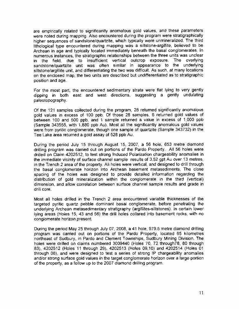
are empirically related to significantly anomalous gold values, and these parameters were noted during mapping. Also encountered during the program were stratigraphically higher sequences of sandstone/quartzite, which typically were unmineralized. The third lithological type encountered during mapping was a siltstone-argillite, believed to be Archean in age and typically located immediately beneath the basal conglomerates. In numerous instances, the stratigraphic relationships between the three units was unclear in the field, due to insufficient vertical outcrop exposure. The overlying sandstone/quartzite unit was often similar in appearance to the underlying siltstone/argillite unit, and differentiating the two was difficult. As such, at many locations on the enclosed map, the two units are described but undifferentiated as to stratigraphic position and age.
For the most part, the encountered sedimentary strata were flat lying to very gently dipping in both east and west directions, suggesting a gently undulating paleotopography.
Of the 121 samples collected during the program, 28 returned significantly anomalous gold values in excess of 100 ppb. Of those 28 samples, 6 returned gold values of between 100 and 500 ppb, and 1 sample returned a value in excess of 1,000 ppb (Sample 343555, with 1,880 ppb Au). Most all the significantly anomalous gold values were from pyritic conglomerate, though one sample of quartzite (Sample 343732) in the Tee Lake area returned a gold assay of 528 ppb Au.
During the period July 15 through August 15, 2007, a 56 hole, 653 metre diamond drilling program was carried out on portions of the Pardo Property. All 56 holes were drilled on Claim 4202512, to test strong Induced Polarization chargeability anomalies in the immediate vicinity of surface channel sample results of 3.52 gpt Au over 13 metres, in the Trench 2 area of the property. All holes were vertical, and designed to drill through the basal conglomerate horizon into Archean basement metasediments. The close spacing of the holes was designed to provide detailed information regarding the distribution of gold mineralization within the conglomerate in the third (vertical) dimension, and allow correlation between surface channel sample results and grade in drill core.
Most all holes drilled in the Trench 2 area encountered variable thicknesses of the targeted pyritic quartz pebble dominant basal conglomerate, before penetrating the underlying Archean metasedimentary stratigraphy (argillites-siltstones). In certain lower lying areas (Holes 15, 43 and 56) the drill holes collared into basement rocks, with no conglomerate horizon present.
During the period May 25 through July 07, 2008, a 41 hole, 979.5 metre diamond drilling program was carried out on portions of the Pardo Property, located 65 kilometres northeast of Sudbury, in Pardo and Clement Townships, Sudbury Mining Division. The holes were drilled on claims numbered 3009440 (Holes 70, 72 through78, 80 through 83),4202512 (Holes 11 through 29), 4202513 (Holes 09,10) and 4202514 (Holes 01 through 08), and were designed to test a series of strong IP chargeability anomalies and/or strong surface gold values in the target conglomerate horizon over a large portion of the property, as a follow up to the 2007 diamond drilling program.
11

7. Magnetometer Survey Methodology
During the period August 20 through August 27, 2009, Monica Proudfoot was contracted to complete a magnetometer on newly cut grid on the Pardo property.
A GPS-mode walking magnetometer and base station magnetometer were used for the survey. The mobile unit was a GSM19W+GPS magnetometer. The base station model was a GSM19 Base magnetometer. The magnetometer specifications are as follows:
Resolution: 0.01 nT (gamma), magnetic field and gradient. Accuracy: 0.2nT over operating range. Range: 20,000 to 120,000nT. Gradient Tolerance: Over 10, OOOnTlm Operating Interval: 3 seconds minimum, faster optional. Readings initiated from keyboard, external trigger, or carriage return via RS-232C. Input I Output 6 pin weatherproof connector, RS-232C, and (optional) analog output. Power Requirements: 12V, 200mA peak (during polarization), 30mA standby. 300mA peak in gradiometer mode. Power Source: Internal 12V, 2.6Ah sealed lead-acid battery standard, others optional. An External 12V power source can also be used. Battery Charger: Input: 110 VAC, 60Hz. Optional 110 1220 VAC, 50 160Hz. Output: dual level charging.
o 0
Operating Ranges: Temperature: - 40 C to +60 C. Battery Voltage: 10.0V minimum to 15V maximum. Humidity: up to 90% relative, non condensing.
o 0
Storage Temperature: -50 C to +65 C. Display: LCD: 240 X 64 pixels, OR 8 X 30 characters. Built in heater for operation below
o -20 C. Dimensions: Console: 223 x 69 x 240mm. Sensor Staff: 4 x 450mm sections. Sensor: 170 x 71mm dia. Weight: console 2.1 kg, Staff 0.9kg, Sensors 1.1 kg each. VLF Frequency Range: 15 - 30.0 kHz Parameters Measured: Vertical in-phase and out-of-phase components as percentage of total field. 2 relative components of horizontal field. Absolute amplitude of total field. Resolution: 0.1%. Number of Stations: Up to 3 at a time. Storage: Automatic with: time, coordinates, magnetic field I gradient, slope, EM field, frequency, in- and out-of-phase vertical, and both horizontal components for each selected station.
o 0
Terrain Slope Range: 0 - 90 (entered manually). Sensor Dimensions: 140 x 150 x 90 mm. (5.5 x 6 x 3 inches). Sensor Weight 1.0 kg (2.2 lb.).
The datum used for the survey was 56000nT based on the estimated ambient magnetic field described for the area. Cut lines were walked and readings were taken at 1 second
12
intervals. Field notes were taken to supplement the data. The base station was placed in the area of surveying each day of survey. Data was uploaded from the unit at the end of each field day and sent to Martin st. Pierre for interpretation and to make diurnal corrections from base station data.
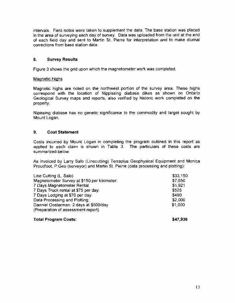
8. Survey Results
Figure 3 shows the grid upon which the magnetometer work was completed.
Magnetic Highs
Magnetic highs are noted on the northwest portion of the survey area. These highs correspond with the location of Nippissing diabase dikes as shown on Ontario Geological Survey maps and reports, also verified by historic work completed on the property.
Nipissing diabase has no genetic significance to the commodity and target sought by Mount Logan.
9. Cost Statement
Costs incurred by Mount Logan in completing the program outlined in this report as applied to each claim is shown in Table 3. The particulars of these costs are summarized below:
As invoiced by Larry Salo (Linecutting) Terraplus Geophysical Equipment and Monica Proudfoot, P.Geo (surveyor) and Martin St. Pierre (data processing and plotting):
Line Cutting (L. Salo) Magnetometer Survey at $150 per kilometer: 7 Days Magnetometer Rental 7 Days Truck rental at $75 per day: 7 Days Lodging at $70 per day: Data Processing and Plotting: Danniel Oosterman: 2 days at $500/day (Preparation of assessment report)
Total Program Costs:
$33,150 $7,650 $1,921 $525 $490 $2,000 $1,000
$47,936
13

T f able 3. Alottment 0 ex pen d ' I . h' I Itures on c alms upon w IC I work was com pleted
Township/ Area Claim line
Work Performed Rental/Processing Totals/Claim Number Km
Linecutting Magnetometer Interp/Rental -
PARDO 3011982 0 .9 $585.00 $135.00 $1,187.20 $1,907.20
PARDO 3011983 13 $8,450.00 $1,950.00 $1,187.20 $11,587.20
PARDO 3011984 20 $13,000.00 $3 ,000.00 $1, 187.20 $17,187. 20
PARDO 3011999 15 $9, 750.00 $2,250.00 $1,187. 20 $13,187.20
PARDO 3009441 2.1 $1,365.00 $315.00 $1,187.20 $2,867.20
Totols: 51 $33, 150 $7,650 $5,936 $46,736.00
FiBure 3. Newly cut Grid on Pardo PlrOperty totaling 51 line km ..
14

Appendix 1 contains a 1: 15000 scale colour contoured magnetometer map showing Total Magnetic Field.
10. Selected References
Bruce, E.L. 1932: Geology of the Townships of Janes, McNish, Pardo and Dana; Ontario
Department of Mines Volume 41, Part 4, p.1-28, Accompanied by map 41f, scale 1 inch to ~ mile.
Clark, J.G. 1998: Report on 1998 Geophysics and Humus Sampling, Pardo Property; Triex
Resources Inc. Internal Report
Cullen, D. 1997: Report on 1997 Prospecting, Geological Mapping, Stripping and Channel
Sampling on the Pardo Property; Tenajon Resources Corporation Internal Reportd
Dressler, Burkhart O. 1979: Geology of McNish and Janes Townships, District of Sudbury; Ontario
Geological Survey Report 191, 91 p., Accompanied by Map 2425, scale 1 :31 ,680
Fairbairn, H.W. et al 1960: Mineral and Rock Ages at Sudbury-Blind River, Ontario; Proceedings of
the Geological Association of Canada, Volume 12, p. 41-66
Long, D.G.F. 1981: The Sedimentary Framework of Placer Gold Concentrations in Basal
Huronian Strata of the Cobalt Embayment; in Summary of Field Work, 1981, by the Ontario Geological Survey, OGS Miscellaneous Paper 100, ed. by John Wood et al.
MacVeigh, B.A. 1956: Report on the Geology of the Pickle Crow Gold Mines Property, Pardo
Township, Temagami Area, Ontario; Pickle Crow Gold Mines Internal Report.
Mcivor, D.F. 2006: The Results of a July, 2006 Diamond Drilling Program in Pardo Township, Sudbury Mining Division, Ontario; Endurance Gold Corporation Assessment Report 2.33271
Mcivor, D.F. 2006: The Results of an October, 2006 Mechanized Stripping, Washing and Channel Sampling Program on Claim 4202512 in Clement Township, Pardo
15
Property, Sudbury Mining Division, Ontario; Endurance Gold Corporation Assessment Report W0670.01904
Mcivor, D. F. 200B: Report on the October-November 2007 Prospecting and Sampling
Program on the Pardo Property, Pardo and Clement Townships, Sudbury Mining Division, Ontario; Endurance Gold Corporation Assessment Report WOB70.00796
Mcivor, D.F. 200B: Report of the 2007Diamond Drilling Program on the Pardo Property,
Pardo and Clement Townships, Sudbury Mining Division, Ontario; Endurance Gold Corporation Assessment Report Number WOB70.00953
Mcivor, D.F. 2009: Report of the 200BDiamond Drilling Program on the Pardo Property,
Pardo and Clement Townships, Sudbury Mining Division, Ontario
Ontario Geological Survey 1975: Map 2361, Sudbury-Cobalt Geological Compilation
Ploeger, C.J. 2006: Magnetometer and VLF Surveys Over the Pardo Gold Project, Pardo and Clement Townships, Ontario; Larder Geophysics Ltd. Assessment Report 00670.01901
Stockwell, C.H. 1964 Fourth Report on Structural Provinces, Orogenies and Time Classification
of the Canadian Precambrian Shield; p.1-21, in Age Determinations and Geological Studies, Part II, Geological Studies, Geological Survey of Canada, Paper 64-17,29 p.
Thomson, J.E. 1960 Uranium and Thorium Deposits at the Base of the Huronian System in the
District of Sudbury; Ontario Department of Mines Geological Report No.
Van Schmus, W.R. 1965 The Geochronology of the Blind River-Bruce Mines Area, Ontario,
Canada; Journal of Geology, Volume 73, Number 5, p. 755-7BO
16

APPENDIX I

d " I
I I I 1
~ I ~ f~!
I
I ~)54000
Scale 1 :'15000
554500 55500D 555500 55GOOO
20 IT. 100nT: --
556 500
,
I I::.n );-;: I~.t; !'-' I I
I I 1
I~ i ........ ) I<Q 10 jC} I I I I I ~
-j ?;l 18 I I I I
TMI nT
MT. LOG/,N RESOURCES LTD PARDO PROPERTY
GROUND Mfl.GNETIC SURVEY
or-.JTOU ED COLOUR IM/I,G E OF TC>TAL MAG['~ETiC FIELD
'vVITH VERTICAL SHADOW DRAPE