maharashtra state board of technical...
TRANSCRIPT

17310
[Type text] Page 1/16
MAHARASHTRA STATE BOARD OF TECHNICAL EDUCATION
(Autonomous)
(ISO/IEC-270001 – 2005 certified)
WINTER-14 EXAMINATION
Subject code: 17310 Model Answer Page No:1/16
Important Instructions to examiners:
1) The answer should be examined by keywords and not as word-to-word as given in the
model answer scheme.
2) The model answer and the answer written by candidate may vary but the examiner may
try to assess the understanding level of the candidate.
3) The language error such as grammatical, spelling errors should not be given more
importance.(Not applicable for subject English and communication skill).
4) While assessing figures, examiner may give credit for principal components indicated in
the figure. The figure drawn by candidate and model answer may vary. The examiner
may give credit for any equivalent figure drawn.
5) Credits may be given step wise for numerical problems. In the some cases, the assumed
constants values may vary and there may be some difference in the candidates answer
and model answer.
6) In case of some questions credit may be given by judgment on part of examiner of
relevant answer based on candidates understanding.
Q1) a) Attempt any SIX of the following 12
i) State the principles of survey.
Ans. :- Following are the principles:-
i) To work from the whole to the part.
ii) To fix the position of new station by to independent process (i.e. the process
may be both linear, both angular, one linear and one angular.
01
01
ii) State the two uses of survey based on geodetic surveying
Ans.:- Two uses of survey based on geodetic surveying:-
i) To determine the precise position s on the surface of the earth.
ii) Preparation of maps of large area like map of a country, state, etc.
iii) Establishment of GTS bench Marks across the country.
iv) Preparation of military maps for defense purposes.
01
mark
each
(any
two)
iii) Give any four codes of signals use to direct assistant in ranging.
Sr.
No
Signal Meaning
1 Rapid sweeps with right Hand Move considerably to the right
2 Rapid sweeps with Left Hand Move considerably to the Left
3 Slow Sweep with right Hand Move slowly to the right
4 Slow sweeps with Left Hand Move slowly to the Left
5 Right arm extended Continue to move to the right
6 Left arm extended Continue to move to the Left
7 Right arm Up and moved to the right Plumb the road to the right
8 Left arm Up and moved to the Left Plumb the road to the Left
9 Both hands above Head and then Brought
Down
Correct
10
Both Arms extended forward horizontally
and the hands depressed briskly
Fix
mark
each
( Any
Four
)

17310
[Type text] Page 2/16
iv) Define: WCB and Quadrantal Bearing system.
Ans.: 1)WCB:-In this system the bearing of a line is always measured clockwise for
the north point of the reference meridian towards the line round the circle the angle
thus measured is called as WCB system
2) Quadrantal Bearing system:- In this system the bearing of a line is measured
clockwise from the north point or south point whichever is nearest .
1
1
v) How would you detect presence of local attraction at a place ?
Ans.:- The presence of local attraction may be detected by finding difference of FB & BB
of the line. If the fore bearing and back bearing difference is 1800 then there is no
local attraction at both stations. If the fore bearing and back bearing difference is not
equal to 1800 then there is local attraction at both or any one station.
2
vi) State the situation where plane table is suitable.
Ans.:-
1) It is most suitable for preparing small scale maps
2) It is suitable in magnetic are where compass survey is not reliable
3) It is most suitable for filling in details between stations fixed by triangulation
4) It is suitable where accuracy is not required.
1
mark
each
(any2)
vii) Define :
1) Bench mark 2) Datum surface
3) Line of collimation 4) Change Point
Ans.:-1) Bench mark: - It is a fixed reference point of known elevation..
2)Datum surface :-It is any arbitrarily assumed level surface from which vertical
distance are measured
3) Line of collimation:- It is the line joining the intersection of cross –hair on
diaphragm to the optical center of the object class and its continuation up to the object.
4) Change Point:-It is the point on which the fore and back sights are taken.
It is the point denoting the shifting of the level.
½
each
viii) Define fly leveling and profile leveling
Ans.:- Fly Leveling adopted to transfer bench marks from one place to other .In this leveling
only FS & BS are taken.
Profile leveling:- The operation in which the object is to determine the elevation of
points at known distanced apart along a given line to obtained the accurate outline of
the surface of the ground
1
1
b) Attempt any two of the following : 8
i) Different between plane surveying and geodetic surveying.
Ans:-
Plane Surveying Geodetic surveying
i) The curvature of earth is not taken
into account.
i)The curvature of earth is taken into
account
ii)The line connecting two point on
the surface is straight
ii) The line connecting two point on the
surface of earth is curved.
iii)The earth surface assumed as a
plane
iii) The earth is assumed to be perfect
sphere.
iv) The object of plane survey is to
survey of area of much greater extent
when great accuracy is not required.
iv) The object of Geodetic survey is to
determine the precise position on the
surface of earth.
v)Covered Areas < 250km2 v) Covered Areas >250km2
vi)
^^
vi)
01
mark
each
(any
4)

17310
[Type text] Page 3/16
ii) Draw conventional symbols for the following :
a)Pucca building b)Lake c) Embankment d) Church.
Ans:-
a)Pucca building :- b)Lake:-
c)Embankment :- d) Church.:-
01
mark
each
iii) The down hill end of the 30m taps is held 80cm too low ,what is horizontal length?
Ans:-
Correction for slope = h2/2l
Here, h=0.8m , L= 30m
The required correction =0.82/2 X30= 0.0167 m
Hence the horizontal length =30-0.0167
= 29.9833m
Or
By trigonometric relation
Sin Ɵ = Opposite side / Hypotenuses
Sin Ɵ = 0.80/30 =1.5280
The horizontal distance = L Cos Ɵ = 30 cos 1.528
= 29.98 m
02
02
01
02
01
Q.2 Attempt any four of the following 16
a) Explain Indirect ranging with neat sketch.
Step wise procedure indirect ranging i.e. reciprocal ranging-
Let A and B be the two station with rising ground or a hill intervening
between them even
i)Select any two intermediate station say M1 and N1 , between A and B with
ranging rods such that from M1 points N1 and B are visible and from N1 , points
M1 and A are visible ( as shown in fig.)
ii) Chainman at M1 direct the chainman at N1 to in line with M1 B point ie position
at N2 then chainman at N2 directs the chainman at M1 two in line with N2 to A ie
position at M2 iii)In the next step Chainman at M2 direct the chainman at N2 to
move in line with M2 B ie position at N3.
iv) Thus by successively directing each other into line there position will be changed
until finally they are both on the line A B exactly.
03

17310
[Type text] Page 4/16
01
b) Explain the method of chaining on sloping ground.
Ans.: 1) Method Of stepping(direct Method)
Suppose the horizontal distance between points A and B as shown in fig. is to be
measured. The line AB is first ranged properly. Then the follower holds the zero end of the
tape at A. The Leader selects a suitable length AP1 so that P1 is at chest height and AP1 is
just horizontal. The horizontally is maintained by eye estimation, by tri-square or by
wooden set square. The point P2 is marked on the ground by plumb bob so that P1 is just
over P2. The horizontal length AP1 is noted. Then the follower moves to the position P2
and hold the zero end of the tape at that point. Again the leader selects a suitable length
P2P3 in such way that P2P3 is horizontal and P3P4 is Vertical. Then the horizontal lengths
P2P3 and P4P5 are Measured.
So the total Horizontal Length AB= AP1 + P2P3 + P4P5
2
1
1
c) Length of a survey line measured with a 30 meter chain was found to be
1000meter .At the end of survey ,the chain was compared with a standard
chain ,it was found to be 0.15 meter too long .Find correct length of the line .
Ans:-
Data Given:L = 30m,M.L.of line =1000 m, Error = e= 0.15m too long,True length of line =?
Incorrect length of chain = L’ = (30 + 30.15)/2
= 30.075 m
True length Of line
= (Incorrect length of chain/Correct length of chain) X Measured length of line
T.L.= (L’/L) X M.L.
= (30.075/30) X 1000
T.L. = 1002.5 m OR
Note: If Considered Chain was incorrect at the start, then L’= 30.15m & T.L. =1005m
01
02
01
d) What are offsets? How are they taken and recorded? Explain with sketch.
Offsets are lateral measurement to the base line.
They are Located by judgment if short And by instruments (optical square or
cross staff) if long and measured by metallic tape and shown with their
chainages on base line
01
01

17310
[Type text] Page 5/16
02
e) What consideration would you have while selecting survey stations and survey lines
in a chain survey?
Ans:- Following points to be considered while selecting survey stations and survey lines 1) Main survey station should be mutually visible.
2) All triangles should be well conditioned.
3) The survey line should lie over the leveled ground.
4) The no of survey line should be as few as practicable.
5) Each triangle should be provided at least one check line.
6) The principle of survey i.e. To work from whole to the part should be strictly
observed.
7) Base line should run through the center of the area so as to form the frame work of
triangles on it to cover maximum area.
1
mark
each (Any four)
f) Describe with neat sketch, the optical square and explain its principle.
Principal of optical square :- the angle between the first incident ray and the last
reflected ray is twice the angle between the two mirrors
OR If there are two plane mirrors whose reflecting surfaces make a given angle
with each other and if a ray of light in plane perpendiculars to the plains of both
mirrors is reflected successively from both, it undergoes a deviation of twice the angle
between the reflecting surfaces.
In the case of optical square the angle between the mirrors is 450 while that
between the first incident ray and last reflected ray is 900.
02
02
Q.3 Attempt any four of the following 16

17310
[Type text] Page 6/16
a) Prepare a page of field showing the chain line with following details
i) Length of base line 100m.
ii) A electric pole 25 m perpendicular from chainage 20m at left.
iii) The corners of building are 40m and 55 m from chainage 60 m and 80 m to
the right of chain.
Ans:-
01
02
01
b) Convert following bearing from R.B to W.C.B.
i) N 400 30’ W, ii) S 49
0 30’E , iii) S 43
0 30’ W , iv) N 45
0 00’ E
i) W.C.B. = 3600 - 40
0 30’ = 319
0 30’
R.B. = 30
0 30’
ii ) W.C.B. = 1800 - 49
0 30’= 130
0 30’
iii )W.C.B. = 1800 + 43
030’ = 223
030’
iii) W.C.B. = R.B. = 450 00’
01
01
01
01
c) Draw a neat sketch of Prismatic compass and label its component.
Ans:-
*( Fig. 2 mark labeling 2mark)
*
d) Calculate back bearing for following bearing :
i) AB – N 480 E , ii) EF - 270
0 30’, iii) CD –S 58
0 30’ W , iv) GH - 180
0
Ans:-

17310
[Type text] Page 7/16
Back Bearing = Fore Bearing ± 1800
i) Back Bearing = S 480 W
ii ) Back Bearing = 2700
30’ _ 180
0= 90
0 30’
iii ) Back Bearing = N 58030 ‘E
iv ) Back Bearing = 00
01
01
01
01
e) What is meant by closing error? Explain graphical method of adjustment of closing
errors.
Ans:-
Closing error: The distance by which the traverse fails to close is called closing error.
Step 1 ) Draw a horizontal line AA1 Equal to the length of perimeter of the traverse
to a suitable scale
1) Mark the distances AB,BC,CD,…Etc on the line as per their lengths
2) Draw a perpendicular or (parallel to the direction of closing errors) to the line
AA1 Equal to the closing errors.
3) Join ‘Aa’ as shown in figure.
4) Draw perpendiculars B, C, D, E,To join the line ‘Aa’ at b,c,d,e
5) Transfer the ordinates to the respective stations on the traverse parallel to the
closing errors
6) Join the the new points which gives the closed traversed. A, B, C,D and A.
01
01
02
f) Give the differences between closed and open traverse survey
Ans:-
Closed traverse Survey Open traverse Survey
In closed traversed survey the bearing of
first line and included angles are measured.
In open traversed survey bearing of
survey lines are measured
Closed traverse survey is suitable for survey
of ponds, Buildings etc.
Open traverse survey is suitable for the
survey of roads, rivers, coast lines etc.
Check a)Sum of all included angle
(2N - 4) x 90
b) Sum of all External angle
( 2N + 4) x 90
Check :- a) Length of Check line on Map
= Length of Check line on Ground
b)Bearing of Check line on Map =
Bearing of Check line on Ground
1
1
1
1
Q.4 Attempt any FOUR of the following : 16
a) The following bearings observed in a traverse survey conducted with a Prismatic
compass at a place where local attraction was suspected. At what station do you
suspect local attraction? Find the correct bearings of the line.
Line FB BB
AB 440 30’ 226
0 30’
BC 1240 15’ 303
0 15’
CD 1810 00’ 1
0 00’
DA 2890 30’ 108
0 45’
Ans:-
The difference of fore bearing and back bearing of only line CD is Exactly 1800 Hence
station C & D are free from local attraction.

17310
[Type text] Page 8/16
At station A & B local attraction is suspected
Line F.B B.B. Differ
ence
Correction Corrected Remark
F.B B.B.
AB 440 30’ 226
0 30’ 182 + 0
0 45’At A 45
015’ 225
0 15’ station C
& D are
free from
local
attraction
BC 1240 15’ 303
0 15’ 179 - 1
015’ At B 123
0 15’ 303
0 15’
CD 1810 00’ 1
0 00’ 180
0 ----- 181
0 00’ 1
0 00’
DA 2890 30’ 108
0 45’ 180
o
45
--------- 2890 30’ 109
0 30’
At the line CD, FB. of DC –BB. of CD = 1810 00’ – 1
0 00’= 180
0
Therefore C and D are free from local attraction
Corrected FB of DA = 2890 30’
Corrected Back bearing Of DA = Corrected FB of DA - 1800
= 289
0 30’ - 180
0 = 109
0 30’
Correction at A =Corrected Back bearing of DA – Observed Back bearing of DA
= 109030’- 108
0 45’= 0
0 45’
Corrected FB of AB = Obs. FB of AB + correction at A
= 440 30’ + 0
045’ = 45
015’
Corrected BB of AB = 450 15’ + 180
0= 225
0 15’
Correction at B = 225015’- 226
0 30’ = -1
015’
Corrected FB of BC = 1240 30’ - 1
015’ = 123
0 15’
Corrected BB of BC = 1230 15’ + 180
0= 303
0 15’ = Observed BB of BC
O.K. Check is Verified
*( Identification of stations 1 mark, sample calculation 1mark,Corrected FB And BB
2 mark)
*
b) What are the sources of errors in plane tabling?
Ans:- The following are the sources of errors in plane tabling
1) The board not being horizontal
2) The table not being accurately centered
3) The table not being Correctly oriented
4) The objects not being sited accurately
5) The alidade not being correctly centered on the station point on the paper
6) The rays not being accurately drawn through the station point
7) Inaccuracy in plotting
8) The expansion and contraction of the paper
*(Any Four 1 mark each)
*
c) State advantages and disadvantages of plane table survey
Ans.:- Advantages :-
1. It is the most rapid method of surveying.
2. There is no need for a field book as plotting is done along with the field work. So,
the problem of mistake in booking field notes does not arise.
3. Plotted work can be compared with actual object regardless of whether or not they
are properly represented.
4. There is no possibility of overlooking any important object.
5. There is no possibility of overlooking any measurement as plotting is done in the
field.
6. Irregular objects may be represented accurately.
7. It is suitable in magnetic areas.
8. The map can be prepared easily, and does not require any great skill.
9. Errors in measurement and plotting can be detected by check lines.
10. Inaccessible points can be easily located by intersection.
*(Any Two 1 mark each)
Disadvantages :-
1. The plane table is not suitable for accurate work as the fitting arrangement is not
perfect.
*
*

17310
[Type text] Page 9/16
2. Plane table surveying is not suitable in wet climate, in the rainy season, on foggy
mornings and in windy weather.
3. The number of accessories required in such survey is large, and they are likely to be
lost.
4. The instrument is very heavy and difficult to carry.
5. The map cannot be replotted to a different scale as there is no field book.
*(Any Two 1 mark each)
d) State any four accessories of plane table with their uses.
Ans:- Following are the accessories of plane table survey
i) The plane table: It is used for fixing a drawing sheet over it. To locate the position
of the objects on the sheet by drawing rays and plotting to suitable scale.
ii)The Alidade (plain Alidade, Telescopic Alidade):It is used to sight the objects .
To draw rays along the fiducial edge
iii) The spirit level: It is used for leveling the plane table
iv) The compass: (Trough Compass, Circular compass): It is used for marking the
North direction on the map. To orient the plane table
v) U-Fork or Plumbing fork with plumb bob: It is used for centering the table over
the station.
* (Any four 1/2mark for name of accessories and ½ for function.)
*
e) What is meant by orientation of plane table? Explain any one method.
Orientation: The orientation of plane table means keeping the plane table at all stations
parallel to the position at first station
Orientation by Magnetic needle : Procedure-
a) Suppose A and B are the two stations. The plane table is set up at station A and
leveled by sprit level. The centering is done by U fork and plumb bob so that pint a
is just over the station A. Then the trough compass or circular box compass is placed
on the right hand top corner of the sheet in such a way that the needle coincides with
0-0 mark. After this, a line representing the north line is drawn through the edge of
the compass box. The table is clamped.
b) With the alidade touching the point a, the ranging rod atB is bisected and a ray is
drawn. The distance AB is measured and plotted to any suitable scale.
c) The table is shifted and centered over B, so that point b is just over B. the table is
leveled. Now the trough compass is placed exactly along the north line drawn
previously. The table is then turn clockwise or anticlockwise until the needle
coincides exactly with 0-0 mark of the compass. While turning the table, care should
be taken not to disturb the centering. In case it is, it should be adjusted immediately.
d) When the centering and leveling are perfect and the needle is exactly at 0-0, the
orientation is said to be perfect
OR
Orientation by back sighting: Procedure- Ref Fig. bellow
a) Suppose A and B are two stations. The plane table is set up over A. the table is
leveled by spirit level and centered by U-fork so that point ‘a’ is just over station A.
The north line is marked on the right hand top corner of the sheet by trough
compass.
b) With the alidade touching ‘a’, the ranging rod at B is bisected and a ray is drawn.
The distance AB is measured and plotted to any suitable scale. So the point ‘b’
represents station B.
c) The table is shifted and set up over B. It is leveled and centered so that ‘b’ just over
B. Now the alidade is placed along the line ‘ba’, and the ranging rod at A is bisected
by turning the table clockwise or anticlockwise. When the centering, leveling and
bisection of the ranging rod at A are perfect, then the orientation is said to be perfect.
01
03
02

17310
[Type text] Page 10/16
01
f) Draw a neat sketch of dumpy level and name all parts.
Ans:-
*(Sketch 02 marks ,Any four parts labeling 02 marks)
*
Q.5 .Attempt any four of the following : 16
a) Define the following :
i)Height of instrument ii) Back sight
iii) Fore Sight iv)Axis of bubble tube
i) Height of instrument :The elevation (R.L.) of the plane of collimation with respect
to the datum when the instrument is correctly leveled is known as height of
instrument
ii) Back sight: The first staff reading taken on a point of known elevation (i.e. B.M. or
C.P.) after the level is set up and leveled is known as back sight.
iii) Fore sight: The last staff reading taken on a point denoting the shifting of the
instrument whose elevation is to be determined as on change point or end point.
iv) Axis of bubble tube: An imaginary line tangential to longitudinal curve of the
bubble tube at its middle point is known as axis of bubble tube.
01
01
01
01
17310
[Type text] Page 11/16
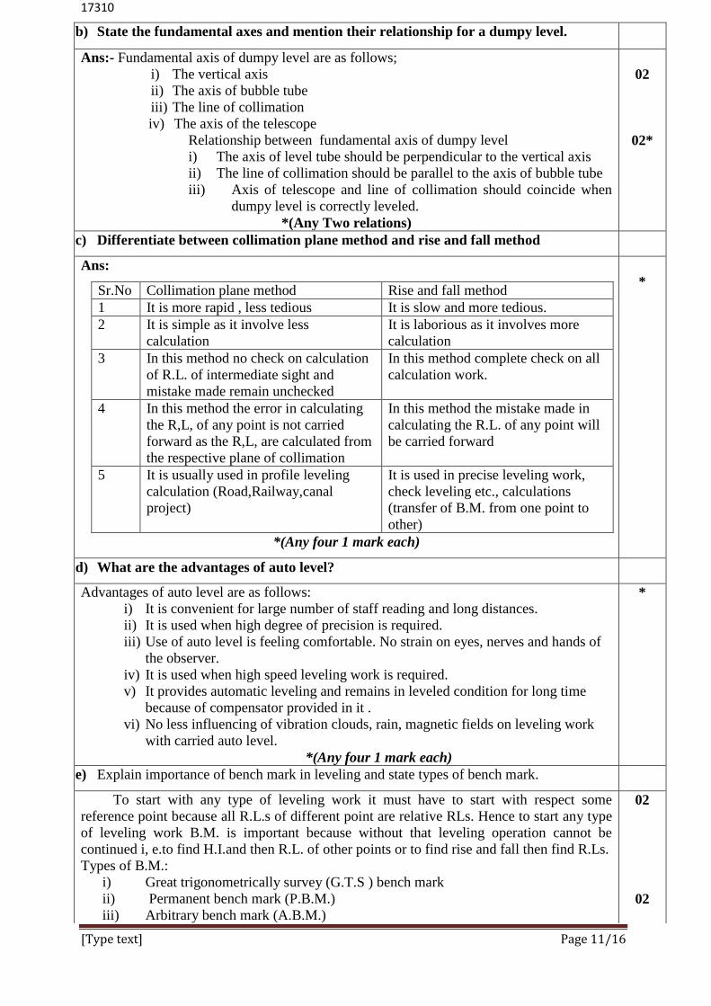
b) State the fundamental axes and mention their relationship for a dumpy level.
Ans:- Fundamental axis of dumpy level are as follows;
i) The vertical axis
ii) The axis of bubble tube
iii) The line of collimation
iv) The axis of the telescope
Relationship between fundamental axis of dumpy level
i) The axis of level tube should be perpendicular to the vertical axis
ii) The line of collimation should be parallel to the axis of bubble tube
iii) Axis of telescope and line of collimation should coincide when
dumpy level is correctly leveled.
*(Any Two relations)
02
02*
c) Differentiate between collimation plane method and rise and fall method
Ans:
Sr.No Collimation plane method Rise and fall method
1 It is more rapid , less tedious It is slow and more tedious.
2 It is simple as it involve less
calculation
It is laborious as it involves more
calculation
3 In this method no check on calculation
of R.L. of intermediate sight and
mistake made remain unchecked
In this method complete check on all
calculation work.
4 In this method the error in calculating
the R,L, of any point is not carried
forward as the R,L, are calculated from
the respective plane of collimation
In this method the mistake made in
calculating the R.L. of any point will
be carried forward
5 It is usually used in profile leveling
calculation (Road,Railway,canal
project)
It is used in precise leveling work,
check leveling etc., calculations
(transfer of B.M. from one point to
other)
*(Any four 1 mark each)
*
d) What are the advantages of auto level?
Advantages of auto level are as follows:
i) It is convenient for large number of staff reading and long distances.
ii) It is used when high degree of precision is required.
iii) Use of auto level is feeling comfortable. No strain on eyes, nerves and hands of
the observer.
iv) It is used when high speed leveling work is required.
v) It provides automatic leveling and remains in leveled condition for long time
because of compensator provided in it .
vi) No less influencing of vibration clouds, rain, magnetic fields on leveling work
with carried auto level.
*(Any four 1 mark each)
*
e) Explain importance of bench mark in leveling and state types of bench mark.
To start with any type of leveling work it must have to start with respect some
reference point because all R.L.s of different point are relative RLs. Hence to start any type
of leveling work B.M. is important because without that leveling operation cannot be
continued i, e.to find H.I.and then R.L. of other points or to find rise and fall then find R.Ls.
Types of B.M.:
i) Great trigonometrically survey (G.T.S ) bench mark
ii) Permanent bench mark (P.B.M.)
iii) Arbitrary bench mark (A.B.M.)
02
02

17310
[Type text] Page 12/16
iv) Temporary bench mark (.T.B.M)
f) The following consecutive reading were taken with a dumpy level and 4 m leveling staff
on continuously sloping ground A to B at every 30 m interval.0.355 m on A ,
0.730,1.055,2.690,3.950,0.485,1.020,1.895,2.535. The R.L. of A was 560.250 m Prepare
page of level book and checks your calculation by usual method. Determine the gradient
of the line AB.
Staff
station
Chainage Staff reading H.I. R.L. Remark
B.S. I.S. F.S.
1 00 0.355 560.605 560.250 Point A
2 30 0.730 559.875
3 60 1.055 559.550
4 90 2.690 557.915
5 120 0.485 3.950 557.140 556.655 C.P1
6 150 1.020 556.120
7 180 1.895 555.245
8 210 2.535 554.605 Point B
Arithmetic check = ∑ B.S. - ∑ F.S. = Last R.L. – First R.L.
0.840 - 6.485 = 554.605 – 560.
- 5.645 = -5.645
O.K. check is verified
Sample calculations :
For staff station 01: H.I. = R.L. of station of station A + B.S.
= 560,250 + 0.355 = 560.605
For staff station 02: R.L. = H.I.- I.S.
560.605- 0.730 = 559.875
Gradient of line AB =
=
= 2.688% downward from A to B
OR
Staff
station
Chainage Staff reading Rise Fall R.L. Remark
B S. I.S. F.S.
1 00 0.355 560.250 Point A
2 30 0.730 0.375 559.875
3 60 1.055 0.325 559.550
4 90 2.690 1.635 557.915
5 120 0.485 3.950 1.260 556.655 C.P1
6 150 1.020 0.535 556.120
7 180 1.895 0.875 555.245
8 210 2.535 0.640 554.605 Point B
Arithmetic check = ∑ B.S. - ∑ F.S. =∑Rise - ∑Fall = Last R.L. – First R.L
0.840 - 6.485 = 00-5.645 =554.605 – 560.
- 5.645 = -5.645
Gradient of line AB =
=
= 2.688% downward from A to B
*(Preparation of page of level book /Table 1 mark, Determination of gradient
1 mark ,calculation of RL 2 marks)
*

17310
[Type text] Page 13/16
Q.6 attempt any two of the following :
a) 1) Describe with neat sketch.
i)Base line ii)check line
iii)Tie line iv)Tie station
Description AB :- Base line: “The line on which the formwork of the survey is built is known as the
base line,
DE :- Tie Line : The line joining the tie stations are known as tie line,
HI –Check Line : The line joining the apex point of triangle to some fixed point on its
base
Tie Stations : F,D,-Subsidiary stations taken on the main survey line are known as Tie
Stations
02
02
2)Plot the given cross staff survey of a field ABCDEFA and calculate its area in sq.m

17310
[Type text] Page 14/16
Ans:-
Fig No Chainage Base
distanc
e
Offset Mean
offset
Area
from to I II
1 2 3 4 5 6 7 8
1 0 15 15 0 20 10 150
2 15 60 45 20 40 30 1350
3 60 100 40 40 0 20 800
4 80 100 20 55 0 27.5 550
5 45 80 35 30 55 42.5 1487.5
6 0 45 45 30 0 15 675
Area of field ABCDEFA =5012.5 sqm
*(Table 1mark, Data Entry 1 marks, Calculation 01 mark)
1
b) The following bearings have been observed while carrying out a closed compass
traverse in clockwise direction.
Line Observed
AB
BC
CD
DA
F.B B.B
285030’
32000’
149000’
198030’
105030’
210000’
331030’
18000’
Calculate the error due to local attraction and find corrected bearing and also compute the
included angles.
Ans:-
Step 1: Find the difference between F.B, And B.B. Of a line and determine the Station
free from Local Attraction.
Line Observed Differe
nce
Corre
ction
Corrected Corrected
Included angle
F.B B.B FB BB
AB 285030’ 105
030’ 180
00’ - 285
030’ 105
030’ 92
030’
BC 32000’ 210
000’ 178
00’ - 32
000’ 212
000’ 73
030’
CD 149000’ 331
030’ 182
00’ At c 20 151
000’ 331
000’ 61
000’
DA 198030’ 18
000’ 180
030’ At d 30’ 198
000’ 180
030’ 133
000
’
Step 2: Hence the Difference between F.B. Of line =1800,there forestations A and B
are free from Local Attraction and bearings observed at A and B are already correct
Start from: F.B. of BC = 32000’
To find BB of BC = +18000’ = 212
000’
To find correction at c station = -210000’
------------------
Correction at stations C = +200’
To find correct FB of CD = +14900’
-------------------
Correct FB of CD = 151000’
To find BB Of CD = +18000’
Correct BB of CD = 331000’
To find correction at station D = - 331030’
------------------
Correction at station D = - 0030’
To find correct FB of DA =+ 198030’
Correct FB of DA = 198000’
To find correct BB of DA = -180000’
*

17310
[Type text] Page 15/16
Correction BB of DA = 1800’
= observed BB of DA
Sample calculation Included angles o.k. check is verified
Included angles =B.B of preceding line FB of next line i.e.
< A =(BB OF DA-FB of AB)
= 180
- 285030’
= +267030’ >180
< A=92030’ (360
0-267
030)
Similarly < B=105030
’-32
000
’=73
030’
< C=2120001-151
000
’=61
000’
< D=331000
1-198
000
’=133
000
’
(2n-4) x 90=360000
’
*(Identification of stations 2 mark. Calculation of correction 2 marks, calculation of
corrected bearing 02 mark, Calculation of included angle 02 mark)
c) The series of staff reading observed on a continuously sloping ground are
0.850,1.650,2.540,3.255,0.655,1.250,1.955,2.650,3.250,1.150,1.655,2.055 And
3.255.The first reading was taken on a B.M. Of R.L. 150.000 Calculation the R.l of
all points by collimation plane method. Apply usual checks. Show tabulation
Ans:-
Staff
station
Staff Reading H.I R.L Remark
BS IS FS
1 0.850 150.850 150.000 First Reading
B.M
2 1.65.0 149.200
3 2.450 148.400
4 0.6555 3.255 148-250 147.595 CPI
5 1.250 147.000
6 1.955 146.295
7 2.650 145.600
8 1.150 3.250 146.150 145.000 CPZ
9 1.655 144.495
10 2.055 144.095
11 3.255 142.895 Last reading
Ans:-Arithmetic check
∑BS -∑FS = Last RL-first RL
2.655-9.76 = 142-895-150.000
-7.105 = -7.105
Ok check is verified
Sample calculation
H.I-RL of BM (or RL of CP)+BS
RL of any point =H.I-(IS or FS)
*

17310
[Type text] Page 16/16
H.I-first set ,150.000+0.850=150.850
C.P.(1) second set 147.595+0.655=148.250
C.P.(2) Third set 145.595+1.150=146.250
RL of point 4=150.850-3.255=147.595m
And so on….
*(Table 01 mark. Data entry 02 mark Sample calculation 01 mark, Calculation of RL02
marks, Check 02 marks, )