maldon local development plan · maldon local development plan assessment of impact of proposed...
TRANSCRIPT

Maldon Local Development Plan
Assessment of Impact of Proposed Development Sites in Heybridge, South
Maldon and Burnham-on-Crouch on Highway Network
May 2013
Prepared by:
County Hall Market Road Chelmsford Essex CM1 1QH
For:
Maldon District Council
Council Offices Princes Road Maldon Essex CM9 5DL
EB004a

Maldon Local Development Plan
Assessment of Traffic Impact Report
ii
Document Control Sheet
Report Title Maldon Local Development Plan
CD Reference
Status Final
Revision 1
Control Date 14th May, 2013
Record of Issue
Issue Status Author Date Check Date Authorised Date
1 Final B Johnston May ‘13 J Jones M Young
May ‘13 J Jones C Aarons
May ‘13
Distribution
Organisation Contact Number of Copies
Maldon District Council David Coleman 1
Essex County Council Hannah Neve 1
Essex County Council Kevin Fraser 1
Essex County Council Matthew Bradley 1
Essex Highways Brendan Johnston 1
EB004a

N:\9 Trans Impr\TP\Projects\TTP1012 - Maldon LDP\(4) Reports\Maldon LDP Report Final - May 2013.docx
iii
Contents
1 Introduction ..................................................................................................................... 1
1.1 Background to Study ......................................................................................................... 1
1.2 Report Structure ............................................................................................................... 1
2 Proposed Developments .................................................................................................. 3
2.1 Location and Number of Dwellings for Assessment ......................................................... 3
2.2 Study Area – Heybridge and Maldon ................................................................................ 4
2.3 Study Area – Burnham-on-Crouch .................................................................................... 6
2.4 Committed Developments ................................................................................................ 7
3 Forecast Traffic Flows ....................................................................................................... 9
3.1 Methodology .................................................................................................................... 9
3.2 Traffic Counts .................................................................................................................. 10
3.3 Assessment Year and Background Traffic Growth .......................................................... 10
3.4 Future Year Trip Generation ........................................................................................... 10
3.5 Trip Distribution and Assignment of Development Traffic ............................................. 12
3.6 Forecast Traffic Flows ..................................................................................................... 13
4 Assessment Methodology .............................................................................................. 14
4.1 Junction Assessments Methodology .............................................................................. 14
4.2 Understanding Junctions 8 Results ................................................................................. 14
5 Impact of Redistribution of Heybridge Development Traffic ............................................ 15
5.1 Reassignment of Heybridge Development Traffic to Link Road ..................................... 15
5.2 Resultant Traffic Flows .................................................................................................... 15
6 Impact of Heybridge and South Maldon Development .................................................... 18
6.1 Introduction .................................................................................................................... 18
6.2 B1018 Langford Road / B1018 Heybridge Approach / Holloway Road Roundabout ..... 19
6.3 B1018 Heybridge Approach / A414 Roundabout ........................................................... 20
6.4 A414 / Fullbridge Roundabout........................................................................................ 21
6.5 B1018 The Causeway / The Square / B1022 The Street Roundabout ............................ 22
6.6 B1022 Colchester Road / B1026 Goldhanger Road Roundabout ................................... 23
6.7 A414 / Spital Road Roundabout ..................................................................................... 24
6.8 A414 / B1018 Limebrook Way Roundabout ................................................................... 25
6.9 Limebrook Way / Fambridge Road Roundabout ............................................................ 26
EB004a

N:\9 Trans Impr\TP\Projects\TTP1012 - Maldon LDP\(4) Reports\Maldon LDP Report Final - May 2013.docx
iv
6.10 Limebrook Way / Mundon Road / Park Road ................................................................. 27
6.11 Proposed A414 Bypass / South Maldon Development Access Junction (west of Limebrook Way Roundabout) ...................................................................................................... 28
6.12 Proposed A414 Bypass / Wycke Hill Junction ................................................................. 29
7 Impact of Burnham-on-Crouch Developments ................................................................. 31
7.1 Introduction .................................................................................................................... 31
7.2 Junction Assessment Considerations .............................................................................. 31
7.3 B1021 Church Road / B1010 Maldon Road Junction ...................................................... 32
7.4 B1010 Maldon Road / Creeksea Lane Junction .............................................................. 34
7.5 Southminster Road Access.............................................................................................. 36
7.6 Accident Data on B1010 and B1012 ............................................................................... 38
7.7 Walking Threshold for Burnham Primary School ............................................................ 41
8 A414 and B1019 Impact .................................................................................................. 43
8.1 Traffic Flows .................................................................................................................... 43
8.2 A414 Oak Corner Junction .............................................................................................. 46
9 Summary of Findings and Concluding Comments ............................................................ 48
9.1 Study Findings Summary ................................................................................................. 48
9.2 Concluding Comment ..................................................................................................... 49
EB004a

N:\9 Trans Impr\TP\Projects\TTP1012 - Maldon LDP\(4) Reports\Maldon LDP Report Final - May 2013.docx
v
Figures Figure 1. Heybridge Development Location .............................................................................. 3 Figure 2. South Maldon Development Locations ....................................................................... 4 Figure 3. Burnham-on-Crouch Development Locations.............................................................. 4 Figure 4. Heybridge and Maldon Junction Assessment Locations ............................................... 5 Figure 5: Proposed Wycke Hill Bypass Route ............................................................................. 6 Figure 6. Burnham-on-Crouch Junction Assessment Locations ................................................... 7 Figure 7. Maldon / Heybridge Committed Development Locations ............................................ 8 Figure 8. Burnham-on-Crouch Committed Development Locations ............................................ 8 Figure 9. Heybridge Redistribution of Traffic Following Link Road Reassignment – AM Peak .... 16 Figure 10. Heybridge Redistribution of Traffic Following Link Road Reassignment – PM Peak .. 17 Figure 11: 5 Year Accident Data Plot ....................................................................................... 40 Figure 12: Creeksea Lane - Burnham-on-Crouch Primary School Walking Threshold ................. 42 Figure 13: Impact on Main Maldon / Heybridge Access Road - AM Peak .................................. 44 Figure 14: Impact on Main Maldon / Heybridge Access Roads – PM Peak ................................ 45
Tables Table 3-1: Vehicle Trip Rates (per dwelling) for Heybridge and Burnham-on-Crouch Development......................................................................................................................... 10 Table 6-1: B1018 / Holloway Roundabout Junction Performance ............................................ 19 Table 6-2: B1018 Heybridge Approach / A414 Roundabout Junction Performance ................... 20 Table 6-3: A414 / Fullbridge Roundabout Junction Performance ............................................. 21 Table 6-4: B1018 The Causeway / The Square / B1022 The Street Roundabout Junction Performance ......................................................................................................................... 22 Table 6-5: B1022 Colchester Road / B1026 Goldhanger Road Roundabout Junction Performance ............................................................................................................................................. 23 Table 6-6: A414 / Spital Road Junction Performance ............................................................... 24 Table 6-7: A414 B1018 Limebrook Way Roundabout Junction Performance............................. 25 Table 6-8: Limebrook Way / Fambridge Road Roundabout Junction Performance ................... 26 Table 6-9: Limebrook Way / Mundon Road / Park Road Roundabout Junction Performance .... 27 Table 6-10: Proposed A414 Bypass / South Maldon Development Access Junction Performance ............................................................................................................................................. 28 Table 6-11: Proposed A414 Bypass / Wycke Hill Junction Performance .................................... 29 Table 6-12: Proposed A414 Bypass / Wycke Hill Signalised Junction Performance .................... 30 Table 7-1: B1021 Church Road / B1010 Maldon Road Junction Roundabout Performance ........ 32 Table 7-2: B1010 Maldon Road / B1021 Church Road - Western Intersection Junction Performance ......................................................................................................................... 33 Table 7-3: B1010 Maldon Road / B1021 Church Road - Northern Intersection Junction Performance ......................................................................................................................... 33 Table 7-4: B1010 Maldon Road / Creeksea Lane - East Junction Performance .......................... 34 Table 7-5: B1010 Maldon Road / Creeksea Lane - West Junction Performance ......................... 35 Table 7-6: B1010 Maldon Road / Creeksea Lane - South Junction Performance ........................ 35 Table 7-7: 5 Year Accident Data for B1010 by Mode ................................................................ 38 Table 7-8: Accident Circumstances ......................................................................................... 38 Table 8-1: A414 Oak Corner Junction Performance ................................................................. 46
EB004a

N:\9 Trans Impr\TP\Projects\TTP1012 - Maldon LDP\(4) Reports\Maldon LDP Report Final - May 2013.docx 1
1 Introduction
1.1 Background to Study
Essex County Council (ECC) and Maldon District Council (MDC) have been working together to
progress MDC’s Local Development Plan (LDP) towards the submission stage. As part of this
process, ECC’s consultants, Mouchel, completed a study in December 2010 to assess the potential
impact of proposed development sites in Heybridge, Burnham-on-Crouch and Southminster in the
year 2026. In total, the effects of up to 1,000 dwellings in Heybridge, 600 dwellings in Burnham-on
Crouch and 100 dwellings in Southminster were assessed. The findings indicated that, whilst some
areas of the highway network would be congested, a ‘nil detriment’ scenario could be achieved if
certain mitigation measures were put in place. This included the introduction of a link road to
serve the new development in Heybridge and upgrades to three key junctions in Heybridge and
Maldon.
Following on from the above study, MDC and ECC have approached Essex Highways (EH) to
consider further development proposals across Heybridge, Maldon and Burnham-on-Crouch. This
report therefore considers the implications of the latest proposals and how they impact (in terms
of capacity) both locally and further afield on the highway network.
The report will also take into account other considerations for proposed development sites. For
example, accident data will be scrutinised along the B1010 linking Burnham-on-Crouch with the
rest of Essex to establish if there are any definitive trends. This stretch of road has had a
reputation for poor safety in recent years and the security of the public will have to be a
consideration in the location of proposed development sites.
In relation to Burnham-on-Crouch in particular, two further issues are covered in this study.
Firstly, the feasibility of providing a development access junction on Southminster Road in
Burnham-in-Crouch will be considered. This stretch of road currently has a small bridge across
Pannel’s Brook. The report will assess whether this and potential sight lines (a line of trees and a
hedgerow border the north-south route) could be affected. Secondly, walking thresholds to the
primary school will be considered in Burnham-on-Crouch. Given that the existing primary school is
located on the eastern periphery of the town, the implications of travel to and from the site will
be assessed.
1.2 Report Structure
Following this introductory section, Section 2 details the proposed developments that are being
considered and the study area surrounding them, Section 3 will provide a summary of how future
year traffic flows have been obtained, before Section 4 details the methodology for the highway
capacity assessments which have been undertaken. Section 5 then proceeds to consider the
EB004a

N:\9 Trans Impr\TP\Projects\TTP1012 - Maldon LDP\(4) Reports\Maldon LDP Report Final - May 2013.docx 2
impact of reassigning some of the proposed development traffic in Heybridge, Section 6 then
assesses the South Maldon development in conjunction with the Heybridge development and
Section 7 covers the likely effects of the proposed Burnham-on-Crouch developments. Section 8
then assesses the wider impact of the Heybridge and South Maldon developments before Section
9 summarises and concludes the report.
EB004a

N:\9 Trans Impr\TP\Projects\TTP1012 - Maldon LDP\(4) Reports\Maldon LDP Report Final - May 2013.docx 3
2 Proposed Developments
2.1 Location and Number of Dwellings for Assessment
ECC / MDC have requested that three principal development sites be considered. They are:
1. Heybridge – 1,000 dwellings to be located in an area of land north of Holloway Road (this
is the same level of provision as the December 2010 study but, unlike previously, assumes
that all dwellings will be accessed via the proposed relief road linking Broad Street Green
Road with Holloway Road / Langford Road);
2. South Maldon – 1,250 dwellings across four separate parcels of land bordering the A414,
Limebrook Way and Park Drive; and
3. Burnham-on-Crouch – 900 dwellings, 450 of which are to be accessed by Creeksea Lane
and 450 by the B1021 Southminster Road and Marsh Road.
The corresponding locations are shown in Figures 1, 2 and 3. NB The outlined areas have yet to be
confirmed and are therefore purely indicative at this stage.
Figure 1. Heybridge Development Location
© Crown Copyright All Rights Reserved 100019602 2013
EB004a

N:\9 Trans Impr\TP\Projects\TTP1012 - Maldon LDP\(4) Reports\Maldon LDP Report Final - May 2013.docx 4
Figure 2. South Maldon Development Locations
Figure 3. Burnham-on-Crouch Development Locations
2.2 Study Area – Heybridge and Maldon
The December 2010 study considered an area that included the following junctions in the
Heybridge and Maldon area:
© Crown Copyright All Rights Reserved 100019602 2013
© Crown Copyright All Rights Reserved 100019602 2013
EB004a

N:\9 Trans Impr\TP\Projects\TTP1012 - Maldon LDP\(4) Reports\Maldon LDP Report Final - May 2013.docx 5
B1018 Langford Road / B1018 Heybridge Approach;
A414 / B1018 Heybridge Approach;
A414 / B1018 The Causeway / Fullbridge;
B1018 The Causeway / The Square / B1022 The Street;
B1022 Colchester Road / B1026 Goldhanger Road;
B1022 Colchester Road / Scraley Road / B1022 Broad Street Green Road;
A414 / Spital Road; and
A414 Maldon Road / A414 Wycke Hill / Wycke Hill Business Park Access / B1018
Limebrook Way.
In order to achieve a robust assessment of the newly proposed developments across the highway
network, traffic counts have also been undertaken at the following junctions for this study:
B1018 Limebrook Way / B1010 Fambridge Road;
Limebrook Way / Mundon Road / Park Drive; and
A414 Chelmsford Road / A414 Maldon Road / B1010 Burnham Road / B1418 Southend
Road (Oak Corner Roundabout).
Figure 4 shows the precise location of each junction.
Figure 4. Heybridge and Maldon Junction Assessment Locations
© Crown Copyright All Rights Reserved 100019602 2013
EB004a

N:\9 Trans Impr\TP\Projects\TTP1012 - Maldon LDP\(4) Reports\Maldon LDP Report Final - May 2013.docx 6
Lastly, in addition to the relief road in Heybridge, the Heybridge and South Maldon part of this
study will look at a proposed link road to bypass the Maldon Road / Wycke Hill / Wycke Hill
Business Park Access / Limebrook Way (referred to hereafter as the ‘bypass’). This has been put
forward as part of the document ‘Preliminary Masterplan, Land at Spital Road / Wycke Hill,
Maldon’ (Nathaniel Lichfield and Partners, November 2012). The junctions at each end of the link
will be considered in terms of their necessary level of performance for the assessment year of
2026. Figure 5 below is an excerpt from the above document and indicates an approximate
alignment for the road.
Figure 5: Proposed Wycke Hill Bypass Route
2.3 Study Area – Burnham-on-Crouch
The December 2010 study also considered the following junctions in Burnham-on-Crouch:
B1021 Southminster Road / Marsh Road / B1021 Church Road;
B1021 Church Road / B1010 Maldon Road;
B1021 Station Road / Alexandra Road;
B1021 Station Road / Devonshire Road / Foundry Lane; and
EB004a

N:\9 Trans Impr\TP\Projects\TTP1012 - Maldon LDP\(4) Reports\Maldon LDP Report Final - May 2013.docx 7
B1010 Maldon Road / Creeksea Lane.
As agreed with ECC and MDC officers, each of the junctions listed has been considered in this
latest study. Figure 6 shows the precise location of each junction in Burnham-on-Crouch.
Figure 6. Burnham-on-Crouch Junction Assessment Locations
The Burnham-on-Crouch aspect of this study will also consider three other areas, as well as
highway capacity. They are:
Safety - concerns have been raised about the B1010, ie the main road into Burnham-on-
Crouch from the rest of Essex. The study assesses the levels and types of accidents that
have taken place on this route in the last 5 years since safety is a key consideration in the
planning process.
Access – half of the proposed development in Burnham-on-Crouch is accessed via
Southminster Road. The study will therefore consider the feasibility of providing an access
junction along this stretch of road in engineering terms.
Walking distances – the proposed Creeksea Lane development is on the periphery of the
town. The study will therefore consider the relative threshold for primary school children
to access Burnham-on-Crouch Primary School from the proposed development.
2.4 Committed Developments
The December 2010 report also considered a number of committed developments as part of the
future case scenario. Figure 7 and Figure 8 are taken from the report and have therefore also
© Crown Copyright All Rights Reserved 100019602 2013
EB004a

N:\9 Trans Impr\TP\Projects\TTP1012 - Maldon LDP\(4) Reports\Maldon LDP Report Final - May 2013.docx 8
been accounted for in calculations of future traffic flows. The developments include areas set
aside for both housing and employment.
Figure 7. Maldon / Heybridge Committed Development Locations
Figure 8. Burnham-on-Crouch Committed Development Locations
© Crown Copyright All Rights Reserved 100019602 2013
© Crown Copyright All Rights Reserved 100019602 2013
EB004a

N:\9 Trans Impr\TP\Projects\TTP1012 - Maldon LDP\(4) Reports\Maldon LDP Report Final - May 2013.docx 9
3 Forecast Traffic Flows
3.1 Methodology
This study has followed the same methodology for deriving future year traffic flows as the
December 2010 study. The only difference is the addition of the 3 traffic counts described in
Section 2.2. An overview of the methodology used to build the network of traffic flows for each
scenario is set out in the flowchart below. Subsequent sections give a more detailed explanation
of these steps.
Traffic Counts
Base Network AM and PM
Base Network + Background traffic growth to 2026
AM and PM
Add TEMPRO / NTM traffic growth factor to 2026 using alternative planning assumptions
Traffic from committed developments assigned to the network
2026 ‘Do Minimum’ Network AM and PM
2026 ‘Do Something’ Network AM and PM
Traffic from LDP locations assigned to the network
EB004a

N:\9 Trans Impr\TP\Projects\TTP1012 - Maldon LDP\(4) Reports\Maldon LDP Report Final - May 2013.docx 10
3.2 Traffic Counts
Manual classified turn counts were carried out by ‘Count on Us’ on Thursday 27th May, 2010 at
each of the locations listed in Section 2.2. They were undertaken between the hours of 0730 and
0930 in the morning and 1630 and 1830 in the evening. The additional 3 traffic counts to support
this study (also manual classified turn counts) were completed on Thursday 22nd November, 2012.
These were 12-hour surveys commencing at 0700 and finishing at 1900. Peak hour flows of 0800
to 0900 and 1700 to 1800 hours (0745 to 0845 for the Oak Corner junction) were identified from
the counts. Appendices A and B show the base flows used in the study for Heybridge / Maldon
and Burnham-on-Crouch respectively.
3.3 Assessment Year and Background Traffic Growth
As per the agreement between Mouchel, ECC and MDC officers during the previous study, a
future design year of 2026 has been assumed for the highway capacity assessments.
Remaining consistent with the previous study, the same factors have been used to ‘growth’
background traffic levels from the base year to the design year of 2026, namely 1.099 and 1.109
for the AM and PM peak respectively in Heybridge / Maldon, and 1.093 and 1.096 for the AM and
PM peak respectively for Burnham-on-Crouch. This was done using the standard transport
planning methodology of combining the National Traffic Model along with TEMPRO local factors.
NB Alternative planning assumptions within TEMPRO have been input in order to avoid double
counting traffic from the LDP and committed developments.
3.4 Future Year Trip Generation
Again remaining consistent with the December 2010 study, the same trip rates for the proposed
developments in Heybridge, South Maldon and Burnham-on-Crouch have been used. These have
been obtained from an interrogation of the TRICS (Trip Rate Information Computer System)
database and are summarised in Table 3-1 below. TRICS is a database of traffic surveys for various
types of development and is managed by JMP Consultancy. It is the standard transport planning
industry tool for quantifying the level of trip generation expected for proposed developments. It is
widely used by both developers and local highway authorities in putting together and assessing
planning applications respectively.
Housing Type AM Peak PM Peak
ARR DEP ARR DEP
Flats Rented 0.063 0.125 0.122 0.091
Flats Privately owned 0.045 0.179 0.149 0.069
Houses Rented 0.129 0.235 0.270 0.172
Houses Privately owned 0.157 0.457 0.401 0.235
Table 3-1: Vehicle Trip Rates (per dwelling) for Heybridge and Burnham-on-Crouch Development
EB004a

N:\9 Trans Impr\TP\Projects\TTP1012 - Maldon LDP\(4) Reports\Maldon LDP Report Final - May 2013.docx 11
In order to determine the number of vehicle trips that are expected to be generated by the LDP
development sites in each peak period, sites have been identified in the TRICS database that are
comparable in terms of location, and where the survey sample size is sufficient. In this case, data
from edge of town sites were used. Full details of the trip rate data is contained within Appendix
A of the December 2010 study.
It should be noted that average trip rates (rather than the commonly-used 85th percentile rates)
were originally used because it was assumed that any future development would be expected to
provide a comprehensive package of sustainable transport measures, such as new or improved
public transport services and facilities, connections to the local pedestrian and cycle networks,
and a detailed travel plan to encourage the use of non-car modes of travel.
Based on the above trip rates, Table 3.2 below details total trip generation calculated for the
morning and evening peak periods in Heybridge. The housing split was based on information
provided by MDC officers.
Housing Type AM Peak PM Peak
ARR DEP ARR DEP
Flats Rented 4 9 8 6
Flats Privately owned 10 40 33 15
Houses Rented 20 38 43 28
Houses Privately owned 86 252 220 129
Total 120 339 304 178
Table 3.2: Summary of Heybridge Development Trip Generation
Similarly, Table 3.3 details the trip generation calculated for the morning and evening peak for the
proposed South Maldon development. Again, these are based on the same housing split as
Heybridge.
Housing Type AM Peak PM Peak
ARR DEP ARR DEP
Flats Rented 5 10 10 7
Flats Privately owned 13 50 42 19
Houses Rented 26 47 54 34
Houses Privately owned 108 314 276 162
Total 152 421 382 222
Table 3-3: Summary of South Maldon Development Trip Generation
EB004a

N:\9 Trans Impr\TP\Projects\TTP1012 - Maldon LDP\(4) Reports\Maldon LDP Report Final - May 2013.docx 12
Lastly, Table 3-4 below shows the trip generation calculated for the two combined sites in
Burnham-on-Crouch. Once more, it has been based on the same housing spilt as both Heybridge
and South Maldon.
Housing Type AM Peak PM Peak
ARR DEP ARR DEP
Flats Rented 4 7 7 5
Flats Privately owned 9 36 30 14
Houses Rented 18 34 39 25
Houses Privately owned 78 226 199 116
Total 109 303 275 160
Table 3.4: Summary of Burnham-on-Crouch Development Trip Generation
3.5 Trip Distribution and Assignment of Development Traffic
Trip distribution and assignment methodology has also remained consistent with the December
2010 study (except, as stated in Section 2.1, in this case all Heybridge development traffic is being
assigned to the relief road between Broad Street Green Road and Holloway Road / Langford
Road). It was previously based on 2001 Census Travel to Work data and, with the more recent
2011 data unavailable at the outset of this piece of work, this criteria has been retained. Full
details of the methodology are covered in Section 3.5 of the previous work. NB The trip
assignment for the South Maldon and the section of Burnham-on-Crouch development adjacent
to Southminster Road / Marsh Road, were adjusted to account for their location being in a
different ward to the previous study’s development.
As described in Section 2.1 and shown in Figure 2.2, the proposed South Maldon development has
been divided into 4 parcels of land and therefore each section feeds onto the highway network at
different locations. It has been assumed that trips from 120 dwellings would access the network
on the proposed bypass, trips from 180 dwellings would access the A414 via the proposed
roundabout at the western end of the bypass, trips from 800 dwellings would access Limebrook
Way between the Wycke Hill and Fambridge Road roundabouts and trips from 150 dwellings
would access Park Drive just east of the Mundon Road roundabout.
With regard to Burnham-on-Crouch, and similarly mentioned in Section 2.1, trips from 450
dwellings have been assigned via Creeksea Lane. Trips from the other 450 dwellings have been
divided into 3 parts; 60% would access Southminster Road from west of the north-south aligned
route, 15% from the east side and 25% from Marsh Road.
EB004a

N:\9 Trans Impr\TP\Projects\TTP1012 - Maldon LDP\(4) Reports\Maldon LDP Report Final - May 2013.docx 13
3.6 Forecast Traffic Flows
Following the trip distribution and assignment, updated future year (2026) traffic flows have been
obtained for AM and PM peak periods. These are included in Appendix C for the Heybridge and
South Maldon study area and are based on the assumption that all Heybridge development traffic
is assigned to the proposed relief road. Meanwhile, Appendix D shows the 2026 flows for
Burnham-on-Crouch.
EB004a

N:\9 Trans Impr\TP\Projects\TTP1012 - Maldon LDP\(4) Reports\Maldon LDP Report Final - May 2013.docx 14
4 Assessment Methodology
4.1 Junction Assessments Methodology
Following the establishment of the future year traffic flows, the next task was to feed them into
junction assessment models. In the December 2010 study, these were carried out using Transport
Research Laboratory’s (TRL) ARCADY software for roundabouts or PICADY for priority junctions.
Both of these two pieces of software have now been superseded by TRL’s Junctions 8 software
however. The previous models have therefore been ‘imported’ into the newest version before
assessment in this study. NB It should be stressed that the previous assessments are not affected
by this process and therefore the different traffic flows in this piece of work are the only reason
for differing results.
4.2 Understanding Junctions 8 Results
The outputs of Junctions 8 have remained consistent with those produced by ARCADY and
PICADY. As such, a junction’s performance is given by the Ratio of Flow to Capacity (RFC) for each
approach. Generally, where the RFC is shown to be greater than 1.0 then the approach is said to
have reached its theoretical capacity as the number of vehicles arriving at the junction on that
approach exceeds its capacity. Any approach with an RFC above 1.0 would be expected to suffer
from significant vehicle queues and delays. However, for existing junctions, as a rule of thumb, an
RFC between 0.90 and 1.0 is usually taken as a point where an approach has reached its practical
capacity and where vehicles will start to experience some delay and congestion. Any arm with an
RFC of less than 0.90 can be considered to operate satisfactorily.
For ease of reference, the tables in the following sections have been colour-coded. Any junction
arm with an RFC of more than 1.0 is therefore shown in red, RFCs of 0.90 to 1.00 are shown in
amber, whilst green represents anything less than 0.90. The tables will also provide an indication
of the level of queuing likely to take place on each arm. These are shown in passenger car units
(pcus).
EB004a

N:\9 Trans Impr\TP\Projects\TTP1012 - Maldon LDP\(4) Reports\Maldon LDP Report Final - May 2013.docx 15
5 Impact of Redistribution of Heybridge Development Traffic
5.1 Reassignment of Heybridge Development Traffic to Link Road
The December 2010 study was based on a number of assumptions regarding trip assignment. This
included the supposition that background trips passing through Heybridge would use the
proposed link road instead of the existing, congested route on the B1022 and B1018. Whilst the
majority of the development traffic was also assigned to the link road, some trips were assigned
directly to Holloway Road. In all, the previous study had 125 departures and 47 arrivals accessing
the development via Holloway Road in the AM peak. In the PM peak, there were 67 departures
and 113 arrivals via Holloway Road. All of these development trips have now been assigned to the
proposed link road in this study.
5.2 Resultant Traffic Flows
The resultant traffic flows are shown in Figures 9 and 10 and compares flows before and after the
reassignment for the AM and PM peak. In both figures, increases in flows are shown with red
arrows and falls are marked with green arrows. The figures also highlight the percentage change
for each link of the network.
As could be expected, assigning all the Heybridge development onto the proposed link road
reduces flows on Holloway Road in both peak periods. It also marginally reduces flows in both
directions along the B1018 The Causeway route. It does, however, push some traffic onto the
surrounding roads. Nevertheless, the increases are minimal compared to the December 2010
study’s forecast flows and are therefore not considered sufficient enough to impact junction
performance in the locality significantly.
EB004a

N:\9 Trans Impr\TP\Projects\TTP1012 - Maldon LDP\(4) Reports\Maldon LDP Report Final - May 2013.docx 16
Figure 9. Heybridge Redistribution of Traffic Following Link Road Reassignment – AM Peak
© Crown Copyright All Rights Reserved 100019602 2013
EB004a

N:\9 Trans Impr\TP\Projects\TTP1012 - Maldon LDP\(4) Reports\Maldon LDP Report Final - May 2013.docx 17
Figure 10. Heybridge Redistribution of Traffic Following Link Road Reassignment – PM Peak
© Crown Copyright All Rights Reserved 100019602 2013
EB004a

N:\9 Trans Impr\TP\Projects\TTP1012 - Maldon LDP\(4) Reports\Maldon LDP Report Final - May 2013.docx 18
6 Impact of Heybridge and South Maldon Development
6.1 Introduction
This section sets out the junction assessment results for Heybridge and Maldon following the
reassignment of Heybridge traffic detailed in Section 5, and the addition of traffic from the
proposed South Maldon development. It considers each junction where issues were identified in
the December 2010 study, and as detailed in Section 2.2, two additional junctions near the South
Maldon development along Limebrook Way. It does not include details of the B1022 Colchester
Road / Scraley Road / B1022 Broad Street Green Road junction (the previous study identified no
capacity concerns at this location and this study has confirmed those findings) or the A414 Oak
Corner junction, which is considered in detail in Section 8. In each case, the flows have been
compared to the December 2010 study so that the full impact of the South Maldon development,
in addition to the Heybridge development, can be understood.
This section will also consider how the junctions connecting the proposed southern relief road to
the A414 (referred to in Section 2.2) should perform if the South Maldon development should
proceed as proposed.
EB004a

N:\9 Trans Impr\TP\Projects\TTP1012 - Maldon LDP\(4) Reports\Maldon LDP Report Final - May 2013.docx 19
6.2 B1018 Langford Road / B1018 Heybridge Approach / Holloway Road Roundabout
Table 6.1 shows the performance of the junction in 2026 on completion of the South Maldon
development. The results confirm that the junction should perform satisfactorily in the AM peak.
However, with an RFC of 1.00 and maximum queue length of 22 vehicles, the Langford Road West
arm, ie towards Heybridge from Hatfield Peverel, is expected to operate at capacity in the PM
peak.
Base Year 2026 Background
Traffic
2026 with 1,000
Heybridge
Dwellings
2026 with 1,000
Heybridge
Dwellings +
Reassignment to
Link Road and
South Maldon
RFC Q Length RFC Q Length RFC Q Length RFC Q Length
AM Peak
Langford Road East 0.55 1 0.64 2 0.87 6 0.90 8
Heybridge Approach 0.55 1 0.63 2 0.73 3 0.79 4
Langford Road West 0.42 1 0.47 1 0.55 1 0.57 1
Development Access N/A N/A N/A N/A 0.03 0 0.04 0
PM Peak
Langford Road East 0.40 1 0.46 1 0.60 2 0.64 2
Heybridge Approach 0.62 2 0.73 3 0.90 8 0.93 11
Langford Road West 0.63 2 0.76 3 0.92 10 1.00 22
Development Access N/A N/A N/A N/A 0.03 0 0.04 0
Table 6-1: B1018 / Holloway Roundabout Junction Performance
Given the level of development being planned, ie 1,000 dwellings in Heybridge and 1,250 in South
Maldon, plus the fact that 2026 represents a reasonably distant future year scenario, we would
not consider this junction’s performance to be a major concern. We would, however, be of the
opinion that any additional development would raise congestion issues. Consequently, further
mitigation may need to be investigated at this junction.
EB004a

N:\9 Trans Impr\TP\Projects\TTP1012 - Maldon LDP\(4) Reports\Maldon LDP Report Final - May 2013.docx 20
6.3 B1018 Heybridge Approach / A414 Roundabout
The December 2010 study identified mitigation measures as necessary at this junction with the
addition of 1,000 dwellings at Heybridge. These entailed the provision of unopposed slip lanes
from Heybridge Approach to A414 East and A414 South to Heybridge Approach. Table 6.2 below
compares the Base and 2026 Background Traffic scenarios with the previous study’s mitigation
scenario for the Heybridge development, and the addition of South Maldon traffic. The results
indicate that the junction should operate satisfactorily in both peak periods in 2026 when traffic
from both developments is added if the mitigation referred to above is in place.
Base Year 2026 Background
Traffic
2026 with 1,000
Heybridge
Dwellings plus
Mitigation
2026 with 1,000
Heybridge
Dwellings plus
Mitigation,
Reassignment to
Link Road and
South Maldon
RFC Q Length RFC Q Length RFC Q Length RFC Q Length
AM Peak
A414 East 0.56 1 0.70 2 0.59 1 0.58 1
A414 South 0.65 2 0.81 4 0.53 1 0.58 1
B1018 Heybridge
Approach 0.69 2 0.84 5 0.79 4 0.84 5
PM Peak
A414 East 0.65 2 0.84 5 0.81 4 0.83 5
A414 South 0.75 9 0.91 9 0.53 1 0.57 1
B1018 Heybridge
Approach 0.57 1 0.68 2 0.59 1 0.67 2
Table 6-2: B1018 Heybridge Approach / A414 Roundabout Junction Performance
EB004a

N:\9 Trans Impr\TP\Projects\TTP1012 - Maldon LDP\(4) Reports\Maldon LDP Report Final - May 2013.docx 21
6.4 A414 / Fullbridge Roundabout
With only one arm (B1018 The Causeway) in one peak period (AM peak) exceeding the
recommended threshold of 0.90 in 2026 with the Heybridge development, mitigation measures
were not considered necessary at this junction previously. The addition of South Maldon traffic
does not have much influence on this junction (most such trips route elsewhere) meaning the
only concern is the impact from the Heybridge development. Following reassignment to the link
road however, the pressure on The Causeway arm is alleviated slightly to the point where the RFC
falls to 0.90 from 0.93 previously. As such, we would consider the performance of this junction to
be reasonable in the 2026 scenario.
Base Year 2026 Background
Traffic
2026 with 1,000
Heybridge
Dwellings
2026 with 1,000
Heybridge
Dwellings plus
Reassignment to
Link Road and
South Maldon
RFC Q Length RFC Q Length RFC Q Length RFC Q Length
AM Peak
B1018 The Causeway 0.71 2 0.65 2 0.93 10 0.90 8
Fullbridge 0.46 1 0.56 1 0.54 1 0.54 1
A414 West 0.61 2 0.76 3 0.72 3 0.78 3
PM Peak
B1018 The Causeway 0.55 1 0.66 2 0.69 2 0.67 2
Fullbridge 0.69 2 0.83 5 0.85 5 0.87 6
A414 West 0.57 1 0.80 4 0.81 4 0.81 4
Table 6-3: A414 / Fullbridge Roundabout Junction Performance
EB004a
N:\9 Trans Impr\TP\Projects\TTP1012 - Maldon LDP\(4) Reports\Maldon LDP Report Final - May 2013.docx 22
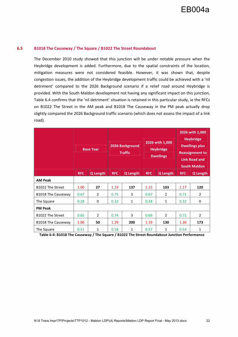
6.5 B1018 The Causeway / The Square / B1022 The Street Roundabout
The December 2010 study showed that this junction will be under notable pressure when the
Heybridge development is added. Furthermore, due to the spatial constraints of the location,
mitigation measures were not considered feasible. However, it was shown that, despite
congestion issues, the addition of the Heybridge development traffic could be achieved with a ‘nil
detriment’ compared to the 2026 Background scenario if a relief road around Heybridge is
provided. With the South Maldon development not having any significant impact on this junction,
Table 6.4 confirms that the ‘nil detriment’ situation is retained in this particular study, ie the RFCs
on B1022 The Street in the AM peak and B1018 The Causeway in the PM peak actually drop
slightly compared the 2026 Background traffic scenario (which does not assess the impact of a link
road).
Base Year 2026 Background
Traffic
2026 with 1,000
Heybridge
Dwellings
2026 with 1,000
Heybridge
Dwellings plus
Reassignment to
Link Road and
South Maldon
RFC Q Length RFC Q Length RFC Q Length RFC Q Length
AM Peak
B1022 The Street 1.00 27 1.19 137 1.15 103 1.17 120
B1018 The Causeway 0.67 2 0.75 3 0.67 2 0.71 2
The Square 0.28 0 0.33 1 0.34 1 0.32 0
PM Peak
B1022 The Street 0.65 2 0.74 3 0.69 2 0.71 2
B1018 The Causeway 1.06 50 1.29 200 1.19 130 1.26 173
The Square 0.51 1 0.58 1 0.57 1 0.54 1
Table 6-4: B1018 The Causeway / The Square / B1022 The Street Roundabout Junction Performance
EB004a
N:\9 Trans Impr\TP\Projects\TTP1012 - Maldon LDP\(4) Reports\Maldon LDP Report Final - May 2013.docx 23
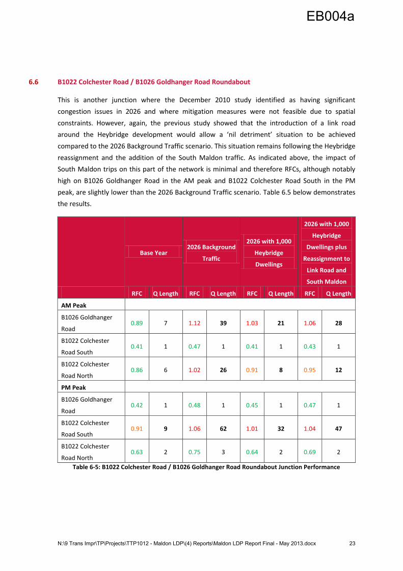
6.6 B1022 Colchester Road / B1026 Goldhanger Road Roundabout
This is another junction where the December 2010 study identified as having significant
congestion issues in 2026 and where mitigation measures were not feasible due to spatial
constraints. However, again, the previous study showed that the introduction of a link road
around the Heybridge development would allow a ‘nil detriment’ situation to be achieved
compared to the 2026 Background Traffic scenario. This situation remains following the Heybridge
reassignment and the addition of the South Maldon traffic. As indicated above, the impact of
South Maldon trips on this part of the network is minimal and therefore RFCs, although notably
high on B1026 Goldhanger Road in the AM peak and B1022 Colchester Road South in the PM
peak, are slightly lower than the 2026 Background Traffic scenario. Table 6.5 below demonstrates
the results.
Base Year 2026 Background
Traffic
2026 with 1,000
Heybridge
Dwellings
2026 with 1,000
Heybridge
Dwellings plus
Reassignment to
Link Road and
South Maldon
RFC Q Length RFC Q Length RFC Q Length RFC Q Length
AM Peak
B1026 Goldhanger
Road 0.89 7 1.12 39 1.03 21 1.06 28
B1022 Colchester
Road South 0.41 1 0.47 1 0.41 1 0.43 1
B1022 Colchester
Road North 0.86 6 1.02 26 0.91 8 0.95 12
PM Peak
B1026 Goldhanger
Road 0.42 1 0.48 1 0.45 1 0.47 1
B1022 Colchester
Road South 0.91 9 1.06 62 1.01 32 1.04 47
B1022 Colchester
Road North 0.63 2 0.75 3 0.64 2 0.69 2
Table 6-5: B1022 Colchester Road / B1026 Goldhanger Road Roundabout Junction Performance
EB004a

N:\9 Trans Impr\TP\Projects\TTP1012 - Maldon LDP\(4) Reports\Maldon LDP Report Final - May 2013.docx 24
6.7 A414 / Spital Road Roundabout
The December 2010 study identified the necessity for mitigation measures at this junction to
cater for the proposed Heybridge development traffic. These entailed the provision of an
unopposed slip lane from A414 South to A414 North and the widening of the A414 South exit
arm. Consequently, the proposed improvements have been carried forward in assessing the South
Maldon development. It should be noted that the reassignment of Heybridge development traffic
to the link road is not a factor in this location.
The results in Table 6.6 show that the junction should operate satisfactorily in both peak periods
following the addition of the South Maldon traffic if the mitigation measures are in place.
Base Year 2026 Background
Traffic
2026 with 1,000
Heybridge
Dwellings plus
Mitigation
2026 with 1,000
Heybridge
Dwellings plus
Mitigation and
South Maldon
RFC Q Length RFC Q Length RFC Q Length RFC Q Length
AM Peak
Spital Road 0.69 2 0.86 5 0.68 1 0.71 2
A414 South 0.80 4 0.95 14 0.27 0 0.28 0
A414 North 0.73 3 0.85 5 0.76 3 0.78 4
PM Peak
Spital Road 0.45 1 0.58 1 0.46 1 0.54 1
A414 South 0.92 9 1.08 77 0.31 0 0.31 0
A414 North 0.75 3 0.92 10 0.77 3 0.83 5
Table 6-6: A414 / Spital Road Junction Performance
EB004a

N:\9 Trans Impr\TP\Projects\TTP1012 - Maldon LDP\(4) Reports\Maldon LDP Report Final - May 2013.docx 25
6.8 A414 / B1018 Limebrook Way Roundabout
The December 2010 study also identified this junction as needing improvements to accommodate
the Heybridge development traffic in 2026. These included the widening of the Limebrook Way
and A414 west approaches to the junction and the widening of the A414 North exit arm.
However, in this study the dynamics of the junction have changed. It has been assumed that A414
traffic, ie A414 West arm to A414 North arm and vice-versa, would re-route to use the proposed
bypass referred to in Section 2.2. A check of the current layout of the junction with updated turn
counts to include South Maldon traffic, but excluding A414 movements, has therefore been
carried out. It indicated that mitigation would still be necessary. Table 6.7 therefore demonstrates
the junction assessment results for 2026 compared to Base Year and 2026 Background Traffic
scenarios with mitigation in place.
Base Year 2026 Background
Traffic
2026 with 1,000
Heybridge
Dwellings plus
Mitigation
2026 with 1,000
Heybridge
Dwellings plus
Mitigation and
South Maldon
with Bypass
RFC Q Length RFC Q Length RFC Q Length RFC Q Length
AM Peak
B1018 Limebrook
Way 1.02 29 1.27 133 1.16 88 0.88 7
A414 West 0.81 4 0.94 12 0.79 4 0.26 0
A414 North 0.77 3 0.91 9 0.91 9 0.35 1
Morrisons Access 0.28 0 0.34 1 0.38 1 0.23 0
PM Peak
B1018 Limebrook
Way 0.67 2 0.84 5 0.63 2 0.52 1
A414 West 1.01 28 1.24 147 1.15 108 0.49 1
A414 North 0.74 3 0.87 6 0.92 10 0.59 1
Morrisons Access 0.53 1 0.67 2 0.38 2 0.54 1
Table 6-7: A414 B1018 Limebrook Way Roundabout Junction Performance
It is clear that, with mitigation and a southern bypass in place, this junction should operate
satisfactorily in both peak periods in 2026. Indeed, its performance is notably improved compared
to even the Base Year scenario. This confirms that a bypass has a significant benefit in terms of
reducing demand on this section of the network.
EB004a

N:\9 Trans Impr\TP\Projects\TTP1012 - Maldon LDP\(4) Reports\Maldon LDP Report Final - May 2013.docx 26
6.9 Limebrook Way / Fambridge Road Roundabout
This junction was one of the three additional assessments carried out as a result of the South
Maldon development proposals. Consequently, it has also been assessed with the traffic flows
from all of the scenarios of the previous study, as well as the proposed South Maldon
development.
Table 6.8 confirms that, in all modelled scenarios, this junction performs satisfactorily. Given that
the majority of South Maldon trips will access the highway network to the west of the roundabout
and therefore not have to negotiate it, these results would seem reasonable and provide
confidence that the existing road layout can cater for future demands adequately.
Base Year 2026 Background
Traffic
2026 with 1,000
Heybridge
Dwellings
2026 with 1,000
Heybridge
Dwellings and
South Maldon
RFC Q Length RFC Q Length RFC Q Length RFC Q Length
AM Peak
Fambridge Rd North 0.27 0 0.31 0 0.31 0 0.33 0
Limebrook Way East 0.33 0 0.37 1 0.37 1 0.41 1
Fambridge Rd South 0.51 1 0.58 1 0.61 2 0.65 2
Limebrook Way West 0.37 1 0.41 1 0.41 1 0.45 1
PM Peak
Fambridge Rd North 0.31 0 0.36 1 0.37 1 0.41 1
Limebrook Way East 0.22 0 0.25 0 0.26 0 0.27 0
Fambridge Rd South 0.36 1 0.41 1 0.42 1 0.44 1
Limebrook Way West 0.60 1 0.67 2 0.69 2 0.76 3
Table 6-8: Limebrook Way / Fambridge Road Roundabout Junction Performance
EB004a
N:\9 Trans Impr\TP\Projects\TTP1012 - Maldon LDP\(4) Reports\Maldon LDP Report Final - May 2013.docx 27
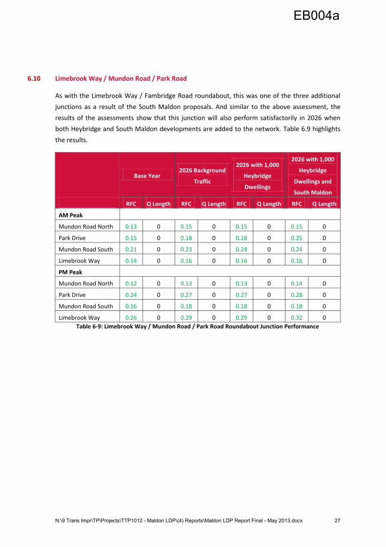
6.10 Limebrook Way / Mundon Road / Park Road
As with the Limebrook Way / Fambridge Road roundabout, this was one of the three additional
junctions as a result of the South Maldon proposals. And similar to the above assessment, the
results of the assessments show that this junction will also perform satisfactorily in 2026 when
both Heybridge and South Maldon developments are added to the network. Table 6.9 highlights
the results.
Base Year 2026 Background
Traffic
2026 with 1,000
Heybridge
Dwellings
2026 with 1,000
Heybridge
Dwellings and
South Maldon
RFC Q Length RFC Q Length RFC Q Length RFC Q Length
AM Peak
Mundon Road North 0.13 0 0.15 0 0.15 0 0.15 0
Park Drive 0.15 0 0.18 0 0.18 0 0.25 0
Mundon Road South 0.21 0 0.23 0 0.24 0 0.24 0
Limebrook Way 0.14 0 0.16 0 0.16 0 0.16 0
PM Peak
Mundon Road North 0.12 0 0.13 0 0.13 0 0.14 0
Park Drive 0.24 0 0.27 0 0.27 0 0.28 0
Mundon Road South 0.16 0 0.18 0 0.18 0 0.18 0
Limebrook Way 0.26 0 0.29 0 0.29 0 0.32 0
Table 6-9: Limebrook Way / Mundon Road / Park Road Roundabout Junction Performance
EB004a

N:\9 Trans Impr\TP\Projects\TTP1012 - Maldon LDP\(4) Reports\Maldon LDP Report Final - May 2013.docx 28
6.11 Proposed A414 Bypass / South Maldon Development Access Junction (west of Limebrook Way
Roundabout)
In order to understand the scale of highway capacity required to accommodate both the
Heybridge and South Maldon developments, we have undertaken a preliminary assessment using
the updated traffic flows.
The principal movement at the junction would be a north to west movement in the AM peak
period and vice-versa in the PM peak. This is based on the assumption that A414 traffic would
route via the proposed bypass and therefore avoid the Limebrook Way junction. Early indications
show that a roundabout junction would need to have two lanes on both the entry and exit of the
A414 western arm. The other arms could potentially be single lane approaches, but would need to
incorporate suitable flares into the design. On the assumption that this is provided, Table 6.10
below shows an indication of the junction’s potential performance.
2026 with 1,000
Heybridge
Dwellings and
South Maldon
RFC Q Length
AM Peak
A414 Bypass North 0.73 3
Former A414 East 0.62 2
Site Access South 0.11 0
A414 West 0.65 2
PM Peak
A414 Bypass North 0.63 2
Former A414 East 0.28 0
Site Access South 0.03 0
A414 West 0.92 10
Table 6-10: Proposed A414 Bypass / South Maldon Development Access Junction Performance
It should be reiterated that the above figures are indicative. They are based on a preliminary
design and therefore should not be considered as confirmation of the junction’s likely
performance. Clearly design would need to be considered in more detail as part of the planning
process.
EB004a

N:\9 Trans Impr\TP\Projects\TTP1012 - Maldon LDP\(4) Reports\Maldon LDP Report Final - May 2013.docx 29
6.12 Proposed A414 Bypass / Wycke Hill Junction
Unlike the western end of the proposed bypass, it has been extremely difficult to devise a suitable
junction at the eastern end on Wycke Hill due to the large conflicting traffic flows. As with the
western junction, the predominant flows are in each direction on the A414. However, there is also
significant demand on Wycke Hill northbound in both peak periods. Accommodating this demand
is problematic unless it is at the expense of at least one direction of A414 flow. Table 6.11 below
indicates the results that have been obtained for a roundabout junction. It should be noted that,
contrary to Figure 5 in Section 2.2 and in order to improve performance, it has been assumed that
the junction is three arms with a designated left slip lane from the A414 western arm to the A414
northbound arm, a designated straight on north to south lane bypassing the junction and no
additional development access, ie all development trips would have to access the network along
the bypass route itself.
2026 with 1,000
Heybridge
Dwellings and
South Maldon
RFC Q Length
AM Peak
A414 North 0.62 2
Wycke Hill South 2.58 393
A414 Bypass West 0.00 0
PM Peak
A414 North 0.47 1
Wycke Hill South 1.39 112
A414 Bypass West 0.01 0
Table 6-11: Proposed A414 Bypass / Wycke Hill Junction Performance
Therefore, even with the designated slip lanes, access from the southern arm (Wycke Hill) arm is
unsatisfactory in both peak periods. It should also be noted that, according to the Masterplan
drawing shown in Figure 5 in Section 2.2, this junction is only approximately 200m north of the
Limebrook Way roundabout and any significant queues could potentially extend back and across
it thus causing further congestion in the area. Furthermore, a house just to the north of the
proposed junction (on the west side of the A414) could also adversely affect plans for the design
of a suitable junction.
EB004a

N:\9 Trans Impr\TP\Projects\TTP1012 - Maldon LDP\(4) Reports\Maldon LDP Report Final - May 2013.docx 30
In light of the above results, we have also undertaken a preliminary signals assessment using JCT
Consultancy’s LinSig software. This has entailed the provision of two lane approaches on each of
the three arms. Table 6.12 demonstrates the indicative results. NB Results in LinSig are shown in
Degree of Saturation (similar to Junctions 8, 100% is considered to be at capacity).
2026 with 1,000
Heybridge
Dwellings and
South Maldon
D of S
Mean
Max Q
Length
AM Peak
A414 North 101.6% 43
Wycke Hill South 100.0% 20
A414 Bypass West 53.1% 9
PM Peak
A414 North 79.8% 17
Wycke Hill South 76.5% 9
A414 Bypass West 73.8% 17
Table 6-12: Proposed A414 Bypass / Wycke Hill Signalised Junction Performance
The results show that, although the PM peak achieves a reasonable performance, the AM peak
has congestion issues on two arms. With the aforementioned proximity of other junctions, any
significant queues would be a concern.
Once more, it should be reiterated that the above results are drawn from preliminary design
junctions. More detailed design would be necessary before they should be considered wholly
reliable. However, irrespective of whether a roundabout or a signalised junction is planned for
this location, it is clear from our assessments that a sizable junction would be required to
accommodate future demand in this location. This may mean that, as part of the planning
process, an agreement will be necessary with developers to ‘free up’ additional land to
accommodate highway network demand.
EB004a

N:\9 Trans Impr\TP\Projects\TTP1012 - Maldon LDP\(4) Reports\Maldon LDP Report Final - May 2013.docx 31
7 Impact of Burnham-on-Crouch Developments
7.1 Introduction
This section considers the impact of the proposed development sites in Burnham-on-Crouch on
the surrounding highway network. It firstly covers the junction assessments, before considering
the potential for a development access junction(s) on Southminster Road, accident statistics for
the B1010 Maldon Road and walking thresholds for Burnham-on-Crouch Primary School. As stated
previously, Appendices B and D contain Base Year and 2026 Forecast Traffic Flows from which the
junction assessments are based.
7.2 Junction Assessment Considerations
As well as a 100 dwelling development at Creeksea Lane, the December 2010 study considered a
500 dwelling development to the east of Burnham-on-Crouch town centre. Trips to / from the
development were split between Alexandra Road and Marsh Road. As stated in Section 2.1, this
latest study assumes that 450 dwellings will now access the highway network from Creeksea Lane
and 450 dwellings from Southminster Road. 75% of the Southminster Road dwellings have been
assessed from north of the junction with Marsh Road and 25% from Marsh Road itself.
Consequently, with the removal of trips on Alexandra Road and the majority of the proposed
development assigned to the B1010 Maldon Road in the peak hours, traffic flows have fallen
slightly in the central area of the town compared to the previous study.
In this study, the only increase in flows is on Southminster Road to the north of the town centre
and Maldon Road. We have therefore not undertaken assessments at the following junctions as
we can be confident that their performance, which was satisfactory in the previous study, would
be further improved in this study:
B1021 Station Road / Alexandra Road;
B1021 Station Road / Foundry Lane / Devonshire Road; and
B1021 Southminster Road / B1021 Church Road / Marsh Road.
The last of the above junctions has not been assessed because, despite an increase in overall flow
on the main north-south road, there are less trips to / from Marsh Road compared to the previous
study. As such, the junction should continue to perform satisfactorily.
EB004a
N:\9 Trans Impr\TP\Projects\TTP1012 - Maldon LDP\(4) Reports\Maldon LDP Report Final - May 2013.docx 32
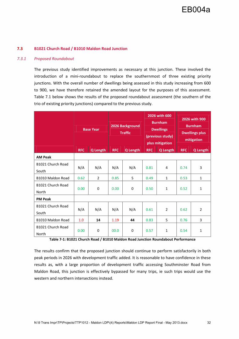
7.3 B1021 Church Road / B1010 Maldon Road Junction
7.3.1 Proposed Roundabout
The previous study identified improvements as necessary at this junction. These involved the
introduction of a mini-roundabout to replace the southernmost of three existing priority
junctions. With the overall number of dwellings being assessed in this study increasing from 600
to 900, we have therefore retained the amended layout for the purposes of this assessment.
Table 7.1 below shows the results of the proposed roundabout assessment (the southern of the
trio of existing priority junctions) compared to the previous study.
Base Year 2026 Background
Traffic
2026 with 600
Burnham
Dwellings
(previous study)
plus mitigation
2026 with 900
Burnham
Dwellings plus
mitigation
RFC Q Length RFC Q Length RFC Q Length RFC Q Length
AM Peak
B1021 Church Road
South N/A N/A N/A N/A 0.81 4 0.74 3
B1010 Maldon Road 0.62 2 0.85 5 0.49 1 0.53 1
B1021 Church Road
North 0.00 0 0.00 0 0.50 1 0.52 1
PM Peak
B1021 Church Road
South N/A N/A N/A N/A 0.61 2 0.62 2
B1010 Maldon Road 1.0 14 1.19 44 0.83 5 0.76 3
B1021 Church Road
North 0.00 0 00.0 0 0.57 1 0.54 1
Table 7-1: B1021 Church Road / B1010 Maldon Road Junction Roundabout Performance
The results confirm that the proposed junction should continue to perform satisfactorily in both
peak periods in 2026 with development traffic added. It is reasonable to have confidence in these
results as, with a large proportion of development traffic accessing Southminster Road from
Maldon Road, this junction is effectively bypassed for many trips, ie such trips would use the
western and northern intersections instead.
EB004a

N:\9 Trans Impr\TP\Projects\TTP1012 - Maldon LDP\(4) Reports\Maldon LDP Report Final - May 2013.docx 33
7.3.2 Western Intersection
Table 7.2 below shows the results of the western intersection junction. As in the December 2010
study, its performance is shown to be satisfactory with the addition of trips from 900 dwellings in
both peak periods in 2026.
2026 with 600
Burnham
Dwellings
(previous study)
2026 with 900
Burnham
Dwellings
RFC Q Length RFC Q Length
AM Peak
B1010 Maldon Road West N/A N/A N/A N/A
B1021 Church Road North 0.58 1 0.75 3
B1010 Maldon Road East 0.00 0 0.00 0
PM Peak
B1010 Maldon Road West N/A N/A N/A N/A
B1021 Church Road North 0.24 0 0.34 1
B1010 Maldon Road East 0.00 0 0.00 0
Table 7-2: B1010 Maldon Road / B1021 Church Road - Western Intersection Junction Performance
7.3.3 North Intersection
Table 7.3 shows the results of the northern intersection assessment. Again, the results for the
2026 with development scenario indicate satisfactory performance in both peak periods.
2026 with 600
Burnham
Dwellings
(previous study)
2026 with 900
Burnham
Dwellings
RFC Q Length RFC Q Length
AM Peak
B1021 Church Road South N/A N/A N/A N/A
B1010 Maldon Road 0.20 0 0.27 0
B1021 Church Road North 0.46 1 0.58 2
PM Peak
B1021 Church Road South N/A N/A N/A N/A
B1010 Maldon Road 0.27 0 0.36 1
B1021 Church Road North 0.18 0 0.25 1
Table 7-3: B1010 Maldon Road / B1021 Church Road - Northern Intersection Junction Performance
EB004a

N:\9 Trans Impr\TP\Projects\TTP1012 - Maldon LDP\(4) Reports\Maldon LDP Report Final - May 2013.docx 34
7.4 B1010 Maldon Road / Creeksea Lane Junction
This intersection is similar to the Maldon Road / Church Road junction in that it is divided into a
trio of junctions. No capacity issues were identified in the December 2010 study. However, this
study sees a notable increase in the number of dwellings being accessed via Creeksea Lane (450
compared to 100 previously).
7.4.1 East Intersection
Table 7.4 shows the results of the assessment with 450 dwellings compared to the 100 dwellings
of the previous study. Although there has been an increase in traffic flow on both Creeksea Lane
and Maldon Road, the junction is shown to continue to perform satisfactorily in 2026 in both peak
periods.
2026 with 600
Burnham
Dwellings
(previous study)
2026 with 900
Burnham
Dwellings
RFC Q Length RFC Q Length
AM Peak
B1010 Maldon Road East N/A N/A N/A N/A
Creeksea Lane 0.13 0 0.33 0
B1010 Maldon Road West 0.00 0 0.00 0
PM Peak
B1010 Maldon Road East N/A N/A N/A N/A
Creeksea Lane 0.09 0 0.21 0
B1010 Maldon Road West 0.00 0 0.00 0
Table 7-4: B1010 Maldon Road / Creeksea Lane - East Junction Performance
EB004a

N:\9 Trans Impr\TP\Projects\TTP1012 - Maldon LDP\(4) Reports\Maldon LDP Report Final - May 2013.docx 35
7.4.2 West Intersection
Table 7.5 below shows the results of the west intersection. Again, despite the increase in traffic
flow, the junction is shown to operate satisfactorily in 2026 in both peak periods.
2026 with 600
Burnham
Dwellings
(previous study)
2026 with 900
Burnham
Dwellings
RFC Q Length RFC Q Length
AM Peak
B1010 Maldon Road East N/A N/A N/A N/A
Creeksea Lane 0.06 0 0.24 0
B1010 Maldon Road West 0.03 0 0.09 0
PM Peak
B1010 Maldon Road East N/A N/A N/A N/A
Creeksea Lane 0.03 0 0.10 0
B1010 Maldon Road West 0.08 0 0.31 1
Table 7-5: B1010 Maldon Road / Creeksea Lane - West Junction Performance
7.4.3 South Intersection
Table 7.6 shows the results of the south intersection. Once more, despite the increase in traffic
flow, there are no concerns in terms of the junction capacity in 2026 in either peak period.
2026 with 600
Burnham
Dwellings
(previous study)
incl mitigation
2026 with 900
Burnham
Dwellings incl
mitigation
RFC Q Length RFC Q Length
AM Peak
Creeksea Lane North N/A N/A N/A N/A
B1010 Maldon Road East 0.05 0 0.09 0
Creeksea Lane South 0.06 0 0.15 0
PM Peak
Creeksea Lane North N/A N/A N/A N/A
B1010 Maldon Road East 0.04 0 0.12 0
Creeksea Lane South 0.05 0 0.11 0
Table 7-6: B1010 Maldon Road / Creeksea Lane - South Junction Performance
EB004a

N:\9 Trans Impr\TP\Projects\TTP1012 - Maldon LDP\(4) Reports\Maldon LDP Report Final - May 2013.docx 36
7.5 Southminster Road Access
7.5.1 Site Description
As per a Development Framework Document (dated August 2012) prepared by a possible
developer for the area, the two proposal sites are located to the north of Burnham-on-Crouch
town centre and to the east and west of the B1021 Southminster Road. Pannel’s Brook separates
one site to the North and the other to the south. The southern site is immediately adjacent to St
Peter’s High School to the North and both sites are currently located in rural gap between areas of
existing development within Burnham-on-Crouch. The existing development to the north
incorporates what appear to be stables and therefore there may be equestrian road users
throughout the area.
The B1021 Southminster Road runs straight north to south between the sites at approx. just over
5.5m wide and appears to be subject to a 30mph speed limit by virtue of street lighting. The road
crosses Pannel’s Brook via a small bridge with relatively low brick parapet walls with the B1021
approaching on minor embankments either side. Both sites are lower than the level of the B1021
but with different rates of level change for each site. Ditches are present on both sides of the
bridge and to a greater extent on the eastern side which features greater numbers of trees.
Vegetation is also present on the western side but mostly located to the south including some
larger trees and a hedgerow which may have Tree Preservation Orders (TPO) imposed upon them.
A staggered system of street lighting is present which would appear to be supplied from the
overhead electricity mains supply on the Eastern side of the B1021 which appears to transfer to
underground mains from the overhead pole located immediately South of the Eastern bridge
parapet wall. The site also incorporates a number of illuminated signs on both sides of the road
therefore road crossing supplies are further anticipated. There is a telecoms overhead pole
located to the south-east of the southern site on the western highway verge which links overhead
to the south-east to a shared electricity pole on the eastern verge and the service run appears to
become underground on the western verge.
7.5.2 Junction Provisions
The provision of a single junction providing access to both development sites is not considered to
be a realistic prospect given the separation of the two proposed accesses points (approximately
120m) and the existing bridge between the two locations and would require major inappropriate
changes to the existing B1021 through route which would result in very high costs especially with
the presence of the brook considered.
Although the current speed limit is 30mph, it is possible that vehicle speeds could be higher as the
surrounding frontage is rural and implies that a higher speed limit applies. At present, vehicle
speeds are anticipated to be in the region of 40-45mph.Therefore, using the current situation, the
EB004a

N:\9 Trans Impr\TP\Projects\TTP1012 - Maldon LDP\(4) Reports\Maldon LDP Report Final - May 2013.docx 37
visibility required in either direction will be a minimum of 120m (assuming a design speed of
70kph or 43.5mph as per DMRB TD 42/95, Table 7/1). The development will change the nature of
the area and provide a more urban feel for drivers therefore it is fair to assume vehicle speeds will
reduce once the development has taken place. Using Table 7/1 as above, the design speed can be
reduced to 60kph (37.3mph) or 50kph (31.1mph) resulting in visibility distances of 90m and 70m
respectively but likely that the higher design speed will be required.
There may be issues providing larger visibility splays to the south of the southern site which is
approached by a sweeping right hand bend but the proposed access location is located on a
straight section of the road which should permit for reasonable visibility of approaching vehicles.
There is also a slight restriction at the northern site where the main road climbs slightly to meet
the bends at Eve’s Corner junction which may affect visibility provision but this would be assessed
at detail design stage.
Existing vegetation will need to be removed or cut back at both sites. At the northern site there
are trees which may have accompanying TPO’s to both sides of the proposed junction which will
impact on visibility and a hedgerow to the north which provides some screening for the existing
houses at Ashwood Close but may have an adverse effect on provision of adequate visibility.
There may also be issues with the rise in vertical alignment between the site and the road level at
the northern site affecting the visibility. At the southern site, there will need to be consideration
given to linking across the road side ditch/ embankment of the main road to the site. The net
change in level does not appear to be as much at the northern site but the presence of the ditch
will require an engineering solution to enable access to the site.
EB004a

N:\9 Trans Impr\TP\Projects\TTP1012 - Maldon LDP\(4) Reports\Maldon LDP Report Final - May 2013.docx 38
7.6 Accident Data on B1010 and B1012
Accident data for the 5 year period between 1st November, 2007 and 31st October, 2012 has been
examined along the B1010 from South Woodham Ferrers to Burnham-on-Crouch, Essex. This
represents the most recent available data. In total, there have been 115 accidents recorded along
the extent of the route. Table 7.7 summarises the data in terms of severity and the type of
vehicles involved whilst Table 7.8 details the accident circumstances. Figure 11, meanwhile, plots
the exact location of each recorded incident.
Mode Fatal Serious Slight Total
Motor vehicles only (excluding 2-wheels) 1 11 78 90
2-wheeled motor vehicles 2 8 9 19
Pedal Cycles 0 1 5 6
Horses and other 0 0 0 0
Total 3 20 92 115
Table 7-7: 5 Year Accident Data for B1010 by Mode
Circumstance (NB some accidents have more than one factor)
Fatal Serious Slight
Lost control of vehicle 1 13 19
Occurred on bends - 7 22
Occurred in process of turning movement 1 3 24
Involved right turn movement 1 2 18
Involved overtaking manoeuvre 1 3 7
Occurred after dark in unlit area 2 2 24
Failed to give way - 1 22
Wet / Damp conditions 1 9 33
Table 7-8: Accident Circumstances
As Table 7.7 therefore shows, three accidents were categorised as fatal, 20 as serious and 92 as
slight. Two of the three fatal accidents occurred in darkness where there was no street lighting.
One of these was caused by a vehicle overtaking and then losing control (alcohol and drugs were
involved). Another of these occurred in wet conditions when a motorcycle rider lost control falling
into the path of an oncoming vehicle. The other fatal accident occurred during daylight and was
caused when a towing vehicle turned right into a field and an oncoming motorcycle collided with
the rear of the trailer.
Thirteen of the serious accidents were caused by drivers losing control of their vehicles, and of
these, six occurred in wet / damp conditions. Seven of these accidents were cited as occurring on
a bend. Three of the serious accidents were caused due to turning vehicles and other vehicles
colliding with them and two were due to right turning vehicles. One accident was caused when a
EB004a

N:\9 Trans Impr\TP\Projects\TTP1012 - Maldon LDP\(4) Reports\Maldon LDP Report Final - May 2013.docx 39
driver failed to give way to a pedal cycle at a junction. The other serious collision was caused by a
lorry knocking off an oncoming vehicle’s wing mirror which hit the driver.
Of the 92 slight accidents recorded, 19 resulted from drivers losing control of their vehicles and 22
were described as drivers losing control on a bend. Other slight accidents were caused by
overtaking vehicles, drivers failing to stop for slowing vehicles, drivers pulling out of junctions into
the path of oncoming vehicles. The pedestrian accidents were caused by a pedestrian crossing
from behind a stationary van into the path of a turning vehicle and the other accident was caused
by an intoxicated pedestrian in the middle of the road on the exit of a roundabout and was
clipped by a wing mirror.
In summary, there has been a higher number of accidents recorded along this stretch of road than
could be expected. A number of the incidents have been recorded at or near bends in the road –
something that is a feature of this route (particularly at the eastern end near Burnham-on-
Crouch). However, as Figure 11 shows, many of the accidents have also been recorded on the
straighter sections and along much of the length of the route. This may be attributable to the
route also being comparatively narrow for long stretches. This would seem to confirm that safety
is a greater issue on this section of the highway network than could be expected for a road with
relatively low traffic flows. However, Maldon district remains among the three Essex authorities
which suffer the lowest number of fatal or seriously injured accidents.
If considered necessary, there are various measures that can be undertaken at varying degrees of
cost to assist in reducing accident levels. These include reducing speed limits and the introduction
of cameras, road widening, improving visibility at junctions or on bends, better signposting of
junctions / bends, right turn lanes at junctions and anti-skid surface material at key points.
EB004a

N:\9 Trans Impr\TP\Projects\TTP1012 - Maldon LDP\(4) Reports\Maldon LDP Report Final - May 2013.docx 40
Figure 11: 5 Year Accident Data Plot
EB004a

N:\9 Trans Impr\TP\Projects\TTP1012 - Maldon LDP\(4) Reports\Maldon LDP Report Final - May 2013.docx 41
7.7 Walking Threshold for Burnham Primary School
The proposed Creeksea Lane development is situated at the western end of Burnham-on-Crouch.
With the town’s primary school situated on the eastern side of the central area, we have
undertaken an assessment of the relevant accessibility for school children. Figure 12 highlights
the location of the development site in relation to the primary school.
There is a statutory walking distance for the determination of whether a local authority should
provide transport to school. For pupils under the age of 8, this is over 2 miles (approximately
3.2km). Figure 12 shows the walking distance from the easterly edge of the proposed
development at Creeksea Lane to Burnham-on-Crouch Primary School is either 2km, 2.1km or
2.2km depending on the route chosen (it should be noted that two of the marked routes follow a
public right of way and feature an at-grade railway crossing, which may be inadvisable for primary
school children). Whilst the distances may therefore be acceptable to Essex County Council in
terms of not having to provide transport, they are above usual walking thresholds.
The School Travel Health Check (STHC) website (developed by a consultancy of former local
authority officers) deems 800m to be the distance that most pupils of primary school age should
“reasonably / realistically” be able to walk to school. There has also been a national campaign
which states that pupils should be able to walk for 20 minutes to school (at average speed, this
would be approximately one mile or 1.6km). With the Burnham-on-Crouch Primary School being
beyond both distances, it is possible that a higher than average number of school trips by car may
emanate from a development at Creeksea Lane.
Given the above points, it may therefore be prudent to consider school travel planning initiatives
and / or the provision of school transport if there is a desire to pursue a development in the
Creeksea Lane area.
EB004a

N:\9 Trans Impr\TP\Projects\TTP1012 - Maldon LDP\(4) Reports\Maldon LDP Report Final - May 2013.docx 42
Figure 12: Creeksea Lane - Burnham-on-Crouch Primary School Walking Threshold
EB004a

N:\9 Trans Impr\TP\Projects\TTP1012 - Maldon LDP\(4) Reports\Maldon LDP Report Final - May 2013.docx 43
8 A414 and B1019 Impact
8.1 Traffic Flows
This study has concentrated mainly on the impact of the proposed developments in and around
the built up areas of Heybridge, Maldon and Burnham-on-Crouch. However, concern has also
been raised about possible impact of the proposed Heybridge and South Maldon developments
on the wider highway network.
With Maldon and Heybridge representing an easterly extremity in Essex, a large proportion of
highway demand in the morning peak is westbound towards Chelmsford and the A12, which acts
as the main regional distributor. This demand is reversed in the evening peak period. There are
currently two main westbound routes from Maldon and Heybridge, the A414 which routes
through the village of Danbury and the B1019 which connects to the B1137 and the A12 at
Hatfield Peverel. This section considers the increase in demand that can be expected as a result of
the proposed developments.
Figures 13 and 14 compare the AM and PM peak hour flows for the Base Year scenario against
those predicted for 2026 with development. They show the difference in actual numbers, as well
as percentage change for the links at Oak Corner on the A414 and on the B1019 Langford Road
just west of Heybridge.
The figures confirm that traffic increases are likely to be significant. In the AM peak, the A414
westbound flow on the approach to Oak Corner is predicted to rise by 47% (1,518 vehicles in 2026
compared to 1,031 in the Base Year). Although some of this traffic is predicted to route
southbound along the B1418 Southend Road, the demand on the A414 Chelmsford Road
westbound increases by 300 vehicles (1,174 compared to 874 in the Base Year) or 34%. Given that
the route along the A414 in Danbury is already congested in the morning peak, such an increase
should be considered a concern.
Similarly, the westbound B1019 towards Hatfield Peverel is predicted to increase by 247 vehicles
in the AM peak. This represents a 33% increase from the Base Year scenario. The likelihood is
that, even with some dispersal of trips onto more rural routes, the increase will lead to queuing at
the junction with the B1137 in Hatfield Peverel.
In the PM peak, Maldon-bound flows increase by 36% on Chelmsford Road (1,103 vehicles in 2026
compared to 813 in the Base Year) and 44% on Southend Road (635 vehicles in 2026 compared to
441 in the Base Year. As with the AM peak, the Chelmsford Road trips will have to negotiate
Danbury and its congested thoroughfare prior to accessing the Oak Corner junction.
EB004a

N:\9 Trans Impr\TP\Projects\TTP1012 - Maldon LDP\(4) Reports\Maldon LDP Report Final - May 2013.docx 44
Figure 13: Impact on Main Maldon / Heybridge Access Road - AM Peak
EB004a

N:\9 Trans Impr\TP\Projects\TTP1012 - Maldon LDP\(4) Reports\Maldon LDP Report Final - May 2013.docx 45
Figure 14: Impact on Main Maldon / Heybridge Access Roads – PM Peak
EB004a

N:\9 Trans Impr\TP\Projects\TTP1012 - Maldon LDP\(4) Reports\Maldon LDP Report Final - May 2013.docx 46
Meanwhile, on Langford Road, a 33% increase is predicted in the PM peak (996 vehicles in 2026
compared to 747 in the Base Year. Whilst the modelling in this study has suggested that the
Langford Road / Holloway Road / Heybridge Approach junction can accommodate these
increases, there may also be an impact on the aforementioned B1137 / B1019 junction.
It should also be added that, whilst there is strong tidal flow tendency on both the A414 and
B1019, ie from Maldon / Heybridge in the AM peak and to Maldon / Heybridge in the PM peak,
Figures 13 and 14 confirm that there are also notable increases in flows in the opposite directions
in both peak periods. Naturally the increases will affect the performance of the wider highway
network and junctions in particular. It is therefore important that ECC and MDC consider this
within the planning process. Meanwhile, Section 8.2 below considers the impact of the overall
increases at the key Oak Corner junction on the A414.
8.2 A414 Oak Corner Junction
Table 8.1 demonstrates the junction performance of the Oak Corner roundabout. As stated in
Section 2, this junction was not the subject of assessment in the December 2010 study. A full
appraisal of each traffic flow scenario has therefore been completed.
Base Year 2026 Background
Traffic
2026 with 1,000
Heybridge
Dwellings
2026 with 1,000
Heybridge
Dwellings and
South Maldon
RFC Q Length RFC Q Length RFC Q Length RFC Q Length
AM Peak
A414 Chelmsford
Road 0.43 1 0.48 1 0.53 1 0.56 1
A414 Maldon Road 0.70 2 0.78 3 0.90 8 1.04 49
B1010 Burnham Road 0.65 2 0.80 4 1.01 14 1.23 41
B1418 Southend
Road 0.68 2 0.84 5 1.10 23 1.23 43
PM Peak
A414 Chelmsford
Road 0.75 3 0.86 6 1.02 29 1.16 97
A414 Maldon Road 0.47 1 0.52 1 0.59 1 0.62 2
B1010 Burnham Road 0.28 0 0.33 0 0.35 1 0.35 1
B1418 Southend
Road 0.79 4 0.94 10 1.19 56 1.43 116
Table 8-1: A414 Oak Corner Junction Performance
EB004a

N:\9 Trans Impr\TP\Projects\TTP1012 - Maldon LDP\(4) Reports\Maldon LDP Report Final - May 2013.docx 47
The results indicate that the Oak Corner roundabout will perform satisfactorily in both peak
periods in 2026 in the Base Year and Background Traffic scenarios. However, the addition of 1,000
dwellings from Heybridge leads to delays on two of the four arms of the junction in both peak
periods. These delays are exacerbated with the addition of South Maldon traffic. It is therefore
clear that development traffic is responsible for the junction operating above capacity in the
future case.
Although mitigation has not been considered in any detail as part of this study, it would appear
that land may be available to upgrade this junction. Consequently, we would suggest that a
designated left turn lane from Chelmsford Road to Maldon Road would contribute to improved
performance. The widening of the Maldon Road exit arm would also be likely to reduce delays.
Given that the proposed developments are a key factor in the decline of the junction’s
performance, there is a strong argument that developer contributions should be made to assist
any mitigation measures.
EB004a

N:\9 Trans Impr\TP\Projects\TTP1012 - Maldon LDP\(4) Reports\Maldon LDP Report Final - May 2013.docx 48
9 Summary of Findings and Concluding Comments
9.1 Study Findings Summary
This study has considered the impact on the highway network of 1,000 potential dwellings at land
on the north side of Heybridge, 1,250 dwellings across four parcels of land in South Maldon and
900 dwellings split between 2 main sites in Burnham-on-Crouch. The methodology for the study
has remained consistent with that used in a December 2010 study by Mouchel plc with regard to
trip generation, assignment to the highway network and capacity assessments.
The principal findings are summarised as follows:
Heybridge
The December 2010 study assumed that some of the proposed 1,000 dwellings would
access the road network along Holloway Road. This study has assigned all development
trips (and relevant background trips) to the proposed Heybridge link road. The resultant
changes in traffic flows on the highway network were considered negligible in terms of
affecting the performance of junctions in the locality.
Heybridge and South Maldon
Junction assessments were carried out at the same locations as the December 2010
study, but were supplemented by 3 additional sites on the south and west of Maldon. The
findings showed that a ‘nil detriment’1 scenario could be attained at all junctions assessed
previously, plus 2 of the 3 additional sites if a) all Heybridge development traffic is
assigned to the proposed link road, b) an A414 bypass route is provided to avoid the A414
/ Limebrook Way junction, and c) mitigation measures identified in the December 2010
study are retained at B1018 Heybridge Approach / A414, A414 / Spital Road and A414 /
B1018 Limebrook Way roundabouts (described in main text).
However, the A414 Oak Corner junction has been shown to operate above capacity in
both peak periods in 2026 with the addition of traffic from proposed developments at
Heybridge and South Maldon. Mitigation measures are therefore predicted to be required
at this location.
Furthermore, whilst it appears feasible to design a junction which will serve the proposed
A414 bypass to the west of Maldon satisfactorily, the study has confirmed that a sizable
junction would be necessary at the northern end to link into Wycke Hill. This may entail
1 NB Although a ‘nil detriment’ is achievable at The Causeway / The Square / The Street and Colchester Road /
Goldhanger Road junctions compared to the 2026 Background Traffic scenario, it should be reiterated that congestion is predicted at these locations due to the lack of space to provide mitigation measures.
EB004a

N:\9 Trans Impr\TP\Projects\TTP1012 - Maldon LDP\(4) Reports\Maldon LDP Report Final - May 2013.docx 49
more detailed feasibility work and entering an agreement with developers to ‘free up’
additional land.
Burnham-on-Crouch
Junction assessments indicated that the proposed developments could be
accommodated satisfactorily on the existing highway network if the mitigation
measure identified in the December 2010 study at the B1010 Maldon Road / B1021
Church Road junction is retained, ie mini-roundabout at southern intersection.
From the Development Framework document prepared by a possible developer for
the area, it would not appear feasible to provide a single access to the proposed
development either side of Southminster Road. However, two separate junctions
would seem to be possible.
5 year accident data confirms that safety is an issue along the B1010 and B1012.
Although notorious for its windy nature, it is also notable that many accidents have
also been recorded along straight stretches of the route. Accident mitigation
measures along the route may therefore be prudent if Burnham-on-Crouch
developments are carried forward in the planning process.
The distance between the proposed Creeksea Lane development and Burnham-on-
Crouch Primary School is less than 2 miles (3.2km) and therefore the local authority
would not legally have to provide transport for pupils. However, it is beyond the
distance which primary school-aged children should “reasonably / realistically” be
expected to walk to school and could therefore mean that the development would
lead to higher than average car trips to school. Consequently, it may be prudent to
consider school travel planning initiatives and / or the provision of school transport.
A414 and B1019 Impact
The proposed developments at Heybridge and South Maldon are shown to increase traffic flows
notably in both directions on the A414 and B1019. Given that these roads route through already
congested locations on the highway network such as Danbury and Hatfield Peverel, it is likely that
the impact of the developments will be felt outside of the immediate study area. The results of
the A414 Oak Corner junction assessment would appear to confirm this and indicate that
mitigation measures may be required across a wider section of the highway network.
9.2 Concluding Comment
This study has shown that, whilst it may be possible to accommodate the proposed developments
with ‘nil detriment’ compared to the 2026 Background Traffic scenario if certain mitigation
measures are in place and new junctions are built with sufficient capacity, there are a number of
additional factors that need to be considered in the planning process. Furthermore, these are not
EB004a

N:\9 Trans Impr\TP\Projects\TTP1012 - Maldon LDP\(4) Reports\Maldon LDP Report Final - May 2013.docx 50
necessarily restricted just to the area in and around Heybridge, Maldon and Burnham-on-Crouch.
The impact is likely to be felt further afield and issues such as safety should also be a
consideration.
EB004a

N:\9 Trans Impr\TP\Projects\TTP1012 - Maldon LDP\(4) Reports\Maldon LDP Report Final - May 2013.docx 51
EB004a

N:\9 Trans Impr\TP\Projects\TTP1012 - Maldon LDP\(4) Reports\Maldon LDP Report Final - May 2013.docx 52
Appendices
Appendix A: Heybridge / Maldon Base Traffic Flows ............................................................... 54
Appendix B: Burnham-on-Crouch Base Traffic Flows ............................................................... 58
Appendix C: Heybridge / Maldon 2026 Forecast Traffic Flows ................................................. 62
Appendix D: Burnham-on-Crouch 2026 Forecast Traffic Flows ................................................. 66
EB004a

N:\9 Trans Impr\TP\Projects\TTP1012 - Maldon LDP\(4) Reports\Maldon LDP Report Final - May 2013.docx 53
EB004a

N:\9 Trans Impr\TP\Projects\TTP1012 - Maldon LDP\(4) Reports\Maldon LDP Report Final - May 2013.docx 54
Appendix A: Heybridge / Maldon Base Traffic Flows
EB004a

N:\9 Trans Impr\TP\Projects\TTP1012 - Maldon LDP\(4) Reports\Maldon LDP Report Final - May 2013.docx 55
B1022 Broad Street Green Road
343 31373 131
Scraley Road
B1018 Langford Road 51Holloway Road 185
220 87 673 30B1022 Colchester Road
421 268126182
479 276573 410 342 245 12 32 B1026 Goldhanger Road
B1018 Heybridge Approach 482
218 B1022 Heybridge Street485 A414 93 604 12 975583 501 A414 The Causeway
483 31 400 626
477 246
A414 329 458
Fullbridge
812 257
Spital Road
213362
850 275A414 680 275 174
Retail Park562 1482 119 28
141 89 B1010 Fambridge Road 106 Park Drive76
176 105 40 25A414 Maldon Road 91
255 522 160 B1018 Limebrook Way 144 42 108141 39 53225
76285 85 149 1734 Mundon Road
329 154 22
0745 - 0845
A414 Chelmsford Road54% 358 A414 Maldon Road
15926
55% 42% 3%571 433 27
26 256 4 B1010 Burnham Road39% 43 7%
277B1418 Southend Road 19
Heybridge & Maldon
Base Year AM Flows
0800 to 0900 hours
EB004a

N:\9 Trans Impr\TP\Projects\TTP1012 - Maldon LDP\(4) Reports\Maldon LDP Report Final - May 2013.docx 56
B1022 Broad Street Green Road
276 48470 277
Scraley Road
B1018 Langford Road 20Holloway Road 99
352 119 382 70B1022 Colchester Road
323 14226990
433 475489 312 602 668 23 52 B1026 Goldhanger Road
B1018 Heybridge Approach 308
136 B1022 Heybridge Street612 A414 126 1003 10 664553 420 A414 The Causeway
424 50 475 526
589 405
A414 508 633
Fullbridge
825 264
Spital Road
157238
1003 311A414 510 435 176
Retail Park707 22138 208 53253 92 B1010 Fambridge Road 76 Park Drive
212124 133 58 44
A414 Maldon Road 114123 347 103 B1018 Limebrook Way 234 123 131
305 76 111319
34192 48 110 2828 Mundon Road
250 108 39
1700 - 1800
A414 Chelmsford Road55% 564 A414 Maldon Road
22920
53% 44% 2%355 294 16
17 415 9 B1010 Burnham Road40% 46 4%
176B1418 Southend Road 9
Heybridge & Maldon
Base Year PM Flows
1700 to 1800 hours
EB004a

N:\9 Trans Impr\TP\Projects\TTP1012 - Maldon LDP\(4) Reports\Maldon LDP Report Final - May 2013.docx 57
EB004a

N:\9 Trans Impr\TP\Projects\TTP1012 - Maldon LDP\(4) Reports\Maldon LDP Report Final - May 2013.docx 58
Appendix B: Burnham-on-Crouch Base Traffic Flows
EB004a

N:\9 Trans Impr\TP\Projects\TTP1012 - Maldon LDP\(4) Reports\Maldon LDP Report Final - May 2013.docx 59
B1021 Southminster Road
269 60
Marsh Road2743 45
90207 62
B1010 Maldon Road 109 25492
429 2242 16 18
B1021 Church RoadCreeksea Lane
452 16361 187
Alexandra Road
B1021 Station Road
3314
520 8 B1021 Station Road
107 120 246 100312
Foundry LaneDevonshire Road
6813
27 353 10 9
Burnham-on-Crouch
Base Year AM Flows
0800 to 0900 hours
EB004a
N:\9 Trans Impr\TP\Projects\TTP1012 - Maldon LDP\(4) Reports\Maldon LDP Report Final - May 2013.docx 60
B1021 Southminster Road
259 31
Marsh Road3672 21
50234 61
B1010 Maldon Road 51 25481
287 3664 13 10
B1021 Church RoadCreeksea Lane
560 46219 220
Alexandra Road
B1021 Station Road
2010
413 13 B1021 Station Road
148 120 342 1072040
Foundry LaneDevonshire Road
3616
40 241 13 16
Burnham-on-Crouch
Base Year PM Flows
1700 to 1800 hours
EB004a

N:\9 Trans Impr\TP\Projects\TTP1012 - Maldon LDP\(4) Reports\Maldon LDP Report Final - May 2013.docx 61
EB004a

N:\9 Trans Impr\TP\Projects\TTP1012 - Maldon LDP\(4) Reports\Maldon LDP Report Final - May 2013.docx 62
Appendix C: Heybridge / Maldon 2026 Forecast Traffic Flows
EB004a
N:\9 Trans Impr\TP\Projects\TTP1012 - Maldon LDP\(4) Reports\Maldon LDP Report Final - May 2013.docx 63
B1022 Broad Street Green Road 126 201
9041 361 34
466 170 25 10 8 Scraley Road
23 175B1018 Langford Road 56
144 321 0 211393
210 97 731 384 B1022 Colchester Road
693 367133
1 209622 417 3 525
873 504 326 276 49 B1026 Goldhanger RoadB1018 Heybridge Approach 548
218 B1022 Heybridge Street716 104 630 13 1117692 615 A414 The Causeway
572 34 389 734
511 299
A414 402 544
Fullbridge
1123 283
Spital Road
51 2356 411
A414
1 1168 314 2 937 541727 0 349 1931
2 1772 Retail Park
0 26 8 4690 136 31
944 8 0 189 98 B1010 Fambridge Road 117A414 Maldon Road 84
215 116 44 32696 0 B1018 Limebrook Way 100276 537 444 702 177 61 191 51 1587 5 160 43 60
27 270
29 24 3 84208 352 93 165 21
41 37 Mundon Road406 170 24
0745 - 0845
A414 Chelmsford Road457 A414 Maldon Road17529
841 637 40
29 327 4 B1010 Burnham Road55
304B1418 Southend Road 21
Heybridge & Maldon 2026 with Link
Road and S Maldon Bypass - AM Peak
0800 to 0900 hours
EB004a

N:\9 Trans Impr\TP\Projects\TTP1012 - Maldon LDP\(4) Reports\Maldon LDP Report Final - May 2013.docx 64
B1022 Broad Street Green Road 81 231
13434 296 53
619 372 52 4 6 Scraley Road
37 296B1018 Langford Road 22
304 167 3 111607
380 143 387 984 B1022 Colchester Road
480 195290
0 102554 763 9 395
725 387 676 771 62 B1026 Goldhanger RoadB1018 Heybridge Approach 347
143 B1022 Heybridge Street934 149 1167 11 720615 429 A414 The Causeway
549 55 519 608
728 511
A414 640 771
Fullbridge
1172 293
Spital Road
32 1742 303
A414
6 1369 352 5 696 815983 0 613 2023
1 1658 Retail Park
0 29 41 11153 232 60
670 22 0 432 102 B1010 Fambridge Road 84A414 Maldon Road 236
167 148 64 50983 0 B1018 Limebrook Way 126577 284 185 447 115 188 291 172 15226 3 373 84 126
37 414
10 12 7 3890 220 53 123 33
40 31 Mundon Road299 120 43
0745 - 0845
A414 Chelmsford Road827 A414 Maldon Road25422
480 395 22
19 607 10 B1010 Burnham Road71
195B1418 Southend Road 10
Heybridge & Maldon 2026 with Link
Road and S Maldon Bypass - PM Peak
1700 to 1800 hours
EB004a

N:\9 Trans Impr\TP\Projects\TTP1012 - Maldon LDP\(4) Reports\Maldon LDP Report Final - May 2013.docx 65
EB004a

N:\9 Trans Impr\TP\Projects\TTP1012 - Maldon LDP\(4) Reports\Maldon LDP Report Final - May 2013.docx 66
Appendix D: Burnham-on-Crouch 2026 Forecast Traffic Flows
EB004a

N:\9 Trans Impr\TP\Projects\TTP1012 - Maldon LDP\(4) Reports\Maldon LDP Report Final - May 2013.docx 67
B1021 Southminster Road
424 69
Marsh Road37630 54
134285 78
B1010 Maldon Road 246 317159
666 31396 75 48
B1021 Church RoadCreeksea Lane
601 17423 215
Alexandra Road
B1021 Station Road
3615
608 8.7 B1021 Station Road
128 131 269 109314
Foundry LaneDevonshire Road
7414
38 420 11 9.8
Burnham-on-Crouch 2026 Forecast
Flows - AM Peak
0800 to 0900 hours
EB004a

N:\9 Trans Impr\TP\Projects\TTP1012 - Maldon LDP\(4) Reports\Maldon LDP Report Final - May 2013.docx 68
B1021 Southminster Road
336 39
Marsh Road50287 27
67367 99
B1010 Maldon Road 107 292211
383 43043 56 63
B1021 Church RoadCreeksea Lane
656 50270 261
Alexandra Road
B1021 Station Road
2211
503 14 B1021 Station Road
185 132 375 1172244
Foundry LaneDevonshire Road
3918
44 293 14 18
Burnham-on-Crouch 2026 Forecast
Flows - PM Peak
1700 to 1800 hours
EB004a