managed realignment - bournemouth universityeprints.bournemouth.ac.uk/21139/1/2014 esteves - managed...
TRANSCRIPT
Forthcoming in June 2014. Available from: http://www.springer.com/earth+sciences+and+geography/earth+system+sciences/book/978-94-017-9028-4/. Please cite as: Esteves, L.S., 2014. Managed realignment: A viable long-term coastal management strategy? SpringerBriefs in Environmental Science. New York: Springer.
Managed realignment A viable long-term coastal management strategy?
Luciana S. Esteves
Faculty of Science and Technology
Bournemouth University
UK
2014

i
CONTRIBUTORS
Thorne Abbott, Coastal Planners, Coastal Resource Planner, Hawaii, USA,
Thorne Abbott is currently a consultant specialised in assisting oceanfront landowners in
addressing erosion crisis and shoreline change in Hawaii. He has over 20 years of
experience in natural resources management in the public and private sectors in continental
USA and in the territories in the Pacific Ocean.
Phil Dyke, The National Trust, Coast and Marine National Specialist, UK,
Phil Dyke has 30 years of experience working for the National Trust on coastal and marine
issues. In his current position since 2007, he supports the National Trust in England, Wales
and Northern Ireland to implement sustainable coastal and marine management
approaches. In addition to his role at the National Trust, Phil teaches coastal and marine
management and he is the Chair of the EUROPARC Atlantic Isles Coast and Marine
Working Group, which seeks to promote integrated management approaches in protected
areas.
Tony Flux, The National Trust, South West Region Coast and Marine Adviser, UK,
Tony Flux has extensive experience in issues concerning coastal management in South
West England. As a Coastal Adviser for the National Trust since 2007, he supports projects
along the Dorset and East Devon coasts. Previously, Tony worked for the Dorset Coast
Forum and the Dorset Areas of Outstanding Natural Beauty team.
Jan P. M. Mulder, Deltares and University of Twente, Assistant Professor, Netherlands,
Jan Mulder has over 25 years of experience in researching topics related to coastal
morphology and management. He has worked at TNO, Dutch Ministry of Infrastructure &
Environment (Rijkswaterstaat) and, since 2008, at Deltares. Jan is also part-time assistant
professor at Twente University. His expertise includes translation of research into policy and
the integration of field observations and empirical and numerical modelling concerning
physical and ecological disciplines.

ii
Nigel Pontee, CH2M HILL, Global Technology Leader Coastal Planning & Engineering, UK,
Nigel Pontee has 20 years of experience in consultancy work concerning coastal
geomorphology and management, during which he has contributed to over 190 estuary
projects, including the appraisal of over 150 habitat restoration sites and the design of
managed realignment schemes in the UK. He has authored over 200 consultancy reports
and over 75 publications on coastal and estuarine shoreline management aspects, including
managed realignment and habitat creation design.
Joost Stronkhorst, Deltares, Senior Coastal Policy Advisor, Netherlands,
Joost Stronkhorst has more than 30 years of experience in the development of water and
sediment management in the Netherlands and multidisciplinary coastal research. He has
worked for the Dutch Ministry of Infrastructure & Environment (Rijkswaterstaat) where he
was involved in the Delta works and marine pollution control.
Karen Thomas, The Environment Agency, Senior Coastal Advisor (Eastern Area), UK
Karen Thomas is a technical expert in flood risk management with 20 years of experience in
management of coastal issues at the national and local levels. Karen has led the Essex and
South Suffolk Shoreline Management Plan and works on managed realignment projects
since joining the Environment Agency in 1999. She works with communities and
stakeholders to encourage greater interest in managing the coast in a more sustainable
manner.

iii
CONTRIBUTORS .................................................................................................................. i
List of Figures ....................................................................................................................... vi
List of Tables ........................................................................................................................ xi
Preface ................................................................................................................................ xii
Acknowledgements ............................................................................................................. xvi
1. Introduction .................................................................................................................... 1
1.1. The need to shift from hold-the-line to managed realignment .................................. 3
1.2. Compensation or offsetting of coastal habitats loss................................................. 6
1.2.1. Coastal squeeze .............................................................................................. 7
1.3. Sustainable flood and erosion risk management ................................................... 10
1.4. Delivery of other ecosystem services .................................................................... 14
References ...................................................................................................................... 16
2. What is managed realignment? .................................................................................... 19
2.1. Confusing terminology .......................................................................................... 21
2.2. Changes in focus and terminology through time ................................................... 22
2.3. Clarifying the terminology ...................................................................................... 24
2.4. Proposing a new definition .................................................................................... 29
References ...................................................................................................................... 29
3. Methods of implementation .......................................................................................... 35
3.1. Removal of defences ............................................................................................ 36
3.2. Breach of defences ............................................................................................... 39
3.3. Realignment of defences ...................................................................................... 40
3.4. Controlled tidal restoration .................................................................................... 42
3.5. Managed retreat ................................................................................................... 43
References ...................................................................................................................... 46
4. Examples of relevant strategies and policies ................................................................ 48
4.1. Making Space for Water and Making Space for Nature, UK .................................. 49
4.2. Sigma Plan, Belgium ............................................................................................. 52
4.3. Room for River and Building with Nature, The Netherlands .................................. 53
iv
4.4. Cross-border conflict in the Scheldt estuary .......................................................... 55
4.5. Cities and Climate Change, Germany ................................................................... 56
4.6. Coastal Wetlands Planning, Protection and Restoration Act, Louisiana, USA ....... 58
4.7. Texas Open Beaches Act, USA ............................................................................ 59
4.8. National Strategy for the Integrated Management of the Shoreline, France .......... 61
References ...................................................................................................................... 63
5. Considerations on managed realignment in the Netherlands ....................................... 66
5.1. Introduction ........................................................................................................... 66
5.2. Coastline shortening, land reclamation and hold-the-line ...................................... 67
5.3. Dutch examples of landward realignment of the shoreline .................................... 69
5.4. Conclusions .......................................................................................................... 72
References ...................................................................................................................... 72
6. The National Trust Approach to Coastal Change and Adaptive Management .............. 74
6.1. Introduction ........................................................................................................... 74
6.2. National Trust understanding and planning for coastal change ............................. 75
6.3. Hard choices and coastal squeeze – the advocacy message ............................... 77
6.4. Making time and space for change ....................................................................... 78
6.5. Brownsea Island shoreline restoration project ....................................................... 79
6.5.1. Shoreline planning, consents and designations ............................................. 80
6.6. Brownsea and beyond: looking to the future ......................................................... 82
References ...................................................................................................................... 83
7. Managed Retreat in Maui, Hawaii ................................................................................ 84
References ...................................................................................................................... 87
8. Managed realignment in the UK: the role of the Environment Agency .......................... 88
8.1. Introduction ........................................................................................................... 88
8.2. Legal and policy drivers for managed realignment ................................................ 89
8.2.1. EU Habitats and Birds Directives ................................................................... 90
8.2.2. EU Water Framework Directive (WFD) .......................................................... 90
8.2.3. UK Government policy on flood risk management and habitat creation ......... 91

v
8.2.4. Emerging policy ............................................................................................. 91
8.3. What have we learnt from existing managed realignment projects? ...................... 94
8.3.1. Engagement and Communication .................................................................. 95
8.3.2. Statutory process ........................................................................................... 96
8.3.3. Technical expertise ........................................................................................ 96
8.3.4. Funding and partnership ................................................................................ 97
8.4. Conclusions .......................................................................................................... 99
References ...................................................................................................................... 99
9. Factors Influencing the Long-Term Sustainability of managed realignment ................ 102
9.1. Introduction ......................................................................................................... 102
9.2. Factors influencing the sustainability of managed realignment ............................ 105
9.2.1. Creation of habitats within realignment sites ................................................ 106
9.2.2. Is there sufficient land to offset the predicted losses of coastal habitats? ..... 107
9.2.3. Stakeholder support ..................................................................................... 108
9.2.4. Costs of managed realignment .................................................................... 109
9.2.5. Agricultural land and food Issues ................................................................. 110
9.2.6. Mitigation for freshwater habitat displacement ............................................. 111
9.3. Conclusions ........................................................................................................ 111
References .................................................................................................................... 112
10. Current perceptions about managed realignment ................................................... 117
10.1. Suitability of managed realignment for habitat creation and flood risk management
...................................................................................................................................... 119
10.2. Performance of projects ........................................................................................ 120
10.3. Current perceptions about the future scope for managed realignment outside the UK
...................................................................................................................................... 122
10.4. Main limitations ..................................................................................................... 125
References .................................................................................................................... 130
11. Concluding remarks................................................................................................ 134
Appendix: List of managed realignment projects in Europe ............................................... 138

vi
List of Figures
Figure 1. Adaptation can take many forms. This house had just been built (in Ziltendorfer
Niederung, the floodplain of the River Oder in Germany) when it was flooded in the summer
of 1997. Afterwards the owner decided to re-build the house in a slightly retreated position
and on an elevated level, so the ‘ground floor’ would be less prone to flooding. The photo
shows the original position of the house and how it looks after ‘redevelopment’. Photo
courtesy of Baerbel Koppe, AQUADOT Engineering Consultants, Hamburg). ...................... 1
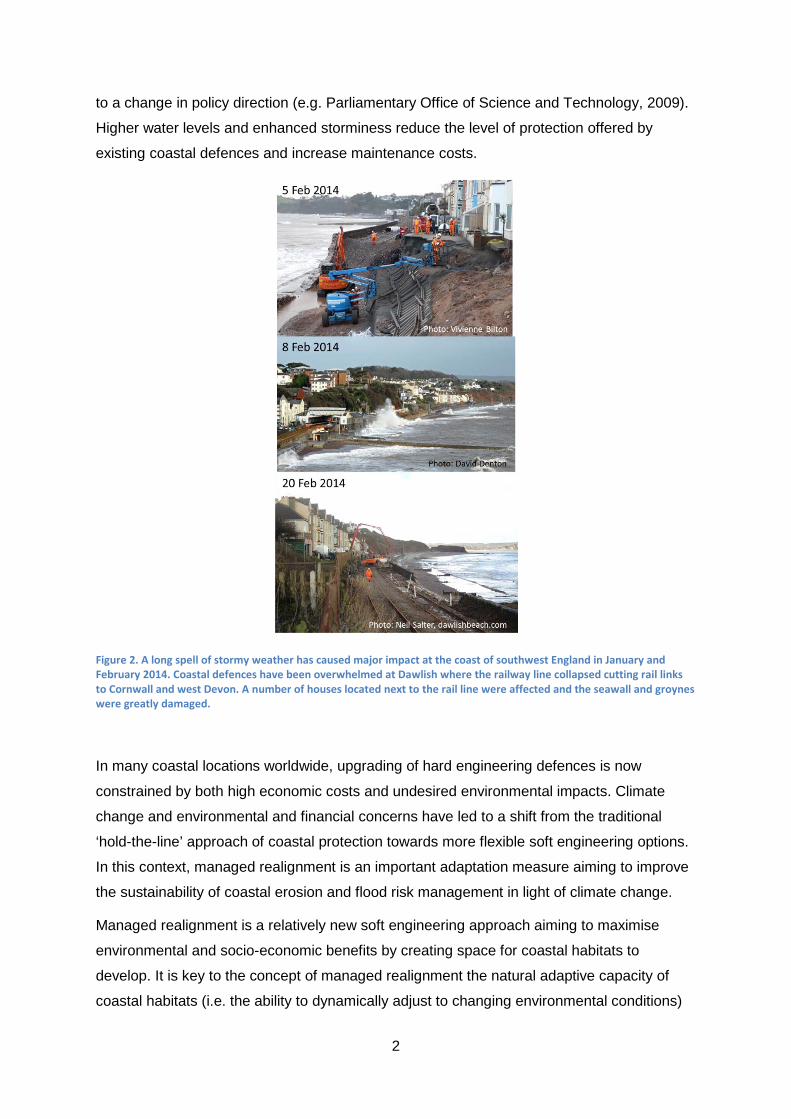
Figure 2. A long spell of stormy weather has caused major impact at the coast of southwest
England in January and February 2014. Coastal defences have been overwhelmed at
Dawlish where the railway line collapsed cutting rail links to Cornwall and west Devon. A
number of houses located next to the rail line were affected and the seawall and groynes
were greatly damaged. .......................................................................................................... 2
Figure 3. Hard engineering structures are shaping coasts and rivers worldwide, causing
natural habitat loss and favouring development in hazard-prone areas. (a) Storms have
greatly reduced the beach fronting coastal defences in Selsey, an area also prone to
flooding (photo: L.S. Esteves). (b) Flood defence along the Mississippi river close to where a
breach occurred during hurricane Katrina causing devastating flooding (photo: L.S. Esteves).
(c) Cancún is a narrow barrier beach densely occupied by hotels and subjected to intense
erosion due to hurricanes impacts; hotels survival depends on beach nourishment and hard
engineering beach nourishment (photo courtesy of Grupo de Ingeniería de Costas y Puertos
del Instituto de Ingeniería, UNAM). (d) Map Ta Phut suffers critical coastal problems due to
the engineering works that support the large industrial park in the country (photo courtesy of
Andy Coburn, Western Carolina University). ......................................................................... 3
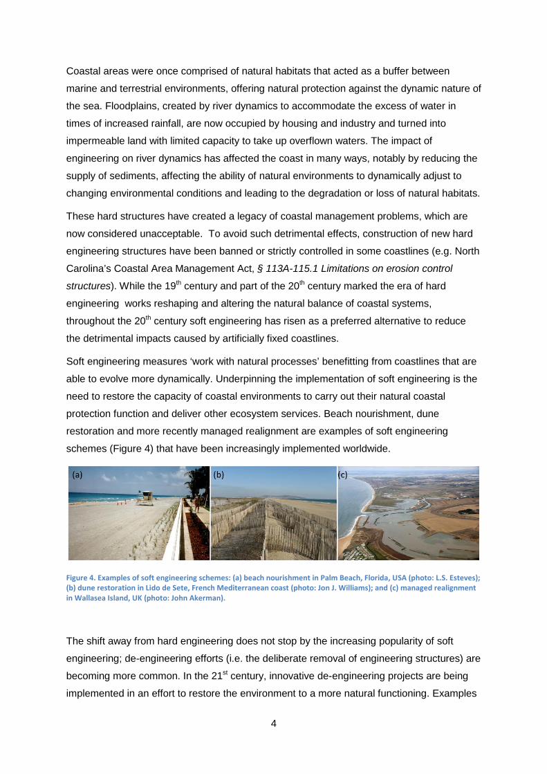
Figure 4. Examples of soft engineering schemes: (a) beach nourishment in Palm Beach,
Florida, USA (photo: L.S. Esteves); (b) dune restoration in Lido de Sete, French
Mediterranean coast (photo: Jon J. Williams); and (c) managed realignment in Wallasea
Island, UK (photo: John Akerman). ....................................................................................... 4
Figure 5. (a) Lower Shannock Falls Dam Removal and Fish Passage project was conducted
as part of a wider strategy to restore natural conditions at the Pawcatuck Watershed Start
(photo by Chris J. Fox, Wood Pawcatuck Watershed Association, Rhode Island). (b) Elwha
river dam in the state of Washington after removal and (c) Dillsboro Dam on the
Tuckaseegee River in North Carolina being removed (photos by Andy Coburn, Western
Carolina University). .............................................................................................................. 5

vii
Figure 6. Coastal habitats develop as a function of interacting physical and biological
characteristics. The elevation in relation to the tidal range is one of the key factors
determining the type of intertidal habitat (a). As a response to rising sea levels, coastal
habitats tend to migrate inland (b). The intertidal area may expand or reduce depending, for
example, on the coastal topography. Hard engineering structures will invariably fix the
landward limit of intertidal areas (c,d), which will be reduced in extent as sea levels rise and
more land becomes permanently inundated (d). The loss of coastal habitats due to rising sea
levels in front of artificially fixed shorelines is known as coastal ‘squeeze’. Managed
realignment is often implemented through planned breaching or removal of coastal defences
to create space for the development of intertidal habitats (e) with the aim of improving flood
risk management with added environmental value. ............................................................... 9
Figure 7. Farlington Marshes (Portsmouth, southern England) was reclaimed in the 1770s
and is enclosed by sea defences. Managed realignment to restore tidal flow into about 30 ha
has been suggested as a preferred option in the medium term. Plans include breaching of
the existing seawall and realign the defences as indicated in the figure. This realignment
would reduce the length of the defences to be maintained by about 700 m. Additionally, less
frequent repairs would be required if saltmarshes develop within the site helping dissipation
of wave energy in front of the new defence line. Aerial image dated 21 July 2008, available
from the Channel Coastal Observatory (www.channelcoast.org)......................................... 11
Figure 8. A set back line defines an area where constructions are not allowed to safeguard
people and property from erosion and/or flooding. If buildings placed seaward of the set back
line (a) need to be re-developed (e.g. due to impact of storms), this must only be permitted
inland of the set back line, within the same land lot if space is available or elsewhere (b). .. 25
Figure 9. The Polder de Sébastopol (Vendée, France), reclaimed from the sea in 1856, had
tidal flows restored into the embanked area through regulated tidal exchange implemented in
1999. Photo by Jacques Oudin, courtesy of Communauté de Communes de île de
Noirmoutier. ........................................................................................................................ 26
Figure 10. Diagram representing the water flow exchange within flood control areas (a) and
control reduced tide schemes, during storm water levels (b), spring tides (c) and neap tides
(d). Depending on the water level, the water enters the site through the upper culvert and/or
over the waterfront dike. The water leaves the site through the lower culvert (controlled by an
outlet valve), when water level outside is below the water level within the site. Modified from:
(a) Cox et al. (2006) and (b,c,d) Beauchard et al. (2011) and Beauchard (2012). ............... 28
Figure 11. Often when the location is backed by higher topography or a secondary line of the
defence (a), managed realignment is implemented through removal of defences (b) or

viii
breach of defences (c). Realignment of defences, most commonly involves building or
upgrading a defence line further inland, and the removal (d) or breach (e) of an existing line
of defence. It is proposed here that seaward realignment of defences (f) may also be
considered a method of managed realignment if aiming to improve the sustainability of flood
and erosion risk management by creating space for the development of habitat. ................ 37
Figure 12. Realignment of the seawall at Littlehaven Beach in 2013 was an integral part of
the local regeneration plan to increase the aesthetic and amenity value of the beach
frontage, in addition to improvement of coastal protection (Photo from Steve Burdett,
courtesy of Royal HaskoningDHV). ..................................................................................... 41
Figure 13. Location of the control reduced tide scheme at the Lippenbroek polder in the
Shelde river, Belgium (A). The polder is enclosed by dykes and tidal exchange occurs with
water entering the site through the upper culvert and returning to the estuary through the
lower culvert (B). A view of the culvert system looking from inside the polder is shown in C.
Modified from: Beauchard et al. (2011). .............................................................................. 42
Figure 14. Cape Hatteras Lighthouse was moved landwards in 1999 from a position just
behind the revetment seen in the foreground. This photo was taken on 16 July 2008 after
landfall of hurricane Isabel (photo courtesy of The Program for the Study of Developed
Shorelines, Western Carolina University). ........................................................................... 45
Figure 15. Distribution of the 54 managed realignment projects implemented in the UK
showing the type of scheme (left) and the size of the realigned area. ................................. 51
Figure 16. Aerial view of the Elbe river and the location of the Pilot Project Kreetsand at the
east margin of the Wilhelmsburg island. Note that the image shows a visualisation of how
the realigned site will look when implemented (project completion is expected in 2015). The
realignment of defences that confine the Kreetsand tidal space was completed in 1999.
(Image courtesy of HPA/Studio Urbane Landschaften). ...................................................... 58
Figure 17. Example of house relocation under the Texas Open Beach Act. The house
location was within the public beach easement at Sunny Beach, West Galveston Island (top
left) and was relocated further inland (bottom) on 1 Nov 2010. The photos on the top show
the beach before (left) and after house relocation (right). Photos courtesy of Texas General
Land Office. ........................................................................................................................ 60
Figure 18. Along the Dutch coast, managed realignments through breach of flood defences
have been implemented at few locations, including: De Kerf (1), Noard-Fryslan Butendyk (2),
Sieperdaschor (3), Breebaart (4) and Kroon’s polders (5). More recently, seaward shoreline

ix
realignment projects have been realised along the Holland coast at the Sand Motor (a),
Hondsbossche zeewering (b), Walcheren (c) and Zeeuws-Vlaanderen (d). ........................ 67
Figure 19. Beach nourishments and dike-dune reinforcements (left) as part of the Weak
Links project have improved both flood safety and spatial quality at Nolle-Westduin near
Vlissingen, SW Delta. The Sand Motor project (in the right during construction phase in
2011) involves a large sand nourishment along the eroding coast south of The Hague.
Photos: courtesy of Rijkswaterstaat. ................................................................................... 69
Figure 20. Two examples of small-scale managed landward shoreline realignments in the
Netherlands. (a) At De Kerf (near Schoorl, North Holland) the seaward dune ridge was
artificially breached to increase biodiversity and coastal dynamics. (b) At the Breebaart
polder (near the Dollard estuary in rural North Netherlands) a culvert and a fish passage
restored tidal flow into the embanked area resulting in an increase in biodiversity. Photos:
courtesy of Rijkswaterstaat. ................................................................................................ 71
Figure 21. Location of the National Trust coastal management 'hotspots' identified in the
CRA2. ................................................................................................................................. 76
Figure 22. Aerial view of Brownsea Island showing the extent of the shoreline restoration
project. The tidal inlet of Poole Harbour (which opens to the east-southeast) is seen at the
top right. .............................................................................................................................. 80
Figure 23. Failing defences in Brownsea Island (a) were removed in 2011 (b) and by early
2013 the shoreline showed an appearance similar to the time before sea defences were built
(c). ...................................................................................................................................... 82
Figure 24. Oceanfront buildings (highlighted in the left and top right) of the ANdAZ Hyatt,
former Wailea Renaissance, were demolished and new development is seen under
construction seaward of the setback (bottom right), note the position of the demolished
buildings is outlined). Images sources: (left) Wailea Renaissance; (top right) orthorectified
aerial photography dated of 1997, Coastal Geology Group, University of Hawaii; (bottom
right) Google Earth, imagery date: 4 Mar 2013. ................................................................... 86
Figure 25. At Charlie Young’s beach the beach width and dunes have been restored after a
campaign resulted in removal of shrubs grown by beachfront property owners over the public
beach. Photos: Tara M. Owens, County of Maui Planning Department. .............................. 87
Figure 26. Managed realignment at Medmerry (left), West Sussex, southern England, was
breached in November 2013; it will create around 320 ha of intertidal habitat once
completed. The Steart Coastal Management Project under construction (right), Somerset,

x
southwest England, is the largest managed realignment site in the UK to date (over 400 ha);
breach is to occur in 2014. .................................................................................................. 89
Figure 27. Managed realignment at Abbotts Hall (left), Blackwater estuary, Essex, and Paull
Holme Strays (right), Humber estuary. ................................................................................ 94
Figure 28. Breaching of flood defences at Wallasea Island (Crouch estuary, Essex) was
completed on the 4th July 2006. The project was implemented in partnership with the
landowner and the RSPB. ................................................................................................... 97
Figure 29. Alkborough Flats scheme in the Humber Estuary. This scheme was opened in
September 2006 with the principal objectives being to create new inter-tidal habitat and
provide flood storage. Photo by www.petersmith.com, courtesy of the Environment Agency.
......................................................................................................................................... 104
Figure 30. Hesketh Out Marsh West in the Ribble Estuary during the construction phase.
The scheme covers about 168 ha and was opened in 2008 with the principal objective being
to create compensatory intertidal habitat. Photo courtesy of the RSPB. ............................ 104
Figure 31. Steart Coastal Management Project in the River Parrett is due to be opened in
autumn 2014. This scheme has two objectives: to provide compensatory habitat and to
improve flood defences for the local community. Note that the breach has not yet occurred at
the time of the photo, the water seen within the scheme is freshwater due to a particularly
wet winter. Photo courtesy of the Environment Agency. .................................................... 105
Figure 32. Extensive areas of reeds have colonised the inner parts of Poole Harbour. The
presence of reeds means that there is a high likelihood of them colonising any managed
realignment sites that are created in this area. Photo by Nigel Pontee. ............................. 107
Figure 33. Results (in percentage of responses) obtained from the online survey on current
views about specific statements related to managed realignment, as shown in (a), (b) and
(c). Responses from UK, non-UK and all participants are show at the top. The views of
practitioners (government and non-government), consultants, researchers and stakeholders
(including members of the public) from the UK are shown at the bottom (modified from
Esteves and Thomas, 2014). ............................................................................................ 120
Figure 34. Results obtained from the online survey on current views about the performance
of managed realignment projects. (a) Comparison of responses from UK, non-UK and all
participants. (b) The views of practitioners (government and non-government), consultants,
researchers and stakeholders (including members of the public) from the UK (modified from
Esteves and Thomas, 2014). ............................................................................................ 121

xi
Figure 35. Online survey results concerning current awareness, implementation and future
potential for managed realignment outside the UK. ........................................................... 123
Figure 36. Results of the online survey concerning factors limiting the implementation of
managed realignment based on the views of all respondents (a) and stakeholders in the UK
(b). .................................................................................................................................... 126
List of Tables
Table 1. Coastal ecosystem services, the benefits they bring to society, the importance of
coastal areas in the overall provision of benefits and the potential for improvement through
managed realignment. ........................................................................................................ 15
Table 2. Primary and secondary characteristics of the five managed realignment methods of
implementation (black=primary; grey=secondary; white=not applicable). ............................ 35
Table 3. Characteristics of the respondents in the online survey ‘Yours views about
managed realignment’. ...................................................................................................... 118
Table 4. Requisites for facilitating the implementation and wider uptake of managed
realignment. ...................................................................................................................... 128

xii
Preface
While I am writing this preface long spells of extreme weather are affecting people
worldwide. Stormy and wet weather have caused floods that are disrupting lives across
England and Wales for more than three months. The Met Office has announced that January
2013 was the wettest in some parts of the UK since records began more than 100 years.
Heat waves and record high temperatures mark the summer in southern Australia and
southern Brazil. The ‘big freeze’ affects the USA where some locations have had the coldest
temperatures ever recorded. Due to population growth and climate change, the challenges
brought by extreme weather will be faced by more and more people each year.
This is particularly concerning in coastal areas, where extreme storms can coincide with high
tides and exacerbate flooding and erosion risk to people, economies and natural habitats.
Examples of such extreme conditions are widespread, such as seen in the USA during
hurricanes Katrina (New Orleans in 2005) and Sandy (New York in 2012), in the Philippines
during Tropical Storm Trami (Manila in 2013) and typhoon Haiyan (Tacloban in 2013) and
the recent floods in the UK (affecting East Anglia, Southwest, Midlands and Wales), just to
name a few. No single event can be attributed to climate change. Independently on whether
climate change is human-induced or not, the effects of climate change are upon us.
Adaptation is inevitable and we all (individually and collectively) need to learn new ways of
living to become more resilient to the consequences of extreme weather events.
This book is not about extreme weather or climate change. It is about how they are
provoking a change in the way flooding and erosion risks are managed in coastal areas and
the alternatives that exist to counteract the negative socio-economic and environmental
effects. More specifically, this book describes and discusses a relatively new alternative
called managed realignment. Managed realignment is a soft engineering approach that aims
to provide a more sustainable way to manage coastal erosion and flood risk by enhancing
the natural adaptive capacity of intertidal habitats. In other words, managed realignment
creates space for coastlines to evolve more naturally, adjusting dynamically to changing
environmental conditions, including rising sea levels. Therefore, managed realignment
represents a shift from the traditional hard engineering approach to coastal protection.
Although managed realignment is becoming increasingly popular worldwide, its
implementation is faced by great challenges, including public acceptance, limited knowledge,
funding constraints and uncertainties related to natural coastal evolution. The first managed
realignment projects were implemented in the 1980s (in France, Germany and the
Netherlands). In the early 2000s managed realignment became an important climate change
adaptation mechanism in national strategies (e.g. in the UK) aiming to deliver economically
xiii
and environmentally sustainable coastal management. Since then, there has been a great
increase in the number of publications addressing the subject. However, the great majority
include ‘white papers’ produced by government agencies and consultants involved in the
design or delivery of managed realignment projects. Only few independent studies have
been published and even fewer present reliable documentation and analysis of how
realigned sites are actually evolving.
This is the first book focusing on managed realignment. It is written with the objective to
provide an independent overview about managed realignment, how it has been implemented
in different countries, current achievements and limitations, and its potential to deliver
sustainable long-term coastal management. Investments in managed realignment are
increasing. In the UK, there are plans to realign 10% of the English and Welsh coastline by
2030. In France, the National Strategy for Integrated Shoreline Management explicitly
includes planning for retreat from high risk areas as a priority action. It is timely now that
managed realignment is clearly explained and independently assessed.
The content of the book provides to readers a balance between academic research and
practical experience. I have used my academic judgement based on the available literature
to clarify the basic concepts and definitions and summarise the state-of-the-art knowledge
about managed realignment. In five chapters, external contributions provide an account of
practical experience in planning, designing and implementing managed realignment in the
Netherlands, the USA and the UK. The book describes general concepts and discusses
approaches used internationally. However, the content does have a European and British
bias, as most of the literature available is produced in Europe and the UK is the country with
the largest number of known projects.
The first three chapters provide an overview of the basic concepts required to understand
managed realignment, including underlying drivers, terminology and methods of
implementation. In Chapter 1, I explain the socio-economic and environmental drivers
underpinning the need for managed realignment. The terminology associated with managed
realignment is often used inconsistently in the literature and variable across countries. In
Chapter 2, I clarify the most common terminology and propose a new (and broader)
definition for managed realignment to incorporate the different methods of implementation
that exist. These different methods of implementation are explained in Chapter 3.
The following six chapters describe and illustrate the different managed realignment
approaches and strategies implemented by different countries. Chapter 4 describes some of
the relevant national and transnational strategies that are currently in place to support
managed realignment and other innovative alternatives to manage coastal flood and erosion

xiv
risk. Chapters 5, 6 and 7 illustrates the range of approaches that can be adopted to
implement manage realignment in practice, varying from a combination of hard and soft
engineering used in the Netherlands (Chapter 5), the removal of coastal defences used by
the National Trust in England and Wales (Chapter 6) and managed retreat used in Maui,
Hawaii (Chater 7).
In Chapter 5, Joost Stronkhorst and Jan Mulder describe the coastal management strategies
implemented in the Netherlands and provide examples of different managed realignment
methods implemented along the sandy coast of the North Sea and the silty shorelines of
estuaries and the Wadden Sea. It is common knowledge that the Netherlands is a low-lying
country where land reclamation and protection against floods are of paramount importance.
Therefore, the Dutch experience demonstrates that managed realignment, alongside
different coastal engineering approaches, can be strategically implemented to provide
coastal protection and promote sustainable uses.
In Chapter 6, Phil Dyke and Tony Flux describe the principles of coastal management
adopted by the National Trust and present their experience in a project where managed
realignment was implemented through removal of coastal defences in Brownsea Island, UK.
The National Trust is a non-governmental charity organisation that owns about 10% of the
coastline of England and Wales and is recognised worldwide as a role model of institutional
capacity for promoting the sustainable management of coastlines. While the National Trust
deals with coastlines that are mainly rural, Chapter 7 provides an example of managed
retreat alternatives for developed coastlines reliant on beach-related tourism. In Chapter 7,
Thorne Abbott describes how the implementation of a set back line in Maui (Hawaii, USA)
assists managed retreat and contributes to maintain and enhance the local economy.
Chapters 8 and 9 focus on the UK, where managed realignment is undertaken mainly
through the realignment of defences with the objective to create intertidal habitat. These
chapters benchmark the current state of affairs of managed realignment in the UK through
the perspective of practitioners in both the public and private sectors. In Chapter 8, Karen
Thomas describes emerging policies and the drivers underpinning the implementation of
managed realignment and lessons learned so far by the Environment Agency, which is the
government agency responsible for overlooking coastal flooding and erosion risk
management in England and Wales. Chapter 9 brings the experience and views of Nigel
Pontee, a private consultant involved in planning, designing and delivering managed
realignment projects. Nigel identifies and discusses the factors influencing the long-term
sustainability of managed realignment.

xv
Chapter 10 draws from existing literature and the results of a survey conducted in 2013 to
discuss differences in the current perception about managed realignment in the UK and
elsewhere. This chapter contrasts the views of stakeholders and other groups (practitioners,
researchers, consultants) It also compares how researchers, practitioners and stakeholders
perceive potential, performance and limitations of management realignment in the UK and
elsewhere in the world.
Finally, Chapter 11 provides final remarks about the long-term sustainability of managed
realignment taking into consideration the current understanding presented in the previous
chapters. The Appendix provides a ‘working in progress’ list of managed realignment
projects implemented in Europe and few examples of projects in the USA that fit the broad
definition of managed realignment suggested in this book. You can keep updated with the
progress of compiling a more comprehensive list of managed realignment projects, by
accessing the online map of all identified projects through the link provided to you in the
Appendix.
Managed realignment involves complex issues which vary in space and time. The
knowledge about how the many social, economic and technical aspects interact is evolving
fast as new policies are formulated, more projects are implemented and new monitoring data
becomes available. I have learned a great deal during the process of writing this book and
hopefully you will find in these pages enough content to get you started in this interesting
and relevant topic. Throughout the book you will find relevant sources of information you can
access online to find out more and keep track of recent developments. I hope you enjoy
reading.
Luciana S. Esteves
February 2014
Winchester, UK
xvi
Acknowledgements
I would like to thank all that directly or indirectly helped me accomplish the objective of
writing the first book to be published on managed realignment. First of all I would like to
thank Sherestra Saini (Acquisitions Editor for Environmental Sciences at Springer) for
believing in the relevance of the topic and in my ability to develop this project (not to mention
for understanding my many request for deadline extensions). Without her interest this book
would still be just an idea. Thanks Sher!
I am very grateful to all contributors (named above) for accepting the invitation to write a
book chapter providing their valuable practical experience on the many facets of managed
realignment. Their state-of-the-art knowledge and relevant examples bring to the book a
much needed balance between practice and academic research. An appreciation of support
is given to over the 250 respondents of my online survey on managed realignment, part of
the results are presented in Chapter 10.
It is also invaluable the support of all that so kindly allowed their photographic or graphic
work to be reproduced in this book or provided information about their knowledge and
experience (listed here in surname alphabetical order): John Akerman for the beautiful aerial
photos of Medmery (UK); Tony Baker (RSBP) for allowing the use of the Hesketh Marsh
photo (UK); Oliver Beauchard (Netherlands Institute for Sea Research, NIOZ) for the photo
of Lippenbroek and diagram of CRT; Pieter de Boer (Rijkswaterstaat, Netherlands) for
assisting in the production of Chapter 5; Steve Burdett and Nick Cooper (Royal
HaskoningDHV, UK) for the photos of the seawall realignment at South Tyneside; Olivia
Burgess (Crown Estate, UK) for information on ownership of intertidal land in the UK; Andy
Coburn (and Bill Neal and Norma Longo) for many fantastic photos; David Denton for his
photos of the stormy Dawlish shoreline; Chris Fox (Wood Pawcatuck Watershed
Association, USA) for the photos of the dam removal; Katharina Jacob (IBA Hamburg) for
the photo and information about the Kreetsand project; Baerbel Koppe (AQUADOT,
Germany) for the photo of the house rebuilt in the flood plain of the river Oder; Sylvain
Moreira (DIMER/Groupe Environnement, France) for digging the photos of the Polder de
Sebastopol (and permission of use); Tara Owens (County of Maui and University of Hawaii)
for the photos of Charley Young’s beach in Maui; Hadassah Schloss (Texas General Land
Office, USA) for the photos and information about the relocation of houses in Texas; Peter
Smith (http://www.petersmith.com/) for his aerial photo of Alkborough (UK); John Tabernham
(Environment Agency) for giving permission to use the aerial images of Steart (UK); Lucie
Thiebot (Artelia Maritime, France) for providing information about managed realignment in
France.

xvii
Many thanks to Jon Williams for peer-reviewing earlier drafts and keeping me on track; his
comments greatly help improving content, structure and readability of the text. Last but not
less important, I appreciate the contribution of Ayden Liddell and Samuel Lowther in helping
compiling information for the book as their work placement in the summer of 2013. Ayden
produced a GIS database of realignment projects in the UK and Sam was looking into the
effects of managed realignment on birds.
Finally, I would like to apologise to all family, friends and colleagues from Bournemouth
University for my impatience and lack of time, during the months I was working on this book.

1
1. Introduction
Climate change has become omnipresent in the media and scientific debates in recent
decades. Irrespectively of whether you believe it is a natural or human-induced process,
climate change is already affecting our lives directly or indirectly. Scientific predictions
influence government policies; these in turn affect society behaviour locally, nationally and
internationally. Policies underpinned by climate change concerns are reflected in many
aspects of our lives, from the price, availability and provenience of services and goods (e.g.
energy, water and food) to the way natural resources are managed and valued. The way we
live is greatly dependent on the natural environment, which is changing in response to the
new climatic conditions.
Directly through environmental changes or indirectly through government policies, climate
change has consequences on management of waste, soil and water; urban planning; flood
and erosion risk etc. The ultimate consequence of climate change to society is that we
cannot continue living the way we do because the environment around us is changing.
Therefore, we are all compelled to adapt to the new conditions and become more resilient as
individuals and communities (Figure 1). Adaptation can be defined as “adjustments in
ecological-social-economic systems in response to actual or expected climatic stimuli, their
effects or impacts” (Smit et al. 2000, p. 225).
Figure 1. Adaptation can take many forms. This house had just been built (in Ziltendorfer Niederung, the floodplain of the River Oder in Germany) when it was flooded in the summer of 1997. Afterwards the owner decided to re-build the house in a slightly retreated position and on an elevated level, so the ‘ground floor’ would be less prone to flooding. The photo shows the original position of the house and how it looks after ‘redevelopment’. Photo courtesy of Baerbel Koppe, AQUADOT Engineering Consultants, Hamburg).
Predictions of climate change impacts in coastal areas often include sea-level rise and more
frequent and intense extreme weather events (e.g. IPCC, 2013). Such future conditions
challenge risk management in areas prone to coastal flooding and erosion (Figure 2) leading
2
to a change in policy direction (e.g. Parliamentary Office of Science and Technology, 2009).
Higher water levels and enhanced storminess reduce the level of protection offered by
existing coastal defences and increase maintenance costs.
Figure 2. A long spell of stormy weather has caused major impact at the coast of southwest England in January and February 2014. Coastal defences have been overwhelmed at Dawlish where the railway line collapsed cutting rail links to Cornwall and west Devon. A number of houses located next to the rail line were affected and the seawall and groynes were greatly damaged.
In many coastal locations worldwide, upgrading of hard engineering defences is now
constrained by both high economic costs and undesired environmental impacts. Climate
change and environmental and financial concerns have led to a shift from the traditional
‘hold-the-line’ approach of coastal protection towards more flexible soft engineering options.
In this context, managed realignment is an important adaptation measure aiming to improve
the sustainability of coastal erosion and flood risk management in light of climate change.
Managed realignment is a relatively new soft engineering approach aiming to maximise
environmental and socio-economic benefits by creating space for coastal habitats to
develop. It is key to the concept of managed realignment the natural adaptive capacity of
coastal habitats (i.e. the ability to dynamically adjust to changing environmental conditions)

3
and the ecosystem services1 they provide (i.e. the benefits society gain from the presence of
functional ecosystems). This chapter describes the main drivers leading to the
implementation of managed realignment and the multiple functions it is expected to provide.
1.1. The need to shift from hold-the-line to managed realignment
For centuries, hard engineering structures have been built to protect assets at the coast from
erosion and flooding events. Hard engineering has controlled the dynamic nature of
floodplains and coasts (Figure 3) to safeguard human occupation and economic activities.
As a result, many natural habitats have been destroyed and a large number of people and
assets are now located in hazard-prone zones.
Figure 3. Hard engineering structures are shaping coasts and rivers worldwide, causing natural habitat loss and favouring development in hazard-prone areas. (a) Storms have greatly reduced the beach fronting coastal defences in Selsey, an area also prone to flooding (photo: L.S. Esteves). (b) Flood defence along the Mississippi river close to where a breach occurred during hurricane Katrina causing devastating flooding (photo: L.S. Esteves). (c) Cancún is a narrow barrier beach densely occupied by hotels and subjected to intense erosion due to hurricanes impacts; hotels survival depends on beach nourishment and hard engineering beach nourishment (photo courtesy of Grupo de Ingeniería de Costas y Puertos del Instituto de Ingeniería, UNAM). (d) Map Ta Phut suffers critical coastal problems due to the engineering works that support the large industrial park in the country (photo courtesy of Andy Coburn, Western Carolina University).
1 The Millennium Ecosystem Assessment (2005) was the benchmark for the assessment of ecosystem services worldwide and the consequences of ecosystem changes to society. All technical and synthesis reports are available from: www.maweb.org.
4
Coastal areas were once comprised of natural habitats that acted as a buffer between
marine and terrestrial environments, offering natural protection against the dynamic nature of
the sea. Floodplains, created by river dynamics to accommodate the excess of water in
times of increased rainfall, are now occupied by housing and industry and turned into
impermeable land with limited capacity to take up overflown waters. The impact of
engineering on river dynamics has affected the coast in many ways, notably by reducing the
supply of sediments, affecting the ability of natural environments to dynamically adjust to
changing environmental conditions and leading to the degradation or loss of natural habitats.
These hard structures have created a legacy of coastal management problems, which are
now considered unacceptable. To avoid such detrimental effects, construction of new hard
engineering structures have been banned or strictly controlled in some coastlines (e.g. North
Carolina’s Coastal Area Management Act, § 113A-115.1 Limitations on erosion control
structures). While the 19th century and part of the 20th century marked the era of hard
engineering works reshaping and altering the natural balance of coastal systems,
throughout the 20th century soft engineering has risen as a preferred alternative to reduce
the detrimental impacts caused by artificially fixed coastlines.
Soft engineering measures ‘work with natural processes’ benefitting from coastlines that are
able to evolve more dynamically. Underpinning the implementation of soft engineering is the
need to restore the capacity of coastal environments to carry out their natural coastal
protection function and deliver other ecosystem services. Beach nourishment, dune
restoration and more recently managed realignment are examples of soft engineering
schemes (Figure 4) that have been increasingly implemented worldwide.
Figure 4. Examples of soft engineering schemes: (a) beach nourishment in Palm Beach, Florida, USA (photo: L.S. Esteves); (b) dune restoration in Lido de Sete, French Mediterranean coast (photo: Jon J. Williams); and (c) managed realignment in Wallasea Island, UK (photo: John Akerman).
The shift away from hard engineering does not stop by the increasing popularity of soft
engineering; de-engineering efforts (i.e. the deliberate removal of engineering structures) are
becoming more common. In the 21st century, innovative de-engineering projects are being
implemented in an effort to restore the environment to a more natural functioning. Examples

5
of such de-engineering efforts include: removal of river dams in the USA (Figure 5) and the
removal of coastal defences (see Chapter 6).
Figure 5. (a) Lower Shannock Falls Dam Removal and Fish Passage project was conducted as part of a wider strategy to restore natural conditions at the Pawcatuck Watershed Start (photo by Chris J. Fox, Wood Pawcatuck Watershed Association, Rhode Island). (b) Elwha river dam in the state of Washington after removal and (c) Dillsboro Dam on the Tuckaseegee River in North Carolina being removed (photos by Andy Coburn, Western Carolina University).
River restoration projects including removal of dams are becoming more common in the
USA to restore salmon migration and sediment supply to the coast. According to American
Rivers 51 dams were removed from U.S. rivers in 2013 adding to the almost 850 removed in
the last 20 years. Dams retain sediment and prevent them reaching the coast causing a
sediment deficit that can lead to coastal erosion. The largest of such river restoration
projects is being conducted in the Elwha River in Washington, USA. The Elwha Dam was
completely removed in 2012 (Figure 5b) and the removal of the Gilnes Canyon Dam is
expected to be completed in September 20142. Over 100 years these dams retained an
estimated sediment load of 26 million m3. Preliminary results indicate that about 18% of this
sediment storage have already been mobilised and are slowly reaching the Strait of Juan de
Fuca coast, which received about 1.2 million m3 of new sediment during the winter 2012-
2103 (MacDonald and Harris, 2013).
2 Videos, photos and information about the Elwha River dam removal project can be found at: http://www.nps.gov/olym/naturescience/elwha-ecosystem-restoration.htm.

6
Only time will tell whether de-engineering will become widespread in the 21st century as the
ultimate solution to current coastal management problems. In the meanwhile, soft
engineering methods are currently the most common response to the environmental and
economic problems created by hard engineering. Managed realignment, in particular, is
appearing as a sustainable option to create opportunities for the development of habitats
able to provide desired multiple functions, including: (1) compensation or offsetting intertidal
habitat loss due to coastal squeeze and developmental pressures; (2) sustainable coastal
protection by dissipating wave energy and/or acting as flood-water storage areas; and (3)
other ecosystem services such as carbon sequestration, amenity value etc.
There are various interpretations about what types of mechanisms or methods of
implementation can be considered as managed realignment and a clarification of terms,
including a new definition is proposed in Chapter 2. Schemes described as managed
realignment are most commonly implemented in low-lying estuarine or open coast sites and
often include breaching or removal of existing defences (Figure 4c). In many sites, the
construction of a new line of defences further inland is required to control flood risk. Hence
the expression ‘managed realignment’ may refer to the inland relocation of both the coastline
and the flood defence line.
1.2. Compensation or offsetting of coastal habitats loss
Only recently, the realisation about the cascading environmental impacts caused by
engineering works translated into restoration actions. Good part of coastal habitats
worldwide have been lost or degraded as a consequence of human activities (e.g. Gedan et
al., 2009). It is estimated that only about 50% of the saltmarshes remain worldwide (Barbier
et al., 2011). A recent assessment (Dahl and Stedman, 2013) indicates that about 50% of
wetlands in the continental USA have been lost, with coastal wetlands being lost at rates of
32,300 ha per year on average from 2004 to 2009, reflecting a 25% increase over the
previous six years. Similar losses of coastal wetlands are found in many countries
worldwide, e.g. 51% in China (An et al., 2007); 70% in Singapore (Yee et al., 2010).
Land reclamation and coastal development are two major causes for the reduction in the
extent of intertidal habitats. Recognitions of the importance of coastal habitats to society
have led to the creation of legislation aiming to prevent further human-induced habitat loss
and, through habitat creation, compensate unpreventable losses and offset past impacts.
Environmental regulations are now enforced in many locations to mitigate further damage
and to compensate for loss of natural habitats (e.g. van Loon-Steensma and Vellinga, 2014).

7
European legislation (especially the Habitats Directive and the Birds Directive3) has been a
fundamental drive for nature conservation efforts in the countries member of the European
Union (EU). To protect habitats and species of European importance, an EU-wide network of
designated conservation sites (called Natura 2000) has been established. Each EU country
is obliged to transpose the EU Directives into national legislation. National governments are
responsible for identifying which geographical locations must be designated Natura 2000
sites4 within their territory and for taking all necessary measures to ensure the protection of
designated habitats and species.
Many coastal habitats in Europe, including most intertidal flats and saltmarshes, are now
within Natura 2000 sites. Similar transnational efforts are in place elsewhere in the world.
For example, the North American Waterfowl Management Plan was established in 1986 to
address the decline in waterfowl populations associated with the destruction of wetlands in
Canada and the USA. Mexico joined the Plan in 1993. However, it is at the national
legislation that compensation for loss of natural habitats is most commonly addressed, e.g.
the USA National Ocean Policy Implementation Plan (National Ocean Council, 2012);
Australia’s Environment Protection and Biodiversity Conservation Act 1999; Canada’s
Federal Policy on Wetland Conservation of 1991; New Zealand’s Resource Management Act
1991 to name just a few.
Most often, these legislations establish that human-induced loss or damage to protected
coastal habitats (e.g. by the constructions of ports and marinas, dredging activities, coastal
defence works etc.) must be prevented, but if inevitable, it must be compensated by
recreation or restoration of equivalent habitats. In Europe, it is also legally binding to offset
long-term habitat loss due to coastal squeeze.
1.2.1. Coastal squeeze
Coastal squeeze and land reclamation are often cited as the main causes for the loss of
intertidal habitats (e.g. Doody, 2013). The term ‘coastal squeeze’ is most commonly used in
the literature referring to the loss of intertidal habitats caused by rising sea levels along
coastlines fixed by hard engineering structures (e.g. French, 2004; Pontee, 2013). Coastal
3 Over 200 habitat types and 1,000 species of plants and animals of European importance are protected under the Habitats and Birds Directives. More information about the European nature and biodiversity legislation is found at: http://ec.europa.eu/environment/nature/legislation/habitatsdirective/. 4 Two types of designated areas form part of the Natura 2000 network: Special Areas of Conservation (SAC) and Special Protection Areas (SPA). SACs are designated for habitat conservation under the Habitats Directive. SPAs are designated under the Birds Directive for supporting species or populations of birds of European importance. The distribution and location of the designated Natura 2000 sites can be viewed at: http://natura2000.eea.europa.eu/.

8
squeeze reflects loss of habitats caused by the presence of hard engineering structures and
should not refer to losses due to natural processes (Pontee, 2013).
Natural coasts will dynamically change to adjust to new meteorological and oceanographic
conditions, including short and long-term sea-level fluctuations. In natural systems, rising
sea levels usually result in a landward migration of habitats (Figure 6a,b), a process
characteristic of transgressive coasts. Depending on a number of interacting physical and
biotic variables (e.g. sediment availability, rate of sea-level rise, coastal topography,
presence and type of vegetation), habitats such as saltmarshes are able to migrate inland
and accrete vertically without resulting in loss of intertidal habitat. The extent of intertidal
area and the type of habitat that will develop depend on the coastal topography and whether
both low and high water lines are able to move inland at similar rates.
The type of intertidal wetland that may be established at any particular location is influenced
(amongst other variables) by their position within the tidal range (Figure 6a). The vertical
zonation of marshes reflects the tolerance of species to inundation (Pennings and Calloway,
1992), i.e. more tolerant species are found at lower elevations (which are flooded more
often). Saltmarshes tend to form between the mean high neap and mean high spring water
levels; pioneer species colonise areas between mean low neap and mean high neap water
levels and mudflats develop between mean low spring and mean low neap water levels.
Coastal defences fix the landward boundary of intertidal habitats by preventing the high
water line to move further inland (Figure 6c). Therefore, a rise in sea level will gradually
increase the frequency and duration of inundation and ultimately result in loss of intertidal
area as lower areas become permanently submerged (Figure 6d). Depending on the range
of elevations in relation to the water levels, increased exposure to inundation may lead to a
shift in the types of marsh communities and/or the loss of habitats. Mudflats may occupy
areas formerly dominated by pioneer marshes; these might shift to higher ground and
eventually species less tolerant to inundation will disappear if suitable conditions are not
available (Figure 6d).
Considering that some countries are legally bound to compensate for habitat lost due to
human-induced processes, it is important to identify when and where loss and degradation is
due to natural causes. Storm impacts for example are partly responsible for the loss of
wetlands along the USA Gulf of Mexico coastline (Dahl and Stedman, 2013). Hughes and
Paramor (2004) suggest that increases in the abundance of the polychaete Nereis might be
the cause of widespread loss of pioneer marshes in south-east England. However, it is
widely accepted that anthropogenic activities are the major causes of intertidal habitat loss
and legislation efforts now aim to offset this negative impact.

9
Figure 6. Coastal habitats develop as a function of interacting physical and biological characteristics. The elevation in relation to the tidal range is one of the key factors determining the type of intertidal habitat (a). As a response to rising sea levels, coastal habitats tend to migrate inland (b). The intertidal area may expand or reduce depending, for example, on the coastal topography. Hard engineering structures will invariably fix the landward limit of intertidal areas (c,d), which will be reduced in extent as sea levels rise and more land becomes permanently inundated (d). The loss of coastal habitats due to rising sea levels in front of artificially fixed shorelines is known as coastal ‘squeeze’. Managed realignment is often implemented through planned breaching or removal of coastal defences to create space for the development of intertidal habitats (e) with the aim of improving flood risk management with added environmental value.
Many coastlines in Europe are protected by hard engineering defences and many of these
structures are very close or at the boundaries of Natura 2000 sites. With the continuation of
rising sea levels, EU countries are required to compensate for coastal squeeze likely to
affect protected sites throughout the life-time of the hard engineering structures. Therefore,
not only the construction of new coastal defences but also the upgrading or even the
maintenance of existing structures must be carefully assessed. For example, policy

10
guidance in the UK, (Defra Flood Management Division, 2005) indicates that any project
negatively affecting a Natura 2000 site can only be allowed if all the following three criteria
apply: (1) no other alternatives exist; (2) the project is necessary for imperative reasons of
overriding public interest; and (3) measures are in place to ensure that ecological functions
lost will be compensated so the coherence of the Natura 2000 network is maintained.
Managed realignment most often involves planned breaching or removal of coastal
defences. By allowing tidal waters to flow further inland (Figure 6e), new intertidal areas and
accommodation space for sediment deposition are created. The development of intertidal
habitats enhances local biodiversity and the sustainability of coastal protection and,
therefore, is crucial for the success of managed realignment as a sustainable coastal
management approach. Managed realignment is playing an important role in providing the
opportunities for the creation of habitats required by law. Often, countries adopt an estuary-
wide or regional strategy (see Chapter 4) and evaluate in an integrated manner the extent in
area and the type of habitats that will be lost within the physiographic region and the most
suitable sites where compensatory measures might be implemented.
1.3. Sustainable flood and erosion risk management
Sea-level rise and intense extreme weather events threaten the sustainability of coastal
defences worldwide. The challenges are not only the increasing financial costs to maintain
coastal defences and provide the required level of protection against coastal flooding and
erosion; they also relate to the loss of intertidal habitat and the wider consequences to the
environment, the economy and people’s well-being. In light of climate change and current
environmental legislation, governments and private land owners have to adopt strategic
approaches that lead to improved long-term financial, environmental and social
sustainability. Generally, ‘improved sustainability’ of flood and erosion risk management is
translated into the following needs:
(a) to reduce the costs of maintaining coastal defences. There are two ways of cutting such
financial costs: by shortening the overall length of defences and/or the frequency in which
repairs are required. Both hard engineering and managed realignment can be used to
reduce the length of the shoreline that needs to be protected. In the Netherlands, hard
engineering has greatly shortened the country’s shoreline length (see Chapter 5). Managed
realignment can be designed to remove defences in sections of the shoreline or reduce the
overall length through realignment (Figure 7).

11
In the UK, 53 managed realignment schemes have been implemented (see a list in the
Appendix), in 35 sites through removal, breaching or realignment of defences. A new
defence line was built further inland in 20 sites; no new line of defence was built in 11 sites;
no information was found for the remaining four sites (Esteves, 2013). New defences were
not required in some sites because a secondary line of defence was already in place (and it
was upgraded as part of the realignment scheme) or there was no flood risk to inland areas
(e.g. due to higher topography). In 17 sites, the total length of the new defences was similar
or considerably longer than the old defence line (length ratio varied from 70-190%). Only in
three sites, the length of new defences is considerably shorter than the old defences.
It is expected that the realignment site will act as a sink for sediments, favouring the
development of saltmarshes. The resulting wider intertidal profile provides natural coastal
Figure 7. Farlington Marshes (Portsmouth, southern England) was reclaimed in the 1770s and is enclosed by sea defences. Managed realignment to restore tidal flow into about 30 ha has been suggested as a preferred option in the medium term. Plans include breaching of the existing seawall and realign the defences as indicated in the figure. This realignment would reduce the length of the defences to be maintained by about 700 m. Additionally, less frequent repairs would be required if saltmarshes develop within the site helping dissipation of wave energy in front of the new defence line. Aerial image dated 21 July 2008, available from the Channel Coastal Observatory (www.channelcoast.org).

12
protection through dissipation of wave energy (French, 2004; Shepard et al., 2011; Spalding
et al., 2013), which tends to be significantly greater over saltmarshes than over un-vegetated
intertidal flats (Möller et al., 2001). The UK National Ecosystem Assessment (2011)
estimates that the first 10-20 m of saltmarshes are able to attenuate about 50% of the
incoming wave energy. The same report indicates that coastal habitats provide to England
£3.1-33.2 billion savings in costs of engineering defences and the natural defence offered by
sand dunes in Wales alone was valued to be worth between £53 and £199 million in 2007.
The development of saltmarshes, beaches and dunes help protecting the existing line of
defences they front, reducing the frequency of maintenance and the size of defences
required. Managed realignment projects often include cost-benefit analysis in the planning
stage. However, studies validating the original estimates or presenting an assessment of the
maintenance cost-savings accruing from the creation of coastal habitats in the realigned
sites are rare or not readily available. All managed realignment projects in the UK have been
implemented at sites where flood defences were in poor conditions. Considering that these
defences were not being maintained and that many sites have now a longer line of defence,
it is difficult to ascertain whether managed realignment has resulted in lower maintenance
costs.
(b) to reduce risk to people and key assets. This need can be addressed in two (somewhat
antagonic) approaches: by improving the level of protection provided to hazard-prone areas
or by reducing the number of people and assets located in these areas. Improving the level
of protection offered to certain areas might result in increased number of people and
property at risk if no planning regulation is in place. Areas with new or improved defences
are often perceived as ‘safe’ and become attractive for dwellings and businesses. The issue
here is that coastal protection schemes are designed to offer protection against events of
certain magnitudes and cannot prevent impacts from events exceeding in magnitude,
duration and or combination of factors not anticipated in the design.
The consequences of such ‘extreme’ events can be catastrophic as illustrated by the
aftermath of the stormy weather in the 2013-2014 winter causing widespread coastal erosion
and flooding in the UK; hurricane Sandy in 2012 along the coasts of New York and Long
Island (USA); cyclone Xynthia in 2010 affecting the French coast along the Bay of Biscay
and hurricane Katrina in 2005 along the embankments of the Mississippi River in New
Orleans (USA). Although improving the level of protection offered by coastal defences might
be desired in populated areas, the only safe climate-proof response at all temporal scales is
to reduce the number of people and assets in high risk areas.

13
The level of protection can be improved by making defences more robust or more efficient.
Environmental legislation might prevent upgrading or building hard defences; therefore
efforts tend to resource on soft engineering alternatives, including managed realignment.
The advantage of soft engineering resides on recreating coastal habitats to benefit from their
capacity to provide natural protection against storms. Wide dune and beach systems,
mangroves and saltmarshes act as a buffer, reducing the water level and wave energy
reaching areas further inland. Therefore, this natural storm buffering capacity can improve
the level of protection offered to people and property (Spalding et al., 2013). However, it is
important to recognise that the ability to offer protection might be limited in habitats at early
stages of development.
Although many managed realignment projects are based around the capacity of coastal
habitats to offer natural protection during storms, the effects of habitat creation in realigned
sites are still to be quantified. Despite improved flood risk management being a major drive
for managed realignment, there are virtually no studies addressing how land use changes on
realigned sites have affected flood risk to adjacent areas. Recent studies indicate that
breaching of defences can cause significant hydrodynamic changes to the local coastal
system (Friess et al., 2014) and it is important to understand the potential consequences to
flood risk.
(c) to ensure no preventable damage or loss of natural habitats. As discussed previously, in
many locations, coastal defence works are not allowed if they are likely to cause damage or
loss of natural habitats; and compensation is required for impacts on designated
conservation areas. Such requirements pose a challenge to flood and erosion risk control, as
in some places either removing existing defences or upgrading them will cause harm to one
type of habitat or another.
Farlington Marshes (Figure 7), for example, was reclaimed over 200 years ago and the
presence of seawalls allowed the development of freshwater habitats that are now protected
by national and European legislation. The site supports a number of protected bird species
and attracts bird watchers from far afield; it has also important recreational and amenity
value for the local population. Managed realignment in the area will undoubtedly result in
loss of the freshwater habitats affecting the site’s capacity to support designated species.
There is also potential for impact on flood risk to the area north of the site, including over 550
dwellings, a major road and the rail line. Managed realignment in Farlington Marshes would
create intertidal habitat estimated to compensate for about 100 years of local loss due to
coastal squeeze.
14
In case such as this, it is a matter of having to choose between maintaining the existing
habitat (which took more than 200 years to develop and will need to be compensated if lost)
or replacing it to create intertidal habitats to compensate for others types of habitats already
lost. The issue here is then to decide between the uncertain gains brought by managed
realignment; which will depend on the type and quality of intertidal habitats that might
develop; and the certain loss of realised values; which often cannot be re-created locally or
in the short-term (Esteves, 2013). Similar situation is found in other locations in Europe and
the conflict is well described by Maltby (2006, p.93):
“We are then confronted by the contradictory situation of ecosystem destruction
and re-establishment both featuring prominently in society’s agenda. The challenge
is to manage the processes of change so that we do not irretrievably lose assets
difficult or impossible to replace”.
1.4. Delivery of other ecosystem services
The great interest in the implementation of managed realignment is the potential to deliver
multiple functions through the creation of habitats that are able to provide a range of
ecosystem services (Table 1). The functions each ecosystem is able to execute depend on
its biophysical characteristics (i.e. the interactions between biota and the physical
environment); the ecosystem services include all the functions that contribute to human well-
being and, therefore, have a socio-economic value (e.g. Haines-Young and Potschin, 2010).
Costal ecosystems provide more services contributing to human well-being than other
ecosystems (Millennium Ecosystem Assessment, 2005). Estimates at the global scale
indicate that 77% of the total economic value produced by the world’s ecosystems are
generated at the coast (Martínez et al., 2007).
Table 1 lists the services provided by coastal ecosystem and the benefits they offer to
society. It also shows the importance of coastal habitats for the overall provision of the
identified benefits; which is a qualitative evaluation based on the UK National Ecosystem
Assessment (2005). The relative importance of coastal ecosystem services varies
depending on the geographical characteristics and the spatial scale under consideration
(e.g. higher importance may be expected in island nations than in large continental
countries).
As managed realignment creates space for the development of costal habitats, it has the
potential to enhance the provision of specific ecosystem services (Table 1). Different types
of ecosystems might be more or less able to deliver each one of these services and

15
associated benefits; therefore the potential for enhancement through managed realignment
depends on the type of habitats that will be created. For example, coastal wetlands provide
habitat for wildlife (e.g. spawning grounds, nurseries, shelter, and food for fish, shellfish,
birds and other wildlife), help improve water quality by filtering runoff from agricultural and
urban areas, and act as a buffer against storm and wave damage (e.g. Dahl and Stedman,
2013).
Table 1. Coastal ecosystem services, the benefits they bring to society, the importance of coastal areas in the overall provision of benefits and the potential for improvement through managed realignment.
Ecosystem services a Benefits to society Importance b Potential
Prov
isio
n
Food provision Fisheries; shellfish; algae Medium-high Undervalued
Water storage and provision Water availability Medium-low n/a
Biotic materials and biofuels
Genetic resources; raw materials;
medicinal resources; ornamental
resources
Medium-low n/a
Reg
ulat
ion
Water quality regulation Sequestration of pollutants; water
purification High Undervalued
Air quality regulation Sequestration of pollutants; gas
regulation Low n/a
Coastal protection
Natural hazard regulation; erosion
and flood control; water and
sediment flow regulation
High High
Climate and weather
regulation
Carbon and nitrogen
sequestration; temperature and
humidity regulation
Medium-high High
Ocean nourishment Nutrient cycling; soil formation Medium-low c Low
Life cycle maintenance Maintenance of genetic diversity;
habitat High High
Biological regulation Pest and disease control Low Low
Cul
tura
l
Symbolic and aesthetic
values
Cultural heritage and identity;
well-being High Undervalued
Recreation and tourism Leisure and recreation High High
Cognitive effects Information, education, inspiration High Undervalued a classification of ecosystem services modified from Liquete et al. (2013). b Adapted from UK National Ecosystem Assessment (2005). c As reported for soil quality-purification.
n/a indicates ecosystem services that have not yet being associated to managed realignment.
16
Not all ecosystems services listed in Table 1 have been associated to ‘potential’
enhancement as a result of managed realignment (here identified as n/a); it does not mean
however that the potential does not exist. On the other hand, some of these ecosystem
services are the main objective of realignment projects and therefore are identified as ‘high’
potential for enhancement. Other ecosystem services are rarely explicitly mentioned as a
planned outcome of managed realignment, despite their high importance in coastal areas –
these are indicated as ‘undervalued’ potential in Table 1.
Coastal protection and life cycle maintenance are the two primary ecosystem services
sought to be enhanced through managed realignment. However, research studies so far
have greatly focused on the biodiversity aspects, while little knowledge has been produced
on the effects on flood and erosion regulation. Similarly, there is a high recognition for the
potential of managed realignment to provide cultural ecosystem services but little progress
has been made to quantify the benefits accruing from existing projects. Recently, more
studies are focusing on biogeochemistry and the effects of land use changes in realigned
sites on carbon and nitrogen flux. A brief review of current knowledge on the achievements
of managed realignment on delivering creation of habitats and associated ecosystem
services is provided in Chapter 10.
References
An, S.; Li, H.; Guan, B.; Zhou, C.; Wang, Z.; Deng, Z.; Zhi, Y.; Liu, Y.; Xu, C.; Fang, S.;
Jiang, J. and Hongli Li, H., 2007. China’s natural wetlands: past problems, current status,
and future challenges. Ambio 34, 335-342.
Barbier, E.B.; Hacker, S.D.; Kennedy, C.; Koch, E.W.; Stier, A.C. and Silliman, B.R., 2011.
The value of estuarine and coastal ecosystem services. Ecological Monographs, 81, 169-
193.
Dahl T.E. and Stedman. S.M., 2013. Status and trends of wetlands in the coastal
watersheds of the Conterminous United States 2004 to 2009. U.S. Department of the
Interior, Fish and Wildlife Service and National Oceanic and Atmospheric Administration,
National Marine Fisheries Service. 46 p.
Defra Flood Management Division, 2005. Coastal Squeeze Implications for Flood
Management, the requirements of the European Birds and Habitats Directives. Defra Policy
Guidance, available at:
https://www.gov.uk/government/uploads/system/uploads/attachment_data/file/181444/coast
alsqueeze.pdf, accessed 3 Feb 2014.

17
Doody, J. P., 2013. Coastal squeeze and managed realignment in southeast England, does
it tell us anything about the future? Ocean & Coastal Management, 79, 34-41.
Gedan, K.B.; Silliman, B.R. and Bertness, M.D., 2009. Centuries of human driven change in
salt marsh ecosystems. Annual Review of Marine Science 1, 117-141.
Esteves, L.S., 2013. Is managed realignment a sustainable long-term coastal management
approach? Journal of Coastal Research, Special Issue No. 65, 933-938,
French, P. W., 2004. Coastal and Estuarine Management. London: Routledge.
Friess, D.A.; Möller, I.; Spencer, T.; Smith, G.M.; Thomson, A.G. and Hill, R.A., 2014.
Coastal saltmarsh managed realignment drives rapid breach inlet and external creek
evolution, Freiston Shore (UK). Geomorphology, 208, 22-33.
Haines-Young, R.H. and Potschin, M.P., 2010. The links between biodiversity, ecosystem
services and human well-being. In: Raffaelli, D.G. and Frid, C.L.J. (eds.), Ecosystem
Ecology: A New Synthesis. Cambridge: BES Ecological Reviews Series, Cambridge
University Press, 110–139.
Hughes, R. G. and Paramor, O. A. L., 2004. On the loss of saltmarshes in south-east
England and methods for their restoration. Journal of Applied Ecology, 41: 440–448.
IPCC (Intergovernmental Panel on Climate Change), 2013. Summary for Policymakers. In:
Stocker, T.F., D. Qin, G.-K. Plattner, M. Tignor, S. K. Allen, J. Boschung, A. Nauels, Y. Xia,
V. Bex and P.M. Midgley (eds.). Climate Change 2013: The Physical Science Basis.
Contribution of Working Group I to the Fifth Assessment Report of the Intergovernmental
Panel on Climate Change. Cambridge University Press, Cambridge, United Kingdom and
New York, USA.
Liquete, C.; Piroddi, C.; Drakou, E.G.; Gurney, L.; Katsanevakis, S.; Charef, A. and Egoh, B.,
2013. Current Status and Future Prospects for the Assessment of Marine and Coastal
Ecosystem Services: A Systematic Review. PLoS ONE, 8(7): e67737.
doi:10.1371/journal.pone.0067737.
MacDonald, J.M. and Harris, N. (ed.), 2013. Proceedings of the 8th Annual Elwha Nearshore
Consortium Workshop, 27 February 2013, Port Angeles, Washington. Available from:
http://www.clallam.net/ccmrc/documents/ENC_2013_Proceedings.pdf, last accessed on 10
Feb 2014.
Maltby, E., 2006. Wetland conservation and management: questions for science and society
in applying the ecosystem approach. In: R. Bobbink; B. Beltman; J.T.A. Verhoeven and D.F.

18
Whigham (Eds). Wetlands: Functioning, Biodiversity Conservation, and Restoration.
Ecological Studies, 191(2), 93-116.
Martínez; M.L.; Intralawan, A.; Vázquez, G.; Pérez-Maqueo, O.; Sutton, P. and Landgrave,
R., 2007. The coasts of our world: Ecological, economic and social importance. Ecological
Economics, 63, 254–272.
Millennium Ecosystem Assessment, 2005. Ecosystems and Human Well-being: Wetlands
and water - Synthesis. Island Press, Washington, DC.
Möller, I., Spencer, T., French, J. R., Leggett, D. J. and Dixon, M., 2007. The sea-defence
value of salt marshes: field evidence from North Norfolk. Journal of the Chartered Institution
of Water and Environmental Management, 15, 109-116.
Parliamentary Office of Science and Technology, 2009. Coastal Management, Postnote,
342, 5p. Available at: www.parliament.uk/briefing-papers/POST-PN-342.pdf, last accessed 7
Feb 2014.
Pennings, S. C., and Calloway, R. M., 1992. Salt marsh plant zonation: the relative
importance of competition and physical factors. Ecology, 73: 681‐690.
Pontee, N., 2013. Defining coastal squeeze: a discussion. Ocean & Coastal Management,
84, 204-207.
Shepard, C.C.; Crain, C.M. and Beck, M.W., 2011. The Protective Role of Coastal Marshes:
A Systematic Review and Meta-analysis. PLoS ONE, 6(11), e27374,
doi:10.1371/journal.pone.0027374.
Smit, B., Burton, I., Klein, R.J.T. and Wandel, J., 2000. An anatomy of adaptation to climate
change and variability. Climatic Change, 45, 223-251.
Spalding, M.D.; McIvor, A.L.; Beck, M.W.; Koch, E.W.; Möller, I.; Reed, D.J.; Rubinoff, P.;
Spencer, T.; Tolhurst, T.J.; Wamsley, T.V.; van Wesenbeeck, B.K.; Wolanski, E. and
Woodroffe. C.D., 2013. Coastal ecosystems: a critical element of risk reduction.
Conservation Letters, 00, 1–9, doi: 10.1111/conl.12074.
UK National Ecosystem Assessment, 2011. The UK National Ecosystem Assessment:
Synthesis of the Key Findings. UNEP-WCMC, Cambridge.
van Loon-Steensma, J.M. and Vellinga, P., 2013. Trade-offs between biodiversity and flood
protection services of coastal salt marshes. Current Opinion in Environmental Sustainability,
5, 320-326.
Yee, A.T.K; Ang, W.F.; Teo, S.; Liew, S.C. and Tan, H.T.W., 2010. The present extent of
mangrove forests in Singapore. Nature in Singapore 3, 139-145.

19
2. What is managed realignment?
Many definitions of managed realignment exist. The understanding of what the term actually
represents in practice has evolved through time and varies regionally, across sectors and
among practitioners. A common understanding of the term is further complicated by the use
of other related terms; sometimes synonymous with managed realignment while at other
times reflecting different concepts. The description that more widely reflects the range of
existing definitions (as it indicates different forms of implementation and the associated
objectives) is provided below:
“Managed realignment means the deliberate process of realigning river, estuary
and/or coastal defences. This may take the form of retreating to higher ground,
constructing a set-back line of defence, shortening the overall defence length to be
maintained, reducing wall or embankment heights or widening a river flood plain.
The purpose of managed realignment schemes might be to:
• Reduce defence costs by shortening the overall length of defences to be
maintained;
• Increase the efficiency and long term sustainability of flood and coastal
defences by recreating river, estuary or coastal habitats and using their flood
and storm buffering capacity;
• Provide other environmental benefits through re-creation of natural habitats; or
• Provide replacement habitats in or adjacent to a European designated site to
compensate for habitat loss as a result of reclamation or coastal squeeze.”
(Defra, 2002, p.1).
This definition has a broad scope in the opening sentence and is not restrictive in the forms
managed realignment may take. However, subsequent definitions are more restrictive and
explicitly refer to retreat of the shoreline position (i.e. landward realignment of defences), as
illustrated by this quote:
“Managed realignment involves the landward movement of a sea defence structure
and the promotion of new habitat creation in front of this new line of defence. The
land between the old and new defences then forms a new part of the intertidal zone
which is more able to respond to coastal processes, and thus reduce the effects of
coastal squeeze” (French, 2004, p.102).
Through time, the most common understanding of managed realignment became even
narrower, including only schemes involving the removal or artificial breaching of flood

20
defences to reinstate tidal flooding into previously defended areas (e.g. French, 2006;
Wolters et al., 2008; Blackwell et al., 2010; Mossman et al., 2012):
“…managed realignment is a technique which is increasingly used to restore
intertidal habitat by the removal or breaching of dikes to restore tidal influence...”
(Jacobs et al., 2009, p.368).
This narrow interpretation has led to the popular perception that managed realignment
refers exclusively to the landward realignment of the coastal defences, which sometimes are
viewed detrimentally as ‘giving up land to the sea’.
A different perspective is taken by some practitioners, who consider that managed
realignment does not necessarily involve flooding of previously defended land. Under this
perspective, it is advocated that managed realignment can involve the creation of habitat by
advancing the shoreline seawards. Responding to a survey about perceptions of managed
realignment (see Chapter 10), a private consultant from east England wrote: “Please note
managed realignment is not necessarily the same as managed retreat. It is about changing
or allowing change within the coastal form… forward or backward”.
The conflicting perceptions about managed realignment and managed retreat result from the
inconsistent use of these terms in the literature (see Section 2.2). Variations in how
managed realignment is interpreted are encouraged by disparities in the definitions
presented in Government documents (cf. Defra, 2002 and 2006). The quotation below
explicitly refers to realignment of the shoreline forward (i.e. seaward) or backward (i.e.
inland), contrasting other definitions showing a clear focus on concepts of retreat and set-
back.
“…allowing the shoreline to move backwards or forwards, with management to
control or limit movement (such as reducing erosion or building new defences on
the landward side of the original defences)” (Defra 2006, p.14).
The understanding that managed realignment involves deliberate alterations to existing
coastal defences and, therefore requires planning, is common to all interpretations. It is
important to recognise the planning element and the creation of multiple benefits to
distinguish managed realignment from other initiatives. In some countries (e.g. France,
Spain and Portugal), restoration of coastal habitats is more commonly promoted by the
natural failure of abandoned defences than through managed realignment. The rationale for
planning how and when defences will be altered are indicated here:
“Managed realignment means the deliberate process of altering flood defences to
allow flooding of a presently defended area. Managing this process helps to avoid
21
uncertain outcomes and negative impacts and to maximise the potential benefits.
Managed realignment may take many forms, dependent on the reasons for
undertaking it…” (Leggett et al., 2004, p.23).
Realising the wider benefits provided by coastlines that are allowed to evolve more naturally
and dynamically is central to the concept of managed realignment and sustainable coastal
management. Managed realignment is underpinned by the need to manage coastlines in a
more sustainable way. Sustainability here might refer to social, economical, environmental or
legal aspects (often a complex mix of these elements). As with other soft engineering
approaches, the sustainability of managed realignment is based on the adaptive capacity of
dynamically evolving coastal habitats and the natural coastal protection (and other
ecosystem services) they offer.
2.1. Confusing terminology
Regional variations and changes in the preferred use of terms through time (see Section 2.2)
have resulted in the inconsistent use of the terminology in the literature. The terms most
commonly used, sometimes as synonyms of managed realignment, include: managed
retreat, set back, de-embankment, depoldering, regulated tide exchange (RTE) and
controlled reduced tide (CRT). Note that the spelling of some terms also varies, for example:
“…managed realignment (also known as ‘set back’, ‘managed retreat’, or de-
poldering in the Netherlands).” (French, 2006; p.409).
“Coastal realignment (or managed retreat) is a soft engineering option that aims at re-
creating salt marshes and intertidal mudflats by breaching hard coastal defences…”
(Badley and Allcorn, 2006, p.102).
“…managed realignment schemes (also known as de-embankment, de-poldering, set
back, wetland mitigation banks, controlled reduced tide (CRT) or flood control area
(FCA)) are now in place in many parts of the developed world” (Mazik et al., 2010, p.
11).
“The removal of existing flood defences has been variously referred to as managed
retreat, managed realignment and habitat creation or restoration, depending on the
underlying objectives of the particular scheme. …managed realignment is the form of
coastal adaptation that removes a part, or all, of a sea wall in order to allow some
additional land area to be subject to tidal action. This may, or may not, require the
provision of modified defences, or defences set back on a new line…” (Townend et
al., 2010, p.60).
22
“Throughout Western Europe and elsewhere, managed realignment schemes (also
referred to as depolderisation) are in place…” (Mander et al., 2013, p.1).
The use of terms is influenced by geographical location and the definition of ‘managed
realignment’ adopted by the author. Although many terms are applied to describe the
creation of intertidal areas through artificial restoration of tidal inundation in previously
protected land, they are not always recognised as ‘managed realignment’. While the term
managed realignment is widely used in the UK (and increasingly common in the international
literature), it is much less common in other countries.
Outside Europe, managed realignment and its synonyms are not widely used; instead
authors may refer to active habitat restoration (e.g. Bowron et al., 2009), tidal hydrology
restoration (NOAA, 2010) or simply tidal marsh restoration (e.g. Warren et al., 2002; van
Proosdij et al., 2010; Brand et al., 2012). However, these terms are not applied exclusively to
describe ‘managed realignment’ projects; it is also used to describe initiatives of habitat
restoration purely focused on biodiversity and not related to flood and erosion management.
2.2. Changes in focus and terminology through time
Pressure from legal requirements to create or enhance intertidal habitat has led to a shift in
the focus of managed realignment projects. Initially, sustainable flood risk management
seemed to be the primary motivation for managed realignment. However, through time the
emphasis has shifted to nature conservation and climate change adaptation. By creating
space for coastlines to respond dynamically to changes in environmental conditions,
management realignment helps reinstating the natural adaptive capacity of coastal habitats.
Therefore, managed realignment is increasingly used as a key mechanism for the
restoration of intertidal habitats (e.g. Jacobs et al., 2009) driven by strategic and legislative
needs to adapt to sea-level rise, and to compensate for loss and degradation of natural
habitats and wildlife.
“Setting back the defences and restoring coastal habitats, known as ‘managed
realignment’, is an important adaptation to rising sea levels. Managed realignment
gives coastal habitats space to migrate inland as sea levels rise.” (Committee on
Climate Change, 2013, p.93).
In the UK, the strong emphasis on environmental objectives has created a negative public
perception. Public reaction reflects the views that interests and safety of local people and
communities are now second to habitat creation, as indicated by the following statements
given to the academic survey described in Esteves and Thomas (2014):

23
“A useful tool has become a plaything for environmentalists” (Stakeholder from
east England, on 1 Aug 2013).
“this realignment for the birds, is barmy...” (Member of the public from east
England, on 1 Aug 2013).
“Madness!! when we have starving people in the world and we want to flood
productive land!” (Farmer from east England, on 2 Aug 2013).
“…why do various so called environmentalists think that they can 'play God' in
deciding that land that is home to a huge variety of land animals, plants and crops,
insects and birds is all of a sudden flooded for some wading birds!” (Stakeholder
from east England, on 2 Aug 2013).
“…most sites today, however conceived, will ultimately look like nature
conservation sites for birds. This image puts many farmers off, and even causes
antagonism.” (Consultant from south England, on 7 Aug 2013).
“…too much emphasis is on habitat creation only approaches and this constrains
the opportunities for more societal benefits and sometimes stops projects
progressing as it is seen as people v birds. …The approach needs to be
remarketed and 'sold' more effectively …so that landowners and the coastal
communities want it rather than assuming …it's a bad thing/giving up to the sea.”
(Government practitioner from east England, on 6 Aug 2013).
In an attempt to disentangle negative connotations associated with managed realignment,
the terminology used by government and practitioners in the UK has evolved through time.
Managed retreat and set-back were commonly used in earlier documents, but have
gradually fallen in disuse for being interpreted as ‘giving up land to the sea’. This
interpretation was perceived as a government failure or slackness in providing protection
against flooding and erosion, as evidenced in the literature:
“…’managed realignment’, although within the literature, it may also be referred to as
managed retreat or set back. Increasingly, the term managed retreat is going out of
favour as it suggests a negativity in coastal management, ‘retreating in the face of the
enemy (sea)’ which many coastal managers and coastal residents find
unacceptable.” (French, 2001, p.271)
“The restoration of tidal wetlands in the United Kingdom was initially referred to as
“set-back,” a pejorative phrase that was rapidly changed, first to “managed retreat”
but that is now officially termed “managed realignment”.” (Pethick, 2002, p. 431)
24
In many locations worldwide, hard engineering has been the type of coastal defence most
people expect. Therefore, managed realignment represents a shift from the status quo. How
people react to change in general depends on the potential threats it might bring to the
individual and collective way of life, how and from whom they learn about the change and
their level and type of engagement (e.g. Lorenzone et al., 2007; Pidgeon et al., 2008; O’Neill
and Nicholson-Cole, 2009; Hobson and Niemeyer, 2011).
It is much harder for people to accept change if their initial perception is associated with a
negative impact or connotation. In the case of government policies, for example, it is
important that a clear and consistent message is used to explain the changes they might
bring to individuals and society. As importantly, the terminology associated with new policies
must be carefully considered to reduce the chances of undesirable interpretations.
The lack of a clear understanding about the definition of terms, policy drivers and outcomes
can lead to avoidable misunderstandings among practitioners, researchers and, particularly,
the public. ‘Negative’ terminology is thought to have caused such an impact on the wider
perception of managed realignment in the UK that once again the government is assessing
whether a new term should be used (see Chapter 8). Therefore, it is possible that managed
realignment will be substituted by a new term in future documents.
2.3. Clarifying the terminology
De-embankment and depolderisation5 are used, especially in northern Europe, to describe
total or partial removal (breaching) of flood defences to create intertidal areas in previously
embanked land (e.g. Rupp-Armstrong and Nicholls, 2007; Mander et al., 2013). Note that in
France6, term dépoldériser is similarly used (e.g. Goeldner-Gianella, 2007). De-
embankment sometimes refers also to accidental or unplanned breaching of flood defences
(e.g. during storms) and adjectives such as ‘deliberate’ de-embankment might be used to
differentiate (e.g. Wolters et al., 2005).
Set back is used as a synonym of managed realignment only by few authors (e.g. French,
2006; Ducrotoy and Elliott, 2006; Mazik et al., 2010). The term is said to have fallen into
disuse owing to its negative connotations (e.g. French, 2001; Elliott and Cutts, 2004). In the
context of managed realignment, set back means realignment of the defence line to an
inland position. However, in the literature the term set back most commonly refers to 5 Low-lying areas, reclaimed from the sea protected by embankments are called polders, a word of Dutch origin commonly used in northern Europe. 6 See, for example, the debate and documents about the project at Hable d’Ault, at the coast of Picardy at: http://www.baiedesomme.org/actu/hable-dault-depolderiser-or-not-depolderiser-424.html.

25
construction control zoning to keep buildings and people away from hazard zones (e.g. Sanò
et al., 2011; Portman et al., 2012; Ramsay et al., 2012; Abbott, 2013; Mycoo, 2013;
Reisinger et al., 2014).
Set back lines or areas indicate the minimum distance from the shoreline new development
must be built (Figure 8), which can be defined based on fixed distance from a selected
shoreline proxy (e.g. high water line, cliff edge, dune toe), historic erosion rates or the extent
of extreme flooding. For example, the Article 8-2 of the Mediterranean Integrated Coastal
Zone Management Protocol7 (signed in 2008) establishes that signatory countries should
create a set back zone of at least 100 m in width from the highest winter waterline where no
constructions are allowed. In Hawaii, the shoreline set back is determined based on the
likely shoreline retreat to occur during the life-time of the building (see Chapter7). Shoreline
set back is often implemented as a mechanism to support managed retreat, as illustrated in
Chapter 7.
Figure 8. A set back line defines an area where constructions are not allowed to safeguard people and property from erosion and/or flooding. If buildings placed seaward of the set back line (a) need to be re-developed (e.g. due to impact of storms), this must only be permitted inland of the set back line, within the same land lot if space is available or elsewhere (b).
Managed retreat and managed realignment are used interchangeably in the UK, more
commonly in the literature pre-dating the publication of the policy Making Space for Water in
2005 (e.g. Emmerson et al., 1997; Chang et al., 1998; Macleod et al., 1999; French, 2001;
Pethick, 2002; Cooper, 2003). Elsewhere, such as in Spain (Roca et al., 2008), the USA
(Siders, 2013), Australia (Alexander et al., 2012) and New Zealand (Turbott and Stuart,
2007; Reisinger et al., 2014), managed retreat most often refers to the relocation of property
at risk and/or allowing the shoreline to move more dynamically (e.g. Jackson and Nordstrom,
2013).
7 The text of the protocol and other associated documents are available from: http://www.pap-thecoastcentre.org/itl_public.php?public_id=365&lang=en.

26
“Managed retreat – the relocation of homes and infrastructure under threat from
coastal flooding – is one of the few policy options available for coastal communities
facing long-term risks from accelerated sea level rise” (Alexander et al., 2012,
p.409).
“Retreat, which works with natural dynamics and leaves more space for water and
sediment. Infrastructures are removed and land uses can be abandoned” (Roca et
al., 2008, p. 406).
Regulated tidal exchange (RTE) is a term used to describe projects of habitat restoration
where a controlled tidal flow (extent and duration) is reinstated into embanked areas through
culverts and sluices. This approach is widely used worldwide but the term RTE is most
commonly used in Europe. In France, for example, RTE was implemented in 1999 to
reinstate tidal flows into the 132 ha of the Polder de Sébastopol, île de Noirmoutier, Vendée
(Figure 9). The area was purchased by the local government in 1986 and a project of nature
restoration was started in 1996 to re-create intertidal habitats for the protection of birds. In
2008 the area was designated as Regional Natural Reserve8 of the Pays de la Loire region.
Figure 9. The Polder de Sébastopol (Vendée, France), reclaimed from the sea in 1856, had tidal flows restored into the embanked area through regulated tidal exchange implemented in 1999. Photo by Jacques Oudin, courtesy of Communauté de Communes de île de Noirmoutier.
As RTE sites will still be protected from wave impact by the flood defence, and tidal flow is
controlled, sediment deposition is enhanced thereby maximising the chances for saltmarsh
development, especially at low-lying locations (Nottage and Robertson, 2005). Culverts can
be designed to reduce the flooding height at sites with a low elevation, but the spring-neap
variation in water level tends to be greatly reduced, limiting the restoration of the full
spectrum of intertidal gradient (Beauchard et al., 2011). In some instances, RTE schemes 8 Information about the Regional Nature Reserve is available at: http://www.reserves-naturelles.org/polder-de-sebastopol.

27
are excluded from analyses of managed realignment projects (e.g. Rupp-Armstrong and
Nicholls, 2007; Esteves, 2013), while in other cases, although differences are recognised,
RTE is considered a form of managed realignment:
“regulated tidal exchange (RTE)… differs from managed realignment in that tidal
flooding enters the site through tidal gates or sluices, leaving the sea wall intact
(hereafter RTE sites are included as [managed realignment])” (Mossman et al., 2012,
p.1447).
Flood control areas (FCAs) are, in essence, spaces used to ‘store’ overflow waters with the
objective of reducing the risk of flooding elsewhere. Floodplains and coastal plains naturally
have the function of flood control; however, development has greatly reduced this natural
capacity. Areas that once contributed to flood risk reduction have since lost their capacity to
do so and now require protection from flooding themselves. FCAs are designed to create a
high storage-capacity to contain floodwater in relatively small areas. Often, FCAs are
enclosed by flood defences, which usually have lower embankments or dykes in the section
fronting the river or coast and higher dykes elsewhere (Cox et al., 2006). During high water
events (e.g. river overflow, storm surges), water overflowing from the lower waterfront
defences is contained by the higher inland defences (Figure 10a) thereby reducing the risk
of flooding further inland and/or upstream (Meire et al., 2005).
Although managed realignment creates space and enhances the capacity for natural flood
control, FCAs per se do not necessarily represent a mechanism of managed realignment
and the term is rarely used in this context. The frequency of flooding in FCAs may be only
once or twice a year depending on extreme weather events and therefore the chances for
development of intertidal habitat is limited (Cox et al., 2006). Exceptions occur when FCAs
are managed to enhance opportunities for the delivery of other benefits through the
development of intertidal habitats as currently practiced in Belgium.
Controlled reduced tide (CRT) is an approach similar to RTE, more widely applied in
Belgium to describe the use of carefully designed sluices to control tidal flows within FCAs
with the objective of promoting intertidal habitat development (Cox et al., 2006; Maris et al.,
2007; Jacobs et al., 2009; Vandenbruwaene et al., 2011; Beauchard et al., 2011, 2013). In
CRT schemes, as the inland flood defences will still limit the inland progression of the
highest water levels, it is the landward edge of intertidal habitats, not the flood defence line
that is realigned.
In a CRT, the water enters the FCA through an inlet culvert built high in the flood defence
and flows out of the FCA through an outlet culvert placed lower in the embankment (Cox et
al., 2006; Maris et al., 2007; Beauchard et al., 2011), as shown in Figure 10. During storm

28
high water conditions (Figure 10b), the area can work as an enhanced FCA as a larger
volume of water can enter the site through the upper culvert and overflow of the waterfront
embankment. The lower culvert allows draining of the site when the water level outside is
below the water level inside.
Figure 10. Diagram representing the water flow exchange within flood control areas (a) and control reduced tide schemes, during storm water levels (b), spring tides (c) and neap tides (d). Depending on the water level, the water enters the site through the upper culvert and/or over the waterfront dike. The water leaves the site through the lower culvert (controlled by an outlet valve), when water level outside is below the water level within the site. Modified from: (a) Cox et al. (2006) and (b,c,d) Beauchard et al. (2011) and Beauchard (2012).
This design creates an internal tidal regime that maintains a spring-neap variation (Figure
10c), which can be modulated based on habitat restoration objectives (Beauchard et al.,
2011). Inundation depths tend to be reduced and durations increased in comparison with
adjacent tidal marsh areas (Cox et al., 2006; Maris et al., 2007). This altered tidal regime
allows marshes to develop on land with elevations much lower than would be possible under
a normal tidal regime (Beauchard et al., 2011; Vandenbruwaene et al., 2011).
It is evident now that in the literature, many terms have been associated with managed
realignment and the context in which they are used is not always clear. The inconsistent use
of the terminology has caused confusion, especially when terms are used interchangeably
on some occasions, and reflect different meanings on others. To facilitate wider
understanding and stimulate consistency in the use of terminology, it is suggested here that
the term managed realignment is applied more broadly to indicate a group of approaches

29
that can be implemented to create opportunities for coasts to evolve more dynamically and
be managed more sustainably. A revised definition for managed realignment is suggested in
the next section.
2.4. Proposing a new definition
Taking into consideration the various definitions and aspects influencing the general
understanding of managed realignment, a less prescriptive but more widely applicable
definition may be: managed realignment is a soft engineering approach aiming to promote (socio-economic, environmental and legal) sustainability of coastal erosion and flood risk management by creating opportunities for the realisation of the wider benefits provided by the natural adaptive capacity of coastlines that are allowed to respond more dynamically to environmental change. Therefore, ‘managed’ refers to take
purposefully actions, to plan, implement and monitor projects; and ‘realignment’ refers to the
position of the shoreline and/or the line of defences.
Within this broader context, managed realignment becomes a general term that can be used
to describe collectively the many mechanisms implemented to allow coastlines to evolve
more flexibly. In this regard, creating space for enhancing the adaptive capacity of coastlines
can be achieved by either landward or seaward shoreline realignment. Chapter 3 describes
five categories of methods that can be used to implement managed realignment: removal of
flood defences, breach of defences, realignment of defences, controlled tidal flow and
managed retreat.
The distinction then between managed realignment and other soft engineering approaches
is that decisions are made based on an integrated long-term planning for the delivery of
multiple functions (and the associated tangible benefits) is intrinsic to the process, which
should take into consideration the uncertainties related to the variability of naturally evolving
coasts. Adopting the definition of managed realignment suggested here will help clarify the
terminology, which is currently used inconsistently, leaving margin to conflicting and varied
interpretations.
References
Abbott, T., 2013. Shifting shorelines and political winds – The complexities of implementing
the simple idea of shoreline setbacks for oceanfront developments in Maui, Hawaii. Ocean &
Coastal Management, 73, 13-21.

30
Alexander, K.S.; Ryan, A. and Measham, T.G., 2012. Managed retreat of coastal
communities: understanding responses to projected sea level rise. Journal of Environmental
Planning and Management, 55(4), 409-433.
Badley, J. and Allcorn, R.I., 2006.Changes in bird use following the managed realignment at
Freiston Shore RSPB Reserve, Lincolnshire, England. Conservation Evidence, 3: 102-105.
Beauchard, O., 2012. Tidal freshwater habitat restoration through controlled reduced tide
system: a multi-level assessment. Ph.D. thesis, University of Antwerp, University Press
Antwerp.
Beauchard, O., Jacobs, S., Cox, T.J.S., Maris, T., Vrebos, D., Van Braeckel, A. and Meire,
P., 2011. A new technique for tidal habitat restoration: evaluation of its hydrological
potentials. Ecological Engineering, 37, 1849–58.
Beauchard, O., Jacobs, S., Ysebaert, T. and Meire, P., 2013. Sediment macroinvertebrate
community functioning in impacted and newly-created tidal freshwater habitats. Estuarine,
Coastal and Shelf Science, 120, 21-32.
Blackwell, M.S.A; Yamulki, S. and Bol, R., 2010. Nitrous oxide production and denitrification
rates in estuarine intertidal saltmarsh and managed realignment zones. Estuarine, Coastal
and Shelf Science, 87(4), 591-600.
Bowron, T., Neatt, N., van Proosdij, D., Lundholm, J. and Graham, J., 2009. Macro-Tidal Salt
Marsh Ecosystem Response to Culvert Expansion. Restoration Ecology, 19(3), 307–322.
Brand, L.A.; Smith, L.M.; Takekawa, J.Y.; Athearn, N.D.; Taylor, K.; Shellenbarger, G.G.;
Schoellhamer, D.H. and Spenst, R., 2012. Trajectory of early tidal marsh restoration:
Elevation, sedimentation and colonization of breached salt ponds in the northern San
Francisco Bay. Ecological Engineering, 42, 19-29.
Chang, Y.H., Scrimshaw, M.D., Emmerson, R.H.C. and Lester, J.N., 1998. Geostatistical
analysis of sampling uncertainty at the Tollesbury Managed Retreat site in Blackwater
Estuary, Essex, UK: Kriging and cokriging approach to minimise sampling density. Science
of The Total Environment, 221, 43-57.
Committee on Climate Change, 2013. Managing the land in a changing climate. Chapter 5:
Regulating services – coastal habitats. Last accessed on 1st Dec 2013.
http://www.theccc.org.uk/publication/managing-the-land-in-a-changing-climate/, pp. 92-107.
Cooper, N. J., 2003. The use of 'managed retreat' in coastal engineering. Proceedings of the
Institution of Civil Engineering, Engineering Sustainability, 156(ES2), 101-110.

31
Cox, T., Maris, T., De Vleeschauwer, P., De Mulder, T., Soetaert, K. and Meire, P., 2006.
Flood control areas as an opportunity to restore estuarine habitat. Ecological Engineering,
28, 55-63.
Defra (Department for Environment, Food and Rural Affairs), 2002. Managed Realignment
Review. Policy Research Project FD 2008, Flood and Coastal Defence R&D Programme.
Available from: http://randd.defra.gov.uk/Document.aspx?Document=FD2008_537_TRP.pdf,
last accessed on 10 January 2014.
Defra (Department for Environment, Food and Rural Affairs), 2005. Making space for water -
Taking forward a new Government strategy for flood and coastal erosion risk management in
England. First Government response to the autumn 2004 consultation exercise. London.
Defra (Department for Environment, Food and Rural Affairs), 2006. Shoreline management
plan guidance; Volume 1: Aims and requirements; March 2006, Available online at:
https://www.gov.uk/government/publications/shoreline-management-plans-guidance,
Accessed 29th December 2013.
Ducrotoy, J.P. and Elliott, M., 2006. Recent developments in estuarine ecology and
management. Marine Pollution Bulletin, 53, 1-4.
Elliott, M. and Cutts, N.D., 2004. Marine habitats: loss and gain, mitigation and
compensation. Marine Pollution Bulletin, 49, 671-674.
Emmerson, R.H.C., Manatunge, J. M. A., Macleod, C. L. and Lester, J. N., 1997. Tidal
Exchanges Between Orplands Managed Retreat Site and the Blackwater Estuary, Essex.
Water and Environment Journal, 11: 363–372.
Esteves, L.S. and Thomas, K., 2014. Managed realignment in practice in the UK: results
from two independent surveys. Journal of Coastal Research, Special Issue 66 (in press),
French, P. W., 2001. Coastal Defences: Processes, Problems and Solutions. London:
Routledge.
French, P. W., 2004. Coastal and Estuarine Management. London: Routledge.
French, P. W., 2006. Managed realignment – The developing story of a comparatively new
approach to soft engineering. Estuarine, Coastal and Shelf Science, 67(3), 409-423.
Goeldner-Gianella, L., 2007. Dépoldériser en Europe occidentale. Annales de géographie,
656, 339-360.
Hobson, K. and Niemeyer, S., 2011. Public responses to climate change: The role of
eliberation in building capacity for adaptive action. Global Environmental Change, 21(3),
957-971.

32
Jackson, N.L. and Nordstrom, K.F., 2013. Removing shore protection structures to facilitate
migration of landforms and habitats on the bayside of a barrier spit. Geomorphology, 199,
179-191.
Jacobs, S.; Beauchard, O.; Struyf, E.; Cox, T.; Maris, T. and Meire, P., 2009. Restoration of
tidal freshwater vegetation using controlled reduced tide (CRT) along the Schelde Estuary
(Belgium). Estuarine, Coastal and Shelf Science, 85(3), 368-376.
Leggett, D.J.; Cooper, N. and Harvey, R., 2004. Coastal and estuarine managed realignment
– design issues. CIRIA C628, London, 46p. Available from:
http://www.ciria.org/service/bookshop/core/orders/product.aspx?prodid=117.
Lorenzone, I., Nicholson-Cole, S. and Whitmarsh, L., 2007. Barriers perceived to engaging
with climate change among the UK public and their policy implications. Global Environmental
Change, 17, 445–459
Macleod, C.L., Scrimshaw, M.D., Emmerson, R.H. C., Chang, Y.H. and Lester, J.N., 1999.
Geochemical Changes in Metal and Nutrient Loading at Orplands Farm Managed Retreat
Site, Essex, UK (April 1995–1997). Marine Pollution Bulletin, 38, 1115-1125.
Mander, L., Marie-Orleach, L. and Elliott, M., 2013. The value of wader foraging behaviour
study to assess the success of restored intertidal areas. Estuarine, Coastal and Shelf
Science, 131, 1-5.
Maris, T., Cox, T., Temmerman, S., De Vleeschauwer, P., Van Damme, S., De Mulder, T.,
Van den Bergh, E., Meire, P., 2007. Tuning the tide: creating ecological conditions for tidal
marsh development in a controlled inundation area. Hydrobiologia, 588, 31-43.
Mazik, K., Musk, W., Dawes, O., Solyanko, K., Brown, S., Mander, L. and Elliott, M., 2010.
Managed realignment as compensation for the loss of intertidal mudflat: A short term
solution to a long term problem? Estuarine, Coastal and Shelf Science, 90(1): 11-20.
Meire, P., Ysebaert, T., Van Damme, S., Van den Bergh, E., Maris, T. and Struyf, E., 2005.
The Scheldt estuary: a description of a changing ecosystem. Hydrobiologia 540, 1–11.
Mossman, H. L., Davy, A. J., and Grant, A., 2012. Does managed coastal realignment create
saltmarshes with ‘equivalent biological characteristics’ to natural reference sites? Journal of
Applied Ecology, 49, 1446–1456.
Mycoo, M., 2013. Sustainable tourism, climate change and sea level rise adaptation policies
in Barbados. Natural Resources Forum, DOI: 10.1111/1477-8947.12033.
NOAA (Restoration Center and Coastal Services Center), 2010. Returning the Tide - A Tidal

33
Hydrology Restoration Guidance Manual for the Southeastern U.S. NOAA, Silver Spring,
MD. Available from http://www.habitat.noaa.gov/partners/toolkits/tidal_hydro.html, last
accessed on 20 Feb 2014.
Nottage, A. and Robertson, P., 2005. The saltmarsh creation handbook: a project manager’s
guide to the creation of saltmarsh and intertidal mudflat. The Royal Society for the Protection
of Birds and CIWEM: London.
O’Neill, S. and Nicholson-Cole, S., 2009. “Fear Won’t Do It”: promoting positive engagement
with climate change through visual and iconic representations. Science Communication, 30,
355–379.
Pethick, J., 2002. Estuarine and tidal wetland restoration in the United Kingdom: Policy
versus practice. Restoration Ecology, 10(3), 431-437.
Pidgeon, N.F., Simmons, P., Sarre, S., Henwood, K.L. and Smith, N., 2008. The ethics of
socio-cultural risk research. Health, Risk & Society 10 (4), 321-329.
Portman, M.E., Esteves, L.S., Le, X. Q. and Khan, A.Z., 2012. Improving integration for
integrated coastal zone management: An eight country study. Science of the Total
Environment, 439, 194-201.
Ramsay, D.L.; Gibberd, B.; Dahm, J. and Bell, R.G., 2012. Defining coastal hazard zones
and setback lines. A guide to good practice. National Institute of Water & Atmospheric
Research Ltd, Hamilton, New Zealand.
Reisinger, A., Lawrence, J., Hart, G. and Chapman, R., 2014. From coping to resilience: the
role of managed retreat in highly developed coastal regions of New Zealand. In: Glavovic,
B., Kaye, R., Kelly M. and Travers, A. (Eds.), Climate Change and the Coast: Building
Resilient Communities. CRC Press: London.
Roca, E., Gamboa, G. and Tàbara, J. D., 2008. Assessing the Multidimensionality of Coastal
Erosion Risks: Public Participation and Multicriteria Analysis in a Mediterranean Coastal
System. Risk Analysis, 28(2), 399-412.
Rupp-Armstrong, S. and Nicholls, R.J., 2007. Coastal and estuarine retreat: A comparison of
the application of managed realignment in England and Germany. Journal of Coastal
Research, 23(6): 1418–1430.
Sanò, M., Jimenez, J.A., Medina, R., Stanica, A., Sanchez-Arcilla, A. and Trumbic, I., 2011.
The role of coastal setbacks in the context of coastal erosion and climate change. Ocean &
Coastal Management, 54, 943-950.

34
Siders, A., 2013. Managed coastal retreat: a legal handbook on shifting development away
from vulnerably areas. Centre for Climate Change Law, Columbia Public Law Research
Paper No. 14-365, 140p.
Townend, I., Scott, C. and Dixon, M., 2010. Managed Realignment: A Coastal Flood
Management Strategy. In: Pender, G. and Faulkner, H. (eds.), Flood Science Risk and
Management. Wiley-Blackwell: Oxford, p. 60-86.
Turbott, C. and Stuart, A., 2007. Managed retreat from coastal hazards: options for
implementation. Environment Waikato Technical Report 2006/48,89p. Available from:
http://www.waikatoregion.govt.nz/PageFiles/5405/tr06-48.pdf, last accessed on 20 Jan 2014.
Vandenbruwaene, W., Maris, T., Cox, T.J.S., Cahoon, D.R., Meire, P. and Temmerman, S.,
2011. Sedimentation and response to sea-level rise of a restored marsh with reduced tidal
exchange: Comparison with a natural tidal marsh. Geomorphology, 130, 115-126.
van Proosdij, D., Lundholm, J., Neatt, N., Bowron, T. and Graham J., 2010. Ecological re-
engineering of a freshwater impoundment for salt marsh restoration in a hypertidal system.
Ecological Engineering, 36(10), 1314-1332.
Warren, R.S., Fell, P.E., Rozsa, R., Brawley, A.H., Orsted, A.C., Olson, E.T., Swamy, V. and
Niering, A., 2002. Salt marsh restoration in Connecticut: 20 years of science and
management. Restoration Ecology, 10(3), 497-513.
Wolters, M., Garbutt, A. and Bakker, J.P., 2005. Salt-marsh restoration: evaluating the
success of de-embankments in north-west Europe. Biological Conservation, 123(2): 249-
268.
Wolters, M.; Garbutt, A.; Bekker, R.M.; Bakker, J.P.; Carey, P.D., 2008. Restoration of salt-
marsh vegetation in relation to site suitability, species pool and dispersal traits. Journal of
Applied Ecology, 45 (3), 904-912.

35
3. Methods of implementation
The objective of this chapter is to describe the different methods most commonly used in the
implementation of managed realignment. In Chapter 2 a broad definition of managed
realignment is proposed. Following this definition, many approaches described in the
literature reflect different ways in which managed realignment can be implemented. Here
these approaches are grouped into five methods of implementation: removal of defences;
breach of defences; realignment of defences; controlled tidal restoration and managed
retreat (Table 2). The wider adoption of the definition and terminology proposed here would
reduce the many conflicting uses and facilitate the wider understanding of the managed
realignment concept and the differences between the methods of implementation.
Table 2. Primary and secondary characteristics of the five managed realignment methods of implementation (black=primary; grey=secondary; white=not applicable).
Managed realignment methods of implementation
Removal
of defences
Breach of defences
Realignment of defences
Controlled tidal restoration Managed
retreat RTE CRT Extended sections of coastal defences are removed primary n/a secondary
Coastal defence is artificially breached
Defence is allowed to breach naturally
Project involves new line of defence or upgrading existing defences
Sluices and culverts restore a controlled tidal flow
Project involves flood control areas
Planned removal of people and assets at risk
Primary and secondary (short-term) outcomes Creation of habitat Improved flood risk management * * *
Other ecosystem services Climate change adaptation Potential for application in
Urban areas low to moderate Areas of low occupation high
Rural areas * Improved flood risk depends on the habitat that will be created and therefore it should be considered either a secondary outcome or a long-term primary objective.

36
Table 2 identifies the primary and secondary elements characterising each method of
implementation. The primary characteristic is the main action taken in the implementation of
the project, which generally is reflected in the name of the implementation method. The
secondary characteristic depends mostly on the site’s pre-existing conditions (e.g.
topography, land use, presence of a secondary line of defence etc.). Table 2 indicates
whether each method is more likely to have habitat creation or erosion/flood risk
management as a primary outcome and their potential suitability to urban and rural areas
(low occupation might refer to low population density and/or fewer properties). It is important
to note that many managed realignment projects have multiple objectives and the priorities
may vary between projects. Here the identification of primary or secondary outcome refers to
the most immediate outcomes. By defining the short- and long-term objectives, it is possible
then to select the most adequate method of implementation.
The identification of the most immediate outcome of each method (as shown in Table 2) is
based on two simple assumptions. In the methods involving creation of space for a more
naturally evolving coastline without the construction of new or upgraded defences, reduction
of flood risk will change depending on how the coast (and the habitat created) will evolve;
therefore, flood risk management is considered a secondary outcome. Flood risk
management is a primary outcome of methods that create opportunity for a more naturally
evolving coast through controlled conditions and/or confined within defences. Flood risk
management is also a primary outcome of managed retreat, as it aims to reduce the number
of people, property and infrastructure at risk.
3.1. Removal of defences
Entire sections of defences are removed (Figure 11) allowing the coastline to respond more
freely to waves and tides (i.e. resulting in the realignment of the shoreline position). To be
considered a managed realignment implemented through removal of defences, building new
or upgraded defences should not be included as part of the project design. In cases where
the removal of defences is planned in combination with the construction of new or upgraded
defences further inland are described here as realignment of defences (Figure 11).
Therefore, in the literature, many schemes described as removal of defences may actually
represent realignment of defences.
The option to remove defences is not suitable for many locations, as the area behind the
defence will be exposed to waves and tides and potentially be subjected to increased
erosion and/or flooding. On the other hand, local erosion might provide sediment to replenish
adjacent areas (i.e. reducing erosion) and the site might act as flood-water storage (FCA

37
effect), reducing the risk of flooding elsewhere. The managed realignment site will then act
as a sacrificial area to create benefits elsewhere. Depending on the characteristics of the
site, there is also the potential to enhance biodiversity and create intertidal habitats that can
offer a wider range of ecosystem services.
Figure 11. Often when the location is backed by higher topography or a secondary line of the defence (a), managed realignment is implemented through removal of defences (b) or breach of defences (c). Realignment of defences, most commonly involves building or upgrading a defence line further inland, and the removal (d) or breach (e) of an existing line of defence. It is proposed here that seaward realignment of defences (f) may also be considered a method of managed realignment if aiming to improve the sustainability of flood and erosion risk management by creating space for the development of habitat.

38
Managed realignment through removal of defences is usually implemented at sites with
particular characteristics, usually involving a willing landowner. The National Trust has
promoted such approach as a more sustainable option to manage its coastlines, as
illustrated by the Brownsea Island project (Dorset, UK), detailed in Chapter 6. Attention to
the removal of defences is gradually increasing due to the pressures posed by rising sea
levels and the sustainability of maintaining defences in the future. Public and political
acceptance of removing defences is still challenging and it has been suggested that it is
necessary to develop a number of demonstration projects for promoting the wider uptake of
this strategy (Jackson and Nordstrom, 2013). Economic drivers and long-term planning are
important to support removal of defences, but wider implications in the longer term must be
carefully assessed.
Removal of defences is likely to be implemented at locations where: (a) local erosion and
flooding are acceptable and (b) risks can be managed to avoid unacceptable impacts
through time. In this regards, removal of defences is more suitable in rural or low occupation
areas and where erosion and flood risk can be contained or controlled by higher ground or
existing defences further inland, which are able to provide the required level of protection
without upgrading. To maximise the potential for realising benefits and minimising
detrimental impacts, the planning processes must take careful consideration about: the
intended objectives; expectations about potential gains and losses and the associated time-
frames in which these are likely to occur; the characteristics of the site and how they might
affect the evolution of coastal change in the short- and long-term.
For example, this method of managed realignment might not be the most suitable for the
creation of saltmarshes as the increased exposure to tidal currents and waves might prevent
the development of such habitats (Nottage and Robertson, 2005).
In Europe, the earliest deliberate removal of defences to restore estuarine habitat was
implemented at l’Aber de Crozon9 (Brittany, France). The construction of a dyke (la digue
Rozan) in 1860 reclaimed part of the estuary to create agricultural land and another dyke (la
digue Richet) was built in 1958 reclaiming a further 40.5 ha to create a harbour. Changes in
economic and environmental policies led to the removal of la digue Richet in 1981 and
alterations of la digue Rozan by the Conservatoire du littoral with the objective of restoring
87 ha of intertidal habitat10.
9 As reported by Le Conservatoire du Littoral at: http://www.conservatoire-du-littoral.fr/siteLittoral/57/28-l-aber-29-_finistere.htm. 10 Information about the l’Aber Crozon was obtained from Brittany’s General Inventory of Cultural Heritage, available from: http://patrimoine.region-bretagne.fr/sdx/sribzh/main.xsp?execute=show_document&id=MERIMEEIA29004203
39
3.2. Breach of defences
This method is similar to removal of defences, but here only selected sections of the existing
defences are removed to allow tides and waves into previously protected land (Figure 11).
Therefore, the considerations about the suitability of sites for the removal of defences are
also applicable to managed realignment through breaching of defences. However, this
alternative maintains certain degree of shelter behind the remaining defences reducing the
effects of waves and tides. The sheltering effect might be desired to promote sedimentation
and favour the development of saltmarshes, for example. In the lack of maintenance, the
remaining of the defence will eventually degrade and the effects of increased exposure to
the newly created habitat must be taken into consideration in the longer term (Nottage and
Robertson, 2005). However, if sheltering is essential, it is possible to keep regular
maintenance in selected sections of the remaining defences.
Managed realignment schemes may involve one or multiple breaches. Often these schemes
also involve building a new line of defences further inland and, therefore, these cases would
be more correctly categorised as realignment of defences. Therefore, in the literature, many
schemes described as breaching of defences may actually represent realignment of
defences. Expert planning of the design and location of breaches is the key element
controlling the tidal flow and level of exposure within the realignment site, which in turn
influence patters of erosion and sedimentation within the site and in the adjacent area.
The use of numerical modelling is essential to assess how breach design will alter the
hydrodynamics at the sites. A survey conducted in 2013 indicates that although practitioners
in the UK have great confidence in the hydrodynamic modelling tools used to assist project
design, improvement is required concerning sediment processes (Esteves and Thomas,
2014). At some sites, sediment dynamics responses following breaches can be complex, as
observed at Freiston Shore (Lincolnshire, UK), where a managed realignment scheme was
completed in 2002.
At Freiston Shore, the design of the managed realignment scheme was informed by
modelling results and included: breaching of the flood defence (three breaches, each 50-m
wide), upgrading of an existing embankment further inland and the creation of an artificial
tidal creek system. During two years after breaching, development of the tidal creeks
showed landward growth (through erosion of adjacent intertidal areas) at rates reaching 400
m/year or about 20 times greater than observed at natural conditions (Symonds and Collins,
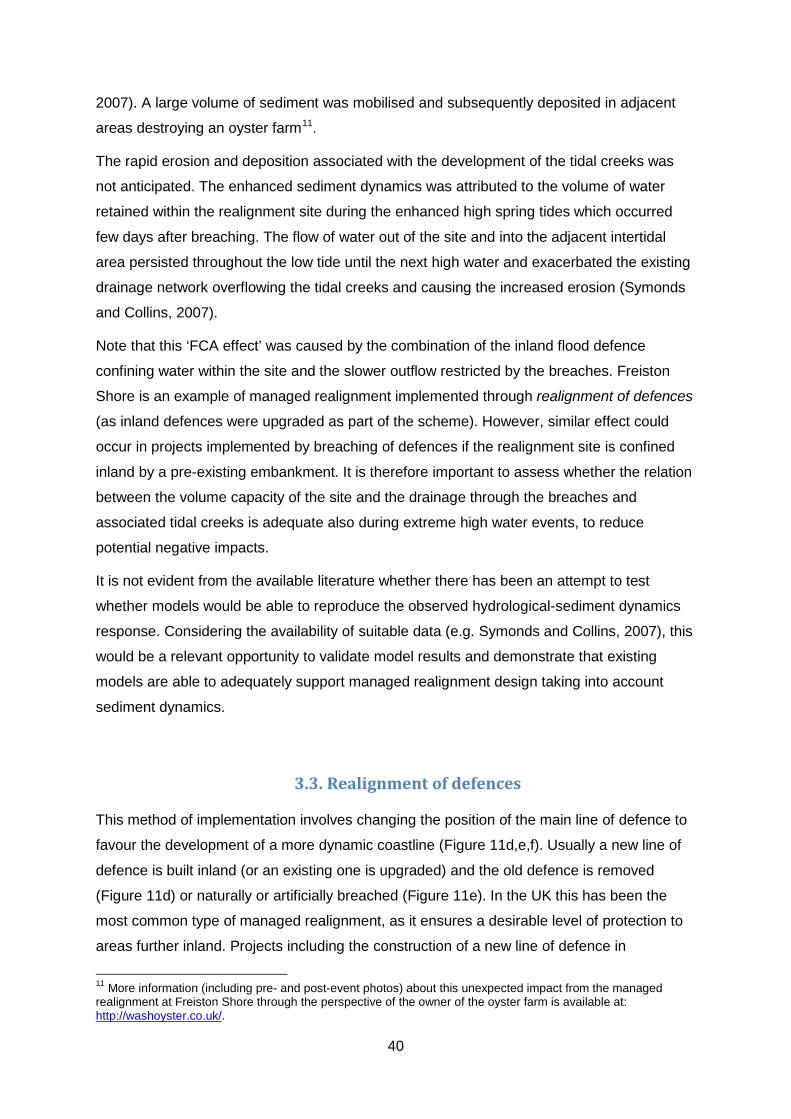
40
2007). A large volume of sediment was mobilised and subsequently deposited in adjacent
areas destroying an oyster farm11.
The rapid erosion and deposition associated with the development of the tidal creeks was
not anticipated. The enhanced sediment dynamics was attributed to the volume of water
retained within the realignment site during the enhanced high spring tides which occurred
few days after breaching. The flow of water out of the site and into the adjacent intertidal
area persisted throughout the low tide until the next high water and exacerbated the existing
drainage network overflowing the tidal creeks and causing the increased erosion (Symonds
and Collins, 2007).
Note that this ‘FCA effect’ was caused by the combination of the inland flood defence
confining water within the site and the slower outflow restricted by the breaches. Freiston
Shore is an example of managed realignment implemented through realignment of defences
(as inland defences were upgraded as part of the scheme). However, similar effect could
occur in projects implemented by breaching of defences if the realignment site is confined
inland by a pre-existing embankment. It is therefore important to assess whether the relation
between the volume capacity of the site and the drainage through the breaches and
associated tidal creeks is adequate also during extreme high water events, to reduce
potential negative impacts.
It is not evident from the available literature whether there has been an attempt to test
whether models would be able to reproduce the observed hydrological-sediment dynamics
response. Considering the availability of suitable data (e.g. Symonds and Collins, 2007), this
would be a relevant opportunity to validate model results and demonstrate that existing
models are able to adequately support managed realignment design taking into account
sediment dynamics.
3.3. Realignment of defences
This method of implementation involves changing the position of the main line of defence to
favour the development of a more dynamic coastline (Figure 11d,e,f). Usually a new line of
defence is built inland (or an existing one is upgraded) and the old defence is removed
(Figure 11d) or naturally or artificially breached (Figure 11e). In the UK this has been the
most common type of managed realignment, as it ensures a desirable level of protection to
areas further inland. Projects including the construction of a new line of defence in
11 More information (including pre- and post-event photos) about this unexpected impact from the managed realignment at Freiston Shore through the perspective of the owner of the oyster farm is available at: http://washoyster.co.uk/.

41
anticipation of a high probability of old defences being naturally breached should also be
considered as managed realignment. Projects involving seaward realignment of defences
(Figure 11f) with the objective of creating favourable conditions for the development of
habitats may be considered within the broad definition of managed realignment (see Chapter
2). In the Netherlands, for example, the Sand Motor is a large beach nourishment schemes
aiming to create a buffer for storm impact and space for the development of back beach
environments (see Chapter 5).
Creation of habitat is not always an objective for realignment of defences. Sometimes, due
to continued coastal erosion or inadequate design/positioning, the alignment of coastal
defences make them too exposed to the direct impact of waves (e.g. the embankment that
was breached at Freiston Shore). High exposure reduces the life-time of the structure (e.g.
undermining, structural damage) and the level of protection they offer (e.g. overtopping
during storm surges). Realignment of defences may be implemented to reduce exposure
and create opportunities for other benefits (e.g. recreation and amenity value). This was the
case at Littlehaven Beach (South Tyneside, Northeast England). At Littlehaven beach the
seawall was realigned (Figure 12) switching from a protruding to a concave planform, to
improve coastal defence, reduce maintenance costs and increase amenity value (Cooper et
al., 2013).
Figure 12. Realignment of the seawall at Littlehaven Beach in 2013 was an integral part of the local regeneration plan to increase the aesthetic and amenity value of the beach frontage, in addition to improvement of coastal protection (Photo from Steve Burdett, courtesy of Royal HaskoningDHV).

42
3.4. Controlled tidal restoration
The main characteristics of controlled tidal restoration methods are: defences are maintained
and tidal flow into the embanked area is controlled through culverts and sluices (Figure 13).
In controlled tidal restoration, realignment refers to the shoreline rather than the line of
defence, as the high water line moves landwards within an embanked area. There are two
types of controlled tidal restoration methods: regulated tidal exchange (RTE) and controlled
reduced tide (CRT). These methods are described in Chapter 2. RTE schemes are often
implemented with the main objective of habitat restoration (e.g. Polder de Sébastopol,
(Figure 9). CRT schemes aim to enhance creation of intertidal habitat within flood control
areas (see Figure 10); therefore they have both flood risk management and habitat creation
as primary objectives. The use of flood control areas for agriculture is usually unsuitable due
to the salinity of the estuarine water that enters the site through overtopping of flood
defences during extreme high water level events. Therefore, these areas have become
attractive for restoration of intertidal habitats to compensate for loss elsewhere.
Figure 13. Location of the control reduced tide scheme at the Lippenbroek polder in the Sheldt river, Belgium (A). The polder is enclosed by dykes and tidal exchange occurs with water entering the site through the upper culvert and returning to the estuary through the lower culvert (B). A view of the culvert system looking from inside the polder is shown in C. Modified from: Beauchard et al. (2011).
In locations with high coastal development pressure, where land is scarce and expensive
(e.g. Belgium), managed realignment implemented through the removal or breaching of flood
defences is often unsuitable (Cox et al., 2006). Controlled tidal restoration through CRT
offers opportunity for managed realignment in coastlines heavily engineered by flood
defences and where flood risk mitigation is a serious concern. CRT schemes have been

43
implemented in Belgium and the Netherlands, often as part of a transnational agreement for
improving environmental quality in the Scheldt estuary (see Chapter 4).
In terms of opportunities for habitat creation, controlled tidal restoration allows saltmarshes
to develop on land with elevations considerably lower than it would be possible naturally
(Vandenbruwaene et al., 2011). The characteristics of the tidal inundation and sedimentation
patterns within RTE and CRT sites are considerably different than natural intertidal areas as
the tidal flow is regulated by the size and elevation of sluices and culverts. Within RTE sites
water level variations tends to be similar at neap and spring tides; while CRT schemes aim
to create a neap-spring tidal variation with the wider range of inundation levels and
frequency required for the establishment of the full spectrum of intertidal habitats (Jacobs et
al., 2009; Maris et al., 2007).
On the other hand, the inflow and outflow of storm water at CRT schemes may increase the
need of management when compared with RTE. The inflow of water during storms may
enhance sediment accumulation, which needs to be controlled to avoid undesirable
reduction of storage capacity; while emptying of storm water storage from the site may result
in high erosion rates affecting habitat restoration (Cox et al., 2006). The Lippenbroek polder
(Figure 13) was an active agricultural area until 2003; construction of the CRT scheme
started in 2004 culminating with the restoration of current tidal regime in March 2006
(Teuchies et al., 2012). The tidal amplitude within the CRT site is reduced from 5.2 m in the
estuary to 0.9 m (Beauchard et al., 2011). A rapid sediment accumulation was observed,
especially at lower elevations, where the agricultural soils were covered by ~30 cm estuarine
sediments in three years (Vandenbruwaene et al., 2011).
Numerical modelling simulations indicate that differences in sedimentation patterns between
natural and CRT marshes are likely to influence their long-term evolution (Vandenbruwaene
et al., 2011). Results of these simulations show that, in conditions of sea level rise, CRT
marshes may reach equilibrium at lower elevations and be less able to cope with rising water
levels than natural marshes. However, the advantage of controlled tidal restoration is the
opportunity for adaptive adjustments (e.g. modifying drainage systems and sluices) to
accommodate for sea-level rise and other climatic changes.
3.5. Managed retreat
The primary objective of managed retreat is to reduce the number of people, property and
infrastructure at risk through planned retreat from hazard-prone areas. This method of
managed realignment requires a long-term strategy for planning land-use changes that will

44
create the space for the shoreline to respond dynamically to sea-level rise and erosion
(Roca et al., 2008; Reisinger et al., 2014). Long-term and strategic planning makes
managed retreat one of the few options available for developed coasts threatened by rising
sea levels (Alexander et al., 2012). The implications of climate change on the management
of coastal areas (including flood and erosion risk) is leading to an increased interest on
managed retreat strategies at the local and national levels, as illustrated by the French
national strategy for coastal management (see Section 4.8) and the removal of buildings in
Texas (see Section 4.7) and Maui (Chapter 7).
In Europe, managed retreat experiences are rare, while elsewhere (e.g. the USA and New
Zealand), this approach has been more widely discussed and implemented. Managed
retreat is a long-term adaptive solution that promotes coastal sustainability and resilience in
the face of climate change. It enables accruing social, economic and environmental benefits
by: (a) reducing dependence on the increasing costs of providing protection through hard
engineering; (b) reducing the number of people and property at risk from coastal defence
failures during extreme events; (c) creating space for restoration or preservation of habitats;
and (d) creating and enhancing recreational and amenity value (e.g. Reisinger et al., 2014).
In some cases, it involves the relocation of single structures at risk. The Cape Hatteras
lighthouse and associated buildings (North Carolina, USA) were moved 880 m further inland
in 1999 to protect the historic landmark from coastal erosion12 (Figure 14). Also in 1999 the
Belle Tout lighthouse (East Sussex, UK), then converted to a private home, was moved 17
m away from the edge of the eroding cliff 13. Although these examples may be technically
and economically challenging, at the same time they are relatively simple as they were led
by willing owners. The implementation of managed retreat in a larger-scale (e.g. involving
entire communities) is more complex and requires political will (e.g. adequate policy and
legislative measures), institutional capacity (e.g. integration between planning and
management of flooding and erosion risk) and public engagement.
Legislation supporting managed retreat usually involves alterations to private property rights
based on defined thresholds of risk. It might include, for example, restrictions to restoration
or reconstruction of properties affected by flooding or erosion if they are within high risk
zones. In the aftermath of the Xynthia storm of 2010, a compulsory purchasing of property at
high risk was adopted in France. In USA financial assistance to facilitate relocation if a
property is considered at threat of imminent damage from erosion or flooding was supported
through the Upton-Jones amendment adopted in 1988. The amendment was repealed in 12 Photos and more information about the relocation of Cape Hatteras lighthouse are available at: http://www.nps.gov/caha/historyculture/movingthelighthouse.htm. 13 A time-line and images illustrating the history of the Belle Tout is available at: http://www.belletout.co.uk/history.html.

45
1994 due to lack of interest from the public. However, there has been some appeals for the
amendment to be reinstated (e.g. Nags Head in North Carolina, USA). Similar initiatives
exist at the state level, such as in Texas where the government offers reimbursement of up
to US$50,000 to cover for landowners costs related to moving out from the public beach
(see Section 4.7).
Figure 14. Cape Hatteras Lighthouse was moved landwards in 1999 from a position just behind the revetment seen in the foreground. This photo was taken on 16 July 2008 after landfall of hurricane Isabel (photo courtesy of The Program for the Study of Developed Shorelines, Western Carolina University).
Public opposition can delay or prevent managed realignment projects and therefore early
engagement with communities and stakeholders is essential (see Chapter 8). Public support
for managed retreat depends on who will pay the costs, how the loss in assets and changes
in existing use rights are managed and who benefits from a natural shoreline retreat (e.g.
Reisinger et al., 2014), whether alternative land is available and the underpinning cultural
values of communities and individuals (Alexander et al., 2012).
Managed retreat usually requires strong integration between long-term planning and the
sustainability of risk reduction measures, which is often deficient in public administrations.
However, challenging times require drastic changes and the only safe climate-proof
response at all temporal and spatial scales is to reduce the number of people and assets at
risk. As it is an effective mechanism to reduce risk from both climatic variability and extreme
events, managed retreat is increasingly been implemented (or planned) in many locations
worldwide.
46
However, implementing managed retreat is complex due to the variety of social and political
issues it involves. The delivery of long-term strategies is usually hindered by inadequate
institutional systems and public resistance, which are accustomed to short-term remediation
that can be immediately claimed (e.g. within the 4-5 years of administrative cycles) and the
inability to understand that compromising personal or sectorial gains is needed so greater
social, environmental and economic benefits are realised.
References
Alexander, K.S.; Ryan, A. and Measham, T.G., 2012. Managed retreat of coastal
communities: understanding responses to projected sea level rise. Journal of Environmental
Planning and Management, 55(4), 409-433.
Beauchard, O., Jacobs, S., Cox, T. J. S., Maris, T., Vrebos, D., Van Braeckel, A., and Meire,
P., 2011. A new technique for tidal habitat restoration: evaluation of its hydrological
potentials. Ecological Engineering, 37, 1849–58.
Cooper, N.J.; Wilson, S. and Hanson, T., 2013. Realignment of Littlehaven Sea Wall, South
Tyneside, UK. Proceedings Institution of Civil Engineers Coastlines, Structures and
Breakwaters Conference, 10p.
Cox, T., Maris, T., De Vleeschauwer, P., De Mulder, T., Soetaert, K. and Meire, P., 2006.
Flood control areas as an opportunity to restore estuarine habitat. Ecological Engineering,
28, 55-63.
Esteves, L.S. and Thomas, K., 2014. Managed realignment in practice in the UK: results
from two independent surveys. Journal of Coastal Research, Special Issue No. 66.
Jackson, N.L. and Nordstrom, K.F., 2013. Removing shore protection structures to facilitate
migration of landforms and habitats on the bayside of a barrier spit. Geomorphology, 199,
179-191.
Jacobs, S.; Beauchard, O.; Struyf, E.; Cox, T.; Maris, T. and Meire, P., 2009. Restoration of
tidal freshwater vegetation using controlled reduced tide (CRT) along the Schelde Estuary
(Belgium). Estuarine, Coastal and Shelf Science, 85(3), 368-376.
Nottage, A. and Robinson, P., 2005. The saltmarsh creation handbook: a project manager’s
guide to the creation of saltmarsh and intertidal mudflat. RSPB, Sandy and CIWEM, London.
Reisinger, A., Lawrence, J., Hart, G. and Chapman, R., 2014. From coping to resilience: the
role of managed retreat in highly developed coastal regions of New Zealand. In: Glavovic,

47
B., Kaye, R., Kelly M. and Travers, A. (Eds.), Climate Change and the Coast: Building
Resilient Communities. CRC Press: London.
Roca, E., Gamboa, G. and Tàbara, J. D., 2008. Assessing the Multidimensionality of Coastal
Erosion Risks: Public Participation and Multicriteria Analysis in a Mediterranean Coastal
System. Risk Analysis, 28(2), 399-412.
Symonds, A.M. and Collins, M.B., 2007. The establishment and degeneration of a temporary
creek system in response to managed coastal realignment: The Wash, UK. Earth Surface
Processes and Landforms, 32(12), 1783-1796.
Teuchies, J.; Beauchard, O.; Jacobs, S.; and Meire, P., 2012. Evolution of sediment metal
concentrations in a tidal marsh restoration project. Science of the Total Environment, 419(1),
187-195.
Vandenbruwaene, W.; Maris, T.; Cox, T.J.S.; Cahoon, D.R.; Meire, P. and Temmerman, S.,
2011. Sedimentation and response to sea-level rise of a restored marsh with reduced tidal
exchange: Comparison with a natural tidal marsh. Geomorphology, 130, 115-126.

48
4. Examples of relevant strategies and policies
Independently on the terminology used nationally or locally, managed realignment projects
are increasingly popular in the western developed countries. The underpinning drivers for
the implementation of managed realignment are generally similar and revolve around
restoration of natural habitats, improved flood and erosion risk management and climate
change adaptation. Emerging national and regional strategies will play an important role in
the increase of managed realignment approaches being implemented in the next decades.
However, there are differences in the strategies adopted by different countries, their primary
objectives and the preferred mechanisms of implementation. The multiple functions and
benefits provided by managed realignment are widely recognised; but some countries have
placed stronger emphasis on the environmental benefits while others primarily focus on
sustainable management of flood and erosion risk in face of climate change.
In the UK managed realignment is commonly implemented through realignment of defences
or controlled tidal restoration (see Appendix) with nature conservation taking the spotlight. In
Belgium and the Netherlands, flood protection is a primary concern and projects focus on
adding environmental benefits to new flood defence strategies. In the USA, implementation
of managed realignment is more diverse, in some areas focusing on managed retreat and
others on breach, removal or realignment of defences with focus on nature restoration.
Although experiences are still few and scattered, the interest on managed retreat is also
increasing in other countries (e.g. Australia and New Zealand).
The first managed realignment projects in Europe were implemented in France in 1981 and
in Germany in 1982 and the Netherlands in 1989 (see Appendix). These were isolated
initiatives to attend to local needs. Currently, projects tend to be designed and implemented
as part of regional or estuary-wide strategies, some of which are described in this chapter.
The UK is said to have the highest number of managed realignment projects implemented to
date. However, this might not be the case if all mechanisms of implementation are
considered. It would be necessary to have an inventory of all managed realignment projects
implemented in the USA (which might include some of the projects of wetland restoration,
hydraulic restoration and managed retreat), for example, to allow adequate comparison. This
is a difficult task because of the range of terminology used and the many different
programmes and individual projects of relevance spread along different countries and
regions.

49
The Online Managed Realignment Guide (OMReG14, ABPmer, 2014) provides a list of
projects implemented in Europe, including an overview of their main characteristics and
location. An updated list of managed realignment projects in Europe, based on information
obtained from a range of sources, including verified projects listed in the OMReG, is
provided in the Appendix. Projects are listed alphabetically per country and information is
provided about the mechanism of implementation, date, size of the realigned site (in
hectares) and relevant sources of information.
Due to the range of terminology used in different countries, information is often scattered
and therefore this list should be considered a work in progress. No attempt has been made
here to list schemes implemented outside Europe due to the time and effort this would
require. However, a few projects implemented in the USA are listed to illustrate that some
projects, although not disseminated as managed realignment, do fit the definition suggested
in this book. Therefore, managed realignment experiences worldwide are actually more
widely spread than first anticipated.
The list indicates that the number of managed realignment projects is increasing through
time. Not only many large scale projects are currently under construction, many more are
planned to be implemented in the next decades as part of national and regional
programmes. As a consequence of these regional programmes, it is clear that managed
realignment schemes so far tend to be implemented in certain geographical areas.
Notoriously many projects are planned in the Scheldt estuary (Belgium and Netherlands)
and in the UK many schemes have been implemented in the Blackwater and Humber
estuaries (Figure). To illustrate the geographical differences and similarities, some of the
main policies and regional plans driving the implementation of managed realignment are
described here. These should be taken as examples of the strategies that many
governments at different levels (local, regional, national, transnational) are now adopting
towards more sustainable coastal management and climate change adaptation.
4.1. Making Space for Water and Making Space for Nature, UK In the UK, especially in England, managed realignment is implemented to create intertidal
habitat and to deliver more sustainable flood risk management, e.g. by reducing costs and
aggregating environmental and amenity values. The Department for Environment Food and
Rural Affairs (Defra) is responsible for policy-making concerning nature conservation and
flood risk. The Environment Agency is the operating authority responsible for implementing 14 OMReG is planned to be re-structured in the near future and re-launched as the Online Marine Register to include other types of marine habitat creation projects (as announced by Susanne Armstrong during the ABPmer Habitat Creation Conference in November 2013, London).

50
policy related to coastal erosion and flood management. Under the Flood and Water
Management Act15 (2010), local authorities are the designated Lead Local Flood Authority,
which have the duty for managing local flood risk. Chapter 8 presents the Environment
Agency perspectives on the drivers for managed realignment in England and Wales and the
practical challenges associated with its implementation. Here, a brief overview of the
national policies is presented.
In 2005, Making Space for Water was implemented as the new strategy for managing flood
and coastal erosion risk in England and Wales. It aims to “reduce the threat to people and
their property” and “deliver the greatest environmental, social and economic benefits”
following the principles of sustainable development (Defra, 2005). Climate change
adaptation and the statutory duty of nature conservation (and related economic implications)
are the main drivers for this strategy (see Chapter 8 and 9). The implementation of managed
realignment is the preferred approach for managing flood risk in rural areas and to create
habitat to offset or compensate loss.
To ensure compensation is delivered when required, the Environment Agency is encouraged
to develop a strategic plan to “anticipate habitat creation requirements and opportunities”
(Defra Flood Management Division, 2005). This strategic approach is taken by identifying
opportunities for managed realignment into existing coastal management instruments, such
as the Shoreline Management Plans16 (SMP) and the Catchment Flood Management
Plans17 (CFMP). Defra estimates that about 100 ha of intertidal habitat needs to be created
per year to compensate loss due to coastal squeeze and development projects within Natura
2000 sites especially in south and east England. Taking into consideration Defra’s regional
estimates on the extent and type of habitat that needs to be created, compensation may be
delivered through habitat creation programmes (e.g. the Anglian Regional Habitat Creation
Programme).
Not surprisingly managed realignment has been a preferred coastal management strategy in
England in the 21st century. The Appendix lists 54 managed realignment projects
implemented in the UK since 1991, their geographical distribution, type of method of
implementation and size of the realigned area can be seen in Figure 15. The shift from a
15 The roles and responsibilities for flood risk management in England and Wales are summarised at: http://www.local.gov.uk/local-flood-risk-management/-/journal_content/56/10180/3572186/ARTICLE. 16 SMPs are non-statutory guidance on coastal management alternatives. Currently, 22 SPMs cover the entire coastal length of England and Wales and each identify a management plan in three time horizons (0-20, 20-50 and 50-100 years). The SPMs can be accessed from: http://www.environment-agency.gov.uk/research/planning/105014.aspx. 17 CFMPs describe flood risk from all sources (except the sea) within the catchment and recommend management approaches over the next 50-100 years. They can be accessed from: http://www.environment-agency.gov.uk/research/planning/33586.aspx.

51
flood risk management strategy based on hard engineering to the more environmentally-
focused managed realignment was the focus of the Making Space for Water policy. In
relative terms, this shift in flood management in England can be compared to the 1960s shift
from hard engineering to beach nourishment in the management of coastal erosion in the
USA.
Figure 15. Distribution of the 54 managed realignment projects implemented in the UK showing the type of scheme (left) and the size of the realigned area.
The UK’s National Adaptation Programme (Defra, 2013) incorporates land use changes as a
mechanism to enhance climate and flood control and sets out the development of “a
strategic plan for coastal realignment” as one of the actions to address priority risks. The
government plans to realign, in England and Wales, a total of 111 km by 2016 and 550 km
(10% of the coastline) by 2030 resulting in the creation of 6,200 ha of intertidal habitat at a
cost of £10-15 million per year (Committee on Climate Change, 2013). Until November 2013,
about 66 km of England’s coastline have been realigned (Committee on Climate Change,
2013). Therefore, the government plans require that the length of realigned shorelines
almost double in the next two years (2014-2016) and eight-fold increase in 16 years (2014-
2030).
The independent review Making Space for Nature (Lawton et al., 2010) assessed the
sustainability of natural environments in England in face of climate change. The report

52
makes 24 recommendations, which will set the direction for upcoming habitat restoration and
re-creation strategies. It identifies that natural habitat sites are too small and isolated and are
not able to maintain provision of all ecosystem functions, especially when climate change
impacts on existing sites are considered. A more effective ecological network is required if
society is to benefit from ecosystem services of water-quality, flood and erosion control and
carbon storage. Chapter 8 describes the implications of this report for the implementation of
managed realignment.
This ambitious strategy illustrates the importance of managed realignment to deliver multiple
functions to satisfy the need to adapt to climate change, compensate for habitat loss and
provide sustainable coastal protection. Implementation of managed realignment at the scale
and rate planned by the government requires: (a) ensuring that the identified sites have
favourable conditions to the development of the habitats to be created; (b) the willingness of
landowners; and (c) increasing contribution from external funding. Challenges known to
delay or hinder managed realignment projects (see Chapter 8).
4.2. Sigma Plan, Belgium Belgium’s coastline is heavily engineered by flood defences and flood risk mitigation is a
serious concern. It is a country with high coastal development pressure where land is scarce
and expensive (Cox et al., 2006). As in other European countries, restoration of intertidal
habitats is required to abide to environmental law. The need to provide improved protection
against floods and nature restoration has led to the implementation of managed realignment,
mainly through controlled reduced tide (CRT). Most of CRT projects (13 out of 15) in
Belgium have been implemented along the Scheldt estuary and more schemes are planned
to be implemented by 2030.
The Scheldt marks the border between the Netherlands and Belgium. The Scheldt Estuary
Development Plan, a Netherlands-Flanders agreement, establishes an integrated long-term
vision for the estuary’s accessibility, environmental conservation and flood protection.
Human interference (e.g. dredging and land reclamation) in the Scheldt estuary has reduced
intertidal habitat to less than 50% over the past century (Meire et al., 2005). The economic
and ecological importance of the Scheldt has caused historic cross-border conflicts; more
recently involving a case of managed realignment (see Section 4.4).
In Belgium, the Sigma Plan18 is a major regional strategy aiming to deliver improved flood
risk management in the Flanders region and enhancement of environmental conditions
18 Information about the Sigma Plan and its projects can be found at: http://www.sigmaplan.be/en/sigma-plan.

53
along the Scheldt and its tributaries. It was developed as a response to a major flood that in
1976 badly affected Antwerp and other parts of Flanders. The Sigma Plan included three
main measures: 512 km of enhanced dikes, flood control areas and one flood barrier (which
was considered unfeasible and dropped from the plan). In 2005 the Sigma Plan was revised
to deliver a more integrated plan that attends to current multifunctional needs (i.e. recreation,
nature restoration, climate change adaptation and sustainability of economic activities). A
good overview of the Sigma Plan is provided in Beukelaer-Dossche and Decleyre (2013).
Managed realignment plays a key role in the revised Plan, which includes about 1300 ha of
flood storage area and total over 850 ha of new habitat. The Sigma Plan has been
developed by the Waterways and Sea Canal (which is responsible for flood protection and
navigation) in partnership with the Agency for Nature and Forest. A number of large scale
projects have been identified, including realignment of flood defences and CRT, and
systematically planned to be implemented in time-periods of five years, with the final delivery
of the plan expected in 2030. The projects that have already started are included in the list of
management realignment projects in Europe (see the Appendix). Lippenbroek (Figure 13)
was the first CRT project piloted in Belgium (Jacobs et al., 2009; Beauchard et al., 2011;
Teuchies et al., 2012).
To reduce impact of the revised Sigma Plan on urban and agricultural areas, it was decided
to concentrate most of the projects into preferred areas. Although affecting a smaller area,
the impact on the value of farmland in the affected areas is considerable and the
government decided for a policy of expropriation and freehold purchasing that is currently
being tested in the Kalkense Meersen (Van Rompaey and Decleyre, 2013). Other measures
to facilitate land purchase include: creation of a land bank (so land is available to offer as
exchange to owners affected by the Sigma Plan); € 2,000/ha in financial incentives (above
market value) for willingness to sell; relocation; compensation for loss of production; low
interest loans etc. Another set of measures are also in place to enhance the recreational
value of the projects.
4.3. Room for River and Building with Nature, The Netherlands The Netherlands is a country notoriously known for reclaiming land from the sea and
engineering coastlines to ensure flood protection and secure the functioning of the country
(see Chapter 5). The importance of the dams-dikes system and a robust coastal
management plan cannot be understated in a country where about two thirds of its area is
below sea level (Brouwer and van Ek, 2004). Rijkswaterstaat (Ministry of Infrastructure and

54
Environment) is responsible for the main waterways, water systems and road networks in
the Netherlands, including flood protection.
The catastrophic impact of the 1953 floods reinforced an already strong culture of
engineering protection of polders. In the aftermath of this major event, the Delta Plan was
devised to enhance protection of the country against high water levels through the
constructions of dams. In 1958 the first of the ‘deltaworks’ was concluded; as a result of hard
engineering conducted under the Delta Plan the Dutch shoreline was shortened by 700 km.
In 1990, the government implemented a new policy known as Dynamic Preservation of the
Coastline, stating that the coastline should not be allowed to retreat inland of its 1990
position (Hillen and Roelse, 1995). Beach nourishment became the main mechanism of
implementation.
Climate change adaptation and environmental concerns have led to a new policy
development, the Delta Programme19, which is expected to be completed between 2015 and
2020. The Delta Programme aims to integrate flood protection, freshwater availability and
spatial planning and it has nine sub-programmes (three thematic and six geographic):
Safety; Freshwater; New Urban Developments and Restructuring; Ijsselmeer region; Rhine
Estuary-Drechtsteden; Southwest Delta; Rivers; Coast and Wadden region.
The Dutch policy has evolved through time to respond to new challenges and the current
Delta Programme not only recognises the importance of naturally evolving coasts but also is
underpinned by concepts of eco-engineering and building with nature (Rijkswaterstaat and
Deltares, 2013). Currently eco-engineering approaches that promote the multiple benefits
(e.g. ecosystem services) provided by the creation of natural environments such as dunes
and wetlands are increasingly used in the Netherlands.
Many of the eco-engineering projects described as building with nature (e.g. Rijkswaterstaat
and Deltares, 2013) could be classified as managed realignment. However, the perception of
‘retreat’ associated with the term ‘managed realignment’ restricts its use and acceptance in
the Netherlands (Eertman et al., 2002). Chapter 5 describes the Dutch experience
concerning managed realignment and places it in the wider context of flood and erosion
protection. To date, ten managed realignment projects have been implemented in the
Netherlands, including one of the oldest schemes in Europe, implemented in 1989 at
Holwerder Zomerpolder.
19 The latest developments and details of the new policy can be found at: http://www.government.nl/issues/water-management/delta-programme.

55
4.4. Cross-border conflict in the Scheldt estuary The Scheldt estuary is about 160 km long, and the mean high water line (MHWL) has risen
faster along the inner Scheldt estuary (15 mm a-1) than at its mouth (3 mm a-1) in the last 100
years (Temmerman et al., 2004). Due to high flood risk, the estuary is constrained by a
network of flood defences.
A common agreement between the Flemish and Dutch governments involves mutual
cooperation on the management for the safety, environmental quality and accessibility along
the estuary (De Beukelaer-Dossche and Decleyre, 2013). Among the agreed objectives
were the number of times the navigation channel would be deepened and the creation of
600 ha of low-dynamic estuary environment (300 ha in the saltwater part of the estuary and
300 ha in the brackish part of the estuary). The mechanisms to be adopted by each
government to deliver the long-term plan were identified in the agreement (e.g. the
deepening of the channel given access to the Port of Antwerp, a revision of the Sigma Plan
and habitat restoration projects). The Dutch government has changed the plans concerning
some of the habitat restoration projects proposed through managed realignment, creating
conflict with the Flemish government.
In 1998, Rijkswaterstaat proposed the implementation of managed realignment to
compensate the loss of intertidal habitats within a designated Special Protection Area in the
Scheldt Estuary caused by the dredging of the navigation channel. Local communities
opposed the idea due to concerns about increasing flood risk; thus, leading local authorities
to reject the proposal, which the Dutch government withdrawn in 2000. This change in plans
caused havoc across the border as in Belgium it was perceived as a break in the bilateral
agreement.
A similar issue has arisen more recently and the case was taken to the European
Parliament. Under the EU Habitats Directive member states must take appropriate measures
to restore favourable conservation status and to avoid further deterioration of Natura 2000
sites. According to the European Commission, it is the competence of the country
responsible for the activity causing environmental damage to identify the most suitable
measures, the location where they will be implemented and the time-frame in which actions
will be taken to avoid further deterioration.
In 2005 the Netherlands identified that restoration of tidal flow into the Hedwige Polder was
the most suitable measure to compensate for damage caused by the deepening of the
Western Scheldt channel. The area is at the border between Belgium and the Netherlands,
with the Hedwige polder being on the Dutch side and the Prosper polder on the Belgium
side. In June 2011, the Dutch authorities communicated to the European Commission that

56
they would adopt alternative measures instead of creating intertidal habitats in the Hedwige
polder.
Some of the alternative measures included creation of habitat in an area that was already
planned to compensate loss caused elsewhere. This double accounting was not well
received by the Flemish authorities, which have filed three separate sets of questioning20 to
the European Parliament. The main concerns were: (a) political motivation; (b) the time-
frame in which the alternative compensation measures were proposed (i.e. most actions
were proposed to take place after 2015); and (c) the equivalence of the quantity and quality
of the habitat that could be created at a site under hydrodynamic different conditions.
The European Commission provided a consolidated response to the three set of questions
on 15th September 201121. The response was based on three main points:
1. The Habitats Directive and, therefore, the issue revolves on restoration of nature’s
favourable conservation status and the Commission is not required to provide a formal
opinion on the measures elected by the competent authorities of the Netherlands.
2. The Habitats Directive does not establish a precise time-frame in which favourable
conservation status of designated species and habitats should be achieved. However, it
is expected that the Netherlands take timely and efficient measures to avoid irreversible
ecosystem deterioration in the Western Scheldt.
3. As the decision of the Dutch Government on alternative compensation measures created
controversy, the Commission requested that the effectiveness of the new proposal and
its equivalence to the original plan should be substantiated scientifically to remove any
reasonable questions.
The realignment of defences at the Hedwige-Prosper polder has being finally agreed and
works on both sides of the border have started in preparation to restore tidal flow into 465 ha
of previously reclaimed land.
4.5. Cities and Climate Change, Germany Managed realignment in Germany has been implemented along the Baltic and North Sea
coasts and along main rivers, such as the Elbe and the Weser. A total of 29 managed
realignment projects have been implemented in Germany (ABPmer, 2014), most involving
compensation for habitat loss (Armstrong, 2013). Coastal managed realignment sites are
20 Parliamentary questions E-006402/11(30 June 2011), E-006507/11 (4 July 2011) and P- 006822/11 ( 12 July 2011) 21 OJ C 128 E, 03/05/2012: http://www.europarl.europa.eu/sides/getAllAnswers.do?reference=P-2011-006822&language=EN

57
found in Lower Saxony (by the North Sea) and Mecklenburg–Western Pomerania (by the
Baltic Sea), but the objectives differ across these two areas (Rupp-Armstrong and Nicholls,
2007). In Lower Saxony, managed realignment is usually implemented for compensation
reasons (i.e. loss of intertidal habitats due to coastal development, port construction etc.). In
western Pomerania managed realignment often combines the need for improvement of flood
defences and creation of new intertidal habitats.
The coastal managed realignment projects tend to be of larger size than the estuarine sites.
However, the concept of multiple functions is more evidenced in recent estuarine projects.
For example, managed realignment on the Elbe island of Wilhelmsburg (called Pilot Project
Kreetsand22) is part of the project Elbe Islands Dyke Park (Deichpark-Elbinsel23), which aims
to combine the creation of flood storage space with provision of a recreational park. These
initiatives are part of the Cities and Climate Change programme promoted by IBA Hamburg,
which include a series of projects concerning ‘climate-compatible’ sustainable development
for the metropolitan Hamburg area.
The Pilot Project Kreetsand is being developed by the Hamburg Port Authority and IBA
Hamburg and involves breaching of existing defences at the margin of the river Elbe (Figure
16). The objective is to allow flooding of 30 ha to create a tidal space of around 1 million
cubic metres. Increasing space for tidal dynamics in the Elbe is vital for the future viability of
the Hamburg Port, which will benefit from reduced sedimentation and flood risk. The project
is associated with design and landscape features aiming to promote nature conservation and
recreational value.
22 A description of the project and relevant links are available at: http://www.iba-hamburg.de/en/themes-projects/elbe-islands-dyke-park/pilot-project-kreetsand/projekt/pilot-project-kreetsand.html. 23 The process of planning and implementation of the Elbe Islands Dyke Park, including stakeholders engagement and the landscape works to incorporate multiple functions to existing flood defences, is described at: http://www.osp-urbanelandschaften.de/fileadmin/user_upload/osp_urbanelandschaften_Deichpark_Elbinsel_english.pdf

58
Figure 16. Aerial view of the Elbe river and the location of the Pilot Project Kreetsand at the east margin of the Wilhelmsburg island. Note that the image shows a visualisation of how the realigned site will look when implemented (project completion is expected in 2015). The realignment of defences that confine the Kreetsand tidal space was completed in 1999. (Image courtesy of HPA/Studio Urbane Landschaften).
4.6. Coastal Wetlands Planning, Protection and Restoration Act,
Louisiana, USA The Coastal Wetlands Planning, Protection and Restoration Act (CWPPRA) was enacted in
1990 to assist projects aiming to reduce loss and restore coastal wetlands in the USA.
CWPPRA annual budget has ranged between US$ 30 - 80 million. The program aims to:
integrate agencies to steer operations; plan and implement restoration projects; and
maintain a comprehensive monitoring program to evaluate performance. Strategic plans to
address wetland loss in Louisiana have been developed and managed by a partnership
between the State of Louisiana and five Federal agencies (Army Corps of Engineers,
Environmental Protection Agency, Fish and Wildlife Service, Natural Resources
Conservation Service, National Marine Fisheries Service, and U.S. Geological
Survey/National Wetlands Research Center), which form the CWPPRA Task Force.
The first project was completed in April 1994 (LaBranche Wetlands) and a total of 151
projects covering more than 44,500 ha have been funded since24. A range of techniques is
used in the CWPPRA funded projects, named: barrier island (natural coastal protection);
marsh creation (offsetting habitat loss); shoreline protection (hold the line); hydrological
restoration (improving stability); terracing (innovation); freshwater and sediment diversion 24 A list of CWPPRA projects in Louisiana is available from: http://lacoast.gov/new/Projects/List.aspx.

59
(restoring natural processes)25. Although named using different terminology, some of the
projects and techniques used fit within the broad definition of managed realignment.
Restoration of tidal flow into impounded areas by installing culverts or other methods is a
form of controlled tidal restoration. Breaching the Mississippi river embankments to allow
distribution of sediment to feed the wetlands can be considered managed realignment
through breach of flood defences. Depending on implementation methods and objectives,
some of the projects of barrier islands restoration that aim to provide shelter for the
development of back barrier wetlands may be consider a form of realignment of defences.
The selection of projects starts every January with new applications from local communities,
agencies and government. A workgroup will then short-list a number of candidate projects
that will be evaluated for feasibility and cost-effectiveness. A budget is estimated to
implement, maintain and operate the project for 20 years and the CWPPRA Task Force will
select the projects that will be funded according to a set of criteria. Demonstration projects
are also selected to test new methods and applications that might be able to improve
efficiency and results. One of the strengths of the programme is the systematic monitoring
and the online dissemination of data publicly available online. This monitoring and data
sharing is the basis of the ‘adaptive management’, which refers to the application of lessons
learned to improve existing and future individual projects and the overall achievements of the
programme.
In 2002, the CWPPRA projects were reviewed to identify achievements and actions needed
to improve existing and future projects (Raynie and Visser, 2002). The outcomes of the
review indicate that evaluation of achievements is impaired when the original intent of the
project is lost or becomes secondary as the project evolves. It is important therefore that
success criteria and targets are clearly defined at the planning stage and monitoring should
evaluate whether progress is being achieved towards the set target so adjustments can be
made if required.
4.7. Texas Open Beaches Act, USA The Texas Open Beaches Act (OBA), enacted in 1959, establishes that the public has free
and unrestricted access to the State’s beaches26, commonly known as the ‘wet beach’, or
25 The brochure Partners in Restoration - 20th Anniversary Portfolio, produced by the CWPPRA Outreach Committee and the U.S. Geological Survey National Wetlands Research Center describes the range of techniques and provides background information about the work of CWPPRA. Available at: http://lacoast.gov/products/Portfolio_of_Success_Final_web.pdf. 26 A description of the Act and how it is enforced is provided by the Texas State General Land Office at: http://www.glo.texas.gov/what-we-do/caring-for-the-coast/open-beaches/.

60
the area between the mean low tide and the mean high tide. The ‘dry beach’ between the
mean high tide and the natural vegetation line can be privately owned but may be subjected
to public beach easement (i.e. right of way). Under the OBA, structures on the public beach
easement are prohibited if posing hazard to safety or interfering with free and unrestricted
public access.
About 63% of Texas shorelines are critically eroding (Patterson, 2007), through time erosion
results in structures being located within the public beach easement. In 2006, the ‘structure
removal initiative’ was created to reduce litigation between the State and property owners in
these situations. Through funding from the Coastal Erosion Planning and Response Act
(CEFRA), the government offers up to US$50,000 to reimburse property owners for the
costs to move structures located within the public beach easement to a suitable, landward
location (Figure 17). Therefore, the ‘structure removal initiative’ is a mechanism to support
the implementation of managed retreat.
According to the Texas General Land Office, 18 structures have been relocated without
litigation since this initiative was implemented. CEPRA also encourages local governments
to establish set backlines, restore and protect dunes and purchase properties seaward of set
back lines. The objective is to improve public access to the beach and reduce risk to people
and property during storms.
Figure 17. Example of house relocation under the Texas Open Beach Act. The house location was within the public beach easement at Sunny Beach, West Galveston Island (top left) and was relocated further

61
inland (bottom) on 1 Nov 2010. The photos on the top show the beach before (left) and after house relocation (right). Photos courtesy of Texas General Land Office.
In 2012 the Texas Supreme Court ruled that the location of the public beach easement
should not be affected by sudden erosion events (e.g. due to storms or hurricanes); but may
move due to gradual changes resulting from coastal dynamic conditions. This decision was
the outcome of a lawsuit27 filed by a property owner against the Texas Land Commissioner
over the interpretation of the OBA. The complainant owned several houses in Galveston’s
West Beach, which were located in the public beach easement as a result from the impact of
Hurricane Rita in 2005. As customary in these cases, the General Land Office sent a letter to
the property owner stating that the houses were subject to removal under the Open Beaches
Act.
The consequences of the Supreme Court decision were: (1) some of the beach houses
under litigation were purchased by the Federal Emergency Management Agency (paid by
taxpayers) so they could be removed; and (2) the OBA has been amended (by the H.B.
3459 which took effect on 1 September 2013) to allow temporary suspension of the line of
vegetation as the landward limit of the public beach easement when it is altered by a
meteorological event.
4.8. National Strategy for the Integrated Management of the Shoreline,
France Despite the fact that the first managed realignment project in Europe has been implemented
in France (Aber de Crozon in 1981), the idea of managed realignment is still at its inception.
The Conservatoire du Littoral28 is currently the main player, implementing managed
realignment in some of its coastal properties. In 2012, the Conservatoire du Littoral
published a booklet about coastal management options in face of climate change in which it
advocates land use changes, realignment of defences and managed retreat strategies, as
long-term and sustainable options.
This approach reflects the direction set by the National Strategy for Integrated Coastal Zone
Management (2011), which explicitly indicates the need to plan for the retreat of coastal
activities and structures as one of its principles. The programme of actions (Ministère de
27 Severance v. Patterson, 370 SW 3d 705 - Tex: Supreme Court 2012. 28 It is a government organisation created in 1975 to ensure the protection and management of coasts, estuaries and other water bodies. Land acquisition and subsequent creation of natural reserves is one of the mechanisms adopted to improve sustainable use and conservation of the natural environment. On the time of writing, the Conservatoire du Littoral owns 153,288 ha across France (http://www.conservatoire-du-littoral.fr/).

62
l’Écologie, du Développement durable et de l'Énergie, 2012) is based on four goals and nine
actions, one of the goals involves the re-organisation of the territorial space and action 7
refers to the provision of mechanisms for the implementation of relocation strategies. Other
principles include: prohibit occupation in high risk areas; integration of spatial planning and
reduction of risk from natural hazards; protection and restoration of coastal ecosystems; and
planning for climate and environmental change at time scales of 10, 40 and 90 years.
Existing managed realignment experiences in France are still limited and include
realignment of defences at Aber de Crozon and Île Nouvelle, controlled tidal restoration at
the Polder de Sébastopol (Figure 9), and retreat of a road and other land uses in the
Languedoc-Roussillon coast (between Sète and Marseillan). Lack of awareness and poor
acceptance of coastal communities and planners is still a major constraint to the
implementation of managed realignment (Bawedin, 2004; Goeldner-Gianella, 2007;
SOGREAH, 2011).
Interests however are arising on the subject and studies have been commissioned on the
feasibility of managed realignment at few sites. For example, in 2011 a committee has been
established to assess the feasibility of managed realignment at Bas-Champs de Cayeux
(Picardy). This reclaimed land is protected by embankments, which have been breached and
flooded during storms in the past. About € 55 million have been spent between 1971 and
2014 to protect this area.
The discussions with local communities in the Bas-Champs area revolve around the relative
comparison between the consequences of flooding due to an accidental breach and the
planned restoration of tidal inundation in the area. However, such discussion is not new in
the area and studies have addressed the subject since the accidental breach of 1990
caused severe flooding in the area (e.g. Bawedin, 2000; 2004). A social survey with 250
local residents indicated that 69% of respondents oppose to managed realignment at Bas-
Champs and only 10% accepts it unreserved (SOGREAH, 2011). The respondents that
would accept some form of realignment, 41% would prefer it to occur through an accidental
breach of defences.
The National Observatory on Climate Change Effects (ONERC) has recommended that
managed realignment initiatives need careful planning to account for impacts of climate
change on the coasts, such as saltwater intrusion, sea level rise, erosion etc. (ONERC,
2007). It seems, however, that in the aftermath of the catastrophic Xynthia storm in 2010,
managed realignment has received greater attention according to Philippe Boët29 (from the
29 Towards depolderisation in the Gironde estuary, http://www.irstea.fr/en/our-editions/info-medias/towards-depolderisation-gironde-estuary#margo.

63
National Research Institute of Science and Technology for Environment and Agriculture at
Bordeaux). Compulsory land purchase of areas at high risk of flooding is a mechanism used
by public bodies in France often after major storm impacts. For example, the Conservatoire
du Littoral purchased Mortagne-sur-Gironde and Île Nouvelle, two agricultural areas, after
they were flooded due to accidental breaching of flood defences during a storm in 1999.
References
ABPmer, 2014. Online Managed Realignment Guide. Available from:
http://www.abpmer.net/omreg/.
Armstrong, S., 2013. What have we achieved, and what can we learn from elsewhere in
Europe? Presentation at the ABPmer Habitat Creation Conference, 20 November 2013,
London.
Bawedin, V., 2000. Les Bas-Champs de Cayeux / Mer (Somme): enjeux et conséquences
d’une éventuelle dépoldérisation. Master Dissertation, Université de Picardie Jules Verne,
151 p.
Bawedin, V., 2004. La dépoldérisation, composante d’une gestion intégrée des espaces
littoraux ? Prospective sur le littoral picard et analyse à la lumière de quelques expériences:
Baie des Veys (Normandie), Aber de Crozon (Bretagne), Tollesbury (Essex) et Freiston
shore (Lincolnshire). Cahiers Nantais, 6, 11-20.
Beauchard, O., Jacobs, S., Cox, T.J.S., Maris, T., Vrebos, D., Van Braeckel, A. and Meire,
P., 2011. A new technique for tidal habitat restoration: evaluation of its hydrological
potentials. Ecological Engineering, 37, 1849–58.
Brouwer, R. and van Ek, R. 2004. Integrated ecological, economic and social impact
assessment of alternative flood control policies in the Netherlands. Ecological Economics,
50, 1-21.
Committee on Climate Change, 2013. Managing the land in a changing climate. Chapter 5:
Regulating services – coastal habitats. Last accessed on 1st Dec 2013.
http://www.theccc.org.uk/publication/managing-the-land-in-a-changing-climate/, pp. 92-107.
Cox, T., Maris, T., De Vleeschauwer, P., De Mulder, T., Soetaert, K. and Meire, P., 2006.
Flood control areas as an opportunity to restore estuarine habitat. Ecological Engineering,
28, 55-63.

64
De Beukelaer-Dossche, M. and Decleyre, D. (eds.), 2013. Bergenmeersen, Construction of
a Flood Control Area with Controlled Reduced Tide as Part of the Sigma Plan. Available
from www.vliz.be/imisdocs/publications/250657.pdf, last accessed on 18 Feb 2014.
Defra (Department for Environment, Food and Rural Affairs), 2005. Making space for water -
Taking forward a new Government strategy for flood and coastal erosion risk management in
England. First Government response to the autumn 2004 consultation exercise. London.
Defra (Department for Environment, Food and Rural Affairs), 2013. National Adaptation
Programme: Making the Country Resilient To a Changing Climate. The Stationary Office,
Norwich, 182p.
Defra Flood Management Division, 2005. Coastal Squeeze Implications for Flood
Management, the requirements of the European Birds and Habitats Directives. Defra Policy
Guidance. Available at:
https://www.gov.uk/government/uploads/system/uploads/attachment_data/file/181444/coast
alsqueeze.pdf, accessed 3 Feb 2014.
Eertman, R.H.M.; Kornman, B.A.; Stikvoort, E. and Verbeek, H., 2002. Restoration of the
Sieperda Tidal Marsh in the Scheldt Estuary, The Netherlands. Restoration Ecology, 10,
438-449.
Goeldner-Gianella, L., 2007. Perceptions and attitudes towards de-polderisation in Europe:
A comparison of five opinion surveys in France and in the UK. Journal of Coastal Research,
23(5), 1218-1230.
Hillen, R. and Roelse, P., 1995. Dynamic preservation of the coastline in the Netherlands.
Journal of Coastal Conservation, 1, 17-28.
Jacobs, S.; Beauchard, O.; Struyf, E.; Cox, T.; Maris, T. and Meire, P. 2009. Restoration of
tidal freshwater vegetation using controlled reduced tide (CRT) along the Schelde Estuary
(Belgium). Estuarine, Coastal and Shelf Science, 85(3), 368-376.
Lawton, J.H., Brotherton, P.N.M., Brown, V.K., Elphick, C., Fitter, A.H., Forshaw, J.,
Haddow, R.W., Hilborne, S., Leafe, R.N., Mace, G.M., Southgate, M.P., Sutherland, W.A.,
Tew, T.E., Varley, J., and Wynne, G.R., 2010. Making Space for Nature: A review of
England’s Wildlife Sites and Ecological Network. Report submitted to Defra. Available from:
http://archive.defra.gov.uk/environment/biodiversity/documents/201009space-for-nature.pdf,
last accessed on 15 January 2014.
Meire, P.; Ysebaert, T.; Van Damme, S.; Van den Bergh, E.; Maris, T. and Struyf, E., 2005.
The Scheldt estuary, a description of a changing ecosystem. Hydrobiologia, 540, 1-11.

65
Ministère de l’Écologie, du Développement durable et de l'Énergie, 2012. Stratégie nationale
de gestion intégrée du trait de côte. Vers la relocalisation des activités et des biens. French
Government, Paris. Available at: http://www.developpement-
durable.gouv.fr/IMG/pdf/12004_Strategie-gestion-trait-de-cote-2012_DEF_18-06-
12_light.pdf.
ONERC (Observatoire National sur les Effets du Réchauffement Climatique), 2007.
Stratégie nationale d’adaptation au réchauffement climatique. La Documentation
française97p. Available at: http://www.developpement-
durable.gouv.fr/IMG/pdf/Strategie_Nationale_2-17_Mo-2-2.pdf
Patterson, J., 2007. Coastal Erosion Planning & Response Act (CEPRA). Report to the 80th
Texas Legislature, February 2007. Texas General Land Office. Available at:
http://www.glo.texas.gov/what-we-do/caring-for-the-coast/_publications/cepra-report-
2007.pdf.
Raynie, R.C. and Visser, J.M., 2002. CWPPRA Adaptive Management Review Final Report.
Prepared for the CWPPRA Planning and Evaluation Subcommittee, Technical Committee,
and Task Force. Available at: http://lacoast.gov/reports/project/3891519~1.pdf.
Rijkswaterstaat and Deltares, 2013. Eco-engineering in the Netherlands: Soft interventions
with a solid impact, 44p.
Rupp-Armstrong, S. and Nicholls, R.J., 2007. Coastal and estuarine retreat: A comparison of
the application of managed realignment in England and Germany. Journal of Coastal
Research, 23(6), 1418–1430.
SOGREAH, 2011. Etude de Faisabilite – Depolderisation partielle et eventuelle des Bas-
Champs du Vimeu – La recherché d’un avenir sur un territoire perenne. Phase 1: Etat des
lieux – diagnostic du territoire. Chapitre 8: Approche géographie sociale – perceptions.
Temmerman, S.; Govers, G.; Wartel, S. and Meire, P., 2004. Modelling estuarine variations
in tidal marsh sedimentation: response to changing sea level and suspended sediment
concentrations. Marine Geology, 212, 1-19.
Teuchies, J.; Beauchard, O.; Jacobs, S.; and Meire, P., 2012. Evolution of sediment metal
concentrations in a tidal marsh restoration project. Science of the Total Environment, 419(1),
187-195.
Van Rompaey, M. and Decleyre, D., 2013. Public Support. In: De Beukelaer-Dossche, M.
and Decleyre, D. (eds.), 2013. Bergenmeersen, Construction of a Flood Control Area with
Controlled Reduced Tide as Part of the Sigma Plan. Available from:
www.vliz.be/imisdocs/publications/250657.pdf, last accessed on 18 Feb 2014.

66
5. Considerations on managed realignment in the Netherlands
Joost Stronkhorsta & Jan Muldera,b
a Deltares, PO Box 177, 2600 MH Delft, The Netherlands, [email protected]
b University of Twente, Water Engineering and Management, P.O. Box 217, 7500AE
Enschede, The Netherlands, [email protected]
5.1. Introduction
The Netherlands is a small and densely populated country located in the deltas of the rivers
Rhine, Meuse, Ems and Scheldt and bordering the North Sea. The Dutch coast consists of
three distinct sections (Figure 18): the SW Delta region with islands and enclosed estuaries,
the Holland coast with an almost uninterrupted line of dunes and the Wadden Sea region
with intertidal flats behind barrier islands and saltmarshes along the mainland. The low-lying
polders behind the dunes and dikes are vulnerable to flooding by rivers and the sea. The
dunes, beaches, saltmarshes and intertidal flats are highly valued as natural habitats and
recreation areas, but above of all, essential for flood protection. For that reason, sustainable
management of these areas is vital.
Much effort is spent by different authorities concerning with managing the coast. The
national agency Rijkswaterstaat is responsible for shoreline management and flood safety
policy, the regional water boards have to provide maintenance of sea defences and nature
conservation organisations safeguard wildlife and habitats. One in a suite of management
options is managed realignment, i.e. the realignment of the shoreline, either landward or
seaward, to create space for coastal habitat development (e.g. saltmarshes) and a natural
buffer zone for flood protection through dissipation of wave energy. Figure 18 indicates the
locations where such projects have been implemented.
Along the Dutch shores, there is little application of managed realignment compared to, for
instance, East England. Reasons for this are related to common practices and paradigms
rooted in centuries-old heritage of water management (e.g. Van Koningsveld et al., 2008)
based on: (i) dike construction and reinforcements and shortening of the coastline for flood
safety, (ii) reclamation of land from the sea for agriculture and (iii) ‘hold-the-line’ (using both
hard and soft engineering) to maintain the intrinsic value of dunes and beaches. This chapter
will illustrate the approaches of coastal management applied along the Dutch coast,
including a brief overview of recent experience with managed realignment.

67
Figure 18. Along the Dutch coast, managed realignments through breach of flood defences have been implemented at few locations, including: De Kerf (1), Noard-Fryslan Butendyk (2), Sieperdaschor (3), Breebaart (4) and Kroon’s polders (5). More recently, seaward shoreline realignment projects have been realised along the Holland coast at the Sand Motor (a), Hondsbossche zeewering (b), Walcheren (c) and Zeeuws-Vlaanderen (d).
5.2. Coastline shortening, land reclamation and hold-the-line
Along the Dutch coast, dike construction and dune reinforcements have been common
practice for centuries to improve flood safety of the low-lying country and to reclaim land that
had been lost by successive storm surges. Since the 13th century an estimated 5,700 km2 of
land have been lost to the sea due to many floods caused by storm surges, human-induced
land subsidence, coastal erosion and sea-level rise. However, over the centuries and with
great effort, land was reclaimed through drainage of lakes or meres in the Holland region
and land reclamation of saltmarshes in the Wadden and SW Delta regions. This has created
very productive farmland (polders), with a total surface area nearly equal to what was lost
(van de Ven, 1993).
Historically, driven by the need for safety and land space, ‘natural realignments’ caused by
storm surges have been counteracted. During the last century, this approach has resulted in
a systematic shortening of the coastline. A major advantage is that the need for maintenance
and reinforcement is restricted to a limited stretch of the coast. In this respect, there are two
major projects of dike construction that have played a key role (Bosch & van der Ham,
1998). Firstly, the construction of the closure dam Afsluitdijk (1932) created a freshwater
lake out of the Zuiderzee reducing the coastline by approximately 600 km. Secondly, in the
aftermath of the storm surge in February 1953, which caused a major flood disaster in the
SW Delta region, the Delta Project (1958-1997) was initiated. The Delta Project involved the

68
construction of closure dams in all tidal inlets of the area, except the Western Scheldt,
shortening the total length of the coastline by 700 km. Consequently, in the last century the
coastline of the Netherlands has reduced from 2000 to 650 km (excluding the coastlines of
the Wadden Sea barrier islands).
In 1990 the Dutch government adopted a national policy called dynamic preservation of the
coastline (Hillen & Roelse, 1995), which in practice aims to ‘hold-the-line’ as shoreline retreat
inland of its 1990 position is not to be allowed (Van Koningsveld and Mulder, 2004). The
long-term development of the sandy coastal system of the Netherlands is characterized by a
structural sediment deficit. Therefore, since 1990 coastline management is achieved by
replenishments using sand sources largely available from the deeper North Sea.
In 2000 the policy was extended with the aim of sustainably preserving the sandy coast by
keeping pace with sea-level rise. A system-approach was adopted that considers the sand
volume of the whole coastal foundation including dunes, beaches and foreshores to a depth
of 20 m below mean sea-level and on a timescale of decades to centuries (Mulder et al.,
2011). Annually 12 million cubic meters of sand are used for foreshore and beach dune
nourishments to keep pace with the present sea-level rise of 2 mm/year. This approach is
generally regarded by stakeholders as very successful. For the Holland coast in particular,
this has changed the sand balance from negative (erosion) to slightly positive (accretion)
and consequently resulted in a slight seaward shift of the coastline (Giardino et al., 2014).
In recent years, innovative coastal defences have been developed that further improve flood
safety, beach quality and dune habitats, and imply a shift towards seaward realignments of
the coastline. An example is the project Weak Links (2008-2015) implemented at eight
locations along the coast of Holland and SW Delta, involving a seaward expansion of the
coastline by 50-100 m using a combination of hard and soft engineering (Figure 19) in nearly
all cases.
An even more substantial seaward expansion of 0.5-1 km was created in 2011 at the
eroding coast south of The Hague by a single, large sand nourishment (Figure 19) of 20
million cubic meters (Stive et al., 2013). In the next few decades natural processes will
distribute the sand gradually to the beach and dunes benefiting this whole coastal stretch
thereby strengthen the natural coastal defence. This so called Sand Motor is based on the
principles of building-with-nature and eco-engineering (De Vriend and Koningsveld, 2012;
Rijkswaterstaat, Ecoshape and Deltares, 2013) and aims to combine an improved coastal
defence and opportunities to create space for nature development and recreation.

69
Figure 19. Beach nourishments and dike-dune reinforcements (left) as part of the Weak Links project have improved both flood safety and spatial quality at Nolle-Westduin near Vlissingen, SW Delta. The Sand Motor project (in the right during construction phase in 2011) involves a large sand nourishment along the eroding coast south of The Hague. Photos: courtesy of Rijkswaterstaat.
Approaches such as the Sand Motor are not widely recognised as managed realignment as
they involve realignment of the shoreline seawards. However, through shoreline realignment,
these approaches create space for a more dynamic response to waves and tides providing
opportunities for environmental, social and economic benefits (e.g. enhanced biodiversity,
areas for recreation and improved natural coastal defence). Therefore, the Sand Motor fits
well the broad definition of managed realignment suggested in Chapter 2. Examples of
managed landward realignment of the shoreline in the Netherlands are described in the next
section.
5.3. Dutch examples of landward realignment of the shoreline
Given the long tradition of holding the line, the idea of managed realignment as most
commonly perceived (i.e. landward realignment) is not accepted lightly in the Netherlands.
The issue encounters strong public and political opposition. An example is the planned
breach of defences at the Hedwige polder - a 300 ha polder at the Belgium-Netherlands
border near Antwerp - as part of a Belgian-Dutch nature-compensation program30 for
dredging activities in the Western Scheldt estuary. After strong opposition in particular from
the (farmers) population in the region, in 2012 and after nearly 10 years of political debate,
the Dutch government finally decided upon de-poldering, which is scheduled to take place in
2016 - 2019.
Yet, the potential benefits of managed realignment (i.e. the creation of intertidal habitats in
response to rising sea levels, thus providing effective wave energy attenuation and 30 This cross-border project is part of the Sigma Plan, which is the strategy to manage flood risk and nature conservation in the Sheldt estuary and its tributaries (see Section 4.2). Information about the Hedwige-Prosper project can be found at: http://www.sigmaplan.be/en/projectareas/hedwige-prosper-project.

70
contributing to flood safety and reduction of maintenance efforts of the flood defences), have
been recognized also in the Netherlands (e.g. Saeijs et al, 2003; ComCoast, 2007;
Temmerman et al, 2013). The government programme Room for the River has formally
adopted realignment of river dikes as one of the useful measures to tackle the combined
effects of high river discharges and a rising sea level. The programme includes several
examples where different managed realignment approaches will be used for flood protection
along the rivers in the Netherlands31.
Along the coast, over the last two decades, managed realignment has been applied at a few
locations as pilot projects. The cases have been initiated by nature conservation
organisations and developed in close collaboration with Water Boards, among others, to
meet flood safety issues. Implementation of coastal managed realignment projects in the
Netherlands can be distinguished based on the types of coastal environments that are being
restored:
• in sandy environments along the North Sea coast, projects focus on restoration of
natural dune dynamics and biodiversity improvements without hampering flood safety
(Löffler et al, 2013) and
• in silty environments along the estuaries and Wadden Sea, projects deal with restoration
of saltmarsh dynamics, habitats and biodiversity.
Figure 18 shows the location of specific examples of coastal managed realignment pilots in
the Netherlands, including:
• De Kerf (Figure 20a), in the calcareous-poor dunes at the Holland coast, between
Schoorl and Bergen aan Zee. In 1997, aimed to increase biodiversity and dune
dynamics, the seaward dune ridge was breached to allow seawater flowing into the
dunes at high tide and the calcareous beach sand being blown landward. More than ten
years later, the breach has naturally closed.
• Breebaart (Figure 20b) is a small polder (reclaimed in 1979) near the Dollard estuary.
About ten years after embankment the area was purchased to be transformed in a
nature conservation site. A connection with the estuary was created in 2001 using a
culvert and a fish passage. This has improved the fish population, saltmarsh vegetation
and increased the number of waders32.
31 Information about the Room for the River programme, including the all the nine types of measures that have been formally adopted examples of where they will be implemented can be found at: http://www.ruimtevoorderivier.nl/meta-navigatie/english/publications/. 32 The website with information about the reserve provides information about the biodiversity (in Dutch): http://www.avifaunagroningen.nl/index.php/gebieden/569-polder-breebaart.

71
Figure 20. Two examples of small-scale managed landward shoreline realignments in the Netherlands. (a) At De Kerf (near Schoorl, North Holland) the seaward dune ridge was artificially breached to increase biodiversity and coastal dynamics. (b) At the Breebaart polder (near the Dollard estuary in rural North Netherlands) a culvert and a fish passage restored tidal flow into the embanked area resulting in an increase in biodiversity. Photos: courtesy of Rijkswaterstaat.
• Noard-Fryslan Butendyks, summer polders along the Wadden Sea coast of North
Friesland. Summer polders are reclaimed saltmarshes now used to herd cattle during the
summer. These polders are bordered by dykes, higher in the landward side (to protect
the mainland from flooding) and lower seaward. De-poldering by breaching the seaward
dike started at Noarderleech in 2001 and Bildt Pollen in 2009. Results so far indicate
enhanced diversity of flora and fauna33. A total of 4,000 ha of saltmarsh is planned to be
restored at these sites.
• Sieperdaschor34 is a small polder reclaimed in 1966 along the Western Scheldt estuary
at the Belgian-Dutch border, adjacent to the large saltmarsh area named Land van
Saeftinge. A storm in February 1990 breached the seaward dike (therefore it is not an
actual ‘managed’ realignment). As the polder was of little value, the breach was left open
for saltmarsh development. The initial sedimentation rate after breaching reached 4-8
cm/year (Kornman, 2000).
• Kroon’s polders35, at the Wadden Sea barrier island Vlieland. These few small polders
were created in the early 20th century by developing a series of dikes using branches and
reed screens to trap sand. However, the polders were of little agricultural use due to a
33 The website with information about the reserve provides photos and information about the biodiversity (in Dutch): http://www.itfryskegea.nl/Natuurgebied/Noard-Fryslan-Butendyks/ 34 Information about the site can be found (in Dutch) at: http://www.deltabirding.nl/gebied.asp?g=33. 35Find out more about the history and biodiversity of the site at: http://www.ecomare.nl/en/encyclopedia/regions/wadden-sea-region/dutch-wadden-region/vlieland/vlie-nature/kroons-polders/.

72
high groundwater table and became a nature conservation area. In 1996, the Wadden
dike was breached to restore tidal flow into the polders.
5.4. Conclusions
The removal of sea defences to create space for wetland development is to be a critical
issue for the low-lying delta of the Netherlands. Managed realignment leading to a landward
shift of the shoreline goes against a long tradition of dike construction, land reclamation,
shortening of the coastline and the national policy of ‘hold-the-line’. Using the concept of
building-with-nature and eco-engineering, over the last decade the focus is shifting towards
a gradual seaward expansion of the shoreline. This approach stimulates wetland
development in an offshore direction, as illustrated by the Sand Motor project. Projects
creating a deliberate seaward shift of the shoreline position are not widely recognised as
managed realignment. However, they can be considered a method of managed realignment
under the wider definition adopted in this book. Over the last two decades, albeit at a small
scale, managed realignment through breach of defences or controlled tidal restoration has
been applied along the Dutch coast mainly with the aim of improving biodiversity and
restoring natural dynamics along sandy (i.e. dunes along the North Sea coast) and silty
shorelines (i.e. along estuaries and Wadden Sea).
References
Bosch A & van der Ham W, 1998. Twee eeuwen Rijkswaterstaat 1798-1998. Europese
Bibliotheek Zaltbommel, 1998, 343 p.
ComCoast, 2007. [ http://ec.europa.eu/ourcoast/download.cfm?fileID=773]
De Vriend HJ & Van Koningsveld M, 2012. Building with Nature: Thinking, acting and
interacting differently. EcoShape, Building with Nature, Dordrecht, the Netherlands.
Giardino A, Santinelli G, Vuik V, 2014. Coastal state indicators to assess the morphological
development of the Holland coast due to natural and anthropogenic pressure factors, Ocean
& Coastal Management 87 (2014) 93-101.
Hillen, R. and Roelse, P., 1995. Dynamic preservation of the coastline in the Netherlands.
Journal of Coastal Conservation, 1, 17-28.
Koningsveld M van & Mulder JPM, 2004. Sustainable coastal policy developments in the
Netherlands. A systematic approach revealed. Journal of Coastal Research, 20(2), 375

73
Koningsveld, M van, Mulder JPM, Stive MJF, van der Valk L, van der Weck AW, 2008.
Living with Sea Level Rise; a case study of the Netherlands. Journal of Coastal Research
24(2):367
Kornman BA, 2000. Sieperdaschor; 10 years of morphological research. Rijkswaterstaat
document RIKZ/OS/2000/80x, 14p. (in dutch)
Löffler M, van der Spek AJF, van Gelder-Maas C, 2013. Options for dynamic coastal
management -a guide for managers. Deltares, Bureau Landwijzer, Rijkswaterstaat Centre
for Water Management. Deltares, report 1207724, Delft.
Mulder JPM, Hommes S, Horstman EM, 2011. Implementation of coastal erosion
management in the Netherlands, Ocean and Coastal Management 54 (2011) 888 -897; DOI:
10.1016/j.ocecoaman.2011.06.009
Rijkswaterstaat, Ecoshape and Deltares, 2013. Eco-engineering in the Netherlands. Soft
interventions with a solid impact. Brochure. Available from:
http://www.deltares.nl/xmlpages/TXP/files?p_file_id=23102,.
Saeijs H, Smits T, Overmars W, Willems, D, 2003. Changing estuaries, changing views.
Erasmus University Rotterdam, Radboud University Nijmegen
[http://hdl.handle.net/1765/1850]
Stive M, de Schipper M, Luijendijk A, Ranasinghe R, van Thiel de Vries J, Aarninkhof S, van
Gelder-Maas C, de Vries S, Henriquez M, Marx S, 2013. The Sand Engine: a solution for
vulnerable Deltas in the 21st century? Proceedings Coastal Dynamics 2013, 1537 – 154.
Temmerman S, Meire P, Bouma TJ, Herman PM, Ysebaert T, De Vriend HJ, 2013.
Ecosystem-based coastal defence in the face of global change. Nature, vol 504, 79-83.
Ven GP van de (ed.) 1993. Man-made lowlands a history of water management and land
reclamation in the Netherlands. Utrecht Matrijs –Ill, The Netherlands. ISBN 90-5345-030-0.

74
6. The National Trust Approach to Coastal Change and Adaptive
Management
Phil Dykea and Tony Fluxb aThe National Trust, National Specialist Coast and Marine
bThe National Trust, South West Region Coast and Marine Adviser
6.1. Introduction
The National Trust36 is a charity totally independent of Government that aims to protect open
spaces and historic places. The Trust’s properties are held in perpetuity for the enjoyment of
the public. The very first donation to the Trust in 1895 was a 2 ha of gorse-covered cliff top
at Dinas Oleu overlooking Cardigan Bay in Wales. Today the Trust cares for 1,187 km of
coastlines (almost 10% of the shoreline) in England, Wales and Northern Ireland, including
dunes, saltmarshes, soft cliffs, hard cliffs, as well as villages, infrastructure, harbours etc.
The scale of the Trust’s coastal ownership presents serious management challenges
associated with sea-level rise, in particular an increase in coastal erosion and flooding. To
deal with these challenges in a sustainable manner, the Trust has adopted the following
coastal management principles:
• The coast is dynamic and changing and we will work with natural processes wherever
possible, taking a long-term view and flexible approach to coastal management, enabling
and promoting adaptability in response to sea level rise.
• Interference in natural coastal processes will only be supported for reasons of overriding
benefit to society. We will only favour development at the coast which takes full account
of coastal change and environmental/cultural considerations (including
landscape/seascape).
• Valued natural and cultural coastal heritage features will be conserved as far as is
practicable. We accept some valued features will be lost and we will substitute if
appropriate (natural assets) or properly record where loss is inevitable (cultural values).
• We aspire to deliver Integrated Coastal Zone Management (ICZM) in our sites and will
work with others to achieve this.
36 More about the National Trust is found at: http://www.nationaltrust.org.uk/what-we-do/.

75
• The Trust promotes public access and recreational opportunity at the coast to help
realise health and well-being benefits and increase people’s understanding of the coast
and marine environment.
• The Trust will consider acquisition where it is the best option to support these principles.
6.2. National Trust understanding and planning for coastal change
Forecasts suggest with increasing confidence that climate change will lead to continued sea-
level rise and increased storminess, accelerating the scale and pace of coastal change. To
help plan for this uncertain future, the Trust commissioned a study looking at how our
coastline is likely to change over the next 100 years. The results lead to the production of
the Coastal Risk Assessment 1, a gazetteer examining flood, erosion and accretion
responses to a 1 m rise in sea level at the Trust’s coastal sites. Subsequently, the Coastal
Risk Assessment Phase 2 (CRA2) completed a more detailed analysis of these impacts at
each of our 500 coastal sites. The main essence of the CRA2 reports is presented to the
public in the publication Shifting Shores (National Trust, 2005), an unprecedented policy
document that sets out the Trust’s position on working with a changing coast. Companion
documents looking in more detail at coastal change in Wales, South West England (National
Trust, 2007) and key sites in Northern Ireland (National Trust, 2008) were also published.
CRA2 results paint an interesting and perhaps unexpected picture of the future. Around the
Trust 70 ‘hotspot’ locations (Figure 21) were identified, where a complex mix of issues may
pose a challenge to management, including threats to infrastructure, habitats, historic
structures, communities and third-party interests. To support the management of these
complex situations, a decision-making framework in now in place to develop Coastal
Adaptation Strategies (CAS) that, over time will cover all hotspot locations. The actions
identified in each CAS are intended to feed back into the Trust’s core business planning
mechanisms and inform/be informed by relevant public policies (e.g. Shoreline Management

76
Plans; Flood and Coastal Erosion Risk Management Strategies37 and the yet untested
Coastal Change Management Areas38).
Figure 21. Location of the National Trust coastal management 'hotspots' identified in the CRA2.
37 Under the requirement set by the Flood and Water Management Act 2010, the Environment Agency has developed a strategy for flood and coastal erosion risk management in England. The strategy establishes Lead Local Flood Authorities (usually the role is taken by local authorities) and requires that they develop local flood risk management strategies taking an integrated and co-ordinated approach. Similarly, a National Strategy was developed for Wales. The national strategies for England and Wales can be accessed, respectively, from the following links: http://www.official-documents.gov.uk/document/other/9780108510366/9780108510366.pdf http://wales.gov.uk/docs/desh/publications/111114floodingstrategyen.pdf. 38 The Planning Policy Statement 25 (Development and Coastal Change) published in 2010 requires Local Planning Authorities to identify Coastal Change Management Area, “where rates of shoreline change are significant over the next 100 years, taking account of climate change”. Shorelines where the SMP indicate the policies of hold-the-line or advance the line (maintain existing defences or build new defences) are excluded.

77
6.3. Hard choices and coastal squeeze – the advocacy message
The big message in Shifting Shores is that it is unrealistic, in a time of rising sea levels, to
think that we can continue to build our way out of trouble on the coast as we have for the
past 150 years. Ever since the civil engineering advances of the 19th century, building hard
coastal defences has been the usual reaction to coastal change. Indeed we have gone
further by pushing out into the sea, advancing the line, reclaiming land for agriculture, ports
and urban settlements. Our pre-Victorian forebears may have cautioned against such an
audacious approach, counselling us to work with and not against nature, ensuring that
coastal infrastructure was placed beyond the grasp of the sea.
Through Shifting Shores the Trust promotes a discussion at a national, regional and local
level about the importance of working with natural coastal processes. It is through
understanding these processes and making space for change at the coast that we can,
wherever practicable, make the switch from a shoreline management response based on
civil engineering to an approach based on natural process. Instead of pouring concrete, the
Trust’s approach aims to enable newly eroded material to be retained at the shoreline to
provide a natural sea defence in the form of a beach, sand dune or saltmarsh. At present
this valuable sediment is too often being washed out to sea as an unintended consequence
of engineered coastal defences.
The Trust is arguing for the areas of largely undeveloped coast, about 70% of the coast of
England, Wales and Northern Ireland (Masselink and Russell, 2013), to be able to evolve in
a natural manner. Shoreline features, such as sandy dunes, should be free to naturally move
inland as sea level rises and, subject to sediment supply, maintain a natural and dynamic
form of sea defence. If constrained by a man-made sea wall on one side and a rising sea-
level on the other, coastal features become squeezed, with sediment transported offshore
and often lost. Coastal squeeze will leave behind a steepened coastal profile and an
undermined sea wall vulnerable to collapse. The Trust is not alone in highlighting this
concern. The Marine Climate Change Impacts Partnership (MCCIP, 2008) highlighted that,
over the past 100 years, intertidal profiles have steepened in almost half of England’s and in
a quarter of Wales’ shoreline, particularly on coasts protected by hard engineering
structures.
Future shorelines dominated by failed sea defences and denuded of sand will not be
attractive places to visit. From a coastal tourism perspective, it is also attractive to have
naturally functioning coastlines for people to enjoy – an asset to support the often fragile
economy of rural coastal communities. Following careful consideration, at a number of

78
properties, the Trust decided to remove failing or counterproductive sea defences and to
allow natural coastal processes to resume.
6.4. Making time and space for change
In the future there may be a place for sea-defences but in the Trust we are clear that these
structures will only be appropriate as a mechanism to enable us to buy time so we can
develop long-term and sustainable approaches to manage our future coast. In some places
this may involve managed re-alignment through seawall breaching on reclaimed land or
unpicking failed, failing and counterproductive sea defences. More generally it will be about
allowing a natural roll-back of the shoreline and planning to move out of the risk areas
wherever we can. Working with natural processes and have adaptability as guiding
principles inevitably means that some coastal management decisions will be difficult and on
occasion controversial. Our challenge is to effectively communicate the long-term benefits
of this approach.
A key issue for the Trust and wider society is the need to be able to think for the long-term if
we are to deal effectively with a changing coast. Thinking in 20, 50 and 100-year time-
frames needs to become the norm, to replace our current practice of thinking in short 5-year
planning and political cycles. Our Coastal Management Principles and Coastal Adaptation
Strategies are enabling staff at the Trust’s coastal sites to put this thinking into practice –
challenging ourselves to think beyond the short-term. The Shifting Shores documents
illustrate how the Trust is adopting novel approaches to the conservation of buildings, the
management of visitor infrastructure, creating opportunities for wildlife and ensuring we
understand the significance of archaeological features as they are exposed.
To help individuals and organisations to face the realities of coastal change, national
governments need to continue investing in coastal change monitoring and research. When
financial resources are tight, knowing where to get the best return from coastal defences
investments if of paramount importance. Such information can only be gained by
understanding how our coasts are evolving. A comprehensive network of coastal monitoring
observatories is in place in England and Wales (e.g. the Channel Coast Observatory39). In
Northern Ireland there is still a need to develop such monitoring initiative and a parallel
process of shoreline planning – an approach that the National Trust is actively seeking to
bring about through working with others. The Trust believes that we stand the best chance of
39 The Channel Coastal Observatory is the data management centre for the Regional Coastal Monitoring Programmes, it compiles and provides a range of real-time and field data that can be accessed online from: www.channelcoast.org.

79
making the right decisions about the future management of our coast by: utilising the best
available scientific information; embracing an adaptive approach; harnessing creativity and
innovation; and communicating effectively with all neighbours, stakeholders and partners.
6.5. Brownsea Island shoreline restoration project
To illustrate the Trust’s approach in practice, the actions taken to enable a more naturally
functioning shoreline at Brownsea Island are described here. This example highlights the
challenges associated with unpicking failed sea defences, which is one of the many ways of
facilitating coastal realignment.
Brownsea Island (Figure 22) has been in the ownership of the National Trust since 1962 and
is one of the most popular coastal sites in the Trust’s care. The Island has an area of 202 ha
and it is located within Poole Harbour (one of the largest natural harbours in the world), in
Dorset, South West of England (Figure 21). During the 1970s, various attempts were made
to impede erosion along 2.4 km of the south and west shores, including the use of: 105 m of
steel pilings, 2,600 wooden piles and numerous stone-filled gabions. The defences were
erected at a time when the traditional approach to coastal erosion was to defend by
whatever means available. In 2008 all these coastal defences were in a failing condition
(Figure 23a). The defences were unsightly and the wooden pilings in particular represented
a potential hazard to navigation if they broke away and floated into the navigation channels.
The Brownsea Island Management Approach adopted in 2009 recognised the exceptional
wildlife and heritage value of the Island and sought to offer safe access to all permitted areas
for visitors, including most of the foreshore. Failing and unsightly sea defences conflicted
with this aim and spoiled the ambience of the southern foreshore. Ensuring safety for the
public and navigation also helped justified the removal of the failed defences. Taking into
consideration the Trust’s coastal management principles, a project aiming to restore a more
naturally functioning shoreline started in 2009.
The decision to remove the failed sea defences was taken based on the Coastal Adaptation
Strategy for Brownsea40 and three additional assessments conducted in 2009 (Failing
Defences Condition Survey; Consulting Engineers Brief; and Brownsea Island Sea Level
Rise Study). The conclusions of the three studies indicated that the accelerated erosion
projected to occur due to the removal of coastal defences would be acceptable. The findings
40 Further information can be found at: http://www.climatebuffer.eu/downloads/ldv_visit_brownsea_island_shoreline-120926.pdf

80
indicated that the eroded sediment would be beneficial to build beach levels and contribute
to the natural evolution of the foreshore profile.
Staff, volunteers and the public were concerned to hear that there was no intention to
replace the failing defences. Time and effort were invested in meetings and workshops41 to
engage all stakeholders in discussing the logic behind the idea that an undefended shoreline
was the most sustainable management option for that section of the Brownsea shoreline.
Figure 22. Aerial view of Brownsea Island showing the extent of the shoreline restoration project. The tidal inlet of Poole Harbour (which opens to the east-southeast) is seen at the top right.
6.5.1. Shoreline planning, consents and designations
The development of the Brownsea shoreline restoration project took place within the context
of a number of shoreline planning, consenting and designation regimes:
Shoreline Planning - The Shoreline Management Plan for the area (Royal Haskoning, 2010)
indicates ‘no active intervention’ policy for this section of coast for the next 100 years. It was
clearly beneficial to have a broad alignment between the public policy and the Trust’s
intentions for the management of this shoreline.
Consents – According to the legislation in place in 2010, it was necessary to establish
whether or not the project required a Food and Environmental Protection Act Licence and 41 An educational video was produced with support from the Department for Environment, Food and Rural Affairs (Defra) to help explaining the project during meetings. The video is available from: http://www.youtube.com/watch?v=ifDGs_eAIZ8.

81
Coastal Protection Act Consent. However, the marine licensing system in England changed
in the 6th April 2011 in accordance with provisions made in the Marine and Coastal Access
Act 2009. Therefore, a number of communications with the Marine Management
Organisation officers were required to clarify the licensing issue before it was established
that an exemption clause did apply due to the minimalist nature of the intervention.
The proposed demolition works required planning permission and pre-planning advice was
sought from the Purbeck District Council in September 2010, with permissions granted four
months later. A number of ecological and archaeological conditions needed to be complied
with during the project. The Trust also sought agreement with Poole Harbour
Commissioners, the harbour operating authority, that the work should take place. The
Harbour Commissioners have responsibility for ensuring navigational safety and were
supportive, in particular, that the wooden piles were removed.
Designations - Brownsea Island forms part of the Poole Harbour Site of Special Scientific
Interest (SSSI). SSSI are areas of conservation protected by national legislation. The south
shore of the island is specifically designated for important littoral sediments and the
associated flora and fauna. Until recently, environmental assessments reported this
shoreline as being in ‘unfavourable condition’, partly due to the old coast defences interfering
with natural sediment transport processes.
The National Trust applied for a Higher Level Stewardship (HLS) grant to secured sufficient
funds to implement the complete programme of works. HLS grants are managed by Natural
England and funds projects capable of delivering significant environmental benefits in priority
areas. A re-appraisal of the environmental conditions in the Poole Harbour SSSI concluded
that the area of the project (sub-unit 60) is now in ‘unfavourable–recovering’ condition42.
In January 2011 thousands of wooden pilings and gabions started to be removed (Figure
23). Work halted in March 2011 to prevent interference with the bird breeding season and re-
commenced in November 2011 when all the steel pilings were removed. As part of the
programme, most of the material was recycled and the foreshore was graded to something
akin to a natural profile. Within three months, the gradient of the sandstone cliffs were
beginning to readjust and beach levels were noticeably improved. By early 2013, the south
shore had returned to its pre-intervention appearance (Figure 23c). Monitoring shows that
the sediment cover is still improving and leading to enhancement of the amenity value.
42 SSSI conditions countrywide is assessed by Natural England and results are available online. For Poole Harbour check: http://www.sssi.naturalengland.org.uk/special/sssi/unit_details.cfm?situnt_id=1030590.

82
Figure 23. Failing defences in Brownsea Island (a) were removed in 2011 (b) and by early 2013 the
shoreline showed an appearance similar to the time before sea defences were built (c).
6.6. Brownsea and beyond: looking to the future
The Brownsea shoreline restoration project illustrates that managed realignment can take a
number of different forms. At Brownsea removal of the failed sea defences was ‘managed’
and cliffs and foreshore are now realigning. Coastal management, as the coast itself, is
constantly evolving as innovative solutions are implemented to respond more sustainably
and efficiently to climate change and sea-level rise. Pressure to ‘defend’ urban frontages will
increase as existing engineering works break down or become obsolete. The costs of
replacing these defences will rise, requiring an ever more critical appraisal through cost-
benefit analysis. As money is channelled to protect areas with the most valuable economic
assets, it will be increasingly difficult to secure funding for sea defences along rural and less
developed coastlines.
Managed realignment and other approaches for re-naturalising coastlines are likely to
become the most plausible option on less developed coasts. These solutions are not
necessarily cheap to implement but they offer the chance for transformation. Re-
establishment of a naturally functioning shoreline free ourselves from the ‘sea defence cycle’
– construct, fail and reconstruct. In the long-run we must adapt and move out of the risk
areas wherever we conceivably can rather than storing up the problems for future
generations to deal with.
It is heartening to see some signs that public policy in the UK is moving beyond a narrowly
focused reliance on hard engineering solutions for shoreline management. One example of
moving beyond the ‘defend or do nothing’ stalemate is the approach articulated in the
publication Working with natural processes to manage flood and coastal erosion risk
(Environment Agency, 2010). Although, and as welcoming as this thinking is, it seems there
is a significant disconnect in the ‘line of sight’ between innovative high level strategy and
actions on the ground. The latter often being undertaken in response to storm events when
the necessity emerges for public bodies to be seen to apply yet another short term fix rather

83
than engaging communities in more sustainable solutions based on roll-back, realignment
and restoring the natural functioning of our shorelines.
At many National Trust ‘coastal change hotspots’, the journey of managed realignment is still
to begin. Guided by the Trust’s coastal management principles, adaptive approaches to the
coastline will continue to be promoted and adopted in coastlines under our care.
References
Environment Agency, 2010. Working with natural processes to manage flood and coastal
erosion risk. Available from: http://cdn.environment-agency.gov.uk/geho0310bsfi-e-e.pdf,
last accessed on 10 January 2014.
National Trust, 2005. Shifting Shores: Living with a changing coastline. Available from:
http://www.nationaltrust.org.uk/document-1355766981061/, last accessed on 10 January
2014.
National Trust, 2007. Shifting Shores in the South West: Living with a changing coastline.
Available from: http://www.nationaltrust.org.uk/document-1355766981103/, last accessed on
10 January 2014.
National Trust, 2008. Shifting Shores: Living with a changing coastline in Northern Ireland.
Available from: http://www.nationaltrust.org.uk/document-1355766980464/, last accessed on
10 January 2014.
MCCIP (Marine Climate Change Impacts Partnership), 2008. Marine Climate Change
Impacts Annual Report Card 2007-2008. Available from:
http://www.mccip.org.uk/media/3007/arc2007.pdf
Masselink, G. and Russell, P., 2013. Impacts of Climate Change on Coastal Erosion. Marine
Climate Change Impacts Partnership: Science review 2013, 16p. Available from:
http://www.mccip.org.uk/media/13234/2013arc_backingpapers_9_ce.pdf, last accessed on
10 January 2014.
Royal Haskoning, 2010. Poole & Christchurch Bays Shoreline Management Plan. Available
from http://www.twobays.net/.

84
7. Managed Retreat in Maui, Hawaii
Thorne Abbott
Coastal Planners, LLC, 3993 Maalaea Bay Place, Wailuku, Hawaii, USA
Maui County is taking forward managed retreat initiatives in two forms: relocation after major
storm impact and through the implementation of shoreline setbacks based on historic
erosion rates. Beach and marine-based activities are of great importance to Maui’s
economy, culture and lifestyle (Fletcher et al., 2004). Hard engineering structures hinder
access to the beach, impound sand reservoirs, and contribute to beach scour, leading to
narrow beaches that can ultimately be completely lost. Beach loss equates to a financial loss
in the long-term. Managed retreat is implemented to facilitate the maintenance of a wide
beach able to support tourism and to reduce the risk from extreme storm events to people
and property. Therefore, managed retreat in Maui is a policy-decision underpinned by both
economic and environmental reasons.
Maui’s beaches are golden yellow consisting of moderately coarse coralline sands.
Nearshore waters are crystal clear and blue oceans stretch to neighboring islands where the
water’s surface is frequently breached by whales within the Hawaiian Islands Humpback
Whale National Marine Sanctuary during the winter season. It is to everyone’s advantage to
preserve this unique coastal experience, and to profit from its naturalness.
Currently, Maui is undertaking a study to support the development of guidelines and
protocols to promote coastal re-development and reconstruction after a major coastal storm,
hurricane or tsunami. The study is assessing relocation options for private and public
infrastructure and the preferred development patterns after an acute shore-changing event.
A decision matrix based on coastal typology, development pattern and environmental
qualities is being proposed to help expedite the reconstruction permitting process and
reduce negative impacts on coastal amenities. Recognizing the particularities of the range of
coastal typologies found in the County’s three islands43 is an integral part of the process.
The matrix would be vetted with local, state and federal regulators, and determinations of
‘appropriate’ redevelopment patterns evaluated through community-based workshops,
including remote and underserved communities. Results of the study are anticipated in
January 2015.
43 The County of Maui consists of the islands of Maui, Lānai, and Molokai (part of Molokai is within Kalawao County).

85
Maui adopted shoreline setbacks in 2003 based on site-specific erosion rates44 (Fletcher et
al., 2004). Thereafter, seven resorts and a number of residential homes redeveloped their
property by demolishing structures along the shoreline and locating new development inland
of the shoreline setback area. When a private property is slated for redevelopment, the
government approving agency can seek exactions of the developer by requiring new
structures to be located inland of the defined shoreline setback to protect public health and
safety. The setback is calculated based on the annual rate of erosion45 that is likely to occur
over the expected lifespan of the building; which is considered as 50 years in Maui, and 70
years in Kauai (Abbott, 2013). This enables the developer to assure potential property
buyers that their investment is relatively safe from damage that would be caused by beach
erosion and flooding.
Most of Maui’s hotels, condo’s and resort accommodations were built in the 1970s and
1980s and are now outdated in relation to current standards. Acute erosion events in 2003,
2005 and 2007 caused damage to resorts on Maui’s west shore resulting in lost visitors and
tourism revenue. The hoteliers realized that without a quality sandy beach experience, their
occupancy and room rates would quickly decline. It was a financial decision that led resorts
to relocate out of harm’s way as they refurbished and reconstructed oceanfront properties.
Recent examples of redevelopment are described next.
The Wailea Renaissance (now ANdAZ Hyatt) along Maui’s south shore, removed an
underground sewer trunk line and demolished three buildings and new development has
been built seaward of the setback area (Figure 24). A seaside concrete walkway is being
replaced with recycled materials that are portable and movable and allow easy repositioning
following erosion. A new emergency vehicle access path, increased public beach parking,
and other public amenities are also part of the redevelopment.
Along Halama Street, a new development involved demolishing two older homes,
constructing two luxury oceanfront homes (landward of the shoreline setback), and removing
a 45-m long, 2.5-m high series of geo-textile bags that were installed on the properties
seaward edge. The area was restored with native vegetation to allow for a more natural
grade and permit the previously impounded sand resources to respond naturally to coastal
dynamics.
44 The rules of shoreline setbacks in Maui are explained at: http://www.co.maui.hi.us/index.aspx?NID=865. 45 Annual rates of erosion were calculated by researchers from the Coastal Geology Group at the University of Hawaii and results can be viewed at: http://www.soest.hawaii.edu/coasts/erosion/maui/.

86
Figure 24. Oceanfront buildings (highlighted in the left and top right) of the ANdAZ Hyatt, former Wailea Renaissance, were demolished and new development is seen under construction seaward of the setback (bottom right), note the position of the demolished buildings is outlined). Images sources: (left) Wailea Renaissance; (top right) orthorectified aerial photography dated of 1997, Coastal Geology Group, University of Hawaii; (bottom right) Google Earth, imagery date: 4 Mar 2013.
At Charlie Young’s beach, a popular tourist location in Kihei, the public beach was
substantially narrowed by the presence of naupaka46 shrubs grown by homeowners as a
privacy buffer at the seaward edge of their properties. The hedge hindered lateral access
along the beach during high tide. A public education and outreach campaign resulted in the
removal of these hedges and restoration of the site to a natural sand dune (Figure 25).
Community volunteering work contributed to improve dune restoration by erecting sand
fences and beach access by installing dune walkovers to focus foot traffic and reduce dune
blowouts and facilitate access for those with disabilities. These efforts have doubled the
beach width enhancing public amenity value and restoring the natural adaptive capacity to
respond to erosion events.
46 Scaevola taccada, a native Hawaiian plant
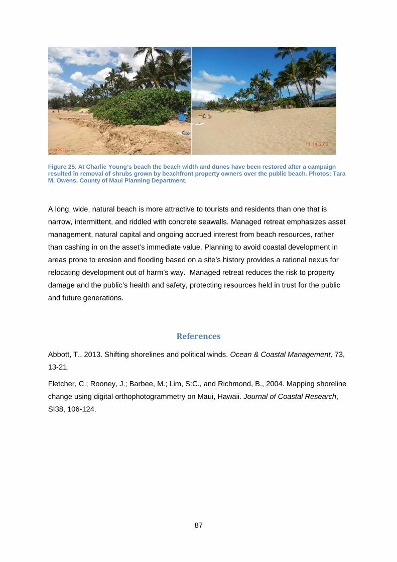
87
Figure 25. At Charlie Young’s beach the beach width and dunes have been restored after a campaign resulted in removal of shrubs grown by beachfront property owners over the public beach. Photos: Tara M. Owens, County of Maui Planning Department.
A long, wide, natural beach is more attractive to tourists and residents than one that is
narrow, intermittent, and riddled with concrete seawalls. Managed retreat emphasizes asset
management, natural capital and ongoing accrued interest from beach resources, rather
than cashing in on the asset’s immediate value. Planning to avoid coastal development in
areas prone to erosion and flooding based on a site’s history provides a rational nexus for
relocating development out of harm’s way. Managed retreat reduces the risk to property
damage and the public’s health and safety, protecting resources held in trust for the public
and future generations.
References
Abbott, T., 2013. Shifting shorelines and political winds. Ocean & Coastal Management, 73,
13-21.
Fletcher, C.; Rooney, J.; Barbee, M.; Lim, S:C., and Richmond, B., 2004. Mapping shoreline
change using digital orthophotogrammetry on Maui, Hawaii. Journal of Coastal Research,
SI38, 106-124.

88
8. Managed realignment in the UK: the role of the Environment
Agency
Karen Thomas
Environment Agency, Eastern Area Senior Coastal Advisor, Ipswich, UK
8.1. Introduction
Discussion about managed realignment started in the UK in the late 1980’s. At the time
practitioners were questioning the need for ongoing maintenance of flood defences in some
locations around the coast due to rising costs. In particular consideration was given to
locations where there were relatively self-contained rural areas of land, rising in elevation
from the floodplain with no people, property or infrastructure. At the same time coastal
squeeze had been identified as an issue and saltmarsh habitat was in decline so there were
calls to recreate intertidal habitat areas.
By the mid-late 1990’s the selection of early managed realignment sites was based on the
conditions of the flood defences and challenges faced to maintain them (e.g. exposure to
high wave energy or undercutting by tidal currents) and the willingness of landowners to the
new approach. Intertidal habitat and new flood storage areas were created as a result.
The Environment Agency (EA) is responsible for the strategic overview for flood and coastal
management for England (EA, 2007). Partner organisations and the EA have successfully
delivered managed realignment at about 50 UK locations in the past three decades, resulting
in the creation of 400 ha of intertidal habitat. By the end of 2014, a further 500 ha of new
intertidal habitats will be created with the completion of the second phase of Medmerry and
the new Steart Peninsula site, the two largest managed realignment sites in the UK to date
(Figure 26).

89
Figure 26. Managed realignment at Medmerry (left), West Sussex, southern England, was breached in November 2013; it will create around 320 ha of intertidal habitat once completed. The Steart Coastal Management Project under construction (right), Somerset, southwest England, is the largest managed realignment site in the UK to date (over 400 ha); breach is to occur in 2014.
This chapter will describe the EA’s role in implementing managed realignment as a
mechanism for delivering broader flood risk and environmental policy agendas and the
opportunities and challenges that exist. The text identifies legislative and policy drivers and
discusses the use of emerging ecosystems services and biodiversity offsetting approaches
to support managed realignment. The importance of engaging communities, landowners and
partners is considered, especially in the light of results from a survey about lessons learnt to
date from managed realignment practices (Thomas, 2013) conducted for the EA programme
entitled Better Ways of Working.
8.2. Legal and policy drivers for managed realignment
Defra’s biodiversity policy sets as a minimum standard that all flood risk management works
must be environmentally acceptable (Defra, 2011). The EA is required to seek opportunities
for environmental enhancement when selecting flood and coastal defence options both at
the strategic and project level. Defra’s biodiversity outcome measures are reflected in the
EA’s corporate strategy47 as performance targets. To achieve these targets, a strategic view
is needed, both to deliver the most cost-effective managed realignment and to maximise
opportunities to create habitats from the start of the planning process. Biodiversity is at the
centre of both legal and policy drivers leading to the implementation of managed
realignment. The main drivers are described next.
47 The EA’s corporate reports, including updates, can be accessed from: http://www.environment-agency.gov.uk/aboutus/149594.aspx.

90
8.2.1. EU Habitats and Birds Directives
On behalf of the UK Government the EA is responsible for ensuring that all possible actions
are taken to avoid further net loss of protected intertidal habitats. As part of this legislative
duty, the EA needs to maintain Natura 2000 sites and habitats that support protected bird
species and assemblages. Therefore, any flood-risk management scheme which
unavoidably affects Natura 2000 sites requires creation of habitat as a compensatory
measure. In some places, the only way to protect people and properties from flood risk is
through new or improved flood defences. Where upgrading of existing flood defences or
construction of new ones are proposed within designated Natura 2000 sites damage or loss
of intertidal habitats must be compensated for.
The legal requirement of protecting Natura 2000 sites also takes into consideration long-term
processes leading to habitat loss and degradation (e.g. due to coastal squeeze) and both
historical and future losses count to estimate the extent of compensatory habitat that needs
to be created. A recent review on the implementation of the Habitats and Birds Directives
(Defra, 2012) indicates that the ecosystems approach can and should play a greater role in
assisting long-term strategic decisions about mitigation and compensation measures.
8.2.2. EU Water Framework Directive (WFD)
The WFD requires consideration of the potential impacts of retaining flood defences around
our coast and estuaries on water quality and the features that support it. The WFD requires
improvements to the ecological status of transitional (estuarine) and coastal water bodies
and a need to retain or increase vital intertidal habitats. Where flood defences are
constraining natural estuary functions, the implementation of WFD may actively support
managed realignment as a remedy against coastal squeeze and to improve the ecological
status of transitional and coastal water bodies. In the UK, WFD policy is developed through
River Basin Management Plans (RBMPs), which are the highest tier of strategic plans
promoting delivery of sustainable water management including flood and coastal
management. There is also guidance to develop WFD assessments as part of SMPs (e.g.
East Anglia Coastal Group, 2010). RBMPs give a steer on managed realignment as an
option, especially where broader water management outcomes align with SMP. The project
Managed Realignment: Moving Towards Water Framework Objectives48 (funded by the EU
LIFE programme) used existing evidence to provide guidance for practitioners on how
managed realignment can lead to the improvement of ecological quality in estuaries meeting
the standards set by the WFD.
48 Project reports are available from: http://www.environment-agency.gov.uk/homeandleisure/floods/123710.aspx.

91
8.2.3. UK Government policy on flood risk management and habitat creation
Defra encourages a strategic (e.g. estuary-wide) approach to deliver intertidal habitat re-
creation, including compensation for sea-level rise. As the EA manages several thousand
kilometres of flood defences around the coast of England, coastal squeeze is an issue that
must be addressed to meet environmental obligations. A strategic approach helps to
conserve sites subject to long-term habitat loss and avoid delays in implementing justified
flood management works. RBMPs and SMPs are best placed to provide the necessary
business case, strategic framework and rationale for undertaking habitat creation for
compensation and environmental enhancement. The creation of larger areas of new habitat,
rather than several isolated smaller areas, is encouraged as a more sustainable approach
both ecologically and economically.
Regional Habitat Creation Programmes (RHCP) proactively seeks willing landowners to
develop managed realignment projects ahead of capital projects and ongoing maintenance
needs of EA’s flood defences. The EA then acquire sites, as and when they become
available. This strategic approach helps reduce land purchase costs to the taxpayer and
allows planning, in collaboration with landowners and partners, to maximise project
outcomes. The RHCP approach was first implemented in the Anglian region in 2003 and
has since been replicated across EA’s regions. These regional programmes have a system
of recording, reporting and accounting for habitat created and provide a national view of
habitat gains and losses. The recording system allows identifying whether there is a pipeline
of projects in place to balance current and future coastal change. The RHCP system is
auditable and transparent to clarify the links with the statutory drivers and outcomes.
The strategic approach described here has been successful. However, delivering managed
realignment is challenging. Finding willing landowners is difficult. Gaining support from
communities and local politicians can be very hard. Often managed realignment is perceived
as ‘giving up land to the sea’ (see Chapter 2), especially where landowning families have
been involved in local flood defence management in the past. New legislation and
innovative ways to assess the value of the natural environment (e.g. ecosystem services)
are creating opportunities to improve and adapt our approach to managed realignment.
8.2.4. Emerging policy
The report Making Space for Nature: A review of England’s Wildlife Sites and Ecological
Network (Lawton et al., 2010) sets out a number of recommendations that will shape future
government’s directions about nature conservation. The report suggests that to face climate
change impacts (e.g. sea-level rise and increased storminess) natural defences will be more

92
important than ever. The need for dynamic coastal environments is highlighted and, to
promote dynamic coastlines, investments in ‘soft engineering’ solutions are required. The
importance of ecosystem services is emphasised, including the role of saltmarshes in natural
flood regulation, carbon sequestration and nutrients cycling.
One of the biggest challenges in delivering managed realignment is the engagement of
willing landowners. Creating new funding streams to incentivise landowners to embrace
managed realignment might be an option to address this issue. Lawton et al. (2010)
recommend that the government should promote the creation of new markets and stimulate
payment for ecosystem services to ensure these are taken into account in decisions that
affect the management and use of the natural environment.
“The urgent and logical next step is to develop markets that enable these values to be
realised for services such as water quality, flood risk management, climate regulation
and other benefits.
If we take into account the potential values of a broad range of ecosystem services,
the benefits of establishing and managing a coherent and resilient ecological network
could, in many situations, outweigh the costs many times over. There is an urgent
need to develop market mechanisms through which landowners can realise the value
of the ecosystem services that their land provides to society.” (Lawton et al., 2010
p.83).
Payment for ecosystem services is now under consideration by Defra as a mechanism for
funding habitat management (Dunn, 2011; Scott Wilson, 2011). There has been an increase
in interest in recent years in the creation of new, small-scale markets to fund nature
conservation management (Scott Wilson, 2011). There is already evidence that people are
prepared to pay a premium for products that bring benefits for wildlife and other
environmental values, including more sustainable ways of farm and land management
(Dunn, 2011). Understanding the links between biodiversity and a wider range of ecosystem
services is rapidly improving and we are increasingly able to place values on such services
(Ecosystem Markets Task Force, 2013; Defra, 2013).
Defra are currently piloting ecosystem services approaches, for example, to support the
development of flood risk management policies in a community-led estuary management
plan such as in the Deben Estuary in Suffolk. The Deben Estuary Partnership, the EA and
the Suffolk Coast and Heaths Unit are working together in the development of the Deben
Estuary Plan49. In demonstrating the benefits that ecosystems have to offer and establishing
49 Information about the partnership and the Deben Estuary Plan can be found at: http://www.suffolkcoastandheaths.org/projects-and-partnerships/deben-estuary-partnership/

93
which flood risk management policies will enhance ecosystems, communities and partners
are better able to identify the most sustainable options. By identifying the benefits of flood
risk management approaches, including managed realignment, it is possible to map potential
beneficiaries who in turn may be interested in investing in the delivery of the plan. Such
approach supports the Sustainability Appraisal process, which is an essential element of the
plan. The experience gained in the development of the Deben Estuary Plan and the
extensive work already conducted on the Humber Estuary will underpin how the Government
and the EA will use ecosystem services in the future.
Biodiversity offsetting has been suggested as a way of enhancing nature and creating wider
benefits through planning (Lawton et al., 2010; Ecosystem Markets Task Force, 2013; Defra,
2013). Biodiversity offsets are designed to compensate for residual and unavoidable harm to
existing wildlife sites caused by development. It is fundamental to biodiversity offsets the
production of measurable outcomes, based on losses and gains being quantified in the
same way (Defra, 2012b). This mechanism aims to ensure that, when a development
causes detrimental impact on nature (and this damage cannot be avoided), new, bigger or
better nature sites will be created. Biodiversity offsetting could be a mechanism used to
support managed realignment in estuarine and coastal areas to create new coastal wetlands
(ICE Maritime Expert Panel, 2013).
In 2012, Defra started a two-year pilot programme for biodiversity offsetting50 at six locations
(managed by Natural England, Defra and local councils): Devon, Doncaster, Essex, Greater
Norwich, Nottinghamshire, Warwickshire, Coventry and Solihull. The lessons learnt from
these pilots will inform UK Government policy. In September 2013, Defra started an open
consultation asking about the role biodiversity offsetting could play in mitigating and
compensating for environmental damage as a result of development in England. The
responses to the consultation are currently being analysed and the outcome will soon be
published.51
Biodiversity offsetting has the potential to be more broadly and strategically used.
Developers could invest in intertidal restoration projects in a similar way that some private
companies invest in ‘green’ projects as part of their wider business portfolio. In particular,
carbon and nutrient sequestration opportunities that saltmarsh re-creation offer would be
directly comparable with other carbon offsetting initiatives that are now common-place in
corporate business.
50 Further details about biodiversity offsetting in the UK can be found at: https://www.gov.uk/biodiversity-offsetting 51 The consultation outcomes will be available from: https://www.gov.uk/government/consultations/biodiversity-offsetting-in-england.

94
Ecosystem services approaches are already being employed in managed realignment
projects and at the strategic level in development of flood risk management plans.
Biodiversity offsetting is an emerging mechanism that could provide further support to
managed realignment in the future. The current EA corporate strategy will be reviewed in
2015 and any emerging policy will be reflected in the 2016-2020 strategy.
8.3. What have we learnt from existing managed realignment projects?
Many managed realignment projects are currently in place or underway. However, within the
existing policy and legislative framework, the ease and speed of managed realignment
delivery can be challenging. Local opposition has prevented the implementation of managed
realignment even in areas where realignment has already been implemented, such in Essex
and on the Humber estuary (Figure 27).
In 2013, the EA has decided to review existing experiences with the objective to inform and
improve works related to flood and coastal risk management. As part of the Better Ways of
Working Programme the review aimed to establish a snapshot of the current thinking among
practitioners about managed realignment projects that have been delivered to date. A
questionnaire was developed and distributed to key practitioners (within the EA and
externally) with experience in managed realignment projects asking their views on lessons
learnt and opportunities to take forward new ways of working. A relatively small number of
practitioners have actually managed realignment projects and their experience and
knowledge is valuable and needed to be documented.
Figure 27. Managed realignment at Abbotts Hall (left), Blackwater estuary, Essex, and Paull Holme Strays (right), Humber estuary.
The EA is using the outputs of the questionnaire survey to inform practitioners and
encourage further efficiencies and innovative approaches to managed realignment projects

95
in the future. To build in-house capacity and expertise, the EA also takes into consideration
evidence produced by other studies, such as the independent survey conducted by
Bournemouth University (Esteves and Thomas, 2014). The EA survey covered four broad
aspects relevant to the implementation of managed realignment projects and a summary of
the outcomes in each of these aspects is presented below.
8.3.1. Engagement and Communication
Since the late 1990s, due to changing legislation, the primary objective for managed
realignment has shifted from flood risk management to an option to create compensatory
habitat. Currently there is a general view that emphasising managed realignment as a
multifunctional approach might make it more appealing to the public and stakeholders and
help attract funds from a wider range of sources. By engaging with local communities to
identify how they are likely to benefit from future managed realignment, a greater sense of
ownership might be created leading to increased uptake of managed realignment in general
and better acceptance of projects near their homes and businesses.
The reasons for delivering managed realignment are varied and there is no single
justification that may be appropriate to all projects. However, it is important that practitioners
are able to communicate a clear and consistent message about why managed realignment
is needed here and now. It is important to consider how stakeholders and partners perceive
managed realignment so a communication strategy can be developed to address common
misunderstandings and false expectations. Public engagement and uptake will be even
more important to support the emerging role of managed realignment in delivering Water
Framework Directive and climate change adaptation outcomes (Committee on Climate
Change, 2013).
Tools and techniques available to practitioners for engagement and communication are well
advanced. However, having time to engage and reach the relevant groups has been
identified as challenging. Opportunities to enhance engagement should be sought where
possible, particularly with regard to the messages we give about managed realignment.
Sometimes even policy names may lead to misconceptions. For example, managed retreat
was often used interchangeably with managed realignment but fell in disuse as it was
considered to give a negative connotation to the policy (see Chapter 2). Intertidal wetland
restoration is emerging as a more favourable policy name to replace managed realignment.
At many locations, public perception has been challenging, sometimes delaying or
preventing the implementation of local managed realignment projects (e.g. the second
breach Deveraux farm in Essex and Donna Nook on the Humber). Local communities
sometimes are uncertain about the benefits they might accrue from managed realignment.

96
Public opposition is a problem especially when projects involve loss of access rights to
existing footpaths or there is a perception that increased flood risk will occur elsewhere in
their area. Public perception is clearly a communication issue that needs to be addressed;
even more so as it also affects partnership and funding opportunities.
8.3.2. Statutory process
The process for obtaining statutory consents and licences required for managed realignment
are often perceived as a significant challenge. Since managed realignment projects are still
relatively rare compared to the more routine planning applications on the coast, planners
and regulators need support at an early stage to increase knowledge and understanding.
The publication of the latest SMPs should help to underpin decision-making at planning
stages. Whilst the SMP is not a statutory planning document, most Local Authorities have
adopted or endorsed SMP policies (including managed realignment) and embedded these
policies into core planning documents (e.g. Local Plans and Core Strategies). Consequently,
there is policy guidance to support statutory consultees, which should improve the planning
process for future managed realignment projects.
Understanding the timescales of statutory processes is key to avoiding delays later in the
project. The EA has a role to work closely with statutory partners to streamline the process
so that the various planning and marine consents are aligned (e.g. planning permission,
marine licences, sustainability or strategic environmental appraisal). Individually these can
each take several months so they need to be planned in parallel where possible.
Straightforward managed realignment projects with good partnerships and engaged
communities can be delivered with 2-3 years (e.g. Abbotts Hall) but more typically take
longer if popular footpaths and perceived flood risk issues are involved (e.g. Deveraux farm
Essex and Donna Nook Humber respectively). Whilst there will be local differences, the
RHCP approach means that knowledge can be shared across England between EA
practitioners and partners to ensure a consistent approach is employed.
8.3.3. Technical expertise
Practitioners in the UK have the knowledge and expertise to develop and create managed
realignment projects. Technical expertise seems to be the aspect in which practitioners
have gained the most experience and confidence, especially in terms of selecting,
engineering, monitoring and modelling managed realignment projects. However, it is
important to recognise that only few practitioners have direct experience of managed
realignment so sharing tools and techniques is a good way to build and enhance capacity for
the future.

97
The EA will be seeking opportunities to build knowledge and experience through networks
and sharing of good practice. The EA intends to compile and centralise relevant information
and guidance, which will be then signposted to EA and external practitioners. In addition,
sharing data obtained from monitoring is key to developing robust evidence whilst reducing
costs. This is already under development with Natural England and can easily be extended
to other organisations and partners.
As discussed in Section 8.2.4, managed realignment is likely to play an important role in the
implementation of biodiversity offsetting opportunities, ecosystems services and the Water
Framework Directive. As new objectives and requirements emerge, the development of
appropriate technical expertise will be needed.
8.3.4. Funding and partnership
The EA has specific outcomes for managed realignment sites for which Government funds
are available. The EA have successfully worked with landowners and non-Government
organisations, most notably the Royal Society for the Protection of Birds (RSPB) and The
Wildlife Trusts, to deliver wider environmental and socio-economic outcomes. Experience
has shown that working in partnership is the best way forward. Good examples to date
include: Abbotts Hall (Figure 27) involving partnership with the Essex Wildlife Trust; and
many projects delivered in partnership with the RSPB, such as Freiston in Lincolnshire,
Medmerry (Figure 26) on the southern Kent coast and Wallasea Island (Figure 28) in Essex.
Figure 28. Breaching of flood defences at Wallasea Island (Crouch estuary, Essex) was completed on the 4th July 2006. The project was implemented in partnership with the landowner and the RSPB.

98
Partnerships allow for shared knowledge strengthening potential for success in terms of
project delivery and the likelihood of local acceptance. Shared knowledge facilitates the
identification and dissemination of the wider benefits managed realignment can deliver and
partners contribute to select the appropriate design to maximise chances for the realisation
of the intended outcomes. Partnerships generally lead to a more streamlined project delivery
and help attracting wider funding streams, supporting the objective to create more
sustainable coasts that can adapt to climate change and sea-level rise.
Finding willing landowners is a challenge that leads to the conundrum of strategic versus
opportunistic habitat creation. Current SMPs and Estuary plans indicate the locations where
managed realignment is the most sustainable policy options. However, the willingness of
landowners is central to enable the strategic view to be delivery at the local level. managed
realignment projects cannot progress without willing landowners. Landowners can choose to
maintain flood defences with private funds in locations where flood defences are no longer
economic (and therefore no longer maintained by the Government). As a result it may be
challenging to deliver managed realignment in the most sustainable locations.
If willing landowners are identified in less suitable locations, the EA may choose to
implement managed realignment at these more opportunistic sites due to the need to meet
habitat creation targets. However, opportunistic managed realignment schemes do not
always deliver the best return for the investment of public money and there is a need to
balance opportunity against the benefits that can be realised. Results of a survey conducted
within the Managing Coastal Change Project 52 indicates that landowners are not necessarily
adverse to managed realignment as a policy but they express that greater business
incentives are needed to encourage them to ‘give up’ productive agricultural land for
intertidal habitat creation.
The ecosystem services approaches currently being piloted by Defra (see Section 8.2.4)
identify the type of benefits that can be realised from managed realignment and the potential
beneficiaries. Such approaches may provide funding mechanism opportunities for future
managed realignment projects. Managed realignment is likely to play an important role in
the implementation of the Water Framework Directive, biodiversity offsetting and ecosystems
services approaches. Improved understanding of the wider benefits provided by managed
realignment in the light of emerging policies is expected to strengthen project outcomes and
enhance the appeal to partners, funders and communities.
52 The project was funded by Making Space for Water-Defra 2007 Innovation Fund, which was set up to share £1.2 million across UK to non-government projects concerning adaptation to climate change.
99
8.4. Conclusions
The EA is required to deliver intertidal habitat due to legal requirements and to implement
Government policy through RHCP. The EA contributes significantly to managed realignment
developments in England and, through managed realignment, will have created over 900 ha
of intertidal habitat by 2015. Funding and partnership working is fundamental to the delivery
of managed realignment at the strategic and local level. Working in partnership is the best
way to ensure the delivery of multi-functional coastal wetlands and to gain trust and support
from local communities and stakeholders. Emerging ecosystems services and biodiversity
offsetting approaches are under consideration and, following policy guidance from Defra,
these will be reflected in the EA Corporate plan 2016-2020, which will steer future directions
of managed realignment implementation. The EA recognises the importance of managed
realignment as an approach for delivering a wide range of environmental, socio-economic
and flood risk management outcomes. The EA will continue to work with landowners,
communities and partners to promote and develop managed realignment projects with the
objective of delivering the greatest benefits to society while meeting statutory environmental
requirements.
References
Committee on Climate Change, 2013. Chapter 5: Regulating services – coastal habitats.
Available from: http://www.theccc.org.uk/wp-content/uploads/2013/07/ASC-2013-
Chap5_singles_2.pdf, pp. 92-107.
Defra, 2006. Shoreline management plan guidance. Volume 1: Aims and requirements.
Available from:
https://www.gov.uk/government/uploads/system/uploads/attachment_data/file/69206/pb1172
6-smpg-vol1-060308.pdf, last accessed on 14 January 2014.
Defra, 2011. Biodiversity 2020. A strategy for England’s wildlife and ecosystem service.
Available from:
https://www.gov.uk/government/uploads/system/uploads/attachment_data/file/69446/pb1358
3-biodiversity-strategy-2020-111111.pdf, last accessed on 16 January 2014.
Defra, 2012a. Report of the Habitats and Wild Birds Directives Implementation Review.
Available from:
https://www.gov.uk/government/uploads/system/uploads/attachment_data/file/69513/pb1372
4-habitats-review-report.pdf, last accessed on 14 January 2014.

100
Defra, 2012b. Biodiversity Offsetting Pilots. Technical Paper: the metric for the biodiversity
offsetting pilot in England. Available from:
https://www.gov.uk/government/uploads/system/uploads/attachment_data/file/69531/pb1374
5-bio-technical-paper.pdf, last accessed on 18 January 2014.
Defra, 2013. Realising Nature’s value: The Final Report of the Ecosystem Markets Task
Force. Government Response. Available from:
https://www.gov.uk/government/uploads/system/uploads/attachment_data/file/236879/pb139
63-government-response-emtf-report.pdf, last accessed on 16 January 2014.
Dunn, H., 2011. Payments for Ecosystem Services. Defra Evidence and Analysis Series,
Paper 4. Available from:
https://www.gov.uk/government/uploads/system/uploads/attachment_data/file/69329/ecosyst
em-payment-services-pb13658a.pdf, last accessed on 16 January 2014.
East Anglia Coastal Group, 2010. The Wash Shoreline Management Plan. Appendix K
Water Framework Directive Assessment. Available from: http://www.eacg.org.uk/smp4.asp,
last accessed on 15 January 2014.
Ecosystem Markets Task Force, 2013. Realising Nature’s value: The Final Report of the
Ecosystem Markets Task Force. Available from: http://www.defra.gov.uk/ecosystem-
markets/files/Ecosystem-Markets-Task-Force-Final-Report-.pdf, last accessed on 16
January 2014.
Environment Agency, 2007. Coastal Strategic Overview - Implementation Plan. Sea
Flooding and Coastal Erosion Risk Management. Available from:
www.archive.defra.gov.uk/environment/flooding/documents/policy/strategy/coastimp.pdf,
last accessed on 14 January 2014.
Esteves, L.S. and Thomas, K., 2014. Managed realignment in practice in the UK: results
from two independent surveys. Journal of Coastal Research, Special Issue 66.
ICE Maritime Expert Panel, 2013. The Role of Coastal Engineers In Delivering No Net Loss
through Biodiversity Offsetting - A Discussion Paper. Available from:
http://www.ice.org.uk/Information-resources/Document-Library/The-Role-of-Coastal-
Engineers-in-Delivering-No-Net, last accessed on 18 January 2014.
Lawton, J.H., Brotherton, P.N.M., Brown, V.K., Elphick, C., Fitter, A.H., Forshaw, J.,
Haddow, R.W., Hilborne, S., Leafe, R.N., Mace, G.M., Southgate, M.P., Sutherland, W.A.,
Tew, T.E., Varley, J., and Wynne, G.R., 2010. Making Space for Nature: A review of
England’s Wildlife Sites and Ecological Network. Report submitted to Defra. Available from:

101
http://archive.defra.gov.uk/environment/biodiversity/documents/201009space-for-nature.pdf,
last accessed on 15 January 2014.
Scott Wilson, H., 2011. Barriers and Opportunities to the Use of Payments for Ecosystem
Services. Final Report to Defra. Available from:
http://randd.defra.gov.uk/Document.aspx?Document=PESFinalReport28September2011(FI
NAL).pdf, last accessed on 16 January 2014.
Thomas, K., 2013. A Review of Managed Realignment. Sharing and embedding coastal
knowledge. Report for the Environment Agency Programme Better Ways of Working,
October 2013.

102
9. Factors Influencing the Long-Term Sustainability of managed
realignment
Nigel Pontee
CH2M HILL, Global Technology Leader Coastal Planning & Engineering
Burderop Park, Swindon, SN40QD, UK
9.1. Introduction
Managed realignment is considered here in its most common form, which involves re-
introducing tidal regimes to areas of previously reclaimed low-lying land. This can be
undertaken by breaching or removing the existing flood defences; or by using structures
(e.g. culverts, tidal gates) to create RTE schemes. Managed realignment typically creates a
range of mudflat, saltmarsh and transitional habitats.
Managed realignment helps reducing flooding and erosion risks by allowing coastal habitats
to migrate inland in response to climate change and sea-level rise. Managed realignment
can therefore help limit the projected increase in the cost of providing coastal defences in the
long-term (Adaptation Sub-Committee, 2013) and plays an important role in the
management of our coasts (Pontee and Parsons, 2012). In the UK, more than 50 managed
realignment schemes have been implemented (ABPmer, 2013) and an estimated 1,300 ha
of new intertidal habitat were created (Adaptation Sub-Committee, 2013).
In order to discuss whether managed realignment is sustainable in the long-term, it is
necessary to understand the main policy drivers to date and the direct or indirect influencing
factors at the strategic and implementation levels. In the UK, two main drivers lead to the
implementation of managed realignment:
Provision of compensatory habitats required under European legislation: The Habitats
Directive and the Birds Directive have been important drivers for restoring coastal habitats in
Europe (see Pontee et al., 2013 for further details). Port expansion projects reclaiming
intertidal mudflat habitat, or construction of sea defences on existing saltmarsh, commonly
need to provide compensatory habitat, including for indirect losses arising from coastal
squeeze. In the UK, compensation measures have commonly been delivered by recreating
new habitats within managed realignment schemes.

103
Strategic flood and coastal erosion management: In England and Wales the central
Government plays a key role in setting the policy framework for flood and coastal defence
(see Chapter 8). The strategic approach has been implemented through a three level
hierarchy of Shoreline Management Plans (SMPs), strategy plans and schemes (e.g. Pontee
et al., 2005; Pontee and Parsons, 2010). The idealised route for a flood risk management
scheme would therefore be: (1) for the SMP to recommend this as a policy, (2) a strategy to
confirm the policy and to identify the type of scheme that will deliver the policy, and (3) a
scheme to carry out the detailed design, seek necessary approvals (e.g. planning permission
etc.) and implement the works. Strategies typically investigate net gains and losses of
existing habitats and make recommendations about how and where managed realignment
should be implemented. Further details on assessing the gains and losses of estuary
habitats can be found in Canning and Pontee (2013). Strategic approaches to the
management of coastal habitats for some coasts and estuaries have been promoted by
Coastal Habitat Management Plans (CHaMPS, led by Natural England) and specific habitat
management or managed realignment studies funded by the Environment Agency or Local
Authorities.
The most recent round of SMPs and strategies in England and Wales developed policies for
three epochs (0-20, 20-50 and 50-100 years). These timescales were deliberately chosen in
recognition that present day ‘hold the line’ policies may not be sustainable, but that coastal
communities need time to adapt to more sustainable polices such as managed realignment.
According to the Adaptation Sub-Committee (2013) the managed realignment policies
proposed in the SMPs for the English coast will create approximately 6,200 ha by 2030 and
11,500 ha by 2060.
The two drivers of (i) compensatory habitat provision and (ii) coastal defence management
are interlinked. Additionally, when analysing schemes that have been constructed,
confusion may arise between the driver (i.e. the primary reason why a scheme is
undertaken) and the resulting benefits. Whilst some schemes, such as Welwick53 (Humber
estuary), have been undertaken purely to recreate habitat lost to port development in the
estuary, many other schemes have involved both drivers in some way. The following
examples illustrate this:
• The Alkborough scheme in the Humber Estuary (Figure 29) was driven by the need to
provide compensation for habitat loss directly and indirectly caused by flood defences
throughout the estuary, but also by the opportunity to reduce extreme water levels and
flood defence costs elsewhere in the estuary (see Wheeler et al., 2008).
53 Breaching of flood defences at Welwick MR site occurred in 2006 and this 54 ha scheme forms part of the compensation package for port developments at Immingham and Hull.

104
Figure 29. Alkborough Flats scheme in the Humber Estuary. This scheme was opened in September 2006 with the principal objectives being to create new inter-tidal habitat and provide flood storage. Photo by www.petersmith.com, courtesy of the Environment Agency.
• Hesketh Out Marsh West in the Ribble Estuary (Figure 30) was developed to create
additional intertidal habitat to compensate for habitat losses in Morecambe Bay, while
maintaining flood defence standards in the local area of the Ribble (see Tovey et al.,
2009).
Figure 30. Hesketh Out Marsh West in the Ribble Estuary during the construction phase. The scheme covers about 168 ha and was opened in 2008 with the principal objective being to create compensatory intertidal habitat. Photo courtesy of the RSPB.

105
• The Steart Scheme in the Parrett Estuary (Figure 31) was undertaken primarily to
provide compensatory habitat for loses caused by sea defences in the Bristol Channel
and Severn Estuary, but also allowed the provision of improved flood defences to the
village of Steart and its access road.
Figure 31. Steart Coastal Management Project in the River Parrett is due to be opened in autumn 2014. This scheme has two objectives: to provide compensatory habitat and to improve flood defences for the local community. Note that the breach has not yet occurred at the time of the photo, the water seen within the scheme is freshwater due to a particularly wet winter. Photo courtesy of the Environment Agency.
9.2. Factors influencing the sustainability of managed realignment
Sustainable shoreline management policies have been defined as “those which take account
of the relationships with other defences, developments and processes, and which avoid, as
far as possible, committing future generations to inflexible and expensive options for
defence” (Defra, 2006, p. 12). However, in the real world, practical understanding of
sustainability typically varies between stakeholders depending on their interest or
perspective. This is especially the case for managed realignment schemes since the natural
habitats created can perform a number of functions (see Table 1). The sustainability of
schemes can be considered from any of these perspectives. A recent review stated that the
ecosystem services provided by coastal habitats, could equate to a value of £680 to £2,500
per hectare (Adaptation Sub-Committee, 2013). The key factors influencing the sustainability
of managed realignment are identified and discussed below.

106
9.2.1. Creation of habitats within realignment sites
Since managed realignment schemes are often used to provide compensatory habitat it is
important to consider how the habitat created within schemes compares with natural
habitats. The successful creation of intertidal habitats hinges on the creation of appropriate
physical conditions within sites. Key physical aspects include a number of hydraulic,
hydrological, morphological and sedimentological factors (see Pontee, 2003).
Site elevation is one of the most fundamental considerations in the design of intertidal
habitats. Elevation influences the frequency and duration of tidal inundation, as well as
exposure to wave action, all of which affect the colonisation and development of vegetation
(Pontee, 2003). Given this, it is perhaps not surprising that inappropriate elevations has
been one of the most significant factors in the failure of a number of schemes in the USA in
the past (Roberts, 1991). In the UK, experience has shown that saltmarsh recreation
proceeds best between elevations of mean high water neap (MHWN) tides and mean high
water spring (MHWS) tides, which equates to around 450–500 tidal inundations each year.
Furthermore, a gradual, ‘natural’ gradient across the marsh surface provides a range of
elevations and tidal inundations, which promotes a more diverse saltmarsh (Toft and
Madrell, 1995).
Site elevation is a dynamic parameter influenced by sedimentation levels in the site. In
estuaries with high suspended sediment concentrations such as the Humber or the Severn,
is that it can be difficult to create sustainable, long term mudflat habitat within schemes. This
is because the high sediment supply coupled with relatively quiescent conditions within the
realignment site can lead to high siltation rates, which cause mudflats to accrete vertically
and evolve into saltmarsh habitats (Morris, 2012; Pontee, 2014). Such habitat changes have
implications for invertebrate assemblages and bird usage (ABP Research & Consultancy
Ltd, 1998; Atkinson et al., 2001; Nottage and Robinson, 2005).
Mazik et al. (2010) have concluded that realignment sites may only be a short-term solution
to the loss of intertidal mudflats, owing to high natural accretion rates within the sites
resulting in a change from mudflat to saltmarsh. On the Humber high siltation rates have
been observed in the many realignment sites particularly in the early years following
opening. For example at Alkborough the first year of monitoring recorded rates of up to 0.58
m. Similarly at Paull Holme Strays rates of up to 0.17 m were measured over a three months
period. The design issues associated with high siltation rates are described further in Pontee
(2014).

107
In relation to the use of managed realignment to re-create saltmarsh habitats, Mossman et
al. (2012) found that the resulting plant communities were significantly different in their
composition from natural marshes since several species were absent. However, ongoing
work by Mossman and her co-workers has indicated that raising elevation within small plots
and planting seedlings meets with a high degree of success. If such concepts can be scaled
up to larger areas then this could help ensure that saltmarsh communities within schemes
are a closer match to natural marshes.
Another issue with creating habitats within schemes in areas of low salinity is the
colonisation of site by the common reed (Pragmites australis). This can be a problem in the
upper parts of estuaries with freshwater inflows. Such issues have recently been
encountered in feasibility studies looking at managed realignment options in the River Clyst,
a tributary to the Exe Estuary, and the inner parts of Poole Harbour (Figure 32).
Figure 32. Extensive areas of reeds have colonised the inner parts of Poole Harbour. The presence of reeds means that there is a high likelihood of them colonising any managed realignment sites that are created in this area. Photo by Nigel Pontee.
9.2.2. Is there sufficient land to offset the predicted losses of coastal habitats?
Coastal habitats have been lost around England and Wales due to development, conversion
to agricultural land and coastal erosion. It has been estimated that extent of coastal habitats
in England (excluding mudflats), declined by 13,000 ha from 1945 to 2010. This was
comprised of the loss of 4,800 ha of saltmarsh, 5,000 ha of shingle and 2,600 ha of dunes
(Adaptation Sub-Committee, 2013). Ongoing sea-level rise means that habitats will continue
to be lost due to erosion and coastal squeeze. Predicting the extent of these losses is,

108
however, subject to high levels of uncertainty. For example the Adaptation Sub-Committee
(2013) stated that there were 21,000 ha of saltmarsh and 45,000 ha of mudflat at risk of
coastal squeeze in front of defences in England. However, these numbers are substantially
greater than those given by Defra/EA (2006), which assessed that up to 4,420 ha of
saltmarsh could be lost due to coastal squeeze in England over the next 100 years. The
latter report also identified a potential gain in other coastal marshes of 4,514 ha, giving a net
increase of 94 ha overall. These differences illustrate the difficulties in making accurate long
term predictions of net changes in habitat extent at a national scale and in using these
predictions to set appropriate targets for the amounts of compensatory habitat required.
The Adaptation Sub-Committee (2013) analysed the SMP policies for England and
calculated that managed realignment policies could create up to 6,200 ha by 2030. This
indicates that significant areas of our coastal zone are potential suitable for managed
realignment. This concurs with the findings of the RSPB (2002) who concluded that 33,088
ha of land were suitable for managed realignment, which was more than sufficient to ensure
no net loss of inter-tidal habitats for 60 years. However, in order to create 6,200 ha by 2030
the current rate of implementation would have to double from its current average rate of 130
ha/year. Given the difficulties in assessing the future losses of habitat losses it is not clear
whether these predicted gains will be sufficient to compensate for all of the past and future
losses, although they will certainly be a significant step in the right direction. Whether or not
such large areas of realignment can actually be delivered depends on a number of factors
which are discussed in the following sections.
9.2.3. Stakeholder support
From many perspectives, which have already discussed here, managed realignment policies
can be argued to be more sustainable than traditional hard engineering solutions. However,
there are a number of other aspects that make local stakeholders reluctant to welcome such
schemes. Local stakeholders may lose land and property, or may need to alter their use of
the land following realignment. Strong stakeholder objection may prevent schemes obtaining
planning permission and thus prevent them from being implemented. When the first
managed realignment schemes were implemented in the UK in the 1990s, there was little
local stakeholder interest. However, public interest has grown over the last two decades and
stakeholder consultation has become increasingly important. There are many reasons for
this increased public interest, including: the more widespread occurrence of managed
realignment, the larger size of some schemes, increased media coverage and internet
access to information. The greater involvement of local stakeholders has been further

109
encouraged by the Localism Bill54. This, plus the increasing involvement of third-party
funders under the latest Flood and Coastal Erosion Risk Management funding mechanism,
may lead to demands for schemes that meet local needs but are unsustainable in the long-
term or have adverse effects further afield. This may make it more difficult to implement local
managed realignments schemes (see Pontee et al., 2011).
A key aspect in the successful promotion of managed realignment schemes is therefore the
early and continued engagement of local stakeholders in the decision making process.
Managed realignment schemes can provide a number of benefits (e.g. bird watching, fishing,
walking, cycling, horse riding and other leisure activities) which may help attract the support
of local stakeholders. However, careful dialogue is needed with local residents to ensure that
such interests do not lead to unwanted visitors to areas which have hitherto been quiet
backwaters. Whilst managed realignments do lead to changes in agricultural land use, some
practices such as low intensity grazing may continue, and discussions with landowners
along these lines can help gain acceptance for schemes.
9.2.4. Costs of managed realignment
In England at present, the Environment Agency typically works to a guideline cost of £50,000
per hectare for managed realignment schemes. However, many have questioned the validity
of this particular value, especially since it is not index linked. A review of the cost of
managed realignment over the last 20 years in the UK (Rowlands, 2011) has shown that
costs per hectare have varied widely depending on factors such as the size of the scheme,
the promoter and the date of implementation. A recent review of the likely future costs of
managed realignment in Wales shows costs varying from £100,000 to £675,000 per hectare
(Richard Park, 2013), with the higher costs for schemes on contaminated land (see also
Latham et al., 2013). High land prices in some parts of the country (e.g. around the Thames
estuary) can also make implementing managed realignment difficult for government
agencies such as the Environment Agency, who may not be able to justify the expenditure
required to purchase the land. These concerns may be less of an issue for private
developers, such as ports, who may be able to better justify high costs against anticipated
returns on investment.
In the right setting, managed realignment can be a cost effective coastal management
measure in the long-term and this is a key reason why managed realignment policies are
chosen at SMP level. The Adaptation Sub-Committee (2013) concluded that the costs of
implementing managed realignment in England to 2030 (£10m-£15m per year), would be
54 The Localism Bill (2011) gives more power and freedom to local authorities, communities and individuals to decide about planning local development. The legislation documentation can be accessed at: http://www.legislation.gov.uk/ukpga/2011/20/contents/enacted/data.htm.

110
more than offset by the financial savings on flood defence (£180 to £380 million, excluding
flood storage benefits), as well as the environmental benefits (£80 to £280 million). Cost
savings can arise by reducing maintenance requirements for flood defences in a number of
ways. For example, managed realignment schemes may remove the requirement for flood
defences all together, shorten the length of defences and/or create new defences in areas of
reduced wave and tidal energy. Cost savings can also arise if schemes act as flood storage
areas, thereby leading to lower water levels during storms55 and reduced maintenance costs
elsewhere (e.g. Wheeler, et al., 2008).
Managed realignment may not, however, be the cheapest option in all situations. The initial
costs are likely to be higher than maintaining existing defences in the short term and,
compared to no active intervention, managed realignment is a costly option. On large
floodplains where high land lies a substantial distance inland, creating managed realignment
schemes may require construction of the long defences across the floodplain, which
increases scheme costs. A recent review by the Adaptation Sub-Committee (2013) reported
that the overall savings in maintenance costs may have been rather overstated to date due
to the failure to account for additional maintenance costs associated with new pumping
stations, breach maintenance and the larger dimensions of the new defences. These factors
can considerably affect the cost effectiveness of managed realignment schemes particularly
for small schemes.
9.2.5. Agricultural land and food Issues
In several managed realignment sites, such as Hesketh Outmarsh West (Tovey et al., 2009)
and Steart (Burgess et al., 2013), there is a drive to continue low intensity grazing. This does
not however, deal with the issue of losing areas of high grade arable farmland, food security
and land prices in relation to managed realignment (Walsh, 2008). Additionally, increasing
grain prices have driven up the market value of agricultural land in the UK over the last
decade and further increases could make managed realignment more difficult in some areas
in the future.
The Adaptation Sub Committee (2013) concluded that managed realignment would only
result in the loss of 0.1% of England’s high grade agricultural land by 2030. They also
concluded that these losses could be offset by taking advantage of the other ecosystem
services and opportunities provided by managed realignment such as aquaculture, fish
nursery and grazing. This conclusion appears to suggest that the loss of agricultural land will
not pose a problem in the implementation of more realignment in the future. However, not all
farmers will be willing to embrace such changes and substantial stakeholder engagement is 55 Note: In some instances managed realignment can also lead to water levels being raised within estuaries (see Burgess et al., 2013).

111
likely to be required both nationally, with the National Union of Farmers; and locally, with
individual farmers. An incentive for farmers to sell their land for managed realignment
schemes may be the payment of an increment on the market value of the land based on the
additional ecosystems services that may be gained.
9.2.6. Mitigation for freshwater habitat displacement
Managed realignment schemes that lead to a loss of internationally designated freshwater
habitats (e.g. Special Protection Areas, Special Areas of Conservation, Ramsar sites) have
to allow for the re-creation of these habitats elsewhere. This raises the question of whether
there is sufficient space to create these freshwater habitats further landwards. This can be
particularly challenging in estuaries where the current balance of freshwater and marine
habitats may have been significantly altered by embankment construction over many
centuries (see for example Pontee et al., 2013). However, to date freshwater compensation
issues have been dealt with on a site by site basis and, whilst adding difficulty to some
schemes, have not prevented the uptake of managed realignment at a national level.
Nevertheless, studies to determine the availability of secondary compensation freshwater
sites at a national scale would seem to be necessary to inform any assessment of the long
term sustainability of managed realignment as a policy.
9.3. Conclusions
Managed realignment can offer a sustainable long-term management option for coasts and
estuaries by reducing the pressures on flood defences and compensating for habitat lost due
to developments or coastal squeeze. The habitats created also provide other ecosystem
services and opportunities, such as: aquaculture, fish nursery, grazing, and recreation.
Where schemes are undertaken to compensate for the loss of specific habitat types then
careful scheme design is needed. It can be difficult to create sustainable mudflat in estuaries
with high suspended sediment concentrations and although saltmarsh readily forms in
managed realignments, some rare species may be absent. Additionally Phragmites can
prove an unwanted colonising plant in some low salinity settings. These difficulties, plus the
fact that many estuaries currently have an artificial distribution of designated habitats,
suggest that future habitat management could usefully consider wider regions or
biogeographic areas in order to allow some ‘natural’ changes in the balance of habitats in
some estuaries or European Sites (see Pontee et al., 2013).
Over 10 years ago, Defra (2003) noted that managed realignment was perceived as a long-
rather than a short-term solution, due to it being politically less acceptable then. Undoubtedly

112
there will always be some locations where managed realignment cannot be promoted in the
short term. However, the implementation of more than 50 schemes in the last two decades
indicates that, at a national scale, managed realignment can be delivered in relatively short-
time.
To create all the managed realignment schemes identified in SMPs by 2030 will require a
doubling in the current rate of implementation. Studies have shown that there is more than
enough suitable land on which to create managed realignment schemes around our coasts
(RSPB, 2002; Adaptation Sub Committee, 2013). However, managed realignment is not the
best option for all coastal areas. Policies of managed realignment for flood risk management
alone may be uneconomic in areas of high land values, where long lengths of new defences
are needed or where there is contaminated land. Increases in agricultural land prices, plus
competition between private developers and Government Agencies, may also make
managed realignment schemes more difficult to implement in the future. Additionally, local
stakeholder objections may prevent schemes from gaining planning permission in some
areas.
In the future it is certain that we will continue to see managed realignment schemes being
built in the UK. However, managed realignment is not a universal panacea – it will not be
possible to implement this policy everywhere, and schemes are unlikely to be viewed as a
success from all perspectives. Increases in third party funding and greater local involvement
in decisions mean that managed realignment schemes will require the buy-in of many
stakeholders. The continued implementation of managed realignment schemes in the future
will therefore require extensive stakeholder consultation.
References
ABP Research and Consultancy Ltd, 1998. Review of Coastal Habitat Creation, Restoration
and Recharge Schemes. Report No. R 909. ABP Research & Consultancy Ltd.,
Southampton. pp78.
Adaptation Sub-Committee, 2013. Progress Report 2013 - Managing the land in a changing
climate. Committee on Climate Change, 136pp. Available online at:
http://www.theccc.org.uk/publication/managing-the-land-in-a-changing-climate/, Accessed
29th December 2013.
Atkinson, P.W., Crooks, S., Grant, A. and Rehfisch, M.M., 2001. The success of creation
and restoration schemes in producing intertidal habitat suitable for waterbirds. English
Nature Research Report No. 425. English Nature, Peterborough.

113
Burgess, K., Pontee, N., Wilson, T., Lee, S.C., Cox, R., 2013. Steart Coastal Management
Project: engineering challenges in a hyper-tidal environment. Coasts, Marine Structures and
Breakwaters 2013, Aberdeen, 17 - 20 September 2013.
Canning P. and Pontee, N., 2013. Assessing habitat compensation requirements in estuary
environments. Coasts, Marine Structures and Breakwaters 2013, Aberdeen, 17 - 20
September 2013.
Defra, 2009. Appraisal of flood and coastal erosion risk management: A Defra policy
statement, June 2009. 52pp. Available from:
https://www.gov.uk/government/publications/appraisal-of-flood-and-coastal-erosion-risk-
management-a-defra-policy-statement-june-2009, last accessed on 13 January 2014.
Defra/EA, 2006. National evaluation of the costs of meeting coastal environmental
requirements NEoCOMER). R&D Technical Report FD2017/TR Joint Defra/EA Flood and
Coastal Erosion Risk Management R&D Programme. Report produced by Risk and Policy
Analysts Ltd, Royal Haskoning UK Ltd and ABP Marine Environmental Research Ltd for
Defra/EA, April 2006, 2pp.
Defra, 2003. managed realignment Review. Defra/Environment Agency Policy Theme R&D
Project FD2008, Defra Publications, Defra-Flood Management Division, Ergon House,
London SW1P, 2003, 2AL. 222pp + App.
Defra, 2006. Shoreline management plan guidance; Volume 1: Aims and requirements;
March 2006, Available online at: https://www.gov.uk/government/publications/shoreline-
management-plans-guidance, Accessed 29th December 2013.
European Commission, 2009. Council Directive 2009/147/EC on the conservation of wild
birds (the codified and consolidated version of Council Directive 79/409/EEC as amended).
European Commission, 1992. ‘Habitats Directive’ - Council Directive 92/43/EEC on the
Conservation of natural habitats and of wild fauna and flora. European Community directive
adopted in 1992.
FRaME, 2013. FRaME InterReg 3b project – Best Practice Manual for Flood Risk and
Management in Estuaries. http://www.discoverysoftware.co.uk/frame/, Accessed 4 January
2014.
Latham, D., Pontee, N.. Monroe, B., Bond, I., 2013. Reconstructing habitats in a heavily
industrialised estuary: from brine wells to salt marsh. Coasts, Marine Structures and
Breakwaters 2013, Aberdeen, 17 - 20 September 2013.

114
Mazik, K., Musk, W., Dawes, O., Solyanko, K., Brown, Su., Mander, L., Elliott, M., 2010.
managed realignment as compensation for the loss of intertidal mudflat: A short term
solution to a long term problem? Estuarine Coastal and Shelf Science, 90(1), 11-20.
Morris, R.K.A., 2012. Managed realignment: A sediment management perspective. Ocean &
Coastal Management, 65, 59-66.
Mossman, H.L., Davy, A.J., Grant, A., 2012. Does managed coastal realignment create
saltmarshes with ‘equivalent biological characteristics’ to natural reference sites? Journal of
Applied Ecology, 49(6), 1446–1456.
Walsh, K., 2008. Food fight. New Civil Engineer, 2008. Issue dated 109th April 2008‘Food
fight’,. p14-15. Available from: http://www.nce.co.uk/food-fight/1098084.article, last accessed
on 13 January 2014.
Nottage, A. and Robinson, P., 2005. The saltmarsh creation handbook: a project manager’s
guide to the creation of saltmarsh and intertidal mudflat. RSPB, Sandy and CIWEM, London.
Park, R., 2013. Challenges in Wales. Presentation given at the ABPmer Habitat Creation
Conference, 20th November, 2013. Institution of Civil Engineers, London. Presentation
available online at: http://www.abpmer.net/omreg/, accessed 29 December 2013.
PIANC, 2003. Ecological and Engineering Guidelines for Wetlands Restoration in Relation to
the Development, Operation, and Maintenance of Navigation Infrastructures. Report
produced by working group 7, Environmental Commission (EnviCom) PIANC - International
Navigation Association (formerly Permanent International Association of Navigation
Congresses), General Secretariat, Graaf de Ferraris building - 11th floor, Blvd. du Roi Albert
II, 20 - Box 3, B-1000 Brussels (Belgium), 2003, 58pp.
Pontee, N.., 2014. Accounting for siltation in the design of intertidal creation schemes.
Ocean and Coastal management, 88, 8-12.
Pontee, N. I., (2003). Designing sustainable estuarine intertidal habitats. Engineering
Sustainability 156, September, 2003, Proceedings of the Institution of Civil Engineers, Issue
ES3, 157-167.
Pontee, N., Ashby Crane, R., Batty, L., 2013. A fresh look at managed realignment: estuary
wide and long term sustainability. Coasts, Marine Structures and Breakwaters 2013
(Aberdeen, 17 - 20 September 2013), available from:
http://www.ice.org.uk/ICE_Web_Portal/media/Events/Breakwaters%202013/A-Fresh-Look-
At-Managed-Realignment---Estuary-Wide-and-Long-Term-Sustainability.pdf.
115
Pontee, N.I. and Parsons, A.. 2012. Adaptation as part of sustainable shoreline management
in England and Wales. Proceedings of the Institution of Civil Engineers, Maritime
Engineering Journal, 165, MA3, pp 113-130.
Pontee, N.I., Parsons, A., Ashby Crane, R.., 2011. Local Empowerment: A barrier to
strategic flood and coastal risk management. Abstract for presentation at: Water &
Environment 2011: CIWEM's Annual Conference, Big Society - Future Environment, 06 Apr
11 - 07 Apr 11, Olympia London.
Pontee, N.I. and Parsons, A.. 2012. Adaptation as part of sustainable shoreline management
in England and Wales. Proceedings of the Institution of Civil Engineers, Maritime
Engineering Journal, 165, MA3, pp 113-130.
Pontee N. I. and Parsons, A.., 2010. A review of coastal risk management in the UK.
Proceedings of the Institution of Civil Engineers, Maritime Engineering Journal. Volume 163,
Issue MA1, pp31-42.
Pontee., N.I., Hamer, B.A., Turney, P.D., 2005. Sustainable flood risk management in
European estuaries. Proceedings of the 1st International Conference on Coastal
Management and Engineering in Middle East (ARABIAN COAST 2005), Dubai, 27th – 29th
November 2005. Theme D: COASTAL RISK MANAGEMENT. Available on line at:
http://www.iahr.net/site/e_library/ConfPro/ArabianCoast2005/ArabianCoast2005_ToC.pdf
Accessed January 4th 2014.
Roberts, T. H., 1991. Habitat Value of Man-made Coastal Marshes in Florida. US Army
Corps of Engineers, Waterways Experiment Station, 1991, Wetlands Research Programme
Technical Report WRP-RE-2, Mississippi.
Rowlands, O.E., 2011. Current Trends in the Costs of managed realignment and Regulated
Tidal Exchange. Schemes in the UK. Unpublished MSc thesis: University of Southampton.
81p.
Tovey, E. L., Pontee, N. I., Harvey, R., 2009. Award Winning managed realignment: Hesketh
Out Marsh West. Target Journal: Proceedings of the Institution of Civil Engineers,
Sustainable Engineering. Volume 162, issue 4, pp223-228.
Toft, A. R. and Madrell, R. J. A, 1995. Guide to the Understanding and Management of
Saltmarshes. National Rivers Authority, 1995, Project 444, pp. 1–213.
RSPB, 2002. Seas of Change - The potential area for inter-tidal habitat creation around the
coast of mainland Britain. Authors: Pilcher, R., Burston, P., Kindleysides, D., Davis., R..
October 2002. 35pp.

116
Wheeler, D., Tan, S., Pontee, N., Pygott, J., 2008. Alkborough scheme reduces extreme
water levels in the Humber Estuary and creates new habitat. FLOODrisk 2008 - The
European conference on flood risk management research in to practice 30 September - 2
October 2008 Keble College, Oxford, UK.

117
10. Current perceptions about managed realignment
The previous chapters provide an overview of the range of approaches and the diversity of
context in which managed realignment has been implemented in Europe and elsewhere.
Differences in physical settings, objectives, technical approaches, and political, institutional
and cultural background make existing managed realignment projects almost unique. Many
differences also exist across national and regional strategies (see Chapter 4). It is therefore
difficult to generalise achievements and limitations as these vary from case to case and
depend on the intended objectives and general expectations. Despite these many variations,
there are certain elements of commonality that provide relevant lessons that can be
applicable to facilitate and improve the implementation of managed realignment in general.
Public perception and stakeholders engagement are often cited in this book (e.g. Chapters
2, 5, 8 and 9) and in the wider literature (e.g. McGlashan, 2003; Myatt et al., 2003a,b;
Ledoux et al., 2005; French, 2006; Goeldner-Gianella, 2007; Roca and Villares, 2012) as a
factor limiting the wider implementation of managed realignment. Considering the scale and
importance of managed realignment in national and regional strategies of climate change
adaptation, habitat creation and flood risk management, gaining wider public acceptance is
fundamental. To take adequate actions that can improve social uptake of managed
realignment, it is first necessary to understand the differences between public perception
and the current knowledge of practitioners and researchers. It is timely to identify the key
factors leading to the negative social perception about managed realignment.
Research on social perceptions about managed realignment is limited (Roca and Villares,
2012) and dominantly concerns projects in the UK (e.g. Myatt-Bell et al., 2002, 2003a, b;
Midgley and McGlashan, 2004; Parrott and Burningham, 2008), with some recent studies
related to future projects elsewhere (e.g. SOGREAH, 2011; Roca and Villares, 2012).
Assessment of social perception includes reactions to proposed projects (Myatt et al.,
2003a; Midgley and McGlashan, 2004; SOGREAH, 2011; Roca and Villares, 2012),
response to implemented projects (e.g. Myatt-Bell et al., 2002, Myatt et al., 2003b) and
general views about implementation and performance of managed realignment (e.g. Ledoux
et al., 2005; Goeldner-Gianella, 2007; Parrott and Burningham, 2008). However, none of the
existing studies have assessed how the wider social perception contrasts with the
understanding of researchers and practitioners directly or indirectly involved in managed
realignment.
An online survey was conducted in 2013 with the objective of obtaining a general overview
of current perceptions about managed realignment. To obtain a wide range of participants
from the UK, Europe and elsewhere, a link for the survey was distributed via twitter (to

118
relevant groups and organisations), professional online discussion groups (e.g. in LinkedIn)
and email sent to researchers and practitioners. A total of 238 usable responses were
obtained, 63% from the UK and 47% from a wide range of geographical spread (see Table
3). The geographical spread reflects well the distribution of experiences in managed
realignment to date (when considering the most common use of the terminology) and
therefore results can be considered a valid representation of current overall perceptions.
Table 3. Characteristics of the respondents in the online survey ‘Yours views about managed realignment’.
Total n = 238 UK (n = 151) Other (n = 87)
Represented sectors Private consultants Stakeholders Researchers/academics Government NGO
29% 22% 21% 14% 14%
23% 3% 56% 15% 3%
Geographical distribution
35% East England 26% South England 17% Southwest England 8% Northeast England 6% Scotland 4% Wales 4% Northwest England
37% Europe 16% USA and Canada 15% Oceania 5% Africa 6% Latin America 8% Other 13% Unknown
Type of involvement
Not involved Flood risk management Habitat compensation Creation of habitat
15% 71% 70% 78%
25% 53% 40% 38%
Additionally, the range of UK participants allowed contrasting the views of practitioners,
researchers and stakeholders. Results concerning the views in the UK are partly presented
in Esteves and Thomas (2014). This chapter summarises the main findings of this study and
extends the analysis to include all responses. The results of the online survey and findings
from existing relevant literature are then used to identify the key issues that need to be
addressed to improve social acceptance and uptake of managed realignment (Table 4). It is
anticipated that these key findings are applicable to inform future policy developments
concerning managed realignment in the UK and elsewhere.

119
10.1. Suitability of managed realignment for habitat creation and flood risk
management
The great value of managed realignment as a more sustainable coastal management option
is related to its multiple functions and the ecosystem services the created habitats can
provide (e.g. Luisetti et al., 2011; Spencer and Harvey, 2012). As a result, most projects
have multiple objectives including: habitat creation; compensation for habitat loss;
improvement of flood defences; and reduction of costs to maintain defences (e.g. Esteves,
2013). Results from the online survey indicate that the majority of respondents (56%) agree
that managed realignment is a good mechanism to deliver sustainable flood risk
management with added environmental benefits. About 12% of respondents disagree with
this statement and these are mainly stakeholders and members of the public. Concerning
the same statement, Esteves and Thomas (2014) show that around 60% of practitioners,
consultants and researchers in the UK expressed agreement, contrasting with only 9% of
stakeholders.
Similar results are found about whether managed realignment is a promising strategy to
reduce flood risk and the costs to maintain coastal defences (Figure 33b). However overall
agreement is expressed by about 45% of respondents, with more positive answers from
non-UK than UK respondents (57% and 38% respectively). A contrasting 76% of
stakeholders and members of the public in the UK disagree with the statement shown in
Figure 33b, comparing with only 14% of practitioners and consultants (Figure 33b, bottom).
Opinions are more divided about the statement that managed realignment is better suited for
the creation of intertidal habitats than for flood risk management (Figure 33a). In the UK,
stakeholders and researchers responded similarly, roughly showing equally divided opinions,
while 61% of consultants and 41% of practitioners disagreeing with the statement (Figure
33a bottom). Results indicate that the majority of respondents are satisfied with the results
from managed realignment projects. About 54% of all respondents disagree and 14% agree
with the statement that results are not very convincing so far (Figure 33c). The perception of
stakeholders in the UK once again contrasts with other respondents (Figure 33c, bottom)
and contribute to increase the percentage of negative responses.

120
Figure 33. Results (in percentage of responses) obtained from the online survey on current views about specific statements related to managed realignment, as shown in (a), (b) and (c). Responses from UK, non-UK and all participants are show at the top. The views of practitioners (government and non-government), consultants, researchers and stakeholders (including members of the public) from the UK are shown at the bottom (modified from Esteves and Thomas, 2014).
In general terms, respondents support the concept that managed realignment is a good
strategy for managing flood risk and deliver wider environmental benefits. However, it is
concerning the differences in the responses provided by stakeholders in comparison with
other groups. It was expected that consultants and practitioners would have a more positive
view about managed realignment as they are involved in project design and deliver.
Nevertheless, there is a considerable proportion of partial agreement with the statements
offered in the survey, which may indicate variability of results across sites and uncertainty
about the progress of sites recently implemented (see Section 10.2).
Negative comments from stakeholders often express that loss of land is not being balanced
by a clear benefit, and there is a lack of trust in the parties involved in policy, planning and
implementation of managed realignment (a limitation also identified by Roca and Villares,
2012). A clear and consistent participatory process is necessary to establish confidence
amongst the parties involved (e.g. Midgley and McGlashan, 2004; Ledoux et al., 2005) that
may lead to the development of working partnerships essential for the viability of managed
realignment (see Chapter 8).
10.2. Performance of projects
Figure 34 shows that opinions about the performance of managed realignment projects
against the planned objectives are similar in the UK and elsewhere. It is clear that the

121
majority of respondents think projects are performing well in all or some aspects and only a
small proportion of respondents think projects are not performing well. Outside the UK, views
tend to be slightly more positive, with lower proportion of respondents indicating that projects
are not performing well so far and higher proportion thinking projects are performing well.
The differences between UK and non-UK responses are due mainly to the views of
stakeholders and members of the public. Only a few of these participants are from outside
the UK and they have not answered the question shown in Figure 34. On the other hand, the
members of the public and stakeholders from the UK expressed a more negative view than
practitioners and researchers (Figure 34b). Considerably larger percentage of stakeholders
(including members of the public) think projects are not performing well in comparison with
other respondents (note that none of the practitioners indicated projects are not performing
well so far). Not surprisingly practitioners (who are directly involved in implementation and
management of projects) show the most positive views with 36% of respondents indicating
projects are performing well in all objectives (Figure 34b).
Figure 34. Results obtained from the online survey on current views about the performance of managed realignment projects. (a) Comparison of responses from UK, non-UK and all participants. (b) The views of practitioners (government and non-government), consultants, researchers and stakeholders (including members of the public) from the UK (modified from Esteves and Thomas, 2014).

122
A good proportion of respondents from all groups think projects are performing well in some
aspects and not so well in others. It is understandable that sites are perceived to be
performing differently due to a number of reasons. Respondents indicate that many projects
are at early stages of implementation and therefore too early to judge performance of all or
some aspects. Others indicate that performance varies from poor to good across projects,
while performance cannot be measures in some cases due to the lack of set objectives.
Poor or variable results have also been attributed to issues related to project design (e.g.
breach to small; poor drainage; land elevation too low or too high) or insufficient funds to
properly implement the planned design and/or monitor progress.
About 30% believe it is too early to judge and this is expected as many realignment projects
have been implemented in the last 10 years and they are at different stages of development.
Perceptions may change through time depending how sites evolve and whether projects
have clear set targets (so performance can be assessed). Only time will tell to which
direction the outcome of these projects will shift perceptions.
10.3. Current perceptions about the future scope for managed realignment
outside the UK
Figure 35 shows the result of a question aimed to obtain an overview of current perceptions
about awareness, implementation and future potential for managed realignment outside the
UK. It is noticeable (although expected) that implementation of managed realignment is
considered limited at present (by 52% of respondents); however, the answers indicate that
managed realignment might be more widespread in the future. About 35% of respondents
say that implementation of projects at present are widespread, good or increasing, while
64% say the same concerning implementation of managed realignment in the future. Not
surprisingly, results indicate that currently researchers are more aware about managed
realignment than practitioners but 27% of respondents say awareness is increasing at both
sectors.
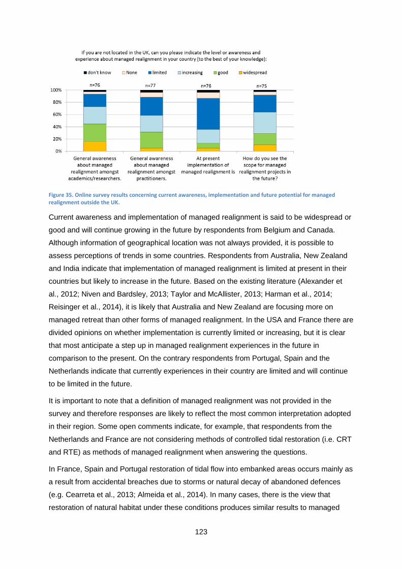
123
Figure 35. Online survey results concerning current awareness, implementation and future potential for managed realignment outside the UK.
Current awareness and implementation of managed realignment is said to be widespread or
good and will continue growing in the future by respondents from Belgium and Canada.
Although information of geographical location was not always provided, it is possible to
assess perceptions of trends in some countries. Respondents from Australia, New Zealand
and India indicate that implementation of managed realignment is limited at present in their
countries but likely to increase in the future. Based on the existing literature (Alexander et
al., 2012; Niven and Bardsley, 2013; Taylor and McAllister, 2013; Harman et al., 2014;
Reisinger et al., 2014), it is likely that Australia and New Zealand are focusing more on
managed retreat than other forms of managed realignment. In the USA and France there are
divided opinions on whether implementation is currently limited or increasing, but it is clear
that most anticipate a step up in managed realignment experiences in the future in
comparison to the present. On the contrary respondents from Portugal, Spain and the
Netherlands indicate that currently experiences in their country are limited and will continue
to be limited in the future.
It is important to note that a definition of managed realignment was not provided in the
survey and therefore responses are likely to reflect the most common interpretation adopted
in their region. Some open comments indicate, for example, that respondents from the
Netherlands and France are not considering methods of controlled tidal restoration (i.e. CRT
and RTE) as methods of managed realignment when answering the questions.
In France, Spain and Portugal restoration of tidal flow into embanked areas occurs mainly as
a result from accidental breaches due to storms or natural decay of abandoned defences
(e.g. Cearreta et al., 2013; Almeida et al., 2014). In many cases, there is the view that
restoration of natural habitat under these conditions produces similar results to managed

124
realignment (e.g. Cearreta et al., 2013). The literature suggests that the vegetation structure
of restored saltmarshes is likely to differ from natural systems (Zedler and Adam, 2002;
Wolters et al., 2005; Spencer et al., 2008; Mossman et al., 2012), even after time-frames of
50-100 years (Garbutt and Wolters, 2008; Mossman et al., 2012). This difference raises the
question whether restored saltmarshes are able then to deliver equivalent ecosystems
services and functions (e.g. Craft et al., 2003; Garbutt and Wolters, 2008; Santín et al.,
2009; Mossman et al., 2012; Burden et al., 2013). Until knowledge is advanced to clarify this
issue, it is up to debate whether there is justification for the expenditure of public funds in
managed realignment projects. Evidence that tax payer money is being used to provide
tangible wider benefits (e.g. improvement of flood risk management, recreation or
opportunities for economic activities) is required to shift perceptions.
Comments from respondents indicate that the wider implementation of managed realignment
is limited by insufficient number of demonstration projects and opposition from stakeholders
and the public. The UK experience is often taken as guidance but differences in physical
settings, government policies/structure and cultural background are not always applicable.
Lack of understanding the long-term evolution of sites is also cited as a limiting factor (see
Section 10.4). This stems from the fact that only few examples exist that are more than a
decade old and not much is known about their evolution and the ecosystem services they
are providing.
It is clear from the results shown in Figure 35 that there is room for improving awareness of
researchers and especially practitioners about managed realignment. Practitioners need to
be knowledgeable about existing experiences and convinced that managed realignment is
the best option to promote the idea at the local level. Concerns about the amount of time and
effort involved in public engagement and required to change perceptions about managed
realignment is another issue raised by respondents.
The wider implementation of managed realignment outside the UK is faced with a
conundrum. More evidence and examples are required to increase the understanding of
practitioners and researchers about managed realignment and facilitate public acceptance.
However, opportunities for implementation of managed realignment projects are limited
because of the novelty of the concept. It is therefore key that robust evidence obtained from
monitoring of existing projects (within and outside the context of the country) is widely
disseminated to inform practitioners and the public.
The limiting factors identified above are not too dissimilar of the ones encountered in the UK.
However in the UK, many communities and stakeholders have already had direct or indirect
involvement with existing projects. Not only more people are aware of the terminology

125
associated with managed realignment, social perceptions are already influenced by the way
projects were implemented and public engagement conducted. There is room for
improvement in many aspects of the planning and implementation process; more importantly
it is time that uncontested and clear evidence of realised benefits is widely disseminated. To
increase reliability and transparency it is important that evidence is assessed independently
and based on robust data analyses, which should address individual projects and overall
achievements of regional and national targets.
Evidence is required to: improve project design, inform policy development, educate
practitioners and attract support from stakeholders and the public. Practitioners are unlikely
to convince stakeholders and the public if they are uncertain about the benefits (and losses)
brought by managed realignment.
10.4. Main limitations
Managed realignment is a novel and challenging concept to most communities and great
efforts are required to gain support for project implementation at the local level. It has been
suggested that wider acceptance might increase the longer the concept is being discussed
and more projects implemented (Pethick, 2002; Myatt-Bell et al., 2002; Myatt et al., 2003).
Only when managed realignment becomes a more established coastal management
approach, there might be enough public understanding and acceptance to influence opinions
at the local level. However the ‘not in my backyard’ attitude might still prevail irrespective of
general increased acceptance.
It is clear from the results of the online survey presented so far that there is a considerable
difference in the perception of stakeholders about the suitability and performance of
managed realignment projects in comparison with other groups involved in managed
realignment. Similar discrepancy is found about the factors limiting the implementation of
managed realignment. Results based on the views of all respondents participating in the
online survey are show in Figure 36a, while the views of stakeholders in the UK are shown in
Figure 36b.

126
Figure 36. Results of the online survey concerning factors limiting the implementation of managed realignment based on the views of all respondents (a) and stakeholders in the UK (b).
In general terms, it is fair to say that overall views are divided as the majority (>50%) of
respondents expressed the same view in only few cases. Additionally, only in one aspect
there was agreement between the majority of stakeholders and the majority of all
respondents (Figure 36). Over 67% of all respondents and 71% of UK stakeholders agree
that better understanding about long-term evolution of the realigned sites is needed (Figure
36). From the practitioners and consultants perspective, there is certain confidence in the
tools available to assist project design and engineering; however; it is recognised that
improvement of hydrodynamic modelling capabilities and/or uptake of model results
concerning sediment processes is required (e.g. Esteves and Thomas, 2014). Across the
groups, there is a general agreement that there is a need to better understand the changes
in hydrodynamic and sedimentary processes due to managed realignment (e.g. Spencer and
Harvey, 2012) as they influence colonisation by the biota (e.g. Marquiegui and
Aguirrezabalaga, 2009; Davy et al., 2011), effects on flood risk (e.g. Morris, 2012) and some
biogeochemical aspects (e.g. Adams et al., 2012; Burden et al., 2013) important for the
capacity to store carbon, cycle nutrients and support fisheries. Long-term monitoring of
sedimentary processes is fundamental to quantify environmental changes and assess
whether site evolution is occurring towards the desired objectives. Long-term, in this case,
should be defined by the time the site reaches equilibrium, i.e. when trends and rates of
changes become more constant.

127
About the same proportion of UK stakeholders and all respondents disagree that lack of
knowledge is a major constraint. However, a much larger percentage of stakeholders agree
with this statement (Figure 36). The online survey also asked opinions about the duration
and coverage of systematic monitoring at realigned sites and respondents, including
stakeholders indicated they think all sites should be monitored and for longer than current
general practice. Notably, the majority of researchers and stakeholders indicate that
vegetation, sedimentation and biogeochemical processes should be monitored for at least
10 years or longer (Esteves and Thomas, 2013). Consultants and practitioners more often
think the minimum monitoring could be 5 years or less.
Interestingly, there was no overwhelming agreement with the statement “public acceptance
is a major constrain” was inconclusive as opinions were generally divided (Figure 36). More
respondents agree than disagree with the statement in both groups but interestingly more
stakeholders disagree. It is possible that some stakeholders (and other respondents) have
disagreed with the statement as they might believe that public opposition may delay but not
stop managed realignment projects; therefore public acceptance, although important at the
local level, is not considered a major constraint. Researchers are the group that most agree
that public acceptance is a major constraint (42%), but this might reflect findings from the
literature rather than practical experience.
Concerning funding for and costs of managed realignment, opinions of stakeholders contrast
with the perceptions of all respondents. Figure 36 shows that only 19% of stakeholders think
funding is a major constraint; however, 67% perceive managed realignment to be too
expensive for the benefits it may create. In contrast 47% of all respondents agree that
funding is a major constraint and only 12% think it is too expensive. It is evident that
stakeholders are more likely to believe that enough money is available for managed
realignment (so funding is not an issue), but they question whether the funds are being well-
spent. On the other hand, practitioners (who have to seek funding sources for the projects),
are more likely to perceive funding to be an issue.
Availability of suitable areas might affect the cost of managed realignment in the future as
suitable land becomes scarcer. In England, for example, the government plans to realign a
total of 111 km by 2016 and 550 km by 2030 resulting in the creation of 6,200 ha of intertidal
habitat at a cost of £10-15 million per year (Committee on Climate Change, 2013). The
estimated cost would not be sufficient even to maintain the current needs without the
increased rate required to meet the future targets. In England (and other countries, such as
Belgium), land purchase is negotiated case-by-case and subjected to high price variability.
Often projects are implemented in areas behind flood defences in poor state of conservation,
where land usually have a discounted value (e.g. £5,000/ha in Wallasea Island) and

128
landowners are more willing to sell or work in partnership56. In the future, suitable land may
be restricted to high grade agricultural land, which have a current average value in the UK of
£18,400/ha (RICS, 2013). Demand for land is high near ports and areas planned for future
development and in such locations (e.g. along the Thames and Humber estuaries) prices
can be twice the average agricultural value.
Many factors limiting the implementation of managed realignment have been identified this
book and in the wider literature. Most limiting factors can be group the main into three
categories: (1) governance and high-level strategy; (2) delivery of objectives at the project
level (implementation and performance of projects); and (3) public perception and
stakeholders engagement. To facilitate the implementation of managed realignment and
increase the uptake by stakeholders and the public, the limitations within these three
categories need to be addressed. Table 4 identifies generic requirements that will lead to
improve implementation, understanding and acceptance of managed realignment. Not all
requirements may be relevant to all methods of implementation or all individual projects.
Table 4. Requisites for facilitating the implementation and wider uptake of managed realignment.
Governance and high-level strategy
Horizontal and vertical integration of policies (e.g. integrated planning and flood risk management; clear definition of roles and responsibilities).
Political will to take decisions for long-term and wider benefits instead of personal gain (e.g. think beyond the election cycles)
Clear and well-justified strategic vision (targets and time-frames are widely disseminated and understood)
Funding and institutional mechanisms that facilitate the implementation of the strategy across the national to local levels (e.g. to purchase land; to fund dissemination and educational plans)
Ensure the mechanisms to implement the strategy do not conflict with private property rights
Capacity building for practitioners and policy-makers related to key knowledge concepts, uncertainties and potential socio-economic implications
Robust public dissemination (i.e. consistent message) and stakeholder engagement strategy
Adaptive management (i.e. based on regular assessments)
56 In many countries, property rights might be an issue limiting government to acquire the required land for managed realignment. In the UK, the Crown Estate takes ownership of newly intertidal areas created naturally with immediate effect regardless of who originally purchased the land. Therefore, intertidal land created by accidental breaches of defences immediately revert to Crown Estate; resulting in loss of ownership. However, if the area is created artificially (and would not be inter tidal without the intervention) then the Crown Estate will not claim ownership until such time as the area would have become intertidal naturally.

129
Delivery at the project level
Clear targets and well-defined time-frames for each project
Strong knowledge basis about potential benefits accruing from local projects and associated uncertainties
Availability of suitable land to deliver regional and local targets
Institutional capacity and expertise at the local level (or external support to enable knowledge transfer)
Emphasis on multipurpose functions and benefits to attract wider support
Structured strategy to overcome strong sectorial views or individual strong voices (local power)
Robust stakeholder engagement to understand local needs and expectations
Tailored project design to maximise benefits relevant to local communities
Designed based on modelling outputs considering worst-case scenarios of meteorologic and oceanographic conditions
Better understanding of long-term evolution of realigned sites and hydrodynamics and sediment interactions (e.g. evidence based on monitoring)
Systematic monitoring of relevant parameters until rates of change/conditions stabilize
Independent and science based data analysis to provide evidence of performance
Public perception and stakeholders engagement
Good understanding of national, regional and local targets
Focus on multiple-functions and benefits (to attract wider interests and reduce not-in-my-backyard attitude)
Increase trust in government and non-government players (e.g. through a transparent decision-making process and a legitimate participatory process)
Bottom-up approach to determine local targets
Education efforts to reduce negativity associated with ‘give in to the sea’ perception
Increased awareness about ecosystem services, climate change adaptation needs, the concept of managed realignment
Long-term dissemination and engagement plan to reduce the ‘novelty effect’ (i.e. to establish the concept into the public mind)
Dissemination of evidence about the effects on flood risk to people and property and wider benefits
Working with the media to disseminate consistent messages and reduce influence of misinformation or unfounded perception

130
References
Adams, C.A.; Andrews, J.E. and Jickells, T., 2012. Nitrous oxide and methane fluxes vs.
carbon, nitrogen and phosphorous burial in new intertidal and saltmarsh sediments. Science
of the Total Environment, 434, 240–251.
Alexander, K.S.; Ryan, A. and Measham, T.G., 2012. Managed retreat of coastal
communities: understanding responses to projected sea level rise. Journal of Environmental
Planning and Management, 55(4), 409-433.
Almeida, D.; Neto, C.; Esteves, L.S.; Costa, J.C., 2014. The impacts of land-use changes on
the recovery of saltmarshes in Portugal. Ocean and Coastal Management, 92, 40-49.
Burden, A.; Garbutt, R.A.; Evans, C.D.; Jones, D.L. and Cooper, D.M., 2013. Carbon
sequestration and biogeochemical cycling in a saltmarsh subject to coastal managed
realignment. Estuarine, Coastal and Shelf Science, 120, 12-20.
Cearreta, A.; García-Artola, A.; Leorri, E.; Irabien, M.J. and Masque, P., 2013. Recent
environmental evolution of regenerated salt marshes in the southern Bay of Biscay:
Anthropogenic evidences in their sedimentary record. Journal of Marine Systems, 109–110,
S203–S212.
Committee on Climate Change, 2013. Chapter 5: Regulating services – coastal habitats.
Available from: http://www.theccc.org.uk/wp-content/uploads/2013/07/ASC-2013-
Chap5_singles_2.pdf, pp. 92-107.
Craft, C., Megonigal, P., Broome, S., Stevenson, J., Freese, R., Cornell, J., Zheng, L.,
Sacco, J., 2003. The pace of ecosystem development of constructed Spartina alterniflora
marshes. Ecological Applications 13, 1417-1432.
Davy, A.J.; Brown, M.J.H.; Mossman, H.L. and Grant, A., 2011. Colonization of a newly
developing salt marsh: disentangling independent effects of elevation and redox potential on
halophytes. Journal of Ecology, 99, 1350-1357.
Esteves, L.S., 2013. Is managed realignment a sustainable long-term coastal management
approach? Journal of Coastal Research, Special Issue 65, 933-938.
Esteves, L.S. and Thomas, K., 2014. Managed realignment in practice in the UK: results
from two independent surveys. Journal of Coastal Research, Special Issue 66.
French, P. W., 2006. Managed realignment – The developing story of a comparatively new
approach to soft engineering. Estuarine, Coastal and Shelf Science, 67(3), 409-423.
Garbutt, A. and Wolters, M., 2008. The natural regeneration of salt marsh on formerly
reclaimed land. Applied Vegetation Science, 11, 335-344.

131
Goeldner-Gianella, L., 2007. Perceptions and Attitudes Toward De-polderisation in Europe:
A Comparison of Five Opinion Surveys in France and the UK. Journal of Coastal Research,
23(5), 1218-1230.
Harman, B.P.; Heyenga, S.; Taylor, B.M., and Fletcher, C.S., 2014. Global lessons for
adapting coastal communities to protect against storm surge inundation. Journal of Coastal
Research (in press).
Ledoux, L.; Cornell, S.; O’Riordan, T.; Harvey, R. and Banyard, L. 2005. Towards
sustainable flood and coastal management: identifying drivers of, and obstacles to, managed
realignment. Land Use Policy, 22(2), 129-144.
Luisetti, T., Turner, R. K., Bateman, I. J., Morse-Jones, S., Adams, C. and Fonseca, L. 2011.
Coastal and marine ecosystem services valuation for policy and management: Managed
realignment case studies in England. Ocean & Coastal Management, 54(3), 212-224.
Marquiegui, M.A. and Aguirrezabalaga, 2009. Colonization process by macrobenthic infauna
after a managed coastal realignment in the Bidasoa estuary (Bay of Biscay, NE Atlantic).
Estuarine, Coastal and Shelf Science, 84,598–604.
McGlashan, D.J., 2003. Managed relocation: an assessment of its feasibility as a coastal
management option. The Geographical Journal, 169(1), 6-20.
Midgley, S. and McGlashan, D.J., 2004. Planning and management of a proposed managed
realignment project: Bothkennar, Forth Estuary, Scotland. Marine Policy, 28, 429-435.
Morris, R.K.A., 2013. Managed realignment: A sediment management perspective. Ocean &
Coastal Management, 65, 59-66.
Mossman, H.L.; Davy, A.J. and Grant, A., 2012. Does managed coastal realignment create
saltmarshes with ‘equivalent biological characteristics’ to natural reference sites? Journal of
Applied Ecology, 49(6), 1446–1456.
Myatt-Bell, L.B.; Scrimshaw, M.D.; Lester, J.N. and Potts, J.S., 2002. Public perception of
managed realignment: Brancaster West Marsh, North Norfolk, UK. Marine Policy, 26(1), 45-
57.
Myatt, L.B.; Scrimshaw, M.D. and Lester, J.N., 2003a. Public perceptions and attitudes
towards a forthcoming managed realignment scheme: Freiston Shore, Lincolnshire, UK.
Ocean & Coastal Management, 46(6-7), 565-582.
Myatt, L.B.; Scrimshaw, M.D. and Lester, J.N., 2003b. Public perceptions and attitudes
towards an established managed realignment scheme: Orplands, Essex, UK. Journal of
Environmental Management, 68(2), 173-181.

132
Niven, R.J. and Bardsley, D.K., 2013. Planned retreat as a management response to coastal
risk: a case study from the Fleurieu Peninsula, South Australia. Regional Environmental
Change, 13, 193-209.
Parrott, A. and Burningham, H., 2008. Opportunities of, and constraints to, the use of
intertidal agri-environment schemes for sustainable coastal defence: A case study of the
Blackwater Estuary, southeast England. Ocean & Coastal Management, 51(4), 352-367.
Pethick, J., 2002. Estuarine and tidal wetland restoration in the United Kingdom: Policy
versus practice. Restoration Ecology, 10(3), 431-437.
Reisinger, A., Lawrence, J., Hart, G. and Chapman, R., 2014. From coping to resilience: the
role of managed retreat in highly developed coastal regions of New Zealand. In: Glavovic,
B., Kaye, R., Kelly M. and Travers, A. (Eds.), Climate Change and the Coast: Building
Resilient Communities. CRC Press: London.
RICS (Royal Institution of Chartered Surveyors), 2013. Rural Land Market Survey H1.
Available from http://www.rics.org/uk/knowledge/market-analysis/ricsrac-rural-market-
survey/ricsrau-rural-land-market-survey-h1-2013/.
Roca, E. and Villares, M., 2012. Public perceptions of managed realignment strategies: The
case study of the Ebro Delta in the Mediterranean basin. Ocean & Coastal Management, 60,
38-47.
Santín, C., de la Rosa, J.M., Knicker, H., Otero, X.L., Álvarez, M.Á, González-Vila, F.J.,
2009. Effects of reclamation and regeneration processes on organic matter from estuarine
soils and sediments. Organic Geochemistry, 40, 931–941.
SOGREAH, 2011. Etude de Faisabilite – Depolderisation partielle et eventuelle des Bas-
Champs du Vimeu – La recherché d’un avenir sur un territoire perenne. Phase 1: Etat des
lieux – diagnostic du territoire. Chapitre 8: Approche géographie sociale – perceptions.
Spencer, K.L.; Cundy, A.B.; Davies-Hearn, S.; Hughes, R.; Turner, S. and MacLeod, C.L.,
2008. Physicochemical changes in sediments at Orplands Farm, Essex, UK following 8
years of managed realignment. Estuarine, Coastal and Shelf Science, 76(3), 608-619.
Spencer, K.L. and Harvey, G.L., 2012. Understanding system disturbance and ecosystem
services in restored saltmarshes: Integrating physical and biogeochemical processes.
Estuarine, Coastal and Shelf Science, 106, 23-32.
Taylor and McAllister, 2013. Bringing it all together: researcher dialogue to improve
synthesis in regional climate adaptation in South-East Queensland, Australia. Regional
Environmental Change, DOI 10.1007/s10113-013-0517-4.
133
Wolters, M.; Garbutt, A. and Bakker, J.P., 2005. Salt-marsh restoration: evaluating the
success of de-embankments in north-west Europe. Biological Conservation, 123, 249–268.
Zedler, J.B., Adam, P., 2002. Salt marshes. In: Perrow, M.R., Davy, A.J. (Eds.), Handbook of
Ecological Restoration. Restoration in Practice, vol. 2. Cambridge University Press,
Cambridge, 238-266.

134
11. Concluding remarks
Managed realignment is a soft engineering approach for managing coastal erosion and flood
risk. Increasingly it is seen as an alternative to traditional hard engineering with a capacity to
deliver sustainable coastal management solutions that can account for climate change. In
this respect managed realignment aims to restore or maintain the adaptive capacity of
natural environments in response to sea-level rise. Importantly, managed realignment has
been widely implemented as a management approach to compensate for habitat loss due to
coastal development and coastal squeeze.
Underlying the implementation of managed realignment as a strategic climate change
adaptation, is the potential to create opportunities for the development of fully functional
coastal habitats able to benefit society through the provision of multiple ecosystem services.
Most commonly, managed realignment project are designed to promote ecosystem services
related to: natural protection against storms; flood control; and provision of habitat and
biodiversity. Additionally, more recently attention has been given to the potential of managed
realignment to provide carbon sequestration functions, nutrient cycling, water purification,
recreation and amenity value.
The earliest managed realignment schemes were implemented in the 1980s and comprised
of isolated initiatives to address local needs. A more strategic approach was taken from mid-
1990s, where projects started to be implemented as part of estuary-wide plans. Since then a
total of 125 managed realignment projects are currently known to have been implemented in
Europe (see a list in the Appendix) and an unknown number of initiatives exist in the USA.
Although practice has advanced knowledge in many technical aspects, it is surprising how
little is still known about the long-term evolution of sites. This gap in knowledge is partially
due to the fact that many projects are relatively recent, but also because systematic
monitoring is inadequate or non-existent, data availability is restricted to organisations
involved in the design and implementation of schemes, and only a few independent studies
exist.
Managed realignment is still a novel approach to coastal management and examples to date
are limited both in the number of projects and geographical spread. However, recent national
and regional policies (e.g. in Belgium, France and the UK) have placed a strong emphasis
on managed realignment approaches as a long-term strategy for coastal management. As a
result, a large number of projects are planned to be implemented in the next decades. For
example, by 2030 there are plans to realign about 10% of the English and Welsh coastline
length (see Section 4.1) and to create about 1300 ha of flood storage area and over 850 ha
of new habitat along the Scheldt estuary at the border of Belgium and Netherlands (see
135
Section 4.2). Planning for retreat from high risk areas is high in the agenda in France and
New Zealand and increasingly in many other countries.
Despite the increased interest in managed realignment, there are a number of complicating
factors which need to be addressed to facilitate its wider implemented in the future. Limiting
factors identified in this book, include: inadequate political instruments (e.g. unclear targets
at the strategic and individual project levels; inadequate funding mechanisms to purchase
land or property; poor communication and public engagement strategies); technical viability
(e.g. land availability, suitability of sites to create the desired habitats, environmental
constraints; uncertainties due to variability of natural processes); poor knowledge of long-
term evolution of sites (e.g. hydrodynamics and sedimentary processes, colonisation by
biota, time-frame for mature ecosystems to develop; lack of or inadequate monitoring); and
public perception.
Public opposition is the issue most often cited as causing delays or impeding implementation
of managed realignment at the local level. Public opposition results from a combination of
factors mainly related to: poor awareness about policy drivers and strategic targets; mistrust
on government actions and actors; resistance to change from the status quo; lack of
understanding about managed realignment; uncertainties about potential benefits; ‘not in my
backyard’ attitude; and strong sectorial views. The three main elements contributing to
negative public perception about managed realignment are: (1) confusing terminology and
inconsistent definitions which make it difficult to understanding the general concept; (2) lack
of clarity and consistency in the dissemination of strategic messages and objectives of
individual projects; and (3) lack of evidence about benefits gained from existing projects.
Chapter 2 explains the inconsistencies and ambiguities in the use of terminology and
proposes a wider definition of managed realignment that encompasses the many methods of
implementation currently in use. Most often, managed realignment is defined as the planned
breaching or removal of coastal defences to create new intertidal area in previously
protected land, resulting in a landward realignment of the shoreline. Here it is suggested that
managed realignment is used as a general term to reflect five methods of implementation:
(1) removal of defences; (2) breach of defences; (3) realignment of defences; (4) controlled
tidal restoration; and (5) managed retreat. It is considered that this revised definition will
contribute to: (a) clarify the terminology to facilitate wider understanding of the central
concept; (b) present managed realignment as a suite of approaches applicable to a range of
environmental and socio-economic settings; and (c) demonstrate that, in its wider concept,
managed realignment has been more widely implemented than currently anticipated (as
many initiatives not currently recognised as managed realignment fit in the wider definition).

136
All these forms of managed realignment aim to improve flood and erosion risk management
with added environmental value by creating space for the development of a more naturally
functioning coast. However, in some cases (e.g. in the UK) there has been a strong
emphasis on habitat creation and biodiversity and considerably less focus on the impact of
managed realignment on flood and erosion risk to people and property. The mismatch
between policy objectives and targets of individual projects (often unclear or omitting
reduction of flood and erosion risk) has led to the public perception in the UK that managed
realignment is a costly option to protect habitats and species at the expense of public safety
and social interests. In response to this, there has been a recent call from practitioners and
researchers for a more balanced coverage of the range of multiple functions and benefits
associated with managed realignment.
Any change in policy affecting people (e.g. from hard engineering to managed realignment)
must be supported by a consistent message, widely disseminated to local communities and
stakeholders directly affected, which clarifies the rationale for the change. Engagement with
stakeholders and local communities at early planning stages helps identifying the range of
potential gains and losses from managed realignment projects at the local level. Project
design can then be tailored to maximise the most desired benefits. Public engagement
provides an opportunity to discuss expectations, including the time-frames in which benefits
might be realised, and the effects of uncertainties related to long-term evolution of the sites.
It is of paramount importance to gain public support (and private funding) and to identify and
quantify uncontested evidence of the benefits accrued by existing managed realignment
schemes. Objective quantification can only be possible if the project performance is
assessed against pre-defined targets and based on evidence obtained from consistent data
collection and robust data analysis. Improvements in project design and performance can
only be achieved through adaptive management, as implemented in the USA Coastal
Wetlands Planning, Protection and Restoration Act (see Section 4.6). This approach
involves: long-term (e.g. 20 years) systematic monitoring of existing projects; periodic review
of performance based on evidence from monitoring; and project adjustments to improve
performance where and when required. Lessons learned from each individual project are
then applied to inform future projects.
There is little disagreement that conceptually, managed realignment has great potential to:
(a) provide natural defence against storms and rising sea levels; (b) contribute to the
achievement of wider environmental policy objectives (e.g. EU Habitats and Water
Framework directives); and (c) deliver additional ecosystem services (e.g. recreation, carbon
sequestration, fisheries etc.), which may vary according to site characteristics. It is now time
to provide evidence that benefits are being realised through existing projects.

137
For managed realignment to realise its potential as a long-term sustainable coastal
management alternative it is necessary to: (a) develop a long-term strategic plan that
effectively integrates multiple objectives (e.g. habitat creation, flood protection and amenity);
(b) clearly define local and national targets at specified time frames; (c) implement
systematic monitoring so performance can be adequately measured against targets; and (d)
review schemes periodically based on evidence so adjustments to each project and the
overall strategy can be put in place where necessary.
In order to adapt to climate change, it is very important to devise a long-term strategy
integrating the range of managed realignment methods and planning policies. Reducing the
number of people and properties in areas at high risk of flooding and erosion is the only
climate-proof option across all time scales. Therefore, planning for managed retreat in
combination with other managed realignment approaches might be the only sustainable
option to reduce flood and erosion risk in low-lying coastal and estuarine areas. There is
evidence in this book that this is an approach already on the agenda of concerned
government and non-government organisations. Ultimately, as a society facing unknown
climate change consequences, we cannot continue to live the way we have in the past.
Government policies are already reflecting the need for radical change, and one of the great
challenges now is to find a means of changing the attitude of individuals and communities
towards climate change adaptation.

138
Appendix: List of managed realignment projects in Europe
Existing managed realignment projects in Europe are listed below alphabetically per country
and indicating the geographical location, method of implementation, year of project
completion and project size. Note that few projects are listed for the USA, but the list is not
intended to be comprehensive. The objective is to demonstrate that, although not widely
recognised as managed realignment, some initiatives outside Europe fit the wider definition
used in this book.
This list was produced based on evidence from existing literature and online sources,
especially the Online Managed Realignment Guide57 (OMReG). The OMReG provides a
useful list of the managed realignment projects in Europe and their main characteristics. In
February 2013, it listed a total of 102 projects in Europe, half of which in the UK. Information
about the implementation of managed realignment projects is scattered and not always
readily available. Some missing entries and inconsistencies found in the OMReG are
corrected in the list provided here, which includes projects already implemented or under
construction (as of February 2014).
For some of the projects listed in OMReG, no other source of information was found during
the research conducted for the production of this book. Some projects, especially in the UK,
Belgium, Netherlands and France, are documented in the grey literature and, a selected few,
also in scientific publications. The main source of information for each project listed below is
identified as a footnote (note that more sources might exist for some projects); when a
footnote is missing, the OMReG is the main source of information.
Site name Location Method Year Area (ha)
Belgium
Bergenmeersen 58 Scheldt Controlled tidal restoration – CRT
Works started in 2013
41
Dijlemonding 59 Dijle estuary Controlled tidal restoration – CRT
Works started in 2013
207
Hedwige-Prosper 59 Scheldt Realignment of defence Works started in 2010
465
Heusden 60 Scheldt Breach of defence 2006 10
57 The OMReG is an online catalogue (http://www.abpmer.net/omreg/) about managed realignment produced by ABPmer, a private environmental consultancy based in Southampton, UK. 58 De Beukelaer-Dossche, M. and Decleyre, D. (eds.), 2013, www.vliz.be/imisdocs/publications/250657.pdf 59 Sigma Plan, http://www.sigmaplan.be/en/ 60 Van den Bergh, E.; Verbessem, I.; Van den Neucker, T.; De Regge, N. and Soors, J., 2008. Evaluation of managed realignments in the Sheldt estuary. 6th European Conference on Ecological Restoration (Ghent, 8-12 Sep 2008).

139
Kalkense Meersen 59 Scheldt Realignment of defence Works started in 2013
606
Ketenisse schor 60 Scheldt Realignment of defence and land lowering 2003 60
Lippenbroek 59,61,62 Scheldt Controlled tidal restoration – CRT 2006 10
Paardebroek 60 Scheldt Realignment of defence Works started in 2013
28
Paardenschor 60 Scheldt Realignment of defence and land lowering 2004 12
Paddebeek 60 Scheldt Realignment of defence 2003 1.6
Polders of Kruibeke 59 Scheldt Realignment of defence and controlled tidal restoration – CRT
Works started in 2013
650
Vlassenbroek and Wal-Zwijn 59 Scheldt
Realignment of defence and controlled tidal restoration – CRT
Works started in 2012
416
Wijmeers 1 58 Scheldt Realignment of defence Works started in 2013
159
Wijmeers 2 58 Scheldt Realignment of defence Works started in 2013
28
Yzer mouth Yzer Removal of defence 2001 50 Denmark Geddal Strandenge Limfjord Breach of defence 1992 140 Viggelsø Odense Fjord Breach of defence 1993 66 France Aber de Crozon 63 Crozon Removal of defence 1981 87 Île Nouvelle64 Gironde estuary Breach of defence 2000 265 Polder de Sébastopol65 Ile de
Noirmouthier Controlled tidal restoration 1999 132
Sète-Marseillan66 Languedoc-Roussillon
Managed retreat 2010 ?
Germany Anklamer Stadtbruch Oderhaff Breach of defence 2004 1750 Beltringharder Koog67 North Friesland Controlled tidal restoration 1988 853 Billwerder Insel Elbe estuary Removal of defence 2008 20 Dorumer Sommerpolder East Friesland Removal of defence 2001 4
61 Jacobs, S.; Beauchard, O.; Struyf, E.; Cox, T.; Maris, T. and Meire, P., 2009. Restoration of tidal freshwater vegetation using controlled reduced tide (CRT) along the Schelde Estuary (Belgium). Estuarine, Coastal and Shelf Science, 85, 368-376. 62 Beauchard, O., Jacobs, S., Cox, T. J. S., Maris, T., Vrebos, D., Van Braeckel, A., and Meire, P., 2011. A new technique for tidal habitat restoration: evaluation of its hydrological potentials. Ecological Engineering, 37, 1849-1858. 63 Digue Richet, Inventaire général du patrimoine culturel, http://patrimoine.region-bretagne.fr/sdx/sribzh/main.xsp?execute=show_document&id=MERIMEEIA29004203 64 Conservatoire du Littoral, http://www.conservatoire-du-littoral.fr/siteLittoral/222/28-ile-nouvelle-33-_gironde.htm 65 Pays de La Loire, RNR de Sébastopol, http://www.paysdelaloire.fr/les-pays-de-la-loire/reserves-regionales/actu-detaillee/n/polder-de-sebastopol/. 66 Heurtefeux, H.; Sauboua, P.; Lanzellotti, P. and Bichot, A., 2011. Coastal Risk Management Modes: The Managed Realignment as a Risk Conception More Integrated. In: Savino, M. (ed.), Risk Management in Environment, Production and Economy. InTech, Rijeka, Croacia. 67 RESTORE, 2013. Case study:Beltringharder Koog Regulated Tidal Exchange Scheme. Available at: http://restorerivers.eu/wiki/index.php?title=Case_study%3ABeltringharder_Koog_Regulated_Tidal_Exchange_Scheme.
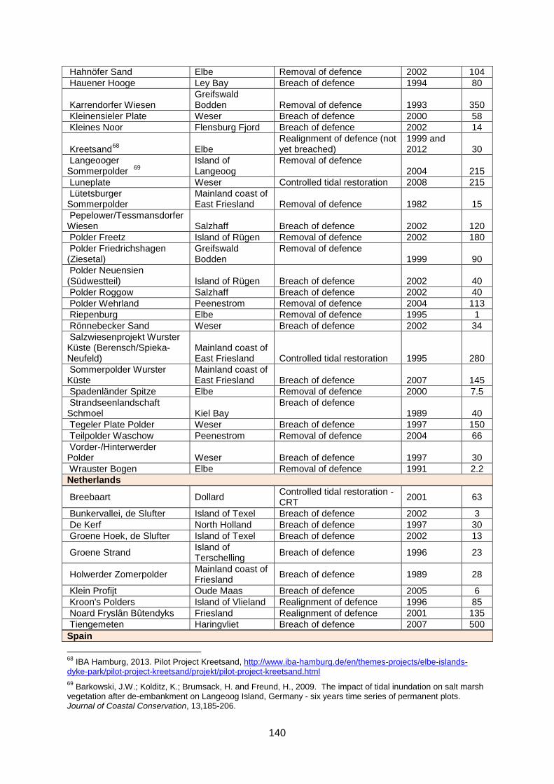
140
Hahnöfer Sand Elbe Removal of defence 2002 104 Hauener Hooge Ley Bay Breach of defence 1994 80
Karrendorfer Wiesen Greifswald Bodden Removal of defence 1993 350
Kleinensieler Plate Weser Breach of defence 2000 58 Kleines Noor Flensburg Fjord Breach of defence 2002 14
Kreetsand68 Elbe Realignment of defence (not yet breached)
1999 and 2012 30
Langeooger Sommerpolder 69
Island of Langeoog
Removal of defence 2004 215
Luneplate Weser Controlled tidal restoration 2008 215 Lütetsburger Sommerpolder
Mainland coast of East Friesland Removal of defence 1982 15
Pepelower/Tessmansdorfer Wiesen Salzhaff Breach of defence 2002 120 Polder Freetz Island of Rügen Removal of defence 2002 180 Polder Friedrichshagen (Ziesetal)
Greifswald Bodden
Removal of defence 1999 90
Polder Neuensien (Südwestteil) Island of Rügen Breach of defence 2002 40 Polder Roggow Salzhaff Breach of defence 2002 40 Polder Wehrland Peenestrom Removal of defence 2004 113 Riepenburg Elbe Removal of defence 1995 1 Rönnebecker Sand Weser Breach of defence 2002 34 Salzwiesenprojekt Wurster Küste (Berensch/Spieka-Neufeld)
Mainland coast of East Friesland Controlled tidal restoration 1995 280
Sommerpolder Wurster Küste
Mainland coast of East Friesland Breach of defence 2007 145
Spadenländer Spitze Elbe Removal of defence 2000 7.5 Strandseenlandschaft Schmoel Kiel Bay
Breach of defence 1989 40
Tegeler Plate Polder Weser Breach of defence 1997 150 Teilpolder Waschow Peenestrom Removal of defence 2004 66 Vorder-/Hinterwerder Polder Weser Breach of defence 1997 30 Wrauster Bogen Elbe Removal of defence 1991 2.2 Netherlands
Breebaart Dollard Controlled tidal restoration - CRT 2001 63
Bunkervallei, de Slufter Island of Texel Breach of defence 2002 3 De Kerf North Holland Breach of defence 1997 30 Groene Hoek, de Slufter Island of Texel Breach of defence 2002 13
Groene Strand Island of Terschelling Breach of defence 1996 23
Holwerder Zomerpolder Mainland coast of Friesland Breach of defence 1989 28
Klein Profijt Oude Maas Breach of defence 2005 6 Kroon's Polders Island of Vlieland Realignment of defence 1996 85 Noard Fryslân Bûtendyks Friesland Realignment of defence 2001 135 Tiengemeten Haringvliet Breach of defence 2007 500 Spain 68 IBA Hamburg, 2013. Pilot Project Kreetsand, http://www.iba-hamburg.de/en/themes-projects/elbe-islands-dyke-park/pilot-project-kreetsand/projekt/pilot-project-kreetsand.html 69 Barkowski, J.W.; Kolditz, K.; Brumsack, H. and Freund, H., 2009. The impact of tidal inundation on salt marsh vegetation after de-embankment on Langeoog Island, Germany - six years time series of permanent plots. Journal of Coastal Conservation, 13,185-206.

141
Marismas de la Vega de Jaitzubia
Bidasoa estuary Removal of defence 2004 23
UK (an online map of managed realignment projects in the UK is available from http://binged.it/1fFF9pF) Abbotts Hall 70 Blackwater Controlled tidal restoration 1996 84 Breach of defence 2002 84 Alkborough 71 Humber Breach of defence 2006 440
Alnmouth 1 Aln
Breach of defence (2 adjacent areas, one beach in each) 2006 8
Alnmouth 2 Aln Breach of defence 2008 20 Amble Marshes 72 Camel Controlled tidal restoration 2010 56 Annery Kiln Torridge Breach of defence 2000 3.8 Barking Creek 73 Barking Creek Removal of defence 2006 0.3 Barking tidal barrier 4 Barking Creek Breach of defence 2006 1.0
Black Devon Wetlands 74 Forth/Black Devon Controlled tidal restoration
2000-2005 28 ha
Black Hole Marsh Axe Controlled tidal restoration 2009 6 Bleadon Levels Axe Breach of defence 2001 13 Brancaster West Marsh 75 North Norfolk Realignment of defence 2002 7.5 Brandy Hole Crouch Breach of defence 2002 12
Chalkdock Marsh Chichester Harbour Controlled tidal restoration 2000 3.2
Chowder Ness 76 Humber Realignment of defence 2006 15 Clapper Marshes 3 Camel Controlled tidal restoration 2004-2011 10 Cone Pill Severn Breach of defence 2001 50 Devereux Farm 77 Hamford Water Breach of defence 2010 6 Freiston 78 The Wash Realignment of defence 2002 66 Glasson Conder Controlled tidal restoration 2005 6.4 Goswick Farm 3 South Low River Controlled tidal restoration 2010 4.5 Halvergate Yare Realignment of defence 2005 5 Havergate Island Ore Realignment of defence 2000 8.1 Hesketh Out Marsh 79 Ribble Estuary Realignment of defence 2008 168 70 Pickaver, A., 2010. A sustainable coastal defence re-creating wildlife habitats alongside economic farming methods, Abbott’s Hall Farm – UK. OURCOAST project. Available from: http://ec.europa.eu/ourcoast/index.cfm?menuID=8&articleID=5 http://www.wwf.org.uk/filelibrary/pdf/mu52.pdf. 71 Manson, S. and Pinnington, N., 2012. Alkborough Managed Realignment (Humber estuary). Measure analysis in the framework of the Interreg IVB project TIDE. Measure 30. 25 pages. Hull. http://www.tide-toolbox.eu/pdf/measures/Alkborough.pdf. 72 Environment Agency, Camel Valley Wetland Restoration. http://www.environment-agency.gov.uk/static/documents/Leisure/Camel_Valley_Wetland_Restoration.pdf 73 RESTORE Partnership (n/a), Lower River Roding Regeneration Project - Summary Report. http://restorerivers.eu/wiki/images/e/ef/Lower_River_Roding_Regeneration_Project.pdf. 74 Clackmannanshire Council, Black Devon Wetland, http://www.clacksweb.org.uk/environment/blackdevonwetland/ 75 Myatt, L.B.; Scrimshaw, M.D., Lester, J.N. and Potts, J.S., 2002. Public perceptions of managed realignment: Brancaster West marsh, North Norfolk, UK. Marine Policy, 26, 45-57. 76 Hemingway, K.L., Cutts, N.C. and R. Pérez-Dominguez., 2008. Managed Realignment in the Humber Estuary, UK. Institute of Estuarine & Coastal Studies (IECS), University of Hull, UK. Report produced as part of the European Interreg IIIB HARBASINS project. http://ec.europa.eu/ourcoast/download.cfm?fileID=863 77 David Eagle (Deveraux Farm land owner), personal communication. 78 Friess, D.; Möller, I. and Spencer, T., 2008. Case study: managed realignment and the re-establishment of saltmarsh habitat, Freiston Shore, Linconlnshire, United Kingdom. ProAct Network, http://www.proactnetwork.org/proactwebsite/media/download/CCA_DRR_reports/casestudies/em.report.case_6.pdf. 79 Environment Agency, 2010. Working with natural processes to manage flood and coastal erosion risk. A guidance Document.
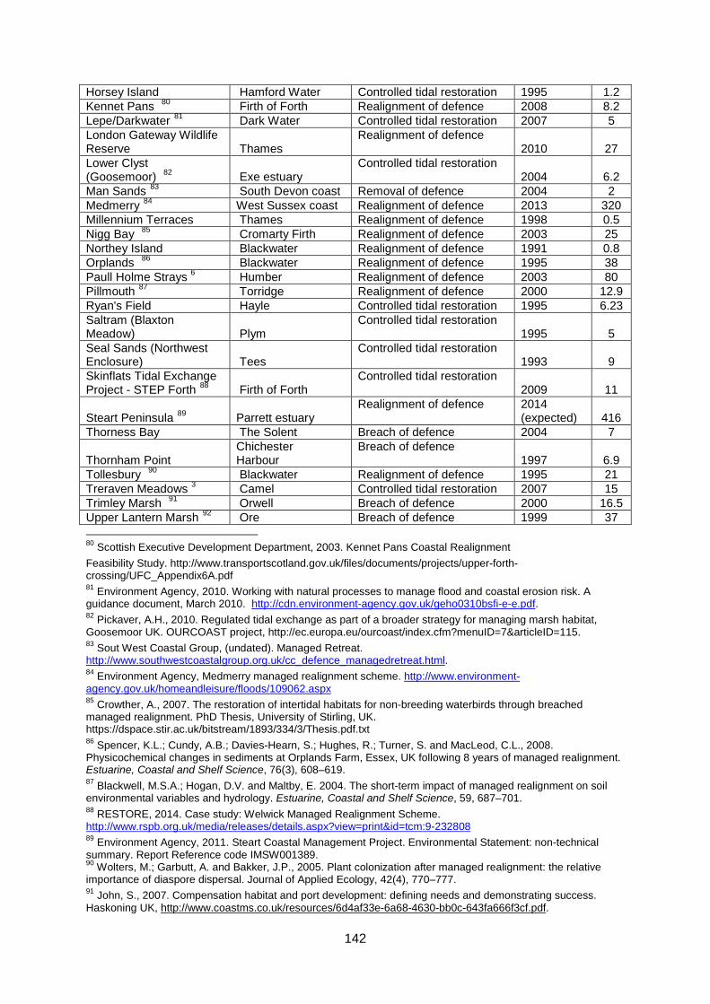
142
Horsey Island Hamford Water Controlled tidal restoration 1995 1.2 Kennet Pans 80 Firth of Forth Realignment of defence 2008 8.2 Lepe/Darkwater 81 Dark Water Controlled tidal restoration 2007 5 London Gateway Wildlife Reserve Thames
Realignment of defence 2010 27
Lower Clyst (Goosemoor) 82 Exe estuary
Controlled tidal restoration 2004 6.2
Man Sands 83 South Devon coast Removal of defence 2004 2 Medmerry 84 West Sussex coast Realignment of defence 2013 320 Millennium Terraces Thames Realignment of defence 1998 0.5 Nigg Bay 85 Cromarty Firth Realignment of defence 2003 25 Northey Island Blackwater Realignment of defence 1991 0.8 Orplands 86 Blackwater Realignment of defence 1995 38 Paull Holme Strays 6 Humber Realignment of defence 2003 80 Pillmouth 87 Torridge Realignment of defence 2000 12.9 Ryan's Field Hayle Controlled tidal restoration 1995 6.23 Saltram (Blaxton Meadow) Plym
Controlled tidal restoration 1995 5
Seal Sands (Northwest Enclosure) Tees
Controlled tidal restoration 1993 9
Skinflats Tidal Exchange Project - STEP Forth 88 Firth of Forth
Controlled tidal restoration 2009 11
Steart Peninsula 89 Parrett estuary Realignment of defence 2014
(expected) 416 Thorness Bay The Solent Breach of defence 2004 7
Thornham Point Chichester Harbour
Breach of defence 1997 6.9
Tollesbury 90 Blackwater Realignment of defence 1995 21 Treraven Meadows 3 Camel Controlled tidal restoration 2007 15 Trimley Marsh 91 Orwell Breach of defence 2000 16.5 Upper Lantern Marsh 92 Ore Breach of defence 1999 37 80 Scottish Executive Development Department, 2003. Kennet Pans Coastal Realignment Feasibility Study. http://www.transportscotland.gov.uk/files/documents/projects/upper-forth-crossing/UFC_Appendix6A.pdf 81 Environment Agency, 2010. Working with natural processes to manage flood and coastal erosion risk. A guidance document, March 2010. http://cdn.environment-agency.gov.uk/geho0310bsfi-e-e.pdf. 82 Pickaver, A.H., 2010. Regulated tidal exchange as part of a broader strategy for managing marsh habitat, Goosemoor UK. OURCOAST project, http://ec.europa.eu/ourcoast/index.cfm?menuID=7&articleID=115. 83 Sout West Coastal Group, (undated). Managed Retreat. http://www.southwestcoastalgroup.org.uk/cc_defence_managedretreat.html. 84 Environment Agency, Medmerry managed realignment scheme. http://www.environment-agency.gov.uk/homeandleisure/floods/109062.aspx 85 Crowther, A., 2007. The restoration of intertidal habitats for non-breeding waterbirds through breached managed realignment. PhD Thesis, University of Stirling, UK. https://dspace.stir.ac.uk/bitstream/1893/334/3/Thesis.pdf.txt 86 Spencer, K.L.; Cundy, A.B.; Davies-Hearn, S.; Hughes, R.; Turner, S. and MacLeod, C.L., 2008. Physicochemical changes in sediments at Orplands Farm, Essex, UK following 8 years of managed realignment. Estuarine, Coastal and Shelf Science, 76(3), 608–619. 87 Blackwell, M.S.A.; Hogan, D.V. and Maltby, E. 2004. The short-term impact of managed realignment on soil environmental variables and hydrology. Estuarine, Coastal and Shelf Science, 59, 687–701. 88 RESTORE, 2014. Case study: Welwick Managed Realignment Scheme. http://www.rspb.org.uk/media/releases/details.aspx?view=print&id=tcm:9-232808 89 Environment Agency, 2011. Steart Coastal Management Project. Environmental Statement: non-technical summary. Report Reference code IMSW001389. 90 Wolters, M.; Garbutt, A. and Bakker, J.P., 2005. Plant colonization after managed realignment: the relative importance of diaspore dispersal. Journal of Applied Ecology, 42(4), 770–777. 91 John, S., 2007. Compensation habitat and port development: defining needs and demonstrating success. Haskoning UK, http://www.coastms.co.uk/resources/6d4af33e-6a68-4630-bb0c-643fa666f3cf.pdf.

143
Vange Marsh Thames Controlled tidal restoration 2006 1 Walborough Axe Controlled tidal restoration 2004 4.5 Wallasea 93 Crouch Realignment of defence 2006 115 Warkworth Coquet Breach of defence 2009 0.4 Watertown Farm Yeo Breach of defence 2000 1.5 Welwick 94 Humber Realignment of defence 2006 54 USA Cheniere Ronquille Barrier Island Restoration 95
Louisiana Realignment of defence 2010 187
East Harbor Lagoon 96 Cape Cod National Seashore Controlled tidal restoration 2011 ?
Isles Dernieres Restoration Trinity Island 97
Louisiana Realignment of defence 1999 314
Little River Marsh Restoration 98
North Hampton, New Hampshire Controlled tidal restoration 2000 81
Whiskey Island Restoration99 Louisiana Realignment of defence 2004 420
Surfside Beach (9 houses relocated)
Brazoria County, Texas Managed retreat ? -
Tarramar Beach City of Galveston, Texas Managed retreat ? -
Sunny Beach West Galveston Island Managed retreat 2010 -
Wailea Beach Maui Managed retreat 2012 -
Brigthon Beach Hotel Coney Island, New York Managed retreat 1888 -
Diamond City North Carolina Managed retreat 1899 -
92 National Trust, Orford Ness National Nature Reserve, http://www.nationaltrust.org.uk/orford-ness/wildlife/view-page/item418077/ 93 ABPmer, 2013. Wallasea Wetlands Creation Project. http://www.abpmer.net/wallasea/ 94 http://restorerivers.eu/wiki/index.php?title=Case_study%3AWelwick_Managed_Realignment_Scheme 95 CWPPRA projects, http://lacoast.gov/reports/gpfs/BA-76.pdf 96 Smith, S. and Medeiros, K., 2013. Manipulation of water levels to facilitate vegetation change in a coastal lagoon undergoing partial tidal restoration (Cape Cod, Massachusetts). Journal of Coastal Research, 29(6A), 93–99. 97 CWPPRA projects, http://lacoast.gov/new/Projects/Info.aspx?num=TE-24 98 NOAA Restoration Center and NOAA Coastal Services Center, 2010. Returning the Tide: A Tidal Hydrology Restoration Guidance Manual for the Southeastern United States. NOAA, Silver Spring. Available at: http://www.habitat.noaa.gov/partners/toolkits/. 99 CWPPRA projects, http://lacoast.gov/new/Projects/Info.aspx?num=TE-50