map reading skills. map reading skills - blitz quiz number your paper 1-16
TRANSCRIPT

Map Reading Skills

Map Reading Skills - Blitz Quiz
Number your paper 1-16

1. What three modern states were the first colonial settlements located in?

2. How many people lived in Greenville, North Carolina?

3. What was the first colonial settlement?
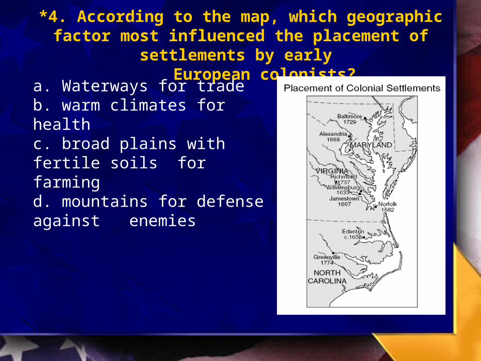
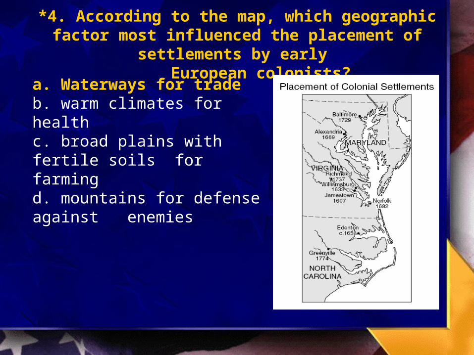
*4. According to the map, which geographic factor most influenced the placement of settlements by early
European colonists?
a. Waterways for tradeb. warm climates for healthc. broad plains with fertile soils
for farmingd. mountains for defense against
enemies
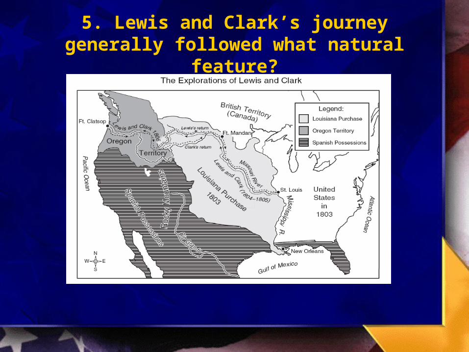
5. Lewis and Clark’s journey generally followed what natural feature?
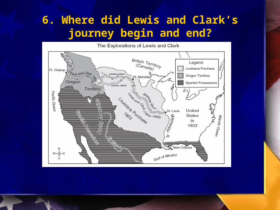
6. Where did Lewis and Clark’s journey begin and end?

7. How many days did it take Lewis and Clark to make their journey?

*8. It can be concluded from the map that one purpose of the Lewis and Clark expedition was to –
a. gain information about Spanish possessions in the Southwest
b. explore Canadian territoryc. explore areas west of the
Mississippi Riverd. lay claim to the Rio
Grande
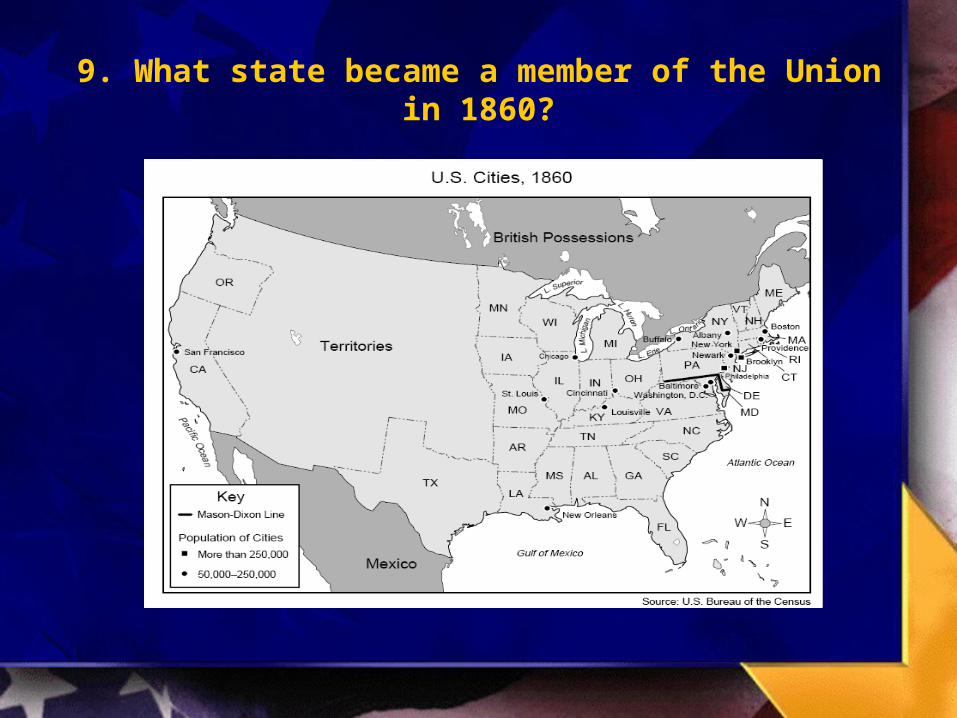
9. What state became a member of the Union in 1860?

10. Between what two states was the Mason-Dixon line located?
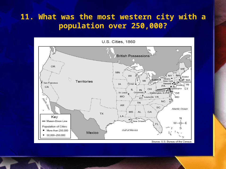
11. What was the most western city with a population over 250,000?
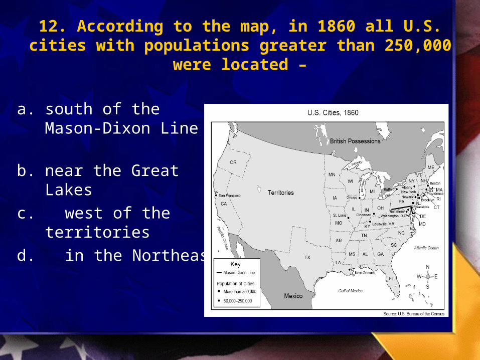
12. According to the map, in 1860 all U.S. cities with populations greater than 250,000 were located –
a. south of the Mason-Dixon Line
b. near the Great Lakes
c. west of the territories
d. in the Northeast

13. How many Native Americans live in California?
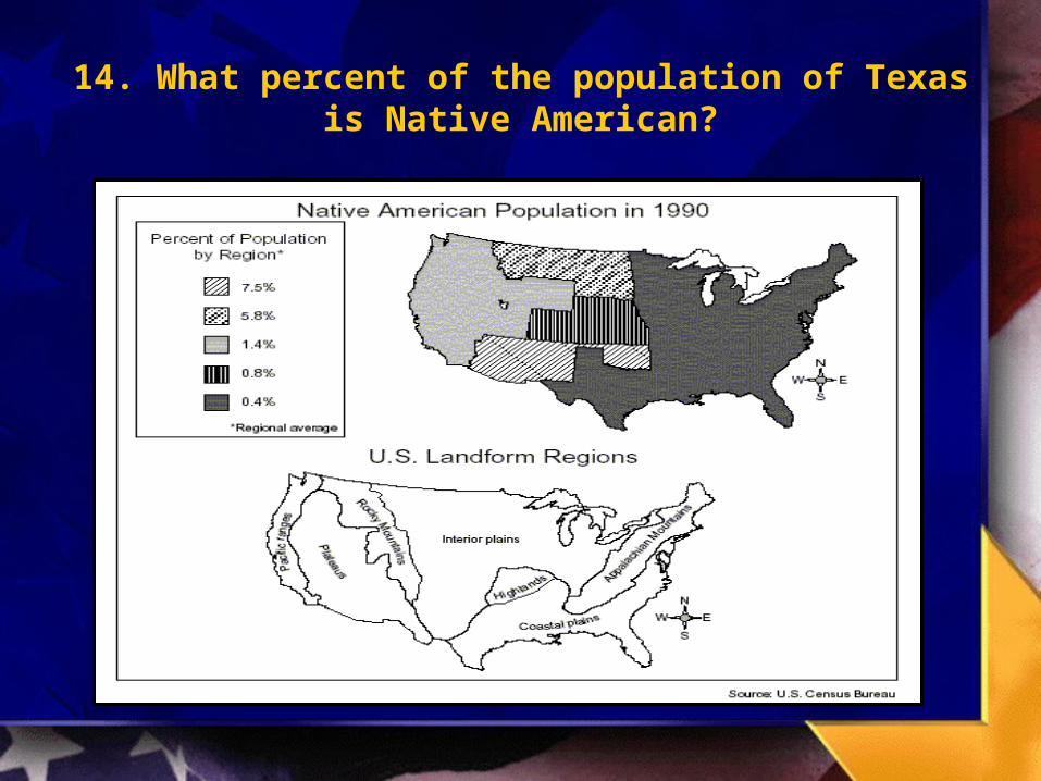
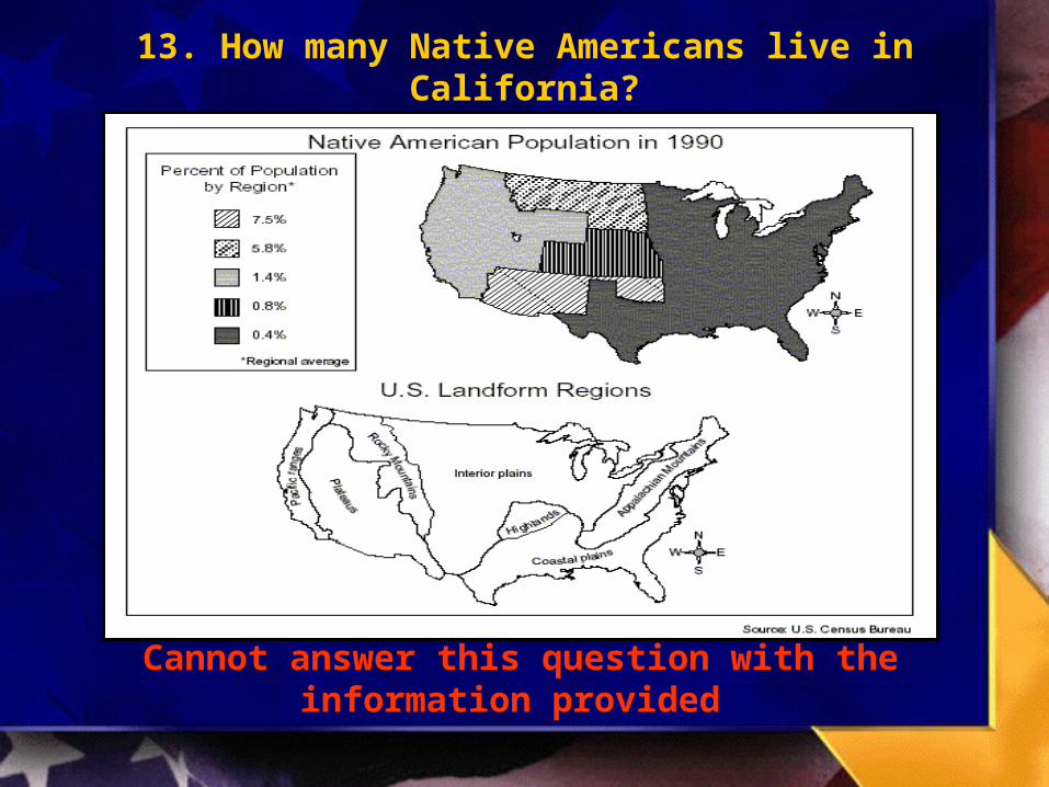
14. What percent of the population of Texas is Native American?

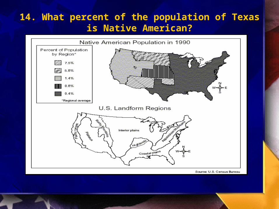
15. Houston is located in what geographical region?

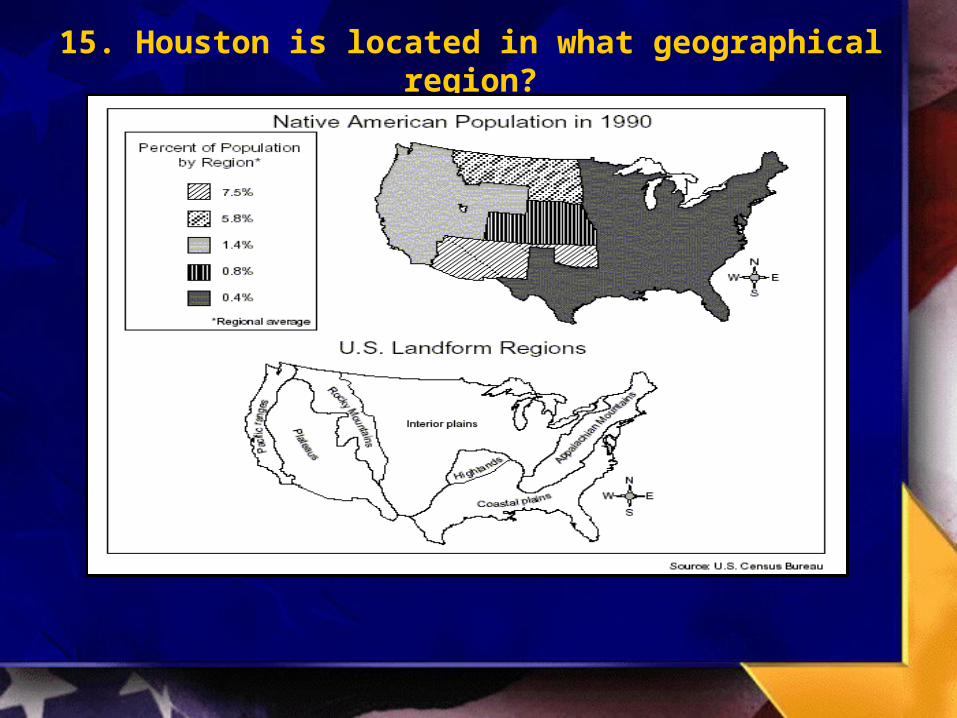
16. The areas of the United States with the largest Native American populations are characterized by
which physical features?
a. Coastal plains and Pacific ranges
b. Interior plains and Appalachian Mountains
c. Plateaus, interior plains, and Rocky Mountains
d. Appalachian Mountains, coastal plains, and interior plains

Map Reading Skills - Blitz Quiz
ANSWERS 1-16
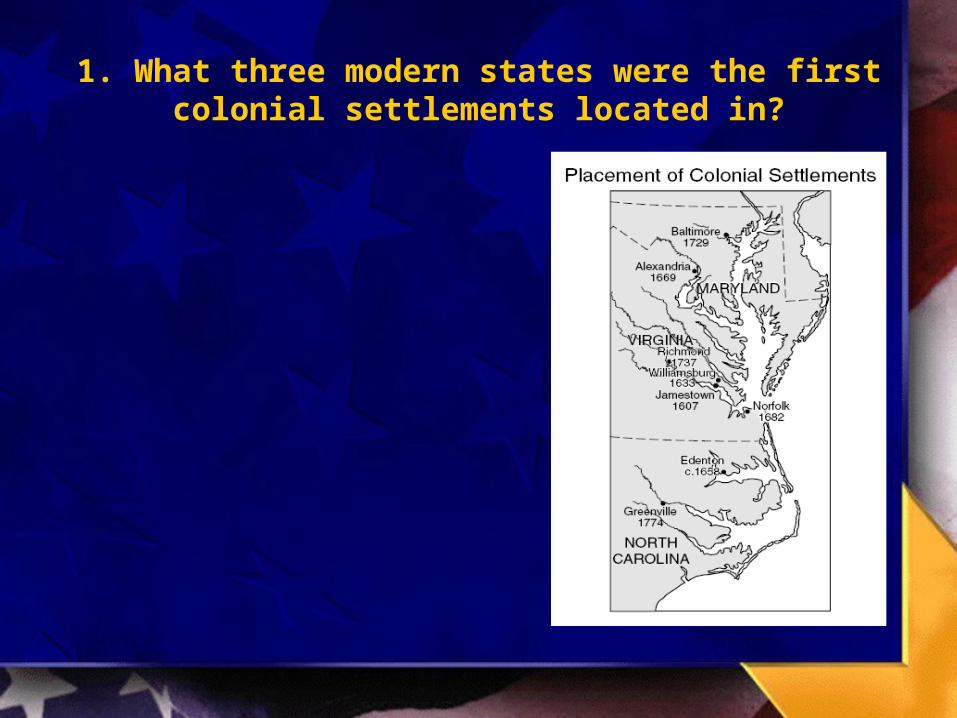
1. What three modern states were the first colonial settlements located in?
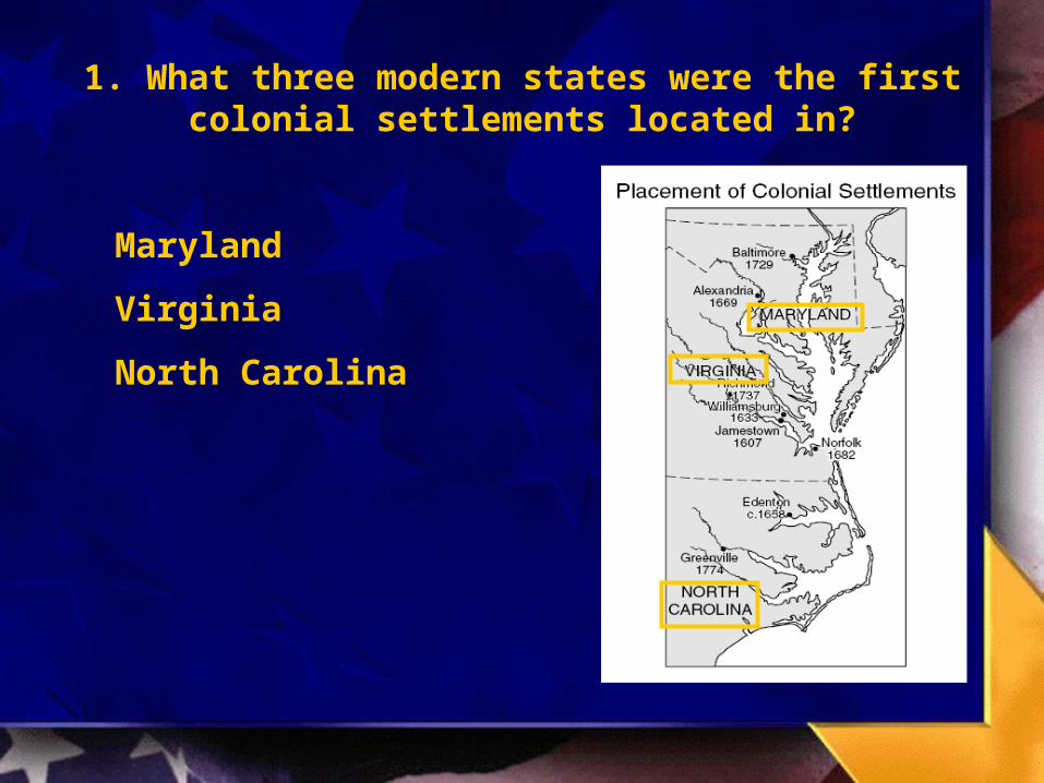
1. What three modern states were the first colonial settlements located in?
Maryland
Virginia
North Carolina
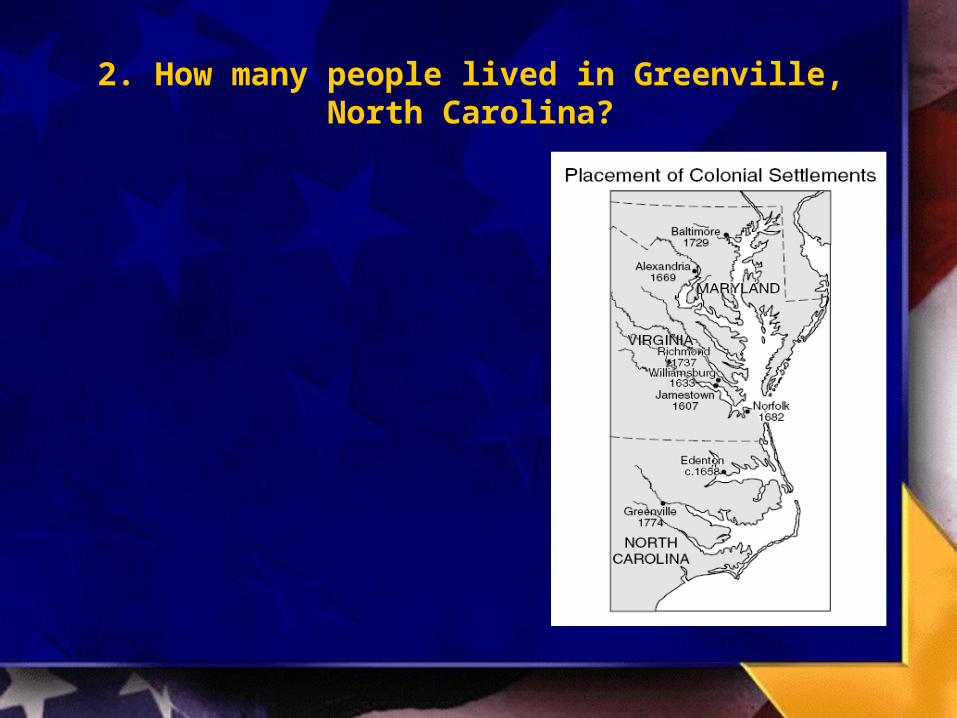
2. How many people lived in Greenville, North Carolina?
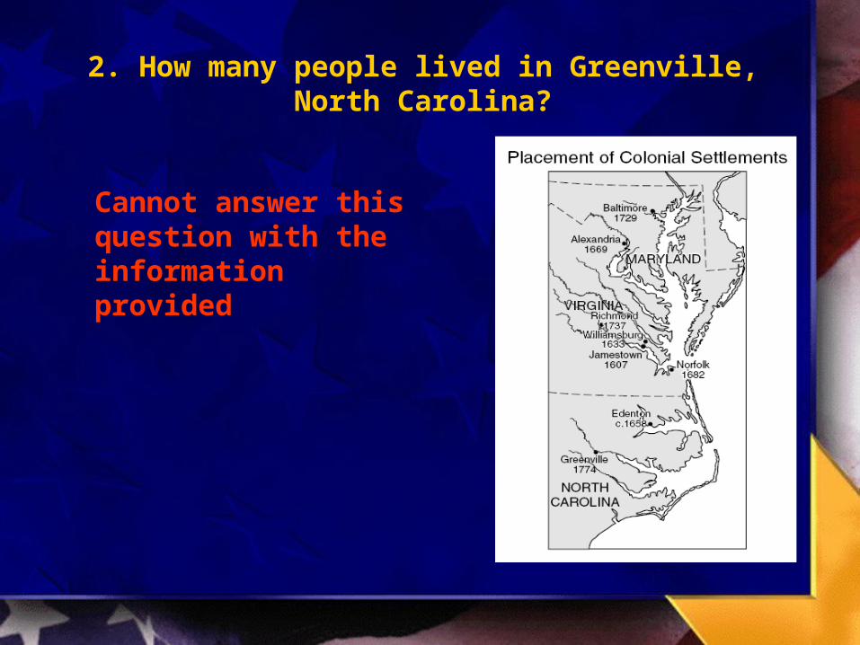
2. How many people lived in Greenville, North Carolina?
Cannot answer this question with the information provided
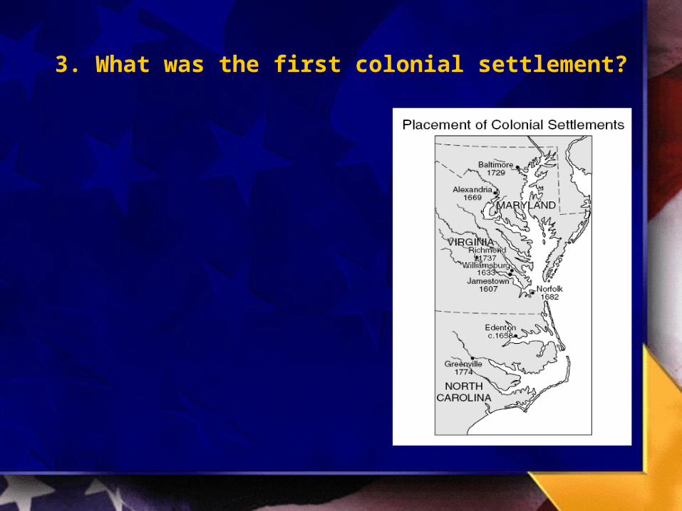
3. What was the first colonial settlement?
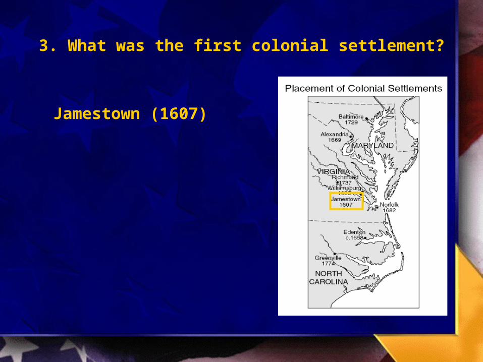
3. What was the first colonial settlement?
Jamestown (1607)

*4. According to the map, which geographic factor most influenced the placement of settlements by early
European colonists?
a. Waterways for tradeb. warm climates for healthc. broad plains with fertile soils
for farmingd. mountains for defense against
enemies
*4. According to the map, which geographic factor most influenced the placement of settlements by early
European colonists?
a. Waterways for tradeb. warm climates for healthc. broad plains with fertile soils
for farmingd. mountains for defense against
enemies

5. Lewis and Clark’s journey generally followed what natural feature?

5. Lewis and Clark’s journey generally followed what natural feature?
Rivers (Missouri / Columbia)
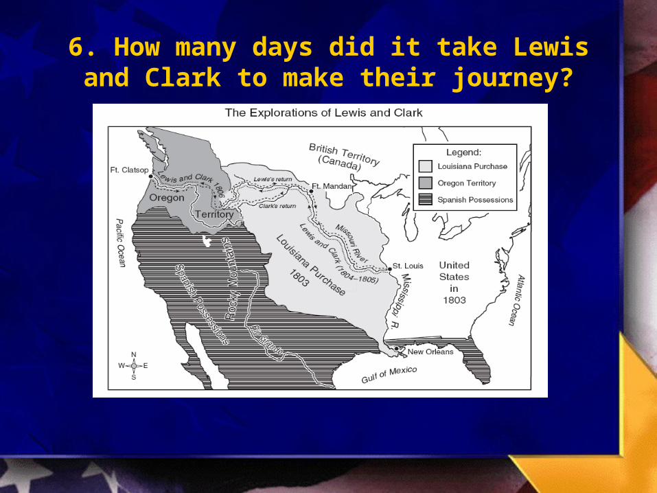
6. How many days did it take Lewis and Clark to make their journey?
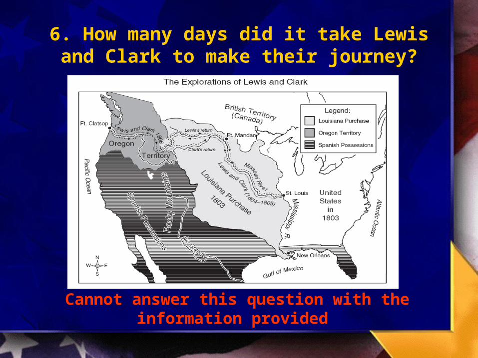
6. How many days did it take Lewis and Clark to make their journey?
Cannot answer this question with the information provided

7. Where did Lewis and Clark’s journey begin and end?
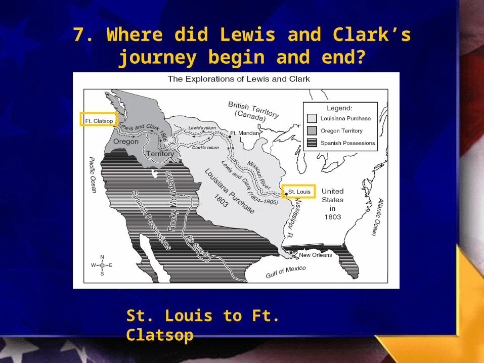
7. Where did Lewis and Clark’s journey begin and end?
St. Louis to Ft. Clatsop
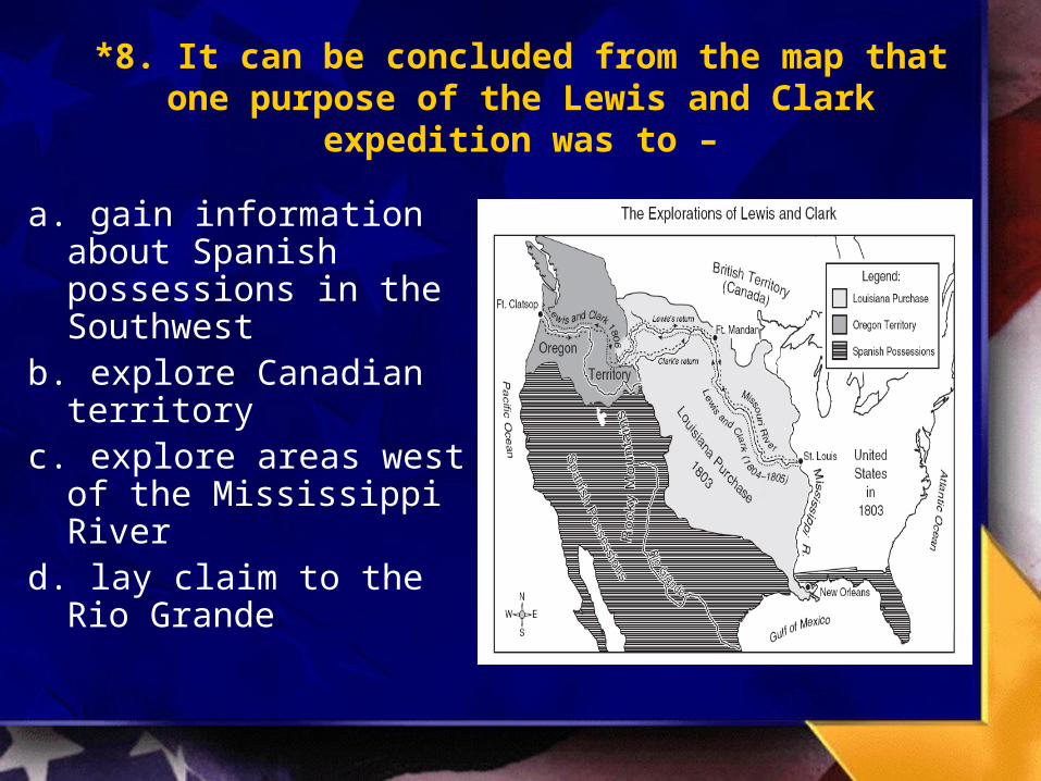
*8. It can be concluded from the map that one purpose of the Lewis and Clark expedition was to –
a. gain information about Spanish possessions in the Southwest
b. explore Canadian territoryc. explore areas west of the
Mississippi Riverd. lay claim to the Rio
Grande

*8. It can be concluded from the map that one purpose of the Lewis and Clark expedition was to –
a. gain information about Spanish possessions in the Southwest
b. explore Canadian territoryc. explore areas west of
the Mississippi Riverd. lay claim to the Rio
Grande

9. What state became a member of the Union in 1860?
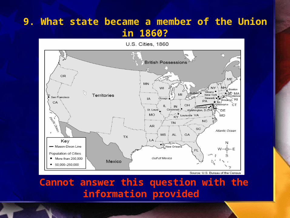
9. What state became a member of the Union in 1860?
Cannot answer this question with the information provided

10. Between what two states was the Mason-Dixon line located?
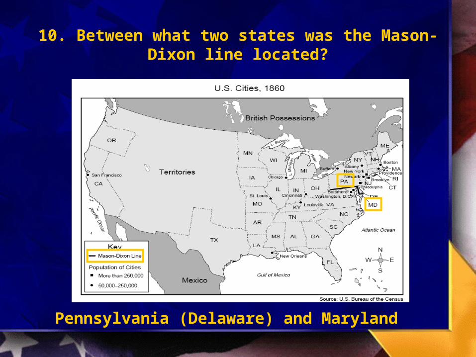
10. Between what two states was the Mason-Dixon line located?
Pennsylvania (Delaware) and Maryland

11. What was the most western city with a population over 250,000?

11. What was the most western city with a population over 250,000?
Philadelphia

12. According to the map, in 1860 all U.S. cities with populations greater than 250,000 were located –
a. south of the Mason-Dixon Line
b. near the Great Lakes
c. west of the territories
d. in the Northeast

12. According to the map, in 1860 all U.S. cities with populations greater than 250,000 were located –
a. south of the Mason-Dixon Line
b. near the Great Lakes
c. west of the territories
d. in the Northeast
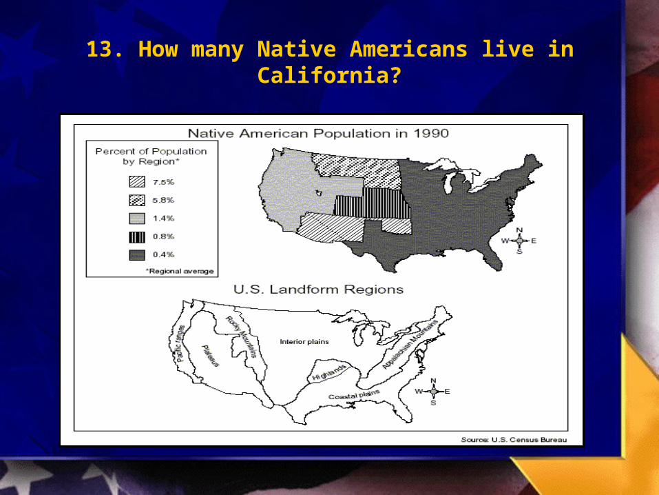
13. How many Native Americans live in California?
13. How many Native Americans live in California?
Cannot answer this question with the information provided
14. What percent of the population of Texas is Native American?

14. What percent of the population of Texas is Native American?
0.4%
15. Houston is located in what geographical region?
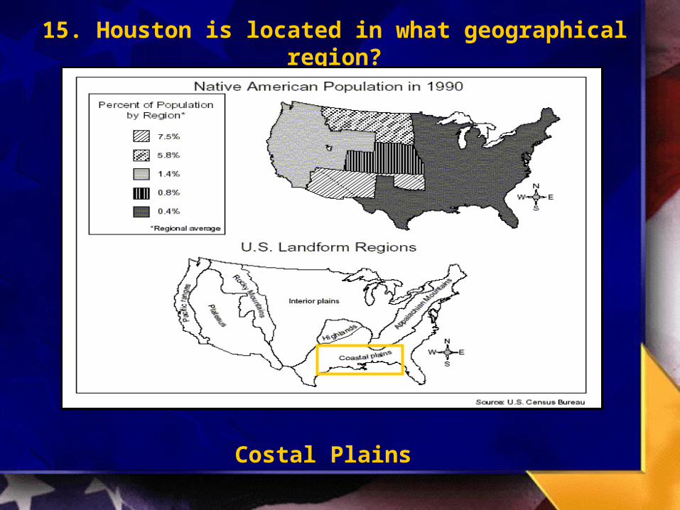
15. Houston is located in what geographical region?
Costal Plains

16. The areas of the United States with the largest Native American populations are characterized by
which physical features?
a. Coastal plains and Pacific ranges
b. Interior plains and Appalachian Mountains
c. Plateaus, interior plains, and Rocky Mountains
d. Appalachian Mountains, coastal plains, and interior plains
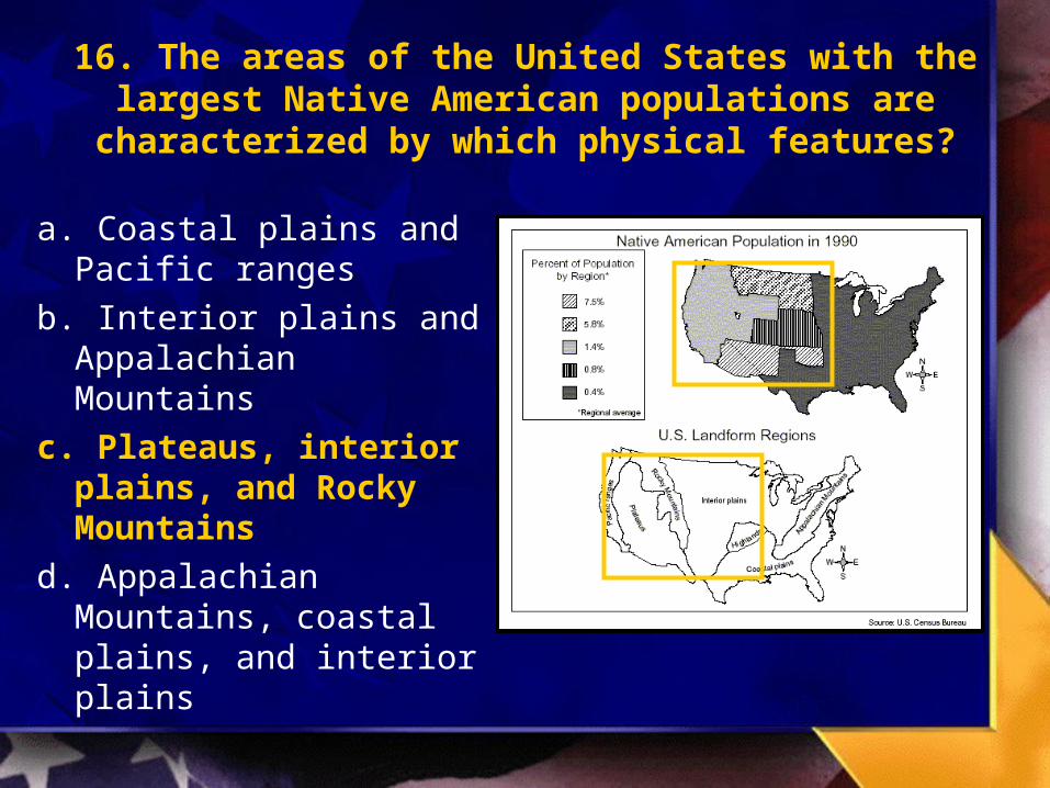

Map Reading Skills - Blitz Quiz
Number 17-32

17. What continent was most of Alexander the Great’s Empire located on?

18. The region most dependent on Alexander was located on what part of his empire?
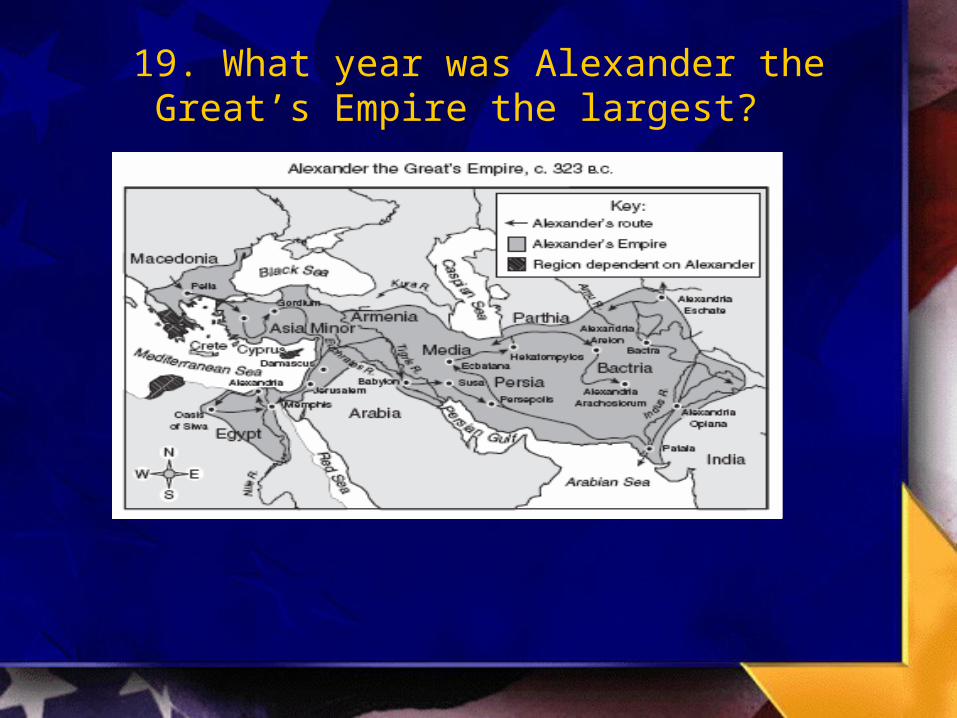
19. What year was Alexander the Great’s Empire the largest?
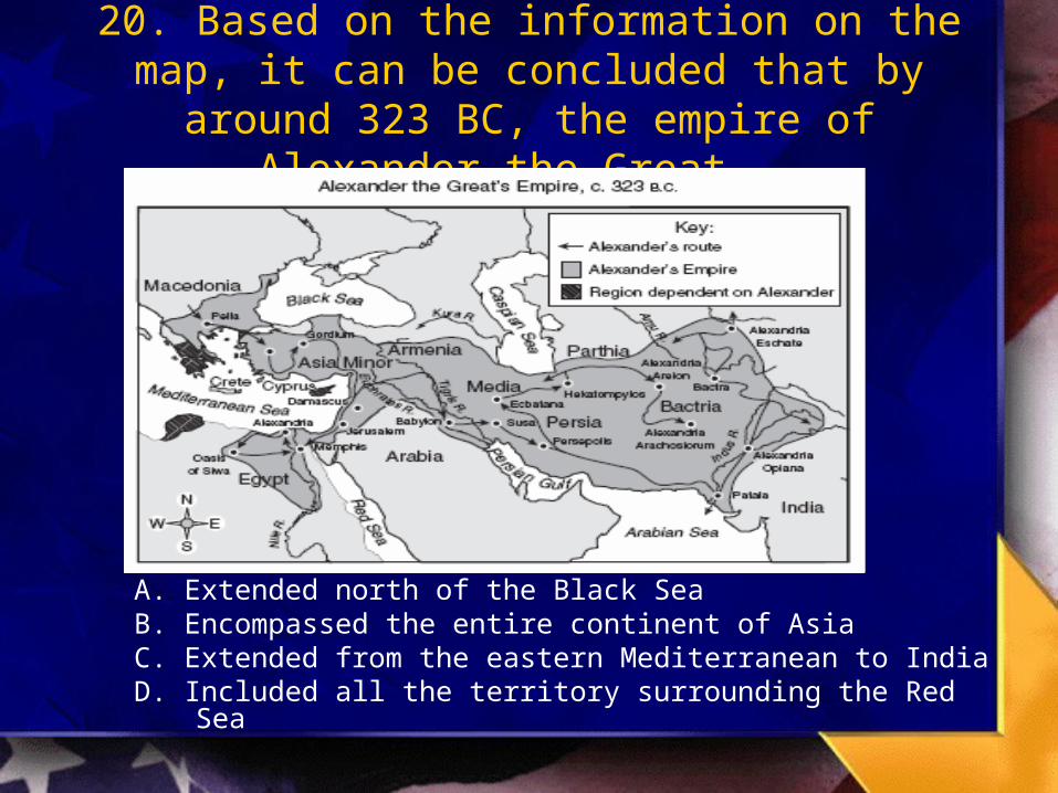
20. Based on the information on the map, it can be concluded that by around 323 BC, the empire of
Alexander the Great -
A. Extended north of the Black SeaB. Encompassed the entire continent of AsiaC. Extended from the eastern Mediterranean to IndiaD. Included all the territory surrounding the Red Sea
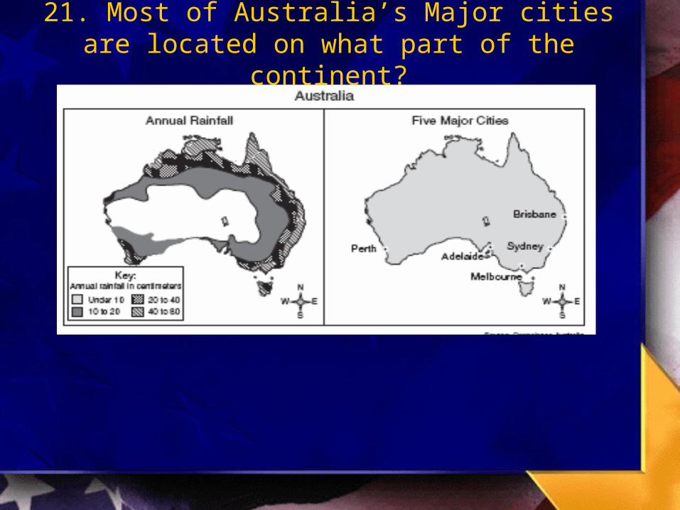
21. Most of Australia’s Major cities are located on what part of the continent?
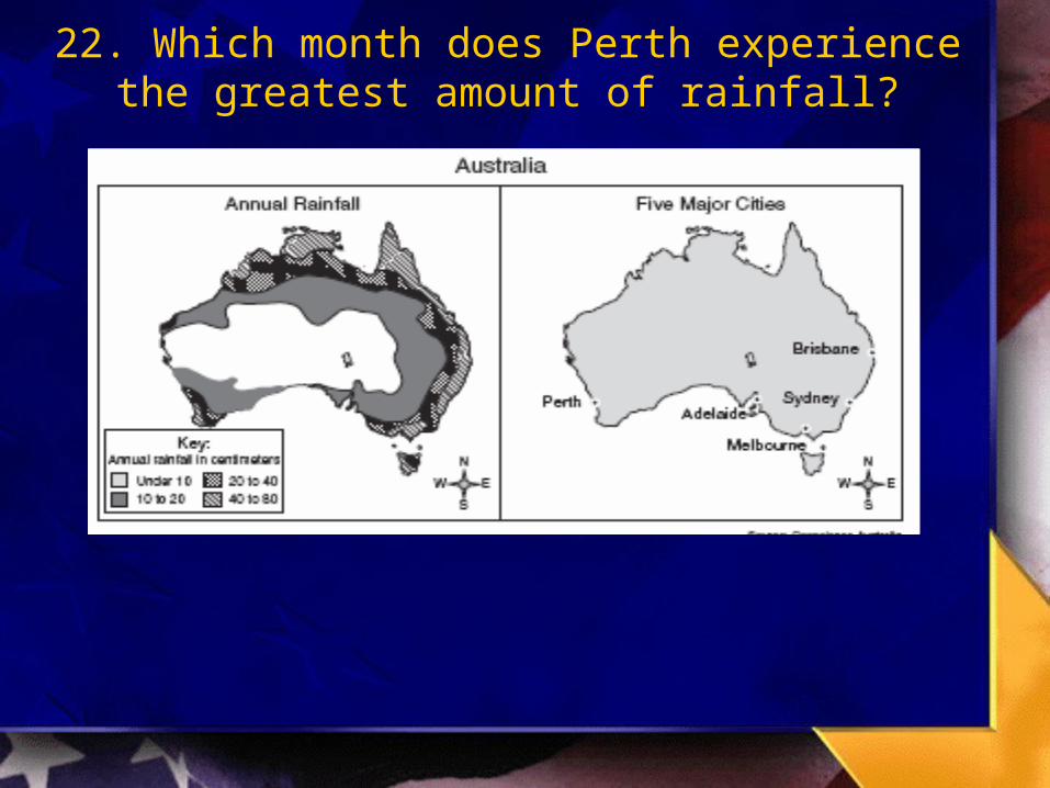
22. Which month does Perth experience the greatest amount of rainfall?

23. What area of Australia receives the least amount of rainfall?
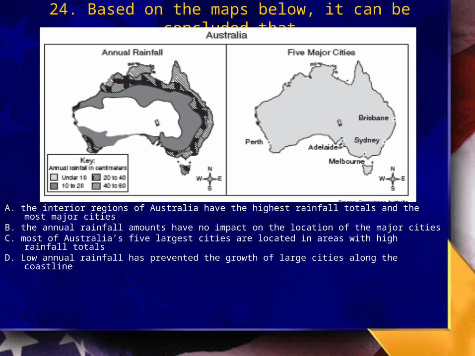
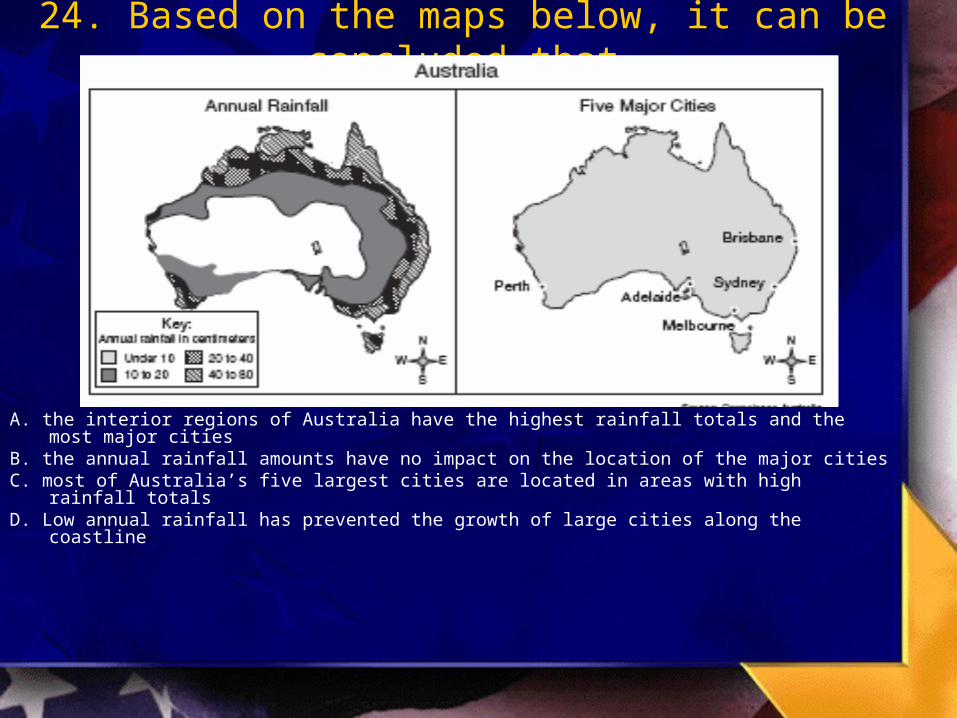
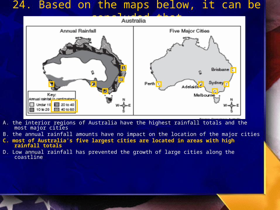
24. Based on the maps below, it can be concluded that
A. the interior regions of Australia have the highest rainfall totals and the most major cities
B. the annual rainfall amounts have no impact on the location of the major cities C. most of Australia’s five largest cities are located in areas with high rainfall totalsD. Low annual rainfall has prevented the growth of large cities along the coastline

25. According to the map, how many peacekeeping operations are taking place in the United States?

26. The majority of the Peacekeeping Operations in 2003 are funded by the United States?

27. What two continents have a majority of the peacekeeping operations taken place on?

28. According to the map, in which of the following regions does the United Nations have peacekeeping operations
A. South America C. Northern Europe
B. Central America D. The Middle East

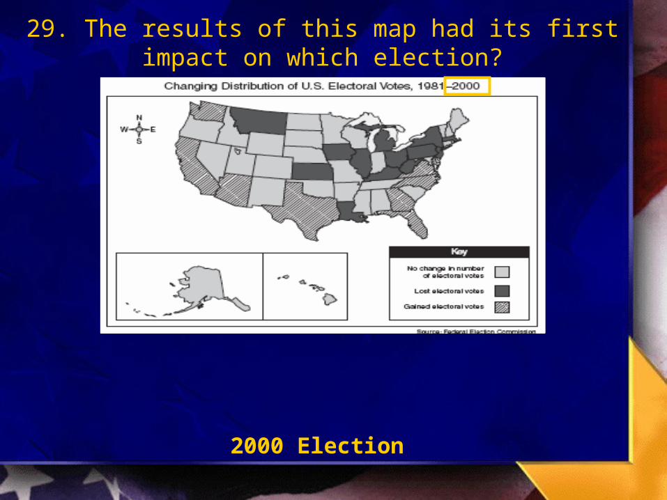
29. The results of this map had its first impact on which election?
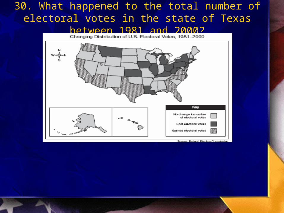
30. What happened to the total number of electoral votes in the state of Texas between 1981 and 2000?

31. How many electoral votes did California gain?
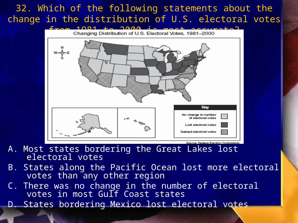
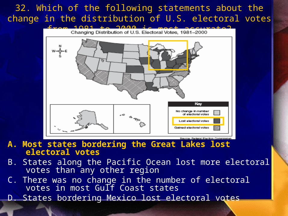
32. Which of the following statements about the change in the distribution of U.S. electoral votes from 1981 to 2000 is most
accurate?
A. Most states bordering the Great Lakes lost electoral votesB. States along the Pacific Ocean lost more electoral votes than
any other regionC. There was no change in the number of electoral votes in most
Gulf Coast statesD. States bordering Mexico lost electoral votes

Map Reading Skills - Blitz Quiz
ANSWERS 17-32
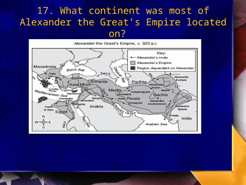
17. What continent was most of Alexander the Great’s Empire located on?
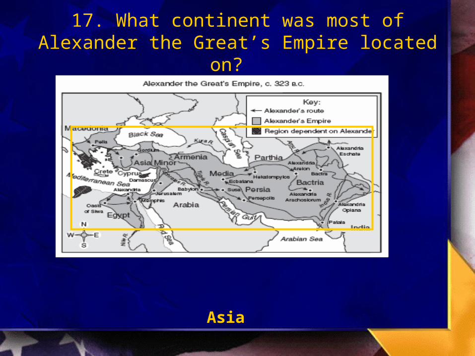
17. What continent was most of Alexander the Great’s Empire located on?
Asia
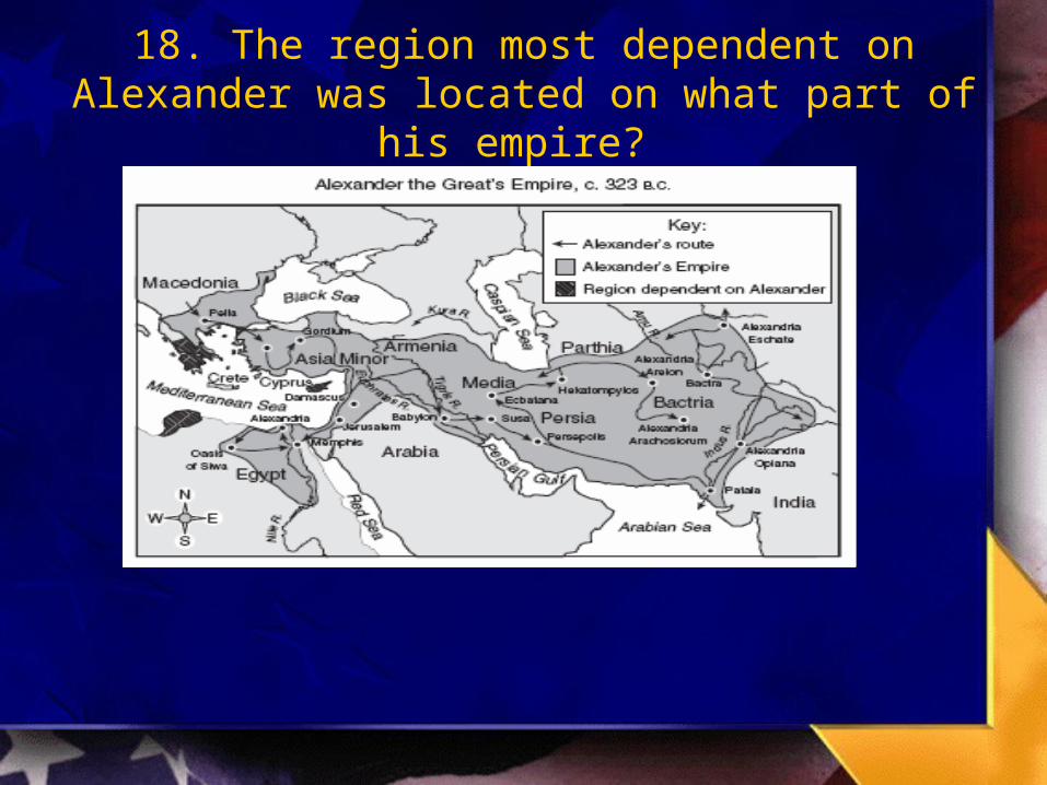
18. The region most dependent on Alexander was located on what part of his empire?
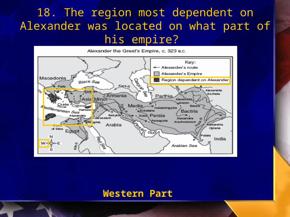
18. The region most dependent on Alexander was located on what part of his empire?
Western Part

19. What year was Alexander the Great’s Empire the largest?
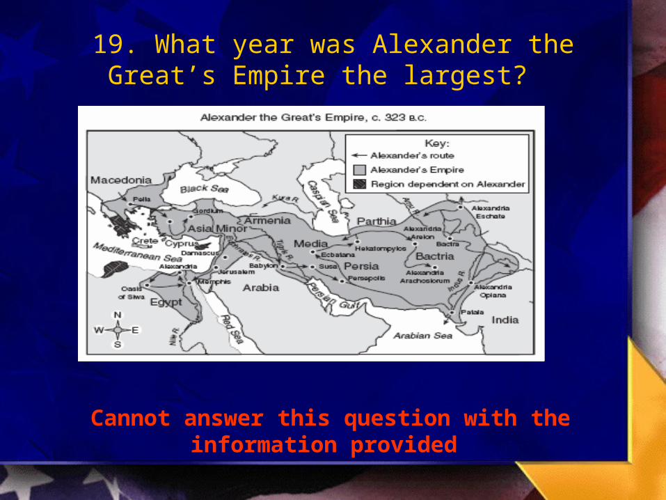
19. What year was Alexander the Great’s Empire the largest?
Cannot answer this question with the information provided

20. Based on the information on the map, it can be concluded that by around 323 BC, the empire of
Alexander the Great -
A. Extended north of the Black SeaB. Encompassed the entire continent of AsiaC. Extended from the eastern Mediterranean to IndiaD. Included all the territory surrounding the Red Sea

21. Most of Australia’s Major cities are located on what part of the continent?
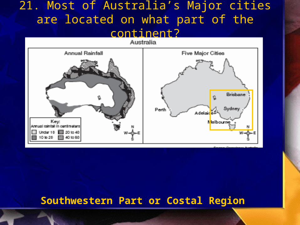
21. Most of Australia’s Major cities are located on what part of the continent?
Southwestern Part or Costal Region

22. Which month does Perth experience the greatest amount of rainfall?
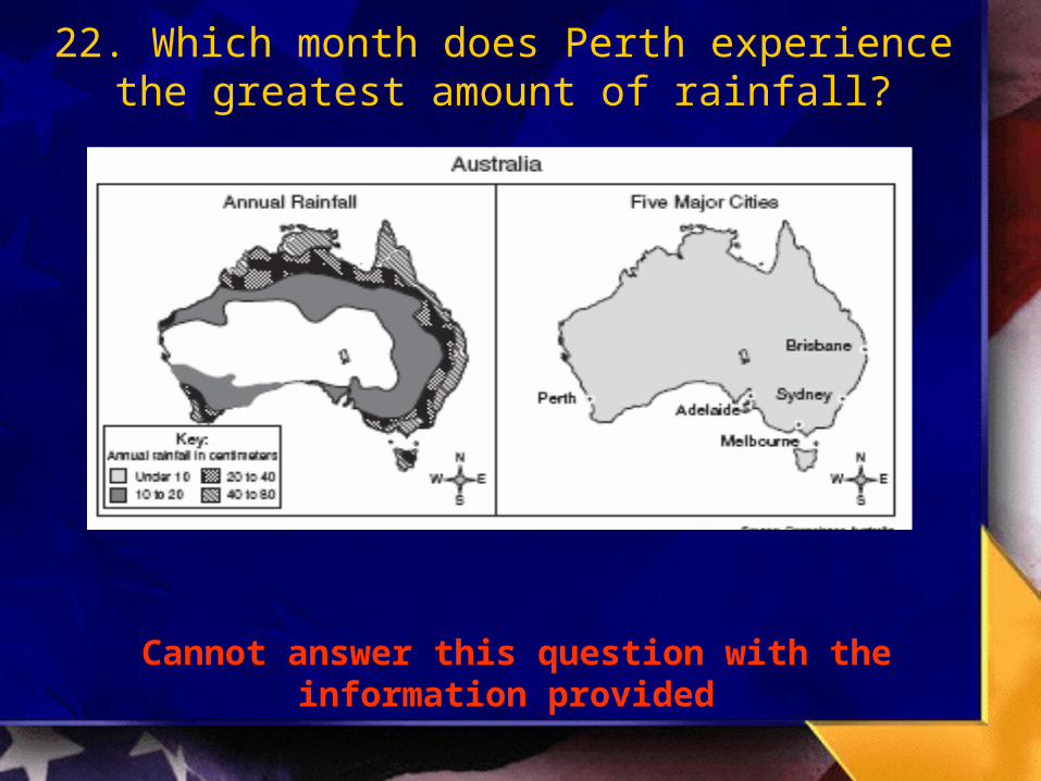
22. Which month does Perth experience the greatest amount of rainfall?
Cannot answer this question with the information provided

23. What area of Australia receives the least amount of rainfall?

23. What area of Australia receives the least amount of rainfall?
Interior Region
24. Based on the maps below, it can be concluded that
A. the interior regions of Australia have the highest rainfall totals and the most major cities
B. the annual rainfall amounts have no impact on the location of the major cities C. most of Australia’s five largest cities are located in areas with high rainfall totalsD. Low annual rainfall has prevented the growth of large cities along the coastline
24. Based on the maps below, it can be concluded that
A. the interior regions of Australia have the highest rainfall totals and the most major cities
B. the annual rainfall amounts have no impact on the location of the major cities C. most of Australia’s five largest cities are located in areas with high rainfall
totalsD. Low annual rainfall has prevented the growth of large cities along the coastline
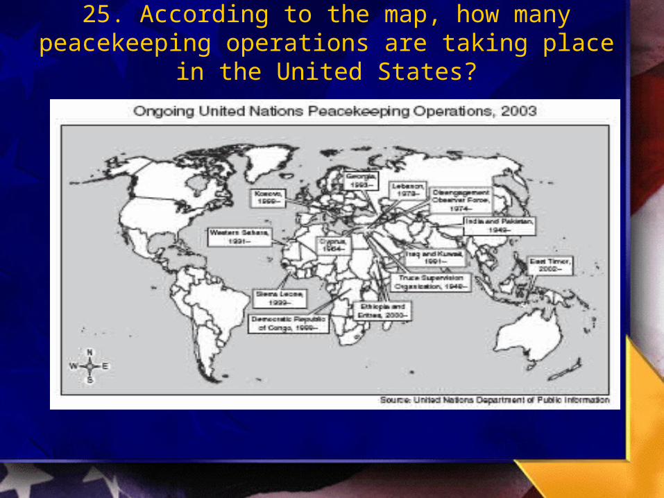
25. According to the map, how many peacekeeping operations are taking place in the United States?

25. According to the map, how many peacekeeping operations are taking place in the United States?
None

26. The majority of the Peacekeeping Operations in 2003 are funded by the United States?
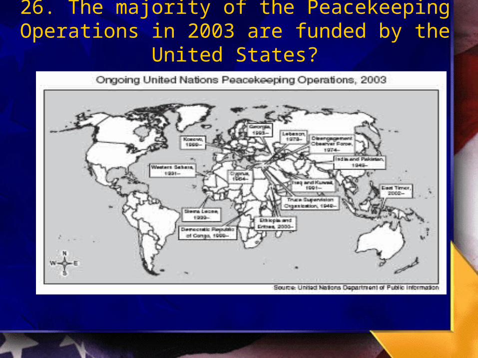
26. The majority of the Peacekeeping Operations in 2003 are funded by the United States?
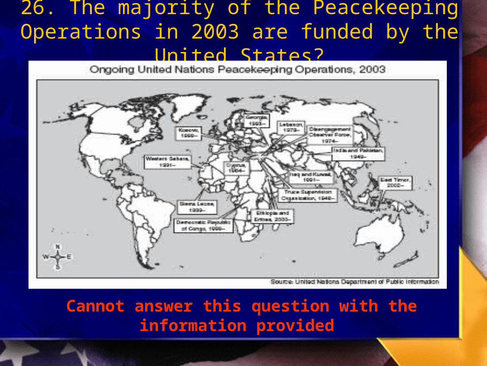
26. The majority of the Peacekeeping Operations in 2003 are funded by the United States?
Cannot answer this question with the information provided
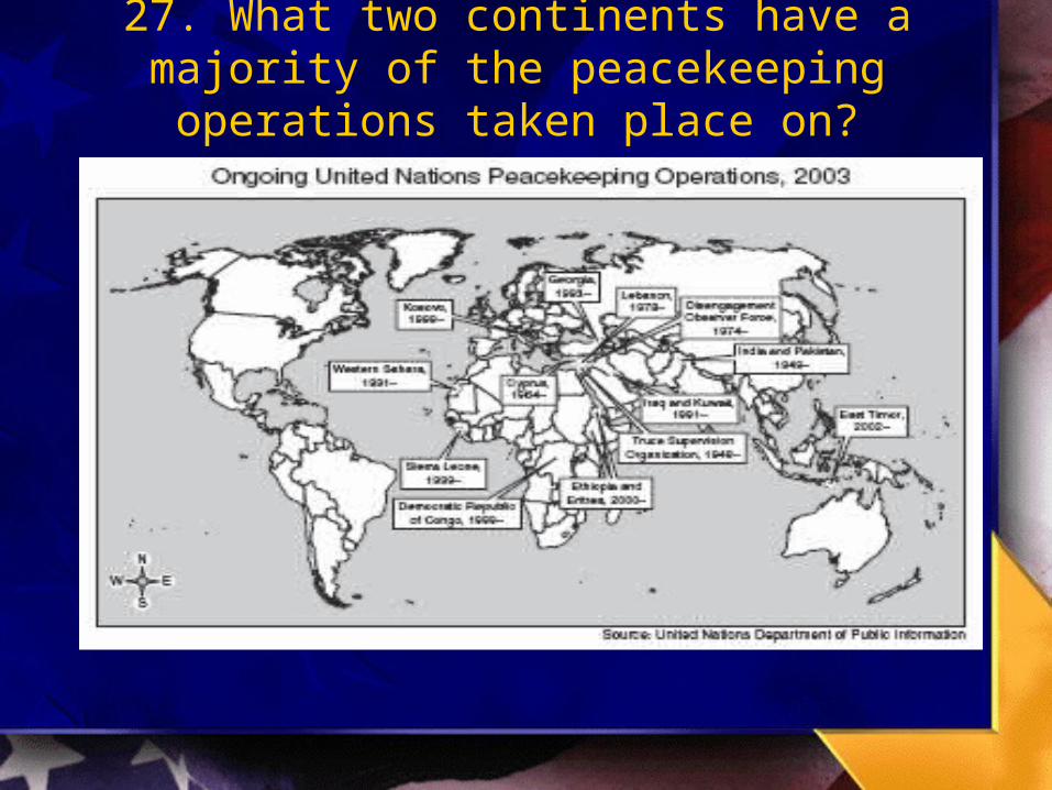
27. What two continents have a majority of the peacekeeping operations taken place on?
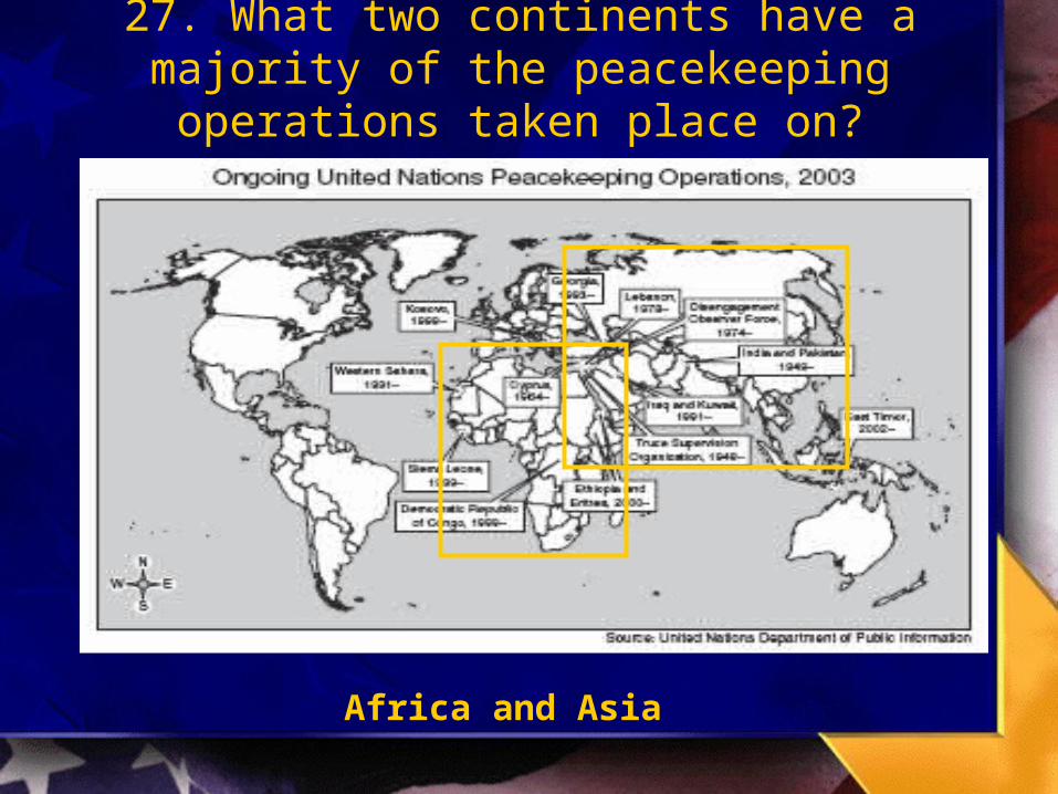
27. What two continents have a majority of the peacekeeping operations taken place on?
Africa and Asia

28. According to the map, in which of the following regions does the United Nations have peacekeeping operations
A. South America C. Northern Europe
B. Central America D. The Middle East
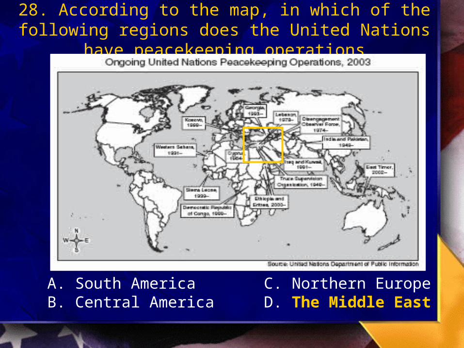
28. According to the map, in which of the following regions does the United Nations have peacekeeping operations
A. South America C. Northern EuropeB. Central America D. The Middle East
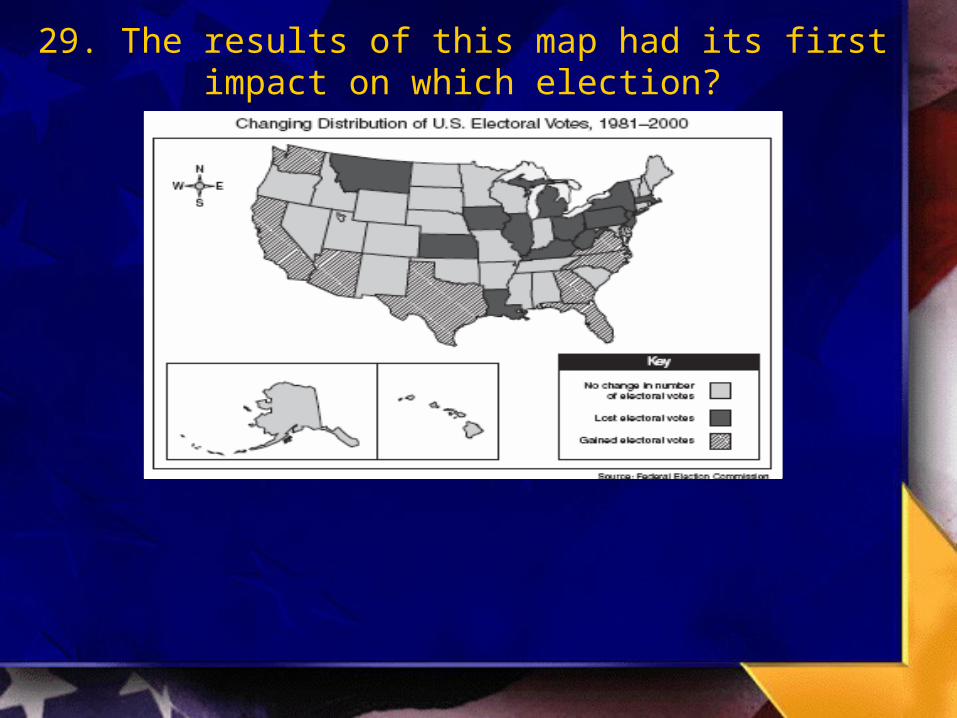
29. The results of this map had its first impact on which election?
29. The results of this map had its first impact on which election?
2000 Election

30. What happened to the total number of electoral votes in the state of Texas between 1981 and 2000?

30. What happened to the total number of electoral votes in the state of Texas between 1981 and 2000?
Gained Electoral Votes

31. How many electoral votes did California gain?

31. How many electoral votes did California gain?
Cannot answer this question with the information provided

32. Which of the following statements about the change in the distribution of U.S. electoral votes from 1981 to 2000 is most
accurate?
A. Most states bordering the Great Lakes lost electoral votesB. States along the Pacific Ocean lost more electoral votes than
any other regionC. There was no change in the number of electoral votes in most
Gulf Coast statesD. States bordering Mexico lost electoral votes
TAKS Blitz Quiz
Number 1-8

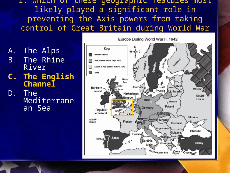
1. Which of these geographic features most likely played a significant role in preventing the Axis powers from taking
control of Great Britain during World War II?
A. The AlpsB. The Rhine
RiverC. The English
ChannelD. The
Mediterranean Sea

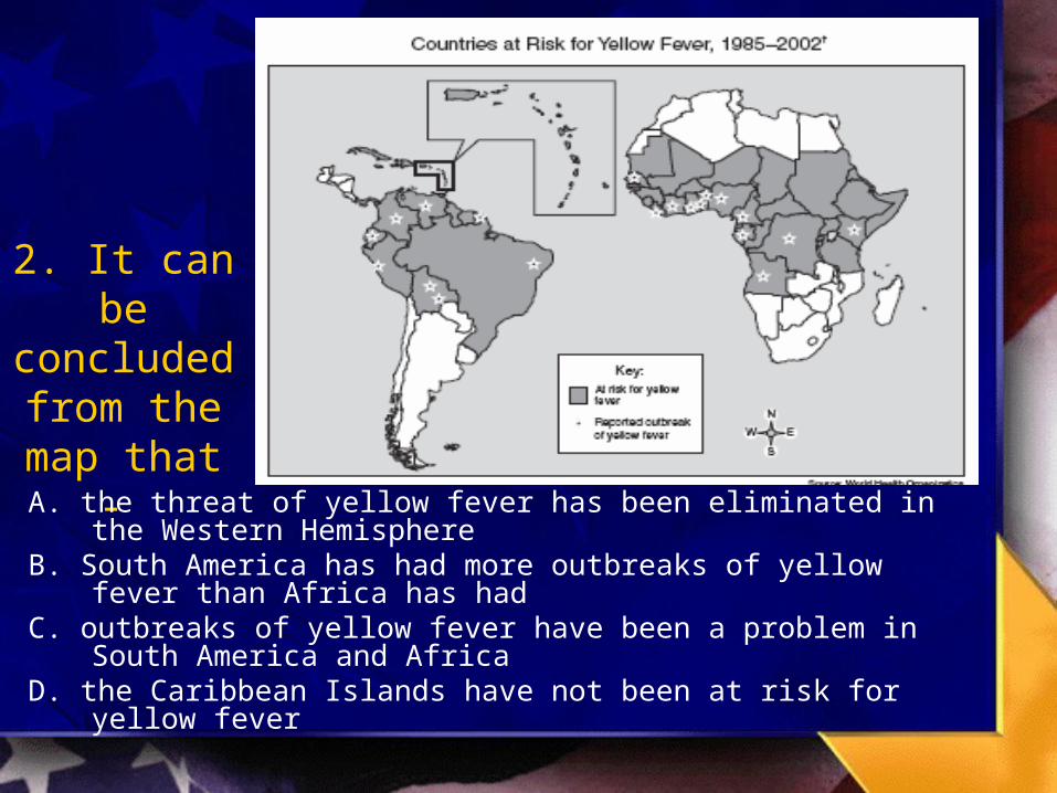
2. It can be concluded from the
map that - A. the threat of yellow fever has been eliminated in the Western
HemisphereB. South America has had more outbreaks of yellow fever than
Africa has hadC. outbreaks of yellow fever have been a problem in South
America and AfricaD. the Caribbean Islands have not been at risk for yellow fever

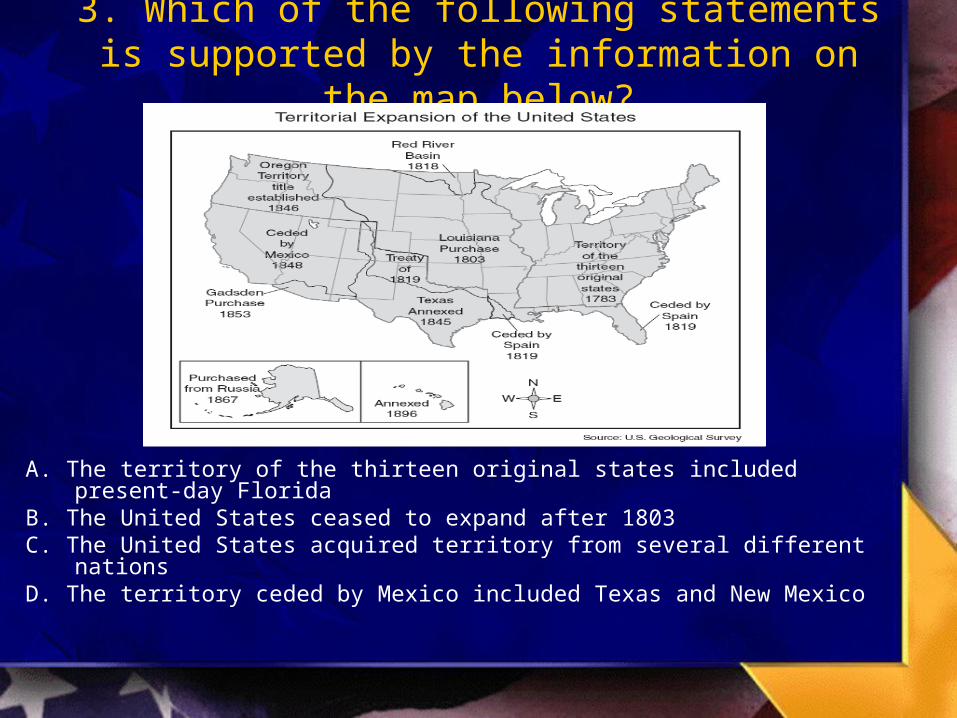
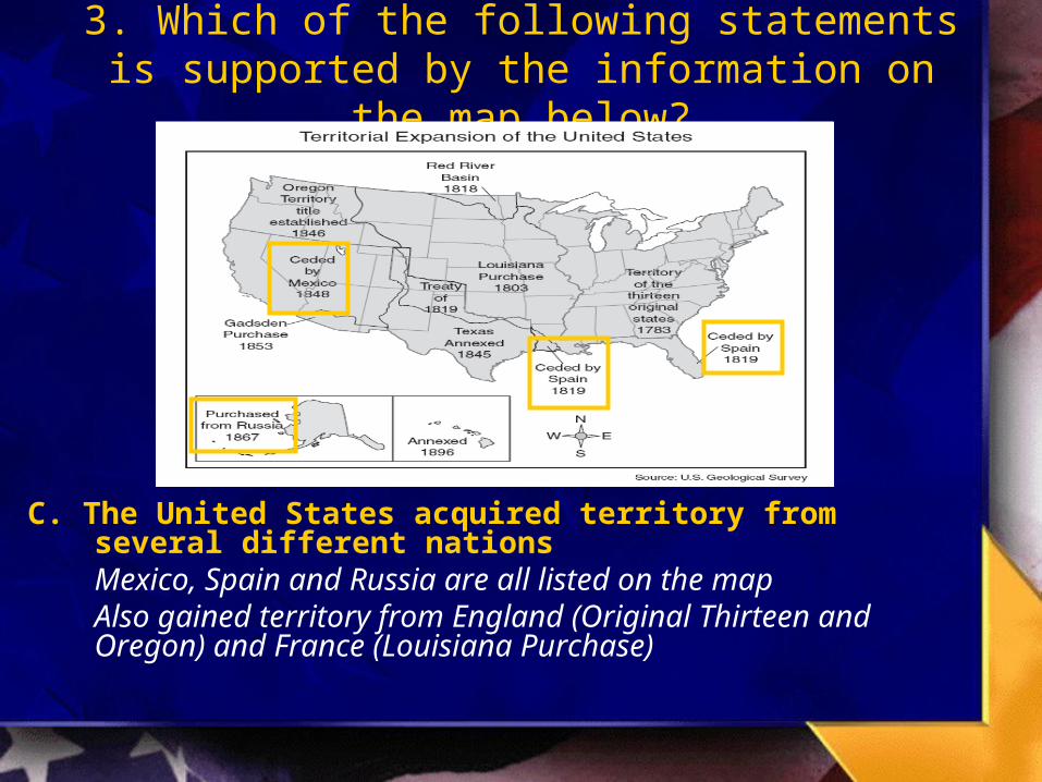
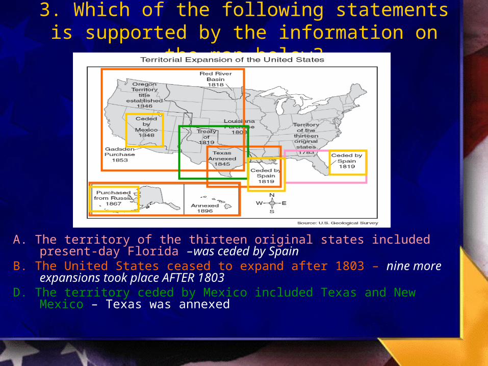
3. Which of the following statements is supported by the information on the map below?
A. The territory of the thirteen original states included present-day FloridaB. The United States ceased to expand after 1803C. The United States acquired territory from several different nationsD. The territory ceded by Mexico included Texas and New Mexico

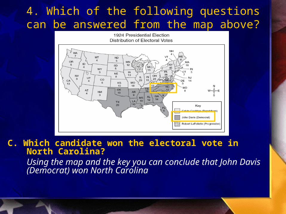
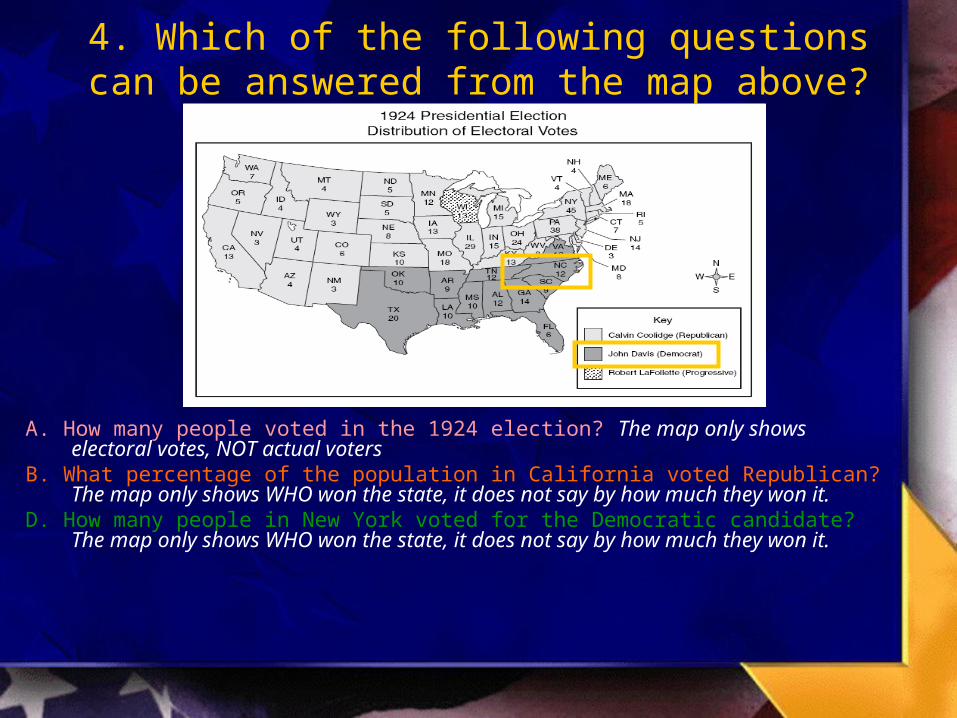
4. Which of the following questions can be answered from the map above?
A. How many people voted in the 1924 election?B. What percentage of the population in California voted Republican?C. Which candidate won the electoral vote in North Carolina?D. How many people in New York voted for the Democratic candidate?

5. According to the map, which of the following statements about
Napoleon’s Empire in 1812 is true?
A. The entire Russian Empire was under Napoleon’s control.
B. Napoleon did not have any allies among the nations of Europe.
C. Most of Europe was under Napoleon’s influence.
D. Southern Europe remained free of Napoleon’s control.
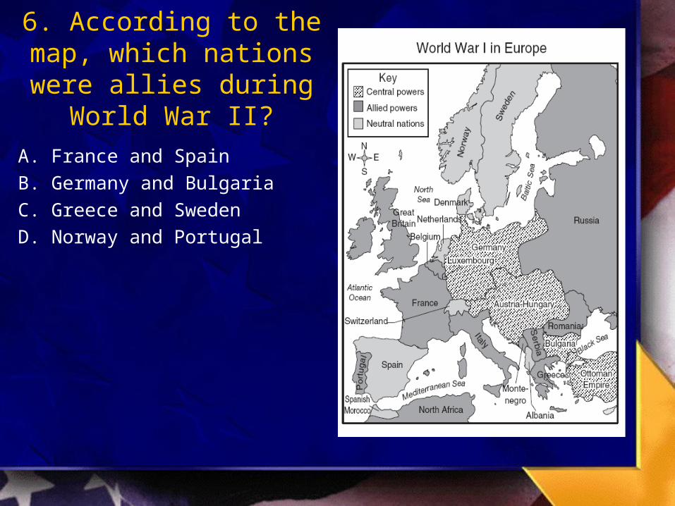
6. According to the map, which nations were allies
during World War II?
A. France and Spain
B. Germany and Bulgaria
C. Greece and Sweden
D. Norway and Portugal
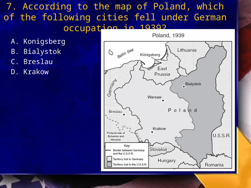
7. According to the map of Poland, which of the following cities fell under German occupation in 1939?
A. Konigsberg
B. Bialystok
C. Breslau
D. Krakow
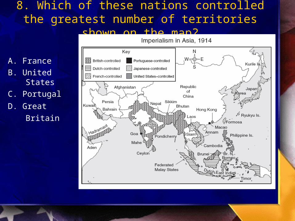
8. Which of these nations controlled the greatest number of territories shown on the map?
A. France
B. United States
C. Portugal
D. Great Britain

Map Reading Skills - Blitz Quiz
Number 9-12
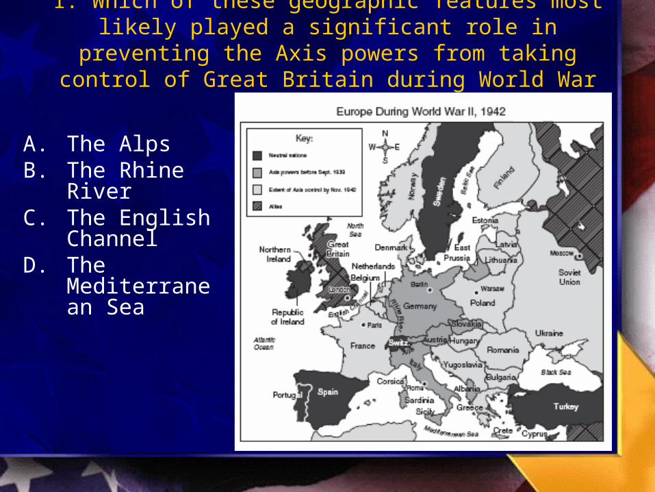
1. Which of these geographic features most likely played a significant role in preventing the Axis powers from taking
control of Great Britain during World War II?
A. The AlpsB. The Rhine
RiverC. The English
ChannelD. The
Mediterranean Sea
1. Which of these geographic features most likely played a significant role in preventing the Axis powers from taking
control of Great Britain during World War II?
A. The AlpsB. The Rhine
RiverC. The English
ChannelD. The
Mediterranean Sea
2. It can be concluded from the
map that - A. the threat of yellow fever has been eliminated in the Western
HemisphereB. South America has had more outbreaks of yellow fever than
Africa has hadC. outbreaks of yellow fever have been a problem in South
America and AfricaD. the Caribbean Islands have not been at risk for yellow fever
3. Which of the following statements is supported by the information on the map below?
A. The territory of the thirteen original states included present-day FloridaB. The United States ceased to expand after 1803C. The United States acquired territory from several different nationsD. The territory ceded by Mexico included Texas and New Mexico
3. Which of the following statements is supported by the information on the map below?
C. The United States acquired territory from several different nationsMexico, Spain and Russia are all listed on the mapAlso gained territory from England (Original Thirteen and Oregon) and France (Louisiana Purchase)
3. Which of the following statements is supported by the information on the map below?
A. The territory of the thirteen original states included present-day Florida –was ceded by Spain
B. The United States ceased to expand after 1803 – nine more expansions took place AFTER 1803
D. The territory ceded by Mexico included Texas and New Mexico – Texas was annexed

4. Which of the following questions can be answered from the map above?
A. How many people voted in the 1924 election?B. What percentage of the population in California voted Republican?C. Which candidate won the electoral vote in North Carolina?D. How many people in New York voted for the Democratic candidate?
4. Which of the following questions can be answered from the map above?
C. Which candidate won the electoral vote in North Carolina?Using the map and the key you can conclude that John Davis (Democrat) won North Carolina
4. Which of the following questions can be answered from the map above?
A. How many people voted in the 1924 election? The map only shows electoral votes, NOT actual voters
B. What percentage of the population in California voted Republican? The map only shows WHO won the state, it does not say by how much they won it.
D. How many people in New York voted for the Democratic candidate? The map only shows WHO won the state, it does not say by how much they won it.
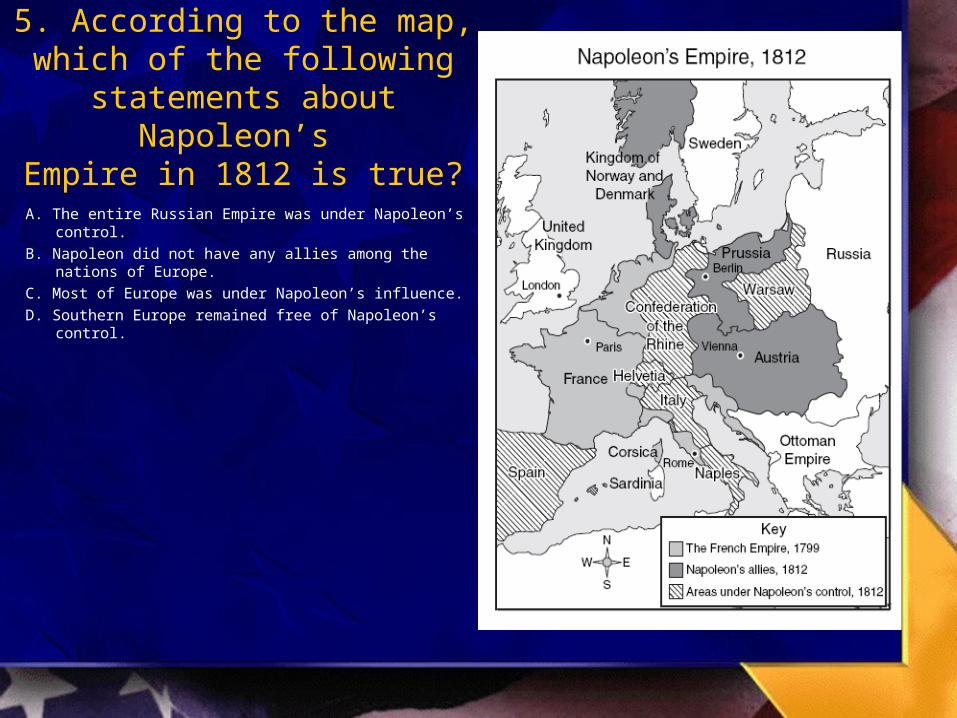
5. According to the map, which of the following statements about
Napoleon’s Empire in 1812 is true?
A. The entire Russian Empire was under Napoleon’s control.
B. Napoleon did not have any allies among the nations of Europe.
C. Most of Europe was under Napoleon’s influence.
D. Southern Europe remained free of Napoleon’s control.
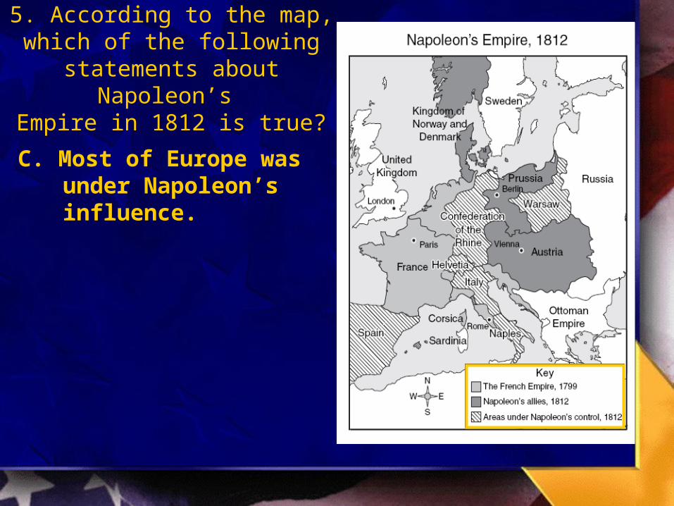
5. According to the map, which of the following statements about
Napoleon’s Empire in 1812 is true?
C. Most of Europe was under Napoleon’s influence.

5. According to the map, which of the following statements about
Napoleon’s Empire in 1812 is true?
A. The entire Russian Empire was under Napoleon’s control.
B. Napoleon did not have any allies among the nations of Europe.
D. Southern Europe remained free of Napoleon’s control.

6. According to the map, which nations were allies
during World War II?
A. France and Spain
B. Germany and Bulgaria
C. Greece and Sweden
D. Norway and Portugal
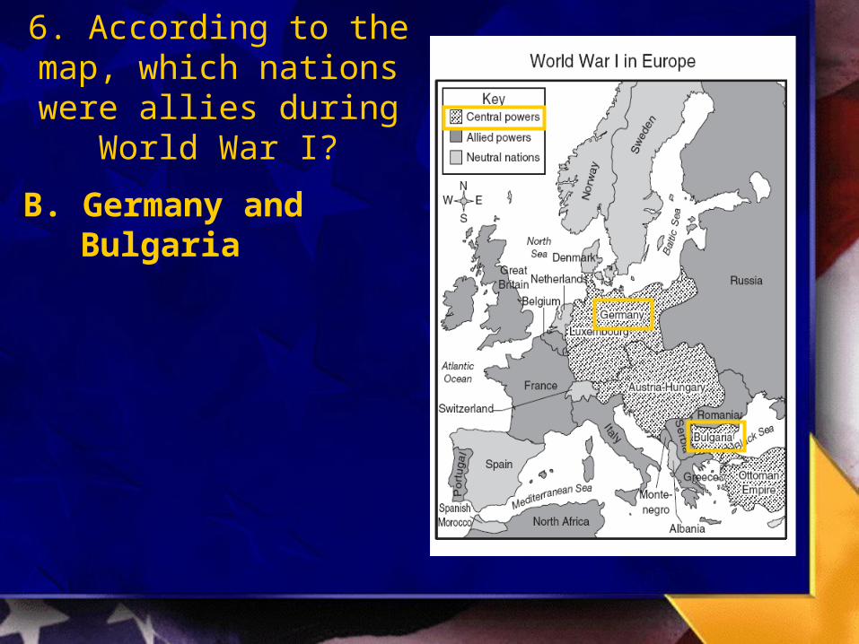
6. According to the map, which nations were allies
during World War I?
B. Germany and Bulgaria

6. According to the map, which nations were allies
during World War II?
A. France and Spain
C. Greece and Sweden
D. Norway and Portugal

7. According to the map of Poland, which of the following cities fell under German occupation in 1939?
A. Konigsberg
B. Bialystok
C. Breslau
D. Krakow

7. According to the map of Poland, which of the following cities fell under German occupation in 1939?
D. Krakow
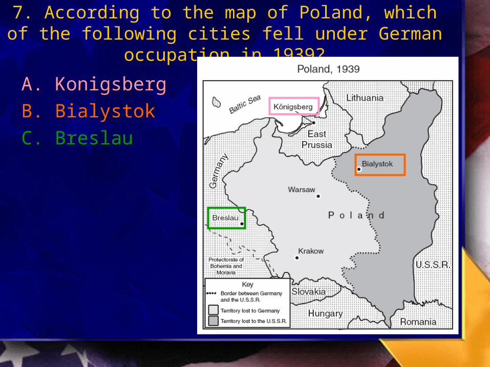
7. According to the map of Poland, which of the following cities fell under German occupation in 1939?
A. Konigsberg
B. Bialystok
C. Breslau

8. Which of these nations controlled the greatest number of territories shown on the map?
A. France
B. United States
C. Portugal
D. Great Britain
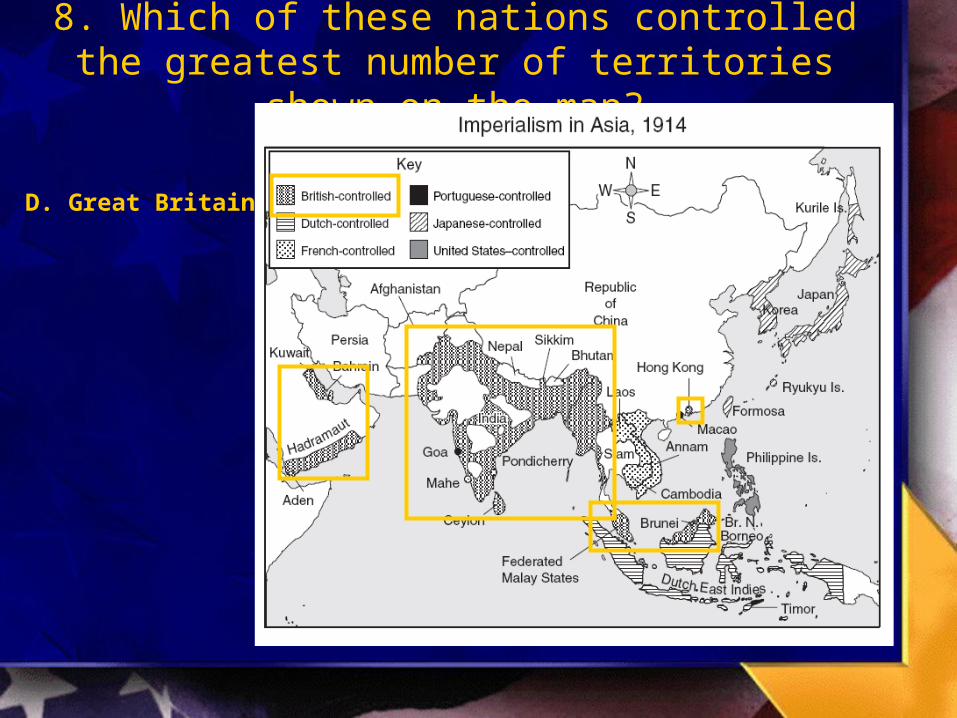
8. Which of these nations controlled the greatest number of territories shown on the map?
D. Great Britain
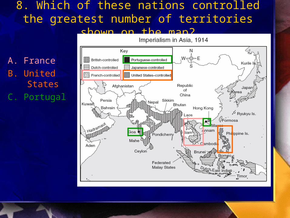
8. Which of these nations controlled the greatest number of territories shown on the map?
A. France
B. United States
C. Portugal