marcus johnson, ph.d. flight test director uas traffic ... · uas traffic management . university...
TRANSCRIPT

National Aeronautics and Space Administration
Marcus Johnson, Ph.D.Flight Test Director
UAS Traffic Management
University of California Berkley Lecture April [email protected]
https://ntrs.nasa.gov/search.jsp?R=20180000390 2019-03-12T12:53:06+00:00Z

2Consumer
Public ServiceCommercial

Safety Security Privacy
3

What is a UAS?
• An Unmanned Aircraft System (UAS) historically has had various names – Drone, ROA, RPA, UAV, Model/R-C
• UAS come in all kinds of shapes & sizes
• UAS have many uses – Agricultural to Zoological
• UAS have many different users – Government entities – Universities
4

UAS come in all shapes and sizes5

UAS Classifications6
• By US Military Group• By Location• By Physical Size• By Weight
– Weight vs Altitude• By Endurance
– Endurance vs Weight– Endurance vs Altitude– Endurance vs Payload
• By Altitude– Altitude vs Speed
• By Wing Loading• By Engine Type
• By Range/Altitude• By Performance• By Capabilities• By Type
– Micro– Small– Medium Altitude Long
Endurance (MALE)– High Altitude Long Endurance
(HALE)• International Classifications
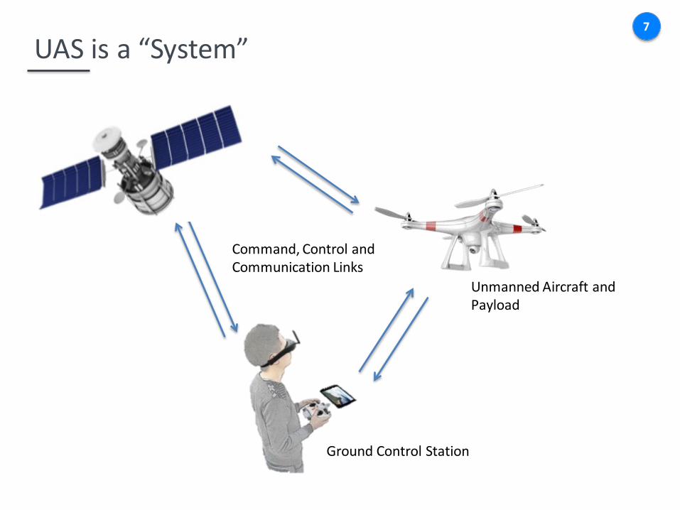
UAS is a “System”7
Ground Control Station
Unmanned Aircraft and Payload
Command, Control and Communication Links

UAS Sensors and Payloads8
• Electro Optical (EO)• Infrared (IR)• Infrared Linescan (IRLS)• Multi Spectral Imaging
(MSI)• Hyper Spectral Imaging
(HSI)• Light Detection & Ranging
(LIDAR)• Laser Radar (LADAR)• Chemical, Biological,
Radiological & Nuclear (CBRN) Detection
• Synthetic Aperture Radar (SAR)
• Moving Target Indication (MTI)
• Signals Intelligence (SIGINT)

Why use a UAS?
• Effective for missions that are Dull, Dirty or Dangerous – Humans not put at risk – Continuous operations
• Lower cost than manned aircraft • Presents opportunity for a U.S.-based industry with
significant growth and job potential– Increasing Demand for UAS = jobs– Manufacturing, training, maintenance, software, etc.
• United States is a global aerospace leader in terms of safety and technology – Embracing UAS opportunities now will enhance our leadership
position – Thoughtful, prudent integration will ensure integration risks
are accurately identified and properly mitigated
9

Applications of Unmanned Aerial Systems 10
News Gathering
Spraying/Seeding

The National Airspace System11
Class A• Highly regulated airspace with jet routes• UAS would share skies with airliners, military transport and general aviation• UAS must carry a transponder and report location to ATC• UAS will operate under Instrument Flight Rules (IFR) and communicate with ATC• Detect and Avoid technologies are needed to avoid aircraft in an emergency

The National Airspace System12
Class B,C,D• Airspace that surrounds airports• Two way communications are required with ATC• Likely all UAS will have to take-off/land under ATC supervision in this airspace

The National Airspace System13
Class E• Above FL 600 holds promise for high altitude long endurance (HALE) UAS• UAS performance differences above FL 600 may cause challenge for detect and avoid• From 0-18,000 ft in Class E, detect and avoid is complicated by aircraft without transponders
and UAS size, weight and power requirements

The National Airspace System14
• Currently utilized by recreational UAS hobbyist (0-400 ft AGL) within line of sight• Risk of colliding with helicopters, general aviation, and man-made objects• Good starting point for UAS Traffic Management
Class G
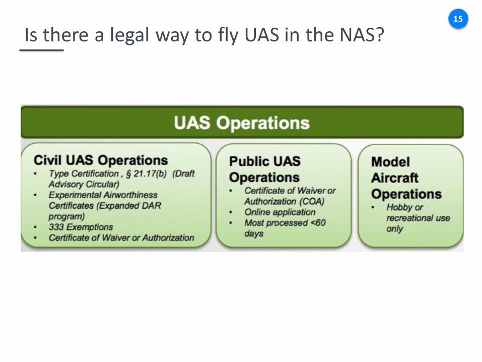
Is there a legal way to fly UAS in the NAS?15

Public UAS Operations16
Who is Operating UAS:• Department of Agriculture • Department of Commerce • Department of Defense • Department of Energy • Department of Homeland
Security • Department of Interior • Department of Justice • NASA • State Universities • State/Local Law
Enforcement
What are they doing with UAS?• Border Patrol • Firefighting • Disaster Relief • Search and Rescue • Training for Ops Missions • Operational Missions • Research • System Development • Sensor Development &
Testing

Civil UAS Operations17
Who is Operating UAS:• 4,731 petitions
granted (as of 4/13/2016)
What are they doing with UAS?• Wide Range of Applications
https://www.faa.gov/uas/legislative_programs/section_333/333_authorizations/
• Typical Operations:– visual line of sight– under 400 ft AGL– 2-5 miles away from
airport/helipad– Daytime operations under
visual flight rules– 55 lb aircraft and under

Model Aircraft Operations
• Fly below 400 feet and remain clear of surrounding obstacles
• Keep the aircraft within visual line of sight at all times• Remain well clear of and do not interfere with
manned aircraft operations• Don't fly within 5 miles of an airport unless you
contact the airport and control tower before flying• Don't fly near people or stadiums• Don't fly an aircraft that weighs more than 55 lbs• Don't be careless or reckless with your unmanned
aircraft
18


20
Grand Canyon June 1956
21

22
Security Pacific National Bank Collection / Los Angeles Public Library Photo Collection

Unmanned Aerial System Traffic Management (UTM) 23
Near-term Goal: Safely enable initial low-altitude UAS as early as possible Long-term Goal: Accommodate increased demand with highest safety, efficiency, and capacity

Challenge and Opportunities
• Challenge: Acceptance of large-scale UAS operations in low altitude airspace – Airspace operations requirements: technology and procedures
– Safety
– Privacy policy
– Security
– Noise
– Public perception
• Economics: Safe, secure, and scalable “Beyond visual line of sight” operations
• Opportunities: Technology advancements and new business models
24

NATIONAL AND REGIONAL SECURITY
Protecting key assets
25

UTM Functions AIRSPACE OPERATIONS & MANAGEMENT
• Geographical needs and applications• Rules of the airspace: performance-
based• Geofences: dynamic and static• Consider other traffic and underlying
environment
26

UTM Functions27
WIND & WEATHER INTEGRATION
• Actual and predicted winds/weather
CONGESTION MANAGEMENT
• Demand/capacity imbalance• Only if needed – corridors,
altitude for direction, etc.

UTM Functions28
SEPARATION MANAGEMENT• Airspace reservation• V2V and V2UTM • Tracking: ADS-B, cellphone, & satellite
based
CONTINGENCY MANAGEMENT• Large-scale GPS or cell outage• 9-11 like situations

Airspace Managed by UTM29
Based upon four risk-based criteria:– Population Density– Density of Man-made
Structures– Likelihood of Manned
Operations– Number of UTM operations
Bounded by– Jurisdiction and Airspace
Management Authority– UTM Connectivity
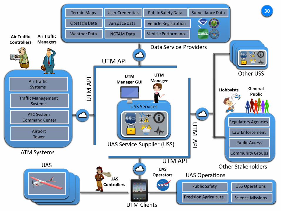
USS Services
UTM Manager GUI
UTM Manager
UTM
API
UTM API
UTM
API
UTM API
Regulatory Agencies
Law Enforcement
Public Access
Community Groups
Hobbyists General Public
Air Traffic Systems
Traffic Management Systems
ATC SystemCommand Center
AirportTower
Air TrafficControllers
Air Traffic Managers
Precision Agriculture
Public Safety USS Operations
Science Missions
ATM Systems
UTM Clients
Data Service Providers
Other StakeholdersUAS
UASControllers
Other USS
UAS OperationsUAS
Operators
Terrain Maps
Obstacle Data
Weather Data
Public Safety Data
Airspace Data
NOTAM Data
Surveillance DataUser Credentials
Vehicle Registration
Vehicle Performance
30
UAS Service Supplier (USS)

• System Health Monitoring
• Vehicle Registration• User Authentication• Flight Monitoring
Security Services
• Flight Planning• Scheduling and Demand
Management• Separation Assurance• Contingency
Management• Spectrum Management
Flight Services
• Airspace Definition• Weather Information• Terrain and
Obstructions• Traffic Operations
Information Services
31
USS Services
USS Services

32
TCL 1: August 2015 TCL 2: October 201632
Line of Sight OperationsLow Risk EnvironmentAirspace ReservationGeo-fencing for SeparationNo Fly ZonesUser Authentication
Beyond Line of Sight OperationsLow Risk Environment
Segmented Flight PlansWeather and Traffic Advisories
Altitude StratificationContingency Management (Alerting)
System Health Monitoring

TCL 3: January 2018 TCL 4: March 2019
33
Beyond Line of Sight OperationsSuburban EnvironmentIn-Flight Separation ProvisionsContingency Management (Resolutions)On-demand Public Service OperationsSpectrum ManagementInteracting UTMsLimited Connections to ATMWeather and Traffic Avoidance
Beyond Line of Sight OperationsUrban Environment
Detect and AvoidGPS-Denied Environments
Large Scale Contingency ManagementDynamic Airspace Reconfiguration
High Density Operations
34
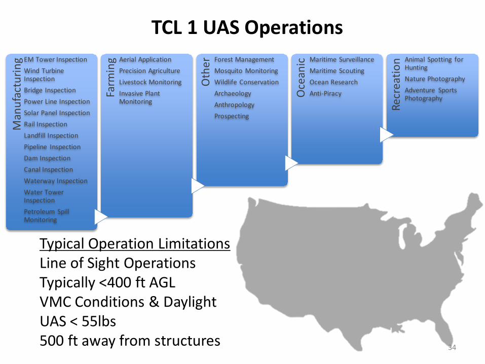
Man
ufac
turin
g EM Tower InspectionWind Turbine InspectionBridge InspectionPower Line InspectionSolar Panel InspectionRail InspectionLandfill InspectionPipeline InspectionDam InspectionCanal InspectionWaterway InspectionWater Tower InspectionPetroleum Spill Monitoring
Farm
ing Aerial Application
Precision AgricultureLivestock MonitoringInvasive Plant Monitoring
Oth
er Forest ManagementMosquito MonitoringWildlife ConservationArchaeologyAnthropologyProspecting
Oce
anic Maritime Surveillance
Maritime ScoutingOcean ResearchAnti-Piracy
Recr
eatio
n Animal Spotting for HuntingNature PhotographyAdventure Sports Photography
TCL 1 UAS Operations
Typical Operation LimitationsLine of Sight OperationsTypically <400 ft AGLVMC Conditions & DaylightUAS < 55lbs500 ft away from structures

UAS Operator submits operational plan1
UTM
Static constraints are checked3
Vehicle registration checked2
Vehicle Performance and Registration Database
Dynamic constraints are checked4
UTM reports no issues and UAS operation begins
5
UTM Services are provided during operation
6
UAS operation completes7
Schedule Crop Monitoring of Farm X

36
UAS Requirements
CNS Requirements
Airspace Management Requirements
Operational Rules and Guidelines
Data Services, Interfaces, and Architecture Requirements
NASA UTM Project Objectives

Weather Sensors
Acoustic Sensors
Surveillance Sensors
Simultaneous UAS OperationsAug. 24 – Sept 1st, 2015~ 108 Flights~18 Flight HoursDuration: 2-38 minutesAvg. Flight Time: ~ 11 min
37

Demonstration Objectives38
Objective 1: Demonstrate UTM Capabilities
Objective 2: Collect Data on UAS Navigation Performance Error
Objective 3: Collect Data on Aircraft Tracking Performance
Objective 4: Collect Weather Observations for Forecasting Models
Objective 5: Collect Data on Noise Signature of UAS Vehicles

UTM Vehicles39
8 multi-rotors and 2 fixed wing
~ 4 lbs ~ 40 lbs
Maximum Take-off Weight Endurance
15 min 60 min
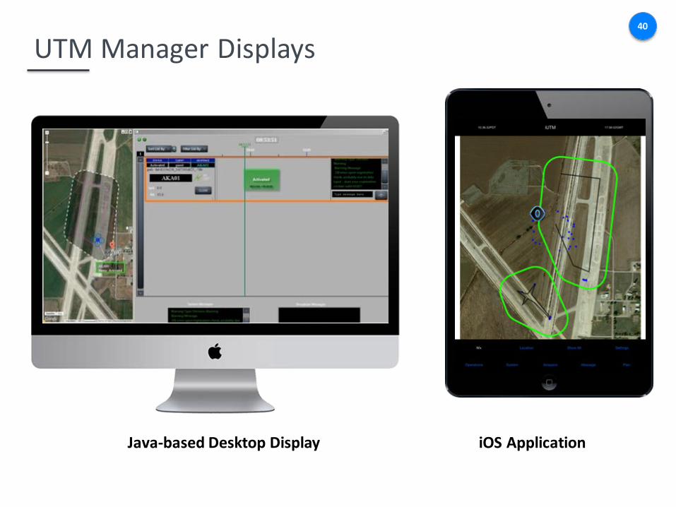
UTM Manager Displays40
Java-based Desktop Display iOS Application

UTM Field Equipment : Weather41
RadiosondeWeather Balloon
Data Collected
Remote Automated Weather Station
TemperaturePressureWind DirectionWind SpeedAltitudeTurbulent Kinetic Energy
Weather Tower

UTM Field Equipment : Surveillance and Acoustics42
Data Collected
Ground Situation Awareness Display (ADS-B In, En Route
radar, Terminal Radar, ASDE-X, ASSC)
LatitudeLongitudeAltitudeSound magnitude and frequency
Short Range Radar
ADS-B Out Transponder
Cellular Network Tracking
Nicolet Vision XP
B&K Nexus4-Ch Power Supply
½” B&KMicrophone
+ Wind Screen
Acoustic Measurement

43
Flight Profiles:• Free Flight• Horizontal Trajectory Conformance• Vertical Trajectory Conformance• Sound Recording• System Identification Maneuvers
Altitude: up to 400 ft AGLDuration: 8-30 minutesSimultaneous Aircraft: 2
Imagery ©2015 Google, Map data ©2015 Google

Observations of Operational Use44
• New Airspace Users will require training and UTM needs to be intuitive• Observation: UAS Operators submitting an operational plan to the system that differs
from what was input into the GCS or a willingness to violate an operational plan.• Recommendation: Operator training and integration of flight planning and traffic
management services into ground control stations
• The right equipment for the operational environment• Observation: High temperatures had impact on ground equipment. C2 interference
occurred with local farming equipment. Degradation of GPS signals impacted flight operations.
• Recommendation: UAS and ground systems and instruments are “qualified” by operational environment and performance.
• Situation awareness is key for safe operations• Observation: sUAS varies with size and line of sight (LOS) can be easily lost (e.g. sUAS
looked like birds during operation). Weather reported on the ground isnt always indicative of weather experienced at operational altitude. Tracking of sUAS needs to occur at sufficiently fast update rates.
• Recommendation: Improvements are needed in weather forecasting, modeling, and sensing at low altitudes. Tracking UAS infrastructure will need to be built to scale and with sufficient bandwidth. Airspace users should be given a common picture of their environment for safe operations.

45
Questions

System Error46
1
2
NSE
FTE
TSE
Conformance buffer
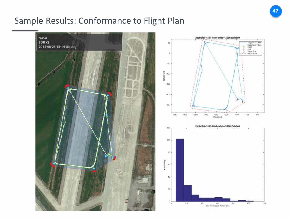
Sample Results: Conformance to Flight Plan47

Sample Results: Determination of Buffer for Operational Area48

Sample Results: Weather Comparison to HRRR49
Wind Speed
Wind Direction
Temperature
Turbulent Kinetic Energy

Sample Results: Vehicle Sound Profile • Scaled to 10 m AGL.
• Plotted as a function of MTOW not weight as tested!
• Under 10 lb group clusters around 60 – 65 dB
• Over 10 lb group has no definitive trend with MTOW
• Fixed-wing DragonEye has comparable noise level as the quads. Surprised!
IRIS+
X8
DragonEye
S1000
DeltaDrone
Flirtey
50

Sample Results: Relative Sound Footprint• Sound Exposure Level (SEL)
scaled to 500-ft AGL.
• UAV data plotted as a function of MTOW not weight as tested!
• UAVs cluster around 40 – 50 dB below conversation level
• FAA data for light helos are 30 – 40 dB higher
IRIS+
S1000
BELL 206L4
EC120
Δ 30dB
51