mason county shoreline master program update · mason county shoreline master program update ......
TRANSCRIPT
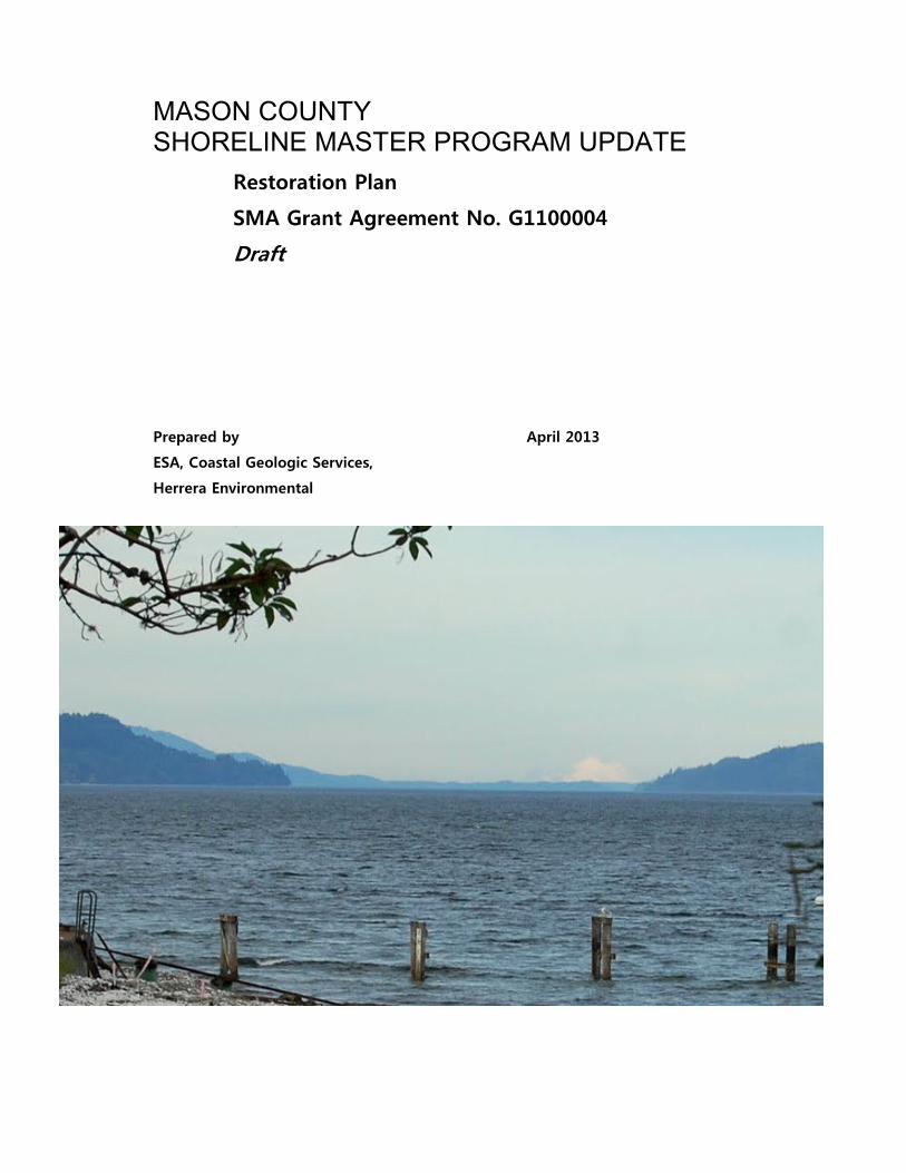
MASON COUNTY SHORELINE MASTER PROGRAM UPDATE
Restoration Plan
SMA Grant Agreement No. G1100004
Draft
Prepared by April 2013
ESA, Coastal Geologic Services,
Herrera Environmental

Mason County Shoreline Restoration Plan – April 2013 Page i
TABLE OF CONTENTS
Chapter 1.0 Introduction ............................................................................................................. 1-1 1.1 Plan Purpose and Scope ....................................................................................................... 1-1
1.1.1 Format and Content – How to Use this Plan ........................................................ 1-2 1.2 Defining Restoration ............................................................................................................. 1-3
1.2.1 Restoration versus Protection ................................................................................... 1-3 1.2.2 Phasing of Restoration ................................................................................................. 1-4 1.2.3 No Net Loss and Shoreline Restoration ................................................................. 1-6 1.2.4 Shorelines of Statewide Significance ...................................................................... 1-7
1.3 Additional Studies .................................................................................................................. 1-8 1.3.1 Data Gaps ........................................................................................................................... 1-8
Chapter 2.0 Restoration Vision and Goals ............................................................................. 2-1 2.1 Restoration Vision .................................................................................................................. 2-2 2.2 Restoration PLan Goals ........................................................................................................ 2-2
Chapter 3.0 Watershed Overview ............................................................................................ 3-1 3.1 Marine Shorelines ................................................................................................................... 3-1 3.2 WRIA 14a: Kennedy Goldsborough ................................................................................. 3-3 3.3 WRIA 15: Tahuya Peninsula ............................................................................................... 3-4 3.4 WRIA 16/14b: Skokomish-Dosewallips and South Shore ...................................... 3-4 3.5 WRIA 22: Lower Chehalis .................................................................................................... 3-5
Chapter 4.0 Overview of Restoration Priorities .................................................................. 4-1 4.1 Freshwater Restoration Potential .................................................................................... 4-1 4.2 Nearshore Restoration Potential ...................................................................................... 4-1
4.2.1 Data Sets ............................................................................................................................. 4-2 4.2.2 Results ................................................................................................................................. 4-3
Chapter 5.0 Restoration Actions for Marine Nearshore Areas ..................................... 5-1 5.1 Programmatic Actions .......................................................................................................... 5-1 5.2 PSNERP Recommendations ................................................................................................ 5-2
5.2.1 Hood Canal ........................................................................................................................ 5-3 5.2.2 South Puget Sound ......................................................................................................... 5-3
5.3 Site-Specific Restoration Opportunities ........................................................................ 5-3 5.3.1 Hood Canal ........................................................................................................................ 5-4 5.3.2 South Puget Sound ...................................................................................................... 5-11
Chapter 6.0 Restoration Actions for Lakes ........................................................................... 6-1 6.1 Programmatic Actions .......................................................................................................... 6-1 6.2 Restoration Actions for Specific Lakes ........................................................................... 6-2
6.2.1 Invasive Aquatic Vegetation and Water Quality ................................................. 6-2 6.2.2 Dams and Reservoirs .................................................................................................... 6-3 6.2.3 Restoration Opportunities .......................................................................................... 6-4
Chapter 7.0 Restoration Actions for Streams and Rivers ................................................ 7-1
Mason County Shoreline Restoration Plan – April 2013 Page ii
7.1 Programmatic Actions .......................................................................................................... 7-1 7.2 Restoration Actions by WRIA............................................................................................. 7-2
Chapter 8.0 Existing Restoration Programs and Partners .............................................. 8-1
Chapter 9.0 Timelines, Benchmarks and Monitoring ....................................................... 9-1 9.1 Timelines and Benchmarks ................................................................................................ 9-1 9.2 Potential Funding ................................................................................................................... 9-2 9.3 Obstacles and Challenges..................................................................................................... 9-3 9.4 Monitoring and Adaptive Management Strategies .................................................... 9-3
Chapter 10.0 References ......................................................................................................... 10-1
LIST OF APPENDICES
Appendix A: Marine Restoration Figures
Appendix B: Methods
Appendix C: Potential Funding Sources
LIST OF FIGURES
Figure 1-1. Mitigation versus Restoration in Shoreline Master Programs .................. 1-6
Figure 4-1. Conceptual link from shoreforms to stressors to restoration priorities ................................................................................................................................................. 4-2
Figure B-1. Relationship between nearshore process degradation and site potential............................................................................................................................................... 10-3
LIST OF TABLES
Table 1-1. Examples of Typical Protection and Restoration Actions ........................ 1-4
Table 1-2. Typical Restoration Phases and Actions .................................................... 1-5
Table 2-1. Mason County Restoration Goals, Objectives, Actions, and Success Measures ......................................................................................................................... 2-4
Mason County Shoreline Restoration Plan – April 2013 Page iii
Table 4-1. Recommendations and Priorities for Protection, Restoration, and Enhancement in the Marine Shorelines of Mason County Based upon Coastal Processes ......................................................................................................................... 4-3
Table 4-2. Recommendations and Priorities for Protection, Restoration and Enhancement in Hood Canal Based upon Coastal Processes ..................................... 4-4
Table 4-3. Recommendations and Priorities for Protection, Restoration and Enhancement in South Puget Sound ............................................................................. 4-4
Table 5-1. Miles of Shoreline Recommended for Different Strategies to Achieve Sediment Supply, Sediment Transport, and Tidal Flow .............................................. 5-4
Table 5-2. Restoration Opportunities on Public Shores of Hood Canal ..................... 5-6
Table 5-3. Restoration Opportunities on Public Shores of South Puget Sound ...... 5-12
Table 6-1. Restoration Actions for Mason County Lakes ............................................ 6-5
Table 7-1. Restoration Actions for Mason County Rivers and Streams – WRIA 14a ........................................................................................................................ 7-4
Table 7-2. Restoration Actions for Mason County Rivers and Streams – WRIA 15 ........................................................................................................................ 7-10
Table 7-3. Restoration Actions for Mason County Rivers and Streams – WRIA 16/14b ................................................................................................................ 7-14
Table 7-4. Restoration Actions for Mason County Rivers and Streams – WRIA 22 ........................................................................................................................ 7-20
Table 8-1. Potential Restoration Partner Organizations and their Roles in Future Restoration ..................................................................................................................... 8-2

Mason County Shoreline Restoration Plan – April 2013 Page 1-1
Chapter 1.0 Introduction
This plan was prepared as part of Mason County’s Shoreline Master Program (SMP) comprehensive update project. The County’s SMP contains policies and regulations that govern the use and development of the County’s freshwater rivers, lakes and marine shorelines1. The SMP is designed to protect shoreline ecological functions, provide for public access to public shorelines, and accommodate reasonable and appropriate uses of the shoreline. The SMP also must include a “real and meaningful” strategy to restore shoreline ecological functions where such functions are impaired. This restoration plan is a key element of the County’s shoreline restoration strategy as required in WAC 173-26-201(2)(f). It supplements the County’s Shoreline Inventory and Characterization Report (ESA et al. 2012), which documents general shoreline conditions throughout Mason County.
This restoration plan was prepared by Environmental Science Associates (ESA) with assistance from Herrera Environmental Consultants and Coastal Geologic Services (CGS) and in cooperation with Mason Department of Community Development. It was funded by a grant from the Washington State Department of Ecology (Ecology) (Grant No. G1100004).
The first complete version of this report was prepared in August 2012, following a presentation of the proposed methods to the County’s Joint Technical Advisory Committee in May 2012. The comment period for both the JTAC and Citizen’s Advisory Committee was extended to December 2012. This report was subsequently revised to reflect comments received.
1.1 PLAN PURPOSE AND SCOPE
This plan, in conjunction with the SMP policies and regulations, is designed to satisfy the shoreline guideline requirements for shoreline restoration planning. It provides a planning-level framework for understanding how and where shoreline ecological functions can be restored in Mason County. The plan also describes how future restoration activities can be integrated with existing and ongoing restoration efforts including: the region-wide effort to restore Puget Sound (which the Puget Sound Partnership is spearheading); the work of the Mason County Conservation District,
1 In this document, the term ‘shoreline’ is synonymous with ‘shorelines of the state.’ These are defined in
RCW 90.58 and generally include all streams with a mean annual flow of 20 cubic feet per second or more,
all marine shores, and lakes greater than 20 acres as well as the adjacent ‘shorelands’ that accompany these
waters. Shorelands means the lands extending 200 feet from the ordinary high water mark, floodways and
contiguous floodplains 200 feet from the floodway, and all associated wetlands. For a list of all of the
shorelines of the state in Mason County, refer to the Shoreline Inventory and Characterization Report (ESA
et al. 2012).
Mason County Shoreline Restoration Plan – April 2013 Page 1-2
Hood Canal Coordinating Council, South Puget Sound Salmon Enhancement Group, Hood Canal Salmon Enhancement Group, and the regional recovery efforts for Puget Sound Chinook, bull trout, steelhead, and endangered southern resident killer whales (orca); and the diversity of other restoration efforts being implemented by federal and state agencies, Tribes, the City of Shelton, nongovernmental organizations, and private citizens.
1.1.1 Format and Content – How to Use this Plan
The format and content of this plan are designed to:
• Describe an overarching vision that guides future restoration efforts;
• Summarize the County’s shoreline restoration goals and objectives;
• Identify the freshwater and marine nearshore areas that are high priorities for restoration;
• Describe specific restoration opportunities and recommended actions for each watershed and waterbody;
• Identify potential partners and existing/ongoing restoration activities and describe opportunities to integrate this plan with those existing efforts; and
• Explain how future restoration efforts can be implemented in a way that maximizes effectiveness and achieves the greatest overall benefits.
To understand and effectively implement this plan, restoration planners and practitioners are encouraged to review the vision, goals, and objectives in Chapter 2 to understand the desired restoration outcomes. Planners and practitioners should then consider the information in Chapter 3 identifying general areas of the County that have been identified as top priorities for restoration. Specific opportunities and actions in those areas and elsewhere in Mason County can be found in Chapters 4 through 7. Restoration projects can then be fully developed in cooperation with the partners and programs identified in Chapter 8 to maximize restoration benefits.
The projects and actions described herein represent voluntary actions to restore marine and freshwater shorelines in Mason County. It is not the County’s intention to require restoration on private property or to commit privately owned land for restoration purposes without the willing cooperation and participation of the affected landowners. However, the County is eager to support and foster restoration actions on both public and private lands and encourages private landowners to help implement this plan. In addition, private landowners who are required to provide mitigation for development-related impacts may wish to implement actions noted in this plan to meet their mitigation obligations.
Mason County Shoreline Restoration Plan – April 2013 Page 1-3
1.2 DEFINING RESTORATION
Restoration can be defined generally as returning an area to a previous condition by improving ecological structure and function. Restoration creates a net increase in the amount, size, and/or functions of an ecosystem or components of an ecosystem compared to a baseline condition (Thom et al. 2005a). The shoreline guidelines define restoration more specifically as follows:
“The reestablishment or upgrading of impaired ecological shoreline
processes or functions. This may be accomplished through measures
including but not limited to re-vegetation, removal of intrusive shoreline
structures and removal or treatment of toxic materials. Restoration
does not imply a requirement for returning the shoreline area to
aboriginal or pre-European settlement conditions.” 2
The guidelines require that restoration goals, policies, and actions “be designed to achieve overall improvements in shoreline ecological functions over time, when compared to the status upon adoption of the master program.”3 Inherent in these definitions is the concept of repairing past damage to natural resources and habitats, but not necessarily recreating historic conditions.
Many researchers have cautioned that simply recreating the form or structure of a particular habitat without also addressing the ecosystem processes and their interaction with ecological functions may not fully achieve restoration goals or objectives (Stanley et al. 2005, Montgomery et al. 2003; Gersib 2001). As a result, this plan emphasizes the need to restore ecosystem processes so that restoration strategies are sustainable and successful in the long term.
1.2.1 Restoration versus Protection
Restoration is different from protection. For shorelines, the latter is achieved primarily through the SMP policies and regulations (as well as other County, state, and federal regulations) that safeguard resources from damage caused by use and development. Protection requires that development is prohibited in some areas and that, when development is allowed, it occurs in a way that mitigates adverse effects on the natural environment such that the net result of the development activity is no worse than the pre-development condition. Protection also requires that deliberate measures are taken to ensure that natural ecosystem processes (such as net shore-drift, channel migration, large woody debris recruitment) continue with minimal impairment.
2 WAC 173-26-020
3 WAC 173-26-201(2)(f)
Mason County Shoreline Restoration Plan – April 2013 Page 1-4
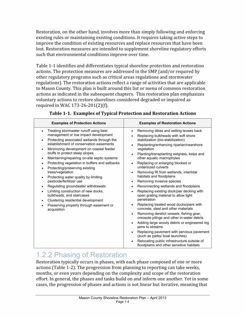
Restoration, on the other hand, involves more than simply following and enforcing existing rules or maintaining existing conditions. It requires taking active steps to improve the condition of existing resources and replace resources that have been lost. Restoration measures are intended to supplement shoreline regulatory efforts such that environmental conditions improve over time. Table 1-1 identifies and differentiates typical shoreline protection and restoration actions. The protection measures are addressed in the SMP (and/or required by other regulatory programs such as critical areas regulations and stormwater regulations). The restoration actions reflect a range of activities that are applicable to Mason County. This plan is built around this list or menu of common restoration actions as indicated in the subsequent chapters. This restoration plan emphasizes voluntary actions to restore shorelines considered degraded or impaired as required in WAC 173-26-201(2)(f).
Table 1-1. Examples of Typical Protection and Restoration Actions
Examples of Protection Actions Examples of Restoration Actions
• Treating stormwater runoff using best management or low impact development
• Protecting associated wetlands through the establishment of conservation easements
• Minimizing development on coastal feeder bluffs to protect steep slopes
• Maintaining/repairing on-site septic systems
• Protecting vegetation in buffers and setbacks
• Protecting/preserving existing trees/vegetation
• Protecting water quality by limiting pesticide/fertilizer use
• Regulating groundwater withdrawals
• Limiting construction of new docks, bulkheads, and staircases
• Clustering residential development
• Preserving property through easement or acquisition
• Removing dikes and setting levees back
• Replacing bulkheads with soft shore stabilization (bio-stabilization)
• Replanting/enhancing riparian/nearshore vegetation
• Planting/transplanting eelgrass, kelps and other aquatic macrophytes
• Replacing or enlarging blocked or undersized culverts
• Removing fill from wetlands, intertidal habitats and floodplains
• Removing invasive species
• Reconnecting wetlands and floodplains
• Replacing existing dock/pier decking with open grating material to allow light penetration
• Replacing treated wood docks/piers with concrete, steel and other materials
• Removing derelict vessels, fishing gear, creosote pilings and other in-water debris
• Adding large woody debris or engineered log jams to streams
• Replacing pavement with pervious pavement (such as parks/ boat launches)
• Relocating public infrastructure outside of floodplains and other sensitive habitats
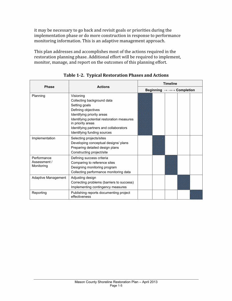
1.2.2 Phasing of Restoration Restoration typically occurs in phases, with each phase composed of one or more actions (Table 1-2). The progression from planning to reporting can take weeks, months, or even years depending on the complexity and scope of the restoration effort. In general, the phases and tasks build on and inform one another. Yet in some cases, the progression of phases and actions is not linear but iterative, meaning that
Mason County Shoreline Restoration Plan – April 2013 Page 1-5
it may be necessary to go back and revisit goals or priorities during the implementation phase or do more construction in response to performance monitoring information. This is an adaptive management approach. This plan addresses and accomplishes most of the actions required in the restoration planning phase. Additional effort will be required to implement, monitor, manage, and report on the outcomes of this planning effort.
Table 1-2. Typical Restoration Phases and Actions
Phase Actions Timeline
Beginning → →→ Completion
Planning Visioning
Collecting background data
Setting goals
Defining objectives
Identifying priority areas
Identifying potential restoration measures in priority areas
Identifying partners and collaborators
Identifying funding sources
Implementation Selecting projects/sites
Developing conceptual designs/ plans
Preparing detailed design plans
Constructing project/site
Performance Assessment / Monitoring
Defining success criteria
Comparing to reference sites
Designing monitoring program
Collecting performance monitoring data
Adaptive Management Adjusting design
Correcting problems (barriers to success)
Implementing contingency measures
Reporting Publishing reports documenting project effectiveness
Mason County Shoreline Restoration Plan – April 2013 Page 1-6
1.2.3 No Net Loss and Shoreline Restoration
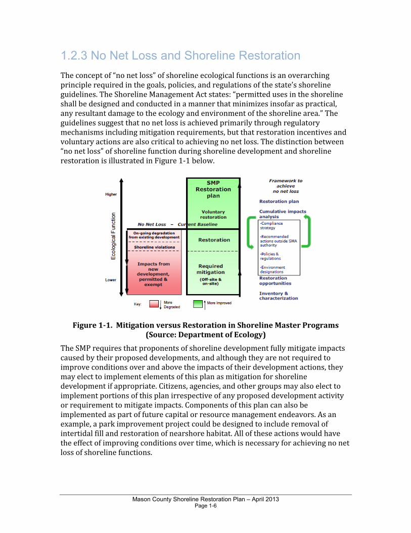
The concept of “no net loss” of shoreline ecological functions is an overarching principle required in the goals, policies, and regulations of the state’s shoreline guidelines. The Shoreline Management Act states: “permitted uses in the shoreline shall be designed and conducted in a manner that minimizes insofar as practical, any resultant damage to the ecology and environment of the shoreline area.” The guidelines suggest that no net loss is achieved primarily through regulatory mechanisms including mitigation requirements, but that restoration incentives and voluntary actions are also critical to achieving no net loss. The distinction between “no net loss” of shoreline function during shoreline development and shoreline restoration is illustrated in Figure 1-1 below.
Figure 1-1. Mitigation versus Restoration in Shoreline Master Programs
(Source: Department of Ecology)
The SMP requires that proponents of shoreline development fully mitigate impacts caused by their proposed developments, and although they are not required to improve conditions over and above the impacts of their development actions, they may elect to implement elements of this plan as mitigation for shoreline development if appropriate. Citizens, agencies, and other groups may also elect to implement portions of this plan irrespective of any proposed development activity or requirement to mitigate impacts. Components of this plan can also be implemented as part of future capital or resource management endeavors. As an example, a park improvement project could be designed to include removal of intertidal fill and restoration of nearshore habitat. All of these actions would have the effect of improving conditions over time, which is necessary for achieving no net loss of shoreline functions.
Mason County Shoreline Restoration Plan – April 2013 Page 1-7
1.2.4 Shorelines of Statewide Significance
The Shoreline Management Act designates certain shorelines as shorelines of
statewide significance. These are generally described as including portions of Puget Sound and other marine water bodies, rivers west of the Cascade range that have a mean annual flow of 1,000 cubic feet per second (cfs) or greater, rivers east of the Cascade range that have a mean annual flow of 200 cfs or greater, and freshwater lakes with a surface area of 1,000 acres or more (RCW 90.58.030). The following are shorelines of statewide significance in Mason County:
1. Marine waters and shorelands (200 feet landward of the OHWM) of Hood Canal;
2. Marine waters of South Puget Sound seaward from extreme low tide;
3. Freshwater of Lake Cushman including shorelands; and
4. Skokomish River (downstream from the confluence of its North and South Forks) including shorelands.
In determining that certain shorelines are of statewide significance, the Shoreline Management Act also determined that the interests of all of the people of the state shall be considered in the management of these shorelines. Because the shorelines of statewide significance of Mason County are a major resource from which all people in the state derive benefit, the SMP gives preference to uses that favor preservation and protection of the natural character and ecology of the shoreline and uses that increase public access and recreational opportunities. Specifically, RCW 90.58.020 gives priority to uses in the following order of preference:
1. Recognize and protect the statewide interest over local interest;
2. Preserve the natural character of the shoreline;
3. Result in long-term over short-term benefit;
4. Protect the resources and ecology of the shoreline;
5. Increase public access to publicly owned areas of the shorelines;
6. Increase recreational opportunities for the public in the shoreline;
7. Provide for any other element as defined in RCW 90.58.100 deemed appropriate or necessary.
Mason County Shoreline Restoration Plan – April 2013 Page 1-8
1.3 ADDITIONAL STUDIES
All of the restoration opportunities mentioned in this report will require further investigation and analysis to fully assess feasibility and determine actual benefits and costs. In some cases, restoration actions are recommended that may involve private properties. This plan makes no claims as to the ownership or availability of any parcel of land for restoration purposes and does not recommend takings of any private land.
Restoration activities described here would be undertaken on a voluntary basis with the express permission of private property owners. Additional study, collaboration, and project planning and design would be required to ensure consensus on the restoration priorities; acquire permission or easements; and develop detailed implementation plans, budgets, schedules, and monitoring programs.
1.3.1 Data Gaps
Due to data limitations many important ecological processes, features, and conditions could not be fully described in this plan. No single comprehensive restoration assessment has been conducted for all of the shores of Hood Canal or Southern Puget Sound. Additional data gaps include a County-wide wetland inventory; restoration opportunities for many freshwater lakes, and comprehensive mapping of abandoned and derelict overwater structures.
Mason County Shoreline Restoration Plan – April 2013 Page 2-1
Chapter 2.0 Restoration Vision and Goals
This plan seeks to establish a basic framework for improving the quality and sustainability of Mason County’s shoreline resources over time in a collaborative and cohesive manner. This overarching goal is consistent with the Shoreline Management Act and with the developing regional strategy for restoring Puget Sound, which is embodied in Engrossed Substitute Senate Bill (ESSB) 5372 signed by the State Legislature in May 2007. In ESSB 5372, the Legislature declared that:
“Puget Sound, including Hood Canal and the waters that flow to it are a
national treasure and a unique resource. Residents enjoy a way of life
centered around these waters that depends upon clean and healthy
marine and freshwater resources. Puget Sound is in serious decline….
This decline is indicated by loss of and damage to critical habit, rapid
decline in species populations, increases in aquatic nuisance species,
numerous toxics contaminated sites, urbanization and attendant storm
water drainage, closure of beaches to shellfish harvest due to disease
risks, low-dissolved oxygen levels causing death of marine life, and other
phenomena. If left unchecked, these conditions will worsen. Puget Sound
must be restored and protected in a more coherent and effective
manner. The current system is highly fragmented. Immediate and
concerted action is necessary by all levels of government working with
the public, nongovernmental organizations, and the private sector to
ensure a thriving natural system that exists in harmony with a vibrant
economy.”
The Legislature directed the Puget Sound Partnership (the Partnership) to coordinate and lead the regional restoration effort. The Partnership has developed an "Action Agenda” that describes the steps needed to restore the Sound by 2020. In identifying specific restoration goals and objectives that the Action Agenda must achieve, the Legislature described the characteristics of a healthy and restored Puget Sound as follows:
• A healthy human population supported by a healthy Puget Sound that is not threatened by changes in the ecosystem;
• A quality of human life that is sustained by a functioning Puget Sound ecosystem;
• Healthy and sustaining populations of native species in Puget Sound, including a robust food web;
• A healthy Puget Sound where freshwater, estuary, nearshore, marine, and upland habitats are protected, restored, and sustained;
Mason County Shoreline Restoration Plan – April 2013 Page 2-2
• An ecosystem that is supported by groundwater levels as well as river and streamflow levels sufficient to sustain people, fish, and wildlife, and the natural functions of the environment; and
• Fresh and marine waters and sediments of a sufficient quality so that the waters in the region are safe for drinking, swimming, shellfish harvest and consumption, and other human uses and enjoyment, and are not harmful to the native marine mammals, fish, birds, and shellfish of the region.
This plan seeks to achieve those same goals by contributing to the Puget Sound restoration effort and to the specific strategies being developed by the Partnership as part of the 2020 Action Agenda (Puget Sound Partnership 2008). This plan is also intended to be compatible with and incorporate the restoration goals already developed by other restoration planning entities in the region including, but not limited to, the Skokomish Tribe, the Squaxin Island Tribe, the Chehalis Tribe, the Hood Canal Coordinating Council, the South Puget Sound Salmon Enhancement Group, the WRIA Action Plans, and many others.
2.1 RESTORATION VISION
The restoration vision for Mason County can be described as follows:
The County will strive to restore, protect and enhance the shoreline
resources and ecological processes that contribute to those resources
through a combination of public actions and voluntary private actions.
Restoration efforts, combined with protection of existing shoreline
resources, will be targeted to create a net improvement in the shoreline
ecosystem over time so as to benefit native fish and wildlife, and
maintain public amenities for the people of Mason County, Washington.
2.2 RESTORATION PLAN GOALS
Mason County has the following restoration planning goals for the County’s shorelines:
1. To improve shoreline processes, functions, and values over time through voluntary and incentive-based public and private programs and actions that are consistent with the SMP and other agency/locally adopted restoration plans;
2. To increase the availability, viability, and sustainability of shoreline habitats for salmon, shellfish, forage fish, shorebirds and marine seabirds, and other species; improve habitat quality for sensitive and/or locally important
Mason County Shoreline Restoration Plan – April 2013 Page 2-3
species; and support the biological recovery goals for federally protected species4;
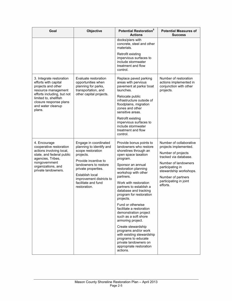
3. To integrate restoration efforts with capital projects and other resource management efforts including, but not limited to, shellfish closure response plans and water cleanup plans;
4. To encourage cooperative restoration actions involving local, state, and federal public agencies, Tribes, nongovernment organizations, and private landowners;
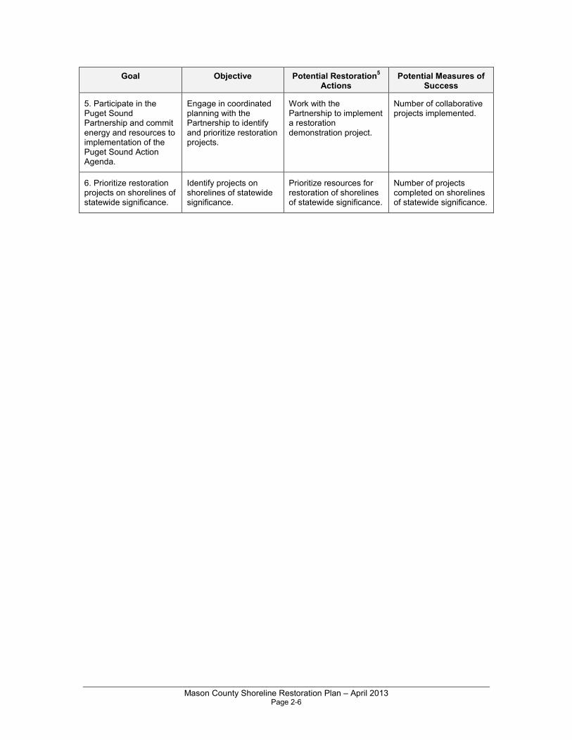
5. To participate in the Puget Sound Partnership and commit energy and resources to implementation of the Puget Sound Action Agenda; and
6. To prioritize restoration projects on shorelines of statewide significance.
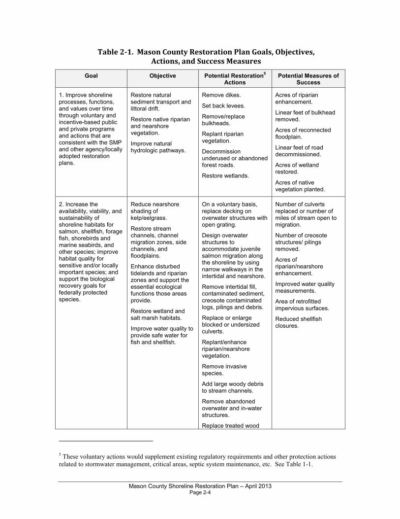
Table 2-1 provides examples of measures that could be used to evaluate progress in meeting the above goals. However, detailed measures of success must be determined for each project through the establishment of project-specific performance criteria. Similarly, the potential for restoration projects to improve specific ecological functions can only be determined case by case. Ideally, each project will be designed to ensure a high likelihood of success in restoring the functions that are targeted for that project.
4 Federal sensitive species include endangered, threatened, candidate, and species of concern. Definitions
of the federal designations can be found in the USFWS Glossary at
http://www.fws.gov/endangered/glossary.html.
The State of Washington designates priority species which require protective measures for their survival
due to their population status, sensitivity to habitat alteration, and/or recreational, commercial, or tribal
importance. Priority species include State Endangered, Threatened, Sensitive, and Candidate species;
animal aggregations considered vulnerable; and species of recreational, commercial, or tribal importance
that are vulnerable. The state also designates priority habitats. Definitions of these designations are
provided at http://wdfw.wa.gov/hab/phslist.htm.
Mason County Shoreline Restoration Plan – April 2013 Page 2-4
Table 2-1. Mason County Restoration Plan Goals, Objectives,
Actions, and Success Measures
Goal Objective Potential Restoration5
Actions Potential Measures of
Success
1. Improve shoreline processes, functions, and values over time through voluntary and incentive-based public and private programs and actions that are consistent with the SMP and other agency/locally adopted restoration plans.
Restore natural sediment transport and littoral drift.
Restore native riparian and nearshore vegetation.
Improve natural hydrologic pathways.
Remove dikes.
Set back levees.
Remove/replace bulkheads.
Replant riparian vegetation.
Decommission underused or abandoned forest roads.
Restore wetlands.
Acres of riparian enhancement.
Linear feet of bulkhead removed.
Acres of reconnected floodplain.
Linear feet of road decommissioned.
Acres of wetland restored.
Acres of native vegetation planted.
2. Increase the availability, viability, and sustainability of shoreline habitats for salmon, shellfish, forage fish, shorebirds and marine seabirds, and other species; improve habitat quality for sensitive and/or locally important species; and support the biological recovery goals for federally protected species.
Reduce nearshore shading of kelp/eelgrass.
Restore stream channels, channel migration zones, side channels, and floodplains.
Enhance disturbed tidelands and riparian zones and support the essential ecological functions those areas provide.
Restore wetland and salt marsh habitats.
Improve water quality to provide safe water for fish and shellfish.
On a voluntary basis, replace decking on overwater structures with open grating.
Design overwater structures to accommodate juvenile salmon migration along the shoreline by using narrow walkways in the intertidal and nearshore.
Remove intertidal fill, contaminated sediment, creosote contaminated logs, pilings and debris.
Replace or enlarge blocked or undersized culverts.
Replant/enhance riparian/nearshore vegetation.
Remove invasive species.
Add large woody debris to stream channels.
Remove abandoned overwater and in-water structures.
Replace treated wood
Number of culverts replaced or number of miles of stream open to migration.
Number of creosote structures/ pilings removed.
Acres of riparian/nearshore enhancement.
Improved water quality measurements.
Area of retrofitted impervious surfaces.
Reduced shellfish closures.
5 These voluntary actions would supplement existing regulatory requirements and other protection actions
related to stormwater management, critical areas, septic system maintenance, etc. See Table 1-1.
Mason County Shoreline Restoration Plan – April 2013 Page 2-5
Goal Objective Potential Restoration5
Actions Potential Measures of
Success
docks/piers with concrete, steel and other materials.
Retrofit existing impervious surfaces to include stormwater treatment and flow control.
3. Integrate restoration efforts with capital projects and other resource management efforts including, but not limited to, shellfish closure response plans and water cleanup plans.
Evaluate restoration opportunities when planning for parks, transportation, and other capital projects.
Replace paved parking areas with pervious pavement at parks/ boat launches.
Relocate public infrastructure outside of floodplains, migration zones and other sensitive areas.
Retrofit existing impervious surfaces to include stormwater treatment and flow control.
Number of restoration actions implemented in conjunction with other projects.
4. Encourage cooperative restoration actions involving local, state, and federal public agencies, Tribes, nongovernment organizations, and private landowners.
Engage in coordinated planning to identify and scope restoration projects.
Provide incentive to landowners to restore private properties.
Establish local improvement districts to facilitate and fund restoration.
Provide bonus points to landowners who restore shorelines through an open space taxation program.
Sponsor an annual restoration planning workshop with other partners.
Work with restoration partners to establish a database and tracking program for restoration projects.
Fund or otherwise facilitate a restoration demonstration project such as a soft shore armoring project.
Create stewardship programs and/or work with existing stewardship programs to educate private landowners on appropriate restoration actions.
Number of collaborative projects implemented.
Number of projects tracked via database.
Number of landowners participating in stewardship workshops.
Number of partners participating in joint efforts.
Mason County Shoreline Restoration Plan – April 2013 Page 2-6
Goal Objective Potential Restoration5
Actions Potential Measures of
Success
5. Participate in the Puget Sound Partnership and commit energy and resources to implementation of the Puget Sound Action Agenda.
Engage in coordinated planning with the Partnership to identify and prioritize restoration projects.
Work with the Partnership to implement a restoration demonstration project.
Number of collaborative projects implemented.
6. Prioritize restoration projects on shorelines of statewide significance.
Identify projects on shorelines of statewide significance.
Prioritize resources for restoration of shorelines of statewide significance.
Number of projects completed on shorelines of statewide significance.
Mason County Shoreline Restoration Plan – April 2013 Page 3-1
Chapter 3.0 Watershed Overview
The information in this chapter is summarized from the Mason County Shoreline Inventory and Characterization Report, which describes existing conditions of the county shorelines in detail (ESA et al. 2012).
Mason County is located generally in the southwestern corner of the Puget Sound Basin in western Washington. According to the U.S. Census Bureau, Mason County has a total area of 1,051 square miles, of which 961 square miles is land and 90 square miles (8.6 percent) is water. Elevations in the County range from 6,400 feet above mean sea level (MSL) in the foothills of the Olympic Mountains, to sea level along the coastline of Puget Sound and Hood Canal.
The County includes portions of five Water Resource Inventory Areas (WRIAs) as outlined below:
• WRIA 14a: Kennedy - Goldsborough;
• WRIA 15: Tahuya Peninsula;
• WRIA 16/14b: Skokomish-Dosewallips and South Shore of Hood Canal;
• WRIA 21: Queets-Quinault; and
• WRIA 22: Lower Chehalis.
The portion of WRIA 21 within Mason County is located entirely within federal land (Olympic National Park) and is not discussed further in this report. Also, lands within tribal ownership or in tribal trust, for example those owned by the Squaxin Island Tribe, are not governed by the County’s SMP and are not included in this plan.
With the exception of WRIA 22, each of the remaining three basins includes both marine and freshwater shorelines. An overview of the marine shorelines of the County is provided below, followed by a summary of each of the four WRIAs.
3.1 MARINE SHORELINES
The marine shorelines in Mason County are located in WRIAs 14a, 15, and 16/14b. Marine shorelines cover about 217 linear miles including the inner shores of inlets, embayments, and estuaries. Mason County nearshore character varies considerably and is composed of numerous geomorphic shore types. Controlling factors within the Mason County marine landscape include climate, wave energy (exposure), sea level, topography, and bathymetry. Other variables influence Mason County marine shores including: net shore-drift of sediment, bluff geology (stratigraphy), tidal regime, and numerous fluvial systems, the largest of which are the Hamma Hamma and Skokomish Rivers.
Mason County Shoreline Restoration Plan – April 2013 Page 3-2
Mason County encompasses marine shorelines in two distinct areas of Puget Sound, including (1) southern Hood Canal (from near Triton Head south), and (2) the southern extent of the Southern Puget Sound sub-basin from between the Pierce County line in northern Case Inlet to the heads of Hammersley, Totten and Little Skookum Inlets, including Oakland Bay, Pickering Passage, Peale Passage and Harstine Island. Several smaller islands are also encompassed within the County including Stretch, Reach, McMicken, and Hope Islands.
Key management issues related to shoreline restoration in the nearshore areas of Mason County include the following:
Hood Canal
• Low dissolved oxygen concentrations which contribute to adverse effects on fish and other marine organisms;
• Water quality degradation related to nutrient loading and high fecal coliform bacteria concentrations in marine waters;
• Modifications along the shoreline such as existing bulkheads and hardened armoring;
• Highways and transportation corridors (Highway 101) paralleling the shore with impervious surfaces which contribute to stormwater runoff and pollutant loading;
• Bridges and causeways creating constrictions at estuary mouths which impair tidal flow;
• Development near the shoreline resulting in reductions in forested canopy and habitat;
• Cumulative effects on aquatic resources related to construction of new residential docks and piers; and
• Removal of trees and clearing native vegetation on private properties for views.
South Puget Sound
• Water quality degradation related to nutrient loading and high fecal coliform bacteria concentrations in marine waters;
• Water quality degradation in Oakland Bay related to dioxins and other contaminants in sediments;
• Modifications such as existing bulkheads and hardened armoring;
• Highways and transportation corridors (SR 3) resulting in impervious surfaces which contribute to stormwater runoff and pollutant loading;
• Bridges and causeways creating constrictions at estuary mouths which impair tidal flow;
Mason County Shoreline Restoration Plan – April 2013 Page 3-3
• Development near the shoreline resulting in reductions in forested canopy and habitat;
• Cumulative effects on aquatic resources related to construction of new residential docks and piers;
• Removal of trees and clearing native vegetation on private properties for views;
3.2 WRIA 14A: KENNEDY GOLDSBOROUGH
WRIA 14 covers approximately 244,000 acres at the southwest terminus of Puget Sound (Kuttel 2002). This watershed includes the major river drainages of Kennedy Creek and Goldsborough Creek. Of this area, approximately 85 percent of the WRIA is located in Mason County; the remainder of this WRIA is located in Thurston County. With the exception of the Black Hills in the extreme southwest portion of WRIA 14, the majority of this watershed is composed of low elevation hills and valleys.
In 2008, the State Legislature passed a bill that split WRIA 14 into two separate areas for watershed planning. The bill (SB 6204) designated WRIA 14b as the portion of Kennedy-Goldsborough that drains into the southern portion of lower Hood Canal. The legislation then states that the WRIA 16 planning efforts must include WRIA14b. No freshwater streams meeting the definition of shorelines of the state are found within WRIA 14b; however, two shoreline lakes drain to the south shore of Hood Canal in WRIA 14b.
Principal drainages include Cranberry, Goldsborough, Kennedy, Mill, Sherwood, Johns, Deer, and Skookum Creeks. Despite the abundance of creeks, WRIA 14 has no major rivers. Numerous lakes are present. WRIA 14 includes the community of Allyn and the City of Shelton and its Urban Growth Area. The Squaxin Island Tribe Reservation encompasses the entirety of Squaxin Island; the Tribe also holds reservation and trust lands near the mouth and other areas of Skookum Creek.
Land use in the Kennedy-Goldsborough area is primarily forest (71 percent) with urban and agricultural use accounting for 4 percent each. Timber production was the dominant industry in WRIA 14a until the 1980s, when timber production slowed due to measures designed to protect the spotted owl. Since then, oyster and clam production have become other valuable local commodities (Vleming 2011). Damming of streams and wetlands to create lakes, and shoreline modifications for residential development, have been common in WRIA 14a. These activities along with conversion of forestland to agricultural or residential land uses have altered the natural flow regime of many streams in the region. Dams and failed culverts may hinder salmonid migration in the Kennedy-Goldsborough Basin.
Mason County Shoreline Restoration Plan – April 2013 Page 3-4
Marine shorelines of WRIA 14a are the shorelines of Case Inlet, Oakland Bay, and Totten Inlet, including islands such as Harstine and Squaxin. Marine shorelines of WRIA 14b include the south shore of Hood Canal.
3.3 WRIA 15: TAHUYA PENINSULA
WRIA 15 includes approximately 631,000 acres of the Kitsap Peninsula, most of which lies within Kitsap County. This area is locally known as the Tahuya Peninsula. Of this area, approximately 13 percent of the greater WRIA is located in Mason County, encompassing the Tahuya Peninsula from Belfair to Dewatto. The topography of WRIA 15 is generally low in elevation and gradient. Major water bodies in this watershed include the Union River, Tahuya River, Dewatto River, Rendsland Creek, and Mission Creek. Many small lakes also occur in the glacial till plain of Kitsap Peninsula.
Development within the Tahuya Peninsula is relatively sparse, with residential uses occurring primarily along Hood Canal. The Tahuya State Forest, owned by DNR, occupies a large portion of the peninsula. Major land uses in WRIA 15 are forest resources, agriculture, residential, and urban services. The community of Belfair is located at the eastern end of Hood Canal. Although the degree of shoreline development is high in some areas, the upland watersheds have relatively low impervious surface areas, and predominantly forest or mixed forest/pasture land cover. This area generally lacks large urban/industrial development (Haring 2000; ESA Adolfson 2007). Another major impact is State Route 300 and North Shore County Road, which run along the entire shoreline.
Anadromous salmonid distribution is limited in some WRIA 15 streams by the presence of natural barriers (falls and cascades), culverts, dams or tide gates, and reduced instream flows. The marine shoreline of Hood Canal borders the western and southern boundaries of WRIA 15 in Mason County.
3.4 WRIA 16/14B: SKOKOMISH-DOSEWALLIPS AND SOUTH SHORE OF HOOD CANAL
WRIA 16 covers approximately 430,000 acres (WRIA 16 Planning Unit 2006). Of this area, approximately 56 percent of the WRIA is located in Mason County. This watershed area contains the Dosewallips River, eastern shore of Hood Canal, the Skokomish River drainage and South Shore. The topography ranges from mountains in the western part of the basin to low-elevation river valleys that drain to Hood Canal. The largest rivers in the Mason County portion of the watershed are the Skokomish and Hamma Hamma Rivers. Many smaller streams, some of which are intermittent, also flow directly into Hood Canal. For watershed planning purposes, WRIA 16 has been combined with WRIA 14b, which includes lands
Mason County Shoreline Restoration Plan – April 2013 Page 3-5
draining to the south shore of Hood Canal from the community of Union to the southern edge of the Belfair Urban Growth Area.
Lake Cushman is a large reservoir formed in the 1920s by damming of the North Fork Skokomish River for hydroelectric power. Lake Kokanee and Kokanee Dam are also located on the North Fork. Numerous small dams are located on smaller streams throughout the WRIA (Correa 2003).
The economy in WRIA 16 relies largely on shellfish harvesting, commercial forestry, tourism, Christmas-tree farming, and some agriculture (WRIA 16 Planning Unit undated). Agriculture and residential development within the floodplains of many WRIA 16 watersheds have resulted in channelization of rivers and tributaries, draining of beaver ponds for livestock grazing, and logging in forested riparian zones. Forest practices in the watershed have caused adverse impacts on salmon habitat in WRIA 16 (Correa 2003).
The Skokomish Tribe Reservation is located near the mouth of the Skokomish River on Hood Canal. The communities of Hoodsport, Potlatch, and Lilliwaup are located north of the reservation. WRIA 16 extends west into federally owned national park, national forest, and wilderness lands.
WRIA 16 has approximately 8,000 permanent residents who reside mainly along the shore of Hood Canal (WRIA 16 Planning Unit 2006). In addition to the effects of residential development along the marine shoreline, a major impact to the nearshore environment is Highway 101 North, which extends north/south along the entire shoreline, and SR 106, which extends along the entire South Shore.
3.5 WRIA 22: LOWER CHEHALIS
WRIA 22 covers approximately 939,500 acres draining from the southwestern Olympic Mountains. Of this area, only 14 percent of WRIA 22 is located in Mason County. This watershed drains southerly to the Chehalis River. Major water bodies in the Mason County portion of WRIA 22 include the East Fork and Middle Fork Satsop River, Cloquallum Creek, and Decker Creek. These water bodies flow southward toward the mainstem Chehalis River, which in turn flows westerly to discharge to Grays Harbor on the Washington coast.
The Mason County portion of WRIA 22 has a low population density and is mostly set aside for commercial forestry. Forest land in the Olympic National Forest occupies the northern part of the drainage in Mason County. No marine shorelines are present in the Mason County portion of WRIA 22.

Mason County Shoreline Restoration Plan – April 2013 Page 4-1
Chapter 4.0 Overview of Restoration Priorities
This section provides a broad overview of the individual watersheds, sub-basins, and shorelines that are considered high priority for restoration and how they were identified. Subsequent chapters provide information on specific restoration opportunities within these watersheds/reaches.
4.1 Freshwater Restoration Potential
The approach to developing the restoration plan for Mason County freshwater shorelines combined local site-specific data with regional restoration and conservation priorities identified in WRIA salmon recovery plans, fish passage barrier inventories, riparian assessments, TMDLs, and other documents. The opportunities for freshwater restoration have been identified using a summary of information found in existing technical sources, where available.
Restoration opportunities for shoreline streams and rivers have been identified by watershed lead entities, Tribes, Mason Conservation District, Ecology, South Puget Sound Salmon Enhancement Group (SPSSEG) and others. Identification by the restoration community of specific restoration opportunities for freshwater lakes in the County is generally lacking.
4.2 Nearshore Restoration Potential
The approach applied to formulate the restoration plan for Mason County marine shorelines integrated marine/nearshore site-specific data with regional restoration and conservation priorities. A comprehensive nearshore assessment has not been conducted for the Mason County nearshore environment. Therefore areas with nearshore restoration potential were compiled by relying on existing data.
Data sets of previously identified restoration opportunities were compiled and augmented and then linked with regional restoration priorities. Site-specific restoration opportunities were restricted to publicly owned shorelines and tribal lands. The overlap between the site-specific restoration opportunity points and the regional priorities results in a County-wide geodatabase of prioritized restoration opportunities that can be used for planning and linking with other restoration data. The shoreform-scale recommendations can be used to link and prioritize other site-specific opportunities that may exist on privately-owned shorelines. These combined results provide Mason County with a comprehensive database of restoration actions on public shores that aim to address nearshore process
Mason County Shoreline Restoration Plan – April 2013 Page 4-2
degradation and salmon recovery. The details of each of the steps are described below.
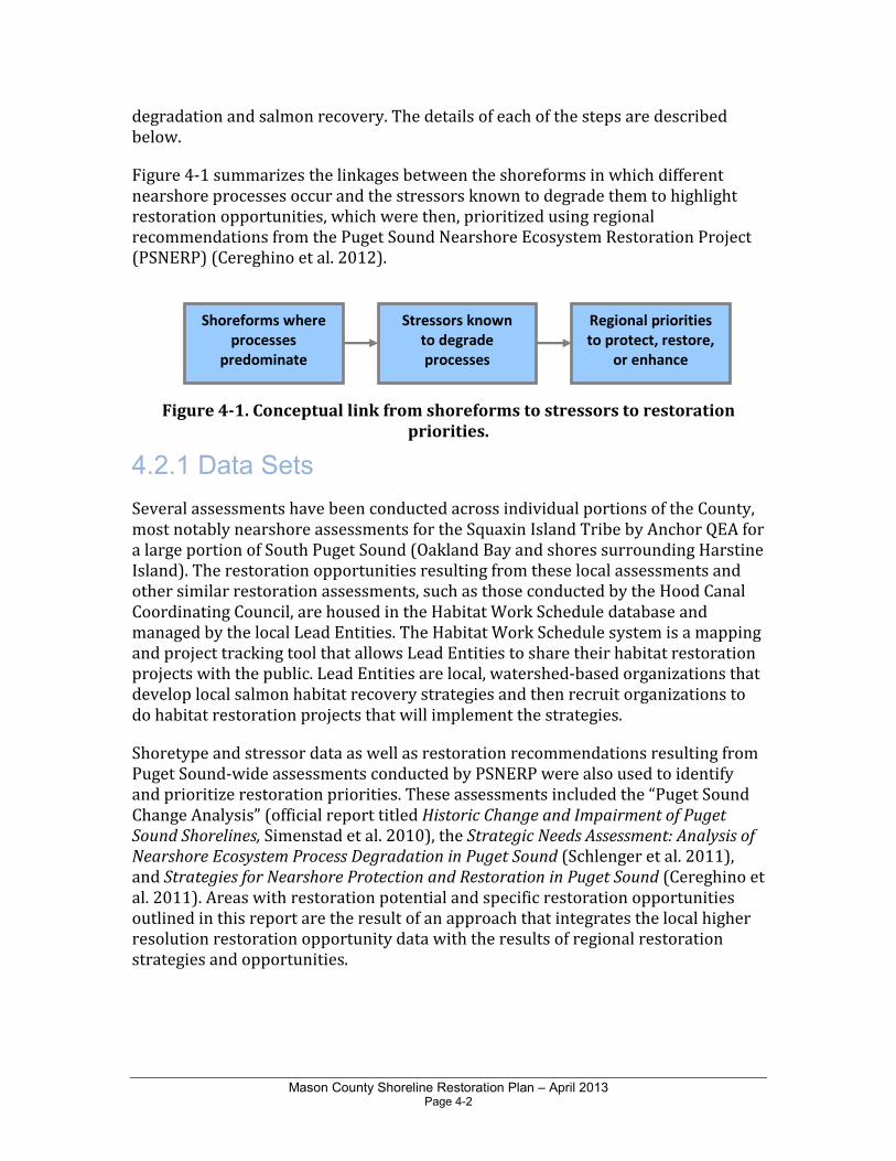
Figure 4-1 summarizes the linkages between the shoreforms in which different nearshore processes occur and the stressors known to degrade them to highlight restoration opportunities, which were then, prioritized using regional recommendations from the Puget Sound Nearshore Ecosystem Restoration Project (PSNERP) (Cereghino et al. 2012).
Figure 4-1. Conceptual link from shoreforms to stressors to restoration
priorities.
4.2.1 Data Sets
Several assessments have been conducted across individual portions of the County, most notably nearshore assessments for the Squaxin Island Tribe by Anchor QEA for a large portion of South Puget Sound (Oakland Bay and shores surrounding Harstine Island). The restoration opportunities resulting from these local assessments and other similar restoration assessments, such as those conducted by the Hood Canal Coordinating Council, are housed in the Habitat Work Schedule database and managed by the local Lead Entities. The Habitat Work Schedule system is a mapping and project tracking tool that allows Lead Entities to share their habitat restoration projects with the public. Lead Entities are local, watershed-based organizations that develop local salmon habitat recovery strategies and then recruit organizations to do habitat restoration projects that will implement the strategies.
Shoretype and stressor data as well as restoration recommendations resulting from Puget Sound-wide assessments conducted by PSNERP were also used to identify and prioritize restoration priorities. These assessments included the “Puget Sound Change Analysis” (official report titled Historic Change and Impairment of Puget
Sound Shorelines, Simenstad et al. 2010), the Strategic Needs Assessment: Analysis of
Nearshore Ecosystem Process Degradation in Puget Sound (Schlenger et al. 2011), and Strategies for Nearshore Protection and Restoration in Puget Sound (Cereghino et al. 2011). Areas with restoration potential and specific restoration opportunities outlined in this report are the result of an approach that integrates the local higher resolution restoration opportunity data with the results of regional restoration strategies and opportunities.
Shoreforms where
processes
predominate
Stressors known
to degrade
processes
Regional priorities
to protect, restore,
or enhance
Mason County Shoreline Restoration Plan – April 2013 Page 4-3
4.2.2 Results
The results of this analysis highlight marine shoreline areas in Mason County where restoration actions are needed related to impaired functions and processes along Hood Canal and South Puget Sound. Restoration opportunities are shown on the maps in Appendix A - Maps; Map 4-1 (Restore and Restore High all processes) and Map 4-2 (Enhance and Enhance High all processes). The methods for this analysis are summarized in Appendix B - Methods.
Recommendations for the type of action (protect, restore or enhance) are applied to each type of process-based restoration action (sediment supply, sediment transport, or tidal processes). Management measures that address each kind of restoration action are described in detail in the PSNERP document Management Measures for
Protecting and Restoring the Puget Sound Nearshore (Clancy et al. 2009, http://pugetsoundnearshore.org/technical_papers/management_measures.pdf). Although the entire analysis of protection, restoration and enhancement was conducted for this effort (as described in Appendix B), only restoration and enhancement priorities were carried forward to inform the County’s restoration plan and strategy. Protection priorities and opportunities were not included in this plan as per direction from Ecology.
Sediment supply can be restored by removing armor from bluff backed beaches. Sediment supply can also be enhanced with strategically placed beach nourishment. Sediment transport can be restored by removing armor, structures that infringe below Mean Higher High Water (MHHW), and other obstructions to littoral sediment transport such as groins and jetties. Sediment transport can be enhanced by implementing sediment bypassing around obstructions to littoral sediment transport, such as at a marina breakwater. Tidal processes can be restored and enhanced by removing armor, fill, and tidal barriers from tidal embayments and tidal wetlands.
Results show that there are widespread opportunities to address sediment supply projects (assuming landowner willingness can be obtained) when compared to other forms of nearshore process restoration. Table 4-1 below summarizes broad-scale restoration and enhancement types within the shores of Mason County.
Table 4-1. Recommendations and Priorities for Restoration and Enhancement
in the Marine Shorelines of Mason County Based upon Coastal Processes
Nearshore Process
Sediment Supply Sediment Transport Tidal Processes
Miles Shoreforms Miles Shoreforms Miles Shoreforms
Restore High 8.0 208 3.3 94 2.9 28
Restore 36.0 940 11.2 268 5.5 164
Enhance High 25.2 544 11.1 212 5.0 95
Enhance 23.5 574 6.2 146 1.3 68
Total 92.7 2266 31.8 720 14.7 355
Mason County Shoreline Restoration Plan – April 2013 Page 4-4
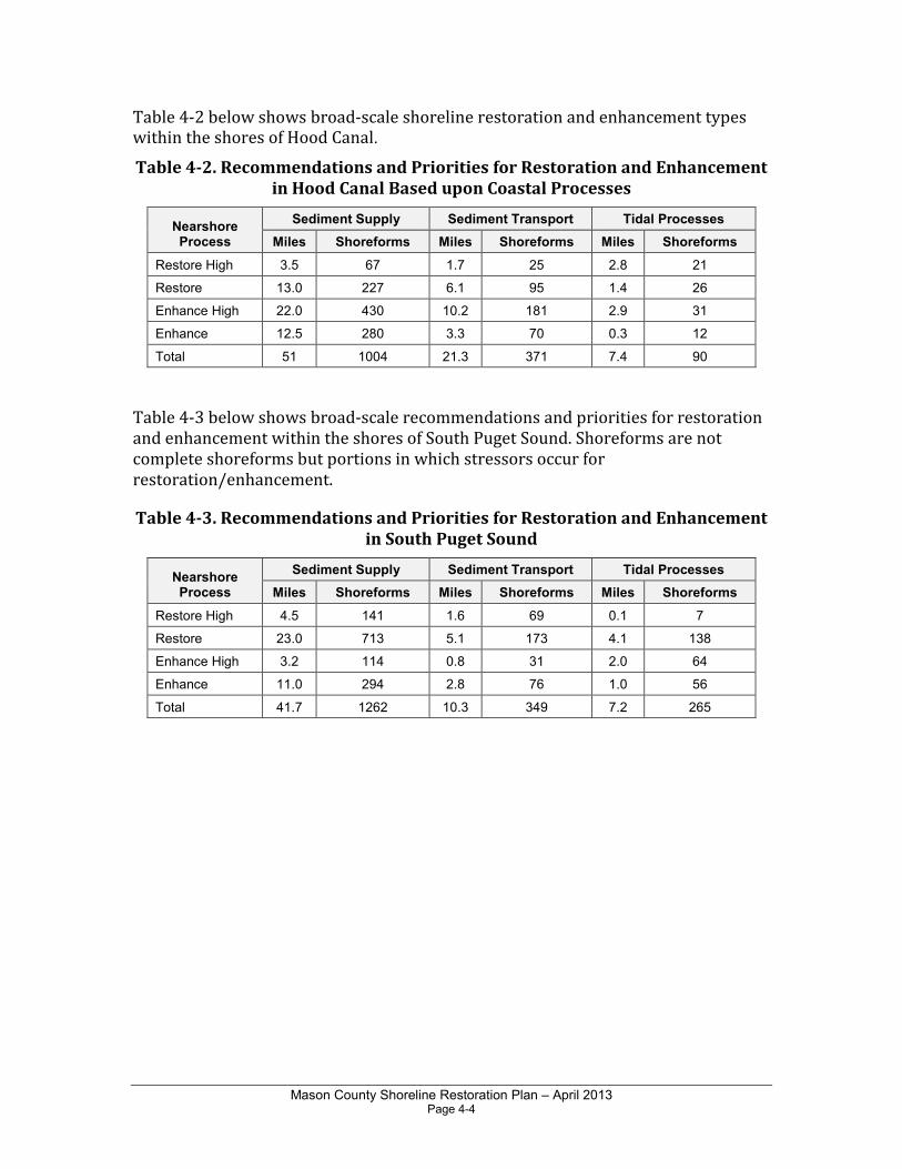
Table 4-2 below shows broad-scale shoreline restoration and enhancement types within the shores of Hood Canal.
Table 4-2. Recommendations and Priorities for Restoration and Enhancement
in Hood Canal Based upon Coastal Processes
Nearshore Process
Sediment Supply Sediment Transport Tidal Processes
Miles Shoreforms Miles Shoreforms Miles Shoreforms
Restore High 3.5 67 1.7 25 2.8 21
Restore 13.0 227 6.1 95 1.4 26
Enhance High 22.0 430 10.2 181 2.9 31
Enhance 12.5 280 3.3 70 0.3 12
Total 51 1004 21.3 371 7.4 90
Table 4-3 below shows broad-scale recommendations and priorities for restoration and enhancement within the shores of South Puget Sound. Shoreforms are not complete shoreforms but portions in which stressors occur for restoration/enhancement.
Table 4-3. Recommendations and Priorities for Restoration and Enhancement
in South Puget Sound
Nearshore Process
Sediment Supply Sediment Transport Tidal Processes
Miles Shoreforms Miles Shoreforms Miles Shoreforms
Restore High 4.5 141 1.6 69 0.1 7
Restore 23.0 713 5.1 173 4.1 138
Enhance High 3.2 114 0.8 31 2.0 64
Enhance 11.0 294 2.8 76 1.0 56
Total 41.7 1262 10.3 349 7.2 265
Mason County Shoreline Restoration Plan – April 2013 Page 5-1
Chapter 5.0 Restoration Actions for Marine Nearshore Areas
5.1 Programmatic Actions
Certain restoration actions could be broadly implemented on a programmatic basis to help achieve restoration goals. The following programmatic actions are recommended for marine shorelines within Mason County. Which County departments or other entities will take the lead on these actions will be determined in the future based upon funding and other County priorities. Mason County will continue to coordinate with neighboring jurisdictions on restoration activities. For example, many restoration actions are planned by Mason County Conservation District, which also coordinates restoration planning for Thurston County. Kitsap and Jefferson Counties are also likely collaborators for restoration actions in the Hood Canal portions of Mason County.
Local Tribes including the Skokomish and Squaxin Island Tribes also have significant involvement in restoration activities in the area. Additional opportunities may exist to partner with not-for-profit groups such as the South Puget Sound Salmon Enhancement Group. Opportunities to partner with City of Shelton on programmatic efforts should also be explored.
• Remove armoring and bulkheads from publicly owned marine sites including parks, wherever feasible. Replace with soft shoreline protection. These projects could be demonstration or pilot projects.
• For permitted shoreline structure replacements or repairs, encourage soft shoreline protection techniques and structure design standards to protect habitat.
• Remove any creosote treated wooden piles and structures from publicly owned parcels. Replace with concrete or steel if a structure is needed. Encourage removal and replacement of existing creosote treated piles by voluntary action.
• Supplement impaired feeder bluff contribution (mitigate for lost sediment supply) where possible, particularly where down-drift forage fish spawning may benefit.
• Remove derelict overwater structures to restore aquatic habitat, and restore impacted substrates. All such removal would be on a voluntary basis.
Mason County Shoreline Restoration Plan – April 2013 Page 5-2
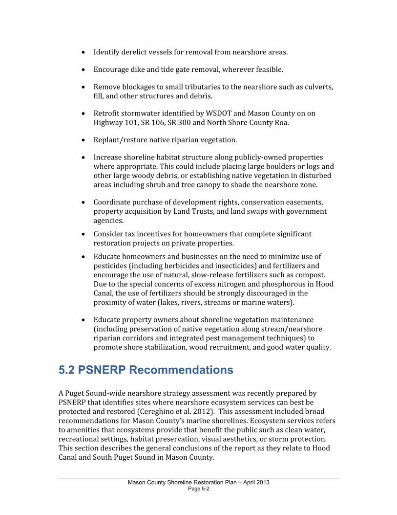
• Identify derelict vessels for removal from nearshore areas.
• Encourage dike and tide gate removal, wherever feasible.
• Remove blockages to small tributaries to the nearshore such as culverts, fill, and other structures and debris.
• Retrofit stormwater identified by WSDOT and Mason County on on Highway 101, SR 106, SR 300 and North Shore County Roa.
• Replant/restore native riparian vegetation.
• Increase shoreline habitat structure along publicly-owned properties where appropriate. This could include placing large boulders or logs and other large woody debris, or establishing native vegetation in disturbed areas including shrub and tree canopy to shade the nearshore zone.
• Coordinate purchase of development rights, conservation easements, property acquisition by Land Trusts, and land swaps with government agencies.
• Consider tax incentives for homeowners that complete significant restoration projects on private properties.
• Educate homeowners and businesses on the need to minimize use of pesticides (including herbicides and insecticides) and fertilizers and encourage the use of natural, slow-release fertilizers such as compost. Due to the special concerns of excess nitrogen and phosphorous in Hood Canal, the use of fertilizers should be strongly discouraged in the proximity of water (lakes, rivers, streams or marine waters).
• Educate property owners about shoreline vegetation maintenance (including preservation of native vegetation along stream/nearshore riparian corridors and integrated pest management techniques) to promote shore stabilization, wood recruitment, and good water quality.
5.2 PSNERP Recommendations
A Puget Sound-wide nearshore strategy assessment was recently prepared by PSNERP that identifies sites where nearshore ecosystem services can best be protected and restored (Cereghino et al. 2012). This assessment included broad recommendations for Mason County’s marine shorelines. Ecosystem services refers to amenities that ecosystems provide that benefit the public such as clean water, recreational settings, habitat preservation, visual aesthetics, or storm protection. This section describes the general conclusions of the report as they relate to Hood Canal and South Puget Sound in Mason County.

Mason County Shoreline Restoration Plan – April 2013 Page 5-3
5.2.1 Hood Canal
The Skokomish River is the largest river delta in Hood Canal. Both the Skokomish and Hamma Hamma Delta areas are considered high potential for restoration. Many of the beach systems identified by PSNERP in Hood Canal are considered high potential for restoration (Cereghino et al., 2012). However, about half of the beaches are substantially developed. The beaches in the Big Bend area, along with the west shore from the Skokomish delta north past Lilliwaup, have been identified as sites suitable for enhancement because they are substantially degraded. The remainder of Hood Canal is composed of high value potential beaches. In Mason County, beaches along the eastern shore of Hood Canal from Dewatto Bay north to the Kitsap County line are considered complex and minimally degraded.
Two barrier embayment sites near the Union Creek coastal inlet are noted to have a high potential for restoration. The beaches from Dewatto north are also considered high potential embayment sites and area recommended for restoration. Coastal inlet sites on Hood Canal were also identified for restoration. The Union River estuary/Lynch Cove near Belfair is highly modified but one of the seven largest and most complex inlets in Puget Sound (Cereghino et al., 2012). On the other hand, Dewatto Bay is considered high value as an unaltered coastal inlet. Tahuya River estuary is considered to be among the most significant coastal inlets in Puget Sound with moderate degradation; this is slated for restoration.
5.2.2 South Puget Sound
South Puget Sound is a complex mosaic of inlets and embayments with short beaches. South Sound also has a very high number of high quality inlets draining large watersheds, with 24 of the overall Puget Sound’s 51 potential inlets considered high value and recommended for protection as determined by PSNERP (Cereghino et al, 2012). There are no large river deltas in the Mason County section of South Sound. High potential restoration opportunities for beaches in South Sound include the southern half of Harstine Island, the rest of Totten Inlet and along the shores north of Oakland Bay.
5.3 Site-Specific Restoration Opportunities
This section describes restoration opportunities for nearshore areas that were identified based on the methods described in Appendix B. The recommendations are described relative to the nearshore processes they would address and the regional priorities that they would help to achieve. The total length of shoreline encompassed within the broad scale restoration and enhancement action areas (Table 5-1) spans almost the entire Mason County shoreline. Additionally, 82 site-specific opportunities located largely in public ownership include specific restoration recommendations, which could likely be implemented in a shorter time
Mason County Shoreline Restoration Plan – April 2013 Page 5-4
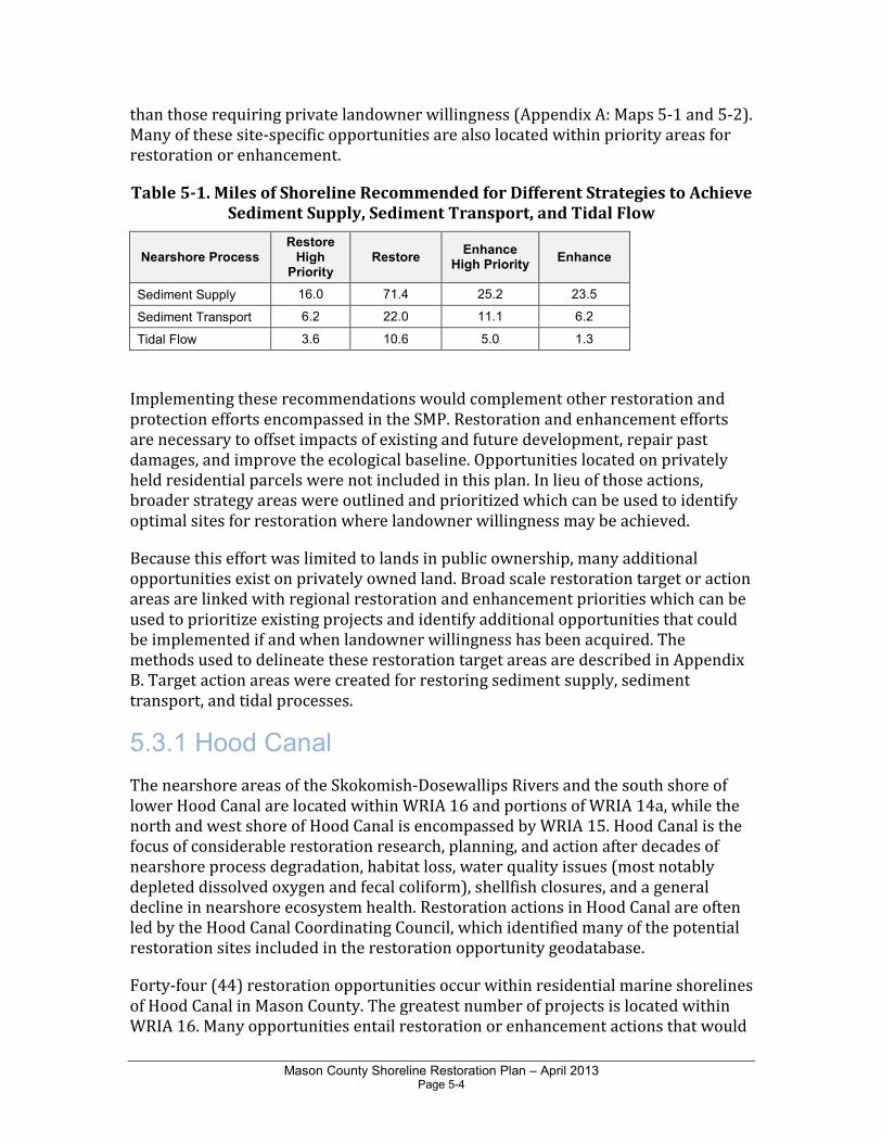
than those requiring private landowner willingness (Appendix A: Maps 5-1 and 5-2). Many of these site-specific opportunities are also located within priority areas for restoration or enhancement.
Table 5-1. Miles of Shoreline Recommended for Different Strategies to Achieve
Sediment Supply, Sediment Transport, and Tidal Flow
Nearshore Process Restore
High Priority
Restore Enhance
High Priority Enhance
Sediment Supply 16.0 71.4 25.2 23.5
Sediment Transport 6.2 22.0 11.1 6.2
Tidal Flow 3.6 10.6 5.0 1.3
Implementing these recommendations would complement other restoration and protection efforts encompassed in the SMP. Restoration and enhancement efforts are necessary to offset impacts of existing and future development, repair past damages, and improve the ecological baseline. Opportunities located on privately held residential parcels were not included in this plan. In lieu of those actions, broader strategy areas were outlined and prioritized which can be used to identify optimal sites for restoration where landowner willingness may be achieved.
Because this effort was limited to lands in public ownership, many additional opportunities exist on privately owned land. Broad scale restoration target or action areas are linked with regional restoration and enhancement priorities which can be used to prioritize existing projects and identify additional opportunities that could be implemented if and when landowner willingness has been acquired. The methods used to delineate these restoration target areas are described in Appendix B. Target action areas were created for restoring sediment supply, sediment transport, and tidal processes.
5.3.1 Hood Canal
The nearshore areas of the Skokomish-Dosewallips Rivers and the south shore of lower Hood Canal are located within WRIA 16 and portions of WRIA 14a, while the north and west shore of Hood Canal is encompassed by WRIA 15. Hood Canal is the focus of considerable restoration research, planning, and action after decades of nearshore process degradation, habitat loss, water quality issues (most notably depleted dissolved oxygen and fecal coliform), shellfish closures, and a general decline in nearshore ecosystem health. Restoration actions in Hood Canal are often led by the Hood Canal Coordinating Council, which identified many of the potential restoration sites included in the restoration opportunity geodatabase.
Forty-four (44) restoration opportunities occur within residential marine shorelines of Hood Canal in Mason County. The greatest number of projects is located within WRIA 16. Many opportunities entail restoration or enhancement actions that would
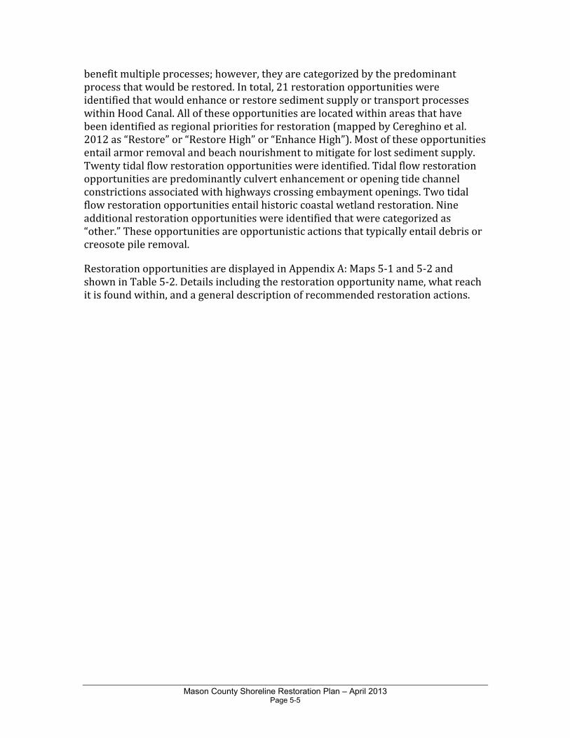
Mason County Shoreline Restoration Plan – April 2013 Page 5-5
benefit multiple processes; however, they are categorized by the predominant process that would be restored. In total, 21 restoration opportunities were identified that would enhance or restore sediment supply or transport processes within Hood Canal. All of these opportunities are located within areas that have been identified as regional priorities for restoration (mapped by Cereghino et al. 2012 as “Restore” or “Restore High” or “Enhance High”). Most of these opportunities entail armor removal and beach nourishment to mitigate for lost sediment supply. Twenty tidal flow restoration opportunities were identified. Tidal flow restoration opportunities are predominantly culvert enhancement or opening tide channel constrictions associated with highways crossing embayment openings. Two tidal flow restoration opportunities entail historic coastal wetland restoration. Nine additional restoration opportunities were identified that were categorized as “other.” These opportunities are opportunistic actions that typically entail debris or creosote pile removal.
Restoration opportunities are displayed in Appendix A: Maps 5-1 and 5-2 and shown in Table 5-2. Details including the restoration opportunity name, what reach it is found within, and a general description of recommended restoration actions.
Mason County Shoreline Restoration Plan – April 2013 Page 5-6
Table 5-2. Restoration Opportunities on Public Shores of Hood Canal
Opportunity Number
Reach Name
Project Name Project Description Process
Type Priority
1 MR-01 Triton Head lagoon enhancement
Remove armoring inside of lagoon, improve channel outlet (unknown ownership)
Tidal restoration
2 MR-02 Hamma Hamma Causeway Replacement and Estuary Restoration
The goal of this proposed project is to restore tidal connectivity in the Hamma Hamma estuary by replacing the SR101 causeway/bridge with an elevated structure that spans the entire delta.
Tidal restoration
Restore
3 MR-03 Cabin Point/Lilliwaup Sediment Supply
Restore sediment supply from feeder bluff Sediment restoration
Restore
4 MR-03 Eagle Creek Salt Marsh Relocate SR101 to the west, and remove fill to reestablish salt marsh and tidal connection to the lagoon
Tidal restoration
Restore
5 MR-03 Jorsted Creek Sediment Supply
Restore sediment supply from feeder bluff Sediment restoration
Restoration High
6 MR-03 Jorstad Creek debris removal
Remove derelict piles (possibly treated with creosote), in excess here (no clear ownership)
Other restoration
7 MR-03 Jorstad Creek beach enhancement
Enhance sediment supply with beach nourishment, create pocket beach habitat (Mason County ownership)
Sediment restoration
Restoration High
8 MR-03 Eagle Creek sediment mitigation
Enhance sediment supply with beach nourishment or landslide sidecasting waterward of road.
Sediment restoration
Enhance High
9 MR-03 Lilliwaup North sediment supply mitigation
Enhance sediment supply with beach nourishment or landslide sidecasting waterward of road.
Sediment restoration
Enhance High
10 MR-04 Lilliwaup South sediment supply mitigation
Enhance sediment supply with beach nourishment or landslide sidecasting waterward of road.
Sediment Restoration
Enhance High
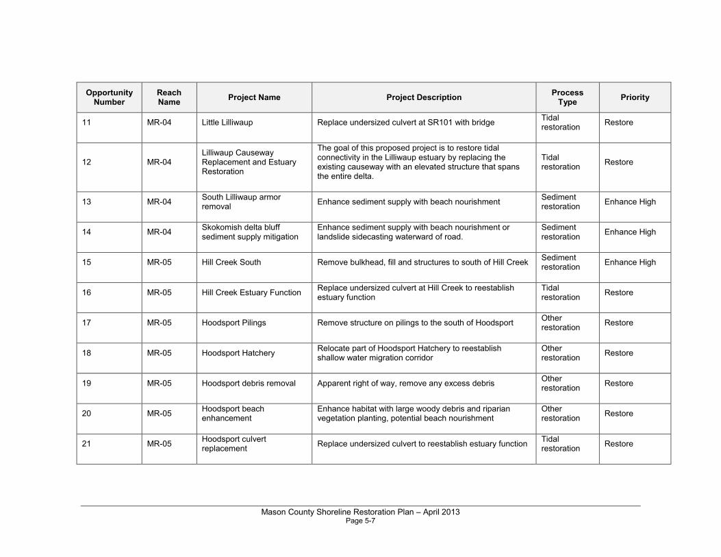
Mason County Shoreline Restoration Plan – April 2013 Page 5-7
Opportunity Number
Reach Name
Project Name Project Description Process
Type Priority
11 MR-04 Little Lilliwaup Replace undersized culvert at SR101 with bridge Tidal restoration
Restore
12 MR-04 Lilliwaup Causeway Replacement and Estuary Restoration
The goal of this proposed project is to restore tidal connectivity in the Lilliwaup estuary by replacing the existing causeway with an elevated structure that spans the entire delta.
Tidal restoration
Restore
13 MR-04 South Lilliwaup armor removal
Enhance sediment supply with beach nourishment Sediment restoration
Enhance High
14 MR-04 Skokomish delta bluff sediment supply mitigation
Enhance sediment supply with beach nourishment or landslide sidecasting waterward of road.
Sediment restoration
Enhance High
15 MR-05 Hill Creek South Remove bulkhead, fill and structures to south of Hill Creek Sediment restoration
Enhance High
16 MR-05 Hill Creek Estuary Function Replace undersized culvert at Hill Creek to reestablish estuary function
Tidal restoration
Restore
17 MR-05 Hoodsport Pilings Remove structure on pilings to the south of Hoodsport Other restoration
Restore
18 MR-05 Hoodsport Hatchery Relocate part of Hoodsport Hatchery to reestablish shallow water migration corridor
Other restoration
Restore
19 MR-05 Hoodsport debris removal Apparent right of way, remove any excess debris Other restoration
Restore
20 MR-05 Hoodsport beach enhancement
Enhance habitat with large woody debris and riparian vegetation planting, potential beach nourishment
Other restoration
Restore
21 MR-05 Hoodsport culvert replacement
Replace undersized culvert to reestablish estuary function Tidal restoration
Restore
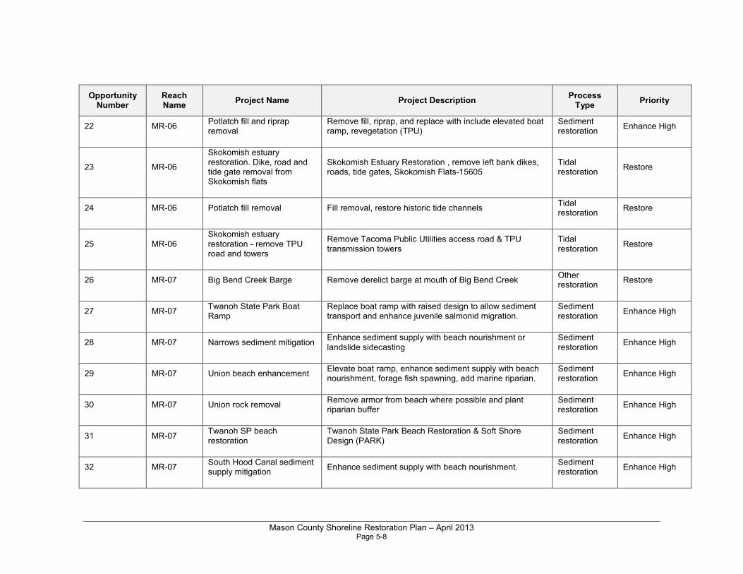
Mason County Shoreline Restoration Plan – April 2013 Page 5-8
Opportunity Number
Reach Name
Project Name Project Description Process
Type Priority
22 MR-06 Potlatch fill and riprap removal
Remove fill, riprap, and replace with include elevated boat ramp, revegetation (TPU)
Sediment restoration
Enhance High
23 MR-06
Skokomish estuary restoration. Dike, road and tide gate removal from Skokomish flats
Skokomish Estuary Restoration , remove left bank dikes, roads, tide gates, Skokomish Flats-15605
Tidal restoration
Restore
24 MR-06 Potlatch fill removal Fill removal, restore historic tide channels Tidal restoration
Restore
25 MR-06 Skokomish estuary restoration - remove TPU road and towers
Remove Tacoma Public Utilities access road & TPU transmission towers
Tidal restoration
Restore
26 MR-07 Big Bend Creek Barge Remove derelict barge at mouth of Big Bend Creek Other restoration
Restore
27 MR-07 Twanoh State Park Boat Ramp
Replace boat ramp with raised design to allow sediment transport and enhance juvenile salmonid migration.
Sediment restoration
Enhance High
28 MR-07 Narrows sediment mitigation Enhance sediment supply with beach nourishment or landslide sidecasting
Sediment restoration
Enhance High
29 MR-07 Union beach enhancement Elevate boat ramp, enhance sediment supply with beach nourishment, forage fish spawning, add marine riparian.
Sediment restoration
Enhance High
30 MR-07 Union rock removal Remove armor from beach where possible and plant riparian buffer
Sediment restoration
Enhance High
31 MR-07 Twanoh SP beach restoration
Twanoh State Park Beach Restoration & Soft Shore Design (PARK)
Sediment restoration
Enhance High
32 MR-07 South Hood Canal sediment supply mitigation
Enhance sediment supply with beach nourishment. Sediment restoration
Enhance High
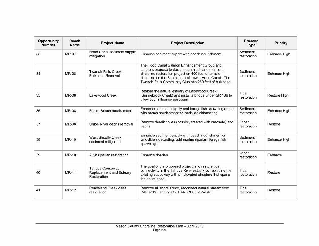
Mason County Shoreline Restoration Plan – April 2013 Page 5-9
Opportunity Number
Reach Name
Project Name Project Description Process
Type Priority
33 MR-07 Hood Canal sediment supply mitigation
Enhance sediment supply with beach nourishment. Sediment restoration
Enhance High
34 MR-08 Twanoh Falls Creek Bulkhead Removal
The Hood Canal Salmon Enhancement Group and partners propose to design, construct, and monitor a shoreline restoration project on 400 feet of private shoreline on the Southshore of Lower Hood Canal. The Twanoh Falls Community Club has 250 feet of bulkhead
Sediment restoration
Enhance High
35 MR-08 Lakewood Creek Restore the natural estuary of Lakewood Creek (Springbrook Creek) and install a bridge under SR 106 to allow tidal influence upstream
Tidal restoration
Restore High
36 MR-08 Forest Beach nourishment Enhance sediment supply and forage fish spawning areas with beach nourishment or landslide sidecasting
Sediment restoration
Enhance High
37 MR-08 Union River debris removal Remove derelict piles (possibly treated with creosote) and debris
Other restoration
Restore
38 MR-10 West Shoofly Creek sediment mitigation
Enhance sediment supply with beach nourishment or landslide sidecasting, add marine riparian, forage fish spawning.
Sediment restoration
Enhance High
39 MR-10 Allyn riparian restoration Enhance riparian Other restoration
Enhance
40 MR-11 Tahuya Causeway Replacement and Estuary Restoration
The goal of the proposed project is to restore tidal connectivity in the Tahuya River estuary by replacing the existing causeway with an elevated structure that spans the entire delta.
Tidal restoration
Restore
41 MR-12 Rendsland Creek delta restoration
Remove all shore armor, reconnect natural stream flow (Menard's Landing Co. PARK & St of Wash)
Tidal restoration
Restore
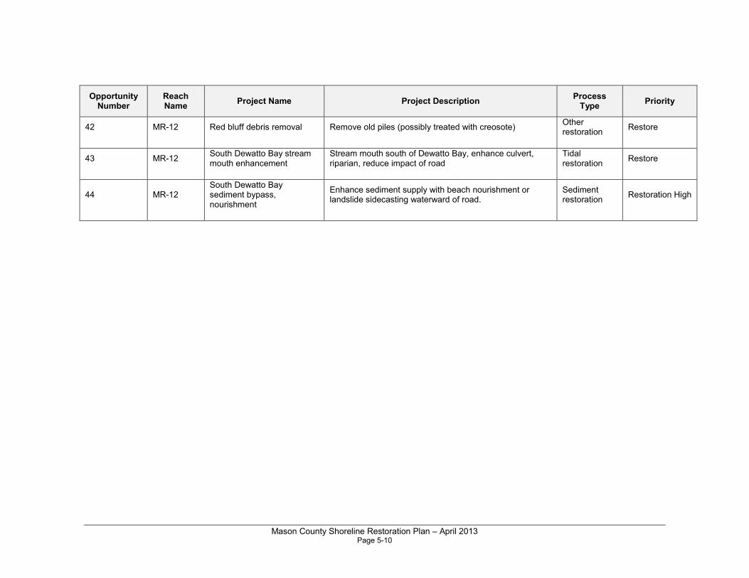
Mason County Shoreline Restoration Plan – April 2013 Page 5-10
Opportunity Number
Reach Name
Project Name Project Description Process
Type Priority
42 MR-12 Red bluff debris removal Remove old piles (possibly treated with creosote) Other restoration
Restore
43 MR-12 South Dewatto Bay stream mouth enhancement
Stream mouth south of Dewatto Bay, enhance culvert, riparian, reduce impact of road
Tidal restoration
Restore
44 MR-12 South Dewatto Bay sediment bypass, nourishment
Enhance sediment supply with beach nourishment or landslide sidecasting waterward of road.
Sediment restoration
Restoration High
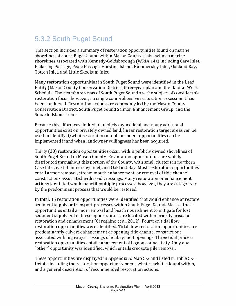
Mason County Shoreline Restoration Plan – April 2013 Page 5-11
5.3.2 South Puget Sound
This section includes a summary of restoration opportunities found on marine shorelines of South Puget Sound within Mason County. This includes marine shorelines associated with Kennedy-Goldsborough (WRIA 14a) including Case Inlet, Pickering Passage, Peale Passage, Harstine Island, Hammersley Inlet, Oakland Bay, Totten Inlet, and Little Skookum Inlet.
Many restoration opportunities in South Puget Sound were identified in the Lead Entity (Mason County Conservation District) three-year plan and the Habitat Work Schedule. The nearshore areas of South Puget Sound are the subject of considerable restoration focus; however, no single comprehensive restoration assessment has been conducted. Restoration actions are commonly led by the Mason County Conservation District, South Puget Sound Salmon Enhancement Group, and the Squaxin Island Tribe.
Because this effort was limited to publicly owned land and many additional opportunities exist on privately owned land, linear restoration target areas can be used to identify if/what restoration or enhancement opportunities can be implemented if and when landowner willingness has been acquired.
Thirty (30) restoration opportunities occur within publicly owned shorelines of South Puget Sound in Mason County. Restoration opportunities are widely distributed throughout this portion of the County, with small clusters in northern Case Inlet, east Hammersley Inlet, and Oakland Bay. Most restoration opportunities entail armor removal, stream mouth enhancement, or removal of tide channel constrictions associated with road crossings. Many restoration or enhancement actions identified would benefit multiple processes; however, they are categorized by the predominant process that would be restored.
In total, 15 restoration opportunities were identified that would enhance or restore sediment supply or transport processes within South Puget Sound. Most of these opportunities entail armor removal and beach nourishment to mitigate for lost sediment supply. All of these opportunities are located within priority areas for restoration and enhancement (Cereghino et al. 2012). Fourteen tidal flow restoration opportunities were identified. Tidal flow restoration opportunities are predominantly culvert enhancement or opening tide channel constrictions associated with highways crossings of embayment openings. Three tidal process restoration opportunities entail enhancement of lagoon connectivity. Only one “other” opportunity was identified, which entails creosote pile removal.
These opportunities are displayed in Appendix A: Map 5-2 and listed in Table 5-3. Details including the restoration opportunity name, what reach it is found within, and a general description of recommended restoration actions.
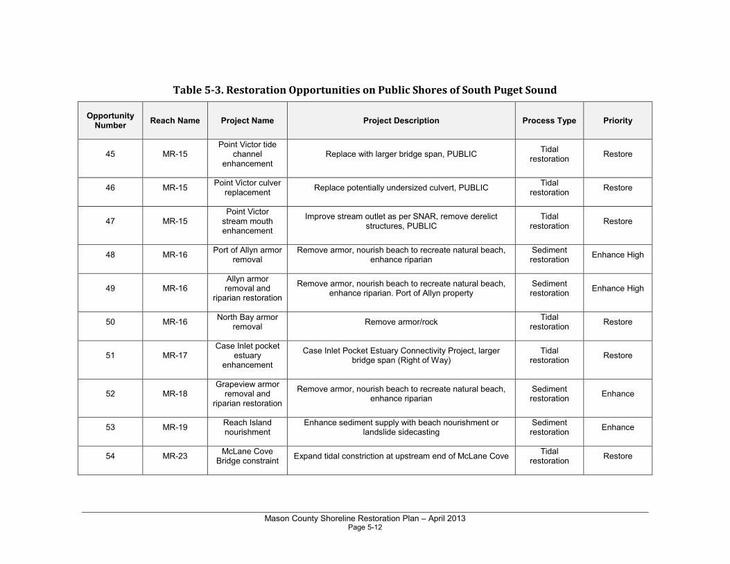
Mason County Shoreline Restoration Plan – April 2013 Page 5-12
Table 5-3. Restoration Opportunities on Public Shores of South Puget Sound
Opportunity Number
Reach Name Project Name Project Description Process Type Priority
45 MR-15 Point Victor tide
channel enhancement
Replace with larger bridge span, PUBLIC Tidal
restoration Restore
46 MR-15 Point Victor culver
replacement Replace potentially undersized culvert, PUBLIC
Tidal restoration
Restore
47 MR-15 Point Victor stream mouth enhancement
Improve stream outlet as per SNAR, remove derelict structures, PUBLIC
Tidal restoration
Restore
48 MR-16 Port of Allyn armor
removal Remove armor, nourish beach to recreate natural beach,
enhance riparian Sediment restoration
Enhance High
49 MR-16 Allyn armor removal and
riparian restoration
Remove armor, nourish beach to recreate natural beach, enhance riparian. Port of Allyn property
Sediment restoration
Enhance High
50 MR-16 North Bay armor
removal Remove armor/rock
Tidal restoration
Restore
51 MR-17 Case Inlet pocket
estuary enhancement
Case Inlet Pocket Estuary Connectivity Project, larger bridge span (Right of Way)
Tidal restoration
Restore
52 MR-18 Grapeview armor removal and
riparian restoration
Remove armor, nourish beach to recreate natural beach, enhance riparian
Sediment restoration
Enhance
53 MR-19 Reach Island nourishment
Enhance sediment supply with beach nourishment or landslide sidecasting
Sediment restoration
Enhance
54 MR-23 McLane Cove
Bridge constraint Expand tidal constriction at upstream end of McLane Cove
Tidal restoration
Restore
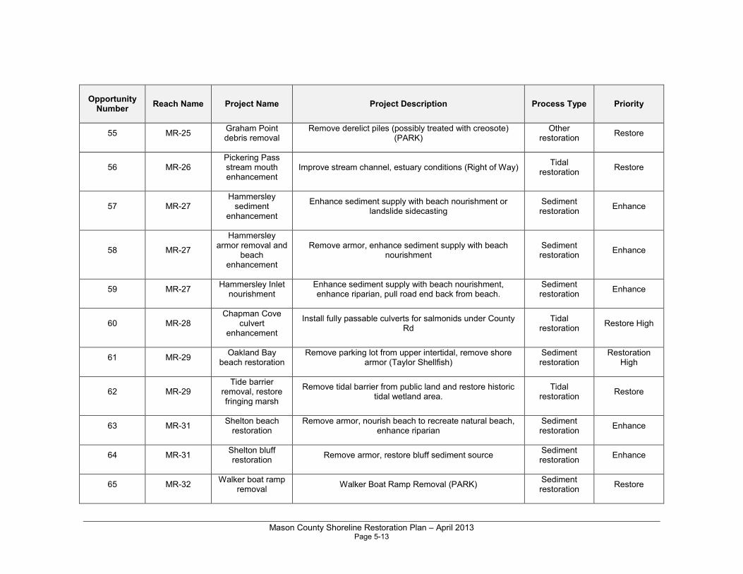
Mason County Shoreline Restoration Plan – April 2013 Page 5-13
Opportunity Number
Reach Name Project Name Project Description Process Type Priority
55 MR-25 Graham Point debris removal
Remove derelict piles (possibly treated with creosote) (PARK)
Other restoration
Restore
56 MR-26 Pickering Pass stream mouth enhancement
Improve stream channel, estuary conditions (Right of Way) Tidal
restoration Restore
57 MR-27 Hammersley sediment
enhancement
Enhance sediment supply with beach nourishment or landslide sidecasting
Sediment restoration
Enhance
58 MR-27
Hammersley armor removal and
beach enhancement
Remove armor, enhance sediment supply with beach nourishment
Sediment restoration
Enhance
59 MR-27 Hammersley Inlet
nourishment Enhance sediment supply with beach nourishment, enhance riparian, pull road end back from beach.
Sediment restoration
Enhance
60 MR-28 Chapman Cove
culvert enhancement
Install fully passable culverts for salmonids under County Rd
Tidal restoration
Restore High
61 MR-29 Oakland Bay
beach restoration Remove parking lot from upper intertidal, remove shore
armor (Taylor Shellfish) Sediment restoration
Restoration High
62 MR-29 Tide barrier
removal, restore fringing marsh
Remove tidal barrier from public land and restore historic tidal wetland area.
Tidal restoration
Restore
63 MR-31 Shelton beach restoration
Remove armor, nourish beach to recreate natural beach, enhance riparian
Sediment restoration
Enhance
64 MR-31 Shelton bluff restoration
Remove armor, restore bluff sediment source Sediment restoration
Enhance
65 MR-32 Walker boat ramp
removal Walker Boat Ramp Removal (PARK)
Sediment restoration
Restore
Mason County Shoreline Restoration Plan – April 2013 Page 5-14
Opportunity Number
Reach Name Project Name Project Description Process Type Priority
66 MR-36 Skookum Inlet dike removal
Skookum Inlet Dike Removal (unknown ownership) Tidal
restoration Restore High
67 MR-36 Arcadia South armor removal
Remove shore armoring from public (Right of Way) Sediment restoration
Restore
68 MR-36 Arcadia North armor removal
Remove shore armoring from public (Right of Way) Sediment restoration
Restore
69 MR-36
Deer Creek stream mouth
culvert enhancement
Enhance Deer Creek stream mouth with perched culvert Tidal
restoration Restore
70 MR-38 Windy Point armor
removal Remove shore armoring from public (Right of Way)
Sediment restoration
Enhance High
71 MR-39
Kennedy Creek NAP Hwy 101 Modification Nearshore Restoration
Modify Hwy 101, which bisects the NAP, to restore estuarine processes and functions to Oyster Bay in Totten
Inlet.
Tidal restoration
Restore
72 MR-40 Dougall Point
lagoon and beach restoration
Dougall Point Lagoon and Beach Restoration (PARK) Tidal
restoration
73 MR-45 Brisco Point
pocket estuary enhancement
Brisco Point Pocket Estuary Passage Restoration (unknown ownership)
Tidal restoration
Restore
74 MR-48
Remove armor and derelict
building from park shoreline
Remove armor on upper beach and derelict building (if still there) replant riparian vegetation
Sediment restoration
Restore
Mason County Shoreline Restoration Plan – April 2013 Page 6-1
Chapter 6.0 Restoration Actions for Lakes
6.1 Programmatic Actions
The following programmatic actions are recommended for freshwater lake shorelines within Mason County.
• Educate property owners about proper vegetation/landscape maintenance to promote shore stabilization, large woody debris recruitment, and good water quality.
• Encourage low impact development practices for shoreline property owners.
• Encourage incentive programs for septic users to replace and increase setbacks for septic systems.
• Educate private property owners about the negative impacts of shore armoring and overwater structures.
• Maintain educational signage about invasive species and water quality protection at all public access points.
• Educate boaters about proper waste disposal methods, anchoring techniques, and other best boating practices to minimize habitat damage and prevent water quality contamination.
• Encourage incentive programs for shoreline property owners, such as transfer or purchase of development rights and tax incentives for shoreline restoration and protection, and the advantages of conservation easements to permanently protect shorelines.
• Provide incentives to encourage restoration as part of redevelopment activities which improve habitat or restore salmonid habitats.
• Remove armoring and bulkheads from publicly owned freshwater sites including parks, wherever feasible. Replace with soft shoreline protection if needed.
• Remove derelict docks, floats, or other overwater structures that are no longer in use.
• Encourage lake associations or stewardship organizations to control invasive aquatic weeds in freshwater lakes.
Mason County Shoreline Restoration Plan – April 2013 Page 6-2
• Maintain or increase shoreline habitat structure along all publicly owned properties. This could include placing large boulders or logs and other large woody debris, establishing native vegetation in disturbed or altered areas including shrub and tree canopy to shade the lake’s riparian zone.
• Establish and support lake managements districts to provide a pathway for the development of conservation plans and restoration activities that improve shoreline habitat and water quality, where impaired.
• Encourage the development and implementation of lake-specific integrated aquatic vegetation management plans (IAVMPs) to establish protocols for vegetation control (including native nuisance vegetation). The planning process should also be used to identify intact shorelines for conservancy areas and to provide education on lake shoreline management.
• Educate homeowners and businesses on the need to minimize use of pesticides (including herbicides and insecticides) and fertilizers and encourage the use of natural, slow-release fertilizers such as compost. Due to the special concerns of excess nitrogen and phosphorous in Hood Canal, the use of fertilizers should be strongly discouraged in the proximity of water (lakes, rivers, streams, or marine waters).
6.2 Restoration Actions for Specific Lakes
This section describes restoration activities that would be applied to lakes due to specific impairments. In some cases the restoration activities are the same or similar to programmatic actions described previously. However, because specific impairments were identified for the reaches, the restoration activities have higher potential to improve ecological functions and may therefore support a higher prioritization.
The following sections describe in more detail the potential restoration actions for several of the lakes that have known issues with invasive aquatic vegetation, water quality degradation, and operation of dams and reservoirs.
6.2.1 Invasive Aquatic Vegetation and Water Quality
Four lakes in WRIA 14a (Island, Limerick, Mason, and Spencer) were identified as having impairments associated with invasive aquatic vegetation. Two of the lakes (Mason Lake and Lake Limerick) have approved Integrated Aquatic Vegetation Management Plans (IAVMPs) for plant management. Restoration activities for these lakes should include evaluating the success of recent control efforts and making adjustments to the control strategy, if needed. Island Lake and Spencer Lake have infestations of Eurasian water-milfoil and swollen bladderwort, respectively. At a
Mason County Shoreline Restoration Plan – April 2013 Page 6-3
minimum, restoration activities should include a survey and evaluation of these lakes to determine control needs. It is worth noting that since there are only a handful of lakes in Mason County with invasive plant problems, it may be well worth the County’s efforts to eradicate these plants before they spread to other lakes in the County.
Mason Lake is included on Ecology’s 303(d) list of impaired waters due to PCB levels in fish tissue. More monitoring and analysis are needed to guide future restoration actions.
Haven Lake in WRIA 15 is included in Ecology’s 303(d) list of impaired waters due to PCBs and other contaminants detected in fish tissue samples. It was not identified as impaired due to invasive aquatic plants, but the native plants are considered to be at nuisance levels and an IAVMP is under development. Agency sponsorship, funding, and community outreach will be necessary to finalize and implement the planning effort.
Fawn Lake in WRIA 14a is not included in Ecology’s 303(d) list of impaired waters, but there are known or suspected septic system problems in this lake that are believed to be contributing to fecal bacteria problems in Skookum Inlet.
6.2.2 Dams and Reservoirs
Lake Cushman and Lake Kokanee (in WRIA 16/14b) are not listed as impaired waters on Ecology’s 303(d) list. However, due to operational impacts associated with the dams that formed these reservoirs, restoration measures are currently in process. The reservoirs are managed by Tacoma Power under the recent relicensing agreement that includes restoration activities for fish, wildlife, and water quality (Tacoma Power 2011). Restoration activities include Staircase Road and day-use site upgrades to protect water quality, monitoring dissolved gases, and development of a fish habitat enhancement and restoration plan for the North Fork Skokomish River basin. The projects associated with the plan include, but are not limited to, in-stream structure enhancements, side channel habitat development, and the removal of existing barriers to upstream migration in upper Big Creek and Dow Creek.
In addition, there are guidelines for construction activities that are related to numerous planned site enhancements around the hydroelectric project. The construction mitigation plan includes measures to restrict the spread of invasive species and maintain native vegetation.
Although there has been significant progress toward restoration as a result of the relicensing agreement, additional restoration activities that should be considered for Lake Cushman and Lake Kokanee would include programmatic actions described previously. For example, because there is public access to Lake Cushman, measures to educate lake users on the risks of spreading invasive species, and invasive species monitoring, would be appropriate.
Mason County Shoreline Restoration Plan – April 2013 Page 6-4
6.2.3 Restoration Opportunities
Table 6-1 presents restoration opportunities for lakes in Mason County by WRIA. All of the projects listed in the table are considered to have a high potential for success in improving the functions of lakes in the WRIA. However, the success of each restoration project ultimately depends on the actual project design and implementation. Fewer restoration opportunities were identified for freshwater lakes (versus rivers) in Mason County. Less information on lakes is generally known. Shoreline lakes not included in Table 6-1 do not have identified restoration needs above and beyond programmatic restoration measures outlined above.
The table also lists the recommended timing for each restoration opportunity as “short-term” or “long-term.” Short-term (approximately 1-5 years) restoration projects include those that could be implemented by local landowners and volunteers and that would benefit the areas that are most in need. Short-term restoration efforts include habitat restoration and enhancement efforts in publicly owned areas of the County’s shorelines. These projects could be implemented in the near term, depending on grant cycles and coordination with volunteer and community organizations. Long-term (approximately 5-10 years) restoration projects could be those that require coordination with other jurisdictions or that cover larger land areas. These projects may be more difficult to implement and would likely require more planning and permitting.

Mason County Shoreline Restoration Plan – April 2013 Page 6-5
Table 6-1. Restoration Actions for Mason County Lakes
Lake WRIA Existing Alterations Restoration Opportunities* Timing (short
term vs long term)
WRIA 14A
Lake Anderson 14A Dams have artificially raised water levels. Land conversion from pervious to impervious surfaces.
Numerous individual docks/piers associated with single-family homes.
Restore trees to riparian zones where vegetation is lacking.
L
Trails End Lake 14A There is a public boat launch at the south end of the lake. Most residential homes have an individual dock/pier.
Restore native trees. L
Mason Lake 14A Public boat launch.
Listed on Ecology’s 303 (d) list of impaired waters for PCB in fish tissue
Water quality impaired by nutrients. Infestation of Eurasian water milfoil and nuisance aquatic plants.
Dock proliferation and overwater structures.
Remove bulkheads and use soft-shore bank stabilization where feasible.
Restore native trees in the riparian zone.
Maintain constant lake discharge (from the hypolimnion) to Sherwood Creek to maintain adequate base flows and cold water input.
Maintain signage at public access points and promote public outreach to educate lake users on milfoil.
Conduct water quality sampling to identify current pollutant levels and sources to inform future restoration actions.
S/L
Spencer Lake 14A Public boat launch.
Infestation of swollen bladderwort.
Overwater structures and dock proliferation.
Develop an IAVMP that includes monitoring and maintenance for swollen bladderwort and other potential invasive plant infestations.
S/L
Cranberry Lake 14A Riparian vegetation removal. Restore forested riparian zone and associated wetlands where degraded.
Monitor and control aquatic invasive species potentially spreading from Lake Limerick.
S/L
Island Lake 14A Eurasian water milfoil infestation.
Overwater structures.
Public boat launch.
Conduct aquatic plant survey and develop a control plan for invasive species.
S/L
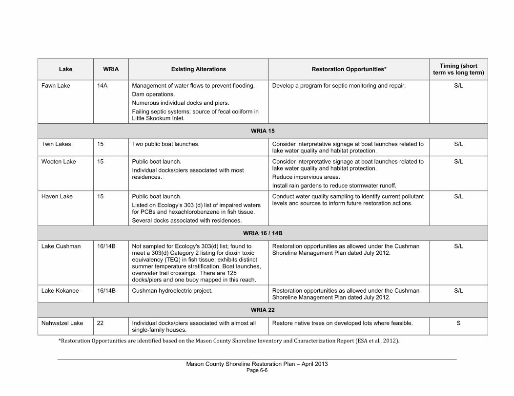
Mason County Shoreline Restoration Plan – April 2013 Page 6-6
Lake WRIA Existing Alterations Restoration Opportunities* Timing (short
term vs long term)
Fawn Lake 14A Management of water flows to prevent flooding.
Dam operations.
Numerous individual docks and piers.
Failing septic systems; source of fecal coliform in Little Skookum Inlet.
Develop a program for septic monitoring and repair. S/L
WRIA 15
Twin Lakes 15 Two public boat launches. Consider interpretative signage at boat launches related to lake water quality and habitat protection.
S/L
Wooten Lake 15 Public boat launch.
Individual docks/piers associated with most residences.
Consider interpretative signage at boat launches related to lake water quality and habitat protection.
Reduce impervious areas.
Install rain gardens to reduce stormwater runoff.
S/L
Haven Lake 15 Public boat launch.
Listed on Ecology’s 303 (d) list of impaired waters for PCBs and hexachlorobenzene in fish tissue.
Several docks associated with residences.
Conduct water quality sampling to identify current pollutant levels and sources to inform future restoration actions.
S/L
WRIA 16 / 14B
Lake Cushman 16/14B Not sampled for Ecology's 303(d) list; found to meet a 303(d) Category 2 listing for dioxin toxic equivalency (TEQ) in fish tissue; exhibits distinct summer temperature stratification. Boat launches, overwater trail crossings. There are 125 docks/piers and one buoy mapped in this reach.
Restoration opportunities as allowed under the Cushman Shoreline Management Plan dated July 2012.
S/L
Lake Kokanee 16/14B Cushman hydroelectric project. Restoration opportunities as allowed under the Cushman Shoreline Management Plan dated July 2012.
S/L
WRIA 22
Nahwatzel Lake 22 Individual docks/piers associated with almost all single-family houses.
Restore native trees on developed lots where feasible. S
*Restoration Opportunities are identified based on the Mason County Shoreline Inventory and Characterization Report (ESA et al., 2012).
Mason County Shoreline Restoration Plan – April 2013 Page 7-1
Chapter 7.0 Restoration Actions for Streams and Rivers
7.1 Programmatic Actions
The following programmatic actions are recommended for stream and river shorelines within Mason County.
• Encourage low impact development practices for shoreline property owners.
• Encourage incentive programs for septic users to replace and increase setbacks for septic systems. Continue to identify failing septic systems and notify landowners of the need for remedial actions.
• Educate private property owners about the negative impacts of shore armoring and overwater structures.
• Encourage incentive programs for shoreline property owners, such as transfer or purchase of development rights and tax incentives for shoreline restoration projects.
• Partnering with Mason Conservation District, consider developing p and implementing a County-wide integrated pest management plan to identify appropriate control measures for each of the key invasive weed or invertebrate types and for different levels of infestation.
• Where shorelines have been modified, provide incentives to encourage redevelopment activities to include habitat restoration.
• Remove armoring and bulkheads from publicly owned freshwater sites including parks, wherever feasible. Replace with soft shoreline protection if needed.
• Work with Mason Conservation District and agricultural landowners to improve stewardship through public incentive programs such as Farm Plans Cost Share, Environment Quality Improvement Program, Wildlife Habitat Improvement Program, and BMP construction.
• Work with WSDOT, DNR, and other agencies to identify undersized or poorly installed culverts and other road maintenance needs. Create a list of prioritized needs and track progress on completion.
• Retrofit stormwater systems using low impact development strategies.
Mason County Shoreline Restoration Plan – April 2013 Page 7-2
• Encourage levee setback projects to allow for channel migration on rivers and provide off-channel habitat for salmonids.
• Coordinate SMP restoration with salmonid recovery and watershed management plans to align with projects prioritized in salmon recovery plans.
• Remove culverts and blockages from smaller tributaries and replace with bridges to allow for fish passage and channel migration.
• Restore historical connections between rivers and floodplains, including associated wetlands or historic oxbows that may be disconnected from the river channel.
• Maintain or increase shoreline habitat structure along all publicly owned properties. This could include placing large boulders or logs and other large woody debris, establishing native vegetation in disturbed or altered areas including shrub and tree canopy to shade the river's riparian zone.
• Educate homeowners and businesses on the need to minimize use of pesticides (including herbicides and insecticides) and fertilizers and encourage the use of natural, slow-release fertilizers such as compost. Due to the special concerns of excess nitrogen and phosphorous in Hood Canal, the use of fertilizers should be strongly discouraged in the proximity of water (lakes, rivers, streams, or marine waters).
• Educate property owners about proper vegetation/landscape maintenance (including preservation of native vegetation along stream/nearshore riparian corridors and integrated pest management techniques) to promote shore stabilization, large woody debris recruitment, and good water quality.
7.2 Restoration Actions by WRIA
The streams and rivers of Mason County have been the subject of numerous restoration efforts because of their important salmon runs and the effect of freshwater inputs on marine water quality and shellfish harvest areas. While many restoration projects and programs have been implemented (see Chapter 8), there are still numerous opportunities to build on these efforts. Some of the major issues related to shoreline functions of the County's streams and rivers include:
• Water quality - high stream temperatures, excess nutrients, fecal coliforms, excessive sediment. Several streams and rivers in the county are subject to Total Maximum Daily Load (TMDL) restrictions.
Mason County Shoreline Restoration Plan – April 2013 Page 7-3
• Riparian vegetation - lack of coniferous tree cover, noxious weeds (particularly knotweed).
• Fish passage barriers such as culverts on both upper tributaries and at the mouths of streams in the nearshore zone.
• Stream flows - excessive peak flows and extreme summer low flows.
• Alterations to river estuaries that restrict tidal interaction (i.e., bridges and highways crossing over estuary mouths).
• Flooding on the Skokomish River - the subject of an ongoing, multi-year general investigation being undertaken by the Corps of Engineers, Mason County, the Skokomish Tribe, and several state, federal, and local government entities.
Tables 7-1 through 7-4 present restoration opportunities for streams and rivers in Mason County by WRIA. All of the projects listed in the tables are considered to have a high potential for success in improving the functions of shorelines in the WRIA. However, the success of each restoration project depends on the ultimate project design and implementation. Restoration opportunities for streams or sections of streams located outside of the County lands in national forest have not been identified in this plan.
This chapter focuses on restoration opportunities in the lower reaches of streams and rivers, below national forest and national park lands and in Mason County jurisdiction. Federally owned lands in the upper watersheds are largely forested and are managed by the U.S. Forest Service and National Park Service. The National Park Service maintains natural habitats through preservation and their conservation measures protect downstream functions. The U.S. Forest Service has adopted a Riparian Reserve Program which provides for well functioning riparian habitat, and is working to decommission logging roads (Correa 2003).
The tables below list the recommended timing for each restoration opportunity as “short-term” or “long-term.” Short-term (approximately 1-5 years) restoration projects include those that could be implemented by local landowners and volunteers and that would benefit the areas that are most in need. Short-term restoration efforts include habitat restoration and enhancement efforts in publicly owned areas of the County’s shorelines. These projects could be implemented in the near term, depending on grant cycles and coordination with volunteer and community organizations. Long-term (approximately 5-10 years) restoration projects could be those that require coordination with other jurisdictions or that cover larger land areas. These projects may be more difficult to implement and would likely require more planning and permitting.
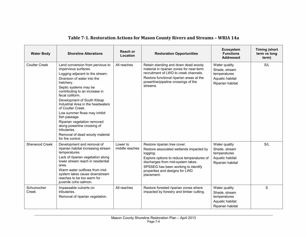
Mason County Shoreline Restoration Plan – April 2013 Page 7-4
Table 7-1. Restoration Actions for Mason County Rivers and Streams – WRIA 14a
Water Body Shoreline Alterations Reach or Location
Restoration Opportunities Ecosystem Functions Addressed
Timing (short term vs long
term)
Coulter Creek Land conversion from pervious to impervious surfaces.
Logging adjacent to the stream.
Diversion of water into the hatchery.
Septic systems may be contributing to an increase in fecal coliform.
Development of South Kitsap Industrial Area in the headwaters of Coulter Creek.
Low summer flows may inhibit fish passage.
Riparian vegetation removed along powerline crossing of tributaries.
Removal of dead woody material for fire control.
All reaches Retain standing and down dead woody material in riparian zones for near-term recruitment of LWD to creek channels.
Restore functional riparian areas at the powerline/pipeline crossings of the streams.
Water quality
Shade, stream temperatures
Aquatic habitat
Riparian habitat
S/L
Sherwood Creek Development and removal of riparian habitat increasing stream temperatures.
Lack of riparian vegetation along lower stream reach in residential area.
Warm water outflows from mid-system lakes cause downstream reaches to be too warm for juvenile coho salmon.
Lower to middle reaches
Restore riparian tree cover.
Restore associated wetlands impacted by logging.
Explore options to reduce temperatures of discharges from mid-system lakes.
SPSSEG has been working to identify properties and designs for LWD placement.
Water quality
Shade, stream temperatures
Aquatic habitat
Riparian habitat
S/L
Schumocher Creek
Impassable culverts on tributaries.
Removal of riparian vegetation.
All reaches Restore forested riparian zones where impacted by forestry and timber cutting.
Water quality
Shade, stream temperatures
Aquatic habitat
Riparian habitat
S
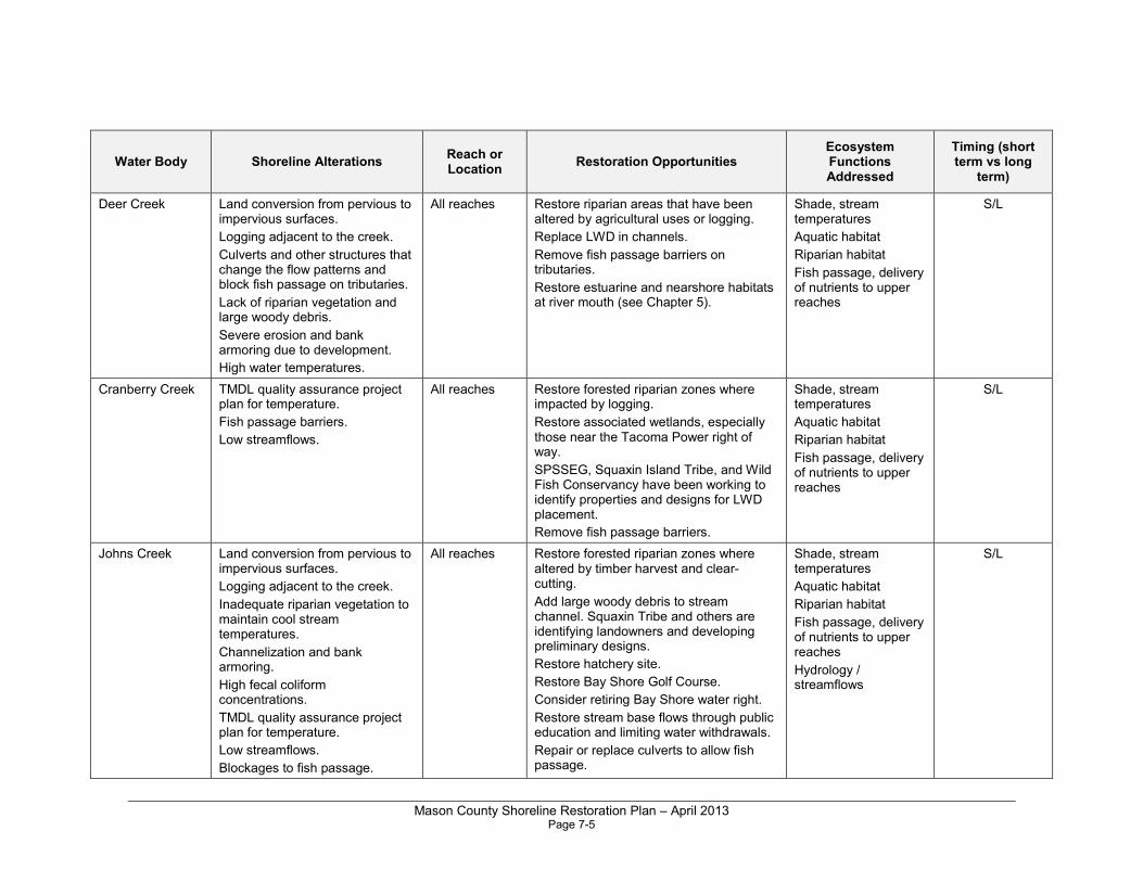
Mason County Shoreline Restoration Plan – April 2013 Page 7-5
Water Body Shoreline Alterations Reach or Location
Restoration Opportunities Ecosystem Functions Addressed
Timing (short term vs long
term)
Deer Creek Land conversion from pervious to impervious surfaces.
Logging adjacent to the creek.
Culverts and other structures that change the flow patterns and block fish passage on tributaries.
Lack of riparian vegetation and large woody debris.
Severe erosion and bank armoring due to development.
High water temperatures.
All reaches Restore riparian areas that have been altered by agricultural uses or logging.
Replace LWD in channels.
Remove fish passage barriers on tributaries.
Restore estuarine and nearshore habitats at river mouth (see Chapter 5).
Shade, stream temperatures
Aquatic habitat
Riparian habitat
Fish passage, delivery of nutrients to upper reaches
S/L
Cranberry Creek TMDL quality assurance project plan for temperature.
Fish passage barriers.
Low streamflows.
All reaches Restore forested riparian zones where impacted by logging.
Restore associated wetlands, especially those near the Tacoma Power right of way.
SPSSEG, Squaxin Island Tribe, and Wild Fish Conservancy have been working to identify properties and designs for LWD placement.
Remove fish passage barriers.
Shade, stream temperatures
Aquatic habitat
Riparian habitat
Fish passage, delivery of nutrients to upper reaches
S/L
Johns Creek Land conversion from pervious to impervious surfaces.
Logging adjacent to the creek.
Inadequate riparian vegetation to maintain cool stream temperatures.
Channelization and bank armoring.
High fecal coliform concentrations.
TMDL quality assurance project plan for temperature.
Low streamflows.
Blockages to fish passage.
All reaches Restore forested riparian zones where altered by timber harvest and clear-cutting.
Add large woody debris to stream channel. Squaxin Tribe and others are identifying landowners and developing preliminary designs.
Restore hatchery site.
Restore Bay Shore Golf Course.
Consider retiring Bay Shore water right.
Restore stream base flows through public education and limiting water withdrawals.
Repair or replace culverts to allow fish passage.
Shade, stream temperatures
Aquatic habitat
Riparian habitat
Fish passage, delivery of nutrients to upper reaches
Hydrology / streamflows
S/L
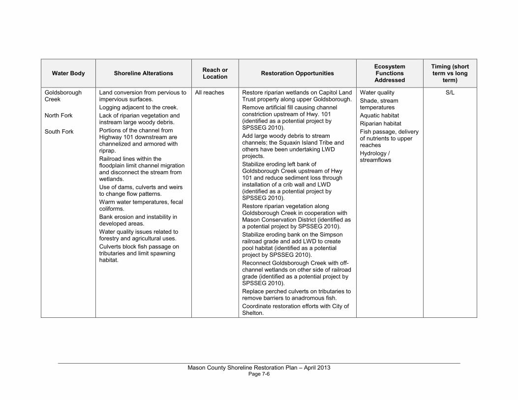
Mason County Shoreline Restoration Plan – April 2013 Page 7-6
Water Body Shoreline Alterations Reach or Location
Restoration Opportunities Ecosystem Functions Addressed
Timing (short term vs long
term)
Goldsborough Creek
North Fork
South Fork
Land conversion from pervious to impervious surfaces.
Logging adjacent to the creek.
Lack of riparian vegetation and instream large woody debris.
Portions of the channel from Highway 101 downstream are channelized and armored with riprap.
Railroad lines within the floodplain limit channel migration and disconnect the stream from wetlands.
Use of dams, culverts and weirs to change flow patterns.
Warm water temperatures, fecal coliforms.
Bank erosion and instability in developed areas.
Water quality issues related to forestry and agricultural uses.
Culverts block fish passage on tributaries and limit spawning habitat.
All reaches Restore riparian wetlands on Capitol Land Trust property along upper Goldsborough.
Remove artificial fill causing channel constriction upstream of Hwy. 101 (identified as a potential project by SPSSEG 2010).
Add large woody debris to stream channels; the Squaxin Island Tribe and others have been undertaking LWD projects.
Stabilize eroding left bank of Goldsborough Creek upstream of Hwy 101 and reduce sediment loss through installation of a crib wall and LWD (identified as a potential project by SPSSEG 2010).
Restore riparian vegetation along Goldsborough Creek in cooperation with Mason Conservation District (identified as a potential project by SPSSEG 2010).
Stabilize eroding bank on the Simpson railroad grade and add LWD to create pool habitat (identified as a potential project by SPSSEG 2010).
Reconnect Goldsborough Creek with off-channel wetlands on other side of railroad grade (identified as a potential project by SPSSEG 2010).
Replace perched culverts on tributaries to remove barriers to anadromous fish.
Coordinate restoration efforts with City of Shelton.
Water quality
Shade, stream temperatures
Aquatic habitat
Riparian habitat
Fish passage, delivery of nutrients to upper reaches
Hydrology / streamflows
S/L
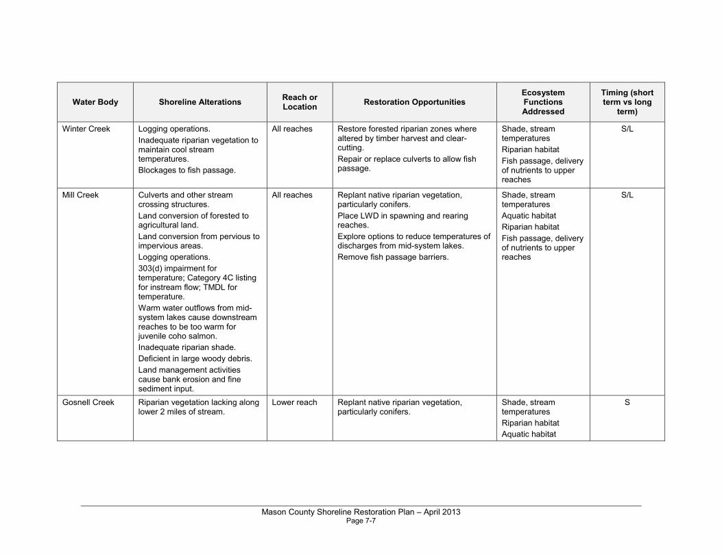
Mason County Shoreline Restoration Plan – April 2013 Page 7-7
Water Body Shoreline Alterations Reach or Location
Restoration Opportunities Ecosystem Functions Addressed
Timing (short term vs long
term)
Winter Creek Logging operations.
Inadequate riparian vegetation to maintain cool stream temperatures.
Blockages to fish passage.
All reaches Restore forested riparian zones where altered by timber harvest and clear-cutting.
Repair or replace culverts to allow fish passage.
Shade, stream temperatures
Riparian habitat
Fish passage, delivery of nutrients to upper reaches
S/L
Mill Creek Culverts and other stream crossing structures.
Land conversion of forested to agricultural land.
Land conversion from pervious to impervious areas.
Logging operations.
303(d) impairment for temperature; Category 4C listing for instream flow; TMDL for temperature.
Warm water outflows from mid-system lakes cause downstream reaches to be too warm for juvenile coho salmon.
Inadequate riparian shade.
Deficient in large woody debris.
Land management activities cause bank erosion and fine sediment input.
All reaches Replant native riparian vegetation, particularly conifers.
Place LWD in spawning and rearing reaches.
Explore options to reduce temperatures of discharges from mid-system lakes.
Remove fish passage barriers.
Shade, stream temperatures
Aquatic habitat
Riparian habitat
Fish passage, delivery of nutrients to upper reaches
S/L
Gosnell Creek Riparian vegetation lacking along lower 2 miles of stream.
Lower reach Replant native riparian vegetation, particularly conifers.
Shade, stream temperatures
Riparian habitat
Aquatic habitat
S
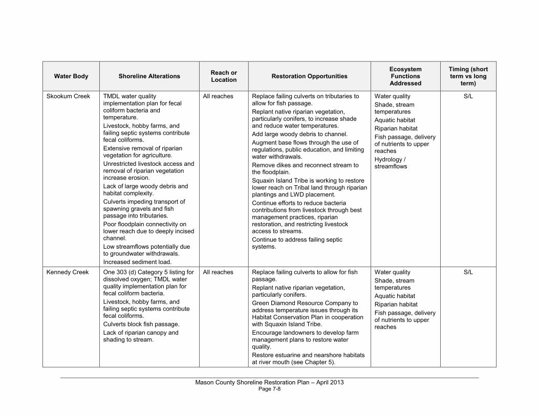
Mason County Shoreline Restoration Plan – April 2013 Page 7-8
Water Body Shoreline Alterations Reach or Location
Restoration Opportunities Ecosystem Functions Addressed
Timing (short term vs long
term)
Skookum Creek TMDL water quality implementation plan for fecal coliform bacteria and temperature.
Livestock, hobby farms, and failing septic systems contribute fecal coliforms.
Extensive removal of riparian vegetation for agriculture.
Unrestricted livestock access and removal of riparian vegetation increase erosion.
Lack of large woody debris and habitat complexity.
Culverts impeding transport of spawning gravels and fish passage into tributaries.
Poor floodplain connectivity on lower reach due to deeply incised channel.
Low streamflows potentially due to groundwater withdrawals.
Increased sediment load.
All reaches Replace failing culverts on tributaries to allow for fish passage.
Replant native riparian vegetation, particularly conifers, to increase shade and reduce water temperatures.
Add large woody debris to channel.
Augment base flows through the use of regulations, public education, and limiting water withdrawals.
Remove dikes and reconnect stream to the floodplain.
Squaxin Island Tribe is working to restore lower reach on Tribal land through riparian plantings and LWD placement.
Continue efforts to reduce bacteria contributions from livestock through best management practices, riparian restoration, and restricting livestock access to streams.
Continue to address failing septic systems.
Water quality
Shade, stream temperatures
Aquatic habitat
Riparian habitat
Fish passage, delivery of nutrients to upper reaches
Hydrology / streamflows
S/L
Kennedy Creek One 303 (d) Category 5 listing for dissolved oxygen; TMDL water quality implementation plan for fecal coliform bacteria.
Livestock, hobby farms, and failing septic systems contribute fecal coliforms.
Culverts block fish passage.
Lack of riparian canopy and shading to stream.
All reaches Replace failing culverts to allow for fish passage.
Replant native riparian vegetation, particularly conifers.
Green Diamond Resource Company to address temperature issues through its Habitat Conservation Plan in cooperation with Squaxin Island Tribe.
Encourage landowners to develop farm management plans to restore water quality.
Restore estuarine and nearshore habitats at river mouth (see Chapter 5).
Water quality
Shade, stream temperatures
Aquatic habitat
Riparian habitat
Fish passage, delivery of nutrients to upper reaches
S/L
Mason County Shoreline Restoration Plan – April 2013 Page 7-9
Sources for WRIA 14a:
• Salmonid Habitat Limiting Factors - Water Resource Inventory Area 14,
Kennedy-Goldsborough Basin (Kuttel 2002)
• EDT Analysis of Habitat Potential and Restoration Options - Coho in South
Puget Sound Streams (Mobrand 2004)
• Oakland Bay, Hammersley Inlet, and Selected Tributaries Fecal Coliform
Bacteria Total Maximum Daily Load - Water Quality Improvement Report and
Implementation Plan (Ecology 2011)
• An Analysis of Potential Factors Limiting Coho Salmon Populations in Mill and
Sherwood Creeks, South Puget Sound, Washington (Stillwater Sciences 2007)
• Salmon Habitat Project Development in the Goldsborough Creek Basin (SPSSEG 2010)
• Squaxin Island Tribe Water Quality Assessment - Clean Water Act 305(b)
Report (Squaxin Island Tribe Natural Resources Department 2005)
• Skookum Watershed Fish and Wildlife/Riparian Habitat Acquisition and
Protection Action Plan (Squaxin Island Tribe 2006)
• Tributaries to Totten, Eld, and Little Skookum Inlets: Fecal Coliform Bacteria
and Temperature Total Maximum Daily Load - Water Quality Improvement
Report (Ecology 2006)
• Watertype Assessment Project Summary - WRIA 14 Phase II (Wild Fish Conservancy 2011)
• Oakland Bay Riparian Area Assessment - Final Project Report (Mason Conservation District 2010)
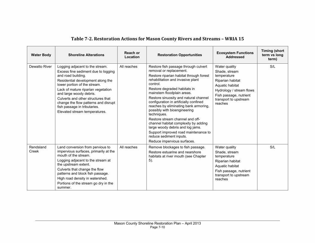
Mason County Shoreline Restoration Plan – April 2013 Page 7-10
Table 7-2. Restoration Actions for Mason County Rivers and Streams – WRIA 15
Water Body Shoreline Alterations Reach or Location
Restoration Opportunities Ecosystem Functions
Addressed
Timing (short term vs long
term)
Dewatto River Logging adjacent to the stream.
Excess fine sediment due to logging and road building.
Residential development along the lower portion of the stream.
Lack of mature riparian vegetation and large woody debris.
Culverts and other structures that change the flow patterns and disrupt fish passage in tributaries.
Elevated stream temperatures.
All reaches Restore fish passage through culvert removal or replacement.
Restore riparian habitat through forest rehabilitation and invasive plant control.
Restore degraded habitats in mainstem floodplain areas.
Restore sinuosity and natural channel configuration in artificially confined reaches by eliminating bank armoring, possibly with bioengineering techniques.
Restore stream channel and off-channel habitat complexity by adding large woody debris and log jams.
Support improved road maintenance to reduce sediment inputs.
Reduce impervious surfaces.
Water quality
Shade, stream temperature
Riparian habitat
Aquatic habitat
Hydrology / stream flows
Fish passage, nutrient transport to upstream reaches
S/L
Rendsland Creek
Land conversion from pervious to impervious surfaces, primarily at the mouth of the stream.
Logging adjacent to the stream at the upstream extent.
Culverts that change the flow patterns and block fish passage.
High road density in watershed.
Portions of the stream go dry in the summer.
All reaches Remove blockages to fish passage.
Restore estuarine and nearshore habitats at river mouth (see Chapter 5).
Water quality
Shade, stream temperature
Riparian habitat
Aquatic habitat
Fish passage, nutrient transport to upstream reaches
S/L
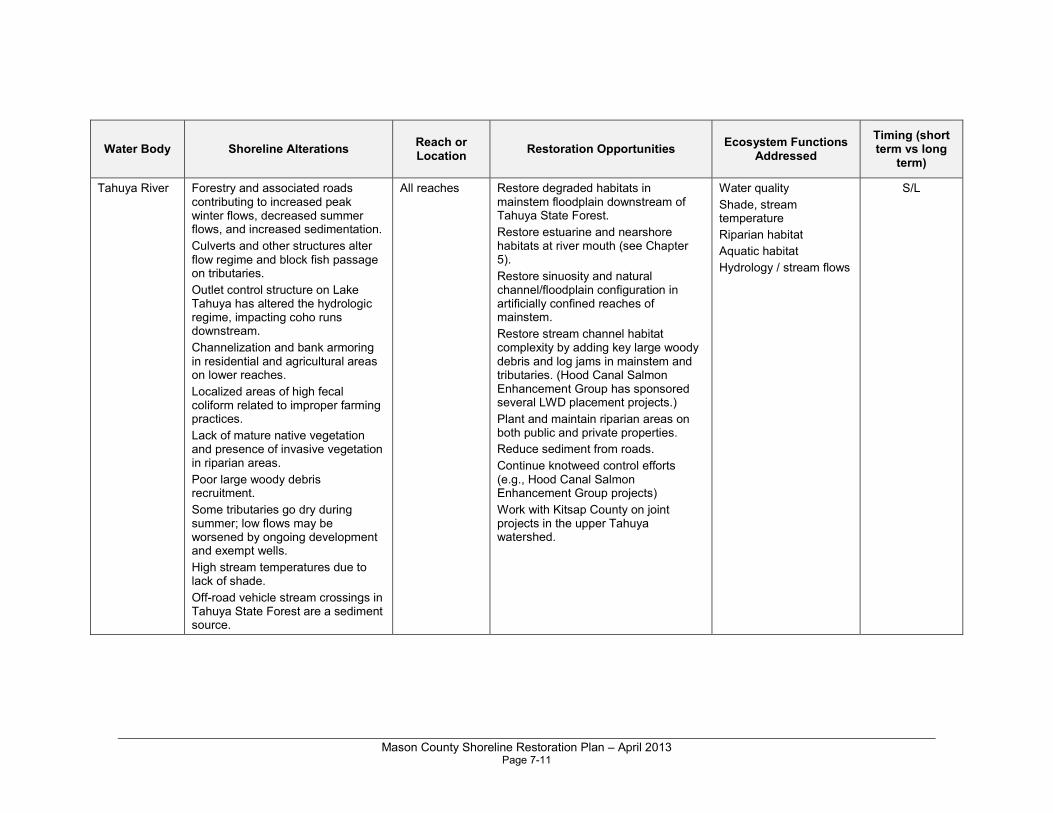
Mason County Shoreline Restoration Plan – April 2013 Page 7-11
Water Body Shoreline Alterations Reach or Location
Restoration Opportunities Ecosystem Functions
Addressed
Timing (short term vs long
term)
Tahuya River Forestry and associated roads contributing to increased peak winter flows, decreased summer flows, and increased sedimentation.
Culverts and other structures alter flow regime and block fish passage on tributaries.
Outlet control structure on Lake Tahuya has altered the hydrologic regime, impacting coho runs downstream.
Channelization and bank armoring in residential and agricultural areas on lower reaches.
Localized areas of high fecal coliform related to improper farming practices.
Lack of mature native vegetation and presence of invasive vegetation in riparian areas.
Poor large woody debris recruitment.
Some tributaries go dry during summer; low flows may be worsened by ongoing development and exempt wells.
High stream temperatures due to lack of shade.
Off-road vehicle stream crossings in Tahuya State Forest are a sediment source.
All reaches Restore degraded habitats in mainstem floodplain downstream of Tahuya State Forest.
Restore estuarine and nearshore habitats at river mouth (see Chapter 5).
Restore sinuosity and natural channel/floodplain configuration in artificially confined reaches of mainstem.
Restore stream channel habitat complexity by adding key large woody debris and log jams in mainstem and tributaries. (Hood Canal Salmon Enhancement Group has sponsored several LWD placement projects.)
Plant and maintain riparian areas on both public and private properties.
Reduce sediment from roads.
Continue knotweed control efforts (e.g., Hood Canal Salmon Enhancement Group projects)
Work with Kitsap County on joint projects in the upper Tahuya watershed.
Water quality
Shade, stream temperature
Riparian habitat
Aquatic habitat
Hydrology / stream flows
S/L
Mason County Shoreline Restoration Plan – April 2013 Page 7-12
Water Body Shoreline Alterations Reach or Location
Restoration Opportunities Ecosystem Functions
Addressed
Timing (short term vs long
term)
Mission Creek Logging adjacent to the stream.
Land conversion from pervious to impervious surfaces.
Culverts and other structures that change the flow patterns and block fish passage.
Channelization and bank armoring.
Adjacent residential development.
Documented issues with fecal coliform especially during summer low flow and in the fall.
Invasive vegetation.
All reaches Restore riparian vegetation where degraded.
Continue knotweed control efforts (Hood Canal Salmon Enhancement Group has sponsored projects).
Remove fish passage blockages.
Water quality
Riparian habitat
Aquatic habitat
Fish passage, nutrient transport to upstream reaches
S/L
Union River Water supply reservoir/diversion in upper watershed.
Bridges that constrict streamflows.
Channelization and bank armoring.
Conversion of forest lands to impervious surfaces.
Elevated water temperatures and low dissolved oxygen.
Floodplain constriction by levees, residential development, hobby farms in lower reaches.
Riparian vegetation on lower reaches is narrow and fragmented.
Invasive knotweed.
Lack of conifers in riparian zone for LWD recruitment.
Elevated fecal coliform bacteria.
All reaches Considered a high priority for knotweed control (HCCC 2009).
Restore degraded habitats in mainstem floodplain areas.
Restore estuarine and nearshore habitats at river mouth (see Chapter 5).
Restore stream channel habitat complexity by adding key large woody debris and log jams in mainstem and lower tributaries.
Fix remaining fish passage barriers.
Plant and maintain riparian areas on both public and private properties.
Reduce sediment from roads.
Water quality
Shade, stream temperature
Riparian habitat
Aquatic habitat
Fish passage
S

Mason County Shoreline Restoration Plan – April 2013 Page 7-13
Sources for WRIA 15:
• Landscape Assessment and Conservation Prioritization of Freshwater and
Nearshore Salmonid Habitat in Kitsap County - 2003 Kitsap Salmonid Refugia
Report (May and Peterson 2003)
• Salmon Habitat Recovery Strategy for the Hood Canal and Eastern Strait of
Juan de Fuca (HCCC 2005)
• Habitat Conditions and Water Quality for Selected Watersheds of Hood Canal
and the Eastern Strait of Juan De Fuca (PNPTC 2001)
• Historical Changes Affecting Freshwater Habitat of Coho Salmon in the Hood
Canal Basin, Pre-1850 to the Present (PNPTC 1996)
• Salmonid Habitat Limiting Factors - Water Resource Inventory Area 15 (East) -
Final Report (Haring 2000)
• Salmonid Habitat Limiting Factors - Water Resource Inventory Areas 15
(West), Kitsap Basin and 14 (North), Kennedy-Goldsborough Basin (Kuttel 2003)
• Hood Canal Regional Knotweed Control Strategy - Draft (HCCC 2009)
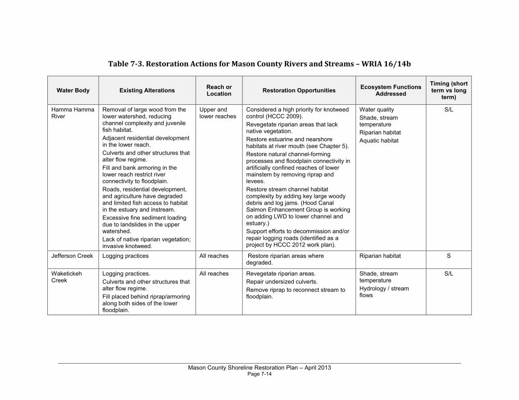
Mason County Shoreline Restoration Plan – April 2013 Page 7-14
Table 7-3. Restoration Actions for Mason County Rivers and Streams – WRIA 16/14b
Water Body Existing Alterations Reach or Location
Restoration Opportunities Ecosystem Functions
Addressed
Timing (short term vs long
term)
Hamma Hamma River
Removal of large wood from the lower watershed, reducing channel complexity and juvenile fish habitat.
Adjacent residential development in the lower reach.
Culverts and other structures that alter flow regime.
Fill and bank armoring in the lower reach restrict river connectivity to floodplain.
Roads, residential development, and agriculture have degraded and limited fish access to habitat in the estuary and instream.
Excessive fine sediment loading due to landslides in the upper watershed.
Lack of native riparian vegetation; invasive knotweed.
Upper and lower reaches
Considered a high priority for knotweed control (HCCC 2009).
Revegetate riparian areas that lack native vegetation.
Restore estuarine and nearshore habitats at river mouth (see Chapter 5).
Restore natural channel-forming processes and floodplain connectivity in artificially confined reaches of lower mainstem by removing riprap and levees.
Restore stream channel habitat complexity by adding key large woody debris and log jams. (Hood Canal Salmon Enhancement Group is working on adding LWD to lower channel and estuary.)
Support efforts to decommission and/or repair logging roads (identified as a project by HCCC 2012 work plan).
Water quality
Shade, stream temperature
Riparian habitat
Aquatic habitat
S/L
Jefferson Creek Logging practices
All reaches Restore riparian areas where degraded.
Riparian habitat S
Waketickeh Creek
Logging practices.
Culverts and other structures that alter flow regime.
Fill placed behind riprap/armoring along both sides of the lower floodplain.
All reaches Revegetate riparian areas.
Repair undersized culverts.
Remove riprap to reconnect stream to floodplain.
Shade, stream temperature
Hydrology / stream flows
S/L

Mason County Shoreline Restoration Plan – April 2013 Page 7-15
Water Body Existing Alterations Reach or Location
Restoration Opportunities Ecosystem Functions
Addressed
Timing (short term vs long
term)
Lilliwaup Creek
Lilliwaup Swamp
Lack of large woody debris leading to low channel habitat complexity.
Adjacent residential development in the lower floodplain.
Lower reach straightened and dredged to route floodwaters away from homes on the east side of the creek.
Lack of riparian vegetation in lower reaches.
Invasive knotweed.
Culverts and other structures that alter flow regime.
Fill and bank armoring in the lower reach.
Roads in the upper watershed have caused sediment transport.
Roads and residential development have degraded fish access to habitat in the estuary and in riparian areas.
Culverts and other structures limit fish passage in tributaries and block transport of woody debris.
Fish passage barriers in upper reaches.
All reaches Restore mainstem floodplain habitat downstream of the falls/anadromous fish barrier.
Restore estuarine and nearshore habitats at stream mouth (see Chapter 5.)
Restore stream channel and floodplain habitat complexity by adding key large woody debris and log jams.
Plant and maintain riparian areas on both public and private properties.
Considered a high priority for knotweed control (HCCC 2009).
Support efforts to address mass wasting, improve road maintenance to reduce sediment inputs, and restore wetlands in upper watershed.
Restoration project on lower floodplain identified in HCCC 2012 work plan.
Riparian habitat
Aquatic habitat
Shade, stream temperature
S
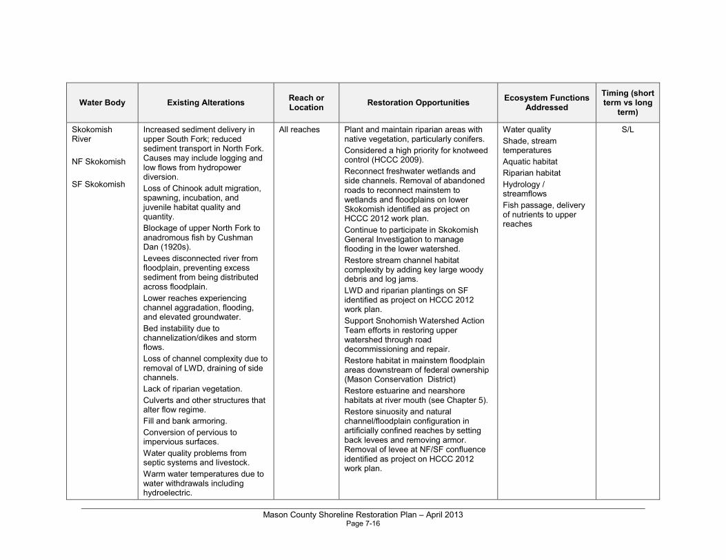
Mason County Shoreline Restoration Plan – April 2013 Page 7-16
Water Body Existing Alterations Reach or Location
Restoration Opportunities Ecosystem Functions
Addressed
Timing (short term vs long
term)
Skokomish River
NF Skokomish
SF Skokomish
Increased sediment delivery in upper South Fork; reduced sediment transport in North Fork. Causes may include logging and low flows from hydropower diversion.
Loss of Chinook adult migration, spawning, incubation, and juvenile habitat quality and quantity.
Blockage of upper North Fork to anadromous fish by Cushman Dan (1920s).
Levees disconnected river from floodplain, preventing excess sediment from being distributed across floodplain.
Lower reaches experiencing channel aggradation, flooding, and elevated groundwater.
Bed instability due to channelization/dikes and storm flows.
Loss of channel complexity due to removal of LWD, draining of side channels.
Lack of riparian vegetation.
Culverts and other structures that alter flow regime.
Fill and bank armoring.
Conversion of pervious to impervious surfaces.
Water quality problems from septic systems and livestock.
Warm water temperatures due to water withdrawals including hydroelectric.
All reaches Plant and maintain riparian areas with native vegetation, particularly conifers.
Considered a high priority for knotweed control (HCCC 2009).
Reconnect freshwater wetlands and side channels. Removal of abandoned roads to reconnect mainstem to wetlands and floodplains on lower Skokomish identified as project on HCCC 2012 work plan.
Continue to participate in Skokomish General Investigation to manage flooding in the lower watershed.
Restore stream channel habitat complexity by adding key large woody debris and log jams.
LWD and riparian plantings on SF identified as project on HCCC 2012 work plan.
Support Snohomish Watershed Action Team efforts in restoring upper watershed through road decommissioning and repair.
Restore habitat in mainstem floodplain areas downstream of federal ownership (Mason Conservation District)
Restore estuarine and nearshore habitats at river mouth (see Chapter 5).
Restore sinuosity and natural channel/floodplain configuration in artificially confined reaches by setting back levees and removing armor. Removal of levee at NF/SF confluence identified as project on HCCC 2012 work plan.
Water quality
Shade, stream temperatures
Aquatic habitat
Riparian habitat
Hydrology / streamflows
Fish passage, delivery of nutrients to upper reaches
S/L

Mason County Shoreline Restoration Plan – April 2013 Page 7-17
Water Body Existing Alterations Reach or Location
Restoration Opportunities Ecosystem Functions
Addressed
Timing (short term vs long
term)
McTaggert Creek
A diversion of the upper portion of McTaggert Creek sends the majority of its flow through Deer Meadow Creek and onward into Kokanee Reservoir.
All reaches Diversion dam removal and culvert replacements identified as projects on HCCC 2012 work plan.
Fish passage, delivery of nutrients to upper reaches
L
Frigid Creek Fish passage barriers. All reaches Removal of fish passage barriers on upper Frigid Creek identified as a project on HCCC 2012 work plan.
Fish passage, delivery of nutrients to upper reaches
L
Brown Creek Lower reaches impacted by timber harvest related to an abandoned hydroelectric project and road building close to the channel.
Debris flows that contribute sediment to upper reaches.
All reaches Continue road decommissioning in upper watershed.
Continue instream habitat and riparian restoration.
Continue slope stabilization activities.
Fish passage, delivery of nutrients to upper reaches
Aquatic habitat
Riparian habitat
S/L
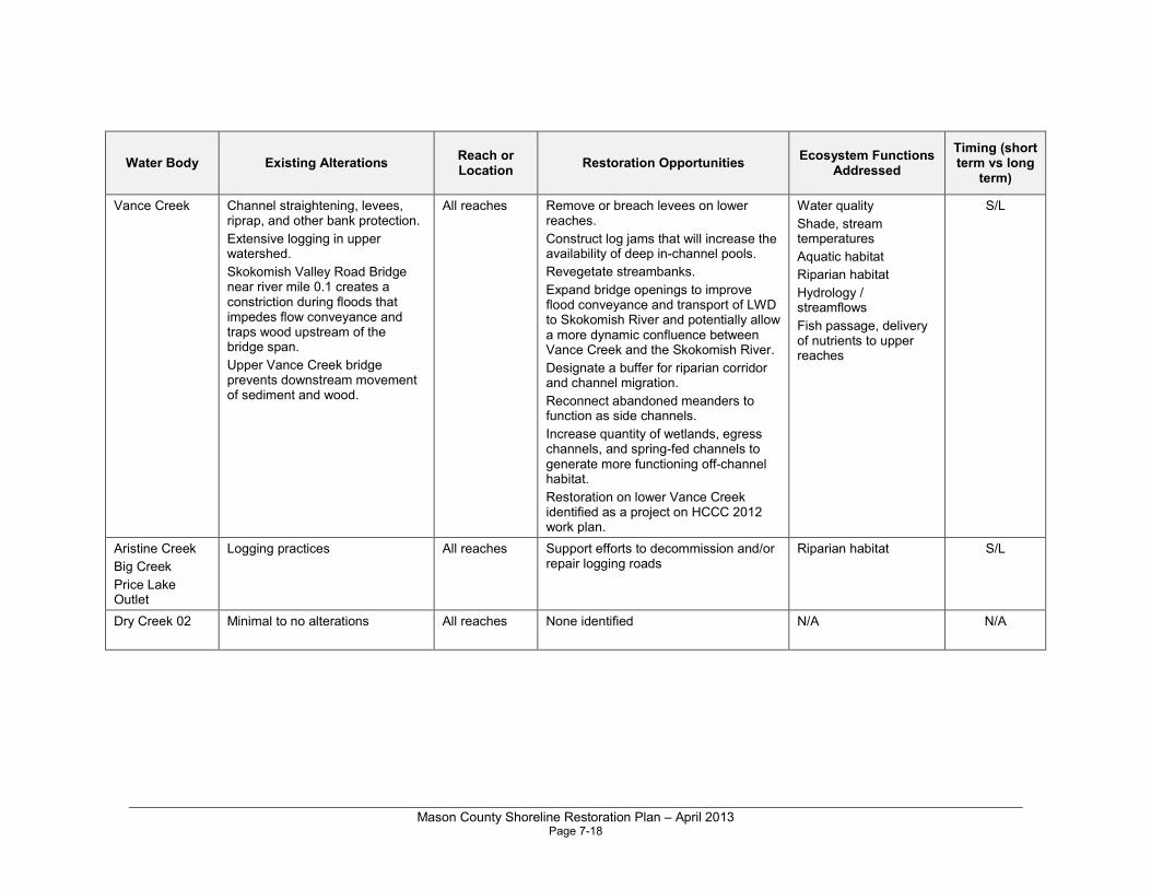
Mason County Shoreline Restoration Plan – April 2013 Page 7-18
Water Body Existing Alterations Reach or Location
Restoration Opportunities Ecosystem Functions
Addressed
Timing (short term vs long
term)
Vance Creek Channel straightening, levees, riprap, and other bank protection.
Extensive logging in upper watershed.
Skokomish Valley Road Bridge near river mile 0.1 creates a constriction during floods that impedes flow conveyance and traps wood upstream of the bridge span.
Upper Vance Creek bridge prevents downstream movement of sediment and wood.
All reaches Remove or breach levees on lower reaches.
Construct log jams that will increase the availability of deep in-channel pools.
Revegetate streambanks.
Expand bridge openings to improve flood conveyance and transport of LWD to Skokomish River and potentially allow a more dynamic confluence between Vance Creek and the Skokomish River.
Designate a buffer for riparian corridor and channel migration.
Reconnect abandoned meanders to function as side channels.
Increase quantity of wetlands, egress channels, and spring-fed channels to generate more functioning off-channel habitat.
Restoration on lower Vance Creek identified as a project on HCCC 2012 work plan.
Water quality
Shade, stream temperatures
Aquatic habitat
Riparian habitat
Hydrology / streamflows
Fish passage, delivery of nutrients to upper reaches
S/L
Aristine Creek
Big Creek
Price Lake Outlet
Logging practices
All reaches Support efforts to decommission and/or repair logging roads
Riparian habitat S/L
Dry Creek 02 Minimal to no alterations All reaches None identified
N/A N/A

Mason County Shoreline Restoration Plan – April 2013 Page 7-19
Sources for WRIA 16/14B:
• Vance Creek Geomorphology and Modeling Report (Reclamation 2011)
• Restoring the Skokomish Watershed: A Three-Year Action Plan (Skokomish Watershed Action Committee 2006)
• Geomorphic Analysis of the Skokomish River, Mason County, Washington (Reclamation 2009)
• Salmon Habitat Recovery Strategy for the Hood Canal and Eastern Strait of
Juan de Fuca (HCCC 2005)
• Recovery Plan for Skokomish River Chinook Salmon (Skokomish Tribe and WDFW 2010)
• Salmon and Steelhead Habitat Limiting Factors - Water Resource Inventory
Area 16, Dosewallips-Skokomish Basin (Correa 2003)
• Watershed Management Plan - Skokomish-Dosewallips Water Resource
Inventory Area (WRIA 16) Including the WRIA 14 South Shore Sub-basin (WRIA 16 Planning Unit 2006)
• Mid Hood Canal Chinook Recovery Planning Chapter (WDFW and Point No Point Treaty Tribes 2005)
• Hood Canal Regional Knotweed Control Strategy - Draft (HCCC 2009)
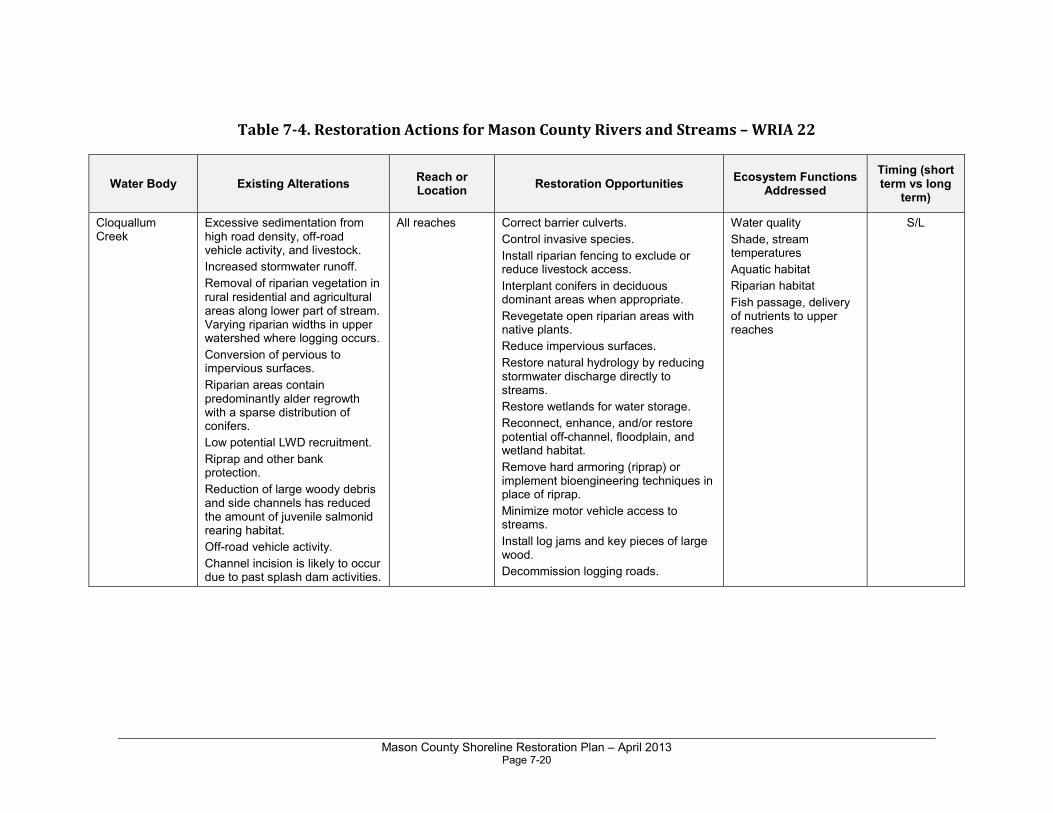
Mason County Shoreline Restoration Plan – April 2013 Page 7-20
Table 7-4. Restoration Actions for Mason County Rivers and Streams – WRIA 22
Water Body Existing Alterations Reach or Location
Restoration Opportunities Ecosystem Functions
Addressed
Timing (short term vs long
term)
Cloquallum Creek
Excessive sedimentation from high road density, off-road vehicle activity, and livestock.
Increased stormwater runoff.
Removal of riparian vegetation in rural residential and agricultural areas along lower part of stream. Varying riparian widths in upper watershed where logging occurs.
Conversion of pervious to impervious surfaces.
Riparian areas contain predominantly alder regrowth with a sparse distribution of conifers.
Low potential LWD recruitment.
Riprap and other bank protection.
Reduction of large woody debris and side channels has reduced the amount of juvenile salmonid rearing habitat.
Off-road vehicle activity.
Channel incision is likely to occur due to past splash dam activities.
All reaches Correct barrier culverts.
Control invasive species.
Install riparian fencing to exclude or reduce livestock access.
Interplant conifers in deciduous dominant areas when appropriate.
Revegetate open riparian areas with native plants.
Reduce impervious surfaces.
Restore natural hydrology by reducing stormwater discharge directly to streams.
Restore wetlands for water storage.
Reconnect, enhance, and/or restore potential off-channel, floodplain, and wetland habitat.
Remove hard armoring (riprap) or implement bioengineering techniques in place of riprap.
Minimize motor vehicle access to streams.
Install log jams and key pieces of large wood.
Decommission logging roads.
Water quality
Shade, stream temperatures
Aquatic habitat
Riparian habitat
Fish passage, delivery of nutrients to upper reaches
S/L
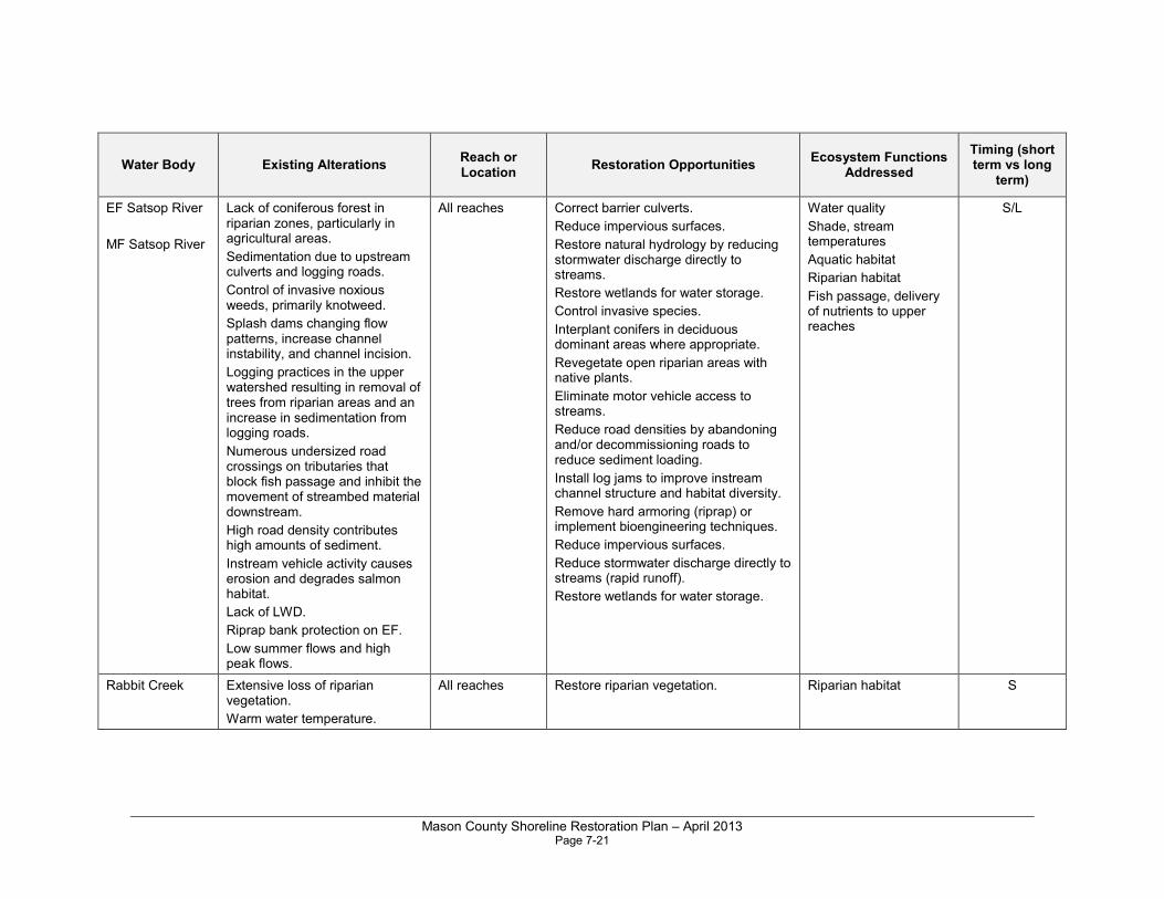
Mason County Shoreline Restoration Plan – April 2013 Page 7-21
Water Body Existing Alterations Reach or Location
Restoration Opportunities Ecosystem Functions
Addressed
Timing (short term vs long
term)
EF Satsop River
MF Satsop River
Lack of coniferous forest in riparian zones, particularly in agricultural areas.
Sedimentation due to upstream culverts and logging roads.
Control of invasive noxious weeds, primarily knotweed.
Splash dams changing flow patterns, increase channel instability, and channel incision.
Logging practices in the upper watershed resulting in removal of trees from riparian areas and an increase in sedimentation from logging roads.
Numerous undersized road crossings on tributaries that block fish passage and inhibit the movement of streambed material downstream.
High road density contributes high amounts of sediment.
Instream vehicle activity causes erosion and degrades salmon habitat.
Lack of LWD.
Riprap bank protection on EF.
Low summer flows and high peak flows.
All reaches Correct barrier culverts.
Reduce impervious surfaces.
Restore natural hydrology by reducing stormwater discharge directly to streams.
Restore wetlands for water storage.
Control invasive species.
Interplant conifers in deciduous dominant areas where appropriate.
Revegetate open riparian areas with native plants.
Eliminate motor vehicle access to streams.
Reduce road densities by abandoning and/or decommissioning roads to reduce sediment loading.
Install log jams to improve instream channel structure and habitat diversity.
Remove hard armoring (riprap) or implement bioengineering techniques.
Reduce impervious surfaces.
Reduce stormwater discharge directly to streams (rapid runoff).
Restore wetlands for water storage.
Water quality
Shade, stream temperatures
Aquatic habitat
Riparian habitat
Fish passage, delivery of nutrients to upper reaches
S/L
Rabbit Creek Extensive loss of riparian vegetation.
Warm water temperature.
All reaches Restore riparian vegetation. Riparian habitat S
Mason County Shoreline Restoration Plan – April 2013 Page 7-22
Sources for WRIA 22:
• The Chehalis Basin Salmon Habitat Restoration and Preservation Strategy for
WRIA 22 and 23 (Grays Harbor County Lead Entity 2011)
• Salmon and Steelhead Habitat Limiting Factors - Chehalis Basin and Nearby
Drainages, Water Resource Inventory Areas 22 And 23 (Smith and Wenger 2001)
• Lower Chehalis Riparian Assessment (Grays Harbor County 2003)

Mason County Shoreline Restoration Plan – April 2013 Page 8-1
Chapter 8.0 Existing Restoration Programs and Partners
Numerous agencies and organizations are planning and implementing restoration efforts in Mason County. Most restoration efforts are undertaken because citizens, Tribes, nongovernment entities, and local, state, and federal resource agencies collaborate to solve problems and achieve shared goals. Continued collaboration at all levels is needed if the goals of this plan are to be achieved.
Table 8-1 provides a summary of government, Tribal, and nonprofit organizations involved in programs that affect shorelines in Mason County. Agencies and organizations are listed in alphabetical order.
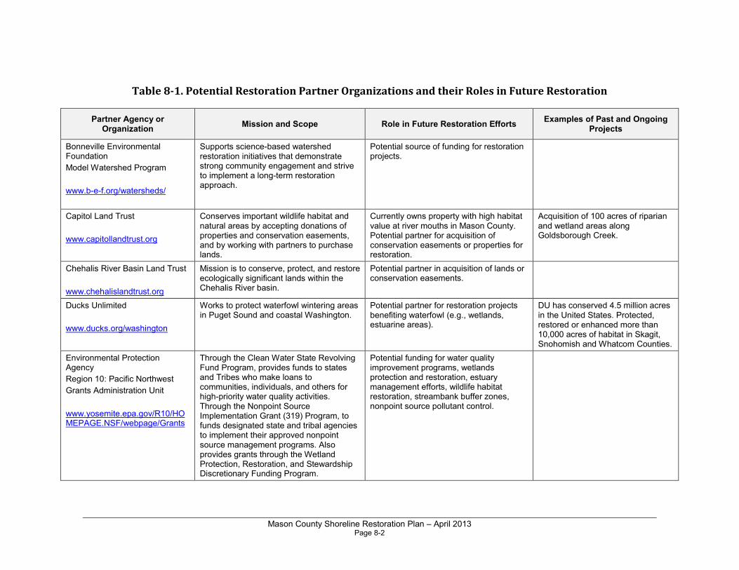
Mason County Shoreline Restoration Plan – April 2013 Page 8-2
Table 8-1. Potential Restoration Partner Organizations and their Roles in Future Restoration
Partner Agency or Organization
Mission and Scope Role in Future Restoration Efforts Examples of Past and Ongoing
Projects
Bonneville Environmental Foundation
Model Watershed Program
www.b-e-f.org/watersheds/
Supports science-based watershed restoration initiatives that demonstrate strong community engagement and strive to implement a long-term restoration approach.
Potential source of funding for restoration projects.
Capitol Land Trust
www.capitollandtrust.org
Conserves important wildlife habitat and natural areas by accepting donations of properties and conservation easements, and by working with partners to purchase lands.
Currently owns property with high habitat value at river mouths in Mason County. Potential partner for acquisition of conservation easements or properties for restoration.
Acquisition of 100 acres of riparian and wetland areas along Goldsborough Creek.
Chehalis River Basin Land Trust
www.chehalislandtrust.org
Mission is to conserve, protect, and restore ecologically significant lands within the Chehalis River basin.
Potential partner in acquisition of lands or conservation easements.
Ducks Unlimited
www.ducks.org/washington
Works to protect waterfowl wintering areas in Puget Sound and coastal Washington.
Potential partner for restoration projects benefiting waterfowl (e.g., wetlands, estuarine areas).
DU has conserved 4.5 million acres in the United States. Protected, restored or enhanced more than 10,000 acres of habitat in Skagit, Snohomish and Whatcom Counties.
Environmental Protection Agency
Region 10: Pacific Northwest
Grants Administration Unit
www.yosemite.epa.gov/R10/HOMEPAGE.NSF/webpage/Grants
Through the Clean Water State Revolving Fund Program, provides funds to states and Tribes who make loans to communities, individuals, and others for high-priority water quality activities. Through the Nonpoint Source Implementation Grant (319) Program, to funds designated state and tribal agencies to implement their approved nonpoint source management programs. Also provides grants through the Wetland Protection, Restoration, and Stewardship Discretionary Funding Program.
Potential funding for water quality improvement programs, wetlands protection and restoration, estuary management efforts, wildlife habitat restoration, streambank buffer zones, nonpoint source pollutant control.
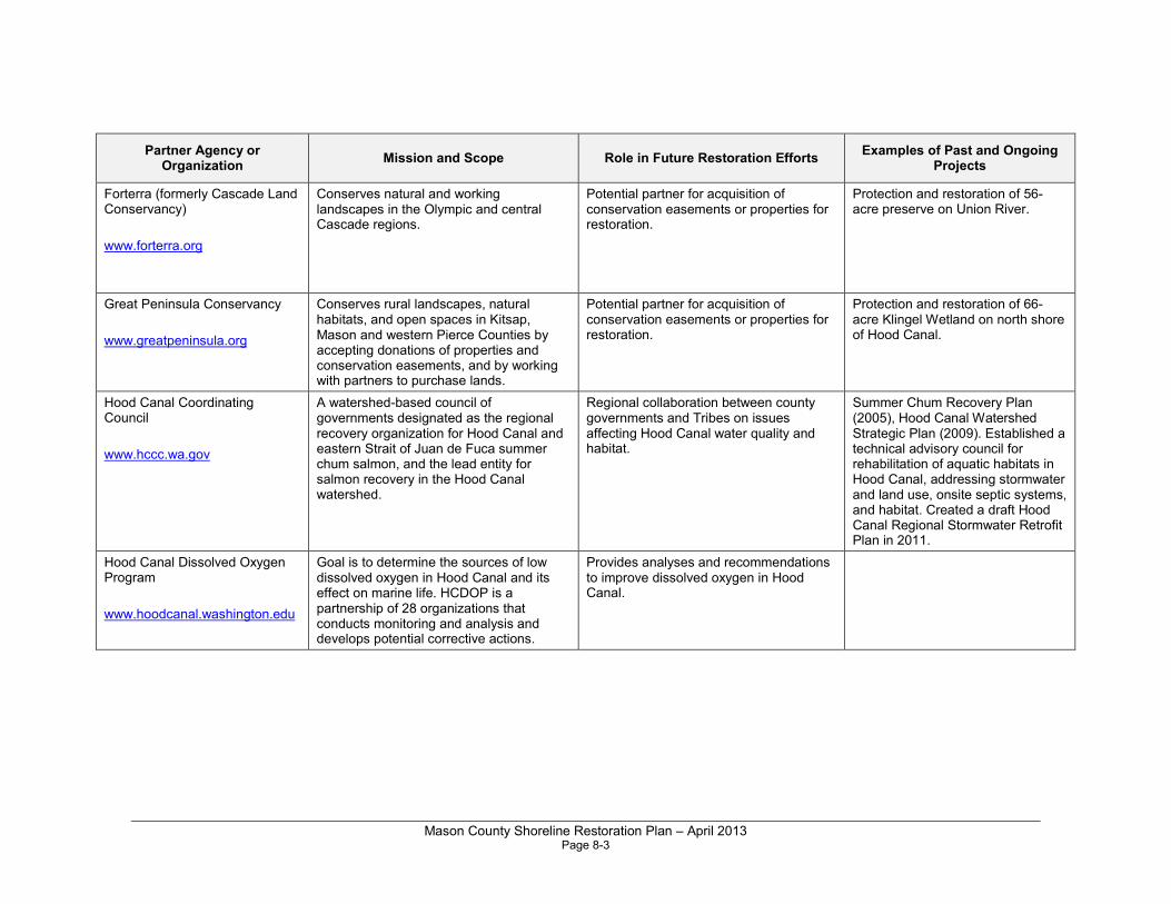
Mason County Shoreline Restoration Plan – April 2013 Page 8-3
Partner Agency or Organization
Mission and Scope Role in Future Restoration Efforts Examples of Past and Ongoing
Projects
Forterra (formerly Cascade Land Conservancy)
www.forterra.org
Conserves natural and working landscapes in the Olympic and central Cascade regions.
Potential partner for acquisition of conservation easements or properties for restoration.
Protection and restoration of 56-acre preserve on Union River.
Great Peninsula Conservancy
www.greatpeninsula.org
Conserves rural landscapes, natural habitats, and open spaces in Kitsap, Mason and western Pierce Counties by accepting donations of properties and conservation easements, and by working with partners to purchase lands.
Potential partner for acquisition of conservation easements or properties for restoration.
Protection and restoration of 66-acre Klingel Wetland on north shore of Hood Canal.
Hood Canal Coordinating Council
www.hccc.wa.gov
A watershed-based council of governments designated as the regional recovery organization for Hood Canal and eastern Strait of Juan de Fuca summer chum salmon, and the lead entity for salmon recovery in the Hood Canal watershed.
Regional collaboration between county governments and Tribes on issues affecting Hood Canal water quality and habitat.
Summer Chum Recovery Plan (2005), Hood Canal Watershed Strategic Plan (2009). Established a technical advisory council for rehabilitation of aquatic habitats in Hood Canal, addressing stormwater and land use, onsite septic systems, and habitat. Created a draft Hood Canal Regional Stormwater Retrofit Plan in 2011.
Hood Canal Dissolved Oxygen Program
www.hoodcanal.washington.edu
Goal is to determine the sources of low dissolved oxygen in Hood Canal and its effect on marine life. HCDOP is a partnership of 28 organizations that conducts monitoring and analysis and develops potential corrective actions.
Provides analyses and recommendations to improve dissolved oxygen in Hood Canal.
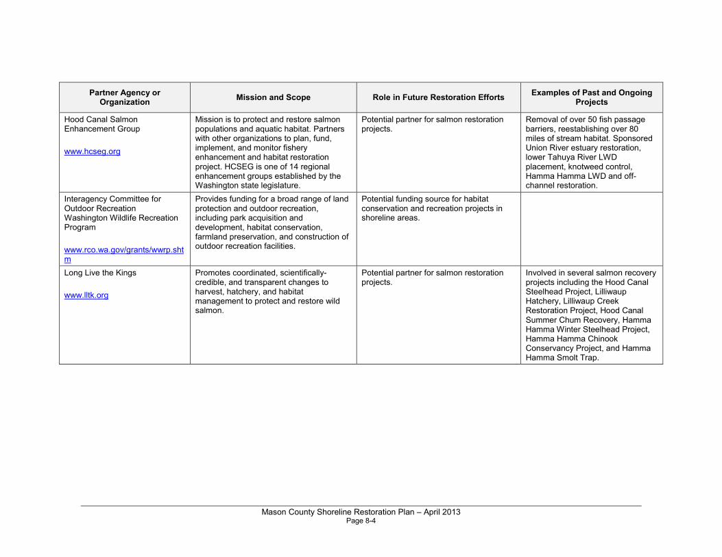
Mason County Shoreline Restoration Plan – April 2013 Page 8-4
Partner Agency or Organization
Mission and Scope Role in Future Restoration Efforts Examples of Past and Ongoing
Projects
Hood Canal Salmon Enhancement Group
www.hcseg.org
Mission is to protect and restore salmon populations and aquatic habitat. Partners with other organizations to plan, fund, implement, and monitor fishery enhancement and habitat restoration project. HCSEG is one of 14 regional enhancement groups established by the Washington state legislature.
Potential partner for salmon restoration projects.
Removal of over 50 fish passage barriers, reestablishing over 80 miles of stream habitat. Sponsored Union River estuary restoration, lower Tahuya River LWD placement, knotweed control, Hamma Hamma LWD and off-channel restoration.
Interagency Committee for Outdoor Recreation Washington Wildlife Recreation Program
www.rco.wa.gov/grants/wwrp.shtm
Provides funding for a broad range of land protection and outdoor recreation, including park acquisition and development, habitat conservation, farmland preservation, and construction of outdoor recreation facilities.
Potential funding source for habitat conservation and recreation projects in shoreline areas.
Long Live the Kings
www.lltk.org
Promotes coordinated, scientifically-credible, and transparent changes to harvest, hatchery, and habitat management to protect and restore wild salmon.
Potential partner for salmon restoration projects.
Involved in several salmon recovery projects including the Hood Canal Steelhead Project, Lilliwaup Hatchery, Lilliwaup Creek Restoration Project, Hood Canal Summer Chum Recovery, Hamma Hamma Winter Steelhead Project, Hamma Hamma Chinook Conservancy Project, and Hamma Hamma Smolt Trap.
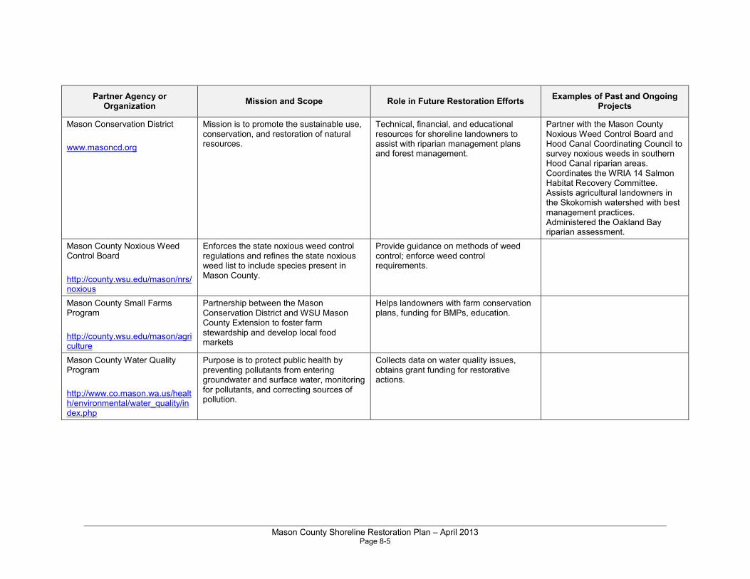
Mason County Shoreline Restoration Plan – April 2013 Page 8-5
Partner Agency or Organization
Mission and Scope Role in Future Restoration Efforts Examples of Past and Ongoing
Projects
Mason Conservation District
www.masoncd.org
Mission is to promote the sustainable use, conservation, and restoration of natural resources.
Technical, financial, and educational resources for shoreline landowners to assist with riparian management plans and forest management.
Partner with the Mason County Noxious Weed Control Board and Hood Canal Coordinating Council to survey noxious weeds in southern Hood Canal riparian areas. Coordinates the WRIA 14 Salmon Habitat Recovery Committee. Assists agricultural landowners in the Skokomish watershed with best management practices. Administered the Oakland Bay riparian assessment.
Mason County Noxious Weed Control Board
http://county.wsu.edu/mason/nrs/noxious
Enforces the state noxious weed control regulations and refines the state noxious weed list to include species present in Mason County.
Provide guidance on methods of weed control; enforce weed control requirements.
Mason County Small Farms Program
http://county.wsu.edu/mason/agriculture
Partnership between the Mason Conservation District and WSU Mason County Extension to foster farm stewardship and develop local food markets
Helps landowners with farm conservation plans, funding for BMPs, education.
Mason County Water Quality Program
http://www.co.mason.wa.us/health/environmental/water_quality/index.php
Purpose is to protect public health by preventing pollutants from entering groundwater and surface water, monitoring for pollutants, and correcting sources of pollution.
Collects data on water quality issues, obtains grant funding for restorative actions.
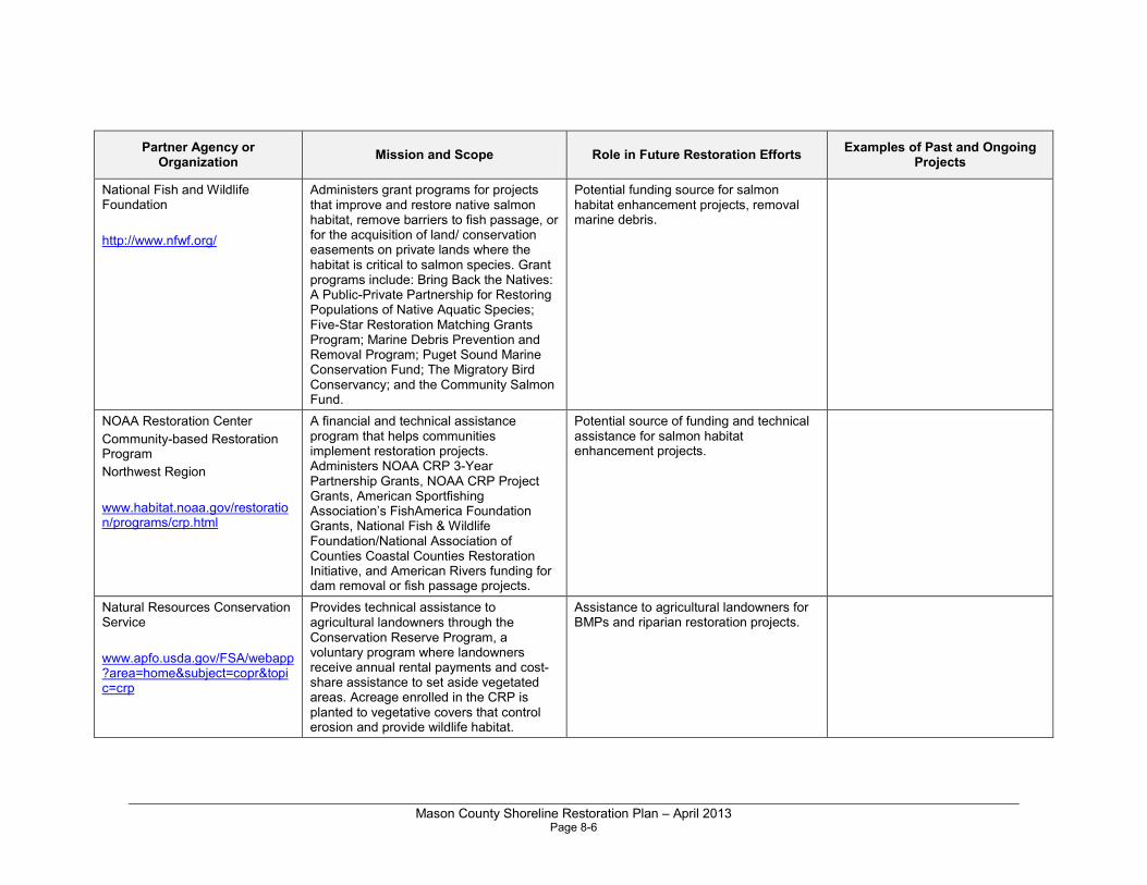
Mason County Shoreline Restoration Plan – April 2013 Page 8-6
Partner Agency or Organization
Mission and Scope Role in Future Restoration Efforts Examples of Past and Ongoing
Projects
National Fish and Wildlife Foundation
http://www.nfwf.org/
Administers grant programs for projects that improve and restore native salmon habitat, remove barriers to fish passage, or for the acquisition of land/ conservation easements on private lands where the habitat is critical to salmon species. Grant programs include: Bring Back the Natives: A Public-Private Partnership for Restoring Populations of Native Aquatic Species; Five-Star Restoration Matching Grants Program; Marine Debris Prevention and Removal Program; Puget Sound Marine Conservation Fund; The Migratory Bird Conservancy; and the Community Salmon Fund.
Potential funding source for salmon habitat enhancement projects, removal marine debris.
NOAA Restoration Center
Community-based Restoration Program
Northwest Region
www.habitat.noaa.gov/restoration/programs/crp.html
A financial and technical assistance program that helps communities implement restoration projects. Administers NOAA CRP 3-Year Partnership Grants, NOAA CRP Project Grants, American Sportfishing Association’s FishAmerica Foundation Grants, National Fish & Wildlife Foundation/National Association of Counties Coastal Counties Restoration Initiative, and American Rivers funding for dam removal or fish passage projects.
Potential source of funding and technical assistance for salmon habitat enhancement projects.
Natural Resources Conservation Service
www.apfo.usda.gov/FSA/webapp?area=home&subject=copr&topic=crp
Provides technical assistance to agricultural landowners through the Conservation Reserve Program, a voluntary program where landowners receive annual rental payments and cost-share assistance to set aside vegetated areas. Acreage enrolled in the CRP is planted to vegetative covers that control erosion and provide wildlife habitat.
Assistance to agricultural landowners for BMPs and riparian restoration projects.
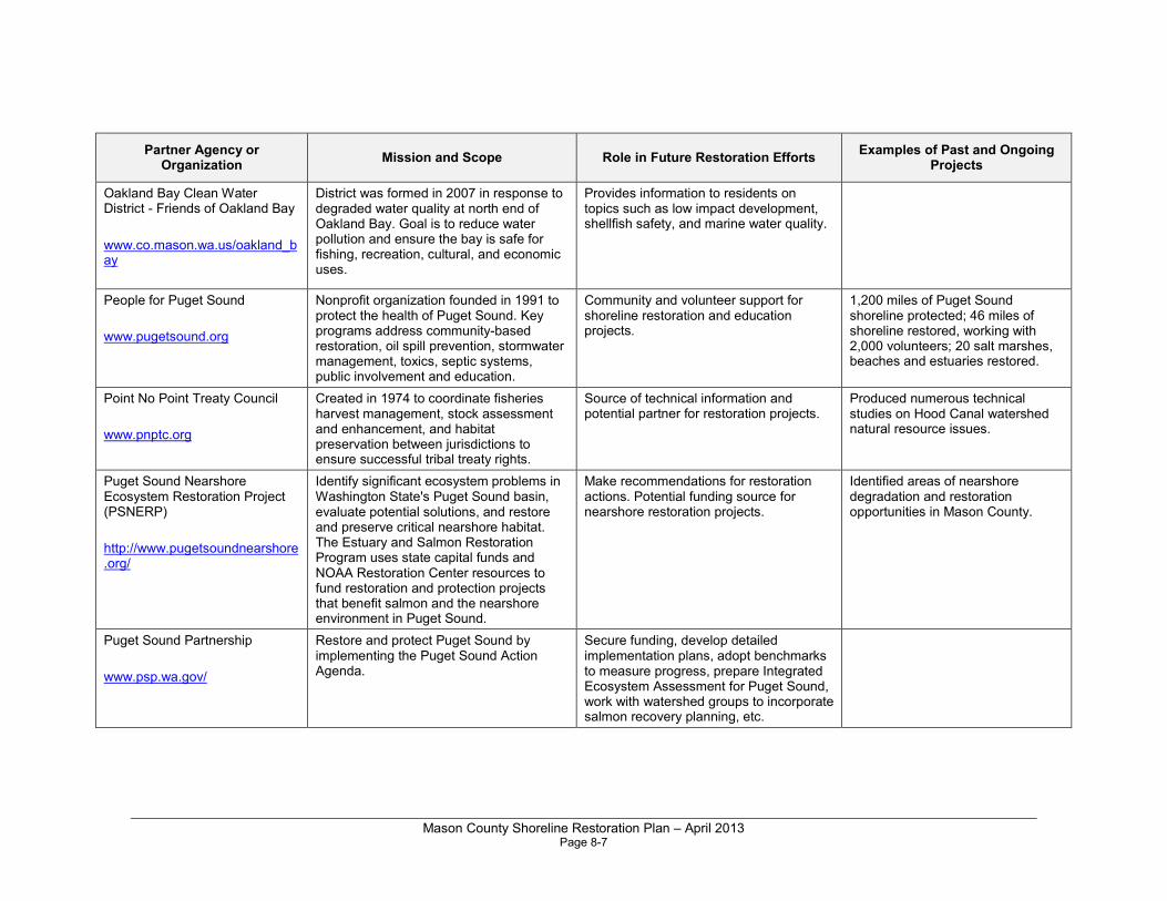
Mason County Shoreline Restoration Plan – April 2013 Page 8-7
Partner Agency or Organization
Mission and Scope Role in Future Restoration Efforts Examples of Past and Ongoing
Projects
Oakland Bay Clean Water District - Friends of Oakland Bay
www.co.mason.wa.us/oakland_bay
District was formed in 2007 in response to degraded water quality at north end of Oakland Bay. Goal is to reduce water pollution and ensure the bay is safe for fishing, recreation, cultural, and economic uses.
Provides information to residents on topics such as low impact development, shellfish safety, and marine water quality.
People for Puget Sound
www.pugetsound.org
Nonprofit organization founded in 1991 to protect the health of Puget Sound. Key programs address community-based restoration, oil spill prevention, stormwater management, toxics, septic systems, public involvement and education.
Community and volunteer support for shoreline restoration and education projects.
1,200 miles of Puget Sound shoreline protected; 46 miles of shoreline restored, working with 2,000 volunteers; 20 salt marshes, beaches and estuaries restored.
Point No Point Treaty Council
www.pnptc.org
Created in 1974 to coordinate fisheries harvest management, stock assessment and enhancement, and habitat preservation between jurisdictions to ensure successful tribal treaty rights.
Source of technical information and potential partner for restoration projects.
Produced numerous technical studies on Hood Canal watershed natural resource issues.
Puget Sound Nearshore Ecosystem Restoration Project (PSNERP)
http://www.pugetsoundnearshore.org/
Identify significant ecosystem problems in Washington State's Puget Sound basin, evaluate potential solutions, and restore and preserve critical nearshore habitat. The Estuary and Salmon Restoration Program uses state capital funds and NOAA Restoration Center resources to fund restoration and protection projects that benefit salmon and the nearshore environment in Puget Sound.
Make recommendations for restoration actions. Potential funding source for nearshore restoration projects.
Identified areas of nearshore degradation and restoration opportunities in Mason County.
Puget Sound Partnership
www.psp.wa.gov/
Restore and protect Puget Sound by implementing the Puget Sound Action Agenda.
Secure funding, develop detailed implementation plans, adopt benchmarks to measure progress, prepare Integrated Ecosystem Assessment for Puget Sound, work with watershed groups to incorporate salmon recovery planning, etc.
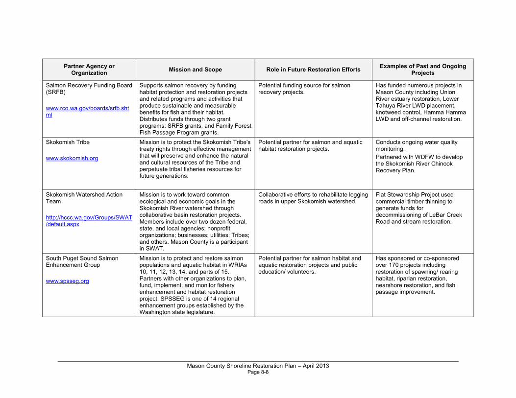
Mason County Shoreline Restoration Plan – April 2013 Page 8-8
Partner Agency or Organization
Mission and Scope Role in Future Restoration Efforts Examples of Past and Ongoing
Projects
Salmon Recovery Funding Board (SRFB)
www.rco.wa.gov/boards/srfb.shtml
Supports salmon recovery by funding habitat protection and restoration projects and related programs and activities that produce sustainable and measurable benefits for fish and their habitat. Distributes funds through two grant programs: SRFB grants, and Family Forest Fish Passage Program grants.
Potential funding source for salmon recovery projects.
Has funded numerous projects in Mason County including Union River estuary restoration, Lower Tahuya River LWD placement, knotweed control, Hamma Hamma LWD and off-channel restoration.
Skokomish Tribe
www.skokomish.org
Mission is to protect the Skokomish Tribe's treaty rights through effective management that will preserve and enhance the natural and cultural resources of the Tribe and perpetuate tribal fisheries resources for future generations.
Potential partner for salmon and aquatic habitat restoration projects.
Conducts ongoing water quality monitoring.
Partnered with WDFW to develop the Skokomish River Chinook Recovery Plan.
Skokomish Watershed Action Team
http://hccc.wa.gov/Groups/SWAT/default.aspx
Mission is to work toward common ecological and economic goals in the Skokomish River watershed through collaborative basin restoration projects. Members include over two dozen federal, state, and local agencies; nonprofit organizations; businesses; utilities; Tribes; and others. Mason County is a participant in SWAT.
Collaborative efforts to rehabilitate logging roads in upper Skokomish watershed.
Flat Stewardship Project used commercial timber thinning to generate funds for decommissioning of LeBar Creek Road and stream restoration.
South Puget Sound Salmon Enhancement Group
www.spsseg.org
Mission is to protect and restore salmon populations and aquatic habitat in WRIAs 10, 11, 12, 13, 14, and parts of 15. Partners with other organizations to plan, fund, implement, and monitor fishery enhancement and habitat restoration project. SPSSEG is one of 14 regional enhancement groups established by the Washington state legislature.
Potential partner for salmon habitat and aquatic restoration projects and public education/ volunteers.
Has sponsored or co-sponsored over 170 projects including restoration of spawning/ rearing habitat, riparian restoration, nearshore restoration, and fish passage improvement.
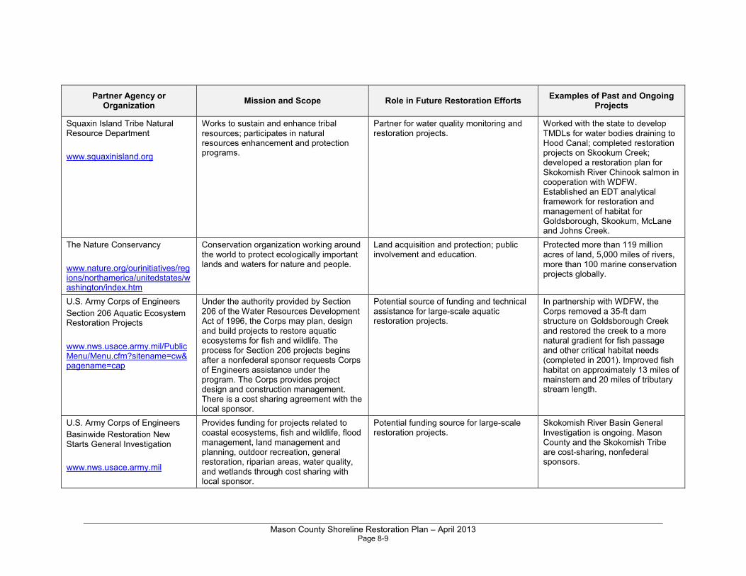
Mason County Shoreline Restoration Plan – April 2013 Page 8-9
Partner Agency or Organization
Mission and Scope Role in Future Restoration Efforts Examples of Past and Ongoing
Projects
Squaxin Island Tribe Natural Resource Department
www.squaxinisland.org
Works to sustain and enhance tribal resources; participates in natural resources enhancement and protection programs.
Partner for water quality monitoring and restoration projects.
Worked with the state to develop TMDLs for water bodies draining to Hood Canal; completed restoration projects on Skookum Creek; developed a restoration plan for Skokomish River Chinook salmon in cooperation with WDFW. Established an EDT analytical framework for restoration and management of habitat for Goldsborough, Skookum, McLane and Johns Creek.
The Nature Conservancy
www.nature.org/ourinitiatives/regions/northamerica/unitedstates/washington/index.htm
Conservation organization working around the world to protect ecologically important lands and waters for nature and people.
Land acquisition and protection; public involvement and education.
Protected more than 119 million acres of land, 5,000 miles of rivers, more than 100 marine conservation projects globally.
U.S. Army Corps of Engineers
Section 206 Aquatic Ecosystem Restoration Projects
www.nws.usace.army.mil/PublicMenu/Menu.cfm?sitename=cw&pagename=cap
Under the authority provided by Section 206 of the Water Resources Development Act of 1996, the Corps may plan, design and build projects to restore aquatic ecosystems for fish and wildlife. The process for Section 206 projects begins after a nonfederal sponsor requests Corps of Engineers assistance under the program. The Corps provides project design and construction management. There is a cost sharing agreement with the local sponsor.
Potential source of funding and technical assistance for large-scale aquatic restoration projects.
In partnership with WDFW, the Corps removed a 35-ft dam structure on Goldsborough Creek and restored the creek to a more natural gradient for fish passage and other critical habitat needs (completed in 2001). Improved fish habitat on approximately 13 miles of mainstem and 20 miles of tributary stream length.
U.S. Army Corps of Engineers
Basinwide Restoration New Starts General Investigation
www.nws.usace.army.mil
Provides funding for projects related to coastal ecosystems, fish and wildlife, flood management, land management and planning, outdoor recreation, general restoration, riparian areas, water quality, and wetlands through cost sharing with local sponsor.
Potential funding source for large-scale restoration projects.
Skokomish River Basin General Investigation is ongoing. Mason County and the Skokomish Tribe are cost-sharing, nonfederal sponsors.
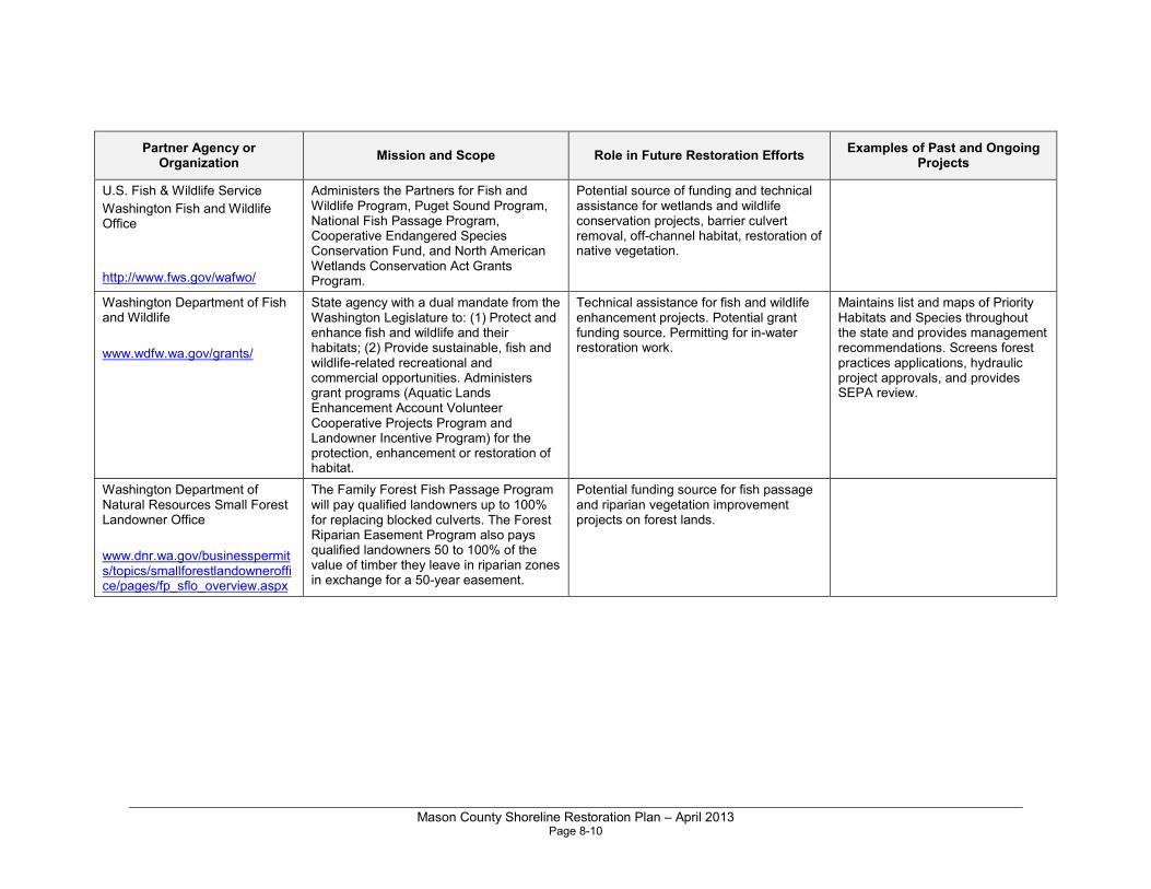
Mason County Shoreline Restoration Plan – April 2013 Page 8-10
Partner Agency or Organization
Mission and Scope Role in Future Restoration Efforts Examples of Past and Ongoing
Projects
U.S. Fish & Wildlife Service
Washington Fish and Wildlife Office
http://www.fws.gov/wafwo/
Administers the Partners for Fish and Wildlife Program, Puget Sound Program, National Fish Passage Program, Cooperative Endangered Species Conservation Fund, and North American Wetlands Conservation Act Grants Program.
Potential source of funding and technical assistance for wetlands and wildlife conservation projects, barrier culvert removal, off-channel habitat, restoration of native vegetation.
Washington Department of Fish and Wildlife
www.wdfw.wa.gov/grants/
State agency with a dual mandate from the Washington Legislature to: (1) Protect and enhance fish and wildlife and their habitats; (2) Provide sustainable, fish and wildlife-related recreational and commercial opportunities. Administers grant programs (Aquatic Lands Enhancement Account Volunteer Cooperative Projects Program and Landowner Incentive Program) for the protection, enhancement or restoration of habitat.
Technical assistance for fish and wildlife enhancement projects. Potential grant funding source. Permitting for in-water restoration work.
Maintains list and maps of Priority Habitats and Species throughout the state and provides management recommendations. Screens forest practices applications, hydraulic project approvals, and provides SEPA review.
Washington Department of Natural Resources Small Forest Landowner Office
www.dnr.wa.gov/businesspermits/topics/smallforestlandowneroffice/pages/fp_sflo_overview.aspx
The Family Forest Fish Passage Program will pay qualified landowners up to 100% for replacing blocked culverts. The Forest Riparian Easement Program also pays qualified landowners 50 to 100% of the value of timber they leave in riparian zones in exchange for a 50-year easement.
Potential funding source for fish passage and riparian vegetation improvement projects on forest lands.
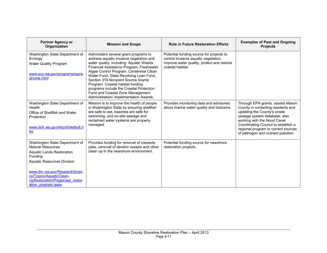
Mason County Shoreline Restoration Plan – April 2013 Page 8-11
Partner Agency or Organization
Mission and Scope Role in Future Restoration Efforts Examples of Past and Ongoing
Projects
Washington State Department of Ecology
Water Quality Program
www.ecy.wa.gov/programs/wq/wqhome.html
Administers several grant programs to address aquatic invasive vegetation and water quality, including: Aquatic Weeds Financial Assistance Program, Freshwater Algae Control Program, Centennial Clean Water Fund, State Revolving Loan Fund, Section 319 Nonpoint Source Grants Program. Coastal habitat funding programs include the Coastal Protection Fund and Coastal Zone Management Administration/ Implementation Awards.
Potential funding source for projects to control invasive aquatic vegetation, improve water quality, protect and restore coastal habitat.
Washington State Department of Health
Office of Shellfish and Water Protection
www.doh.wa.gov/ehp/sf/default.htm
Mission is to improve the health of people in Washington State by ensuring shellfish are safe to eat, beaches are safe for swimming, and on-site sewage and reclaimed water systems are properly managed.
Provides monitoring data and advisories about marine water quality and biotoxins.
Through EPA grants, assists Mason County in contacting residents and updating the County's onsite sewage system database; also working with the Hood Canal Coordinating Council to establish a regional program to correct sources of pathogen and nutrient pollution.
Washington State Department of Natural Resources
Aquatic Lands Restoration Funding
Aquatic Resources Division
www.dnr.wa.gov/ResearchScience/Topics/AquaticClean-UpRestoration/Pages/aqr_restoration_program.aspx
Provides funding for removal of creosote piles, removal of derelict vessels and other clean up in the nearshore environment.
Potential funding source for nearshore restoration projects.
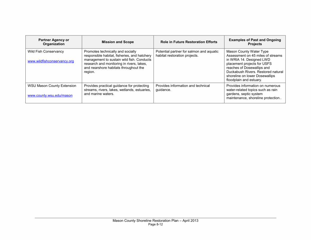
Mason County Shoreline Restoration Plan – April 2013 Page 8-12
Partner Agency or Organization
Mission and Scope Role in Future Restoration Efforts Examples of Past and Ongoing
Projects
Wild Fish Conservancy
www.wildfishconservancy.org
Promotes technically and socially responsible habitat, fisheries, and hatchery management to sustain wild fish. Conducts research and monitoring in rivers, lakes, and nearshore habitats throughout the region.
Potential partner for salmon and aquatic habitat restoration projects.
Mason County Water Type Assessment on 45 miles of streams in WRIA 14. Designed LWD placement projects for USFS reaches of Dosewallips and Duckabush Rivers. Restored natural shoreline on lower Dosewallips floodplain and estuary.
WSU Mason County Extension
www.county.wsu.edu/mason
Provides practical guidance for protecting streams, rivers, lakes, wetlands, estuaries, and marine waters.
Provides information and technical guidance.
Provides information on numerous water-related topics such as rain gardens, septic system maintenance, shoreline protection..
Mason County Shoreline Restoration Plan – April 2013 Page 9-1
Chapter 9.0 Timelines, Benchmarks and Monitoring
As a long-range planning effort without dedicated funding, it is difficult to articulate a firm strategy for accomplishing the goals of this plan. Under the Shoreline Management Act, the County is required to review, and amend if necessary, its SMP once every eight years (RCW 90.58.080(4)). At the time of the update, the County is required to report progress toward meeting its restoration goals, but there is no requirement or timeframe for specifically implementing the restoration plan.
9.1 Timelines and Benchmarks
In the context of the SMP update, restoration planning is a long-term effort. The SMP guidelines include the general goal that local master programs “include planning elements that, when implemented, serve to improve the overall condition of habitat and resources within the shoreline area” (WAC 173-26-201(c)). As a long-range policy plan, it is difficult to establish meaningful timelines and measurable benchmarks in the SMP by which to evaluate the effectiveness of restoration planning or actions. Nonetheless, the legislature has provided an overall timeframe for future amendments to the SMP. In 2003, Substitute Senate Bill 6012 amended the Shoreline Management Act (RCW 90.58.080) to establish an amendment schedule for all jurisdictions in the state. Once Mason County amends its SMP (on or before June 30, 2013), the County is required to review, and amend if necessary, its SMP once every eight years (RCW 90.58.080(4)). During this review period, the County should document progress toward achieving shoreline restoration goals. The review could include the following elements:
• Reevaluating adopted restoration goals, objectives, and policies;
• Summarizing both planning efforts (including application for and securing grant funds) and on-the-ground actions undertaken in the interim to meet those goals; and
• Revising the SMP restoration planning element to reflect changes in priorities or objectives.
Mason County Shoreline Restoration Plan – April 2013 Page 9-2
9.2 Potential Funding
Implementing restoration activities identified in this plan will be a challenge given Mason County’s economic situation. Similar to other local governments in Washington State, the County has been working hard to provide basic services with tighter budgets. A funding mechanism to support these voluntary actions has not yet been identified and funds are not currently dedicated. At present, shoreline restoration is almost entirely dependent on grant funding, which depends upon the availability and award of state and federal monies. The County’s ability to devote any general funds to the implementation of this plan is doubtful, but potential internal funding sources do exist.
One potential funding mechanism would be the establishment of a shoreline restoration program organized like or integrated with a capital improvement program (CIP). Similar to an infrastructure CIP, a shoreline restoration CIP would be evaluated and updated regularly. A restoration CIP could be focused on site-specific projects and could be funded through grants or County general funds. For example, funds could be dedicated to support bulkhead removal, beach cleanup, and riparian enhancements in the shoreline jurisdiction. Further, existing CIP projects, such as stormwater facility and road improvements, could be evaluated to determine if their design could advance shoreline restoration goals.
Special Districts or local improvement districts (LIDs) could also be established to help fund and/or implement restoration projects. A Special District is a local unit of government authorized by law to perform a single function or a limited number of functions, and including but not limited to, water-sewer districts, irrigation districts, and transportation districts. LIDs are primarily a means of financing needed capital improvements. LIDs allow improvements to be financed and paid for over a period of time through assessments on the benefitting properties. They require the approval of the local government and benefited property owners. LIDs involve the sale of bonds to investors and the retirement of those bonds via annual payments by the property owners within a district. Both of the models would provide a potential mechanism for achieving some of the goals of this plan.
A variety of outside funding sources are also available for restoration projects in Puget Sound; these are listed in Appendix C: Potential Funding Sources. Funding opportunities have generally increased since the implementation of Governor Gregoire’s Puget Sound Initiative in 2005, though the process by which organizations are able to obtain funds is typically quite competitive. Sources listed in Appendix C do not represent an exhaustive list of potential funding opportunities, but are meant to provide an overview of the types of opportunities available.
Mason County Shoreline Restoration Plan – April 2013 Page 9-3
9.3 Obstacles and Challenges
The preparation of this shoreline restoration plan is a required part of the County’s SMP update. However, there are a number of potential complicating factors between the development of a county-wide shoreline restoration plan and on-the-ground implementation of its programs and projects. Some of these challenges are summarized below:
• Lack of funding: Designing, carrying out, and monitoring the success of restoration efforts can be an expensive undertaking, particularly at larger (e.g., watershed or reach) scales. In general, funding for restoration is limited to grant dollars and allocation of these monies is competitive.
• Landowner participation: Ownership of Mason County’s shorelines is highly variable. Landowners in areas identified as priorities for restoration efforts may be unwilling or unable to participate in those efforts, while others may be willing to participate in future projects. All of the actions described in this plan are designed to be implemented on a voluntary basis.
• Project permitting: Obtaining necessary permits from local, state, and federal regulatory agencies can require substantial time and effort. Although encouraged and allowed by the SMP, complicated restoration projects may take a year or more to secure permits.
• Climate change: Rising temperatures and sea levels have the potential to dramatically alter Mason County’s shoreline jurisdiction, processes, and functions over time. Depending on the scale of change and time period over which changes occur, restoration priorities could shift substantially within a relatively short period of time. Future restoration should be designed to consider sea level rise and future water elevations in shoreline areas of Mason County.
9.4 Monitoring and Adaptive Management Strategies
The SMP guidelines for restoration planning state that local programs should “…appropriately review the effectiveness of the projects and programs in meeting the overall restoration goals” (WAC 173-26-201(2)(f)). Monitoring of the progress of any restoration plan is an important step in documenting progress and managing change in the shoreline environment. Phase 3 of the SMP guidelines restoration framework (based on Palmer et al. 2005) provides a general roadmap for assessing restoration actions and revising the approach to meeting restoration goals. It includes the following objectives:
• Adaptively manage restoration projects;
Mason County Shoreline Restoration Plan – April 2013 Page 9-4
• Monitor post-restoration conditions; and
• Use monitoring and maintenance results to inform future restoration activities.
As defined by Salafsky et al. (2001), adaptive management is “the integration of design, management, and monitoring to systematically test assumptions in order to adapt and learn.” Testing assumptions involves first thinking about the situation at a specific location and developing a specific set of assumptions about what is occurring at that site and what actions one might be able to use to affect these events. For example, if a bulkhead has been placed in the marine nearshore environment in such a fashion as to block shore-drift behind it, then restoration may include removal of the bulkhead and long-term sediment monitoring to determine whether natural net shore-drift is restored. Restoration practitioners can then implement these actions and monitor the actual results to see how they compare to the ones predicted by the set of assumptions.
Adaptation, in turn, is about taking action to improve a project based on the results of monitoring (Salafsky et al. 2001). Adaptation involves changing assumptions and interventions to respond to new information obtained through monitoring efforts. As in our previous example, if a catastrophic landslide occurs within the reach formerly deprived of sediment, it may no longer be necessary to perform beach nourishment on a recurring basis within that reach. Ongoing monitoring would make clear the necessity of adapting to changed circumstances; namely, the unexpected addition of a new sediment source within the drift cell feeding the scoured beach.
At this time, Mason County does not have dedicated staff or funds to monitor or evaluate restoration projects systematically, and will rely on efforts by organizations involved in restoration activities to supply information on progress toward restoration goals, objectives, and priorities.
Mason County Shoreline Restoration Plan – April 2013 Page 10-1
Chapter 10.0 References
Cereghino, P. J. Toft, S. Simenstad, E. Iverson, S. Campbell, C. Behrens, J. Burke, and B. Craig. 2011. Strategies for Nearshore Protection and Restoration in Puget Sound. Puget Sound Nearshore Ecosystem Restoration Project Technical Report 2012-01. Available: http://www.pugetsoundnearshore.org/technical_papers/psnerp_strategies_maps_lowres.pdf.
Cereghino, P., J. Toft, C. Simenstad, E. Iverson, S. Campbell, C. Behrens,J. Burke. 2012. Strategies for nearshore protection and restoration in Puget Sound. Puget Sound Nearshore Report No. 2012-01. Published byWashington Department of Fish and Wildlife, Olympia, Washington, and the U.S. Army Corps of Engineers, Seattle, Washington.
Clancy, M., I. Logan, J. Lowe, J. Johannessen, A. MacLennan, F.B. Van Cleve, J. Dillon, B. Lyons, R. Carman, P. Cereghino, B. Barnard, C. Tanner, D. Myers, R. Clark, J. White, C. A. Simenstad, M. Gilmer, and N. Chin. 2009. Management Measures for Protecting the Puget Sound Nearshore. Puget Sound Nearshore Ecosystem Restoration Project Report No. 2009-01. Published by Washington Department of Fish and Wildlife, Olympia, Washington.
Correa, G. 2003. Salmon and Steelhead Habitat Limiting Factors, Water Resource Inventory Area 16 Dosewallips-Skokomish Basin Final Report. Washington State Conservation Commission. P.O.Box 47721, Olympia, WA 98504-7721. pp. 257.
ESA Adolfson. 2007. Pierce County Shoreline Master Program Update. Draft Shoreline Inventory and Characterization Report. Prepared for Pierce County Planning and Land Services.
ESA, Coastal Geologic Services, and Herrera Environmental Consultants, Inc. 2012. Draft Mason County Shoreline Master Program Update. Inventory and Characterization Report. SMP Grant Agreement No. G1100004. Prepared for Mason County.
Gersib, R. 2001. The Need for Process-Driven, Watershed-based Wetland Restoration in Washington State. Proceedings of the Puget Sound Research Conference 2001.
Haring, D. 2000. Salmonid Habitat Limiting Factors, Water Resource Inventory Area 15 (East) Final Report. Washington State Conservation Commission. P.O. Box 47721, Olympia, WA 98504-7721. pp. 364.

Mason County Shoreline Restoration Plan – April 2013 Page 10-2
Kuttel, Michael, Jr. 2002. Salmonid Habitat Limiting Factors, Water Resource Inventory Area 14, Kennedy-Goldsborough Basin. Washington State Conservation Commission. P.O. Box 47721, Olympia, WA 98504-7721. pp. 134.
Kuttel, Michael, Jr. 2003. Salmonid Habitat Limiting Factors Water Resource Inventory Areas 15 (West), Kitsap Basin and 14 (North), Kennedy-Goldsborough Basin. Washington State Conservation Commission. P.O. Box 47721, Olympia, WA 98503-7721. pp. 312.
Montgomery, D. R., S. Bolton, D. B. Booth, and L. Wall, editors. 2003. Restoration of Puget Sound rivers. University of Washington Press, Seattle.
Puget Sound Partnership (PSP). 2008. Puget Sound Action Agenda: Protecting and Restoring the Puget Sound Ecosystem by 2020. December 1, 2008. Available: http://www.psp.wa.gov/downloads/ACTION_AGENDA_2008/Action_Agenda.pdf. Accessed August 2012.
Salafsky, N., R. Margoluis, K. Redford. 2001. Adaptive Management: A Tool for Conservation Practitioners. World Wildlife Fund, Inc. Washington, DC.
Schlenger, P., A. MacLennan, E. Iverson, K. Fresh, C. Tanner, B. Lyons, S. Todd, R. Carman, D. Myers, S. Campbell, and A. Wick. 2011. Strategic Needs Assessment: Analysis of Nearshore Ecosystem Process Degradation in Puget Sound. Prepared for the Puget Sound Nearshore Ecosystem Restoration Project. Technical Report 2011-02.
Schlenger, P., A. McLennan, E. Iverson, K Fresh, C. Tanner, B. Lyons, S. Todd, R. Carman, D. Myers, S. Campell, and A. Wick. In prep. Strategic Needs Assessment Report. Puget Sound Nearshore Ecosystem Restoration Project.
Simenstad, C., Ramirez, M., Burke, J., Logsdon, M., Shipman, H., Tanner, C., Davis, C., Fung, J., Bloch, P., Fresh, K., Campbell, S., Myers, D., Iverson, E, Bailey A., Schlenger, P., Kiblinger, C., Myre, P., Gertsel, W.I., and A. MacLennan. 2010. Historic Change and Impairment of Puget Sound Shorelines, Atlas and
Interpretation of Puget Sound Nearshore Ecosystem Restoration Project
Change Analysis.
Stanley, S., J. Brown, and S. Grigsby. 2005. Protecting Aquatic Ecosystems: A Guide for Puget Sound Planners to Understand Watershed Processes. Washington State Department of Ecology. Publication #05-06-027. Olympia, Washington.
Tacoma Power. 2011. Cushman Hydro Project. Available: http://www.mytpu.org/tacomapower/power-system/hydro-power/cushman-hydro-project/Default.htm. Accessed: June 7, 2011.
Mason County Shoreline Restoration Plan – April 2013 Page 10-3
Thom RM, GD Williams, and HL Diefenderfer. 2005. "Balancing the Need to Develop Coastal Areas with the Desire for an Ecologically Functioning Coastal Environment: Is Net Ecosystem Improvement Possible?" Restoration Ecology 13(1):193-203. doi:10.1111/j.1526-100X.2005.00024.x
Vleming, J. 2011. Mason County Profile. Available at: https://fortress.wa.gov/esd/employmentdata/reports-publications/regional-reports/county-profiles/mason-county-profile. Accessed: June, 6, 2011.
WRIA 16 Watershed Planning Unit. Undated. Prioritized List of Sanitary Facility
Needs at Popular Recreation Sites on Hood Canal. Prepared by the WRIA 16 Watershed Planning Unit in Coordination with WDFW.

Mason County Shoreline Restoration Plan – April 2013 Appendix A
APPENDIX A
Marine Restoration Figures

Mason County Shoreline Restoration Plan – April 2013 Appendix B
APPENDIX B
Methods

Mason County Shoreline Restoration Plan – April 2013 Appendix B
Appendix B outlines the method by which restoration opportunities were identified within the marine shorelines of Mason County. This methodology, prepared by Coastal Geologic Services (CGS), integrates the best available technical information for the County’s shorelines along Hood Canal and South Puget Sound.
The first step in this approach was to create a single database of existing restoration opportunities that could be linked with the regional restoration and conservation priority data. The initial step of building the restoration opportunity database was integrating all nearshore restoration opportunities from the Hood Canal Coordinating Council and Mason County Conservation District. Additional restoration opportunities were added to the database from the PRISM database and the local limiting factors reports (Kuttel et al. 2002, 2003, Correa 2003, Haring 2000). The restoration opportunities that were located outside privately-owned residential properties were then selected and exported to create a new data set. The opportunities that are encompassed within private residential property were excluded from this document, to allow for greater restoration focus on the publicly owned shores and to eliminate complexities that could arise from including restoration recommendations on private property in this public planning document. Large scale restoration/protection priority areas were identified so that those opportunities occurring on private properties can be integrated into this same prioritization approach with some simple geospatial data processing.
Each of the opportunities was then reviewed to identify the nearshore processes that would benefit from the recommended restoration action. This information was added to the attribute table. Each action was also attributed with the source of the restoration opportunity as well as other general information including reach location and subbasin.
The database of restoration opportunities was augmented by identifying additional restoration/enhancement actions on publicly owned shores within the county. GIS queries using data from WDFW, Mason County, and data sets from the PSNERP projects listed above were created to focus the identification of new restoration opportunities on areas with nearshore process degradation. The queries used are described further below. Restoration opportunities were delineated in areas where there is an opportunity to address process degradation and/or benefit nearshore habitats such as forage fish spawning areas, outside of privately owned parcels. These new restoration opportunities were similarly attributed, with the source of the opportunity reported as Coastal Geologic Services.
The strategic needs assessment geodatabase, a product of PSNERP, mapped degradation of nearshore processes along Puget Sound shorelines. The strategic needs assessment process degradation data were disaggregated to identify the dominant drivers of process degradation throughout Mason County. Analysis of degradation results showed that the dominant drivers of process degradation were
Mason County Shoreline Restoration Plan – April 2013 Appendix B
process units in which sediment supply, transport, and accretion were degraded as well as tidal flow and tide channel processes. Based on these results, restoration actions that address degraded tidal or sediment processes or actions that could enhance or restore historic tidal wetlands were highlighted as target restoration actions for the County.
Using the PNSERP change analysis geodatabase, “action areas” were identified in which sediment supply, sediment transport, and tidal flow (including tidal wetland) process-based restoration could be conducted throughout the County. This was done by linking the stressors that degrade sediment and tidal nearshore processes with the shoreforms in which the subject nearshore processes are taking place. For example, tidal processes predominantly take place in tide-dominated systems such as tidal embayments, which include closed lagoon marshes, open coastal inlets, barrier estuaries, and barrier lagoons. The occurrence of stressors such as tidal barriers, shore armoring, and nearshore fill directly degrade tidal processes in these systems in which they predominantly occur. Therefore, removing these stressors from tidal embayment shoreforms would enhance and restore tidal processes. Removing fill and armor from a historic barrier lagoon represents a great tidal process restoration action. Tidal process restoration target areas were created in GIS by selecting all tidal embayment shoreforms with co-located stressors that are known to degrade tidal processes.
Sediment processes predominantly take place in areas exposed to waves, which erode and transport sediment. The shoreforms in which these processes predominate in the Puget Sound region include bluff backed beaches and barrier beaches that occur within the transport zones and divergent zone process unit components. Removing stressors such as shore armor and nearshore fill along bluff backed beaches can restore sediment supply processes. Similarly, removing these stressors from barrier beaches can restore natural sediment transport regimes. Where armor removal is infeasible due to land ownership or major infrastructure, sediment processes can be enhanced by strategically conducting beach nourishment to mitigate for lost sediment supply. Sediment process restoration target areas were created in GIS by selecting all armored and filled bluff backed beaches and barrier beaches.
Similar to all restoration action areas, protection areas were also identified throughout the County. Converse to the restoration action areas, protection areas for sediment supply included all bluff backed beaches that are not currently armored. Sediment transport protection action areas included barrier beaches that are not armored. Tidal flow protection action areas included tidal embayment shoreforms in which no stressors were present that are known to degrade tidal processes.
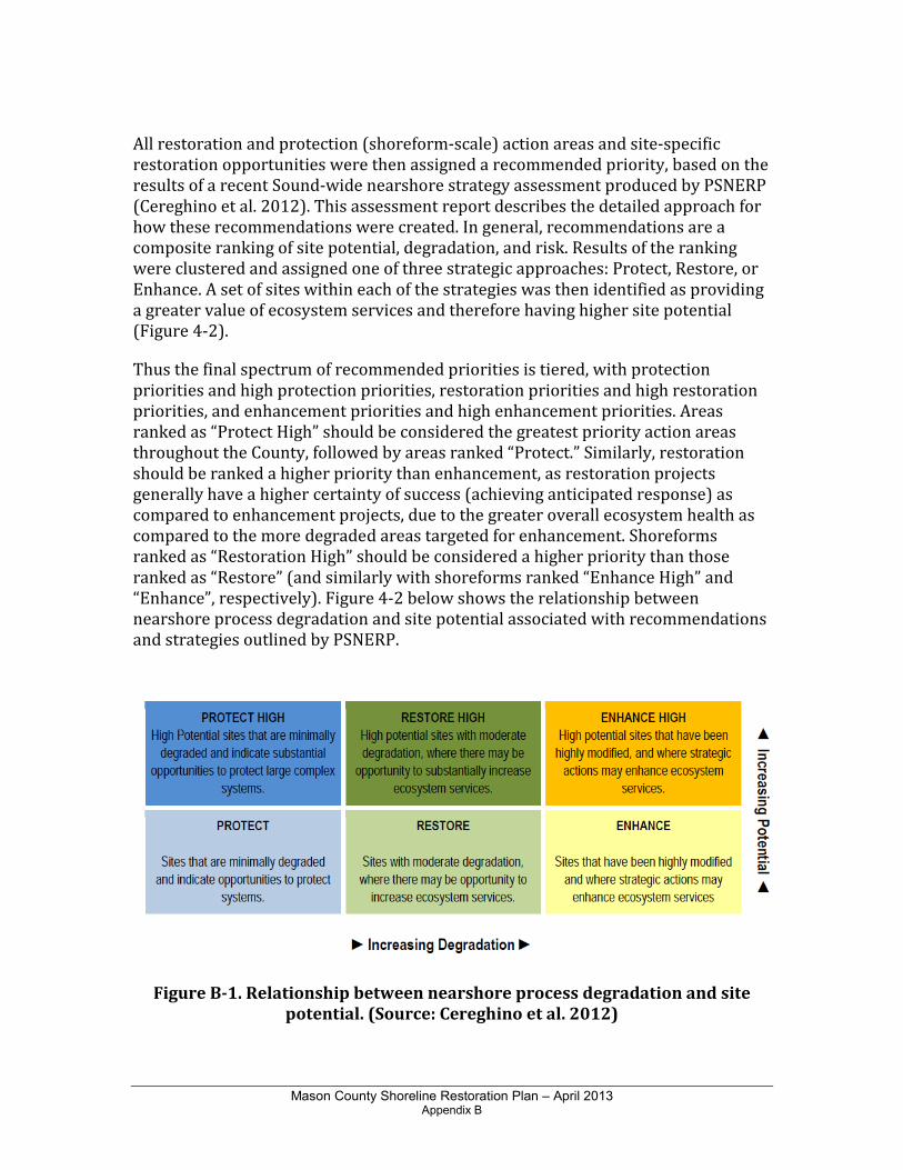
Mason County Shoreline Restoration Plan – April 2013 Appendix B
All restoration and protection (shoreform-scale) action areas and site-specific restoration opportunities were then assigned a recommended priority, based on the results of a recent Sound-wide nearshore strategy assessment produced by PSNERP (Cereghino et al. 2012). This assessment report describes the detailed approach for how these recommendations were created. In general, recommendations are a composite ranking of site potential, degradation, and risk. Results of the ranking were clustered and assigned one of three strategic approaches: Protect, Restore, or Enhance. A set of sites within each of the strategies was then identified as providing a greater value of ecosystem services and therefore having higher site potential (Figure 4-2).
Thus the final spectrum of recommended priorities is tiered, with protection priorities and high protection priorities, restoration priorities and high restoration priorities, and enhancement priorities and high enhancement priorities. Areas ranked as “Protect High” should be considered the greatest priority action areas throughout the County, followed by areas ranked “Protect.” Similarly, restoration should be ranked a higher priority than enhancement, as restoration projects generally have a higher certainty of success (achieving anticipated response) as compared to enhancement projects, due to the greater overall ecosystem health as compared to the more degraded areas targeted for enhancement. Shoreforms ranked as “Restoration High” should be considered a higher priority than those ranked as “Restore” (and similarly with shoreforms ranked “Enhance High” and “Enhance”, respectively). Figure 4-2 below shows the relationship between nearshore process degradation and site potential associated with recommendations and strategies outlined by PSNERP.
Figure B-1. Relationship between nearshore process degradation and site
potential. (Source: Cereghino et al. 2012)

Mason County Shoreline Restoration Plan – April 2013 Appendix B
As previously mentioned, these action-oriented and prioritized shoreforms can be used to prioritize and highlight other restoration opportunities that may exist throughout Mason County. Higher valued priority actions should be targeted first as they are more likely to provide larger scale benefits to nearshore ecosystem functions, goods and services (Cereghino et al. 2012).
Although the entire analysis of protection, restoration and enhancement was conducted for this effort, only restoration and enhancement priorities were carried forward to inform the County’s restoration plan and strategy. Protection priorities were not included under the direction of Ecology.

Mason County Shoreline Restoration Plan – April 2013 Appendix C
APPENDIX C
Potential Funding Sources

Mason County Shoreline Restoration Plan – August 2012 Draft Appendix C
Interagency Committee for Outdoor Recreation
Washington Wildlife Recreation Program 1111 Washington St. SE PO Box 40917 Olympia, WA 98504 360-902-3000, [email protected]
The WWRP provides funds for the acquisition and development of recreation and conservation lands. WWRP funds are administered by account and category. The Habitat Conservation Account includes critical habitat, natural areas, and urban wildlife categories. The Outdoor Recreation Account includes local parks, state parks, trails, and water access categories. Letters of intent are usually due March 1. Applications are usually due May 1.
Washington State Department of Ecology Post Office Box 47600 Olympia, Washington 98504-7600 [email protected] www.ecy.wa.gov/programs/wq/plants/grants/index.html
Grant programs administered by Washington State Department of Ecology are described below.
• Aquatic Weeds Financial Assistance Program: This program provides funding for technical assistance, public education and grants to help control aquatic weeds. Grant projects must address prevention and/or control of freshwater, invasive, non-native aquatic plants. The types of activities funded include: Planning, education, monitoring, implementation, pilot/demonstration projects, surveillance and mapping projects. Grant applications are accepted from October 1 through November 1 of each year during a formal application process.
• Freshwater Algae Control Program: This program provides funding to local governments to manage algae problems. The program targets blue-green algae (also known as cyanobacteria) due to the potential for these algae to produce toxic blooms. The program will pay for algae identification and toxicity testing and supports on online database for results. This program has about $250,000 in funding per year and provides small grants of up to $50,000 for managing algae. Ecology is currently revising funding guidelines for this program.
• Water Quality Program: The Department of Ecology's Water Quality Program administers three major funding programs that provide low-interest loans and grants for projects that protect and improve water quality in Washington State. Ecology acts in partnership with state agencies, local governments, and Indian tribes by providing financial and administrative support for their water quality efforts. As much as possible, Ecology manages the three
Mason County Shoreline Restoration Plan – April 2013 Appendix C
programs as one; there is one funding cycle, application form, and offer list. The three programs are: The Centennial Clean Water Fund, The State Revolving Loan Fund (SRF), and The Section 319 Nonpoint Source Grants Program (Section 319).
• Local governments, Native American tribes, special purpose districts, and non-profit groups are eligible for funding. Grants and loans are available for point source and nonpoint source projects. This includes, but is not limited to, treatment facilities, stream and salmon habitat restoration, and water quality monitoring.
• Coastal Protection Fund: This account is funded primarily by oil spill penalties levied against responsible parties. Restoration efforts undertaken with these funds are diverse and include land acquisition, fish barrier removal, and environmental education projects.
• Coastal Zone Management Administration/Implementation Awards: This program assists states in implementing and enhancing Coastal Zone Management (CZM) programs that have been approved by the Secretary of Commerce. Funds are available for projects in areas such as coastal wetlands management and protection, natural hazards management, public access improvements, reduction of marine debris, assessment of impacts of coastal growth and development, special area management planning, regional management issues, and demonstration projects with potential to improve coastal zone management.
Washington Department of Fish & Wildlife
600 Capitol Way North Olympia, WA 98501-1091 360-902-2806. http://wdfw.wa.gov/volunter/vol-7.htm
• Aquatic Lands Enhancement Account (ALEA) Volunteer Cooperative Projects
Program: The Washington Department of Fish and Wildlife (WDFW) accepts grant applications from individuals and volunteer groups conducting local projects to benefit fish and wildlife. Grants have ranged from $300 to $75,000 in past years to help volunteers pay for materials necessary for projects approved by the agency. Funding cannot be used for wages or benefits. Examples of past projects include habitat restoration, improving access to fish and wildlife areas for disabled people, fish and wildlife research, public education and fish-rearing projects that can benefit the public.
• Landowner Incentive Program: The Landowner Incentive Program (LIP) is a competitive grant program designed to provide financial assistance to private landowners for the protection, enhancement or restoration of habitat to benefit species at risk on privately owned lands. At risk species depend on specific ecosystems for survival. These ecosystems include riparian areas,

Mason County Shoreline Restoration Plan – April 2013 Appendix C
wetlands, oak woodlands, prairies and grasslands, shrub steppe and nearshore environments. Through Washington’s LIP, individual landowners are eligible to apply for up to $50,000 in assistance. In addition, $50,000 is typically set aside for small grants. Any individual applying for these small grant funds may apply for up to $5,000. A 25% non-federal contribution is required, which may include cash and/or in-kind (labor, machinery, materials) contribution.
National Fish and Wildlife Foundation
1120 Connecticut Avenue, NW, #900 Washington, DC 20036 Kathleen Pickering 202-857-0166 www.nfwf.org
Non-profit organizations, local, state or federal government agencies are eligible to apply for funds for community-based projects that improve and restore native salmon habitat, remove barriers to fish passage, or for the acquisition of land/ conservation easements on private lands where the habitat is critical to salmon species. Specific grant programs are listed below.
• Bring Back the Natives: A Public-Private Partnership for Restoring Populations
of Native Aquatic Species: The Bring Back the Natives initiative (BBN) funds on-the-ground efforts to restore native aquatic species to their historic range. Projects should involve partnerships between communities, agencies, private landowners, and organizations that seek to rehabilitate streamside and watershed habitats. Projects should focus on habitat needs of species such as fish, invertebrates, and amphibians that originally inhabited the waterways across the country. Twelve to fifteen grants averaging $60,000 are awarded annually.
• Five-Star Restoration Matching Grants Program: The Five-Star Restoration Program provides modest financial assistance on a competitive basis to support community-based wetland, riparian and coastal habitat restoration projects that build diverse partnerships and foster local natural resource stewardship through education, outreach and training activities.
• Marine Debris Prevention and Removal Program: The NOAA Marine Debris Program (NOAA MDP), codified by the Marine Debris Research, Prevention, and Reduction Act (33 U.S.C. 1951 et seq.) coordinates, strengthens, and enhances the awareness of marine debris efforts within the agency and works with external partners to support research, prevention, and reduction activities related to the issue of marine debris. The NOAA MDP mission is to support a national and international effort focused on preventing, identifying and removing the occurrence of marine debris and to protect and conserve our nation’s natural resources, oceans, and coastal waterways from the impacts of marine debris.
Mason County Shoreline Restoration Plan – April 2013 Appendix C
• Puget Sound Marine Conservation Fund: In spring 2005, the United States charged an international shipping company with violating numerous federal pollution laws after inspections and actions taken by the Washington Department of Ecology and the Coast Guard identified the violations. As part of the settlement, the courts ordered $2,000,000 in community service payments to be made to the National Fish and Wildlife Foundation (Foundation) to be invested in conservation projects in the area of environmental impact.
• The Migratory Bird Conservancy: The MBC will fund projects that directly address conservation of priority bird habitats in the Western Hemisphere. Acquisition, restoration, and improved management of habitats are program priorities. Education, research, and monitoring will be considered only as components of actual habitat conservation projects.
• Community Salmon Fund: NFWF has established local partnerships throughout Washington State through the Community Salmon Fund program to engage landowners, community groups, tribes, and businesses in stimulating smaller-scale, community-oriented habitat restoration and protection projects to aid in salmon recovery. Grants made under this program are administered by NFWF. There are currently three Community Salmon Fund partnership programs. NFWF has partnered with the Washington State Salmon Recovery Funding Board (SRFB) to administer a statewide Community Salmon Fund program that is coordinated with the individual Lead Entity groups.
Salmon Recovery Funding Board (SRFB)
http://www.rco.wa.gov/srfb/board/board.htm The Salmon Recovery Funding Board supports salmon recovery by funding habitat protection and restoration projects. It also supports related programs and activities that produce sustainable and measurable benefits for fish and their habitat. SRFB distributes funds through two grant programs: SRFB grants, and Family Forest Fish Passage Program grants. The grants from SRFB range from $10,000 to nearly $900,000. They were awarded to organizations in 28 counties for work ranging from planting trees along streams to cool the water for salmon, to replacing culverts that prevent salmon from migrating to spawning habitat, to restoring entire floodplains.
Depending on the grant program, eligible applicants may include municipal subdivisions (cities, towns, counties, and special districts such as port, conservation, utility, park and recreation, and school), tribal governments, state agencies, nonprofit organizations, regional fisheries enhancement groups, and private landowners. To be considered for funding, projects must be operated and maintained in perpetuity for the purposes for which funding is sought. All projects require lead entity approval and must be a high priority in the lead entity strategy or regional recovery plan.
Mason County Shoreline Restoration Plan – April 2013 Appendix C
Grants are awarded by the Salmon Recovery Funding Board based on a public, competitive process that weighs the merits of proposed projects against established program criteria.
NOAA Restoration Center
Community-based Restoration Program
Northwest Region Jennifer Steger, Director [email protected] http://www.nmfs.noaa.gov/
The NOAA Community-based Restoration Program (CRP) is a financial and technical assistance program that helps communities implement restoration projects. Specific opportunities are listed below.
• NOAA CRP 3-Year Partnership Grants: These grants fund national and regional habitat restoration partnerships for up to 3 years that provide sub awards for individual grass-roots restoration projects. Typical awards range from $100,000 to $2,000,000.
• NOAA CRP Project Grants: These grants fund grass-roots marine and coastal habitat restoration projects that will benefit anadromous fish species, commercial and recreational resources, and endangered and threatened species. Typical awards range from $30,000 to $250,000.
• American Sportfishing Association’s FishAmerica Foundation Grants: Since 1998, NOAA CRP has partnered with the FishAmerica Foundation to provide funding for fisheries habitat restoration projects nationwide. Grants will fund marine and anadromous fish habitat restoration projects that benefit recreationally fished species. Typical awards range from $5,000 to $50,000.
• National Fish & Wildlife Foundation/National Association of Counties Coastal
Counties Restoration Initiative: In partnership with NOAA CRP, this grant program funds innovative, high quality county-led or supported projects that support wetland, riparian and coastal habitat restoration projects. Typical awards range from $25,000 to $100,000.
• American Rivers, provides funding for dam removal or fish passage projects to individuals and organizations such as civic associations and conservation groups; state, local and tribal governments; and other commercial and non-profit organizations. The partnership funds projects that benefit anadromous fish and support the restoration of habitat for anadromous species.

Mason County Shoreline Restoration Plan – April 2013 Appendix C
Washington State Department of Natural Resources
Aquatic Lands Restoration Funding
Aquatic Resources Division 360-902-1100 Fax 360-902-1786 [email protected] DNR is encouraged that revitalizing the health of Puget Sound and other aquatic lands has become a high priority for the Governor and the people of the state. DNR provides funding for removal of creosote piles, removal of derelict vessels and other clean up in the nearshore environment. Funding is typically awarded to restoration projects between 2004 and 2007 ranged from $8,000 to $35,000. http://www.dnr.wa.gov/ResearchScience/Topics/AquaticClean-UpRestoration/Pages/aqr_aquatic_clean_restoration.aspx.
Puget Sound Nearshore Partnership
Estuary and Salmon Restoration Program
Washington Department of Fish and Wildlife 600 Capital Way N. Olympia, WA 98501 [email protected]
The Estuary and Salmon Restoration Program (ESRP) is a protection and restoration funding opportunity being developed by the Puget Sound Nearshore Partnership to support the transition from opportunistic project funding to strategic and sustained nearshore ecosystem restoration in Puget Sound. The ESRP uses state capital funds and NOAA Restoration Center resources to fund restoration and protection projects that benefit salmon and the nearshore environment in Puget Sound. Projects are selected for their ability to provide long-term protection of restoration of ecosystem processes. ESRP provides phased funding to incrementally support large and complex projects. Projects that rank well through a regional competition are considered for annual funding.
Environmental Protection Agency
Region 10: Pacific Northwest
Grants Administration Unit Bob Phillips [email protected] (206) 553-6367
The Environmental Protection Agency funds a variety of projects that aim to safeguard the natural environment and protect human health. Potential opportunities specific to watershed protection and restoration are listed below.
• The Clean Water State Revolving Fund Program: Under this program, EPA provides grants or “seed money” to all 50 states plus Puerto Rico to capitalize
Mason County Shoreline Restoration Plan – April 2013 Appendix C
state loan funds. The states, in turn, make loans to communities, individuals, and others for high-priority water-quality activities. Projects funded by the low-interest loans may include wetlands protection and restoration, estuary management efforts – including wildlife habitat restoration – and development of streambank buffer zones.
• Nonpoint Source Implementation Grant (319) Program: Clean Water Act Section 319(h) funds are provided only to designated state and tribal agencies to implement their approved nonpoint source management programs. State and tribal nonpoint source programs include a variety of components, including technical assistance, financial assistance, education, training, technology transfer, demonstration projects, and regulatory programs. Each year, EPA awards Section 319(h) funds to states in accordance with a state-by-state allocation formula that EPA has developed in consultation with the states.
• Wetland Protection, Restoration, and Stewardship Discretionary Funding: This program provides support for studies and activities related to implementation of Section 404 of the Clean Water Act for both wetlands and sediment management. Projects can support regulatory, planning, restoration or outreach issues. Typical grant awards range from $5,000 to $20,000.
U.S. Fish & Wildlife Service
Nell Fuller 911 NE 11th Avenue Portland, OR 97232-4181 (503) 231-2014 [email protected]
• Partners for Fish and Wildlife Program: This program provides technical and financial assistance to private landowners and Tribes who are willing to work with USFWS and other partners on a voluntary basis to help meet the habitat needs of Federal Trust Species. The Partners Program can assist with projects in all habitat types which conserve or restore native vegetation, hydrology, and soils associated with imperiled ecosystems such as longleaf pine, bottomland hardwoods, tropical forests, native prairies, marshes, rivers and streams, or ecosystems that otherwise provide an important habitat requisite for a rare, declining or protected species. The typical grant award is approximately $25,000.
• Puget Sound Program: The Puget Sound Program was established to protect, restore, and enhance the natural resources of Washington’s coastal ecosystems. USFWS works closely with the U.S. Environmental Protection Agency’s National Estuary Program, and their State partner, the Puget Sound Water Quality Action Team to conserve fish and wildlife and their habitats in Puget Sound, an “estuary of national significance”. Partnerships with other
Mason County Shoreline Restoration Plan – April 2013 Appendix C
agencies, Native American Tribes, citizens, and organizations are emphasized.
• National Fish Passage Program: Each year the Service solicits and inputs select fish passage projects into the Fisheries Operational Needs System database. Projects are prioritized and selected based upon the benefits to species and the geographical area. Typical projects include barrier culvert removal or replacement with a fish passable culvert or bridge, and re-opening oxbow and off channel habitats. Typical funding amounts range from $30,000 to $110,000 with a minimum 25% cost share requested.
• Cooperative Endangered Species Conservation Fund: Grants offered through the Cooperative Endangered Species Conservation Fund support participation in a wide array of voluntary conservation projects for candidate, proposed and listed species. These funds may in turn be awarded to private landowners and groups for conservation projects.
• North American Wetlands Conservation Act Grants Program: The North American Wetlands Conservation Act of 1989 provides matching grants to organizations and individuals who have developed partnerships to carry out wetlands conservation projects in the United States, Canada, and Mexico for the benefit of wetlands-associated migratory birds and other wildlife. The Standard Grants Program supports projects in Canada, the United States, and Mexico that involve long-term protection, restoration, and/or enhancement of wetlands and associated uplands habitats. The Small Grants Program operates only in the United States; it supports the same type of projects and adheres to the same selection criteria and administrative guidelines as the U.S. Standard Grants Program. However, project activities are usually smaller in scope and involve fewer project dollars. Grant requests may not exceed $75,000, and funding priority is given to grantees or partners new to the Act’s Grants Program.
U.S. Army Corps of Engineers
Section 206 Aquatic Ecosystem Restoration Projects Mr. John R. Kennelly, Chief Planning Branch U.S. Army Corps of Engineers New England District 696 Virginia Road Concord, Massachusetts 01742-2751
Under the authority provided by Section 206 of the Water Resources Development Act of 1996, the Corps may plan, design and build projects to restore aquatic ecosystems for fish and wildlife. The process for Section 206 projects begins after a non-federal sponsor requests Corps of Engineers assistance under the program. When funding is available, the Corps of Engineers prepares a Preliminary Restoration Plan (PRP) paid for by the federal government. The PRP is a 3 to 5 page document used to determine whether federal involvement is appropriate. It
Mason County Shoreline Restoration Plan – April 2013 Appendix C
describes the project benefits and contains an initial schedule and budget. The Final PRP contains a letter from the non-federal sponsor indicating that they understand their obligations for cost sharing and obtaining any necessary real estate. If the sponsor agrees to move forward with the project, the Corps prepares a feasibility study, then plans and specifications. The Corps then manages construction of the project. U.S. Army Corps of Engineers
Basinwide Restoration New Starts General Investigation
Bruce Sexauer P.O. Box 3755 Seattle, WA 98134 (206) 764-6959 Funding for projects related to coastal ecosystems, fish and wildlife, flood management, land management and planning, outdoor recreation, general restoration, riparian areas, water quality, and wetlands is provided through this program at a 65:35 cost share. Studies on the same topics are funded at a 50:50 cost share. Washington Department of Transportation
City Fish Passage Grant Program
Cliff Hall (360) 705-7499 [email protected] The City Fish Passage Barrier Removal and Habitat Restoration Grant Program provides $2 million to be used towards city fish passage barrier removal projects, with complimenting habitat restoration and stormwater components. The intent of the City Fish Passage Barrier Removal and Habitat Restoration Grant program is to integrate clean water with salmon restoration efforts and compliments the WSDOT ESA response. Grant funding may vary from year to year; check with the Program Manager at WSDOT for more detailed information.
Washington Department of Natural Resources Small Forest Landowner Office
(SFLO)
PO Box 47000 1111 Washington Street SE Olympia, WA 98504-7000 (360) 902-1000 The Family Forest Fish Passage Program will pay qualified landowners up to 100% for replacing blocked culverts. The Forest Riparian Easement Program also pays qualified landowners 50 to 100% of the value of timber they leave in riparian zones in exchange for a 50-year easement.
Mason County Shoreline Restoration Plan – April 2013 Appendix C
Ducks Unlimited
Matching Aid to Restore State Habitat (MARSH)
(916) 852-2000 [email protected]
The MARSH program was instituted in 1985 to develop and protect waterfowl habitat in the United States. This reimbursement program provides matching funds for wetland acquisition and habitat restoration and enhancement in each state based on Ducks Unlimited (DU's) income within that state. Projects submitted for MARSH funding must significantly benefit waterfowl. Normally, all projects must be on land under the control of a public agency or private cooperator with which DU has an approved memorandum of understanding. Control must be through ownership, lease, easement, or management agreement. Control must be adequate for protection, maintenance, and use of the project throughout its projected life.
Trout Unlimited
Embrace-A-Stream
406-543-1192 www.tu.org Embrace-A-Stream (EAS) is the flagship grant program for funding Trout Unlimited’s conservation efforts to conserve, protect, and restore coldwater fisheries and their watersheds. Trout Unlimited annually raises money from TU members, corporate and agency partners, and foundations to distribute as small grants to local TU projects. The goal of EAS is to conserve coldwater fisheries through innovative grassroots conservation projects. Successful projects are based on sound science, benefit the resource, strengthen the local TU chapter and council, and help build the constituency for protecting trout and salmon. TU volunteers are actively involved in project work and are expected to provide matching funds. An Embrace-A-Stream Committee comprised of TU volunteer representatives and scientific advisors evaluates all proposed projects.
Bonneville Environmental Foundation
Model Watershed Program
(503) 248-1905 http://www.b-e-f.org/watersheds/
The Bonneville Environmental Foundation (BEF) supports science-based watershed restoration initiatives that demonstrate strong community engagement and strive to implement a long-term restoration approach. BEF accepts letters of inquiry on an open basis, and there is no official cycle for the review and solicitation of proposed Model Watershed Projects. Any individual, organization, tribe, or local government in the Pacific Northwest may submit a letter of inquiry. Awards range from $5,000 to $40,000 annually for up to a 10-year period.
Mason County Shoreline Restoration Plan – April 2013 Appendix C
Other Potential Sources
A number of private foundations, businesses, and other organizations administer grant programs with the intent of restoring habitat and ecosystems. Organizations with focal areas including Puget Sound, watershed protection, and habitat conservation include:
• The Russell Family Foundation (www.trff.org/home.asp);
• Northwest Fund for the Environment (www.nwfund.org/);
• The Bullitt Foundation (www.bullitt.org);
• The Compton Foundation (www.comptonfoundation.org);
• The Acorn Foundation (www.commoncounsel.org); and
• The Hugh and Jane Ferguson Foundation (http://www.foundationcenter.org/grantmaker/ferguson/).