shoreline master program update - skamania county county... · shoreline master program update ....
TRANSCRIPT
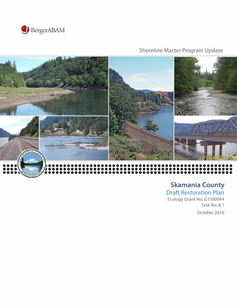
Shoreline Master Program Update
Skamania County Draft Restoration Plan Ecology Grant No. G1500044
Task No. 8.1
October 2016
Draft Restoration Plan Skamania County Shoreline Master Program Update Submitted to Skamania County Stevenson, Washington October 2016 Submitted by BergerABAM 210 East 13th Street, Suite 300 Vancouver, Washington 98660-3231 A15.0208.02

Skamania County - Shoreline Master Program Update BergerABAM, A15.0208.02 Draft Restoration Plan October 2016 Ecology Grant No. G1500044 Page i of iv
DRAFT RESTORATION PLAN
Skamania County Shoreline Master Program Update
TABLE OF CONTENTS SECTION PAGE ACRONYMS ........................................................................................................................................... iii
1.0 INTRODUCTION ......................................................................................................................... 1 1.1 Purpose ......................................................................................................................... 1 1.2 Requirements ............................................................................................................... 2 1.3 Restoration Planning ................................................................................................... 2
1.3.1 Protection versus Restoration ........................................................................ 3 1.3.2 No Net Loss and Restoration .......................................................................... 4
2.0 CURRENT CONDITIONS ............................................................................................................. 5 2.1 WRIA 26 Cowlitz ........................................................................................................... 5 2.2 WRIA 27 Lewis ............................................................................................................. 5 2.3 WRIA 28 Salmon-Washougal ....................................................................................... 6 2.4 WRIA 29 Wind-White Salmon ...................................................................................... 7 2.5 Data Gaps ...................................................................................................................13
3.0 RESTORATION GOALS AND POLICIES ....................................................................................15 3.1 Existing County-Wide Goals .......................................................................................15 3.2 Restoration Goals and Policies .................................................................................16
4.0 RESTORATION PARTNERS ......................................................................................................18 5.0 PROPOSED PROGRAMMATIC AND RESTORATION ACTIONS ...............................................21
5.1 Programmatic Actions ...............................................................................................21 5.2 Restoration Actions ...................................................................................................21
5.2.1 WRIA 26 –Recommended Restoration Actions ...........................................22 5.2.2 WRIA 27 - Recommended Restoration Actions ...........................................25 5.2.3 WRIA 28 - Recommended Restoration Actions ...........................................39 5.2.4 WRIA 29 - Recommended Restoration Actions ...........................................47
6.0 IMPLEMENTATION AND MONITORING ...................................................................................58 6.1 Timelines and Benchmarks .......................................................................................58 6.2 Monitoring Strategies ................................................................................................58 6.3 Potential Funding .......................................................................................................58 6.4 Obstacles and Challenges .........................................................................................63
7.0 REFERENCES ..........................................................................................................................64
Skamania County - Shoreline Master Program Update BergerABAM, A15.0208.02 Draft Restoration Plan October 2016 Ecology Grant No. G1500044 Page ii of iv
LIST OF FIGURES Figure 1 – Adaptive Management Process ......................................................................................... 4 Figure 2 – WRIA Overview of Skamania County .................................................................................. 8 Figure 3 – WRIA 26 Cowlitz .................................................................................................................. 9 Figure 4 – WRIA 27 Lewis ................................................................................................................. 10 Figure 5 – WRIA 28 Salmon-Washougal ........................................................................................... 11 Figure 6 – WRIA 29 Wind-White Salmon .......................................................................................... 12 LIST OF TABLES Table 1 – Skamania County Data Gaps ............................................................................................ 13 Table 2 – Existing Programs and Potential Partners ....................................................................... 19 Table 3 – WRIA 26 Restoration Actions ........................................................................................... 23 Table 4 – WRIA 27 Restoration Actions ........................................................................................... 26 Table 5 – WRIA 28 Restoration Actions ........................................................................................... 40 Table 6 – WRIA 29 Restoration Actions ........................................................................................... 48
Skamania County - Shoreline Master Program Update BergerABAM, A15.0208.02 Draft Restoration Plan October 2016 Ecology Grant No. G1500044 Page iii of iv
ACRONYMS
ALEA Aquatic Lands Enhancement Account County Skamania County CBWTP Columbia Basin Water Transactions Program CWA Clean Water Act DNR Washington Department of Natural Resources Ecology Washington State Department of Ecology EPA U.S. Environmental Protection Agency ESA Endangered Species Act FEMA Federal Emergency Management Agency FWS U.S. Fish and Wildlife Service GIS Geographic Information Systems HUC hydraulic unit code LCFRB Lower Columbia Fish Recovery Board LWD large woody debris NFFP National Fish Passage Program NGO non-governmental organization NOAA National Oceanic and Atmospheric Administration NPCC PCSRF
Northwest Power and Conservation Council Pacific Coastal Salmon Recovery Fund
RCO Washington State Recreation and Conservation Office RCW Revised Code of Washington RFEG RIST RM
Regional Fisheries Enhancement Group (Pacific Northwest) Recovery Implementation Science Team river mile
SCC Skamania County Code SMA Washington State Shoreline Management Act (RCW 90.58) SMP Shoreline Master Program SSHIAP UCD USACE
Salmon and Steelhead Stock Inventory Assessment Program Underwood Conservation District U.S. Army Corps of Engineers
USDA U.S. Department of Agriculture USFS U.S. Forest Service USFWS U.S. Fish and Wildlife Service USGS U.S. Geological Survey WAC Washington Administrative Code WDFW Washington Department of Fish and Wildlife WF WRIA
West Fork Water Resource Inventory Area
WRWP WSCC WSDOT
Wind River Watershed Project Washington State Conservation Commission Washington State Department of Transportation
Skamania County - Shoreline Master Program Update BergerABAM, A15.0208.02 Draft Restoration Plan October 2016 Ecology Grant No. G1500044 Page iv of iv
WSWMC WWRP
White Salmon Watershed Management Committee Washington Wildlife Recreation Program
Skamania County - Shoreline Master Program Update BergerABAM, A15.0208.02 Draft Restoration Plan October 2016 Ecology Grant No. G1500044 Page 1 of 67
DRAFT RESTORATION PLAN SKAMANIA COUNTY SHORELINE MASTER PROGRAM UPDATE
1.0 INTRODUCTION This restoration plan was prepared as part of the Skamania County (County) Shoreline Master Program (SMP) update (Skamania County 2016a). The County is currently updating its SMP (Title 20 of the Skamania County Code [SCC]) in order to comply with the Washington State Shoreline Management Act (SMA), Revised Code of Washington (RCW) 90.58, and Washington Administrative Code (WAC) 173.26 adopted in 2003 by the Washington State Legislature. The County’s SMP was first adopted in June 1974, and was revised in August 1975 and again in July 1986 (Skamania County 1974). This plan is funded with grant assistance from the Washington State Department of Ecology (Ecology) (Ecology Grant No. G1500044).
1.1 Purpose The purpose of the plan is to provide a non-regulatory framework for the restoration of shorelines in the County utilizing the goals and policies proposed in the Draft SMP and information contained in “Skamania County Final Inventory and Characterization Report,” prepared by BergerABAM (Skamania County 2016b). The restoration plan establishes a basis for improving the quality and sustainability of Skamania County’s shoreline resources over time in a collaborative and cohesive manner.
The report is not proposed for inclusion as regulatory code or as part of the Skamania County Comprehensive Plan or the SCC. However, the County’s SMP indicates that degraded areas should be restored in accordance with this restoration plan, and the report will serve as a useful reference during SMP implementation.
Although many of the opportunities for restoration activities described in this plan affect private property, it is not the intention of the County to require or commit private property owners to carrying out those restoration activities. Instead, the County is eager to support and foster restoration actions in willing collaboration with the participation of the landowners. Additionally, private landowners who are required to provide mitigation by other entities for development-related impacts may choose to implement the actions noted in this plan as a way of meeting those mitigation obligations.
In order to understand and implement this plan, people involved in restoration in Skamania County are encouraged to first review Chapter 2 to understand the current conditions of the watersheds in the County (including degraded areas and ongoing restoration activities). Chapter 3 is a logical follow-up in understanding the County’s goals and priorities as they relate to the current conditions described in Chapter 2. Chapter 4 discusses opportunities and actions to implement the restoration plan’s goals, and Chapter 5 describes programs and partners that are currently active in restoring the
Skamania County - Shoreline Master Program Update BergerABAM, A15.0208.02 Draft Restoration Plan October 2016 Ecology Grant No. G1500044 Page 2 of 67
waterways covered in this restoration plan, thus helping planners and practitioners identify ways to collaborate on existing activities or develop new restoration projects.
1.2 Requirements The County’s SMP lists the policies and regulations that govern the use and development of the County’s freshwater rivers, lakes, and shorelines. Research has shown that even the best designed and implemented mitigation projects are subject to some degree of failure. Therefore, the SMP must include a “real and meaningful” strategy to restore shoreline ecological functions where such functions are impaired.
SMPs must include goals, policies, and actions to restore impaired shoreline ecological functions. These provisions are to achieve overall improvements in shoreline ecological functions over time, when compared to the functions’ status upon adoption of the SMP.
To comply with WAC 173-26-186 (8)(c), restoration plans must:
• Identify degraded areas, impaired ecological functions, and sites with potential for ecological restoration.
• Establish overall goals and priorities for the restoration of degraded areas and impaired ecological functions.
• Identify existing and ongoing projects and programs that are being implemented, or are reasonably assured of being implemented (based on an evaluation of funding likely in the foreseeable future), and which are designed to contribute to local restoration goals.
• Identify additional projects and programs needed to achieve local restoration goals and implementation strategies, including prospective funding sources for the projects and programs.
• Identify timelines and benchmarks for implementing restoration projects and programs and achieving local restoration goals.
• Provide mechanisms or strategies that will ensure 1) the implementation of restoration projects and programs according to plans, and 2) the appropriate review of their effectiveness in meeting the overall restoration goals.
1.3 Restoration Planning Generally speaking, shoreline and waterbody restoration is defined as returning an area to a previous condition by improving its current ecological conditions. The SMA defines restoration as follows:
‘Restore,’ ‘restoration’ or ‘ecological restoration’ means the reestablishment or upgrading of impaired ecological shoreline processes or functions. This may be accomplished through measures including, but not limited to, revegetation, removal of intrusive shoreline structures and removal or treatment of toxic
Skamania County - Shoreline Master Program Update BergerABAM, A15.0208.02 Draft Restoration Plan October 2016 Ecology Grant No. G1500044 Page 3 of 67
materials. Restoration does not imply a requirement for returning the shoreline area to aboriginal or pre-European settlement conditions. (WAC 173-26-020)
The SMA guidelines require that restoration goals, policies and actions “be designed to achieve overall improvements in shoreline ecological functions over time, when compared to the status upon adoption of the master program” (WAC 173-26-201[2][f]). Restoration then, per the SMA, involves the concept of repairing past damage to natural resources and habitats, but not necessarily the re-creation of pristine or historic conditions, which in many cases may prove impossible to accomplish.
1.3.1 Protection versus Restoration Protecting shorelines means to safeguard them from current or future damage caused by use or development, and may require prohibiting some activities in certain areas, or requiring development to adhere to certain regulations in order to mitigate adverse effects. Protection, essentially, is the effort to maintain the ecological integrity of a shoreline at its present condition.
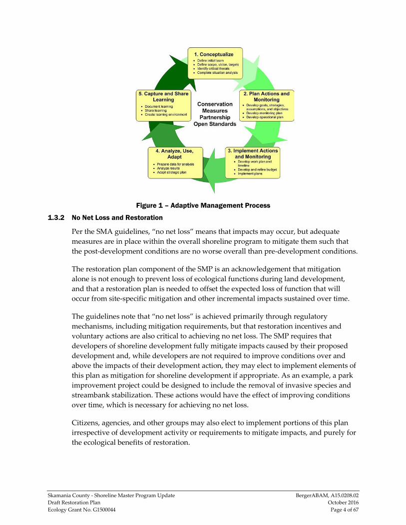
Rather than maintaining current conditions, restoration involves actions that improve the current conditions of a shoreline that have previously been degraded. Restoration generally requires a phased approach, as illustrated in Figure 1, below. The progression from the planning phase to the reporting phase can vary widely in length, ranging from weeks to years, depending on the scope and complexity of the restoration effort in question. In some cases, the progression is not linear, meaning that it may be necessary for the restoration team to go back and conduct more planning or assessment, before progressing to the final phase. This iterative process is known as “adaptive management,” and allows flexibility and informed decision-making throughout the restoration process.
This document accounts for the actions required during the restoration planning phase. Future and additional efforts will be needed to accomplish the post-planning restoration phases (implementation, assessment, management, and reporting).
Skamania County - Shoreline Master Program Update BergerABAM, A15.0208.02 Draft Restoration Plan October 2016 Ecology Grant No. G1500044 Page 4 of 67
Figure 1 – Adaptive Management Process
1.3.2 No Net Loss and Restoration
Per the SMA guidelines, “no net loss” means that impacts may occur, but adequate measures are in place within the overall shoreline program to mitigate them such that the post-development conditions are no worse overall than pre-development conditions.
The restoration plan component of the SMP is an acknowledgement that mitigation alone is not enough to prevent loss of ecological functions during land development, and that a restoration plan is needed to offset the expected loss of function that will occur from site-specific mitigation and other incremental impacts sustained over time.
The guidelines note that “no net loss” is achieved primarily through regulatory mechanisms, including mitigation requirements, but that restoration incentives and voluntary actions are also critical to achieving no net loss. The SMP requires that developers of shoreline development fully mitigate impacts caused by their proposed development and, while developers are not required to improve conditions over and above the impacts of their development action, they may elect to implement elements of this plan as mitigation for shoreline development if appropriate. As an example, a park improvement project could be designed to include the removal of invasive species and streambank stabilization. These actions would have the effect of improving conditions over time, which is necessary for achieving no net loss.
Citizens, agencies, and other groups may also elect to implement portions of this plan irrespective of development activity or requirements to mitigate impacts, and purely for the ecological benefits of restoration.
Skamania County - Shoreline Master Program Update BergerABAM, A15.0208.02 Draft Restoration Plan October 2016 Ecology Grant No. G1500044 Page 5 of 67
2.0 CURRENT CONDITIONS This section is an overview of the watersheds that comprise Skamania County. This background information helps set the context for the goals, priorities, and restoration strategies discussed in subsequent sections.
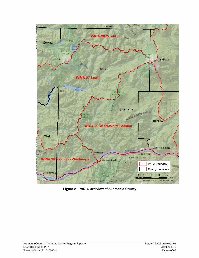
As illustrated in Figure 2, significant drainage basins within the County include four water resource inventory areas (WRIAs): WRIA 26 Cowlitz, WRIA 27 Lewis, WRIA 28 Salmon-Washougal, and WRIA 29 Wind-White Salmon. The WRIAs were formalized under WAC 173-500-040 and authorized under the Water Resources Act of 1971, RCW 90.54. Summaries of each drainage basin follow and include its size, known significant waterbodies, and overall ecological health.
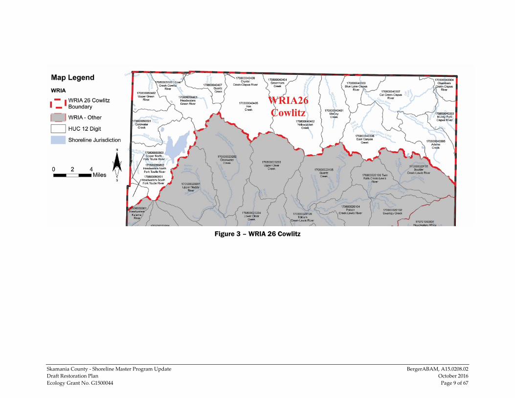
2.1 WRIA 26 Cowlitz WRIA 26 Cowlitz (Figure 3) has a drainage basin of approximately 2,492 square miles and includes the Cowlitz River and its tributaries, which drain the region around Mount Rainier, Mount Adams, and Mount St. Helens. The river enters the Columbia River downstream of Skamania County near Longview. WRIA 26 includes approximately 285 square miles of the north portion of Skamania County.
Because the portion of WRIA 26 within the County is mostly forestland, there is little development and alteration to the shoreline area, which mostly exists in a natural condition and supports a variety of fish and wildlife species. However, a loss of fish access to upstream areas of the Cowlitz River and its tributaries, caused primarily by
human-made impassable barriers such as dams, has reduced historical runs such as fall-run Chinook and coho salmon and winter-run and summer-run steelhead within the WRIA (Lower Columbia Fish Recovery Board 2010). The subbasins within WRIA 26 in Skamania County include the Upper Cowlitz River subbasin and the Toutle River subbasin.
The major surface waters within WRIA 26 that are located in the County are: North Fork Toutle River, Green River, Lower Cispus River, and Upper Cispus River. Some of the significant lakes located in this portion of WRIA 26 include Deadman’s Lake, Venus Lake, Elk Lake, Hanaford Lake, Coldwater Lake, Saint Helens Lake, Spirit Lake, Takhlakh Lake, and Council Lake.
The following waterbodies in WRIA 26 in the County are listed on Ecology’s 2012 303d list as impaired (Category 4 or 5) based on temperature: East Canyon Creek, Quartz Creek, Pumice Creek, and Greenhorn Creek.
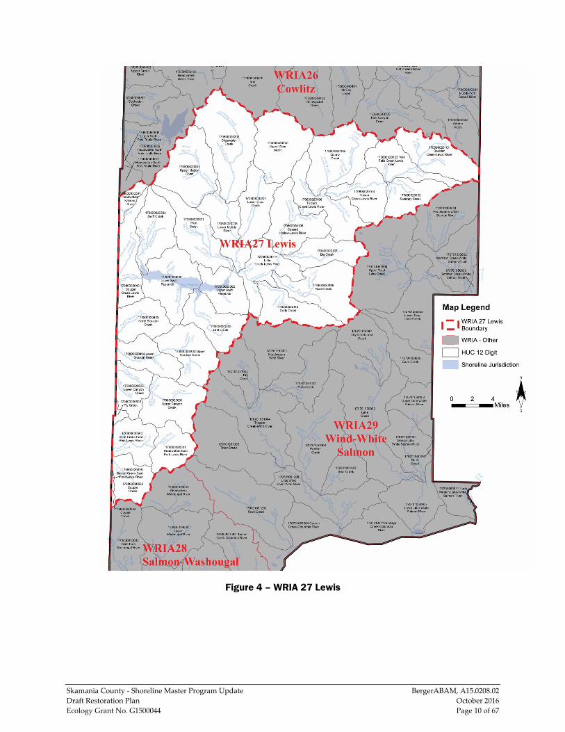
2.2 WRIA 27 Lewis WRIA 27 Lewis (Figure 4) has a drainage basin of approximately 1,308 square miles, and approximately 638 square miles are located within the west and north-central parts of the County. Major subbasins in WRIA 27 include the North Fork Lewis River subbasin, the East Fork Lewis River subbasin, and a small portion of the Kalama River subbasin.
Skamania County - Shoreline Master Program Update BergerABAM, A15.0208.02 Draft Restoration Plan October 2016 Ecology Grant No. G1500044 Page 6 of 67
The streams and rivers of WRIA 27 generally flow southwest through the Gifford Pinchot National Forest and pass south of Mount St. Helens before entering Clark County to the west and Cowlitz County to the north. The major surface waters of WRIA 27 that are located in Skamania County include the headwaters of the Lewis River and the Muddy River, Upper Lewis River, Middle Lewis River, Lower Lewis River, and East Fork Lewis River. Some significant lakes and reservoirs located in WRIA 27 include Swift Reservoir and Placid Lake.
The Swift Reservoir community is located in WRIA 27, and its development is guided by the Swift Reservoir Subarea Comprehensive Plan (Skamania County 2007b). Per the restoration plan, resident fish and priority anadromous/resident fish residing in the subarea include bull trout, rainbow trout, cutthroat trout, and whitefish. Human-made impassable barriers and a loss of access to headwater production areas within WRIA 27 have severely reduced the distribution of some salmon populations (Lower Columbia Fish Recovery Board 2010).
The Lewis River and Swift Creek are listed on Ecology’s 2012 303d list as impaired (Category 4 or 5) based on total dissolved gas (oxygen); Lewis River is also listed as impaired (Category 4 or 5) based on temperature. The following waterbodies in WRIA 27 are listed on Ecology’s 2012 303d list as impaired (Category 4 or 5) based on temperature: Clear Creek, Clearwater Creek, Copper Creek, Muddy River, and Siouxon Creek.
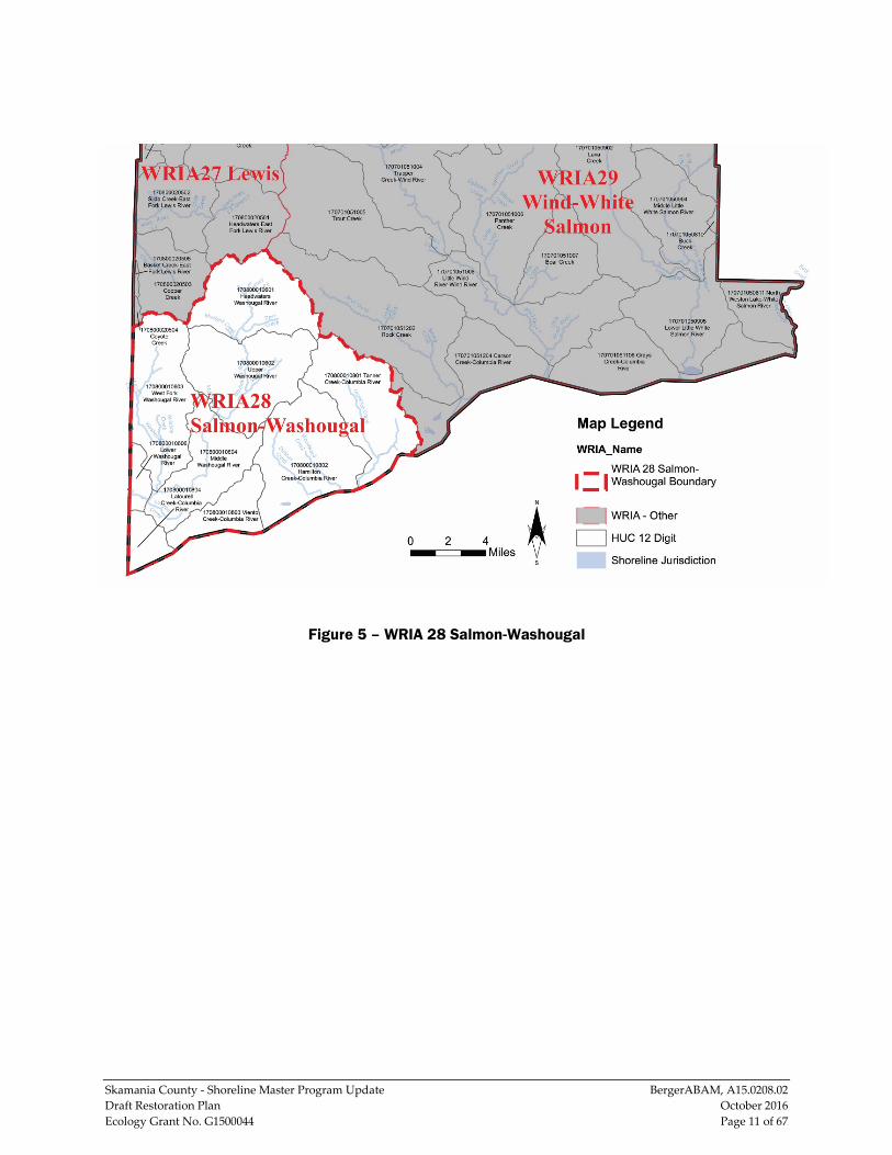
2.3 WRIA 28 Salmon-Washougal WRIA 28 Salmon-Washougal (Figure 5) is approximately 495 square miles, of which approximately 160 square miles are located in the southwest portion of the County. The watershed of the Washougal River is the only portion of WRIA 28 that is located in the County.
The headwaters of the Washougal River are located in Gifford Pinchot National Forest, and the river and its tributaries generally flow south and then west through Clark County toward the Columbia River, entering the river downstream of Skamania County at Camas. Duncan Creek, Hamilton Creek, Tanner Creek, and Woodward Creek flow south directly into the Columbia River. Some of the significant lakes located in WRIA 28 include Franz Lake and Woody’s Lake.
Salmon and steelhead populations within WRIA 28 have declined from historical levels and there are significant extinction risks for fall-run Chinook and chum, summer-run and winter-run steelhead, and coho because of a loss of the quantity and quality of tributary habitat, predation, and harvest and hatchery impacts (Lower Columbia Fish Recovery Board 2010).
The major surface waters of WRIA 28 that are located in the County include the Washougal River, West Fork Washougal River, Hamilton Creek, Tanner Creek, and
Skamania County - Shoreline Master Program Update BergerABAM, A15.0208.02 Draft Restoration Plan October 2016 Ecology Grant No. G1500044 Page 7 of 67
portions of the Columbia River. The Washougal River is listed on Ecology’s 2012 303d list as impaired (Category 4 or 5) for bacteria/fecal coliform. The Columbia River is listed on Ecology’s 2012 303d list as impaired (Category 4 or 5) based on total dissolved gas (oxygen) and temperature.
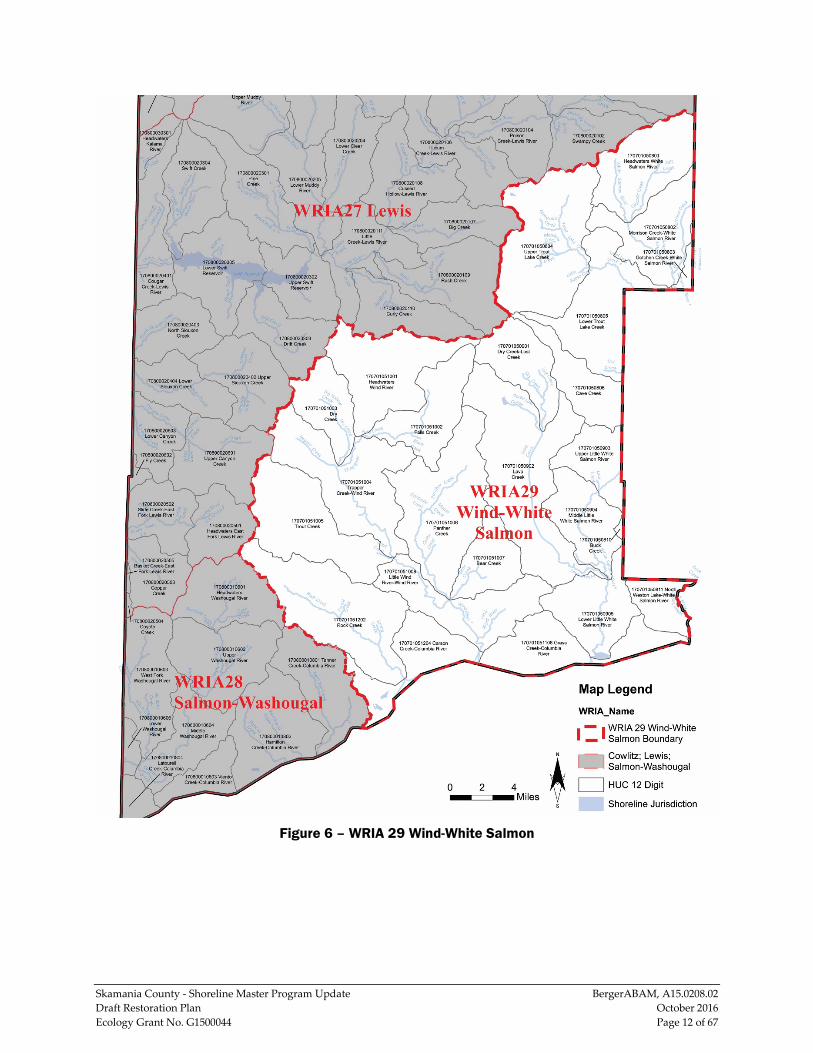
2.4 WRIA 29 Wind-White Salmon WRIA 29 Wind-White Salmon (Figure 6) is 902 square miles, with approximately 589 square miles located within the County. The headwaters of the Wind and White Salmon rivers are located on the southwest flanks of Mount Adams, and the rivers and their tributaries generally flow southward to the Columbia River; the Wind River enters near Carson and the White Salmon River enters upstream at Underwood along the County’s eastern boundary. Approximately two-thirds of WRIA 29 is located within Gifford Pinchot National Forest. The major surface waters of WRIA 29 that are located in the County include the Wind River, Eagle Creek, Rock Creek, White Salmon River, Little White Salmon River, and Mosier Creek. Some of the significant lakes located in WRIA 29 include Swampy Meadows, Big Mosquito Lake, Goose Lake, Drano Lake, Ashes Lake, and Wauna Lake.
The 2011 removal of the Condit hydroelectric dam, which was constructed in 1913 on the White Salmon River, is expected to provide access to approximately 32.4 miles of river and tributary habitat for steelhead and salmon; restore connectivity to spawning, rearing, foraging, and overwintering habitat for bull trout in the river; and add to the overall potential of increased production for salmonids (Ecology 2010). Washington Department of Fish and Wildlife (WDFW) surveys from 2013 indicated that fall-run Chinook were spawning upstream of the former site of the dam (U.S. Geological Survey 2015). The following waterbodies in WRIA 29 in Skamania County are listed on Ecology’s 2012 303d list as impaired (Category 4 or 5) based on temperature: Bear Creek, Martha Creek, Ninemile Creek, Falls Creek, Little White Salmon River, Little Wind River, Lost Creek, Layout Creek, Trout Creek, Trout Lake Creek, Wind River, Crater Creek, and Eightmile Creek.
The West End community is located in WRIA 27, near the southwest corner of the County, and its development is guided by the West End subarea comprehensive plan (Skamania County 2007c). The subarea plan notes that the area lacks sufficient stormwater infrastructure, and recommends giving serious consideration to the development of a stormwater plan and standards in the subarea. Additionally, the plan notes that threatened salmon and steelhead are located in many of the surface waters in the West End, and natural and the man-made fish passage obstructions in the subarea include falls, small dams, and culverts.
Skamania County - Shoreline Master Program Update BergerABAM, A15.0208.02 Draft Restoration Plan October 2016 Ecology Grant No. G1500044 Page 8 of 67
Figure 2 – WRIA Overview of Skamania County
Skamania County - Shoreline Master Program Update BergerABAM, A15.0208.02 Draft Restoration Plan October 2016 Ecology Grant No. G1500044 Page 9 of 67
Figure 3 – WRIA 26 Cowlitz
Skamania County - Shoreline Master Program Update BergerABAM, A15.0208.02 Draft Restoration Plan October 2016 Ecology Grant No. G1500044 Page 10 of 67
Figure 4 – WRIA 27 Lewis
Skamania County - Shoreline Master Program Update BergerABAM, A15.0208.02 Draft Restoration Plan October 2016 Ecology Grant No. G1500044 Page 11 of 67
Figure 5 – WRIA 28 Salmon-Washougal
Skamania County - Shoreline Master Program Update BergerABAM, A15.0208.02 Draft Restoration Plan October 2016 Ecology Grant No. G1500044 Page 12 of 67
Figure 6 – WRIA 29 Wind-White Salmon
Skamania County - Shoreline Master Program Update BergerABAM, A15.0208.02 Draft Restoration Plan October 2016 Ecology Grant No. G1500044 Page 13 of 67
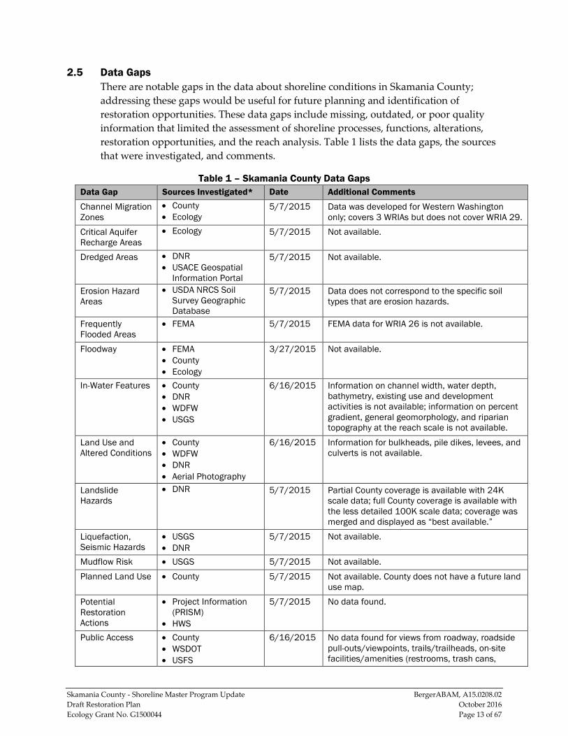
2.5 Data Gaps There are notable gaps in the data about shoreline conditions in Skamania County; addressing these gaps would be useful for future planning and identification of restoration opportunities. These data gaps include missing, outdated, or poor quality information that limited the assessment of shoreline processes, functions, alterations, restoration opportunities, and the reach analysis. Table 1 lists the data gaps, the sources that were investigated, and comments.
Table 1 – Skamania County Data Gaps Data Gap Sources Investigated* Date Additional Comments
Channel Migration Zones
• County • Ecology
5/7/2015 Data was developed for Western Washington only; covers 3 WRIAs but does not cover WRIA 29.
Critical Aquifer Recharge Areas
• Ecology 5/7/2015 Not available.
Dredged Areas • DNR • USACE Geospatial
Information Portal
5/7/2015 Not available.
Erosion Hazard Areas
• USDA NRCS Soil Survey Geographic Database
5/7/2015 Data does not correspond to the specific soil types that are erosion hazards.
Frequently Flooded Areas
• FEMA 5/7/2015 FEMA data for WRIA 26 is not available.
Floodway • FEMA • County • Ecology
3/27/2015 Not available.
In-Water Features • County • DNR • WDFW • USGS
6/16/2015 Information on channel width, water depth, bathymetry, existing use and development activities is not available; information on percent gradient, general geomorphology, and riparian topography at the reach scale is not available.
Land Use and Altered Conditions
• County • WDFW • DNR • Aerial Photography
6/16/2015 Information for bulkheads, pile dikes, levees, and culverts is not available.
Landslide Hazards
• DNR 5/7/2015 Partial County coverage is available with 24K scale data; full County coverage is available with the less detailed 100K scale data; coverage was merged and displayed as “best available.”
Liquefaction, Seismic Hazards
• USGS • DNR
5/7/2015 Not available.
Mudflow Risk • USGS 5/7/2015 Not available. Planned Land Use • County 5/7/2015 Not available. County does not have a future land
use map. Potential Restoration Actions
• Project Information (PRISM)
• HWS
5/7/2015 No data found.
Public Access • County • WSDOT • USFS
6/16/2015 No data found for views from roadway, roadside pull-outs/viewpoints, trails/trailheads, on-site facilities/amenities (restrooms, trash cans,
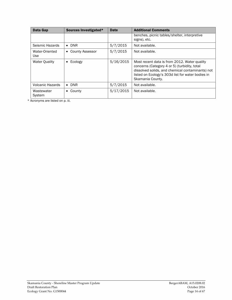
Skamania County - Shoreline Master Program Update BergerABAM, A15.0208.02 Draft Restoration Plan October 2016 Ecology Grant No. G1500044 Page 14 of 67
Data Gap Sources Investigated* Date Additional Comments benches, picnic tables/shelter, interpretive signs), etc.
Seismic Hazards • DNR 5/7/2015 Not available. Water-Oriented Use
• County Assessor 5/7/2015 Not available.
Water Quality • Ecology 5/16/2015 Most recent data is from 2012. Water quality concerns (Category 4 or 5) (turbidity, total dissolved solids, and chemical contaminants) not listed on Ecology’s 303d list for water bodies in Skamania County.
Volcanic Hazards • DNR 5/7/2015 Not available. Wastewater System
• County 5/17/2015 Not available.
* Acronyms are listed on p. iii.
Skamania County - Shoreline Master Program Update BergerABAM, A15.0208.02 Draft Restoration Plan October 2016 Ecology Grant No. G1500044 Page 15 of 67
3.0 RESTORATION GOALS AND POLICIES
3.1 Existing County-Wide Goals The restoration plan seeks to establish a basic framework for improving the quality and sustainability of the County’s shoreline resources over time in a collaborative, consistent, manner. This plan is also intended to be compatible with the restoration goals already developed by other restoration planning entities in the region such as Skamania County, the Underwood Conservation District (UCD), and area tribes.
The vision statement for Skamania County, as enunciated in the 2007 comprehensive plan, is:
Skamania County is strongly committed to protecting our rural character and natural resource based industries while allowing for planned future development that is balanced with the protection of critical resources and ecologically sensitive areas, while preserving the community’s high quality of life. (Skamania 2007a)
Several goals and policies from the Skamania County 2007 Comprehensive Plan provide guidance on the County’s intent with regard to restoring its shorelines and other natural assets. These include:
• Goal LU.5: To promote improvements which make our communities more livable, healthy, safe and efficient.
• Goal E.2: To enhance water quality; protect environmentally sensitive areas including wetlands, streams, rivers, lakes, riparian areas, and aquifer recharge areas.
• Policy E.1.9: Encourage the use of northwest native plants in landscaping, particularly adjacent to critical areas.
• Policy E.1.10: Ensure prompt restoration of land after grading and vegetation removal through phased clearing and grading, replanting requirements, and other appropriate revegetation and engineering techniques.
• Policy E.2.1: Allow enhancement or restoration of degraded wetlands and riparian corridors to maintain or improve ecological functions. Approve wetland mitigation proposals if they will result in improved overall wetland functions. Preserve land used for wetland mitigation in perpetuity.
• Policy E.2.3: Actively monitor the Lower Columbia Fish Recovery Board activities in WRIAs 25, 26, 27 and 28, which focuses on the long-term strategic watershed planning, management, conservation and restoration, and addresses water quality, water quantity, and fish habitat.
• Policy E.2.4: Actively participate as lead agency in WRIA 29, which focuses on the long-term strategic watershed planning, management, conservation
Skamania County - Shoreline Master Program Update BergerABAM, A15.0208.02 Draft Restoration Plan October 2016 Ecology Grant No. G1500044 Page 16 of 67
and restoration, and addresses water quality, water quantity, and fish habitat.
• Goal E.4: To consider the requirements of the human population while protecting fish and wildlife habitats, including salmonid habitat, by preserving, restoring, and enhancing critical areas; and linking habitat for wildlife and native ecosystems.
• Goal E.4.2: Develop strategies for preserving, protecting or restoring important habitats and corridors, particularly if they are at risk of significant degradation. Some strategies may include public acquisition of habitat; linking habitats using open space areas, riparian corridors, and other natural features; encouraging the use of conservation easements for long-term habitat protection; promoting land use plans and development that avoid impacts on habitat; and protecting native plant communities by encouraging management and control of non-native invasive plants, including aquatic plants.
• Policy E.4.4: Coordinate with other jurisdictions and agencies to protect environmentally critical habitats, particularly ecosystems and watersheds that span jurisdictional boundaries. (Skamania County 2007 Comprehensive Plan)
3.2 Restoration Goals and Policies The SMA guidelines require that restoration goals, policies and actions “be designed to achieve overall improvements in shoreline ecological functions over time, when compared to the status upon adoption of the master program” (WAC 173-26-201[2][f]).
The development of this restoration plan as a non-regulatory framework that will fulfil the requirements of the SMA and accomplish the County’s restoration goals included articulating these goals and policies.
Goal 1: To restore water quality so that the waters in the County are safe for drinking, swimming, and other human uses and enjoyment, and are not harmful to the native mammals, fish, and birds.
Policy 1.1: Working with local partners and organizations, identify sources of pollutants (e.g., stormwater runoff) and develop restoration projects to address these sources.
Policy 1.2: Work with USFS and other organizations to promote the upgrading or decommissioning of problem forest roads.1
Policy 1.3: Promote the replacement of paved parking areas with pervious pavement through incentives such as grants or development fee reductions.
1 A “problem forest road” is a road that creates adverse environmental effects due to substandard construction or condition; impacts can include erosion, mass wasting, and/or sedimentation.
Skamania County - Shoreline Master Program Update BergerABAM, A15.0208.02 Draft Restoration Plan October 2016 Ecology Grant No. G1500044 Page 17 of 67
Goal 2: To increase the availability and viability of shoreline habitats for salmon, resident fish, mammals, birds, and other species.
Policy 2.1: Working with local partners and organizations, identify shoreline structures that are degrading local habitats, and develop programs to upgrade or remove the structures.
Policy 2.2: Improve habitat quality for sensitive and/or locally important species, and support the biological recovery goals for federally protected species.
Policy 2.3: Restore stream channels and channel migration zones.
Goal 3: To restore degraded riparian vegetation throughout Skamania County.
Policy 3.1: Support the shoreline vegetation measures of the SMP.
Policy 3.2: Working with the Skamania County Noxious Weed Control Program, develop projects to eradicate invasive species from shoreline habitats as development occurs or as voluntary restoration actions.
Goal 4: To encourage cooperative restoration actions involving local, state, and federal public agencies, tribes, non-governmental organizations (NGO), and private landowners, and to integrate restoration efforts with capital projects and other resource management efforts.
Policy 4.1: Evaluate restoration opportunities when planning for parks, transportation, and other capital projects.
Policy 4.2: Provide incentive to landowners to restore private properties, through local, state, or NGO programs.
Policy 4.3: Work with restoration partners to establish a database and tracking program for restoration projects.
Skamania County - Shoreline Master Program Update BergerABAM, A15.0208.02 Draft Restoration Plan October 2016 Ecology Grant No. G1500044 Page 18 of 67
4.0 RESTORATION PARTNERS Several agencies and organizations are conducting restoration efforts in the county’s watersheds. Their activities may be located in the County, or in a watershed beyond the county where the restoration activities will have positive effects on waterbodies that flow into and out of the county. Most restoration efforts involve the voluntary collaboration of residents, tribes, NGOs, and local, state, and federal resource agencies. Ongoing restoration planning efforts in the County and surrounding areas may help inform and implement future restoration actions.
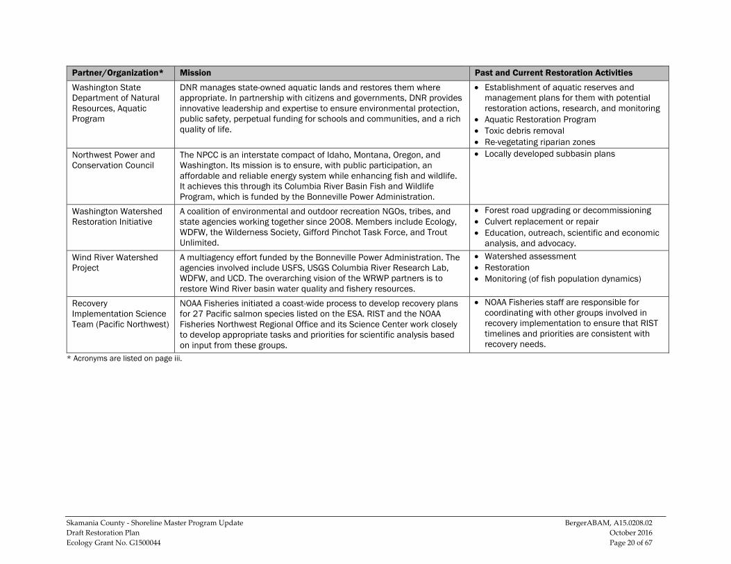
The organizations responsible for the existing restoration programs in the County and throughout the region are likely to play a major role in carrying out the restoration efforts described in this plan. These potential partners are identified in Table 2. They are some of the key organizations that have ecological restoration as their primary focus and are actively involved in the restoration and stewardship of the County’s freshwater resources. The list, which is not exhaustive, describes the key partners, their mission or area of focus, and some past and current projects that illustrate the role they can play in future restoration activities.
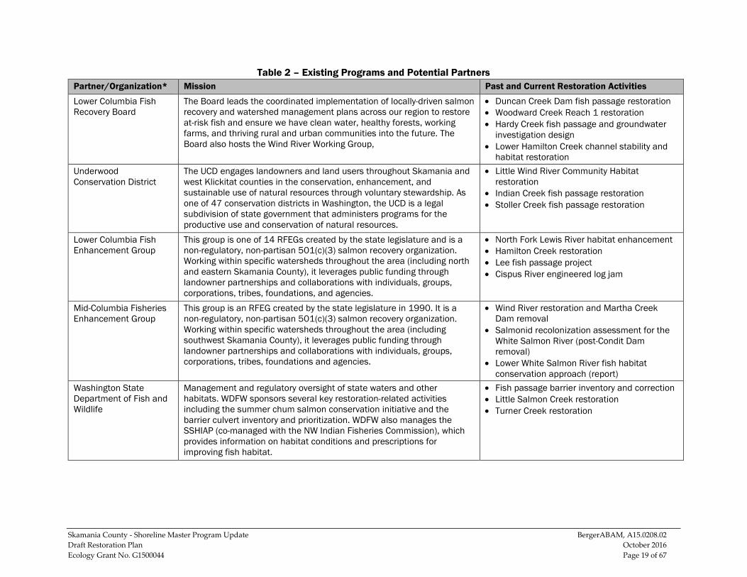
Skamania County - Shoreline Master Program Update BergerABAM, A15.0208.02 Draft Restoration Plan October 2016 Ecology Grant No. G1500044 Page 19 of 67
Table 2 – Existing Programs and Potential Partners Partner/Organization* Mission Past and Current Restoration Activities
Lower Columbia Fish Recovery Board
The Board leads the coordinated implementation of locally-driven salmon recovery and watershed management plans across our region to restore at-risk fish and ensure we have clean water, healthy forests, working farms, and thriving rural and urban communities into the future. The Board also hosts the Wind River Working Group,
• Duncan Creek Dam fish passage restoration • Woodward Creek Reach 1 restoration • Hardy Creek fish passage and groundwater
investigation design • Lower Hamilton Creek channel stability and
habitat restoration Underwood Conservation District
The UCD engages landowners and land users throughout Skamania and west Klickitat counties in the conservation, enhancement, and sustainable use of natural resources through voluntary stewardship. As one of 47 conservation districts in Washington, the UCD is a legal subdivision of state government that administers programs for the productive use and conservation of natural resources.
• Little Wind River Community Habitat restoration
• Indian Creek fish passage restoration • Stoller Creek fish passage restoration
Lower Columbia Fish Enhancement Group
This group is one of 14 RFEGs created by the state legislature and is a non-regulatory, non-partisan 501(c)(3) salmon recovery organization. Working within specific watersheds throughout the area (including north and eastern Skamania County), it leverages public funding through landowner partnerships and collaborations with individuals, groups, corporations, tribes, foundations, and agencies.
• North Fork Lewis River habitat enhancement • Hamilton Creek restoration • Lee fish passage project • Cispus River engineered log jam
Mid-Columbia Fisheries Enhancement Group
This group is an RFEG created by the state legislature in 1990. It is a non-regulatory, non-partisan 501(c)(3) salmon recovery organization. Working within specific watersheds throughout the area (including southwest Skamania County), it leverages public funding through landowner partnerships and collaborations with individuals, groups, corporations, tribes, foundations and agencies.
• Wind River restoration and Martha Creek Dam removal
• Salmonid recolonization assessment for the White Salmon River (post-Condit Dam removal)
• Lower White Salmon River fish habitat conservation approach (report)
Washington State Department of Fish and Wildlife
Management and regulatory oversight of state waters and other habitats. WDFW sponsors several key restoration-related activities including the summer chum salmon conservation initiative and the barrier culvert inventory and prioritization. WDFW also manages the SSHIAP (co-managed with the NW Indian Fisheries Commission), which provides information on habitat conditions and prescriptions for improving fish habitat.
• Fish passage barrier inventory and correction • Little Salmon Creek restoration • Turner Creek restoration
Skamania County - Shoreline Master Program Update BergerABAM, A15.0208.02 Draft Restoration Plan October 2016 Ecology Grant No. G1500044 Page 20 of 67
Partner/Organization* Mission Past and Current Restoration Activities
Washington State Department of Natural Resources, Aquatic Program
DNR manages state-owned aquatic lands and restores them where appropriate. In partnership with citizens and governments, DNR provides innovative leadership and expertise to ensure environmental protection, public safety, perpetual funding for schools and communities, and a rich quality of life.
• Establishment of aquatic reserves and management plans for them with potential restoration actions, research, and monitoring
• Aquatic Restoration Program • Toxic debris removal • Re-vegetating riparian zones
Northwest Power and Conservation Council
The NPCC is an interstate compact of Idaho, Montana, Oregon, and Washington. Its mission is to ensure, with public participation, an affordable and reliable energy system while enhancing fish and wildlife. It achieves this through its Columbia River Basin Fish and Wildlife Program, which is funded by the Bonneville Power Administration.
• Locally developed subbasin plans
Washington Watershed Restoration Initiative
A coalition of environmental and outdoor recreation NGOs, tribes, and state agencies working together since 2008. Members include Ecology, WDFW, the Wilderness Society, Gifford Pinchot Task Force, and Trout Unlimited.
• Forest road upgrading or decommissioning • Culvert replacement or repair • Education, outreach, scientific and economic
analysis, and advocacy. Wind River Watershed Project
A multiagency effort funded by the Bonneville Power Administration. The agencies involved include USFS, USGS Columbia River Research Lab, WDFW, and UCD. The overarching vision of the WRWP partners is to restore Wind River basin water quality and fishery resources.
• Watershed assessment • Restoration • Monitoring (of fish population dynamics)
Recovery Implementation Science Team (Pacific Northwest)
NOAA Fisheries initiated a coast-wide process to develop recovery plans for 27 Pacific salmon species listed on the ESA. RIST and the NOAA Fisheries Northwest Regional Office and its Science Center work closely to develop appropriate tasks and priorities for scientific analysis based on input from these groups.
• NOAA Fisheries staff are responsible for coordinating with other groups involved in recovery implementation to ensure that RIST timelines and priorities are consistent with recovery needs.
* Acronyms are listed on page iii.
Skamania County - Shoreline Master Program Update BergerABAM, A15.0208.02 Draft Restoration Plan October 2016 Ecology Grant No. G1500044 Page 21 of 67
5.0 PROPOSED PROGRAMMATIC AND RESTORATION ACTIONS This section lists the programmatic and restoration actions that are recommended in order to fulfill the purpose of the restoration plan: to establish a basic framework for improving the quality and sustainability of Skamania County’s shoreline resources over time in a collaborative manner. The actions are recommended to address shoreline degradation and impairments in order to achieve the vision, goals, and priorities discussed in section 3.0 and “no net loss” of shoreline ecological function in Skamania County.
5.1 Programmatic Actions The programmatic restoration/conservation actions apply to all areas of the county. Implementing the programmatic actions will also help to improve ecological conditions over time on a County-wide scale.
Programmatic actions are broad, comprehensive steps that the County can take to achieve restoration goals. Programmatic actions for Skamania County include:
• Encouraging agricultural owners to implement best management practices in runoff controls and animal watering stations;
• Implementing water-withdrawal measures to manage in-stream flows and address future water needs;
• Encouraging best management practices in stormwater control, and updating/installing stormwater infrastructure where practicable;
• Educating property owners on native vegetation and the impacts of lawn chemicals and fertilizers, and encouraging participation in the Skamania County Master Gardeners training offered by Oregon State University - Hood River and Washington State University Vancouver;
• Working with the USFS to either repair or decommission damaged forest roads;
• Educating homeowners on low-impact development practices for shoreline properties;
• Supporting and encouraging participation in the Skamania County Noxious Weed Control Program; and
• Implementing an educational program for boaters regarding best boating practices to minimize habitat disruption/damage and water contamination.
5.2 Restoration Actions The restoration actions recommended for each WRIA were compiled from a number of studies and reports, including the inventory and characterization report, the Draft Shoreline Master Program, and reports and knowledge provided by partners in restoration (as listed in section 2.5 and section 5.3). Of particular note are two partners: The Lower Columbia Fish Recovery Board and the Washington State Conservation Commission, which provided much of the data for waterbody-specific restoration needs.
Skamania County - Shoreline Master Program Update BergerABAM, A15.0208.02 Draft Restoration Plan October 2016 Ecology Grant No. G1500044 Page 22 of 67
While the recommended actions were compiled using the best available information, additional restoration activities beyond those discussed in this report should be explored as new data or opportunities arise. As outlined in section 2.5 and Table 1, the data available for the county has gaps that hinder the identification of site-specific restorations needs and opportunities. In addition to the potential restoration projects identified in this section, restoration efforts may be initiated by first addressing some of these gaps.
On a county-wide scale, the primary impairments in need of addressing through restoration are (1) impaired water quality (often due to temperature) and (2) impaired habitat quality and diversity (primarily attributed to problem forest roads, timber harvest activities, and other human development). Common restoration projects needed throughout the county are revegetation of shorelines with native plants; side-channel projects to improve stream flow; placement of LWD in streams to improve habitat complexity and provide fish shelter; and the planting of coniferous riparian vegetation to increase shading and future LWD recruitment.
Table 3 through Table 6 list the recommended restoration activities for watersheds, organized by WRIA, subbasin, and waterbody. Both the protective efforts contained in the SMP and the restoration efforts are necessary to successfully address the impacts of past, existing, and future development, and ensure the ecological integrity of Skamania County’s shorelines.
5.2.1 WRIA 26 –Recommended Restoration Actions Recommended restoration projects for WRIA 26, by subbasin and waterbody, are identified in Table 3. WRIA 26 comprises the northern portion of the county and includes the Upper Cowlitz River subbasin and the Toutle River subbasin.
The Upper Cowlitz subbasin is located primarily outside Skamania County, in Lewis County to the north. Within Skamania County, the subbasin accounts for most of the northern border with Lewis County. A loss of fish access to upstream areas of the Cowlitz River and its tributaries caused by human-made impassable barriers such as dams has reduced historical runs such as fall-run Chinook and coho salmon and winter-run and summer-run steelhead within the WRIA (Lower Columbia Fish Recovery Board 2010).
The Toutle River subbasin is located in the northwest corner of the County, and most of the basin lies in Cowlitz County, to the west. The headwaters of the Toutle River are on Mount St. Helens in Skamania County, and flow west towards Cowlitz County. The subbasin was greatly affected by the Mount St. Helens eruption in 1980, which resulted in large mudflows, large accumulations of debris, and a loss of forest lands (Lower Columbia Fish Recovery Board 2010). The resulting habitat and water quality impacts from sedimentation remain issues for the subbasin.
Skamania County - Shoreline Master Program Update BergerABAM, A15.0208.02 Draft Restoration Plan October 2016 Ecology Grant No. G1500044 Page 23 of 67
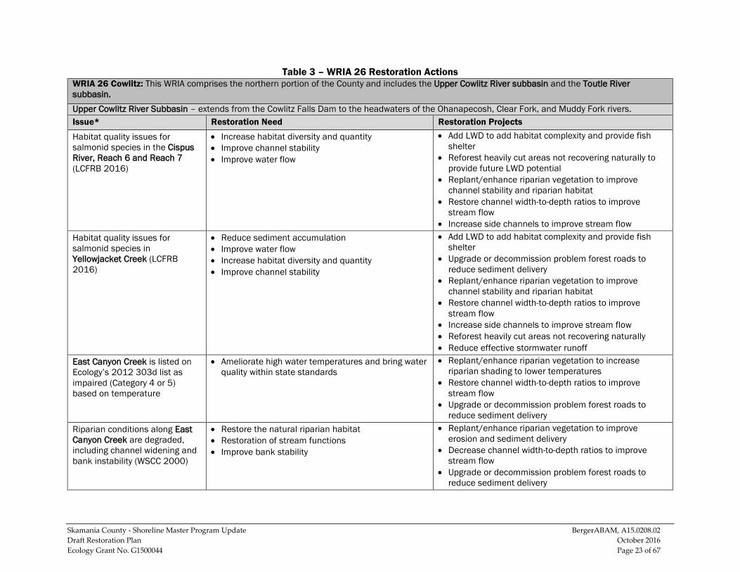
Table 3 – WRIA 26 Restoration Actions WRIA 26 Cowlitz: This WRIA comprises the northern portion of the County and includes the Upper Cowlitz River subbasin and the Toutle River subbasin. Upper Cowlitz River Subbasin – extends from the Cowlitz Falls Dam to the headwaters of the Ohanapecosh, Clear Fork, and Muddy Fork rivers. Issue* Restoration Need Restoration Projects
Habitat quality issues for salmonid species in the Cispus River, Reach 6 and Reach 7 (LCFRB 2016)
• Increase habitat diversity and quantity • Improve channel stability • Improve water flow
• Add LWD to add habitat complexity and provide fish shelter
• Reforest heavily cut areas not recovering naturally to provide future LWD potential
• Replant/enhance riparian vegetation to improve channel stability and riparian habitat
• Restore channel width-to-depth ratios to improve stream flow
• Increase side channels to improve stream flow Habitat quality issues for salmonid species in Yellowjacket Creek (LCFRB 2016)
• Reduce sediment accumulation • Improve water flow • Increase habitat diversity and quantity • Improve channel stability
• Add LWD to add habitat complexity and provide fish shelter
• Upgrade or decommission problem forest roads to reduce sediment delivery
• Replant/enhance riparian vegetation to improve channel stability and riparian habitat
• Restore channel width-to-depth ratios to improve stream flow
• Increase side channels to improve stream flow • Reforest heavily cut areas not recovering naturally • Reduce effective stormwater runoff
East Canyon Creek is listed on Ecology’s 2012 303d list as impaired (Category 4 or 5) based on temperature
• Ameliorate high water temperatures and bring water quality within state standards
• Replant/enhance riparian vegetation to increase riparian shading to lower temperatures
• Restore channel width-to-depth ratios to improve stream flow
• Upgrade or decommission problem forest roads to reduce sediment delivery
Riparian conditions along East Canyon Creek are degraded, including channel widening and bank instability (WSCC 2000)
• Restore the natural riparian habitat • Restoration of stream functions • Improve bank stability
• Replant/enhance riparian vegetation to improve erosion and sediment delivery
• Decrease channel width-to-depth ratios to improve stream flow
• Upgrade or decommission problem forest roads to reduce sediment delivery
Skamania County - Shoreline Master Program Update BergerABAM, A15.0208.02 Draft Restoration Plan October 2016 Ecology Grant No. G1500044 Page 24 of 67
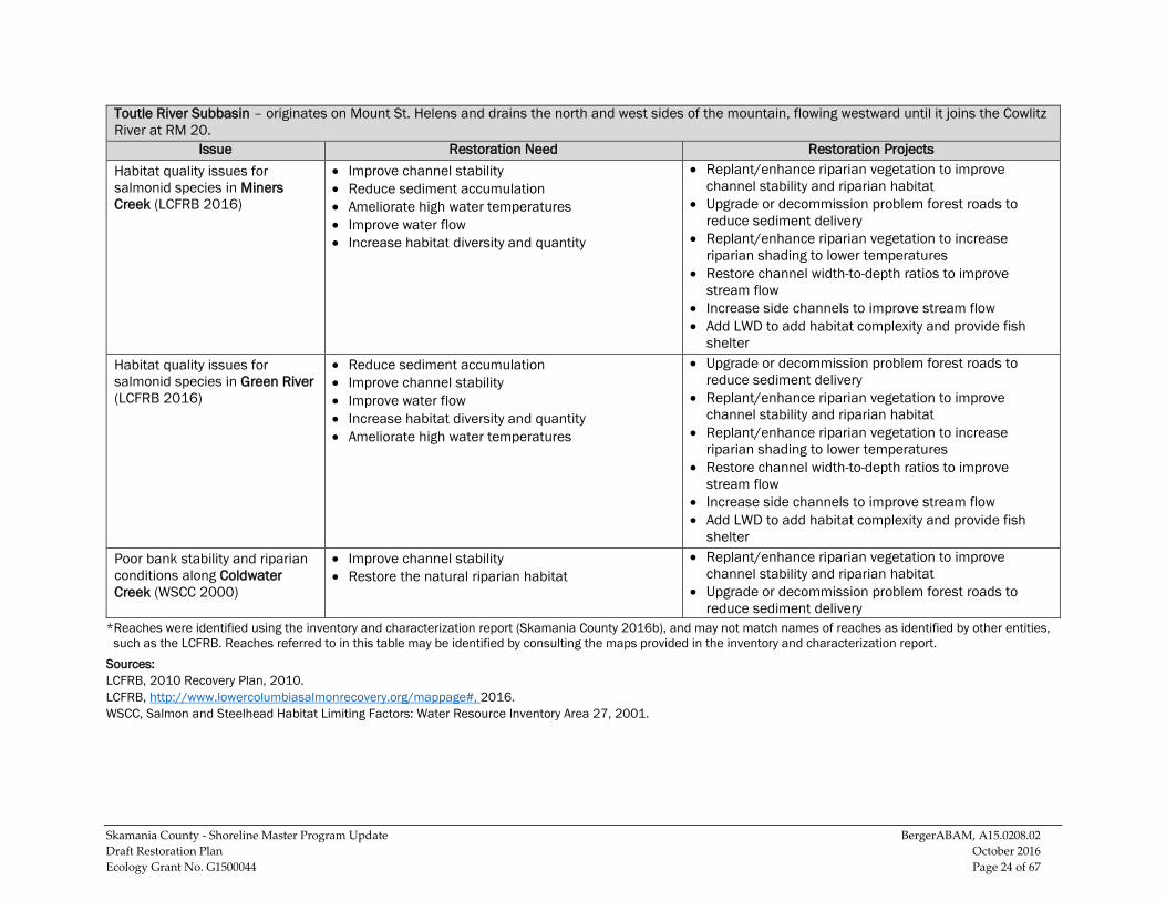
Toutle River Subbasin – originates on Mount St. Helens and drains the north and west sides of the mountain, flowing westward until it joins the Cowlitz River at RM 20.
Issue Restoration Need Restoration Projects Habitat quality issues for salmonid species in Miners Creek (LCFRB 2016)
• Improve channel stability • Reduce sediment accumulation • Ameliorate high water temperatures • Improve water flow • Increase habitat diversity and quantity
• Replant/enhance riparian vegetation to improve channel stability and riparian habitat
• Upgrade or decommission problem forest roads to reduce sediment delivery
• Replant/enhance riparian vegetation to increase riparian shading to lower temperatures
• Restore channel width-to-depth ratios to improve stream flow
• Increase side channels to improve stream flow • Add LWD to add habitat complexity and provide fish
shelter Habitat quality issues for salmonid species in Green River (LCFRB 2016)
• Reduce sediment accumulation • Improve channel stability • Improve water flow • Increase habitat diversity and quantity • Ameliorate high water temperatures
• Upgrade or decommission problem forest roads to reduce sediment delivery
• Replant/enhance riparian vegetation to improve channel stability and riparian habitat
• Replant/enhance riparian vegetation to increase riparian shading to lower temperatures
• Restore channel width-to-depth ratios to improve stream flow
• Increase side channels to improve stream flow • Add LWD to add habitat complexity and provide fish
shelter Poor bank stability and riparian conditions along Coldwater Creek (WSCC 2000)
• Improve channel stability • Restore the natural riparian habitat
• Replant/enhance riparian vegetation to improve channel stability and riparian habitat
• Upgrade or decommission problem forest roads to reduce sediment delivery
*Reaches were identified using the inventory and characterization report (Skamania County 2016b), and may not match names of reaches as identified by other entities, such as the LCFRB. Reaches referred to in this table may be identified by consulting the maps provided in the inventory and characterization report.
Sources: LCFRB, 2010 Recovery Plan, 2010. LCFRB, http://www.lowercolumbiasalmonrecovery.org/mappage#, 2016. WSCC, Salmon and Steelhead Habitat Limiting Factors: Water Resource Inventory Area 27, 2001.
Skamania County - Shoreline Master Program Update BergerABAM, A15.0208.02 Draft Restoration Plan October 2016 Ecology Grant No. G1500044 Page 25 of 67
5.2.2 WRIA 27 - Recommended Restoration Actions Recommended restoration projects for WRIA 27, by subbasin and waterbody, are identified in Table 4. WRIA 27 is located in the west and north-central parts of the County and accounts for a significant amount of its drainage area. WRIA 27 is composed primarily of the North Fork Lewis River subbasin, in addition to the East Fork Lewis River subbasin and a small portion of the Kalama River subbasin.
The North Fork Lewis subbasin is located mostly in Skamania County. The Lewis River has a relatively large and highly viable fall-run Chinook population (Lower Columbia Fish Recovery Board 2010) and documented coastal cutthroat trout habitat (Washington Department of Fish and Wildlife 2015). Issues affecting the subbasin include the isolation of key salmonid habitats because of channel modifications, impaired water quality because of agricultural or forestry practices, and various impacts from fish hatcheries (Lower Columbia Fish Recovery Board 2010).
The East Fork Lewis River subbasin is located in the southwest corner of the County, and most of the subbasin lies in Cowlitz County, to the west. The headwaters of the East Fork Lewis River are located in Skamania County, and have been identified as critical to salmon recovery (Lower Columbia Fish Recovery Board 2010). Ecological functions have been significantly altered and/or adversely impacted according to the 303(d) listings associated with temperature within the subwatershed.
The Kalama River originates on the southwest slopes of Mount St. Helens. Its headwaters are in Skamania County, although 99 percent of the subbasin lie within Cowlitz County. The Dryer Glacier Reach is the only reach within Skamania County’s portion of the subbasin, and this reach of the river flows in a southwesterly direction to the County boundary.
Skamania County - Shoreline Master Program Update BergerABAM, A15.0208.02 Draft Restoration Plan October 2016 Ecology Grant No. G1500044 Page 26 of 67
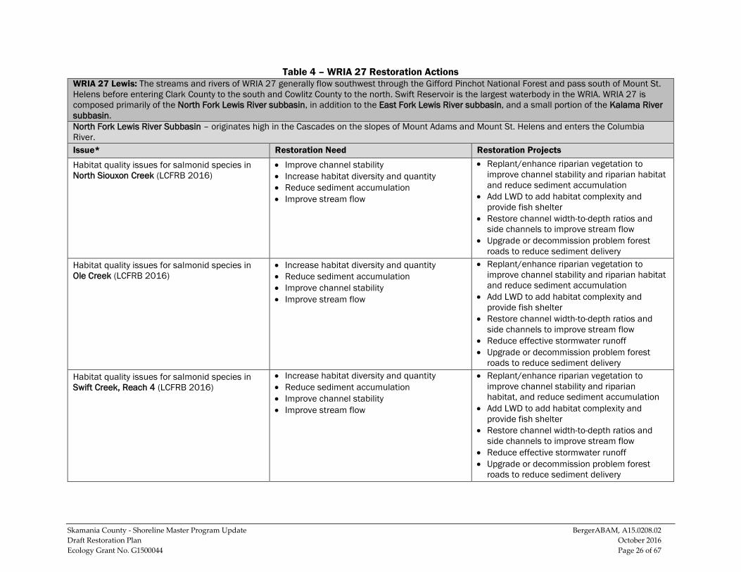
Table 4 – WRIA 27 Restoration Actions WRIA 27 Lewis: The streams and rivers of WRIA 27 generally flow southwest through the Gifford Pinchot National Forest and pass south of Mount St. Helens before entering Clark County to the south and Cowlitz County to the north. Swift Reservoir is the largest waterbody in the WRIA. WRIA 27 is composed primarily of the North Fork Lewis River subbasin, in addition to the East Fork Lewis River subbasin, and a small portion of the Kalama River subbasin. North Fork Lewis River Subbasin – originates high in the Cascades on the slopes of Mount Adams and Mount St. Helens and enters the Columbia River. Issue* Restoration Need Restoration Projects
Habitat quality issues for salmonid species in North Siouxon Creek (LCFRB 2016)
• Improve channel stability • Increase habitat diversity and quantity • Reduce sediment accumulation • Improve stream flow
• Replant/enhance riparian vegetation to improve channel stability and riparian habitat and reduce sediment accumulation
• Add LWD to add habitat complexity and provide fish shelter
• Restore channel width-to-depth ratios and side channels to improve stream flow
• Upgrade or decommission problem forest roads to reduce sediment delivery
Habitat quality issues for salmonid species in Ole Creek (LCFRB 2016)
• Increase habitat diversity and quantity • Reduce sediment accumulation • Improve channel stability • Improve stream flow
• Replant/enhance riparian vegetation to improve channel stability and riparian habitat and reduce sediment accumulation
• Add LWD to add habitat complexity and provide fish shelter
• Restore channel width-to-depth ratios and side channels to improve stream flow
• Reduce effective stormwater runoff • Upgrade or decommission problem forest
roads to reduce sediment delivery Habitat quality issues for salmonid species in Swift Creek, Reach 4 (LCFRB 2016)
• Increase habitat diversity and quantity • Reduce sediment accumulation • Improve channel stability • Improve stream flow
• Replant/enhance riparian vegetation to improve channel stability and riparian habitat, and reduce sediment accumulation
• Add LWD to add habitat complexity and provide fish shelter
• Restore channel width-to-depth ratios and side channels to improve stream flow
• Reduce effective stormwater runoff • Upgrade or decommission problem forest
roads to reduce sediment delivery

Skamania County - Shoreline Master Program Update BergerABAM, A15.0208.02 Draft Restoration Plan October 2016 Ecology Grant No. G1500044 Page 27 of 67
Issue* Restoration Need Restoration Projects
Habitat quality issues for salmonid species in Marble Creek (LCFRB 2016)
• Reduce sediment accumulation • Improve channel stability • Increase habitat diversity and quantity • Improve stream flow
• Replant/enhance riparian vegetation to improve channel stability and riparian habitat, and reduce sediment accumulation
• Add LWD to add habitat complexity and provide fish shelter
• Restore channel width-to-depth ratios and side channels to improve stream flow
• Reduce effective stormwater runoff • Upgrade or decommission problem forest
roads to reduce sediment delivery Habitat quality issues for salmonid species in Range Creek (LCFRB 2016)
• Reduce sediment accumulation • Improve channel stability • Increase habitat diversity and quantity • Improve stream flow
• Replant/enhance riparian vegetation to improve channel stability and riparian habitat, and reduce sediment accumulation
• Add LWD to add habitat complexity and provide fish shelter
• Restore channel width-to-depth ratios and side channels to improve stream flow
• Reduce effective stormwater runoff • Upgrade or decommission problem forest
roads to reduce sediment delivery Habitat quality issues for salmonid species in Drift Creek (LCFRB 2016)
• Reduce sediment accumulation • Improve channel stability • Increase habitat diversity and quantity • Improve stream flow
• Replant/enhance riparian vegetation to improve channel stability and riparian habitat, and reduce sediment accumulation
• Add LWD to add habitat complexity and provide fish shelter
• Restore channel width-to-depth ratios and side channels to improve stream flow
• Reduce effective stormwater runoff • Upgrade or decommission problem forest
roads to reduce sediment delivery
Skamania County - Shoreline Master Program Update BergerABAM, A15.0208.02 Draft Restoration Plan October 2016 Ecology Grant No. G1500044 Page 28 of 67
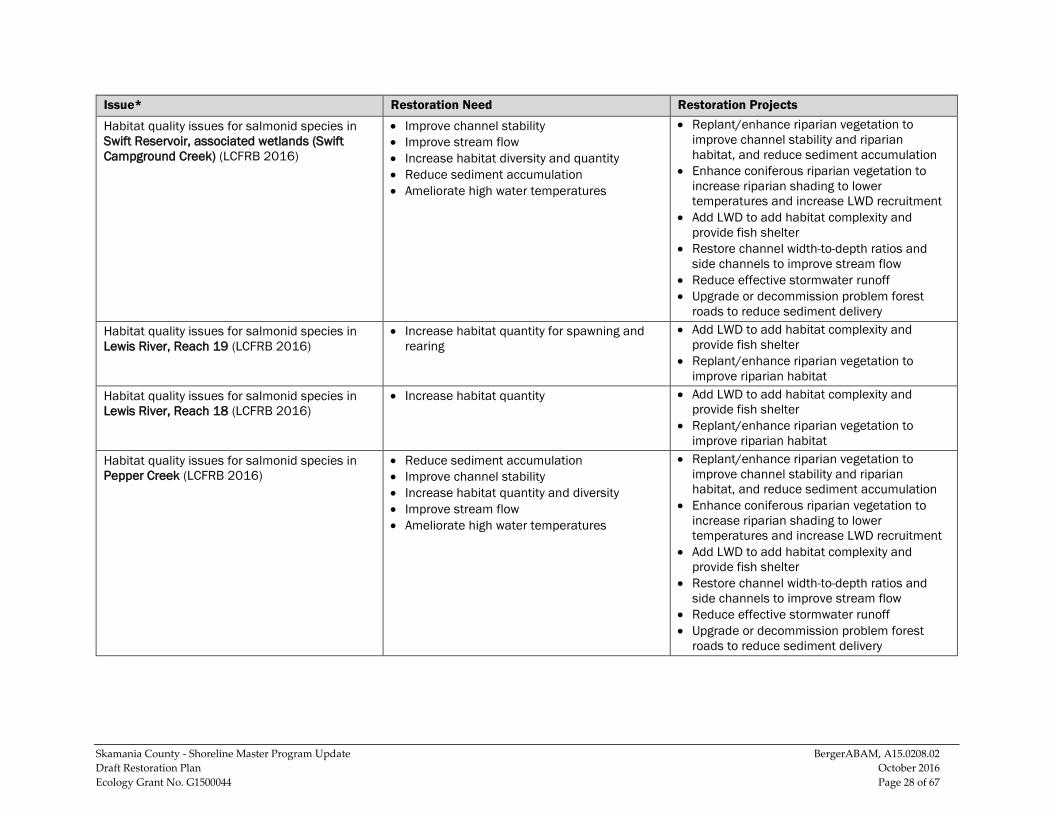
Issue* Restoration Need Restoration Projects
Habitat quality issues for salmonid species in Swift Reservoir, associated wetlands (Swift Campground Creek) (LCFRB 2016)
• Improve channel stability • Improve stream flow • Increase habitat diversity and quantity • Reduce sediment accumulation • Ameliorate high water temperatures
• Replant/enhance riparian vegetation to improve channel stability and riparian habitat, and reduce sediment accumulation
• Enhance coniferous riparian vegetation to increase riparian shading to lower temperatures and increase LWD recruitment
• Add LWD to add habitat complexity and provide fish shelter
• Restore channel width-to-depth ratios and side channels to improve stream flow
• Reduce effective stormwater runoff • Upgrade or decommission problem forest
roads to reduce sediment delivery Habitat quality issues for salmonid species in Lewis River, Reach 19 (LCFRB 2016)
• Increase habitat quantity for spawning and rearing
• Add LWD to add habitat complexity and provide fish shelter
• Replant/enhance riparian vegetation to improve riparian habitat
Habitat quality issues for salmonid species in Lewis River, Reach 18 (LCFRB 2016)
• Increase habitat quantity • Add LWD to add habitat complexity and provide fish shelter
• Replant/enhance riparian vegetation to improve riparian habitat
Habitat quality issues for salmonid species in Pepper Creek (LCFRB 2016)
• Reduce sediment accumulation • Improve channel stability • Increase habitat quantity and diversity • Improve stream flow • Ameliorate high water temperatures
• Replant/enhance riparian vegetation to improve channel stability and riparian habitat, and reduce sediment accumulation
• Enhance coniferous riparian vegetation to increase riparian shading to lower temperatures and increase LWD recruitment
• Add LWD to add habitat complexity and provide fish shelter
• Restore channel width-to-depth ratios and side channels to improve stream flow
• Reduce effective stormwater runoff • Upgrade or decommission problem forest
roads to reduce sediment delivery
Skamania County - Shoreline Master Program Update BergerABAM, A15.0208.02 Draft Restoration Plan October 2016 Ecology Grant No. G1500044 Page 29 of 67
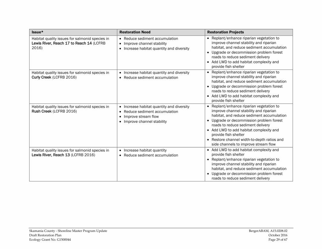
Issue* Restoration Need Restoration Projects
Habitat quality issues for salmonid species in Lewis River, Reach 17 to Reach 14 (LCFRB 2016)
• Reduce sediment accumulation • Improve channel stability • Increase habitat quantity and diversity
• Replant/enhance riparian vegetation to improve channel stability and riparian habitat, and reduce sediment accumulation
• Upgrade or decommission problem forest roads to reduce sediment delivery
• Add LWD to add habitat complexity and provide fish shelter
Habitat quality issues for salmonid species in Curly Creek (LCFRB 2016)
• Increase habitat quantity and diversity • Reduce sediment accumulation
• Replant/enhance riparian vegetation to improve channel stability and riparian habitat, and reduce sediment accumulation
• Upgrade or decommission problem forest roads to reduce sediment delivery
• Add LWD to add habitat complexity and provide fish shelter
Habitat quality issues for salmonid species in Rush Creek (LCFRB 2016)
• Increase habitat quantity and diversity • Reduce sediment accumulation • Improve stream flow • Improve channel stability
• Replant/enhance riparian vegetation to improve channel stability and riparian habitat, and reduce sediment accumulation
• Upgrade or decommission problem forest roads to reduce sediment delivery
• Add LWD to add habitat complexity and provide fish shelter
• Restore channel width-to-depth ratios and side channels to improve stream flow
Habitat quality issues for salmonid species in Lewis River, Reach 13 (LCFRB 2016)
• Increase habitat quantity • Reduce sediment accumulation
• Add LWD to add habitat complexity and provide fish shelter
• Replant/enhance riparian vegetation to improve channel stability and riparian habitat, and reduce sediment accumulation
• Upgrade or decommission problem forest roads to reduce sediment delivery

Skamania County - Shoreline Master Program Update BergerABAM, A15.0208.02 Draft Restoration Plan October 2016 Ecology Grant No. G1500044 Page 30 of 67
Issue* Restoration Need Restoration Projects
Habitat quality issues for salmonid species in Big Creek (LCFRB 2016)
• Increase habitat quantity and diversity • Reduce sediment accumulation • Improve stream flow • Improve channel stability
• Add LWD to add habitat complexity and provide fish shelter
• Replant/enhance riparian vegetation to improve channel stability and riparian habitat, and reduce sediment accumulation
• Upgrade or decommission problem forest roads to reduce sediment delivery
• Restore channel width-to-depth ratios and side channels to improve stream flow
Habitat quality issues for salmonid species in Lewis River, Reach 12 (LCFRB 2016)
• Reduce sediment accumulation • Increase habitat quantity
• Add LWD to add habitat complexity and provide fish shelter
• Replant/enhance riparian vegetation to improve channel stability and riparian habitat, and reduce sediment accumulation
• Upgrade or decommission problem forest roads to reduce sediment delivery
Habitat quality issues for salmonid species in Cussed Hollow (LCFRB 2016)
• Increase habitat quantity and diversity • Improve stream flow • Ameliorate high water temperatures • Reduce sediment accumulation • Improve channel stability
• Add LWD to add habitat complexity and provide fish shelter
• Replant/enhance riparian vegetation to improve channel stability and riparian habitat, and reduce sediment accumulation
• Upgrade or decommission problem forest roads to reduce sediment delivery
• Restore channel width-to-depth ratios and side channels to improve stream flow
Habitat quality issues for salmonid species in Lewis River, Reach 11 (LCFRB 2016)
• Increase habitat quantity and diversity • Reduce sediment accumulation • Improve channel stability
• Add LWD to add habitat complexity and provide fish shelter
• Replant/enhance riparian vegetation to improve channel stability and riparian habitat, and reduce sediment accumulation
• Upgrade or decommission problem forest roads to reduce sediment delivery

Skamania County - Shoreline Master Program Update BergerABAM, A15.0208.02 Draft Restoration Plan October 2016 Ecology Grant No. G1500044 Page 31 of 67
Issue* Restoration Need Restoration Projects
Habitat quality issues for salmonid species in Lewis River, Reach 10 (LCFRB 2016)
• Increase habitat quantity and diversity • Reduce sediment accumulation • Improve stream flow • Ameliorate high water temperatures
• Add LWD to add habitat complexity and provide fish shelter
• Replant/enhance riparian vegetation to improve channel stability and riparian habitat, and reduce sediment accumulation
• Enhance coniferous riparian vegetation to increase riparian shading to lower temperatures and increase LWD recruitment
• Upgrade or decommission problem forest roads to reduce sediment delivery
• Restore channel width-to-depth ratios and side channels to improve stream flow
Habitat quality issues for salmonid species in Chickoom Creek (LCFRB 2016)
• Increase habitat quantity and diversity • Reduce sediment accumulation • Improve stream flow • Ameliorate high water temperatures
• Add LWD to add habitat complexity and provide fish shelter
• Replant/enhance riparian vegetation to improve channel stability and riparian habitat, and reduce sediment accumulation
• Enhance coniferous riparian vegetation to increase riparian shading to lower temperatures and increase LWD recruitment
• Upgrade or decommission problem forest roads to reduce sediment delivery
• Restore channel width-to-depth ratios and side channels to improve stream flow
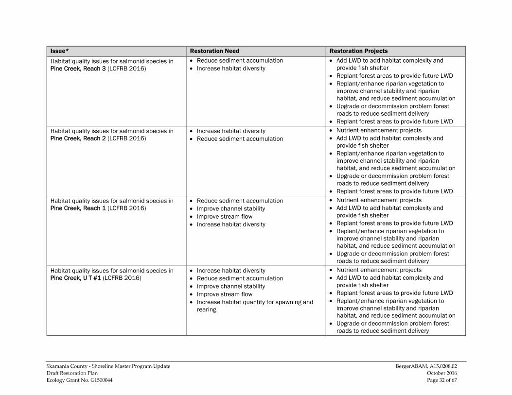
Habitat quality issues for salmonid species in Pine Creek, Reach 4 (LCFRB 2016); has low LWD quantities and recruitment potential (WSCC 2000)
• Increase habitat diversity • Reduce sediment accumulation
• Add LWD to add habitat complexity and provide fish shelter
• Replant forest areas to provide future LWD • Replant/enhance riparian vegetation to
improve channel stability and riparian habitat, and reduce sediment accumulation
• Upgrade or decommission problem forest roads to reduce sediment delivery
Skamania County - Shoreline Master Program Update BergerABAM, A15.0208.02 Draft Restoration Plan October 2016 Ecology Grant No. G1500044 Page 32 of 67
Issue* Restoration Need Restoration Projects
Habitat quality issues for salmonid species in Pine Creek, Reach 3 (LCFRB 2016)
• Reduce sediment accumulation • Increase habitat diversity
• Add LWD to add habitat complexity and provide fish shelter
• Replant forest areas to provide future LWD • Replant/enhance riparian vegetation to
improve channel stability and riparian habitat, and reduce sediment accumulation
• Upgrade or decommission problem forest roads to reduce sediment delivery
• Replant forest areas to provide future LWD Habitat quality issues for salmonid species in Pine Creek, Reach 2 (LCFRB 2016)
• Increase habitat diversity • Reduce sediment accumulation
• Nutrient enhancement projects • Add LWD to add habitat complexity and
provide fish shelter • Replant/enhance riparian vegetation to
improve channel stability and riparian habitat, and reduce sediment accumulation
• Upgrade or decommission problem forest roads to reduce sediment delivery
• Replant forest areas to provide future LWD Habitat quality issues for salmonid species in Pine Creek, Reach 1 (LCFRB 2016)
• Reduce sediment accumulation • Improve channel stability • Improve stream flow • Increase habitat diversity
• Nutrient enhancement projects • Add LWD to add habitat complexity and
provide fish shelter • Replant forest areas to provide future LWD • Replant/enhance riparian vegetation to
improve channel stability and riparian habitat, and reduce sediment accumulation
• Upgrade or decommission problem forest roads to reduce sediment delivery
Habitat quality issues for salmonid species in Pine Creek, U T #1 (LCFRB 2016)
• Increase habitat diversity • Reduce sediment accumulation • Improve channel stability • Improve stream flow • Increase habitat quantity for spawning and
rearing
• Nutrient enhancement projects • Add LWD to add habitat complexity and
provide fish shelter • Replant forest areas to provide future LWD • Replant/enhance riparian vegetation to
improve channel stability and riparian habitat, and reduce sediment accumulation
• Upgrade or decommission problem forest roads to reduce sediment delivery
Skamania County - Shoreline Master Program Update BergerABAM, A15.0208.02 Draft Restoration Plan October 2016 Ecology Grant No. G1500044 Page 33 of 67
Issue* Restoration Need Restoration Projects
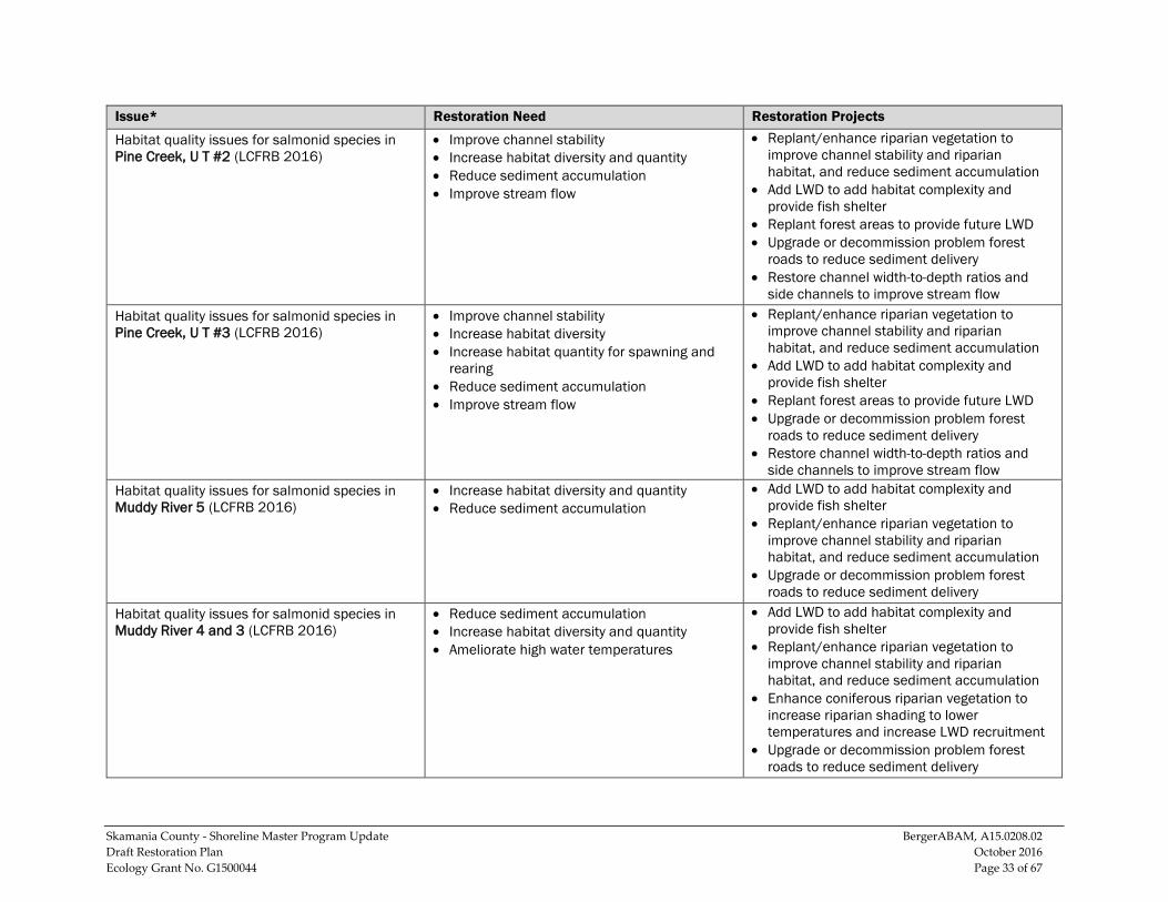
Habitat quality issues for salmonid species in Pine Creek, U T #2 (LCFRB 2016)
• Improve channel stability • Increase habitat diversity and quantity • Reduce sediment accumulation • Improve stream flow
• Replant/enhance riparian vegetation to improve channel stability and riparian habitat, and reduce sediment accumulation
• Add LWD to add habitat complexity and provide fish shelter
• Replant forest areas to provide future LWD • Upgrade or decommission problem forest
roads to reduce sediment delivery • Restore channel width-to-depth ratios and
side channels to improve stream flow Habitat quality issues for salmonid species in Pine Creek, U T #3 (LCFRB 2016)
• Improve channel stability • Increase habitat diversity • Increase habitat quantity for spawning and
rearing • Reduce sediment accumulation • Improve stream flow
• Replant/enhance riparian vegetation to improve channel stability and riparian habitat, and reduce sediment accumulation
• Add LWD to add habitat complexity and provide fish shelter
• Replant forest areas to provide future LWD • Upgrade or decommission problem forest
roads to reduce sediment delivery • Restore channel width-to-depth ratios and
side channels to improve stream flow Habitat quality issues for salmonid species in Muddy River 5 (LCFRB 2016)
• Increase habitat diversity and quantity • Reduce sediment accumulation
• Add LWD to add habitat complexity and provide fish shelter
• Replant/enhance riparian vegetation to improve channel stability and riparian habitat, and reduce sediment accumulation
• Upgrade or decommission problem forest roads to reduce sediment delivery
Habitat quality issues for salmonid species in Muddy River 4 and 3 (LCFRB 2016)
• Reduce sediment accumulation • Increase habitat diversity and quantity • Ameliorate high water temperatures
• Add LWD to add habitat complexity and provide fish shelter
• Replant/enhance riparian vegetation to improve channel stability and riparian habitat, and reduce sediment accumulation
• Enhance coniferous riparian vegetation to increase riparian shading to lower temperatures and increase LWD recruitment
• Upgrade or decommission problem forest roads to reduce sediment delivery
Skamania County - Shoreline Master Program Update BergerABAM, A15.0208.02 Draft Restoration Plan October 2016 Ecology Grant No. G1500044 Page 34 of 67
Issue* Restoration Need Restoration Projects
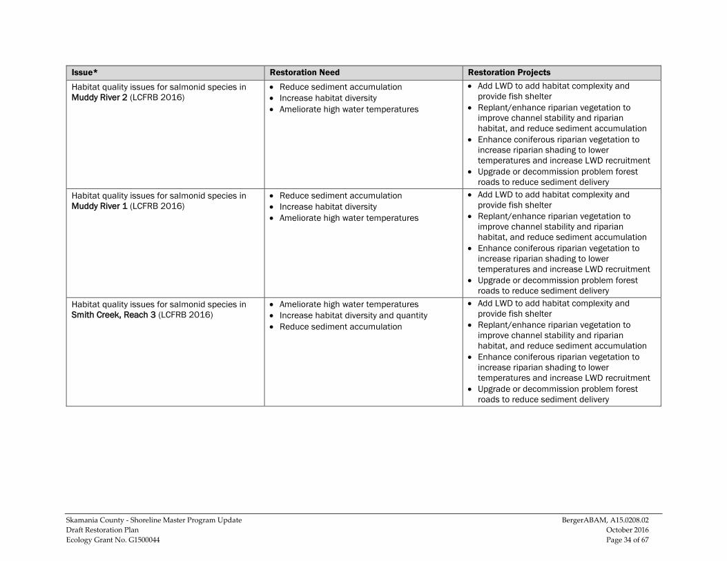
Habitat quality issues for salmonid species in Muddy River 2 (LCFRB 2016)
• Reduce sediment accumulation • Increase habitat diversity • Ameliorate high water temperatures
• Add LWD to add habitat complexity and provide fish shelter
• Replant/enhance riparian vegetation to improve channel stability and riparian habitat, and reduce sediment accumulation
• Enhance coniferous riparian vegetation to increase riparian shading to lower temperatures and increase LWD recruitment
• Upgrade or decommission problem forest roads to reduce sediment delivery
Habitat quality issues for salmonid species in Muddy River 1 (LCFRB 2016)
• Reduce sediment accumulation • Increase habitat diversity • Ameliorate high water temperatures
• Add LWD to add habitat complexity and provide fish shelter
• Replant/enhance riparian vegetation to improve channel stability and riparian habitat, and reduce sediment accumulation
• Enhance coniferous riparian vegetation to increase riparian shading to lower temperatures and increase LWD recruitment
• Upgrade or decommission problem forest roads to reduce sediment delivery
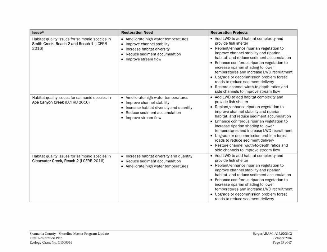
Habitat quality issues for salmonid species in Smith Creek, Reach 3 (LCFRB 2016)
• Ameliorate high water temperatures • Increase habitat diversity and quantity • Reduce sediment accumulation
• Add LWD to add habitat complexity and provide fish shelter
• Replant/enhance riparian vegetation to improve channel stability and riparian habitat, and reduce sediment accumulation
• Enhance coniferous riparian vegetation to increase riparian shading to lower temperatures and increase LWD recruitment
• Upgrade or decommission problem forest roads to reduce sediment delivery
Skamania County - Shoreline Master Program Update BergerABAM, A15.0208.02 Draft Restoration Plan October 2016 Ecology Grant No. G1500044 Page 35 of 67
Issue* Restoration Need Restoration Projects
Habitat quality issues for salmonid species in Smith Creek, Reach 2 and Reach 1 (LCFRB 2016)
• Ameliorate high water temperatures • Improve channel stability • Increase habitat diversity • Reduce sediment accumulation • Improve stream flow
• Add LWD to add habitat complexity and provide fish shelter
• Replant/enhance riparian vegetation to improve channel stability and riparian habitat, and reduce sediment accumulation
• Enhance coniferous riparian vegetation to increase riparian shading to lower temperatures and increase LWD recruitment
• Upgrade or decommission problem forest roads to reduce sediment delivery
• Restore channel width-to-depth ratios and side channels to improve stream flow
Habitat quality issues for salmonid species in Ape Canyon Creek (LCFRB 2016)
• Ameliorate high water temperatures • Improve channel stability • Increase habitat diversity and quantity • Reduce sediment accumulation • Improve stream flow
• Add LWD to add habitat complexity and provide fish shelter
• Replant/enhance riparian vegetation to improve channel stability and riparian habitat, and reduce sediment accumulation
• Enhance coniferous riparian vegetation to increase riparian shading to lower temperatures and increase LWD recruitment
• Upgrade or decommission problem forest roads to reduce sediment delivery
• Restore channel width-to-depth ratios and side channels to improve stream flow
Habitat quality issues for salmonid species in Clearwater Creek, Reach 2 (LCFRB 2016)
• Increase habitat diversity and quantity • Reduce sediment accumulation • Ameliorate high water temperatures
• Add LWD to add habitat complexity and provide fish shelter
• Replant/enhance riparian vegetation to improve channel stability and riparian habitat, and reduce sediment accumulation
• Enhance coniferous riparian vegetation to increase riparian shading to lower temperatures and increase LWD recruitment
• Upgrade or decommission problem forest roads to reduce sediment delivery
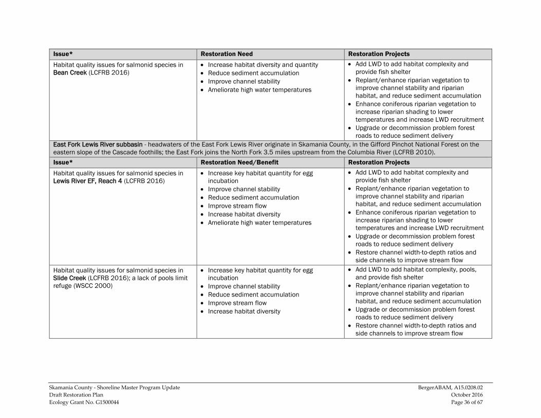
Skamania County - Shoreline Master Program Update BergerABAM, A15.0208.02 Draft Restoration Plan October 2016 Ecology Grant No. G1500044 Page 36 of 67
Issue* Restoration Need Restoration Projects
Habitat quality issues for salmonid species in Bean Creek (LCFRB 2016)
• Increase habitat diversity and quantity • Reduce sediment accumulation • Improve channel stability • Ameliorate high water temperatures
• Add LWD to add habitat complexity and provide fish shelter
• Replant/enhance riparian vegetation to improve channel stability and riparian habitat, and reduce sediment accumulation
• Enhance coniferous riparian vegetation to increase riparian shading to lower temperatures and increase LWD recruitment
• Upgrade or decommission problem forest roads to reduce sediment delivery
East Fork Lewis River subbasin - headwaters of the East Fork Lewis River originate in Skamania County, in the Gifford Pinchot National Forest on the eastern slope of the Cascade foothills; the East Fork joins the North Fork 3.5 miles upstream from the Columbia River (LCFRB 2010). Issue* Restoration Need/Benefit Restoration Projects
Habitat quality issues for salmonid species in Lewis River EF, Reach 4 (LCFRB 2016)
• Increase key habitat quantity for egg incubation
• Improve channel stability • Reduce sediment accumulation • Improve stream flow • Increase habitat diversity • Ameliorate high water temperatures
• Add LWD to add habitat complexity and provide fish shelter
• Replant/enhance riparian vegetation to improve channel stability and riparian habitat, and reduce sediment accumulation
• Enhance coniferous riparian vegetation to increase riparian shading to lower temperatures and increase LWD recruitment
• Upgrade or decommission problem forest roads to reduce sediment delivery
• Restore channel width-to-depth ratios and side channels to improve stream flow
Habitat quality issues for salmonid species in Slide Creek (LCFRB 2016); a lack of pools limit refuge (WSCC 2000)
• Increase key habitat quantity for egg incubation
• Improve channel stability • Reduce sediment accumulation • Improve stream flow • Increase habitat diversity
• Add LWD to add habitat complexity, pools, and provide fish shelter
• Replant/enhance riparian vegetation to improve channel stability and riparian habitat, and reduce sediment accumulation
• Upgrade or decommission problem forest roads to reduce sediment delivery
• Restore channel width-to-depth ratios and side channels to improve stream flow
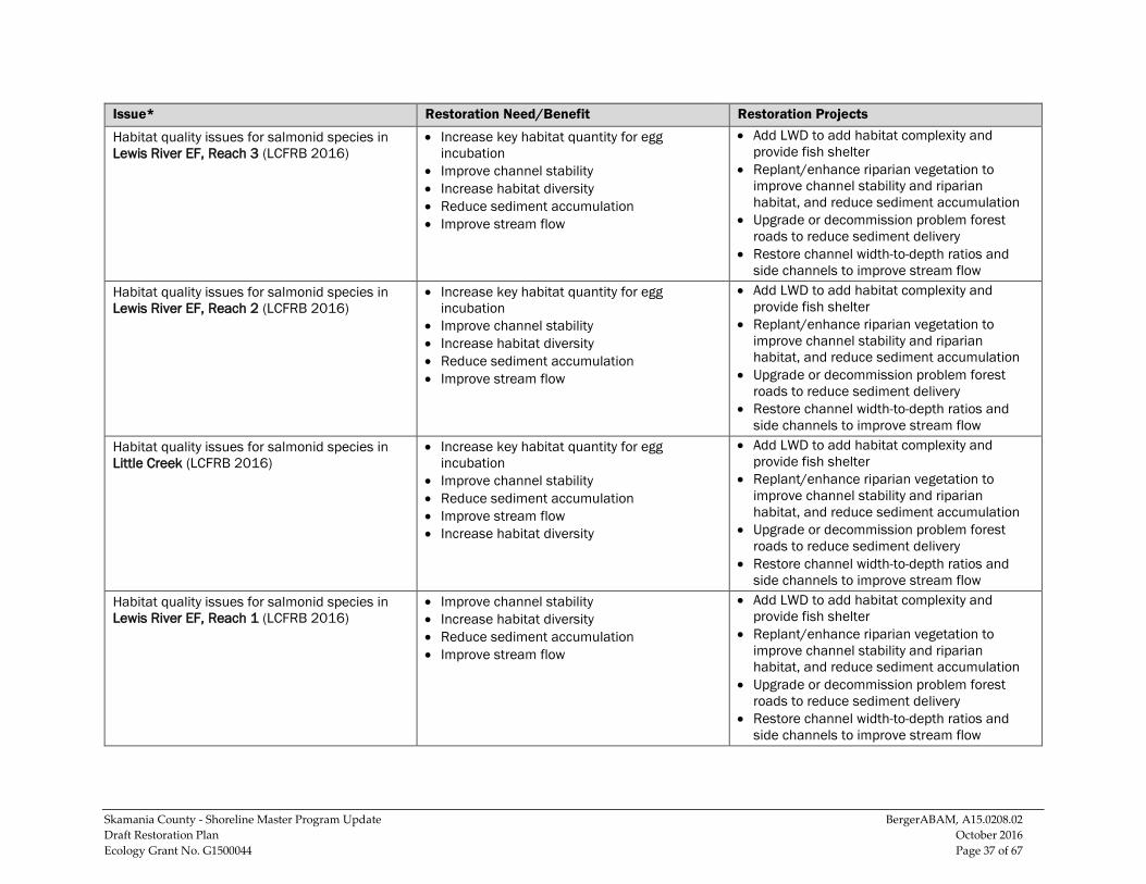
Skamania County - Shoreline Master Program Update BergerABAM, A15.0208.02 Draft Restoration Plan October 2016 Ecology Grant No. G1500044 Page 37 of 67
Issue* Restoration Need/Benefit Restoration Projects
Habitat quality issues for salmonid species in Lewis River EF, Reach 3 (LCFRB 2016)
• Increase key habitat quantity for egg incubation
• Improve channel stability • Increase habitat diversity • Reduce sediment accumulation • Improve stream flow
• Add LWD to add habitat complexity and provide fish shelter
• Replant/enhance riparian vegetation to improve channel stability and riparian habitat, and reduce sediment accumulation
• Upgrade or decommission problem forest roads to reduce sediment delivery
• Restore channel width-to-depth ratios and side channels to improve stream flow
Habitat quality issues for salmonid species in Lewis River EF, Reach 2 (LCFRB 2016)
• Increase key habitat quantity for egg incubation
• Improve channel stability • Increase habitat diversity • Reduce sediment accumulation • Improve stream flow
• Add LWD to add habitat complexity and provide fish shelter
• Replant/enhance riparian vegetation to improve channel stability and riparian habitat, and reduce sediment accumulation
• Upgrade or decommission problem forest roads to reduce sediment delivery
• Restore channel width-to-depth ratios and side channels to improve stream flow
Habitat quality issues for salmonid species in Little Creek (LCFRB 2016)
• Increase key habitat quantity for egg incubation
• Improve channel stability • Reduce sediment accumulation • Improve stream flow • Increase habitat diversity
• Add LWD to add habitat complexity and provide fish shelter
• Replant/enhance riparian vegetation to improve channel stability and riparian habitat, and reduce sediment accumulation
• Upgrade or decommission problem forest roads to reduce sediment delivery
• Restore channel width-to-depth ratios and side channels to improve stream flow
Habitat quality issues for salmonid species in Lewis River EF, Reach 1 (LCFRB 2016)
• Improve channel stability • Increase habitat diversity • Reduce sediment accumulation • Improve stream flow
• Add LWD to add habitat complexity and provide fish shelter
• Replant/enhance riparian vegetation to improve channel stability and riparian habitat, and reduce sediment accumulation
• Upgrade or decommission problem forest roads to reduce sediment delivery
• Restore channel width-to-depth ratios and side channels to improve stream flow
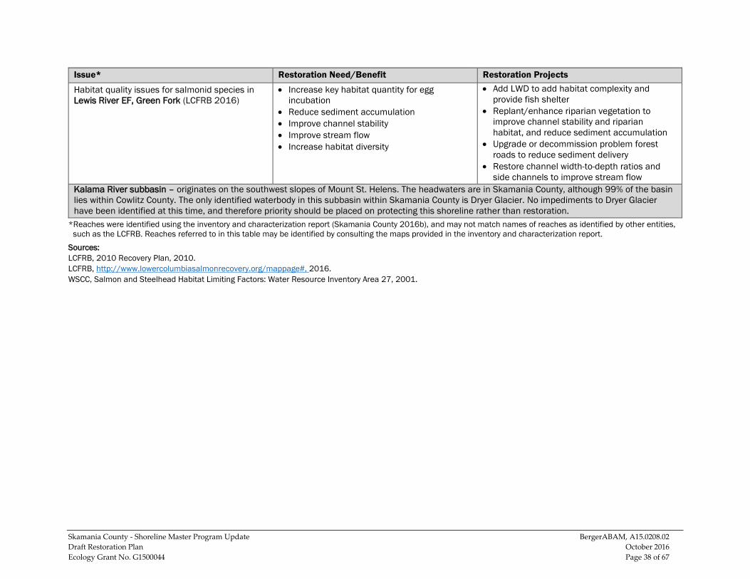
Skamania County - Shoreline Master Program Update BergerABAM, A15.0208.02 Draft Restoration Plan October 2016 Ecology Grant No. G1500044 Page 38 of 67
Issue* Restoration Need/Benefit Restoration Projects
Habitat quality issues for salmonid species in Lewis River EF, Green Fork (LCFRB 2016)
• Increase key habitat quantity for egg incubation
• Reduce sediment accumulation • Improve channel stability • Improve stream flow • Increase habitat diversity
• Add LWD to add habitat complexity and provide fish shelter
• Replant/enhance riparian vegetation to improve channel stability and riparian habitat, and reduce sediment accumulation
• Upgrade or decommission problem forest roads to reduce sediment delivery
• Restore channel width-to-depth ratios and side channels to improve stream flow
Kalama River subbasin – originates on the southwest slopes of Mount St. Helens. The headwaters are in Skamania County, although 99% of the basin lies within Cowlitz County. The only identified waterbody in this subbasin within Skamania County is Dryer Glacier. No impediments to Dryer Glacier have been identified at this time, and therefore priority should be placed on protecting this shoreline rather than restoration.
*Reaches were identified using the inventory and characterization report (Skamania County 2016b), and may not match names of reaches as identified by other entities, such as the LCFRB. Reaches referred to in this table may be identified by consulting the maps provided in the inventory and characterization report.
Sources: LCFRB, 2010 Recovery Plan, 2010. LCFRB, http://www.lowercolumbiasalmonrecovery.org/mappage#, 2016. WSCC, Salmon and Steelhead Habitat Limiting Factors: Water Resource Inventory Area 27, 2001.
Skamania County - Shoreline Master Program Update BergerABAM, A15.0208.02 Draft Restoration Plan October 2016 Ecology Grant No. G1500044 Page 39 of 67
5.2.3 WRIA 28 - Recommended Restoration Actions Recommended restoration projects for WRIA 28, by subbasin and waterbody, are identified in Table 5. WRIA 28 is located within the southwest portion of the County, and includes two subbasins in Skamania County: the Washougal River subbasin and the Lower Columbia Gorge tributaries subbasin.
The Washougal River subbasin is almost evenly divided between Skamania County and Clark County. The headwaters of the Washougal River are located in Skamania County, approximately 12 miles northwest of the city of Stevenson, and in the northeast corner of WRIA 28. Significant causes of impairments in this subbasin include loss of habitat, harvesting, and impacts from fish hatcheries (Lower Columbia Fish Recovery Board 2010).
The Lower Columbia Gorge tributaries subbasin includes all the streams between Bonneville Dam and Vancouver, except Salmon Creek and the Washougal River. Ecological concerns in this subbasin include loss of habitat diversity, low stream flows, sedimentation, temperature, human impacts, and degraded riparian conditions (Lower Columbia Fish Recovery Board 2010).
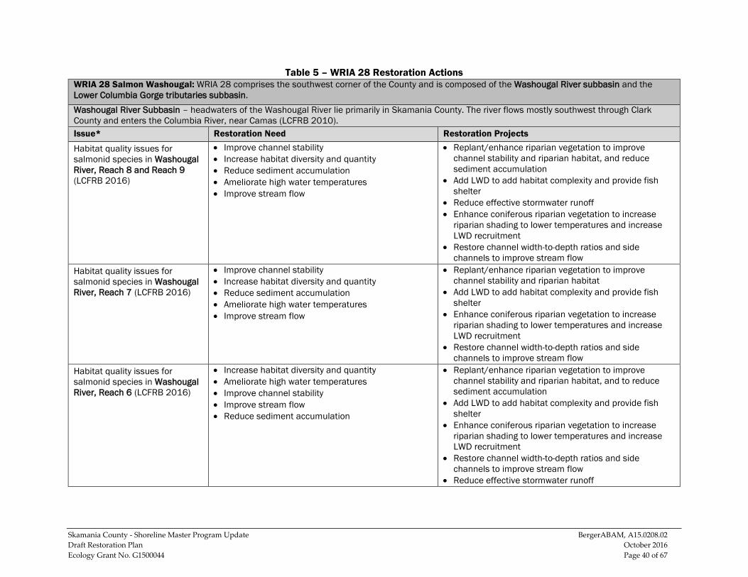
Skamania County - Shoreline Master Program Update BergerABAM, A15.0208.02 Draft Restoration Plan October 2016 Ecology Grant No. G1500044 Page 40 of 67
Table 5 – WRIA 28 Restoration Actions WRIA 28 Salmon Washougal: WRIA 28 comprises the southwest corner of the County and is composed of the Washougal River subbasin and the Lower Columbia Gorge tributaries subbasin. Washougal River Subbasin – headwaters of the Washougal River lie primarily in Skamania County. The river flows mostly southwest through Clark County and enters the Columbia River, near Camas (LCFRB 2010). Issue* Restoration Need Restoration Projects
Habitat quality issues for salmonid species in Washougal River, Reach 8 and Reach 9 (LCFRB 2016)
• Improve channel stability • Increase habitat diversity and quantity • Reduce sediment accumulation • Ameliorate high water temperatures • Improve stream flow
• Replant/enhance riparian vegetation to improve channel stability and riparian habitat, and reduce sediment accumulation
• Add LWD to add habitat complexity and provide fish shelter
• Reduce effective stormwater runoff • Enhance coniferous riparian vegetation to increase
riparian shading to lower temperatures and increase LWD recruitment
• Restore channel width-to-depth ratios and side channels to improve stream flow
Habitat quality issues for salmonid species in Washougal River, Reach 7 (LCFRB 2016)
• Improve channel stability • Increase habitat diversity and quantity • Reduce sediment accumulation • Ameliorate high water temperatures • Improve stream flow
• Replant/enhance riparian vegetation to improve channel stability and riparian habitat
• Add LWD to add habitat complexity and provide fish shelter
• Enhance coniferous riparian vegetation to increase riparian shading to lower temperatures and increase LWD recruitment
• Restore channel width-to-depth ratios and side channels to improve stream flow
Habitat quality issues for salmonid species in Washougal River, Reach 6 (LCFRB 2016)
• Increase habitat diversity and quantity • Ameliorate high water temperatures • Improve channel stability • Improve stream flow • Reduce sediment accumulation
• Replant/enhance riparian vegetation to improve channel stability and riparian habitat, and to reduce sediment accumulation
• Add LWD to add habitat complexity and provide fish shelter
• Enhance coniferous riparian vegetation to increase riparian shading to lower temperatures and increase LWD recruitment
• Restore channel width-to-depth ratios and side channels to improve stream flow
• Reduce effective stormwater runoff
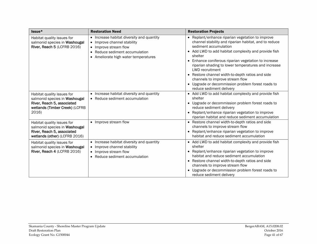
Skamania County - Shoreline Master Program Update BergerABAM, A15.0208.02 Draft Restoration Plan October 2016 Ecology Grant No. G1500044 Page 41 of 67
Issue* Restoration Need Restoration Projects
Habitat quality issues for salmonid species in Washougal River, Reach 5 (LCFRB 2016)
• Increase habitat diversity and quantity • Improve channel stability • Improve stream flow • Reduce sediment accumulation • Ameliorate high water temperatures
• Replant/enhance riparian vegetation to improve channel stability and riparian habitat, and to reduce sediment accumulation
• Add LWD to add habitat complexity and provide fish shelter
• Enhance coniferous riparian vegetation to increase riparian shading to lower temperatures and increase LWD recruitment
• Restore channel width-to-depth ratios and side channels to improve stream flow
• Upgrade or decommission problem forest roads to reduce sediment delivery
Habitat quality issues for salmonid species in Washougal River, Reach 5, associated wetlands (Timber Creek) (LCFRB 2016)
• Increase habitat diversity and quantity • Reduce sediment accumulation
• Add LWD to add habitat complexity and provide fish shelter
• Upgrade or decommission problem forest roads to reduce sediment delivery
• Replant/enhance riparian vegetation to improve riparian habitat and reduce sediment accumulation
Habitat quality issues for salmonid species in Washougal River, Reach 5, associated wetlands (other) (LCFRB 2016)
• Improve stream flow • Restore channel width-to-depth ratios and side channels to improve stream flow
• Replant/enhance riparian vegetation to improve habitat and reduce sediment accumulation
Habitat quality issues for salmonid species in Washougal River, Reach 4 (LCFRB 2016)
• Increase habitat diversity and quantity • Improve channel stability • Improve stream flow • Reduce sediment accumulation
• Add LWD to add habitat complexity and provide fish shelter
• Replant/enhance riparian vegetation to improve habitat and reduce sediment accumulation
• Restore channel width-to-depth ratios and side channels to improve stream flow
• Upgrade or decommission problem forest roads to reduce sediment delivery
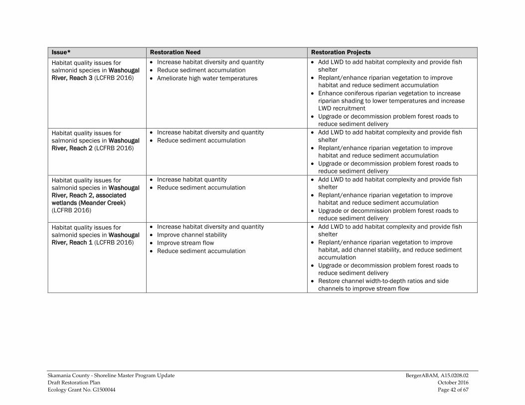
Skamania County - Shoreline Master Program Update BergerABAM, A15.0208.02 Draft Restoration Plan October 2016 Ecology Grant No. G1500044 Page 42 of 67
Issue* Restoration Need Restoration Projects
Habitat quality issues for salmonid species in Washougal River, Reach 3 (LCFRB 2016)
• Increase habitat diversity and quantity • Reduce sediment accumulation • Ameliorate high water temperatures
• Add LWD to add habitat complexity and provide fish shelter
• Replant/enhance riparian vegetation to improve habitat and reduce sediment accumulation
• Enhance coniferous riparian vegetation to increase riparian shading to lower temperatures and increase LWD recruitment
• Upgrade or decommission problem forest roads to reduce sediment delivery
Habitat quality issues for salmonid species in Washougal River, Reach 2 (LCFRB 2016)
• Increase habitat diversity and quantity • Reduce sediment accumulation
• Add LWD to add habitat complexity and provide fish shelter
• Replant/enhance riparian vegetation to improve habitat and reduce sediment accumulation
• Upgrade or decommission problem forest roads to reduce sediment delivery
Habitat quality issues for salmonid species in Washougal River, Reach 2, associated wetlands (Meander Creek) (LCFRB 2016)
• Increase habitat quantity • Reduce sediment accumulation
• Add LWD to add habitat complexity and provide fish shelter
• Replant/enhance riparian vegetation to improve habitat and reduce sediment accumulation
• Upgrade or decommission problem forest roads to reduce sediment delivery
Habitat quality issues for salmonid species in Washougal River, Reach 1 (LCFRB 2016)
• Increase habitat diversity and quantity • Improve channel stability • Improve stream flow • Reduce sediment accumulation
• Add LWD to add habitat complexity and provide fish shelter
• Replant/enhance riparian vegetation to improve habitat, add channel stability, and reduce sediment accumulation
• Upgrade or decommission problem forest roads to reduce sediment delivery
• Restore channel width-to-depth ratios and side channels to improve stream flow
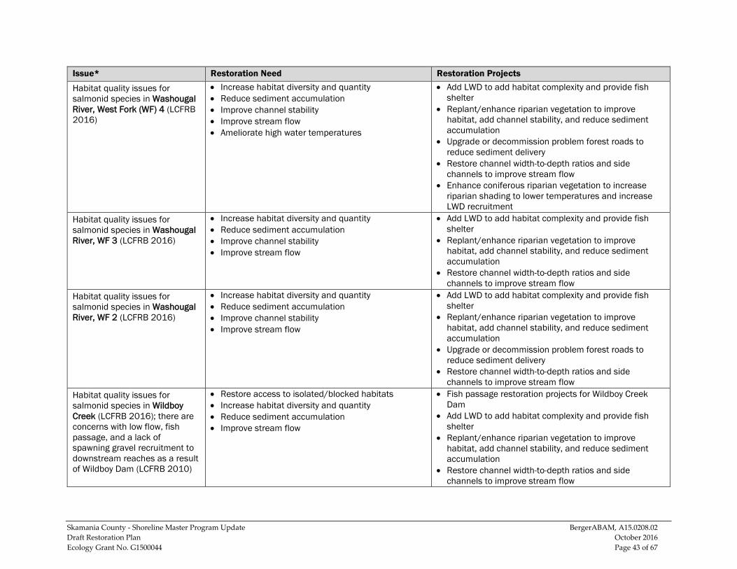
Skamania County - Shoreline Master Program Update BergerABAM, A15.0208.02 Draft Restoration Plan October 2016 Ecology Grant No. G1500044 Page 43 of 67
Issue* Restoration Need Restoration Projects
Habitat quality issues for salmonid species in Washougal River, West Fork (WF) 4 (LCFRB 2016)
• Increase habitat diversity and quantity • Reduce sediment accumulation • Improve channel stability • Improve stream flow • Ameliorate high water temperatures
• Add LWD to add habitat complexity and provide fish shelter
• Replant/enhance riparian vegetation to improve habitat, add channel stability, and reduce sediment accumulation
• Upgrade or decommission problem forest roads to reduce sediment delivery
• Restore channel width-to-depth ratios and side channels to improve stream flow
• Enhance coniferous riparian vegetation to increase riparian shading to lower temperatures and increase LWD recruitment
Habitat quality issues for salmonid species in Washougal River, WF 3 (LCFRB 2016)
• Increase habitat diversity and quantity • Reduce sediment accumulation • Improve channel stability • Improve stream flow
• Add LWD to add habitat complexity and provide fish shelter
• Replant/enhance riparian vegetation to improve habitat, add channel stability, and reduce sediment accumulation
• Restore channel width-to-depth ratios and side channels to improve stream flow
Habitat quality issues for salmonid species in Washougal River, WF 2 (LCFRB 2016)
• Increase habitat diversity and quantity • Reduce sediment accumulation • Improve channel stability • Improve stream flow
• Add LWD to add habitat complexity and provide fish shelter
• Replant/enhance riparian vegetation to improve habitat, add channel stability, and reduce sediment accumulation
• Upgrade or decommission problem forest roads to reduce sediment delivery
• Restore channel width-to-depth ratios and side channels to improve stream flow
Habitat quality issues for salmonid species in Wildboy Creek (LCFRB 2016); there are concerns with low flow, fish passage, and a lack of spawning gravel recruitment to downstream reaches as a result of Wildboy Dam (LCFRB 2010)
• Restore access to isolated/blocked habitats • Increase habitat diversity and quantity • Reduce sediment accumulation • Improve stream flow
• Fish passage restoration projects for Wildboy Creek Dam
• Add LWD to add habitat complexity and provide fish shelter
• Replant/enhance riparian vegetation to improve habitat, add channel stability, and reduce sediment accumulation
• Restore channel width-to-depth ratios and side channels to improve stream flow
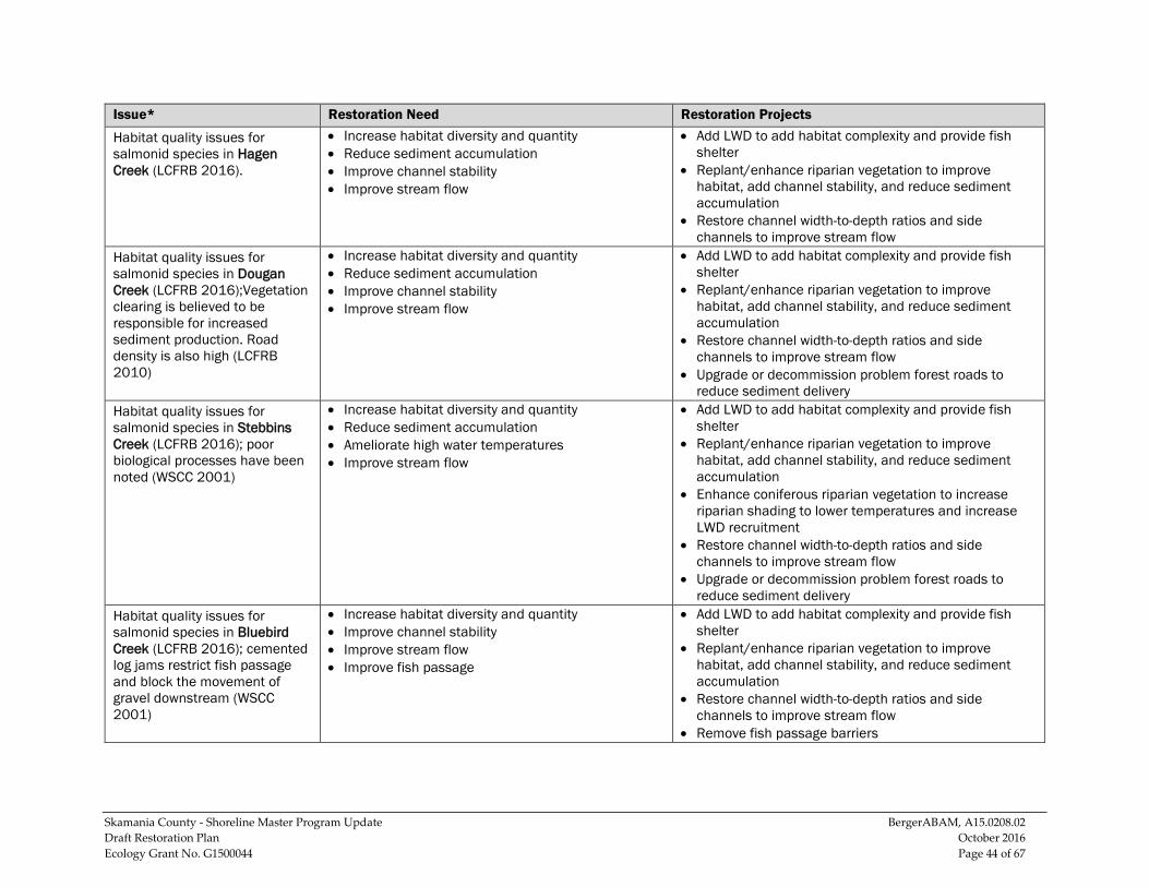
Skamania County - Shoreline Master Program Update BergerABAM, A15.0208.02 Draft Restoration Plan October 2016 Ecology Grant No. G1500044 Page 44 of 67
Issue* Restoration Need Restoration Projects
Habitat quality issues for salmonid species in Hagen Creek (LCFRB 2016).
• Increase habitat diversity and quantity • Reduce sediment accumulation • Improve channel stability • Improve stream flow
• Add LWD to add habitat complexity and provide fish shelter
• Replant/enhance riparian vegetation to improve habitat, add channel stability, and reduce sediment accumulation
• Restore channel width-to-depth ratios and side channels to improve stream flow
Habitat quality issues for salmonid species in Dougan Creek (LCFRB 2016);Vegetation clearing is believed to be responsible for increased sediment production. Road density is also high (LCFRB 2010)
• Increase habitat diversity and quantity • Reduce sediment accumulation • Improve channel stability • Improve stream flow
• Add LWD to add habitat complexity and provide fish shelter
• Replant/enhance riparian vegetation to improve habitat, add channel stability, and reduce sediment accumulation
• Restore channel width-to-depth ratios and side channels to improve stream flow
• Upgrade or decommission problem forest roads to reduce sediment delivery
Habitat quality issues for salmonid species in Stebbins Creek (LCFRB 2016); poor biological processes have been noted (WSCC 2001)
• Increase habitat diversity and quantity • Reduce sediment accumulation • Ameliorate high water temperatures • Improve stream flow
• Add LWD to add habitat complexity and provide fish shelter
• Replant/enhance riparian vegetation to improve habitat, add channel stability, and reduce sediment accumulation
• Enhance coniferous riparian vegetation to increase riparian shading to lower temperatures and increase LWD recruitment
• Restore channel width-to-depth ratios and side channels to improve stream flow
• Upgrade or decommission problem forest roads to reduce sediment delivery
Habitat quality issues for salmonid species in Bluebird Creek (LCFRB 2016); cemented log jams restrict fish passage and block the movement of gravel downstream (WSCC 2001)
• Increase habitat diversity and quantity • Improve channel stability • Improve stream flow • Improve fish passage
• Add LWD to add habitat complexity and provide fish shelter
• Replant/enhance riparian vegetation to improve habitat, add channel stability, and reduce sediment accumulation
• Restore channel width-to-depth ratios and side channels to improve stream flow
• Remove fish passage barriers
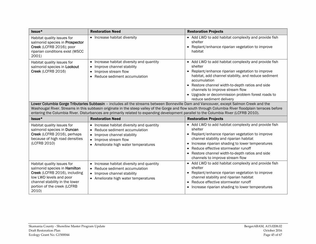
Skamania County - Shoreline Master Program Update BergerABAM, A15.0208.02 Draft Restoration Plan October 2016 Ecology Grant No. G1500044 Page 45 of 67
Issue* Restoration Need Restoration Projects
Habitat quality issues for salmonid species in Prospector Creek (LCFRB 2016); poor riparian conditions exist (WSCC 2001)
• Increase habitat diversity • Add LWD to add habitat complexity and provide fish shelter
• Replant/enhance riparian vegetation to improve habitat
Habitat quality issues for salmonid species in Lookout Creek (LCFRB 2016)
• Increase habitat diversity and quantity • Improve channel stability • Improve stream flow • Reduce sediment accumulation
• Add LWD to add habitat complexity and provide fish shelter
• Replant/enhance riparian vegetation to improve habitat, add channel stability, and reduce sediment accumulation
• Restore channel width-to-depth ratios and side channels to improve stream flow
• Upgrade or decommission problem forest roads to reduce sediment delivery
Lower Columbia Gorge Tributaries Subbasin – includes all the streams between Bonneville Dam and Vancouver, except Salmon Creek and the Washougal River. Streams in this subbasin originate in the steep valley of the Gorge and flow south through Columbia River floodplain terraces before entering the Columbia River. Disturbances are primarily related to expanding development parallel to the Columbia River (LCFRB 2010). Issue* Restoration Need Restoration Projects
Habitat quality issues for salmonid species in Duncan Creek (LCFRB 2016), perhaps because of high road densities (LCFRB 2010)
• Increase habitat diversity and quantity • Reduce sediment accumulation • Improve channel stability • Improve stream flow • Ameliorate high water temperatures
• Add LWD to add habitat complexity and provide fish shelter
• Replant/enhance riparian vegetation to improve channel stability and riparian habitat
• Increase riparian shading to lower temperatures • Reduce effective stormwater runoff • Restore channel width-to-depth ratios and side
channels to improve stream flow Habitat quality issues for salmonid species in Hamilton Creek (LCFRB 2016), including low LWD levels and poor channel stability in the lower portion of the creek (LCFRB 2010)
• Increase habitat diversity and quantity • Reduce sediment accumulation • Improve channel stability • Ameliorate high water temperatures
• Add LWD to add habitat complexity and provide fish shelter
• Replant/enhance riparian vegetation to improve channel stability and riparian habitat
• Reduce effective stormwater runoff • Increase riparian shading to lower temperatures
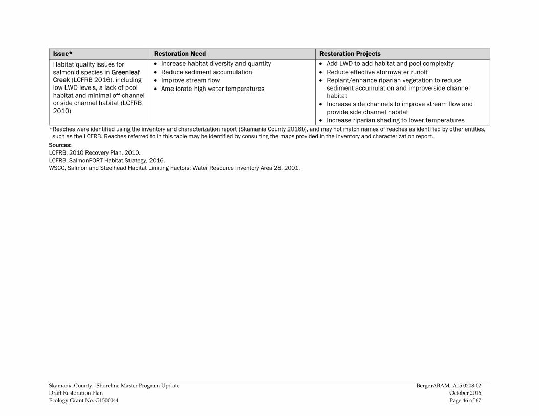
Skamania County - Shoreline Master Program Update BergerABAM, A15.0208.02 Draft Restoration Plan October 2016 Ecology Grant No. G1500044 Page 46 of 67
Issue* Restoration Need Restoration Projects
Habitat quality issues for salmonid species in Greenleaf Creek (LCFRB 2016), including low LWD levels, a lack of pool habitat and minimal off-channel or side channel habitat (LCFRB 2010)
• Increase habitat diversity and quantity • Reduce sediment accumulation • Improve stream flow • Ameliorate high water temperatures
• Add LWD to add habitat and pool complexity • Reduce effective stormwater runoff • Replant/enhance riparian vegetation to reduce
sediment accumulation and improve side channel habitat
• Increase side channels to improve stream flow and provide side channel habitat
• Increase riparian shading to lower temperatures *Reaches were identified using the inventory and characterization report (Skamania County 2016b), and may not match names of reaches as identified by other entities,
such as the LCFRB. Reaches referred to in this table may be identified by consulting the maps provided in the inventory and characterization report.. Sources: LCFRB, 2010 Recovery Plan, 2010. LCFRB, SalmonPORT Habitat Strategy, 2016. WSCC, Salmon and Steelhead Habitat Limiting Factors: Water Resource Inventory Area 28, 2001.
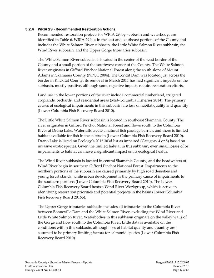
Skamania County - Shoreline Master Program Update BergerABAM, A15.0208.02 Draft Restoration Plan October 2016 Ecology Grant No. G1500044 Page 47 of 67
5.2.4 WRIA 29 - Recommended Restoration Actions Recommended restoration projects for WRIA 29, by subbasin and waterbody, are identified in Table 6. WRIA 29 lies in the east and southeast portions of the County and includes the White Salmon River subbasin, the Little White Salmon River subbasin, the Wind River subbasin, and the Upper Gorge tributaries subbasin.
The White Salmon River subbasin is located in the center of the west border of the County and a small portion of the southwest corner of the County. The White Salmon River originates in Gifford Pinchot National Forest along the south slope of Mount Adams in Skamania County (NPCC 2004). The Condit Dam was located just across the border in Klickitat County; its removal in March 2011 has had significant impacts on the subbasin, mostly positive, although some negative impacts require restoration efforts.
Land use in the lower portions of the river include commercial timberland, irrigated croplands, orchards, and residential areas (Mid-Columbia Fisheries 2014). The primary causes of ecological impairments in this subbasin are loss of habitat quality and quantity (Lower Columbia Fish Recovery Board 2010).
The Little White Salmon River subbasin is located in southeast Skamania County. The river originates in Gifford Pinchot National Forest and flows south to the Columbia River at Drano Lake. Waterfalls create a natural fish passage barrier, and there is limited habitat available for fish in the subbasin (Lower Columbia Fish Recovery Board 2010). Drano Lake is listed on Ecology’s 2012 303d list as impaired (Category 4 or 5) based on invasive exotic species. Given the limited habitat in this subbasin, even small losses of or impairments to habitat can have a significant impact on its ecological health.
The Wind River subbasin is located in central Skamania County, and the headwaters of Wind River begin in southern Gifford Pinchot National Forest. Impairments to the northern portions of the subbasin are caused primarily by high road densities and young forest stands, while urban development is the primary cause of impairments to the southern portions (Lower Columbia Fish Recovery Board 2010). The Lower Columbia Fish Recovery Board hosts a Wind River Workgroup, which is active in identifying restoration priorities and potential projects in the basin (Lower Columbia Fish Recovery Board 2016b).
The Upper Gorge tributaries subbasin includes all tributaries to the Columbia River between Bonneville Dam and the White Salmon River, excluding the Wind River and Little White Salmon River. Waterbodies in this subbasin originate on the valley walls of the Gorge and flow south to the Columbia River. Little data is available on the conditions within this subbasin, although loss of habitat quality and quantity are assumed to be primary limiting factors for salmonid species (Lower Columbia Fish Recovery Board 2010).
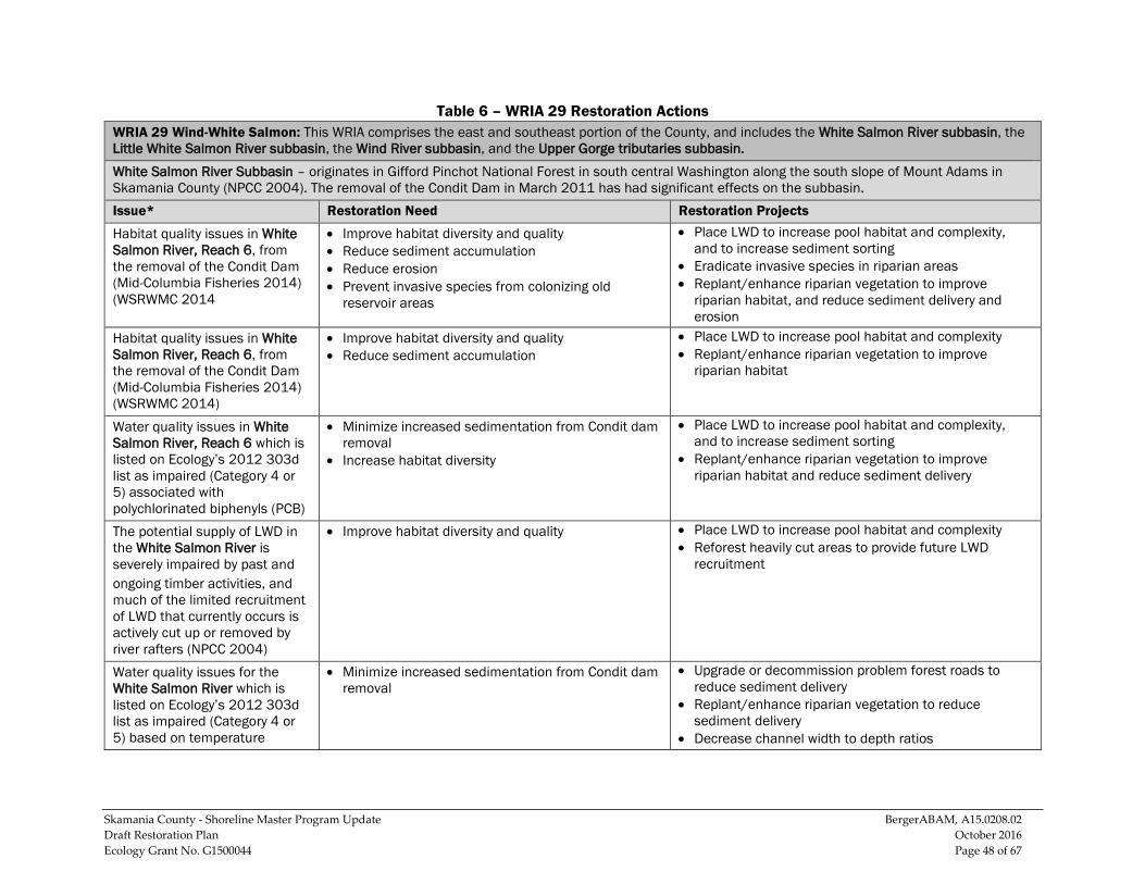
Skamania County - Shoreline Master Program Update BergerABAM, A15.0208.02 Draft Restoration Plan October 2016 Ecology Grant No. G1500044 Page 48 of 67
Table 6 – WRIA 29 Restoration Actions WRIA 29 Wind-White Salmon: This WRIA comprises the east and southeast portion of the County, and includes the White Salmon River subbasin, the Little White Salmon River subbasin, the Wind River subbasin, and the Upper Gorge tributaries subbasin. White Salmon River Subbasin – originates in Gifford Pinchot National Forest in south central Washington along the south slope of Mount Adams in Skamania County (NPCC 2004). The removal of the Condit Dam in March 2011 has had significant effects on the subbasin. Issue* Restoration Need Restoration Projects
Habitat quality issues in White Salmon River, Reach 6, from the removal of the Condit Dam (Mid-Columbia Fisheries 2014) (WSRWMC 2014
• Improve habitat diversity and quality • Reduce sediment accumulation • Reduce erosion • Prevent invasive species from colonizing old
reservoir areas
• Place LWD to increase pool habitat and complexity, and to increase sediment sorting
• Eradicate invasive species in riparian areas • Replant/enhance riparian vegetation to improve
riparian habitat, and reduce sediment delivery and erosion
Habitat quality issues in White Salmon River, Reach 6, from the removal of the Condit Dam (Mid-Columbia Fisheries 2014) (WSRWMC 2014)
• Improve habitat diversity and quality • Reduce sediment accumulation
• Place LWD to increase pool habitat and complexity • Replant/enhance riparian vegetation to improve
riparian habitat
Water quality issues in White Salmon River, Reach 6 which is listed on Ecology’s 2012 303d list as impaired (Category 4 or 5) associated with polychlorinated biphenyls (PCB)
• Minimize increased sedimentation from Condit dam removal
• Increase habitat diversity
• Place LWD to increase pool habitat and complexity, and to increase sediment sorting
• Replant/enhance riparian vegetation to improve riparian habitat and reduce sediment delivery
The potential supply of LWD in the White Salmon River is severely impaired by past and ongoing timber activities, and much of the limited recruitment of LWD that currently occurs is actively cut up or removed by river rafters (NPCC 2004)
• Improve habitat diversity and quality • Place LWD to increase pool habitat and complexity • Reforest heavily cut areas to provide future LWD
recruitment
Water quality issues for the White Salmon River which is listed on Ecology’s 2012 303d list as impaired (Category 4 or 5) based on temperature
• Minimize increased sedimentation from Condit dam removal
• Upgrade or decommission problem forest roads to reduce sediment delivery
• Replant/enhance riparian vegetation to reduce sediment delivery
• Decrease channel width to depth ratios
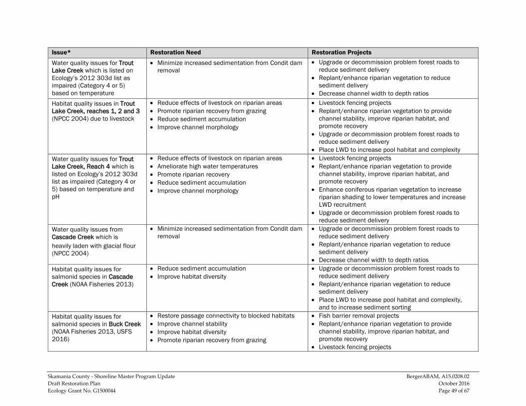
Skamania County - Shoreline Master Program Update BergerABAM, A15.0208.02 Draft Restoration Plan October 2016 Ecology Grant No. G1500044 Page 49 of 67
Issue* Restoration Need Restoration Projects
Water quality issues for Trout Lake Creek which is listed on Ecology’s 2012 303d list as impaired (Category 4 or 5) based on temperature
• Minimize increased sedimentation from Condit dam removal
• Upgrade or decommission problem forest roads to reduce sediment delivery
• Replant/enhance riparian vegetation to reduce sediment delivery
• Decrease channel width to depth ratios Habitat quality issues in Trout Lake Creek, reaches 1, 2 and 3 (NPCC 2004) due to livestock
• Reduce effects of livestock on riparian areas • Promote riparian recovery from grazing • Reduce sediment accumulation • Improve channel morphology
• Livestock fencing projects • Replant/enhance riparian vegetation to provide
channel stability, improve riparian habitat, and promote recovery
• Upgrade or decommission problem forest roads to reduce sediment delivery
• Place LWD to increase pool habitat and complexity Water quality issues for Trout Lake Creek, Reach 4 which is listed on Ecology’s 2012 303d list as impaired (Category 4 or 5) based on temperature and pH
• Reduce effects of livestock on riparian areas • Ameliorate high water temperatures • Promote riparian recovery • Reduce sediment accumulation • Improve channel morphology
• Livestock fencing projects • Replant/enhance riparian vegetation to provide
channel stability, improve riparian habitat, and promote recovery
• Enhance coniferous riparian vegetation to increase riparian shading to lower temperatures and increase LWD recruitment
• Upgrade or decommission problem forest roads to reduce sediment delivery
Water quality issues from Cascade Creek which is heavily laden with glacial flour (NPCC 2004)
• Minimize increased sedimentation from Condit dam removal
• Upgrade or decommission problem forest roads to reduce sediment delivery
• Replant/enhance riparian vegetation to reduce sediment delivery
• Decrease channel width to depth ratios Habitat quality issues for salmonid species in Cascade Creek (NOAA Fisheries 2013)
• Reduce sediment accumulation • Improve habitat diversity
• Upgrade or decommission problem forest roads to reduce sediment delivery
• Replant/enhance riparian vegetation to reduce sediment delivery
• Place LWD to increase pool habitat and complexity, and to increase sediment sorting
Habitat quality issues for salmonid species in Buck Creek (NOAA Fisheries 2013, USFS 2016)
• Restore passage connectivity to blocked habitats • Improve channel stability • Improve habitat diversity • Promote riparian recovery from grazing
• Fish barrier removal projects • Replant/enhance riparian vegetation to provide
channel stability, improve riparian habitat, and promote recovery
• Livestock fencing projects
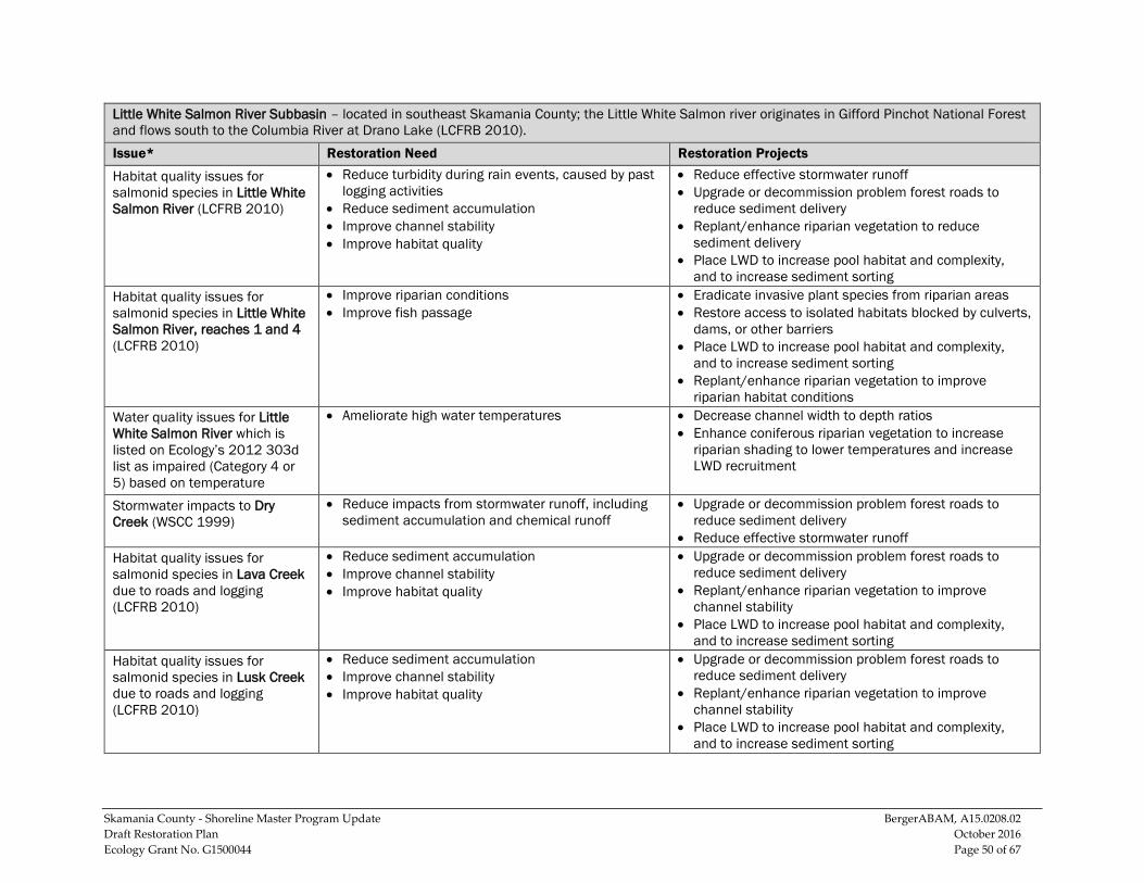
Skamania County - Shoreline Master Program Update BergerABAM, A15.0208.02 Draft Restoration Plan October 2016 Ecology Grant No. G1500044 Page 50 of 67
Little White Salmon River Subbasin – located in southeast Skamania County; the Little White Salmon river originates in Gifford Pinchot National Forest and flows south to the Columbia River at Drano Lake (LCFRB 2010). Issue* Restoration Need Restoration Projects
Habitat quality issues for salmonid species in Little White Salmon River (LCFRB 2010)
• Reduce turbidity during rain events, caused by past logging activities
• Reduce sediment accumulation • Improve channel stability • Improve habitat quality
• Reduce effective stormwater runoff • Upgrade or decommission problem forest roads to
reduce sediment delivery • Replant/enhance riparian vegetation to reduce
sediment delivery • Place LWD to increase pool habitat and complexity,
and to increase sediment sorting Habitat quality issues for salmonid species in Little White Salmon River, reaches 1 and 4 (LCFRB 2010)
• Improve riparian conditions • Improve fish passage
• Eradicate invasive plant species from riparian areas • Restore access to isolated habitats blocked by culverts,
dams, or other barriers • Place LWD to increase pool habitat and complexity,
and to increase sediment sorting • Replant/enhance riparian vegetation to improve
riparian habitat conditions Water quality issues for Little White Salmon River which is listed on Ecology’s 2012 303d list as impaired (Category 4 or 5) based on temperature
• Ameliorate high water temperatures • Decrease channel width to depth ratios • Enhance coniferous riparian vegetation to increase
riparian shading to lower temperatures and increase LWD recruitment
Stormwater impacts to Dry Creek (WSCC 1999)
• Reduce impacts from stormwater runoff, including sediment accumulation and chemical runoff
• Upgrade or decommission problem forest roads to reduce sediment delivery
• Reduce effective stormwater runoff Habitat quality issues for salmonid species in Lava Creek due to roads and logging (LCFRB 2010)
• Reduce sediment accumulation • Improve channel stability • Improve habitat quality
• Upgrade or decommission problem forest roads to reduce sediment delivery
• Replant/enhance riparian vegetation to improve channel stability
• Place LWD to increase pool habitat and complexity, and to increase sediment sorting
Habitat quality issues for salmonid species in Lusk Creek due to roads and logging (LCFRB 2010)
• Reduce sediment accumulation • Improve channel stability • Improve habitat quality
• Upgrade or decommission problem forest roads to reduce sediment delivery
• Replant/enhance riparian vegetation to improve channel stability
• Place LWD to increase pool habitat and complexity, and to increase sediment sorting
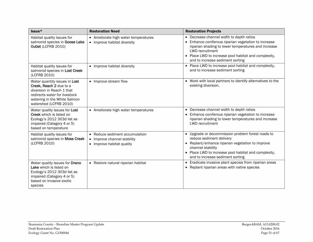
Skamania County - Shoreline Master Program Update BergerABAM, A15.0208.02 Draft Restoration Plan October 2016 Ecology Grant No. G1500044 Page 51 of 67
Issue* Restoration Need Restoration Projects
Habitat quality issues for salmonid species in Goose Lake Outlet (LCFRB 2010)
• Ameliorate high water temperatures • Improve habitat diversity
• Decrease channel width to depth ratios • Enhance coniferous riparian vegetation to increase
riparian shading to lower temperatures and increase LWD recruitment
• Place LWD to increase pool habitat and complexity, and to increase sediment sorting
Habitat quality issues for salmonid species in Lost Creek (LCFRB 2010)
• Improve habitat diversity • Place LWD to increase pool habitat and complexity, and to increase sediment sorting
Water quantity issues in Lost Creek, Reach 2 due to a diversion in Reach 1 that redirects water for livestock watering in the White Salmon watershed (LCFRB 2010)
• Improve stream flow • Work with local partners to identify alternatives to the existing diversion.
Water quality issues for Lost Creek which is listed on Ecology’s 2012 303d list as impaired (Category 4 or 5) based on temperature
• Ameliorate high water temperatures • Decrease channel width to depth ratios • Enhance coniferous riparian vegetation to increase
riparian shading to lower temperatures and increase LWD recruitment
Habitat quality issues for salmonid species in Moss Creek (LCFRB 2010)
• Reduce sediment accumulation • Improve channel stability • Improve habitat quality
• Upgrade or decommission problem forest roads to reduce sediment delivery
• Replant/enhance riparian vegetation to improve channel stability
• Place LWD to increase pool habitat and complexity, and to increase sediment sorting
Water quality issues for Drano Lake which is listed on Ecology’s 2012 303d list as impaired (Category 4 or 5) based on invasive exotic species
• Restore natural riparian habitat • Eradicate invasive plant species from riparian areas • Replant riparian areas with native species
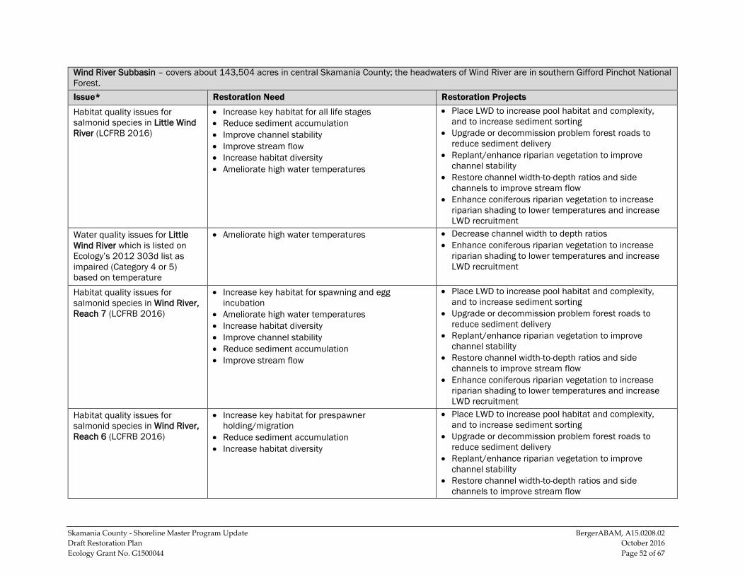
Skamania County - Shoreline Master Program Update BergerABAM, A15.0208.02 Draft Restoration Plan October 2016 Ecology Grant No. G1500044 Page 52 of 67
Wind River Subbasin – covers about 143,504 acres in central Skamania County; the headwaters of Wind River are in southern Gifford Pinchot National Forest. Issue* Restoration Need Restoration Projects
Habitat quality issues for salmonid species in Little Wind River (LCFRB 2016)
• Increase key habitat for all life stages • Reduce sediment accumulation • Improve channel stability • Improve stream flow • Increase habitat diversity • Ameliorate high water temperatures
• Place LWD to increase pool habitat and complexity, and to increase sediment sorting
• Upgrade or decommission problem forest roads to reduce sediment delivery
• Replant/enhance riparian vegetation to improve channel stability
• Restore channel width-to-depth ratios and side channels to improve stream flow
• Enhance coniferous riparian vegetation to increase riparian shading to lower temperatures and increase LWD recruitment
Water quality issues for Little Wind River which is listed on Ecology’s 2012 303d list as impaired (Category 4 or 5) based on temperature
• Ameliorate high water temperatures • Decrease channel width to depth ratios • Enhance coniferous riparian vegetation to increase
riparian shading to lower temperatures and increase LWD recruitment
Habitat quality issues for salmonid species in Wind River, Reach 7 (LCFRB 2016)
• Increase key habitat for spawning and egg incubation
• Ameliorate high water temperatures • Increase habitat diversity • Improve channel stability • Reduce sediment accumulation • Improve stream flow
• Place LWD to increase pool habitat and complexity, and to increase sediment sorting
• Upgrade or decommission problem forest roads to reduce sediment delivery
• Replant/enhance riparian vegetation to improve channel stability
• Restore channel width-to-depth ratios and side channels to improve stream flow
• Enhance coniferous riparian vegetation to increase riparian shading to lower temperatures and increase LWD recruitment
Habitat quality issues for salmonid species in Wind River, Reach 6 (LCFRB 2016)
• Increase key habitat for prespawner holding/migration
• Reduce sediment accumulation • Increase habitat diversity
• Place LWD to increase pool habitat and complexity, and to increase sediment sorting
• Upgrade or decommission problem forest roads to reduce sediment delivery
• Replant/enhance riparian vegetation to improve channel stability
• Restore channel width-to-depth ratios and side channels to improve stream flow
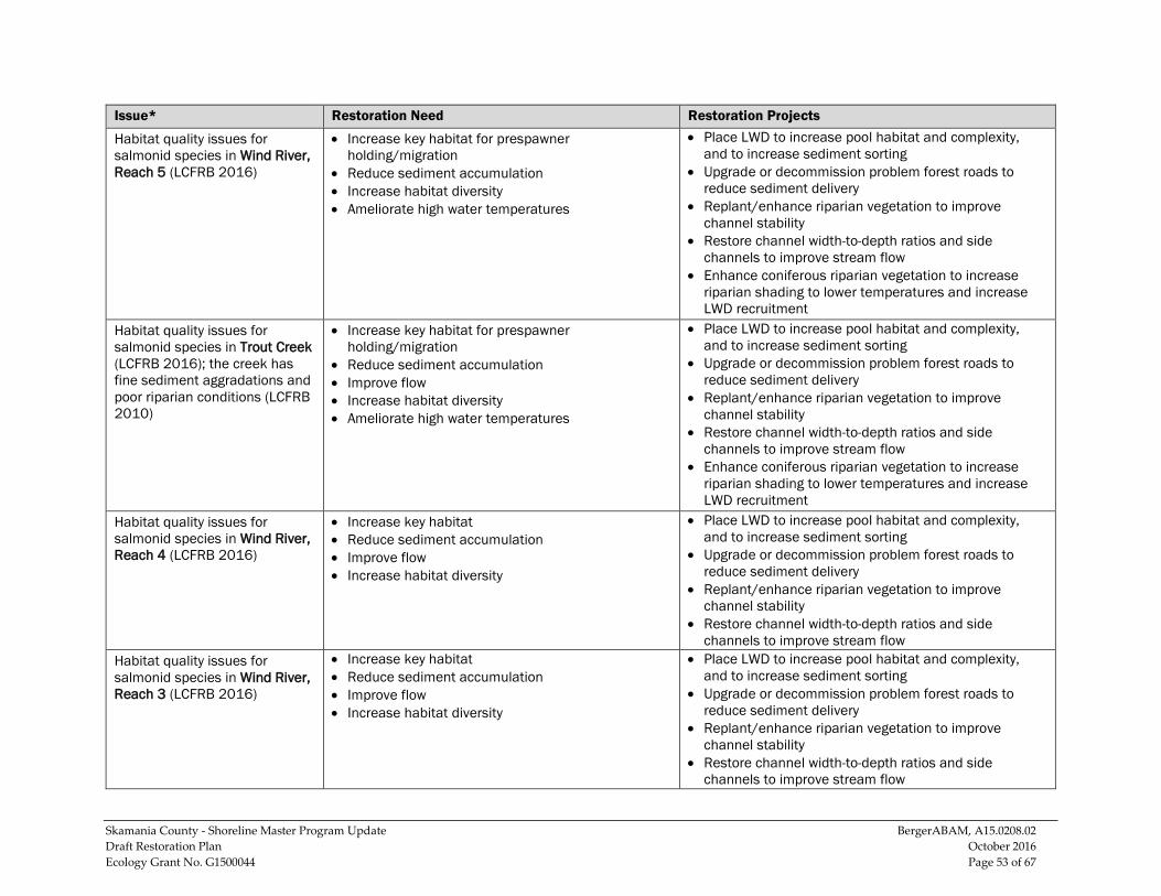
Skamania County - Shoreline Master Program Update BergerABAM, A15.0208.02 Draft Restoration Plan October 2016 Ecology Grant No. G1500044 Page 53 of 67
Issue* Restoration Need Restoration Projects
Habitat quality issues for salmonid species in Wind River, Reach 5 (LCFRB 2016)
• Increase key habitat for prespawner holding/migration
• Reduce sediment accumulation • Increase habitat diversity • Ameliorate high water temperatures
• Place LWD to increase pool habitat and complexity, and to increase sediment sorting
• Upgrade or decommission problem forest roads to reduce sediment delivery
• Replant/enhance riparian vegetation to improve channel stability
• Restore channel width-to-depth ratios and side channels to improve stream flow
• Enhance coniferous riparian vegetation to increase riparian shading to lower temperatures and increase LWD recruitment
Habitat quality issues for salmonid species in Trout Creek (LCFRB 2016); the creek has fine sediment aggradations and poor riparian conditions (LCFRB 2010)
• Increase key habitat for prespawner holding/migration
• Reduce sediment accumulation • Improve flow • Increase habitat diversity • Ameliorate high water temperatures
• Place LWD to increase pool habitat and complexity, and to increase sediment sorting
• Upgrade or decommission problem forest roads to reduce sediment delivery
• Replant/enhance riparian vegetation to improve channel stability
• Restore channel width-to-depth ratios and side channels to improve stream flow
• Enhance coniferous riparian vegetation to increase riparian shading to lower temperatures and increase LWD recruitment
Habitat quality issues for salmonid species in Wind River, Reach 4 (LCFRB 2016)
• Increase key habitat • Reduce sediment accumulation • Improve flow • Increase habitat diversity
• Place LWD to increase pool habitat and complexity, and to increase sediment sorting
• Upgrade or decommission problem forest roads to reduce sediment delivery
• Replant/enhance riparian vegetation to improve channel stability
• Restore channel width-to-depth ratios and side channels to improve stream flow
Habitat quality issues for salmonid species in Wind River, Reach 3 (LCFRB 2016)
• Increase key habitat • Reduce sediment accumulation • Improve flow • Increase habitat diversity
• Place LWD to increase pool habitat and complexity, and to increase sediment sorting
• Upgrade or decommission problem forest roads to reduce sediment delivery
• Replant/enhance riparian vegetation to improve channel stability
• Restore channel width-to-depth ratios and side channels to improve stream flow
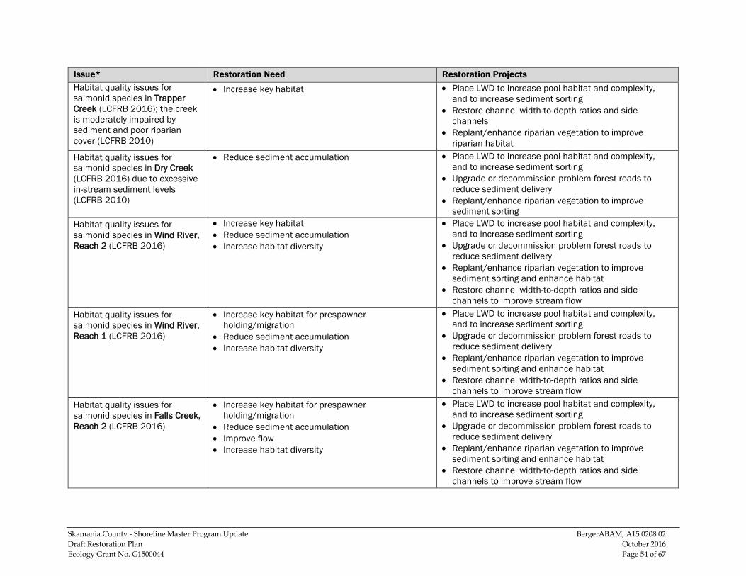
Skamania County - Shoreline Master Program Update BergerABAM, A15.0208.02 Draft Restoration Plan October 2016 Ecology Grant No. G1500044 Page 54 of 67
Issue* Restoration Need Restoration Projects Habitat quality issues for salmonid species in Trapper Creek (LCFRB 2016); the creek is moderately impaired by sediment and poor riparian cover (LCFRB 2010)
• Increase key habitat • Place LWD to increase pool habitat and complexity, and to increase sediment sorting
• Restore channel width-to-depth ratios and side channels
• Replant/enhance riparian vegetation to improve riparian habitat
Habitat quality issues for salmonid species in Dry Creek (LCFRB 2016) due to excessive in-stream sediment levels (LCFRB 2010)
• Reduce sediment accumulation • Place LWD to increase pool habitat and complexity, and to increase sediment sorting
• Upgrade or decommission problem forest roads to reduce sediment delivery
• Replant/enhance riparian vegetation to improve sediment sorting
Habitat quality issues for salmonid species in Wind River, Reach 2 (LCFRB 2016)
• Increase key habitat • Reduce sediment accumulation • Increase habitat diversity
• Place LWD to increase pool habitat and complexity, and to increase sediment sorting
• Upgrade or decommission problem forest roads to reduce sediment delivery
• Replant/enhance riparian vegetation to improve sediment sorting and enhance habitat
• Restore channel width-to-depth ratios and side channels to improve stream flow
Habitat quality issues for salmonid species in Wind River, Reach 1 (LCFRB 2016)
• Increase key habitat for prespawner holding/migration
• Reduce sediment accumulation • Increase habitat diversity
• Place LWD to increase pool habitat and complexity, and to increase sediment sorting
• Upgrade or decommission problem forest roads to reduce sediment delivery
• Replant/enhance riparian vegetation to improve sediment sorting and enhance habitat
• Restore channel width-to-depth ratios and side channels to improve stream flow
Habitat quality issues for salmonid species in Falls Creek, Reach 2 (LCFRB 2016)
• Increase key habitat for prespawner holding/migration
• Reduce sediment accumulation • Improve flow • Increase habitat diversity
• Place LWD to increase pool habitat and complexity, and to increase sediment sorting
• Upgrade or decommission problem forest roads to reduce sediment delivery
• Replant/enhance riparian vegetation to improve sediment sorting and enhance habitat
• Restore channel width-to-depth ratios and side channels to improve stream flow
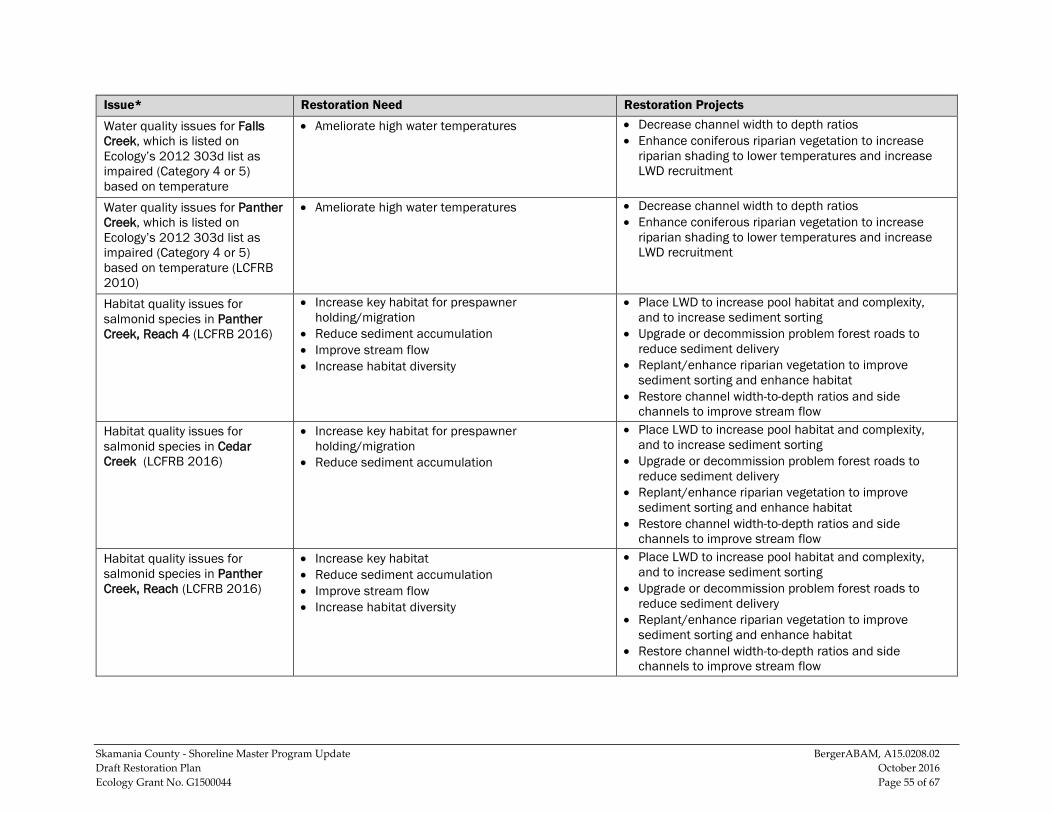
Skamania County - Shoreline Master Program Update BergerABAM, A15.0208.02 Draft Restoration Plan October 2016 Ecology Grant No. G1500044 Page 55 of 67
Issue* Restoration Need Restoration Projects
Water quality issues for Falls Creek, which is listed on Ecology’s 2012 303d list as impaired (Category 4 or 5) based on temperature
• Ameliorate high water temperatures • Decrease channel width to depth ratios • Enhance coniferous riparian vegetation to increase
riparian shading to lower temperatures and increase LWD recruitment
Water quality issues for Panther Creek, which is listed on Ecology’s 2012 303d list as impaired (Category 4 or 5) based on temperature (LCFRB 2010)
• Ameliorate high water temperatures • Decrease channel width to depth ratios • Enhance coniferous riparian vegetation to increase
riparian shading to lower temperatures and increase LWD recruitment
Habitat quality issues for salmonid species in Panther Creek, Reach 4 (LCFRB 2016)
• Increase key habitat for prespawner holding/migration
• Reduce sediment accumulation • Improve stream flow • Increase habitat diversity
• Place LWD to increase pool habitat and complexity, and to increase sediment sorting
• Upgrade or decommission problem forest roads to reduce sediment delivery
• Replant/enhance riparian vegetation to improve sediment sorting and enhance habitat
• Restore channel width-to-depth ratios and side channels to improve stream flow
Habitat quality issues for salmonid species in Cedar Creek (LCFRB 2016)
• Increase key habitat for prespawner holding/migration
• Reduce sediment accumulation
• Place LWD to increase pool habitat and complexity, and to increase sediment sorting
• Upgrade or decommission problem forest roads to reduce sediment delivery
• Replant/enhance riparian vegetation to improve sediment sorting and enhance habitat
• Restore channel width-to-depth ratios and side channels to improve stream flow
Habitat quality issues for salmonid species in Panther Creek, Reach (LCFRB 2016)
• Increase key habitat • Reduce sediment accumulation • Improve stream flow • Increase habitat diversity
• Place LWD to increase pool habitat and complexity, and to increase sediment sorting
• Upgrade or decommission problem forest roads to reduce sediment delivery
• Replant/enhance riparian vegetation to improve sediment sorting and enhance habitat
• Restore channel width-to-depth ratios and side channels to improve stream flow
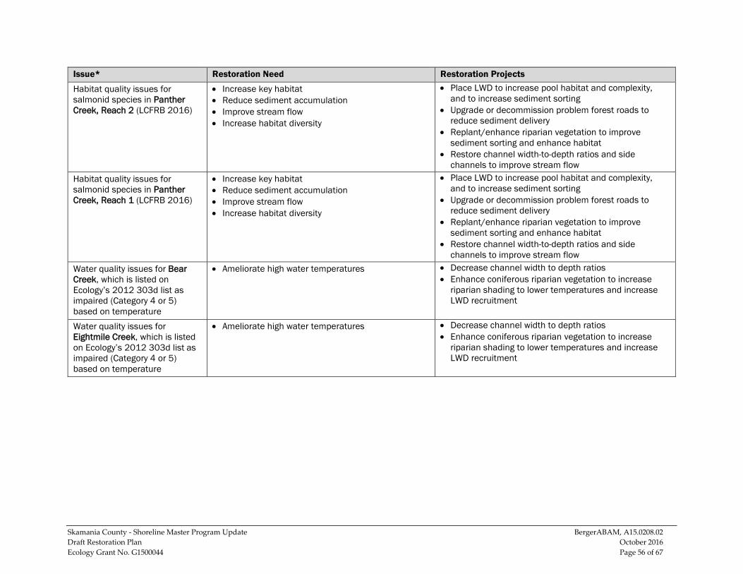
Skamania County - Shoreline Master Program Update BergerABAM, A15.0208.02 Draft Restoration Plan October 2016 Ecology Grant No. G1500044 Page 56 of 67
Issue* Restoration Need Restoration Projects
Habitat quality issues for salmonid species in Panther Creek, Reach 2 (LCFRB 2016)
• Increase key habitat • Reduce sediment accumulation • Improve stream flow • Increase habitat diversity
• Place LWD to increase pool habitat and complexity, and to increase sediment sorting
• Upgrade or decommission problem forest roads to reduce sediment delivery
• Replant/enhance riparian vegetation to improve sediment sorting and enhance habitat
• Restore channel width-to-depth ratios and side channels to improve stream flow
Habitat quality issues for salmonid species in Panther Creek, Reach 1 (LCFRB 2016)
• Increase key habitat • Reduce sediment accumulation • Improve stream flow • Increase habitat diversity
• Place LWD to increase pool habitat and complexity, and to increase sediment sorting
• Upgrade or decommission problem forest roads to reduce sediment delivery
• Replant/enhance riparian vegetation to improve sediment sorting and enhance habitat
• Restore channel width-to-depth ratios and side channels to improve stream flow
Water quality issues for Bear Creek, which is listed on Ecology’s 2012 303d list as impaired (Category 4 or 5) based on temperature
• Ameliorate high water temperatures • Decrease channel width to depth ratios • Enhance coniferous riparian vegetation to increase
riparian shading to lower temperatures and increase LWD recruitment
Water quality issues for Eightmile Creek, which is listed on Ecology’s 2012 303d list as impaired (Category 4 or 5) based on temperature
• Ameliorate high water temperatures • Decrease channel width to depth ratios • Enhance coniferous riparian vegetation to increase
riparian shading to lower temperatures and increase LWD recruitment
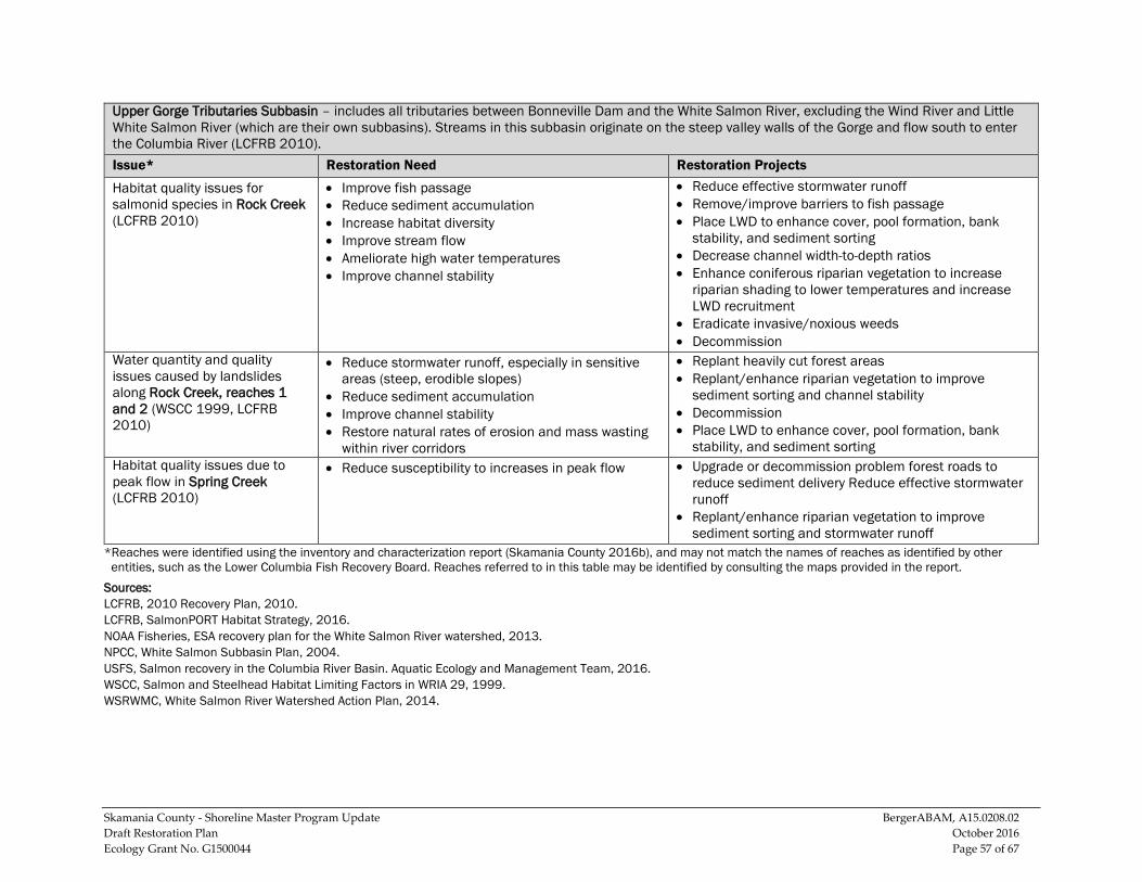
Skamania County - Shoreline Master Program Update BergerABAM, A15.0208.02 Draft Restoration Plan October 2016 Ecology Grant No. G1500044 Page 57 of 67
Upper Gorge Tributaries Subbasin – includes all tributaries between Bonneville Dam and the White Salmon River, excluding the Wind River and Little White Salmon River (which are their own subbasins). Streams in this subbasin originate on the steep valley walls of the Gorge and flow south to enter the Columbia River (LCFRB 2010). Issue* Restoration Need Restoration Projects
Habitat quality issues for salmonid species in Rock Creek (LCFRB 2010)
• Improve fish passage • Reduce sediment accumulation • Increase habitat diversity • Improve stream flow • Ameliorate high water temperatures • Improve channel stability
• Reduce effective stormwater runoff • Remove/improve barriers to fish passage • Place LWD to enhance cover, pool formation, bank
stability, and sediment sorting • Decrease channel width-to-depth ratios • Enhance coniferous riparian vegetation to increase
riparian shading to lower temperatures and increase LWD recruitment
• Eradicate invasive/noxious weeds • Decommission
Water quantity and quality issues caused by landslides along Rock Creek, reaches 1 and 2 (WSCC 1999, LCFRB 2010)
• Reduce stormwater runoff, especially in sensitive areas (steep, erodible slopes)
• Reduce sediment accumulation • Improve channel stability • Restore natural rates of erosion and mass wasting
within river corridors
• Replant heavily cut forest areas • Replant/enhance riparian vegetation to improve
sediment sorting and channel stability • Decommission • Place LWD to enhance cover, pool formation, bank
stability, and sediment sorting Habitat quality issues due to peak flow in Spring Creek (LCFRB 2010)
• Reduce susceptibility to increases in peak flow • Upgrade or decommission problem forest roads to reduce sediment delivery Reduce effective stormwater runoff
• Replant/enhance riparian vegetation to improve sediment sorting and stormwater runoff
*Reaches were identified using the inventory and characterization report (Skamania County 2016b), and may not match the names of reaches as identified by other entities, such as the Lower Columbia Fish Recovery Board. Reaches referred to in this table may be identified by consulting the maps provided in the report.
Sources: LCFRB, 2010 Recovery Plan, 2010. LCFRB, SalmonPORT Habitat Strategy, 2016. NOAA Fisheries, ESA recovery plan for the White Salmon River watershed, 2013. NPCC, White Salmon Subbasin Plan, 2004. USFS, Salmon recovery in the Columbia River Basin. Aquatic Ecology and Management Team, 2016. WSCC, Salmon and Steelhead Habitat Limiting Factors in WRIA 29, 1999. WSRWMC, White Salmon River Watershed Action Plan, 2014.
Skamania County - Shoreline Master Program Update BergerABAM, A15.0208.02 Draft Restoration Plan October 2016 Ecology Grant No. G1500044 Page 58 of 67
6.0 IMPLEMENTATION AND MONITORING This section discusses what is required of the County under the SMA to move restoration efforts forward and suggests some paths (such as funding opportunities).
6.1 Timelines and Benchmarks Under the SMA, the County must review and, if necessary, amend its SMP once every 7 years (RCW 90.58.080(4)). The County is required to report progress toward meeting its restoration goals, but there is no particular requirement or timeframe for implementing the restoration plan. Additionally, it is difficult to set a firm timeline for accomplishing the goals of the plan as it is a long-range planning effort without dedicated funding.
Significant further study, collaboration, identification, and implementation of restoration projects are needed before an accurate timeline or benchmarks can be developed. However, the County may continue to look for opportunities for involvement in restoration planning and implementation with other partners.
6.2 Monitoring Strategies The SMP guidelines for restoration planning state that local programs should “…review the effectiveness of the projects and programs in meeting the overall restoration goals” (WAC 173-26-201(2)(f)). Monitoring restoration activities and achievements could include a periodic review of environmental functions at the time of periodic SMP updates. This would serve to assess the effectiveness of the SMP, including the restoration plan, in achieving no net loss of shoreline ecological functions in Skamania County.
6.3 Potential Funding Shoreline restoration in Skamania County depends almost entirely on grant funding, and its availability is unpredictable and varies from year to year. Many of the proposed restoration projects will require outside funding through federal or state grants along with local, private, or non-profit matching funds. Projects may be funded in multiple phases, with different funding sources appropriate for each phase.
Provided below is a list of potential funding sources for future restoration activities. While this is not an exhaustive list, in conjunction with the list of potential partners provided in section 4.0, it is a starting point for implementing restoration projects in the County.
Washington State Recreation and Conservation Office (RCO) 1111 Washington St. SE PO Box 40917 Olympia, WA 98504 360-902-3000 http://www.rco.wa.gov/grants/index.shtml
Skamania County - Shoreline Master Program Update BergerABAM, A15.0208.02 Draft Restoration Plan October 2016 Ecology Grant No. G1500044 Page 59 of 67
RCO provides leadership, funding, and technical assistance to protect and restore habitats, invest in and track salmon health and recovery, and protect Washington’s diverse biological heritage. Grant programs offered by the RCO include:
• Aquatic Lands Enhancement Account (ALEA) targets re-establishing the natural, self-sustaining ecological functions of the waterfront, providing or restoring public access to the water, and increasing public awareness of aquatic lands as a finite natural resource and irreplaceable public heritage. ALEA grants may be used for the acquisition, improvement, or protection of aquatic lands for public purposes. They also may be used to provide or improve public access to the waterfront.
• The Family Forest Fish Passage Program provides funding to small forest landowners to repair or remove fish passage barriers, such as culverts and other stream crossing structures, that keep trout, salmon, and other fish from reaching upstream habitat. The program funds the replacement of eligible barriers with new structures. Since 2003, nearly 285 landowners have taken advantage of the program to remove 353 barriers and open more than 804 miles of stream habitat.
• The Washington Wildlife Recreation Program (WWRP) provides funds for the acquisition and development of recreation and conservation lands. WWRP funds restoration projects such as animal watering stations, bank stabilization, LWD placement, and riparian revegetation.
Washington Department of Fish & Wildlife 600 Capitol Way North Olympia, WA 98501 360-902-2806 http://wdfw.wa.gov/
WDFW’s mission is to preserve, protect and perpetuate fish, wildlife and ecosystems while providing sustainable fish and wildlife recreational and commercial opportunities. The department offers several types of grants to achieve these goals, including:
• Landowner Incentive Program is designed to provide financial assistance to private landowners for the protection, enhancement, or restoration of habitat to benefit species at risk on privately owned lands. At-risk species depend on specific ecosystems for survival such as riparian areas, wetlands, oak woodlands, prairies and grasslands, shrub steppe, and nearshore environments. Through Washington’s LIP, individual landowners can apply for up to $50,000 in assistance. In addition, $50,000 is usually set aside for small grants to individuals of up to $5,000. A 25 percent non-federal contribution is required, which may include cash and/or in-kind contributions (labor, machinery, materials).
National Fish and Wildlife Foundation 1120 Connecticut Avenue, NW, #900 Washington, DC 20036
Skamania County - Shoreline Master Program Update BergerABAM, A15.0208.02 Draft Restoration Plan October 2016 Ecology Grant No. G1500044 Page 60 of 67
202-857-0166 www.nfwf.org
Non-profit organizations and local, state, or federal government agencies are eligible to apply for funds for community-based projects that improve and restore native salmon habitat or remove barriers to fish passage or for the acquisition of land/ conservation easements on private lands where the habitat is critical to salmon species. Specific grant programs are listed below.
• The Bring Back the Natives/More Fish program invests in conservation activities that restore, protect, and enhance native populations of sensitive or listed fish species across the United States, especially in areas on or adjacent to federal agency lands. The program emphasizes coordination between private landowners and federal agencies, tribes, corporations, and states to improve the ecosystem functions and health of watersheds.
• The Columbia Basin Water Transactions Program (CBWTP) was developed in 2002 to address chronically diminished stream flows in tributaries of the Columbia River. To enhance stream flow, the CBWTP works through locally based entities to acquire water rights voluntarily from willing landowners. Using temporary and permanent water rights acquisitions and other incentive-based approaches, the CBWTP supports program partners to assist landowners who wish to voluntarily restore flows to key fish habitat. Funding for this program is provided by Bonneville Power Administration in cooperation with NPCC and with support from Altria.
• The Five Star and Urban Waters Restoration Program seeks to develop nation-wide-community stewardship of local natural resources, preserving these resources for future generations and enhancing habitat for local wildlife. Projects seek to address water quality issues in priority watersheds, such as erosion due to unstable streambanks, pollution from stormwater runoff, and degraded shorelines caused by development.
Environmental Protection Agency, Region 10: Pacific Northwest 1200 Sixth Avenue, Suite 900 Seattle, WA 98101 206-553-6367 https://www3.epa.gov/
The EPA funds a variety of projects that aim to safeguard the natural environment and protect human health. Potential opportunities specific to watershed protection and restoration are listed below.
• The Clean Water State Revolving Fund Program provides grants or “seed money” to all 50 states plus Puerto Rico to capitalize state loan funds. The states, in turn, make loans to communities, individuals, and others for high-priority water-quality activities. Projects funded by the low-interest loans may include wetlands protection
Skamania County - Shoreline Master Program Update BergerABAM, A15.0208.02 Draft Restoration Plan October 2016 Ecology Grant No. G1500044 Page 61 of 67
and restoration, estuary management efforts – including wildlife habitat restoration – and development of streambank buffer zones.
• Nonpoint Source Implementation Grant (319) Program provides Clean Water Act Section 319(h) funds only to designated state and tribal agencies to implement their approved nonpoint source management programs. State and tribal nonpoint source programs include a variety of components, including technical assistance, financial assistance, education, training, technology transfer, demonstration projects, and regulatory programs. Each year, EPA awards Section 319(h) funds to states in accordance with a state-by-state allocation formula that EPA has developed in consultation with the states.
• Wetland Protection, Restoration, and Stewardship Discretionary Funding supports studies and activities related to implementation of Section 404 of the Clean Water Act for both wetlands and sediment management. Projects can support regulatory, planning, restoration, or outreach.
U.S. Fish & Wildlife Service Pacific Region 911 NE 11th Avenue Portland, OR 97232 503-231-2014 https://www.fws.gov/
The USFWS funds a variety of projects that aim to safeguard the natural environment and protect human health. Potential opportunities specific to watershed protection and restoration are listed below.
• National Fish Habitat Action Plan: This program is a national investment strategy to leverage federal and privately raised funds to protect, restore, and enhance the nation's fish and aquatic habitats through partnerships that foster fish habitat conservation. Funds will support national and regional science and coordination activities to protect, restore, or enhance fish habitats.
• National Fish Passage Program (NFPP): NFFP is a voluntary program that provides direct technical assistance and financial assistance in the form of cooperative agreements to partners to provide fish (and other aquatic organisms) passage and restore aquatic connectivity for the benefit of federal trust resources. The NFPP is delivered through Fisheries and Aquatic Conservation Field Offices. The Field Offices staff coordinates with project partners, stakeholders and other Service programs to identify and collaboratively implement projects within Regional priority areas.
• Partners for Fish and Wildlife Program: This program provides technical and financial assistance to private landowners and Tribes who are willing to work with USFWS and other partners on a voluntary basis to help meet the habitat needs of Federal Trust Species. The Partners Program can assist with projects in all habitat types
Skamania County - Shoreline Master Program Update BergerABAM, A15.0208.02 Draft Restoration Plan October 2016 Ecology Grant No. G1500044 Page 62 of 67
which conserve or restore native vegetation, hydrology, and soils associated with imperiled ecosystems such as longleaf pine, bottomland hardwoods, tropical forests, native prairies, marshes, rivers and streams, or ecosystems that otherwise provide an important habitat requisite for a rare, declining or protected species.
• North American Wetlands Conservation Act Grants Program provides matching grants to wetlands conservation projects through a Standard Program and a Small Grants Program. Both are competitive and require that grant requests be matched by partner contributions at no less than a 1-to-1 ratio.
Washington State Department of Transportation City Fish Passage Grant Program 310 Maple Park Ave., SE Olympia, WA 98501 206-386-7220 http://www.wsdot.wa.gov/Projects/FishPassage/default.htm
State highways cross streams and rivers in thousands of places in Washington. At many places, culverts are too small or otherwise inadequate to allow fish to migrate upstream and downstream as necessary for growth and reproduction. State law (RCW 77.57.030) requires WSDOT to install and maintain all culverts, fishways, and bridges to provide unrestricted fish passage. WSDOT has worked for more than two decades to improve fish passage and reconnect streams.
Northwest Fund for the Environment, Aquatic Ecosystem Program 1904 Third Ave., Suite 615 Seattle, WA 98101 360-705-7518 http://www.nwfund.org/
Grants by the Northwest Fund come from an endowment designated to be spent to promote change in the uses of natural resources which will increase their protection and preservation in Washington. Special emphasis is placed on "the protection of wild fish, native wildlife, natural forests, wetlands and shorelines, and the preservation of pure and free-flowing waters." The fund’s Aquatic Ecosystem Program aims to protect and restore the extensive network of fresh and saltwater ecosystems in Washington and the native species that inhabit them.
NOAA Pacific Coastal Salmon Recovery Fund 1201 Northeast Lloyd Boulevard, Suite 1100 Portland, OR 97232 503-872-2791 http://www.westcoast.fisheries.noaa.gov/protected_species/salmon_steelhead/recovery_planning_and_implementation/pacific_coastal_salmon_recovery_fund.html
Skamania County - Shoreline Master Program Update BergerABAM, A15.0208.02 Draft Restoration Plan October 2016 Ecology Grant No. G1500044 Page 63 of 67
The fund was established by Congress in 2000 to reverse the declines of Pacific salmon and steelhead. NOAA Fisheries is the agency charged with administering this competitive grants process. PCSRF has catalyzed the development of a community of salmon restoration experts and fostered partnerships among land owners, local governments, and state, tribal, and federal agencies.
6.4 Obstacles and Challenges Some obstacles and challenges that lie between the recommended restoration actions and their successful implementation can hinder the predictability of initiating a restoration project. They include, but are not limited to, the following.
• Funding: Large-scale restoration projects can be expensive, and their funding is both limited and competitive.
• Landowner participation: Landowners may be unwilling or unable to participate in restoration projects.
• Project permitting: Obtaining local, state, and federal permits for restoration projects can be time-intensive and hinder the project’s implementation.
• Climate change: Changes in precipitation patterns have the potential to alter Skamania County’s shoreline jurisdiction, processes, and functions dramatically over time. In turn, these changes may affect restoration priorities in the county.
Skamania County - Shoreline Master Program Update BergerABAM, A15.0208.02 Draft Restoration Plan October 2016 Ecology Grant No. G1500044 Page 64 of 67
7.0 REFERENCES Lower Columbia Fish Recovery Board. 2016a. Salmon Partners Ongoing Recovery
Tracking (SalmonPORT) Habitat Strategy. Available at: http://www.lowercolumbiasalmonrecovery.org/mappage#b
Lower Columbia Fish Recovery Board. 2016b. Wind River Community-Based Restoration Strategy Development. Community Workshop Presentation. Available at: http://www.lcfrb.gen.wa.us/#!wind-river-workgroup/cv7s
Lower Columbia Fish Recovery Board. 2010. Washington Lower Columbia Salmon Recovery and Fish & Wildlife Subbasin Plan: Volumes I and II.
Lower Columbia Fish Recovery Board. 2004. Lower Columbia salmon recovery and fish and wildlife subbasin plan. December 15, 2004.
Mid-Columbia Fisheries Enhancement Group (Mid-Columbia Fisheries). 2014. White Salmon Fish Habitat Plan. December 31, 2014.
National Oceanic and Atmospheric Administration (NOAA) Fisheries. 2013. ESA recovery plan for the White Salmon River watershed.
Northwest Power and Conservation Council (NPCC). 2004. White Salmon Subbasin Plan.
Pacific Water Resources. 2003. Hydrologic Modeling of Effects of Land Use Changes WRIA 27/28 East Fork of the Lewis River and Washougal River. Lower Columbia Fish Recovery Board, Longview, Washington.
Skamania County. 2016a. Draft Skamania County Shoreline Master Program. August 2016. Prepared by BergerABAM, Inc.
Skamania County. 2016b. Skamania County Final Inventory and Characterization Report. June 2016. Prepared by BergerABAM, Inc.
Skamania County. 2007a. Skamania County Comprehensive Plan.
Skamania County. 2007b. Swift Subarea Comprehensive Plan.
Skamania County. 2007c. West End Subarea Comprehensive Plan.
Skamania County. 1974, Revised 1975 and 1986. Skamania County Shoreline Management Master Program.
U.S. Forest Service. 2016. Salmon recovery in the Columbia River Basin. Aquatic Ecology and Management Team. Accessed on 14 April 2016. Available at: http://www.fs.fed.us/pnw/lwm/aem/projects/salmon_recovery.html
Skamania County - Shoreline Master Program Update BergerABAM, A15.0208.02 Draft Restoration Plan October 2016 Ecology Grant No. G1500044 Page 65 of 67
U.S. Geological Survey (USGS). 2015. Salmon habitat assessment for conservation planning in the Lower White Salmon River, Washington. Open-File Report 2015-1100.
Washington Department of Fish and Wildlife (WDFW). 2015. Species fact sheet: coastal cutthroat trout (Oncorhynchus clarkii).
Washington Forest Protection Association. 2005. New Washington State road maintenance and abandonment program addresses aquatic habitat and fish passage issues.
Washington State Conservation Commission (WSCC) 2000. Salmon and Steelhead Habitat Limiting Factors in WRIA 29.
Washington State Department of Ecology (Ecology). 2010. An assessment of the PCB and dioxin background in Washington freshwater fish, with recommendations for prioritizing 303(d) listings. Publication no. 10-03-007.
White Salmon Watershed Management Committee. 2014. White Salmon River Watershed Action Plan, January 27, 2014. Facilitated by the Underwood Conservation District
