master plan update pullman campus 2012 - washington...
TRANSCRIPT

2012pullman campusmaster plan update
hanbury evans wright vlattas companymay 2012 volume 2
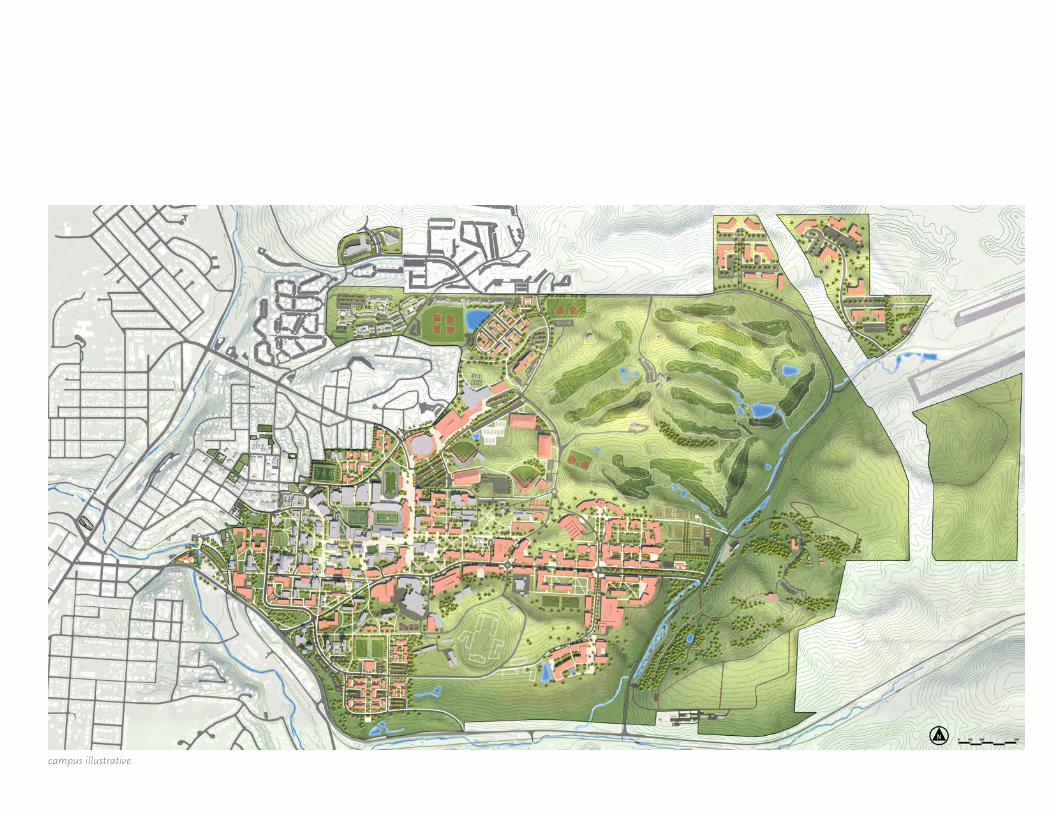
campus illustrative

A COLLABORATIVE EFFORT 1
INTRODUCTION 5
ALIGNMENT WITH THE STRATEGIC PLAN 6
ENROLLMENT AND SPACE PLANNING 8
MASTER PLAN UPDATE PROCESS OVERVIEW 10 Drivers and Goals 13 Primary Actions 14 Major Elements 17
FOCUS AREAS 20 Focus Area 1: North Campus District 22 Focus Area 2: West Campus District 24 Focus Area 3: South Campus District 26 Focus Area 4: East Campus Research District 28 Focus Area 5: Northeast Campus Technology Research Park 30 Focus Area 6: Former Boyd Property 32 Whitman County Properties 33
LANDSCAPE PLANNING 36 Campus Character 36 Open Space Framework 38 Goals 41 Terrain + Walking Circle 42
TRANSPORTATION, ACCESS AND PARKING 44 Roadways + Parking 44 Transit 48 Pedestrians + Bicycles 50
A SUSTAINABLE CAMPUS 52
MASTER PLAN UPDATE SUMMARY 56
table of contents
future signature campus open spacecover photo by Bob Hubner, © 2011, Washington State University

Established in 1890, the Washington Agricultural College, Experiment Station and School of Science opened its doors to its first class of students two years later. Its beginnings were humble; the vision of its early leaders was ambitious.
They did not want this to be considered just a technical or agricultural school. As President Enoch Bryan said in 1894, the land-grant college must provide “col-legiate work that is advanced scientific and technical work, and a liberal education.”
Throughout the tenure of Dr. Bryan and our other early leaders, the same theme is repeated. They embraced the agricultural, land-grant mission. However, their vision was broader than that. This college would provide education in the arts and sciences. It would be a home for outstanding research and graduate studies.
This update of the master plan for the Pullman campus of Washington State University continues and modernizes that vision, making it vibrant in an age of interdisciplinary research and instantaneous communication. It reflects our dedica-tion to sustainability and resource conservation. It shows our ability to adapt to the escalating pace of change that will impact higher education and our society as a whole in the coming decades.
This plan is the product of a thoughtful and thorough process, which included careful consultation with those who live, work and learn on the Pullman campus
and with the larger community. That process reflects the close connection between our community and our campus. We are interdependent; one cannot thrive without the other.
Our goals, as reflected in this plan, are straightforward:
• Ouruniversitywillberecognizedasoneofthenation’sleadingland-grant universities.
• Ourresearchprofilewillgrow,particularlyinareasweidentifyasareasof academic preeminence.
• Wewillbededicatedtoexcellenceandaccessinundergraduateeduca-tion and will expand the enrollment and reputation of our graduate programs.
• Wewillbeadiverseinstitution–diverseinideas,diverseinculture,diverse in the backgrounds of our students, faculty, and staff.
• Wewillbeaglobaluniversity,servingthecitizensofWashingtonasourprincipal obligation.
Thisplanembodiesthoseprinciplesandwillbecentraltoshapingouruniversity’sfuture.
Elson S. FloydPresident
a letter from the president

“We stand on a strong land-grant tradition as the people’s university of Washington. We inherit a legacy of accomplishment by innova-tive and visionary researchers, a legacy we are enhancing every day. And we are poised on the brink of an era where our strengths are a perfect complement to the needs of the state and nation we serve.
Our mission of education and research, ex-tension and outreach has never been more relevant.”
Elson S. Floyd2/27/2008


1washington state univer sity 2012 pullman campus master plan update
The 2012 Campus Master Plan Update is the result of a collaborative effort led by the University’s Office of Capital Planning and Development and Hanbury Evans Wright Vlattas + Company. The process was guided by a Steering Committee and a Campus Master Planning Committee com-posed of University faculty, staff and students. The plan incorporates ideas generated through on-site workshops, stakeholder interviews, planning team meetings, presentations and reviews with University executive staff and the Board of Regents.
EXECUTIVE OFFICERS
Elson S. Floyd, President
Warwick Bayly, Provost & Executive Vice President
John Fraire, Vice President for Enrollment Management
Howard Grimes, Vice President for Research & Dean of Graduate School
Larry James, Associate Executive Vice Provost
Joan King, Associate Vice President & Chief Budget Officer
Bill Moos, Director of Athletics
Vijii Murali, Vice President of Information Systems & Chief Information Officer
Roger Patterson, Vice President for Business & Finance
Mary Wack, Vice Provost for Undergraduate Education
DEANS
Daniel Bernardo, Dean of College of Agriculture Human & Natural Resource Sciences
David Cillay, Executive Director of Online Administration
Candis Claiborn, Dean & Professor, College of Engineering & Architecture
Daryll DeWald, Dean & Professor, College of Science
Douglas Epperson, Dean & Professor, College of Liberal Arts
A.G. Rud, Dean & Professor, College of Education
Jay Sarratt, Dean of Libraries
a collaborative effort
Bryan Slinker, Dean of College of Veterinary Medicine
Eric Spangenberg, Dean of College of Business & Economics
MASTER PLAN UPDATE STEERING COMMITTEE
Thomas Ambrosi, Senior Director Networking & Chief Information Security Officer
Terry Boston, Assistant VP Administrative Services & Auxiliary Support
Bridgette Brady, Director Parking & Transportation Services
Deborah Carlson, Director of Capital Budget
Ev Davis, Associate Vice President, Facilities Operations
Bill Gardner, Director Police Department
Kathleen Hatch, Executive Director University Recreation
Pete Jacoby, Associate Dean College of Agriculture, Human & Natural Resource Sciences
John Johnson, Senior Associate Director of Athletics
Mike Malcolm, Director of Administrative Services & Business, College of Veterinary Medicine
Dan Nordquist, Assistant Vice President for Research Administration & Director
Bobbie Ryder, Senior Campus Planner
Olivia Yang, Associate Vice President for Facilities Services
CAMPUS MASTER PLANNING COMMITTEE
Cynthia Arbour, Campus Planner
Chris Bruce, Director of Museum of Art
Margaret Benson, Chair of Animal Sciences
Robert Corcoran, Executive Director Facilities Operations
Eleanor Finger, Director Residence Life
Phil Gruen, Associate Professor, School of Architecture & Construction Management
Paul Hirzel, Professor, School of Architecture & Construction Management

executive summary2
Max Kirk, Associate Professor, School of Architecture & Construction Management
Michael Leonas, Director of Capital Project Services
Michelle Martinez, Administrative Manager College of Veterinary Medicine
V.S. Manoranjan, Associate Dean & Professor College of Sciences
Darlene Neunherz, Director of Space & Facility Management College of Business
Rod Sayler, Associate Professor, Department of Natural Resource Sciences
Phillip Waite, Associate Professor Horticulture & Landscape Architecture
John David Wicker, Assistant Director of Athletic Events & Facilities Operations
STUDENT REPRESENTATIVES
Students coordinated public forums and information sessions. They attended Campus Master Planning Committee and Master Plan Steering Committee MeetingsLouis Dalton, Graphic Arts
Marisa Hagney, Architecture
Dan Haynes, Civil Engineering
Annie Manning, Education
Laurie Mooney, Masters in Landscape Architecture
Valeriya Simonova, Communications
Daniel Taibleson, Graphic Arts
Jenni Whelan, Architecture
ASWSU Representatives
Jake Bredstrand, President, ASWSU
Josh Meyer, Vice President, ASWSU
consultant teamHANBURY EVANS WRIGHT VLATTAS + COMPANY
D. Keith Storms, AIA, LEED AP
Kenneth B. Hall, ASLA
James Negri
Wesley L. Page, AIA
MARTIN / ALEXIOU / BRYSON, PC
George Alexiou, PE
Nat Grier, PE
AFFILIATED ENGINEERS, INC
Geoff McMahon, PE, LEED AP
Brian Griffith, LEED AP
Tim Quiring, PE LEED AP
KPFF CONSULTING ENGINEERS
Martin Chase, PE
Thaddeus Egging, PE, LEED AP BD+C
SWIFT COMPANY, LLC
Barbara Swift, ASLA
Caitlin Evans
Amy Lindemuth, ASLA, LEED AP
a collaborative effortcontinued

3washington state univer sity 2012 pullman campus master plan update

executive summary4

5washington state univer sity 2012 pullman campus master plan update
Over its 120-year history, WSU has grown from a small agricultural and science college, to a state university always adapting to meet the opportu-nities and challenges of the day. Many master plans and updates occurred focusing on capital project growth. The most recent master plan adopted by the Board of Regents was published in 1994.
Since that time the University’s office of Capital Planning and Development has followed and modified the 1994 plan with periodic updates in 1998 and 2008. These updates reflect specific captial projects to meet on-going space needs.
This Master Plan Update establishes a big vision for WSU as a research leader benchmarking itself against the members of the Association of American Universities because the association represents the highest level of competitive research institutions. To realize this goal, WSU proposes a significant increase in graduate enrollment and the development of a new research campus.
The plan specifies renewal and replacement of aging buildings, diminishing the visual impact of the ubiquitous automobile, creating a multi-modal transportation system and an open space framework of interlinked formal and informal green spaces to create a truly pedestrian campus.
introduction
The 2012 Campus Master Plan Update creates a framework for growth at the Pullman Campus envisioning a reinvigorated undergraduate experience and a thriving graduate research agenda.
executive summary6
alignment with the strategic plan
visionWashington State University will be recognized as one of the nation’s lead-ing land-grant research universities.
missionWashington State University is a public research university committed to its land-grant heritage and tradition of service to society. Our mission is threefold:
1. To advance knowledge through creative research and scholarship across a wide range of academic disciplines.
2. To extend knowledge through innovative educational programs in which emerging scholars are mentored to realize their highest potential and assume roles of leadership, responsibility, and service to society.
3. To apply knowledge through local and global engagement that will improve quality of life and enhance the economy of the state, nation, and world.
Toward the fulfillment of these statements, the Strategic Plan targets four overarching goals:
1. Achieve national and international preeminence in innovation, discovery, and creativity.
2. Provide a premier education and transformative experience that prepares students to excel in a global society.
3. Lead in relevant local, national, and global outreach and engagement
4. Embrace an environment of diversity, integrity, and transparency.
The Strategic Plan establishes benchmarks to evaluate University achieve-ments in reaching its goals. Key among them is the set of indicators used by the Association of American Universities (AAU) to assess the quality of an institution and its faculty. AAU’s 61 member institutions represent the top echelon of research universities, public and private, in the United States and Canada. By matching or exceeding these performance criteria, WSU will take its place among the top universities in the world.
Development of the 2012 Campus Master Plan Update is a key action to fulfilling WSU’s 2008-2013 Strategic Plan. The Strategic Plan reaffirms the Vision and Mission of the University:

7washington state univer sity 2012 pullman campus master plan update

executive summary8
comprehensive square footage projections*ASF: Assignable Square Feet
enrollment and space planning
Modified Scenario Existing ASF Existing
ASF/ student
Proposed
ASF/Student Benchmark
Projected ASF New ASF Projected ASF New ASF
Enrollment 19,22116,348 undergrads
21,15016,700 undergrads
26,00018,000 undergrads
SPACE USE CLASSIFICATION
Classrooms 199,477 10.38 11.00 232,650 33,173 286,000 86,523
Laboratories 1,162,517 60.48
Non-schedulded Open Labs 203,904 10.61 8.00 169,200 -34,704 208,000 4,096
Scheduled Teaching labs 169,744 8.83 9.31 196,907 27,163 242,060 72,316
Research 788,869 362 sf/$100,000 700 sf/$100,000 1,374,661 585,792 2,749,322 1,960,453
Offices 1,055,288 267.22 210 1,199,205 143,677 1,474,200 418,912
Staff Other offices 528,862
General 320,570
Faculty 206,096
Library/Study 381,635 19.86 20.00 423,000 41,365 520,000 138,365
Special Use 987,163 51.36 54.00 1,142,100 154,937 1,404,000 416,837
General Use 685,314 35.65 37.00 782,550 97,236 962,000 276,686
Central Support 768,027 39.96 8% of other space 566,203 -201,824 953,488 185,461
Health Care 118,984 6.19 6.53 138,110 19,126 169,780 50,796
Residential 1,464,386 215.00 350.00 2,220,750 756,364 3,185,000 1,720,614
2011 = 6,811 resident students 35% of Students 30% of Students
Unclassified 67,139 3.49 3.49 73,877 6,738 90,818 23,679
TOTAL ASSIGNED SQUARE FEET 6,890,170 358.47 175.00 8,500,000 1,600,000 12,200,000 5,300,000
TOTAL GROSS SQUARE FEET 10,620,579 552.55 13,100,000 2,500,000 18,800,000 8,200,000
2011 2020 2030

9washington state univer sity 2012 pullman campus master plan update
In the fall of 2011, enrollment at the Pullman campus was 16,348 under-graduate students and 2,873 graduate, professional and post doctoral students. Campus facilities at that time totaled 10,620,579 gross square feet (GSF) of space. The plan represents a conceptual framework for growth necessary to accommodate projected enrollment in 2020 and 2030, as well as the corresponding increase in faculty and staff. The plan also anticipates the need for renewal and replacement of aging and inadequate facilities.
Based on lengthy discussions with WSU leadership about the future of graduate research and undergraduate education the following projections were made:
• ENROLLMENT AT 2020
• 16,700 undergraduates • 4,450 graduate students
Potential campus facilities target of 13.1 million total GSF*
• ENROLLMENT AT 2030
• 18,000 undergraduates • 8,000 graduate students
Potential campus facilities target of 18.8 million GSF*
*Includes facilities that would be relocated / reconstructed on other properties owned by WSU in Whitman County

executive summary10
master plan update process overview
WSU commissioned the firm of Hanbury Evans Wright Vlattas + Company (the planning team) to lead the master planning update process. The result is a plan that includes conceptual level strategies to guide campus develop-ment for the next 20 years and beyond. The plan thoroughly analyzes the existing physical and organizational conditions of the campus and makes detailed recommendations as to scale and physical organization tailored to support the Strategic Plan’s goals and evaluative benchmarks.
This master planning update effort began in May 2010 and was completed in October 2011. The intensity and comprehensiveness of the planning process is attested to by the approximately 100 client interfaces – meetings, forums, presentations, and remote conferences – scheduled over the life of the planning effort. The planning team investigated and analyzed the University’s assets, deficiencies and future needs.
These investigations explored a broad range of issues and concerns, includ-ing but not limited to:
1. Past Planning Efforts
2. Academic Mission, Programs and Facilities
3. Enrollment Growth and Profile
4. Research Growth and Focus
5. Student and Residence Life
6. Athletic and Recreational Sports
7. Faculty, Staff, and Student and Alumni Organizations
8. Land Use, Landscape, Open Space and Urban Design
9. Research, Teaching, Residence and Support Facilities
10. Facility Renewal, Replacement and Program Relocation
11. Utilities and Infrastructure

11washington state univer sity 2012 pullman campus master plan update
12. Information Technologies
13. Facilities Maintenance
14. Architectural and Landscape Character
15. Wayfinding
16. Transportation Access and Parking
As part of the master planning update effort, the planning team • Conducted meetings with WSU faculty and staff, student
representatives, members of the Board of Regents and members of the City of Pullman staff and City Council
• Conducted two open forums in the CUB to obtain broad University input
• Toured campus facilities and grounds, photographing and cataloguing existing conditions
• Reviewed previous planning documents and coordinated with on-going planning efforts for Martin Stadium and the Moscow Pullman Regional Airport
• Engaged in multiple events for feedback with WSU constituents, including the Steering and Master Planning Committees, Deans and Department Heads, the President, Provost and Executive Staff
• Developed 2-D and 3-D graphics to present and study existing conditions on campus and to evaluate design options
An iterative cycle of analysis and feedback ensured that the final plan rep-resents a collaborate effort between the planning team and the University to address WSU’s needs and future growth.

executive summary12

13washington state univer sity 2012 pullman campus master plan update
drivers for the master plan update1. Campus plan response to WSU’s research initiatives,
• Proposed increases in graduate student population
• Increase in space needs
2. Current pattern of campus growth to the east to create a 15 – 20 minute walking distance
• Impact of topography
3. Potential future regional transportation impact on campus arrival
• Migration away from the historic Oak Street entrance
4. Lack of a cohesive open space network
• Impervious coverage
5. Ramifications and opportunities of new land acquisition
• Former Boyd property
6. Moscow Pullman Regional Airport expansion
• Impacts to existing WSU facilities and potential future building sites
7. A transportation, parking and access strategy that
• Reduces the visible presence of automobiles in the core campus
• Creates a truly pedestrian-focused campus
master plan update goals1. Create a facilities master plan update that supports and enables the
University’s strategic goals
2. Plan for facilities that position the University to compete with AAU member institutions. This will require a significant increase in the University’s research infrastructure
3. Plan for space that accommodates enrollment growth
4. Plan physical arrangements and adjacencies that foster interdisciplinary collaboration
5. Develop an open space network that enhances the University’s sense of place and links with the natural environment of the Palouse
6. Create an environment that focuses on the pedestrian
7. Create a plan that compliments the topography of the campus, while mitigating grade changes for pedestrians
8. Create a plan for development of the land east of Stadium Way
9. Create a plan that addresses deficient facilities
10. Develop a transportation, access and parking strategy
11. Create an exemplary sustainable campus that also teaches about sustainability
During the master planning process seven primary drivers emerged to influence the final plan. As these were eval-uated eleven master plan update goals were developed to guide decisions about future growth, campus character and environmental leadership.

executive summary14
In response to the goals and planning drivers, the master
plan update proposes four primary actions:
1superlative research campusCreate a superlative research campus in the eastern area of campus centered on Grimes Way. The new campus will accommodate the research space required to achieve the University’s strategic goals.
Existing animal research facilities, greenhouses and Facility Operations functions will be relocated.
campus sense of placeReinforce the existing campus core as the academic nucleus for undergraduate programs. Systematically address facility deficiencies through renovation and new construction. Improve
the campus’ sense of place by enhancing outdoor spaces as part of a campus-wide network of open space. Enhance pedestrian and bicycle connections to the downtown. Address undergraduate student life.
2

15washington state univer sity 2012 pullman campus master plan update
pedestrian focusCreate an interdisciplinary research zone organized around a new signature green space along the east side of Stadium Way and Grimes Way. Relocate programs such as the College of
Engineering and Architecture to this area to facilitate interdisciplinary research and collaboration. Create a pedestrian mall on Stadium Way between North Fairway Road and Grimes Way to enhance pedestrian connectivity between the graduate and undergraduate campus areas.
3 leadership in sustainabilityImplement the above actions in a manner that embraces and teaches about environmental sustainability. Strategies include low-impact site development, best management practices for
storm water, buildings designed to USGBC’s LEED standards, didactic landscapes, and a multi-modal approach to transportation. Moreover, sustainable operations practices should complement these develop-ment strategies.
4

executive summary16master plan update illustrative
J
H
G
F
D
U
E
B A
C
P
Q
O
K
N
LM
I
R
S
T

17washington state univer sity 2012 pullman campus master plan update
the major elements of the planThe illustrative plan indicates the proposed locations for elements of the plan. Each is sited to extend and enhance the campus network of open spaces, and complement existing and future program functions.
A. Renovated and expanded Beasley Coliseum
B. Revitalized north campus housing residence halls
C. Stadium Way pedestrian mall
D. Interim location for new WSU visitor center
E. Student life facility and alternative site for potential future hotel confer-ence center
F. Revitalized south campus housing for single graduate students
G. Research incubator park
H. Animal research
I. Family housing
J. Potential future hotel conference center
K. Relocated baseball stadium
L. Greenhouses and growth chambers
M. Organic farm
N. Long-term location of WSU visitor center
O. Grimes Way as divided boulevard with integrated storm-water facilities
P. Research campus
Q. Future expansion of research campus
R. South campus loop road
S. Future chilled-water storage tank
T. Central green space
U. Existing welcome center. Future mixed use site
Existing Library Mall
Proposed Stadium Way Mall

executive summary18
Land Use Diagram
Teaching
Residential
Agriculture
Research
Athletic / Recreation
Transitional Research
Veterinary Medicine
USDA
Support
Arboretum
Crop Research
N

19washington state univer sity 2012 pullman campus master plan update
The campus currently is organized by land assignment to colleges and departments and, for all practical purposes, growth has been governed by individual program and departmental growth initiatives. Historically, campus growth began in the west adjacent to the City of Pullman but has migrated always eastward, resulting in a pattern of growth that extends beyond the 10 minute class change.
The plan reflects the University’s goal of interdisciplinary research and collaboration, with emphasis on strengthening the core campus, creat-ing a research campus to the east along Grimes Way and establishing a transitional research zone connecting the existing campus to the new research zone.
Student housing continues to occupy the perimeter of campus, with athlet-ics and recreation expansion adjacent to current facilities. Land northeast of Terre View Road, including the former Boyd property, have become opportunities for future growth as well as locations for the relocation of animal facilities impacted by airport expansion and other uses displaced by development of the graduate research campus. Lands owned by WSU elsewhere in Whitman County will continue to operate within their as-signed use. It is anticipated that the animal science facilities currently located on Grimes Way will be relocated to the Tula Young Hastings farm on Country Club Road.
NO BUILD ZONES
Planning Parti Diagram
TEACHING ZONE
RESEARCH ZONE CENTER
10-minute walking circle
5-minute walking circle
proposed new airport impact zone
campus entrances
TRANSITIONAL RESEARCH ZONE
PROPO
SED
NO
RTHER
N
REG
ION
AL
BYPA
SS

executive summary20
focus areas overall
1
2
3
4
5

21washington state univer sity 2012 pullman campus master plan update
6
1 North Campus District
2 West Campus District
3 South Campus District
6 Former Boyd Property
5 Northeast Campus Technology Research Park
4 East Campus Research District

executive summary22
focus area 1north campus district
main themes • Relocate family housing and
WSU Children’s Center
• Define dedicated expansion for athletics and recreation program needs
• Establish campus loop road connection to North Fairway Road
• Redefine arrival from the north on Stadium Way
H
G
D
E
B
A
C
I
J
F
P
Q
O
K
N
L
M
Proposed Plan Focus Area 1
N

23washington state univer sity 2012 pullman campus master plan update
proposed actionsA. New artificial turf intramural play fields; turf grass research area
relocated to the former Boyd property
B. New WSU Children’s Center at the corner of Terre View Drive and North Fairway Drive
C. Nez Perce Apartments demolished; new location of housing for students with families
D. Student apartments renovated or replaced per WSU housing study
E. North campus residence halls replaced per WSU housing study
F. Soccer stadium with parking structure below
G. Beasley Coliseum expansion
H. New parking structure with connection to Student Recreation Center (SRC)
I. Pedestrian promenade connecting SRC to Stadium Way pedestrian mall
J. Baseball stadium converted to women’s softball stadium
K. Indoor practice facility bubble replaced with roof
L. New baseball stadium
M. New indoor courts facility
N. New indoor tennis center
O. Campus loop road
P. New leadership training center
Q. Potential future site of hotel conference center
Perspective Area of Proposed Focus Area 1

executive summary24
focus area 2west campus district
main themes • Preserve character of historic
campus
• Use surface parking lots as infill building sites
• Use new buildings to shape quadrangle spaces
• Minimize conflicts between pedestrians and automobiles
• Create better town / gown interface
• Move Welcome Center to campus
• Realign Stadium Way and Grimes Way
• Create a signature open space for campus
Proposed Plan Focus Area 2
H
G
D
E
B
A
C
I
J
F
P
Q
OK
N
L
M
R
ST
U
V
W
X
N

25washington state univer sity 2012 pullman campus master plan update
proposed actionsA. Student life building with parking deck below. Potential location of
future hotel conference center as a town/gown interface.
B. Green roof terrace connects to new residence halls to mitigate topo-graphic site conditions
C. Interim relocation site for WSU Visitor Center until future bypass shifts primary arrival of campus to Airport Road
D. Landscape buffer to mitigate views from Main Street to College Avenue steam plant and service yard; remove abandoned oil tanks
E. Preserve historic campus lawns
F. Renovate steam plant façade to remove abandoned infrastructure components; consider future potential use of alternative green tech-nology energy production
G. New residence halls replace outdated academic buildings; College of Engineering and Architecture relocate to Grimes Way transitional research zone
H. Realign intersection at Stadium Way / Nevada Street / Olympia Avenue; demolish Health and Wellness Services building and relo-cate to the existing WSU Children’s Center building. Relocate the Children’s Center to the corner of Terre View Drive and North Fairway Drive
I. Create new academic quadrangle to accommodate future growth of the sciences; first phases used as surge space for renovation or replacement of Fulmer and Heald Halls
J. Replace Neill Hall
K. Replace Fulmer Hall
L. Cleveland Hall Addition
M. Replace Heald Hall
N. New academic buildings fronting new central green space
O. Realign access to existing parking structures
P. Realign Stadium Way and Grimes Way to create pedestrian mall and central green space; close Stadium Way to automobile traffic. (In the interim Stadium Way will serve as a transit mall.)
Q. Demolish public safety building; future Fine Arts Museum with green roof as civic space. Public safety office moves to the Old Bookie
R. Demolish Johnson Tower to create new quadrangle
S. Redevelop Wilson Road extending Terrell Mall to Stadium Way
T. Complete landscape improvements on Terrell Mall
U. Construct addition to Martin Stadium for Athletics operations, press box and premium seating
V. Demolish Annex to create pedestrian promenade to Martin Stadium
W. Expand Martin Stadium seating
X. Close Stadium Way at North Fairway Road to Grimes Way; create pedestrian mall
Perspective View of Proposed Focus Area 2

executive summary26
focus area 3south campus district
main themes • Establish a southern loop road
alignment
• Create a graduate student housing district
• Establish a hierarchy of green spaces and pedestrian pathways
• Refine access to VetMed
• Create a central green space for campus
• Realign Stadium Way and Grimes Way
• Establish a land reserve for transitional research
• Replace aging facilities
H
G
D
E
B A
C
IJ
F
P
Q
O
K
N
L
M
R
S
T
U
Proposed Plan Focus Area 3
N

27washington state univer sity 2012 pullman campus master plan update
proposed actionsA. Replace residence halls and dining facilities per WSU housing study
B. Replace pedestrian bridge
C. Demolish Southside Café and replace with quadrangle open space
D. Relocate Health and Wellness Services
E. Replace Wegner and McCoy Halls with state of the art facilities
F. Add new parking structure
G. Create new signature campus open space
H. Realign Stadium Way / Grimes Way
I. Add new academic buildings
J. Create new Alumni Center quadrangle
K. Create Wilson Road pedestrian mall
L. Plan for Global Animal Health phase 2
M. Build new chilled water storage facility
N. Add new residence halls and quadrangle open space
O. Add new student recreation facility and community center at Rogers-Orton playfield
P. Replace existing student apartments with single graduate student apartments arranged in a courtyard configuration
Q. Create 100-foot landscape buffer between student housing and pasture
R. Align new south campus loop road with topographic conditions
S. Remove existing Yakama Village to create green way linkage along southern perimeter of campus
T. Transitional Research
U. Design traffic circle at Grimes Way / Olympia Avenue intersection
Perspective View of Proposed Focus Area 3

executive summary28
focus area 4east campus research district
main themes • Research district along Grimes
Way
• Research campus transforms perception of WSU from SR 270
• Existing animal facilities on Grimes Way move to Tula Young Hastings Farm
• South campus loop road moves automobile traffic to the perimeter of campus
• New buildings shape quadrangle open space
• Parking structures replace surface parking lots
• Grimes Way becomes the main entrance to campus once a new highway bypass is constructed
• Long-term location of WSU Visitor’s Center at Grimes Way / Airport Road intersection
• Organic Farm is linked to Visitor’s Center
• Southern and eastern perimeter of campus remains a informal open space
H
G
DE
E
B
A
C
I
J
J
J
F
F
P
Q
Q
Q
O
K
N
N
L
M
R
Proposed Plan Focus Area 4
N

29washington state univer sity 2012 pullman campus master plan update
proposed actionsA. Alumni Arboretum as part of the network of open spaces
B. Expanded chiller facility
C. Growth chamber expansion
D. Northeast campus loop road
E. New greenhouses
F. New parking structure
G. Greenhouses on top of new parking structure
H. Traffic circle at Grimes Way / Olympia Avenue intersection
I. South campus loop road
J. Quadrangle open spaces with new research buildings
K. Long-term location of WSU Visitor’s Center
L. Organic Farm as sustainable agriculture research and community outreach; link with visitor’s center by pedestrian pathway
M. Grimes Way as divided boulevard with storm-water treatment com-ponents in the median
N. Traffic circle as traffic calming device
O. Expanded Grimes Way steam plant
P. New intramural fields
Q. Preservation of hilltops
R. Pedestrian paths along the perimeter of campus and linking to the campus Arboretum and Wildlife Conservation Center (AWCC)
Perspective View of Focus Area 4

executive summary30
focus area 5northeast campus technology research park
main themes • Establish technology research
park on the northeast perimeter of campus
• Identify future highway bypass and airport expansion
• Relocate agricultural and VetMed uses to former Boyd property
• Create informal open space along the perimeter of campus used for pedestrian paths
G
D
E
B
A
C
C
H
I
F
J
Proposed Plan Focus Area 5
N

31washington state univer sity 2012 pullman campus master plan update
proposed actionsA. Research park capacity: 200,000 gross square feet at two stories
B. Sustainable storm-water feature
C. Open space linkage to campus
D. Perimeter of golf course for pedestrian pathway network through informal open space
E. Regional northern bypass right of way
F. Research park capacity: 250,000 gross square feet at two stories
G. Scabies sheep facilities relocated from existing location in impact zone of new airport runway alignment
H. Airport Road
I. Proposed new airport runway alignment
J. Potential future chilled water facility Perspective View of Focus Area 5

executive summary32
focus area 6boyd property
main themes • Relocated facilities impacted by
proposed new airport runway alignment
• Student recreation fields expansion area
• VetMed animal facilities compound; relocation of facilities impacted by research campus development
• Relocated campus compost facility
Proposed Plan Focus Area 6
N

33washington state univer sity 2012 pullman campus master plan update
whitman county propertiesexisting properties
A. Smoot Hill
B. Cunningham Farm
C. Palouse Conservation Research Station
D. Tula Young Hasting Farm
E. Colton Natural Area
F. Spillman Farm
G. Wawawai
A
B
C
F
G E
D
IDAH
O – LATAH
CO.
WASHINGTON – GARFIELD CO.

executive summary34
Smoot HillEXISTING USE
• College of Sciences – Research
• Natural area and teaching facility
• Threatened species
• 300 acres – Farm Services Agency
• Conservation reserve – outside existing forested area
POTENTIAL USE
• Use existing barns for isolation of animal groups
Cunningham FarmEXISTING USE
• Crops and Soils Department
• Cook Research Farm
• 51 acres leased to a local farmer – 2 year rolling lease
• No till research
• Weed research
• Shop for plant pathology
Palouse Conservation Research StationEXISTING USE
• Long term ultra violet radiation research
• USDA small holding
POTENTIAL USE
• USDA facilities currently at the corner of Rt.270 and Airport Road
• Relocated orchard impacted by new airport runway alignment
• Relocation of seed storage facility impacted by growth along Grimes Way
• Horticulture and Landscape Architecture facilities impacted by new airport runway alignment
• Cold storage, offices and shops
Tula Young Hasting FarmEXISTING USE
• Student caretaker housing
• Dairy, beef, swine facilities
• Need additional land for grazing
• Need to modernize dairy and increase herd
• Approaching limits of the lagoons
• Manure spreading capacity
• Pump 15 million gallons between the first of May to the end of October
• Underground pipe system needed to connect lagoons
• Need additional land for dispersal
POTENTIAL USE
• Cattle feeding lab
• Cannot mix animals with the beef or dairy herds
• Slope and wind are issues
• Goat barn
• Feed plant
• Need better access for tractor trailers in winter – pave road
• Farm services
• Feed mill
• Increased revenue potential
• Location closer to the highway may be best
whitman county properties

35washington state univer sity 2012 pullman campus master plan update
• Could address through a land swap with the farmer who owns the land
• Program elements to consider
• Commodity storage and feed lab together – covered and uncovered area
• Feed plant as separate facility
• Flexibility to house small groups of animals in isolation barns – not the goat barn
Colton Natural AreaEXISTING USE
• Twenty nine acres – Palouse prairie remnant (will not plow)
• Right of way is wide enough for an ATV – not a vehicle road
• Natural area for Yellow Star Thistle
• Received a grant for restoration
Spillman FarmEXISTING USE
• Crops and Soils
• On a two year rotation
• Would like to have a three year rotation – but need more land
• Breeding farm for new wheat and barley
• USDA has one building
• Desire to expand land holding by 160 acres
• Expansion area owned by the Department of Natural Resources; has river access
WawawaiEXISTING USE
• Pasture for beef cattle
• Reduces feed needs in early spring
• Crew area is leased from the Army Corps of Engineers
• Instruction area
• Storage for boats
Former Boyd PropertyEXISTING USE
• 225 acres of crop land
• Need dedicated access
• Consider purchasing adjacent parcel to the south for better connectivity to campus
POTENTIAL USE
• VetMed animal research facilities and holding pens
• University composting area
• Relocated orchard
• Student recreation fields
• Horticulture and Landscape Architecture facilities impacted by new airport runway alignment
USDA site at corner of Route 270 and Airport RoadEXISTING USE
• Crop field research
POTENTIAL USE
• Potential site for orchard and Organic Farm

executive summary36
1910
WSU Campus circa 1910
1936
landscape planning
In the early decades, the campus developed with buildings shaping a gra-cious landscape of lawns and shade trees. Over time, many of these lawns were lost due to new building construction. Expansion along Grimes Way has been opportunistic and haphazard. The clear patterning of the historic core has been lost, and the campus lacks a signature open space.
The pedestrian experience also has suffered. Campus expansion to the east has meant students must navigate up and down campus terrain. Classroom destinations from the west to the east are now well outside the ideal 10-minute class change. Stadium Way, initially a perimeter roadway, now bifurcates the campus with automobile traffic as motorists use it as a bypass around Main Street and downtown. This has resulted in numerous conflicts between pedestrians and motorists and many near accidents. As the research campus develops along Grimes Way, increased pressure on pedestrian movement will require a more organized approach to pedestrian circulation.
campus character

37washington state univer sity 2012 pullman campus master plan update
1945 1965 1985
WSU Campus circa 1965

executive summary38
landscape planning
Formal
Informal
Functional
Preserve
Hilltops
N
open space framework
open space framework

39washington state univer sity 2012 pullman campus master plan update
The campus is located in the unique regional context of the Palouse and is characterized by significant topographic conditions. Situated atop a hill, it overlooks its host community and surrounding farmland. The campus landscape is characterized by a framework of open spaces consisting of four basic typologies:
1. Formal open space
• Large lawn spaces
• Low, non-focal point vegetation
• Seasonal color and native species
• Transition of built and natural environment
• Great streetscapes
2. Informal open space
• Remnant open space around the perimeter of campus
• Community gardens such as the Organic Farm as features of stewardship, education and sustainability
• Includes arboretum, stream channels, wetlands, storm-water features, interstitial zones between buildings, forest remnants
3. Functional open space
• Sports and recreation fields
• Golf course and driving range
• Pastures and animal grazing areas
• Agricultural fields
4. Preserve
• Palouse remnants

executive summary40
landscape planning
proposed campus quadrangle in research district
campus quadrangle prototype

41washington state univer sity 2012 pullman campus master plan update
goal 1ESTABLISH A NETWORK OF FORMAL AND INFORMAL OPEN SPACES
• Preserve historic campus core quads and mature trees
• Use new buildings to create formal quad spaces and courtyards; buildings should shape the space not occupy it
• Take advantage of topography; extend vistas and axes to take advantage of views to the Palouse
• Interconnect informal spaces with pedestrian malls
goal 2CREATE A SIGNATURE OPEN SPACE AT THE CORNER OF GRIMES WAY
AND STADIUM WAY
• Remove parking at Bustad Hall
• Reroute Stadium Way along the face of Bustad Hall and link with Grimes Way at Alumni Way
• Close Grimes Way between Alumni Way and Stadium Way
• Establish a quadrangle suitable for gatherings and passive recreation
goal 3CREATE A PEDESTRIAN MALL ON STADIUM WAY
• Close Stadium Way to automobile traffic from North Fairway Drive to Grimes Way
• In the near term, create a transit and pedestrian mall maintaining routes for Pullman Transit
• Long term strategy: Reroute transit vehicles to campus loop road
• Consider how pedestrian malls can facilitate game day access and tailgating
goal 4CREATE A NETWORK OF PEDESTRIAN PATHWAYS
• Redefine Terrell and Library Malls incorporating additional landscaping, art, seating, and shade
• Redefine service vehicle access on pedestrian malls; limit times and types of vehicles
• Convert Wilson Road into an extension of Terrell Mall to the Alumni Center
• Collaborate with UREC to define running trails around the perimeter of campus
• Link pedestrians to the arboretum and downtown
• Standardize pathway materials, signage and lighting to enhance ease of use and safety
The 2012 Campus Master Plan Update recommends four goals to address these issues:

executive summary42
landscape planningterrain + walking circle
high
low
ALTITUDE
N

43washington state univer sity 2012 pullman campus master plan update
WSU’s physical character, or sense of place, results from the blending of numerous characteristics – topography, architecture, landscape, and broader geographic context, as well as its physical relationship to its host community.
Verticality is WSU’s most striking feature, creating a campus that is both scenic and physically demanding. Stadium Way is crossed by five pedes-trian bridges in less than one mile. At class-change time, pedestrian travel between the east and west campus takes longer than the 10-minutes al-lowed, however, the terrain also allows the campus populace to experience the reality of the Palouse hills. These features could be enhanced through careful placement of future buildings so that views up and down hills and out to the landscape are shown to best advantage.
walking radius diagram

executive summary44
transportation, access and parkingroadways + parking
P8
P2
P1
P4
P3
P5
P6
P9
P7
Proposed Parking
Existing Parking
Campus Streets
Service Lanes
City Streets
TERRE VIEW ROAD
MAIN STREET
SR 270
AIRPO
RT RO
AD
STADIUM WAY
Parking Structure Counts
P1: 115
P2: 279
P3: 555
P4: 600
P5: 900
P6: 600
P7: 700
P8: 1200
P9: 1200
N
roadways and parking plan

45washington state univer sity 2012 pullman campus master plan update
The existing and future transportation network on the campus – the streets, sidewalks and paths – provide the framework around which the campus will develop. There is already a strong network, particularly in the historic campus core, but the plan envisions stronger future connections. As with all transportation, and particularly on any university campus, the challenge is to balance the need for access with local circulation. The University’s population is expected to grow substantially, with a disproportionate increase in researchers and graduate students who have different travel patterns than undergraduate students. At the same time, the campus will become more spread out as the center of gravity shifts east, further necessitating quality connections to allow and encourage the mixing of disciplines and researchers. The plan seeks to achieve this balance by strengthening east-west pedestrian corridors, limiting vehicle traffic at the campus core, and introducing a shuttle to promote campus movement. The plan continues to provide convenient parking, recognizing that driving to campus is the only option for many.
While Stadium Way serves as the campus primary access, it also provides an opportunity for a relatively high-speed cut through for community members (whether affiliated with the university or not). The four-lane roadway impedes east-west movement for pedestrians and bicyclists on the campus. This barrier has long been recognized with various “loop roads” in previous plans sought to reduce some of the Stadium Way load while ensuring continued access for all.
This plan makes the bold, long-term suggestion that Stadium Way serve as an access point rather than a thoroughfare. Important to its closure will be the creation of alternative routes to ensure continued access for vehicles and transit to all part of campus. This ultimately will require development of a loop road to the east of Stadium Way to provide continued connectivity to the off-campus segment of Stadium Way and to provide access to new academic and research buildings in campus areas that currently have few or no such facilities.
While the phasing of the plan was not studied in detail, there are several options that allow traffic along Stadium Way to be restricted in the near term in concert with or independently of other plan related improvements. As service and emergency vehicles would maintain access in all scenarios, the primary concern would be circulation of Pullman Transit vehicles. If public access along Stadium were restricted, Pullman Transit would need to retain access until the loop is completed. While funding may allow construction of some of the loop in the near term, it is likely that much of the loop will not be constructed for many years, coinciding with the construction of new research and academic facilities.
As part of the loop road construction, through traffic would be diverted off Olympia Avenue to a new road to the south. This would serve as the southern portion of the loop as well as connect to a new road that will provide access to the southeastern portion of the new research campus.

executive summary46
With the closure of a portion of Stadium Way and the completion of the loop road, the plan anticipates Grimes Way being upgraded as a new entrance to campus. While two travel lanes would be sufficient support day-to-day activities, this upgrade may need to be designed for a three- or four-lane cross-section to support game-day activities.
There are other minor adjustments to campus vehicle circulation envi-sioned by the plan. As part of the closure of Stadium Way, for example, Grimes Way will be realigned near its intersection with Stadium Way such that traffic on southern Stadium Way will continue onto Grimes Way. This will allow the creation of a large civic green to serve as both gathering space and as a focal point at the end of Grimes Way. Additionally, it is envisioned that Spokane Street will be realigned south of Washington Street. The new alignment would follow the existing Washington Street roadbed but would curve to the south, providing an improved connection to Stadium Way at the existing Nevada Street intersection.
Although off-campus roadways were not part of the plan study, it will be important to evaluate the impacts of campus growth on these roads. While the plan envisions a reduced reliance on the automobile, no doubt there will be an increase in vehicle trips to and from campus. As the campus grows east, it is not be unreasonable to anticipate that some portions of Airport Road would need to be widened. Much of the extent of local improvements may hinge on the proposed northern and southern bypass roads and the alignments selected if one or both are constructed.
Provisions for parking remain a critical issue in the plan, as the reality is that driving will continue to be a primary mode of travel for people coming to
roadways + parking
transportation, access and parking

47washington state univer sity 2012 pullman campus master plan update
and from campus. The illustrative plan anticipates that up to 4,300 spaces could be lost to accommodate new building construction, while anticipated campus growth suggests additional demand of roughly 9,600 spaces in 2020 and 13,900 spaces in 2030. While there is potential for future park-ing deficits exists, there currently is an excess of parking spaces. This will provide short-term flexibility for early phases of plan implementation, for example, lot closures related to the greening of Stadium Way.
To meet the transportation needs of the growing campus, it will be neces-sary to reduce reliance on the single occupant vehicle (SOV). At build out, nearly all of the parking on campus will need to be in structures – an option that can be up to 10 times as expensive to build and maintain as surface spaces. Moreover, if the campus tried to “build its way out” by constructing a large amount of new parking, it would also need to build wider streets to accommodate increased commuter traffic. Rather, WSU should exploit its transportation demand management (TDM) program to reduce future parking demand.
The plan envisions a staged approach to vehicle accommodation that focuses on TDM and the promotion of alternative parking. TDM measures would include enhanced promotion of the Pullman Transit system, as well as measures to support walking and bicycling to campus. Most important would be the development of rideshare tools to allow individuals to carpool more easily, as well as supportive measures such as an emergency ride home (ERH) program that would guarantee a ride home (or to another location) if, for example, a family member gets sick, or individual has to work unscheduled overtime.
The plan also calls for supplementing the parking on the main campus. This includes the creation of park-and-ride lots. Currently, there are two such lots, though both are under-utilized. One is located on Terre View Road at the Chief Joseph student apartments and one is located on Merman Drive adjacent to the Valley Road playfields. As these lots fill, the University could look for additional locations adjacent to Pullman Transit routes. It may also be beneficial to develop a park-and-ride system that would capture the large number of WSU commuters who live in Moscow. Depending upon demand, the University may also seek to establish remote lots. These would serve primarily as resident student vehicle storage lots but could also serve as a low-price parking alternative. In addition, the plan assumes that interim surface lots will be constructed within the campus core as conditions warrant. (Much of the parking in the eastern research district, for example, is assumed to be surface parking at first.)
While future TDM participation levels will depend upon the success of the University’s TDM programs and exogenous changes, the plan envisions that up to 10 percent of those who might otherwise park on campus will be parking in remote locations and another three to five percent will be using community park-and-ride by 2030. Over time additional commuters will eschew the SOV, resulting in roughly 20 percent participating in a TDM program and by carpooling, taking the bus, walking or bicycling to campus. The plan estimates that the ratio of main campus parking spaces will decrease from roughly 0.40 per person today to about 0.33 by the year 2030.

executive summary48
P
P
P
P
P
PP
P
P
transit
Proposed Parking
Transit Hub
Existing Parking
Pullman Transit
Research Park Shuttle
WSU Shuttle
N
transit plan
transportation, access and parking

49washington state univer sity 2012 pullman campus master plan update
A central component of future campus circulation is a shuttle to connect the campus east to west as the campus extends along Grimes Way. Today, the campus core can be crossed on foot in roughly 15 minutes, a time that is near the edge of what most consider an acceptable travel time for on-campus movement. Eastward growth will more than double the time that it could take to travel between research and academic centers of the campus. The shuttle ensures that the campus can be crossed in no more than 15 minutes. This interconnectivity is crucial to the future success of research at the university, allowing continued collaboration among departments, allowing students, particularly undergraduates, to be involved in research, allowing increased flexibility in academic and resource scheduling, and ensuring that researchers are fully integrated into the campus.
Several versions of a shuttle were examined by the master planning upate team. While the route ultimately will evolve to reflect the program of fu-ture buildings, a direct east-west route with limited stops is the preferred alignment. This keeps travel times low and minimizes students using the shuttle for short trips, trips which inevitably slows the shuttle system and raises the costs as the school must provide an increasing number of buses to accommodate class-changes. A likely alignment connects proposed student life facilities at the west end of College Avenue with the core of new research facilities at the east end of Grimes Way. For some or all of the route, it may be preferable to utilize Wilson Road instead of Grimes, though this is generally in conflict with the vision of Wilson as a pedestrianized area.
The plan envisions that Pullman Transit will continue to play a key role on the campus and anticipates strong growth in ridership. While the overall parking supply on campus will grow, the rate at which parking is provided will decrease. Moreover, permit costs can be expected to rise to offset the increased cost of structured parking. In response, an increasing number of students and employees will take the bus to campus. The plan also envisions a park-and-ride network with lots in Pullman and Moscow. It is likely that primary service for these lots would be by Pullman Transit, although the University or a contractor could provide some of the service.
Given the continued importance of Pullman Transit, it will be critical that these buses continue to circulate around the campus. In the short term, few, if any, changes are envisioned. In the longer term, as Stadium Way is closed and the new loop opens, buses will be shifted away from the pedestrianized core to the loop. There will be one or more locations where the campus shuttle intersects the off-campus routes to allow for a con-venient transfer for those who prefer not to walk to their final destination. The plan calls for transfer points at several of the new parking structures. These stations would become multimodal hubs and also include Green Bike stations and other transportation-related functions.

executive summary50
pedestrians + bicycles
Informal Open Space
Existing Bike Path
Proposed Bike Path
Proposed Ped/Bike Mall
N
pedestrian and bicycle plan
transportation, access and parking

51washington state univer sity 2012 pullman campus master plan update
Improved pedestrian circulation is at the core of the plan. The “pedestrian-ization” of the campus core recognizes the importance of pedestrian travel in campus daily activities. Not only will these changes improve pedestrian safety, they will speed travel for walkers in those places where they currently share space with vehicles. The plan also envisions creation of new iconic spaces and buildings which, in addition to enhancing the overall campus, aid in pedestrian navigation by providing reference points. The grid-like structure of the plan east of Stadium Way will improve pedestrian circula-tion by increasing connectivity.
In areas where vehicles will remain, the plan envisions more pedestrian-scale streets with narrower streets and elimination of on-street parking. The new research campus will have a neighborhood feel with wide sidewalks along tree-lined streets. Buildings will have small set-backs to promote activation of the street. Grimes Way will become a key east-west link anchored by a new green and a landmark building at the intersection of Stadium and Grimes. While the emphasis will be the more formal paths and walks adjacent to buildings, the pedestrian network will connect to a series of paths and trails ensuring the continued connection with the landscape that is important to so many of WSU’s students and employees.
While bicycles currently are not a dominant mode of transportation, their use is anticipated to increase. The Green Bike program has met with great success, and there are plans to continue the addition of bikes and stations. Private bicycle usage likely will increase in response to parking changes as well as the growth in academic and research along Grimes Way. The plan calls for the installation of bike lanes in key locations, particularly where vehicle speeds or volumes are high. It also will be key to examine locations where grades are sufficiently steep that an uphill bike lane is warranted, for example, Nevada Street south of Stadium Way. For much of the campus, however, vehicle speeds will be low so bicycles will be able to share the street.
As additional portions of the campus are closed to vehicles, it will be important to establish regulations indicating where bicycles are allowed and where they are prohibited or must be walked to ensure pedestrian safety. The key will be to provide viable bike routes through the campus.
One of the best ways to increase bicycle use is to adopt bicycle-friendly policies. Requirements such as showers in new buildings, in addition to the provision of secure covered bicycle storage, are important. Similarly, policies to guide roadway design will ensure that future campus streets and upgrades will accommodate bicycles through bike lanes or other design elements.

executive summary52
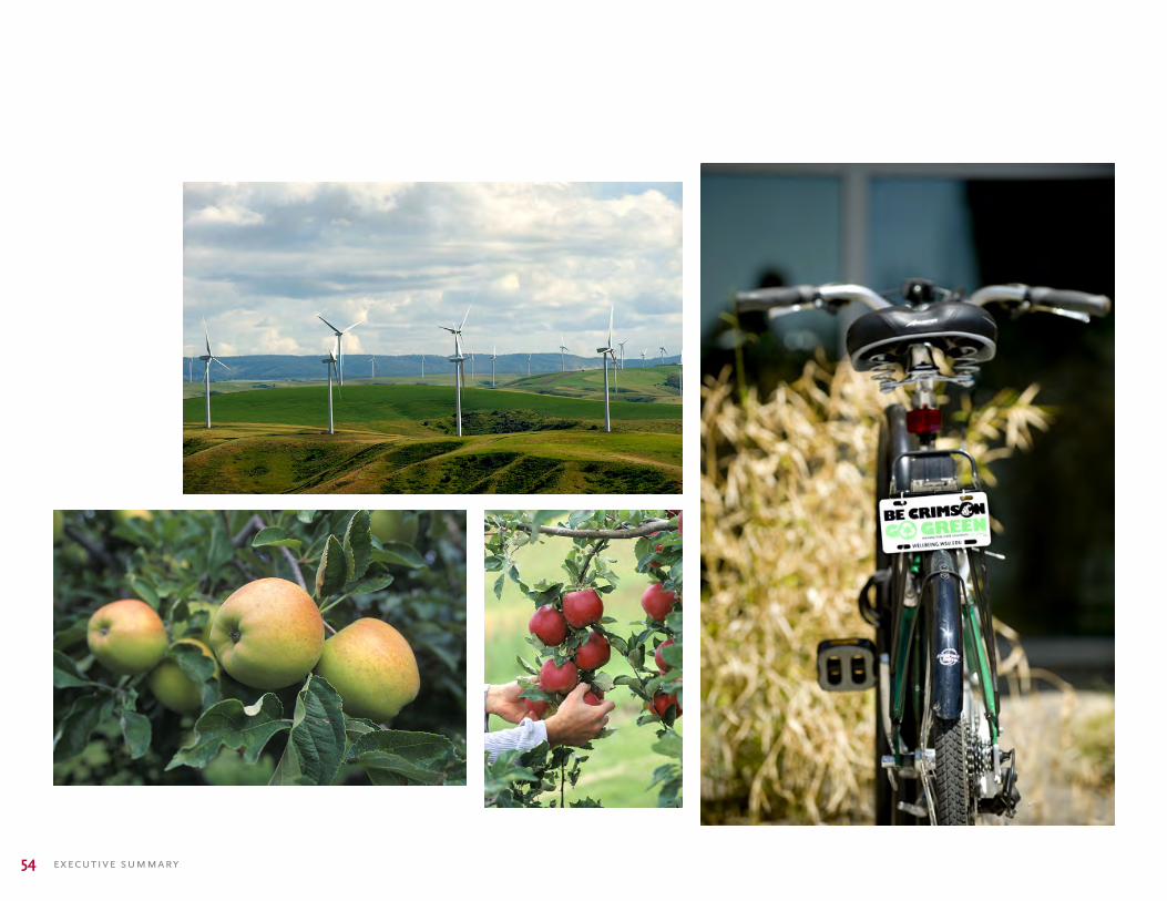
a sustainable campus
As Washington State’s only Land Grant University, WSU desires to be a leader in sustainability. To maximize such opportunities, the plan reinforces several strategies that contribute toward achieving an environmentally responsible living environment:
• Site selection and development that supports efficient land use, effective storm-water management, and a pedestrian-focused community with easy access to transit locations, bike paths and campus connections.
• Preservation and re-establishment of natural land features and vegetation.
• Building masses that contribute to shading exterior spaces, opportunities for natural day-lighting for interior spaces, and preservation of significant view corridors.
• Opportunities for a landscape composed of native species or drought-resistant plant material.
• Dedicated program and site space that support the collection, storage and removal of recyclable materials.
• Project budgets that allow the University flexibility in material and building system choices on a per-project basis. This allows the University to evaluate the life-cycle costs, principles of sustainable development and the social impact of each option.
• WSU is committed to providing new facilities that are responsible in the use of natural resources. These projects shall comply with the USGBC LEED rating system as a point of reference, and LEED Silver certification will be the minimum goal for the project. Additional opportunities for LEED compliance will be considered in every aspect of the design and every economical attempt will be made to provide the maximum level of sustainability possible.

53washington state univer sity 2012 pullman campus master plan update
executive summary54

55washington state univer sity 2012 pullman campus master plan update
In specific response to environmental opportunities this plan recommends the following actions for consideration by the University:
1. Utilization of finish materials that the students can see and touch. These provide visible and physical evidence of the University’s commitment to the environment, and “pride of place” for the students. Students’ desire to be environmentally conscious is a lifestyle not a special action. Examples of this include:
• Finishes that promote the use of recycled materials, such as tiles made from recycled soda bottles.
• Finishes that use rapidly renewable materials sources that are also highly durable in student environments, such as cork or bamboo flooring.
• Lighting that mitigates light pollution, in particular site lighting standards and exterior building lighting.
• Natural outdoor environments that encourage habitats for birds, butterflies, and other visible evidence that the environment is desired by animals as well as people.
2. Develop visible icons that can become sources of campus identity regarding commitment to the environment. The natural features of the sites, as well as opportunities regarding the environment, can provide a significant source of campus identity that is aligned with environmentally responsible actions. Examples of this include:
• The enhancement of natural features such as the stream channels, Palouse remnants and hilltops across campus.
• The prominent placement and celebration of physical features that provide visible reminders of the campus’ commitment to the environment. Good examples of this include solar-powered lighting, photovoltaics, biomass and windmills for energy sources.
3. Creating an environment of sites and buildings that educate students, staff, and the public. As an institution of higher education, WSU can use the development of any project as an opportunity to create a three-dimensional textbook out of the built and natural environments. Examples include:
• Design features that are visible to the students, faculty staff and visitors and that communicate, sometimes through written explanation (signage, general literature, etc.), the intent and the commitment of the University. Once communicated and established, these features will become known and appreciated by the broader community.
• The natural landscape as an educational tool through the identification and explanation of the native plant species on site.
• Allow capital projects the opportunity to “test” products and processes. While there is always risk associated with using new materials and processes, there can also be rewards. The University is an environment of exploration and discovery, and projects of this magnitude allow the opportunity to test, even in a limited application, within the project.

executive summary56
The 2012 Campus Master Plan Update establishes a vision for campus growth to 2030 and beyond. It recognizes WSU’s commitment to grow its graduate enrollment significantly, while experiencing only modest growth in undergraduates. Correspondingly, the campus will expand its physical infrastructure of academic, research, student life, housing and support facilities to create a truly collaborative interdisciplinary pedagogy.
The plan reflects the campus’ location in southeastern Washington. It is influenced by the topography of the region and the nature of the Palouse. It accommodates anticipated changes in regional transportation and expansion of the regional airport.
master plan update summary
The plan accomplishes the following: • Creates a plan that supports and enables the University’s strategic
goals and positions it to compete with AAU member institutions
• Accommodates anticipated increased enrollment, while creating a framework for interdisciplinary collaboration
• Creates an open space network of interlinked formal and informal green spaces that establishes a sense of place and links the campus to the natural environment
• Refocuses the campus from being automobile-centric to one that is pedestrian focused
• Creates a plan for development east of the Martin Stadium that embraces the order found on the historic core campus
• Outlines the renewal and replacement of aging buildings
• Creates a multimodal transportation, access and parking strategy that diminishes the appearance of automobiles on the campus core
• Outlines strategies for sustainability that help the University meet its climate action commitment
The plan is inspired by the campus, its students, faculty and staff. It is the result of months of work spanning June 2010 to October 2011. It is a living document, capturing the dreams of the moment; it is flexible to accommodate changing realities and challenges of the future. The planning team wishes to thank all those who contributed their time and talents to the realization of this plan.

57washington state univer sity 2012 pullman campus master plan update
campus illustrative

120 Atlantic Street . Norfolk, VA 23510 . 757.321.9600 . www.hewv.com
hanbury evans wright vlattas companyarchitecture planning+