matilda bay reserve - home - parks and wildlife … · matilda bay reserve management plan 1992 -...
TRANSCRIPT

MATILDA BAY RESERVE
MANAGEMENT PLAN
1992 - 2002
Department of Conservation and Land Managementfor the
National Parks and Nature Conservation AuthorityPerth, Western Australia, 1992

i
PREFACE
Conservation reserves in Western Australia such as national parks, conservation parks, nature reserves
and some other kinds of reserves are vested in the National Parks and Nature Conservation Authority
(NPNCA) and managed by the Department of Conservation and Land Management (CALM).
The NPNCA is responsible for the preparation of management plans for all lands which are vested in
it. These plans are prepared by CALM and released as drafts for public comment. After
consideration of public comment, the NPNCA submits the revised plans to the Minister for the
Environment for approval.
During the public consultation period the Swan River Trust provided detailed advice to CALM
concerning the draft plan. This advice was considered by CALM in the preparation of the final
report. The implementation of some recommendations in this plan would constitute development as
defined in the Swan River Trust Act 1988 and such development will require the formal approval of
the Minister for the Environment in accordance with Part 5 of the Swan River Trust Act.
The Management Plan for Matilda Bay Reserve was available as a draft for public comment from 2
November 1991 to 8 February 1992. Sixty-eight submissions were received, all of which have been
considered in the preparation of the final management plan. The term of the management plan will
be 10 years from the gazettal date.
On July 31 1992, the Bush Fires Board endorsed this plan under Section 34(1) of the Bush Fires Act
(1954).

i i
ACKNOWLEDGEMENTS
The planning team comprised Jacqueline Pontre (coordinator), Jim Williamson, Gordon Graham,
Leon Griffiths and Matt Cavana. Richard Hammond, Robert Powell, Allan Padgett, Neville Marchant,
Rae Burrows, members of Planning Branch and other CALM staff assisted the planning team. The
advice provided by the Department of Marine and Harbours, the University of Western Australia and
the Western Australian Museum is acknowledged. Many other interested people and groups also
contributed.
CALM's Land Information Branch prepared the maps, Debbie Bowra typed the manuscript and
Richard Grant edited the plan. The cover photograph was provided by Allan Padgett from CALM's
Planning Branch.

i i i
TABLE OF CONTENTS
PREFACE ___________________________________________________________________ i
ACKNOWLEDGEMENTS______________________________________________________ii
TABLE OF CONTENTS_______________________________________________________ iii
PART A. INTRODUCTION___________________________________________________11. OVERVIEW ___________________________________________________________2
2. INDEX OF ACTIONS____________________________________________________4
PART B. PRINCIPAL MANAGEMENT
DIRECTIONS________________________________________________________________63. PURPOSE AND TENURE ________________________________________________7
4. SURROUNDING WATERS AND ADJACENT LAND__________________________8
5. POLICIES AND GOALS ________________________________________________10
PART C. RECREATION_____________________________________________________126. PRINCIPAL RECREATION DIRECTIONS _________________________________13
7. VISITOR USE _________________________________________________________13
8. CONCEPT PLAN ______________________________________________________15
9. ACCESS _____________________________________________________________21
10. SERVICES AND UTILITIES______________________________________________23
11. LEASES______________________________________________________________25
12. COMMERCIAL OPERATIONS___________________________________________29
PART D. CONSERVATION__________________________________________________3013. PRINCIPAL CONSERVATION DIRECTIONS_______________________________31
14. CULTURAL RESOURCES_______________________________________________3114.1 ABORIGINAL HISTORY__________________________________________________________3114.2 EUROPEAN HISTORY ___________________________________________________________32
15. VISUAL RESOURCES __________________________________________________33
16. VEGETATION ________________________________________________________35
17. EROSION ____________________________________________________________40
18. PESTS AND WEEDS____________________________________________________40
19. FIRE ________________________________________________________________41
20. PETS ________________________________________________________________42
PART E. INFORMATION, INTERPRETATION
AND EDUCATION___________________________________________________________4321. INFORMATION, INTERPRETATION AND EDUCATION_____________________44
PART F. RESEARCH AND MONITORING ____________________________________46

iv
22. RESEARCH AND MONITORING_________________________________________47
PART G. IMPLEMENTATION_______________________________________________4823. PRIORITIES, FUNDING AND STAFF _____________________________________49
24. COMMUNITY LIAISON ________________________________________________56
25. TERM OF THIS PLAN__________________________________________________56
REFERENCES ______________________________________________________________57
MAPS
Map 1. Locality MapMap 2. Reserve MapMap 3. Concept Plan for RecreationMap 4. Individual LeasesMap 5. Naturally Occurring Plants
TABLES
Table 1. Reserve Visitors by Day TypeTable 2. Satisfaction With Parking FacilitiesTable 3. Matilda Bay Reserve LeasesTable 4. Naturally Occurring Plants: Matilda Bay AreaTable 5. Naturally Occurring Plants: Pelican Point AreaTable 6. Matilda Bay Reserve Actions, Priority and Ease of Implementation

1
PART A. INTRODUCTION

2
1. OVERVIEW
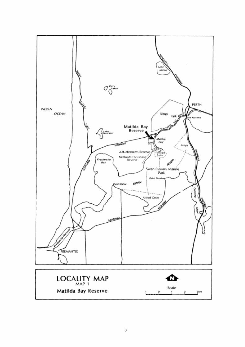
Matilda Bay Reserve is a thin strip of land between Hackett Drive and the Swan River's low water
mark (Map 1). The Reserve extends from Mounts Bay Road just north of Cygnet Hall, south to the
windsurfing ramp past Pelican Point. It is gazetted for Recreation.
The Reserve, like national parks, marine parks, nature reserves and marine nature reserves in Western
Australia, is vested in the National Parks and Nature Conservation Authority and managed by the
Department of Conservation and Land Management (CALM). Matilda Bay Reserve is an 'A' class
reserve covering 20.6 ha. An 'A' class reserve is one which requires the consent of both Houses of
Parliament for any changes to occur in either purpose or boundaries. Most of the Reserve is located
within the City of Subiaco with a small part at the northern end in the City of Perth (Map 2).
During weekdays, the Reserve is mainly used by people from the University of Western Australia. On
weekends and on weekday evenings, especially in summer, visitors are mainly family and social
groups as well as those going to the yacht clubs..
A number of leases occur on the Reserve. These include three sailing clubs, two rowing clubs, the
Pelican Point Sea Scouts, a kiosk and a restaurant. The Reserve contains two CALM offices and
provides for car parking for users as well as CALM staff. Over the years students have increasingly
used the Reserve for parking. A well used bicycle path/footpath traverses the Reserve, and a boat
ramp is available for public use.
The Reserve is managed by CALM and has a full-time maintenance worker.
Matilda Bay Reserve's values include -
• a parkland setting and scenic qualities that have attracted visitors from the Perth 9 metropolitan
area, the country, interstate and overseas for nearly a century; and
• picnicking, walking, swimming and boating opportunities.
A specific characteristic of Matilda Bay Reserve is that it provides a link between the University of
Western Australia and the Swan River. Together, with the yacht clubs, they form an harmonious
landscape and visual resource.
3

4
2. INDEX OF ACTIONS
References are shown as the page number followed (in brackets) by the action number. Bold type
denotes a principal reference.
SUBJECT REFERENCE(S)
Aboriginal History 36(1-4)Access 23(4, 6), 24(11, 15), 25(1-8), 31(7)Australia 11 Drive 23(4, 7)
Barbecues 23(9)Boat Ramp 23(5), 25(7)
Commercial Operations 32(1-4)Community Liaison 63(l)
Development 12(2), 23(1-10), 24(11-21), 36(2)Disabled Access 23(1), 25(2, 3)Drainage 27(5)
Electric Power 27(1, 2)Erosion 43(1, 2)European History 37(1)
Ferry 23(8)Fire 44(1)
Implementation 57(1-3), 63(l, 2)Information, Interpretation and Education 36(3), 37(1), 50(1-9)
Jetties 24(14, 16)
Kiosk 24(11, 12)
Landscape 24(20), 39(2)Leases 31(1-8), 32(3)Lighting 27(3)
Monitoring 53(1, 2)
Parking 23(5, 6), 24(11, 15), 25(1, 4-8)Path 24(13), 27(3)Pests 44(1-3)Pets 45(1)
Radio Antenna 27(11)Research 53(1, 2)Reticulation 27(6, 7)Rubbish Disposal 27(8, 9)

5
Signs 50(6, 7)Silver Gulls 44 (1)Sponsorship 57(3)Swan River Trust 12(3),27(5), 31(4, 8)
Telephones 27(12)Tenure 9(1, 2)Term of Plan 63(1, 2)Toilets 23(1-3), 25(3), 27(4)
University of Western Australia 25(4, 5), 32(4)
Vegetation 39(1-3), 40(4, 5)Visitor Use 18(1, 2)Visual Resource 38(1-5)Volunteers 53(2)
Water Authority of W.A. 27(5)Weeds 44(2, 3)Western Australian Tourism Commission 50(3)

6
PART B. PRINCIPAL MANAGEMENTDIRECTIONS

7
3. PURPOSE AND TENURE
The objective is to protect Matilda Bay Reserve's values by its gazetted purpose and its security of
tenure.
Eight categories of reserve exist under the Conservation and Land Management Act 1984, (CALM
Act): nature reserve, national park, conservation park, marine nature reserve, marine park, State forest,
timber reserve and miscellaneous reserves (those that do not fall into a specific category).
Matilda Bay Reserve is an A class reserve (17375) covering 20.6 ha, and is gazetted for Recreation.
This designated purpose will be retained.
While the Reserve has been known for years as the Matilda Bay Reserve, it has never been formally
named.
The existing purpose of Matilda Bay Reserve reflects its present use. It attracts about 400 000 visitors
each year, mainly by people engaged in a wide range of active or passive recreation activities.
Being close to the city, Matilda Bay Reserve is accessible to residents of Perth and tourists. These
features, together with its visual qualities and its harmony with the grounds of the adjacent University
of Western Australia and the adjoining Swan River, are the Reserve's essential values.
A number of commercial developments are located on the Reserve, including a restaurant and three
yacht clubs. No further major developments are expected.
ACTIONS
1. Formally name the Reserve "Matilda Bay Reserve".
2. Retain the existing character of Matilda Bay Reserve.
3. Ensure that further development on Matilda Bay Reserve is kept to a minimum and aimed at
improving facilities.

8
4. SURROUNDING WATERS AND ADJACENT LAND
The objective is to integrate the management of Matilda Bay Reserve with the management of
surrounding waters and adjacent land.
Matilda Bay Reserve adjoins or is adjacent to the University of Western Australia, the Swan River,
Pelican Point nature reserve, part of the Swan Estuary Marine Park, J H Abrahams Reserve and the
Nedlands Foreshore Reserve (Maps 1 and 2). Management actions for the Matilda Bay Reserve must
be compatible with the uses of these adjoining lands and waters.
The University of Western Australia
The Crawley campus is a classified reserve open to the public. The University considers the river
foreshore as a natural extension to its landscaped grounds, an understanding shared and respected by
CALM. CALM's objective is to maintain visual harmony between the University of Western Australia
and the Reserve.
The Swan River
The Swan River Trust was set up on I March 1989 under the Swan River Trust Act 1988. It is
responsible to plan, manage and protect the Swan River Trust Management Area, which includes the
waters of the Swan-Canning River system and adjoining Metropolitan Region Scheme Parks and
Recreation Reservations. The Swan River Trust is responsible to the Minister for the Environment.
Matilda Bay Reserve falls wholly within the Swan River Trust Management Area. This means that any
developments, including a change of use within the Trust's area, must be approved by the Minister for
the Environment under Part V of the Swan River Trust Act. The Swan River Trust assesses such
applications and makes recommendations to the Minister who determines the application.
The Swan River Trust may advertise any significant developments that fall within its management
area. CALM has a responsibility to advertise draft management plans, proposed changes to approved
management plans and to create new reserves. It may be possible to combine these advertising
periods.
CALM will be able to implement this management plan, subject to clearing of design details with the
Swan River Trust. If the Swan River Trust considers that CALM's implementation proposals differ
from the intention of the management plan, then the Trust would treat this as a separate development
application requiring public comment. CALM and the Swan River Trust are currently preparing a
"Memorandum of Understanding" outlining how the two organisations will work together to
streamline consideration of development applications. The memorandum will include advertising of
significant developments, liaison between CALM field staff and Swan River Trust inspectors, and the
implementation of CALM management plans.

9

10
The Nature Reserve and Marine Park
The Pelican Point Nature Reserve and part of the Swan Estuary Marine Park, which adjoins the south
end of the Reserve (Map 1), are not addressed in detail in this management plan. The Swan Estuary
Marine Park also encompasses mudflats adjacent to the Alfred Cove Nature Reserve and Milyu
Nature Reserve in South Perth. The Marine Park, including the adjacent nature reserves, will be the
subject of a separate management plan.
Abrahams Park
Abrahams Park is adjacent to the Pelican Point windsurfers' ramp and is managed by the City of
Subiaco. Abrahams Park is managed in a similar way to Matilda Bay with minimum commercial
concessions (City of Subiaco, pers. comm., 1991). The Park is used mainly for group picnics and as
a take off point by windsurfers.
Nedlands Foreshore Reserve
The Nedlands Foreshore Reserve runs along the River just past Abrahams Park to the Jetty
Restaurant, and incorporates the Nedlands Yacht Club and the Perth Flying Squadron Yacht Club.
This foreshore area is very popular with cyclists, picnickers, and kite flyers.
ACTIONS
1. Integrate management of the Reserve with management of adjoining lands and waters.
2. Ensure that modifications to existing developments are in harmony with the character of the
Reserve and the surrounding settings.
3. Where appropriate, combine the public comment periods required by CALM and the Swan River
Trust.
5. POLICIES AND GOALS
NPNCA AND CALM MANAGEMENT POLICIES
This plan is based on current NPNCA and CALM policies (May, 1992). These policies derive from
legislation, principally the CALM Act (1984) and the Wildlife Conservation Act (1950), and
associated regulations. Policies are published and distributed throughout CALM as policy statements.
They are available to the public on request. These policies, as they relate to this Reserve, cover aspects
of the promotion of recreation, conservation and education.

11
MANAGEMENT GOALS FOR MATILDA BAY RESERVE
The following management goals for Matilda Bay Reserve are based on those applicable to lands
managed by CALM throughout Western Australia and on concerns specific to the Reserve.
Recreation
Provide the public with recreation opportunities and facilities that are consistent with management
objectives and minimises conflict between users.
Conservation
Protect and conserve the Reserve's physical, cultural and scenic resources.
Information, Interpretation and Education Promote an understanding of the Reserve's history and
natural environment, and an awareness and appreciation of its values.
Research and Monitoring
Promote and undertake studies on the Reserve's social values and natural processes, and monitor the
impacts of visitor use and management.
Management objectives for specific issues are provided throughout the plan.

12
PART C. RECREATION

13
6. PRINCIPAL RECREATION DIRECTIONS
RECREATION GOAL
Provide the public with recreation opportunities and facilities that are consistent with management
objectives and minimise conflict between users.
The objectives are to:
• Ensure recreation is in accordance with the CALM recreation policy and guidelines.
• Promote recreational experiences for the public use areas of the Reserve which are:
- based on enjoyment and appreciation of the Reserve
- equitable
- non-disruptive
- consistent with the natural settings of the Reserve.
• Integrate recreation experiences with interpretation and education programs.
• Continue the traditional uses of the Reserve.
RECREATION STRATEGY
The strategy for recreation management is to encourage non-disruptive use of the Reserve, based on
the special qualities of Matilda Bay. Activities which result in conflict between users will be
discouraged.
A concept plan for improved recreational facilities has been developed based on consultation with
leaseholders, the public, data obtained from a visitor survey, submissions received for this plan and
CALM policies. The plan includes picnic areas, barbecue areas and upgraded toilet facilities (Section
8. Concept Plan).
7. VISITOR USE
Matilda Bay Reserve provides for a range of recreational opportunities, including sightseeing,
picnicking, windsurfing, swimming, prawning and boating. Natural features, such as the parkland
setting and safe swimming areas, along with city and river views, attract people to Matilda Bay.
An estimated 400 000 people visit the Reserve each year. This figure includes people who visit the
restaurant (approximately 50 000 a year), the yacht clubs (approximately 250 000 a year) as well as
visitors using the Reserve for passive recreation (approximately 100 000 a year). Peak days for
visiting the Reserve are Australia Day, Easter Sunday, Mother's Day and Boxing Day. Other public
holidays in the summer and autumn months are also very busy when 1000 - 2 000 people visit the

14
Reserve. The Reserve becomes a focus for special events such as the 96FM skyshow and regattas. In
addition, it is estimated that more than four million people drive along the edge of the Reserve
annually.
A visitor survey assessed visitor use, obtained visitors' attitudes towards facilities and sought opinions
on how the Reserve could be improved (Pontre and Cavana, 1992). The survey was conducted over a
four week period during April and May, 1991.
Two hundred and sixty-seven visitors were surveyed during school holidays, weekends and normal
week days. As shown in Table 1 the weekday visitor pattern is significantly different from the
weekend pattern. On weekdays during a University of Western Australia term, 67% of the visitors are
associated with the University compared with 16% on the weekend. When school holidays coincide
with University term 60% of visitors are associated with the University.
TABLE 1. RESERVE VISITORS BY DAY TYPE
WEEKDAY WEEKEND SCHOOL TOTAL
% (N o.) % (No.) HOLIDAYS (No.)
% (No.)
Associated with 67.3 (33) 16.0 (15) 60.0 (74) 122
University
Not associated 32.7 (16) 84.0 (79) 40.0 (50) 145
with University
TOTAL 100 (49) 100 (94) 100 (124) 267
In summer, the Reserve is also used by corporate organisations for parties varying in size up to 300
people. Organisers of sporting events, such as marathons, occasionally use the Reserve as a stop
point.
Most visitors to Matilda Bay are from the Perth metropolitan area, but a substantial number come
from country areas and interstate. Five percent of visitors are from overseas. The Reserve is a
valuable tourist asset for the State and the facilities provided need to be of a corresponding standard.
ACTIONS
1. Provide and maintain satisfactory facilities and services to cater for visitors.

15
2. Maintain the booking system for organised groups to use the Reserve and, where appropriate, set
a fee.
8. CONCEPT PLAN
The objective is to develop a concept plan to facilitate recreational opportunities and reduce
conflicts and issues that currently exist on the Reserve.
A Concept Plan was developed following consultation with Reserve users, leaseholders, the University
of Western Australia, CALM, local government authorities (Perth and Subiaco) and the Swan River
Trust. This consultation, together with results from the visitor survey, revealed that attention is
expected to be given to:
• toilet facilities
• parking
• Hackett Drive traffic and transport alternatives
• barbecues and picnic facilities
• visual impact of kiosk
• services
• erosion (see Section 17)
• pedestrian circulation.
The resolution of these problems forms the essential thrust of the concept plan. It should be stressed
that the following proposals are at a conceptual stage. At the time of implementation, site plans will
be developed in consultation with all relevant bodies.
Toilet facilities
Toilet facilities on the Reserve are inadequate and not in accordance with either the expectations of
users or CALM standards. Two separate toilet facilities are currently located on the Reserve. One is
located at the southern end between the restaurant and the kiosk. Male and female facilities are in
separate buildings. These toilets are frequently used. The other is located halfway between the
University Boat Club and the kiosk and is not frequently used. Toilet facilities are lacking in the
northern end of the Reserve and neither toilet block caters for disabled people.
It is proposed to replace the toilets between the restaurant and the kiosk and incorporate them into
one building with facilities for disabled people. An architectural style consistent with the environment
and history of the Reserve will be employed. It is also proposed that the toilets located between the
University Boat Club and the kiosk be replaced by new facilities near the northern end of the Reserve
(Map 3).

16
Australia II Drive Realignment and Parking Areas
Australia II Drive is used extensively by restaurant patrons, yacht club members, CALM staff and
University Students. The current alignment is dangerous and causes traffic congestion.
Australia II Drive will be realigned (Map 3) and spur roads established as follows:
Spur A - will provide access to Matilda Bay Restaurant, CALM Headquarters and the
boat launch/carpark.
Spurs B and C - will provide access to Royal Perth Yacht Club.
Spur D - will provide separate access to Mounts Bay Yacht Club and Pelican Point Sea
Scouts.
Parking is a major problem on the Reserve, particularly during University terms when there is
conflict between Reserve users and University students. CALM has had to take interim measures in an
attempt to resolve the parking problems by introducing parking meters on the Reserve (see Section
9. Access). CALM will continue to liaise with the major stakeholders and University of Western
Australia on this issue. Parking on the grassed area and on the Reserve's road verge will be permitted
during peak periods only, and a sign will be erected at the entrance to Australia II Drive warning
people that parking is restricted on the Reserve to the designated parking areas. These interim
arrangements will continue until the eight proposed parking areas as shown in Map 3 are established.
They are:
• Area 1 - Matilda Bay Restaurant (Reserved Area)
• Area 2 - CALM Headquarters (Restricted)
• Area 3 - Boat launch (Public and CALM)
• Area 4 - Public area
• Area 5 - Public area and yacht club overflow
• Area 6 - Public area and yacht club overflow
• Area 7 - Public area and yacht club overflow
• Area 8 - Terminus bays and bird observatory.
Parking fees will be paid in these areas.

17

18
Hackett Drive traffic and transport alternatives
Hackett Drive has a marked effect on Reserve management and visitor satisfaction. It is intensively
used and, running as it does alongside the western edge of the Reserve, it disrupts access and breaks
the visual continuity between the University grounds and the Reserve. Two alternatives were
canvassed with the public during the preparation of this plan. The first alternative was to close
Hackett Drive. While some people supported this option, the majority who contributed a submission
were against it. CALM will not, therefore, pursue 'this option with the relevant authorities.
More support was forthcoming for the second alternative which was to implement slowing devices
along Hackett Drive, thus changing its purpose from a through route to a scenic drive. CALM does
not have jurisdiction over Hackett Drive and will continue to negotiate with the responsible
authorities, particularly the City of Subiaco, with regard to the following proposals about Hackett
Drive:
• implement three major pedestrian crossing points with zebra markings
• narrow the road in favour of a wider median strip with suitable tree plantings
• introduce a 40 kph zone
• remove all parallel parking bays on the Matilda Bay side but retaining the perpendicular 'view'
bays
• construct a roundabout junction at Australia 11 Drive incorporating a new southern access point
to- the University.
A roundabout junction at the beginning of Australia 11 Drive would make entry and exit to the
Drive safer. This proposal will be fully investigated with the Main Roads Department and has the
support of the City Of Subiaco.
To alleviate traffic problems as well as to enhance vehicle-free access to the Reserve, CALM would
support construction of a commercially viable ferry jetty and terminal on the foreshore near the
University Boat Club. This would allow river access to the Reserve and would be an alternative means
of transport for students.
Barbeque and picnic facilities
At present only one barbeque is located on the Reserve. The public has sought more barbeques and
for more picnic facilities, such as benches and tables.
Two separate picnic areas are proposed, one in the north of the Reserve and one in the south. As
shown on Map 3 each area will have provision for barbeques, picnic tables, toilet facilities and bin
clusters.
Subject to cost and feasibility a beach may be developed at each area.
In the southern area it is proposed to repair the existing jetties for use by swimmers.

19
Kiosk
The service access road to the kiosk is not suitably located and is not a formalised access. The present
service access road will be removed and a new road will be located at a safe junction point. Two
parking bays for kiosk staff will be provided.
The visual impact of the kiosk, which is out of character with the Reserve and its University backdrop,
has been widely criticised. Subject to availability of funds, it would be desirable to redevelop the
kiosk in a style consistent with its surroundings and the history of the Reserve.
Multi-purpose Path
The path running through the Reserve is used by pedestrians and cyclists, and is often a cause of
conflict, especially in the northern end of the Reserve near Cygnet Hall.
It is proposed that the path at the northern end be relocated to a safer place, and that the path
through the Reserve be widened to three metres, a width recommended by both Bikewest and the
Ministry of Sport and Recreation. This will resolve conflict between pedestrians and cyclists, and
allow access by management vehicles without damaging the lawn (Section 10. Services and Utilities).
New Access to Cygnet Hall
At present a single road provides access to Cygnet Hall and Perth Dinghy Sailing Club. Cygnet Hall
houses CALM's Corporate Relations Division and Hale School Boat Club. Vehicle congestion occurs
here especially between October and April, when Hale School uses the shed twice on weekdays and
on Saturday mornings.
It is proposed to modify the current access to alleviate vehicle congestion and to provide new parking
facilities at the northern end of Cygnet Hall.
Pelican Point Sea Scouts Jetty
The jetty located within the lease boundaries of the Pelican Point Sea Scouts is in a poor state of
repair and is a potential danger to those using it. The jetty will need to be either repaired or removed.
Overall Theme
An overall theme will be adopted for the Reserve. The building materials, architectural style and
colours chosen for any development should have a common theme and be in harmony with the
adjoining lands and buildings. Along Hackett Drive it is proposed that a theme consistent with the
University be adopted. A marine theme, consistent with yacht clubs, could be adopted along Australia
11 Drive. This would include fencing, signs, and barrier treatment, such as logs and bollards.
Facilities, including path surfacing, tables, bins and benches, will be consistent throughout the
Reserve. The theme in the southern end will be developed in consultation with the yacht clubs.

20
Landscape Development Plan
A landscape plan, including a tree management plan, that encompasses the overall theme of the
Reserve will be developed. The tree management plan will include a strategy for management of all
vegetation on the Reserve and will be prepared by a select committee including CALM landscape
architects and interested individuals.
Site Development Plans
Site development plans and construction plans will be formulated for each work program as the plan
is implemented. This will be done in consultation with relevant bodies such as stakeholders and/or
leaseholders on the Reserve.
ACTIONS
1. Redevelop toilets in an architectural design which is in harmony with the environment, and
which include facilities for disabled people.
2. Demolish existing toilets between the restaurant and kiosk and replace by one new structure.
3. Demolish the toilet block currently situated midway between the kiosk and the University Boat
Club, and build a toilet in the northern section of the Reserve.
4. Realign Australia Il Drive and develop spur roads to lease areas and CALM Headquarters.
5. Redesign parking areas and boat ramp.
6, Negotiate with relevant authorities regarding installation of vehicle slowing devices on Hackett
Drive.
7. Consider a roundabout junction at Australia Il Drive.
8. Consider building a ferry jetty on the Reserve.
9. Create two picnic areas with provision for barbeques and other picnic facilities.
10. Consider creating a beach for swimmers at each picnic area.
11. Relocate access road to kiosk and provide two parking bays for kiosk staff.
12. Consider redevelopment of kiosk in consultation with the lessee.
13. In consultation with Bikewest, widen the multi-purpose path to three metres and relocate
northern section of path to ensure safe cycling and walking.

21
14. Repair the two swimming jetties.
15. Modify the access to Cygnet Hall, and provide additional parking.
16. Require Pelican Point Sea Scouts to either repair or remove their jetty.
17. Develop an overall theme for the Reserve.
18. Provide adequate furniture and maintain it to a high standard.
19. Replace existing galvanised iron fence with a unified barrier system.
20. Develop a landscape plan for the Reserve involving a committee of interested people.
21. Develop site and construction plans for each work program on the Reserve in consultation with
relevant bodies.
9. ACCESS
The objective is to provide parking facilities and access to the Reserve to meet the needs of
visitors, including disabled people, and to improve the access between the Reserve and the
University of Western Australia.
Parking
A survey of visitors to the Reserve (Pontre and Cavana, 1992) showed that 60% came by car, 30%
walked and 7% rode a bicycle. The survey also showed that visitors to the Reserve who were not
associated with the University were dissatisfied with parking facilities, especially during weekdays and
school holidays. As shown in Table 2, 53% of weekday visitors are dissatisfied with parking facilities
compared with 25% during the weekend.
A major contributing factor to the parking problem is the use of facilities by University of Western
Australia students. The problem is exacerbated on public holidays not observed by the University,
and when school holidays do not coincide with University holidays. In consultation with the City of
Subiaco and the University of Western Australia, CALM has introduced parking meters on the
Reserve.

22
TABLE 2. SATISFACTION WITH PARKING FACILITIES(Visitors NOT associated with University of W.A.)
WEEKDAYS AND WEEKENDS (%)
SCHOOL HOLIDAYS (%)
Dissatisfied 52.6 25.0
Satisfied 20.3 33.8
Neutral 27.1 41.2
Disabled Access
Disabled people, including organised groups, currently use the Reserve for picnics and for water
activities, such as remote control sailing. At present access to the foreshore and toilets is limited.
ACTIONS
1. Ensure parking is available to visitors of the Reserve, leaseholders and CALM staff.
2. Consider extending disabled access where feasible, including foreshore access along paths to
major facilities.
3. Redevelop toilet facilities to enable use by disabled people.
4. Encourage public use of car parking facilities at University of Western Australia on weekends
and during holidays.
5. Consult the University of Western Australia and other relevant bodies, including local
government authorities and lessees, when decisions concerning parking need to be made.
6. Establish a car parking committee.
7. Charge for use of the boat ramp if pressure of use requires management.
8. Allow parking on the grassed area and on the road verge of Australia II Drive during peak
periods only.

23
10. SERVICES AND UTILITIES
The objective is to provide cost efficient, effective and safe services and utilities to the Reserve.
Power Lines
Currently, overhead power lines service the Reserve. Not all lease holders on the Reserve have
individual electricity meters, which has often led to confusion over power bills. Overhead power lines
are considered dangerous on the Reserve because of the presence of the yacht clubs which generate
heavy use by trailers and boats, which increases the danger of boat masts hitting overhead power
lines. Power lines also degrade the visual amenity of the Reserve.
Lighting on the Reserve is not considered to be adequate particularly along the multi-purpose path.
Effluent Disposal and Drainage
The toilets and restaurant are at present serviced by a septic tank effluent pumping system.
According to the Water Authority of Western Australia this system is not the most effective way of
dealing with wastewater and its life span is limited. A medium term objective would be to connect the
Reserve to the main sewerage system.
A problem exists with drainage along Australia 11 Drive and in the carparks which are often flooded
during wet weather. This problem will need to be addressed in consultation with the Water Authority
of Western Australia.
Lawn Care
At present the garden is maintained by CALM and mowed under contract by the Building
Management Authority. The watering is done via an on-site bore controlled by an automatic timing
system. No fertilisers are used. The reticulation system is old and in need of upgrading. Concern has
been expressed about the safety of the control cubicle which has rusted over the years. Another
concern is the apparent conflict between care of the lawn and the current rubbish disposal system
which is damaging the lawn.
Rubbish Disposal
The large number of visitors to the Reserve generates a substantial amount of rubbish, especially
during summer. Rubbish largely results from picnic material brought into the Reserve and from the
purchase of goods from the kiosk. While the number of bins provided is substantial, the bins
sometimes overflow during busy times.
The bins are the standard green plastic type on wheels, and are secured to trees and posts by chains
and padlocks. This detracts from the aesthetic qualities of the Reserve. The bins are placed along the
grassed area and are emptied by a service vehicle driving through the Reserve, causing some damage
to the grassed area, and possibly to reticulation.
24
Rubbish bins could be placed close to the path or road to facilitate access by service vehicles. The
public could be encouraged to take their rubbish to these areas. This strategy would reduce littering
in the Reserve and would protect the grassed area.
With regard to prawning activities, it is the Swan River Trust's policy that prawners should return the
by-products of their catch back to the river, ensuring that fish are still alive. Prawners are not allowed
to leave rubbish behind.
Radio Antenna
A radio antenna used by the Royal Perth Yacht Club is located in the southern part of the Reserve
south of Australia II Drive. It may be more appropriate for the antenna to be moved into the Royal
Perth Yacht Club's leased area.
Telephones
Public telephones are situated on Australia II Drive and near the kiosk. Installing public telephone
facilities in the northern part of the Reserve should be considered.
ACTIONS
1. Investigate installing master electricity meters for all Reserve lease holders.
2. Replace overhead power lines with underground power, as resources allow, to improve the
safety and aesthetics of the Reserve.
3. Consider providing improved lighting on the Reserve, particularly along the multi-purpose path.
4. Consider connecting the public, restaurant and kiosk toilets to mains sewerage.
5. Review the drainage system in consultation with the Water Authority of Western Australia and
the Swan River Trust.
6. Replace the reticulation pump control cubicle.
7. Upgrade and maintain the reticulation system.
8. Consider providing additional bins, making more frequent rubbish collections and promoting
"take it home" education.
9. Place bins in clusters close to paths so that service vehicles do not need to drive along the
grassed area.
10. Consider providing drinking fountains where appropriate.

25
11. Negotiate with Royal Perth Yacht Club to relocate the radio antenna situated in the southern
part of the Reserve.
12. Investigate the possibility of installing public telephone facilities in the northern part of the
Reserve.
11. LEASES
The objective is to manage and develop leases in a manner compatible with the character of
Matilda Bay Reserve.
There are seven leases on the Reserve. Table 3 presents a summary of the lease areas and terms in
order from north to south (Map 4).
Cygnet Hall
Cygnet Hall was built in 1956 by the Governors of Hale School as the base for the school's rowing
club and to house its rowing shells.
Perth Dinghy Sailing Club
Perth Dinghy Sailing Club was established in 1903 and was located near the Barrack Street Jetty
before moving to Matilda Bay in 1960. The club provides small dinghy sailing and its membership is
principally family orientated, with a predominance of junior sailors.
University Boat Club
The University Boat Club was opened in July 1929. The original design was by the same architects
(Rodney Alsop and Conrad Sayce) who designed Winthrop Hall, and showed a two-storey pitched
roof building with verandahs at the river end. Owing to limited funds this structure was not developed
and instead a single storey boat storage and preparation shed was built with a viewing platform on
top. At a later stage, the upper level was boxed in to become the mainly flat roofed building which
stands today. The Guild of Undergraduates holds the lease for the Boat Club.
Matilda Bay Restaurant and Kiosk
The Matilda Bay Restaurant was built in 1968. It was designed by John White who is now a lecturer
in architecture at the University of Western Australia. The restaurant underwent major refurbishment
in 1984, and in 1987 the upstairs facilities of the restaurant were redeveloped. The kiosk is a
sub-lease of the restaurant.

26
Royal Perth Yacht Club
Royal Perth Yacht Club was established in 1865 and was located near the Barrack Street jetty until
1953 when the club moved to Matilda Bay. The marina and club house were built by club members.
In 1979 the club organised the Parmelia race from Plymouth to Fremantle to commemorate the
150th anniversary of British settlement on the Swan River. In 1983 the club won the America's Cup,
and mounted an unsuccessful Cup defence in 1987.
Mounts Bay Sailing Club
Mounts Bay Sailing Club was founded in 1897 and built its first club house in 1939. During World
War 11 the building was used by the United States Navy which operated a Catalina flying boat base at
Matilda Bay. The present premises were built in the late 1950s and early 1960s.
Pelican Point Sea Scouts
The 1st Pelican Point Sea Scouts was originally known as the 1st WA Sea Scouts and was established
in Albany in 1913. In the 1920s the troop moved to Perth and was located briefly in Irwin Street,
before moving to floating headquarters 'Dolphin', a wooden coastal steamer moored near the location
of the present University Boat Club. In 1926 the group moved to its present area located at the end
of a very narrow spit of land known then as Point Currie. New scouts buildings were commenced in
1957 on land filled in from pre-war dredging of Matilda Bay.
TABLE 3. MATILDA BAY RESERVE LEASES
LEASE AREA (ha) TERM EXPIRY DATE
Cygnet Hall 0.1 18 years 16.11.1994
Perth Dinghy 0.5 21 years 30.06.2002Sailing Club
University 0.2 21 years 31.08.2005Boat Club
Matilda Bay 0.4 20 years 18.10.2005Restaurant andKiosk
Royal Perth 2.0 21 years 30.06.2004Yacht Club
Mounts Bay 0.8 21 years 30.06.1995Sailing Club
Pelican Point 0.5 21 years 30.06.1999Sea Scouts

27
DISCUSSION
The leases represent major levels of use of the Reserve and provide recreational opportunities for
local, interstate and international visitors, which number over 250 000 a year. The three yacht clubs
on the Reserve have a membership of approximately 3 000 people. Restaurant patronage is over 50
000 people a year, 40% of whom are from interstate and overseas.
A problem exists with public access to the foreshore because of the security requirements of the
leases. Although most users, apart from visitors to lease areas, visit the central parts of the Reserve, it
is essential that access along the length of the Reserve be provided according to the Swan River
Management Strategy (Management Strategy Task Force, 1988). Nevertheless, the leases have a need
for security, especially at night.
The leases on the Reserve are widely accepted by the public. However, it is probable that further
major developments would be opposed.
ACTIONS
1. Further leases should not be allowed.
2. Minimise changes to existing lease areas, and follow the principle that any additional area
provided to [ease holders be compensated by the equivalent release of land for public use.
3. Minimise changes within the lease areas, but allow changes if they are necessary for the more
efficient functioning of the lease.
4. Changes to buildings must be approved by the NPNCA and the Swan River Trust.
5. Progressively implement an overall architectural theme on the Reserve as opportunities for
building changes arise.
6. Standardise, where possible, the principles guiding the conditions of club leases.
7. Continue public access to the foreshore during daylight hours.
8. Swan River Trust and the Department of Marine and Harbours to refer to CALM all extensions
or changes to sea bed leases and private moorings.

28
29
12. COMMERCIAL OPERATIONS
The objective is to ensure that commercial operations allowed on the Reserve do not adversely
affect the environment or the use of the Reserve by the public and, as far as possible, assist in
peoples' enjoyment of the Reserve.
Commercial concessions may be granted on CALM lands or waters to provide appropriate facilities
and services for visitors. Proposals are carefully considered by CALM and require approval by the
NPNCA and the Minister. Concessions must be consistent with the purpose of the Reserve and protect
its values. Facilities or services which exist or can be developed elsewhere to adequately meet visitor
needs should not be provided on lands and waters managed by CALM. Commercial concessions, if
excessive, can detract from the conservation values of the Reserve, while limited concessions can
enhance public access and enjoyment.
Apart from the restaurant and kiosk (Section 11. Leases), only one concessionairre currently
operates on Matilda Bay Reserve, providing a recreational activity in the form of pedal water craft. It
may be possible to allow other commercial operators on the Reserve. Any new operations will require
approval from the NPNCA and the Swan River Trust. The Department of Marine and Harbours is
responsible to issue licenses for marine activities.
ACTIONS
1. Establish and manage commercial operations in accordance with CALM Policy Statement No 18,
Recreation, Tourism and Visitor Services. Concessions on the Reserve may be provided if they are
consistent with the purpose of the Reserve and its conservation values, and with the Swan River
Strategy.
2. Ensure that concession holders fulfil the concession's conditions.
3. Only consider commercial concessions on leases that are consistent with the objectives of this
management plan, values of the adjoining nature reserve and marine park and the conditions of
the lease.
4. Liaise with the University of Western Australia and the Cities of Perth and Subiaco to ensure that,
as far as possible, commercial operations on their land do not conflict with the objectives for the
Reserve.

30
PART D. CONSERVATION

31
13. PRINCIPAL CONSERVATION DIRECTIONS
CONSERVATION GOAL
Protect and conserve the Reserve's physical, cultural and scenic resources.
The objective is to protect the Reserve's values, restore degraded areas and promote a
conservation ethic for Matilda Bay.
CONSERVATION STRATEGY
The strategy for conservation management of Matilda Bay Reserve is to minimise conflict between
recreational use and conservation values (Sections 6 - 20), rehabilitate degraded areas (Section 16),
control erosion (Section 17) and control pest species (Section 18).
14. CULTURAL RESOURCES
14.1 ABORIGINAL HISTORY
The objective is to protect Aboriginal cultural features in Matilda Bay Reserve.
Matilda Bay was an important riverine and estuarine area for Aboriginal people for thousands of
years. The Bay was known as Godroo, Gurndandalup or Goodamioorup.
The Bay was a favoured area because of its abundance of fish (Corrie Bodney, pers. comm., 1991),
and water holes were located in the Pelican Point area, including in the current nature reserve. Hot
water springs were located where the University of Western Australia now stands. Aboriginal people
also used that area as a battle ground.
The Aboriginal traditional custodians were the Ballaruk who inhabited the area around the Swan
River.
At the time of British settlement the area around the Swan-Avon streams was divided into well
recognised hunting grounds (Williams, 1980). The largest of these hunting grounds extended along
the north bank of the Swan River to approximately 25 km south of Moore River. It included the
Matilda Bay area. The tribe which used this area was the Mooro and it is believed that Yellagonga was
their leader (Green, 1984).

32
All Aboriginal sites are covered by the Aboriginal Heritage Act 1972-80 regardless of whether they
are or are not known to the Western Australian Museum. Section 17 of this Act makes it an offence
to alter in any way an Aboriginal site without written permission from the Minister for Aboriginal
Affairs.
A search of the Aboriginal Sites Register was conducted in April 1991 by the Western Australian
Museum for Matilda Bay Reserve. The search indicated one known Aboriginal site, although its exact
extent has not been defined, and possibly a second site located on the Reserve.
A comprehensive study of Matilda Bay Reserve is necessary to determine if other sites exist. Such a
study should include Aboriginal representatives.
ACTIONS
1. Ensure that CALM's obligations are fulfilled according to relevant legislation if any proposed
activities in the Reserve involve development.
2. Conduct an Aboriginal site study of the Reserve as a matter of priority. Include Aboriginal
representatives in the study group.
3. Incorporate information on the Aboriginal history of the Reserve into interpretive material.
4. Continue dialogue with Aboriginal people on their association with Matilda Bay.
14.2 EUROPEAN HISTORY
The objective is to protect European historical features of Matilda Bay Reserve.
Matilda Bay is unofficially named after Matilda Bennett, whose husband was Sir John Septimus Roe,
the first Surveyor-General of Western Australia. Previous names for the Reserve included Eliza Bay,
Currie's Bay and Crawley Bay.
Matilda Bay Reserve was part of a block of 32 acres taken up in 1829 by Captain Mark Currie,
Fremantle's first harbourmaster. In 1875, the Crawley Estate passed to Sir George Shenton, a Member
of the Legislative Council and Mayor of Perth, who lived on the estate until his death in 1909.
In 1910, the State Government resumed the property for public recreation, turning the foreshore into
a camping ground. This was served by a tram line from the city which hugged the river's edge all the
way to Nedlands Baths. The University of Western Australia acquired the bulk of the land in 1914.

33
The river landscape changed dramatically in the 1930s and 1940s due to public works programs.
Extensive dredging of the shallows adjacent to Pelican Point's north side resulted in considerable
landfill on the Point's south side, and increased the land area by four or fivefold with the loss of
previously existing wetlands. The larger part of the current land of Pelican Point was originally
lagoon or river shallows.
During World War 11, the Commonwealth Government requisitioned the foreshore reserve for
defence purposes (Spillman, 1985). The American Navy established a base at Matilda Bay for its
Catalina flying-boats, where Mounts Bay Sailing Club and the Royal Perth Yacht Club now stand.
The Royal Perth Yacht Club launching ramp was built to launch the Catalinas with the hangars being
on the boat servicing area. The world's longest rescue mission was mounted from Matilda Bay. Other
foreshore buildings, including the University boatshed, were also used by the Navy during the war.
Some of the University's nearby buildings were occupied by servicemen. Numerous existing features,
such as the ablution blocks, owe their location to the military pipelines, sewerage and power systems.
Since World War 11, the change rooms, swimming jetties, restaurant and kiosk have been constructed
and numerous trees planted. In 1987, the Royal Perth Yacht Club played host to the America's Cup,
won from the New York Yacht Club in 1983.
Today, Matilda Bay Reserve is a favourite spot for family picnics, University staff and students, and
visitors to Perth.
ACTION
1. Formalise the naming of Matilda Bay Reserve.
2. Incorporate information on the European history of the Reserve into interpretive material.
15. VISUAL RESOURCES
The objective is to protect the Reserve's visual resources, and ensure future development is
compatible with the Reserve's landscape and the University and yacht club buildings.
One of the main values of Matilda Bay Reserve is its setting on a protected bay that offers views
across the Swan River to the city.

34
As discussed in Section 4, the University of Western Australia considers the Matilda Bay foreshore as
a natural extension to its landscaped grounds and has identified some key visual corridors (Ferguson
and Associates, 1990). Similarly the yacht clubs provide another character to the Reserve.
Landscape management - or visual resource management as it is also termed - is the scientific
discipline concerned with the management of land, vegetation and water resources so as to maintain
or improve their visual quality. Its prime goal is to ensure that all uses and activities are planned and
implemented so as to complement, rather than detract from, the inherent visual qualities of the
environments in which they occur. Visual Resource Management is a positive and integral
component of land-use planning and management processes. It should not be regarded as a cosmetic
exercise in which the results of careless planning and development are hidden from view, or
superficially treated to make them more palatable to the viewing public.
Matilda Bay Reserve has high scenic qualities from within the Reserve, the adjoining lands and from
the Swan River. Its parkland settings with its varied vegetation, the sheltered bay, the landform and
the view of Perth city are some of the factors that contribute to the high scenic quality of the Reserve.
The areas which offer these views include:
• the Reserve itself
• the yacht clubs and other buildings
• Hackett Drive and Mounts Bay Road
• the University of Western Australia
• the Swan River.
Visual resource management in Matilda Bay Reserve involves protecting the landscape (including
landform, vegetation and waterform), and locating and planning land-use developments so as not to
obstruct views in any way.
Both positive and negative visual elements occur on the Reserve. The negative elements include:
• toilet blocks
• fences of galvanised pipe
• rubbish bins chained to trees
• water bore pump and pipes
• Marine and Harbours signs (these are old and not in harmony with CALM signs)
• cement bollards
• the kiosk
• erosion
• power lines
• the radio antenna located in the southern part near the nature reserve.
The positive elements include:
• bird observatory
• jetties

35
• parkland setting
• city views
• boats
• trees
• sheltered bay.
ACTIONS
1. Develop a landscape management plan for the Reserve.
2. Protect the visual qualities and natural landscape of the Reserve.
3. Retain and enhance existing positive elements of the Reserve.
4. Reduce existing negative visual impacts of the Reserve.
5. Seek advice on visual management of the Reserve, as required, from CALM landscape architects.
16. VEGETATION
The objective is to manage vegetation of the Reserve by recognising its aesthetic value to visitors.
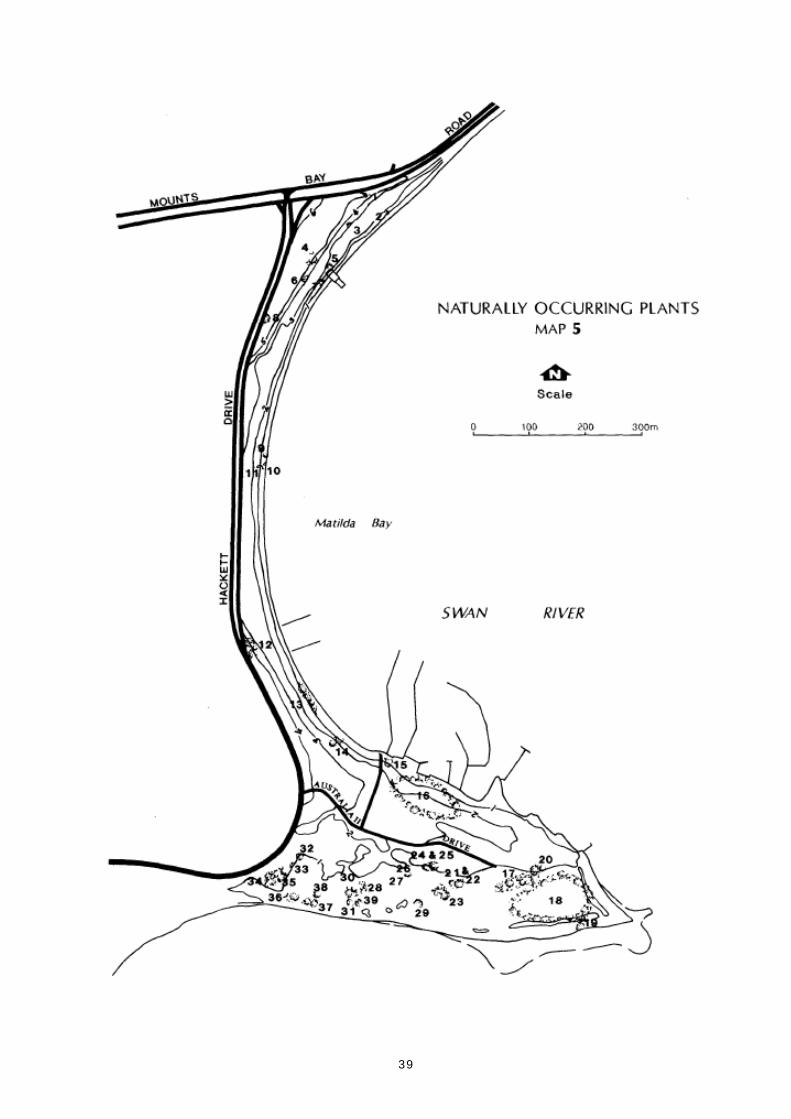
The Reserve's vegetation can be divided into two separate areas - the Matilda Bay area north of
Australia 11 Drive and the Pelican Point area south of Australia 11 Drive (Map 5).
The Reserve's remnant plants were surveyed in April 1991. The name, location and contour interval
of naturally occurring (that is local) plants were recorded1 (Tables 4 and 5). Very few local plants
remain in the Matilda Bay area; approximately 95% of the flora is not natural to the site. These
non-local species include Ti-tree (Leptospermum laevigatum), Moreton Bay Fig (Ficus sp.), Norfolk
Island Pine (Araucaria heterophylla) and London Plane Tree (Plantanus X acerifolia) which provide
shade during summer. These plants represent a substantial period of tending as specimen trees in a
standard horticultural tradition. While some of the non-local species should remain, others could be
replaced by local species when they die or become diseased. This could be done while maintaining
visual harmony with the University of Western Australia, Matilda Bay and the Swan River.
1 The survey was conducted by Robert Powell, author of Leaf and Branch: Trees and Tall Shrubs of Perth (1990), and
Jacqueline Pontre.

36
In the Pelican Point area of the Reserve, non-local species are less common but are of greater
concern, particularly the Coastal Ti-tree and the salt sheoak Casuarina glauca. Both perform as
weeds and detract from the value of this area (Keighery, in press). The area should be rehabilitated
and local species grown to create ecological and visual continuity with the adjoining nature reserve.
The Pelican Point area of the Reserve has degraded due to rubbish dumping and burning, but it can
be rehabilitated with local species.
The Reserve is used for tree-planting events such as Arbor Day. Both local and non-local species will
be planted in the Matilda Bay area. Local species only will be planted in the Pelican Point area.
Concern has been expressed about a number of trees on the Reserve which have dropped limbs and
caused damage, and which remain a safety hazard to visitors and property.
ACTIONS
1. Prepare a tree management plan as part of a comprehensive landscape plan which provides for
long-term planting, being mindful of the historic value of existing non-local species.
2. In the Pelican Point area adjacent to the nature reserve create a transition to a more indigenous
landscape including replacing non-local trees as they die or become diseased with indigenous
species (as per the landscape plan).
3. Promote and protect indigenous plant communities in the Pelican Point area.
4. Assess each tree on the Reserve and take appropriate action if a threat to life or property exists.
5. Protect trees of special significance on the Reserve, for example, those planted on special
occasions.

37
TABLE 4. NATURALLY OCCURRING PLANTS IN THE MATILDA BAY AREA
Ref Common Botanical Quantity Contour
No Name Name Interval
1. Zamia Macrozamia riedlei 1 5m
2. Coojong Acacia saligna 2 2
3. Jarrah Eucalyptus marginata 2 3-4
4. Jarrah E. marginata 1 5
5. Flooded gum E. rudis 1 2-3
6. Jarrah E. marginata 1 4-5
7. Salt sheoak Casuarina obesa 1 1
8. Tuart hybrid* Eucalyptus
gomphocephala X E. sp. 1 5-6
9. Coojong Acacia saligna 1 1-2
10. Rush (Unknown sp.) 1 0
11. Flooded gum Eucalyptus rudis 1 1
12. Marri E. calophylla 12 4
13. Flooded gum E. rudis 3 (-1
14 . Flooded gum E. rudis 3 1-3
15 . Coojong Acacia saligna 1 0-1
16 . Flooded gum Eucalyptus rudis 6+ 1-2
* A chance hybrid between Wart and another eucalypt, presumably an eastern Australian species. The
tree is probably unique.

38
TABLE 5. NATURALLY OCCURRING PLANTS IN THE PELICAN POINT AREA
Ref Common Botanical Quantity Contour
No Name Name Interval
17. Saltwater paperbark Melaleuca cuticularis 100+ 0-1m
18. Rushes Unknown spp numerous 0-1
19. Salt sheoak Casuarina obesa 1 0-1
20. Freshwater paperbark Melaleuca rhaphiophylla 3 0-1
21. Salt sheoak Casuarina obesa 4 0-1
22. Saltwater paperbark Melaleuca cuticularis 1 0-1
23. Coojong A Acacia saligna 50+ 0-1
24. Salt sheoak Casuarina obesa 1 1
25. Coojong A Acacia saligna 1 1
26. Christmas tree Nuytsia floribunda 1 0-1
27. Grey stinkwood Jacksonia furcellata numerous 0-1
28. Saltwater paperbark Melaleuca cuticularis 50+ 0-1
29. Flooded gum Eucalyptus rudis 1 0-1
30. Coojong Acacia saligna 20 0-1
31. Red-eyed wattle A. cyclops 1 0-1
32. Coojong A. saligna 6 1
33. Red-eyed wattle A. cyclops 1 1
34. Flooded gum Eucalyptus rudis 50 1
35. Swamp tea-tree Pericalymma ellipticum 1 1
36. Freshwater paperbark Melaleuca rhaphiophylla 3 0-1
37. Red-eyed wattle Acacia cyclops 2 0-1
38. Coojong A. saligna 4 0-1
39. White-stemmed wattle A. xanthina 1 0-1
39

40
17. EROSION
The objective is to control erosion.
Erosion occurs naturally on the banks of any river. Localised erosion can occur at the surface in tidal
waters from wave action, being either wind induced or in heavily trafficked waters, from boat wash
and foreshore use. In Matilda Bay erosion is quite severe, caused primarily by non-natural causes.
Various options exist to control erosion. The Department of Marine and Harbours (1990) strategies
include:
• Increase the beach area so that the slope is more gradual
• Plant trees, rushes and other vegetation to enhance natural protection
• Construct walls, usually of logs or ungrouted rock.
ACTIONS
1. Implement measures to deal with erosion by modifying the beach area and plant appropriate
vegetation that is consistent with landscape values.
2. Construct suitable bank protection if other measures fail to relieve erosion.
18. PESTS AND WEEDS
The objective is to control pests, eradicate weeds if possible, and minimise any adverse effects from
control measures.
Silver Gulls are an indigenous species whose numbers may be reaching pest proportions (CALM,
1990). Gull population growth is related to urban development and the increased availability of
food.
Control of Silver Gull populations is possible on a local basis either by reducing breeding success at
colonies or by reducing the amount of food available on the Reserve. The former is considered
difficult; controlling the availability of food is considered more practical. Visitors using the Reserve
often feed the gulls.
Rabbits have been a nuisance in the Reserve area for a number of years. In 1979, the Agriculture
Protection Board seeded the area with the European Rabbit Flea to control rabbit numbers in the
area. In recent years, numbers appear to have been reduced.

41
The Rainbow Lorikeet appears to be spreading rapidly and increasing in numbers throughout the
metropolitan area. Their wide range of habitat and food preferences, and their likely competition
with other hole nesters are of concern. The founder population is resident in the adjacent University
of Western Australia grounds (Agriculture Protection Board, pers. comm., 1992).
Other pests on the Reserve include cats, foxes, mosquitoes and European bees. The impact of cats
and foxes is of great concern in the southern part of the Reserve because of the potential danger to
the flora and fauna of the neighbouring nature reserve.
Onehunga weed (Soliva pterosperma) has been recorded in the Reserve. Other weeds of concern on
the Reserve include kikuyu (Pennisetum clandestinum), buffalo grass (Stenotraphurn secundatum),
and morning glory (Ipomaea indica). Where possible, spraying will be conducted on intensely used
areas.
ACTIONS
1. Inform the local community and visitors to the Reserve of the Silver Gull problem through an
appropriate education program, emphasising that gulls should not be fed.
2. Liaise with the Agriculture Protection Board, leaseholders and local authorities regarding pest
and weed control in the Reserve.
3. When resources allow, annually spray Onehunga in limited areas.
19. FIRE
The objective is to protect people, property and the conservation values of Matilda Bay Reserve.
No wild fires have been recorded on Matilda Bay Reserve, however, fire could threaten life, and
damage facilities. The major fire risk area is the southern part of the Reserve near the Pelican Point
nature reserve especially during summer when the vegetation is driest. The Western Australian Fire
Brigade is primarily responsible for fire suppression on the Reserve. CALM will assist the Brigade in
this task.
ACTION
1. Develop a fire suppression plan with the WA Fire Brigade.

42
20. PETS
The objective is to protect the Reserve's conservation and recreational values.
Dogs are allowed in the adjacent Abrahams Reserves and the Nedlands Foreshore Reserve is vested as
a dogs' exercise area (see Map 1). Given the high level of use of Matilda Bay Reserve for family-type
outings it is considered inappropriate for dogs to be allowed on the majority of the Reserve.
Domestic pets, including dogs and especially cats, pose threats to wildlife. This is especially important
near the nature reserve because of the presence of small perching birds that are prone to predation.
ACTION
1. Allow for dogs on a leash along the multi-purpose path and around the boat ramp only.

43
PART E. INFORMATION, INTERPRETATIONAND EDUCATION

44
21. INFORMATION, INTERPRETATION AND EDUCATION
INFORMATION, INTERPRETATION AND EDUCATION GOAL
Promote an understanding of the Reserve's history and natural environment, and an awareness and
appreciation of its values.
The objective is to enhance visitors' appreciation and understanding of the Reserve's natural and
cultural values.
Any visit to Matilda Bay Reserve would be improved if its features and values were understood. As
discussed in Section 14. Cultural Resources and Section 3. Purpose and Tenure, Matilda Bay Reserve
contains a variety of cultural resources, and has special values. Visitors value information, and its
provision is an important aspect of management.
The information process has three parts:
Information - providing details about facilities, activities and regulations.
Interpretation - explaining cultural and natural features.
Education - providing detailed materials and programs designed to educate groups at all
levels.
At present the Reserve does not have an information and interpretation plan. According to the
regional interpretation plan the following themes would form the basis for information and
interpretive activities in the Reserve:
• cultural history
• the riverine vegetation
• appropriate use
• promotion of CALM activities.
Information
Services provided should include displays, self-guided walks and signs.
Displays
Displays are an important means of informing visitors of the Reserve's features, facilities and
regulations. This could be set up in information centres and shelters in the Reserve.
Self-guided activities
Self-guided activities are a successful way of helping visitors learn about the Reserve at their own
time and pace. Activities could be based on a vegetation theme and historical themes.

45
Signs
Signs are an important element of visitor facilities, providing guidance, advice and information on
the Reserve's features and activities. Careful attention to accuracy is required, and signs must be
designed and sited to harmonise with the appearance of the Reserve.
Interpretation and Education
Organised activities such as community education programs and holiday activity programs can be
developed, possibly with the help of a 'friends' group.
ACTIONS
1. Prepare an Interpretation Plan for the Reserve to promote public awareness and appreciation of
the Reserve, including its natural and cultural history.
2. Develop an interpretation walk through the Reserve.
3. Liaise with the Western Australian Tourism Commission to promote visitor use of the Reserve.
4. Install and maintain appropriate information on the Reserve in accordance with the
Interpretation Plan.
5. Encourage school and group activities on the Reserve for educational purposes.
6. Provide appropriate directional, warning and feature signs in accordance with the CALM Sign
Manual.
7. Liaise with other departments and agencies such as the Department of Marine and Harbours and
the City of Subiaco to ensure conformity of signs on, and adjacent to, the Reserve.
8. Establish an Arbor Day interpretation program.
9. Use Matilda Bay Reserve to promote CALM's activities elsewhere in the State.

46
PART F. RESEARCH AND MONITORING

47
22. RESEARCH AND MONITORING
RESEARCH AND MONITORING GOAL
Promote and undertake studies on the Reserve's social values and natural processes, and monitor the
impacts of visitor use and management.
The objective is to develop and maintain knowledge regarding the social values and natural
processes of the Reserve.
Recreation is the Reserve's principal value.
Social monitoring that determines visitor satisfaction and impacts is receiving increasing attention
from park management agencies throughout Australia. The impact of recreation on the natural
environment also needs to be monitored so management actions can be evaluated.
It would be appropriate that research projects and monitoring programs involve as wide a range of
people as possible. The involvement of volunteers, educational institutions and individual researchers
can reduce research and monitoring costs, and assist to provide information to the broader
community.
CALM currently coordinates and promotes research undertaken within the Reserve.
ACTIONS
1. Implement an integrated program of survey, research and monitoring (including social
monitoring) based on the actions in relevant sections of this plan.
2. Encourage the participation of volunteers, educational institutions and other organisations in
research projects within the Reserve, and promote research programs and findings that address
key issues.

48
PART G. IMPLEMENTATION

49
23. PRIORITIES, FUNDING AND STAFF
The objective is to maintain and improve Matilda Bay's unique character.
Matilda Bay Reserve is managed from existing CALM resources.
Many actions are outlined in this management plan. While some are guidelines, others are
prescriptions for specific actions. This management plan will be implemented by CALM within the
framework of available resources, according to priorities within the plan and CALM regional and
statewide priorities. A budget will be needed during the first two to three years of this plan for major
works.
As mentioned in Section 8, the Reserve is used extensively by private corporations. It also has a high
public profile generally. Accordingly, it is possible that private corporations may see value in
providing sponsorship to upgrade the Reserve. It is proposed that CALM approaches a range of
organisations for this purpose.
ACTIONS
1. Prepare a 10 year implementation plan, taking into account the priorities outlined in Table 6.
Review the implementation plan annually and prepare an annual progress report.
2. Subject to Departmental priorities and funding, provide adequate staff to implement the Matilda
Bay Reserve Management Plan and to protect and maintain the Reserve.
3. Consider seeking corporate sponsorship for Matilda Bay Reserve.

50
Table 6.MATILDA BAY RESERVE ACTIONS, PRIORITY AND EASE OF
IMPLEMENTATION
SECTION ACTION IMPLEMENTATION*
HIGH PRIORITY
3. Purpose and Tenure 2. Retain the existing character of Matilda Bay Reserve. E23. Ensure that further development on Matilda Bay El
Reserve is kept to a minimum and aimed atimproving facilities.
4. Surrounding Waters 1. Integrate management of the Reserve with E2and Adjacent Land management of adjoining lands and waters.
2. Ensure that modifications to existing developments E3are in harmony with the character of the Reserve andthe surrounding settings.
3. Where appropriate, combine the public comment Elperiods required by CALM and the Swan River Trust.
7. Visitor Use 1. Provide and maintain satisfactory facilities and E2services to cater for visitors.
2. Maintain the booking system for organised groups to Eluse the Reserve and, where appropriate, set a fee.
8. Concept Plan 1. Redevelop toilets in an architectural design which is E3in harmony with the environment, and which includefacilities for disabled people.
2. Demolish existing toilets between the restaurant and E3kiosk and replace by one new structure.
5. Redesign parking areas and boat ramp. E29. Create two picnic areas with provision for barbecues E2
and other picnic facilities.11. Relocate access road to kiosk and provide two parking E3
bays for kiosk staff.12. Consider redevelopment of kiosk in consultation with E3
the lessee.15. Modify the access to Cygnet Hall and provide E3
additional parking.16. Require Pelican Point Sea Scouts to either repair or E3
remove their jetty.17. Develop an overall theme for the Reserve. E318. Provide adequate furniture and maintain it to a high E2
standard.19. Replace existing galvanised iron fence with a unified E2
barrier system.20. Develop a landscape plan for the Reserve involving a El
committee of interested people,21. Develop site and construction plans for each work El
program on the Reserve in consultation with relevantbodies.

51
SECTION ACTION IMPLEMENTATION*
9. Access 1. Ensure parking is available to visitors of the Reserve, E3leaseholders and CALM staff.
2. Consider extending disabled access, where feasible, E2including foreshore access along paths to majorfacilities.
3. Redevelop toilet facilities to enable use by disabled E2people.
5. Consult the University Of Western Australia and other Elrelevant bodies, including local governmentauthorities and lessees, when decisions concerningparking need to be made.
6. Establish a car parking committee. El7. Change for use of the boat ramp is pressure of use E2
requires management.8. Allow parking on the grassed area and on the road El
verge of Australia 11 Drive during peak periods only.
10. Services and 2. Replace overhead power lines with underground E3Utilities power, as resources allow, to improve the safety and
aesthetics of the Reserve.4. Consider connecting the public, restaurant and kiosk E3
toilets to mains sewerage.7. Upgrade and maintain the reticulation system. E311. Negotiate with Royal Perth Yacht Club to relocate E2
the radio antenna situated in the southern part of theReserve.
11. Leases 1. Further leases should not be allowed. E12. Minimise changes to existing lease areas and follow E2
the principle that any additional area provided to leaseholders be compensated by the equivalent release ofland for public use.
3. Minimise changes within the lease areas, but allow E2changes it' they are necessary for the more efficientfunctioning of the lease.
4. Changes to buildings must be approved by the E2NPNCA and the Swan River Trust.
5. Progressively implement an overall architectural E2theme on the Reserve as opportunities for buildingchanges arise.
6. Standardise, where possible, the principles guiding E2the conditions of club leases.
7. Continue public access to the foreshore during Eldaylight hours in accordance with Swan RiverManagement Strategy.
8. The Swan River Trust and the Department of Marine Eland Harbours to refer to CALM all extensions orchanges to sea bed leases and private moorings.
12. Commercial 1. Establish and manage commercial operations in E2Operations accordance with CALM Policy Statement No 18,
Recreation, Tourism and Visitor Services.Concessions on the Reserve may be provided if theyare consistent with the purpose of the Reserve and itsconservation values, and with the Swan RiverStrategy.

52
SECTION ACTION IMPLEMENTATION*
2. Ensure that concession holders fulfil the concession's E2conditions.
3. Only consider commercial concessions on leases that Elare consistent with the objectives of this managementplan, values of the adjoining nature reserve andmarine park and the conditions of the lease.
14.1 Aboriginal History 1. Ensure that CALM's obligations are fulfilled E2according to relevant legislation if any proposedactivities on the Reserve involve development.
2. Conduct an Aboriginal site study of the Reserve as a E2matter of priority. Include Aboriginal representativesin the study group.
3. Incorporate information on the Aboriginal history of Elthe Reserve into interpretive material.
4. Continue dialogue with Aboriginal people on their Elassociation with Matilda Bay.
14.2 European History 1. Incorporate information on the European history of Elthe Reserve into interpretive material.
15. Visual Resources 1. Develop a landscape management plan for the ElReserve.
2. Protect the visual qualities and natural landscape ofthe Reserve. El
4. Reduce existing negative visual impacts of the ElReserve.
16. Vegetation 3. Promote and protect indigenous plant communities in E2the Pelican Point area.
4. Assess each tree on the Reserve and take appropriate E2action if a threat to life or property exists.
17. Erosion 1. Implement measures to deal with erosion by E2modifying the beach area and planting appropriatevegetation that is consistent with landscape values.
2. Construct suitable bank protection if other measures E3fail to relieve erosion.
19. Fire 1. Develop a fire suppression plan with the WA Fire ElBrigade.
20. Pets 1. Allow for (logs on a leash along the multi-purpose E2path and around the boat ramp only.
21. Information, 1. Prepare an Interpretation Plan for the Reserve to ElInterpretation and promote public awareness and appreciation of theEducation Reserve, including its natural and cultural history.
2. Develop an interpretation walk through the Reserve. El3. Liaise with the Western Australian Tourism El
Commission to promote visitor use of the Reserve.5. Encourage school and group activities on the Reserve El
for educational purposes.6. Provide appropriate directional, warning and feature El
signs in accordance with the CALM Sign Manual.

53
SECTION ACTION IMPLEMENTATION*
9. Use Matilda Bay Reserve to promote CALM's Elactivities elsewhere in the State.
23. Priorities, Funding 1. Prepare a 10 year implementation plan, taking into E2and Staff account the priorities outlined in Table 6. Review the
implementation plan annually, and prepare an annualprogress report.
2. Subject to Departmental priorities and funding, E3provide adequate staff to implement the Matilda BayReserve Management Plan and to protect andmaintain the Reserve.
24. Community 1. Consider the role the public can play in E2Liaison implementing this plan.
25. Term of this Plan 1. Review the implementation of the plan annually, prior E2to preparing the works program for the followingyear. The review should identify whichrecommendations have been achieved and to whatdegree, and any new information which may affectmanagement.
2. Review the plan within 10 years from the date of E2gazettal of the final management plan. This reviewshould identify the extent to which the objectiveshave been achieved and recommendationsimplemented, the reason for lack of achievement orimplementation, and a summary of informationwhich may effect future management.
MEDIUM PRIORITY
8. Concept Plan 3. Demolish the toilet block currently situated midway E3between the kiosk and University Boat Club, andbuild a toilet in the northern section of the Reserve.
4. Realign Australia 11 Drive and develop spur roads to E3lease areas and CALM Headquarters.
6. Negotiate with relevant authorities regarding E2installation of vehicle slowing devices on HackettDrive.
7. Consider a roundabout junction at Australia 11 Drive. E28. Consider building a ferry jetty on the Reserve. E310. Consider creating a beach for swimmers at each picnic E2
area.13. In consultation with Bikewest, widen the multi- E3
purpose path to three metres and relocate northernsection of path to ensure safe cycling and walking.
14. Repair the two swimming jetties. E3
9. Access 4. Encourage public use of car parking facilities at UWA E2on weekends and during holidays.
10. Services and 1. Investigate installing master electricity meters for all E2Utilities Reserve lease holders.
3. Consider providing improved lighting on the Reserve, E2particularly along the multi-purpose path.

54
SECTION ACTION IMPLEMENTATION*
5. Review the drainage system in consultation with the E2Water Authority of Western Australia and the SwanRiver Trust.
6. Replace the reticulation pump control cubicle. El8. Consider providing additional bins, making more El
frequent rubbish collections and promoting "take ithome" education.
9. Place bins in clusters close to paths so that service E2vehicles do not need to drive along the grassed area.
10. Consider providing drinking fountains where E2appropriate.
12. Investigate the possibility of installing public E2telephone facilities in the northern part of theReserve.
12. Commercial 4. Liaise with the University of Western Australia and ElOperations the Cities of Perth and Subiaco to ensure that, as far
as possible, commercial operations on their land donot conflict with the objectives of the Reserve.
15. Visual Resource 3. Retain and enhance existing positive elements of the E3Reserve.
5. Seek advice on visual management of the Reserve, as Elrequired, from CALM landscape architects.
16. Vegetation 1. Prepare a tree management plan as part of a E2comprehensive landscape plan which provides forlong-term planting, being mindful of the historicvalue of existing non-local tree species.
2. In the Pelican Point area adjacent to the nature reserve E2create a transition to a more indigenous landscapeincluding replacing non-local trees as they die orbecome diseased with indigenous species (as per thelandscape plan).
5. Protect trees of special significance on the Reserve, Elfor example, those planted on special occasions.
18. Pests and Weeds 1. Inform the local community and visitors to the ElReserve of the Silver Gull problem through anappropriate education program, emphasising thatgulls should not be fed.
2. Liaise with the Agriculture Protection Board, E2leaseholders and local authorities regarding pest andweed control in the Reserve.
3. When resources allow, annually spray Onehunga in E2limited areas.
21. Information, 4. Install and maintain appropriate information on the ElInterpretation and Reserve in accordance with the Interpretation Plan.Education 7. Liaise with other departments and agencies such as El
the Department of Marine and Harbours and the Cityof' Subiaco to ensure conformity of signs on, andadjacent to, the Reserve.
8. Establish an Arbor Day Interpretation program. El

55
SECTION ACTION IMPLEMENTATION*
22. Research and 1. Implement an integrated program of survey, research E2Monitoring and monitoring (including social monitoring) based
on the actions in relevant sections of this plan.2. Encourage the participation of volunteers, educational E2
institutions and other organisations in researchprojects within the Reserve, and promote researchprograms and findings that address key issues.
23. Priorities, Funding 3. Consider seeking corporate sponsorship for Matilda E2and Staff Bay Reserve.
LOW PRIORITY
3. Purpose and Tenure 1. Formally name the Reserve "Matilda Bay Reserve". El
14.2 European History 1. Formalise the naming of Matilda Bay Reserve. El
* El - Easy to implementE2 - Moderately difficult to implementE3 - Difficult to implement
NOTE: This refers to a combination of technical difficulty and availability of staff and finances.

56
24. COMMUNITY LIAISON
The objective is to provide the public and organisations with the opportunity to be involved in the
Reserve's management and planning.
On-going liaison with local community groups and associations is essential, as is liaison with interests
further afield. This has been achieved by day-to-day contact between CALM staff and members of
the public. The community has also been made aware of the preparation of this management plan
through radio and newspaper advertising. A public display was held during the two months public
review period to give the community an opportunity to provide comments on the future development
of the Reserve.
Liaison between CALM, leaseholders and other Government agencies has also taken place and is
discussed in Section 4. Surrounding Waters and Adjacent Land.
The public could become involved in the implementation of this plan through the setting up of an
advisory committee, which would include members from the general public. appointed by the
Executive Director. Any such committee would be chaired by CALM.
ACTION
1. Consider the role the public can play in implementing this plan.
25. TERM OF THIS PLAN
The term of this plan will be 10 years.
ACTIONS
1. Review the implementation of the plan annually prior to preparing the works program for the
following year. The review should identify which recommendations have been achieved and to
what degree, and any new information which may affect management.
2. Review the plan within 10 years from the date of gazettal of the final management plan. This
review should identify the extent to which the objectives have been achieved and
recommendations implemented, the reason for lack of achievement or implementation, and a
summary of information which may affect future management.
Section 61 of the CALM Act provides for the plan to be amended as required. If major changes to
the plan are proposed, the revised plan will be released for public comment.

57
REFERENCES
Department of Conservation and Land Management (1990). Shoalwater Islands Draft Management
Plan. Perth, Western Australia.
Department of Marine and Harbours (1990). Swan River Trust Foreshore Erosion Study 1990. Perth,
Western Australia.
Ferguson R J and Associates (1990). The University of Western Australia Campus Planning Review
1990. Perth, Western Australia.
Green N (1984). Broken Spears: Aboriginal and Europeans in the Southwest of Australia. Focus
Education Services: Perth, Western Australia.
Keighery GJ (in press) Floristics of System Six Reserves and Bushland 1: Pelican Point, Alfred Cove
and Milyu Nature Reserves. CALM Technical Bulletin.
Management Strategy Task Force (1988). Swan River Management Strategy. Government of Western
Australia.
Pontre I and Cavana M (1992). Matilda Bay Reserve User Survey. Department of Conservation and
Land Management. Perth, Western Australia.
Powell R (1990). Leaf and Branch. Trees and Tall Shrubs of Perth. Department of Conservation and
Land Management. Perth, Western Australia.
Spillman K (1985). Identity Prized: A History of Subiaco, University of Western Australia Press:
Nedlands for the City of Subiaco.
Williams A (1980). Nedlands: From Campsite to City. City of Nedlands: Nedlands. Western Australia.