resources.bgs.ac.ukresources.bgs.ac.uk/sadcreports/malawi1989undpgroundwater.pdflimestone matrix....
TRANSCRIPT


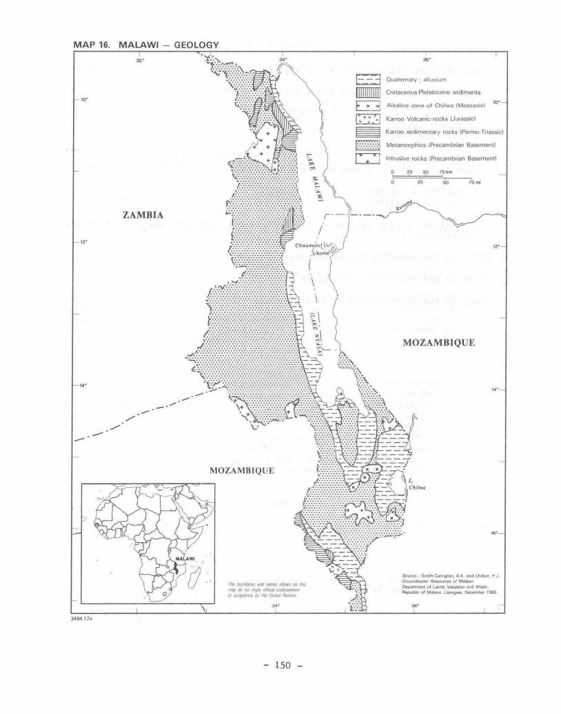
MAP 16. MALAWI - GEOLOGY
...
,,.
.---
...
34841h
ZAMBIA
MOZAMBIQUE
'''~ __ J,WoIIlllIIr:I
nup do IlOl ",.~ 0111Ql/ ~ III 1ItXf(Jlt'n by IIIr In/Ill tu/fIllS
150 -
,..
1:-; 3 Quaternary alluvium
nIIIIIIIIIJ Cretaceous Pleistocene sedlmenLS
~ Alkaline zone of Ch'lwa (Me60loicl
~ Kauoo Volcanic rocks WUrassic)
...
Kauoo sedimentar y rocks (PetmoTriassic)
Melamot'phrcs IPrecambrian Basement)
Intrusive rocks {Precambrian Basement!
o o
25 50 ,,, .. ,, 25 50 "'"
MOZAMBIQUE
$O<JrctI SmllI. Car,,,,,.on, A K _ Chlltorl p..J G"""""-IW ~ 01 M..t~lol~V" ... bOIl...:lW_ AIpubk ol~ .. 1.IIongw!t. o..;.m .. 1983

MALAWI
Area: 119,300 km2
Population: 6.4 million (1983)
I. BACKGROUND
Malawi is situated in the extreme south of the big Rift Valleys of Eastern Africa. The relief is extremely rugged and has important effects on the climate and hydrology and the presence of ground water. This is why the water-resources units or provinces have been defined mainly on the basis of topographical criteria. It should be noted that the population distribution and demand for water are also closely associated with the topography.
Malawi has the following four geographical systems:
Plateau areaSj
Upland areas;
Rift Valley escarpment;
Rift Valley plains.
The plateaus are gently undulating peneplains with wide valleys and interfluves. Ancient erosion surfaces at altitudes of 900 to 1,300 m predominate in the centre and the north, with wide interfluves and wide valleys draining towards the Rift Valley - the "dambos", swampy grassy areas subject to flooding and lacking any clearly defined beds.
The uplands include both inselbergs rising above the plateaus and two larger areas which are evidence of an Ancient erosion surface (post-Gondwana): the Mulanje, Zomba and Dedza mountains, and the Viphya and Nyika plateaus which reach altitudes of 2,000 to 3,000 m they consist mainly of granitic and syenitic intrusions which have stood up better to erosion. The escarpment consists of parallel faults which "step down" the slope to the floor of the Rift Valley. The rocks are outcropping or suboutcropping, for erosion removes alteration products as soon as they are formed.
The Rift Valley plains undulate very gently without any marked relief; they extend along the shores of Lake Malawi and the upper valley of the Shire River at an altitude below 600 m and decline to an altitude of 100 m in the lower valley of the Shlre. Erosion products, particularly from the escarpment area, accumulate in these plains.
Hydrographic network
The hydrographic network is clearly controlled by Lake Malawi which with an area of 28,750 m2, is the third-largest lake in Africa (volume: 7,700 km3); its only outlet is the Shire River, a tributary of the Zambezi. The upper course is an alluvial plain which passes to the lower course through a series of gorges, rapids and cascades. The Ruo and Mwanza are tributaries of the Shire. The main watercourses flowing into the Lake are the Linthipe, Bua, Dwangwa and Rukuru.
- 151 -

MAP 17. MALAWI - GEOMORPHOLOGICAL SKETCH
--
ZAMBIA
........ . - .......
'\ \"
I ~
Nyika Plateau
Viphya
,/
.-.~.-:,-
\ i
I
~
I f \.
\ \
.~ \',Lilong;e
./ -' , , "'-,~' ./ V
MOZAMBIQUE Zomba
IItf/IIIIIIIrWJII"~tIWJWtJ.,a. fIWP d? .of 1IfIfJI'f,,/fQf ~I tIIl(UJJUiO/l'ftMt.nfJldNIUJIII.
- 152 -
30'
t=§ Plains (Rift Valley)
D Plateaus
~ Rift Valley escarpment
~ Higher areas
o 2~ 60 7611.m
, ,. " "'"
MOZAMBIQUE
~. SmtIt> c.ongton, A K. n:I 0'IiIr0n. P J GrflUlldwltt~ R_",u of M~ ~I ollMld&, VIIIURion.nd W_ """'** I;Il MINwI ~ ~ 1983

Most of these watercourses emerge from vast "dambos" on the plateaus which can occupy up to 25 % of the surface area and have a complex hydrology. The main watercourses have deep, steeply-sided valleys; the slopes flatten as they reach the Rift Valley and sediments are deposited in the annually flooded areas. The watercourses lose a large part of their flow to infiltration in the alluvial areas.
The slopes above the Lake have in Tanzania and Mozambique, with a the annual rainfall of 1,180 mm).
an area of 97,750 km2 , including the mean annual flow of 912 m3 /s (300 mm
parts located o r 25 % of
In the rainy season the steep slopes can cause very high flood-water flows, but in the dry season only temporary flows occur, except in the case of the largest rivers. The whole of the hydrographic network terminates in Lake Malawi or the Shire River, except for the endorheic basin of Lake Chilwa, an area where evaporation dissipates the input. This lake is saline and can dry up if the evaporation is excessive: it is surrounded by swampy areas in the rainy season.
Climate
The country is subject to alternating periods of south-east prevailing winds and north-east monsoons, but these winds are strongly influenced by Lake Malawi and the topography. The plateaus have a hot climate and receive moderate rainfall, while the Rift Valley has a hot climate or even semi-arid in some zones.
There are three main seasons. The hot wet season runs from November to March; the rains begin a little later in the north but can last until April-May. The dry season is subdivided into a cool dry season lasting from May to August and a hot dry season when temperatures and relative humidity increase steadily from September to November.
The rainfall is closely associated with the topography: the upland areas and the slopes exposed to the prevailing winds receive more rainfall than the low areas and leeward slopes. The annual rainfall exceeds 800 mm over 90 % of the country. The Hulanje and Zomba mountains and the shores of Nkhata Bay up against the Rift escarpment receive over 1,800 mm. The areas with least rainfall include most of the shores of the Lake and the upper valley of the Shire.
There are large interannual variations, with alternating series of wet and dry years which cannot be forecast. The rain can be very heavy. often with daily amounts in excess of 20 mm.
The monthly temperatures are 10-16 ·C on the Nyika uplands, 20-29 ·C on the uplands of the central region, 20-29 ·C along the shores of the Lake, and 21-30 ·C in the lower valley of the Shire, with a maximum of 40 ·C in October-November.
The absolute minimum is 4-6 ·C on the uplands.
The moderating influence of Lake Malawi can be very clearly observed along its shores.
Evaporation from a free surface is in the order of 1,500 to 2,000 mm on the uplands and 2,000 to 2,200 mm on the shores of the Lake and in the Shire valley.
- 153 -

11. GEOLOGY
Formations of the Precambrian and Lower Paleozoic crystalline basement outcrop or suboutcrop over most of the country (the basement complex); these formations are themselves overlain in discontinuity by more recent sediments or volcanic rocks, extensive outcrops of which are found in the north and south of the country. The stratigraphic table is as follows:
Geologic age
Quaternary
Cretaceous to Pleistocene
Jurassic
Jurassic
Permian-Triassic
Lower Paleozoic Precambrian
Formation
Alluviums
Sungwa, Chiwondo and Chitlmbe strata, Dinosauric strata. Lupata series
Alcaline province of Chilwa
Stormberg volcanic rock (Karroo)
Karrao sedimentary series
Crystalline basement
Main lithology
Clays, silts, sands and sometimes gravels
Sandstones, sedimentary schists, marls and conglomerates
Plutonic rocks (syenites, granites)
Basalts
Sandstones, conglomerates, sedimentary schists with coal seams
Gneiss and granulites with granitic and syenitic intrusions
The main structural feature is the Rift Valley, formed by a subsidence fault during the Upper Mesozoic and Cenozoic which is still active . The Quaternary alluviums are themselves faulted. Lake Malawi, Lake Malonbe and the Shire River occupy the floor of the Rift Valley. The faults run mainly N-S or NNW-SSE.
In Malawi the crystalline basement consists essentially of gneiss and granulites, together with metamorphic schists, quartzites and marbles.
The rocks of the Mafinga and Mchinjin groups in the north and east consist mainly of unmetamorphized sandstones and conglomerates in which the sedimentary structure is still preserved. Lastly, the basement is traversed by intrusive rocks such as the Nyika and Dzanalyama granites, syenltes, and dykes of pegmatite and dolerite.
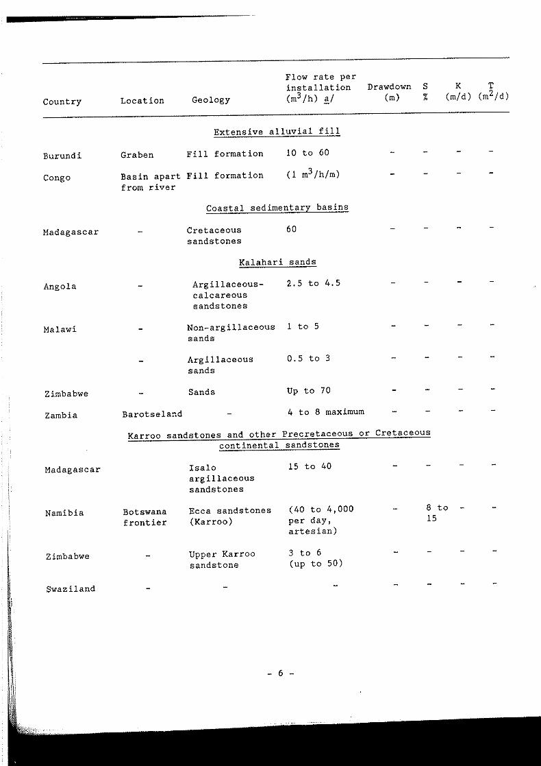
Karroo sediments outcrop in the north of the country in north-south basins and to the south-west of the Shire valley. They rest on the crystalline basement with, at the bottom, conglomerates, sandstones, argillaceous schists and coal seams, and at
- 154 -

the top, arkosic sandstones, marls, and argillaceous schists. These sediments are well bonded by calcite and hardened: they therefore have low porosity. They can be over 3,500 m thick.
Stormberg volcanic rocks are found at the top of the Karroo system . They include a series of basaltic flows with layers of sandstone and tufa in places. The most permeable parts are found in areas of contact between the flows, which are more porous.
The alkaline province of Chilwa in the south of the country includes plutonic intrusions of granites and syenites which are of little hydrogeological interest owing to the steepness of the slopes and the compactness of the permeable rocks, which have no major alteration .
Cretaceous-Pleistocene sediments are found in small narrow elongated basins in the north, running parallel to the shores of the Lake. They include crumbly sandstones, unconsolidated sands, sandy marls, clays and conglomerates. These are mainly sandstone formations of desert origin, with abundant traces of evaporites in a limestone matrix. The permeability and porosity of these rocks are probably high.
Quaternary formations (alluviums, colluviums, lacustral deposits) are well developed in the immediate vicinity of the lakes in the Shire and Bwanje valleys.
The strata contain clays, silts, sands and gravels and are intersected in many cases, with a predominance of fine elements and wide variation of facies.
The thickness of the alluvial sediments is very variable along Lake Malawi but it tends to increase closer to the shore to a maximum of 60 m. The alluviums are 40 to 80 m thick in the centre of the Shire and Bwanje valleys, with a maximum of 150 m in the lower course of the Shire.
The rocks of the crystalline base complex (Precambrian basement) have different degrees of alteration . The basement as a whole can be considered to be a single aquifer with no need to distinguish the types of rock, for the alteration products of the granitogneiss are in all cases minerals or clays with residual quartz fragments. However, the best aquifers are associated with the presence of coarse-grained minerals. The circulation of ground water is an important factor in the alteration of the rocks.
The type of the alteration formation depends on the geological location. The infiltration water is generally slightly acid (pH below 7) owing to the presence of CO 2 from the atmosphere and the organic components of the soil .
- 155 -

Alteration of the most recent metamorphic and igneous rocks
Depth of Storage Parent rock Texture Alteration products alteration capacity
Gneiss Coarse Minerals of clays Moderate to high Good grains and quartz
Schists Foliaceous Minerals of clays High Poor
Quartzite Fine to Mechanical alteration Low Poor to coarse good grains
Granite and Coarse Minerals of clays High Good granodiorite grains with quartz and mica
Syenite Coarse Minerals of clays Moderate Poor grains
Gabbro Coarse Minerals of clays Moderate Poor grains
Dolerite Fine Minerals of clays Moderate to high Poor grains and iron oxides
The presence of faults and dykes tends to facilitate alteration at depth by infiltration of water. The density of the joints between the rocks is also an important determinant of the depth and degree of alteration.
Ill. GROUND WATER
History of ground-water research and exploitation in Malawi
very
In Malawi ground water is exploited mainly for village water supplies. Before 1979 the installation of boreholes and wells was the responsibility of the Geological Service. The first boreholes were drilled in the 1930s. About 100 boreholes a year were installed between 1947 and 1968 . This number grew rapidly between 1969 and 1972 to a rate of 500 installations a year under the large agricultural development programmes in the lower reaches of the Shire, on the shores of the Lake at Salima and in the Lilongwe and Karonga areas. The Government's own rigs and rigs belonging to private companies were used for this purpose (11 cable rigs in 1987). The rate of installation slowed down at the end of the 1970s, with 180 holes drilled in 1980. The first combined rotary and down-the-hole hammer rig was introduced in Malawi in 1980. In 1987 there was a total of 5,500 water boreholes in the country. Most of them were equipped with hand-operated pumps.
Large-diameter wells were also excavated in the 1930s. Between 1931 et 1939, 400 wells equipped with winches and buckets were installed and some of them are still in operation; this type of installation then fell out of fashion, until in 1975 a works programme was initiated which included several hundred installations a year, with a total of 1,600 in 1987, all equipped with hand pumps. In July 1979 the Government merged all the services responsible for exploitation of water into a
- 156 -

single organization - the Department of Lands, Valuation and Water (DLVW). The ground-water section of this Department's Water Resources Service is responsible for the exploitation of ground water and the construction and maintenance of boreholes and dug wells.
The first reports on ground-water research in Malawi were prepared under a programme of water-supply studies which was carried out between 1931 and 1940. Little information was available until the publication by the Geological Service in 1970 of an overall report and several regional reports. The bulletins of the Geological Service also contain some useful data on ground water.
Mention should also be made of the reports prepared by a firm of consultants concerning the development of the Shire valley (1980-1982). 1979 saw the start-up of a major project to improve all aspects of the ground-water development programme and to prepare the reports and maps for the National Water Resources Master Plan (NWRMP). Studies were made of the water resources of certain valleys and the shores of the Lake. Test boreholes were drilled to determine the ground-water potential of certain alluvial areas, with a view to irrigation. Considerable improvement was achieved in the design of the boreholes; a pump-manufacturing programme was started, together with various ground-water development programmes.
The country was divided into 17 water resources units; these units are themselves subdivided into 66 secondary units on the basis of the hydrographic network, and a rational numbering system was adopted for the boreholes (up to 6,000 in number) based on their location and the chronological order of their installation. For example, 5 F 148 in the 148th borehole in the F subdivision (Rusa) of the Bua unit (5). Abandoned boreholes bear the suffix Xi those which have been cleaned out, the suffix C, and those which have been restored, the suffix R. A detailed index card has been drawn up for each installation. Hydrogeological maps on scale 1:100,000 have been produced. They include inter alia the location of the borehole and its number, the test yield and specific yield when known, the level of the water table at rest with the isopiestic measurements, the depth of the substratum in the alluvial areas, and the electrical conductivity of the ground water. Index cards also exist for the dug wells, with information about their characteristics, condition, etc.
Study methodology
Up to 1980 geophysical prospecting by the resistivity method was commonly used to determine the sitting of the boreholes. In the basement areas an attempt was made to identify the low-resistivity strata - taken to be an indication of a thick altered zone and/or a zone where the water table is close to the surface. Strata with very high resistivity were avoided, for this could indicate an unaltered rocky substratum close to the surface or a water table at greater depth. In the alluvial area this method of constant separation traverse (eST) identified the sandier or more gravelly zones of moderate resistivity; very low resistivity, possibly due to a high clay content in the alluviums, indicated zones to be avoided.
In rural areas therefore, where the water points are generally equipped with hand pumps, a limit was placed on geophysical prospecting. More detailed research was undertaken to determine the geological structures when there was a need to locate larger available discharges to be exploited by motorized pumps .
In 1973 other geophysical methods of ground-water exploration were introduced in Malawi under a mining research project implemented by the United Nations: magnetometry, electromagnetic methods and induced polarization.
- 157 -

The prospecting was carried out near Blantyre in the lower valley of the Shire.
It has emerged more recently that there was no need to engage in geophysical prospecting over most of the plateau and alluvial areas, for the low discharges identified are almost always available and, where the choice of site is concerned, the main thing is to take account of the wishes of the users and to minimize the likelihood of pollution.
Aerial photography is thus used to identify the villages, "dambos", existing springs and rocky outcrops, with a view to determining the needs and the sites of new wells and boreholes.
More extensive studies are justified, particularly in difficult terrain, with respect to water supplies for urban areas, industries and irrigation. In such cases, geophysical prospecting, exploration boreholes and test pumping are carried out.
Hydrogeology
There are two main types of aquifer in Malawi:
The vast aquifers in altered formations of the crystalline basement rock of the plateau which furnish moderate unit yields;
The alluvial aquifers at the edges of the Lake and in the Shire Valley which furnish better yields.
The alteration zone is 15 to 30 m thick on the plateau - and sometimes more. It is thinner in the vicinity of the rocky outcrops and thicker in the faulted zones.
The degree of alteration increases from the parent rock upwards to the soil. The texture can change considerably from one point to another: the permeable horizons can thus be very small in extent.
It is possible to distinguish, from bottom to top:
The fractured and unaltered substratum where water is found only in the fracturesj
The dislocated substratum with impermeable blocks, where the water is found in the gaps. The size of the blocks declines rapidly in the vertical direction and they acquire a sandy or gravelly texture, with the original structure more or less preserved.
The formation becomes less consolidated from bottom to top. The upper layers c onsist main l y of sandy clays and arglllaceous sands overlain close to the surface by compact clays.
The ground water is usually under slight pressure beneath the clay strata. The available yields depend on the thickness of the water-bearing stratum. It is usually possible to count on an aquifer 10 m thick for rural boreholes equipped with hand pumps. If the water-bearing stratum is too thin or the depth to water too great, the available yields will probably be i nsufficient. In addition, the alteration formation must not be too argillaceous. Lateritic strata are often found, particularly when the aquifer is close to the surface, for fluctuations in the water level lead to their formation. The lateritic fossil crusts have very poor porosity and permeability and do not therefore facilitate infiltration.
- 158 -

The alteration profile in the "dambos" zones has received little study, but it has very marked lateral variations.
With only a few exceptions, the fractured and unaltered basement rock is not a very productive aquifer. When these fractures are tapped by pumping in fairly deep boreholes (60 to 70 m), it is possible to drain the underlying alteration formations.
The Karroo sedimentary formations are very thick but have poor porosity and permeability, for the strata are bonded with calcite. As a result, ground water is found only in the joints and fractures, which may also have been enlarged by leaching. Very few data are available on this type of aquifer, which is unproductive in the lower valley of the Shire where the ground water is often found at 20 to 30 m below ground level.
The Stormberg basalts in the lower valley of the Shire are water-bearing in areas of contact between the lava flows, and good yields are found in places. However, in some cases the poor quality of the water make it unfit for the uses for which it is intended. Some boreholes have been drilled in the basalts. They yield between 0.25 and 2 lis . These boreholes are up to 45 m deep. The water table is 10 to 20 m below ground level.
The alluvial aquifers formed of fluvial and lacustral sediments are heterogeneous both vertically and horizontally; they are found in several basins which, with the exception of Lake Chilwa, all lie along the floor of the Rift Valley. Many boreholes have been drilled in the alluvial zones but some have not penetrated the alluviums over their full depth. They are probably thickest close to the river banks and in the centre of the alluvial valleys. The best yields come from the fossil beds and the littoral areas of the Lake.
Lake Chilwa is perched on the eastern edge of the Rift. It is thought that the formations here are mainly clay with locally more productive zones of sand and gravel corresponding to fossil beds.
Data on the available yields have usually been obtained by means of test pumping for five, and sometimes 12 hours. The data on record usually indicate fairly low yields, below 2 lis for all the aquifers; this seems to point to defective design and installation of the drilled wells.
Number of Average test Zone Type of aquifer boreholes yield (l/s)
South Rukurn Altered basement 234 0.75
Lilongwe Al tered basement 1,000 1 to 1.2
Salima Alluvial 240 0.9
Lower Bwanj e Alluvial 104 1.1
Upper Bwanj e Alluvial 170 0.8
Lower Shire Alluvial 260 0.95
- 159 -
It was noted that in the Lilongwe zone the wells equipped with strainers after 197 3 had better yields (1.5 lis). The low yields are probably due in many cases to i nsufficient pumping capacity.
In any event, the exploitation of rural wells is limited by the capacity of the hand pump with which they are equipped (0.25 to 0.5 l/s). Similar yields can be expected from all the alteration formations of the crystalline basement, provided that they are sufficiently thick, and it is probable that this result can be obtained without prior geophysical prospecting.
In fact, it is the thickness of the saturated alteration stratum rather than the depth of the borehole which determines a satisfactory yield. For example, at Lilongwe international airport yields of 1.5 to 5 lIs were obtained from alteration f ormations 20 to 29 m thick, under pressure under the compact clays.
The borehole yields are rather low in the alluvial zones (under 2 lis), probably because the tubing is not fitted with a strainer at the level of the productive strata. This is demonstrated by the fact that eight test holes drilled with care in the Shire Valley to evaluate the possibility of irrigation with ground water furnished yields of 15 lis (1982) and would no doubt have yielded more with a l a rger-capacity pump.
There is no doubt that better borehole design would produce higher unit yields. However, with the passage of time boreholes in Malawi undergo serious deterioration:
Clogging with fine materials of filter blocks with over-large perforations;
Corrosion of the tubing and the pump by acid ground water;
Encrustation of the filter block and perforations and the pumps with ferrous deposits, and clogging of the fractures in the rocks caused by over-vigorous pumping . This occurs in boreholes not fitted with strainers;
Decline of the water table when the extraction of ground water is greater than the recharge.
Hydrogeological properties
The known values of the transmissivity coefficient T are in the order of 100 to 300 m2/day for the alluviums and 5 to 30 m2/day for the altered basement rock . The values for the permeability coefficient K are 0.5 to 1.5 m/day in exceptional cases and 5 to 10 m/day in the alluvial sands and gravels free of argillaceous elements. The storage coefficient S is estimated at 5 to 10 p. 1/1,000 in the altered basement rock , and 1 to 5 p. 1/100 in the alluviums.
Fluctuation of the aqUifers
The greater the recharge, the closer the piezometric level to the surface. In fact, the surface of the aquifer reproduces on a smaller scale the configuration of the ground surface. On the plateaus the piezometric level of the aquifer at rest is usually less than 25 m below the surface, and in most cases less than 15 m. The aquifer spreads in the "dambos" in the rainy season. It lies at 30 m or deeper in the leeward areas which receive less rainfall. Near the Lake it is directly influenced by the level of the Lake. The piezometric levels are usually at fairly great depths in the Karroo sediments.
- 160 -

The seasonal fluctuations are in the order of 1 to 5 m for the basement zones and 1 to 3 m in the alluvial basins; the daily variations are in the order of 1 to 5 cm , depending on the atmospheric pressure.
No sustained drop in the water table was found between 1971 and 1981 either in the basement rock or in the alluviums. This is not surprising as the exploitation of the aquifers is still on a small scale in comparison with their recharge . This is not the case in certain fractured aquifers. However, in the areas irrigated with water from the Shire River the water table has risen by several metres.
The recharge has been estimated by several methods: for the basement rock and alluviums it is 10 to 100 mm (20 to 40 mm on average?).
The permanent water resources, i.e. those which occupy the saturation zone, are about 1,500 mm in the alluviums (for a thickness of 50 m) and 150 mm in the basement alteration zones (for a thickness of 50 m).
Chemical composition of the ground water
Ground water in Malawi usually has the following composition (mg/l),
Altered basement (plateau) Alluviums
Dry residue (dr) 60 to 600 300 to 1,800
Calcium (Ca) 10 to 100 100 to 150
Magnesium (Mg) 5 to 50 20 to 100
Sodium (Na) 5 to 70 20 to 1,500
Potassium (K) 1 to 6 1 to 6
Total iron (Fe) 1 to 5 1 to 5
Bicarbonate (C03H) 100 to 500 200 to 1,000
Sulphates (S04) 5 to 1,000 20 to 2,000
Chloride (Cl) Under 20 20 to 2,000
Nitrate (N03N) Under 5 Under 5
Fluoride (F) Under 1 2 to 10
The iron content is relatively large in all cases, and above the WHO standards . The resulting bitter taste and coloration can prompt the people to use water which is more agreeable to the taste and the eye but harmful to the health. The use of PVC tubing at least eliminates the oxidation which affects metallic tubing and increases the water's iron content. However, the general causes of high iron oxide content in the water have still not been established .
- 161 -

The chloride content can be high in some alluvial zones, especially in the lower valley of the Shire. The low nitrate content seems to indicate that the water is not polluted. The pollutants are probably halted or absorbed by the clays.
The water of the basement rock is usually suitable for irrigation use but the available yields are small. However, the alluvial aquifer could be used for large-scale irrigation in some cases, but this must be confirmed by means of pilot projects.
Need for additional studies
It is necessary to acquire more detailed information about ground water. In particular, the recharge modalities of the aquifers in the altered zones will have to be determined. A number of methods have been used to calculate this recharge: analysis of hydrograms, isopiestic curves and fluctuations in water table, and determination of water balances. The results are quite varied; the range of 10 to 90 mm expresses the complexity of the behaviour of the altered basement rock and the considerable uncertainties associated with some of the methods. First among these uncertaInties is the "dambos" system and its effect on the basic flow and real evapotranspiration . A programme of detailed studies is being carried out at present (1987) to determine the nature, thickness and origin of the dambo deposits and the altered basement aquifer as a whole and to establish the other characteristics of the aquifer, with a view to obtaining a more accurate estimate of the recharge. Such estimates need not cause concern for the annual drawoff by hand pumps is no more than 1 mm - with 2 to 3 mm in densely populated areas. The problem of overexploitation of the aquifers will arise only in the event of increased requirements for the distribution networks supplied by motorized pumps or for small irrigated areas also served by motorized pumps.
A study is currently being made of the possibility of exploiting the aquifers in the crystalline basement rock by wells with radiating drains drilled horizontally or with a slight slope. The alluvial formations will also have to be studied in order to determine their thickness, nature and potential, particularly in the lower reaches of the Shire, and the conditions of formation of water with a high sulfate content in the crystalline basement rock will have to be studied as a means of detecting the presence of water. Lastly, geophysical prospecting methods will have to be improved, in order to facilitate detailed study of boreholes with high yields.
IV. EXPLOITATION OF THE GROUND WATER
The 1981 census of the installations produced the following results:
Boreholes equipped with hand pumps Boreholes equipped with motorized pumps
Abandoned boreholes: with tubing without tubing Total
Modern dug wells with covers (protected against pollution) Old dug wells (open)
Total
- 162 -
4,275 577
254 428
5,534
1,582 455 -----
2,037

The per capita water consumption is less than 10 litres a day when the source is distant and 10 to 25 litres when it is less than a few hundred metres from the users. The average for the country is 10 to 15 litres.
It is estimated that one borehole is required for 250 inhabitants, one dug well for 125 inhabitants, and one standpipe for 160.
In 1977 it was estimated that a quarter of the rural populations, i.e. 1.28 million persons, had sufficient water of acceptable quality. In 1987 2 million people were being supplied, with a total annual drawoff of 12.5 million m3 . The demand in 1990 will be 71 million m3 . The demand for irrigation water has remained fairly low so far. About 20,000 hectares, mainly sugar cane plantations, are irrigated with surface water. It is possible that with the increasing population ground water will have to be used for irrigation in certain areas of the country where surface water is not available. Most of the livestock is watered from rivers and natural lakes and dams, except in the lower course of the Shire where hand pumps are used . Four-fifths of the population of urban areas are supplied from surface water: Blantyre, Lilongwe, Zomba and Mzuzu.
It should be noted that Malawi manufactures hand pumps. The MALDEV pump is relatively cheap and easy to maintain and repair.
V. REFERENCES
The material for this paper was taken from a report of the Department of Lands, Valuation and Water entitled "Ground Water Resources of Malawi" (172 pp.») published in December 1983 by the Overseas Development Administration - Institute of Geological Sciences .
This report contains a virtually exhaustive list of publications and unpublished reports on ground water in Malawi:
Publications
Chilton and Smith-Carington, Characteristics of the weathered basement aquifer in Malawi in relation to rural water supplies. Proceedings of the Harare symposium, IAHS Publ., 1984 .
Cooper, W.G.G., Electrical aids in water finding. Geological Survey of Malawi, Bulletin No. 7, 1950. Revised edition, 1965.
DLVW, Manual for integrated projects for rural ground-water supplies. ODA/UNDP/Malawi Government, 1982.
MoWS, Hydrogeological reconnaissance map of Malawi, at 1:250,000 scale in nine sheets. ODA/Malawi Government, 1987.
Lewis and Chilton, Performance of sanitary completion measures of wells and boreholes used for rural water supplies in Malawi. Proceedings of th& Harare symposium, IAHS Publ., 1984.
- 163 -

Unpublished reports
Bath, A.H., Hydrochemistry in ground-water development: report on an advisory visit to Malawi. Institute of Geological Sciences, 1980.
Bradford, R.B., Several reports on the hydrogeology and hydrochemistry of the Shire Valley. Geological Survey of Malawi, 1973.
Carruthers, R.M., Report on a visit to Malawi (October-December 1980) to advise on the use of geophysics in ground-water development. Institute of Geological Sciences, 1981.
Chapusa, F.W.P., Several reports on the lakeshore and Bwanje Valley areas. Geological Survey of Malawi, 1977.
Chilton, P.J., Report on a visit to Malawi, 29 September 1978 to 6 January 1979. Institute of Geological Sciences, 1979.
DLVW, Data Book Project - Preliminary report for District Water Supply Schemes. Water Supply Branch, Report No. HR 46, 1982.
____ ~~~~J Manual for integrated projects for rural ground-water supplies. ODA/UNDP/Malawi Government, 1982.
Dray ton, R.S., A regional analysis of river floods and low flows in Malawi. DLVW, Water Resources Branch, report No. TP, 1980.
Jackson, M., Water supply and sewerage study for Malawi. WHO/World Bank reports, 1979.
Kidd, C.R., A water resources evaluation of Lake Malawi and the Shire River. WHO Report No. MLW/77/012, 1983.
National and Shire Irrigation Study, Final national report - Annex C, Ground-water Resources. Hunting Technical Services, Macdonald & Partners with Ministry of Agriculture and Natural Resources, 1980.
National and Shire Irrigation Study, Addendum on ground-water irrigation potential. Hunting Technical Services, Macdonald & Partners with Ministry of Agriculture and Natural Resources, 1982.
Ruxton, C.W.F., Estimates of aquifer properties and recharge in the Dowa West integrated groundwater project. DLVW, 1983.
Smith-Carington, A.K., Aquifer tests at Lilongwe International Airport. Water Department, 1983.
, Hydrogeological bulletin for the Bua catchment: Water resource unit 5. ----=-=-=~ DLVW, 1983.
Smith-Carington and Msonthi, Retesting of some boreholes in the Livulezi integrated ground-water project. DLVW, 1983.
UNDP, National Water Resources Master Plan. UNDP/Water Department, 1986.
Wilderspin, K.E., A general outline of the ground-water resources of Malawi. Geological Survey of Malawi, 1973.
- 164 -