mcgrath ~ takotna ~ nikolai ~ telida -...
TRANSCRIPT
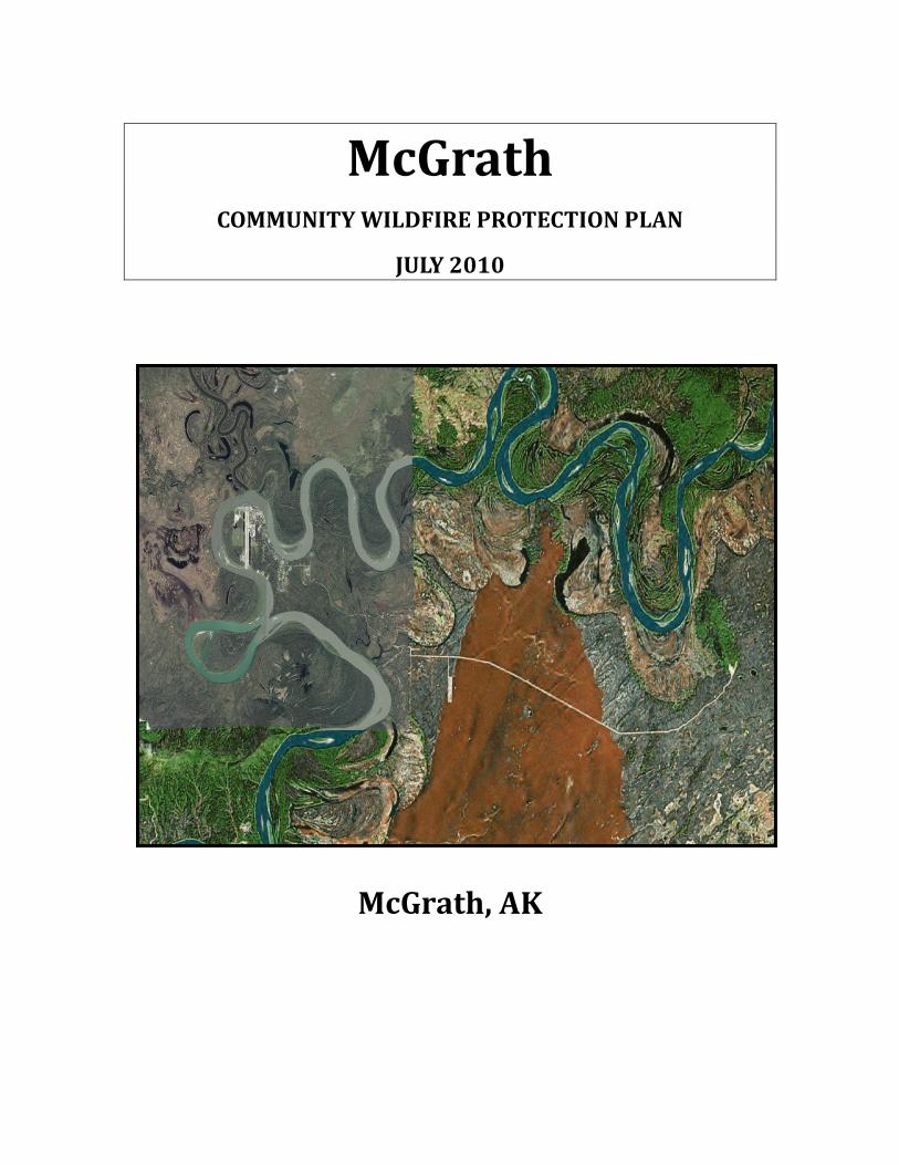
McGrath COMMUNITY WILDFIRE PROTECTION PLAN
JULY 2010
McGrath, AK
2 | P a g e McGrath CWPP 2010
Table of Contents
Introduction Page 3
1. Background Page 4
2. Executive Summary Page 5
3. Collaboration Page 6
4. Assessment to Prioritize Areas for Fuels Reduction Page 7
4.1. Identification and Description of Community Page 7
4.2. Areas or Values to be Protected Page 10
4.3. Wildfire Hazard / Risk Assessment Page 11
5. Wildfire History Page 20
6. Summary Page 20
7. Maps Page 22
8. The Next Step / CWPP Phase 2 Page 25
8.1. Mitigation Plan Page 25
8.2. Monitoring Plan Page 30
9. Signatures Page 31
10. References Page 32
3 | P a g e McGrath CWPP 2010
Introduction The village of McGrath is located within the Doyon, Limited Region. Doyon, Limited is the Regional Corporation for the villages of McGrath, Takotna, Nikolai and Telida known as MTNT, Limited. The land entitlement for each of these villages is based upon a population census that was taken in 1970. The Alaska Native Claims Settlement Act (ANCSA) was an Act which settled aboriginal claims for land against the United States Government; this was established by creating Native Corporations, transferring land and natural resources to the Corporations from the Federal Government. The Regional Corporations received fee title land; ownership of surface and subsurface to certain lands while the Village Corporations received title to the subsurface estate only. The four villages started out as their own corporation but later joined together, thus, creating MTNT, Limited. The letters stand for the first letter in the name of each of the four villages. The main office is located in the Hub of the villages; McGrath, which holds the largest population. Through ANCSA the village of McGrath received 92,160 acres and the remaining three villages received 69,120 acres each for a total of 299,520 acres for all four villages.
This plan is for the village of McGrath. Future plans include capturing all of the villages that make up MTNT Corporation in one “Regional CWPP.” This plan is similar to plans already developed for communities in Alaska and in the lower 48 states.
Grants The Division of Forestry along with the collaborators of this plan will pursue grants and additional funding to carry out fire prevention, fuels mitigation and pre-fire planning.
Western States Fire Grant Since 1999, the Council of Western State Foresters has awarded funding on a competitive basis to the western states and protectorates under the Western WUI Grant Program. Key program areas include: fuels reduction, restoration of fire-adapted ecosystems, homeowner action, and prevention & education.

4 | P a g e McGrath CWPP 2010
1. Background Community Wildlife Protection Plan (CWPP) Community Wildfire Protection Plans (CWPPs) represent the best opportunity we have to address the challenges of the Wildland/Urban Interface (WUI) in a way that brings about comprehensive and locally supported solutions. The long-term success of CWPPs will require dedicated and focused leadership along with meaningful collaboration by all partners. It is important that agency and organizational leaders understand and demonstrate commitment to the unique roles they play in producing and implementing effective CWPPs. Having a CWPP enables the communities and agencies involved to see a clear view of protection priorities set in place for each village. Priorities may differ between each village and having such a plan will allow the priorities to be seen clearly. There is a great common concern for protecting our communities, the assets to our communities and the values we hold in the land; by having this plan it allows the village to have a voice. The CWPP will bring the village of McGrath together, helping to keep the focus which will be to protect communities, vital structures such as schools, clinics, homes, offices, the land we live on and use, natural resources, and historical and cultural sites. The natural resources of our land are vital to the community members living in these communities as a subsistence lifestyle is an everyday part of living in such remote areas of Alaska. Minimum requirements for a CWPP; include:
(1) Collaboration. (2) Prioritizing areas for treatment. (3) Recommended measures to reduce structure ignitibility.
The following process is an aid to help a community to complete a CWPP. It should not be overly complex. Three elements are addressed in this process:
(1) Risk/hazard assessment. (2) Mitigation plan. (3) Monitoring.

5 | P a g e McGrath CWPP 2010
2. Executive Summary The McGrath Community Wildfire Protection Plan (CWPP) is a collaborative effort that has been developed as a result of the 2003 Healthy Forest Restoration Act (HFRA) which directs communities at risk of wildfire to develop a risk assessment and mitigation plan. Guidance for the McGrath plan is based on the Alaska Wildland Fire Coordination Group CWPP outline (Nov. 2005). Many other data sources and plans such as the McGrath Community Strategic Plan and demographics information were retrieved from the internet and are listed in the reference section. The village of McGrath is the headquarters for the State of Alaska, Department of Natural Resources, Division of Forestry; known as the Southwest Area District (SWS). 86 million acres are contained within the SWS Fire District where over the past 23 years, an average of 165,000 acres burn annually. Communities such as McGrath, Takotna, Nikolai, and Telida are surrounded by primarily black spruce fuels types and during an average fire season, are always at risk. Certainly, other vegetation exists especially in the riparian zone but enough acres are contained within 1 mile radius of the villages to warrant hazard fuel reduction. After the initial Risk/Hazard Assessment, five areas or “phases” were designated as priority areas for fuels reduction work. It is estimated that approximately 280 acres need treatment in and around the village of McGrath. Fire crew type personnel, organized as such, from local communities, will perform this important work. Minimal equipment will participate in the Shaded Fuels Break or Hazard Fuel Reduction projects. State Forestry along with the cooperators of this CWPP will utilize this plan to secure grant funding for essential hazard fuels mitigation work, fire prevention and community education efforts. Alaska Firewise techniques will be introduced as a prevention method, for residents, to reduce the fire risk/hazard in and around structures. Firewise is a proven method for communities to prepare and plan for wildfire.
The goal of this CWPP is to develop a wildfire prevention strategy and prioritize a thorough list of risk reduction projects in the high risk areas identified by vegetation
maps and local community knowledge/assessment.

6 | P a g e McGrath CWPP 2010
3. Collaboration and the Planning Process Collaborative efforts cut across many cultural and agency boundaries-state and federal agencies, city government, volunteer fire departments, village councils along with native non-profit and profit corporations. The McGrath CWPP has been developed to bring landowners and stake holders together to prevent and reduce wildland fire risk / hazard in and around the village, homes and structures on lands in the area that consists of privately owned land, stated owned land, and federally owned land. Wildland fire risk priorities are defined and implemented by the community and agencies involved to ensure specific strategic actions and priorities are in place prior to a wildland fire. The CWPP Process Step One: Convene Decision Makers Step Two: Involve Federal Agencies Step Three: Engage Interested Parties Step Four: Establish a Community Based Map Step Five: Develop a Community Risk Assessment Step Six: Establish Community Priorities Step Seven: Develop an Action Plan and Assessment Strategy Step Eight: Finalize Community Wildfire Protection Plan To maintain the stability and outcome of the initial priorities and concerns of the communities involved, a mutual decision will be made by the following:
MTNT Limited Corporation, State of Alaska DNR/Div. of Forestry, McGrath Native Village Council, McGrath Volunteer Fire Department, City of McGrath, Doyon, Tanana Chiefs Conference, State Fish and Game, the US Fish and Wildlife Refuge and interested members of the public.
7 | P a g e McGrath CWPP 2010
4. Assessment to Prioritize Areas for Fuels Reduction This risk assessment system provides information about four primary elements contributing to or mitigating wildfire danger within or near a given Alaska community. These elements are:
1) Risk/Hazard 2) Barriers 3) Fire Protection Response 4) Community Firewise Rating A. Introduction: The Risk/Hazard Assessment was conducted during July 3rd – 18th, 2010. The primary assessment was conducted by the State of Alaska, Division of Forestry with input from MTNT Limited, the City of McGrath, the MVFD, McGrath Native Village Council and the public. 4.1 Identification and Description of Community and Area: 1. Describe the WUI boundary and how it was delineated: The Wildland Urban Interface Boundary has been delineated by assessing the values at risk. Those include not only structures, commercial and private property but also the land that provides needed resources to enable a subsistence lifestyle. The boundary is delineated by the main runway and extends east on Cranberry Ridge Road 5 miles to the emergency runway.
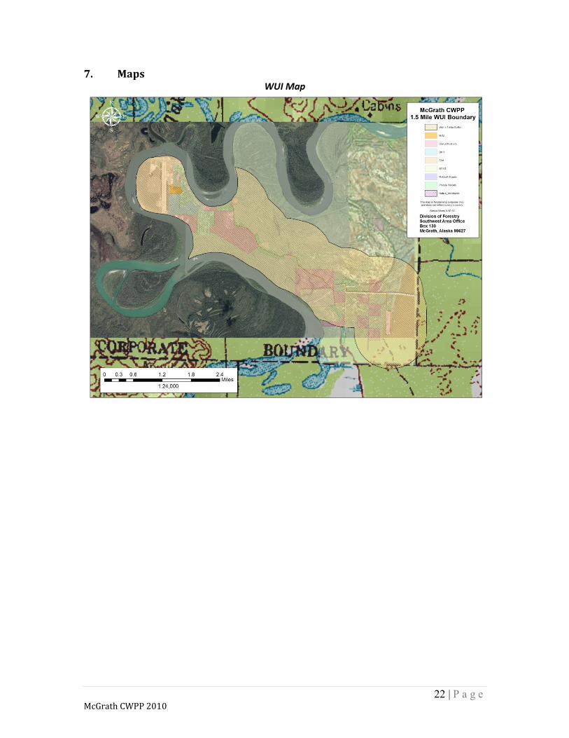
See the WUI Map in… Section 7. Maps It is viewed that west of the main runway is in little to no danger of wildfire impacting the area. 2. Community Name: McGrath (muh-GRATH) 3. Location:
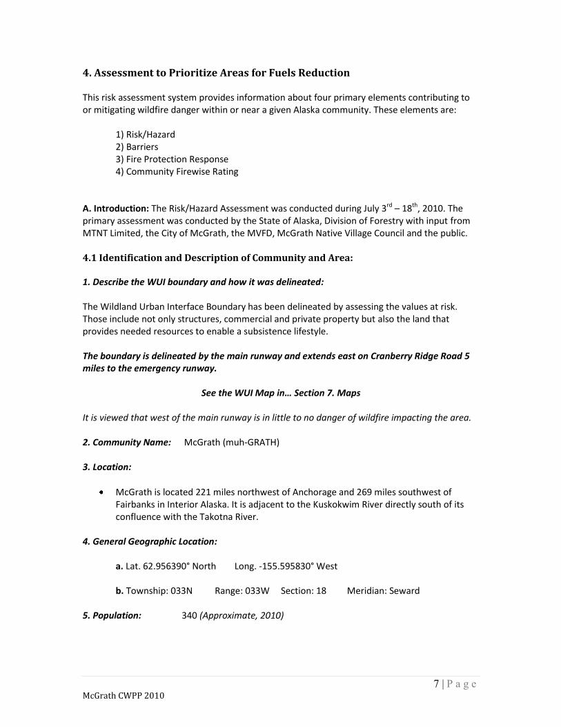
McGrath is located 221 miles northwest of Anchorage and 269 miles southwest of Fairbanks in Interior Alaska. It is adjacent to the Kuskokwim River directly south of its confluence with the Takotna River.
4. General Geographic Location: a. Lat. 62.956390° North Long. -155.595830° West b. Township: 033N Range: 033W Section: 18 Meridian: Seward 5. Population: 340 (Approximate, 2010)
8 | P a g e McGrath CWPP 2010
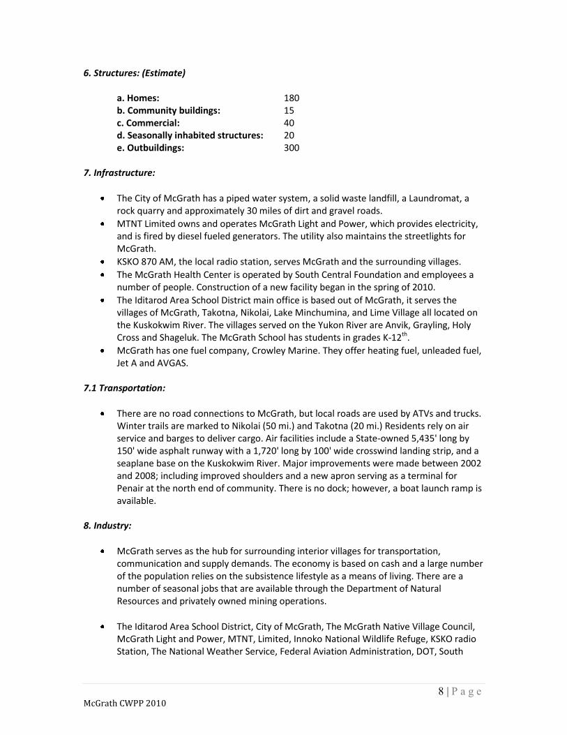
6. Structures: (Estimate) a. Homes: 180 b. Community buildings: 15 c. Commercial: 40 d. Seasonally inhabited structures: 20 e. Outbuildings: 300
7. Infrastructure:
The City of McGrath has a piped water system, a solid waste landfill, a Laundromat, a rock quarry and approximately 30 miles of dirt and gravel roads.
MTNT Limited owns and operates McGrath Light and Power, which provides electricity, and is fired by diesel fueled generators. The utility also maintains the streetlights for McGrath.
KSKO 870 AM, the local radio station, serves McGrath and the surrounding villages.
The McGrath Health Center is operated by South Central Foundation and employees a number of people. Construction of a new facility began in the spring of 2010.
The Iditarod Area School District main office is based out of McGrath, it serves the villages of McGrath, Takotna, Nikolai, Lake Minchumina, and Lime Village all located on the Kuskokwim River. The villages served on the Yukon River are Anvik, Grayling, Holy Cross and Shageluk. The McGrath School has students in grades K-12th.
McGrath has one fuel company, Crowley Marine. They offer heating fuel, unleaded fuel, Jet A and AVGAS.
7.1 Transportation:
There are no road connections to McGrath, but local roads are used by ATVs and trucks. Winter trails are marked to Nikolai (50 mi.) and Takotna (20 mi.) Residents rely on air service and barges to deliver cargo. Air facilities include a State-owned 5,435' long by 150' wide asphalt runway with a 1,720' long by 100' wide crosswind landing strip, and a seaplane base on the Kuskokwim River. Major improvements were made between 2002 and 2008; including improved shoulders and a new apron serving as a terminal for Penair at the north end of community. There is no dock; however, a boat launch ramp is available.
8. Industry:
McGrath serves as the hub for surrounding interior villages for transportation, communication and supply demands. The economy is based on cash and a large number of the population relies on the subsistence lifestyle as a means of living. There are a number of seasonal jobs that are available through the Department of Natural Resources and privately owned mining operations.
The Iditarod Area School District, City of McGrath, The McGrath Native Village Council, McGrath Light and Power, MTNT, Limited, Innoko National Wildlife Refuge, KSKO radio Station, The National Weather Service, Federal Aviation Administration, DOT, South

9 | P a g e McGrath CWPP 2010
Central Foundation, United States Post Office, Pen Air , The AC Co. and many other smaller locally owned businesses make up the economy for McGrath.
9. Natural Resource Values:
The community of McGrath shares a subsistence lifestyle like many other rural Alaska villages. Summer and fall activities include fishing for Salmon and White Fish, berry picking, hunting for Moose, Caribou, Farewell Bison, Bears, Grouse and other birds. In winter many residents enjoy trapping along the Kuskokwim River system.
Timber is also important to the community. Most resident’s burn wood for heat and several locals harvest White Spruce along the rivers surrounding the community.
A Bio-Mass study is ongoing to determine the viability of utilizing local woody material to provide supplemental heat to McGrath’s businesses and residential structures.
10. Cultural Sites:
There are approximately 150 known, registered, cultural sites in the McGrath area. (State of Alaska, Office of History & Archaeology)
11. Dumps:
The Sanitary Landfill is located on the corner of Chinana Ave. and Cranberry Ridge Road. An incinerator is in place which has reduced animal issues and unwanted fires.
12. Hazards:
There is a Fuel Tank Farm located at the north end of town owned and operated by Crowley Marine. 9 large fuel tanks are housed there and supply the fuel to the Power Plant, aviation operators and residents with fuel.
Several large Fuel tanks are dispersed throughout the community. Ranging from 10,000 – 40,000 gallons.
13. Fire Equipment:
The McGrath Volunteer Fire Department is operated by the City of McGrath. There is 1 Type 1 structural fire Engine and 1 Type 6 wildland fire engine housed in the City of McGrath building. Only 2 people are currently rated to wear SCBA equipment to make entry to a burning structure.
At the State of Alaska, Airport Maintenance Facility, a Project Code Red unit is available for response.
14. Local Fire Prevention Efforts:
The McGrath School presents the “Fire in Alaska” curriculum. The US Fish and Wildlife Service sponsor a Science Camp that teaches Fire Ecology.

10 | P a g e McGrath CWPP 2010
15. Other community values:
The Iditarod Historical Trail passes through McGrath and has both historical and economic significance.
4.2 Areas or Values to be protected It is viewed by the community that the greatest area of concern is the structures along the east side of the community in what is known as the “HUD” subdivision. In addition to non-Firewise construction and landscaping on many properties, a significant fuel load (Black Spruce) exists adjacent to the east, south and partially to the west sides of the subdivision. Concern is also held in the area to the west of the “HUD” subdivision. There is fuel loading of Black Spruce and a history of human caused fires in this area. Further concerns are smoke impacting the airport and potential short-term and long-term damage to subsistence lands and watersheds.
McGrath Regional Affairs map, circa 1984.
11 | P a g e McGrath CWPP 2010
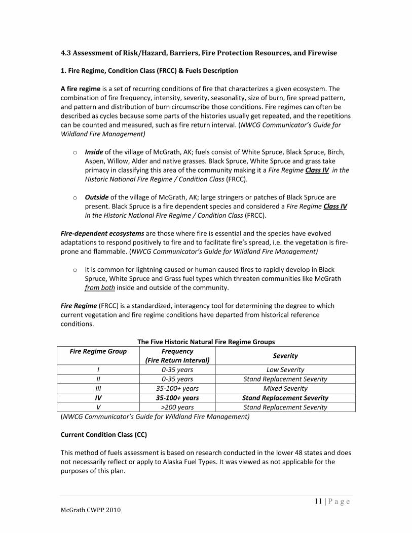
4.3 Assessment of Risk/Hazard, Barriers, Fire Protection Resources, and Firewise 1. Fire Regime, Condition Class (FRCC) & Fuels Description A fire regime is a set of recurring conditions of fire that characterizes a given ecosystem. The combination of fire frequency, intensity, severity, seasonality, size of burn, fire spread pattern, and pattern and distribution of burn circumscribe those conditions. Fire regimes can often be described as cycles because some parts of the histories usually get repeated, and the repetitions can be counted and measured, such as fire return interval. (NWCG Communicator’s Guide for Wildland Fire Management)
o Inside of the village of McGrath, AK; fuels consist of White Spruce, Black Spruce, Birch, Aspen, Willow, Alder and native grasses. Black Spruce, White Spruce and grass take primacy in classifying this area of the community making it a Fire Regime Class IV in the Historic National Fire Regime / Condition Class (FRCC).
o Outside of the village of McGrath, AK; large stringers or patches of Black Spruce are
present. Black Spruce is a fire dependent species and considered a Fire Regime Class IV in the Historic National Fire Regime / Condition Class (FRCC).
Fire-dependent ecosystems are those where fire is essential and the species have evolved adaptations to respond positively to fire and to facilitate fire’s spread, i.e. the vegetation is fire-prone and flammable. (NWCG Communicator’s Guide for Wildland Fire Management)
o It is common for lightning caused or human caused fires to rapidly develop in Black Spruce, White Spruce and Grass fuel types which threaten communities like McGrath from both inside and outside of the community.
Fire Regime (FRCC) is a standardized, interagency tool for determining the degree to which current vegetation and fire regime conditions have departed from historical reference conditions.
The Five Historic Natural Fire Regime Groups
Fire Regime Group
Frequency (Fire Return Interval)
Severity
I 0-35 years Low Severity
II 0-35 years Stand Replacement Severity
III 35-100+ years Mixed Severity
IV 35-100+ years Stand Replacement Severity
V >200 years Stand Replacement Severity
(NWCG Communicator’s Guide for Wildland Fire Management)
Current Condition Class (CC) This method of fuels assessment is based on research conducted in the lower 48 states and does not necessarily reflect or apply to Alaska Fuel Types. It was viewed as not applicable for the purposes of this plan.

12 | P a g e McGrath CWPP 2010
Fuels Description For the purposes of this document a “General” Fuels Description using the Canadian Forest Fire Danger Rating System (CFFDRS) and the Fuel model guide to Alaska vegetation was used to verify fuel type and determine the Wildfire Hazard / Risk Assessment. Inside the community: McGrath can be separated into 2 geographically referenced sections, East and West McGrath.
o East McGrath is comprised of Chinana Ave. extending from the city center to Cranberry Ridge Road. This area is of most concern due to the homes along Martella Ave. and Laska St. having a significant amount of C-2 Black Spruce fuels adjacent to structures.
o West McGrath is comprised of mostly M1 Boreal Mixed Wood-Leafless and Boreal
Mixed Wood-Green. Specific fuels include Alder, Aspen, Birch, Cottonwood, Willow and various shrubs and grasses. There is little concern of problem fire behavior in the area of the community.
Outside the community: The dominant fuel type of concern outside the community is C-2 Black Spruce.
o Starting just east of the Laska Street and Martella Avenue there is substantial C-2 Black Spruce and associated Caribou Moss, Lichens, Feather Moss and sphagnum bog; both open and closed stands that extends several miles to the east following Cranberry Ridge Road, the Kuskokwim River and the various sloughs and oxbows associated with the river corridor.
o To the north, south and west of McGrath (across the Kuskokwim River) C-2 Black Spruce
sphagnum bog; both open and closed stands are the dominant fuel type and pose the greatest risk/hazard to the community. Despite the width of the river it is felt that, during favorable conditions, the river would aid in suppression efforts but not provide an absolute barrier to fire spread potential, as is the case in other areas of Alaska.
The 2002 Vinasale Fire reached approximately 189,705 acres and the 2009 Broken Snowshoe fire reached approximately 25,339 acres in the Fuel Types described above.
See the Fire History Map in… Section 7. Maps

13 | P a g e McGrath CWPP 2010
2. Rating Elements Reference A) Risk/Hazard Analysis (1) Inside Community: The rating area includes lands within one mile of the community in all directions. The rating is based on history/likelihood of fire in the community and the availability of hazard fuels. Provide a description of local fire history and fuel conditions and give High, Moderate or Low rating based on the Risk/Hazard Chart. (2) Outside Community: The rating area is from 1-10 miles outside the community and is based on the history/likelihood of fire in the area and the availability of hazard fuels. Provide a description of area fire history and fuel conditions and give a High, Moderate or Low rating based on the Risk/Hazard Chart. B) Barriers Alaska communities are situated in a variety of conditions through out Alaska. Some are along river corridors, others on uplands, and along coastal areas. Surrounding many of these communities are barriers. Barriers are zones that would help restrict large fire movement from coming into the community. Barriers may be water, natural or manmade. A natural barrier may be a topographic feature, vegetation change, or bare ground. An example of a manmade barrier would be a road. Describe any barriers that would provide protection or slow the progress from wildfires burning in fuels less than1 mile from the community. Give an Excellent, Fair or Poor rating based on the Barrier Rating Chart. C) Fire Protection Resources Communities typically rely on the State of Alaska, Division of Forestry, or the BLM, Alaska Fire Service for protection from large wildfires. However, other protection resources may exist, and response times can vary widely in remote areas of Alaska. Describe the situation. Using the Fire Protection Response Chart, give an Excellent, Fair or Poor rating based on predicted response times to the community and nearby lands. List the types of resources that are available for initial attacking a wildland fire. D) Firewise Ratings Using the Firewise Home Rating Chart, perform cursory firewise ratings of all home sites and community buildings. Using the Firewise Community Rating Guidelines; give a rating of Excellent, Fair or Poor.

14 | P a g e McGrath CWPP 2010
A) Risk/Hazard Analysis Chart 1
(1) Inside Community Area (within 1 mile)
Alaska Fire Return Interval FUELS (predicted fire behavior based on historic summertime weather with hot, dry conditions)
High (0-99 years)
Moderate (100-300 years)
Low (>300 years)
Black Spruce Boreal Forest (CFFDRS=C2) rate of spread: high intensity: high spotting potential: high
High There is a significant amount of Black Spruce that borders the west side of the community
(within 1 mile).
Black Spruce Lichen Woodland (CFFDRS=C1) rate or spread: moderate intensity: moderate spotting potential: high
Low Minimal relative C-1 fuel component within 1
mile of the community.
Grass (cured tall standing or matted; CFFDRS = O1a/O1b) rate of spread: high intensity: moderate: spotting potential: low
Low Minimal relative grass fuel component within 1
mile of the community.
Mixed Boreal Forest (may include white or black spruce, aspen and/or birch; CFFDRS=M1) rate of spread: moderate intensity: moderate spotting potential: moderate
Moderate/Low There are substantial amounts of this fuel type;
however it is primarily dominated by aspen, birch, cottonwood, alder and willow.
Hardwood Forest (includes aspen & birch; CFFDRS use D1 or M1, M2) rate of spread: low intensity: low spotting potential: low
Low Hazard/Risk from this fuel type is minimal to the
community.
Deciduous Brush (includes willow & alder) rate of spread: low intensity: low spotting potential: low
Low Hazard/Risk from this fuel type is minimal to the
community.
Insect and Disease in Mixed Boreal Forest (may include white or black spruce, aspen and/or birch; rate of spread: moderate intensity: High spotting potential: High
Low Insect and disease is minimal in the area. Leaf minor was observed affecting the Aspen along
the roadways.

15 | P a g e McGrath CWPP 2010
A) Risk/Hazard AnalysisChart
(2) Outside Community Area (1-10 miles)
Alaska Fire Return Interval FUELS (predicted fire behavior based on historic summertime weather with hot, dry conditions)
High (0-99 years)
Moderate (100-300 years)
Low (>300 years)
Black Spruce Boreal Forest (CFFDRS=C2) rate of spread: high intensity: high spotting potential: high
High There is a significant amount of Black Spruce
that borders the west side of the community and across the Kuskokwim River.
Black Spruce Lichen Woodland (CFFDRS=C1) rate or spread: moderate intensity: moderate spotting potential: high
Moderate Transitional areas of Black Spruce / Lichen
(upland) exist along the ridges outside of the community.
Grass (cured tall standing or matted; CFFDRS = O1a/O1b) rate of spread: high intensity: moderate: spotting potential: low
Low Minimal relative grass fuel component outside of
the community.
Mixed Boreal Forest (may include white or black spruce, aspen and/or birch; CFFDRS=M1) rate of spread: moderate intensity: moderate spotting potential: moderate
Moderate/Low This fuel type exists along the roadways and the
edges of the 2002 burn scar; however it is primarily dominated by Aspen, Birch,
Cottonwood, Alder and Willow.
Hardwood Forest (includes aspen & birch; CFFDRS use D1 or M1,M2) rate of spread: low intensity: low spotting potential: low
Low Risk from this fuel type is minimal to the
community.
Deciduous Brush (includes willow & alder) rate of spread: low intensity: low spotting potential: low
Low Risk from this fuel type is minimal to the
community.
Insect and Disease in Mixed Boreal Forest (may include white or black spruce, aspen and/or birch; rate of spread: moderate intensity: High spotting potential: High
Low Insect and disease is minimal in the area. Leaf minor was observed affecting the Aspen along
the roadways.
16 | P a g e McGrath CWPP 2010
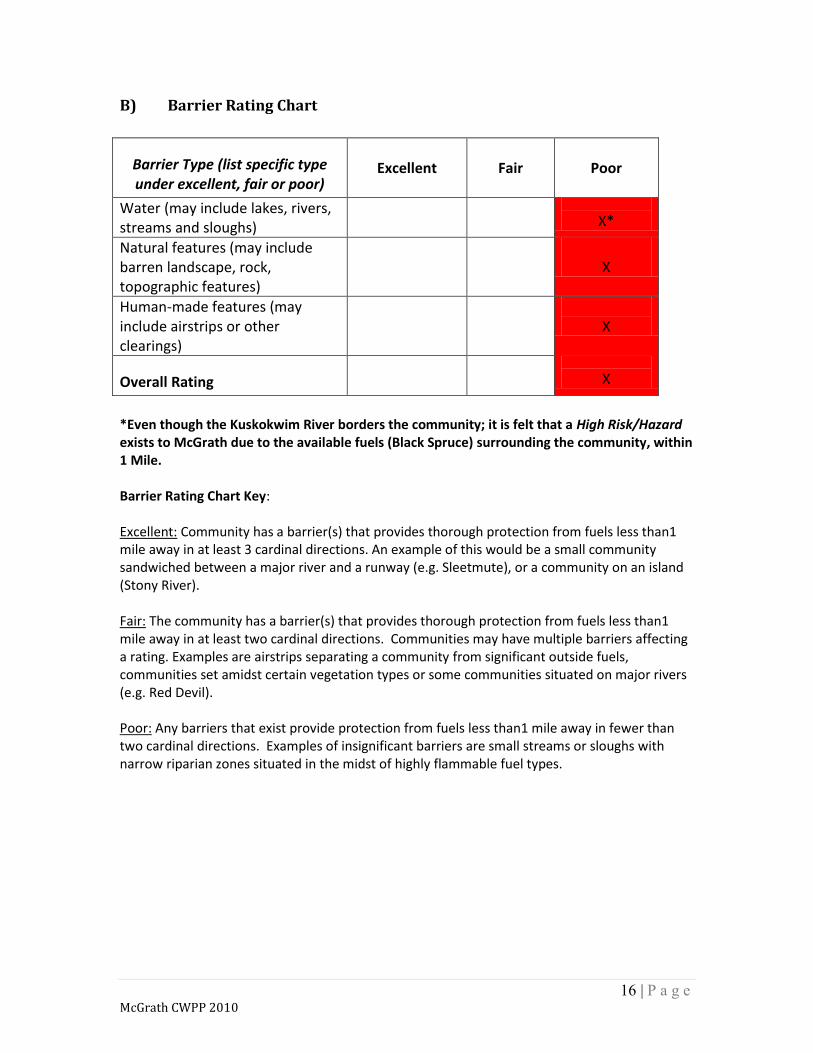
B) Barrier Rating Chart
Barrier Type (list specific type under excellent, fair or poor)
Excellent
Fair
Poor
Water (may include lakes, rivers, streams and sloughs)
X*
Natural features (may include barren landscape, rock, topographic features)
X
Human-made features (may include airstrips or other clearings)
X
Overall Rating
X
*Even though the Kuskokwim River borders the community; it is felt that a High Risk/Hazard exists to McGrath due to the available fuels (Black Spruce) surrounding the community, within 1 Mile. Barrier Rating Chart Key: Excellent: Community has a barrier(s) that provides thorough protection from fuels less than1 mile away in at least 3 cardinal directions. An example of this would be a small community sandwiched between a major river and a runway (e.g. Sleetmute), or a community on an island (Stony River). Fair: The community has a barrier(s) that provides thorough protection from fuels less than1 mile away in at least two cardinal directions. Communities may have multiple barriers affecting a rating. Examples are airstrips separating a community from significant outside fuels, communities set amidst certain vegetation types or some communities situated on major rivers (e.g. Red Devil). Poor: Any barriers that exist provide protection from fuels less than1 mile away in fewer than two cardinal directions. Examples of insignificant barriers are small streams or sloughs with narrow riparian zones situated in the midst of highly flammable fuel types.

17 | P a g e McGrath CWPP 2010
C) Fire Protection Resources Chart
Reasons Influencing a Moderate Rating The community decided that a moderate rating was applicable due to:
Seasonality McGrath experiences periods in the spring and fall when Forestry personnel are not typically present to respond to occasional grass fires and late season (fall) chimney fires. It also was felt that due to the nature of seasonal activity in McGrath that many responders from the MVFD are typically not present during wildfire season because of dependency of work outside of McGrath.
Activity During periods of High Fire Danger, Forestry resources can become scarce and are often deployed elsewhere in the McGrath Area. The MVFD is not equipped or trained in Wildland fire tactics to fill the void often left from activity outside of the community.
Response Time
Risk
Kind of Resource (List kinds of resources
available for initial attack)
Adequate initial attack resources are more than 75 minutes away and
adequate extended attack resources are more than 12 hours away.
High
Adequate initial attack resources are 30-75 minutes away and adequate
extended attack can be in place in 8-12 hours.
Moderate
Heli-tack from Forestry, Type 2 Crews in Region and Engine/Equipment response from MVFD.
Adequate initial attack resources are less than 30 minutes away and
adequate extended attack can be in place in less than 8 hours.
Low

18 | P a g e McGrath CWPP 2010
D) Community Firewise Rating for Defensible Space Overall Community Assessment not individual Structures
Total of Rating Sum / 25 x 100 = Community Firewise Rating Excellent greater than 65%, Fair 35-65%, Poor less than 35%
64%
Standards for Firewise Rating Landscaping: There is a clearing of flammable vegetation at least 30 feet around the home for firefighting equipment: coniferous brush and dead/overhanging branches are removed; trees are pruned 6-10 feet above the ground; lawn is mowed and watered regularly and ladder fuels are removed from the yard; remaining trees are spaced at least 30’ apart at crowns; garden equipment (hoses and hand tools) are kept on the property.
Alaska Firewise Standards
Excellent Over 65% of home sites and community buildings meet standard Value =5
Fair Between 35-65% of home sites and community buildings meet standard Value =3
Poor Less than 35% of home sites
and community buildings meet
standard Value=1
Landscaping
X
Construction X
Water Supply X
Access X
Clear of Flammables/ Refuse/Debris (flammables stored properly & area cleared)
X
Ratings Sums
10
6
0
19 | P a g e McGrath CWPP 2010
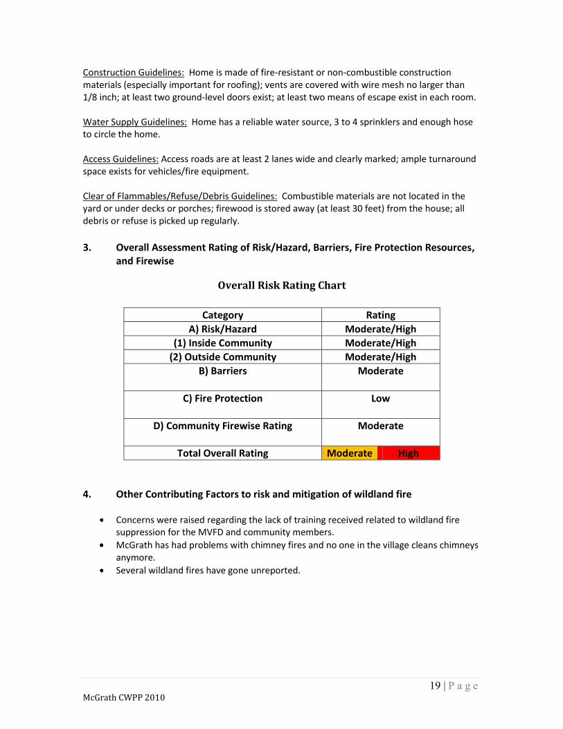
Construction Guidelines: Home is made of fire-resistant or non-combustible construction materials (especially important for roofing); vents are covered with wire mesh no larger than 1/8 inch; at least two ground-level doors exist; at least two means of escape exist in each room. Water Supply Guidelines: Home has a reliable water source, 3 to 4 sprinklers and enough hose to circle the home. Access Guidelines: Access roads are at least 2 lanes wide and clearly marked; ample turnaround space exists for vehicles/fire equipment. Clear of Flammables/Refuse/Debris Guidelines: Combustible materials are not located in the yard or under decks or porches; firewood is stored away (at least 30 feet) from the house; all debris or refuse is picked up regularly.
3. Overall Assessment Rating of Risk/Hazard, Barriers, Fire Protection Resources,
and Firewise
Overall Risk Rating Chart
Category Rating
A) Risk/Hazard Moderate/High
(1) Inside Community Moderate/High
(2) Outside Community Moderate/High
B) Barriers
Moderate
C) Fire Protection
Low
D) Community Firewise Rating
Moderate
Total Overall Rating Moderate High
4. Other Contributing Factors to risk and mitigation of wildland fire
Concerns were raised regarding the lack of training received related to wildland fire suppression for the MVFD and community members.
McGrath has had problems with chimney fires and no one in the village cleans chimneys anymore.
Several wildland fires have gone unreported.

20 | P a g e McGrath CWPP 2010
5. WILDLAND FIRE HISTORY 1990-2009
The primary cause of fires within 10 miles of McGrath area is Human Caused. Fire history data was retrieved from the Alaska Fire Service (AFS), geospatial database.
See the Fire History Map in… Section 7. Maps
Of the 39 fires*, within 10 miles of the community, 10 were caused by lightning and 29
were human caused.
35 of the fires were within 1.5 miles of the community, 28 were human caused and 7
were lightening caused.
Of the Human Caused fires:
o 14 were Open Burning related.
o 1 Fireworks, 1 Vehicle Exhaust, 1 Arson, 1 Smoking and 1 (Vinasale 2002) was
the result of a Shotgun round fired for Bear deterrent.
o The remaining 9 fires are listed as “Other” causes.
Fire History 1990-2009 Fires within 10 miles of the community
General Cause Number of Fires Acres (Est.)
Lightning 10 73,075
Human 28 7.6
Human 1 – Vinasale 189,705
Total 39 262,787.6 *Fire data is from Alaska Fire Service, Geospatial Data, July 2010.
6. Executive Summary
The Wildland Urban Interface Boundary has been delineated by assessing the values at risk. Those include not only structures, commercial and private property but also the land that provides needed resources to enable a subsistence lifestyle. The boundary was established using local knowledge and GIS produce topographic maps. It extends 1.5 miles east of the emergency runway on Cranberry Ridge Road to the west 1.5 miles , across the Kuskokwim River, west of the main runway. The dominant fuel type of concern is Black Spruce, a fire dependent species. When Black Spruce burns it is stand replacement in severity with a high mortality rate. Barriers including the; Kuskokwim River, roads and other man made feature provide little to no protection from the spread of wildfire.

21 | P a g e McGrath CWPP 2010
The Fire Response rating was determined Moderate due to the seasonality of Forestry resources and the possibility of fire suppression forces being deployed elsewhere in the response area when fires occur. Lack of fire wildland fire training and equipment was also raised as a concern for the MVFD and community members adding to the Moderate decision. The lack of “Firewise” type standards in the community was also viewed as a concern and most agree that more could be done in the way of fire prevention. The wildland fire history from 1990-2009 demonstrates the need for increased fire prevention efforts, Firewise standards, increased wildland fire training, more local equipment, fuels reduction work and a new cooperators agreement between State Forestry and the community. The overall risk/hazard rating was viewed as Moderate/High to the potential impacts of wildfire to the community. Damage to life, property, natural resources and critical infrastructure is of most concern to the community.
22 | P a g e McGrath CWPP 2010
7. Maps WUI Map

23 | P a g e McGrath CWPP 2010
Fire History Map
24 | P a g e McGrath CWPP 2010
Hazard Mitigation Map
25 | P a g e McGrath CWPP 2010
8. THE NEXT STEP – CWPP PHASE 2
8.1 Mitigation Plan
Summary
The Wildland Urban Interface Boundary has been delineated by assessing the values at risk. Those include not only structures, commercial and private property but also the land that provides needed resources to enable a subsistence lifestyle. The boundary was established using local knowledge and GIS produce topographic maps. It extends 1.5 miles east of the emergency runway on Cranberry Ridge Road to the west 1.5 miles, across the Kuskokwim River, west of the main runway. The dominant fuel type of concern is Black Spruce, a fire dependent species. When Black Spruce burns it is stand replacement in severity with a high mortality rate. Barriers including the; Kuskokwim River, roads and other man made feature provide little to no protection from the spread of wildfire. The Fire Response rating was determined Moderate due to the seasonality of Forestry resources and the possibility of fire suppression forces being deployed elsewhere in the response area when fires occur. Lack of fire wildland fire training and equipment was also raised as a concern for the MVFD and community members adding to the Moderate decision. The lack of “Firewise” type standards in the community was also viewed as a concern and most agree that more could be done in the way of fire prevention. The wildland fire history from 1990-2009 demonstrates the need for increased fire prevention efforts, Firewise standards, increased wildland fire training, more local equipment, fuels reduction work and a new cooperators agreement between State Forestry and the community. The overall risk/hazard rating was viewed as Moderate/High to the potential impacts of wildfire to the community. Damage to life, property, natural resources and critical infrastructure is of most concern to the community.
Goals and Objectives The Goal of this plan is to minimize the Hazard and Risk of Wildfire impacting the community through Firewise education, hazard fuels reduction and improving fire suppression capabilities. The Objectives of this plan are to:
1. Assist in implementing Alaska Firewise Standards within the community.
26 | P a g e McGrath CWPP 2010
2. Provide recommendations for constructing shaded fuels breaks to prevent spread into the community and aid in suppression of a wildfire.
3. Aid in acquiring practical fire suppression equipment and receive adequate firefighter training.
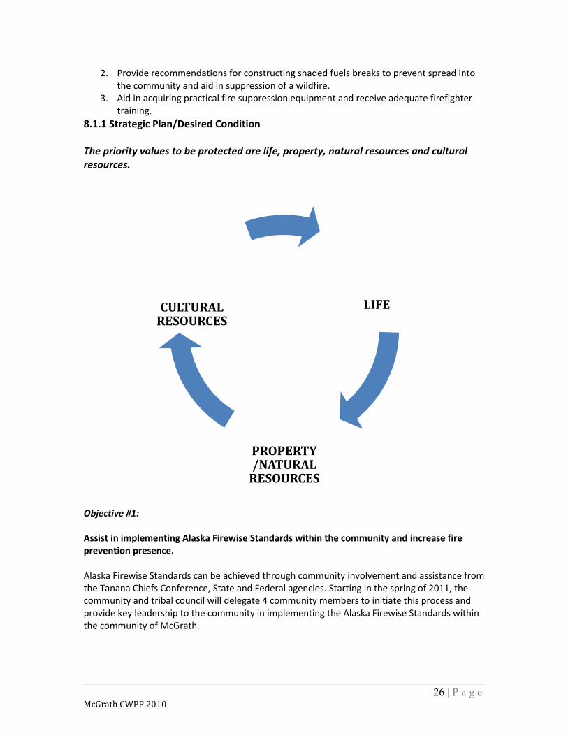
8.1.1 Strategic Plan/Desired Condition The priority values to be protected are life, property, natural resources and cultural resources.
Objective #1: Assist in implementing Alaska Firewise Standards within the community and increase fire prevention presence. Alaska Firewise Standards can be achieved through community involvement and assistance from the Tanana Chiefs Conference, State and Federal agencies. Starting in the spring of 2011, the community and tribal council will delegate 4 community members to initiate this process and provide key leadership to the community in implementing the Alaska Firewise Standards within the community of McGrath.
LIFE
PROPERTY /NATURAL
RESOURCES
CULTURAL RESOURCES
27 | P a g e McGrath CWPP 2010
With assistance from the Tanana Chiefs Conference, State and Federal agencies; instructions on implementing Firewise within the community will take place throughout the summer months of 2011. Minimal funding is needed for this critical component of Hazard / Risk reduction. Objective #2: Provide recommendations for constructing shaded fuels breaks to prevent spread into the community and aid in suppression of a wildfire. After the initial Hazard / Risk Assessment in July of 2010, the community was viewed Moderate/High risk for wildfire to spread both “Outside in” and from “Inside out” the community. There are 3 practical ways to minimize the Hazard / Risk to the community based on the assessment. It was viewed that along the borders of the community, within 1 mile, a significant fuel load existed. This fuel load can be reduced through common thinning and tree removal techniques by local hire workers and minimal equipment like chainsaws and hand tools. Objective #3: Aid in acquiring practical fire suppression equipment and receive adequate firefighter training for the MVFD and interested community members. It was identified by the community that further fire prevention, fire suppression equipment and wildland fire training was needed to aid cooperating agencies in the prevention and suppression of wildfires.
8.1.2 Actions and Methodology (Tactical Plan) Objective #1: Assist in implementing Alaska Firewise Standards within the community and increase fire prevention presence.
Hold a public meeting to gain interest in the Alaska Firewise program.
Solicit community members wanting to become community Firewise team members.
Acquire onsite Alaska Firewise Training for community team.
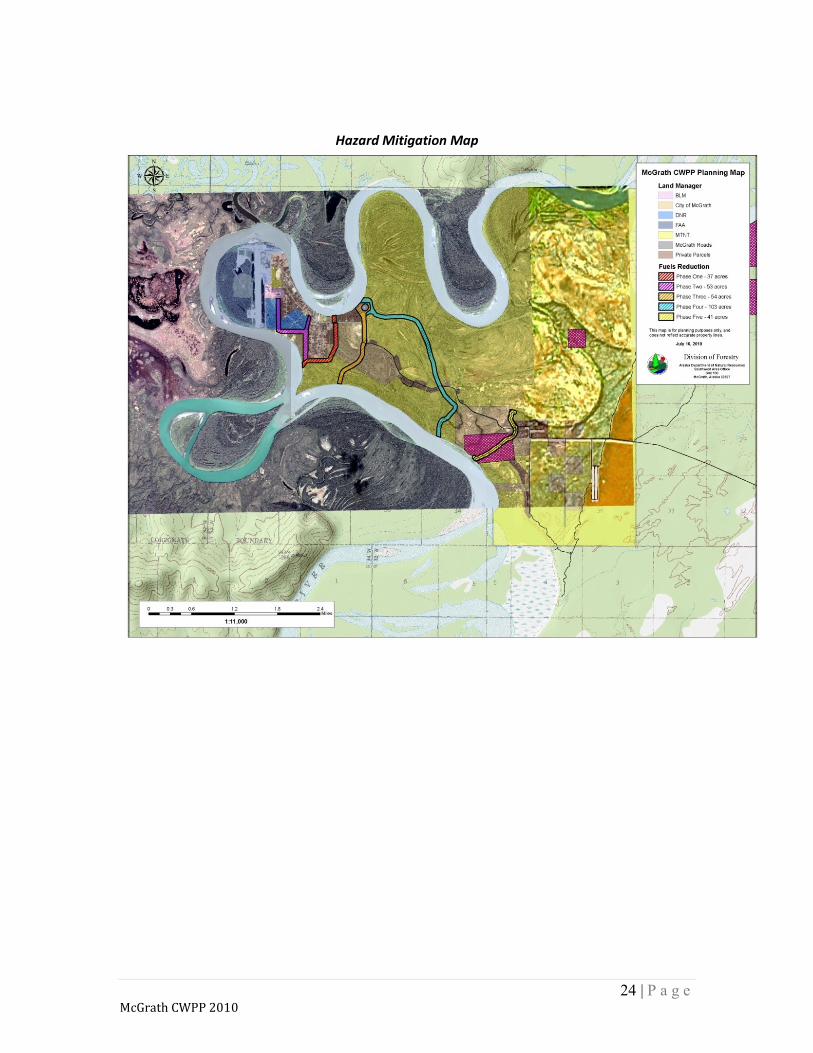
Implement Firewise Assessments. Objective #2: Provide recommendations for constructing Shaded Fuels Breaks to prevent spread into the community and aid in the suppression of a wildfire. After the initial Hazard / Risk Assessment in July of 2010, the community was viewed Moderate/High risk for wildfire to spread both “Outside In” and from “Inside Out” the community. There are 4 (site specific) phases designed to minimize the Hazard / Risk to the community based on the assessment. See Section 7. Maps for “Hazard Mitigation Map” They are:

28 | P a g e McGrath CWPP 2010
Phase 1: Construct a Shaded Fuel Break along the east border of “New HUD” subdivision working from the City of McGrath lot (North of Cranberry Ridge Road) to the south along the subdivision to the Kuskokwim River designated on the Hazard Mitigation Map as “Phase 1”.
Prescription: Remove all dead, down and diseased trees to a width of 300 feet. Thin Spruce trees to establish a 15 – 20 foot space between extending branches. Black Spruce responds better to treatment if trees are clumped in groups of 3-6 trees, as they are self-shading, to avoid overexposure to sunlight and eventual mortality. Remove the limbs of all Spruce trees 3 feet from the ground. Care should also be given as to not damage the trees being left by not scaring the trunk or bole of the tree. Approximately a 37 Acre area.
Phase 2: Construct a Shaded Fuel Break starting at the FAA site on north end of Cranberry Ridge Road extending south along the road to the Dozer line established and ending at the Kuskokwim River. Designated on the Hazard Mitigation Map as “Phase 2”.
Prescription: Remove all dead, down and diseased trees 300 feet wide from the Kuskokwim River, around the FAA site, on the east side of Cranberry Ridge Road to the south following the existing Dozer line until reaching the Kuskokwim River. Approximately a 54 Acre area. Thin Spruce trees to establish a 15 – 20 foot space between extending branches. Black Spruce responds better to treatment if trees are clumped in groups of 3-6 trees, as they are self-shading, to avoid overexposure to sunlight and eventual mortality. Remove the limbs of all Spruce trees 3 feet from the ground. Care should also be given as to not damage the trees being left by not scaring the trunk or bole of the tree.
Phase 3: Establish a Shaded Fuels Break “Perimeter” surrounding the DNR and City lands to the west of the “HUD” subdivision. Designated on the Hazard Mitigation Map as “Phase 3”.
Prescription: Remove all dead, down and diseased trees to a width of 200 feet. Thin Spruce trees to establish a 15 – 20 foot space between extending branches. Black Spruce responds better to treatment if trees are clumped in groups of 3-6 trees, as they are self-shading, to avoid overexposure to sunlight and eventual mortality. Remove the limbs of all Spruce trees 3 feet from the ground. Care should also be given as to not damage the trees being left by not scaring the trunk or bole of the tree. Approximately a 53 Acre area.
Phase 4: Establish a Shaded Fuel Break beginning at the FAA Tower site and working east and south following natural terrain features beneficial to preventing the spread of wildfire.
Prescription: Remove all dead, down and diseased trees to a width of 300 feet. Utilize the existing Cranberry Ridge Road working south to the dozer line and trail to the Kuskokwim River.

29 | P a g e McGrath CWPP 2010
Thin Spruce trees to establish a 15 – 20 foot space between extending branches. Black Spruce responds better to treatment if trees are clumped in groups of 3-6 trees, as they are self-shading, to avoid overexposure to sunlight and eventual mortality. Remove the limbs of all Spruce trees 3 feet from the ground. Care should also be given as to not damage the trees being left by not scaring the trunk or bole of the tree. Approximately a 103 Acre area.
Phase 5: Improve current road and trail by thinning Spruce trees 150 feet on each side of trail and road designated on the Hazard Mitigation Map as “Phase 5.”
Prescription: Remove all dead, down and diseased trees to a width of 300 feet. Utilize the existing the road and trails working south through the allotment to the Kuskokwim River. Thin Spruce trees to establish a 15 – 20 foot space between extending branches. Black Spruce responds better to treatment if trees are clumped in groups of 3-6 trees, as they are self-shading, to avoid overexposure to sunlight and eventual mortality. Remove the limbs of all Spruce trees 3 feet from the ground. Care should also be given as to not damage the trees being left by not scaring the trunk or bole of the tree. Approximately a 103 Acre area.
It is critical to establish a plan of removing slash either by burning or chipping to prevent the threat of insects, disease and additional fire hazards. Objective #3: Aid in acquiring practical fire suppression equipment and receive adequate firefighter training.
1. The community will work cooperatively with state and federal agencies to acquire wildland fire training and equipment to be better prepared for wildland fire events.
2. The Cooperative Agreement between The City of McGrath’s MVFD and the State of Alaska Division of Forestry.
8.1.3 Roles and Responsibilities
1. The State of Alaska, Division of Forestry, will attempt to obtain funding through the Western States Fire Grant.
2. The Tanana Chiefs Conference will be approached for the funding and implementation of Firewise and fuels reduction work.

30 | P a g e McGrath CWPP 2010
8.1.4 Funding Guidelines To be determined at a later date… Specifies how projects and activities may be funded Include estimated cost for treatment. 8.2 Monitoring Plan This initial plan shall be evaluated bi-annually until the following objectives have been completed:
Firewise training, assessments & implementation.
Fuels Reduction Phase 1, 2, 3, 4 & 5.
Equipment and training. Additional plan review and monitoring should be done annually once the initial objectives have been met. Additional monitoring functions / tasks are:
1. Establish pre and post treatment photo points at strategic areas where fuel reduction projects will take place.
2. Monitoring of the fuels treatment project to determine re-occurring maintenance needs.
3. Review SOP’s (incident response, evacuation) biennially or when there is significant change in the community’s situation.
4. Do periodic (every 3,5-10 years) risk assessments using the same criteria and compare whether ratings are lower.

31 | P a g e McGrath CWPP 2010
9. SIGNATURE PAGE This plan has been reviewed and approved by the following: X Date Dustin Parker, Mayor City of McGrath X Date Michael Bye, Fire Chief McGrath Volunteer Fire Department X Date MTNT, Limited X Date McGrath Native Village Council X Date Raymond Kraemer, Fire Management Officer State of Alaska, Division of Forestry SWS X Date Roger Seavoy, Wildlife Biologist III State of Alaska, Department of Fish and Game X Date Mike Curran, Coastal Region Forester State of Alaska, Division of Forestry Prepared by: Natalie Baumgartner City of McGrath Ray Kraemer/Jeff R. Ennenga State of Alaska, Division of Forestry

32 | P a g e McGrath CWPP 2010
10. REFERENCES
Alaska Interagency Coordination Center. http://fire.ak.blm.gov/predsvcs/maps.php. Predictive Services; Maps/Geospatial/Imagery. Alaska Mapper. http://mapper.landrecords.info/Mapper/mapper. State of Alaska 2008. Cella, B. and others. Fuel Guide to Alaska Vegetation, April 2008. Cohen, J. 2006. www.firelab.org. USFS Missoula Fire Sciences Lab. Protecting Your Home from Wildfire. (Last updated 07.21.06) Firewise Communities. www.firewise.org Wildland/Urban Interface Working Team of the National Wildfire Coordinating Group. National Fire Protection Association 2006. Firewise Learning Center. http://www.firewise.org/fw_youcanuse/learningcenter/comm_assess/additional.html National Fire Protection Association 2006. LANDFIRE: LANDFIRE Rapid Assessment Reference Condition Models. (2007, January - last update). [Homepage of the LANDFIRE Project, U.S. Department of Agriculture, Forest Service; U.S. Department of Interior], [Online]., Available: http://www.landfire.gov/index.php [2007, February 8]. National Database of State and Local Wildfire Hazard Mitigation Programs. http://www.wildfireprograms.org/ Pilot, Gerald, Consultant; Anchorage, AK. Community of Koyukuk: Comprehensive Community Development Plan. November, 2008. SAF 2004. Preparing a Community Wildfire Protection Plan: A Handbook for Wildland-Urban Interface Communities. Communities Committee, National Association of Counties, National Association of State Foresters, Society of American Foresters, Western Governors’ Association. March 2004. STEREO PHOTO SERIES FOR QUANTIFYING NATURAL FUELS: VOLUME II: BLACK SPRUCE AND WHITE SPRUCE TYPES IN ALASKA. USDA, Forest Service. (1998) STEREO PHOTO SERIES FOR QUANTIFYING NATURAL FUELS: VOLUME IIA: HARDWOODS WITH SPRUCE IN ALASKA USDA, Forest Service. (2002)