mdnr parcels currently proposed for … · mdnr parcels currently proposed for auction ......
TRANSCRIPT

MDNR PARCELS CURRENTLY PROPOSED FOR AUCTION – JANUARY/FEBRUARY 2016
Parcels may be added or removed from this list at any time Contact: Mike Michalek at (517) 284-5950 or by email [email protected]
1.14 acres – Alpena County – Alpena Township MDNR PAR ID #: 57747 (TAX ID #: 011-030-000-281-00) Reservations: Mineral and Aboriginal Antiquities Minimum Bid: $1,275.00 Property Description: (T30N, R08E) S30, North 200 feet of West 250.8 feet of S1/2 of NW1/4 of NW1/4 less highway right of way 40 acres – Alpena County – Wilson Township MDNR PAR ID #: 58551 (TAX ID #: 084-028-000-270-00) Reservations: Aboriginal Antiquities Minimum Bid: $29,000.00 Property Description: (T31N, R07E) S29, NW 1/4 of SE 1/4 Comments: The State of Michigan is withholding a 50% royalty reservation on the grantee’s gross proceeds for non-metallic minerals. In addition, the parcel appears to be landlocked by private ownership. 2.33 acres – Cheboygan County – Nunda Township MDNR PAR ID #: 233390 (TAX ID #: 251-021-100-003-00) Reservations: Aboriginal Antiquities Minimum Bid: $10,000.00 Property Description: (T33N, R02W) S21, Commencing at point 1731.6 feet East & 221.77 feet South 89d 20' 13" East & 316.9 feet North 2d 43' 40" West & 33.2 feet South 85d 55' 20" East of W ¼ corner Section 21 thence South 85d 55' 20" East 441.12 feet thence South 33d 30' East 250.29 feet thence North 85d 55' 20" West 568.2 feet thence North 2d 43' 40" West 201.1 feet to POB 9.87 acres – Cheboygan County – Nunda Township MDNR PAR ID #s: 2039710, 2039711 (TAX ID #: 251-026-200-001-00) Reservations: Aboriginal Antiquities Minimum Bid: $7,500.00 Property Description: (T33N, R02W) S26, A parcel in section 26 commencing at most S'ly corner of Lot 188 of Timber Line Estates Subdivision th S39d 57' 12" E along N'ly r/w of Cedar Dr 733.27 feet th S 52d40'12" E 514.67 feet th S 69d19'12" E 350 feet th leaving N'ly side of r/w & commencing along centerline of a 66 foot r/w N 16d55'42" E 1776.41 ft to POB th N 89d54' W 955.43 feet to E bank of Little Pigeon River th N 0d6' E 412.92 feet along said bank th leaving Little Pigeon River along N line S 89d54' E1050.43 feet to centerline of r/w th leaving N line of section along centerline S 0d6' W 233.02 feet & S 16d55'42" W 190 feet to POB 16.36 acres – Cheboygan County – Grant Township MDNR PAR ID #: 237135 (TAX ID #: 151-020-400-002-00) Reservations: Aboriginal Antiquities Minimum Bid: $4,900.00 Property Description: (T36, R01E) S20, All that of Government Lot 2 Comments: This parcel has mixed cover and is surrounded by private ownership (i.e., landlocked). In addition, the property has frontage on Mud Lake.
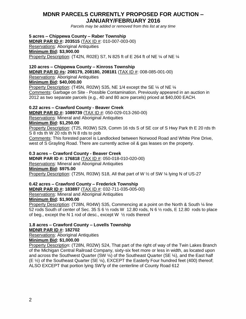
MDNR PARCELS CURRENTLY PROPOSED FOR AUCTION – JANUARY/FEBRUARY 2016
Parcels may be added or removed from this list at any time
2
5 acres – Chippewa County – Raber Township MDNR PAR ID #: 203515 (TAX ID #: 010-007-003-00) Reservations: Aboriginal Antiquities Minimum Bid: $3,900.00 Property Description: (T42N, R02E) S7, N 825 ft of E 264 ft of NE ¼ of NE ¼ 120 acres – Chippewa County – Kinross Township MDNR PAR ID #s: 208179, 208180, 208181 (TAX ID #: 008-085-001-00) Reservations: Aboriginal Antiquities Minimum Bid: $40,000.00 Property Description: (T45N, R02W) S35, NE 1/4 except the SE ¼ of NE ¼ Comments: Garbage on Site - Possible Contamination. Previously appeared in an auction in 2012 as two separate parcels (e.g., 40 and 80 acre parcels) priced at $40,000 EACH. 0.22 acres – Crawford County - Beaver Creek MDNR PAR ID #: 1089739 (TAX ID #: 050-029-013-260-00) Reservations: Mineral and Aboriginal Antiquities Minimum Bid: $1,250.00 Property Description: (T25, R03W) S29, Comm 16 rds S of SE cor of S Hwy Park th E 20 rds th S 8 rds th W 20 rds th N 8 rds to pob Comments: This forested parcel is Landlocked between Norwood Road and White Pine Drive, west of S Grayling Road. There are currently active oil & gas leases on the property. 0.3 acres – Crawford County - Beaver Creek MDNR PAR ID #: 176818 (TAX ID #: 050-018-010-020-00) Reservations: Mineral and Aboriginal Antiquities Minimum Bid: $975.00 Property Description: (T25N, R03W) S18, All that part of W ½ of SW ¼ lying N of US-27 0.42 acres – Crawford County – Frederick Township MDNR PAR ID #: 183897 (TAX ID #: 032-711-035-005-00) Reservations: Mineral and Aboriginal Antiquities Minimum Bid: $1,900.00 Property Description: (T28N, R04W) S35, Commencing at a point on the North & South ¼ line 52 rods South of center of Sec. 35 S 6 ½ rods W 12.80 rods, N 6 ½ rods, E 12.80 rods to place of beg., except the N 1 rod of desc., except W ½ rods thereof 1.8 acres – Crawford County – Lovells Township MDNR PAR ID #: 182702 Reservations: Aboriginal Antiquities Minimum Bid: $1,000.00 Property Description: (T28N, R02W) S24, That part of the right of way of the Twin Lakes Branch of the Michigan Central Railroad Company, sixty-six feet more or less in width, as located upon and across the Southwest Quarter (SW ¼) of the Southeast Quarter (SE ¼), and the East half (E ½) of the Southeast Quarter (SE ¼), EXCEPT the Easterly Four hundred feet (400) thereof; ALSO EXCEPT that portion lying SW'ly of the centerline of County Road 612

MDNR PARCELS CURRENTLY PROPOSED FOR AUCTION – JANUARY/FEBRUARY 2016
Parcels may be added or removed from this list at any time
3
2.5 acres - Gladwin County – Hay Township MDNR PAR ID #: 118306 (TAX ID #: 110-035-400-007-00) Reservations: Mineral and Aboriginal Antiquities Minimum Bid: $19,000.00 Property Description: (T18N, R01E) S 35, SE ¼ of SE ¼ of SE ¼ of SE ¼ Comments: May be landlocked 240 acres – Mackinac County – Marquette Township MDNR PAR ID #s: 135310, 135314, 135312, 135311, 135315, 135313 (TAX ID #s: 007-126-001-00, 007-126-004-00) Reservations: Aboriginal Antiquities Minimum Bid: $150,000.00 Property Description: (T43N, R 01W) S26, NE ¼ AND E ½ of NW ¼ Comments: The parcel is forested and surrounded by private ownership (i.e., landlocked). In addition, the State of Michigan will retain a snowmobile trail easement for Trail 49, which crosses the eastern portion of the property. The State of Michigan is withholding a 50% royalty reservation on the grantee’s gross proceeds for non-metallic minerals. Subject to a 22 acre contracted selective cut of northern hardwoods in the southwest corner of the parcel, which expires on June 30, 2016. 1 acre – Mackinac County – Garfield Township MDNR PAR ID #: 138423 (TAX ID #: 004-319-012-00) Reservations: Aboriginal Antiquities Minimum Bid: $5,000.00 Property Description: (T43N, R10W) S 19, Beginning at a point where N & S 1/4 line intersection US-2 thence North on 1/4 line 209 feet thence East 209 feet thence South 209 feet thence West 209 feet to POB 1.91 acres – Mackinac County – Garfield Township MDNR PAR ID #s: 2044591, 2045610, 2045611, 2045612 (TAX ID #: 004-540-002-00) Reservations: Aboriginal Antiquities Minimum Bid: $24,000.00 Property Description: Block: 01, LOT 2 EXCEPT that part of Lot 2 of Block 1 of the recorded plat of "William Boucha's Plat of the Village of Boucha", being in Government Lot 4, Section 28, T43N-R09W, Garfield Township, Mackinac County, Michigan, and more particularly described as Commencing at the Quarter corner common to Sections 28 and 29, said Quarter corner being monumented as described in a certificate recorded in Liber H, Page 0029, Mackinac County Land Corner Records; thence S 78°37'51" E, 1202.84 feet to a 1"diameter iron pipe capped with a 4" diameter Michigan Dept. of Conservation cap and the Southwest corner of said Lot 2; thence along the South line of said Lot 2, N 88°52'04" E, 300.51 feet to a 5/8" diameter capped iron pin and the Point of Beginning of the parcel to be described; from the Point of Beginning thus established, continue along the South line of said Lot 2, N 88°52'04" E, 51.33 feet to a 1/2" diameter capped iron pin and the Southeast corner of said Lot 2; thence along the Easterly line of said Lot 2, N 18°10'03" E, 57.95 feet to a 5/8" diameter capped iron pin; thence N 65°52'56" W, 39.68 feet to a 5/8" diameter capped iron pin; thence S 24°39'14" W, 79.54 feet, more or less, to the Point of Beginning. Per survey of Stephan J. Szyszkoski, P.S. No. 33986, Project No. 44-02-09, recorded in Liber 779, Page 494-495, Mackinac County Register of Deeds. ALSO including All that portion of Main Street depicted on the William Boucha Plat that is east of the Northerly extension of the Easterly line of Lot Three, Block One.

MDNR PARCELS CURRENTLY PROPOSED FOR AUCTION – JANUARY/FEBRUARY 2016
Parcels may be added or removed from this list at any time
4
Together with easement for ingress and egress over the North Four feet of that portion of Main Street which is bounded on the north by the North line of Government Lot Four, on the South by the platted North line of Block One, on the West by the Northerly extension of the Easterly line of Blake Street, and on the East by the Northerly extension of the Easterly line of Lot Three, Block One; and also an easement for ingress and egress over the South 12 feet of Government Lot 3, Section 28, Town 43 North, Range 9 West, extending 180.18 feet Easterly from the East boundary of Blake Street 0.06 acres - Saint Clair County – Clay Township MDNR PAR ID#: 444556 (TAX ID #: 74-14-856-0092-00) Reservations: Aboriginal Antiquities Minimum Bid: $16,000.00 Property Description: (T02N, R16E) S36, Lot 164 of the Joe Bedore Syndicate Subdivision of Lots 461, Part of Lots 462 & 464 South Channel ------------------------------------------- ARENAC COUNTY PARCELS ----------------------------------------- 185.33 acres – Arenac County – Adams Township MDNR PAR ID #s: 54235, 54236, 54237, 54231, 54234 (TAX ID #s: 001-0-018-200-005-00, 001-0-018-200-010-00, 001-0-018-100-015-00) Reservations: Mineral and Aboriginal Antiquities Minimum Bid: $195,000.00 Property Description: (T19N, R03E) S18, NW 1/4 except NE 1/4 of NW 1/4, AND S 1/2 of NE 1/4 except beginning at E 1/4 post of said section th S 88d38'15" W along E/W 1/4 line 123.86 feet, N 47d16'20" W 287.44 feet, N 01d27'10" W 1119.40 feet to N 1/8 line, th E along said 1/8 line 330 feet to E line of section th S 01d27'10"E along E section line 1319.32 feet to pob. Along with an easement for ingress and egress benefiting one single family dwelling, along the existing two-track in Section 7 that connects the Sterling Truck Trail ROW. Property will be conveyed with restrictions that will prevent splitting in the future. Comments: Flat to rolling mixed-cover (predominantly pine, birch, and oak) property, has an approved easement with the State of Michigan to access the parcel via a two-track from the Sterling Truck Trail. A drainage ditch crosses the center of the property. While there are uplands in the southeast part of the property, the center is low-lying. There are currently active oil & gas leases on the property. 79.83 acres – Arenac County – Adams Township MDNR PAR ID #s: 54220, 2037683, 2037681 (TAX ID #s: 001-0-017-300-005-00, 001-0-017-400-005-01) Reservations: Mineral and Aboriginal Antiquities Minimum Bid: $96,000.00 Property Description: (T19N, R03E) S17, N 1/2 of SE 1/4 except the North 600 feet, AND NE 1/4 SW 1/4 except commencing at S 1/4 corner of said sec. th S 89d25'10" W along S sec. line 9.90 ft, N 47d16'20" W 1829.80 ft to W 1/8 line, N 01d29'17.5" W along W 1/8 line 66 ft to pob, N 01d29'17.5" W 394.44 ft, S 47d16'20" E 529 ft to S 1/8 line, W along said S 1/8 line to pob. Along with an easement for ingress and egress over the North 25 feet of the East 340 feet of the SE 1/4 of the SE 1/4 of Section 17, (T19N, R03E). Also subject to an easement ingress and egress over the South 25 feet of the East 340 feet of the NE 1/4 of the SE 1/4 of Section 17, (T19N, R03E), benefiting the (T19N, R03E) S17, S 1/2 of SE 1/4 except beg at S1/4 corner of said sec. N 89d25'10" E along S line of sec. 471.20 ft, N 47d16'20" W 628 ft to N/S 1/4 line, S along said N/S 1/4line to pob, AND SE 1/4 of SW 1/4 except beginning at S 1/4 corner of said

MDNR PARCELS CURRENTLY PROPOSED FOR AUCTION – JANUARY/FEBRUARY 2016
Parcels may be added or removed from this list at any time
5
sec. th S 89d25'10" W along S sec. line 9.90 ft, N 47d16'20" W 1829.80 ft to W 1/8 line, N 01d29'17.5" W along W 1/8 line 66 ft to S 1/8 line, E along said 1/8 line 412.50 ft, S 47d16'20" E 1343.98 ft to N/S 1/4 line, S along N/S 1/4 line 429 ft to pob, AND S20 NE 1/4 of NW 1/4 Comments: Flat mixed-cover (predominantly oak, aspen, and maple) property, has ~720 feet of frontage on county maintained Demura Road. A Consumers Power right-of-way crosses the southwest corner of the property. The buyer will not have legal access across the Consumers Power right-of-way. In addition, a shared easement will be in place with the adjacent parcel to the south, providing access to an upland trail between the properties. This trail runs northerly through the property ending at the north line, near the northeast corner of the parcel. Several high and dry locations to build on the east part of the property. There are currently active oil & gas leases on the property. 145.81 acres – Arenac County – Adams Township MDNR PAR ID #s: 54266, 54229, 54224, 54230 (TAX ID #s: 001-0-017-300-005-00, 001-0-017-400-005-01, 001-0-020-100-020-00) Reservations: Mineral and Aboriginal Antiquities Minimum Bid: $153,000.00 Property Description: (T19N, R03E) S17, S 1/2 of SE 1/4 except beg at S1/4 corner of said sec. N 89d25'10" E along S line of sec. 471.20 ft, N 47d16'20" W 628 ft to N/S 1/4 line, S along said N/S 1/4line to pob, AND SE 1/4 of SW 1/4 except beginning at S 1/4 corner of said sec. th S 89d25'10" W along S sec. line 9.90 ft, N 47d16'20" W 1829.80 ft to W 1/8 line, N 01d29'17.5" W along W 1/8 line 66 ft to S 1/8 line, E along said 1/8 line 412.50 ft, S 47d16'20" E 1343.98 ft to N/S 1/4 line, S along N/S 1/4 line 429 ft to pob, AND S20 NE 1/4 of NW 1/4. Along with an easement ingress and egress over the South 25 feet of the East 340 feet of the NE 1/4 of the SE 1/4 of Section 17, (T19N,R03E). Also, subject to an easement for ingress and egress over the North 25 feet of the East 340 feet of the SE 1/4 of the SE 1/4 of Section 17, (T19N, R03E), benefiting the (T19N, R03E) S17, N 1/2 of SE 1/4 except the North 600 feet, AND NE 1/4 SW 1/4 except commencing at S 1/4 corner of said sec. th S 89d25'10" W along S sec. line 9.90 ft, N 47d16'20" W 1829.80 ft to W 1/8 line, N 01d29'17.5" W along W 1/8 line 66 ft to pob, N 01d29'17.5" W 394.44 ft, S 47d16'20" E 529 ft to S 1/8 line, W along said S 1/8 line to pob. Comments: Flat mixed-cover (predominantly oak, aspen, and maple) property, has a quarter mile of frontage on county maintained Demura Road. A Consumers Power right-of-way crosses the center of the property. The buyer will not have legal access across the Consumers Power right-of-way. In addition, a shared easement will be in place with the adjacent property to the north, providing access to an upland trail between the properties. This trail runs westerly through the property, winding its way to the Consumers Power right-of-way near the west line. There are several high and dry locations to build along the trail in the central and eastern portions of the property. There are currently active oil & gas leases on the property. 146.7 acres – Arenac County – Adams Township MDNR PAR ID #s: 54276, 54277, 54265, 54262 (TAX ID #s: 001-0-020-100-030-00, 001-0-021-200-005-00, 001-0-020-100-025-00, 001-0-020-100-020-00) Reservations: Mineral and Aboriginal Antiquities Minimum Bid: $160,000.00 Property Description: (T19N, R03E) S21, W 1/2 of NW 1/4, AND S20, S 1/2 of NE 1/4 except beginning at E 1/4 post of said sec th N 01d21' W along E sec. line 561.91 ft, N 47d16'20" W 1,101.52 ft to N 1/8 line, S 89d24'10" W along N1/8 line 480.95 ft, S 47d16'20" E 1311.59 ft, S 01d21' E 417.86 ft to E/W 1/4 line, N 89d23'10" E along 1/4 line 330.03 ft to pob.

MDNR PARCELS CURRENTLY PROPOSED FOR AUCTION – JANUARY/FEBRUARY 2016
Parcels may be added or removed from this list at any time
6
Comments: Flat wooded (predominantly oak, pine, and maple) property, has a quarter mile of frontage on county maintained Ward Road. A Consumers Power right-of-way crosses the center of the property. The buyer will not have legal access across the Consumers Power right-of-way. An established dirt two-track currently enters the property from the north via Ward Road. There are several high and dry locations to build along the northern portion of the property. In addition, a power line runs through the north part of the property paralleling Ward Road. There are currently active oil & gas leases on the property. 79.19 acres – Arenac County - Adams Township MDNR PAR ID #s: 54275, 54278 (TAX ID #: 001-0-021-200-005-00) Reservations: Mineral and Aboriginal Antiquities Minimum Bid: $87,000.00 Property Description: (T19N, R03E) S21, E 1/2 of NW 1/4 Comments: Flat wooded (predominantly oak, pine, and maple) property, has a quarter mile of upland frontage on county maintained Ward Road. An established dirt two-track currently enters the property from the north via Ward Road and exits to the east of the parcel. There are several high and dry locations to build along the northern portion of the property. In addition, a power line runs through the north part of the property paralleling Ward Road. There are currently active oil & gas leases on the property. 39.13 acres – Arenac County – Adams Township MDNR PAR ID #: 54272 (TAX ID #: 001-0-021-100-017-00) Reservations: Mineral and Aboriginal Antiquities Minimum Price: $45,000.00 Property Description: (T19N, R03E) S21, NW 1/4 of NE 1/4 Comments: Flat wooded (predominantly oak, pine, and maple) property, has a quarter mile of upland frontage on county maintained Ward Road. An established dirt two-track currently enters the property from the west and exits near the southeast corner of the parcel. There are several high and dry locations to build throughout the property. In addition, a power line runs through the north part of the property paralleling Ward Road. There are currently active oil & gas leases on the property. 38.33 acres – Arenac County – Adams Township MDNR PAR ID #: 54331 (TAX ID #: 001-0-032-100-010-00) Reservations: Mineral and Aboriginal Antiquities Minimum Price: $30,000.00 Property Description: (T19N, R03E) S32, SW1/4 NE1/4 exc. com at NE cor of sd sec. S 89d33'50" W alg N sec. In 470.01 ft, S 19d07'50" W 2,345.10 ft to E 1/8 ln and pob, th S 39d36' W 536.45 ft to E/W 1/4 ln, N 89d27'40" E alg E/W 1/4 ln 354.06 ft to E 1/8 ln, N 01d41'25" W alg E 1/8 ln 410.19 ft to pob. Comments: The parcel appears to be landlocked by private ownership.

MDNR PARCELS CURRENTLY PROPOSED FOR AUCTION – JANUARY/FEBRUARY 2016
Parcels may be added or removed from this list at any time
7

MDNR PARCELS CURRENTLY PROPOSED FOR AUCTION – JANUARY/FEBRUARY 2016
Parcels may be added or removed from this list at any time
8

MDNR PARCELS CURRENTLY PROPOSED FOR AUCTION – JANUARY/FEBRUARY 2016
Parcels may be added or removed from this list at any time
9

MDNR PARCELS CURRENTLY PROPOSED FOR AUCTION – JANUARY/FEBRUARY 2016
Parcels may be added or removed from this list at any time
10

MDNR PARCELS CURRENTLY PROPOSED FOR AUCTION – JANUARY/FEBRUARY 2016
Parcels may be added or removed from this list at any time
11