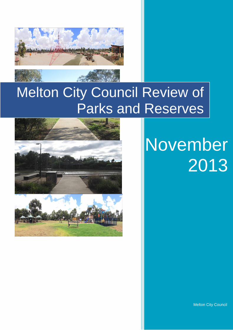
melton city council review of parks and reserves
TRANSCRIPT
Page | 1
Melton City Council
Melton City Council Review of Parks and Reserves
November 2013

Page | 2
Left blank intentionally
Page | 3
Executive Summary
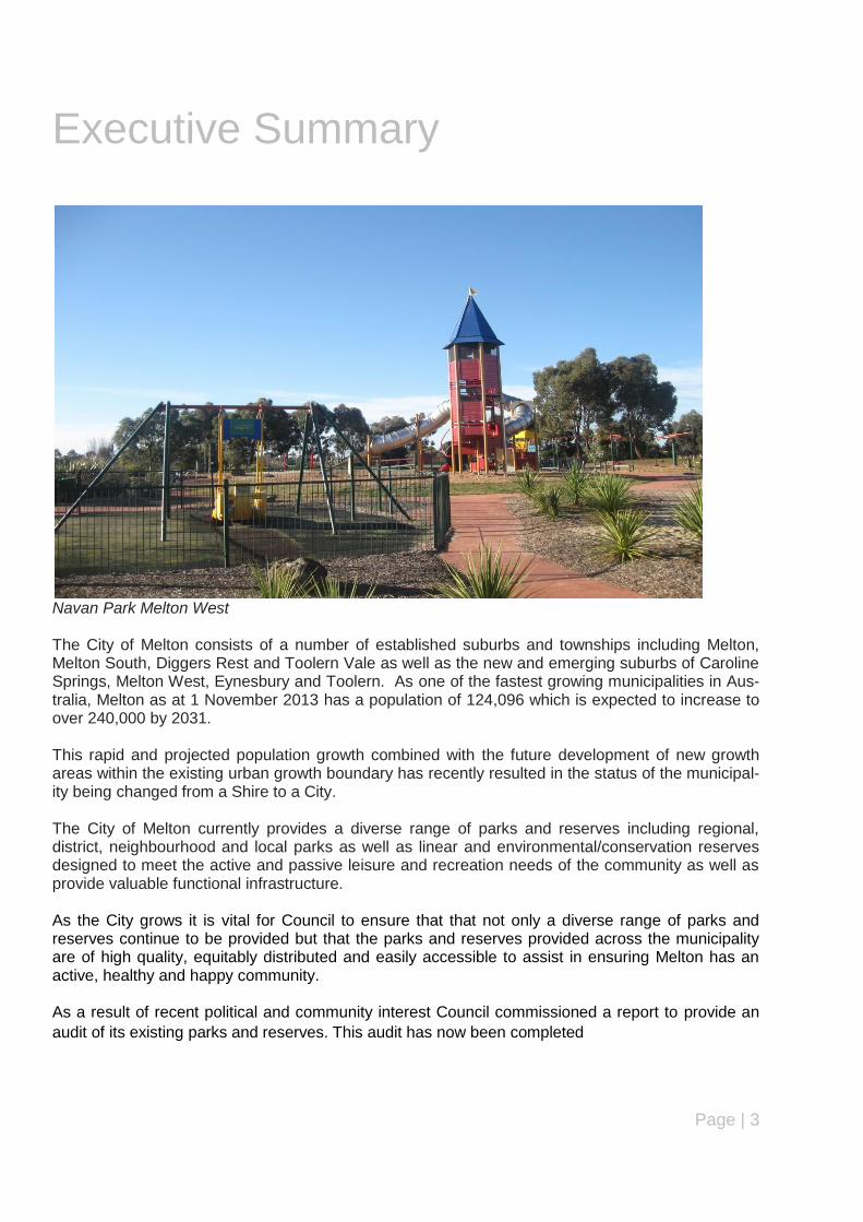
Navan Park Melton West The City of Melton consists of a number of established suburbs and townships including Melton, Melton South, Diggers Rest and Toolern Vale as well as the new and emerging suburbs of Caroline Springs, Melton West, Eynesbury and Toolern. As one of the fastest growing municipalities in Aus-tralia, Melton as at 1 November 2013 has a population of 124,096 which is expected to increase to over 240,000 by 2031. This rapid and projected population growth combined with the future development of new growth areas within the existing urban growth boundary has recently resulted in the status of the municipal-ity being changed from a Shire to a City. The City of Melton currently provides a diverse range of parks and reserves including regional, district, neighbourhood and local parks as well as linear and environmental/conservation reserves designed to meet the active and passive leisure and recreation needs of the community as well as provide valuable functional infrastructure. As the City grows it is vital for Council to ensure that that not only a diverse range of parks and reserves continue to be provided but that the parks and reserves provided across the municipality are of high quality, equitably distributed and easily accessible to assist in ensuring Melton has an active, healthy and happy community. As a result of recent political and community interest Council commissioned a report to provide an
audit of its existing parks and reserves. This audit has now been completed

Page | 4
This audit was designed to confirm the location and identify the type of existing infrastructure
provided at each park and reserve in order to assess the value, purpose, function and condition of
these parks and reserves to meet the needs of our current and future residents.
The audit will also inform and support the preparation of Council‟s new Open Space Strategy and
future supporting strategies such as our Play Space Strategy and Hike and Bike Strategy.
As an outcome of the audit Council has been able to develop a priority order for upgrading,
rejuvenation and/or development of our parks and reserves as well as providing data to enable a
subjective assessment of which parks and reserves should be considered as suitable for alternative
purposes.
This report outlines the objectives of the audit, the methodology used, key findings and
recommendations to Council (including a proposed work programme) established as a result of
completing the audit.
Page | 5
EXECUTIVE SUMMARY 3
1 OVERVIEW 7 1.1 Introduction 7 1.2 Project scope 7 1.3 Project objectives 8 1.4 Project methodology 8 1.5 Stakeholder consultation 9
2 CONTEXT AND CURRENT INFLUENCES 11 2.1 Desktop review 11 2.2 State and local government policies and strategic documents 13
3 DEMOGRAPHIC CHARACTERISTICS AND PARTICIPATION TRENDS 22 3.1 Demographic characteristics and projections 22 3.2 Population projections 23 3.3 City of Melton Active Participation Survey – 2008, 2010 and 2013 24 3.4 Social and economic disadvantage – SEIFA MEASURES 25
4 EXISTING PARKS AND RESERVES NETWORK 27 4.1 Overview of parks and reserves in the City of Melton 27 4.2 Classification and hierarchy of parks and reserves in the City of Melton 27 4.3 Master plans for parks and reserves 34
5 AUDIT OF PARKS AND RESERVES 35 5.1 Number of parks and reserves in the City of Melton 35 5.2 Size of parks and reserves in the city of melton 36 5.3 Age and condition of parks and reserves in the city of melton 38
6 WORK PROGRAMME 45 6.1 Summary of key findings 45 6.2 Options and recommendations 45 6.3 Priority order – upgrading and rejuvenating parks and reserves 46 6.4 Work programme 48
7 CONCLUSION 53
APPENDICES 54
Appendix A – Site Assessment Checklist (Parks and Reserves) 54
Appendix B – Scoping Document (Parks and Reserves Review) 57
Appendix C – List of References (Desktop Review) 65
Appendix D - Summary of Parks and Reserves by Suburb 66
Page | 6
LIST OF FIGURES AND TABLES
Figure 1: Current process for Sale/Acquisition of Council land 14 Figure 2: Population Forecast 2011-2031 (City of Melton) 24 Figure 3: Forecast Age Structure 2011-2031 (City of Melton) 25 Figure 4: Number of Parks and Reserves in the City of Melton by Suburb 36 Figure 5: Age of Parks and Reserves in the City of Melton by Suburb 39 Table 1: Age Structure (2011) for City of Melton 23 Table 2: Classification and Hierarchy of Parks and Reserves (City of Melton) 30 Table 3: Park Furniture and Infrastructure requirements for Parks and Reserves Hierarchy 32 Table 4: Total Area of Parks and Reserves by Suburb 38 Table 5: Area and Proportion of Parks and Reserves by Classification Hierarchy 39 Table 6: Age of Parks and Reserves in the City of Melton by Suburb 40 Table 7: List of Undeveloped Parks and Reserves in the City of Melton 41 Table 8: Condition Score for Parks and Reserves by Suburb in the City of Melton 43

Page | 7
1 Overview
1.1 INTRODUCTION
At the Special Meeting of Council on 17 December 2012, Council passed Notice of Motion (NoM)
349 (Cr Majdlik) Review of All Parks and Reserves in the Whole of Melton City Municipality:
“That Council officers undertake a review of all parks and reserves in the whole of Melton City mu-
nicipality and develop a priority order for Council consideration in association with the 2013/2014
budget for rejuvenation and development of parks, 15 years or greater, identified in the review.”
In response to this NoM, a project plan was developed that involved the preparation of a scoping
document outlining the objectives of the project, the resources and the methodology to be used (in-
cluding desktop review, stakeholder consultation and work programme development), timeline of
the project and the desired outcomes to be achieved from the review.
For the purposes of this review, parks and reserves are defined as land owned and managed by
Council that is used for active and passive leisure, sport, recreation, conservation, environmental or
urban stormwater management purposes. Streetscape and tree reserves are considered to be out-
side the scope of this review.
In order to complete the required review the methodology involved the completion of an audit of all
parks and open space reserves and this involved site inspections, site photographs and the prepa-
ration of a site assessment checklist (See Appendix A) for each park and reserve within the City.
The audit was undertaken on a suburb by suburb basis and reviewed existing information available
from Council‟s Geographic Information System (GIS) and Infrastructure Asset Management System
(IAMS) database on the location, size, age, topography, type/classification (open space hierarchy),
accessibility (pedestrian, motor vehicle and public transport) and proximity of each park and reserve
to local schools, shops, public transport, community facilities and other parks and open space re-
serves.
The audit was designed to assist Council with creating a priority order for upgrading, rejuvenating
and developing parks and reserves in the municipality for consideration and inclusion in Council‟s
five year Capital Works Plan budget.
The project has been undertaken in conjunction with Council‟s Open Space Strategy, Play Space
Strategy, Recreation and Facilities Strategy and Hike and Bike Strategy which are all currently in
progress or will be completed by Council Officers over the next 6-12 months.
1.2 PROJECT SCOPE
The scope of the project has been developed based on the Notice of Motion (No.349) adopted by
Council and consultation with key internal stakeholders within Council. The scoping document
outlines the objectives, resources, methodology, target audience, timelines and anticipated
outcomes. A copy of the scoping document is attached (see Appendix B).

Page | 8
1.3 PROJECT OBJECTIVES
The objectives of the parks and reserves review are:
1. To identify and review all parks and reserves (as defined above) in the City of Melton accord-
ing to their location, size, topography, classification/hierarchy, purpose, value and function.
2. To identify those parks and reserves requiring rejuvenation and development for Council‟s
consideration with emphasis on parks and reserves that are 15 years or older.
3. To prepare a work programme for the rejuvenation and development of parks and reserves
including associated costs for consideration in Council‟s 5 year Capital Works program.
1.4 PROJECT METHODOLOGY
The project methodology outlines the key steps and processes involved in conducting the audit of
parks and reserves in the City of Melton. Once the scoping document was prepared and presented
to Council‟s Executive Team for approval, the initial stages of the project involved meetings with key
internal stakeholders (Council departments) and a desktop review of existing internal (Council) and
external (State Government, Local Government, public and private sector organisations) plans,
policies and strategic documents relating to parks, reserves and open space. A list of all reference
documents is outlined in Appendix C of this report.
Internal stakeholder consultation was undertaken with the following Council departments - Leisure
and Facilities, Planning, Engineering, Housing and Youth Services, Social and Community
Planning, Environmental Services, Business Sustainability and Growth and Operations (Parks and
Gardens). Meetings were also held with Council‟s Executive Team (including Chief Executive
Officer) during key stages and milestones of the project.
A desktop review was completed of all Council strategies, policies and documents relevant to the
provision, development and maintenance of parks and reserves in the City of Melton including
reference to those that are currently being prepared. The desktop review also included an analysis
of State and Local Planning Policies relating to open space as outlined in the Melton Planning
Scheme as well as relevant State Government legislation, other Local Government Open Space
Strategies and policies along with other relevant government and non government reports. The
Precinct Planning Structure Planning Guidelines prepared by the Metropolitan Planning Authority
(formerly Growth Areas Authority) were also reviewed in relation to the current and future planning
of parks and reserves of the designated growth areas (Toolern, Rockbank North, Melton North and
Taylors Hill West) within the City of Melton. The desktop review is outlined in Section 2 of this
report.
An analysis of key current (2011) and projected (2021 and 2031) demographic information (age and
household structure) for the City of Melton was undertaken and is outlined in Section 3 of this
report. The key demographic information was also analysed for each suburb as part of a review of
parks and reserves in these suburbs (see Appendix D).
The 2008, 2010 and 2013 Active Participation Survey conducted by Metropolis Research Pty Ltd on
behalf of Council has also been reviewed and the findings summarised in Section 3 of the report.
Social and Economic disadvantage research undertaken by the Australian Bureau of Statistics
(ABS) was also analysed.
The context and current influences regarding existing parks and reserves in the City of Melton were
also identified. This initially involved identifying the number, name, location, ownership, type
Page | 9
(classification), topography and size of all parks and reserves in the municipality based on existing
information from Council‟s GIS (Intra Maps) and IAMS systems. A list of all parks and reserves was
generated and then arranged based on the suburb where the park or reserve is located.
A site assessment checklist (see Appendix A) was used to perform an audit for each park or reserve
in the City of Melton. The assessment checklist outlined the following information to be collected -
name, address, type/classification (based on the hierarchy in Council‟s draft Open Space Strategy)
and Asset No. (IAMS). It also included an aerial photo showing the location of each park and
reserve and a site photo of each park and reserve.
The identification and condition of the existing infrastructure and equipment provided at each park
and reserve was assessed. This was based on recommended and desired park furniture and
infrastructure outlined for each classification of open space in Council‟s Draft Open Space Strategy
as well other state and local government documentation examined as part of the desktop review.
A rating scale of 0-6 (0 – brand new and 6 – out of service) developed as part of Council‟s Open
Space Assessment Management Plan (Draft) was used to assess the condition of infrastructure and
equipment provided at each park or reserve and a total score provided to give an indication of the
overall condition of the park or reserve. Accessibility (public and private transport), barriers affecting
access and use of parks and reserves, planning controls and active and passive surveillance were
criteria also used as part of the audit for each park and reserve. An overall summary of parks and
reserves is contained in Section 5 of the report while a summary of each suburb is contained in
Appendix D.
A work programme (including a life cycle matrix for the next 15-20 years) has been developed which
outlines how and where Council can upgrade, rejuvenate and develop its parks and reserves over
this period to ensure they are more accessible and more frequently used by the community. The
costs associated with upgrading, rejuvenating and developing Council‟s parks and reserves are
outlined in the work programme. A summary of the key findings is outlined in Section 6 of the
report.
1.5 STAKEHOLDER CONSULTATION
A series of meetings were held with relevant staff from Council departments at the initial (briefing
and inception) stage of the project to assist with defining and developing the scope of the project.
Additional consultation was also undertaken at various stages throughout the project. The Council
departments consulted as part of this project were as follows:
Business Growth and Sustainability.
Engineering
Environmental Services
Housing
Leisure and Facilities
Operations (Parks and Gardens)
Planning
Social and Community Planning
Youth Services

Page | 10
During this consultation, the following issues were identified in relation to Council‟s parks and
reserves:
The draft Open Space Strategy (currently in progress) will set the framework for the review of
all parks and reserves.
The condition of assets within the parks and reserves and how this assessment will be
undertaken is the key element to the review.
Conservation reserves form part of open spaces and should be included as part of the review.
Council will need to consider the ramifications of selling any parks and reserves that it deems
surplus from a community perspective.
Important to develop a framework for prioritising the rejuvenation and development of parks
and reserves and to examine all existing approved master plans for parks and reserves within
the municipality.
The review should look at land that Council could acquire to improve or enhance existing
parks and open space reserves.
Short term infrastructure could be recommended as part of the review and any substantial
infrastructure could be identified for inclusion as part of future master planning for parks and
reserves within the municipality.
There is a need for a standard assessment and justification for parks and reserves and a long
term framework for assessing and determining how parks and reserves are rejuvenated and
developed.
Council should look at fully investing into established parks to ensure that works are
completed at these parks and not left unfinished or undeveloped rather than investing into
developing an undeveloped reserve.
A hands on approach from the community is required to develop parks and reserves in the
municipality.
Council should develop partnerships with Parks Victoria, Melbourne Water and State
Government (DPCD) in relation to linear parks and reserves.
There should also be more focus on natural features in parks and reserves and less on built
form or man-made features.
It is important to develop partnerships with aboriginal and cultural heritage groups in relation
to the use of parks and reserves and developing experiences for children right through the life
cycle process.
Anti social behaviour in parks and reserves is a key issue from a social and community
planning perspective and preventing this type of behaviour through the design and
development of parks and reserves is very important.
Council does not currently have a policy for the sale of Council assets such as open space
and currently uses the market (auction) as a mechanism to obtain the best price for the sale or
acquisition of any land in the municipality.
Council needs to identify any land parcels that have been developed as open space and
which are not in Council ownership. Any land parcels which fit this category would need to be
transferred into Council ownership otherwise anyone else would be able to make a claim for
the land under adverse possession.
A social impact assessment is being prepared to assist Council with identifying land suitable
for housing.
Social isolation and exclusion between social/community housing clients and access to open
space is a key issue for Council.
Page | 11
2 Context and Current Influences
2.1 DESKTOP REVIEW
A literature review was undertaken of relevant Council policies, plans and strategic documents,
State Government policies and strategic documents, other Local Government open space planning
policies, plans and strategic documents and general literature relating to leisure, recreation and
open space planning and provision including the importance and various benefits of open space to
the community. A list of these documents is contained in Appendix C of this report.
Parks and reserves fall under the broader definition of open space which can be defined as “all
parks, gardens, reserves and other parcels of land accessible to the public managed by Council or
other public authorities and used for passive, active, formal and/or informal recreation”1.
„Traditional‟ types of open space include parks and gardens, playgrounds, sports fields and
recreation facilities. These provide opportunities for activities such as organised sports, informal
sports and play, socialising and relaxing. Open spaces may also include „green spaces‟ which can
include areas of natural or cultural value, habitat corridors, some easements, open water/wetlands
and agricultural land2.
Parks are important places, providing communities with spaces to exercise, socialise and relax. Well
developed parks contribute to the physical and mental health of residents, create better connected
communities, make a significant contribution to the character of neighbourhoods and help protect
natural environments and cultural heritage3.
Linking People and Spaces (2002), refers to the social (health and well-being), environmental
(conservation and biodiversity), economic (tourism, education and transport) and aesthetic value of
parks and open space. According to Parks Victoria, there is a direct link between the design and
integration of parks and open spaces with liveability and amenity of the parks and open space.
The maintenance and development of parks, open spaces and green corridors has also been
identified as a core goal and responsibility of Council4. The involvement of the community in any
decision making for the future of open space will be more committed to positive outcomes in relation
to existing and proposed open space.
The impact of population growth and the increased diversity of communities places increased
pressure and competing demands in relation to the existing open space network. Therefore, open
space needs to be flexible and adaptable to changing community needs and ensure equivalent
access to the open space network5
Open space is a vital component of the urban environment and can have a positive impact on a
population‟s levels of physical activity and social interaction, and more broadly on its health and
wellbeing.
1 City of Hume (2010) – Hume City Council Open Space Strategy 2010-2015.
2 City of Greater Dandenong (2009) – Places For People: Open Space in Greater Dandenong May 2009.
3 City of Brimbank (2008) Creating Better Parks – Brimbank Open Space and Playground and Policy Plan May 2008
4 City of Darebin (2011) – Open Space Strategy Site Development Planning May 2011.
5 City of Bayside (2012) – Bayside Open Space Strategy 2012.
Page | 12
Quality public open space that is well located and well developed positively contributes to urban
amenity as well as the environmental, social, health and well being, and economic sustainability of
the community6
According to the Centre for Physical Activity and Nutrition at Deakin University7, physical activity is
influenced by access to recreation facilities and parks and connection between residential areas,
public transport, schools, shops and workplaces. Local parks are important settings for people of all
ages to engage in physical activity.
The benefits of parks and reserves can be summarised as follows:
A place to spend time, to relax, as well as a place to be physically active for people of all abilities from childhood to old age.
The provision of attractive, accessible, and well-connected open space has been shown to
increase levels of recreational walking and active transport (mostly walking and cycling) in
populations living nearby.
Participating in activities such as walking, playing sport, or environmental programs in open
space promotes a sense of belonging and community.
Parks and Reserves have been found to be very important to people from different cultural
backgrounds and provide a free, non-exclusionary and accessible gathering place for all
people.
Parks that are respectful (e.g. historical landmark) of and responsive to their context can
engender a greater sense of place for a local community.
Parks and reserves can provides refuge for wildlife and improve the air, and health for local
residents. Creek corridors are especially important as the link between ecological
communities and can provide a refuge for wildlife.
Integration of open space through urban environments enables the community to bond,
identify with and care for the unique „place where they live‟.
Open space will often provide opportunities for flood alleviation and improved water
management.
Well-developed and well maintained parks have higher visitation levels, more money is spent
in their vicinity benefiting nearby business.
Increased property prices result from investment in park infrastructure and maintenance.
Improving parks may be particularly advantageous for increasing physical activity levels
among disadvantaged populations who are at increased risk of physical inactivity and poor
health.
Park improvement has the potential to dramatically increase park usage and is potentially a
long term and sustainable way to increase population level physical activity and benefit the
health of the population.
A useful resource for education.
Contributing to civic pride and social cohesion.
6 City of Greater Dandenong (2009) Places for People: Open Space in Greater Dandenong Open Space Strategy May 2009
7 Deakin University Australia (2013) Centre for Physical Activity and Nutrition Research Newsletter 26 August 2013.
Page | 13
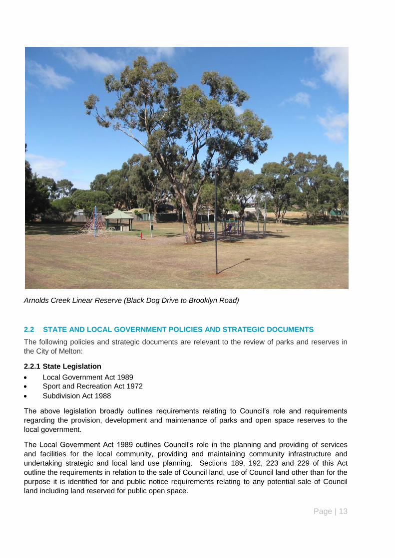
Arnolds Creek Linear Reserve (Black Dog Drive to Brooklyn Road)
2.2 STATE AND LOCAL GOVERNMENT POLICIES AND STRATEGIC DOCUMENTS
The following policies and strategic documents are relevant to the review of parks and reserves in
the City of Melton:
2.2.1 State Legislation
Local Government Act 1989
Sport and Recreation Act 1972
Subdivision Act 1988
The above legislation broadly outlines requirements relating to Council‟s role and requirements
regarding the provision, development and maintenance of parks and open space reserves to the
local government.
The Local Government Act 1989 outlines Council‟s role in the planning and providing of services
and facilities for the local community, providing and maintaining community infrastructure and
undertaking strategic and local land use planning. Sections 189, 192, 223 and 229 of this Act
outline the requirements in relation to the sale of Council land, use of Council land other than for the
purpose it is identified for and public notice requirements relating to any potential sale of Council
land including land reserved for public open space.
Page | 14
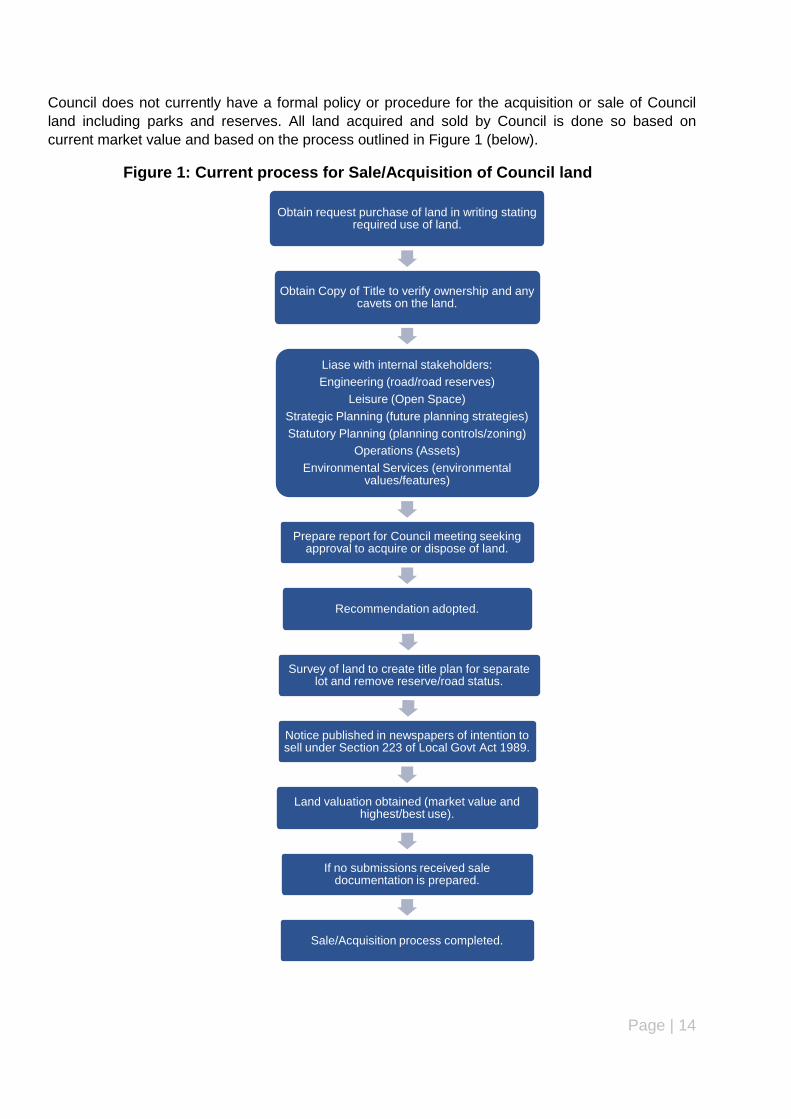
Council does not currently have a formal policy or procedure for the acquisition or sale of Council
land including parks and reserves. All land acquired and sold by Council is done so based on
current market value and based on the process outlined in Figure 1 (below).
Figure 1: Current process for Sale/Acquisition of Council land
Obtain request purchase of land in writing stating required use of land.
Obtain Copy of Title to verify ownership and any cavets on the land.
Liase with internal stakeholders:
Engineering (road/road reserves)
Leisure (Open Space)
Strategic Planning (future planning strategies)
Statutory Planning (planning controls/zoning)
Operations (Assets)
Environmental Services (environmental values/features)
Prepare report for Council meeting seeking approval to acquire or dispose of land.
Recommendation adopted.
Survey of land to create title plan for separate lot and remove reserve/road status.
Notice published in newspapers of intention to sell under Section 223 of Local Govt Act 1989.
Land valuation obtained (market value and highest/best use).
If no submissions received sale documentation is prepared.
Sale/Acquisition process completed.

Page | 15
One of the key recommendations of this report is for Council to prepare an acquisition and sell
(sale) policy to assist with identifying any land adjacent to existing parks and reserves which it can
acquire once it is placed on the market to enhance existing parks and reserves and to sell any
Council land (including parks and reserves) that are deemed to be surplus to Council‟s
requirements. The benefits to Council of developing an acquisition and sell policy are as follows:
An open, transparent and consistent process for the sale and acquisition of land.
Enables Council to identify whether to proceed with the sale of Council owned land.
That any decision to declare land surplus has given significant weight to the future land needs
of Council for the provision of facilities and services.
The proceeds from any land sale are allocated appropriately, particularly in regards to Public Open Space.
All statutory obligations and guidelines are adhered to, including any public consultation proc-esses aligning with Councils Community Consultation Policy.
Any sale of Council land is consistent with relevant Council policies, strategies and plans.
Council optimises the value of the property and that funds are redirected to acquire, develop or improve other assets.
The Subdivision Act 1988 outlines the following definition for public open space:
“Land set aside in a plan or land in a plan zoned or reserved under a planning scheme –
(a) for public recreation or public resort; or (b) as parklands; or (c) for similar purposes;
It also defines reserve as “land set aside for public open space or for the use of a public authority or
the Council”.
Under Section 18 of the Subdivision Act, Council requires an applicant proposing to subdivide land
involving the creation of additional lots to set aside land within the subdivision for public open space
equivalent to a percentage of 5% unless otherwise stated in the planning scheme, pay Council a
percentage of site value for all land in the subdivision not exceeding 5% in lieu of providing land for
public open space or a combination of the two (land and cash) up to a total of 5%.
Under Section 20 (1) of this Act, Council must set aside for public open space any land which is
vested in Council for that purpose. In addition, Council must use any payment for public open
space or the proceeds of any sale of public open space to buy land for use as public recreation,
resort or parklands or improve land already zoned or reserved for public recreation, public resort or
parklands.
In relation to the potential for Council to sell land already reserved for public open space, Section
24A of the Act, Council must first obtain a planning permit authorising the removal of the reserve
status from the title and vesting that land in Council and secure certification and registration of a
Section 24A plan creating a separate title for the land.
However, under Section 24A (8) Council is required to use the proceeds from the sale of any land
previously reserved for open space to paying any expenses of or incidental to the sale or for any
recreation or cultural purpose referred to in Item 5, Schedule 1 of the Local Government Act 1989.
Council would also be required to provide „replacement open space‟ pursuant to Section 20 (4) of

Page | 16
the Subdivision Act 1988. Any replacement of public open space would be based on actual size,
nature and proximity to the reserve being replaced.
The sale of land reserved for public open space should only be considered if Council has
implemented an Open Space Strategy which includes land that could be acquired to replace that
open space that is being sold and the timing of the acquisition of this land.
The Sport and Recreation Act 1972 refers to land which has been granted or reserved for sporting
or recreation purposes and promoting fitness and general health of people in Victoria and
encouraging active participation in sporting activities.
2.2.2 State and Regional Policies
There are a number of state and regional policies relating to the planning, delivery and management
of public open space at local government level including Melbourne 2030, Melbourne @ 5 Million
and the Melton Planning Scheme.
The Melton Planning Scheme (MPS) contains two key state policies that are relevant to public open
space – Settlement and Open Space Planning.
The Settlement Policy under Clause 11 of the MPS states that planning must anticipate and
respond to the needs of existing and future communities through the provision of zoned and
serviced land for recreation and open space.
Clause 11.03 of the MPS outlines the state planning policy for Open Space Planning where the
objective is “to create a diverse and integrated network of public open space that meets the needs
of the community”. This policy also contains the following key strategies:
Open space networks linked to walking and cycling trails and rights of way and integrate with
subdivisions.
Ensure land is set aside and developed in residential areas for local residential use and create
pedestrian and cycling links to community and commercial facilities.
Improve quality and distribution of open space and ensure long term protection.
Ensure land identified as critical to completion of open space networks is transferred for open
space purposes.
Protect overall network of open space by ensuring any change in land use or occupation
resulting in a reduction of open space, the overall network is protected by the addition of
replacement parkland of equal or greater size and quality.
The Local Planning Policy Framework of the MPS outlines Council‟s Municipal Strategic Statement
and local planning policies. This includes Council‟s Recreation, Open Space and Networks Policy
(Clause 22.03). The objectives of this policy are:
Community expects high standards of passive and active recreational opportunities in urban
areas.
Objectives – provide active and passive recreation for a cross section of the community,
maximise opportunities for multi use open space and appropriate community and cultural
facilities near open space, appropriately integrated with surrounding land uses and responds
to natural landscapes and features, provide adequate open space within walking distance of
residents and workers and locate open space and recreation facilities in new developments to
maximise surveillance and direct public access.
Page | 17
The policy aims to ensure that all land parcels given to active open space are large enough to cater
for a range of activities and uses and generally discourage the creation of small areas of pocket
type parks in residential areas.
Clause 52.01 of the Melton Planning Scheme outlines the particular provisions in relation to the
provision of land for public open space. Under this clause, any person proposing to subdivide land
must make a contribution to Council for public open space as specified in the schedule to the
clause. As mentioned above, this is 5 percent of land in the overall subdivision, 5 per cent of the
site value of the land or a combination of both. In this instance, the schedule specifies an amount of
9 per cent which applies to the subdivision of all land in the Melton East Growth Area which covers
the suburbs of Burnside, Burnside Heights, Caroline Springs, Hillside and Taylors Hill.
While there has been changes to planning policies and controls regarding public open space, there
have also been changes to the subdivision process involving the requirements for landscape plans
to be prepared and approved prior to the issue of Statement of Compliance for each stage of a
subdivision. As a result, landscape works are undertaken and completed on land set aside in a
subdivision for public open space before titles can be issued for each lot in the subdivision. The
introduction of development contributions in the subdivision and planning permit process has also
enable Council to seek financial contributions (either as part of or in addition to) the amount required
under Clause 52.01 of the Scheme. In some instances, Council has been able to negotiate with
people subdividing land to provide basic park or reserve furniture and/or equipment as part the
public open space or development contribution for subdividing the land.
2.2.3 Urban growth Boundary and precinct structure planning
Council has a responsibility to ensure that existing and proposed communities have sufficient land
reserved to cater for the open space needs of those communities. This needs to be undertaken at
earliest stage of planning for new growth areas. Although more established areas tend to be
reasonably well supplied with open space areas and facilities, there is an increasing concern that
the surrounding rapidly growing urban areas will be inadequately catered for in the future.
The State Government through the Metropolitan Planning Authority (formerly Growth Areas
Authority) has prepared guidelines for precinct structure planning in new growth areas like those
(Toolern, Taylors Hill West, Rockbank North, Melton North and Diggers Rest) currently being
developed or planned to be developed in the future in response to the rapid population growth in the
City of Melton.
The guidelines apply to the preparation of precinct structure plans (PSP) and outline what should be
addressed in preparing a PSP. In relation to the future provision of public open space in new growth
areas, the guidelines encourage well designed public spaces to promote healthy lifestyles and offer
a diversity of spaces for relaxation and recreation. The guidelines also aim to create links between
active and passive open spaces with pedestrian and cycle networks to create walkable
neighbourhoods.
Among the key objectives for the preparation of PSP‟s are:
“To establish a sense of place and community”
This objective encourages creating public spaces and community facilities that are well designed to
promote healthy lifestyles and strong diverse communities.

Page | 18
“To respond to climate change and increase environmental sustainability”
This objective is designed to ensure that areas for environmental purposes and Aboriginal and post-
contact heritage form part of the open space network, providing for both conservation and
recreation needs.
The guidelines contain the following standards for the provision of open space in new growth areas:
Standard 1 (S1) – Local parks located within 400 metres safe walking distance of at 95% of
dwellings. Active open space and linear parks and trails within 1km of at least 95% of
dwellings. Linear parks and trails along waterways and linked to vegetation corridors within
1km or 95% of all dwellings.
Standard 2 (S2) – 10 per cent of net developable area as total public open space of which 6%
is active open space. Active indoor recreation facilities that co-locate or share space with
schools and integrated community facilities.
Standard 4 – Encumbered land should be used productively for open space. This includes
land retained for drainage, electricity, biodiversity or cultural heritage purposes.
Standard 5 (S5) – Active open space should be of appropriate size (at least 8 hectares).
Appropriate in terms of quality and orientation, located on flat land, access to recycled water,
sharing of space between sports and linked to pedestrian and cycle paths.
Standard 6 – all public open space areas should be designed to maximise passive open
space.
2.2.4 Local Policies and Strategies
(refer to Council’s website www.melton.vic.gov.au for a full and updated list)
Council Plan 2013-2017
Disability Action Plan 2013-2017
Ageing Well Action Plan 2012-2014
Municipal Early Years Plan 2010-2013 (under review)
Municipal Public Health and Wellbeing Plan (2013-2017)
Shire of Melton Leisure and Open Space Strategy 2004 (under review)
The Council Plan (2013-2017) has been prepared and is currently on public exhibition. The plan
identifies Council‟s rapid growth and the ongoing need to provide a range of programs, services,
facilities and infrastructure to meet the diverse current and future needs of the community. The plan
also acknowledges the recent change in Council‟s status from a Shire to a City.
The plan outlines Council‟s strategic and integrated approach to the planning and delivery of
services to meet the current and future needs of the community. Council‟s vision as outlined in the
plan is for “a proud community growing together”.
The plan outlines four key themes. The following themes are relevant to the review of parks and
public open space reserves in the City of Melton:
1) Managing our Growth - A clear vision to connect and develop a sustainable City Managing growth focuses on creating a well connected community by managing the development of new physical, social and economic infrastructure to meet the needs of residents and protect and enhance existing assets.

Page | 19
Objective 1.2 of this theme aims to “Build a sense of place through an engaging range of community facilities and shared open spaces”. The relevant strategies from this objective are: 1.2.1 Provide community access to services and opportunities for all to recreate, learn and social-
ise through the provision and maintenance of integrated and co-located assets and open space
1.2.3 Improve our gateways and entry points, open spaces and streetscapes to enhance the pres-
entation, local pride and accessible amenity for residents, businesses and visitors. Community Health and Wellbeing focuses on enhancing mental and physical health and promoting social inclusion across the community. The plan acknowledges Council‟s responsibility to provide opportunities to access sport and leisure opportunities that will support the community to be physi-cally healthy. Council will also aim to generate an active community that can engage in both planned and incidental physical activity. 4) Community Health and Wellbeing - A City of people leading healthy and happy lives Objective 4.3 aims to “Encourage the community to be physically active and healthy”. The relevant strategies from this objective are: 4.3.2 Research barriers and enablers to regular planned and incidental physical activity and re-
spond through affordable, sustained and accessible physical activity programs 4.3.3 Undertake marketing activities to increase the levels of physical activity and access to rec-
reation pursuits. 4.3.5 Encourage and facilitate sustained physical activity in our growth areas through implement-
ing “healthy by design principles‟. 4.3.7 Facilitate active lifestyles and community interaction through the provision of a range of local
and regional level play spaces, sporting and leisure facilities. As part of the Council plan, an action plan will be prepared each year that states how Council will work towards achieving the above themes and strategic objectives and links up with Council‟s budget process. The review of Council‟s parks and reserves has been identified as one of the key action items (No.14) to be carried out as part of Objective 1.2 of the Council plan. Disability Action Plan (2013-2017) identifies a need by Council to provide a range of services and
facilities and involve people of all abilities.
The strategy also aims to facilitate activity based programming within local parks with an emphasis
on providing low cost, accessible and social opportunities and promote the benefits of lifelong
physical activity through well planned sporting facilities, open space reserves, playgrounds and
walking/cycling trails.
The Ageing Well Action Plan (2012-2014) promotes healthy living to enhance community health and
well being. One of the key themes of the action plan is to foster physical activity by encouraging the
development of Council facilities, parks and reserves to meet the need of older residents. This is to
be achieved through the development of strategies, master plans and detailed designs to meet the
needs and aspirations of older residents and actively promoting and supporting older residents.
Page | 20
Council‟s Municipal Early Years Plan (2010-2013) focuses on catering for the current and future
needs of children and families. Amongst other things, the plan aims to encourage the development
of public spaces and facilities to provide safe, attractive opportunities for children to play and learn.
The plan also aims to ensure that high quality, flexible facilities enable a range of meeting spaces,
activities and programs to be provided to a diverse population that is rapidly growing. Access to
leisure and recreation activities for children of all ages, particularly older children has also been
identified as a key focus of the plan. Another key focus is strengthening the „child friendliness‟ of
community and recreational facilities, particularly parks and play grounds
One of the main goals of the plan is to provide “Safe, attractive places and spaces where children
and families come together to socialise, play and learn”. This goal can be achieved by creating,
maintaining and improving attractive playgrounds and open spaces that promote exciting opportuni-
ties for children up to 12 years to play and experience life safely.
Council‟s Municipal Health and Wellbeing Plan (2013-2017) address the needs of local residents to
improve health and wellbeing and is developed in conjunction with the overall Council Plan (2013-
2017) to ensure a consistent strategic approach. The plan identifies the key issues affecting health,
which include work, housing options, lifestyle, transport accessibility and availability and access to
open spaces, community services and facilities. The plan consists of the following four themes –
Healthy Places, A Healthy Community, Healthy People and Healthy Lifestyles.
Under Healthy Places, residents identified that they visited parks and reserves less frequently com-
pared with other metropolitan average from other municipalities. In response, Objective 1.1 (Urban
Design and Planning) outlines the following key strategies:
1.1.2 Ensure that commercial, industrial, recreational or passive land use activities do not impact negatively on community health and wellbeing. 1.1.4 Provide community access to opportunities for all to recreate, learn and socialise through
the provision and maintenance of integrated and co-located assets and open space.
Healthy Lifestyles focuses on achieving a healthy community through a high quality of life. Objec-
tive 4.1 (Physical Activity) outlines the following key strategies:
4.1.2 Research barriers and enablers to regular planned and incidental physical activity and respond through affordable, sustained and accessible physical activity programs.
4.1.7 Facilitate active lifestyles and community interaction through the equitable provision of a range of local and regional level play spaces, sporting and leisure facilities. A Leisure and Open Space Strategy was prepared and adopted by Council in 2004. The strategy
consisted of seven volumes including a strategy plan, supporting documentation, hike and bike
strategy, Macpherson Park Development Plan and Equestrian Strategy and Community Youth Ac-
tivity Node Strategy.
The strategy provided a consistent direction in open space development across the City, with a
strong focus on open space for sport. The key challenges identified in the strategy included
developing short and long term infrastructure that was socially and financially sustainable,
managing community expectations, sufficient resources to implement the strategy, partnerships and
an integrated and co-ordinated approach to managing and developing open space.
Page | 21
The strategy identified that the most frequently used (popular) parks and reserves in the
municipality were Hannah Watts Park, Navan Park and Melton South Recreation Reserve. Other
popular parks and reserves included Mt Carberry Reserve, Melton Recreation Reserve,
Macpherson Park, Arthur Westlake Reserve, Diggers Rest Recreation Reserve and Toolern Vale
Recreation Reserve.
The main activities conducted at these reserves were walking, BBQ/picnicking and playgrounds.
The strategy identified strong community support for more dog on leash and off leash areas within
Council‟s parks and reserves.
The strategy also identified that parks and reserves in older areas (e.g. Hillside and Burnside) of the
municipality were identified as less well developed than newer areas (Caroline Springs and Taylors
Hill).
Council is currently preparing a new Open Space Strategy, which will continue to acknowledge the
importance of sport while also focusing on the community‟s need for informal leisure, environmental
enhancement and the community health benefits of open space.
Council has also commenced preparation on a Recreation and Facilities Strategy, new Play Space
Strategy and Hike and Bike Strategy. These strategies will guide Council‟s planning and
development of indoor sport and recreation facilities, playgrounds and shared hike and bike paths in
the municipality and will link directly with the vision, objectives and strategies to be developed in the
new Open Space Strategy.
Council has also commenced preparation of an Open Space Assessment Management Plan and
Manual (2013). The objectives of the plan are to maintain Council‟s parks and open space assets
at a safe and functional standard and to ensure that the growth of the municipality is well planned
and managed and Council‟s physical assets are well maintained. Quality, function and safety are
identified in the plan as key performance indicators for managing Council‟s open space assets.

Page | 22
3 Demographic Characteristics and Participation Trends
3.1 DEMOGRAPHIC CHARACTERISTICS AND PROJECTIONS
In 2012, the City of Melton had a total population of 117,951. This has now increased by 6,145
people to a total of 124,096 as of 30 September 2013 comprising 58,782 people in Melton Township
(covering Melton, Melton South, Melton West, Rockbank and Mount Cottrell) and 65, 248 people in
Melton East (covering Caroline Springs, Taylors Hill, Hillside areas and the Diggers Rest township)
(Source: City of Melton website). In Melton Township, the largest population growth occurred in
Brookfield and Melton West while in Melton East, the largest population growth occurred in Taylors
Hill and Caroline Springs.
According to the Australian Bureau of Statistics (ABS) 2011 Census data, the highest proportion of
people are aged 0-4 years and 30-34 years (both 9.3%) which highlights the predominance of
families with young children in the municipality. At the other end of the scale, the lowest proportion
of people are aged 85 years and over (0.6%) followed by 80-84 years (0.8%) and 75-79 years
(1.1%).
Table 1 - Age structure – City of Melton (2011)
City of Melton 2011
Age groups (years) Number %
0 to 4 10,123 9.3
5 to 9 8,908 8.2
10 to 14 7,975 7.3
15 to 19 7,272 6.7
20 to 24 7,288 6.7
25 to 29 8,634 7.9
30 to 34 10,131 9.3
35 to 39 10,013 9.2
40 to 44 8,508 7.8
45 to 49 6,943 6.4
50 to 54 6,140 5.6
55 to 59 5,625 5.1
60 to 64 4,548 4.2
65 to 69 2,728 2.5
70 to 74 1,735 1.6
75 to 79 1,210 1.1
80 to 84 826 0.8
85 and over 651 0.6
Total 109,259 100.0
Source: Australian Bureau of Statistics, Census of Population and Housing 2011.
Page | 23
In 2011, there were 54,266 males (49.7%) and 54,993 females (50.3%). In relation to
household/family composition, the majority of families comprise couples with children (54.1%),
couples without children (27.9%), one parent families (16.7%) and other families (1.3%).
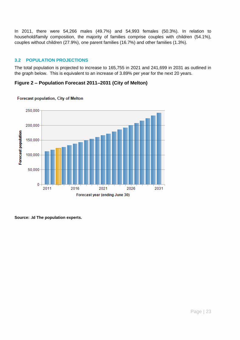
3.2 POPULATION PROJECTIONS
The total population is projected to increase to 165,755 in 2021 and 241,699 in 2031 as outlined in
the graph below. This is equivalent to an increase of 3.89% per year for the next 20 years.
Figure 2 – Population Forecast 2011–2031 (City of Melton)
Source: .Id The population experts.
Page | 24
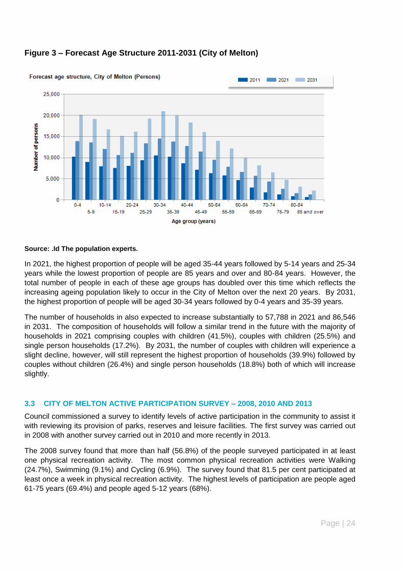
Figure 3 – Forecast Age Structure 2011-2031 (City of Melton)
Source: .Id The population experts.
In 2021, the highest proportion of people will be aged 35-44 years followed by 5-14 years and 25-34
years while the lowest proportion of people are 85 years and over and 80-84 years. However, the
total number of people in each of these age groups has doubled over this time which reflects the
increasing ageing population likely to occur in the City of Melton over the next 20 years. By 2031,
the highest proportion of people will be aged 30-34 years followed by 0-4 years and 35-39 years.
The number of households in also expected to increase substantially to 57,788 in 2021 and 86,546
in 2031. The composition of households will follow a similar trend in the future with the majority of
households in 2021 comprising couples with children (41.5%), couples with children (25.5%) and
single person households (17.2%). By 2031, the number of couples with children will experience a
slight decline, however, will still represent the highest proportion of households (39.9%) followed by
couples without children (26.4%) and single person households (18.8%) both of which will increase
slightly.
3.3 CITY OF MELTON ACTIVE PARTICIPATION SURVEY – 2008, 2010 AND 2013
Council commissioned a survey to identify levels of active participation in the community to assist it
with reviewing its provision of parks, reserves and leisure facilities. The first survey was carried out
in 2008 with another survey carried out in 2010 and more recently in 2013.
The 2008 survey found that more than half (56.8%) of the people surveyed participated in at least
one physical recreation activity. The most common physical recreation activities were Walking
(24.7%), Swimming (9.1%) and Cycling (6.9%). The survey found that 81.5 per cent participated at
least once a week in physical recreation activity. The highest levels of participation are people aged
61-75 years (69.4%) and people aged 5-12 years (68%).
Page | 25
The main reasons for participation were health and fitness (46%) and fun/enjoyment (41.2%). The
main barriers to participation was the activity not being available locally, lack of time, commitments
(work and family) and cost.
The survey revealed that two thirds (67.2%) of respondents visited parks, walking trails and
playgrounds in Melton with the main activities being waking, use of play equipment and play.
Factors that could encourage more frequent use of parks, walking trails and playgrounds include
Shade, play equipment for multiple age groups and points of interest along walking/cycling paths.
The 2010 survey found that the most common physical recreation activities were Walking (29.9%),
Gardening (15.6%) and Reading (15.3%). The majority of people surveyed participated once or
twice a week (47.4%), three or more times (25.7%) and less than once a month (11.8%). The
highest levels of participation are people aged 5-12 years (86.3%), 36-45 years (76.1%) and 20-35
years (74.1%).
The main reasons for participation were fun and enjoyment (60.3%), health and fitness (55.6%) and
competition (24.5%). The main barriers to participation were the activity not being available locally,
lack of time and cost.
The survey revealed that two thirds (67.6%) of respondents visited parks, walking trails and
playgrounds in Melton which is almost identical compared with the survey conducted in 2008. The
most frequently visited parks were Hannah Watts Park, Navan Park, Tenterfield Park and Caroline
Springs Park. The main activities undertaken included being waking, exercise and play.
The people surveyed agreed that open space should be located close to home, all parks should
have similar facilities regardless of size and to provide good play areas for children while they
disagreed that teenagers were well catered for in terms of open space. Well maintained and safe
and welcoming open spaces were identified as being very important to the people surveyed.
The 2013 survey has been completed and a draft report prepared. The final report has not been
released at this stage.
3.4 SOCIAL AND ECONOMIC DISADVANTAGE – SEIFA MEASURES
The Australian Bureau of Statistics (ABS) has produced an index (SEIFA) which outlines the level of
social and economic disadvantage for each local government area (LGA) as well as for each
suburb. The index is based on the current (2011) ABS Census data and covers income, education,
occupation, English language (fluency) and housing ownership.
The City of Melton has a disadvantage index of 1,003 which ranks it at number 50 (1 = most
disadvantaged, 80 = least disadvantaged) compared with other municipalities in Victoria and places
it in the least disadvantaged 38% of municipalities in the state.
The index reveals that Melton South is the most socially and economically disadvantaged suburb in
the municipality with an index of 894 and in the most disadvantaged 5 per cent of suburbs in
Victoria. This is closely followed by Melton which has a disadvantage index of 897 which places it
in the most disadvantaged 6 per cent of suburbs in the state.
Perhaps the most surprising is Burnside given that it is a relatively new suburb which has an index
of 965 and is in the most disadvantaged 19 per cent of suburbs in the state.

Page | 26
The least socially and economically disadvantaged suburb in the municipality is Eynesbury with an
index of 1,117 which places it in the least disadvantaged 1 per cent of suburbs. Caroline Springs
has an index of 1,052 which places it in the least disadvantaged 28 percent of suburbs in the state.

Page | 27
4 Existing Parks and Reserves Network
4.1 OVERVIEW OF PARKS AND RESERVES IN THE CITY OF MELTON
The City of Melton currently has a total of 291 parks and reserves occupying a total area of 862.6
hectares. The existing open space network is diverse and provides a range of active, passive and
amenity spaces including regional parks, district open space, neighbourhood open space, local
open space, linear reserves and conservation/environmental reserves. The majority of parks and
reserves are owned by the City of Melton with the exception of Toolern Creek Park (owned and
managed by Parks Victoria), Harry Allen Reserve (Department of Environment and Primary
Industries) and Melton Reservoir (Southern Rural Water).
Parks and reserves owned by Council are managed and maintained by Council‟s Operations
Department or Environmental Services Department (environmental/conservation reserves) or one of
several different public authorities such as State Government, Parks Victoria, or a water authority
(Melbourne Water, Western Water, Southern Rural Water).
Information in relation to the location, size, type (active or passive), classification (open space
hierarchy) and existing park furniture and infrastructure at all Council‟s parks and reserves is
currently collated through Council‟s Infrastructure Asset Management System (IAMS) and
documented on Council‟s GIS mapping program. Council has recently directed that the IAMS
program be phased out and replaced by a common register (My Data) that will contain all asset
information (including parks and reserves). Council has also commenced preparation of an Open
Space Asset Management Plan and Open Space Asset Management Manual.
4.2 CLASSIFICATION AND HIERARCHY OF PARKS AND RESERVES IN THE CITY OF MELTON
The classification system used for the City of Melton‟s open space network is currently under
review. Council has begun the process of preparing a new Open Space Strategy to guide the future
planning and development for all open spaces (including parks and reserves) in the municipality.
The Strategy is currently being prepared (draft stage), however, the following hierarchy and
classification has been established for open spaces in the City of Melton:
1. Regional
2. District
3. Neighbourhood
4. Local
5. Pocket Parks
6. Waterways, linear parks and trails
7. Conservation

Page | 28
Photo 1: Macpherson Park, Toolern Vale (Regional open space)
Photo 2: Burnside Heights Recreation Reserve, Burnside Heights.
Page | 29
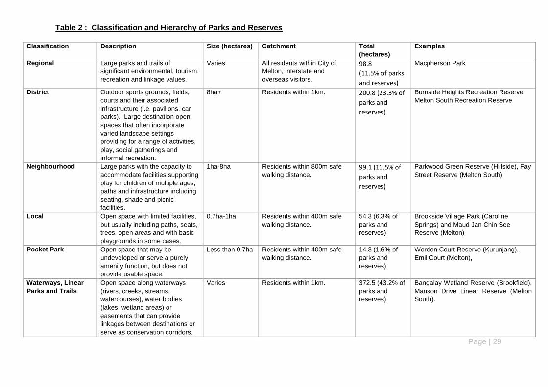
Table 2 : Classification and Hierarchy of Parks and Reserves
Classification Description Size (hectares) Catchment Total
(hectares)
Examples
Regional Large parks and trails of
significant environmental, tourism,
recreation and linkage values.
Varies All residents within City of
Melton, interstate and
overseas visitors.
98.8
(11.5% of parks
and reserves)
Macpherson Park
District Outdoor sports grounds, fields,
courts and their associated
infrastructure (i.e. pavilions, car
parks). Large destination open
spaces that often incorporate
varied landscape settings
providing for a range of activities,
play, social gatherings and
informal recreation.
8ha+ Residents within 1km. 200.8 (23.3% of
parks and
reserves)
Burnside Heights Recreation Reserve,
Melton South Recreation Reserve
Neighbourhood Large parks with the capacity to
accommodate facilities supporting
play for children of multiple ages,
paths and infrastructure including
seating, shade and picnic
facilities.
1ha-8ha Residents within 800m safe
walking distance. 99.1 (11.5% of
parks and
reserves)
Parkwood Green Reserve (Hillside), Fay
Street Reserve (Melton South)
Local Open space with limited facilities,
but usually including paths, seats,
trees, open areas and with basic
playgrounds in some cases.
0.7ha-1ha Residents within 400m safe
walking distance.
54.3 (6.3% of
parks and
reserves)
Brookside Village Park (Caroline
Springs) and Maud Jan Chin See
Reserve (Melton)
Pocket Park Open space that may be
undeveloped or serve a purely
amenity function, but does not
provide usable space.
Less than 0.7ha Residents within 400m safe
walking distance.
14.3 (1.6% of
parks and
reserves)
Wordon Court Reserve (Kurunjang),
Emil Court (Melton),
Waterways, Linear
Parks and Trails
Open space along waterways
(rivers, creeks, streams,
watercourses), water bodies
(lakes, wetland areas) or
easements that can provide
linkages between destinations or
serve as conservation corridors.
Varies Residents within 1km. 372.5 (43.2% of
parks and
reserves)
Bangalay Wetland Reserve (Brookfield),
Manson Drive Linear Reserve (Melton
South).

Page | 30
Classification Description Size (hectares) Catchment Total
(hectares)
Examples
Conservation/
Environmental
Reserve
Open space reserved for
conservation, environmental or
water management with varied
public access and managed by
Council or a public authority
Varies Varies 22.8 (2.6% of
parks and
reserves)
Bridge Road Environmental Reserve
(Melton South), Kororoit Creek
Environmental Reserve (Caroline
Springs)
(Source: City of Melton 2013 – City of Melton Draft Open Space Strategy).
Photo 3: Bangalay Wetland Reserve (Turpentine Road-Manooka Road), Brookfield
Page | 31
Table 3 : Park Furniture and Infrastructure requirements for Parks and Reserves
Hierarchy
Infrastructure Reg
ion
al
Dis
tric
t
Neig
hb
ou
rho
od
Lo
cal
Po
ck
et
Pa
rks
Wate
rways
, L
inear
Park
s a
nd
Tra
ils
Co
nserv
ati
on
/
En
vir
on
men
tal
ACCESS
Disability/wheelchair access
× × × ×
Shared pathways
×
Car parking - on street
× × × ×
Car parking - off street
× × × × ×
Disabled car parking
× × × × ×
PLANTING / LANDSCAPE
Barrier/fencing - safety
× × ×
Drought tolerant planting × × ×
Indigenous planting
Shade planting
SIGNAGE
Directional Signage × × × × ×
Identification Signage
Interpretive Signage × × × ×
Safety Signage × × × × × ×

Page | 32
Infrastructure Reg
ion
al
Dis
tric
t
Neig
hb
ou
rho
od
Lo
cal
Po
ck
et
Pa
rks
Wate
rways
, L
inea
r
Park
s a
nd
Tra
ils
Co
nserv
ati
on
/
En
vir
on
men
tal
PARK FURNITURE
BBQ‟s × × × ×
Bicycle Racks × × × × × ×
Boardwalks(where
appropriate) × × × × ×
Drinking Fountains × × × × ×
Irrigation (WSUD compliant)
× × × × ×
Lighting × × × ×
Picnic Tables × ×
Public Art × × × × × × ×
Public Toilets
× × × ×
Rotunda/Shelter × × × × ×
Rubbish Bins × × × ×
Seating
×
Temporary irrigation
(compliant with WSUD) to
establish trees. × × × × ×
Page | 33
Infrastructure Dis
tric
t
Neig
hb
ou
rho
od
Lo
cal
Po
ck
et
Pa
rks
Wate
rways
, L
inear
Park
s
an
d T
rail
s
Co
nserv
ati
on
/
En
vir
on
men
tal
PLAY
Play space × × ×
Play space (all ages) × × ×
SPORT ×
Open areas (informal play) × × ×
Pavilions
× × × ×
Playing Surfaces (Sport)
× × × ×
Practice Nets (Cricket)
× × × ×
Sportsground Lighting
× × × ×
= recommended = desired × = not required
Page | 34
4.3 MASTER PLANS FOR PARKS AND RESERVES
Council has adopted master plans for all active parks and reserves within the City of Melton and
major passive parks and reserves including Navan Park (Melton West), Archer Drive Reserve
(Kurunjang), Melton Botanic Gardens and Sirdar Street Reserve (Melton).
Council Officers are planning to prepare master plans for other passive parks and reserves
including Hannah Watts Park, Morton Homestead (review of existing plan) and newly acquired land
in Burnside. For passive parks and reserves with no master plan, a landscape development plan
will be prepared for each park/reserve. The development plan will cover minor infrastructure
enhancement to increase and improve the current appearance of the park/reserve.
Master plans have also been adopted for Eynesbury Recreation Reserve and Clarkes Road
Recreation Reserve (Brookfield) which have been planned and are yet to be developed. Council is
also currently preparing master plans for the Melton South Recreation Reserve and West Melton
Recreation Reserve.
Master plans have also been approved in the past 12 months, particularly for reserves in the new
urban growth/precinct structure plan areas including Bridge Road Sports Precinct (Toolern) and
Taylors Hill West Recreation Reserve (Taylors Hill West).
The majority of parks and reserves with master plans have been developed generally in accordance
with the adopted master plans. However, master plans are yet to be implemented for a number of
parks and reserves including existing reserves - Boronia Drive Reserve (Hillside), Archer Drive
Reserve (Kurunjang) as well as those that have been recently planned – Eynesbury Recreation
Reserve, Bridge Road Recreation Reserve (Melton South) and Clarkes Road Recreation Reserve
(Brookfield).
Page | 35
5 Audit of Parks and Reserves
5.1 NUMBER OF PARKS AND RESERVES IN THE CITY OF MELTON
The audit of parks and reserves in the City of Melton has identified a total of 291 parks and reserves
within the municipality. The types of parks and reserves identified are based on the open space
classification hierarchy being developed as part of Council‟s draft Open Space Strategy and the
location of each park or reserve using the existing suburbs within the City of Melton.
The above graph shows that the Caroline Springs (74) has the highest number of parks and reserves in the municipality followed by Melton (34) and Melton West (28). Mount Cottrell (1) has the lowest number of parks and reserves, while Toolern Vale, Rockbank and Exford each have two parks and reserves. The majority of parks and reserves in the City of Melton are waterways, linear parks and trails (88) followed by local parks (78) and neighbourhood parks (48). Environmental/Conservation reserves (5) recorded the lowest number, however, it should be noted that some environmental reserves formed part of larger linear reserves and were included separately under the category of Waterways, Linear Parks and Trails.
The highest number of district level parks and reserves are located in Caroline Springs, Melton
South and Melton West (all 4) while Brookfield, Burnside, Exford and Eynesbury do not contain any
0
10
20
30
40
50
60
70
80
Figure 4: Number of Parks and Reserves in City of Melton by Suburb

Page | 36
district level open space. However, it is noted that a district level reserve is planned for Eynesbury
with Council approving a master plan for the Eynesbury Recreation Reserve in April this year.
The highest number of neighbourhood parks and reserves are located in Caroline Springs (10),
Taylors Hill (7) and Hillside (6) while Exford, Mount Cottrell, Plumpton (including Taylors Hill West)
and Toolern Vale do not have any neighbourhood level open space.
Local Open Spaces are located in Caroline Springs (18), Hillside (11) and Melton South (11) while
Mount Cottrell, Plumpton (including Taylors Hill West), Rockbank and Toolern Vale do not contain
any local open space.
The majority of small parks and reserves are located in Melton (10), Caroline Springs (8) and
Hillside (6). Burnside, Burnside Heights, Exford, Mount Cottrell, Taylors Hill and Toolern Vale do
not have any small open spaces.
The largest number of waterways, linear parks and trails were found in Caroline Springs (33)
followed by Melton (10) while there are no waterways, linear parks and trails in Exford, Diggers
Rest, Rockbank, Mount Cottrell and Toolern Vale.
Conservation Reserves are split amongst Caroline Springs, Kurunjang and Melton South (all 1
each). However, as mentioned earlier, other conservation/environmental reserves were identified in
the City of Melton as part of the review which were identified as being located within or directly
adjacent to larger linear reserve. Where this occurred, the environmental reserve was considered
part of the linear open space (Waterways, Linear Parks and Trails) rather than as a separate
environmental or conservation reserve.
5.2 SIZE OF PARKS AND RESERVES IN THE CITY OF MELTON
The City of Melton has a total of 862.6 hectares of public open space almost evenly divided
between parks (regional, district, neighbourhood, local and pocket parks) and reserves (waterways,
linear parks and trails and conservation reserves). The following table outlines the total area of
parks and reserves in each suburb and as a proportion of total area of parks and reserves in the
municipality.
Page | 37
Table 4: Total Area of Parks and Reserves by Suburb
SUBURB PARKS RESERVES TOTAL AREA (HECTARES)
PROPORTION OF TOTAL OPEN SPACE (%)
POPULATION
(2011)
HECTARES
PER 1,000
PEOPLE
Brookfield 7.2 76 83.2 9.6 6242 13.4
Burnside 5 0.4 5.4 0.6 4464 1.2
Burnside Heights 16.1 8.8 24.9 2.9 5139 4.8
Caroline Springs 50.1 72.9 123 14.3 20944 5.8
Diggers Rest 12.4 0 12.4 1.4 1907 6.5
Exford 2.3 0 2.3 0.3 92 2.5
Eynesbury 5.6 3.6 9.2 1.1 682 15.3
Hillside 29.6 11.7 41.3 4.8 15606 2.6
Kurunjang 17.8 74.8 92.6 10.7 9471 9.8
Melton 54.2 27.6 81.8 9.5 7940 10.3
Melton South 46 81.2 127.2 14.7 8722 14.6
Melton West 51.8 32.9 84.7 9.8 14546 5.8
Mount Cottrell 38.2 0 38.2 4.4 688 63.6
Plumpton 4 0.8 4.8 0.6 418 12
Rockbank 5.8 0 5.8 0.7 1349 4.4
Taylors Hill 20.4 5.7 26.1 3 12100 2.1
Toolern Vale 99.7 0 99.7 11.6 879 124.6
TOTALS: 466.2 396.4 862.6 100 111189
The above table shows the more of the land designated for open space in the City of Melton is
occupied by parks (regional, district, neighbourhood, local and small parks) and compared with
reserves (walkways, linear reserves, trails, conservation and environmental reserves).
Brookfield (131.6 hectares) has the largest area of parks and reserves followed by Melton South
(127.1 hectares) and Caroline Springs (124 hectares). However, Brookfield has only 17 parks and
reserves (7.7 hectares for each park and reserve) compared with 26 in Melton South (4.8 hectares
for each park and reserve) and 74 in Caroline Springs (1.6 hectares for each park and reserve).
Of the established or newly established suburbs, Burnside had one of the smallest areas of parks
and reserves (3.3 hectares or 0.4 hectares per park/reserve) while Toolern Vale had the highest
area per parks and reserve (49.4 hectares per park/reserve) due to the existence of the only
regional park in the municipality (MacPherson Park).
The highest proportion of open space based on area (hectares) is located in Melton South (14.7%)
followed by Caroline Springs (14.3%) and Toolern Vale (11.6%). Exford has the lowest proportion
(0.3%) of open space.

Page | 38
Table 5: Area and Proportion of Parks and Reserves by Classification (Hierarchy)
Park/Reserve Hierarchy No. of Parks/Reserves Area (hectares) Proportion of Open Space
Regional 1 98.8 11.5
District 24 200.8 23.3
Neighbourhood 48 97.9 11.3
Local 78 54.3 6.3
Small Open Spaces 47 14.3 1.6
Waterways, Linear Parks and Trails 88 372.5 43.2
Conservation/Environmental 5 32.4 2.8
TOTALS: 291 862.6 100
The highest proportion of parks and reserves in terms of classification (hierarchy) are waterways,
linear parks and trails (43.2%), district parks (23.3%), regional parks and reserves and
neighbourhood parks and reserves (both 11.5%). Conservation/Environmental parks and reserves
have the lowest proportion (2.6%).
5.3 AGE AND CONDITION OF PARKS AND RESERVES IN THE CITY OF MELTON
5.3.1 Age of Parks and Reserves in the City of Melton
The graph above shows that the majority of Council‟s parks and reserves are aged 0-4 years (23
per cent), 5-9 years (22 per cent), 10-14 years (19 per cent) and 30 plus years (10 per cent). In
particular, 64 per cent of parks and reserves are less than 15 years old, 28.5% are more than 15
years old and 7.5% are unknown. The majority of reserves that are more than 15 years old are
0-4 years23%
5-9 years22%
10-14 years19%
15-19 years7%
20-24 years7%
25-29 years4%
30+years10%
Unknown8%
Figure 5: Age of Parks and Reserves - City of Melton

Page | 39
located in Hillside, Kurunjang and Melton. The reserves identified as unknown as those located on
older plans of subdivision or are Crown allotments.
The City of Melton has 30 parks and reserves that are more than 30 years old. Melton has the
highest proportion (66.6 per cent) followed by Melton South and Kurunjang. Caroline Springs has
the most number of parks and reserves that are less than 5 years old followed by Eynesbury.
This demonstrates the diversity of parks and reserves in the City of Melton between the older,
established areas (e.g. Melton, Melton South) and the newer, more recently developed areas such
as Caroline Springs and Eynesbury.
Table 6: Age of Parks and Reserves by Suburb in the City of Melton
AGE
0-4 years 5-9 years
10-14 years
15-19 years
20-24 years
25-29 years
30+ years Unknown TOTAL
SUBURB
Brookfield 7 3 4 0 2 1 0 0 17
Burnside 0 0 6 1 0 0 0 0 7
Burnside Heights 2 7 0 0 0 0 0 0 9
Caroline Springs 28 26 19 0 0 0 0 1 74
Diggers Rest 0 0 0 1 1 2 0 1 5
Exford 0 0 0 0 0 0 0 2 2
Eynesbury 11 1 0 0 0 0 0 0 12
Hillside 1 6 10 7 3 0 0 0 27
Kurunjang 2 5 1 0 8 1 3 2 22
Melton 0 0 2 3 1 0 20 8 34
Melton South 4 0 0 4 2 4 7 5 26
Melton West 5 9 4 4 3 3 0 0 28
Mount Cottrell 0 0 0 0 0 0 0 1 1
Plumpton (Taylors Hill West) 3 0 0 0 0 0 0 0 3
Rockbank 0 0 0 0 1 1 0 0 2
Taylors Hill 3 8 9 0 0 0 0 0 20
Toolern Vale 0 0 0 0 0 0 0 2 2
Total: 66 65 55 20 21 12 30 22 291
The audit has identified a total of 83 parks and reserves in the City of Melton that are more than 15
years old compared with 186 parks and reserves that are less than 15 years old and 22 parks and
reserves where the age is unknown. The majority of these parks and reserves are located in
Melton, Melton South and Kurunjang. The oldest parks or reserves in the City of Melton are Buckle
Road Reserve Kurunjang (Neighbourhood Park), Gisborne Melton Park, Kurunjang (Conservation
Reserve), Damian Street Reserve, Melton (Small Park) and Fay Street Reserve, Melton
(Neighbourhood Park) which are aged 33 years and 6 months. These reserves are all undeveloped
with the exception of Fay Street Reserve. There are a total of 30 parks and reserves that are more
than 30 years old.
Page | 40
5.3.2 Undeveloped Parks and Reserves in the City of Melton
The audit has identified a total of 32 parks and reserves in the City of Melton that are currently
considered to be undeveloped. These parks and reserves are either vacant (no infrastructure or
equipment) or contain minimal or old infrastructure and equipment. These parks and reserves are
predominantly located in Melton, Melton South, Kurunjang and Hillside. The list of undeveloped
parks and reserves is outlined in the following table:
Table 7: - List of Undeveloped Parks and Reserve in the City of Melton
Name of Park/Reserve Address Suburb Ward Size(m
2) Melways
IAMS No. Comments
Lloyd Court Reserve Lloyd Court Brookfield Coburn 1,969 336 F12 1188
R1Z. No overlays. Re-serve status. 2 separate land parcels.
Burnside Watermain Reserve
Wenden Court Burnside Cambridge 3,700 25 A6 502
R1Z. DPO1. Reserve status. Drainage reserve.
Punjel Drive Reserve Punjel Drive Diggers Rest
Watts 9,639 352 C5 1441 R1Z. No overlays. Re-serve status. Small play space and landscaping.
Hickey Road Reserve Hickey Road Exford Cambridge 12,700 342 A4 47855 GWZ/RCZ. ESO2. Re-serve status. Toilet block and landscaping (north-west corner).
Allenby Road Reserve Allenby Road Hillside Watts 7,097 356 H2 319 R1Z. DPO1. Reserve status.
Chelsea Gardens Glenbruar Drive Hillside Watts 5,800 354 K10 586
R1Z.DPO1. Reserve status.
Duchess Court Reserve Duchess Court Hillside Watts 11,000 354 G9 47882
R1Z. DPO1. Reserve status. Undeveloped. Above ground power lines covering the rear portion of the reserve.
Glencarpel Court Re-serve
Glencarpel Court Hillside Watts 7,900 354 J8 867
R1Z (part) and GWZ (part). DP O (Schedule 5) and Melbourne Airport Environs Overlay (Schedule 2). Reserve Status.
Hillview Court Reserve Hillview Court Hillside Watts 531 354 G9 992
R1Z. DPO (Schedule 1 & 5) and Melbourne Airport Environs (Schedule 2). Reserve status.
Kenswick Drive Reserve Kenswick Drive
Hillside Watts 8,800 3 A9 1101 R1Z. DPO1. Reserve status.
Buckle Road Reserve Buckle Road Kurunjang Coburn 12,400 337 E5 48158 L DR Z. ESO (Schedule 2). Reserve status. Envi-ronmental Reserve.
Gisborne Melton Road Park
Gisborne Melton Road
Kurunjang Coburn 17,000 337 E6 47583 LDRZ. ESO (Schedule 1). Reserve status. Envi-ronmental Reserve.
Dougal Court Reserve Dougal Court Kurunjang Coburn 1083 337 E3 738 R1Z. No overlays. Re-serve status.
Nightmarch Place Re-serve
Nightmarch Place Kurunjang Coburn 23,490 337 E2 1335
R1Z. No overlays. Re-serve status.
Smoult Drive Drainage Reserve
Smoult Drive Kurunjang Watts 331 337 A5 1563 R1Z. No overlays. Re-serve status (drainage).
Smoult Drive Reserve Smoult Drive Kurunjang Watts 5,096 337 A5 1564 R1Z. No overlays. Re-serve status. Undevel-oped. 3 separate parcels.
Brixton Place Reserve Brixton Place Melton Coburn 2,037 337 B7 469
PPRZ. No overlays. Re-serve status. 1 park bench seat and landscap-ing.
Damian Street Reserve Damian Street Melton Coburn 2,797 336 J9 693
PPRZ. No overlays. Lot (non reserve).
Drake Court Reserve Drake Court Melton Coburn 2,420 337 D7 740
R1Z. No overlays. Re-serve status. 4 separate land parcels.
Page | 41
Name of Park/Reserve Address Suburb Ward Size(m
2) Melways
IAMS No. Comments
Inez Court Reserve Inez Court Melton Coburn 1,447 337 A10 1029
PPRZ. 2 separate parcels (both reserve status).
Milverton Street Re-serve
Milverton Street Melton Coburn 2,037 337 A6 1287
R1Z. No overlays. Re-serve status.
Police Paddock High Street Melton Coburn 2,023 337 C8 1433
PPRZ (part) and PUZ – Local Government (part). No overlay controls. Reserve status.
Pound Paddock McKenzie Street Melton Coburn 2,021 337 C9 1436
PPRZ (part) and PUZ – Local Government (part). No overlay controls. Reserve status.
McDonald Street Re-serve
McDonald Street
Melton South
Coburn 7,521 342 K1 1248 PPRZ. No overlays. Lot (non reserve). Undevel-oped.
Musk Court Reserve Musk Court Melton Coburn 1,932 337 A10 1318
PPRZ. 2 separate par-cels – north (Lot), south (reserve status). Unde-veloped.
Yuille Street Reserve
Yuille Street Melton Coburn 5,707 337 D7 1005 PPRZ. No overlays. Re-serve status. Undevel-oped. Golf Course oppo-site.
Crestmont Drive Re-serve
Crestmont Drive
Melton South Coburn 3,664 342 H2 678
R1Z. No overlays. Re-serve status. Undevel-oped.
Gainsborough Place Reserve
Gainsborough Place
Melton West Coburn 2,777 336 E5 840
R1Z. 2 separate parcels – north (reserve status), south (Lot). Undeveloped.
Scarborough Crescent (Children‟s Services Site)
Scarborough Crescent
Melton West Coburn 1,840 336 F4 47763
R1Z. No overlays. Re-serve status. Undevel-oped.
Gleneagles Drive Re-serve
Gleneagles Drive
Melton South Coburn 1,963 336 C8 1669
R1Z. No overlays. Re-serve status. Undevel-oped.
Findon Way Reserve Balmoral Place
Melton West Coburn 1,232 336 H6 819
R1Z. No overlays. Lot (non reserve). Undevel-oped except for 1 park bench seat.
R1Z = Residential 1 Zone LDRZ = Low Density Residential Zone PPRZ = Public Park and Recreation Zone GWZ = Green Wedge Zone RCZ = Rural Conservation Zone PUZ = Public Use Zone DPO = Development Plan Overlay ESO = Environmental Significance
It is recommended that Council further review these undeveloped parks and reserves to determine
whether they should be retained for rejuvenation and development or whether they can be
repurposed to support opportunities for the community. e.g. Housing.
5.3.3 Condition of Parks and Reserves in the City of Melton
The condition of each park and reserve was assessed using a rating system developed by Council
as part of draft Open Space Asset Management Plan and Manual. The system uses a score
ranging from 0 (Brand new) to 6 (Out of Service) to assess the condition of all infrastructure and
equipment currently provided at each park and reserve in the City of Melton.
The park and reserve with the highest score was MacPherson Park (Toolern Vale) and Mt Carberry
Reserve which both had a total score of 49. The lowest score was 0 which was found at a number
of reserves either because infrastructure or equipment at the park or reserve was brand new. Three
reserves did not register a score on the basis that they are undeveloped.
Page | 42
The highest scores reflect those parks and reserves with either most amount of park infrastructure
or furniture (e.g. MacPherson Park) and also those which have a lower level of park infrastructure or
furniture that require rejuvenation or upgrading (e.g. Mt Carberry Recreation Reserve).
The following table provides a summary of the range of scores and the suburbs where these
reserves are located based on these scores.
Table 8: - Condition Score for Parks and Reserve in the City of Melton by Suburb
Park/Reserve Score (Total)
SUBURB 0 to 10 11 to
20
21 to
30
31 to
40
41 to
50
50+ N/A Total
No.
Brookfield 11 5 0 0 0 0 1 17
Burnside 2 3 2 0 0 0 0 7
Burnside Heights 4 5 0 0 0 0 0 9
Caroline Springs 40 25 9 0 0 0 0 74
Diggers Rest 2 1 1 1 0 0 0 5
Exford 1 1 0 0 0 0 0 2
Eynesbury 11 1 0 0 0 0 0 12
Hillside 12 9 3 2 0 0 1 27
Kurunjang 16 5 1 0 0 0 0 22
Melton 24 7 1 2 0 0 0 34
Melton South 14 6 3 1 2 0 0 26
Melton West 17 7 1 3 0 0 0 28
Mount Cottrell 0 0 1 0 0 0 0 1
Plumpton 2 0 0 0 0 0 1 3
Rockbank 0 0 2 0 0 0 0 2
Taylors Hill 6 11 3 0 0 0 0 20
Toolern Vale 0 0 1 0 1 0 0 2
TOTAL: 162 86 28 9 3 0 3 291
The above table shows that more than half the parks and reserves registered a score between 0
and 10 followed by 11-20 and 21-30. The suburb with the most number of scores between 0 and 10
is Caroline Springs (40), which indicates that most of the reserves in this suburb are brand new or
relatively new in relation to park furniture and infrastructure.
Melton (24) recorded the second highest number of parks and reserves with a score between 0 and
10. However, this was based on the high number of parks and reserves in Melton that are
Page | 43
undeveloped or have only a limited amount of infrastructure at each reserve rather than the reserve
being brand new or relatively new.
Taylors Hill (11) has the highest number of parks and reserves with a score between 11 and 20
followed by Hillside (9). This indicates that these suburbs contain the greatest mix between
undeveloped reserves (new and old) and well developed parks and reserves.
Melton South (2) and Toolern Vale (1) are the only suburbs which contained parks and reserves
with total scores in the highest score bracket (41-50).
Waterways, Linear Parks and Trails (64) had the most number of parks and reserves with total
scores in the lowest score bracket (0-10) followed by Pocket Parks (45) and Local Parks (29) which
indicates that most of these type of reserves are undeveloped or developed with a limited level of
infrastructure or equipment (e.g. paths, seating, landscaping). District Parks had the highest
number of parks or reserves with a total score greater than 20 as well as two out of the three
reserves in the highest score bracket (41-50). Local (39) and Neighbourhood Parks (22) had the
most number of parks and reserves in the 11-20 score bracket while Neighbourhood Parks (13) and
District Parks (7) had the most number of parks and reserves with a score between 21 and 30.
5.3.4 Accessibility of Parks and Reserves in the City of Melton
The majority (83.2%) of all parks and reserves it the City of Melton are located within 400-500
metres walking distance of residential properties. The suburbs where the most number of parks and
reserve are outside this buffer distance are Eynesbury (9), Melton (8) and Brookfield (7).
Eynesbury has the highest on the basis that it is a new residential area that is not fully developed. It
is considered that once it has been fully developed, most of these reserves will be within a 400-500
metre catchment of residential properties. On the other hand, Melton and Brookfield are
established suburbs so the high number of parks and reserves indicates a gap in these suburbs in
terms of parks and reserves that are beyond reasonable walking distance for local residents.
Burnside and Burnside Heights recorded the lowest number (3) of parks and reserves that are not
located within a 400-500m walking distance of residential properties. All parks and reserves in
Diggers Rest (5) are located within the recommended 400-500 metre walking distance from
residential properties while all parks and reserves in Plumpton/Taylors Hill West (3) are located
outside the 400-500 metre distance from residential areas.
There are a total of 26 parks and reserves currently located more than 400-500 metres from
residential properties in the Melton Township area. This is compared with 12 in Melton East
Corridor and 11 in the Exford/Eynesbury Area.
5.3.5 Barriers to Access and Use of Parks and Reserves
The majority of parks and reserves in the newer suburbs of Melton east have either been designed
to maximise passive surveillance and/or include a combination of passive (bordered by roads and
residential development fronting the reserve) and active surveillance in the form of lighting (public
and sports ground).
However, the opposite can be said for parks and reserves in the older areas such as Melton, Melton
South and Brookfield where some parks and reserves have poor passive surveillance as a result of
location, enclosure (partial) by solid residential boundary fencing, location at the end of roads/court
bowls as part of the residential subdivision or residential development with side or rear boundaries
directly adjacent to and/or enclosing the reserve.

Page | 44
5.3.6 Planning controls/Zoning of Parks and Reserves – City of Melton
The majority of parks and reserves (58.8%) in the City of Melton are currently in a Residential 1
Zone under the Melton Planning Scheme followed by Public Park and Recreation Zone (17.5%). It
is noted that 9.6% of parks and reserves are located in more than one zone while 4.1% are located
in the Mixed Use Zone which reflects those parks and reserves located within Eynesbury.
Of the parks and reserves located in the Residential 1 Zone, the majority are local open spaces (59)
followed by waterways, linear parks and trails (43) and neighbourhood open space (33).
Waterways, linear parks and trails represent the most number (14) of parks and reserves located in
the Public Park and Recreation Zone followed by district open space (10).
Page | 45
6 Work Programme
6.1 SUMMARY OF KEY FINDINGS
The key findings from the completing the review of parks and reserves are summarised as follows:
The City of Melton has a total of 291 parks and reserves occupying a total area of 862.6
hectares.
Caroline Springs (74) has the highest number of parks and reserves followed by Melton (34)
and Melton West (28).
The majority of parks and reserves are waterways, linear parks and trails (88) followed by
local parks/open spaces (78) and neighbourhood parks/open spaces (48).
63.9 per cent of parks and reserves in the City of Melton are less than 15 years old and 45.3
per cent of parks and reserves are less than 10 years old.
There are 30 parks or reserves in the City of Melton that are more than 30 years old.
The highest number of new parks and reserves are located in Caroline Springs and
Eynesbury while the highest number of parks and reserves more than 20 years old are
located in Melton, Melton South and Kurunjang.
A total of 31 parks and reserves in the City of Melton are what Council Officers consider to be
undeveloped. These parks and reserves are either vacant (no infrastructure or equipment) or
contain minimal or old infrastructure and equipment.
58.7 per cent of parks and reserves are located in a Residential 1 Zone under the Melton
Planning Scheme compared with 17.5 per cent in a Public Park and Recreation Zone.
Lack of consistency in relation to signs identifying the name of parks and reserves in the City
of Melton. The majority of parks and reserves have no signs, large signs with standard
Council logo, lettering and corporate colours or small signs installed by the developer when
the park or reserve was first developed.
Council does not currently have a formal policy or procedure for the sale or acquisition of land.
Rejuvenating and developing parks and reserves would be a key tool to promote and market
parks and reserves in the City of Melton and „activate‟ them and encourage greater use of all
parks and reserves resulting in improve health and well being benefits to the City of Melton
and reduction of associated medical and health care costs.
6.2 OPTIONS AND RECOMMENDATIONS
The options and recommendations from the completion of the parks and reserves are outlined as
follows:
Develop a strategy for the acquisition of land adjacent to existing parks and reserves so that
land can be acquired efficiently and at reasonable cost to Council to expand and enhance
Council‟s existing open space network.
Investigate preparation of a policy for reserve naming and signage standards at all parks and
reserves. This could be a separate policy/strategy or as part of Council‟s new Open Space
Strategy.
Council to further review whether to retain the undeveloped parks and reserves for
rejuvenation and development as active or passive leisure and recreation, if they are suitable

Page | 46
for sale or whether they can be repurposed to support opportunities for the community. e.g.
Housing.
Prepare master plans for other passive parks and reserves including Hannah Watts Park,
Morton Homestead (review of existing plan) and newly acquired land in Burnside.
Prepare a landscape development plan for all remaining passive parks and reserves with no
master plan. The landscape development plan will cover minor infrastructure enhancement to
increase and improve the current appearance of the park/reserve.
Undertake a separate review of existing master plans for active and passive reserves
including priorities and costs prior to including any priority works indentified in these plans as
part of Council‟s 5 year Capital Works Programme.
Investigate the develop a webpage as part of Council‟s website or phone application that will
enable people to locate active and passive parks and reserves and facilities within them (e.g.
BBQ‟s, Shelters, Play Space, Shared Paths etc).
Further community consultation to be undertaken in relation to Work Programme once
background report has been adopted by Council. This should also include ongoing
consultation with internal stakeholders (Council departments) and any other staff within
Council.
Undertake further work involving consolidation of titles where a park or reserve is identified for
rejuvenation or development and rezoning of these parks and reserves to Public Park and
Recreation Zone via an amendment to the Melton Planning Scheme.
6.3 PRIORITY ORDER – UPGRADING AND REJUVENATING PARKS AND RESERVES
A work programme for the rejuvenation and development of parks and reserves has been
developed for inclusion in Council‟s 5 year Capital Works Budget and forms part of this report (see
Section 6.4 below).
Council will seek funding opportunities through the State Government to assist with funding the
rejuvenation and development of parks and reserves in the City of Melton. However, Council may
need to fund any future development of parks and reserves agreed upon.
Based on the number of parks and reserves and the financial quantum, the Work Programme will
need to cover the next 20 plus years. However, a 5 year Work Programme has been prepared as
part of the report and for adoption as a program into Council‟s 5 year Capital Works Plan.
Council has identified 32 parks and reserves considered to be undeveloped, the following may be
suitable for further review:
Chelsea Gardens Reserve, Hillside
Police Paddock, Melton
Pound Paddock, Melton
Punjel Drive Reserve, Diggers Rest (relocate play space to Stan Payne Reserve)
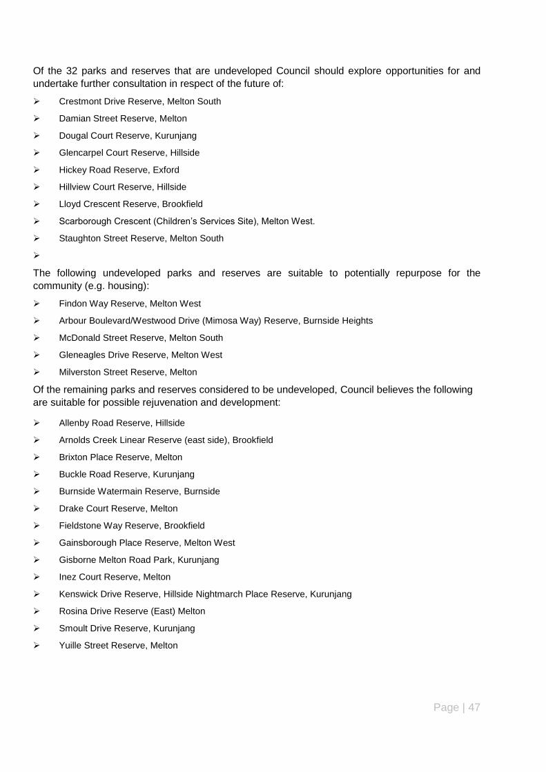
Page | 47
Of the 32 parks and reserves that are undeveloped Council should explore opportunities for and
undertake further consultation in respect of the future of:
Crestmont Drive Reserve, Melton South
Damian Street Reserve, Melton
Dougal Court Reserve, Kurunjang
Glencarpel Court Reserve, Hillside
Hickey Road Reserve, Exford
Hillview Court Reserve, Hillside
Lloyd Crescent Reserve, Brookfield
Scarborough Crescent (Children‟s Services Site), Melton West.
Staughton Street Reserve, Melton South
The following undeveloped parks and reserves are suitable to potentially repurpose for the
community (e.g. housing):
Findon Way Reserve, Melton West
Arbour Boulevard/Westwood Drive (Mimosa Way) Reserve, Burnside Heights
McDonald Street Reserve, Melton South
Gleneagles Drive Reserve, Melton West
Milverston Street Reserve, Melton
Of the remaining parks and reserves considered to be undeveloped, Council believes the following
are suitable for possible rejuvenation and development:
Allenby Road Reserve, Hillside
Arnolds Creek Linear Reserve (east side), Brookfield
Brixton Place Reserve, Melton
Buckle Road Reserve, Kurunjang
Burnside Watermain Reserve, Burnside
Drake Court Reserve, Melton
Fieldstone Way Reserve, Brookfield
Gainsborough Place Reserve, Melton West
Gisborne Melton Road Park, Kurunjang
Inez Court Reserve, Melton
Kenswick Drive Reserve, Hillside Nightmarch Place Reserve, Kurunjang
Rosina Drive Reserve (East) Melton
Smoult Drive Reserve, Kurunjang
Yuille Street Reserve, Melton

Page | 48
6.4 PRIORITY WORK PROGRAMME
The work programme below outlines the priorities for the upgrading, rejuvenation and development of parks and reserves identified in the
review for the first five years of the 20 year program to coincide with Council‟s 5 year Capital Works Budget.
PARK AND RESERVE PRIORITY WORK PROGRAMME 2014/2015-2018/2019 Year 1
Action Description Township Ward Year Indicative Cost
Design and Develop Reserve
Fraser Street Reserve Melton South
Coburn 2014-15 $60,000-$100,000
Design and Develop Reserve
Kenswick Drive Reserve Hillside Watts 2014-15 $60,000-$100,000
Upgrade existing Reserve as per Masterplan/landscape plan
Mt Carberry Reserve Melton South
Coburn 2014-15 $40,000
Upgrade existing Reserve as per Masterplan/landscape plan
Boronia Drive Reserve Hillside Watts 2014-15 $40,000
Upgrade existing Reserve as per Masterplan/landscape plan
Ian Cowie Reserve Rockbank Cam-bridge
2014-15 $40,000
Upgrade existing Reserve as per Masterplan/landscape plan
Stan Payne Reserve Diggers Rest Watts 2014-15 $40,000
Upgrade existing Reserve as per Masterplan/landscape plan
Navan Park Melton West Coburn 2014-15 $40,000
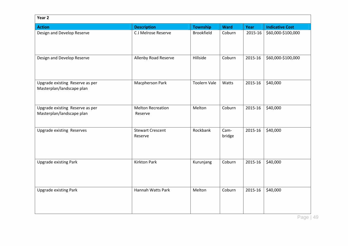
Page | 49
Year 2
Action Description Township Ward Year Indicative Cost
Design and Develop Reserve C J Melrose Reserve Brookfield Coburn 2015-16 $60,000-$100,000
Design and Develop Reserve Allenby Road Reserve Hillside Coburn 2015-16 $60,000-$100,000
Upgrade existing Reserve as per Masterplan/landscape plan
Macpherson Park Toolern Vale Watts 2015-16 $40,000
Upgrade existing Reserve as per Masterplan/landscape plan
Melton Recreation Reserve
Melton Coburn 2015-16 $40,000
Upgrade existing Reserves Stewart Crescent Reserve
Rockbank Cam-bridge
2015-16 $40,000
Upgrade existing Park
Kirkton Park Kurunjang Coburn 2015-16 $40,000
Upgrade existing Park
Hannah Watts Park Melton Coburn 2015-16 $40,000
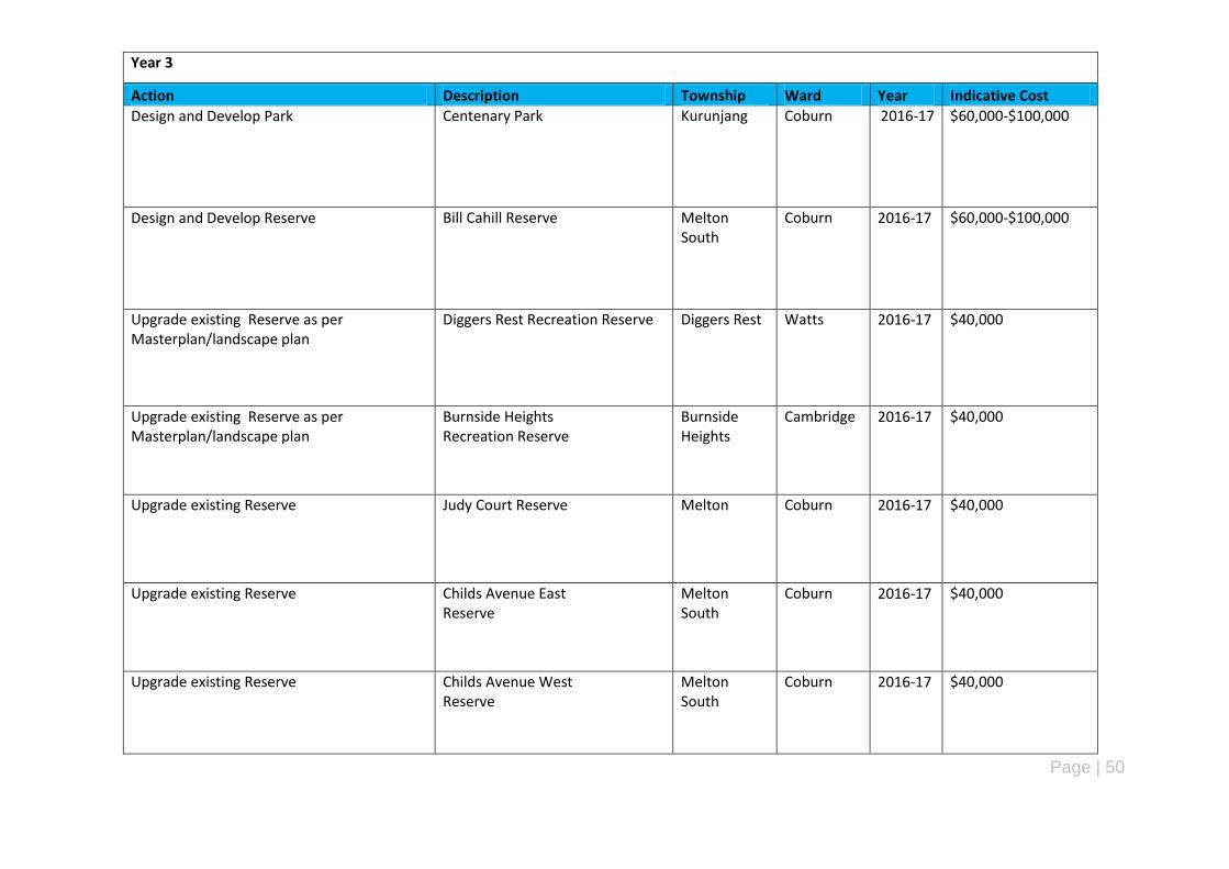
Page | 50
Year 3
Action Description Township Ward Year Indicative Cost
Design and Develop Park
Centenary Park Kurunjang Coburn 2016-17 $60,000-$100,000
Design and Develop Reserve
Bill Cahill Reserve Melton South
Coburn 2016-17 $60,000-$100,000
Upgrade existing Reserve as per Masterplan/landscape plan
Diggers Rest Recreation Reserve Diggers Rest Watts 2016-17 $40,000
Upgrade existing Reserve as per Masterplan/landscape plan
Burnside Heights Recreation Reserve
Burnside Heights
Cambridge 2016-17 $40,000
Upgrade existing Reserve Judy Court Reserve Melton Coburn 2016-17 $40,000
Upgrade existing Reserve Childs Avenue East Reserve
Melton South
Coburn 2016-17 $40,000
Upgrade existing Reserve Childs Avenue West Reserve
Melton South
Coburn 2016-17 $40,000
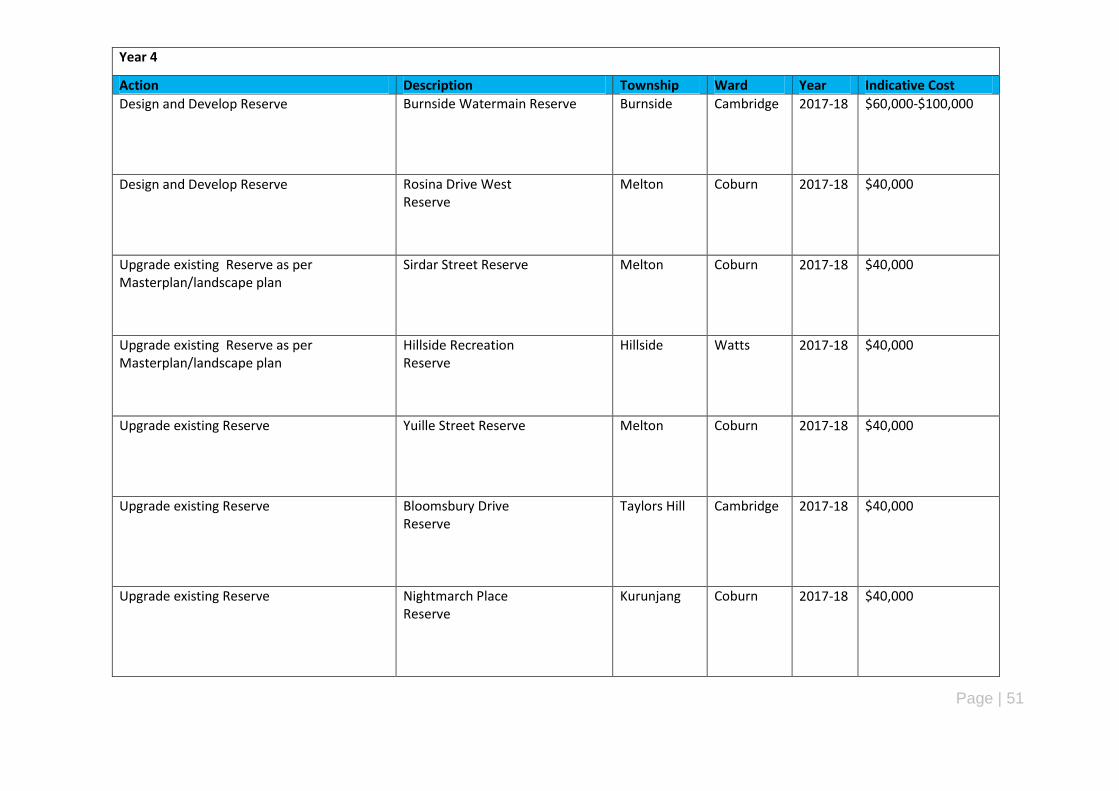
Page | 51
Year 4
Action Description Township Ward Year Indicative Cost
Design and Develop Reserve Burnside Watermain Reserve Burnside Cambridge 2017-18 $60,000-$100,000
Design and Develop Reserve Rosina Drive West Reserve
Melton Coburn 2017-18 $40,000
Upgrade existing Reserve as per Masterplan/landscape plan
Sirdar Street Reserve Melton Coburn 2017-18 $40,000
Upgrade existing Reserve as per Masterplan/landscape plan
Hillside Recreation Reserve
Hillside Watts 2017-18 $40,000
Upgrade existing Reserve Yuille Street Reserve Melton Coburn 2017-18 $40,000
Upgrade existing Reserve Bloomsbury Drive Reserve
Taylors Hill Cambridge 2017-18 $40,000
Upgrade existing Reserve Nightmarch Place Reserve
Kurunjang Coburn 2017-18 $40,000

Page | 52
Year 5
Action Description Township Ward Year Indicative Cost
Design and Develop Reserve Brixton Place Reserve Melton Coburn 2018-19 $60000-$100,000
Design and Develop Reserve Riverviews Road Reserve
Melton West Coburn 2018-19 $60000-$100,000
Upgrade existing Reserve as per Masterplan/landscape plan
Town Centre Recreation Reserve Caroline Springs
Cambridge 2018-19 $40,000
Upgrade existing Reserve as per Masterplan/landscape plan
Arthur Westlake Reserve
Kurunjang Coburn 2018-19 $40,000
Upgrade existing Reserve Inez Court Reserve Melton Coburn 2018-19 $40,000
Upgrade existing Reserve Lake Caroline Reserve Caroline Springs
Cambridge 2018-19 $40,000
Upgrade existing Reserve Smoult Drive Reserve Kurunjang Coburn 2018-19 $40,000

Page | 53
7 Conclusion
The audit of parks and reserves in the City of Melton has identified almost 300 parks and
reserves across the municipality with a broad diversity ranging from regional parks and open
space to linear and environmental/conservation reserves. The majority of parks and reserves
are less than 15 years old reflecting the recent investment by Council in the establishment of
park infrastructure and equipment in parks and reserves in new and relatively new suburbs
such as Caroline Springs, Eynesbury, Melton West and Plumpton (Taylors Hill) as well as the
established higher order parks and reserves (MacPherson Park, Navan Park and Hannah
Watts Park) in the established suburbs. Council has adopted master plans for all its active
parks and reserves and its major passive parks and reserves (Navan Park, Archer Drive
Reserve, Melton Botanic Gardens and Sirdar Street Reserve)
The audit has found that parks and reserves in the City of Melton are generally well located,
distributed and accessible and in good or very good in terms of the size, availability and
condition of infrastructure/equipment, accessibility and surveillance (active and passive).
However, the audit has identified 31 parks and reserves that are considered to be
undeveloped (vacant, minimal or old infrastructure) with the majority of these parks and
reserves located in Melton, Melton South, Kurunjang and Hillside.
Of these parks and reserves, the audit has identified those that require further review and may
potentially be suitable for sale, those parks and reserves that can be repurposed or re-used
for another community purpose (e.g. housing) and those parks and reserves that are suitable
for rejuvenation and upgrading. The audit also identifies a need to consider preparing a land
acquisition and sale policy before any sale or sell of undeveloped parks and reserves and the
preparation of a policy or set of standards for signage at all parks and reserves in the City of
Melton.
Therefore, a priority order has been identified and a work programme prepared to cater for the
rejuvenation and development of Council‟s parks and reserves over the next 20 years. The
work programme covers the next 5 years and incorporated into Council‟s 5 year Capital Works
Program.
Accordingly, it is recommended that parks and reserves be upgraded, rejuvenated or
developed in accordance with the recommendations, priority order and work programme
outlined in this report and incorporated into Council‟s 2013/14 annual budget and 5 year
Capital Works Program.
Page | 54
Appendix A
Site Assessment Checklist – Parks & Reserves (City of Melton)
Park/Reserve Name:
Address:
Ward: -
Melways Ref:
Classification (Hierarchy):
Asset No (IAMS):
Site Area:
Age:
Master Plan: Yes/No. If yes, state name and year adopted
Date of Assessment:
Aerial photo and photo of the park/reserve (to be inserted here) – EXAMPLE ONLY
Existing conditions and purpose:
Description of existing conditions including topography, size, shape, orientation and access.
Function and standard (Quality).
Evidence of current community use of the park and reserve (active, passive, social, vacant or other use).
Proximity to other parks, public open spaces, sport and recreation facilities, shops, public transport and other community facilities.
Comments:
Page | 55
Site Assessment
Existing Facilities: Recommended* Desirable* Available (Yes/No)
Condition Comments
Basketball
BBQ‟s Bicycle racks Boardwalks Car parking Coaches boxes Cricket wickets Disability access Drinking fountains Dog leash/off leash. Fencing Irrigation Landscaping
Garden beds
Trees
Lighting (public and sports)
Netball courts Paths Pavilions Picnic tables Play Space Practice nets (cricket) Public Art Public Toilets Public Transport Rotundas Scoreboards Seating Service Assets (gas, water, power, sewerage)
Signage Sports grounds Tennis courts Waste bins Water features/WSUD
Total: * Refer to the park and reserve hierarchy/classification in Council‟s proposed Open Space Strategy.

Page | 56
Park/Reserve Total score:
Key Assessment Criteria
YES/NO/NA COMMENTS ACCESS
Walking
Car/Motorcycle
Bicycle
Public Transport
BARRIERS
Physical
Social
Psychological
Economic
Emotional
CATCHMENT
Residential areas (within 500m)
Other Open Space areas
Schools
Shops
Community Facilities
PLANNING CONTROLS
Zones and overlays
Native Vegetation
Environmental Significance (Fed/State/Local)
Heritage Significance (Fed/State/Local)
Cultural significance ( AAV)
SAFETY AND
SURVEILLANCE
Condition of equipment
Active/Passive Surveillance
Park/Reserve Condition comments: Recommendations:

Page | 57
Appendix B – Scoping Document (Parks and Reserves Review)
Review of Parks and Reserves within the City of Melton: Scoping Document
Leisure and Facilities Department
April 2013 (UPDATED 29/04/2013)
Introduction
At its meeting on 17 December 2012, Council passed a notice of motion to review all parks and reserves in the whole of the City of
Melton and develop a priority order for the rejuvenation and development of these parks and reserves that are 15 years or older for
consideration in Council’s 2013/2014 budget.
The City of Melton “Draft” Open Space Strategy is currently in progress and has created a vision “to transform Melton’s Open Space
over the next five years and provide adequate open space within the Greenfield areas of the municipality”. A key objective of the draft
strategy is “to improve the standard of existing open space and associated facilities to satisfy ongoing community needs”.
The City of Melton Open Space network consists of over 300 parks and recreation reserves and large areas of land used for conserva-
tion and stormwater management purposes. A total of 2,581 hectares of land is occupied by open space in the municipality compris-
ing 880 hectares of parks and 1,701 hectares of reserves (including conservation, walkways, linear parks and trails).
For the purposes of this review, parks and reserves are defined as land owned and/or managed by Council that is used for active and
passive recreation and conservation/environmental purposes. Streetscape, drainage and tree reserves are considered to be outside
the scope of this review.
This scoping document outlines the key elements of the review including the methodology to be used, form of stakeholder consulta-
tion, project timeline and key outputs of the review. The following details the key components of the review.
Objectives 1. Identify and review all parks and reserves (as defined above) in the City of Melton according to their hierarchy, location, size and function.
2. Develop a priority order for rejuvenating and developing all parks and reserves for Council’s consideration with emphasis on parks and reserves that are 15 years or older.
3. Prepare an action plan outlining priorities for the rejuvenation and development of parks and reserves includ-ing associated costs for consideration in Council’s budget.
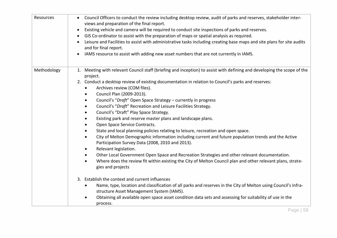
Page | 58
Resources Council Officers to conduct the review including desktop review, audit of parks and reserves, stakeholder inter-views and preparation of the final report.
Existing vehicle and camera will be required to conduct site inspections of parks and reserves.
GIS Co-ordinator to assist with the preparation of maps or spatial analysis as required.
Leisure and Facilities to assist with administrative tasks including creating base maps and site plans for site audits and for final report.
IAMS resource to assist with adding new asset numbers that are not currently in IAMS.
Methodology 1. Meeting with relevant Council staff (briefing and inception) to assist with defining and developing the scope of the project.
2. Conduct a desktop review of existing documentation in relation to Council’s parks and reserves:
Archives review (COM files).
Council Plan (2009-2013).
Council’s “Draft” Open Space Strategy – currently in progress
Council’s “Draft” Recreation and Leisure Facilities Strategy.
Council’s “Draft” Play Space Strategy.
Existing park and reserve master plans and landscape plans.
Open Space Service Contracts.
State and local planning policies relating to leisure, recreation and open space.
City of Melton Demographic information including current and future population trends and the Active Participation Survey Data (2008, 2010 and 2013).
Relevant legislation.
Other Local Government Open Space and Recreation Strategies and other relevant documentation.
Where does the review fit within existing the City of Melton Council plan and other relevant plans, strate-gies and projects
3. Establish the context and current influences
Name, type, location and classification of all parks and reserves in the City of Melton using Council’s Infra-structure Asset Management System (IAMS).
Obtaining all available open space asset condition data sets and assessing for suitability of use in the process.

Page | 59
Current ownership of parks and reserves (e.g. Council, State Government, private).
Benefits of parks and reserves to the community – physical, social, economic, environmental, amenity etc.
Existing hierarchy of open space as outlined in Council’s “Draft” Open Space Strategy – large scale regional parks, district parks, neighbourhood parks, local parks, small local spaces, linear parks and conservation.
Review mapping of existing Council parks and reserves using Intra Maps and IAMS.
Dividing all parks and reserves into precincts as follows: Brookfield Burnside Burnside Heights Caroline Springs Diggers Rest Exford/Parwan Eynesbury Hillside Kurunjang Melton Melton South Melton West Mount Cottrell Plumpton Rockbank Taylors Hill Toolern Vale
Urban growth, the speed of this growth, PSP’s and UGB
Council’s “Draft” Open Space Strategy – currently in progress
Council’s “Draft” Recreation and Leisure Facilities Strategy
Council’s “Draft” Open Space Asset Management Plan
Existing maintenance/servicing arrangements and costs for parks and reserves.

Page | 60
4. Consultation with key internal stakeholders
Meetings with the following internal stakeholders
Executive
Councillors
Leisure Services
Customer Engagement
Operations
Social and Community Planning
Environmental Services
Planning
Engineering
Housing
Children’s Services
Youth Services
Community Care and inclusion
Consultation with key local stakeholders;
SOMLAC – Shire of Melton Leisure and Arts Committee.
Undertake a community forum;
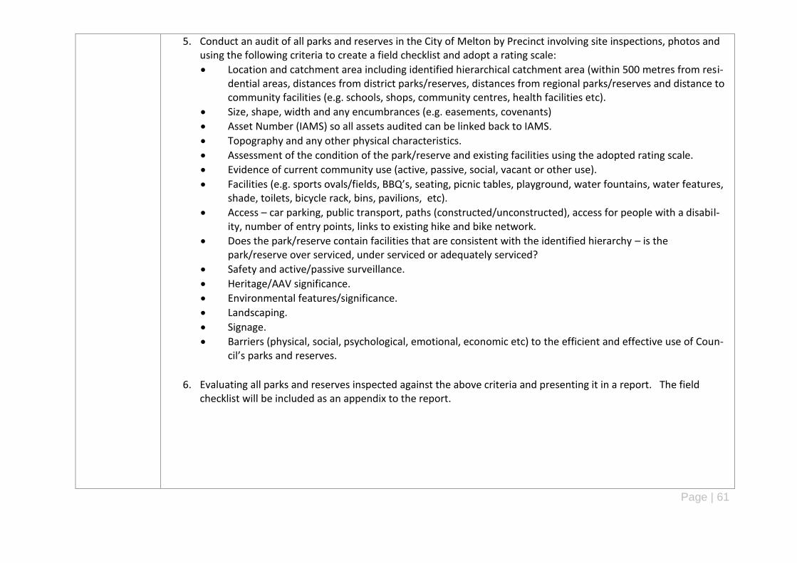
Page | 61
5. Conduct an audit of all parks and reserves in the City of Melton by Precinct involving site inspections, photos and using the following criteria to create a field checklist and adopt a rating scale:
Location and catchment area including identified hierarchical catchment area (within 500 metres from resi-dential areas, distances from district parks/reserves, distances from regional parks/reserves and distance to community facilities (e.g. schools, shops, community centres, health facilities etc).
Size, shape, width and any encumbrances (e.g. easements, covenants)
Asset Number (IAMS) so all assets audited can be linked back to IAMS.
Topography and any other physical characteristics.
Assessment of the condition of the park/reserve and existing facilities using the adopted rating scale.
Evidence of current community use (active, passive, social, vacant or other use).
Facilities (e.g. sports ovals/fields, BBQ’s, seating, picnic tables, playground, water fountains, water features, shade, toilets, bicycle rack, bins, pavilions, etc).
Access – car parking, public transport, paths (constructed/unconstructed), access for people with a disabil-ity, number of entry points, links to existing hike and bike network.
Does the park/reserve contain facilities that are consistent with the identified hierarchy – is the park/reserve over serviced, under serviced or adequately serviced?
Safety and active/passive surveillance.
Heritage/AAV significance.
Environmental features/significance.
Landscaping.
Signage.
Barriers (physical, social, psychological, emotional, economic etc) to the efficient and effective use of Coun-cil’s parks and reserves.
6. Evaluating all parks and reserves inspected against the above criteria and presenting it in a report. The field checklist will be included as an appendix to the report.
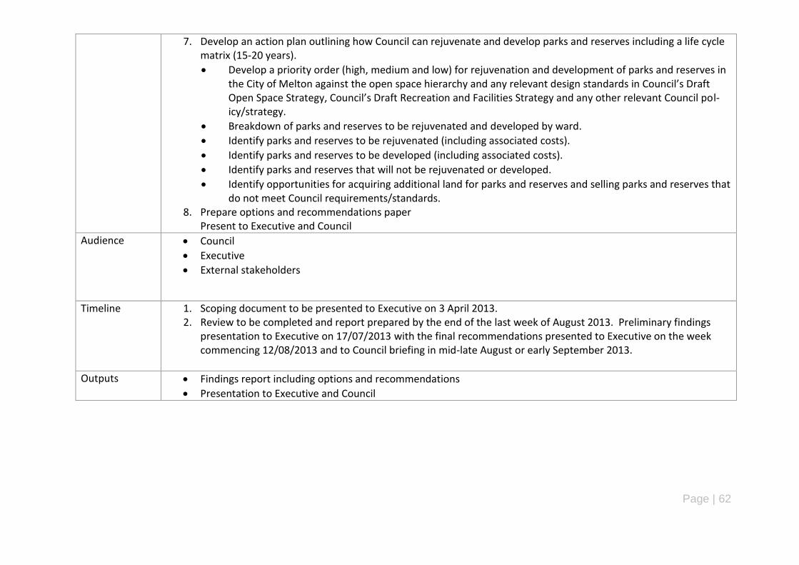
Page | 62
7. Develop an action plan outlining how Council can rejuvenate and develop parks and reserves including a life cycle matrix (15-20 years).
Develop a priority order (high, medium and low) for rejuvenation and development of parks and reserves in the City of Melton against the open space hierarchy and any relevant design standards in Council’s Draft Open Space Strategy, Council’s Draft Recreation and Facilities Strategy and any other relevant Council pol-icy/strategy.
Breakdown of parks and reserves to be rejuvenated and developed by ward.
Identify parks and reserves to be rejuvenated (including associated costs).
Identify parks and reserves to be developed (including associated costs).
Identify parks and reserves that will not be rejuvenated or developed.
Identify opportunities for acquiring additional land for parks and reserves and selling parks and reserves that do not meet Council requirements/standards.
8. Prepare options and recommendations paper Present to Executive and Council
Audience Council
Executive
External stakeholders
Timeline 1. Scoping document to be presented to Executive on 3 April 2013. 2. Review to be completed and report prepared by the end of the last week of August 2013. Preliminary findings
presentation to Executive on 17/07/2013 with the final recommendations presented to Executive on the week commencing 12/08/2013 and to Council briefing in mid-late August or early September 2013.
Outputs Findings report including options and recommendations
Presentation to Executive and Council
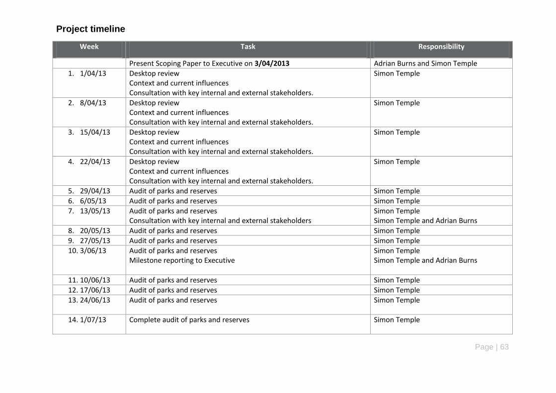
Page | 63
Project timeline
Week Task Responsibility
Present Scoping Paper to Executive on 3/04/2013 Adrian Burns and Simon Temple
1. 1/04/13 Desktop review Context and current influences Consultation with key internal and external stakeholders.
Simon Temple
2. 8/04/13 Desktop review Context and current influences Consultation with key internal and external stakeholders.
Simon Temple
3. 15/04/13 Desktop review Context and current influences Consultation with key internal and external stakeholders.
Simon Temple
4. 22/04/13 Desktop review Context and current influences Consultation with key internal and external stakeholders.
Simon Temple
5. 29/04/13 Audit of parks and reserves Simon Temple
6. 6/05/13 Audit of parks and reserves Simon Temple
7. 13/05/13 Audit of parks and reserves Consultation with key internal and external stakeholders
Simon Temple Simon Temple and Adrian Burns
8. 20/05/13 Audit of parks and reserves Simon Temple
9. 27/05/13 Audit of parks and reserves Simon Temple
10. 3/06/13 Audit of parks and reserves Milestone reporting to Executive
Simon Temple Simon Temple and Adrian Burns
11. 10/06/13 Audit of parks and reserves Simon Temple
12. 17/06/13 Audit of parks and reserves Simon Temple
13. 24/06/13 Audit of parks and reserves Simon Temple
14. 1/07/13 Complete audit of parks and reserves Simon Temple
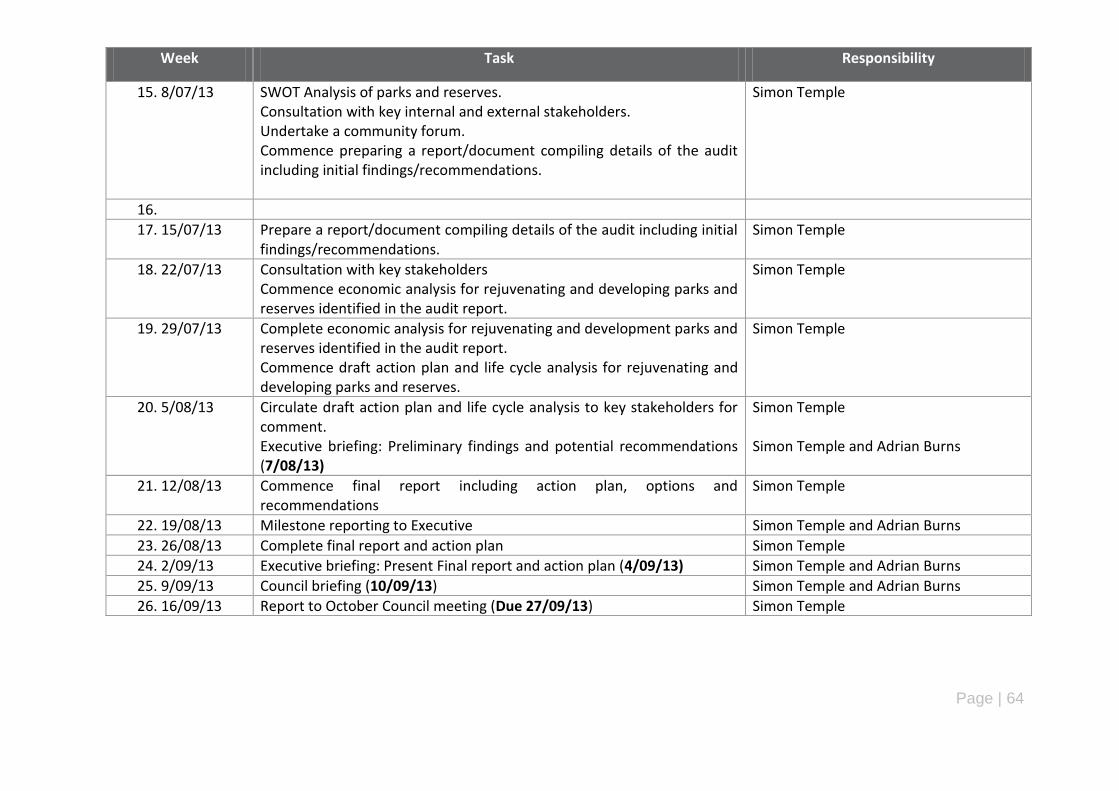
Page | 64
Week Task Responsibility
15. 8/07/13 SWOT Analysis of parks and reserves. Consultation with key internal and external stakeholders. Undertake a community forum. Commence preparing a report/document compiling details of the audit including initial findings/recommendations.
Simon Temple
16.
17. 15/07/13 Prepare a report/document compiling details of the audit including initial findings/recommendations.
Simon Temple
18. 22/07/13 Consultation with key stakeholders Commence economic analysis for rejuvenating and developing parks and reserves identified in the audit report.
Simon Temple
19. 29/07/13 Complete economic analysis for rejuvenating and development parks and reserves identified in the audit report. Commence draft action plan and life cycle analysis for rejuvenating and developing parks and reserves.
Simon Temple
20. 5/08/13 Circulate draft action plan and life cycle analysis to key stakeholders for comment. Executive briefing: Preliminary findings and potential recommendations (7/08/13)
Simon Temple Simon Temple and Adrian Burns
21. 12/08/13 Commence final report including action plan, options and recommendations
Simon Temple
22. 19/08/13 Milestone reporting to Executive Simon Temple and Adrian Burns
23. 26/08/13 Complete final report and action plan Simon Temple
24. 2/09/13 Executive briefing: Present Final report and action plan (4/09/13) Simon Temple and Adrian Burns
25. 9/09/13 Council briefing (10/09/13) Simon Temple and Adrian Burns
26. 16/09/13 Report to October Council meeting (Due 27/09/13) Simon Temple
Page | 65
Appendix C – List of References (Desktop Review)
Bayside City Council (2012) – Bayside Open Space Strategy 2012.
Brimbank City Council (2008) Creating Better Parks – Brimbank Open Space and Playground and Policy Plan May 2008.
City of Greater Dandenong (2009) – Places For People: Open Space in Greater Dandenong May 2009.
Darebin City Council (2011) – Open Space Strategy Site Development Planning May 2011.
Deakin University Australia (2013) Centre for Physical Activity and Nutrition Research
Newsletter 26 August 2013.
Department of Sport and Recreation Western Australia (2012) – Classification framework for
public open space.
Growth Areas Authority (2009) Precinct Structure Planning Guidelines One – Overview of
Planning New Communities.
Hume City Council (2010) – Hume City Council Open Space Strategy 2010-2015.
Melbourne City Council (2012) - City of Melbourne Open Space Strategy: Planning for Future
Growth.
Melton City Council (2013) - Council Plan 2013-2017
Melton City Council (2013) - Disability Action Plan 2013-2017
Melton Shire Council (2011) - Ageing Well Action Plan 2012-2014
Melton Shire Council (2010) - Municipal Early Years Plan 2010-2013
Melton City Council (2013) - Municipal Public Health and Wellbeing Plan (2013-2017)
Melton Shire Council (2003) - Leisure and Open Space Strategy 2004
Parks Victoria (2002) Linking People and Places.

Page | 66
Appendix D - Summary of Parks and Reserves by Suburb
Suburb: Brookfield
Ward: Coburn
Introduction
Brookfield is located to the south-west of Melton Township and is bordered by the Western Freeway
(north), Coburns Road (east), Ballarat-Melbourne railway line (south) and Licina Road (west). It
covers a total area of 1,080 hectares and comprises a mix of new (Botanica Springs) and
established residential development.
Demographic Profile (Current and Future) - Brookfield
Brookfield has a current population of 6,242 people based on the 2011 ABS Census data. This is
expected to more than double to 13,497 people by 2021 and continue increasing to 16,702 people
in 2031.
In 2011, the highest proportion of people are aged 25-29 years (9.4%) followed by 20-24 years
(8.3%) and 0-4 years (8.3%). In 2021, the highest proportion are people aged 30-34 years (9.6%)
followed by 35-39 years (9.2%). In 2031, the highest proportion of people are aged 35-39 years
(8.1%) followed by 5-9 years (2.8%) and 0-4 years (7.6%).
This indicates that the population of Brookfield is predominantly characterised by young people
(single person households and couples with or without children) and that this trend will continue for
the next 20 years. In terms of parks and reserves, there is a need to cater for these age groups by
providing parks and reserves that include play space areas for different age levels and abilities,
seating, rotundas with BBQ‟s and picnic tables, paths, drinking fountains and exercise/fitness
stations.
Existing parks and reserves in Brookfield
A total of 17 parks and reserves are located in Brookfield occupying a total of 83.2 hectares or 9.6%
of the total area of parks and reserves in the City of Melton. This equates to an open space
provision ratio of 13.4 hectares per every 1,000 people in Brookfield. The location of all parks and
reserves is outlined in the map on the next page. This equates to an open space provision ratio of
13.4 hectares per person. The largest park and reserve is 43.7 hectares (Arnold Creek Linear
Reserve (Brooklyn Road) while the smallest is 0.14 hectares (Rupertswood Drive Reserve). The
average size of parks and reserves in Brookfield is 4.9 hectares.
The majority of parks and reserves in Brookfield are waterways, linear parks and trails (7) followed
by neighbourhood parks and reserves (4). The main features of the waterways, linear parks and
trails in Brookfield are shared paths, watercourses (creeks, rivers, streams), landscaping, seating
and waste bins while neighbourhood parks and reserves consist of play space areas, shared paths,
seating, rotundas, BBQ‟s, drinking fountains and landscaping.
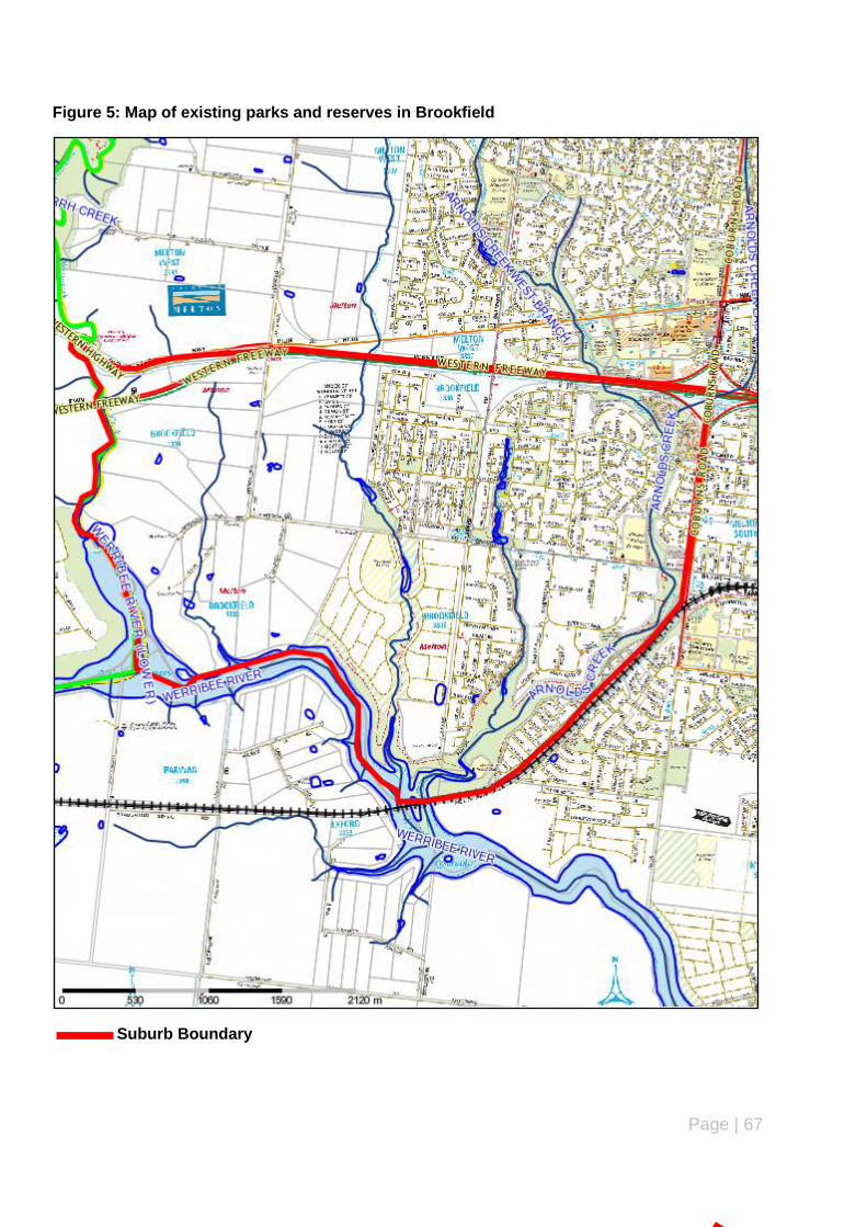
Page | 67
Figure 5: Map of existing parks and reserves in Brookfield
Suburb Boundary
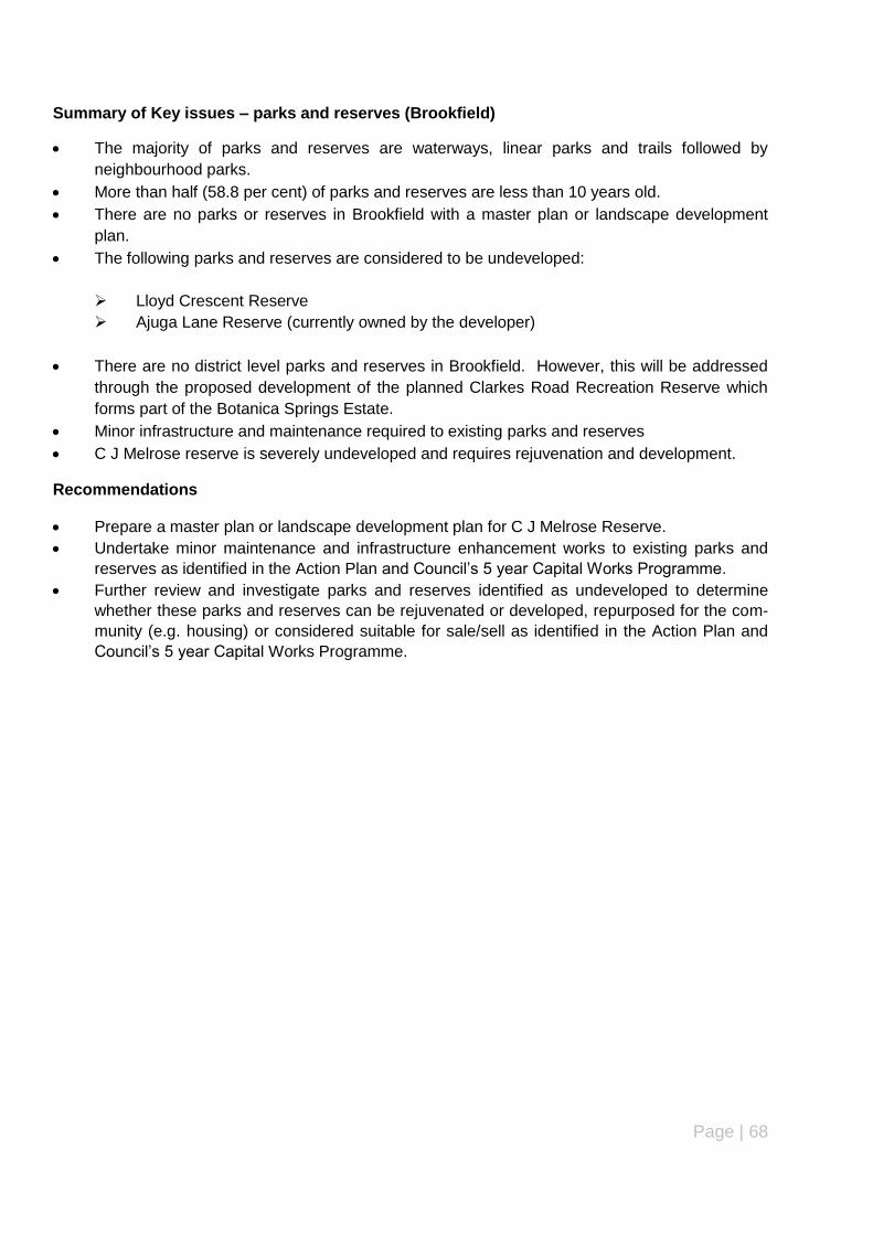
Page | 68
Summary of Key issues – parks and reserves (Brookfield)
The majority of parks and reserves are waterways, linear parks and trails followed by
neighbourhood parks.
More than half (58.8 per cent) of parks and reserves are less than 10 years old.
There are no parks or reserves in Brookfield with a master plan or landscape development
plan.
The following parks and reserves are considered to be undeveloped:
Lloyd Crescent Reserve
Ajuga Lane Reserve (currently owned by the developer)
There are no district level parks and reserves in Brookfield. However, this will be addressed
through the proposed development of the planned Clarkes Road Recreation Reserve which
forms part of the Botanica Springs Estate.
Minor infrastructure and maintenance required to existing parks and reserves
C J Melrose reserve is severely undeveloped and requires rejuvenation and development.
Recommendations
Prepare a master plan or landscape development plan for C J Melrose Reserve.
Undertake minor maintenance and infrastructure enhancement works to existing parks and
reserves as identified in the Action Plan and Council‟s 5 year Capital Works Programme.
Further review and investigate parks and reserves identified as undeveloped to determine
whether these parks and reserves can be rejuvenated or developed, repurposed for the com-
munity (e.g. housing) or considered suitable for sale/sell as identified in the Action Plan and
Council‟s 5 year Capital Works Programme.

Page | 69
Suburb: Burnside
Ward: Cambridge
Introduction
Burnside is located along the north-east boundary of the municipality and is bordered by the
Western Highway (south), municipal boundary with the City of Brimbank (east), Kororoit Creek
(north) and Westwood Drive (west). It covers a total area of 258.8 hectares and comprises
predominantly established residential development.
Demographic Profile (Current and Future) - Burnside
Burnside currently has population of 4,464 people based on the 2011 ABS Census data. This is
expected to increase gradually to 5,390 by 2021 and 5,635 people in 2031.
The highest proportion of people are aged 25-29 years (9.4%) followed by 20-24 years (8.6%) and
0-4 years (8.3%). In 2021, the highest proportion are people will be aged 30-34 years (9.6%)
followed by 35-39 years (9.2%) and 0-4 years/5-9 years (both 8.6%). In 2031, the highest
proportion of people will be aged 35-39 years (8.1%) followed by 30-34 years and 40-44 years (both
8%) and 5-9 years (7.8%).
This indicates that the population of Brookfield is predominantly characterised by young people
(single person households and couples with or without young children). Over the next 20 years, the
key demographic groups will change slightly more towards couples with or without children, less
single person households and children that are slightly older and requiring more advanced play
space equipment and areas for casual ball sports and activities while adults may visit parks and
reserves to supervise children‟s play, rest/relaxation and for social/family activities (e.g.
BBQ‟s/picnicking). In terms of parks and reserves, this suggests a need to develop parks and
reserves that include play space areas for different (older) age levels and abilities, seating, rotundas
with BBQ‟s and picnic tables, paths, drinking fountains and dog on/off leash areas.
Existing parks and reserves - Burnside
There are a total of 7 parks and reserves in Burnside occupying 5.4 hectares of land or 0.6% of total
parks and reserves in the municipality. This equates to an open space provision ratio of 1.2
hectares per every 1,000 people in Burnside. The location of all parks and reserves is outlined in
the map on the next page.
The largest park and reserve is 1.69 hectares (Illawong Terrace Reserve) while the smallest is 0.14
hectares (Jai Court Reserve). The average size of parks and reserves in Burnside is 0.7 hectares.
The majority of parks and reserves in Burnside are local parks (4) followed by neighbourhood parks
(2). There are currently no parks or reserves in Brookfield with an approved master plan. All parks
and reserves (except one) are aged 10-14 years with the other reserve is aged 15-19 years. There
are no parks and reserves aged less than 10 years old or more than 20 years old.
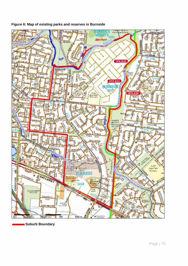
Page | 70
Figure 6: Map of existing parks and reserves in Burnside
Suburb Boundary
Page | 71
Summary of Key issues – parks and reserves (Burnside)
The majority of parks and reserves are local parks followed by neighbourhood parks.
Nearly all parks and reserves are between 10-14 years old except for one reserve that is 15-
19 years old.
There are no parks or reserves in Burnside with a master plan or landscape development
plan.
The following parks and reserves are considered to be undeveloped:
Burnside Watermain Reserve
There are no regional, district or pocket parks and reserves in Brookfield.
Minor infrastructure and maintenance required to existing parks and reserves.
Recommendations
Complete a landscape development plan for Burnside Watermain Reserve.
Undertake minor maintenance and infrastructure enhancement works to existing parks and
reserves as identified in the Action Plan and Council‟s 5 year Capital Works Programme.
Further review and investigate parks and reserves identified as undeveloped to determine
whether these parks and reserves can be rejuvenated or developed, repurposed for the com-
munity (e.g. housing) or considered suitable for sale/sell as identified in the Action Plan and
Council‟s 5 year Capital Works Programme.
Page | 72
Suburb: Burnside Heights
Ward: Cambridge
Introduction
Burnside Heights is located along the eastern boundary of the municipality and is bordered by
Taylors Road (north), Melton-Brimbank municipal boundary (east), Kororoit Creek (south) and
Westwood Drive (west). It covers a total area of 198.1 hectares and comprises recently
established residential development.
Demographic Profile (Current and Future) – Burnside Heights
Burnside Heights has a total population of 5,139 people. This is anticipated to increase to 5,458
people by 2021 before dropping to 5,227 people in 2031. Overall, the population of Burnside
Heights will experience only a very small increase (88 people) between 2011 and 2031.
The highest proportion of people currently living in Burnside Heights are aged 30-34 years (14.3%)
followed by 25-29 years (12.4%) and 0-4 years (11.5%). In 2021, the highest proportion of people
will be aged 40-44 years (9.6%) followed by 5-9 years (9.4%). By 2031, the highest proportion of
people will be aged 50-54 years (7.7%) followed by 0-4 years (7.3%) and 30-34 years (7.2%).
Based on this, it can be seen that the highest number of people are couples (with or without
children) and single person households. This is likely to continue over the next 20 years except that
the population will grow slightly older and there will be a requirement for play space areas with
equipment for different age levels and abilities and facilities to encourage families such as paths,
seating, waste bins, rotundas, picnic tables and BBQ‟s.
Existing parks and reserves – Burnside Heights
There are a total of 9 parks and reserves in Burnside Heights occupying a total area of 24.9
hectares or 2.9% of the total area of parks and reserves in the City of Melton. This equates to an
open space provision ratio of 4.8 hectares per every 1,000 people in Burnside Heights. The location
of all parks and reserves is outlined in the map on the next page.
The largest park and reserve is 8 hectares (Burnside Heights Recreation Reserve) while the
smallest is 0.7 hectares (Freelands Drive Reserve). The average size of parks and reserves in
Burnside Heights is 2.7 hectares. The majority of parks and reserves in Burnside Heights are local
parks (4) followed by waterways, linear parks and trails (3). All parks and reserves in Burnside
Heights are less than 10 years old. Burnside Heights Recreation Reserve is the only park or
reserve with a master plan, which was adopted by Council in 2012.

Page | 73
Figure 7: Map of existing parks and reserves in Burnside Heights
Suburb Boundary

Page | 74
Summary of Key issues – parks and reserves (Burnside Heights)
The majority of parks and reserves are local parks followed by waterways, linear parks and
trails.
All parks and reserves are less than 10 years old.
Burnside Heights Recreation Reserve is the only park and reserve with a master plan or land-
scape development plan.
The following parks and reserves are considered to be undeveloped:
Arbour/Westwood Reserve (Mimosa Way)
Minor infrastructure and maintenance required to existing parks and reserves.
Native Vegetation offsets are located at various locations along the Tenterfield and Arbour
Linear Reserves. These offsets would need to be protected prior to any rejuvenation or de-
velopment works taking place at one of these linear reserves.
Recommendations
Undertake minor maintenance and infrastructure enhancement works to existing parks and
reserves as identified in the Action Plan and Council‟s 5 year Capital Works Programme.
Upgrade existing parks and reserves in accordance with adopted master plans/landscape de-
velopment plans in accordance with the Action Plan and Council‟s 5 year Capital Works Pro-
gramme.
Further review and investigate parks and reserves identified as undeveloped to determine
whether these parks and reserves can be rejuvenated or developed, repurposed for the com-
munity (e.g. housing) or considered suitable for sale/sell as identified in the Action Plan and
Council‟s 5 year Capital Works Programme.
Page | 75
Suburb: Caroline Springs
Ward: Cambridge
Introduction
Caroline Springs is located in the Melton East Corridor, is bordered by Taylors Road (north),
Westwood Drive/Caroline Springs Boulevard (east), Western Highway (south) and Clarkes Road
(west), has a total area of 817.2 hectares and is characterised by a mix of recently established
residential development and new residential development (recently completed or currently under
construction).
Demographic Profile (Current and Future) – Caroline Springs
Caroline Springs has a total population of 20,944 people. This is anticipated to increase to 24,083
people by 2021 before experiencing a slight decline to 22,506 people in 2031. Overall, the
population of Caroline Springs will increase (1,562 people) between 2011 and 2031.
In 2011, the highest number and percentage of people were aged 35-39 years followed by 30-34
years and 0-4 years which, indicates that a high number of young couples with/without children and
single person households are living in Caroline Springs. By 2021, the highest number and
percentage of people will be aged 40-44 years (9.2%) followed by 5-9 years (8.5%) and 35-39 years
and 0-4 years (both 8.4%). In 2031, the highest number and percentage of people will be aged 50-
54 years (7.7%) followed by 45-49 years (7.6%) and 40-44 years (7.5%).
Couples with children currently make up half (50.1%) of the population in Caroline Springs followed
by Couples without children (26.5%) and One parent families (9.4%). This is expected to change
over the next 20 years with a gradual decline in couples with children and a sharp increase in single
person households (from 9.4% to 16.8%) while Couples without children will remain steady (28.6%).
This coincides with the highest total increase in the number of people aged between 55-59 years
and 50-54 years and the largest decrease in people aged 35-39 years. Over the next 20 years,
the focus in relation to parks and reserves will need to shift from young couples with or with children
to older people with teenagers and young adult children who do not require play space areas and
may be more interested in casual play or sports facilities (e.g. skate parks, multi-purpose courts)
and parks/reserves with shared paths to encourage cycling, walking and jogging and
BBQ/picnicking areas for social/family activities.
Existing parks and reserves – Caroline Springs
Caroline Springs has the largest number (74) of parks and reserves in the municipality occupying
a total of 123 hectares of land or 14.3% (second highest) of the total amount of land occupied by
parks and reserves in the municipality. This equates to a ratio of 5.8 hectares per every 1,000
people in Caroline Springs. The location of all parks and reserves is outlined in the map on the next
page.
The majority of parks and reserves are waterways, linear parks and trails (33) followed by local
parks (17) and neighbourhood parks (10). Almost three quarters (73%) of parks and reserves in
Caroline Springs are less than 10 years old. This increases to 98.6% when you include parks and
reserves that are less than 15 years old
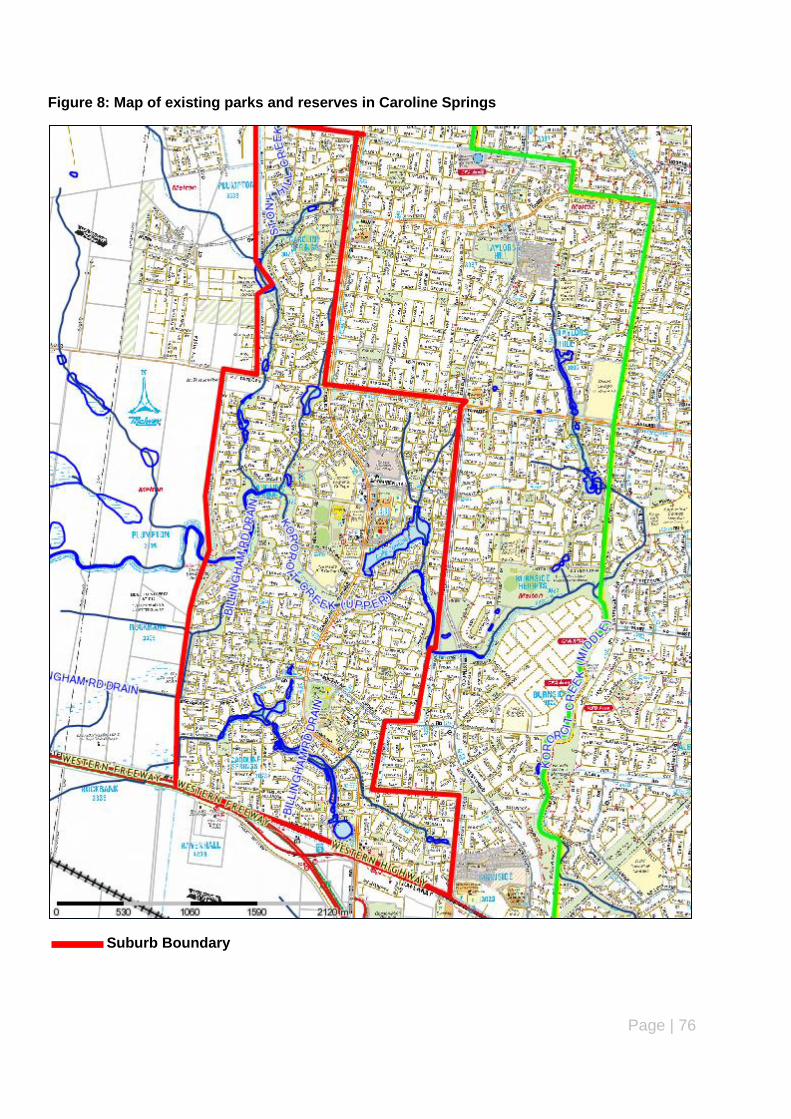
Page | 76
Figure 8: Map of existing parks and reserves in Caroline Springs
Suburb Boundary
Page | 77
Master plans have been prepared and adopted by Council for the following parks and reserves:
Brookside Recreation Reserve (May 2010).
Caroline Springs Town Centre Recreation Reserve (2007).
Summary of Key issues – parks and reserves (Caroline Springs)
The majority of parks and reserves are waterways, linear parks and trails, local parks and
neighbourhood parks.
Almost three quarters (73%) of parks and reserves in Caroline Springs are less than 10 years
old.
There are no parks and reserves in Caroline Springs that are considered to be undeveloped.
The condition of infrastructure and equipment is either brand new or very good. Minor infra-
structure and maintenance are required to existing parks and reserves. However, in most
cases, this is not a high priority.
Recommendations
Undertake minor maintenance and infrastructure enhancement works to existing parks and
reserves as identified in the Action Plan and Council‟s 5 year Capital Works Programme.
Upgrade existing parks and reserves in accordance with adopted master plans/landscape de-
velopment plans in accordance with the Action Plan and Council‟s 5 year Capital Works Pro-
gramme.

Page | 78
Suburb Name: Diggers Rest
Ward: Watts
Introduction
Diggers Rest is a small township located at the north-eastern edge of the municipality and is
bordered by Macedon Ranges Shire Council (north), Calder Freeway (east), Holden Road (south)
and Kororoit Creek (west). Diggers Rest has a total area of 5,411 hectares and is characterised by
well established residential developed.
Demographic Profile (Current and Future) – Diggers Rest
Diggers Rest has a total population of 1,907 people. This is anticipated to increase to 4,270 people
by 2021 and will almost double to 7,813 people in 2031. Overall, the population of Diggers Rest will
increase by 5,906 people between 2011 and 2031.
According to the 2011 ABS Census, the majority of people in Diggers Rest are currently aged 15-19
years (8.7%) followed by 25-29 years and 55-59 years (both 7.7%). By 2021, the highest
percentage of people will be aged 25-29 years (11.6%) followed by 30-34 years (10.7%) and 0-4
years (9.7%). In 2031, the highest percentage of people will be aged 30-34 years (9.9%) followed
by 35-39 years (9.8%) and 20-25 years (5.5%).
The main household types in Diggers Rest are couples with children, single person households and
couples without children. This will continue over the next 20 years. The biggest increase will occur
in people aged 35-39 years (662 people) and 30-34 years (633 people). This reflects a significant
shift from couples with teenage or adult children to couples with young children. This has been
recognised by Council and the State Government as a precinct structure plan has been prepared
and approved (check) for Diggers Rest to accommodate the anticipated increase in population over
the next 20 years.
Existing parks and reserves - Diggers Rest
There are a total of 5 parks and reserves in Diggers Rest occupying a total area of 12.4 hectares or
1.4 per cent of the total area of parks and reserves in the municipality. This equates to a ratio of 6.5
hectares per every 1,000 people in Caroline Springs. The location of all parks and reserves is
outlined in the map on the next page.
Parks and reserves in Diggers Rest range from district parks to pocket parks. The most number of
parks and reserves are neighbourhood parks (2). All parks and reserves are more than 15 years
old with the most (2) being 25-29 years old. Master plans have been prepared and approved by
Council for the Diggers Rest Recreation Reserve (2007) and the Stan Payne Reserve (2007).
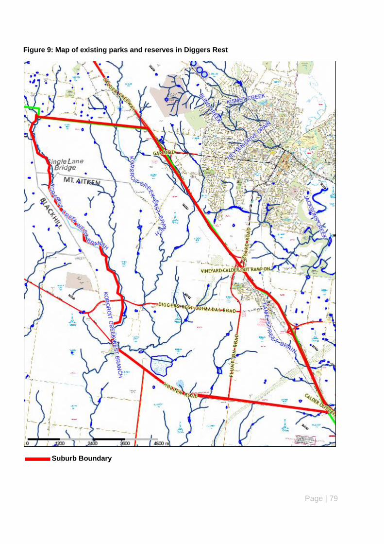
Page | 79
Figure 9: Map of existing parks and reserves in Diggers Rest
Suburb Boundary
Page | 80
Summary of Key issues – parks and reserves (Diggers Rest)
The majority of parks and reserves are neighbourhood parks.
All parks and reserves are more than 15 years old.
There are no parks and reserves less than 15 years old. However, this is likely to change with
the provision of additional parks and reserves as part of the approved Diggers Rest Precinct
Structure Plan.
The following parks and reserves are considered to be undeveloped:
Punjel Drive Reserve (existing play space could be re-located to Stan Payne Reserve)
Recommendations
Undertake minor maintenance and infrastructure enhancement works to existing parks and
reserves as identified in the Action Plan and Council‟s 5 year Capital Works Programme.
Upgrade existing parks and reserves in accordance with adopted master plans/landscape de-
velopment plans in accordance with the Action Plan and Council‟s 5 year Capital Works Pro-
gramme.
Further review and investigate parks and reserves identified as undeveloped to determine
whether these parks and reserves can be rejuvenated or developed, repurposed for the com-
munity (e.g. housing) or considered suitable for sale/sell as identified in the Action Plan and
Council‟s 5 year Capital Works Programme.

Page | 81
Suburb: Exford
Ward: Cambridge
Introduction
Exford is a small village located in the south-west of the municipality, covers a total area of 1,100
hectares and is bordered by the Werribee River (north), Exford Road (east), Exford Road (south)
and Telephone Road (west). Exford is located between the suburbs of Melton South (north and
east) and Eynesbury (south) and is characterised by rural and rural-residential land use and
development.
Demographic Profile (Current and Future)
Exford has a total population of 92 people. There is no data available in relation to the projected
population for Exford in 2021 and 2031.
Existing parks and reserves - Exford
There are only 2 parks and reserves currently located in Exford – Exford Reserve and Hickey Road
Reserve which are both classified as local parks. These parks and reserves occupy a total area of
2.3 hectares or 0.3 per cent of the total area of parks and reserves in the City of Melton. This also
equates to a ratio of 2.5 hectares per every 1,000 people in Exford. The age of both reserves is
unknown. No master plans or landscape development plans have been prepared for either reserve.
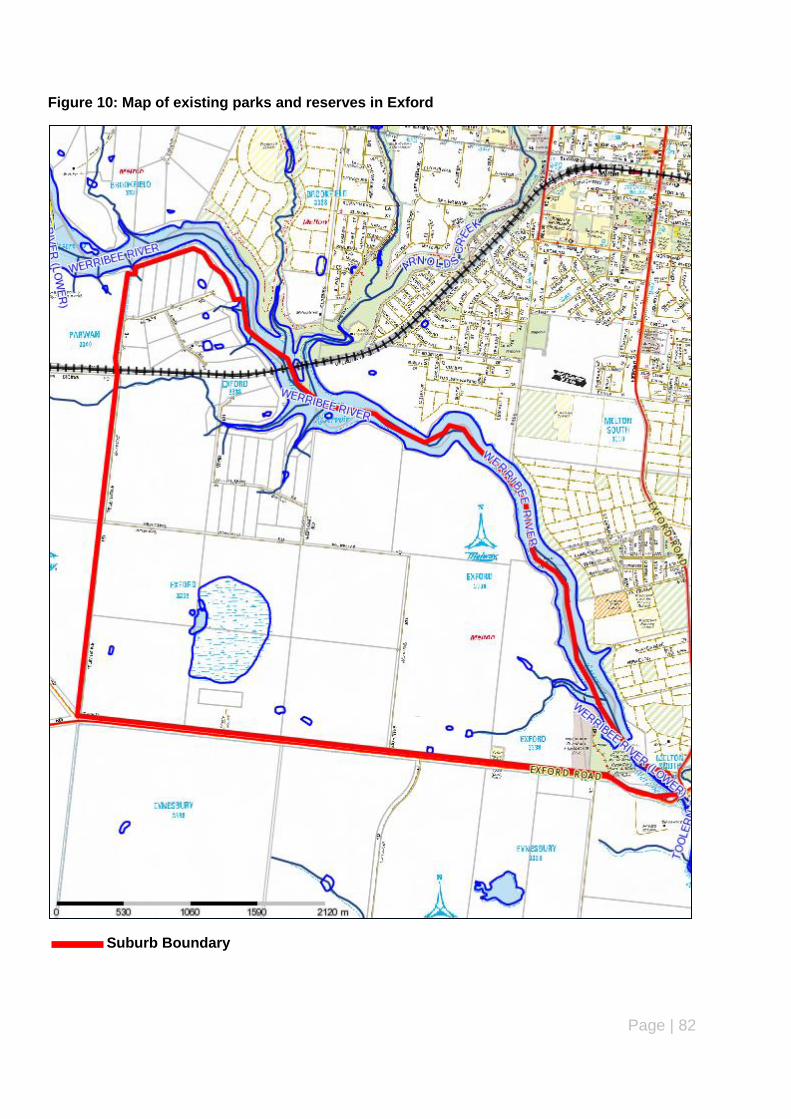
Page | 82
Figure 10: Map of existing parks and reserves in Exford
Suburb Boundary
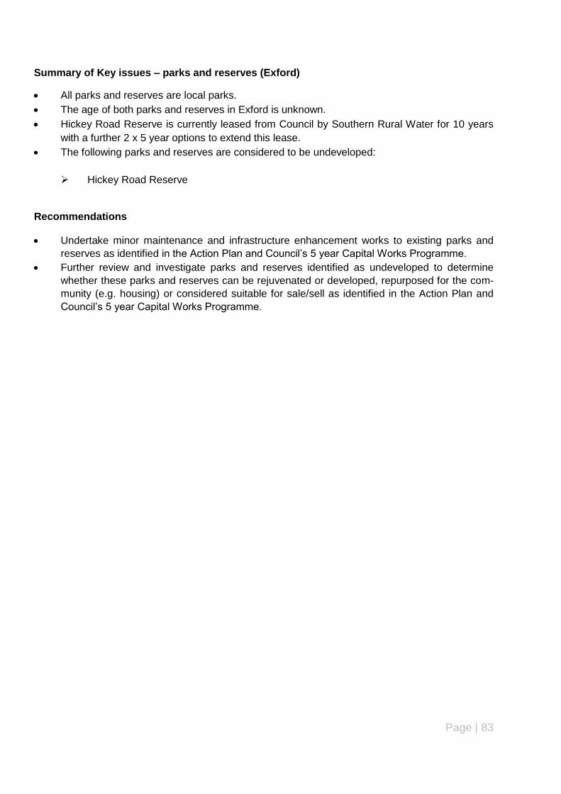
Page | 83
Summary of Key issues – parks and reserves (Exford)
All parks and reserves are local parks.
The age of both parks and reserves in Exford is unknown.
Hickey Road Reserve is currently leased from Council by Southern Rural Water for 10 years
with a further 2 x 5 year options to extend this lease.
The following parks and reserves are considered to be undeveloped:
Hickey Road Reserve
Recommendations
Undertake minor maintenance and infrastructure enhancement works to existing parks and
reserves as identified in the Action Plan and Council‟s 5 year Capital Works Programme.
Further review and investigate parks and reserves identified as undeveloped to determine
whether these parks and reserves can be rejuvenated or developed, repurposed for the com-
munity (e.g. housing) or considered suitable for sale/sell as identified in the Action Plan and
Council‟s 5 year Capital Works Programme.

Page | 84
Suburb: Eynesbury
Ward: Cambridge
Introduction
A relatively new township located at the south-west corner of the municipality. Eynesbury occupies
a total area of 3,154 hectares and is bordered by Exford Road (north), Werribee River (east),
Springhill Road (south) and the municipal boundary with Moorabool Shire (west). Eynesbury
consists of relatively new residential development including vacant residential allotments and
dwellings currently under construction.
Demographic Profile (Current and Future) - Eynesbury
Eynesbury has a total population of 682 people. This is anticipated to significantly increase to 5,197
people by 2021 and to 9,332 people in 2031. Overall, the population of Eynesbury will increase by
8,056 people between 2011 and 2031.
According to the 2011 ABS Census, the majority of people living in Eynesbury are aged 30-34 years
(14.8%) followed by 0-4 years (12.3%) and 35-39 years (11.5%). By 2021, these age groups will
still make up the majority of people living in Eynesbury with a decline in the proportion of people
aged 50-54 years and 55-59 years. The same trend will continue in 2031 with these age groups
continuing to make up the majority of people living in Eynesbury, however, there will be a significant
increase in the people aged 50-54 years and 55-59 years as a proportion of the total population in
Eynesbury.
The main household types in Eynesbury are couples with children, couples without children and
single person households. This will continue to be the same over the next 20 years with the biggest
overall increase occurring in people aged 35-39 years (662 people) and 30-34 years (633 people).
Existing parks and reserves – Eynesbury
Eynesbury has a total of 12 parks and reserves occupying a total area of 9.2 hectares or 1.1 per
cent of total parks and reserves in the City of Melton. This will equate to a ratio of 13.4 hectares per
every 1,000 people in Eynesbury. The location of all parks and reserves is outlined in the map on
the next page.
The majority of parks and reserves in Eynesbury are waterways, linear parks and trails (6) and
pocket parks (3). A golf course is also located in the township around the existing homestead. All
parks and reserves are less than 10 years old which reflects the relatively recent establishment of
Eynesbury and its ongoing development to accommodate the anticipated substantial population
growth outlined above.
A new recreation reserve is planned for Eynesbury with a master plan prepared and adopted by
Council in 2012.

Page | 85
Figure 11: Map of existing parks and reserves in Eynesbury
Suburb Boundary

Page | 86
Summary of Key issues – parks and reserves (Eynesbury)
The majority of parks and reserves are waterways, linear parks and trails and pocket parks.
All parks and reserves in Eynesbury are less than 10 years old.
There are no parks and reserves in Eynesbury that are considered to be undeveloped.
The condition of infrastructure and equipment is either brand new or very good. Minor infra-
structure and maintenance are required to existing parks and reserves. However, in most
cases, this is not a high priority.
Recommendations
Undertake minor maintenance and infrastructure enhancement works to existing parks and
reserves as identified in the Action Plan and Council‟s 5 year Capital Works Programme.
Upgrade existing parks and reserves in accordance with adopted master plans/landscape de-
velopment plans in accordance with the Action Plan and Council‟s 5 year Capital Works Pro-
gramme.

Page | 87
Suburb: Hillside
Ward: Watts
Introduction
Hillside forms part of the Melton East Corridor and is separated into two sections by a main road
(Keilor-Melton Road/Melton Highway) which connects it to Melton Township. The section of
Hillside north of Keilor-Melton Road/Melton Highway is bordered by the urban growth boundary
(north), municipal boundary with Brimbank Council (east), Keilor-Melton Road/Melton Highway
(south) and Plumpton (west). The top half of this section is located within the Melbourne Airport
flight path and is subsequently affected by the Melbourne Airport Environs Overlay under the Melton
Planning Scheme.
The section of Hillside south of Keilor-Melton Road/Melton Highway is bordered by this road to the
north, municipal boundary with Brimbank Council (east), Caroline Springs/Taylors Hill (south) and
Plumpton (west). Hillside has a total area of 776 hectares.
Demographic Profile (Current and future)
Hillside has a total population of 15,606 people. This is anticipated to increase slightly to 15, 881
people by 2021 before experiencing a slight decline to 15,508 people in 2031. Overall, the
population of Hillside will experience a small decrease (98 people) between 2011 and 2031.
In 2011, the majority of people in Hillside were aged 35-39 years (10.1%) followed by people aged
40-44 years (9.5 %) and 5-9 years (9.4%). This is expected to change in 2021 with the majority of
people aged 5-9 years (8.5%) followed by 45-49 years (8.3%). By 2031, the population in Hillside
will be fairly evenly distributed across the majority of age groups with the slight majority aged 5-9
years (7.7%) followed by 10-14 years (7.5%).
Couples with children currently make up more than half (58.6%) of the population in Hillside
followed by Couples without children (21.4%) and One parent families (9.4%). This is expected to
change over the next 20 years with a gradual decline in couples with children, slight increase in
couples without children and a change with single person households becoming more prominent
than one parent families.
The highest overall increase in the number of people will be in the 60-64 age group (655 people)
while the biggest decrease will occur in the 30-34 year age group (decrease of 512 people).
Over the next 20 years, the focus in relation to parks and reserves will need to shift from young
couples with or with children to older people with adult children who do not require play space areas
and may be more interested in sports facilities and parks/reserves with shared paths to encourage
cycling, walking and jogging, dog on/off leash areas and BBQ/picnicking areas for social/family
activities.
Existing parks and reserves - Hillside
A total of 27 parks and reserves are located in Hillside occupying a total area of 41.3 hectares or 4.8
per cent of total parks and reserves in the City of Melton. This equates to a ratio of 2.6 hectares
per 1,000 people in Hillside. The majority of parks and reserves are local parks (12) followed by
neighbourhood parks (6). More than half of the parks and reserves in Hillside are between 5 and 15

Page | 88
years of age. The majority (19 out of 27) of parks and reserves are located in the northern section
of Hillside while the remainder are located in the southern section.
Figure 12: Map of existing parks and reserves in Hillside
Suburb Boundary
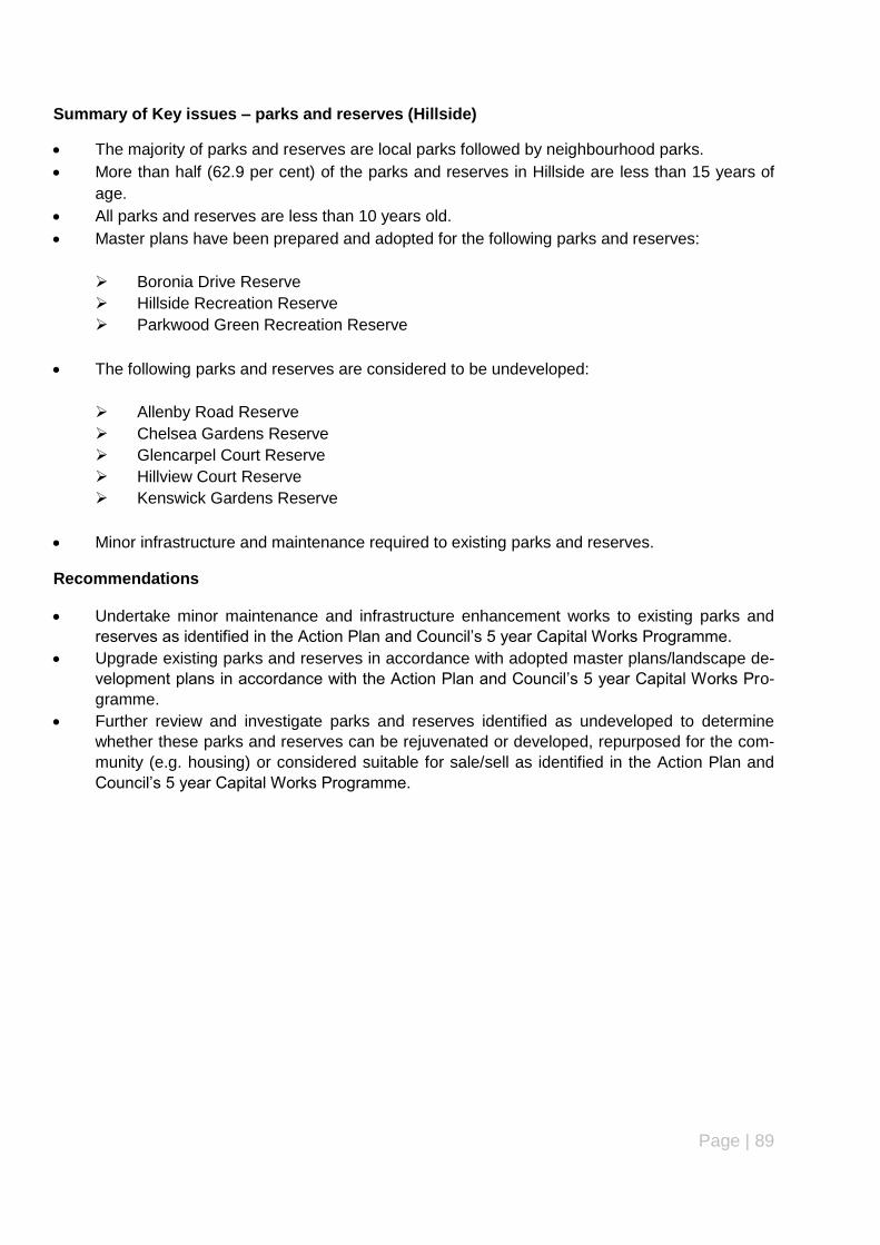
Page | 89
Summary of Key issues – parks and reserves (Hillside)
The majority of parks and reserves are local parks followed by neighbourhood parks.
More than half (62.9 per cent) of the parks and reserves in Hillside are less than 15 years of
age.
All parks and reserves are less than 10 years old.
Master plans have been prepared and adopted for the following parks and reserves:
Boronia Drive Reserve
Hillside Recreation Reserve
Parkwood Green Recreation Reserve
The following parks and reserves are considered to be undeveloped:
Allenby Road Reserve
Chelsea Gardens Reserve
Glencarpel Court Reserve
Hillview Court Reserve
Kenswick Gardens Reserve
Minor infrastructure and maintenance required to existing parks and reserves.
Recommendations
Undertake minor maintenance and infrastructure enhancement works to existing parks and
reserves as identified in the Action Plan and Council‟s 5 year Capital Works Programme.
Upgrade existing parks and reserves in accordance with adopted master plans/landscape de-
velopment plans in accordance with the Action Plan and Council‟s 5 year Capital Works Pro-
gramme.
Further review and investigate parks and reserves identified as undeveloped to determine
whether these parks and reserves can be rejuvenated or developed, repurposed for the com-
munity (e.g. housing) or considered suitable for sale/sell as identified in the Action Plan and
Council‟s 5 year Capital Works Programme.
Page | 90
Suburb Name: Kurunjang
Ward: Coburn
Introduction
Kurunjang forms part of the Melton Township and is an established residential area bordered by
Toolern Vale (north), Toolern Creek (east), Centenary Avenue (south) and Coburns Road (west).
The total area of Kurunjang is 1,034 hectares.
Demographic Profile (Current and Future) - Kurunjang
Kurunjang has a total population of 9,471 people. This is anticipated to increase to 11,505 people
by 2021 and 11,238 people in 2031. Overall, the population of Kurunjang will experience an
increase of 1,767 people between 2011 and 2031. The biggest increase will be among people aged
65-69 years while the biggest decrease will be among people aged 20-24 years.
The majority of people in Kurunjang are aged 30-34 years (8.6%) followed by people aged 25-29
years (8.5%) and 20-24 years (8.2%). In 2021, the majority of people will be aged 25-29 years and
0-4 years (both (8.2%) followed by 5-9 years (8.1%). By 2031, the majority of people living in
Kurunjang will be aged 5-9 years (7.5%) followed by 0-4 years (7.3%) and 35-39 years (7.2%).
Couples with children currently make up the majority (43.56%) of the population in Kurunjang
followed by Couples without children (25.5%) and One parent families (13.5%). This is expected to
change over the next 20 years with a gradual decline in couples with children, slight increase in
couples without children and a change with single person households becoming more prominent
than one parent families.
Existing parks and reserves – Kurunjang
A total of 22 parks and reserves are located in Kurunjang occupying a total area of 92.6 hectares or
10.7 per cent of the total area of parks and reserves in the City of Melton. This equates to a ratio of
9.8 hectares per 1,000 people in Kurunjang. The average size of a park or reserve in Kurunjang is
4.4 hectares. The location of parks and reserves in Kurunjang are shown on the map on the next
page.
The majority of parks and reserves are waterways, linear parks and trails (6) followed by
neighbourhood parks and small (pocket) parks (both 5). The majority of parks and reserves are
more than 20 years old, however, there are also a number of parks and reserves less than 10 years
old which reflects the wide diversity in the age of parks and reserves in Kurunjang.
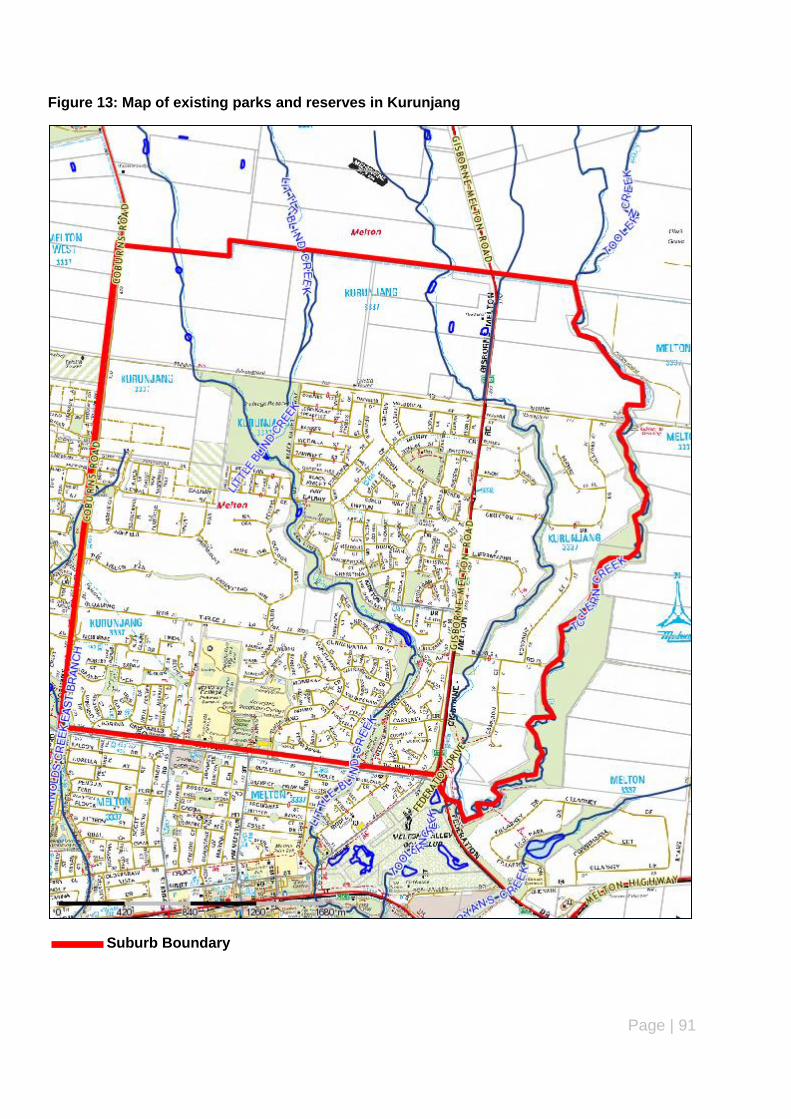
Page | 91
Figure 13: Map of existing parks and reserves in Kurunjang
Suburb Boundary

Page | 92
Summary of Key issues – parks and reserves (Kurunjang)
The majority of parks and reserves are waterways, linear parks and trails, neighbourhood
parks and small (pocket) parks.
More than half (59 per cent) of parks and reserves are more than 20 years old, however, there
are also a number of parks and reserves less than 10 years old.
Master plans have been prepared and adopted for the following parks and reserves:
Archer Drive Reserve
Kurunjang Recreation Reserve
The following parks and reserves are considered to be undeveloped:
Buckle Road Reserve
Gisborne Melton Road Park
Dougal Court Reserve
Little Blind Creek Linear Reserve (Gunnawarra Rd-Centenary Ave)
Nightmarch Place Reserve
Smoult Drive Drainage Reserve
Smoult Drive Reserve
Minor infrastructure and maintenance required to existing parks and reserves.
Recommendations
Undertake minor maintenance and infrastructure enhancement works to existing parks and
reserves as identified in the Action Plan and Council‟s 5 year Capital Works Programme.
Upgrade existing parks and reserves in accordance with adopted master plans/landscape de-
velopment plans in accordance with the Action Plan and Council‟s 5 year Capital Works Pro-
gramme.
Further review and investigate parks and reserves identified as undeveloped to determine
whether these parks and reserves can be rejuvenated or developed, repurposed for the com-
munity (e.g. housing) or considered suitable for sale/sell as identified in the Action Plan and
Council‟s 5 year Capital Works Programme.
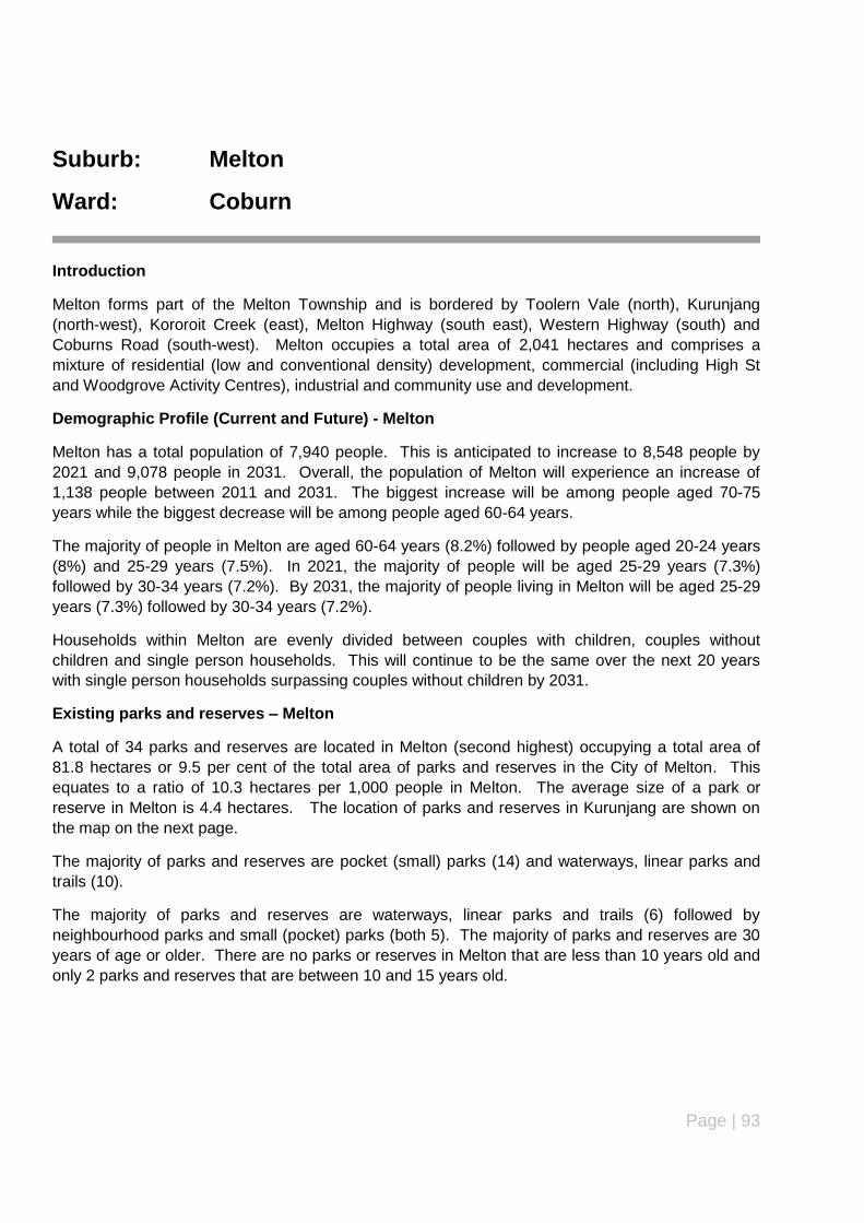
Page | 93
Suburb: Melton
Ward: Coburn
Introduction
Melton forms part of the Melton Township and is bordered by Toolern Vale (north), Kurunjang
(north-west), Kororoit Creek (east), Melton Highway (south east), Western Highway (south) and
Coburns Road (south-west). Melton occupies a total area of 2,041 hectares and comprises a
mixture of residential (low and conventional density) development, commercial (including High St
and Woodgrove Activity Centres), industrial and community use and development.
Demographic Profile (Current and Future) - Melton
Melton has a total population of 7,940 people. This is anticipated to increase to 8,548 people by
2021 and 9,078 people in 2031. Overall, the population of Melton will experience an increase of
1,138 people between 2011 and 2031. The biggest increase will be among people aged 70-75
years while the biggest decrease will be among people aged 60-64 years.
The majority of people in Melton are aged 60-64 years (8.2%) followed by people aged 20-24 years
(8%) and 25-29 years (7.5%). In 2021, the majority of people will be aged 25-29 years (7.3%)
followed by 30-34 years (7.2%). By 2031, the majority of people living in Melton will be aged 25-29
years (7.3%) followed by 30-34 years (7.2%).
Households within Melton are evenly divided between couples with children, couples without
children and single person households. This will continue to be the same over the next 20 years
with single person households surpassing couples without children by 2031.
Existing parks and reserves – Melton
A total of 34 parks and reserves are located in Melton (second highest) occupying a total area of
81.8 hectares or 9.5 per cent of the total area of parks and reserves in the City of Melton. This
equates to a ratio of 10.3 hectares per 1,000 people in Melton. The average size of a park or
reserve in Melton is 4.4 hectares. The location of parks and reserves in Kurunjang are shown on
the map on the next page.
The majority of parks and reserves are pocket (small) parks (14) and waterways, linear parks and
trails (10).
The majority of parks and reserves are waterways, linear parks and trails (6) followed by
neighbourhood parks and small (pocket) parks (both 5). The majority of parks and reserves are 30
years of age or older. There are no parks or reserves in Melton that are less than 10 years old and
only 2 parks and reserves that are between 10 and 15 years old.
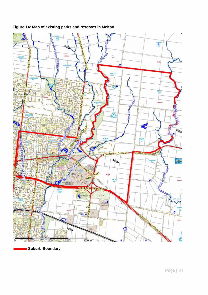
Page | 94
Figure 14: Map of existing parks and reserves in Melton
Suburb Boundary
Page | 95
Summary of Key issues – parks and reserves (Melton)
The majority of parks and reserves are waterways, linear parks and trails (6) followed by
neighbourhood parks and small (pocket) parks
More than half (59 per cent) of parks and reserves are more than 20 years old, however, there
are also a number of parks and reserves less than 10 years old.
Master plans have been prepared and adopted for the following parks and reserves:
Melton Botanic Gardens
Melton Recreation Reserve
Sirdar Street Reserve
The following parks and reserves are considered to be undeveloped:
Brixton Place Reserve
Damian Street Reserve
Duke Court Reserve
Inez Court Reserve
Milverston Street Reserve
Police Paddock Reserve
Pound Paddock Reserve
Rosina Drive East Reserve
Yuille Street Reserve
Minor infrastructure and maintenance required to existing parks and reserves.
Recommendations
Undertake minor maintenance and infrastructure enhancement works to existing parks and
reserves as identified in the Action Plan and Council‟s 5 year Capital Works Programme.
Upgrade existing parks and reserves in accordance with adopted master plans/landscape de-
velopment plans in accordance with the Action Plan and Council‟s 5 year Capital Works Pro-
gramme.
Further review and investigate parks and reserves identified as undeveloped to determine
whether these parks and reserves can be rejuvenated or developed, repurposed for the com-
munity (e.g. housing) or considered suitable for sale/sell as identified in the Action Plan and
Council‟s 5 year Capital Works Programme.

Page | 96
Suburb: Melton South
Ward: Coburn
Introduction
Melton South is an established suburb which forms part of the Melton Township and is bordered by
the Western Highway (north), Mount Cottrell Road (east), Greigs Road (south) and Coburns
Rd/Rees Road/ Ballarat-Melbourne Railway line and Werribee River (west). The total area of
Melton South is 3,007 hectares.
Demographic Profile (Current and Future) – Melton South
Melton South has a total population of 8,722 people. This is anticipated to increase to 11,328
people by 2021 and 12,986 people in 2031. Overall, the population of Melton will experience an
increase of 4,264 people between 2011 and 2031. The biggest increase will be among people aged
40-44 years while the biggest decrease will be among people aged 55-59 years.
The majority of people in Melton South are aged 20-24 years (8.1%), 55-59 years (7.8%) and 0-4
years (7.7%). In 2021, the majority of people will be aged 30-34 years (8.8%), 0-4 years (8.4%) and
25-29 years (8.3%). By 2031, the majority of people living in Melton South will be aged 30-34 years
(8%), 0-4 years (7.8%) and 0-9/25-29 years (both 7.3%).
Households within Melton South are evenly divided between couples with children, couples without
children and single person households. This will continue to be the same over the next 20 years
with single person households surpassing both couples with children and couples without children
to become the predominant household type by 2031.
Existing parks and reserves – Melton South
Melton South has a total of 26 parks and reserves. Parks and reserves in Melton South occupy a
total area of 127.2 hectares or 14.7 per cent of the total area of parks and reserves in the
municipality. This equates to 14.6 hectares per 1,000 people in Melton South. The location of all
parks and reserves in Melton South is shown on the map below (see next page).
The largest park or reserve is 54.2 hectares (Toolern Creek Linear Reserve – Strathtulloh Circuit)
while the smallest park or reserve is 0.21 hectares (Acacia Crescent Reserve). The average size of
a park or reserve in Melton South is 4.9 hectares.
The majority of parks and reserves are local parks (10) and waterways, linear parks and trails (6).
The majority of parks and reserves are 25 years of age or older. There are 4 parks and reserves
less than 5 years old, no parks or reserves between 5 and 15 years old and 6 parks or reserves
between 15 and 25 years old.
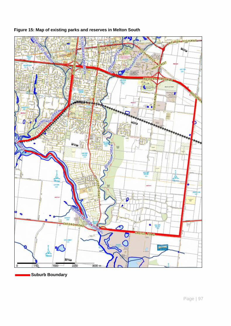
Page | 97
Figure 15: Map of existing parks and reserves in Melton South
Suburb Boundary
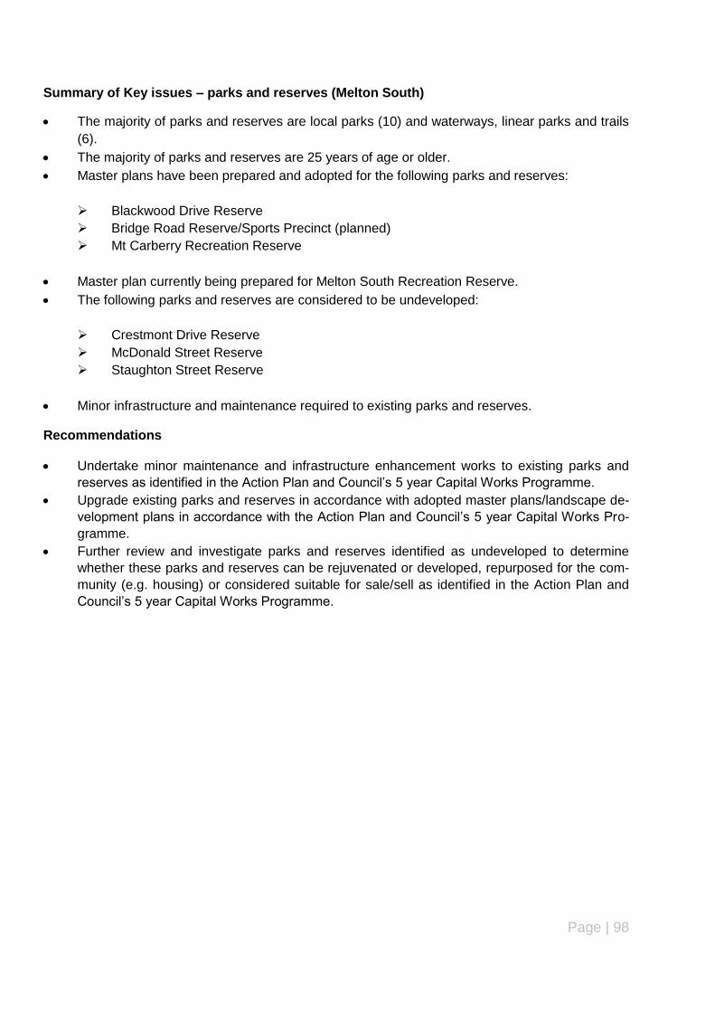
Page | 98
Summary of Key issues – parks and reserves (Melton South)
The majority of parks and reserves are local parks (10) and waterways, linear parks and trails
(6).
The majority of parks and reserves are 25 years of age or older.
Master plans have been prepared and adopted for the following parks and reserves:
Blackwood Drive Reserve
Bridge Road Reserve/Sports Precinct (planned)
Mt Carberry Recreation Reserve
Master plan currently being prepared for Melton South Recreation Reserve.
The following parks and reserves are considered to be undeveloped:
Crestmont Drive Reserve
McDonald Street Reserve
Staughton Street Reserve
Minor infrastructure and maintenance required to existing parks and reserves.
Recommendations
Undertake minor maintenance and infrastructure enhancement works to existing parks and
reserves as identified in the Action Plan and Council‟s 5 year Capital Works Programme.
Upgrade existing parks and reserves in accordance with adopted master plans/landscape de-
velopment plans in accordance with the Action Plan and Council‟s 5 year Capital Works Pro-
gramme.
Further review and investigate parks and reserves identified as undeveloped to determine
whether these parks and reserves can be rejuvenated or developed, repurposed for the com-
munity (e.g. housing) or considered suitable for sale/sell as identified in the Action Plan and
Council‟s 5 year Capital Works Programme.

Page | 99
Suburb: Melton West
Ward: Coburn
Introduction
Melton West is a relatively new suburb located on the western edge of the Melton Township
comprising a mix of established residential and rural residential use/development and new
residential development (under construction). It is bordered by Toolern Vale (north), Coburns Road
(east), Old Western Highway (south), Djerrwarrah Creek (west) and has a total area of 2,621
hectares.
Demographic Profile (Current and Future) – Melton West
Melton West has a total population of 14,546 people. This is anticipated to increase dramatically to
20,375 by 2021 and 24,887 people in 2031. Overall, the population of Melton will experience an
increase of 10, 341 people between 2011 and 2031. The biggest increase will be among people
aged 35-39 years and there will be no decrease in population across any age group in Melton West.
The majority of people in Melton West are aged 25-29 years (9.0%), 0-4 years (8.9%) and 30-34
years (8.4%). In 2021, the majority of people will be aged 30-34 years (8.5%), 5-9 years (8.3%) and
35-39 years (8.2%). By 2031, the majority of people living in Melton West will be aged 30-34 years
(8%), 35-39 years (7.8%) and 5-9 years (7.7%).
Households within Melton West are predominantly couples with children (41.5%), couples without
children (26.1%) and single person households (14.1%). This will continue to be the same over the
next 20 years with the exception that single person households will be more popular than couples
without children by 2031.
Existing parks and reserves – Melton West
Melton West currently has a total 28 parks and reserves occupying a total area of 84.7 hectares or
9.8 per cent of the total area of parks and reserves in the municipality. This equates to 5.8 hectares
per 1,000 people in Melton West.
The majority of parks and reserves are local parks and waterways, linear parks and trails. Exactly
half the number of parks and reserves in Melton West are less than 10 years old. There are no
parks or reserves that are more than 30 years old. The largest park or reserve is 17.7 hectares
(Navan Park) while the smallest park or reserve is 936.5 square metres (Bill‟s Park). The average
size of a park or reserve in Melton West is 4 hectares.
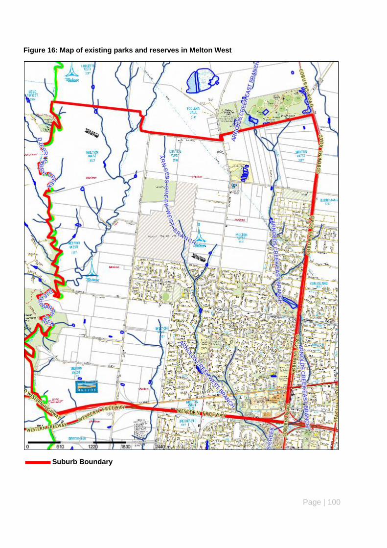
Page | 100
Figure 16: Map of existing parks and reserves in Melton West
Suburb Boundary
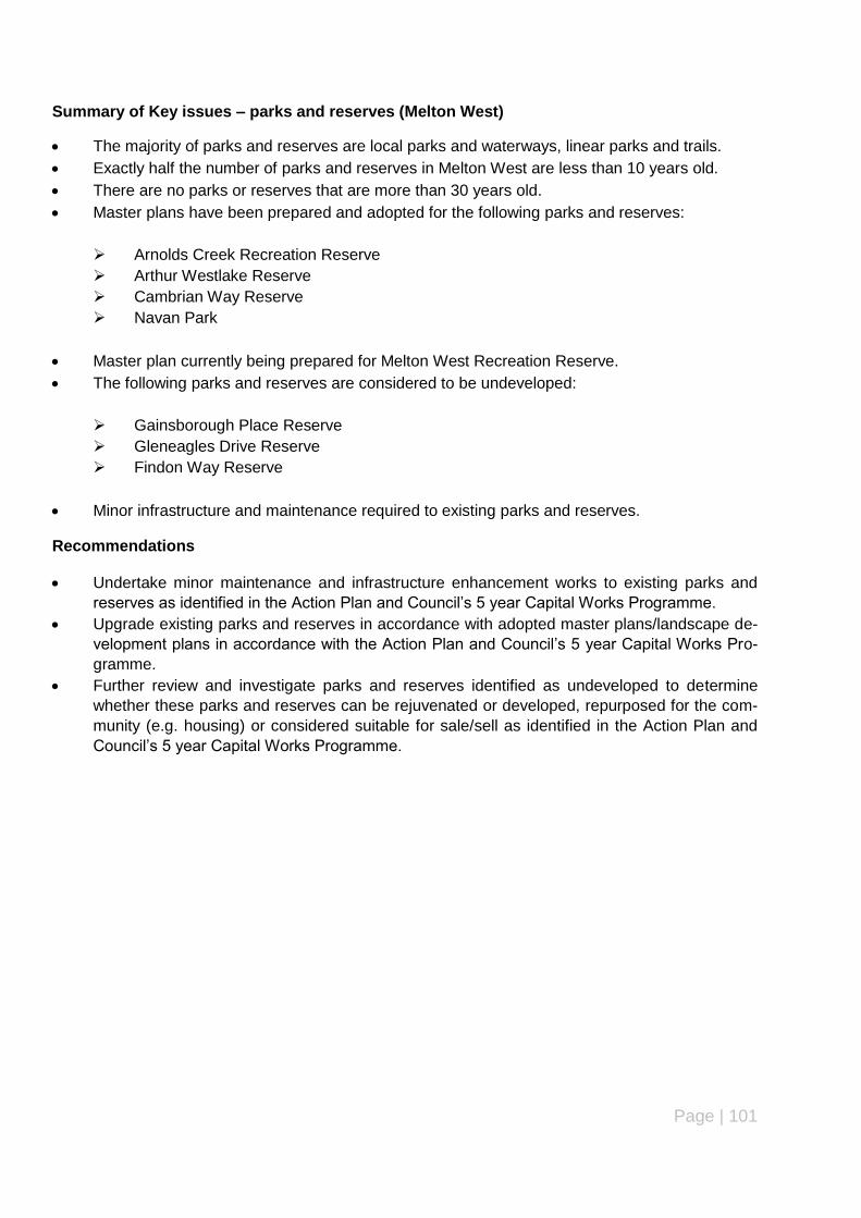
Page | 101
Summary of Key issues – parks and reserves (Melton West)
The majority of parks and reserves are local parks and waterways, linear parks and trails.
Exactly half the number of parks and reserves in Melton West are less than 10 years old.
There are no parks or reserves that are more than 30 years old.
Master plans have been prepared and adopted for the following parks and reserves:
Arnolds Creek Recreation Reserve
Arthur Westlake Reserve
Cambrian Way Reserve
Navan Park
Master plan currently being prepared for Melton West Recreation Reserve.
The following parks and reserves are considered to be undeveloped:
Gainsborough Place Reserve
Gleneagles Drive Reserve
Findon Way Reserve
Minor infrastructure and maintenance required to existing parks and reserves.
Recommendations
Undertake minor maintenance and infrastructure enhancement works to existing parks and
reserves as identified in the Action Plan and Council‟s 5 year Capital Works Programme.
Upgrade existing parks and reserves in accordance with adopted master plans/landscape de-
velopment plans in accordance with the Action Plan and Council‟s 5 year Capital Works Pro-
gramme.
Further review and investigate parks and reserves identified as undeveloped to determine
whether these parks and reserves can be rejuvenated or developed, repurposed for the com-
munity (e.g. housing) or considered suitable for sale/sell as identified in the Action Plan and
Council‟s 5 year Capital Works Programme.
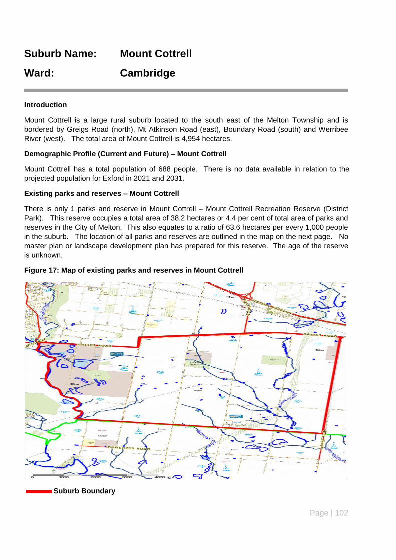
Page | 102
Suburb Name: Mount Cottrell
Ward: Cambridge
Introduction
Mount Cottrell is a large rural suburb located to the south east of the Melton Township and is
bordered by Greigs Road (north), Mt Atkinson Road (east), Boundary Road (south) and Werribee
River (west). The total area of Mount Cottrell is 4,954 hectares.
Demographic Profile (Current and Future) – Mount Cottrell
Mount Cottrell has a total population of 688 people. There is no data available in relation to the
projected population for Exford in 2021 and 2031.
Existing parks and reserves – Mount Cottrell
There is only 1 parks and reserve in Mount Cottrell – Mount Cottrell Recreation Reserve (District
Park). This reserve occupies a total area of 38.2 hectares or 4.4 per cent of total area of parks and
reserves in the City of Melton. This also equates to a ratio of 63.6 hectares per every 1,000 people
in the suburb. The location of all parks and reserves are outlined in the map on the next page. No
master plan or landscape development plan has prepared for this reserve. The age of the reserve
is unknown.
Figure 17: Map of existing parks and reserves in Mount Cottrell
Suburb Boundary

Page | 103
Summary of Key issues – parks and reserves (Mount Cottrell)
The only park or reserve in Mount Cottrell is a district park. The age of this park is unknown.
There is no master plan or landscape development plan prepared and/or approved.
Minor infrastructure and maintenance required to existing parks and reserves.
The reserve is currently managed by Council‟s Environmental Services Department as it con-
tains significant biodiversity values.
It is proposed to use the reserve to accommodate native vegetation offsets resulting from the
removal of native vegetation as part of development projects occurring in proximity to the re-
serve.
A Site Rehabilitation and Environmental Management Plan is currently being prepared for the
reserve to guide the future management and maintenance of the reserve.
Recommendations
The reserve is unlikely to be retained as an active or passive leisure and recreation space due
to the significant environmental values on the land.
Therefore, the reserve will not be rejuvenated or developed for active or passive leisure and
recreation and will become an environmental reserve in accordance with the environmental
management plan being prepared for the reserve.
There is the opportunity to undertake minor maintenance and infrastructure enhancement
works to the reserve.

Page | 104
Suburb: Plumpton (Taylors Hill West)
Ward: Cambridge
Introduction
Plumpton is located on the eastern side of the municipality between Melton Township and the
Melton East Corridor. Plumpton is predominantly a rural area except for part of the western edge
(south of Melton Highway) which is in the process of being developed for residential purposes as
part of the Taylors Hill West Precinct Structure Plan. The remaining section of Plumpton between
the Melton Township and Melton East Corridor (south the Melton Highway) has been included as
part of the urban growth boundary. The section of Plumpton north of Melton Highway is not
included as part of the urban growth boundary and is bordered by Holden Road (north),
Hillside/Calder Park Drive and Caroline Springs (east), Kororoit Creek (south and west). Plumpton
has a total area of 5,828 hectares.
However, for the remainder of this section, Plumpton is defined as the area bordered by Melton
Highway (north), Hillside and Caroline Springs (east), Western Highway (south) and proposed Outer
Metropolitan Ring Road (west) which is consistent the precinct structure boundaries for the Taylors
Hill West Precinct Structure Plan.
Demographic Profile (Current and Future) – Plumpton
Plumpton (Growth Area) has a total population of 356 people. This is anticipated to increase
dramatically to 4,655 by 2021 and almost quadruple to 15,487 people in 2031. Overall, the
population of Plumpton (Growth Area) will experience an increase of 15,191 people between 2011
and 2031. The biggest increase will be among people aged 30-34 years and there will be no
decrease in population across any age group in Plumpton (Growth Area).
The majority of people in Plumpton (Growth Area) are aged 55-59 years (10.1%), 5-9 years (9.3%)
and 50-54 years (9%). In 2021, the majority of people will be aged 30-34 years (12.2%), 0-4 years
(11%) and 35-39 years (10.7%). By 2031, the majority of people living in Plumpton (Growth Area)
will be aged 30-34 years (11.7%), 0-4 years (10.4%) and 35-39 years (10%). As you can see there
is going to be a dramatic shift in the age of people of living in Plumpton (Growth Area) over the next
20 years.
Households within Plumpton (Growth Area) are predominantly couples with children (49.5%) and
couples without children (39.5%). This will continue to be the same over the next 20 years with the
exception that there will be a reduction in couples without children and an increase in single person
households by 2031.
Existing parks and reserves – Plumpton
There are currently 3 parks and reserves (including one under construction) located in Plumpton.
These are all located in Taylors Hill West (see map on next page) as part of the approved precinct
structure plan.
The parks and reserves consist of a district park (proposed), small park and waterway, linear park
and trail. Parks and reserves in Plumpton (Growth Area) currently occupy a total area of 4.8
hectares or 0.6 per cent of the total area of parks and reserves in the municipality. This also
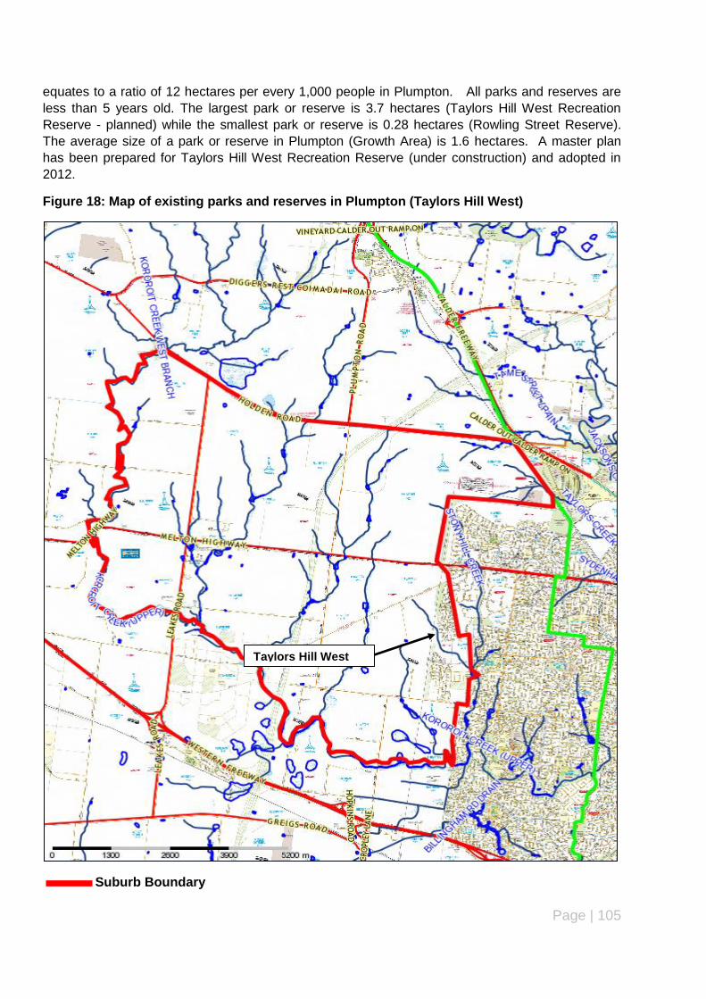
Page | 105
equates to a ratio of 12 hectares per every 1,000 people in Plumpton. All parks and reserves are
less than 5 years old. The largest park or reserve is 3.7 hectares (Taylors Hill West Recreation
Reserve - planned) while the smallest park or reserve is 0.28 hectares (Rowling Street Reserve).
The average size of a park or reserve in Plumpton (Growth Area) is 1.6 hectares. A master plan
has been prepared for Taylors Hill West Recreation Reserve (under construction) and adopted in
2012.
Figure 18: Map of existing parks and reserves in Plumpton (Taylors Hill West)
Suburb Boundary
Taylors Hill West
Page | 106
Summary of Key issues – parks and reserves (Plumpton)
All parks and reserves are less than 5 years old and located within the Taylors Hill West Pre-
cinct Structure Planning Area.
The parks and reserves consist of a district park (proposed), small park and waterway, linear
park and trail.
Master plans have been prepared and adopted for the following parks and reserves:
Taylors Hill West Recreation Reserve (under construction)
There are no parks or reserves that are considered to be undeveloped in Plumpton/Taylors
Hill West.
Minor infrastructure and maintenance required to existing parks and reserves.
The condition of infrastructure and equipment is either brand new or very good. Minor infra-
structure and maintenance are required to existing parks and reserves. However, in most
cases, this is not a high priority
Recommendations
Undertake minor maintenance and infrastructure enhancement works to existing parks and
reserves as identified in the Action Plan and Council‟s 5 year Capital Works Programme.
Upgrade existing parks and reserves in accordance with adopted master plans/landscape de-
velopment plans in accordance with the Action Plan and Council‟s 5 year Capital Works Pro-
gramme.

Page | 107
Suburb: Rockbank
Ward: Cambridge
Introduction
Rockbank is located on the eastern side of the municipality between Melton Township and the
Melton East Corridor. Rockbank is predominantly a rural area which has recently been included as
part of the urban growth boundary. It is bordered by Kororoit Creek (north), Caroline Springs and
Truganina (east), Greigs Road and Truganina (south) and Mount Cottrell Road (west). Rockbank
has a total area of 3,880 hectares.
A precinct structure plan (Rockbank North) has been approved for the section of Rockbank
bordered by Melton Highway (north), the proposed Outer Metropolitan Ring Road (east), Western
Freeway (south) and Mount Cottrell Road (west).
However, for the remainder of this section, Rockbank is defined as the area bordered by Melton
Highway (north), proposed Outer Metropolitan Ring Road (east), Griegs Road (south) and Mount
Cottrell Road (west).
Demographic Profile (Current and Future) - Rockbank
Rockbank (Growth Area) has a total population of 1,080 people. This is anticipated to increase
gradually to 1,512 by 2021 and substantially increase to 12,596 people in 2031. Overall, the
population of Rockbank (Growth Area) will experience an increase of 11,516 people between 2011
and 2031. The biggest increase will be among people aged 30-34 years and there will be no
decrease in population across any age group in the Rockbank (Growth Area).
The majority of people in the Rockbank(Growth Area) are aged 55-59 years (9%), 20-24 years
(8.7%) and 60-64 years (8.6%). In 2021, the majority of people will be aged 25-29 years (8.4%),
20-24 years (7.7%) and 45-49 years (7.7%). By 2031, the majority of people living in Rockbank
(Growth Area) will be aged 30-34 years (11%), 25-29 years (10.4%) and 0-4 years (10%). As you
can see there is going to be a dramatic shift in the age of people of living in Rockbank (Growth
Area) over the next 20 year.
Households within Rockbank (Growth Area) are predominantly single person households (31.8%),
couples with children (30%) and couples without children (24.2%). This will continue to be the same
until 2021. However, by 2031, there will be a dramatic shift with a significant increase in couples
with children making them the predominant household type and a subsequent significant decrease
in single person household while couples within children remains steady.
Existing parks and reserves – Rockbank
There are currently two parks and reserves located in Rockbank (Growth Area) – Ian Cowie
Recreation Reserve and Stewart Crescent Reserve. These parks and reserve occupy a combined
area of 5.8 hectares or 0.7 per cent of the total area of parks and reserves in the municipality. This
equates to a ratio of 4.4 hectares per 1,000 people in Rockbank.
Both parks and reserves are more than 20 years old. The largest park or reserve is 4.4 hectares
(Ian Cowie Recreation Reserve) while the smallest park or reserve is 1.4 hectares (Stewart
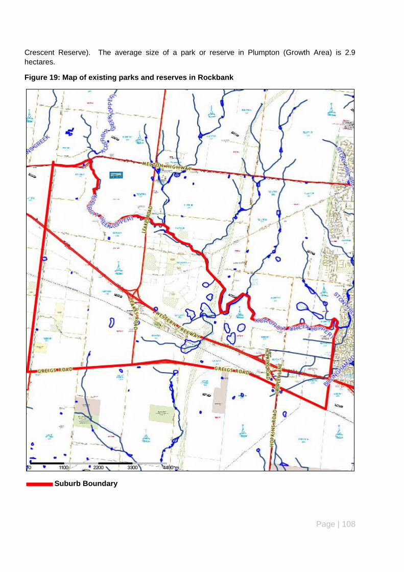
Page | 108
Crescent Reserve). The average size of a park or reserve in Plumpton (Growth Area) is 2.9
hectares.
Figure 19: Map of existing parks and reserves in Rockbank
Suburb Boundary

Page | 109
Summary of Key issues – parks and reserves (Rockbank)
There are only two parks and reserves in Rockbank – a district park and a neighbourhood
park.
Both are more than 20 years old. There are no parks or reserves less than 20 years old,
however, additional parks and reserves will be provided as part of the approved Rockbank
North Precinct Structure Plan.
Master plans have been prepared and adopted for the following parks and reserves:
Ian Cowie Recreation Reserve
There are no parks or reserves that are considered to be undeveloped.
Minor infrastructure and maintenance required to existing parks and reserves.
Recommendations
Stewart Crescent Reserve requires rejuvenation and development and consideration should
be given to preparing a landscape development plan for the reserve.
Undertake minor maintenance and infrastructure enhancement works to existing parks and
reserves as identified in the Action Plan and Council‟s 5 year Capital Works Programme.
Upgrade existing parks and reserves in accordance with adopted master plans/landscape de-
velopment plans in accordance with the Action Plan and Council‟s 5 year Capital Works Pro-
gramme.

Page | 110
Suburb: Taylors Hill
Ward: Watts
Introduction
Taylors Hill forms parts of the Melton East Corridor and is bordered by Hillside and municipal
boundary with Brimbank (north), municipal boundary with Brimbank Council (east), Taylors Road
(south) and Gourlay Road (west). Taylors Hill occupies a total area of 456 hectares.
Demographic Profile (Current and Future) – Taylors Hill
Taylors Hill has a total population of 12,100 people. This is anticipated to increase to 14,098 people
by 2021 before experiencing a decline to 13,125 people in 2031. Overall, the population of Hillside
will experience an increase of 1,025 people between 2011 and 2031.
In 2011, the majority of people in Taylors Hill were aged 30-34 years (11.8%), people aged 0-4
years (11.6 %) and 35-39 years (10.9%). This is expected to change in 2021 with the majority of
people aged 40-44 years (8.9%), 45-49 years and 10-14 years (8.4%) and 5-9 years (8.2%). By
2031, the population in Taylors Hill Hillside will be fairly evenly distributed across the majority of age
groups with the slight majority aged 20-24 years and 50-54 years (both 7.4%), 5-9 years and 45-49
years (both 7.2%) and 0-4 years and 40-44 years (both 7.1%).
The highest overall increase in the number of people will be in the 55-59 year age group (507
people) while the biggest decrease will occur in the 30-34 year age group (decrease of 496 people).
Couples with children currently make up slightly more than half (52.6%) of the population in Taylors
Hill followed by Couples without children (24.4%) and One parent families (9.4%). This is expected
to change over the next 20 years with a gradual decline in couples with children, slight increase in
couples without children and a change with single person households becoming more prominent
than one parent families.
Over the next 20 years, the focus in relation to parks and reserves will need to shift from young
couples with or with children to older people with adult children who do not require play space areas
and may be more interested in sports facilities and parks/reserves with shared paths to encourage
cycling, walking and jogging, dog on/off leash areas and BBQ/picnicking areas for social/family
activities.
Existing parks and reserves – Taylors Hill
A total of 20 parks and reserves are located in Taylors Hill occupying a total area of 26.1 hectares
or 3 per cent of the total area of parks and reserves in the municipality. This equates to a ratio of
2.1 hectares per 1,000 people in Taylors Hill.
The majority of parks and reserves are local parks (9) and neighbourhood parks (6). All parks and
reserves in Taylors Hill are less than 20 years old. Only 1 park/reserve is more than 15 years old.

Page | 111
Figure 20: Map of existing parks and reserves in Taylors Hill
Suburb Boundary

Page | 112
Summary of Key issues – parks and reserves (Taylors Hill)
The majority of parks and reserves are local parks (9) and neighbourhood parks (6).
All parks and reserves in Taylors Hill are less than 20 years old.
There are no parks and reserves in Taylors Hill that are considered to be undeveloped.
Master plans have been prepared and adopted for the following parks and reserves:
Taylors Hill Recreation Reserve
The condition of infrastructure and equipment is either brand new or very good. Minor infra-
structure and maintenance are required to existing parks and reserves. However, in most
cases, this is not a high priority.
Recommendations
Undertake minor maintenance and infrastructure enhancement works to existing parks and
reserves as identified in the Action Plan and Council‟s 5 year Capital Works Programme.
Upgrade existing parks and reserves in accordance with adopted master plans/landscape de-
velopment plans in accordance with the Action Plan and Council‟s 5 year Capital Works Pro-
gramme.

Page | 113
Suburb: Toolern Vale
Ward: Watts
Introduction
Toolern Vale is a rural township located in the north-west corner of the municipality. It is bordered
by the municipal boundary with Macedon Ranges Shire Council (north), Kororoit Creek West Branch
(east), Melton/Melton West and Kurunjang (south) and the municipal boundary with Moorabool
Shire Council (west). Toolern Vale covers a total area of 9,527 hectares.
Demographic Profile (Current and Future) – Toolern Vale
Toolern Vale has a total population of 879 people. There is no data available in relation to the
projected population for Toolern Vale in 2021 and 2031.
Existing parks and reserves – Toolern Vale
There are only 2 parks and reserves currently located in Toolern Vale. However, one of these is the
only regional park in the municipality (Macpherson Park) while the other (Toolern Vale Recreation
Reserve). There are no neighbourhood parks, local parks, small parks, waterways, linear parks or
trails or conservation/environmental reserves located in Toolern Vale.
These parks and reserves occupy a combined area of 99.7 hectares or 11.6 per cent of the total
area of parks and reserves in the municipality. This would equate to 124.6 hectares per 1,000
people in Toolern Vale. The age of both reserves is unknown. A master plan has been prepared
and adopted for Macpherson Park.

Page | 114
Figure 21: Map of existing parks and reserves in Toolern Vale
Suburb Boundary
Page | 115
Summary of Key issues – parks and reserves (Toolern Vale)
There are only two parks and reserves in Toolern Vale – a regional park and a district park.
The age of both reserves is unknown.
A master plan has been prepared for Macpherson Park.
There are no parks or reserves that are considered to be undeveloped.
Minor infrastructure and maintenance required to existing parks and reserves.
Recommendations
Undertake minor maintenance and infrastructure enhancement works to existing parks and
reserves as identified in the Action Plan and Council‟s 5 year Capital Works Programme.
Upgrade existing parks and reserves in accordance with adopted master plans/landscape de-
velopment plans in accordance with the Action Plan and Council‟s 5 year Capital Works Pro-
gramme.