mesooic o caiooic aaeogeogaic mas o e ease ew … · mesooic o caiooic aaeogeogaic mas o e ease ew...
TRANSCRIPT

PALAEOGEOGRAPHY 38
BMR RECORD 1991/113
MESOZOIC TO CAINOZOIC
PALAEOGEOGRAPHIC MAPS
FOR THE EASTERN NEW GUINEA REGION
by
H.I.M. Struckmeyer & M. Yeung
Bureau of Mineral Resources, Geology & Geophysics, AustraliaPetroleum Division of the Australian Mineral Industries Research Association (APIRA)
Phanerozoic History of Australia Project
! I 9 1111111111111J Fill

© Commonwealth of Australia, 1991This work is copyright. Apart from any fair dealing for the purposes of study, research,criticism or review, as permitted under the Copyright Act, no part may be reproduced by anyprocess without written permission. Inquiries should be directed to the Principal InformationOfficer, Bureau of Mineral Resources, Geology and Geophysics, GPO Box 378, Canberra,ACT 2601.
ISSN 0811-062XISBN 0 642 17021 5

TABLE OF CONTENTS
LIST OF FIGURES AND TABLES^
1. INTRODUCTION ^1
2. MESOZOIC TO PALEOCENE ^11
2.1^Triassic ^12
2.2^Jurassic ^17
2.3^Cretaceous ^23
2.4 Paleocene ^30
3. EOCENE TO RECENT ^32
3.1^Late Eocene ^32
3.2 Late Oligocene to Early Miocene ^34
3.3 Late Early Miocene to Early Middle Miocene ^37
3.4^Early Pliocene ^39
3.5 Holocene ^43
4. CONCLUSIONS ^43
5. ACKNOWLEDGEMENTS^ 46
6. BIBLIOGRAPHY ^46
1

LIST OF FIGURES AND TABLES
Figure 1: Location map for the New Guinea region^ 2
Figure 2: Present-day plate tectonic setting of the New Guinea region^ 3
Figure 3:^Plate tectonic reconstruction for the Late Triassic showinglocation of tectonic components^ 5
Figure 4:^Plate tectonic reconstruction for the Late Oligoceneshowing location of tectonic components^ 6
Figure 5: Tectonic components of the Papua New Guinea region^ 7
Figure 6: Tectonic components of Southeastern Indonesia^ 8
Figure 7:^Early Triassic (Scythian to Anisian) palaeogeography(time slices TR1+2)^ 13
Figure 8^Middle Triassic (latest Anisian to Ladinian) palaeogeography(time slices TR 3+4) ^14
Figure 9: Late Triassic (Camian to Rhaetian) palaeogeography(time slices TR 5+6)^ 16
Figure 10: Early Jurassic (Pliensbachian to Toarcian) palaeogeography(time slice J 2) ^18
Figure 11: Middle Jurassic (Bajocian) palaeogeography (time slice J 5)^20
Figure 12: Late Jurassic (Oxfordian to Kimmeridgian) palaeogeography(time slice J 8) ^22
Figure 13: Early Cretaceous (Berriasian to Early Valanginian)palaeogeography (time slice K 1) ^24
Figure 14: Late Early Cretaceous (Aptian) palaeogeography(time slice K 4) ^26
Figure 15: Middle Cretaceous (late Albian to Cenomanian)palaeogeography (time slice K 8) ^28
Figure 16: Late Cretaceous (mid-Campanian to mid-Maastrichtian)palaeogeography (time slice Kl0b) ^29
11

Paleocene to Early Eocene palaeogeography (time slice Cz 1) ^ 31
Late Eocene palaeogeography (time slice Cz 2b) ^33
Late Oligocene to Early Miocene palaeogeography(time slice Cz 4a) ^36
Figure 17:
Figure 18:
Figure 19:
Figure 20: Late Early Miocene to early Middle Miocenepalaeogeography (time slice Cz 4b)^
38
40
42
Figure 21: Early Pliocene palaeogeography (time slice Cz 6a)
Figure 22: Late Quaternary palaeogeography (time slice late Cz 7)
Table 1:^Mesozoic to Cainozoic time slices ^9
Table 2:^Legend for Figures 7 to 22^ 10
111

1. INTRODUCTION
Sixteen time slice interpretative palaeogeographic maps of the eastern NewGuinea region (Figure 1) were produced as part of the BMR-APIRA Phanerozoic
History of Australia Project (1988-1991). The project is the successor to the BMR-APIRA Palaeogeographic Maps Project (1984-1987) which produced interpretative
palaeogeographic maps of Australia for seventy time slices from the Cambrian toRecent (BMR Palaeogeographic Group, 1990; Bradshaw & Yeung, in press;
Bradshaw & others, in prep.; Brakel & Totterdell, in prep.; Cook, 1988; Cook &Totterdell, 1991; Olisoff & others, in prep.; Totterdell & others, in prep.; Walley &others, 1990; Wilford & others, in prep.; Yeates & Mulholland, in prep.). Themaps of Australia were plotted onto a present-day geographic base at a scale of1:5,000,000. Interpretative maps for the Australian Plate margin produced for thecurrent project were prepared for selected Mesozoic and Cainozoic time slicesonly (Table 1), using the Triassic/Permian boundary as a starting point. Themaps were compiled at 1:10 000 000 scale and plotted on base maps depicting platetectonic reconstructions for the appropriate time. The palaeogeographic maps forAustralia were transferred onto these bases at the reduced scale. The time scaleused is based on Harland & others (1982) for the Mesozoic, and Berggren & others(1985a, b) for the Cainozoic.
The palaeogeographic maps are based on the compilation and interpretation of alarge body of published and unpublished geologic data for the New Guinearegion; these are listed in a comprehensive bibliography in Chapter 6. Detaileddata compilations in the form of stratigraphic summary columns and data mapshave been summarised in Struckmeyer (1990, 1991b). For formation names usedin this report, also refer to Struckmeyer (1990, 1991b) and Struckmeyer & others
(1990).
The New Guinea Orogen (Figure 2) is the product of a number of plate tectonicprocesses that have affected the northern margin of the Australian Plate during
1

132' 14.4• 150.
South^Pacific^OceanH alM aher
150 156.
O'—.
,e3a,do Sea
MiSitna
1.00.0 3104C
Artkiptiaso
_IV
Co,-a/ 12*
Sea500 kr,
Figure 1: Location map for the New Guinea region.

150* 156'
a
Weber
Basin
oil
16' 132 ° '50°144 156•
120°^126^ 132'^ 138'^ I 4 4 •
A---m- Ac/'e zabaacrbon %ono^____,.̂ Sir,k, slip faallinqe
Inachlis subaiishoi. zone^—,=,— Thrusl fal-dhngkJCI
11-;^Fauli/laull zone (F .1)^— — — Probable fend/ zonea
%..,t..o^,...,^. o4,.
":7^toot'
7`'elletal■Sik
0
1,06-amipaol
<=),ccs)
JAYA rKiNCY
Basin
0
Spread;rry ridge
3=XSOCCC 4CItt V El rif/New Cuinea
Orojen
500 k rt,
Foolt Zone
a or.3 atr.„, Alk
xay-
a
ANg6a
Y.Ten^. fti,4N1/5 r R EN CH------ - .
P.Arpu 'an
South
New Guinea
SCSI/7^Bo 5 / 17
AUSTRALIAN^PLATE
SOUTH
8,1SmARCK,c) PLATE
L auraCora/ Sea^ 12.
Sasrn
•^•^•
lgoaagarhBasin
PACIFIC PLATE''Oh-
e"111111b■of-Pmt...mmammez._
Sep.k Soon
g rir.;eV w
-o
Figure 2: Present-day plate tectonic setting of the New Guinea region.

its Mesozoic to Cainozoic history. Reconstructions for the New Guinea area havebeen produced by a number of authors (e.g. Crook & Belbin, 1978; Kroenke, 1984;
Pigram & Davies, 1987; Francis & Deibert, 1988; Audley-Charles, 1988; Francis,1990). They differ considerably, both in the timing and mechanisms invoked,which may in part be ascribed to the sparsity of data in a geologically complexarea. Thus, most of the models proposed are valid interpretations of possible
scenarios of the plate tectonic development of the region within the geologicconstraints provided by the data available. The plate tectonic reconstructionswhich were used as bases for the palaeogeographic maps presented here weredeveloped in an attempt to integrate detailed reconstructions for the New
Guinea region with similar reconstructions for other areas of the AustralianPlate margin (Bradshaw & Ross, in prep.; Walley & Ross, 1991) by taking intoaccount a global palaeomagnetic framework and the direction of movement ofthe major bounding plates. The computer-generated maps were produced usingPOMP (Paleoceanographic Mapping Project) digitising and plate tectonicreconstruction software. The plate tectonic reconstructions are discussed indetail in Struckmeyer (1991a) and Yeung & Struckmeyer (in prep.).
The maps in Figures 7 to 22 show coded palaeoenvironments (see legend inTable 2) plotted on the outline of tectonic components which moved relative tothe Australian Craton during the Mesozoic to Cainozoic. The components arenot identified in each of the palaeogeographic maps, but two plate tectonicreconstructions, for the Triassic and Late Oligocene, are given to identify thelocation of the various components (Figures 3 and 4), and two present-daylocation maps of the components are presented in Figures 5 and 6.Palaeolatitudes depicted on the palaeogeographic maps are based on the data basesupplied with the PALEOMAP and Terra MobilisTm (Denham & Scotese, 1988)
software packages.
4

)5MisooliOnin KumawaTerrane
SulaPlatform
Figure 3: Plate tectonic reconstruction for the Late Triassic showing location of tectoniccomponents.
5

Tamrau T.Arfalc Mts T.
Nest New
-• Composite4Guinea .
Gauttier T.Block
• T.Bena
Bena T.Owen Stanley
Northis---,.. Composite BlockCoral Sea '-
QueenslandPlateau
tralia
TowTrough
0^500 km
Figure 4: Plate tectonic reconstruction for the Late Oligocene showing location of tectoniccomponents.
6

■ _
b
e:=7^862
-..,, 901
846
49
.^. ,
85•857 863.
.^-
853 848850 85
801 ,
•,,-.
,^0 i
.. ()
! --. .^
.... 'ISSN..
i950^..../^836^,
` 851
174^/...,
8 1
- •
801 - Australia^850 - Kubor Block^858* - Schrader Terrane836 - North Coral Sea^851* - Kutu-Louisiade Block^859 - Bena Bena Terrane846 - West New Guinea^852* - Owen Stanley^860* - Kokoda Block
Composite Block^Composite Block^861 - South Bismarck Block847 - Torricelli Terrane^853 - Papuan/Irian Jaya^862 - New Ireland Block848 - Finisterre Terrane^Fold Belt^863 - Bougainville Block849 - Jimi Terrane^857* - Marum Terrane^901 - Ontong Java Plateau
950 - Eastern Papuan Plateau* East New Guinea Composite Block
Figure 5: Tectonic components of the Papua New Guinea region.
7

875co^44 957
620
mol,„. 4t
87395.
896^871
872954
1,040-
87403
879
876^:*^887886
'rear^8:8 '-^890.5^ 89
89^952^'
870^ 846)788,/^853
801868^ ■AMPOPII"P-
AV t'‘
..
1400E
111176731ww—
1al.
.1^.620 - Borneo 868 - Banda Volcanic 874 - Molucca Sea 886 - Yapen Island 894- Misool/Onin 954 - Buton801 - Australia Arc Complex Collision Complex 887 - Arfak Mts Terrane Kumawa Terrane 955 - West Sulawesi843- Flores 869 - Banda Para-autochthon 875- Bacan Island 888 - Tamrau Terrane 895 - Salawati Island 956 - Sulabesi Island846 - West New Guinea 870 - East Seram 876 - Waigeo Terrane 889 - Tosem Terrane 896 - East Sulawesi 957 - Netoni Terrane
Composite Block 871 - Buru Island 878 - Halmahera 890 - Biak/Supiori Islands 952 - Bird's Head/853 - Papuan/Irian Jaya 872 - Tukangbesi/Buton Platform 879 - West Seram 892 - Gauttier Terrane Kemum Terrane
Fold Belt 873 - Sula Platform 885 - Lengguru Fold Belt 893 - East Kai 953 - Weber Split-off
Figure 6: Tectonic components of the Southeastern Indonesia region.

Table 1:^Mesozoic to Cainozoic time slices (based on time scales of Harland& others [1982], Berggren [1969] and Berggren & others [1985a, b]).
TIME^AGE^ MA
SLICE
CAINOZOICCz 7^Quaternary^ 0 - 1.7
Cz 6a^Early Pliocene^ 3.0 - 5.0
Cz 4b^Early Miocene toearliest Middle Miocene^ 15.2 - 22.0
Cz 4a^Late Oligocene to earliest Miocene^22.0 - 30.0
Cz 2b^Late Eocene^ 36.5 - 40.0
Cz 1^Paleocene to Early Eocene^52.0 - 66.4
CRETACEOUSK 10b^mid-Campanian to mid-Maastrichtian^78.0- 70.0
K 8^latest Albian to Cenomanian^99.0- 91.0
K 4^Aptian^ 119.0 - 114.0
K 1^Berriasian to earliest Valanginian^144.0 - 137.0
JURASSICJ 8^Oxfordian to Kimmeridgian^162.0 - 150.0
J 5^mid-Bajocian^ 180.0 - 177.0
J2^Pliensbachian to early Toarcian^200.0 - 191.0
TRIASSIC
TR 5-6^Carnian to Rhaetian^ 231.0 - 213.0
TR 3-4^latest Anisian to Ladinian^239.0 - 231.0
TR 1-2^Scythian to Anisian^ 248.0 - 239.0
9

Table 2: Legend for Figures 7 to 22 (from BMR Palaeogeographic Group, 1990).
SYMI3OL^ENVIRONMENT^WORKING DEFINITION
LAND ENVIRONMENTS
LEU^unclassified^Areas with no preserved sediments of time slice age; interpreted as land.
LEE^erosional^Highlands; inferred from palaeocurrents, provenance studies, tectonicsetting, presence of igneous intrusions, etc.
LDU^depositional,^No indication of specific environment; often includes subaerialunclassified^volcanics.
LDF^fluvial^River deposits such as alluvial fans, braided and meandering channeldeposits and coarser overbank sediments; also sand-dominated continentalsequences with no evidence of aeolian or lacustrine deposition.
LDFL^fluvio-lacustrine^Low-energy river environments such as channels, overbanks, backswampsand shallow lakes on low-gradient flood plains; typically sheets of fine-grained sediments and coal.
LDL^lacustrine^Deposits of persistent lakes, typically finely laminated mud and sandfrequently containing freshwater fossils.
LOG^glacial^Typically coarse, poorly sorted sediments, commonly with striatedpebbles, cobbles, and boulders. Overall assemblage of sediments quitecomplex, ranging from aeolian sand flanking glaciers, river gravel, fine-grained mud with or without dropstones, to siliceous sediments.
COASTAL ENVIRONMENTS
CDP^paralic^Coastal or marginal marine environments, e.g. lagoonal, beach, intertidal,deltaic. Range from coarse cross-bedded beach sand, through sanddeposited in tidal deltas, to finely laminated organic sediment depositedin lagoons and estuaries (includes deltaic and intertidal-supratidalenvironments).
CDIS^in tertidal-suprati dal^Tidal zone, indicated by finely interlaminated fine and coarse detritus,herring-bone cross-bedding, flaser bedding, evidence of periodic exposure,etc.
CDD^deltaic^Indicated by thickness pattern, upward-coarsening sequences, and themapped pattern of adjacent environments.
MARINE ENVIRONMENTS
MU^unclassified^No indication of specific marine environment.
MVS^very shallow^Evidence of deposition above wave base and/or occasional emergence,(0-20 m water depth)^e.g. oolites, cross-bedding.
MS^shallow^Continental shelf or flanks of volcanic islands, e.g. sand, mud and(0-200 m water depth)
^
^limestone containing fossils that typically lived in shallow water;includes young, active spreading ridges.
MBA^bathyal to abyssal^Deep-water deposition, e.g. condensed sequences, turbidites, monotonous(>200 in water depth)^shale; deeper-water organisms.
MA^abyssal^Distal turbidite, day, siliceous and calcareous ooze, ocean-floor(>1000 m water depth)^basalt, etc.
10

2. MESOZOIC TO PALEOCENE
During the Mesozoic to Paleocene, the northern edge of the Australian Plate wasa passive margin that experienced two major phases of extension, in theTriassic/Jurassic and in the Late Cretaceous to Early Eocene (Pigram &Panggabean, 1984; Symonds & others, 1984; Pigram & Davies, 1987; Struckmeyer
& others, 1990; Struckmeyer, 1991a; Pigram & Symonds, in press). Figure 3 showsa reconstruction for the Late Triassic, when rifting and breakup to the north
probably led to the detachment of part of the craton margin. The extensionalevent is indicated by the presence of a Triassic to Jurassic rift-drift sequence in the
Papuan and South New Guinea Basins and on continental fragments whichwere detached from the margin later in the Mesozoic and now form part ofeastern Indonesia. During the remainder of the Jurassic to the Early Cretaceousthere was deposition of siliciclastic sag phase sediments along the northernmargin of Australia (e.g. Pigram & Symonds, in press).
The second extensional event along the northeastern margin probablycommenced in the middle Cretaceous and, in the Late Cretaceous to Paleocene,led to the detachment of continental fragments within an oblique, linkedspreading system, as a result of the opening of the Coral Sea and an unnamedocean basin to the north and northwest of the Coral Sea (Pigram, 1990;
Struckmeyer, 1991a; Pigram & Symonds, in press). The Late Cretaceous toPaleocene extensional event was associated with uplift along the plate boundaryin the eastern Papuan Basin that resulted in differential erosion of the Mesozoicsequences. Seafloor spreading continued until the Early Eocene, as indicated bymagnetic lineaments in the Coral Sea Basin (Anomaly 24) and the presence ofthrust slices of ophiolites of this age on the mainland of Papua New Guinea.Incipient subduction to the northeast of Australia may have occurred from theCampanian onwards.
11

2.1 Triassic (Figures 7-9)
During the Triassic, the northeastern margin of Australia was located at thesouthern edge of Tethys at palaeolatitudes of about 25 to 40 °S. The climate wasgenerally warm and humid, probably monsoonal, with the wide extent of land inthe Triassic during a time of low relative sealevel promoting aridity in the
interior of the continent (Parrish & others, 1982).
In the Papuan Basin, the oldest Triassic rocks are granites of the Kubor Complex,which intruded Palaeozoic pelitic metamorphics in the Early to Middle Triassic
(Page, 1976). The Kubor Complex and associated intrusives on the Jimi, Kemumand Netoni Terranes, and the Sula Platform probably formed erosional highs for
at least part of the Mesozoic and provided a sediment source for adjacent areas.In the earliest Triassic (Figure 7), most of the Papuan Basin was probablyemergent. Deep water marine environments were present in the Kubor Blockregion and the Jimi Terrane, as indicated by the dark shales of the YuatFormation (e.g. Pigram, 1978; Francis, in prep.). They are probably timeequivalents of the uniform shaly facies deposited across the Northwest Shelfduring the Early Triassic (Bradshaw & others, 1988; Struckmeyer & others, 1990).
A depositional hiatus on Buton and western Seram during the Early Triassic
probably indicates that these areas were emergent. They are here shown as anorthwest-southeast trending land area with a shallow marine fringe to thesouth and north. A delta fed by rivers eroding the highs of western Seram andTukangbesi/Buton may already have existed along the northeastern shore(Audley-Charles & others, 1979; O'Sullivan & others, 1985; Price & others, 1987),
but dating of the Kanikeh Formation is poor. Deep water turbidites of theKeskain Formation were deposited on Misool (Pigram & others, 1982a, b).
A major regression occurred in the late Early Triassic. Time slices 3 and 4 (Figure8) were characterised by restricted fluvial deposition in the southernmost and
12

Figure 7: Early Triassic (Scythian to Anisian) palaeogeography (TR 1&2).

Figure 8: Middle Triassic (latest Anisian to Ladinian) palaeogeography (TR 3&4).

northwestern Papuan Basin, and shallow marine environments in thenortheast, in the vicinity of the Kubor Block. On the Jimi Terrane, deposition
occurred in fluvial to paralic and probably shallow marine environments withthe accumulation of volcaniclastic sandstone, shale, conglomerate, redbeds and
bimodal volcanics of the Kana Group (Pigram & others, 1987). Similar sedimentsof this age (Tipuma Formation) are present on the southern Birdshead/Kemum
Terrane, where an extensive fluvial to paralic depositional system developed inthe Triassic (Pigram & Sukanta, 1982; Pieters & others, 1985). Theseenvironments were probably continuous with those of the Jimi Terrane. Rift-related volcanism also occurred on the Sula Platform (Pigram & others, 1985a, b;
Garrard & others, 1988), the Tukangbesi Platform (Koswara & Sukarno, 1986) andin southwestern Irian Jaya (Pigram & Panggabean, 1989), probably in terrestrialenvironments. In the northwestern part of the Tukangbesi/Buton Platform,sedimentation commenced with the deposition of the marine Winto Formation,a proven source rock (Davidson, 1991; Smith & Silver, 1991). In Seram,deposition of the deltaic Wakuku/Kanikeh Formation and its offshoreequivalents (Saman Saman Formation) was well established by this time, while aslight shallowing of the depositional environments occurred in the Buru and
Misool areas.
In time slices 5 and 6 (Figure 9), conditions in the northeastern part of the maparea probably remained the same, although a marine incursion resulted in thedeposition of carbonates (Nofanni Limestone) on parts of the Sula Platform(Pigram & others, 1985a, b; Garrard & others, 1988). Reefal and platformlimestones developed on the Misool/Onin/Kumawa Terrane (Bogal Limestone,Lios Marl - Pigram & others, 1982a, b) and the Kubor Block (Kutu Formation -Bain & others, 1975; Skwarko & others, 1976; Francis & others, 1990; Francis, inprep). The reefs may have extended across the entire northern margin linking upwith time equivalent Rhaetian reefs that developed on the northern ExmouthPlateau (Williamson & others, 1989). Fluvial environments in the northernPapuan and South New Guinea Basins became more extensive and the deltaestablished in the earlier Triassic may have been fed by these rivers as indicatedby continued deposition of the Wakuku/Karikeh Formation on southernmost
15

Figure 9: Late Triassic (Carnian to Rhaetian) palaeogeography (TR 5&6).

East Seram. However, most of the Seram and Buru areas were characterised byshallow marine environments with deposition of the Ghegan Formation
(Fortuin & others, 1988; Tjokrosapoetro & Budhitrisna, 1982) and ManuselaFormation (Price & others, 1987; O'Sullivan & others, 1985), both of which
contain bituminous shales. On the Birdshead/Kemum Terrane, deposition of
the red beds of the Tipuma Formation continued.
2.2 Jurassic
During the Jurassic, northeastern Australia was in low to middle latitudes.
Monsoonal climates persisted in Gondwana; the dry interior zone remainedextensive and coastal regions of Tethys still had a strongly seasonal climate(Parrish & others, 1982). Sedimentation along the northern Australian Platemargin was controlled by a change from the Triassic rift regime to one of breakup
and ocean formation. This resulted in widespread Middle to Late Jurassicinundation of areas that were previously characterised by fluvial and paralic
environments.
Early Jurassic - Pliensbachian to Toarcian (Figure 10)
In Papua New Guinea, an extensive river system developed on the southern FlyPlatform and in the western Gulf of Papua as indicated by the presence, in a
number of exploration wells, of a sequence of interbedded mudstone, sandstoneand minor coal (Magobu Formation) deposited in fluvial to fluvio-lacustrineenvironments. On the Jimi Terrane, volcaniclastic sandstones, conglomerates,siltstones and mudstones of the Balimbu Formation and its equivalents
accumulated in shallow marine environments that deepened to the north
(Pigram& others, 1987). The presence of basic volcanics in the marine sequencegives a possible minimum age for ocean formation to the north of Australia.Continental fragments, which may have been present north of Papua NewGuinea during the Triassic, had probably drifted northwards by this time (Pigram& Panggabean, 1984). The shallow marine environments in the vicinity of theJimi Terrane probably extended northwestward, however, due to poor age
17

Figure 10: Early Jurassic (Pliensbachian to Toarcian) palaeogeography (J 2).

control and the structural complexity of the region, it is not clear whetherdeposition in the Late Triassic to Early Jurassic was continuous in some areas ofthe northern Papuan Basin. The Kubor Block may have been emergent duringthis time with a narrow fringe of paralic environments to the north on the
Misool Terrane.
There is poor age control (?late Permian to ?Jurassic) for the Tipuma Formationon the Kemum Block; it is possible that this unit is entirely Triassic in age andthat most of the region was emergent in the Early Jurassic. On the Sula Platform,red bed deposition in fluvial to paralic environments (Bobong and KabauwFormations) commenced after the period of volcanism and minor limestonedeposition in the Triassic (Pigram & others, 1985a; Garrard & others, 1988).
Middle Jurassic - Early to Middle Bajocian (Figure 11)
Deposition became more widespread with the transgression of the sea across theKubor Block, parts of the present Papuan Fold Belt and Gulf of Papua, the JimiTerrane and possibly the southern Birdshead/Kemum Terrane. Deposition ofthe marine fine-grained clastics of the Maril Shale and its equivalents mayalready have commenced in these areas. Remnants of the deeper water slopeand basin sediments deposited in northern Papua New Guinea in the MiddleJurassic to middle Cretaceous are preserved in the West New Guinea CompositeBlock as low to medium grade metamorphic rocks of mostly pelitic origin.Intermediate to felsic intrusives of Late Jurassic to middle Cretaceous age thatoccur within this sequence may be related to initial extension between PapuaNew Guinea and the continental fragments that now form part of Eastern
Indonesia.
In the southern Papuan Basin, coarse clastics sourced from land areas to thesouthwest accumulated in fluvial to fluvio-lacustrine environments on the FlyPlatform and southwestern Gulf of Papua, and coarse to fine-grained sedimentswere deposited in paralic environments to the north and east of the river system.
Locally, thin coal beds developed.
19
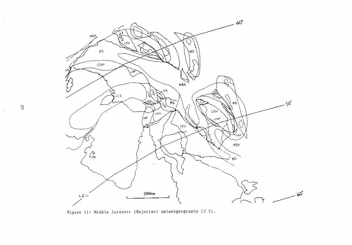
Figure 11: Middle Jurassic (Bajocian) palaeogeography (J 5).

On the Irian Jaya Platform, the marine transgression is indicated by a markedchange from the fluvial to paralic and ?shallow marine coarse to fine-graineddastics of the Tipuma Formation to the claystones, mudstones and subordinatelimestones of the lower Kembelangan Group (Visser & Hermes, 1962; Pigram &Panggabean, 1989; Dow & others, 1990). The greater part of the South New
Guinea Basin remained emergent during this time.
Late Jurassic - Oxfordian to Kimmeridgian (Figure 12)
The Jurassic transgression reached its peak in time slices 7 to 8, when shallowmarine environments were widespread in the Papuan Basin with extensivedeposition of fine-grained clastics (Imburu Mudstone). These mudstones arelikely to be an equivalent of the Maril Formation of the northern and easternPapuan Basin, which consists mostly of shales deposited in bathyalenvironments on, and south of, the Kubor Block and the Jimi Terrane area. Theshales are probably the major Mesozoic source rock interval of the region, andthey are time-equivalents of the Dingo Mudstone, the principal source rock inthe Northwest Shelf area (e.g., Bradshaw & others, 1988; Struckmeyer & others,1990). Paralic environments stretched across the greater part of the Fly Platformand these environments extended southwards around the probably erosionalOriomo High into both the Carpentaria Basin and the Laura Basin, where theygraded into fluvio-lacustrine environments. The North Coral Sea and EasternPlateau components were probably emergent during this time, however, seismicdata indicate that a small sedimentary basin may have been present on thenortheastern Queensland Plateau during the Late Jurassic to Early Cretaceous(Symonds & others, 1984; P.A. Symonds, pers. corn., 1991).
The Irian Jaya terranes were probably inundated during the Late Jurassictransgression with widespread deposition of fine-grained clastics in shallow todeeper water environments, which were later removed by erosion.
21

Figure 12: Late Jurassic (Oxfordian to Kimmeridgian) palaeogeographY (J 8).

2.3 Cretaceous
Following Jurassic rifting and seafloor spreading along the northern Australianmargin, the Early Cretaceous in this region was characterised by a more quiescenttectonic regime with continuing subsidence along the passive margin. The onsetof a second phase of rifting in the mid-Cretaceous and subsequent oceanformation along the northern to northeastern plate margin resulted in extensiveuplift across the region, and the detachment of continental fragments from the
margin in the Late Cretaceous to Paleocene.
In the Early Cretaceous, the northern Australian Plate was located in middlelatitudes ranging from 35 to 50°S. Commencement of the separation of Australiafrom Antarctica in the middle Cretaceous and associated rotation broughtAustralia into progressively lower latitudes. By the end of the Cretaceous, thenorthern part of the plate was located between approximately 20 and 35°S.
Early Cretaceous - Berriasian to earliest Valanginian (Figure 13)
In southern Papua New Guinea, the paralic fringe established in the Middle toLate Jurassic broadened during the latest Jurassic to Early Cretaceous. The greaterpart of the present Fly Platform and fold belt areas was characterised by a shorezone depositional system. Repeated minor transgressions and regressions causedthe migration of beach, barrier-bar and channel-mouth fades, resulting in thedeposition of quartzose sandstones (Toro Sandstone), which are the majorreservoir rocks for hydrocarbons sourced by the underlying fine-grained Jurassicsediments. The Oriomo High remained emergent and probably provided a local
sediment source. The paralic environments extended across the CarpentariaBasin and into the southeastern South New Guinea Basin, and a connectionwith the extensive fluvial system of the northern Eromanga Basin wasestablished. To the north and the east, the Toro Sandstone grades into finerclastics deposited in shallow marine environments that deepened northwards, asindicated by continuing deposition of the Maril Shale/Kompiai Beds in theKubor Block and Jimi Terrane areas. In some areas of the Gulf of Papua,
23

Figure 13: Early Cretaceous (Berriasian to Early Valanginian) palaeogeographY (K 1).

particularly in its northwestern part, no Cretaceous rocks are preserved; this isprobably due to Late Cretaceous to Paleocene uplift and erosion. Early Cretaceous
rocks are also absent from the Kemum Block and the Netoni Terrane.
The paralic environments in the Papuan Basin extended into central Irian Jayawhere beach and barrier bar deposits of the Woniwogi Sandstone are probablypartly correlative with the Toro Sandstone. Similar to the Toro Sandstone, theWoniwogi Sandstone becomes more shaly to the north where it grades into
undifferentiated marine sediments of the Kembelangan Group. Most of theSouth New Guinea Basin was still emergent and may have been connected witha land area to the southwest across the Arafura Sea.
Late Early Cretaceous -Aptian (Figure 14)
During the Early Cretaceous, Australia experienced a major inundation whichculminated in the Aptian when extensive areas of the continent were covered bya shallow inland sea. Shallow marine environments were predominant in thePapuan Basin. Siltstones, mudstones and minor interbedded sandstones of theIeru Formation were deposited across the basin during this time. To the north,deeper marine environments existed as indicated by dark grey to black shales.
The presence of coarser-grained clastics in the latest Aptian succession in someareas of the basin may indicate a regressive period at this time. Basic tointermediate volcanics were extruded in mostly deep water environments in theJimi Terrane area (Kumbruf Volcanics); they probably provided the source ofvolcanic detritus and tuffs within the Ieru Formation and its equivalents (KerabiFormation, Kondaku Unit) in the Papuan Basin. Brown et al. (1980) suggestedthat the volcanics may be derived from a volcanic arc which developed over asubduction zone located to the north and northeast of the Papuan Basin. It is,however, possible that they are derived from volcanism associated withincipient rifting in the Coral Sea, which may have commenced as early as theEarly Cretaceous (Taylor & Falvey, 1977; Symonds & others, 1984). Alkaline
lamprophyre sills of Early to Late Cretaceous age, which intrude the Maril Shalesoutheast of the Kubor High area (Rogerson et al., 1988) and in the
25

Figure 14: Late Early Cretaceous (Aptian) palaeogeography (K 4).

northwesternmost Papuan Basin (Finlayson & others, 1988), may be related to
this igneous phase (see also Struckmeyer, 1991b). The commencement of riftingin the Coral Sea as suggested by seismic data (Symonds & others, 1984; in prep.),is indicated on the map in Figure 14 by the presence of fluvial to paralicenvironments in the Townsville and Queensland Troughs and the proto-CoralSea between the Queensland Plateau and the North Coral Sea component. Partsof the Queensland Plateau, Eastern Papuan Plateau and the North Coral Seacomponent were probably still emergent, but the widespread Aptiantransgression very likely resulted in partial flooding of these areas and the partialencroachment of the sea into the rift grabens.
Marine environments that deepened to the north were also present in Irian Jaya,
as indicated by the presence of mostly fine-grained clastics (Pinya Mudstone,undifferentiated Kembelangan Group). Part of the South New Guinea Basin wasprobably still emergent.
Middle Cretaceous - latest Albian to Cenomanian (Figure 15)
A further transgression occurred in the late Albian after the regressive phase thatfollowed the Aptian peak of the Early Cretaceous inundation (Burger, 1986;Struckmeyer & Brown, 1990). In Papua New Guinea, deposition of the IeruFormation continued across the basin in mostly shallow marine environments.Paralic conditions in the northwesternmost basin and on the southernmost FlyPlatform suggest nearby land sources, indicating commencement of majorregional uplift related to continuing extension in the north and northeast.Continuing granitic intrusive activity (e.g. Mt Victor Granodiorite on the BenaBena Terrane) was probably also related to this extension. Several basementhighs in the Gulf of Papua, and the onshore Papuan Basin, probably formedduring this time, some of which provided locations for pinnacle reefs later in theMiocene.
Deep water environments were present in present-day northern and easternPapua New Guinea. Extensive areas of the Queensland Plateau, Eastern Plateau
27

Figure 15: Middle Cretaceous (late Albian to Cenomanian) palaeogeography (K 8).

1
Figure 16: Late Cretaceous (mid-Campanian to mid-Maastrichtian) palaeogeography (K 10b).

and the North Coral Sea component were probably still emergent, but the seamay have encroached further into the grabens by this time. Oceanic crustprobably formed in the developing ocean basin north of the North Coral Seacomponent with progressive northward movement of the Irian Jayacomponents. Remnants of this ocean basin of Late Cretaceous to Eocene age arepreserved throughout the New Guinea Orogen as thrust slices of ultramafic to
mafic rocks in association with bathyal-abyssal sediments.
Late Cretaceous - mid-Campanian to mid-Maastrichtian (Figure 16)
Regional uplift and differential erosion of upper Mesozoic sediments continuedin the latest Cretaceous and extensive areas were probably emergent includingmost parts of the Papuan Basin and the southeastern South New Guinea Basin.Paralic environments characterised by the deposition of reworked, coarsergrained sediments may have been present as a fringe around the emerging landareas, as indicated by the presence of the Pale Sandstone (Carman, 1987) at the topof the Ieru Formation in the northeastern Papuan Fold Belt area, and in thenorthwestern Papuan Basin. Deeper marine deposition of mostly fine-grainedsediments and subordinate alkaline basaltic volcanics occurred in the vicinity ofthe Kubor Block (Chim Formation), the Jimi Terrane (Asai Shale) and the BenaBena Terrane (Barabuna Beds). Conditions to the southeast, in the Coral Seaarea, may have become increasingly marine with the onset of thermalsubsidence related to seafloor spreading in the northern ocean basin. Paralic tofluvial environments may have been present in the Queensland and Townsville
Troughs.
2.4 Paleocene (Figure 17)
The Late Cretaceous period of erosion and non-deposition in southern PapuaNew Guinea probably continued into the Paleocene as very few sediments of thisage are preserved in the Papuan Basin. The Fly Platform and western Gulf ofPapua were probably still emergent, with a narrow fringe of shallow marineenvironments in the present-day fold belt area; this is indicated by mostly coarse
30

0
Figure 17: Paleocene to Early Eocene palaeogeography (Cz 1).

grained clastics preserved in this area, which probably represent remnants ofproducts of the Late Cretaceous to Paleocene erosional event. Seafloor spreadingin the Coral Sea resulted in increased subsidence in the area and only some partsof the Queensland Plateau and the Eastern Papuan Plateau and North Coral Seacomponents may still have been emergent. Deep water pelitic sedimentationpersisted in the Jimi Terrane area and present-day northern Papua New Guinea.Sea-floor spreading in the northern ocean basin continued and incipientsubduction along the West Melanesian Trench (Manus-Kilinailau Trench)probably commenced in the latest Cretaceous to Paleocene, as evidenced by arcvolcanics of this age on the Torricelli Terrane.
3. EOCENE TO RECENT
Increasing rates of northward movement of the Australian Plate from about 55million years onward (Cande & Mutter, 1982) and a change in movementdirection of the Pacific Plate from northward to westward approximately 45-42million years ago (Clague & Jarrard, 1973), resulted in the conversion of thepassive margin to a convergent margin and the formation of island arcs abovetwo major, northward and southward dipping suduction zones to the north.The oblique collision of the Australian and Pacific Plates resulted in thesuccessive accretion of allochthonous terranes of mixed, oceanic and island arcorigin to the Australian Craton from the Oligocene onwards (e.g. Pigram &Davies, 1987; Struckmeyer, 1991a), the displacement of parts of the formerpassive margin, and the deposition of thick syntectonic sequences in the foreland(Pigram & others, 1989) and in basins forming between the accreting terranes.
3.1 Late Eocene (Figure 18)
In the Papuan Basin, deposition became more widespread during the Middle toLate Eocene, although most of the Fly Platform remained emergent.Sedimentation occurred in the northern and eastern Papuan Basin with theaccumulation of a fringe of shallow water argillaceous to arenaceous carbonates
32

Figure 18: Late Eocene palaeogeograPhY (Cz 2b).

(Mendi Group, Chimbu Limestone) around the emergent Fly Platform andemergent areas to the northeast and east. The shallow water carbonates grade
into deeper water micrites, calcarenites and marls to the north and east (e.g. Nipa
Group).
Distal Mesozoic to Palaeogene sediments of the Australian margin, oceanic crustand early arc-derived volcanics amalgamated above a northward dippingsubduction zone; they would later form the composite terranes of mixed to
oceanic affinity of central and eastern Papua New Guinea (i.e. West New GuineaComposite Block, East Papua Composite Block). For simplicity reasons, these
composite blocks are shown in their present-day shape in Figures 4 and 18 to 21.However, they should be envisaged as gradually forming above the subduction
zone by the scraping off of ocean floor sediments and the incorporation offragments of oceanic crust. The Eocene age of deformation and metamorphismof these terranes is likely to reflect amalgamation of the terranes above thesubduction zone. During the Eocene, palaeoenvironments across theamalgamating terranes were typically bathyal to abyssal, as indicated by thepresence of a Middle to Late Eocene sequence of siliceous mudstone and argillite
with occasional chert and interbeds of tuff and basaltic to andesitic lava (e.g.Gusap Beds, Paga Beds). However, gradually shallowing conditions in someareas are indicated by remnants of shallow water limestones of Late Eocene age.
The developing island arcs to the northeast were characterised by the extrusionof andesitic-basaltic lavas and associated tuffs, agglomerates and dastics in mostlydeep water environments, although some subaerial edifices may have been
present.
3.2 Late Oligocene to Early Miocene (Figure 19)
By the Late Oligocene to Early Miocene, initial collision of the West New GuineaComposite Block (WNGCB) had occurred, but subduction probably continuedfurther to the east, thereby bringing the East Papua Composite Block closer to the
margin. To the northeast, southwestward subduction continued along the West
34

Melanesian Trench with a string of island arc terranes trending NNW to SSE.
In the Papuan Basin, the Fly Platform and the western Gulf of Papua were againcharacterised by shallow marine carbonate platform sedimentation after a majordepositional hiatus in the Early to Middle Oligocene related to the initialcollision in the north. Barrier reefs developed on or near the platform edge(Borabi Reef Trend) and they may have extended to the north and northwestaround the rim of the platform. Pinnacle reefs grew on basement highs alongthe slope and locally reached a stacked thickness of up to 1000m due toaccelerated subsidence. These reefs are proven reservoirs for major gasaccumulations (e.g. Pasca, Pandora fields). To the north and east of the carbonateplatform, open shelf to deeper water carbonates and clastics were deposited.Thus, in the northern trough between the platform and the probably largelyemergent Kubor Block, there was deep water turbiditic sedimentation sourcedfrom both the carbonate platform to the south and emergent landmasses to thenorth.
The initial collision of the WNGCB is reflected in the presence of mostly fine-grained foreland deposits, which accumulated in shallow marine conditions inthe westernmost part of the developing foreland basin, but mostly in bathyalenvironments to the southeast. Part of the composite block may already havebeen emergent by this time. The accreted block was characterised by widespreadintrusions, most of which fall within the age range of 25 to 15 million years; theyprobably represent post-collisional igneous activity. The intrusions areassociated with volcanics deposited in terrestrial to shallow marine conditions.The northern part of the developing Sepik Basin (Figure 2) was probably entirelydeep marine as suggested by the presence of turbiditic sediments.
The East Papua Composite Block was located above the northeastward dippingsubduction zone. Probable forearc basin deposits are preserved along thesouthwestern margin of the block. Related arc volcanics occur in the Cape VogelBasin (Figure 2) - they were deposited in mostly bathyal water depths, although
35
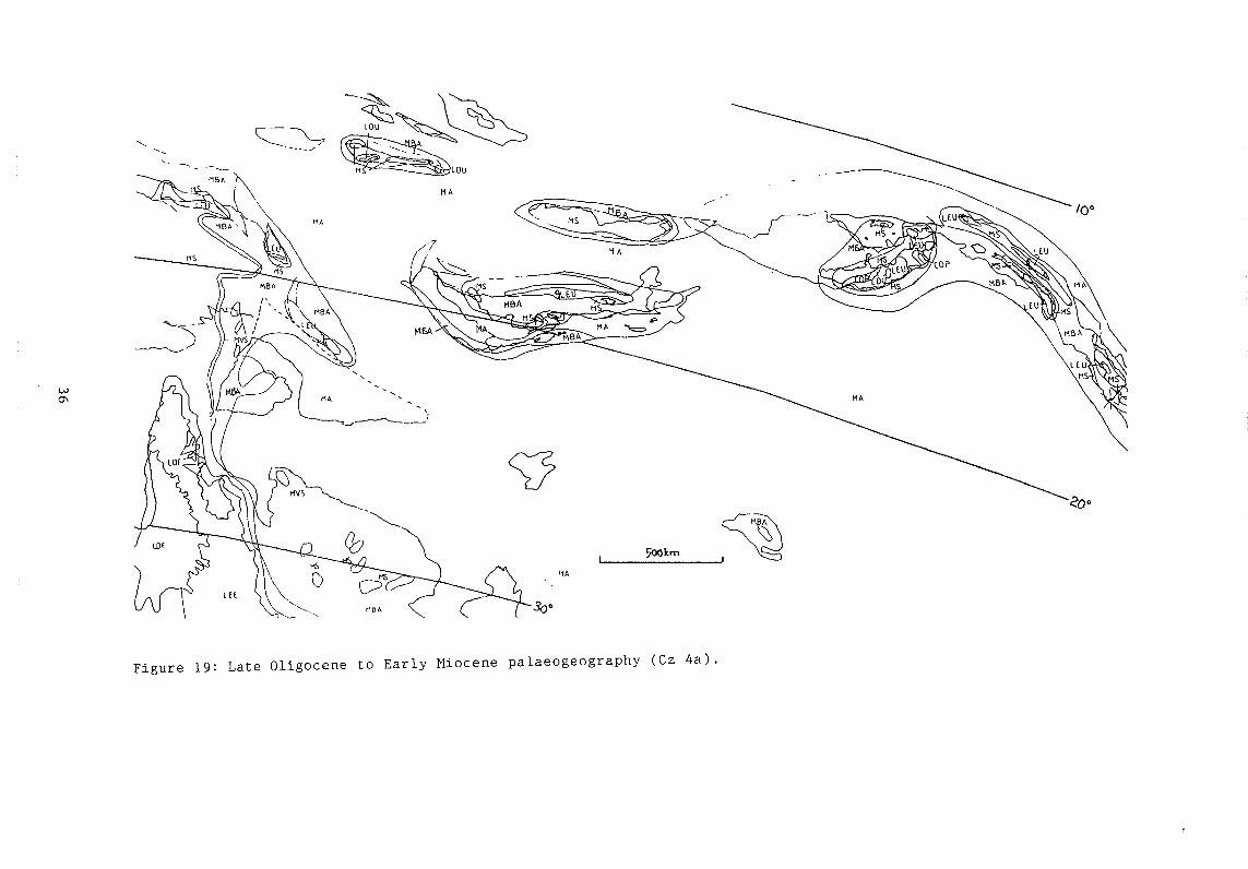
Figure 19: Late Oligocene to Early Miocene palaeogeographY (Cz 4a).

locally shallow water carbonates developed. The volcanics thin to the north,indicating that part of the Trobriand Platform may have been emergent, possiblyrimmed by a shallow water platform; some of the limestones associated with thisenvironment are preserved on Woodlark Island.
Arc volcanism related to the West Melanesian subduction zone continued intotime slice 4a and sedimentation of the associated volcanics and volcaniclasticsoccurred in mostly marine environments. The emergence of the island arc isindicated by conglomerates of this age on the southern Torricelli Terrane and thedevelopment of carbonate buildups in the Aitape Basin (Figure 2). Thesecarbonate buildups could be an important reservoir for hydrocarbons sourcedfrom Miocene to Pliocene sediments. On New Britain, up to 1000m of andesiticlava, tuff, conglomerate and minor limestone were deposited in subaerial,coastal and shallow marine environments. Part of New Ireland, and thesouthwestern New Ireland Basin may have been emergent to shallow marine,but deposition in the greater part of the offshore New Ireland Basin probablyoccurred under bathyal conditions.
3.3 Late Early to Early Middle Miocene (Figure 20)
A major plate tectonic event in Papua New Guinea during this time was thecollision of the East Papua Composite Terrane which is here envisaged to havecaused the northwestward displacement of the jimi and Bena Bena Terranes andthe onset of anticlockwise rotation of the Kubor Block. This is reflected inintensive syn- to post-collisional intrusive activity in the Middle to Late Mioceneon these terranes. Co-magmatic volcanism is indicated by the presence, alongthe margins of the Bena Bena Terrane, of volcanics which were deposited inincreasingly shallow marine conditions. Volcaniclastic turbidites accumulatedin the marine trough south of the emergent landmasses.
Most of the East Papua Composite Block may have been emergent by time slice4b. Arc-related volcanism had ceased and deposition in the Cape Vogel Basinwas characterised by turbidites. Shallowing conditions in the south are indicated
37

Figure 20: Late Early Miocene to early Middle Miocene palaeogeography (Cz 4b).

by the presence of shallow marine volcaniclastic sediments and reefal limestonesalong the southwestern and southern margins of the terrane.
In most of the Papuan Basin, reef and platform environments persisted, butforeland deposits in the north had encroached further south onto the platform.These deposits had become markedly coarser grained by this time. Gradualemergence in the southern Sepik area is evidenced by the presence of coastaldeposits to the southwest and shallow marine conglomerates in the east.Shallow marine conditions in the southern Sepik Basin were probably more
widespread than in time slice 4a.
The northern part of the Sepik Basin was still characterised by turbiditedeposition, but the commencement of collision of the Torricelli Terrane mayhave resulted in generally shallowing conditions. Volcanism on the TorricelliTerrane continued into the Middle Miocene, probably related to northeasterlysubduction of remnant Australian Plate oceanic crust. Fine-grained turbiditicsediments were also deposited in the central Aitape Basin, but reefs probablycontinued growing along the basin margins. Rapid southward deepening in the
southern part of the Terrane probably indicates the location of the trench or
suture.
The arrival of the Ontong Java Plateau at the West Melanesian Trench in latest
time slice 4a time resulted in gradual cessation of volcanism along the former arc
and these areas were now characterised by mostly shallow water carbonate
deposition. Core areas of the islands were probably emergent, as indicated byfluvial to coastal deposits in some areas, for example on the Finisterre Terraneand in New Ireland. Carbonate deposition probably extended into the offshore
basins, for example in the New Ireland and Bougainville Basins.
3.4 Early Pliocene (Figure 21)
By the Early Pliocene the Torricelli Terrane had accreted to the margin. Thecollision of the Finisterre Terrane had commenced in the Late Miocene,
39

0
Figure 21: Early Pliocene palaeogeography (Cz 6a).

progressing eastwards, where a change in provenance in sediments of early LatePliocene age indicates the onset of collision (Abbott & Silver 1991). After the
period of tectonic quiescence in the Middle Miocene in the northeastern arcregion, arc reversal in the Late Miocene resulted in renewed volcanism onBougainville, New Ireland and New Britain. The products of this volcanism are
preserved as volcanidastic sediments which were deposited in mostly shallow to
deep marine environments. They provide a possible regional seal for the
Miocene limestones.
In the Papuan Basin, the greater part of the Fly Platform and western Gulf of
Papua were again inundated by a shallow sea, but the carbonate platform had bythis time been buried by clastics shed from the northern emerging mountains.The sediments become finer towards the east and northeast grading into theshallow to deeper marine thick claystones of the Orubadi Beds. Occasional lensesand interbeds of detrital limestones wthin this sequence indicate commencinguplift of the Miocene carbonate platform in the northern part of the basin.
The greater part of central northern Papua New Guinea was probably emergentwith a central chain of highlands, which reflect continued uplift and thedevelopment of the southern fold belt. Volcanism associated with this upliftcommenced in the late Early Pliocene in the central fold belt area. In thenorthwestern Papuan Basin, thick coarse to fine clastics were shed from thehighlands and were deposited in fluvial to coastal environments. Similarly,continuing uplift of the East Papua Composite Block is evidenced by extensive
fluvial, coastal and marine foreland basin deposition along its southern margin,and preserved early Pliocene fluvial to fluvio-lacustrine deposits in the present-
day ranges themselves. Extensive subaerial volcanism along the western andsouthern margins of the terrane was probably related to thrust loading and uplift.
In northern Papua New Guinea, most of the southern Sepik Basin was probablyemergent, but with a coastal to shallow marine fringe in the northwest, and adeeper marine trough in the northeast. Deep marine conditions probablyprevailed in the central Aitape Basin as indicated by an interbedded sequence of
41

I442 15G°150°
Figure 22: Late Quaternary palaeogeography (Cz 7 - late).

micaceous mudstone and graded lithic sandstone. The greater part of theaccreting eastern Finisterre Terrane was emergent, with outcrops of the earlierarc volcanics providing the source for fluvial conglomerates of the syntectonicLeron Formation, which was deposited along their southeastern rim. Thesedeposits become finer grained towards the west in the Ramu Basin, where fine-to coarse grained sediments were deposited in shallow to deeper marine
environments.
3.5 Holocene (Figure 22)
The last map captures the major sealevel lowstand at approximately 18 000 yearsago during the last major glaciation. The geography in the northern island chainand along tile north coast was very similar to the present-day with slightly more
extensive land areas and coastal fringes due to the sealevel fall. The fluvialsystem on the Fly Platform probably extended further eastwards with a large delta
in the Gulf of Papua, whereas the southern rivers that now run into Torres Straitprobably dewatered into a large inland lake postulated for the Gulf of Carpentaria(Smart, 1977; Langford, 1990). Glaciers developed along the central chain ofhighlands, mostly on the summits of the higher volcanoes.
4. CONCLUSIONS
In conclusion, the major aspects in the palaeogeographic development of the
eastern New Guinea region during the Mesozoic to Recent can be summarised as
follows:
During the Mesozoic to Paleocene, the northern edge of the Australian Plate wasa passive margin which experienced two major phases of extension, in theTriassic/Jurassic and in the Late Cretaceous to Early Eocene. Triassic to EarlyJurassic sedimentation occurred across a passive margin in depocentres thatformed in response to initial extension. Fluvial to shallow marine
volcaniclastics and redbeds were deposited in restricted areas in the Papuan and
South New Guinea Basin and on continental fragments (Birdshead/Kemum
43

Terrane, Jimi Terrane) that were detached from the margin later in the Mesozoic.During the Middle to Late Jurassic, sedimentation along the northeasternAustralian margin was controlled by a change from the Triassic rift regime toone of breakup and ocean formation, resulting in widespread inundation of theregion. In southern Papua New Guinea, deposition continued in fluvial, paralicand shallow marine environments, whereas deeper marine shales accumulatedin northern Papua New Guinea and also across the greater part of the Irian Jayaterranes. The earliest Cretaceous was characterised by widespread paralic todeltaic conditions, which resulted in the deposition of reservoir sandstonesacross the Papuan Basin and the Irian Jaya Platform. Increasing marineinundation during the Early Cretaceous led to the deposition of mostly fine-
grained dastics throughout the region.
A second phase of rifting along the northern margin commenced in the mid-Cretaceous, resulting in extensive volcanism and intrusive activity. The onset ofseafloor spreading in an unnamed ocean basin to the north of present-day PapuaNew Guinea in the Late Cretaceous led to the detachment of continentalfragments that now form part of southeastern Indonesia. Ocean formation in theCoral Sea occurred in the latest Cretaceous to Early Eocene causing the northwardmovement of the North Coral Sea and Eastern Papuan Plateau components.Regional uplift associated with this extensional event occurred throughout theregion in the Late Cretaceous to Paleocene resulting in widespread erosion ofearlier Mesozoic sediments. Remnants of the erosional products are preserved
in the present-day fold belt area.
Increasing rates of northward movement of the Australian Plate and a change in
movement direction of the Pacific Plate from the Middle Eocene onwards led tothe oblique collision of the two plates, the formation of island arcs above twomajor subduction zones, and the successive accretion of allochthonous terranesto the Australian Craton from the Oligocene onwards. On mainland Papua NewGuinea, a carbonate platform developed in the northern and northeasternPapuan Basin, whereas the developing island arcs to the northeast were
44

characterised by the extrusion of andesitic-basaltic lavas and the deposition of
associated sediments in mostly deep water environments.
Carbonate platform and reef environments predominated in most of southern
Papua New Guinea during the Late Oligocene to Middle Miocene, providingimportant reservoir fades for hydrocarbons sourced from Mesozoic and possibly
Pliocene shales. The first collisional event along the northern margin occurredin the mid-Oligocene, resulting in initiation of foreland basin deposition in the
northernmost Papuan Basin. At the same time, to the north and northeast,island arc volcanism continued above two major subduction zones in bathyal to
shallow marine environments.
In time slice 4h time, carbonate deposition continued in most of the PapuanBasin, but clastic foreland basin deposition had encroached further southwards.The accretion of the East Papua Composite Block to the northeastern Australianplate margin caused the displacement of slivers of Australian craton. Upliftcommenced in central northern New Guinea, while successor basins formedbetween the craton and the accreting terranes. The collision of the Ontong JavaPlateau with the West Melanesian Arc caused the waning of volcanism and atectonically quiescent period dominated by carbonate deposition throughout the
region.
During the Early Pliocene burial of the carbonate platform by foreland basin
deposits continued in the Papuan Basin. These sediments provide a seal for the
limestone reservoirs. Collision of the Finisterre island arc terrane and theformation of the Papuan/Irian Jaya Fold Belt commenced, with associated trapformation. Arc reversal in the northeast resulted in the burial of the Miocenecarbonates by thick volcaniclastic sequences.
45

5. ACKNOWLEDGEMENTS
The Mesozoic to Cainozoic palaeogeographic maps and plate tectonicreconstructions were produced as part of the BMR-APIRA Phanerozoic Historyof Australia Project, and sponsoring companies are thanked for their input to theproject. We wish to express thanks to many colleagues from the BMR for theirwillingness to discuss our data and interpretations throughout the project, inparticular C.J. Pigram, P.E. Pieters, P.A. Symonds and R.W. Johnson. M.I. Rossand J. Symond are thanked for their input to the computing side of the project.W.D. Palfreyman, C.J. Pigram and J.M. Totterdell helped by critically reading themanuscript, and P.J. Brown is thanked for drafting the majority of theillustrations.
6. BIBLIOGRAPHY
Abbot, L.D. & Silver, E.A., 1991 - Anatomy of an arc-continent collision: Finisterre Range of PapuaNew Guinea. American Geophysical Union, Fall Meeting 1991, TI 1D-9.
Abers, G.A. & McCaffrey, R., 1988 - Active deformation in the New Guinea fold- and thrust belt:seismological evidence for strike-slip faulting and basement-involved thrusting. Journal ofGeopysical Research, 93, 13332-13354.
Abers, G.A. & Roecker, S.W., 1991 - Deep structure of an arc-continent collision: earthquakerelocation and inversion for upper mantle P and S wave velocities beneath Papua NewGuinea. Journal of Geophysical Research, 96 (B4), 6379-6401.
Achdan, A. & Turkandi, T., 1981 - Geologic map of Kai Quadrangles, Maluku, scale 1:250,000.Geological Research and Development Centre, Indonesia.
Achdan, A. & Turkandi, T., 1982 - Geologic report of Kai Quadrangles, Maluku, scale 1:250,000.Geological Research and Development Centre, Indonesia.
Agustiyanto, D.A., Suparman, M. & Achdan, A., 1988 - Geologic report of Babar Quadrangles,southeast Maluku, scale 1:250,000. Geological Research and Development Centre,Indonesia.
Ahmad, W., 1975 - Geology along the Matano Fault Zone, East Sulawesi, Indonesia. RegionalConference on the Geology and Mineral Resources of Southeast Asia, Proceedings. 2, 143-150.
Arnold, G. 0., Griffin, T. J. & Hodge, C. C., 1979 - Geology of the Ok Tedi and Southern Atbalmin1:100,000 sheet. Papua New Guinea Geological Survey, Report, 79/3.
46

Ashley, P. M. & Flood, R. H., 1981 - Low-K tholeiites and high-K igneous rocks from WoodlarkIsland, Papua New Guinea. Journal of the Geological Society of Australia, 28, 227-240.
Audley-Charles, M.G., 1966 - The age of the Timor Trough. Deep Sea Research, 13, 761-763.
Audley-Charles, M.G., 1968 - Geology of Portuguese Timor. Geological Society of London, Memoir,4, 1-76.
Audley-Charles, M.G., 1972 - Cretaceous deep-sea manganese nodules on Timor: Implications fortectonics and olistostrome development. Nature Physical Science, 240, 137-141.
Audley-Charles, M.G., 1974 - Banda Arcs. In Spencer, H.M. (Editor), Mesozoic - Cenozoic orogenicbelts. Geological Society of London, Special Publication, 4, 349-363.
Audley-Charles, M.G., 1981a - Geological history of the region of Wallace's line. In Whitmore,T.C., (Editor), Wallace's line and plate tectonics. Oxford University Press, 24-35.
Audley-Charles, M.G., 1981b - Geometrical problems and implications of large scale overthrustingin the Banda Arc - Australian margin collision zone. Thrust and Nappe Tectonics,Geological Society of London, Special Publication 9, 407-416.
Audley-Charles, M.G., 1983a - Reconstruction of eastern Gondwanaland. Nature, 306, 48-50.
Audley-Charles, M.G., 1983b - Comment. Geology, 11, 490-493.
Audley-Charles, M.G., 1984 - Cold Gondwana, warm Tethys and the Tibetan Lhasa block. Nature,310, 165-166.
Audley-Charles, M.G., 1985 - The Sumba enigma: Is Sumba a diapiric fore-arc nappe in process offormation? Tectonophysics, 119, 435-449.
Audley-Charles, M.G., 1986a - Rates of Neogene and Quaternary tectonic movements in thesouthern Banda Arc based on micropalaeontology. Journal of the Geological Society ofLondon, 143, 161-175.
Audley-Charles, M.G., 1986b - Timor-Tanimbar Trough : the foreland basin of the evolving Bandaorogen. In Allen, P.A., & Homewood, P. (Editors), Foreland basins. InternationalAssociation of Sedimentologists, Special Publication 8, 91 -102.
Audley-Charles, M.G., 1988 - Evolution of the southern margin of Tethys (North Australian region)from early Permian to late Cretaceous. In Audley-Charles, M.G. & Hallam, A. (Editors),Gondwana and Tethys. Geological Society, Special Publication, 37, 79 -100.
Audley-Charles, M.G., 1991 - Tectonics of the New Guinea area. Annual Reviews, Earth andPlanetary Science, 19, 17-41.
Audley-Charles, M.G. & Carter, D.J., 1972 - Palaeogeographical significance of some aspects ofPalaeogene and Early Neogene stratigraphy and tectonics of the Timor Sea region.Palaeogeography, Palaeoclimatology, Palaeoecology, 11, 247-264.
Audley-Charles, M.G. & Carter, D.J., 1974 - Petroleum prospects of the southern part of the BandaArcs, eastern Indonesia. CCOP Technical Bulletin, 8, 55-70.
Audley-Charles, M.G. & Carter, D.J., 1977 - Interpretation of a regional seismic line from Misool toSeram: Implications for regional structure and petroleum exploration. South East Asian Oiland Gas Journal, 23(10), 20-23.
47

Audley-Charles, M.G. & Hallam, A., 1989 - Introduction. In Audley-Charles, M.G. & Hallam, A.(Editors), Gondwana and Tethys. Geological Society, Special Publication 37, 1-4.
Audley-Charles, M.G., Ballantyne, P.D. & Hall, R., 1988 - Mesozoic-Cenozoic rift-drift sequence ofAsian fragments from Gondwanaland. Tectonophysics, 155, 317-330.
Audley-Charles, M.G., Barber, A.J. & Carter, D.J., 1979 - Geosynclines and plate tectonics in BandaArcs, eastern Indonesia: Discussion. American Association of Petroleum Geologists,Bulletin, 63(2), 249-252.
Audley-Charles, M.G., Carter, D.J. Barber, A.J., Norvick, M.S. & Tjokrosapoetro, S., 1979 -Reinterpretation of the geology of Seram: Implications for the Banda Arcs and northernAustralia. Geological Society of London, Quarterly Journal, 136, 547-568.
Audley-Charles, M.G., Carter, D.J. & Milsom, J.S., 1972 - Tectonic development of Eastern Indonesiain relation to Gondwanaland dispersal. Nature Physical Science, 239, 35-39.
Audley-Charles, M.G., Hurley, A.M. & Smith, A.G., 1981 - Continental movements in the Mesozoicand Cenozoic. In Whitmore, T.C. (Editor), Wallace's line and plate tectonics. ClarendonPress New York, Oxford University Press, 9-23.
Australasian Petroleum Company Pty., 1961 - Geological results of petroleum exploration in westernPapua 1937-1961. Geological Society of America, Journal, 8, (1), 1-133.
Bain, J.H.C., 1971 - A summary of the main structural elements of Papua New Guinea. In Coleman,P.J. (Editor), The Western Pacific, island arcs, marginal seas, geochemistry. University ofWestern Australia Press, Perth, 147-161.
Bain, J. H. C. & Binnekamp, J. G., 1973 - The foraminifera and stratigraphy of the ChimbuLimestone, New Guinea. Bureau of Mineral Resources, Geology & Geophysics, Australia,Bulletin, 139, 1-12.
Bain, J. H. C. & Mackenzie, D. E., 1974 - Karimui, Papua New Guinea - 1:250,000 geological series.Bureau of Mineral Resources, Geology & Geophysics, Australia, and Papua New GuineaGeological Survey, Explanatory Notes, SB/55-9.
Bain, J. H. C. & Mackenzie, D. E., 1975 - Ramu, Papua New Guinea - 1:250,000 geological series.Bureau of Mineral Resources, Geology & Geophysics, Australia, and Papua New GuineaGeological Survey, Explanatory Notes, SB/55-5.
Bain, J. H. C., Mackenzie, D. E. & Ryburn, R. J., 1975 - Geology of the Kubor Anticline, centralhighlands of Papua New Guinea. Bureau of Mineral Resources, Geology & Geophysics,Australia, Bulletin 155.
Bainton, C.S., 1975 - Coal formations in Indonesia. Indonesian Association of Geologists. RegionalConference on the Geology and Mineral Resources of South East Asia, Proceedings, 55-63.
Barber, A.J., 1981 - Structural interpretation of the island of Timor, eastern Indonesia. GeologicalResearch and Development Centre, Special Publication 2, 183-197.
Barber, A.J., 1985 - Allochthonous terranes and strike-slip faulting in the Australia -Banda Arccollision zone. In Leitch, E.C. (Editor), Third Circum-Pacific Terrane Conference, Sydney1985, Extended Abstracts, Geological Society of Australia, Abstracts, 14.
Barber, A.J. & Audley-Charles, M.G., 1976 - The significance of the metamorphic rocks of Timor inthe development of the Banda Arc, eastern Indonesia. Tectonophysics, 30, 119-128.
48

Barber, A.J., Audley-Charles, M.G. & Carter, D.J., 1977 - Thrust tectonics in Timor. Journal of theGeological Society of Australia, 24(1), 51 -62.
Barber, A.J., & Wiryosujono, S., 1979 - The geology and tectonics of eastern Indonesia. GRDC(SEATAR) Special Publication 2 (Pergamon Press).
Barber, A.J., Tjokrosapoetro, S. & Charlton, T.R., 1986 - Mud volcanoes, shale diapirs, wrenchfaults, and melanges in accretionary complexes, eastern Indonesia. American Association ofPetroleum Geologists, Bulletin, 70(11) 1729-1741.
Beckett, C., Kila, U. & Kila, K., 1989 - Petroleum Division open file data catalogue. GeologicalSurvey of Papua New Guinea.
Beiersdorf, H., 1989 - Provenance and accumulation rates of Pliocene and Quaternary sediments fromthe western Coral Sea. Geologische Rundschau, 78 (3), 987-998.
Belford, D.J., 1984 - Tertiary foraminifera and age of sediments, Ok Tedi - Wabag, Papua NewGuinea. Bureau of Mineral Resources, Geology & Geophysics, Australia, Bulletin 216.
Belford, D.J., 1988a - Planktonic foraminifera, age of sediments and polarity reversals, NewBritain, Papua New Guinea. BMR Journal of Australian Geology & Geophysics, 10, 329-343.
Belford, D.J., 1988b - Late Tertiary and Quaternary foraminifera and paleobathymetry of dredgeand core sameples from the New Ireland Basin. In Marlow, M.S., Dadisman, S.V. Sr Exon,N.F. (Editors), Geology and offshore resources of Pacific island arcs - New Ireland andManus region, Papua New Guinea. Circum-Pacific Council for Energy and MineralResources, Earth Science Series, 9, 65-90.
Berggren, W. A., 1969 - Cainozoic chronostratigraphy, planktonic foraminiferal zonation and theradiometric time scale. Nature, 224, 1072-1075.
Berggren, W. A., Kent, D. V. & Van Couvering, J. A., 1985a - Paleogene geochronology andchronostratigraphy. In Snelling, N. J. (Editor), The chronology of the geological record.Geological Society of London, Memoir, 10, 141 -195.
Berggren, W. A., Kent, D. V. & Van Couvering, J. A., 1985b - The Neogene: Part 2. Neogenegeochronology and chronostratigraphy. In Snelling, N. J. (Editor), The chronology of thegeological record. Geological Society of London, Memoir, 10, 211 -260.
Berry, R.F. & Grady, A.E., 1981 - Deformation and metamorphism of the Aileu Formation, northcoast, East Timor and its tectonic significance. Journal of Structural Geology, 3(2), 143-167.
Bickel, R. S., 1974 - Reconnaissance geology of the Cape Vogel Basin, Papua New Guinea. AmericanAssociation of Petroleum Geologists, Bulletin, 52, (12), 2477-2489.
Bickel, R. S., 1976 - Cape Vogel Basin. In Leslie, R. B., Evans, H. J. & Knight, C. L. (Editors),Economic geology of Australia and Papua New Guinea. Volume 3- petroleum. AustralasianInstitute of Mining and Metallurgy, Monograph, 7, 506-513.
Binns, R.A., Scott, S.D. & PACKLARK Participants, 1989 - Propagation of sea-floor spreading intocontinental crust, western Woodlark Basin, Papua New Guinea. Joint CCOPISOPAC -IOC4th International Workshop on Geology, Geophysics and Mineral Resources of the SouthPacific, 24 September-1 October 1989, Canberra, Australia, Programme & Abstracts Volume,14-15.
49

Bird, K.J. & Seggie, R., 1990 - Barikewa and Iehi Gas Fields revisited. In Carman, G.J. & Carman,Z. (Editors), Petroleum exploration in Papua New Guinea. First PNG PetroleumConvention, Port Moresby, 12 -14th February 1990, Proceedings, 551 -565.
Bird, P.R., 1985 - The Permian sediments of the Northwest Shelf of Australia and Timor, Indonesia.Geological Research in Southeast Asia, Report 33, University of London.
Bird, P.R., Brata, K. & Umar, I., 1987 - Sedimentation and deformation of the Permo-Triassic ofKekeno, West Timor: From intracratonic basin to accretionary complex. GEOSEA VIJakarta, 1-33 (unpublished).
Blake, D.H. & Miezitis, Y., 1967 - Geology of Bougainville and Bulca Islands, New Guinea. Bureauof Mineral Resources, Geology & Geophysics, Australia, Bulletin 93.
Blow, W. H., 1969 - Late Middle Eocene to Recent planktonic foraminiferal biostratigraphy. InBronniman, P. & Rens, H.H. (Editors), 1st International Conference on PlanktonicMicrofossils, Geneva, 1967, Proceedings, 1, 199-422.
Blow, W. H., 1979 - The Cainozoic Globigerinida. A study of the morphology, taxonomy,evolutionary relationships and the stratigraphic distribution of some Globigerinida(mainly Globigerinacea). E.I. Brill, Leiden.
BMR Palaeogeographic Group, 1990 - Australia, evolution of a continent. Bureau of MineralResources, Geology & Geophysics, Australia, 97pp.
Bowin, C., & Johnston, C., 1981 - Arc-continent collision in Banda Sea region: reply. AmericanAssociation of Petroleum Geologists, Bulletin, 65(5-9) 867.
Bowin, C., Purdy, G.M., Johnston, C., Shor, G., Lawyer, L., Hartono, H.M.S. & Jezek, P., 1980 - Arc-continent collision in Banda Sea region. American Association of Petroleum Geologists,Bulletin, 64(6), 868-915.
Bradshaw, M.T. & Yeung, M., in press - Palaeogeographic Atlas of Australia. Volume 8 Jurassic.Bureau of Mineral Resources, Geology & Geophysics, Australia.
Bradshaw, M.T. & Ross, M.I., in prep. - Preliminary reconstructions for the Solomon Islands -Vanuatu - Fiji region.
Bradshaw, M.T., Beynon, R.M., Burger, D. & Yeung, M., in prep. - Palaeogeographic Atlas ofAustralia. Volume 9 Cretaceous. Bureau of Mineral Resources, Geology & Geophysics,Australia.
Bradshaw, M.T., Yeates, A.N., Beynon, R.M., Brakel, A.T., Langford, R.P., Totterdell, J.M. &Yeung, M., 1988 - Palaeogeographic evolution of the North West Shelf region. In Purcell,P.G. & Purcell, R.R. (Editors), The North West Shelf of Australia. Petroleum ExplorationSociety of Australia, North West Shelf Symposium, Perth, Proceedings, 29-54.
Brakel, A.T. & Totterdell, J.M., in prep. - Palaeogeographic Atlas of Australia. Volume 6 Permian.Bureau of Mineral Resources, Geology & Geophysics, Australia.
Brown, C. M., 1977 - Yule, Papua New Guinea - 1:250,000 geological series. Bureau of MineralResources, Geology & Geophysics, Australia, Explanatory Notes, SC/55 -2.
Brown, C.M., 1982 - Kavieng, Papua New Guinea - 1:250,000 geological series. Geological Survey ofPapua New Guinea, Explanatory Notes, SA/56-9.
50

Brown, C.M. & Robinson, G.P., 1982 - Kutubu, Papua New Guinea - 1:250,000 geological series.Geological Survey of Papua New Guinea, Explanatory Notes, SB/54-12.
Brown, C. M., Pieters, P. E. & Robinson, G. P., 1975 - Stratigraphic and structural development ofthe Aure Trough and adjacent shelf and slope areas. The APEA Journal, 15, 61-71.
Brown, C. M., Pigram, C. J. & Skwarko, S. K., 1980 - Mesozoic stratigraphy and geological historyof Papua New Guinea. Palaeogeography, Palaeoclimatology, Palaeoecology, 29, 301-322.
Bruns, T.R., Cooper, A.K., Mann, D.M. & Vedder, J.G., 1986 - Seismic stratigraphy and structure ofsedimentary basins in the Solomon Islands region. in Vedder, J.G., Pound, K.S. & Boundy,S.Q. (Editors), Geology and offshore resources of Pacific island arcs - central and westernSolomon Islands. Circum -Pacific Council for Energy and Mineral Resources Earth ScienceSeries, 4, 177-223.
Bruns, T.R., Vedder, J.G. & Cooper, A.K., 1989 - Structure and tectonics along the Kilinailau Trench,Bougainville-Buka region, Papua New Guinea. In Vedder, J.G. & Bruns, T.R. (Editors),Geology and offshore resources of Pacific island arcs - Solomon Islands and Bougainville,Papua New Guinea regions. Circum-Pacific Council for Energy and Mineral Resources EarthScience Series, 12, 93-123.
Burger, D., 1986 - Palynology, cyclic sedimentation, and palaeoenvironments in the Late Mesozoicof the Eromanga Basin. In Gravestock, D.I., Moore, P.S. & Pitt, G.M. (Editors),Contributions to the geology and hydrocarbon potential of the Eromanga Basin. GeologicalSociety of Australia, Special Publication, 12, 53-70.
Burns, B.J. & Bein, J., 1980 - Regional geology and hydrocarbon potential of the Mesozoic of thewestern Papuan Basin, Papua New Guinea. The APEA Journal, 20 (1), 1-15.
Burrett, C., & Stait, B., 1986 - Southeast Asia as a part of an early Palaeozoic AustralianGondwanaland. Geological Society of Malaysia, Bulletin 19, 103 -107.
Cande, S.C. & Mutter, J.C., 1982 - A revised identification of the oldest sea-floor spreadinganomalies between Australia and Antarctica. Earth and Planetary Science Letters, 58, 151-160.
Cardwell, R.K. & Isacks, B.L., 1978 - Geometry of the subducted lithosphere beneath the BandaSea in eastern Indonesia from seismicity and fault plane solutions. Journal of GeophysicalResearch, 83(B6), 2825-2838.
Carman, G.J., 1987 - The stratigraphy of the Aure Scarp, Papua New Guinea. PESA Journal, 11, 26-35.
Carman, G. J., 1990 - Occurrence and nature of Eocene strata in the eastern Papuan Basin. In Carman,G. J. & Carman, Z. (Editors), Petroleum exploration in Papua New Guinea. First PNGPetroleum Convention, Port Moresby, 12 -14 February 1990, Proceedings, 169-183.
Carman, G. J. & Archbold, N.W., 1990 - Macrofossil evidence for a palaeo-high, Erun Anticline,Papua New Guinea. In Carman, G.J. & Carman, Z. (Editors), Petroleum exploration inPapua New Guinea. Proceedings of the First PNG Petroleum Convention, Port Moresby,12-14 February 1990, 397-402.
Carman, G.J. & Carman, Z. (Editors), Petroleum Exploration in Papua New Guinea. First PNGPetroleum Convention, Port Moresby, 12-14 February 1990, Proceedings.
51
Carter, D.J., Audley-Charles, M.G. & Barber, A.J., 1976 - Stratigraphical analysis of island arc-continental margin collision in eastern Indonesia. Journal of the Geological Society ofLondon, 132, 179-198.
Caye, J.P., 1968 - The Timor-Sahul shelf area. The APEA Journal, 8(2), 35-41.
Challinor, A.B., 1989 - The succession of belemnopsis in the Late Jurassic of eastern Indonesia.Palaeontology, 32, (3), 571-596.
Challinor, A.B., 1990 - A belemnite biozonation for the Jurassic-Cretaceous of Papua New Guineaand a faunal comparison with eastern Indonesia. BMR Journal of Australian Geology &Geophysics, 11, 429-447.
Challinor, A.B. & Skwarko, S.K., 1982 - Jurassic belemnites from the Sula Islands, Moluccas,Indonesia. Publication of the Geological Research and Development Centre, Indonesia,Palaeontology Series 3.
Chamalaun, F.H. & Grady, A.E., 1978 - The tectonic development of Timor: a new model and itsimplications for petroleum exploration. The APEA Journal 18(1), 102-108.
Chamalaun, F.H., Grady, A.E., Von Der Borch, C.C. & Hartono, H.M.S., 1981 - The tectonicsignificance of Sumba. Geological Research and Development Centre, Indonesia, Bulletin,5.
Chamalaun, F.H., Lockwood, K. & White, A., 1976 - The Bouguer gravity field and crustal structureof eastern Timor. Tectonophysics, 30, 241-259.
Chappell, J., 1974 - Geology of coral terraces on Huon Peninsula, New Guinea: a study of Quaternarytectonic movements and sealevel changes. Geological Society of America, Bulletin, 85,553-570.
Chappell, J., & Veeh, H.H, 1978 - Late Quaternary tectonic movements and sea-level changes atTimor and Aturo Island. Geological Society of America, Bulletin, 89, 356-368.
Chaproniere, G.C.H., Pigram, C.J., Symonds, P.A. & Davies, P.J., 1990 - The northeasternAustralian margin and adjacent areas - a biostratigraphic review and geohistory analysis.Bureau of Mineral Resources, Geology & Geophysics, Australia, Record 1990/7.
Charlton, T.R., 1986 - A plate tectonic model of the eastern Indonesian collision zone. Nature, 319,394-396.
Charlton, T.R., 1987 - Jurassic-Recent stratigraphic correlation between the Australian NorthwestShelf and Timor. Geological Research in Southeast Asia, Report 49, University of London.
Charlton, T.R., 1988 - Tectonic erosion and accretion in steady state trenches. Tectonophysics, 149,233-243.
Charlton, T.R., 1989 - Stratigraphic correlation across an arc-continent collision zone: Timor and theAustralian Northwest Shelf. Australian Journal of Earth Sciences, 36, 263-274.
Charlton, T.R., Barber, A.J. & Barkham S.T., 1991 - The structural evolution of the Timor collisioncomplex, eastern Indonesia. Journal of Structural Geology, 13(5) 489-500.
Charlton, T.R., Barber, A.J. & De Smet, M.E.M., 1991 - The Banda Arc-Australia collision zone.SGTSG Conference, Kangaroo Island, February 1989, Australasian Tectonics, GeologicalSociety of Australia, Abstracts, 18-19.
52

Chevallier, B. & Bordenave, M.L., 1986 - Contribution of geochemistry to the exploration in theBintuni Basin, Irian Jaya. Indonesian Petroleum Association, 15th Annual Convention,October 1986, Proceedings, 439-460.
Clague, D.A. & Jarrard, R.D., 1973 - Tertiary Pacific plate motion deduced from the Hawaiian-Emperor Chain. Geological Society of America, Bulletin, 84, 1135-1154.
Coleman, P.J. & Packham, G.H., 1976 - The Melanesian borderlands and India - Pacific plates'boundary. Earth Science Reviews, 12, 197-233.
Collins, J.L. & Qureshi, M.K., 1976 - Reef exploration in Bintuni Basin and Bomberai Trough - IrianJaya. Indonesian Petroleum Association, Carbonate Seminar, Proceedings, Special Volume,122-124.
Conybeare, C.E.B. & Jessop, R.G.C., 1972 - Exploration for oil-bearing sand trends in the Fly Riverarea, western Papua. The APEA journal, 1972, 69-73.
Cook, P.J., 1988 - Palaeogeographic Atlas of Australia. Volume 1 Cambrian. Bureau of MineralResources, Geology & Geophysics, Australia.
Cook, P.J. & Totterdell, J.M., 1991 - Palaeogeographic Atlas of Australia. Volume 2 Ordovician.Bureau of Mineral Resources, Geology & Geophysics, Australia.
Cook, S.E., 1985 - A comparison of sandstones from the Northwest Shelf of Australia and from theKekneno area of West Timor, Indonesia. Geological Research in Southeast Asia, Report 34,University of London.
Cook, S.E., 1987 - Stratigraphic sequences in deep water Triassic sediments from Timor. GeologyDepartment, Royal Holloway & Bedford New College, Egham, Surrey, Paper 441.
Cook, S.E., Hasan, K., Said, A. & Hidayat, S., 1987 - Stratigraphic sequences in deep waterTriassic sediments from Timor. Unpublished Report.
Cooper, P. & Taylor, B., 1987 - Seismotectonics of New Guinea: a model for arc reversal followingarc-continent collision. Tectonics, 6 (1), 53-67.
Crook, K. A. W., 1989 - Suturing history of an allochthonous terrane at a modern plate boundarytraced by flysh-to-molasse facies transitions. Sedimentary Geology, 61, (1989), 49-79.
Crook, K.A.W. & Belbin, L., 1978 - The southwest Pacific area during the last 90 million years.Journal of the Geological Society of Australia, 25 (1), 23-40.
Crook, K.A.W., Taylor, B. & Musgrave, R.J., 1989 - Triple junction tectonics, eastern WoodlarkBasin, Solomon Islands. Joint CCOPISOPAC-IOC 4th International Workshop on Geology,Geophysics and Mineral Resources of the South Pacific, 24 September - 1 October 1989,Canberra, Australia, Programme & Abstracts Volume, 27.
Crostella, A., 1977 - Geosynclines and plate tectonics in the Banda Arcs, eastern Indonesia.American Association of Petroleum Geologists, Bulletin, 61(12), 2063-2081.
Crostella, A. & Powell, D.E., 1975 - Geology and hydrocarbon prospects of the Timor Sea.Australasian Oil & Gas Review, 21(11), 18-29.
Cullen, A. B. & Pigott, J. D., 1990 - A kinematic model for opening of the Bismarck spreading systemfollowing terrane accretion, and the effects upon the Plio-Pleistocene geological evolutionof northern Papua New Guinea. Orogenesis in Action, London, 18 -20 April 1990, Abstracts,18.
53

Cussen, M. J., Wangu, A., McCulla, M.S. & Tau Loi, D., 1986 - Geology and mineralisation of theWau area, Papua New Guinea. Geological Survey of Papua New Guinea, Report, 86/16.
D'Addario, G.W., Dow, D.B. & Swoboda, R., 1975 - Geology of Papua New Guinea, 1:2,500,000.Bureau of Mineral Resources, Geology & Geophysics, Australia.
Daly, M.C., Hooper, B.G.D. & Smith, D.G., 1987 - Tertiary plate tectonics and basin evolution inIndonesia. Indonesian Petroleum Association, Sixteenth Annual Convention, Proceedings,400428.
Davey, R.J., 1987 - Palynological zonation of the Lower Cretaceous, Upper and uppermost MiddleJurassic in the northwestern Papuan Basin of Papua New Guinea. Geological Survey ofPapua New Guinea, Memoir 13.
Davidson, J.W., 1991 - The geology and prospectivity of Buton Isalnd, S.E. Sulawesi, Indonesia.Indonesian Petroleum Association, 20th Annual Convention, Proceedings, 209-233.
Davies, H. L., 1971 - Peridotite-gabbro-basalt complex in Eastern Papua: an overthrust plate ofoceanic mantle and crust. Bureau of Mineral Resources, Geology & Geophysics, Australia,Bulletin 128.
Davies, H. L., 1973a - Fergusson Island, Papua New Guinea - 1:250,000 geological series. Bureau ofMineral Resources, Geology & Geophysics, Australia, Explanatory Notes, SC/56-5.
Davies, H.L., 1973b - Gazelle Peninsula, New Britain - 1:250,000 geological series. Bureau ofMineral Resources, Geology & Geophysics, Australia, Explanatory Notes, SB/56-2.
Davies, H. L., 1980a - Folded thrust fault and associated metamorphics in the Suckling-Daymanmassif, Papua New Guinea. American Journal of Science, 280-A, 171-191.
Davies, H. L., 1980b - Crustal structure and emplacement of ophiolite in southeastern Papua NewGuinea. In Allegre, C. & Aubouin, J. (Compilers), Orogenic mafic ultramafic association.Centre National de la Recherche Scientifique, Paris, Colloques Internationaux, 272, 17-33.
Davies, H.L., 1982a - The Papua New Guinea thrust belt, longitude 141-144 East. Bureau of MineralResources, Geology & Geophysics, Australia, Record 1982/3, 24.
Davies, H. L., 1982b - Mianmin, Papua New Guinea - 1:250,000 series. Geological Survey of PapuaNew Guinea, Explanatory Notes, SB/54-3.
Davies, H. L., 1983 - Wabag, Papua New Guinea - 1:250,000 series. Geological Survey of PapuaNew Guinea, Explanatory Notes, SB/54-8.
Davies, H. L., 1988 - The Finisterre collision. 9th Australian Geological Convention, Abstracts, 21,109.
Davies, H. L., 1990 - Structure and evolution of the border region of New Guinea. In Carman, G.J. SrCarman, Z. (Editors), Petroleum exploration in Papua New Guinea. First PNG PetroleumConvention, Port Moresby, 12-14th February 1990, Proceedings, 245-269.
Davies, H. L. & Hutchison, D. S., 1982 - Ambunti, Papua New Guinea - 1:250,000 geological series.Geological Survey of Papua New Guinea, Explanatory Notes, SB/54-4.
Davies, H.L. & Norvick, M., 1974 - Blucher Range, Papua New Guinea, 1:250,000 geological series.Bureau of Mineral Resources, Geology & Geophysics, Australia, and Geological Survey ofPapua New Guinea, Explanatory Notes, SB/54-7.
54

Davies, H. L. & Smith, I. E, 1971 - Geology of Eastern Papua. Geological Society of America,Bulletin, 82, 3299-3312.
Davies, H. L. & Smith, I. E., 1974 - Tufi-Cape Nelson, Papua New Guinea - 1:250,000 geologicalseries. Bureau of Mineral Resources, Geology & Geophysics, Australia, and GeologicalSurvey of Papua New Guinea, Explanatory Notes, SC/55-84.
Davies, H. L. St Warren, R. G., 1988 - Origin of eclogite-bearing, domed, layered metamorphiccomplexes ("core complexes") in the D'Entrecasteaux Islands, Papua New Guinea.Tectonics, 7, 1-21.
Davies, H. L., Honza, E., Tiffin, D. L., Lock, J., Okuda, Y., Keene, J. B., Murakami, F. & Kisimoto,K., 1987 - Regional setting and structure of the western Solomon Sea. Geo-Marine Letters, 7,(3), 153-160.
Davies, H. L., Lock, J., Tiffin, D. L., Honza, E., Okuda, Y., Murakami, F. & Kisimoto, K., 1987 -Convergent tectonics in the Huon Peninsula region, Papua New Guinea. Geo-Marine Letters,7, (3), 143-152.
Davies, H. L., Symonds, P. A. SI Ripper, I. D., 1984 - Structure and evolution of the southernSolomon Sea region. BMR Journal of Australian Geology and Geophysics, 9, 49-68.
Davies, P.J., Symonds, P.A., Feary, D.A. Sr Pigram, C.J., 1988 - Facies models in exploration - thecarbonate platforms of northeast Australia. The APEA Journal, 28, 123-143.
Davies, P.J., Symonds, P.A., Feary, D.A. & Pigram, C.J., 1989 - The evolution of the carbonateplatforms of northeast Australia. Society of Economic Paleontologists and Mineralogists,Special Publication 44, 233-258.
Denham, C.R. St Scotese, C.R., 1988 - Program Terra MobilisTm, Version 2.1/160.
Denison, C.N. & Anthony, J.S., 1990 - New Late Jurassic subsurface lithostratigraphic units, PPL-100, Papua New Guinea. In Carman, G.J. & Carman, Z. (Editors), Petroleum exploration inPapua New Guinea. First PNG Petroleum Convention, Port Moresby, 12-14th February 1990,Proceedings, 153-157.
Derrington, D.D., 1986 - Iagifu 3X summary report. Geological Survey of Papua New Guinea,Archive File F1/R/86-141.
De Smet, M.E.M., Fortuin, A.R., Tjokrosapoetro, S. & Van Hinte, J.E., (in prep.) - Late Cenozoicvertical movements of non volcanic islands in the Banda Arc area.
Dewey, J.F. & Bird, J.M., 1970 - Mountain belts and the new global tectonics. Journal of GeophysicalResearch, 75, 2625- 2647.
Dilley, F.C., 1958 - Report on the palaeontological and microlithological examination of samplesfrom Komewu-No. 2 well. In Turner, E.W., Komewu well No. 1: completion report, Part 1,geological. Island Exploration Company Pty Ltd. (unpublished).
Donaldson, J. C. Sr Wilson, J. T., 1990 - Geology and hydrocarbon potential of the Sepik-Ramu area,Ramu Basin. In Carman, G.J. & Carman, Z. (Editors), Petroleum exploration in Papua NewGuinea. First PNG Petroleum Convention, Port Moresby, 12-14th February 1990,Proceedings, 499-512.
55

Doust, H., 1990 - Geology of the Sepik Basin, Papua New Guinea. In Carman, G.J. & Carman, Z.(Editors), Petroleum exploration in Papua New Guinea. Proceedings of the First PNGPetroleum Convention, Port Moresby, 12 -14th February 1990, 461-478.
Dow, D.B., 1977 - A geological synthesis of Papua New Guinea. Bureau of Mineral Resources,Geology & Geophysics, Australia, Bulletin 201.
Dow, D.B. & Hartono, U., 1982 - The nature of the crust underlying Cenderawasih (Geelvink) Bay,Irian Jaya. Geological Research and Development Centre, Bulletin 6, 30-36.
Dow, D.B. & Hartono, U., 1984 - The mechanism of Pleistocene plate convergence along northeastern Irian Jaya. Indonesian Petroleum Association, Thirteenth Annual Convention,Proceedings, 145-150.
Dow, D.B. & Sukamto, R., 1984a - Western Irian Jaya: the end-product of oblique plate convergencein the Late Tertiary. Tectonophysics 106, 109-139.
Dow, D.B. & Sukamto, R., 1984b - Western Irian Jaya: the end product of oblique plate convergencein the Late Tertiary - Reply. Tectonophysics 121, 348-350.
Dow, D.B. & Sukamto, R., 1986 - Western Irian Jaya: the end product of oblique plate convergence inthe Late Tertiary - Reply. Tectonophysics, 121, 348-350.
Dow, D.B., Harahap, B.H. & Sufni Hakim, 1990 - Geology of the Enarotali Sheet area, Irian Jaya.Geological Research and Development Centre, Indonesia.
Dow, D.B., Robinson, G.P., Hartono, U. & Ratman, N., 1988 - Geology of Irian Jaya. GeologicalResearch and Development Centre, Indonesia, Preliminary Report.
Dow, D.B., Robinson, G.P. & Ratman, N., 1985 - New hypothesis for formation of Lengguru FoldBelt, Irian Jaya, Indonesia. American Association of Petroleum Geologists, Bulletin 69(2),203-214.
Dow, D. B., Smit, J. A. J., Bain, J. H. C. & Ryburn, R. J., 1972 - Geology of the South Sepik region,New Guinea. Bureau of Mineral Resources, Geology & Geophysics, Australia, Bulletin 133.
Dow, D.B., Trail, D.S. & Bhakti Harahap, 1984 - Enarotali 1:250,000 sheet area, Irian Jaya,Geological Research and Development Centre, Indonesia, Geological Data Record.
Durkee, E.F., 1990 - Pasca-Pandora reef exploration in the Gulf of Papua. In Carman, G.J. &Carman, Z. (Editors), Petroleum exploration in Papua New Guinea. First PNG PetroleumConvention, Port Moresby, 12 -14th February 1990, Proceedings, 567-579.
Durkee, E. F., Stewart, W. D. & Francis, G., 1987 - Oil and gas potential of Papua New Guinea. InHorn, M. K. (Editor), 4th Circum Pacific Energy and Mineral Resources Conference,Transactions, 63-101.
Ewart, A., Schiin, R.W. & Stephens, C.J., 1990 - Rift-related Cretaceous volcanism along the centralQueensland coast. Pacific Rim 90 Congress, Proceedings, 123-128.
Ewing, M., Hawkins, L.V. & Ludwig, W.J., 1970 - Crustal structure of the Coral Sea. Journal ofGeophysical Research, 75, 1953-1962.
56

Exon, N.F. & Marlow, M.S., 1988 - Geology and offshore resource potential of the New Ireland-Manus region - a synthesis. In Marlow, M.S., Dadisman, S.V. & Exon, N.F. (Editors),Geology and offshore resources of Pacific island arcs - New Ireland and Manus region, PapuaNew Guinea. Circum-Pacific Council for Energy and Mineral Resources Earth ScienceSeries, 9, 241-262.
Exon, N.F. & Marlow, M.S., 1990 - The New Ireland Basin: a frontier basin in Papua New Guinea.In Carman, G.J. & Carman, Z. (Editors), Petroleum exploration in Papua New Guinea. FirstPNG Petroleum Convention, Port Moresby, 12-14th February 1990, Proceedings, 513-532.
Exon, N.F., Stewart, W.D., Sandy, M.J. & Tiffin, D.L., 1986 - Geology and offshore petroleumprospects of the eastern New Ireland Basin, northeastern Papua New Guinea. BMR Journalof Australian Geology and Geophysics, 10, 39-51.
Falvey, D.A., 1974 - The development of continental margins in plate tectonic history. APEAJournal, 14, 95-106.
Falvey, D. A. & Mutter, J. C., 1981 - Regional plate tectonics and the evolution of Australia'spassive continental margins. BMR Journal of Australian Geology & Geophysics, 6, 1-29.
Falvey, D.A. & Pritchard, T., 1984 - Preliminary palaeomagnetic results from northern Papua NewGuinea: evidence for large microplate rotations. In Watson, S.T. (Editor), Third Circum-Pacific Energy and Mineral Resources Conference, Honolulu 1982, Transactions, 593-599.
Falvey, D.A. & Taylor, L.W.H., 1974 - Queensland Plateau and Coral Sea Basin: structural andtime stratigraphic patterns. Australian Society of Exploration Geophysicists, Bulletin, 5(4), 123-126.
Finlayson, E. J., Rock, N. M. S. & Golding, S. D., 1988 - Deformation and regional metasomatism ofturbidite-hosted alkaline lamprophyres, Papua New Guinea. Chemical Geology, 69,215-233.
Fitch, T.J. & Hamilton, W., 1974 - Reply to discussions by M.G. Audley-Charles & Milsom. Journalof Geophysical Research, 79, 4982-4985.
Foo, W.K., 1990 - Geology of oil and gas accumulations in the Papuan Fold and Thrust Belt.American Association of Petroleum Geologists, Bulletin, 74 (6), 973.
Fortuin, A.R., 1986 - The Snellius-II Expedition Progress Report, Theme 1: geology and geophysicsof the Banda Arc and adjacent areas; Campaign GF2 Bum, Seram and Kai Islands, August-October 1985 - Royal Netherlands Academy of Arts and Sciences (KNAW - Amsterdam)and Indonesian Institute of Science (UPI - Jakarta): 74p.
Fortuin, A.R., DeSmet, M.E.M., Hadiwasastra, S., Van Marle, L.J. & Troelstra, S.R. &Tjokrosapoetro, S., 1990 - Late Cenozoic sedimentary and tectonic history of south Buton,Indonesia. Journal of Southeast Asian Earth Sciences, 4(2), 107-124.
Fortuin, A.R., DeSmet, M.E.M., Sumosusatro, P.A., Van Marle, L.J. & Troelstra, S.R., 1988 - LateCenozoic geohistory of NW Buru, Indonesia and plate tectonic implications. Geologic enMijnbouw 67,91-105.
Francis, G., 1983 - Tertiary biostratigraphy and lithostratigraphy of Petroleum Prospecting Licence(PPL) 30: a critical review. Geological Survey of Papua New Guinea, Report 83-8, 1-24.
Francis, G., 1986 - Some current problems of Mesozoic geology in the Papuan Basin. GeologicalSurvey of Papua New Guinea, Technical Note 4/86.
57

Francis, G., 1988a - Problems with Toro Sandstone correlations in the Ok Tedi 1:250,000 sheet area.Geological Survey of Papua New Guinea, Technical Note 14/88.
Francis, G., 1988b- Stratigraphy of Manus Island, Western New Ireland Basin, Papua New Guinea.In Marlow, M.S., Dadisman, S.V. & Exon, N.F. (Editors), Geology and offshore resources ofPacific island arcs - New Ireland and Manus region, Papua New Guinea. Circum -PacificCouncil for Energy and Mineral Resources Earth Science Series, 9, 31 -40.
Francis, G., 1990 - The North New Guinea Basin and associated infra-basins. In Carman, G.J. &Carman, Z. (Editors), Petroleum exploration in Papua New Guinea. First PNG PetroleumCovention, Port Moresby, 12 -14th February 1990, Proceedings, 445-460.
Francis, G., in prep. - A new Late Triassic macrofauna from the Central Highlands of Papua NewGuinea, and its stratigraphic significance.
Francis, G. & Deibert, D., 1988 - Petroleum potential of the North New Guinea Basin andassociated infrabasins. Geological Survey of Papua New Guinea, Report, 88/37.
Francis, G., Lock, J. & Okuda, Y., 1987 - Seismic stratigraphy and structure of the area to thesoutheast of the Trobriand Platform. Geo-Marine Letters, 7, 121-128.
Francis, G., Rogerson, R., Haig, D.W. & Sari, J., 1986 - Neogene stratigraphy, sedimentation andpetroleum potential of the Oiapu - Yule Island - Oroi region, Papua New Guinea.Geological Society of Malaysia, Bulletin (GEOSEA V, Proceedings Vol. 1), 19, 123-152.
Francis, G., Rogerson, R., Hilyard, D. & Haig, D. W., 1990 - Excursion guide to the Wahgi andChimbu Gorges. First PNG Petroleum Convention, Excursion Guide Series. GeologicalSurvey of Papua New Guinea and Papua New Guinea Chamber of Mines and Petroleum,Port Moresby.
French, D.J., 1966 - The geology of southern New Ireland. Bureau of Mineral Resources, Geology &Geophysics, Australia, Record 1966 / 179.
Froidevaux, C.M., 1974 - Geology of Misool Island (Irian Jaya). Indonesian Petroleum Association,3rd Annual Convention, Proceedings.
Froidevaux, C.M., 1977 - Tertiary tectonic history of the Salawati Area, Irian Jaya, Indonesia.Indonesian Petroleum Association, 6th Annual Convention, Proceedings, 199 -220.
Froidevaux, C.M., 1980 - Radar, an optimum remote-sensing tool for detailed plate tectonic analysisand its application to hydrocarbon exploration (an example in Irian Jaya, Indonesia).Radar Geology An Assessment Report of the Radar Geology Workshops Snowmass,Colorado, July 16-20, 1979, 457-501.
Gafoer, S. & Budhitrisna, T., 1984 - Reconnaissance geologic map of Sarmi and Bufareh quadrangle,Irian Jaya. Geological Research and Development Centre Banding, Indonesia.
Gafoer, S., Suwitodirdjo, K. & Suharsono., 1984 - Geologic map of Bula and Watubela IslandsQuadrangle, Seram, scale, 1:250,000. Geological Research and Development Centre,Indonesia.
Gardner, J.V., 1970 - Submarine geology of the western Coral Sea. Geological Society of America,Bulletin, 70, 1399-1424.
Garrard, R.A., Supandjono, J.B. & Surono, 1988 - The geology of the Banggai-Sula microcontinent,Indonesia. Indonesian Petroleum Association, 17th Annual Convention, Proceedings, 23-52.
58

Garside, I. E. & Stoen, J. D., 1973 - Goodenough No. 1 well completion report. Bureau of MineralResources, Geology & Geophysics, Australia, PSSA Report, 73/223.
Gay, L.O. & Brown, B.R., 1961 - Iehi well No. 1 - completion report. Australasian PetroleumCompany Pty. Ltd. (unpublished).
Germeraad, J.H., 1946 - Geology of central Ceram. Debussy, Amsterdam.
Germeraad, J.H., Hopping, C.A. & Muller, J., 1968 - Palynology of Tertiary sediments from tropicalareas. Review of Palaeobotany and Palynology, 6(3/4), 189-348.
Giddings, J., Klootwijk, C., Sunata, W., Loxton, C., Pigram, C. & Davies, H., 1985 -Palaeomagnetism of Australia's active northern margin in New Guinea. 3rd Circum-PacificTerranes Conference, Sydney, Abstracts.
Giddings, J.W., Sunata, W. & Pigram, C.J., 1988 - Palaeomagnetisrn of the Bird's Head, Irian Jaya.9th Australian Geological Convention, Brisbane 1988, Abstracts, No. 21, 158-159.
Glaessner, M.F., 1949 - Mesozoic fossils from the Suake River, central New Guinea. Memoir of theQueensland Museum, 12 (4), 165-180.
Glaessner, M.F., 1950 - Geotectonic position of New Guinea. American Association of PetroleumGeologists, Bulletin, 34, 856-881.
Glaessner, M.F., 1957 - Cretaceous belemnites from Australia, New Zealand and New Guinea. TheAustralian Journal of Science, August 1957, 88 -89.
Glaessner, M.F., Llewellyn, K.M. & Stanley, G.A.V., 1950 - Fossiliferous rocks of Permian age fromthe Territory of New Guinea. The Australian Journal of Science, 13, 24-25.
Glickson, M., 1988 - Petroleum source rock study, Miocene rocks of New Ireland, Papua New Guinea.In Marlow, M.S., Dadisman, S.V. & Exon, N.F. (Editors), Geology and offshore resources ofPacific island arcs - New Ireland and Manus region, Papua New Guinea. Circum -PacificCouncil for Energy and Mineral Resources Earth Science Series, 9, 161-184.
Gordon, R.G. & Jurdy, D.M., 1986 - Cenozoic global plate motions. Journal of Geophysical Research,91, 12,389-12,406.
Grainge, A.M., Hine, A.J.D. & Brawley, P.J., 1990 - Discovery and development of the Hides GasField in Licence PPL 27, Papua New Guinea. In Carman, G.J. & Carman, Z. (Editors),Petroleum exploration in Papua New Guinea. First PNG Petroleum Coven tion, PortMoresby, 12-14th February 1990, Proceedings, 539-550.
Haig, D.W., 1979 - Early Jurassic foraminiferids from the Western Highlands of Papua NewGuinea. Neues Jahrbuch Geologische und Paliiontologische Mona tshefte, 4, 208-215.
Haig, D. W., 1981 - Mid-Cretaceous foraminiferids from the Wahgi Valley, Central Highlands ofPapua New Guinea. Micropalaeontology, 27, 337-351.
Haig, D. W., 1982 - Deep-sea foraminifera from Paleocene sediments, Port Moresby, Papua NewGuinea. Journal of Foraminiferal Research, 12, (4), 287-297.
Haig, D.W. & Coleman, P.J., 1988 - Neogene foraminifera as time-space indicators in New Ireland,Papua New Guinea. In Marlow, M.S., Dadisman, S.V. & Exon, N.F. (Editors), Geology andoffshore resources of Pacific island arcs - New Ireland and Manus region, Papua NewGuinea. Circum -Pacific Council for Energy and Mineral Resources Earth Science Series, 9, 91 -
111.
59

Haig, D. W. & Malagun, S., 1980 - Uppermost Cretaceous and lowermost Tertiary sediments aroundBogoro Inlet, near Port Moresby, Papua New Guinea. Science in New Guinea, 7, 12-21.
Haig, D.W. & Perembo, R.C.B., 1990 - Foraminifera as Neogene stratigraphic guides for PapuaNew Guinea. In Carman, G.J. & Carman, Z. (Editors), Petroleum exploration in Papua NewGuinea. First PNG Petroleum Convention, Port Moresby, 12 -14th February 1990, Proceedings,381-395.
Haig, D. W. & Tamu, W., 1980 - Stratigraphic relationship between Barune Sandstone (UpperCretaceous) and Baruni Calcarenite (Lower Tertiary), near Port Moresby, Papua NewGuinea. Science in New Guinea, 7, 148-156.
Haig, D. W., Humphreys, G. S., Rogerson, R. & Francis, G., 1986 - Field guide to the KuborAnticline, Central Highlands. 12th International Sedimentological Congress, Canberra,Australia, 1986, Field trip 34 B, Section B, Geological Survey of Papua New Guinea, PortMoresby.
Haile, N.S., 1975 - Progress report on palaeomagnetic research in Southeast Asia. RegionalConference on the Geology and Mineral Resources of Southeast Asis, Proceedings, 2.
Hall, R., 1987 - Plate boundary evolution in the Halmahera region, Indonesia. Tectonophysics, 144,337-352.
Hall, R., Audley-Charles, M.G., Banner, F.T., Hidayat, S. & Tobing, S.L., 1988a - Basement rocks ofthe Halmahera region, eastern Indonesia: A late Cretaceous-Early Tertiary arc and fore-arc. Journal of the Geological Society of London, 145, 65-84.
Hall, R., Audley-Charles, M.G., Banner, F.T., Hidayat, S. & Tobing, S.L., 1988b - Late Palaeogene-Quaternary geology of Halmahera, eastern Indonesia: initiation of a volcanic island.Journal of the Geological Society of London, 145, 577-590.
Hamilton, P.J., Johnson, R.W., Mackenzie, D.E. & O'Nions, R.K., 1983 - Pleistocene volcanic rocksfrom the Fly-Highlands Province of western Papua New Guinea: a note on new Sr and Ndisotopic data and their petrogenetic implications. Journal of Volcanology and GeothermalResearch, 18, 449-459.
Hamilton, W., 1977 - Subduction in the Indonesian region. In Talwani, M. & Pitman, C.W., III(Editors), Island arcs and deep sea trenches and back-arc basins. Maurice Ewing Series ofSymposiums, American Geophysical Union, 1, 15-31.
Hamilton, W., 1979 - Tectonics of the Indonesian region. United States Geological Survey,Professional Paper 1078, 345 pp.
Hag, B.U., Hardenbol, J. & Vail, P.R., 1987 - Chronology of fluctuating sea levels since the Triassic.Science, 235, 1156-1167.
Harland, W. B., Cox, A. V., Llewellyn, P. G., Pickton, C. A. G., Smith, A. G. & Walters, R., 1982 -A geologic time scale. Cambridge Earth Science Series, Cambridge University Press.
Harnish, S.A., 1990 - Tectonics and mineralization of the western and central New Guinea MobileBelt. Pacific Rim 90 Congress, 141 -151.
Harris, L., 1989 - Conjugate faulting associated with orthogonal subduction in Indonesia: structuralconstraints for the timing of the rotation of Sumatra. SGTSG Conference, Kangaroo Island,February 1989, Geological Society of Australia, Abstracts, 59-60.
60

Harrison, J., 1974a- Keram No. 1 well completion report. General Crude Oil Company InternationalLtd (unpublished).
Harrison, J., 1974b- Lake Murray No. 1 well completion report. Continental Oil Company ofAustralia Ltd (unpublished).
Hartono, M.H.S. & Tjokrosapoetro, S., 1984. Preliminary account and reconstruction of Indonesianterranes. Indonesian Petroleum Association, 13th Annual Convention, Proceedings, 185-226.
Hartono, M.H.S., Tjolcrosapoetro, S., Suwitodirdj, K. & Rosidi, H.M.D., 1975 - Some notes on thegeologic map of Timor. Indonesian Association of Geologists, Regional Conference on theGeology and Mineral Resources of Southeast Asia, Proceedings, 2, 69-76.
Hartono, U., Sukanta & U., Ratman, N., (in press) - Pre- and post- Late Tertiary collision magmaticactivity in Irian Jaya, Indonesia.
Hawkins, R.D. & Allen, M., 1963 - Iamara-1 well completion report. Bureau of Mineral Resources,Geology & Geophysics, Australia, File 62/1103.
Hekel, H. , 1986 - Nannofossil determinations from North New Guinea Basin sediments, Madangand East Sepik. Geological Survey of Papua New Guinea (unpublished).
Helby, R.J. & Partridge, A.D., 1976a - Palynological analysis of Aramia-1, Papuan Basin. EssoAustralia Ltd., Palaeontological Report 1976/6A. In Jell, P.A. (Editor), 1987, Studies inAustralian Mesozoic palynology. Association of Australasian Palaeontologists, Memoir, 4,fiche 1:85-98.
Helby, R.J. & Partridge, A.D., 1976b - Palynological analysis of Barikewa-1, Papuan Basin. EssoAustralia Ltd., Palaeontological Report 1976/12. In Jell, P.A. (Editor), 1987, Studies inAustralian Mesozoic palynology. Association of Australasian Palaeontologists, Memoir, 4,fiche 1:100-112.
Helby, R.J. & Partridge, A.D., 1976c - Palynological analysis of Mesozoic core samples from Iehi-1,Papuan Basin. Esso Australia Ltd., Palaeontological Report 1976/13. In Jell, P.A. (Editor),1987, Studies in Australian Mesozoic palynology. Association of AustralasianPalaeontologists, Memoir, 4, fiche 1:114 -124.
Helby, R.J. & Partridge, A.D., 1976d - Palynological analysis of Morehead-1, Papuan Basin. EssoAustralia Ltd., Palaeontological Report 1976/15. Geological Survey of Papua New Guinea,Archive File F2/R/76-20 (unpublished).
Helby, R.J. & Partridge, A.D., 1976e - Palynological analysis of core samples from the Mesozoic ofAnchor Cay-1. Esso Australia Ltd., Palaeontological Report 1976/20 (unpublished).
Helby, R.J. & Partridge, A.D., 1977a - Palynological analysis of the Mesozoic sequence in Iamara-1,Papuan Basin. Esso Australia Ltd., Palaeontological Report 1977/3. In Jell, P.A. (Editor),1987, Studies in Australian Mesozoic palynology. Association of AustralasianPalaeontologists, Memoir, 4, fiche 1:126-142.
Helby, R.J. & Partridge, A.D., 1977b - Palynological analysis of the Mesozoic sequence in Komewu-1and Komewu-2, Papuan Basin. Esso Australia Ltd., Palaeontological Report 1977/4.Geological Survey of Papua New Guinea, Archive File F2/R/77-15 (unpublished).
Helby, R.J. & Partridge, A.D., 1977c - Palynological analyses on core samples from the PapuanBasin wells Iviri-1, Kuru-2, Kuru-3, Muabu-1 and Wana-1. Esso Australia Ltd.,Palaeontological Report 1977/8. Geological Survey of Papua New Guinea, Archive FileF2/R/ 77-12 (unpublished).
61

Helby, R.J. & Partridge, A.D., 1977d - Palynological analysis of Omati-1 and Omati-2 wells,Papuan Basin. Esso Australia Ltd., Palaeontological Report 1977/10. In Jell, P.A. (Editor),1987, Studies in Australian Mesozoic palynology. Association of AustralasianPalaeontologists, Memoir, 4, fiche 1:144-166.
Helby, R.J. & Partridge, A.D., 1979 - Palynological analysis of Goari-1, Papuan Basin. EssoAustralia Ltd., Palaeontology Report 1979/12. Geological Survey of Papua New GuineaArchive File F2/R/79-12 (unpublished).
Helby, RJ., Morgan, R. & Partridge, A.D., 1987 - A palynological zonation of the AustralianMesozoic. In Jell, P.A. (Editor), Studies in Australian Mesozoic palynology. Association ofAustralasian Palaeontologists, Memoir, 4, 1 -81.
Hi1de, T.W.C., Uyeda, S. & Kroenke, L.W., 1977 - Evolution of the western Pacific and its margin.Tectonophysics, 102, 85-104.
Hill, K.C., 1990 - Structural styles and hydrocarbons in the Papuan Fold Belt, a review. InCarman, G.J. & Carman, Z. (Editors), Petroleum Exploration in Papua New Guinea. FirstPNG Petroleum Convention, Port Moresby, 12-14th February 1990, Proceedings, 301 -310.
Hill, K.C. & Gleadow, A.J.W., 1990 - Apatite fission track analysis of the Papuan Basin. InCarman, G.J. & Carman, Z. (Editors), Petroleum Exploration in Papua New Guinea. FirstPNG Petroleum Convention, Port Moresby, 12-14th February 1990, Proceedings, 119-136.
Hill, K.C. & Hegarty, K.A., 1988 - Tectonic interactions between New Guinea and the CarolinePlate - implications for backarc spreading. 9th Australian Geological Convention, Brisbane1988, Abstracts, 21, 192-193.
Hill, K.C., Medd., D. & Darya11, P., 1990 - Structure, stratigraphy, geochemistry andhydrocarbons in the Kagua-Kubor area, Papua New Guinea. In Carman, G.J. & Carman, Z.(Editors), Petroleum Exploration in Papua New Guinea. First PNG Petroleum Convention,Port Moresby, 12-14th February 1990, Proceedings, 351-366.
Hilyard, D. & Rogerson, R., 1989 - Revised stratigraphy of Bougainville and Buka Islands, PapuaNew Guinea. In Vedder, J.G. & Bruns, T.R. (Editors), Geology and offshore resources ofPacific island arcs - Solomon Islands and Bougainville, Papua New Guinea regions. Circum-Pacific Council for Energy and Mineral Resources, Earth Science Series, 12, 87-92.
Hilyard, D., Rogerson, R. & Francis, G., 1988 - Accretionary terranes and evolution of the NewGuinea Orogen, Papua New Guinea. Geological Survey of Papua New Guinea, Report 88/9.
Hilyard, D., Rogerson, R., Lloyd, A., Hekel, H. & Webb, A., 1988 - New micropalaeontological andisotopic age data from the highlands of Papua New Guinea. Geological Survey of PapuaNew Guinea, Report 88/16.
Hine, R. & Mason, D.R., 1978 - Intrusive rocks associated with porphyry copper mineralisation,New Britain, Papua New Guinea. Economic Geology, 73, 749-760.
Hobson, D.M., 1986 - A thin skinned model for the Papuan Thrust Belt and some implications forhydrocarbon exploration. The APEA Journal, 26, 214-224.
Hocking, J.B, Jessop, R.G.C. & Cairns, L.J., 1971 - Magobu Island-1 well completion report. Bureauof Mineral Resources, Geology & Geophysics, Australia, File 70/581.
Hohnen, P.D., 1978 - Geology of New Ireland, Papua New Guinea. Bureau of Mineral Resources,Geology & Geophysics, Australia, Bulletin 194.
62

Home, P.C., Dalton, D.G. & Brannan, J., 1990 - Geological evolution of the western Papuan Basin. InCarman, G.J. & Carman, Z. (Editors), Petroleum Exploration in Papua New Guinea. FirstPNG Petroleum Convention, Port Moresby, 12-14th February 1990, Proceedings, 107-117.
Honza, E., Davies, H.L., Keene, J.B. & Tiffin, D.L., 1987 - Plate boundaries and evolution of theSolomon Sea region. Geo-Marine Letters, 7(3), 161-168.
Howell, D.G., Jones, D.L. & Shermer, E.R., 1985 - Tectonostratigraphic terranes of the Circum-Pacific region. In Howell, D.G. (Editor), Tectonostratigraphic terranes of the Circum-Pacific region. Circum-Pacific Council for Energy and Mineral Resources, Earth ScienceSeries, 1, 3-30.
Hutchison, D. S. & Norvick, M. S., 1978 - Wewak, Papua New Guinea - 1:250,000 geological series.Bureau of Mineral Resources, Geology & Geophysics, Australia, and Geological Survey ofPapua New Guinea, Explanatory Notes, SA/54-16.
Hutchison, D. S. & Norvick, M. S., 1980 - Geology of the north Sepik region, Papua New Guinea.Bureau of Mineral Resources, Geology & Geophysics, Australia, Record 1980/24.
Ingram, B., 1985 - Revision of three Papuan Basin wells: Kanau-1, One-I, Iehi-1. Paltech Pty. Ltd.,Palynology Report AP77 (unpublished).
Jacobson, R.S., Shor, G.G., Kieckhefer, R.M. & Purdy, G.M., 1978 - Seismic refraction and reflectionstudies in the Timor Arc-Trough system and Australian continental shelf. AmericanAssociation of Petroleum Geologists, Memoir, 29, 209-222.
Jaques, A. L., 1976 - High potash island arc volcanics from the Finisterre and Adelbert Ranges,northern Papua New Guinea. Geological Society of America, Bulletin, 87, 861 -867.
Jaques, A.L., 1980 - Admiralty Islands, Papua New Guinea - 1:250,000 geological series. GeologicalSurvey of Papua New Guinea, Explanatory Notes SA/55-10 and SA/55-11.
Jaques, A.L., 1981a - Quaternary volcanism on Manus and M'Buke Islands. Geolgocial Survey ofPapua New Guinea, Memoir, 10, 213-220.
Jaques, A. L., 1981b - Petrology and petrogenesis of cumulative peridotites and gabbros from theMarum Ophiolite Complex, northern Papua New Guinea. Journal of Petrology, 22, (1), 1-40.
Jaques, A.L. & Robinson, G.P., 1977 - The continent/island-arc collision in northern Papua NewGuinea. BMR Journal of Australian Geology & Geophysics, 2, 289-303.
Jaques, A. L. & Robinson, G. P., 1980 - Bogia, Papua New Guinea - 1:250,000 geological series.Geological Survey of Papua New Guinea, Explanatory Notes, SB/55-1.
Jaques, A.L. & Webb, A.W., 1975 - Geochronology of "porphyry copper" intrusives from ManusIsland, Papua New Guinea. Geological Survey of Papua New Guinea, Report 75/5.
Jaques, A. L., Chappell, B. W. & Taylor, S. R., 1978 - Geochemistry of LIL-element enrichedtholeiites from the Marum Ophiolite Complex, northern Papua New Guinea. BMR Journalof Australian Geology and Geophysics, 3, 297-310.
Jenkins, D.A.L., 1974 - Detachment tectonics in western Papua New Guinea. Geological Society ofAmerica, Bulletin, 85, 533-548.
Jenkins, D.A.L. & White, M.F., 1970 - Report on the Strickland River survey, Permit 46, Papua. BPPetroleum Development Australia, Report (unpublished).
63

Johnson, R.W. (Editor), 1976a - Volcanism in Australasia. Elsevier Scientific Publishing Company,New York.
Johnson, R.W., 1976b - Late Cainozoic volcanism and plate tectonics at the southern margin of theBismarck Sea, Papua New Guinea. In Johnson, R.W. (Editor), Volcanism in Australasia.Elsevier Scientific Publishing Company, New York, 101-116.
Johnson, R.W., 1977 - Distribution and major-element chemistry of late Cainozoic volcanoes at thesouthern margin of the Bismarck Sea, Papua New Guinea. Bureau of Mineral Resources,Geologgy and Geophysics, Report 188.
Johnson, R.W., 1979 - Geotectonics and volcanism in Papua New Guinea: a review of the lateCainozoic. BMR Journal of Australian Geology and Geophysics, 4, 181-207.
Johnson, R.W. & Jaques, A.L., 1980 - Continent-arc collision and reversal of arc polarity: newinterpretation from a critical area. Tectonophysics, 63, 111-124.
Johnson, R.W., Mackenzie, D.E. & Smith, I.E.M., 1971 - Seismicity and Late Cenozoic volcanism inparts of Papua New Guinea. Tectonophysics, 12, 15-22.
Johnson, R.W., Mackenzie, D.E. & Smith, I.E.M., 1978 - Delayed partial melting of subductionmodified mantle in Papua New Guinea. Tectonophysics, 46, 197-216.
Johnson, R.W., Mutter, J.C. & Arculus, R.J., 1979 - Origin of the Willaumez-Manus Rise, Papua NewGuinea. Earth and Planetary Science Letters, 44, 247-260.
Johnson, R.W., Perfit, M.R., Chappell, B.W., Jaques, A.L., Schuster, R.D. & Ridley, W.I., 1988 -Volcanism in the New Ireland Basin and Manus Island region: notes on the geochemistryand petrology of some dredged volcanic rocks from a rifted-arc region. In Marlow, M.S.,Dadisman, S.V. & Exon, N.F. (Editors), Geology and offshore resources of Pacific island arcs -New Ireland and Manus region, Papua New Guinea. Circum-Pacific Council for Energy andMineral Resources Earth Science Series, 9, 113-130.
Johnson, R.W., Wallace, D.A. & Ellis, D.J., 1976 - Feldspathoid-bearing potassic rocks andassociated types from volcanic islands off the coast of New Ireland, Papua New Guinea: apreliminary account of geology and petrology. In Johnson, R.W. (Editor), Volcanism inAustralasia. Elsevier Scientific Publishing Company, Amsterdam, 297-316.
Johnston, C.R., 1981 - A review of Timor tectonics, with implications for the development of theBanda Arc. Geological Research and Development Centre, Special Publication 2, 199-216.
Johnston, C.R. & Bowin, C.O., 1981 - Crustal reactions resulting from the mid-Pliocene to Recentcontinent-island arc collision in the Timor region. BMR Journal of Australian Geology andGeophysics 6, 223-243.
Karig, D.E., 1971 - Origin and development of marginal basins in the western Pacific. Journal ofGeophysical Research, 76, 2542-2561.
Karig, D.E., Barber, A.J., Charlton, T.R., Klemperer, S. & Hussono, D.M., 1987 - Nature anddistribution of deformation across the Banda Arc - Australian collision zone at Timor.Geological Society of America, Bulletin 98, 18-32.
Kartaadiputra, LN., Ahmad, Z. & Reymond, A., 1982 - Deep-sea basins in Indonesia. IndonesianPetroleum Association, 11th Annual Convention, Proceedings, 53-81.
64

Katili, J.A., 1974 - Geological environment of the Indonesian mineral deposits. A plate tectonicapproach. (Geological Survey of Indonesia), Direktorat Geologi, Publikasi Teknik-SeriGeologi Ekonomi, 7.
Katili, J.A., 1975a - Plate tectonics in southeast Asia: the state of the art. Regional conference onthe Geology and Mineral Resources of Southeast Asia, Proceedings 2, 5-7.
Katili, J.A., 1975b - Volcanism and plate tectonics in the Indonesian island arcs. Tectonophysics, 26,165-188.
Katili, J.A., 1978 - Past and present geotectonic position of Sulawesi, Indonesia. Techtonophysics,45, 289-322.
Katili, J.A., 1991 - Tectonic evolution of eastern Indonesia and its bearing on the occurrence ofhydrocarbons. Marine and Petroleum Geology, 8, 70-83.
Katili, J.A. & Asikin, S., 1985 - Hydrocarbon prospects in complex palaeo -subduction zones.Indonesian Petroleum Association, 14th Annual Convention, Proceedings, 83-102.
Klootwijk, C., Giddings, J., Pigram, C., Loxton, C., Davies, H., Rogerson, R. & Falvey, D., 1988 -Palaeomagnetic constraints on the tectonic evolution of New Guinea. Results from thehighlands and North Sepik regions of Papua New Guinea. 9th Australian GeologicalConvention, February 1988, Brisbane, Abstracts, 21, 221 -222.
Klootwijk, C., Giddings, J., Pigram, C., Loxton, C., Davies, H., Rogerson, R. & Falvey, D., inpreparation- Papua New Guinea highlands: palaeomagnetic constraints on terraneaccretion.
Koswara, A. & Sukarno, D., 1986 - Laporan geologi Rembar Tukang Besi, Sulawesi tenggara, sekala1:250,000. Geological Research and Development Centre, Bandung, Indonesia.
Kroenke, L.W., 1972 - Geology of the Ontong Java Plateau. Hawaii Institute of Geophysics, ReportHIG-72-5.
Kroenke, L.W., 1984 - Cenozoic tectonic development of the southwest Pacific. ESCAP,CCOPISOPAC Technical Bulletin, 6.
Kugler, A. Jr, 1990 - Geology and petroleum plays of the Aitape Basin, New Guinea. In Carman, G.J., Carman, Z. (Editors), Petroleum Exploration in Papua New Guinea. Proceedings of theFirst PNG Petroleum Convention, Port Moresby, 12 -14th February 1990, 479-490.
Lamerson, P.R., 1990 - Evolution of structural interpretations in Iagifu/Hedinia field, Papua NewGuinea, In Carman, G.J. & Carman, Z. (Editors), Petroleum Exploration in Papua NewGuinea. First PNG Petroleum Convention, Port Moresby, 12-14th February 1990, Proceedings,283-300.
Langford, R.P., 1990 - Cainozoic palaeogeographic evolution of the Australian continental margin.Bureau of Mineral Resources, Geology & Geophysics, Record 1990/34 (Palaeogeography 16).
Lapouille, A., Haryono, H., Larue, M., Pramumjoyo, S. & Lardy, M., 1985 - Age and origin of theseafloor of the Banda Sea (Eastern Indonesia). Oceanologica Acta, 8(4), 379-389.
Leamon, G.R. & Parsons, G.L., 1986 - Tertiary carbonate plays in the Papuan Basin. SEAPEX,Proceedings, VII, 213 -227.
Lee, C.S. & McCabe, R., 1986 - The Banda-Celebes-Sulu basin; a trapped piece of Cretaceous-Eoceneoceanic crust? Nature, 322, 51-54.
65

Leslie, W.C., 1976 - The significance to Indonesia of hydrocarbon production from carbonatereservoirs. Indonesian Petroleum Association, Carbonate Seminar, Proceedings, SpecialVolume, 1 -5.
Lindley, D., 1988 - Early Cainozoic stratigraphy and structure of the Gazelle Peninsula, east NewBritain: An example of extensional tectonics in the New Britain arc-trench complex.Australian Journal of Earth Sciences, 35, 231 -244.
Linthout, K., Helmers, H., Sopaheluwakan, J. & Sura Nila, E., 1989 - Metamorphic complexes inBuru and Seram, northern Banda Arc. Netherlands Journal of Sea Research, 24(2/3), 345-356.
Lloyd, A.R., 1972 - Tertiary stratigraphic correlations in the Indo-Pacific region. Australasian Oil& Gas Review (March 1972), 11-15.
Lloyd, A.R., 1974 - Time measurement of geologic time and precision in correlationPetroleum Exploration Society, Proceedings 1, 31 -43.
Lloyd, A.R., 1975 - An outline of the Tertiary palaeontology and stratigraphy of the Gulf of Papua,Papua New Guinea. Indonesian Association of Geologists. Regional Conference on theGeology and Mineral Resources of Southeast Asia, Proceedings, 43-54.
Lloyd, A.R., 1977 - Geology and hydrocarbon potential of south western Papua New Guinea.(unpublished).
Lloyd, A., 1982 - Evaluation of the petroleum potential of S.E. Irian Jaya, Kai and TanimbarIslands. Geological Research and Development Centre, Indonesia, Geological Data Record.
Lloyd, A.R. 1983 - Review of the geology and petroleum potential of the northern Banda Arc,eastern Indonesia. Unpublished report.
Lloyd, A., 1988 - The geology and hydrocarbon potential of southern Papua New Guinea. Alan R.Lloyd & Associates, Consultant Micropaleontologists, Report (unpublished).
Lock, J., Davies, H.L., Tiffin, D.L., Murakami, F. & Kisimoto, K., 1987 - The Trobriand subductionsystem in the western Solomon Sea. Geo-Marine Letters, 7 (3), 129-134.
Lowe, S. & Welsh, A., 1987 - BP Mesozoic palynological biozonation scheme for Papua New Guinea.In Welsh, A., 1989a, Figure 3.
Luyendyk, B. P., MacDonal, K. C. & Bryan, W. B., 1973 - Rifting history of the Woodlark Basin inthe southwest Pacific. Geological Society of America, Bulletin, 84, 1125-1134.
Lynch,D. & Haig, D.W., in press - Albian foraminifera from the western Papuan Basin:implications for palaeoceanography of north east margin of Australian continent. MarineMicro palaeontology.
Mackenzie, D. E., 1980 - Volcanoes of the Papua New Guinea Highlands: Volcanism on acontinental margin and its relationship to subduction. PhD Thesis, University ofMelbourne. Melbourne (unpublished).
McBride, J.H., 1987 - Arc-continent collision in the Banda Arc: New gravity observations integratedwith geological and geophysical data. Pacific Rim Congress 87, Australia August 1987.
McBride, J.H. & Karig, D.E., 1987 - Crustal structure of the outer Banda arc: new free-air gravityevidence. Tectonophysics, 140, 265-273.
. Southeast Asia
66

McCaffrey, R., 1988 - Active tectonics of the eastern Sunda and Banda Arcs. Journal of GeophysicalResearch, 93(B12), 15,163-15,182.
McCaffrey, R. & Abers, G.A., 1991 - Orogeny in arc-continent collision: The Banda arc and westernNew Guinea. Geology, 19, 563-566.
McCaffrey, R., Silver, E.A. & Raitt, R.W., 1981 - Seismic refraction studies in the East ArmSulawesi-Banggai Islands region of eastern Indonesia. Geological Research andDevelopment Centre, Special Publication. 2, 321 -325.
Marlow, M.S., Exon, N.F., Ryan, H.F. & Dadisman, S.V., 1988 - Offshore structure and stratigraphyof New Ireland Basin in northern Papua. In Marlow, M.S., Dadisman, S.V. & Exon, N.F.(Editors), Geology and offshore resources of Pacific island arcs - New Ireland and Manusregion, Papua New Guinea. Circum-Pacific Council for Energy and Mineral Resources EarthScience Series, 9, 137-155.
Mason, D.R. & Heaslip, J.E., 1980 - Tectonic setting and origin of intrusive rocks and relatedporphyry copper deposits in the western highlands of Papua New Guinea. Tectonophysics,63, 125-137.
Masria, M., Ratman, N. & Suwitodirdio, K., 1982 - The geology of the Biak Quadrangle, Irian Jaya.Geological Research and Development Centre.
Mayes, C.L., Lawyer, L.A. & Sandwell, D.T., 1990 - Tectonic history and new isochron chart of theSouth Pacific. Journal of Geophysical Research, 95 (B6), 8543-8568.
Metcalfe, I., 1990 - Allochthonous terrane processes in Southeast Asia. Royal Society of London,Philosophical Transactions, Series A, 331, 625-640.
Milsom, J., 1989 - New Guinea and the western Melanesian arcs. In: Nairn, A.E.M., Stehli, F.G. &llyeda S. (Editors), The ocean basins and margins. Volume 7A The Pacific Ocean. PlenumPress New York and London, 551 -605.
Milsom, J. & Audley-Charles, M.G., 1986 - Post-collision isostatic readjustment in the southernBanda Arc. In Coward, M.P. & Ries, A.C. (Editors), Collision Tectonics. Geological Societyof London, Special Publication 19, 353-364.
Milsom, J. & Richardson, A., 1976 - Implications of the occurrence of large gravity gradients innorthern Timor. Geologie En Mijnbouw, 55 (3-4), 175-178.
Mollan, R.G. & Blackburn, G.J., 1990 - Petroleum potential of the Fly-Bamu Deltas region. InCarman, G.J. & Carman, Z. (Editors), Petroleum Exploration in Papua New Guinea. FirstPNG Petroleum Convention, Port Moresby, 12-14th February 1990, Proceedings, 215-226.
Morgan, R., 1989 - Overview and hybrid palynology zonation for the Late Mesozoic of Papua NewGuinea (unpublished).
Morgan, R., 1990a - New Mesozoic palynology and sequence stratigraphy, Papuan Basin, P.N.G.(unpublished).
Morgan, R., 1990b - New Mesozoic palynology and sequence stratrigraphy, Papuan Basin, P.N.G.Extension 1 (unpublished).
Mulhadiono & Simbolon B., 198 - Preliminary account on the petroleum potential of Timor Island.Indonesian Petroleum Association, 7th Annual Convention, Proceedings, 89-109.
67

Mutter, J.C. & Kamer, G.D., 1980 - The continental margin off north-east Australia. In Henderson,R.A. & Stephenson, P.J. (Editors), The geology and geophysics of northeast Australia.Geological Society of Australia (Queensland Division), Brisbane, 47-69.
Nairn, A.E.M. & Stehli, F.G. (Editors), 1982 - The ocean basins and margins. Volume 6 - The IndianOcean. Plenum Press, New York, London.
Nayoan, G.A.S., Arpandi, T. & Siregar, M., 1981 - Tertiary carbonate reservoirs in Indonesia. InHalbouty, M.T., Energy Resources of the Pacific Region. Amercian Association of PetroleumGeologists, Studies in Geology, U12, 133-145.
Nicholson, J., Mapstone, N.B. St Carman, G.J., 1975 - Report on the 1975 Olsobip-OksapminSedimentologic Survey, Papua New Guinea. BP Report 4/N/7. Geological Survey of PapuaNew Guinea, Archive File F1/R/75-17.
Nicoll, R.S., 1981 - Irian Jaya conodont age determinations, 1981. Bureau of Mineral Resources,Geology & Geophysics, Australia, Professional Opinion 1981/020.
Nishimura, S. & Suparka, S., 1986 - Tectonic development of East Indonesia. Journal of SoutheastAsian Earth Sciences, 1(1), 45-57.
Norvick, M., 1973 - Results of palaeontological work, Blucher Range 1:250 000 sheet area, PapuaNew Guinea. Bureau of Mineral Resources, Geology & Geophysics, Australia, Record1973/101.
Norvick, M.S., 1979 - The tectonic history of the Banda Arcs, eastern Indonesia: A review. Journalof the Geological Society of London, 136, 519-527.
Norvick, M. S. & Hutchison, D. S., 1980 - Aitape-Vanimo, Papua New Guinea - 1:250,000geological series. Geological Survey of Papua New Guinea, Explanatory Notes, SA/54-15,SA/54-11.
Olissoff, S., Yeates, A.N. & Young, G.C., in preparation - Palaeogeographic Atlas of Australia.Volume 4 Devonian. Bureau of Mineral Resources, Geology & Geophysics, Australia.
Osborne, D.G., 1990 - The hydrocarbon potential of the western Papuan Basin foreland - withreference to worldwide analogues. In Carman, G.J. & Carman, Z. (Editors), Petroleumexploration in Papua New Guinea. First PNG Petroleum Convention, Port Moresby, 12-14thFebruary 1990, Proceedings, 197-213.
O'Sullivan, T., Pegum, D. & Tarigan, J., 1985. Seram oil search, past discoveries and future oilpotential. Indonesian Petroleum Association, 14th Annual Convention, Proceedings, 3-20.
Owings, M.D., 1969 - Tovala-1 and Tovala-1A well completion reports. Bureau of MineralResources, Geology & Geophysics, Australia, File 69/2003.
Page, R. W., 1976 - Geochronology of igneous and metamorphic rocks in the New Guinea Highlands.Bureau of Mineral Resources, Geology & Geophysics, Australia, Bulletin 162.
Page, R.W. & Ryburn, R.J., 1977 - K-Ar ages and geological relations of intrusive rocks in NewBritain. Pacific Geology, 12, 99-105.
Panggabean, H., 1988 - Omba 1:250,000 sheet area, Irian Jaya. Geological Research andDevelopment Centre, Indonesia, Geological Data Record.
Panggabean, H., 1990 - Geologi Lembar Omba, Irian Jaya. (Geology of the Omba Sheet area, IrianJaya). Geological Research and Development Centre, Indonesia.
68

Panggabean, H. & Hakim, A.S., 1986 - Reservoir rock potential of the Palaeozoic-Mesozoicsandstone of the southern flank of the Central Range, Irian Jaya. Indonesian PetroleumAssociation, 15th Annual Convention, Proceedings, 461-480.
Parrish, J.T., Ziegler, A.M. & Scotese, C.R., 1982 - Rainfall patterns and the distribution of coalsand evaporites in the Mesozoic and Cenozoic. Palaeogeography, Palaeoclimatology,Palaeoecology, 40, 67-101.
Parsons, G.L. & Bowen, D.A., 1986 - Tectonic evolution and petroleum potential of the PapuanBasin, Papua New Guinea. 6th Offshore South East Asia Conference, Singapore,Conference Reprints, 195-203.
Pawih, B., 1989 - The stratigraphy of the Maprik district, Papua New Guinea. PESA Journal, 14,(March 1989), 25-33.
Pawih, B., 1990 - Stratigraphy and tectonics of the Wewak Trough. In Carman, G.J. & Carman, Z.(Editors), Petroleum exploration in Papua New Guinea. First PNG Petroleum Convention,Port Moresby, 12 -14th February 1990, Proceedings, 491-497.
Pawih, B., Stewart, W.D. & Francis, G., 1985 - Petroleum potential of remaining exploration areasin the Papuan Basin. Bureau of Mineral Resources, Geology & Geophysics, Australia,Record 85/32.
Peck, J.M. & Soulhol, B., 1986 - Pre-Tertiary tensional periods and their effects on the petroleumpotential of eastern Indonesia. Indonesian Petroleum Association, 15th Annual Convention,Proceedings, 341 -369.
Pertamina, 1982. An appraisal of the petroleum potential of eastern Indonesia. Bureau d' EtudesIndustrielle et de Cooperation de l'Institut Francais du Petrole (BEICIP), Report.(unpublished).
Phoa, R.S.K. & Samuel, L., 1986 - Problems of source rock identification in the Salawah Basin,Irian Jaya. Indonesian Petroleum Association, 15th Annual Convention, Proceedings, 405-
421.
Pieters, P. E., 1978 - Port Moresby-Kalo-Aroa, Papua New Guinea - 1:250,000 series. Bureau ofMineral Resources, Geology & Geophysics, Australia, and Geological Survey of Papua NewGuinea, Explanatory Notes, SC/55-6,7,11.
Pieters, P.E., 1980 - The geology of the Kikori 1:250,000 sheet area, Papua New Guinea. Bureau ofMineral Resources, Geology & Geophysics, Australia, Record 1980/79.
Pieters, P.E., Hakim, A.S. & Atmawinata, S.A., 1985 - Ransiki 1:250,000 sheet area. GeologicalResearch and Development Centre, Indonesia, and Bureau of Mineral Resources, Geology &Geophysics, Australia, Irian Jaya Geological Mapping Project, Geological Data Package.
Pieters, P.E., Hartono, U. & Amri, C., 1989 - Geologi Lembar Mar, Irian Jaya. (Geology of the MarSheet area, Irian Jaya). Geological Research and Development Centre, Indonesia.
Pieters, P.E., Pigram, C.J., Trail, D.S., Dow, D.B., Ratman, N. & Sukamto, R., 1983 - Thestratigraphy of Western Irian Jaya. Geological Research and Development Centre, Bulletin8, 14-48.
Pieters, P.E., Ryburn, R.J. & Trail, D.S., 1979 - Geological reconnaissance in Irian Jaya, 1976 and1977. Bureau of Mineral Resources, Geology & Geophysics, Australia, Record 1979/19.
69

Pigott, J. D. & Cullen, A. B., 1990 - Seismic stratigraphy of the Piore and Sepik Basins: Insight intothe segmentation of the North New Guinea Basin. Orogenesis in Action, London, 18 -20April 1990, Abstracts, p.44.
Pigram, C. J., 1978 - Geology of the Schrader Range. Geological Survey of Papua New Guinea,Report, 76/4.
Pigram, C.J., 1988 - Review of terrane tectonics in New Guinea and Eastern Indonesia, in relation topalaeomagnetic problems. 9th Australian Geological Convention, Brisbane, Abstracts, 21,316-317.
Pigram, C.J., 1990 - Tectonic history of the New Guinea orogen and the origin of the microcontinentsof eastern Indonesia. Orogenesis in Action, London, 18 -20 April 1990, Abstracts, p. 45.
Pigram, C. J. & Davies, H. L., 1987 - Terranes and the accretion history of the New Guinea Orogen.BMR Journal of Australian Geology & Geophysics, 10, 193-211.
Pigram, C.J. & Panggabean, H., 1981 - Pre-Tertiary geology of western Irian Jaya and Misool Island.Implication for the tectonic development of eastern Indonesia. Indonesian PetroleumAssociation, 10th Annual Convention, Proceedings. 385-399.
Pigram, C.J. & Panggabean, H., 1983a - Rifting of the northern margin of the Australian Continentduring the break up of Gondwana. Geological Society of Australia, Abstracts, 124-125.
Pigram, C.J. & Panggabean, H., 1983b - Age of the Banda Sea, eastern Indonesia. Nature, 301, 231-234.
Pigram, C.J. & Panggabean, H., 1984 - Rifting of the northern margin of the Australian continentand the origin of some microcontinents in eastern Indonesia. Tectonophysics, 107, 331-353.
Pigram, C.J. & Panggabean, H., 1989 - Geology of the Waghete Sheet area, Irian Jaya. Explanatorynotes and geological map. Geological Research and Development Centre, BandungIndonesia, Geological Data Record.
Pigram, C.J. & Sukanta, U., 1982 - Taminabuan 1:250,000 sheet area, Irian Jaya. GeologicalResearch and Development Centre, Indonesia, and Bureau of Mineral Resources, Geology &Geophysics, Australia, Irian Jaya Geological Mapping Project, Geological Data Package.
Pigram, C. J. & Symonds, P. A., 1988 - Development of the Moresby Trough region - passive marginto foreland basin. 9th Australian Geological Convention, Brisbane 1988, Abstracts, 21,318-319.
Pigram, C.J. & Symonds, P.A., in press - A review of the timing of the major tectonic events in theNew Guinea Orogen. Southeast Asian Journal of Earth Science.
Pigram, C.J., Challinor, A.B., Hasibuan, F., Rusmana, E. & Hartono, U., 1982a - Geological resultsof the 1981 expedition to the Misool Archipelago, Irian Jaya. Geological Research andDevelopment Centre, Bulletin, 6, 18-29.
Pigram, C.J., Challinor, A.B., Hasibuan, F., Rusmana, E. & Hartono, U., 1982b - Lithostratigraphyof the Misool Archipelago, Irian Jaya, Indonesia. Geologie en Mijnbouw, 61, 245-279.
Pigram, C.J., Davies, P.J., Feary, D.A. & Symonds, P.A., 1989 - Tectonic controls on carbonateplatform evolution in southern Papua New Guinea: passive margin to foreland basin.Geology, 17, 199-202.
70

Pigram, C.J., Davies, P.J., Feary, D.A., Symonds, P.A. & Chaproniere, G.C.H., 1990 - Controls onTertiary carbonate platform evolution in the Papuan Basin: new play concepts. In Carman,G.J. & Carman, Z. (Editors), Petroleum Exploration in Papua New Guinea. First PNGPetroleum Convention, Port Moresby, 12-14th February 1990, Proceedings, 185-195.
Pigram, C. J., Griffin, T. J. & Arnold, G. 0., 1987 - Geology of the Minj 1:1000,000 Sheet area.Geological Survey of Papua New Guinea, Archive File, 20ER.
Pigram, C.J, Robinson, G.P. & Lumbantobing, S., 1983 - Late Cainozoic origin for the Bintuni Basinand adjacent Lengguru Fold Belt, Irian Jaya. Geological Research and Development Centre,Bulletin 7, 24-36.
Pigram, C.J., Surono & Supandjono, J.B., 1985a - Origin of the Sula Platform, eastern Indonesia.Geology, 13, 246-248.
Pigram, C.J., Surono & Supandjono, J.B., 1985b - Geology and regional significance of the SulaPlatform, East Indonesia. Geological Research and Development Centre, Indonesia,Bulletin 11.
Pinchin, J., 1985 - Cape Vogel Basin, PNG - tectonics and petroleum potential. Bureau of MineralResources, Geology & Geophysics, Australia, Record 1985/32, 31-36.
Pono, S., 1988 - Interpretation of seismic reflection records, Cape Vogel Basin, Papua New Guinea.Geological Survey of Papua New Guinea, Report 88/27.
Powell, C.McA., Roots, S.R. & Veevers, J.J., 1988 - Pre-breakup continental extension in eastGondwanaland and the early opening of the eastern Indian Ocean. Tectonophysics, 155, 261-262.
Price, J.B., 1990 - Kutubu Petroleum Development Project Crude Oil Export System. In Carman, G.J.& Carman, Z. (Editors), Petroleum Exploration in Papua New Guinea. First PNG PetroleumConvention, Port Moresby, 12-14th February 1990, Proceedings, 581-585.
Price, N.J. & Audley-Charles, M.G., 1983 - Plate rupture by hydraulic fracture resulting inoverthrusting. Nature, 306 (5943), 572-575.
Price, N.J. & Audley-Charles, M.G., 1987 - Tectonic collision processes after plate rupture.Tectonophysics, 140, 121-129.
Price, N.J., Price, G.D. & Price, S.L., 1989 - Gravity glide and plate tectonics. In Audley-Charles,c) M.G. & Hallam, A. (Editors), Gondwana and Tethys. Geological Society Special
Publication, 37, 5-21.
Price, P.L., O'Sullivan, T. & Alexander, R., 1987 - The nature and occurrence of oil in Seram,Indonesia. Indonensian Petroleum Association, 6th Annual Convention, Proceedings, 141-173.
Pulunggono, A., 1976 - Tertiary carbonates distribution and oil potential in Indonesia. IndonesianPetroleum Association, Carbonate Seminar, Proceedings, Special Volume IPA, 6-14.
Pulunggono, A. & Koesoemadinata, R.P., 1975 - Review of the hydrocarbon potentials in thesedimentary basins of Indonesia. Indonesian Association of Geologists, Regional Conferenceon the Geology and Mineral Resources of Southeast Asia, Proceedings, 65-67.
Purdy, G.M. & Detrick, R.S., 1978 - A seismic refraction experiment in the Central Banda Sea.Journal of Geophysical Research, 83A, 2247-2257.
71

Ratman, N. & Atmawinata, S.A., in preparation - Geology of the Yapen Quadrangle, Irian Jaya.Geological Research and Development Centre, Explanatory Notes.
Richards, J.P., Chappell, B.W. & McCulloch, M.T., 1990 - Intraplate-type magmatism in acontinent-island-arc collision zone: Porgera intrusive complex, Papua New Guinea.Geology, 18, 958-961.
Richards, J.R. & Willmott, W.F., 1970 - K-Ar age of biotites from Torres Strait. Australian Journalof Science, 32, 369.
Ridd, M.F., 1973 - Mesozoic sandstones of southwest Papua New Guinea: A review. AustralasianPetroleum Company, Report 4/R/30 (unpublished).
Ripper, I. & McCue, K.F., 1983 - The seismic zone of the Papuan Fold Belt. BMR Journal ofAustralian Geology and Geophysics, 8, 147-156.
Robertson Research (Australia) Pty Ltd & Flower Doery Buchan Pty Ltd, Sydney, 1984 -Petroleumpotential of the Papuan Basin, Papua New Guinea. Report prepared for Geological Surveyof Papua New Guinea, Department of Minerals and Energy (unpublished).
Robinson, G. P., 1974 - Huon-Sag Sag, Papua New Guinea - 1:250,000 geological series. GeologicalSurvey of Papua New Guinea, Explanatory Notes, SB/55-11.
Robinson, G.P. & Jaques, A.L., 1978 - Karkar Island, Papua New Guinea - 1:250,000 geological series.Bureau of Mineral Resources, Geology & Geophysics, Australia, and Geological Survey ofPapua New Guinea, Explanatory Notes, SB/55-2.
Robinson, G.P. & Ratman, N., 1977 - Explanatory notes on the Manokwari 1:250,000 geologicalsheet, Irian Jaya. Bureau of Mineral Resources, Geology & Geophysics, Australia, Record1977/32.
Robinson, G.P. & Ratman, N., 1978 - The stratigraphic and tectonic development of the ManokwariArea, Irian Jaya. BMR Journal of Australian Geology & Geophysics, 3(1), 19-24.
Robinson, G.P., Harahap, B.H. & Suparman, M., 1988 - Fak Fak 1:250,000 sheet area, Irian Jaya.Geological Research and Development Centre, Indonesia, Geological Data Reord.
Robinson, G.P., Harahap, B.H. & Tobing, S.L., 1988 - Geology of the Pulau Karas (Kanoka) - PulauAdi quadrangle, Irian Jaya. Indonesian Geological Research and Development Centre,Indonesia, Explanatory Notes.
Robinson, G.P., Jaques, A.L. & Brown, C.M., 1976 - Madang, Papua New Guinea - 1:250,000geological series. Bureau of Mineral Resources, Geology & Geophysics, Australia, andGeological Survey of Papua New Guinea, Explanatory Notes, SB/55-6.
Robinson, G.P., Ryburn, R.J., Harahap, B.H. & Tobing, Si., 1988 - Geology of the KaimanaQuadrangle, Irian Jaya. Geological Research and Development Centre, Indonesia,Explanatory Notes.
Robinson, G.P., Ryburn, R.J., Harahap, B.H., Tobing, S.L. & Achdan, A., 1989 - Geology of theSteen'cool (VVasior) Quadrangle, Irian Jaya. Geological Research and Development Centre,Indonesia, Explanatory Notes.
Robinson, K.M., 1987 - An overview of source rocks and oils in Indonesia. Indonesian PetroleumAssociation, 16th Annual Convention, Proceedings, 97-122.
72

Rock, N.M.S. & Finlayson, E.J., 1990 - Petrological affinities of intrusive rocks associated with thegiant mesothermal gold deposit at Porgera, Papua New Guinea. Journal of Southeast AsianEarth Sciences, 4, (3), 247-257.
Rogerson, R. & Haig, D. W., 1990 - Excursion Guide to Port Moresby. Geological Survey of PapuaNew Guinea and Papua New Guinea Chamber of Mines and Petroleum, Port Moresby.
Rogerson, R. J. & Hilyard, D. B., 1990 - Scrapland: a suspect composite terrane in Papua NewGuinea. In Carman, G.J. & Carman, Z. (Editors), Petroleum exploration in Papua NewGuinea. First PNG Petroleum Convention, Port Moresby, 12-14th February 1990,Proceedings, 271-282.
Rogerson, R. & McKee, C., 1990- Geology, volcanism and mineral deposits of Papua New Guinea. InHughes, F.E. (Editor), Geology of the Mineral Deposits of Australia and Papua NewGuinea. The Australasian Institute of Mining and Metallurgy, Monograph 14, 1689-1701.
Rogerson, R. J., Haig, D. W. & Nion, S. T. S., 1981 - Geology of Port Moresby. Geological Survey ofPapua New Guinea, Report, 1981/16.
Rogerson, R., Hilyard, D. & Silver, E., 1988 - Excursion guide to the Papua New Guinea collsionzone. Geological Survey of Papua New Guinea, Report, 88/17.
Rogerson, R., Hilyard, D., Finlayson, E. J., Holland, D. J., Nion, S. T. S., Sumaiang, R. S.,Duguman, J. & Loxton, C. D. C., 1987 - The geology and mineral resources of the Sepikheadwaters region, Papua New Guinea. Geological Survey of Papua New Guinea, Memoir,12, 97pp.
Rogerson, R., Hilyard, D., Francis, G. & Finlayson, E., 1987 - The foreland thrust belt of Papua NewGuinea. Pacific Rim Congress, 1987, 579-583.
Rogerson, R.J., Hilyard, D.B., Finlayson, E.J., Johnson, R.W. & McKee, C.O., 1989 - The geology andmineral resources of Bougainville and Buka Islands, Papua New Guinea. Geological Surveyof Papua New Guinea, Memoir, 16.
Rogerson, R., Williamson, A., Francis, G. & Sandy, M.J., 1982 - Geology and mineralisation of theKainantu area. Geological Survey of Papua New Guinea, Report, 82/23.
Rosidi, H.M.D., Tjokrosapoetro, S., Gafoer, S. & Suwitodirdjo, K., 1979 - Peta geologi LembarKupang-Atambua, Timor. (Geologic map of the Kupang - Atambua, Timor.) GeologicalResearch and Development Centre, Bandung, Indonesia.
Royer, J.-Y. & Sandwell, D.T., 1989 - Evolution of the Eastern Indian Ocean since the LateCretaceous: constraints from GEOSAT altimetry. Journal of Geophysical Research B, 94(10), 13755-13782.
Ryburn, R.J., 1974 - Pomio, New Britain - 1:250,000 geological series. Bureau of Mineral Resources,Geology & Geophysics, Australia, Explanatory Notes, SB/56-6.
Ryburn, R.J., 1975 - Talasea-Gasmata, New Britain - 1:250,000 geological series. Bureau of MineralResources, Geology & Geophysics, Australia, and Geological Survey of Papua New Guinea,Explanatory Notes, SB/56-5,9.
Rybum, R.J., 1976 - Cape Raoult-Arawe, Papua New Guinea - 1:250,000 geological series. Bureau ofMineral Resources, Geology & Geophysics, Australia, and Geological Survey of Papua NewGuinea, Explanatory Notes, SB/56-8, 12.
73

Sanyoto, P., Pieters, P.E., Amri, C.H., Simandjutak, W. & Supriatna, S., 1985 - Preliminarygeological map of parts of the Sorong, Kasim, West Waigeo & Misool quadrangles, IrianJaya, scale 1:250,000. Geological Research and Development Centre, Bandung, Indonesia.
Sari, J., 1988 - Aspects of stratigraphy, sedimentology and petroleum geology of the Toro SandstoneFormation. Geological Survey of Papua New Guinea, Report, 88/3.
Sari, J., 1990 - Revised stratigraphic definition of the Toro Formation: a proposal. In Carman, G.J.& Carman, Z. (Editors), Petroleum exploration in Papua New Guinea. First PNG PetroleumConvention, Port Moresby, 12-14th February 1990, Proceedings, 159-167.
Sato, T., Westermarm, G.E.G., Skwarko S.K. & Hasibuan, F., 1978 - Jurassic biostratigraphy of theSula Islands, Indonesia. Geological Research and Development Centre, Bandung,Indonesia, Bulletin 4(1), 1 -28.
Schliiter, H.U. & Fritsch, J., 1985 - Geology and tectonics of the Banda Arc between Tanimbar Islandand Aru Island. Geologisches Jahrbuch, 30, 3-41.
Scotese, C.R., in preparation - Atlas of Phanerozoic plate reconstructions. American GeophysicalUnion.
Scotese, C.R. & Barrett, S.F., 1990 - Gondwana's movement over the South Pole during thePalaeozoic: evidence from lithological indicators of climate. In McKerrow, W.S. &Scotese, C.R. (Editors), Palaeozoic palaeogeography and biogeography. GeologicalSociety, Memoir, 12, 75-85.
Scotese, C.R. & McKerrow, W.S., 1990 - Revised world maps and introduction. In McKerrow, W.S.& Scotese, C.R. (Editors), Palaeozoic palaeogeography and biogeography. GeologicalSociety, Memoir, 12, 1 -21.
Scotese, C.R., Gahagan, L.M. & Larson, R.L., 1988 - Plate tectonic reconstructions of the Cretaceousand Cenozoic ocean basins. Tectono physics, 155,27-48.
Shaw, R.D., 1985 - Hydrocarbon potential of the Bougainville Basin, Papua New Guinea. 14thBMR Symposium, Extented Abstracts, Canberra, Australia, 22-23 October, 1985, 19-29.Bureau of Mineral Resources, Geology & Geophysics, Australia, Record 1985/32.
Sikumbang, N. & Sanyoto, P., 1984 - Geological map of the Buton and Muna Quadrangles, southeastSulawesi. Geological Research and Development Centre, Bandung, Indonesia.
Silitonga, P.H. & Pudjowalujo, H., 1981 - Geological reconnaissance and mineral prospecting onBesar Island (Moluccas, Indonesia). In The geology and tectonics of eastern Indonesia.Geological Research and Development Centre, Bandung, Indonesia, Special Publication 2,373-381.
Silver, E.A., 1977 - The Sula spur enigma. Geological Society of America, Abstracts, 9(7), 1175-1176.
Silver, E.A., 1981 - A new tectonic map of the Molucca sea and East Sulawesi, Indonesia, withimplications for hydrocarbon potential and metallogenesis. In The geology and tectonics ofEastern Indonesia. Geological Research and Development Centre, Bandung, Indonesia.Special Publication 2, 344-347.
Silver, E.A. & Smith, R.B., 1983 - Comparison of terrane accretion in modern Southeast Asia andthe Mesozoic North American Cordillera. Geology, 11, 198-202.
74

Silver, E.A., Abbott, L., Reed, D.L., Kirchhoff-Stein, K.S., Bernstein, B. & Mackay, M., 1990 -Collision propagation in Papua New Guinea and the Solomon Sea. Orogenesis in Action,London, 18-20 April 1990, Abstracts, p.50.
Silver, E.A., Gill, J.B., Schwartz, D., Prasetyo, H. & Duncan, R.A., 1985 - Evidence for a submergedand displaced continental borderland, north Banda Sea, Indonesia. Geology, 13, 687-691.
Silver, E.A., Joyodiwiryo, Y. & McCaffrey, R., 1978 - Gravity results and emplacement geometry ofthe Sulawesi ultramafic belt, Indonesia. Geology, 6, 527-531.
Silver, E.A., McCaffrey, R., Joyodiwiryo, Y. & Stevens, S., 1983 - Ophiolite emplacement bycollision between the Sula Platform and the Sulawesi Island Arc, Indonesia. Journal ofGeophysical Research, 88 (B11), 9419-9435.
Silver, E.A., McCaffrey, R. & Smith, A.B., 1985 - Collision, rotation and the initiation ofsubduction in the evolution of Sulawesi, Indonesia. Journal of Geophysical Research, 88(B11), 9407-9418.
Silver, E.A., Reed, D., McCaffrey, R. & Joyodiwiryo, Y., 1983 - Back arc thrusting in the easternSunda Arc, Indonesia: A consequence of arc-continent collision. Journal of GeophysicalResearch, 88(B9), 7429-7448.
Simandjuntak, T.O., 1987 - Sedimentology and tectonics of the collision complex in the East Arm ofSulawesi, Indonesia. Geosea Congress VI, 6-12 July 1987, Jakarta, Geological Research andDevelopment Centre, Bandung, Indonesia.
Simbolon, B., Martodjojo, S. & Gunawan, R., 1984 - Geology and hydrocarbon prospects of the pre-Tertiary system of Misool area. Indonesian Petroleum Association, 13th AnnualConvention, Proceedings, 317-340.
Skwarko, S.K., 1963 - New Mesozoic fossil occurrences in New Guinea and their stratigraphicsignificance. Australian Journal of Science, 26 (1), 24-25.
Skwarko, S.K., 1967 - Mesozoic Mollusca from Australia and New Guinea. Bureau of MineralResources, Geology & Geophysics, Australia, Bulletin 75.
Skwarko, S.K., 1983 - Somareoides hastatus (Skwarko), a new Late Triassic bivalve from PapuaNew Guinea. Bureau of Mineral Resources, Geology & Geophysics, Australia, Bulletin 217,105-112.
Skwarko, S. K., Nicoll, R. S. & Campbell, K. S. W., 1976 - The Late Triassic mollusca, conodontsand brachiopods of the Kuta Formation and its Triassic palaeogeography, Papua NewGuinea. BMR Journal of Australian Geology and Geophysics, 1, 219-230.
Slater, A., Balkwill, H.R. & Fong, G.U., 1988 - Seismic evidence for structural style in the offshoreKerema area, Papua New Guinea: application to petroleum exploration. 7th OffshoreSouth East Asia Conference, Singapore 2-5 February 1988, Reprints, 141 -149.
Smart, J., 1977 - Late Quaternary sea-level changes, Gulf of Carpentaria, Australia. Geology, 5, 755-759.
Smith, I. E. M., 1976 - Peralkaline rhyolites from the D'Entrecasteaux Islands, Papua New Guinea.In Johnson, R. W. (Editor), Volcanism in Australasia. Elsevier, New York, 275-286.
Smith, I. E., 1982 - Volcanic evolution of eastern Papua. Tectonophysics, 87, 315-333.
75

Smith, I. E. & Compston, W., 1982 - Strontium isotopes in Cenozoic volcanic rocks from southeasternPapua New Guinea. Lithos, 15, 199-206.
Smith, I. E. & Davies, H. L., 1973a - Samarai, Papua New Guinea - 1:250,000 geological series.Bureau of Mineral Resources, Geology & Geophysics, Australia, and Geological Survey ofPapua New Guinea, Explanatory Notes, SC/56-9.
Smith, I. E. & Davies, H. L., 1973b - Abau, Papua New Guinea - 1:250,000 series. Bureau of MineralResources, Geology & Geophysics, Australia, and Geological Survey of Papua New Guinea,, Explanatory Notes, SC/55 -12.
Smith, I. E. & Davies, H. L., 1976 - Geology of the southeast Papuan mainland. Bureau of MineralResources, Geology & Geophysics, Australia, Bulletin 165.
Smith, I. E. M. & Johnson, R. W., 1981 - Contrasting rhyolite suites in the late Cainozoic of PapuaNew Guinea. Journal of Geophysical Research, 86, 10257-10272.
Smith, R.B., 1983 - Sedimentology and tectonics of a Miocene collision complex and overlying lateorogenic clastic strata, Buton Island, eastern Indonesia. University of California, SantaCruz, PhD Thesis (unpublished).
Smith, R.B. & Silver, E.A., 1991 - Geology of the Miocene collision complex, Buton, easternIndonesia. Geological Society of America, Bulletin, 103, 660-678.
Sopaheluwakan, J., 1990 - Opiolite obduction in the Mutis complex, Timor, eastern Indonesia.University Press, Amsterdam.
Staffer, P.H., 1983 - Unravelling the mosaic of Palaeozoic crustal blocks in southeast Asia.Geologische Rundschau, 72, 1061-1080.
Stewart, W.D. & Durkee, E.F., 1985 - Petroleum potential of the Papuan Basin. Oil & Gas Journal,April 1, 151-160.
Stewart, W.D. & Sandy, M.J., 1986 - Cenozoic stratigraphy and structure of New Ireland and DjaulIsland, New Ireland Province, Papua New Guinea. Geological Survey of Papua NewGuinea, Report 86/12.
Stewart, W.D. & Sandy, M.J., 1988 - Geology of New Ireland and Djaul Islands, northeastern PapuaNew Guinea. In Marlow, M.S., Dadisman, S.V. & Exon, N.F. (Editors), Geology andoffshore resources of Pacific island arcs - New Ireland and Manus region, Papua NewGuinea. Circum-Pacific Council for Energy and Mineral Resources Earth Science Series, 9, 13-
30.
Stewart, W. D., Francis, G. & Deibert, D. H., 1986 - Cape Vogel Basin hydrocarbon potential. Oiland Gas Journal, November 17, 67-71.
Stewart, W.D., Francis, G. & Pederson, S.L., 1987 - Hydrocarbon potential of Papua New Guinea'sBougainville, southeastern New Ireland basins. Oil and Gas Journal, November 23, 83-87.
Stoen, J. D. & Garside, I. E., 1973 - Nubiam No. 1 well completion report. Bureau of MineralResources, Geology & Geophysics, Australia, PSSA Report, 73/238.
Struckmeyer, H. I. M., 1990 - Papuan Basin data compilation: Mesozoic to Cainozoic stratigraphicsummary columns and data maps. Bureau of Mineral Resources, Geology & Geophysics,Australia, Record 1990/67 (Palaeogeography 23), 115pp.
76

Strucluneyer, H.I.M., 1991a - Mesozoic to Cainozoic plate tectonic reconstructions (preliminary) forPapua New Guinea. Bureau of Mineral Resources, Geology & Geophysics, Record 1991/75(Palaeogeography 35), 47 pp.
Struckmeyer, H.I.M., 1991b - Papua New Guinea data compilation: Stratigraphic summary columnsand data maps for the Papua New Guinea Orogen and Neogene basins. Bureau of MineralResources, Geology & Geophysics, Australia, Record 1991/105 (Palaeogeography 37), 45pp.
Struckmeyer, H.I.M. & Brown, P.J., 1990 - Australian sealevel curves part I: Australian inundationcurves. Bureau of Mineral Resources, Geology & Geophysics, Australia, Record 1990/11(Palaeogeography 3), 67pp.
Struckmeyer, H.I.M., Bradshaw, M.T., Walley, A.M. & Yeung, M., 1991 - Mesozoic to Cainozoictectonic evolution of the Australian Plate margin - an overview. BMR-APIRA PhanerozoicHistory of Australia Project, Project Notes November 1991 (unpublished).
Struckmeyer, H.I.M., Yeung, M. & Bradshaw, M.T., 1990 - Mesozoic palaeogeography of thenorthern margin of the Australian plate and its implications for hycrocarbon exploration.In Carman, G.J. & Carman, Z. (Editors), Petroleum exploration in Papua New Guinea. FirstPNG Petroleum Convention, Port Moresby, 12-14th February 1990, Proceedings, 137-152.
Sudana, D. & Yasin, A., 1983 - Laporan dan Peta. Geologi Lembar Obi, Maluku Utara, sekala1:250,000. Geological Research and Development Centre, Bandung, Indonesia, Report.
Sulcamto, R., 1975a - The structure of Sulawesi in the light of plate tectonics. Regional Conferenceon the Geology and Mineral Resources of Southeast Asia, Proceedings, 2, 121-142.
Sukamto, R., 1975b - Geologic map of Indonesia, Ujung Pandang Sheet Scale 1:1,000,000. GeologicalSurvey of Indonesia, Directorate General of Mines, Ministry of Mines.
Sukamto, R., 1975c - Geologi daetah kepulauan Banggai dan sula. J2, 3, 1975 Geologi Indonesia.
Sukamto, R. & Simandjuntak, 1983 - Tectonic relationship between geologic provinces of westernSulawesi, eastern Sulawesi and Banggai-Sula in the light of sedimentological aspects.Bulletin of the Geological Research and Development Centre, Bandung, Indonesia, 7, 1-12.
Sukanta, U., Atmawinata, S. & Harahap, B.H., in press - Tectonically controlled sedimentationwithin the Bintuni Basin, Irian Jaya. 'Pertemuan Ilmiah Tahunan Ikatan Ahli GeologiIndonesia', Proceedings, Bandung, Indonesia.
Sukardi & Sutrisno, 1980 - Report on the Geology of Tanimbar Islands southeast Maluku, scale1:250,000. Geological Research and Development Centre, Bandung, Indonesia.
Sukardi & Sutrisno, 1981 - Preliminary geological map of the Tanimbar Islands quadrangle,Maluku, scale 1:250,000. Geological Research and Development Centre, Indonesia.
Supandjono, J.B. & Haryono, E., 1986 - Laporan Geology Lembar Banggai Sulawesi-Maluku Sekala1:250,000. Proyek pemetaan geologi dan interpretasi foto udara bidang pemetaan geologipusal penelitian dan pengembangan geologi.
Suparman, M., Agustiyanto, D. & Achdan, H., 1987 - Geologic map of the Babar Quadrangles,southeast Maluku, scale 1:250,000. Geological Research and Development Centre, Bandung,Indonesian.
Suprinata, S., Apandi, T. & Simandjuntak, W., 1977 - Geologic map of Waigeo Quadrangle, IrianJaya, scale 1:250,000. Geological Survey of Indonesia.
77

Surono & Sukarna, D., 1985 - Laporan geologi lembar Sanana, Maluku, sekala 1:250,000 (geologicmap of the Sanana quadrange, Maluku). Geological Research and Development Centre,Bandung, Indonesia.
Symonds, P.A., Fritsch, J. & Schluter, H.-U., 1984 - Continental margin around the western CoralSea Basin: Structural elements, seismic sequences, and petroleum geological aspects. InWatson, S.T. (Editor), 3rd Circum-Pacific Energy and Mineral Resources Conference,Hawaii, Transactions, 143-152.
Symonds, P.A., Davies, P.J., Pigram, C.J., Feary, D.A. & Chaproniere, G.H.C., in preparation -Northeast Australia: Torres Shelf - Pandora Trough. Bureau of Mineral Resources, Geology& Geophysics, Australia, Folio 4.
Tallis, N.C., 1975 - Development of the Tertiary offshore Papuan Basin. The APEA Journal, 15, 55-60.
Taylor, B., 1979 - Bismarck Sea: evolution of a back-arc basin. Geology, 7, 171-174.
Taylor, D. J., 1976 - The Late Neogene forarniniferal sequences from the Amogu and Ninab Rivers,North New Guinea Basin. Geological Survey of Papua New Guinea (unpublished).
Taylor, L. & Falvey, D., 1977 - Queensland Plateau and Coral Sea Basin: stratigraphy, structureand tectonics. The APEA Journal, 17 (1), 13-29.
Thompson, I.E., 1967 - A geological history of eastern New Guinea. The APEA Journal, 7(2), 83-93.
Thompson, J.E., 1972 - Continental drift and the geological history of Papua New Guinea. TheAPEA Journal, 12, 64-69.
Thrupp, G.A., Sliter, W.V., Silver, E.A., Pigram, C.J., Prasetyo, H. & Coe, R.S., 1988 -Palaeomagnetism of Late Cretaceous calcareous sediments from the Misool Archipelago,Irian Jaya. 9th Australian Geological Convention, Brisbane 1988, Abstracts 21, 401 -402.
Tiffin, D.L., Davies, H.L., Honza, E., Lock, J. & Okuda, Y., 1987 - The New Britain Trench and 49 0
embayment, western Solomon Sea. Geo-Marine Letters, 7 (3), 135-142.
Tingey, R. J. & Grainger, D. J., 1976 - Markham, Papua New Guinea - 1:250,000 geological series.Bureau of Mineral Resources, Geology & Geophysics, Australia, and Geological Survey ofPapua New Guinea, Explanatory Notes, SB/55-10.
Tjhin, K. T., 1976 - Trobriand Basin exploration, Papua New Guinea. The APEA Journal, 81-90.
Tjokrosapoetro, S. & Budhitrisna, T., 1982 - Geology and tectonics of the northern Banda Arc.Geological Research and Development Centre, Bandung, Indonesia, Bulletin 6, 1 -17.
Totterdell, J.M., Brakel, A.T. & Jones, P.J., in preparation - Palaeogeographic Atlas of Australia.Volume 5 Carboniferous. Bureau of Mineral Resources, Geology & Geophysics, Australia.
Trail, D. S., 1967 - Geology of Woodlark Island, Papua. Bureau of Mineral Resources, Geology &Geophysics, Australia, Report 115.
Untung, M., (in press) - The isostatic state of the crust in the western portion of Irian Jaya. 6thRegional Congress on Geology, Mineral and Hydrocarbon Resources, Jakarta, Proceedings.
Van Andel, T.H. & Veevers, J.J., 1967 - Morphology and sediments of the Timor Sea. Bureau ofMineral Resources, Geology & Geophysics, Australia, Bulletin 83.
78

Van Bemmelen, R.W., 1949 - The Geology of Indonesia. Volume 1B (Portfolio), Government Printingoffice, The Hague, 732pp.
Van Der Linden, W.J.M., Hartosukohardjo, S., Zachariasse, W.J. & de Lange, G.J., 1986 - TheShellius - II expedition progress report, theme 1, geology and geophysics of the Banda Arcand adjacent areas. Royal Netherlands Academy of Arts and Sciences & IndonesianInstitute of Science, 1 -38.
Van Marie, L.J., Hinte, J.E. & Nederbragt, A.J., 1987 - Plankton percentage of the foraminiferalfauna in seafloor samples from the Australian - Irian Jaya continental margin, easternIndonesia. Marine Geology, 77, 151-156.
Van Oyen, F. H., 1972 - Trough evidence along the southern foothills of the Prince AlexanderMountains, Sepik district - New Guinea. The APEA Journal, (1972), 74-78.
Vedder, J.G. & Bruns, T.R., 1989 - Geologic setting and petroleum prospects of basin sequences,offshore Solomon Islands and eastern Papua New Guinea. In Vedder, J.G. & Bruns, T.R.(Editors), Geology and offshore resources of Pacific island arcs - Solomon Islands andBougainville, Papua New Guinea regions. Circum-Pacific Council for Energy and MineralResources Earth Science Series, 12, 287-322.
Vedder, J. G., Bruns, T. R. & Colwell, J. B., 1989 - Geologic setting and petroleum prospects of basinsequences, offshore Solomon Islands and Eastern Papua New Guinea. JointCCOP/SOPAC-IOC 4th International Workshop on Geology, Geophysics and MineralResources of the South Pacific, 24 September - 1 October, Canberra, Australia, Programme &Abstracts Volume, p. 112.
Vedder, J.G., Bruns, T.R. & Cooper, A.K, 1989 - Geologic framework of Queen Emma Basin, easternPapua New Guinea. In Vedder, J.G. & Bruns, T.R. (Editors), Geology and offshore resourcesof Pacific island arcs - Solomon Islands and Bougainville, Papua New Guinea regions.Circum -Pacific Council for Energy and Mineral Resources Earth Science Series, 12, 59-86.
Veevers, J.J., 1991 - Mid-Cretaceous tectonic climax, Late Cretaceous recovery, and Cainozoicrelaxation in the Australian region. Geological Society of Australia, Special Publication,18, 1-14.
Veevers, J.J., Falvey, D.A. Sr Robins, S., 1978 - Timor Trough and Australia: Facies showtopographic wave migrated 80 km during the past 3 m.y. Tectonophysics, 45, p.217-227.
Veevers, J.J., Powell, C.McA. & Roots, S.R., 1991 - Review of seafloor spreading around Australia. I.Synthesis of the patterns of spreading. Australian Journal of Earth Sciences, 38, 373-389.
Visser, W. A. & Hermes, J. J., 1962 - Geological results of the exploration for oil in NetherlandsNew Guinea. Government Printing Office, V. 20, The Hague (Staatsdrukkerij-enuitgeverijbedrijf, 1 & 2).
Von Der Borch, C.C., 1979 - Continent-island arc collision in the Banda Arc. Tectonophysics, 54, 169-193.
Walker, D. A. & McDougall, I., 1982 - 40Ar/39Ar and K-Ar dating of altered glassy volcanic rocks:The Dabi Volcanics, Papua New Guinea. Geochimica et Cosmochimica Acta, 46, 2181-2190.
Wallace, D.A., Johnson, R.W., Chappell, B.W., Arculus, R.J., Perfit, M.R. & Crick, I.H., 1983 -Cainozoic volcanism on the Tabar, Lihir, Tanga, and Feni Islands, Papua New Guinea:Geology, whole-rock analyses, and rock-forming mineral compositions. Bureau of MineralResources, Geology & Geophysics, Australia, Report 243.
79

Walley, A.M. & Ross, M.I., 1991 - Preliminary reconstructions for the Cretaceous to Cainozoic of theNew Zealand - New Caledonia region. Bureau of Mineral Resources, Geology &Geophysics, Australia, Record 1991/12 (Palaeogeography 31), 43pp.
Walley, A.M., Strusz, D.L. & Yeates, A.N., 1990 - Palaeogeographic Atlas of Australia. Volume 3Silurian. Bureau of Mineral Resources, Geology & Geophysics, Australia.
Warren, R.G. & Davies, H.L., 1988 - Eclogite-bearing, domed, layered metamorphic complexes("core-complexes") in the D'Entrecasteaux Islands, Papua New Guinea. 9th AustralianGeological Convention, Brisbane 1988, Abstracts 21, P. 408.
Warns, B.J., 1973 - Plate tectonics and the evolution of the Timor Sea, Northwest Australia. TheAPEA Journal, 13(1), 13-18.
Waschmuth, W. & Kunst, F., 1986 - Wrench fault tectonics in northern Irian Jaya. IndonesianPetroleum Association, 15th Annual Convention, Proceedings, 317-376.
Weissel, J.K. & Watts, A.B., 1979 - Tectonic evolution of the Coral Sea Basin. Journal ofGeophysical Research, 84, 4572-4582.
Weissel, J.K., Taylor, B. & Karner, G.D., 1982 - The opening of the Woodlark Basin, subduction ofthe Woodlark spreading system, and the evolution of northern Melanesia since Pliocenetimes. Tectonophysics, 87, 253-277.
Welsh, A., 1989a - Palynological data from Barikewa-1, Iamara-1, Iehi-1, Komewu-2 andMorehead-1, Papuan Basin, Papua New Guinea. BP Australia, Report R10989(unpublished).
Welsh, A., 1989b - Palynological data from Lake Murray-1 and Mutare-1, Papuan Basin, PapuaNew Guinea. BP Australia, Report R10990 (unpublished).
Welsh, A., 1990 - Applied Mesozoic biostratigraphy in the western Papuan Basin. In Carman, G.J.& Carman, Z. (Editors), Petroleum exploration in Papua New Guinea. First PNG PetroleumConvention, Port Moresby, 12-14th February 1990, Proceedings, 369-379.
Wells, R.E., 1989 - The oceanic basalt basement of the Solomon Islands arc and its relationship tothe Ontong Java Plateau - insights from Cenozoic plate motion models. In Vedder, J.G. &Bruns, T.R. (Editors), Geology and offshore resources of Pacific island arcs - Solomon Islandsand Bougainville, Papua New Guinea regions. Circum -Pacific Council for Energy andMineral Resources Earth Science Series, 12, 7-22.
Wensink, H., 1988 - Displaced terranes of Gondwana origin in Indonesia: palaeomagneticimplications. Extrait des Annales de la Societe Geologique du Nord. CVII 81 -87, May 1988.
Wensink, H., Hartosukohardjo, S. & Suryana, Y., in preparation - Palaeomagnetism of Cretaceoussediments from Misool, Northeastern Indonesia.
Wensink, H., Hartosukohardjo, S. & Kool, K., 1987 - Palaeomagnetism of the Nakfunu Formation ofEarly Cretaceous age, Western Timor, Indonesia. Geologie en Mijnbouw, 66, 89-99.
White, M.F., Boxall, A.M., Findlay, A.L., Sweetman, I.A.D. & Visser, B., 1973 - Report on the Fly-Palmer Geological Survey. Australasian Petroleum Company report. Geological Survey ofPapua New Guinea Archive File F1/R/73-26.
Wilford, G.E., Langford, R.P. & Truswell, E.M., in preparation - Palaeogeographic Atlas ofAustralia. Volume 10 Cainozoic. Bureau of Mineral Resources, Geology & Geophysics,Australia.
80

Williams, P.R. Sr Amiruddin, 1983 - Diapirism and deformation east of the Mamberamo River,northern Irian Jaya. Indonesian Petroleum Association, Twelfth Annual Convention, June1983.
Williams, P.R., Pigram, C.J., Dow, D.B. & Amirrudin, 1984 - Melange production and theimportance of shale diapirism in accretionary terrains. Nature, 309, 145-146.
Williamson, A. & Rogerson, R., 1983 - Geology and mineralisation of Mishna Island. GeologicalSurvey of Papua New Guinea, Report 83/12.
Williamson, P.E., Exon, N.F., Haq, B.U., Von Rad, U. & Shipboard Scientific Party, 1989 - A NorthWest Shelf Triassic reef play: results from ODP Leg 122. The APEA Journal, 29(1), 328-344.
Willmott, W.F., 1972 - Daru-Maer, Papua New Guinea and Queensland - 1:250,000 geologicalseries. Bureau of Mineral Resources, Geology & Geophysics, Australia, Explanatory NotesSC/54-8 and SC/55-5.
Wiryo Sujono, S. & Hainin, J.A., 1975 - Cainozoic sedimentation in Buton Island. RegionalConference on the Geology and Mineral Resources of Southeast Asia, Proceedings, 2, 109-119.
Worthing, M. A., 1988 - Petrology and tectonic setting of blueschist facies metabasites from the EmoMetamorphics of Papua New Guinea. Australian Journal of Earth Sciences, 35, 159-168.
Yasin, A., 1980 - Geologic map of the Bacan Quadrangle, North Maluku, 1:250,000. GeologicalResearch and Development Centre of Indonesia, Directorate General of Mines, Ministry ofMines and Energy.
Yeates, A.N. & Mulholland, S.M., in preparation - Palaeogeographic Atlas of Australia. Volume 7Triassic. Bureau of Mineral Resources, Geology & Geophysics, Australia.
Yeung, M. & Struckmeyer, H.I.M., in preparation - Preliminary plate tectonic reconstructions for theMesozoic to Cainozoic of the Irian Jaya region.
Ziegler, A.M., Scotese, C.R. & Barrett, S.F., 1982 - Mesozoic and Cenozoic paleogeographic maps.In Brosche, P. & Sundermann, J. (Editors), Tidal friction and the Earth's rotation II.Springer-Verlag, Berlin.
Zillman, N.J. & Paten, R.J., 1975 - Geology and petroleum prospects of Seram Island, EasternIndonesia. The APEA Journal, 15(1), 73-80.
81