metals restoration strategy for the little blackfoot
TRANSCRIPT
Metals Restoration Strategy for
the Little Blackfoot Watershed TMDL Planning Area
By Larissa Lee, Big Sky Watershed Corps Member at Trout Unlimited
Table of Contents
Introduction .................................................................................................................................................. 3
Watershed Characterization ......................................................................................................................... 6
Mining History ............................................................................................................................................... 6
Causes and Sources of Pollution ................................................................................................................... 7
Load Reductions .......................................................................................................................................... 10
Management Measures .............................................................................................................................. 13
Prioritization ............................................................................................................................................... 18
Technical and Financial Assistance Needed ................................................................................................ 19
Education and Outreach ............................................................................................................................. 23
Implementation Schedule ........................................................................................................................... 24
Interim Milestones ...................................................................................................................................... 25
Criteria/Evaluation Procedures ................................................................................................................... 25
Monitoring .................................................................................................................................................. 26
Mine Reclamation Summaries .................................................................................................................... 28
References .................................................................................................................................................. 44
Appendices……………………………………………………………………………………………………………………………………………46
2
Introduction
The Little Blackfoot River extends approximately 47 miles from its headwaters to the mouth where it meets with the Clark Fork River. The watershed encompasses 264,124 acres (approximately 413 square miles) and is part of the Upper Clark Fork (17010201) hydrologic unit (DEQ & EPA 2011). The area includes the 1701020105 and 1701020106 fifth-code watersheds, representing the Little Blackfoot River Headwaters and the Lower Little Blackfoot River watersheds respectively. Land ownership varies throughout the watershed, with approximately 50% of the watershed falling within Helena National Forest, and private landowners having rural residences, agricultural lands, and mining claims (Figure 1). In 2010, the Montana Department of Environmental Quality (DEQ) identified the following seven stream segments as impaired by metals on the 303(d) list of water-quality-limited stream segments: Upper Dog Creek, Upper Little Blackfoot River, Lower Little Blackfoot River, Monarch Creek, Upper Telegraph Creek, Lower Telegraph Creek, and Un-named Creek (formally Ontario Mine Wetland) (DEQ 2010). The 303(d) list biennially identifies all waterbodies that fail to meet water quality standards. Sampling to collect data for Total Maximum Daily Loads (TMDL) found five additional stream segments in the watershed with metals impairments, which have since been added to the 2012 303(d) list. The five additional segments include American Gulch Creek, Lower Dog Creek, Sally Ann Creek, Ontario Creek, and O’Keefe Creek.
The Little Blackfoot River Watershed TMDL and Framework Water Quality Improvement Plan (LBFWP) was completed in 2011, with an addendum completed in 2014, listing a total of 55 individual TMDLs for 12 stream segments in the Little Blackfoot watershed. Some restoration has occurred since the TMDL, notably the Bald Butte/Great Divide Sand tailings project, but no planning for a holistic watershed approach to achieving TMDL goals has been completed.
This strategy aims to create a restoration strategy for the metals concerns identified in the LBFWP. After TMDLs are developed, implementation of a strategy to achieve TMDL goals is voluntary for non-point source pollution, and thus requires the cooperation of multiple stakeholders. After the development of the LBFWP, stakeholders from Trout Unlimited, the Helena National Forest, DEQ, and the Environmental Protection Agency (EPA) came together to try to address water quality in the Little Blackfoot watershed. This document is a product of the stakeholders’ collaborative efforts.
Funding for this project was made available through a DEQ 319 grant, which allocates funds towards the planning and implementation of projects addressing non-point source pollution. The EPA requires a Watershed Restoration Plan (WRP) in order to receive 319 funds for project implementation. This plan is written to be adapted in the future into a WRP for the Little Blackfoot watershed. The goals of this metals restoration strategy are to identify the primary causes of metals impairment, describe management measures needed to achieve the TMDL reductions, and prioritize future remedial actions. Additionally, this strategy aims to identify data gaps and address them through future
3

monitoring. While this plan is intended to guide future restoration projects, adaptive management is essential as projects are evaluated and new information becomes available.
4
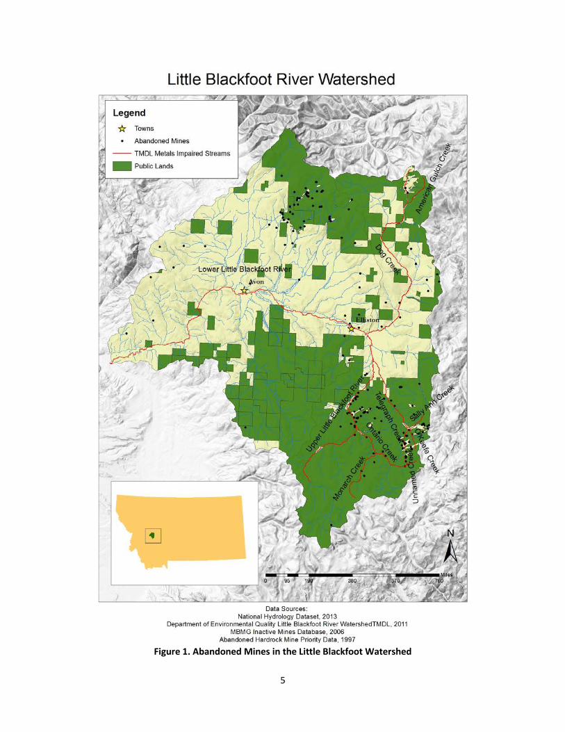
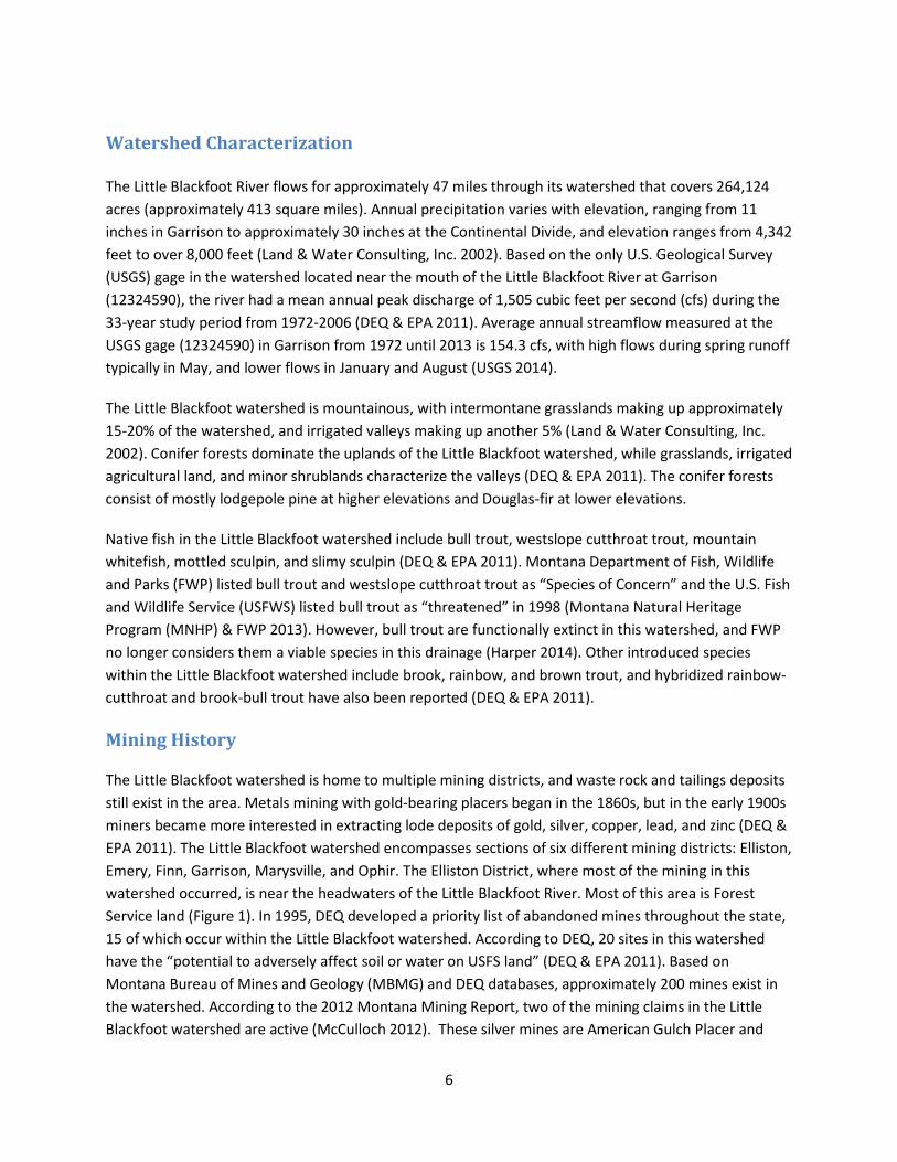
Figure 1. Abandoned Mines in the Little Blackfoot Watershed
5
Watershed Characterization
The Little Blackfoot River flows for approximately 47 miles through its watershed that covers 264,124 acres (approximately 413 square miles). Annual precipitation varies with elevation, ranging from 11 inches in Garrison to approximately 30 inches at the Continental Divide, and elevation ranges from 4,342 feet to over 8,000 feet (Land & Water Consulting, Inc. 2002). Based on the only U.S. Geological Survey (USGS) gage in the watershed located near the mouth of the Little Blackfoot River at Garrison (12324590), the river had a mean annual peak discharge of 1,505 cubic feet per second (cfs) during the 33-year study period from 1972-2006 (DEQ & EPA 2011). Average annual streamflow measured at the USGS gage (12324590) in Garrison from 1972 until 2013 is 154.3 cfs, with high flows during spring runoff typically in May, and lower flows in January and August (USGS 2014).
The Little Blackfoot watershed is mountainous, with intermontane grasslands making up approximately 15-20% of the watershed, and irrigated valleys making up another 5% (Land & Water Consulting, Inc. 2002). Conifer forests dominate the uplands of the Little Blackfoot watershed, while grasslands, irrigated agricultural land, and minor shrublands characterize the valleys (DEQ & EPA 2011). The conifer forests consist of mostly lodgepole pine at higher elevations and Douglas-fir at lower elevations.
Native fish in the Little Blackfoot watershed include bull trout, westslope cutthroat trout, mountain whitefish, mottled sculpin, and slimy sculpin (DEQ & EPA 2011). Montana Department of Fish, Wildlife and Parks (FWP) listed bull trout and westslope cutthroat trout as “Species of Concern” and the U.S. Fish and Wildlife Service (USFWS) listed bull trout as “threatened” in 1998 (Montana Natural Heritage Program (MNHP) & FWP 2013). However, bull trout are functionally extinct in this watershed, and FWP no longer considers them a viable species in this drainage (Harper 2014). Other introduced species within the Little Blackfoot watershed include brook, rainbow, and brown trout, and hybridized rainbow-cutthroat and brook-bull trout have also been reported (DEQ & EPA 2011).
Mining History
The Little Blackfoot watershed is home to multiple mining districts, and waste rock and tailings deposits still exist in the area. Metals mining with gold-bearing placers began in the 1860s, but in the early 1900s miners became more interested in extracting lode deposits of gold, silver, copper, lead, and zinc (DEQ & EPA 2011). The Little Blackfoot watershed encompasses sections of six different mining districts: Elliston, Emery, Finn, Garrison, Marysville, and Ophir. The Elliston District, where most of the mining in this watershed occurred, is near the headwaters of the Little Blackfoot River. Most of this area is Forest Service land (Figure 1). In 1995, DEQ developed a priority list of abandoned mines throughout the state, 15 of which occur within the Little Blackfoot watershed. According to DEQ, 20 sites in this watershed have the “potential to adversely affect soil or water on USFS land” (DEQ & EPA 2011). Based on Montana Bureau of Mines and Geology (MBMG) and DEQ databases, approximately 200 mines exist in the watershed. According to the 2012 Montana Mining Report, two of the mining claims in the Little Blackfoot watershed are active (McCulloch 2012). These silver mines are American Gulch Placer and
6
Ophir Placer (McCulloch 2012). American Gulch mine is located in the American Gulch sub-watershed, while Ophir Placer is located in the Lower Little Blackfoot sub-watershed. Additionally, there is an active dredge permit for gold ore on Carpenter Creek, but is seasonally restricted to May 16th through August 31st to protect fish (DEQ & EPA 2011).
Causes and Sources of Pollution The 2011 LBFWP listed 12 stream segments within the TMDL Planning Area (TPA) as impaired by metals (arsenic, beryllium, cadmium, copper, cyanide, iron, lead, mercury, and zinc). Forty-five individual TMDLs were written addressing these impairments. The 2014 Little Blackfoot River Watershed Metals TMDL Addendum established 10 additional TMDLs for metals (aluminum and zinc) impairments in addition to the 9 stream segments listed in the 2011 LBFWP. The LBFWP listed “natural background loading from mineralized geology; abandoned mines, including adit discharge/drainage from abandoned mines and runoff/drainage from abandoned mine tailings; upland, in-stream, and floodplain metals deposits from historical mining operations; and permitted point sources” as potential sources of metals loading (DEQ & EPA 2011). Metals reductions necessary to achieve TMDL levels ranged from 5-95%. One objective of this document is to describe the primary causes of metals impairment within the watershed. This section identifies mine sites by stream segment, starting with the segment highest in the watershed. The mine sites listed in bold are of the most concern to the metals restoration strategy stakeholder group and will be addressed in this restoration strategy.
Un-named Creek (MT76G006_010) TMDLs were developed in 2011 for arsenic, cadmium, copper, lead, mercury, zinc, and iron, with an additional TMDL written in 2014 for aluminum in Un-named Creek (0.8 mi). The area encompasses both private land and Helena National Forest Land, with the “most probable impairment source,” Ontario Mine, located mostly on private land (DEQ & EPA 2014). The LBFWP gives a single wasteload allocation to Ontario Mine because all human related metals loading to Un-named Creek is associated with this mine (DEQ & EPA 2011). DEQ Abandoned Mine Lands (AML) had Ontario Millsite on its priority list, whereas the LBFWP refers to the Ontario Mine as the primary cause of impairment. Further research and a site investigation are necessary to better understand the impairments from each source and the distinction between the two. Ontario Millsite was ranked as priority number 99 on the original DEQ Priority Abandoned Mine list, but is currently considered reclaimed by the Montana Waste Cleanup Bureau (MWCB) after removal action in 2005 (DEQ 2013). The MWCB oversees the cleanup of abandoned mine lands and National Priority List (NPL) facilities (DEQ 2014). The area also includes two prospect mines and a hardrock mine called Amanda mine, but these are thought to be insignificant sources of metals impairment (DEQ & EPA 2011).
Monarch Creek (MT76G004_060) TMDLs were developed in 2011 for copper, lead, mercury with an additional TMDL written for aluminum in 2014 in the Monarch Creek segment (4.7 mi). The area is located on Helena National Forest land. Monarch mine, the only hardrock mine in the area, is considered the “primary source of metals loading to Monarch Creek” and is currently ranked as DEQ priority number 78 (DEQ & EPA 2011). In 1998, Hargrave, et al. observed “a collapsed mill building, an open but locked adit, another adit that is caved-
7
in but discharging and approximately 0.75 acres of well-vegetated tailings.” The Abandoned Mine Reclamation Bureau (AMRB) reported a hazardous structure and a hazardous adit opening based on observations in the early 1990s in the Summary Report of Abandoned Mine Sites (DEQ 1995). A few prospect mines also exist in the area.
Ontario Creek (MT76G004_130) TMDLs were developed in 2011 for cadmium, copper, and lead, with additional TMDLs developed for aluminum and zinc in 2014 in the Ontario Creek sub-basin. Hard Luck Mine, a 0.3 acre site 1,000 feet from Ontario Creek, upstream of confluence with Monarch Creek, has 3 waste rock piles, 2 adits, and 1 building, with a diversion system present that could use improvement (DEQ 1995). This mine is thought to be the primary source of metals impairment (DEQ & EPA 2011). The Montana Bureau of Mines and Geology (MBMG) has found the site to be dry on occasional visits. (Hargrave, et al. 1998). Hard Luck Mine is currently ranked number 96 on the DEQ Prioritized Short List of AML Sites (DEQ 2013). Three other non-priority mines exist in the area, where water flowing out of mine adits could be impacting water quality (DEQ & EPA 2011).
Sally Ann Creek (MT76G004_055) TMDLs were developed in 2011 for cadmium, copper, and zinc for Sally Ann Creek. The area contains about five abandoned mines, including Telegraph Mine, which is DEQ priority number 119 on the most current Prioritized Short List of AML Sites (DEQ 2013). Telegraph mine had a discharging adit and water flowing through waste rock in 1995. Other non-priority mines in the area with waste rock or water in mine shafts include Home Stake and Excelsior. MBGB determined that Bullion Mine, also in the Sally Ann Creek Basin, had no visible impact in 1993.
O’Keefe Creek (MT76G004_054) TMDLs were developed in 2011 for cadmium, copper, and zinc for O’Keefe Creek. There are approximately 15 mines in the O’Keefe Creek Basin, including Sure Thing Mine, which is DEQ priority number 19 (DEQ 2013). In 1993, Sure Thing Mine consisted of a discharging adit flowing through tailings and waste rock. Another non-priority mine thought to be contributing to metals impairment in O’Keefe Creek is O’Keefe Creek/Copper King Mine.
Telegraph Creek, Upper Segment (MT76G004_051) The 2011 TMDL listed metals impairments for arsenic, beryllium, cadmium, copper, lead, and zinc, with an addition TMDL written for aluminum in the 2014 addendum for Upper Telegraph Creek. The area contains approximately 25 mines, including DEQ Priority mines Lily/Orphan Boy, Third Term, Julia, Anna R/Hattie M, and SE SW Section 10. These mines are currently ranked numbers 10, 127, 38, 44, and 97 respectively on the DEQ Prioritized Short List of AML Sites (DEQ 2013). Other mines in the area include Hub Camp Mine, Viking Mine, Unnamed Mine 8N5W6ABDB, Champion, and Moonlight Cabin Mine, but these are not ranked on the DEQ priority list.
Telegraph Creek, Lower Segment (MT76G004_052) The 2011 TMDL listed metals impairments for lead, mercury, cadmium, copper, and zinc for Lower Telegraph Creek. An additional TMDL was written for aluminum in 2014. There is no record of abandoned mines in the Lower Telegraph Creek sub-basin (DEQ & EPA 2011). Therefore, this restoration
8
strategy will focus on mines in the Upper Telegraph sub-basin, with the intention that cleaning up mines upstream will improve metals impairments downstream as well. Further monitoring in Lower Telegraph Creek will be conducted to determine the sources of metals impairments for this stream segment.
American Gulch Creek (MT76G004_079) A TMDL was written for American Gulch Creek for arsenic in 2011. Although the American Gulch Creek basin has no mines that appear on the DEQ priority abandoned mine list, at least five abandoned mines exist in the basin (DEQ & EPA 2011). These mines include Neenan, NE SE Section 10, Carbonate Marysville, Pine Ridge, and Unnamed 11N06W10CADD, but few details are known about these mines. The 2011 TMDL recommended further monitoring of this stream segment because there was only one sample site at the mouth of American Gulch Creek at Dog Creek, even though most of the mines are located closer to the headwaters (DEQ & EPA 2011). This restoration strategy calls for further monitoring of this site in order to assess a more specific source of impairment and develop a plan for remediation.
Dog Creek, Upper Segment (MT76G004_071) TMDLs were written in 2011 for arsenic, lead, zinc, cadmium, and copper impairments to Upper Dog Creek, with an additional TMDL written in 2014 for aluminum. Bald Butte Mine was a significant contributor to metals impairments in Dog Creek, but has been the site of an extensive reclamation project, which addressed this site and multiple others in the area. Because this is a DEQ priority site, this metals restoration strategy addresses it, but monitoring is necessary to understand the success of reclamation at this site and whether any issues or metals impairments remain. This site is considered “reclaimed by MWCB” due to the removal action that took place in 2012 (DEQ 2013).
Dog Creek, Lower Segment (MT76G004_072) The 2011 TMDL and the 2014 addendum determined a need for reductions of copper, lead, and aluminum. Although numerous mines exist within this stream segment, none are DEQ priority mines. Additional monitoring is recommended in order to determine more specific source allocations of metals impairment in the lower segment of Dog Creek.
Little Blackfoot River, Upper Segment (MT76G004_020) TMDLs were written in 2011 for the Upper segment of the Little Blackfoot River for arsenic, cadmium, copper, cyanide, and lead. There are five additional DEQ priority mines in the Upper Little Blackfoot sub-basin not already discussed in tributary sub-basins: Charter Oak, Kimball, Mountain View, Golden Anchor, and SE SW Section 10. Charter Oak is listed as a mine site reclaimed by other programs/agencies, due to the USFS removal action. The site had waste rock removed, tailings removed, hazardous openings closed, and an onsite repository constructed from 1996-1998 (Oaks 2014). It was originally ranked number 12 on the DEQ priority list. Kimball, Mountain View, Golden Anchor, and SE SW Section 10 are ranked 77, 65, 59, and 97 respectively in the most updated Prioritized Short List of AML Sites (DEQ 2013). Hope Mine has not been listed as a DEQ priority site, but is a mine that is a concern for the Forest Service and is also addressed in this metals restoration strategy.
9
Little Blackfoot River, Lower Segment (MT76G004_010) TMDLs were written in 2011 and 2014 for the lower Little Blackfoot for arsenic, lead, and aluminum. Nearly 100 mines exist throughout this sub-basin; however, only one is a DEQ priority mine: Victory/Evening Star. This mine is currently ranked 118 on the Prioritized Short List of AML Sites (DEQ 2013). Although this restoration strategy focuses primarily on the Upper Little Blackfoot, this mine is addressed in the restoration strategy because it is a priority mine and located near a stream segment addressed in the Little Blackfoot TMDL.
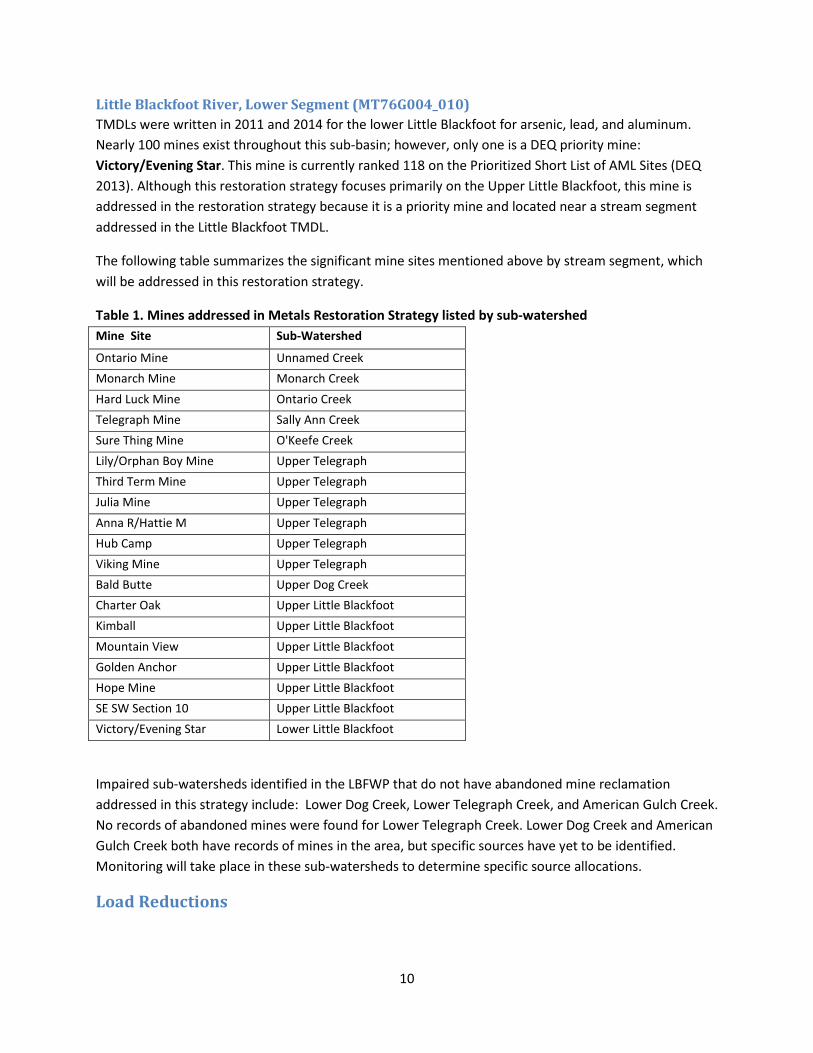
The following table summarizes the significant mine sites mentioned above by stream segment, which will be addressed in this restoration strategy.
Table 1. Mines addressed in Metals Restoration Strategy listed by sub-watershed Mine Site Sub-Watershed
Ontario Mine Unnamed Creek Monarch Mine Monarch Creek Hard Luck Mine Ontario Creek Telegraph Mine Sally Ann Creek Sure Thing Mine O'Keefe Creek Lily/Orphan Boy Mine Upper Telegraph Third Term Mine Upper Telegraph Julia Mine Upper Telegraph Anna R/Hattie M Upper Telegraph Hub Camp Upper Telegraph Viking Mine Upper Telegraph Bald Butte Upper Dog Creek Charter Oak Upper Little Blackfoot Kimball Upper Little Blackfoot Mountain View Upper Little Blackfoot Golden Anchor Upper Little Blackfoot Hope Mine Upper Little Blackfoot SE SW Section 10 Upper Little Blackfoot Victory/Evening Star Lower Little Blackfoot
Impaired sub-watersheds identified in the LBFWP that do not have abandoned mine reclamation addressed in this strategy include: Lower Dog Creek, Lower Telegraph Creek, and American Gulch Creek. No records of abandoned mines were found for Lower Telegraph Creek. Lower Dog Creek and American Gulch Creek both have records of mines in the area, but specific sources have yet to be identified. Monitoring will take place in these sub-watersheds to determine specific source allocations.
Load Reductions
10
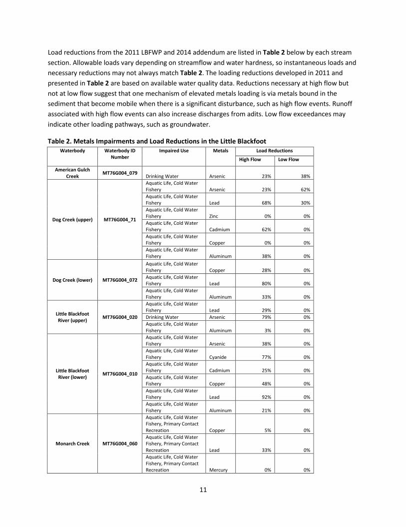
Load reductions from the 2011 LBFWP and 2014 addendum are listed in Table 2 below by each stream section. Allowable loads vary depending on streamflow and water hardness, so instantaneous loads and necessary reductions may not always match Table 2. The loading reductions developed in 2011 and presented in Table 2 are based on available water quality data. Reductions necessary at high flow but not at low flow suggest that one mechanism of elevated metals loading is via metals bound in the sediment that become mobile when there is a significant disturbance, such as high flow events. Runoff associated with high flow events can also increase discharges from adits. Low flow exceedances may indicate other loading pathways, such as groundwater.
Table 2. Metals Impairments and Load Reductions in the Little Blackfoot Waterbody Waterbody ID
Number Impaired Use Metals Load Reductions
High Flow Low Flow
American Gulch Creek MT76G004_079 Drinking Water Arsenic 23% 38%
Dog Creek (upper) MT76G004_71
Aquatic Life, Cold Water Fishery Arsenic 23% 62% Aquatic Life, Cold Water Fishery Lead 68% 30% Aquatic Life, Cold Water Fishery Zinc 0% 0% Aquatic Life, Cold Water Fishery Cadmium 62% 0% Aquatic Life, Cold Water Fishery Copper 0% 0% Aquatic Life, Cold Water Fishery Aluminum 38% 0%
Dog Creek (lower) MT76G004_072
Aquatic Life, Cold Water Fishery Copper 28% 0% Aquatic Life, Cold Water Fishery Lead 80% 0% Aquatic Life, Cold Water Fishery Aluminum 33% 0%
Little Blackfoot River (upper) MT76G004_020
Aquatic Life, Cold Water Fishery Lead 29% 0% Drinking Water Arsenic 79% 0% Aquatic Life, Cold Water Fishery Aluminum 3% 0%
Little Blackfoot River (lower) MT76G004_010
Aquatic Life, Cold Water Fishery Arsenic 38% 0% Aquatic Life, Cold Water Fishery Cyanide 77% 0% Aquatic Life, Cold Water Fishery Cadmium 25% 0% Aquatic Life, Cold Water Fishery Copper 48% 0% Aquatic Life, Cold Water Fishery Lead 92% 0% Aquatic Life, Cold Water Fishery Aluminum 21% 0%
Monarch Creek MT76G004_060
Aquatic Life, Cold Water Fishery, Primary Contact Recreation Copper 5% 0% Aquatic Life, Cold Water Fishery, Primary Contact Recreation Lead 33% 0% Aquatic Life, Cold Water Fishery, Primary Contact Recreation Mercury 0% 0%
11
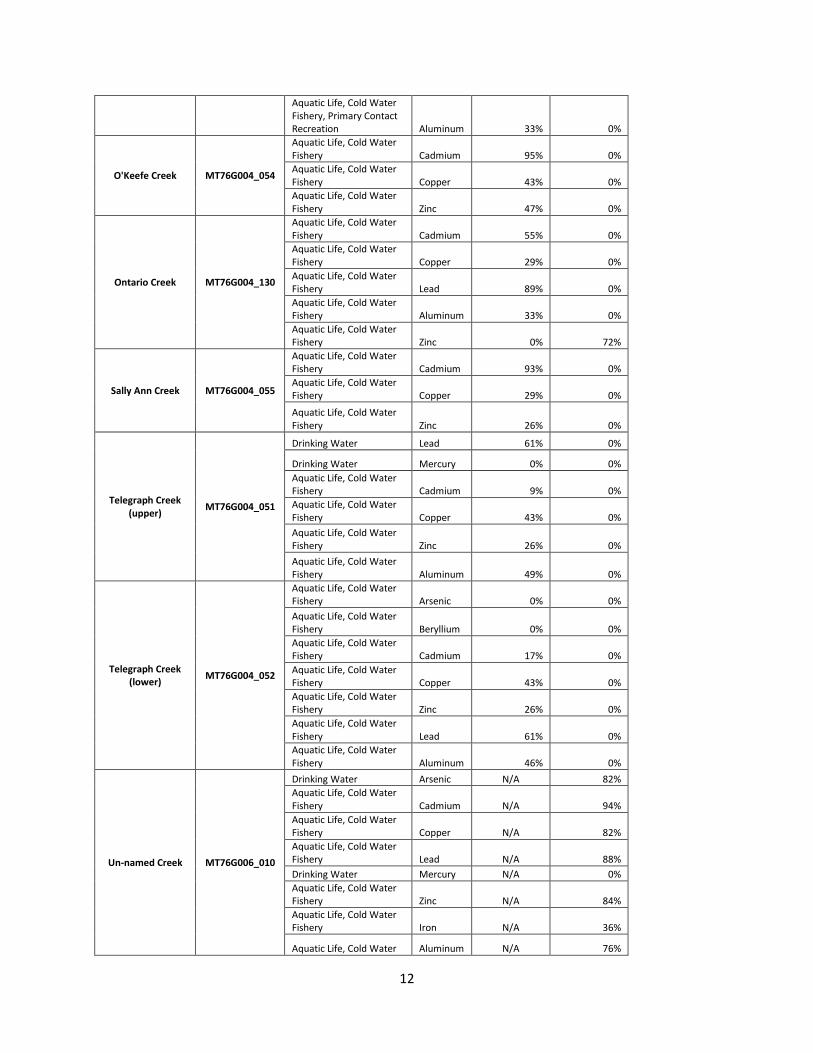
Aquatic Life, Cold Water Fishery, Primary Contact Recreation Aluminum 33% 0%
O'Keefe Creek MT76G004_054
Aquatic Life, Cold Water Fishery Cadmium 95% 0% Aquatic Life, Cold Water Fishery Copper 43% 0% Aquatic Life, Cold Water Fishery Zinc 47% 0%
Ontario Creek MT76G004_130
Aquatic Life, Cold Water Fishery Cadmium 55% 0% Aquatic Life, Cold Water Fishery Copper 29% 0% Aquatic Life, Cold Water Fishery Lead 89% 0% Aquatic Life, Cold Water Fishery Aluminum 33% 0% Aquatic Life, Cold Water Fishery Zinc 0% 72%
Sally Ann Creek MT76G004_055
Aquatic Life, Cold Water Fishery Cadmium 93% 0% Aquatic Life, Cold Water Fishery Copper 29% 0%
Aquatic Life, Cold Water Fishery Zinc 26% 0%
Telegraph Creek (upper) MT76G004_051
Drinking Water Lead 61% 0%
Drinking Water Mercury 0% 0% Aquatic Life, Cold Water Fishery Cadmium 9% 0% Aquatic Life, Cold Water Fishery Copper 43% 0% Aquatic Life, Cold Water Fishery Zinc 26% 0% Aquatic Life, Cold Water Fishery Aluminum 49% 0%
Telegraph Creek (lower) MT76G004_052
Aquatic Life, Cold Water Fishery Arsenic 0% 0% Aquatic Life, Cold Water Fishery Beryllium 0% 0% Aquatic Life, Cold Water Fishery Cadmium 17% 0% Aquatic Life, Cold Water Fishery Copper 43% 0% Aquatic Life, Cold Water Fishery Zinc 26% 0% Aquatic Life, Cold Water Fishery Lead 61% 0% Aquatic Life, Cold Water Fishery Aluminum 46% 0%
Un-named Creek MT76G006_010
Drinking Water Arsenic N/A 82% Aquatic Life, Cold Water Fishery Cadmium N/A 94% Aquatic Life, Cold Water Fishery Copper N/A 82% Aquatic Life, Cold Water Fishery Lead N/A 88% Drinking Water Mercury N/A 0% Aquatic Life, Cold Water Fishery Zinc N/A 84% Aquatic Life, Cold Water Fishery Iron N/A 36%
Aquatic Life, Cold Water Aluminum N/A 76%
12
Fishery
Following the identification of primary sources of metals pollution by stream segment, the next goal of this document is to describe management measures needed to achieve TMDL reductions and to prioritize these remedial actions. The following section enumerates management measures to accomplish these load reductions, focusing on abandoned mine reclamation.
Management Measures
Significant management measures are necessary to achieve load reductions established in the LBFWP. Management measures vary for each stream segment, although the LBFWP recognized that abandoned mine reclamation is the most significant restoration method in achieving TMDL goals. The LBFWP suggested the following goals for addressing metals impairments in the TPA:
• “Prevent soluble metal contaminants or metals contaminated solid materials in the waste rock and tailings materials/sediments from migrating into adjacent surface waters to the extent practicable.
• Reduce or eliminate concentrated runoff and discharges that generate sediment and/or heavy metals contamination to adjacent surface waters and ground water to the extent practical.
• Identify, prioritize, and select response and restoration actions based on a comprehensive source assessment and streamlined risk analysis of areas affected by historical mining” (DEQ & EPA 2011)
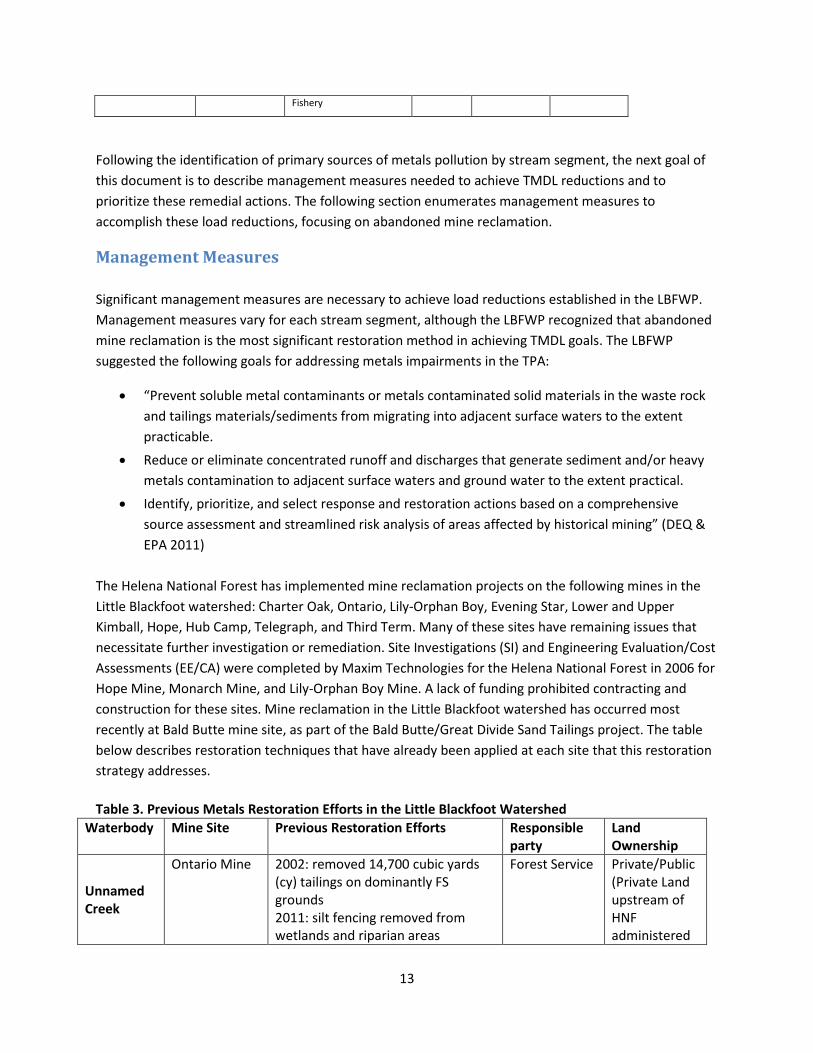
The Helena National Forest has implemented mine reclamation projects on the following mines in the Little Blackfoot watershed: Charter Oak, Ontario, Lily-Orphan Boy, Evening Star, Lower and Upper Kimball, Hope, Hub Camp, Telegraph, and Third Term. Many of these sites have remaining issues that necessitate further investigation or remediation. Site Investigations (SI) and Engineering Evaluation/Cost Assessments (EE/CA) were completed by Maxim Technologies for the Helena National Forest in 2006 for Hope Mine, Monarch Mine, and Lily-Orphan Boy Mine. A lack of funding prohibited contracting and construction for these sites. Mine reclamation in the Little Blackfoot watershed has occurred most recently at Bald Butte mine site, as part of the Bald Butte/Great Divide Sand Tailings project. The table below describes restoration techniques that have already been applied at each site that this restoration strategy addresses. Table 3. Previous Metals Restoration Efforts in the Little Blackfoot Watershed
Waterbody Mine Site Previous Restoration Efforts Responsible party
Land Ownership
Unnamed Creek
Ontario Mine 2002: removed 14,700 cubic yards (cy) tailings on dominantly FS grounds 2011: silt fencing removed from wetlands and riparian areas
Forest Service Private/Public (Private Land upstream of HNF administered
13
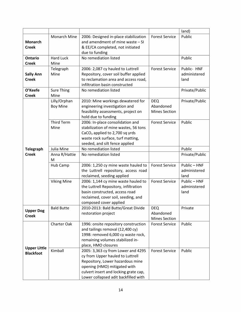
land)
Monarch Creek
Monarch Mine 2006: Designed in-place stabilization and amendment of mine waste – SI & EE/CA completed, not initiated due to funding
Forest Service Public
Ontario Creek
Hard Luck Mine
No remediation listed Public
Sally Ann Creek
Telegraph Mine
2006: 2,087 cy hauled to Luttrell Repository, cover soil buffer applied to reclamation area and access road, infiltration basin constructed
Forest Service Public- HNF administered land
O’Keefe Creek
Sure Thing Mine
No remediation listed Private/Public
Telegraph Creek
Lilly/Orphan Boy Mine
2010: Mine workings dewatered for engineering investigation and feasibility assessments, project on hold due to funding
DEQ Abandoned Mines Section
Private/Public
Third Term Mine
2006: In-place consolidation and stabilization of mine wastes, 56 tons CaCO3 applied to 2,700 sq yrds waste rock surface, turf matting, seeded, and silt fence applied
Forest Service Public
Julia Mine No remediation listed Public Anna R/Hattie M
No remediation listed Private/Public
Hub Camp 2006: 1,250 cy mine waste hauled to the Luttrell repository, access road reclaimed, seeding applied
Forest Service Public – HNF administered land
Viking Mine 2006: 1,144 cy mine waste hauled to the Luttrell Repository, infiltration basin constructed, access road reclaimed, cover soil, seeding, and composed cover applied
Forest Service Public – HNF administered land
Upper Dog Creek
Bald Butte 2010-2013: Bald Butte/Great Divide restoration project
DEQ Abandoned Mines Section
Private
Upper Little Blackfoot
Charter Oak 1996: onsite repository construction and tailings removal (12,400 cy) 1998: removed 6,000 cy waste rock, remaining volumes stabilized in-place, HMO closures
Forest Service Public
Kimball 2005: 3,363 cy from Lower and 4295 cy from Upper hauled to Luttrell Repository, Lower hazardous mine opening (HMO) mitigated with culvert insert and locking grate cap, Lower collapsed adit backfilled with
Forest Service Public
14
boulders & adit discharge channel constructed with erosion matting installed
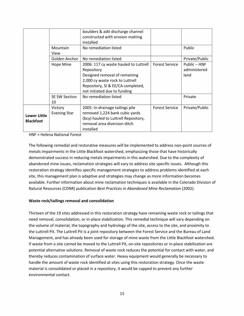
Mountain View
No remediation listed Public
Golden Anchor No remediation listed Private/Public Hope Mine 2006: 117 cy waste hauled to Luttrell
Repository Designed removal of remaining 2,000 cy waste rock to Luttrell Repository, SI & EE/CA completed, not initiated due to funding
Forest Service Public – HNF administered land
SE SW Section 10
No remediation listed Private
Lower Little Blackfoot
Victory Evening Star
2005: In-drainage tailings pile removed 1,224 bank cubic yards (bcy) hauled to Luttrell Repository, removal area diversion ditch installed
Forest Service Private/Public
HNF = Helena National Forest The following remedial and restorative measures will be implemented to address non-point sources of metals impairments in the Little Blackfoot watershed, emphasizing those that have historically demonstrated success in reducing metals impairments in this watershed. Due to the complexity of abandoned mine issues, reclamation strategies will vary to address site specific issues. Although this restoration strategy identifies specific management strategies to address problems identified at each site, this management plan is adaptive and strategies may change as more information becomes available. Further information about mine reclamation techniques is available in the Colorado Division of Natural Resources (CDNR) publication Best Practices in Abandoned Mine Reclamation (2002).
Waste rock/tailings removal and consolidation Thirteen of the 19 sites addressed in this restoration strategy have remaining waste rock or tailings that need removal, consolidation, or in-place stabilization. This remedial technique will vary depending on the volume of material, the topography and hydrology of the site, access to the site, and proximity to the Luttrell Pit. The Luttrell Pit is a joint repository between the Forest Service and the Bureau of Land Management, and has already been used for storage of mine waste from the Little Blackfoot watershed. If waste from a site cannot be moved to the Luttrell Pit, on-site repositories or in-place stabilization are potential alternative solutions. Removal of waste rock reduces the potential for contact with water, and thereby reduces contamination of surface water. Heavy equipment would generally be necessary to handle the amount of waste rock identified at sites using this restoration strategy. Once the waste material is consolidated or placed in a repository, it would be capped to prevent any further environmental contact.
15
Phytostabilization Phytostabilization involves the amendment of soil to mine waste, followed by revegetation. It can often involve the addition of lime (Ca(OH)2) and/or limestone (CaCO3) (See neutralization with lime amendments below). This in-place treatment reduces the mobility of metals, preventing them from entering surface or groundwater, while decreasing the acidity to simultaneously reduce the metals’ solubility (Kerber Creek WMP 2012). The EPA emphasizes soil cover installations that “stabilize soil and waste piles and reduce their exposure” (EPA 2012). Phytostabilization is a less costly alternative to excavation of waste rock at some sites. Costs at Kerber Creek, a site in Colorado with similar metals impairments due to abandoned mines, demonstrated phyostabilization costs of $11,200/acre as opposed to removal costs of $40,034/acre. These costs will vary based on the site location, geology, and topography, and the quantity and composition of waste rock (Kerber Creek WMP 2012). Capping Phytostabilization and capping often occur in conjunction. Capping involves placing an impermeable or minimally permeable surface over mine waste to limit water infiltration from precipitation. This cap can be a soil cover, which is then phytostabilized with the addition of fertilizer and seeding. According to the EPA, BMPs for designing a cap include mimicking the site’s natural setting, accounting for effects of climate change, exploring industrial waste products as a partial substitute for productive soil, and considering anticipated site reuse options (EPA 2012). Closure of hazardous mine openings Many mine sites have hazardous mine openings (HMO). These openings can be dangerous for recreationalists. Injuries related to abandoned mine openings occur each year, and with increased development and population growth, access to these locations is increasing (CDNR 2002). Shafts, stopes, and adits can be closed with barriers, seals, or plugs. Each solution depends on the conditions of the hazard and has different benefits. Land managers must consider the life span, costs, maintenance, and environmental concerns of each solution. Barriers keep visitors away, while seals prevent mine entry, and plugs close the opening fully to completely eliminate the hazard (CDNR 2002). Revegetation Revegetation of mine areas helps restore a degraded site to a more natural state. Vegetation provides improved wildlife habitat and can help contain waste rock or tailings if planted over these materials (CDNR 2002). Studies have also shown that certain plants help with metals uptake, removing metals from the groundwater (Wang Q.R., et al. 2003). Uncontaminated soils should be used to revegetate sites, followed by the application of fertilizer. Sites will be seeded with a seed-mix of native plants in the area that have demonstrated metals tolerance. After seeding, it is best to apply mulch to protect the seeds while they sprout (CDNR 2002).
16
Streambank stabilization Where necessary, streambank stabilization will occur using appropriate techniques and materials, including vegetated soil lifts, vegetated fascines, and slope adjustments to reshape the streambank. These management practices help to physically protect the stream bank, while simultaneously improving ecological function (Christiensen 2014). Metals contamination from migrating wasterock and tailings piles adjacent to streams can be exasperated by eroding streambanks. Additionally, in some locations, placer mining has destabilized stream morphology and contributes to excessive streambank erosion. Bank stabilization will vary based on the condition of the streambank, which will need to be assessed at specific sites. Mine drainage neutralization with lime amendments The addition of lime helps neutralize acidic waste and waters, helping metals precipitate out. Lime (Ca(OH)2) raises soil pH, while limestone (CaCO3) can provide a buffer between the waste and the new soil to preventing contamination of surface or groundwater (Kerber Creek WMP 2012). Anoxic limestone drains can also be used to treat acid mine drainage from discharging adits or openings. The limestone dissolves in the water and raises its pH, causing the metals to drop out of solution into a settling pond (CDNR 2002). Lime amendments can occur in conjunction with other methods, such as phytostabilization, but can also be used as an independent management measure. Passive treatment of adit drainage Discharging adits were identified at 14 of the 19 sites in the Little Blackfoot watershed. There are numerous passive water treatment techniques including chemical amendment, anoxic limestone drains, sulfate-reducing wetlands, aeration and settling ponds, and oxidation wetlands. Passive treatment of adit discharge is less costly than active treatment, and is therefore preferred over creating any type of active water treatment plant. Constructed wetlands must be considered semi-permanent, because although they are long-term solutions, eventually the wetlands will fill with metal-contaminated sediment that must be removed or capped (ITRC 2010). Many types of passive treatment are identified in this section, and each is described briefly below.
Chemical amendment Chemical amendments involve adding a basic materials like lime to acidic water with metals impairments in order to increase the pH of the water (Kerber Creek WMP 2012). This method is often used in conjunction with other strategies. Anoxic limestone drain These are drains with limestone that help increase the pH and alkalinity of acid mine drainage relatively cheaply and effectively under the right conditions. After exiting the drain, water must discharge to a settling pond to allow for metals precipitation prior to re-entering the stream (Skousen 1992).
17
Previously, anoxic limestone drains were implemented where wetlands were insufficient, but they are now being installed as independent systems (Skousen 1992). Sulfate-reducing wetlands Sulfate-reducing wetlands are used to improve the quality of acid mine drainage by employing bacteria to remove the heavy metals. These bacteria prefer acidic environments and produce sulfides that combine with the metals to form metal sulfides. These metal sulfides precipitate out, leaving improved water quality (CDNR 2002).
Aeration and settling ponds Aeration and settling ponds use oxidation to help heavy metals like iron, zinc, and manganese precipitate out. The water is aerated by a steep slope or rough areas that create turbulence, and then it lands in the settling pond at the base where oxidized metals can precipitate out (CDNR 2002). Oxidation wetlands Oxidation wetlands use aquatic plants and algae to help metals precipitate out. The plants help aerate the area, and then when they die, they provide surfaces for the metals to adsorb. The area is usually rough and variable with a diverse array of plants along with gravel and organic material (CDNR 2002). Other techniques Other techniques listed in Colorado’s Division of Minerals and Geology Best Practices report include diversion ditches, stream diversion, and erosion control by re-grading. These may be applicable to some mine sites in the Little Blackfoot watershed, depending on the outcome of further investigations. Preferred techniques: For the purposes of this metals restoration strategy, preferred techniques are those that are most cost-effective, and those that are in line with techniques that have been successful historically within the Little Blackfoot watershed, keeping in line with previous Forest Service techniques. Passive treatment systems are preferred to any active treatment, due to the limited accessibility of many of these sites and lower costs of passive treatment systems. Past Forest Service projects favor hauling waste rock to a nearby repository as a primary form of restoration where necessary.
Prioritization The numerous abandoned mine sites in the Little Blackfoot watershed were narrowed down based on whether or not they were on the most current DEQ priority mine list and were of concern to watershed managers and geologists at the Helena National Forest. After the list was narrowed to 19 sites, the sites were prioritized based on a matrix that accounted for a number of parameters. These included each mine site’s proximity to roads, proximity to residences, proximity to campsites, land ownership,
18
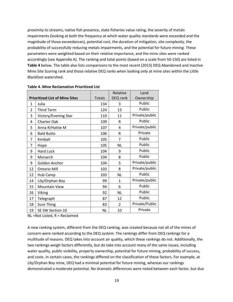
proximity to streams, native fish presence, state fisheries value rating, the severity of metals impairments (looking at both the frequency at which water quality standards were exceeded and the magnitude of those exceedances), potential cost, the duration of mitigation, site complexity, the probability of successfully reducing metals impairments, and the potential for future mining. These parameters were weighted based on their relative importance, and the mine sites were ranked accordingly (see Appendix A). The ranking and total points (based on a scale from 50-150) are listed in Table 4 below. The table also lists comparisons to the most recent (2013) DEQ Abandoned and Inactive Mine Site Scoring rank and those relative DEQ ranks when looking only at mine sites within the Little Blackfoot watershed.
Table 4. Mine Reclamation Prioritized List
Prioritized List of Mine Sites Totals Relative
DEQ rank Land
Ownership 1 Julia 134 3 Public 2 Third Term 124 13 Public 3 Victory/Evening Star 110 11 Private/public 4 Charter Oak 109 R Public 5 Anna R/Hattie M 107 4 Private/public 6 Bald Butte 106 R Private 7 Kimball 105 7 Public 7 Hope 105 NL Public 9 Hard Luck 104 9 Public 9 Monarch 104 8 Public 9 Golden Anchor 104 5 Private/public
12 Ontario Mill 103 R Private/public 12 Hub Camp 103 NL Public 14 Lily/Orphan Boy 99 1 Private/public 15 Mountain View 94 6 Public 16 Viking 92 NL Public 17 Telegraph 87 12 Public 18 Sure Thing 83 2 Private/Public 19 SE SW Section 10 NL 10 Private
NL =Not Listed, R = Reclaimed A new ranking system, different from the DEQ ranking, was created because not all of the mines of concern were ranked according to the DEQ system. The rankings differ from DEQ rankings for a multitude of reasons. DEQ takes into account air quality, which these rankings do not. Additionally, the two rankings weigh factors differently, but do take into account many of the same issues, including water quality, public visibility, property ownership, potential for future mining, probability of success, and costs. In certain cases, the rankings differed on the classification of these factors. For example, at Lily/Orphan Boy mine, DEQ had a minimal potential for future mining, whereas our rankings demonstrated a moderate potential. No dramatic differences were noted between each factor, but due
19
to the different weighting factors, multiple small differences could lead to larger differences in overall outcomes. Overall, the updated ranking system was used to be able to compare all mine sites across the same standards. This ranking system is able to focus more on water quality standards for the impaired uses in the Little Blackfoot, such as aquatic life and cold water fisheries, whereas the DEQ ranking focuses more on human health.
Technical and Financial Assistance Needed
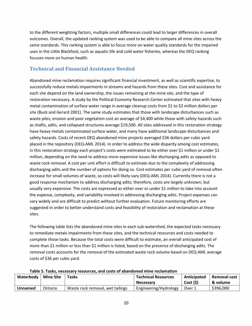
Abandoned mine reclamation requires significant financial investment, as well as scientific expertise, to successfully reduce metals impairments in streams and hazards from these sites. Cost and assistance for each site depend on the land ownership, the issues remaining at the mine site, and the type of restoration necessary. A study by the Political Economy Research Center estimated that sites with heavy metal contamination of surface water range in average cleanup costs from $1 to $3 million dollars per site (Buck and Gerard 2001). The same study estimates that those with landscape disturbances such as waste piles, erosion and poor vegetation cost an average of $4,400 while those with safety hazards such as shafts, adits, and collapsed structures average $19,500. All sites addressed in this restoration strategy have heavy metals contaminated surface water, and many have additional landscape disturbances and safety hazards. Costs of recent DEQ abandoned mine projects averaged $36 dollars per cubic yard placed in the repository (DEQ-AML 2014). In order to address the wide disparity among cost estimates, in this restoration strategy each project’s costs were estimated to be either over $1 million or under $1 million, depending on the need to address more expensive issues like discharging adits as opposed to waste rock removal. A cost per unit effort is difficult to estimate due to the complexity of addressing discharging adits and the number of options for doing so. Cost estimates per cubic yard of removal often increase for small volumes of waste, so costs will likely vary (DEQ-AML 2014). Currently there is not a good response mechanism to address discharging adits; therefore, costs are largely unknown, but usually very expensive. The costs are expressed as either over or under $1 million to take into account the expense, complexity, and variability involved in addressing discharging adits. Project expenses can vary widely and are difficult to predict without further evaluation. Future monitoring efforts are suggested in order to better understand costs and feasibility of restoration and reclamation at these sites. The following table lists the abandoned mine sites in each sub-watershed, the expected tasks necessary to remediate metals impairments from these sites, and the technical resources and costs needed to complete those tasks. Because the total costs were difficult to estimate, an overall anticipated cost of more than $1 million or less than $1 million is listed, based on the presence of discharging adits. The removal costs accounts for the removal of the estimated waste rock volume based on DEQ AML average costs of $36 per cubic yard.
Table 5. Tasks, necessary resources, and costs of abandoned mine reclamation
Waterbody Mine Site Tasks Technical Resources Necessary
Anticipated Cost ($)
Removal cost & volume
Unnamed Ontario Waste rock removal, wet tailings Engineering/Hydrology Over 1 $396,000
20
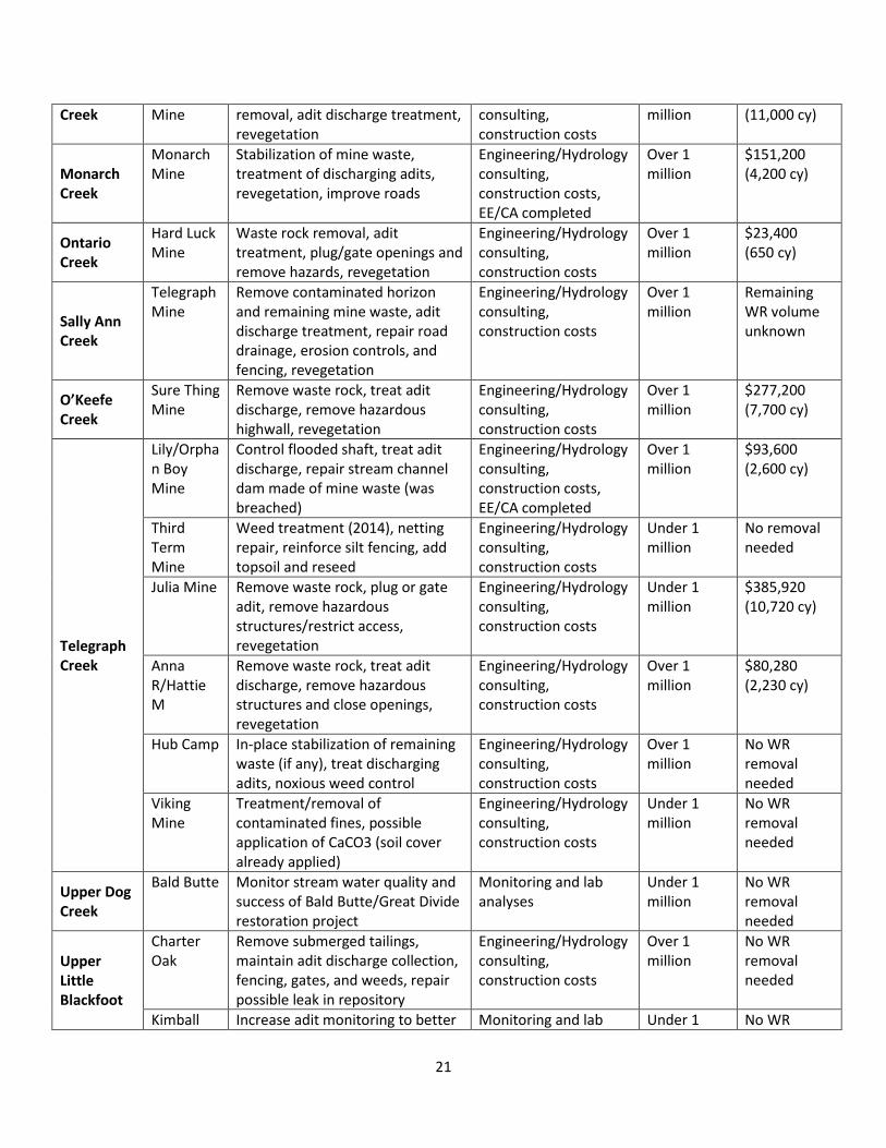
Creek Mine removal, adit discharge treatment, revegetation
consulting, construction costs
million (11,000 cy)
Monarch Creek
Monarch Mine
Stabilization of mine waste, treatment of discharging adits, revegetation, improve roads
Engineering/Hydrology consulting, construction costs, EE/CA completed
Over 1 million
$151,200 (4,200 cy)
Ontario Creek
Hard Luck Mine
Waste rock removal, adit treatment, plug/gate openings and remove hazards, revegetation
Engineering/Hydrology consulting, construction costs
Over 1 million
$23,400 (650 cy)
Sally Ann Creek
Telegraph Mine
Remove contaminated horizon and remaining mine waste, adit discharge treatment, repair road drainage, erosion controls, and fencing, revegetation
Engineering/Hydrology consulting, construction costs
Over 1 million
Remaining WR volume unknown
O’Keefe Creek
Sure Thing Mine
Remove waste rock, treat adit discharge, remove hazardous highwall, revegetation
Engineering/Hydrology consulting, construction costs
Over 1 million
$277,200 (7,700 cy)
Telegraph Creek
Lily/Orphan Boy Mine
Control flooded shaft, treat adit discharge, repair stream channel dam made of mine waste (was breached)
Engineering/Hydrology consulting, construction costs, EE/CA completed
Over 1 million
$93,600 (2,600 cy)
Third Term Mine
Weed treatment (2014), netting repair, reinforce silt fencing, add topsoil and reseed
Engineering/Hydrology consulting, construction costs
Under 1 million
No removal needed
Julia Mine Remove waste rock, plug or gate adit, remove hazardous structures/restrict access, revegetation
Engineering/Hydrology consulting, construction costs
Under 1 million
$385,920 (10,720 cy)
Anna R/Hattie M
Remove waste rock, treat adit discharge, remove hazardous structures and close openings, revegetation
Engineering/Hydrology consulting, construction costs
Over 1 million
$80,280 (2,230 cy)
Hub Camp In-place stabilization of remaining waste (if any), treat discharging adits, noxious weed control
Engineering/Hydrology consulting, construction costs
Over 1 million
No WR removal needed
Viking Mine
Treatment/removal of contaminated fines, possible application of CaCO3 (soil cover already applied)
Engineering/Hydrology consulting, construction costs
Under 1 million
No WR removal needed
Upper Dog Creek
Bald Butte Monitor stream water quality and success of Bald Butte/Great Divide restoration project
Monitoring and lab analyses
Under 1 million
No WR removal needed
Upper Little Blackfoot
Charter Oak
Remove submerged tailings, maintain adit discharge collection, fencing, gates, and weeds, repair possible leak in repository
Engineering/Hydrology consulting, construction costs
Over 1 million
No WR removal needed
Kimball Increase adit monitoring to better Monitoring and lab Under 1 No WR
21
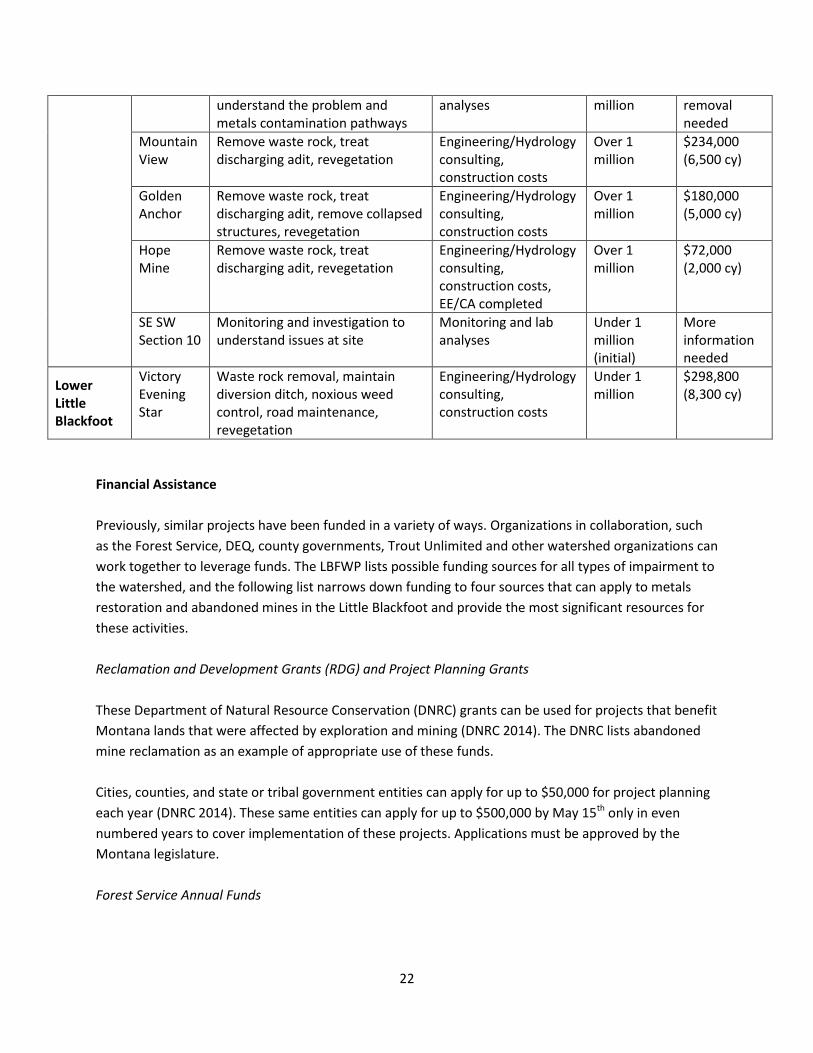
understand the problem and metals contamination pathways
analyses million removal needed
Mountain View
Remove waste rock, treat discharging adit, revegetation
Engineering/Hydrology consulting, construction costs
Over 1 million
$234,000 (6,500 cy)
Golden Anchor
Remove waste rock, treat discharging adit, remove collapsed structures, revegetation
Engineering/Hydrology consulting, construction costs
Over 1 million
$180,000 (5,000 cy)
Hope Mine
Remove waste rock, treat discharging adit, revegetation
Engineering/Hydrology consulting, construction costs, EE/CA completed
Over 1 million
$72,000 (2,000 cy)
SE SW Section 10
Monitoring and investigation to understand issues at site
Monitoring and lab analyses
Under 1 million (initial)
More information needed
Lower Little Blackfoot
Victory Evening Star
Waste rock removal, maintain diversion ditch, noxious weed control, road maintenance, revegetation
Engineering/Hydrology consulting, construction costs
Under 1 million
$298,800 (8,300 cy)
Financial Assistance
Previously, similar projects have been funded in a variety of ways. Organizations in collaboration, such as the Forest Service, DEQ, county governments, Trout Unlimited and other watershed organizations can work together to leverage funds. The LBFWP lists possible funding sources for all types of impairment to the watershed, and the following list narrows down funding to four sources that can apply to metals restoration and abandoned mines in the Little Blackfoot and provide the most significant resources for these activities. Reclamation and Development Grants (RDG) and Project Planning Grants These Department of Natural Resource Conservation (DNRC) grants can be used for projects that benefit Montana lands that were affected by exploration and mining (DNRC 2014). The DNRC lists abandoned mine reclamation as an example of appropriate use of these funds.
Cities, counties, and state or tribal government entities can apply for up to $50,000 for project planning each year (DNRC 2014). These same entities can apply for up to $500,000 by May 15th only in even numbered years to cover implementation of these projects. Applications must be approved by the Montana legislature. Forest Service Annual Funds
22

The U.S. Forest Service has an annual appropriation of approximately $20 million for abandoned mine monitoring, planning, and cleanup (Limerick, et al. 2005). Each forest must apply to receive money from these appropriated funds. These funds can often be used in combination with state funding. DEQ 319 Grants The Montana Department of Environment Quality annually allocates funds to government entities and nonprofit organizations under the 319 (h) section of the Federal Clean Water Act (CWA) for projects that help Montana reach its Nonpoint Source Pollution (NPS) goals (DEQ 2014). For fiscal year 2015, DEQ recommended requesting $50,000 – $300,000 for on the ground projects. DEQ Abandoned Mine Lands Funds The DEQ Abandoned Mine Lands program focuses on restoration and reclamation of abandoned mine lands on private lands. The program currently focuses on abandoned coal mines, but has shown interest and commitment to assisting in abandoned mine cleanup in the Little Blackfoot watershed through expertise and funding. Superfund (Comprehensive Environmental Response, Compensation, and Liability Act or CERCLA) Due to the large area of the watershed and the numerous sources of metals impairments, designating the area as a state or federal Superfund site may be the most effective way to garner resources necessary to clean up the metals contamination in the Little Blackfoot watershed. The problems in the Little Blackfoot watershed are large in scope and complex enough to warrant state or federal superfund status. Gaining either status would provide access to larger sums of money, which are necessary to cleanup these sites.
Education and Outreach This restoration strategy resulted from common concerns among various stakeholders. Trout Unlimited, Helena National Forest, and the Department of Environmental Quality came together to address abandoned mines and water quality in the Little Blackfoot watershed after the DEQ published information about impairments in the watershed. A report that compiled water quality and mine site data throughout the watershed was developed in collaboration with the stakeholder group. Using this information and supporting documents, such as the LBFWP, Forest Service reports, and DEQ data, the group developed a way to prioritize projects. The following organizations were contacted for input to prepare this document:
• Helena National Forest • National Forest Service Region 1 Office • DEQ Nonpoint Source Program • DEQ Abandoned Mine Lands Program
23
• United States Environmental Protection Agency Region 8
The public will be involved in the project in numerous ways. Public meetings will be held to inform local stakeholders of these plans and solicit their input. A presentation at the Deer Lodge Conservation District meeting occurred on September 9, 2014. Additionally, the public will provide input to any final copy of this Metals Restoration Strategy. A public meeting was held on October 21, 2014 at the Avon Community Center in Avon, MT. About 20 people attended to learn more about the metals restoration strategy, ask questions, and provide comments. Public outreach and education will continue as project planning and implementation moves forward in order to provide information on the effects of metals impairments reclamation/restoration activities, and to maintain support from landowners and within the adjacent communities. Once project implementation begins, community volunteers will be utilized where possible for aspects of these projects, such as water quality monitoring and revegetation.
Implementation Schedule Because the mine sites in this restoration strategy have limited amounts of waste rock, it is expected that the removal process can take place during one field season for each site. Another field season would be required prior to removal action for planning and completing both a Site Investigation (SI) and an Engineering Evaluation and Cost Assessment (EE/CA). Lastly, this plan allows a third year for addressing discharging adits or dealing with delays that may occur. An estimated three years should be sufficient for reclamation of most of these sites. The schedule does not include the years following restoration, which will include post-project monitoring and maintenance. Additionally, this schedule assumes that only one restoration project would take place at a time, but that timing for planning would overlap with the final year of the previous schedule. This schedule is in line with the two-year funding cycle of reclamation and development grants. Based on these assumptions and the prioritization described earlier, the schedule for project implementation is as follows:
Table 6. Implementation Schedule
Mine Site Ranking Schedule 1 Julia 2017-2019 2 Third Term 2019-2021 3 Victory/Evening Star 2021-2023 4 Charter Oak 2023-2025 5 Anna R/Hattie M 2025-2027 6 Bald Butte 2027-2029 7 Kimball 2029-2031 7 Hope 2031-2033 9 Hard Luck 2033-2035 9 Monarch 2035-2037 9 Golden Anchor 2037-2039
12 Ontario 2039-2041
24
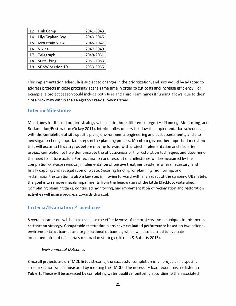
12 Hub Camp 2041-2043 14 Lily/Orphan Boy 2043-2045 15 Mountain View 2045-2047 16 Viking 2047-2049 17 Telegraph 2049-2051 18 Sure Thing 2051-2053 19 SE SW Section 10 2053-2055
This implementation schedule is subject to changes in the prioritization, and also would be adapted to address projects in close proximity at the same time in order to cut costs and increase efficiency. For example, a project season could include both Julia and Third Term mines if funding allows, due to their close proximity within the Telegraph Creek sub-watershed.
Interim Milestones Milestones for this restoration strategy will fall into three different categories: Planning, Monitoring, and Reclamation/Restoration (Ockey 2011). Interim milestones will follow the implementation schedule, with the completion of site specific plans, environmental engineering and cost assessments, and site investigation being important steps in the planning process. Monitoring is another important milestone that will occur to fill data gaps before moving forward with project implementation and also after project completion to help demonstrate the effectiveness of the restoration techniques and determine the need for future action. For reclamation and restoration, milestones will be measured by the completion of waste removal, implementation of passive treatment systems where necessary, and finally capping and revegetation of waste. Securing funding for planning, monitoring, and reclamation/restoration is also a key step in moving forward with any aspect of the strategy. Ultimately, the goal is to remove metals impairments from the headwaters of the Little Blackfoot watershed. Completing planning tasks, continued monitoring, and implementation of reclamation and restoration activities will insure progress towards this goal.
Criteria/Evaluation Procedures Several parameters will help to evaluate the effectiveness of the projects and techniques in this metals restoration strategy. Comparable restoration plans have evaluated performance based on two criteria, environmental outcomes and organizational outcomes, which will also be used to evaluate implementation of this metals restoration strategy (Littman & Roberts 2013). Environmental Outcomes Since all projects are on TMDL-listed streams, the successful completion of all projects in a specific stream section will be measured by meeting the TMDLs. The necessary load reductions are listed in Table 2. These will be assessed by completing water quality monitoring according to the associated
25
Sampling and Analysis Plan (SAP). If TMDL reductions for metals are not fully achieved, the restoration and reclamation practices will be re-evaluated. Removal of waste rock and implementation of passive adit treatment systems will be measureable outcomes of this strategy. Additional outcomes will include the removal/closure of hazardous mine openings and revegetation of waste removal areas. The ultimate goal is to improve water quality in the Little Blackfoot watershed so that all stream segments can fully support their designated beneficial uses and be removed from the 303(d) list. Because this strategy addresses only metals impairments, other restoration projects will need to be implemented to achieve this goal. Organizational Outcomes Trout Unlimited, the Helena National Forest, and the Department of Environmental Quality will continue to collaborate in order to achieve the goals of this metals restoration strategy. Implementation of this strategy will take place as a partnership, with each partner contributing to the planning and restoration work. Communication among partners will ensure successful collaboration. Communication and collaboration with private land owners is also essential in implementation of the metals restoration strategy. Landowner input will be incorporated in the restoration planning and landowners will be informed of activities in the watershed. Efforts will be made to work with landowners in a way that is mutually beneficial, considerate of any landowner concerns, and improves relationships between landowners and partner organizations.
Monitoring Monitoring in the Little Blackfoot watershed began in the mid-1990s with efforts by Montana Bureau of Mines and Geology (MBMG) to inventory abandoned mine sites throughout Montana. In 2008, monitoring for the development of the 2011 LBFWP resulted in more recent data for water quality in the TPA. The LBFWP recommends that monitoring occur both pre- and post-restoration, with water quality tests to determine if load reduction targets are achieved. Sites with unknown sources of metals impairment will be monitored to fill these data gaps. New sites for monitoring water quality will be established along these stream segments. Site investigations will help to assess loads from mines in these sections, and sampling and analysis of waste rock and discharging adits will help to determine sources of metal contaminants.
One of the first monitoring steps of this restoration strategy, in order to better understand the sources of metals impairments and the feasibility of remedial measures for individual sites, would be to hire an environmental engineering firm to complete a feasibility study one sub-basin at a time. Looking at the
26
areas with the highest concentration of mines of concern and using the prioritization as a guideline, this strategy recommends completing the first feasibility study in the Upper Telegraph Creek sub-basin, looking at Upper Telegraph Creek, O’Keefe Creek, and Sally-Ann Creek, looking specifically at Julia Mine, Third Term Mine, Anna R/Hattie M Mine, Hub Camp Mine, Lily Orphan Boy Mine, Viking Mine, Telegraph Mine, and Sure Thing Mine. The next feasibility study would take place in the Ontario Creek sub-basin, looking at Ontario Creek, Un-named Creek, and Monarch Creek, specifically at Hard Luck Mine, Monarch Mine, and Ontario Mine. The majority of mines in this strategy fall within these two sub-watersheds. Next feasibility studies would need to take place in the Upper Dog sub-basin, the Upper Little Blackfoot basin between Ontario and Telegraph Creek, and finally the Lower Little Blackfoot sub-basin, particularly along Ophir Creek where Victory/Evening Star Mine is located. Conducting more detailed feasibility studies by sub-watershed would allow for a better understanding of the remediation needs at each site. Each site addressed in the restoration strategy will be monitored for the development of an EE/CA and SI prior to any restoration work. After restoration is complete, the sites will be monitored for at least 3 years to ensure success of the restoration projects and assess any further needs.
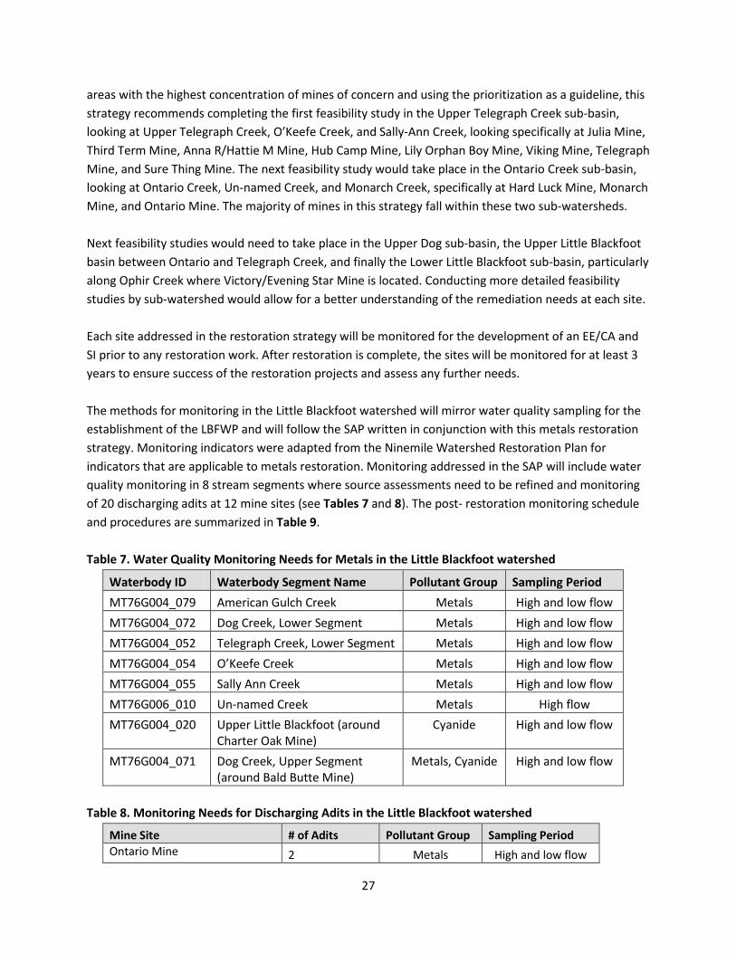
The methods for monitoring in the Little Blackfoot watershed will mirror water quality sampling for the establishment of the LBFWP and will follow the SAP written in conjunction with this metals restoration strategy. Monitoring indicators were adapted from the Ninemile Watershed Restoration Plan for indicators that are applicable to metals restoration. Monitoring addressed in the SAP will include water quality monitoring in 8 stream segments where source assessments need to be refined and monitoring of 20 discharging adits at 12 mine sites (see Tables 7 and 8). The post- restoration monitoring schedule and procedures are summarized in Table 9. Table 7. Water Quality Monitoring Needs for Metals in the Little Blackfoot watershed
Waterbody ID Waterbody Segment Name Pollutant Group Sampling Period MT76G004_079 American Gulch Creek Metals High and low flow MT76G004_072 Dog Creek, Lower Segment Metals High and low flow MT76G004_052 Telegraph Creek, Lower Segment Metals High and low flow MT76G004_054 O’Keefe Creek Metals High and low flow MT76G004_055 Sally Ann Creek Metals High and low flow MT76G006_010 Un-named Creek Metals High flow MT76G004_020 Upper Little Blackfoot (around
Charter Oak Mine) Cyanide High and low flow
MT76G004_071 Dog Creek, Upper Segment (around Bald Butte Mine)
Metals, Cyanide High and low flow
Table 8. Monitoring Needs for Discharging Adits in the Little Blackfoot watershed
Mine Site # of Adits Pollutant Group Sampling Period Ontario Mine 2 Metals High and low flow
27
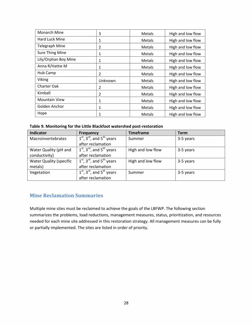
Monarch Mine 3 Metals High and low flow Hard Luck Mine 1 Metals High and low flow Telegraph Mine 2 Metals High and low flow Sure Thing Mine 1 Metals High and low flow Lily/Orphan Boy Mine 1 Metals High and low flow Anna R/Hattie M 1 Metals High and low flow Hub Camp 2 Metals High and low flow Viking Unknown Metals High and low flow Charter Oak 2 Metals High and low flow Kimball 2 Metals High and low flow Mountain View 1 Metals High and low flow Golden Anchor 1 Metals High and low flow Hope 1 Metals High and low flow
Table 9. Monitoring for the Little Blackfoot watershed post-restoration Indicator Frequency Timeframe Term Macroinvertebrates 1st, 3rd, and 5th years
after reclamation Summer 3-5 years
Water Quality (pH and conductivity)
1st, 3rd, and 5th years after reclamation
High and low flow 3-5 years
Water Quality (specific metals)
1st, 3rd, and 5th years after reclamation
High and low flow 3-5 years
Vegetation 1st, 3rd, and 5th years after reclamation
Summer 3-5 years
Mine Reclamation Summaries Multiple mine sites must be reclaimed to achieve the goals of the LBFWP. The following section summarizes the problems, load reductions, management measures, status, prioritization, and resources needed for each mine site addressed in this restoration strategy. All management measures can be fully or partially implemented. The sites are listed in order of priority.
28
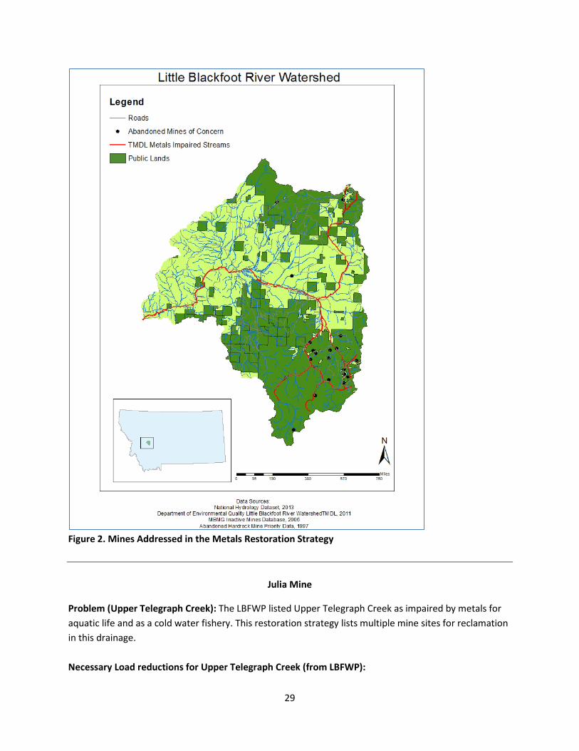
Figure 2. Mines Addressed in the Metals Restoration Strategy
Julia Mine
Problem (Upper Telegraph Creek): The LBFWP listed Upper Telegraph Creek as impaired by metals for aquatic life and as a cold water fishery. This restoration strategy lists multiple mine sites for reclamation in this drainage. Necessary Load reductions for Upper Telegraph Creek (from LBFWP):
29
arsenic: 0% zinc: 26% beryllium: 0% lead: 61% cadmium: 17% aluminum: 46% copper: 43%
Management Measures: Waste rock (10,720 cy) removal could significantly decrease metals impairments from this site. One open adit exists that could be closed with a plug or gate. Removing the loadout structures or somehow restricting access could eliminate and reduce hazards at this site. After removing the large volume of waste rock, this area would need to be revegetated to return to a more natural state. Status: No remediation efforts have been completed to date. Priority Number: 1
Resources Needed: Engineering/Hydrology consulting, partnership with Helena National Forest Costs: Over $1 million
Duration of Mitigation: Less than 1 year for initial implementation, with monitoring and maintenance in subsequent years
Third Term Mine
Problem (Upper Telegraph Creek): The LBFWP listed Upper Telegraph Creek as impaired by metals for aquatic life and as a cold water fishery. This restoration strategy lists multiple mine sites for reclamation in this drainage. Necessary Load reductions for Upper Telegraph Creek (from LBFWP):
arsenic: 0% zinc: 26% beryllium: 0% lead: 61% cadmium: 17% aluminum: 46% copper: 43%
Management Measures: This site has had initial restoration, but is in need of netting repair, and reinforcement of silt fencing. Additionally, low vegetation success occurred on the site, so the addition of top-soil and reseeding and weed removal could improve native vegetation.
30
Status: Helena National Forest plans to treat weeds at this site in 2014, but no further restoration efforts have been planned. In 2006, stabilization and in-place consolidation of mine waste took place, along with application of 56 tons of CaCO3 and 2,700 square yards of turf matting over waste rock. Priority Number: 2
Resources Needed: Partnership with Helena National Forest Costs: Less than $1 million Duration of Mitigation: Less than 1 year
Victory / Evening Star
Problem (Lower Little Blackfoot River): The LBFWP listed the lower Little Blackfoot River as impaired by metals for aquatic life, drinking water, and as a cold water fishery. Numerous mine sites exist in this sub-basin, but Victory/Evening Star is the only mine in this area on the DEQ priority mine site list.
Necessary Load Reductions needed for the Lower Little Blackfoot River (from LBFWP):
arsenic: 79% aluminum: 3% lead: 29%
Management Measures: Although the diversion ditch was repaired in 2012, it requires maintenance. Additionally, noxious weed control is necessary at this site. Additional waste rock may be on site and needs further investigation and removal or consolidation if present. In 1993, the volume of waste rock was recorded at 8,300 cy. The adjacent road delivers sediment to the stream and should be addressed in a non-metals related restoration strategy.
Status: The forest service removed 1,224 bcy of in-drainage tailings and hauled it to the Luttrell Repository in 2005. A removal area diversion ditch was installed at the time and was repaired with riprap and fabric in 2012.
Priority Number: 3
Resources Needed: Engineering/hydrology consulting, partnership with private land owners
Costs: Less than $1 million Duration of Mitigation: 1 year for initial waste rock removal and maintenance, then continual maintenance of diversion ditch in perpetuity
31
Charter Oak
Problem (Upper Little Blackfoot River): The LBFWP listed the Upper Little Blackfoot River as impaired by metals for aquatic life and as a cold water fishery. This restoration strategy lists multiple mine sites for reclamation in this drainage. Necessary Load Reductions needed for the Upper Little Blackfoot River (from LBFWP):
arsenic: 38% cyanide: 48% cadmium: 77% lead: 92% copper: 25% aluminum: 21%
Management Measures: The removal of 3,000 bcy of remaining submerged tailings would help reduce metals impairments from this source and could be placed in the onsite repository. Additionally, the adit discharge collection cell must be continually maintained. There is a potential leak in the repository possibly due to a failure of interior grouting that must also be repaired.
Status: Numerous restoration efforts have taken place at Charter Oak from 1996 through 2011. These efforts include the placement of 18,400 cy of tailings, contaminated soil, waste rock, and debris in an onsite repository, closure of hazardous mine openings, and installation and repair of a discharge collection cell. The site still displays numerous problems, which are addressed above in the management measures.
Priority Number: 4
Resources Needed: Engineering/Hydrology consulting, partnership with Helena National Forest
Costs: over $1 million
Duration of Mitigation: less than 1 year for initial implementation of restoration, then maintenance of adit discharge cell in perpetuity
Anna R./Hattie M. Mine
Problem (Upper Telegraph Creek): The LBFWP listed Upper Telegraph Creek as impaired by metals for aquatic life and as a cold water fishery. This restoration strategy lists multiple mine sites for reclamation in this drainage. Necessary Load reductions for Upper Telegraph Creek (from LBFWP):
32
arsenic: 0% zinc: 26% beryllium: 0% lead: 61% cadmium: 17% aluminum: 46% copper: 43%
Management Measures: Removal of 2,230 cy of waste rock could significantly decrease metals impairments from this site. Additionally, setting up a passive treatment system for the one discharging adit at this mine site would help further reduce metals impairments. The hazardous structures and openings, which include one shaft, one loadout structure, and one collapsing cabin, must be either removed or closed. Lastly, revegetation will help restore this site to its natural state. Status: No remediation efforts have been completed to date. Priority Number: 5
Resources Needed: Engineering/Hydrology consulting, partnership with Helena National Forest Costs: Over $1 million
Duration of Mitigation: less than 1 year for initial restoration, then monitoring and upkeep of passive adit treatment
Bald Butte Mine
Problem (Upper Dog Creek): The LBFWP listed Upper Dog Creek as impaired by metals for aquatic life and as a cold water fishery. Multiple mines exist in the area, and have been reclaimed as part of the Bald Butte/Great Divide restoration projects.
Necessary Load Reductions needed for Upper Dog Creek (from LBFWP):
arsenic:23% cadmium: 62% lead: 68% copper: 0% zinc: 0% aluminum: 38%
Management Measures: Bald Butte mine site has been recently reclaimed as part of the Bald Butte/Great Divide Restoration Project. The next steps for this site would be to implement a stream water quality monitoring plan, if a plan is not already in place.
Status: Major restoration has taken place at this site and was expected to finish in 2013. No post-monitoring data of water quality at this site is available.
Priority Number: 6
33
Resources Needed: Partnership with private land owners and contractors who completed restoration would help facilitate a better understanding of restoration at these sites and any next steps, lab analyses
Costs: less than 1 million
Duration of Mitigation: Multiple years of monitoring (3-5 years)
Kimball
Problem (Upper Little Blackfoot River): The LBFWP listed the Upper Little Blackfoot River as impaired by metals for aquatic life and as a cold water fishery. This restoration strategy lists multiple mine sites for reclamation in this drainage. Necessary Load Reductions needed for the Upper Little Blackfoot River (from LBFWP):
arsenic: 38% cyanide: 48% cadmium: 77% lead: 92% copper: 25% aluminum: 21%
Management Measures: This site is in need of increased adit monitoring to understand the inputs from this source, especially at Upper Kimball where an adit discharges directly into Tramway Creek. Monitoring is limited due to river crossings and private lands.
Status: Waste rock removal took place in 2005, which placed 3,363 bcy of waste rock in the Luttrell Repository from Lower Kimball, and 4,295 bcy from Upper Kimball. At the upper site, an adit discharge channel was constructed with erosion matting installed, and a partially collapsed adit was backfilled with boulders. Additionally an adit culvert cover at the lower site was repaired in 2011 after damage from vandalism.
Priority Number: 7
Resources Needed: Engineering/Hydrology consulting, partnerships with private land owners and Helena National Forest, lab analyses
Costs: Over $1 million
Duration of Mitigation: less than 1 year for initial adit discharge treatment implementation, monitoring and upkeep of passive adit treatment in perpetuity
Hope Mine
Problem (Upper Little Blackfoot River): The LBFWP listed the Upper Little Blackfoot River as impaired by metals for aquatic life and as a cold water fishery. This restoration strategy lists multiple mine sites for reclamation in this drainage.
34
Necessary Load Reductions needed for the Upper Little Blackfoot River (from LBFWP):
arsenic: 38% cyanide: 48% cadmium: 77% lead: 92% copper: 25% aluminum: 21%
Management Measures: Removal of 2,000 cy of waste rock at this site would help reduce metals impairments from this site. A passive adit treatment is also suggested for the one discharging adit. Lastly, revegetation would help return the site to its natural state.
Status: Maxim Technologies completed a SI and an EE/CA in 2006 for waste rock removal at this site, including design information and a haul route to the Luttrell Repository. According to the Forest Service, the restoration was not initiated due to a lack of funding.
Priority Number: 7
Resources Needed: Available funding to implement restoration plan, Engineering/Hydrology Consulting, partnership with Helena National Forest
Costs: Over $1 million
Duration of Mitigation: less than 1 year for initial restoration, then monitoring and upkeep of passive adit treatment in perpetuity
Hard Luck Mine
Problem (Ontario Creek): The LBFWP listed Ontario Creek as impaired by metals for aquatic life and as a cold water fishery. Hard Luck Mine is thought to be the primary source of metals impairment to Ontario Creek.
Necessary Load Reductions for Ontario Creek (from LBFWP):
cadmium: 55% aluminum: 33% copper: 29% zinc: 72% lead: 26%
Management Measures: Removal of 650 cy of mine waste would help eliminate metals impairments from this source. Two potentially hazardous mine openings must be backfilled, gated, or taken down to eliminate hazard. One discharging adit has been recorded on site, which needs some type of passive treatment system.
Status: No remediation efforts have been completed to date.
Priority Number: 9
35
Resources Needed: Engineering/Hydrology consulting, partnership with Helena National Forest, construction & labor
Costs: Over $1 million
Duration of Mitigation: less than 1 year for initial restoration, then monitoring and upkeep of passive adit treatment
Monarch Mine
Problem (Monarch Creek): The LBFWP listed Monarch Creek as impaired by metals for aquatic life, as a cold water fishery, and for primary contact recreation. Monarch mine is the most probable source of metals impairment. Necessary Load Reductions for Monarch Creek (from LBFWP):
copper: 5% mercury: 0% lead: 33% aluminum: 33% Management Measures: In-place stabilization and amendment of mine wastes would decrease the concentration of metals entering Monarch Creek. Access must be improved to address issues at this site. Three discharging adits need mitigation through a constructed wetland, a drainage ditch, or a lime amendment to avoid further metals inputs from these adits. Revegetation of the area would help return the site back to its natural state.
Status: The in-place stabilization and amendment of mine waste was designed in 2006 and an EE/CA developed, but it was not initiated in 2007 due to a lack of funding (Oaks 2014).
Priority Number: 9
Resources Needed: Engineering/Hydrology Consulting, construction & labor
Costs: Over $1 million
Duration of Mitigation: less than 1 year for initial restoration, then monitoring
Golden Anchor
Problem (Upper Little Blackfoot River): The LBFWP listed the Upper Little Blackfoot River as impaired by metals for aquatic life and as a cold water fishery. This restoration strategy lists multiple mine sites for reclamation in this drainage. Necessary Load Reductions needed for the Upper Little Blackfoot River (from LBFWP):
arsenic: 38% cyanide: 48% cadmium: 77% lead: 92%
36
copper: 25% aluminum: 21% Management Measures: Removing the 5,000 cy of waste rock at Golden Anchor could significantly decrease the metals impairments from this site. Creating a passive adit treatment from the one discharging adit would reduce metals impairment further. Additionally the collapsed millsite and other collapsed structures and load-out would need to be removed to eliminate hazards. Revegetation would help return the site to its natural state, especially where waste rock is removed.
Status: No remediation efforts have been completed to date.
Priority Number: 9
Resources Needed: Engineering/Hydrology consulting, partnerships with private landowners
Costs: Over $1 million Duration of Mitigation: less than 1 year for initial restoration, then monitoring and upkeep of passive adit treatment in perpetuity
Ontario Mine and Millsite
Problem (Un-named Creek): The LBFWP listed Un-named Creek as impaired by metals for aquatic life and as a cold water fishery. Ontario Mine is the primary source of metals impairment for this stream, and another mine (Amanda Mine) is a possible source of metals impairment.
Necessary Load Reductions for Unnamed Creek (from LBFWP): arsenic: 82% mercury: 0% cadmium: 94% zinc: 84% copper: 82% iron: 36% lead: 88% aluminum: 76%
Management Measures: Placing the remaining waste rock in the Luttrell repository will prevent metals from waste rock from entering the water. The Luttrell repository is suggested because waste rock was hauled to this site in 2006, meaning that a route has already been developed. Improving the constructed wetlands for filtering adit discharge, and possibly adding lime could help metals precipitate out and neutralize the water’s pH before it enters Un-named Creek. The removal of wet tailings would also take these metals sources out of the stream. Revegetation will help return the site to its natural state.
Status: 16,000 cy of tailings and waste rock was hauled to Luttrell repository in 2006; however 11,000 cy of tailings remain on private land. The adit discharge contains high metals contamination even after flowing through a reclaimed wetland, as documented by Helena National Forest.
37
Priority Number: 12
Resources Needed: Engineering/Hydrology consulting, construction vehicles & labor, cooperation with private land owners
Cost: Over $1 million, $396,000 for waste rock removal
Duration of Mitigation: Less than 1 year for the initial implementation, plus monitoring passive treatment system in perpetuity
Hub Camp Mine
Problem (Upper Telegraph Creek): The LBFWP listed Upper Telegraph Creek as impaired by metals for aquatic life and as a cold water fishery. This restoration strategy lists multiple mine sites for reclamation in this drainage. Necessary Load reductions for Upper Telegraph Creek (from LBFWP):
arsenic: 0% zinc: 26% beryllium: 0% lead: 61% cadmium: 17% aluminum: 46% copper: 43%
Management Measures: More information is needed to understand if and how much waste remains at the site. If any volume exists, it would need to be stabilized in place because access hinders waste rock removal at this site. Two discharging adits were recorded at this site, and establishing a passive adit treatment would help reduce metals impairments at this site. Additionally, although the area was seeded in 2006, noxious weeds remain a problem and must be treated.
Status: The Forest Service hauled 1,250 cy of waste rock to the Luttrell Repository in 2006, the access road was reclaimed, and the area was seeded. Steep terrain hinders further waste removal.
Priority Number: 12
Resources Needed: Engineering consulting, partnership with Helena National Forest
Costs: Over $1 million
Duration of Mitigation: less than 1 year for initial implementation restoration, then monitoring and upkeep of passive adit treatment
Lily/Orphan Boy Mine
38
Problem (Upper Telegraph Creek): The LBFWP listed Upper Telegraph Creek as impaired by metals for aquatic life and as a cold water fishery. This restoration strategy lists multiple mine sites for reclamation in this drainage. Necessary Load reductions for Upper Telegraph Creek (from LBFWP):
arsenic: 0% zinc: 26% beryllium: 0% lead: 61% cadmium: 17% aluminum: 46% copper: 43%
Management Measures: Potential management measures for Lily/Orphan Boy mine are listed in the EE/CA completed in 2010. These were not implemented due to a lack of funding, so securing funding for these projects would be essential moving forward. Status: An EE/CA was completed in 2010, already costing over $1 million. The EE/CA determined “some kind of flow control technology… would be cost effective,” but it was not initiated due to funding. Priority Number: 14
Resources Needed: Funds for project, Engineering/Hydrology consulting, partnership with private land owners and Helena National Forest. Costs: Over $1 million Duration of Mitigation: less than 1 year for initial restoration, then monitoring and upkeep of passive adit treatment
Mountain View
Problem (Upper Little Blackfoot River): The LBFWP listed the Upper Little Blackfoot River as impaired by metals for aquatic life and as a cold water fishery. This restoration strategy lists multiple mine sites for reclamation in this drainage. Necessary Load Reductions needed for the Upper Little Blackfoot River (from LBFWP):
arsenic: 38% cyanide: 48% cadmium: 77% lead: 92% copper: 25% aluminum: 21%
39
Management Measures: This site has at least 3 waste rock dumps, estimated at about 6,500 cy, within the Tramway Creek drainage that are restricting stream migration. Removal of this waste could significantly reduce metals impairments from this site. Additionally, one open discharging adit has been recorded, whose influence to metals impairments could be mitigated by installing a passive adit discharge treatment system. After removal of the waste rock dumps, revegetation of the site and stream bank stabilization may be necessary.
Status: No remediation efforts have been completed to date.
Priority Number: 15
Resources Needed: Engineering/Hydrology consulting, partnership with Helena National Forest
Costs: Over $1 million
Duration of Mitigation: less than 1 year for initial restoration, then monitoring and upkeep of passive adit treatment in perpetuity
Viking Mine
Problem (Upper Telegraph Creek): The LBFWP listed Upper Telegraph Creek as impaired by metals for aquatic life and as a cold water fishery. This restoration strategy lists multiple mine sites for reclamation in this drainage. Necessary Load reductions for Upper Telegraph Creek (from LBFWP):
arsenic: 0% zinc: 26% beryllium: 0% lead: 61% cadmium: 17% aluminum: 46% copper: 43%
Management Measures: Remaining problems on site include contaminated fines with high metals concentrations, but terrain hinders further removal from this site. Suggested management includes the addition of lime to neutralize pH and drop out metals, since a soil cover was already applied to prevent transport/exposure of these fines.
Status: The Forest Service hauled 1,144 cy of waste rock to the Luttrell Repository in 2006, and an infiltration basin was constructed, followed by a soil buffer, seed, and compost application. Additionally, the access road was reclaimed.
Priority Number: 16
40
Resources Needed: Engineering Consulting, partnership with Helena National Forest
Costs: less than 1 million
Duration of Mitigation: Less than 1 year for initial implementation restoration, then monitoring and upkeep
Telegraph Mine
Problem (Sally Ann Creek): The LBFWP listed Sally Ann Creek as impaired by metals for aquatic life and as a cold water fishery. Telegraph Mine is the most probable source of metals impairment in the watershed. Necessary Load reductions for Sally Ann Creek (from LBFWP):
cadmium: 93% zinc: 26% copper: 29% Management Measures: The Forest Service recorded contaminated horizon and remaining mine waste, road drainage and erosion controls need repair, inadequate fencing, and disturbed precipitate pools due to ATV travel. Removal of the contaminated horizon and remaining mine waste could help decrease metals impairment from this source. Additional maintenance and repair of erosion controls, fencing, and precipitate pools could help improve the existing management measures. Status: In 2006, 2,087 cy of waste was hauled to Luttrell Repository, a cover soil buffer was applied to the reclamation area and access road, and an infiltration basin was constructed. Priority Number: 17
Resources Needed: Engineering/Hydrology consulting, partnership with Helena National Forest Costs: Less than $1 million
Duration of Mitigation: less than 1 year for initial removal and repairs, then monitoring and upkeep in perpetuity
Sure Thing Mine Problem (O’Keefe Creek): The LBFWP listed O’Keefe Creek as impaired by metals for aquatic life and as a cold water fishery. Sure Thing Mine is the only DEQ priority mine in this drainage. O’Keefe/Copper King
41
Mine is also suspected to contribute somewhat to the metals impairments, but will not be addressed in this restoration strategy (DEQ & EPA 2011). Necessary Load reductions for O’Keefe Creek (from LBFWP):
Cadmium: 95% Zinc: 47% Copper: 43% Management Measures: Removal of 7,700 cy of waste rock on site could significantly decrease the metals impairments from this source, and should be the initial cleanup option. Developing a passive treatment for the discharging adit could further reduce impairments from this site. Dismantling the highwall is necessary to remove hazards on site, and lastly revegetation would help return this site to its natural state. Status: No remediation efforts have been completed to date. Priority Number: 18
Resources Needed: Engineering/Hydrology consulting, cooperation with private landowners Costs: Over $1 million Duration of Mitigation: less than 1 year for initial restoration, then monitoring and upkeep of passive adit treatment in perpetuity
SE SW Section 10
Problem (Upper Little Blackfoot River): The LBFWP listed the Upper Little Blackfoot River as impaired by metals for aquatic life and as a cold water fishery. This restoration strategy lists multiple mine sites for reclamation in this drainage. Necessary Load Reductions needed for the Upper Little Blackfoot River (from LBFWP):
arsenic: 38% cyanide: 48% cadmium: 77% lead: 92% copper: 25% aluminum: 21%
Management Measures: A site investigation is the first step necessary for this site.
42
Status: SE SW Section 10 is on the DEQ priority mine site list ranking number 97, but little is known about problems at this site.
Priority Number: Not enough data to assess and rank in prioritization matrix
Resources Needed: Engineering/Hydrology consulting
Costs: Unknown – initially just monitoring to learn more about the site through water quality monitoring and a site investigation
Duration of Mitigation: Multiple years of monitoring (3-5)
43
References Buck, Stuart and Gerard, David. 2001 Cleaning up Mining Waste. Political Economy Research Center: Research Study 01-1 – November 2001. Retrieved 5/20/14 from: http://perc.org/sites/default/files/rs01_1.pdf Christensen, Jo. Strategies and Techniques for the Beaverhead River at Tash Ranch. Streambank Revegetation and Bioengineering Workshop. Dillon, MT: April 8, 2014. Colorado Department of Natural Resources (CDNR). 2002. Best Practices in Abandoned Mine Land Restoration: The Remediation of Past Mining Activities. Colorado Dept. of Natural Resources, Division of Minerals and Geology, Denver, CO. http://mining.state.co.us/bmp.pdf. Retrieved 3/13/2014 from: http://mining.state.co.us/bmp.pdf DEQ and EPA Region 8. 2011. Little Blackfoot River Watershed TMDLs and Framework Water Quality Improvement Plan. Helena, MT: Montana Dept. of Environmental Quality; U.S. Environmental Protection Agency, Region 8. DEQ and EPA Region 8. 2014. Little Blackfoot River Watershed TMDLs and Framework Water Quality Improvement Plan – Metals Addendum. Helena, MT: Montana Dept. of Environmental Quality; U.S. Environmental Protection Agency, Region 8. DEQ. 1995. Priority Abandoned Hard Rock Mine Sites Summary Report. 9 Priority Sites Powell to Yellowstone. Helena, MT: Montana Dept. of Environmental Quality.
DEQ. 2013. DEQ-MWCB Priority Site List: DEQ Prioritized Short List of AML Sites. October 9, 2013. Helena, MT: Montana Dept. of Environmental Quality. Retrieved from: http://deq.mt.gov/AbandonedMines/priority.mcpx DEQ. 2014. Hazardous Waste Site Cleanup Bureau. Helena, MT: Montana Dept. of Environmental Quality; Remediation Division. Retrieved May 14, 2014, from http://deq.mt.gov/rem/hwc/default.mcpx DEQ-AML. 2014. Project Costs: Updated March 2014. Helena, MT: Montana Dept. of Environmental Quality; Abandoned Mine Lands. Retrieved June 27, 2014. DNRC. 2014. Conservation and Resource Development: Grant and Loan Program. Helena, MT: Dept. of Natural Resource Conservation. Retrieved 07/28/14 from: http://www.dnrc.mt.gov/cardd/LoansGrants/Default.asp EPA, 2012. Green Remediation Best Practices: Mining Sites. U.S. Environmental Protection Agency: Office of Solid Waste and Emergency Response (5102G). Retrieved 06/18/14 from: http://cluin.org/greenremediation/docs/GR_factsheet_miningsites.pdf Hargrave, Phyllis A, Tom P. Bowler, Jeff D. Lonn, James P. Madison, John J. Metesh, Robert Wintergerst. 1998. Abandoned Inactive Mines of the Blackfoot and Little Blackfoot River Drainages. Helena National Forest, Volume II. Open File Report 368, Montana Bureau of Mines and Geology.
44
Harper, Archie. April 25, 2014. Personal e-mail communication. Asst. Fish Biologist, Helena, MT: Helena National Forest. ITRC. 2010. Technology Overview: Constructed Treatment Wetland. Washington, DC: Interstate Technology & Regulatory Council Mine Waste Team, August 2010. Kerber Creek Watershed Management Plan (WMP). 2012 Kerber Creek Restoration Project, Draft Restoration Plan, Colorado. Received 2/15/14 via e-mail from [email protected]. Land & Water Consulting, Inc. Little Blackfoot River – Physical Features Inventory and Riparian Assessment. Project No. 110291. Little Blackfoot Watershed Group and Deer Lodge Valley Conservation District. Helena, MT: 2 May, 2002. Limerick, P.N., Ryan, J.N., Brown, T.R., and Comp, T.A, 2005. Cleaning Up Abandoned Hardrock Mines in the West: Prospecting for a Better Future. Boulder, CO: Center of the American West; University of Colorado at Boulder. Littman, Nick and Roberts, Rob. 2013. Watershed Restoration Plan for the Ninemile Creek TMDL Planning Area. Missoula, MT: Trout Unlimited. McCulloch, Robin. 2012. “Mines and Exploration in Montana” Montana Bureau of Mines and Geology. Retrieved August 7, 2014, from http://www.mbmg.mtech.edu/gmr/gmr-mines_exploration.asp Ockey, Mark. 2011. Cooke City TMDL Implementation Evaluation. Helena, MT: Montana Dept. of Environmental Quality.
Oaks, Hans. 2014. Upper Little Blackfoot River Mine Sites (Vicinity – SE of Elliston, MT). Minerals & Geology and Abandoned Mine Lands Program, Helena National Forest, Region 1, USFS.
Skousen, Jeff. 1992. Anoxic Limestone Drains for Acid Mine Drainage Treatment. Charleston, WV: West Virginia Surface Mining and Reclamation Association, Green Lands, p.30-35 Retrieved 6/28/14 from: http://www.wvu.edu/~Agexten/landrec/Anoxic_Limestone_Drains_for_AMD_Treatment_LD-F91.pdf U.S. Department of Interior: U.S. Geological Survey (USGS). 2014. Surface Water data for USA: USGS Surface-Water annual Statistics. Montana Water Data Support Team, USGS 12324590 Little Blackfoot River near Garrison, MT. URL: http://waterdata.usgs.gov/nwis/annual? Wang Q.R. et al. Soil contamination and plant uptake of heavy metals at polluted sites in China. J Environ Sci Health A Tox Hazard Subst Environ Eng. 2003 May;38(5):823-38.Wang QR1, Cui YS, Liu XM, Dong YT, Christie P.
45
Appendices A. Acronym List AML Abandoned Mine Lands BCY Bank Cubic Yards CDNR Colorado Department of Natural Resources CERCLA Comprehensive Environmental Response, Compensation, and Liability Act CFS Cubic Feet per Second CY Cubic Yards CWA Clean Water Act DEQ Department of Environmental Quality DNRC Department of Natural Resource Conservation EE/CA Engineering Evaluation and Cost Assessment EPA Environmental Protection Agency FWP Fish, Wildlife & Parks GIS Geographic Information System HMO Hazardous Mine Opening HNF Helena National Forest ITRC Interstate Technology and Regulatory Council LBFWP Little Blackfoot TMDLs and Water Quality Improvement Plan MBMG Montana Bureau of Mines and Geology MNHP Montana Natural Heritage Program MWCB Montana Waste Cleanup Bureau NPS Nonpoint Source Pollution RDG Reclamation and Development Grants SAP Sampling and Analysis Plan SI Site Investigation TMDL Total Maximum Daily Load TPA TMDL Planning Area USFWS U.S. Fish and Wildlife Service USGS U.S. Geological Survey WMP Watershed Management Plan WRP Watershed Restoration Plan
B. Prioritization Framework
46
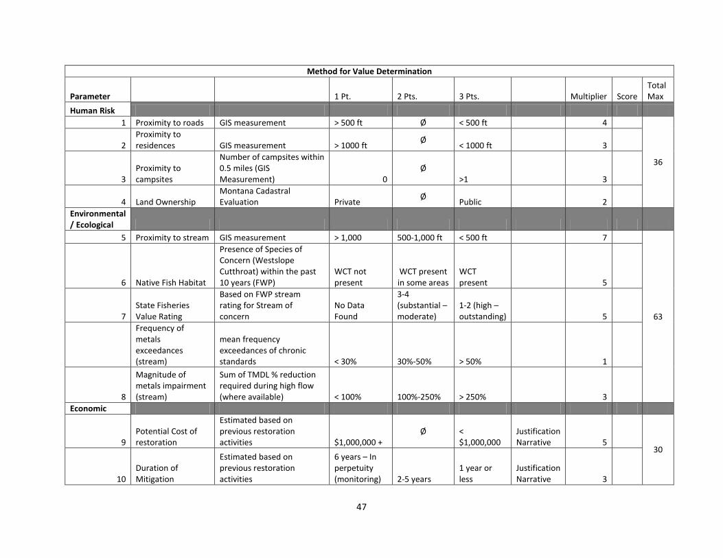
Method for Value Determination
Parameter 1 Pt. 2 Pts. 3 Pts. Multiplier Score Total Max
Human Risk 1 Proximity to roads GIS measurement > 500 ft Ø < 500 ft 4
36
2 Proximity to residences GIS measurement > 1000 ft Ø < 1000 ft 3
3 Proximity to campsites
Number of campsites within 0.5 miles (GIS Measurement) 0
Ø >1 3
4 Land Ownership Montana Cadastral Evaluation Private Ø Public 2
Environmental / Ecological
5 Proximity to stream GIS measurement > 1,000 500-1,000 ft < 500 ft 7
63
6 Native Fish Habitat
Presence of Species of Concern (Westslope Cutthroat) within the past 10 years (FWP)
WCT not present
WCT present in some areas
WCT present 5
7 State Fisheries Value Rating
Based on FWP stream rating for Stream of concern
No Data Found
3-4 (substantial – moderate)
1-2 (high – outstanding) 5
Frequency of metals exceedances (stream)
mean frequency exceedances of chronic standards < 30% 30%-50% > 50% 1
8
Magnitude of metals impairment (stream)
Sum of TMDL % reduction required during high flow (where available) < 100% 100%-250% > 250% 3
Economic
9 Potential Cost of restoration
Estimated based on previous restoration activities $1,000,000 +
Ø < $1,000,000
Justification Narrative 5
30
10 Duration of Mitigation
Estimated based on previous restoration activities
6 years – In perpetuity (monitoring) 2-5 years
1 year or less
Justification Narrative 3
47
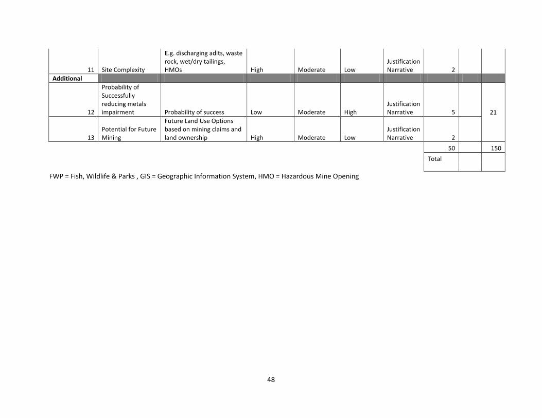
11 Site Complexity
E.g. discharging adits, waste rock, wet/dry tailings, HMOs High Moderate Low
Justification Narrative 2
Additional
12
Probability of Successfully reducing metals impairment Probability of success Low Moderate High
Justification Narrative 5 21
13 Potential for Future Mining
Future Land Use Options based on mining claims and land ownership High Moderate Low
Justification Narrative 2
50 150
Total
FWP = Fish, Wildlife & Parks , GIS = Geographic Information System, HMO = Hazardous Mine Opening
48
C. Sampling and Analysis Plan
METALS RESTORATION STRATEGY SAMPLING – 2015: WATER QUALITY AND METALS IMPAIRMENT SAMPLING
Sampling and Analysis Plan Prepared for: MONTANA DEPARTMENT OF ENVIRONMENTAL QUALITY Water Quality Planning Bureau
P.O. Box 200901 Helena, MT 59620-0901
Approvals
______________________________________ ________________
Eric Trum (Project Manager) Date
______________________________________ ________________
Darrin Kron (Monitoring and Assessment Supervisor) Date
______________________________________ ________________
Mindy McCarthy (Quality Assurance Officer) Date
______________________________________ ________________
Add additional signatories as needed Date
Contents Section 1 – Introduction and Background Information .............................................................................. 52
Section 2 - Project Objectives and Sampling Design ................................................................................... 54
Project Objectives and Goals .................................................................................................................. 54
Sampling Planning and Site Selection ..................................................................................................... 54
Selecting monitoring sites ................................................................................................................... 54
Sampling Timeframe ............................................................................................................................... 55
Section 3 - Field Procedures ........................................................................................................................ 55
General sampling sequence .................................................................................................................... 55
Collecting In Situ Chemistry Field Measurements .................................................................................. 55
Using Field Meters .............................................................................................................................. 55
Collecting Chemistry Samples in Streams and Rivers ............................................................................. 56
Collecting water samples for total recoverable fractions (unfiltered, acid-preserved) ..................... 56
Collecting water samples for total recoverable fractions (unfiltered, frozen) ................................... 56
Water samples for dissolved alumnium (filtered) .............................................................................. 56
Water samples for low-level total mercury ........................................................................................ 57
Measuring Physical Parameters .............................................................................................................. 57
Measuring flow (total discharge) ........................................................................................................ 57
Taking digital photographs to document the site ............................................................................... 57
Site Comments .................................................................................................................................... 57
Section 4 – Sample Handling Procedures ................................................................................................... 58
Section 5 – Laboratory Analytical Methods ................................................................................................ 58
Section 6 – Quality Assurance and Quality Control Requirements ............................................................ 59
Calibrating Field Meters .......................................................................................................................... 59
In the Laboratory ................................................................................................................................ 59
In the Field .......................................................................................................................................... 59
Field Quality Control Samples ................................................................................................................. 60
Duplicate Samples ............................................................................................................................... 60
Field Blanks ......................................................................................................................................... 60
Section 7 – Handling Sampling Records ...................................................................................................... 60
Section 8 – Schedule ................................................................................................................................... 60
Section 9 – Project Team and Responsibilities ........................................................................................... 61
Section 10 - References .............................................................................................................................. 61
Appendix A – Proposed Monitoring Site Locations & Site Choice Rationale . Error! Bookmark not defined.
Appendix B – Number of Samples Planned Per Parameter per Waterbody . Error! Bookmark not defined.
List of Appendices
List of Tables
Section 1 – Introduction and Background Information This document presents a plan for completing metals monitoring and source assessment in the Upper Little Blackfoot Watershed in 2015. It identifies the process for completing this assessment, which will help in deciding specific remediation strategies at each site. This sampling is necessary to identify proper remediation techniques based on specific sources of metals impairment in the Little Blackfoot Watershed. Post-project sampling written into this SAP is important for assessing the success of the restoration strategies and the need for any future restoration. This SAP was developed in conjuction with the 2014 Little Blackfoot Metals Restoration Strategy.
The Little Blackfoot River watershed is contained within Powell, and Lewis and Clark counties. The Little Blackfoot River extends approximately 47 miles from its headwaters to the mouth where it meets with the Clark Fork River. The watershed encompasses 264,124 acres (approximately 413 square miles) and is part of the Upper Clark Fork (17010201) hydrologic unit (DEQ & EPA 2011). The area includes the 170102015 and 170102016 fifth-code watersheds, representing the Little Blackfoot River Headwaters and the Lower Little Blackfoot River watersheds respectively. According to a GIS analysis of public lands within the watershed, approximately 50% of the watershed falls within Helena National Forest.
The most recent assessment of metals in the area is the 2011 Little Blackfoot Watershed TMDLs and Framework Water Quality Improvement Plan (LBFWP)and its 2014 addendum (MDEQ 2011). The report used data from the past ten years (2001-2011), but data collected specifically for this report was from 2008 and 2009 (DEQ & EPA 2011). DEQ completed a reassessment of existing data from the same years to complete the 2014 Addendum (DEQ & EPA 2014). This report based its assessment on water quality data for stream segments within the watershed, clumping mining sources into composite allocations. Previous reports of abandoned mines in the Little Blackfoot watershed include the Montana Bureau of Mines and Geology (MBMG) Open-File Report 368 (Hargrave et al 1998), the Abandoned Hard Rock Mine Priority Sites Summary Report, commonly known as the “Red Book” (DEQ 1995). Both these reports sampled sediment and water quality.
This document calls for further monitoring in order to better understand the sources of metals impairments in each sub-watersheds, and the feasibility and needs for remediation at abandoned mine sites. The LBFWP identified data gaps where further water quality assessment is necessary to complete source assessment in the watershed (DEQ & EPA 2011). This monitoring plan will fill those gaps. Collecting more water quality data and at more locations will help determine the sources of metals impairments and help decide where to focus funding and remedial efforts.
Additionally, the Metals Restoration Strategy brought attention to the lingering problems in addressing discharging adits. By sampling these adits, this monitoring effort will identify how significant contributions from discharging adits are to metals impairment in each stream segment. Site assessments will provide information for future feasibility assessments that will determine the possibility of implementing remedial measures at each abandoned mine site. Addressing adit discharge is expensive and complex, so understanding the contamination from these adits would help to plan remedial measures.
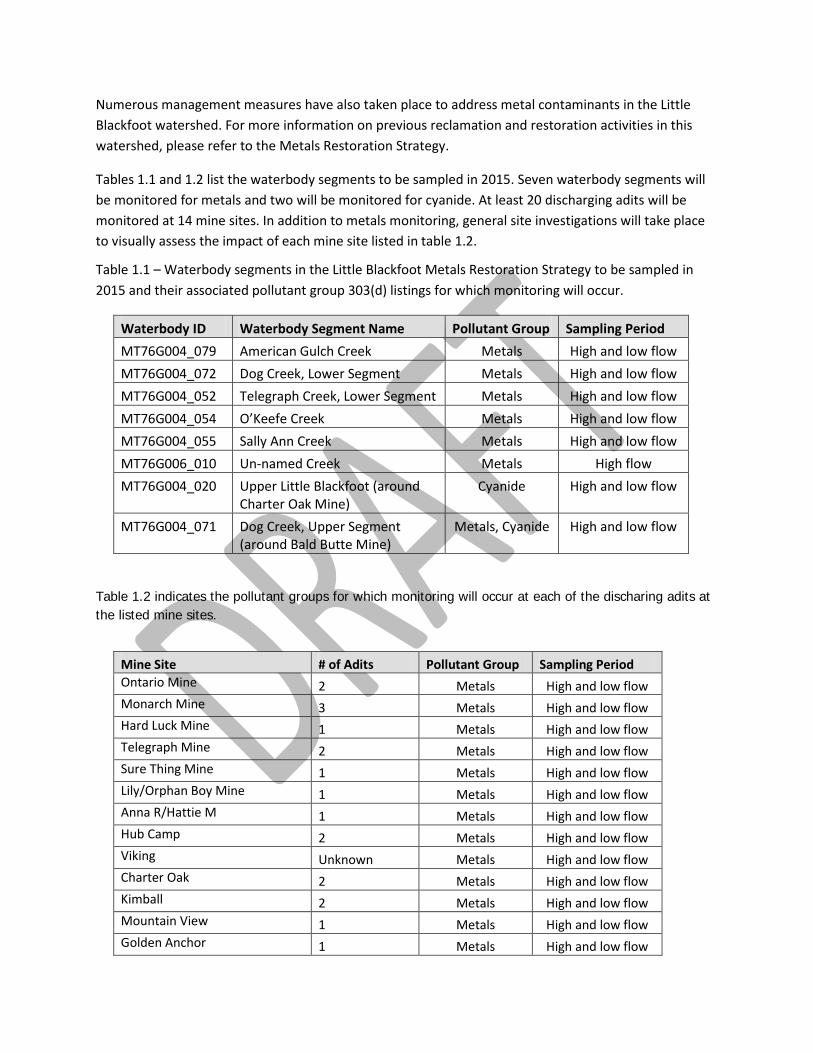
Numerous management measures have also taken place to address metal contaminants in the Little Blackfoot watershed. For more information on previous reclamation and restoration activities in this watershed, please refer to the Metals Restoration Strategy.
Tables 1.1 and 1.2 list the waterbody segments to be sampled in 2015. Seven waterbody segments will be monitored for metals and two will be monitored for cyanide. At least 20 discharging adits will be monitored at 14 mine sites. In addition to metals monitoring, general site investigations will take place to visually assess the impact of each mine site listed in table 1.2.
Table 1.1 – Waterbody segments in the Little Blackfoot Metals Restoration Strategy to be sampled in 2015 and their associated pollutant group 303(d) listings for which monitoring will occur.
Waterbody ID Waterbody Segment Name Pollutant Group Sampling Period MT76G004_079 American Gulch Creek Metals High and low flow MT76G004_072 Dog Creek, Lower Segment Metals High and low flow MT76G004_052 Telegraph Creek, Lower Segment Metals High and low flow MT76G004_054 O’Keefe Creek Metals High and low flow MT76G004_055 Sally Ann Creek Metals High and low flow MT76G006_010 Un-named Creek Metals High flow MT76G004_020 Upper Little Blackfoot (around
Charter Oak Mine) Cyanide High and low flow
MT76G004_071 Dog Creek, Upper Segment (around Bald Butte Mine)
Metals, Cyanide High and low flow
Table 1.2 indicates the pollutant groups for which monitoring will occur at each of the discharing adits at the listed mine sites.
Mine Site # of Adits Pollutant Group Sampling Period Ontario Mine 2 Metals High and low flow Monarch Mine 3 Metals High and low flow Hard Luck Mine 1 Metals High and low flow Telegraph Mine 2 Metals High and low flow Sure Thing Mine 1 Metals High and low flow Lily/Orphan Boy Mine 1 Metals High and low flow Anna R/Hattie M 1 Metals High and low flow Hub Camp 2 Metals High and low flow Viking Unknown Metals High and low flow Charter Oak 2 Metals High and low flow Kimball 2 Metals High and low flow Mountain View 1 Metals High and low flow Golden Anchor 1 Metals High and low flow
Hope 1 Metals High and low flow
Section 2 – Project Objectives and Sampling Design
Project Objectives and Goals The primary objectives of this project are:
1. To fill remaining data gaps to aid in the determination of site specific metals remediation plans within the Little Blackfoot watershed.
2. To better understand sources of metals impairment within each impaired waterbody segment in the Little Blackfoot.
DEQ assessment methods for metals will guide the analysis of the resulting dataset (cite relevant assessment methods). These methods define the data quality requirements for metals sampling, including minimum sample size and sample independence requirements.
The study design for this monitoring project are as follows:
• Collect metals (dissolved aluminum, and total recoverable suite) from adit discharge to better understand the input to streams.
• Collect metals (dissolved aluminum, and total recoverable suite) on 7 waterbody segments.
• Collect cyanide samples for 2 stream segments.
• Collect ultra-low-level total mercury samples on 7 waterbody segments.
• Collect physical parameters (temperature, dissolved oxygen, pH, and conductivity) in situ and monitor instantaneous flow all sampling sites.
• Complete site documentation including photographs and general comments on the state of the mine site.
The study design is intended to provide sufficient data for source assessments of metals contamination to the Little Blackfoot waterbody segments.
Sampling Planning and Site Selection
Selecting monitoring sites The sampling at each location is based on data gaps in each stream segment and at sites where restoration projects are planned in the Metals Restoration Strategy. Sites will be identified using existing site locations from the LBFWP, GIS, topographic maps, and coordination with Helena National Forest, Department of Environmental Quality Abandoned Mine Lands program, and the Environmental Protection Agency. Exact coordinates for sampling locations will be gathered in the field.
Table 2. Proposed Monitoring sites
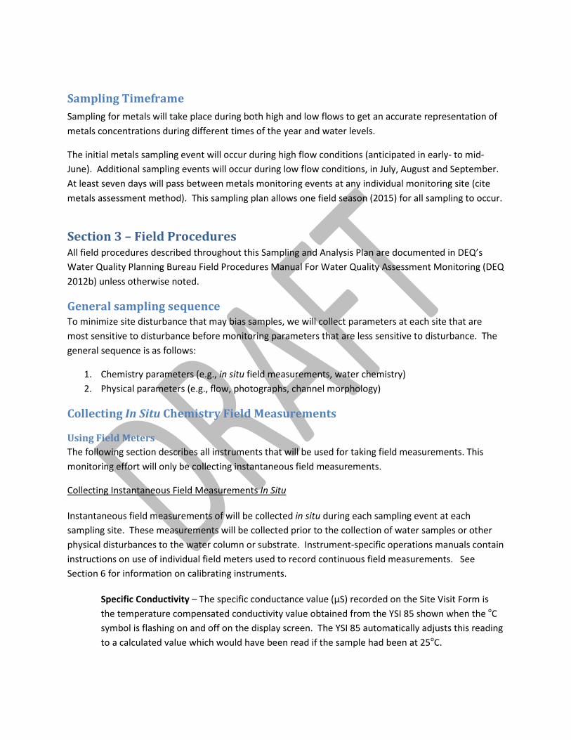
Sampling Timeframe Sampling for metals will take place during both high and low flows to get an accurate representation of metals concentrations during different times of the year and water levels.
The initial metals sampling event will occur during high flow conditions (anticipated in early- to mid-June). Additional sampling events will occur during low flow conditions, in July, August and September. At least seven days will pass between metals monitoring events at any individual monitoring site (cite metals assessment method). This sampling plan allows one field season (2015) for all sampling to occur.
Section 3 – Field Procedures All field procedures described throughout this Sampling and Analysis Plan are documented in DEQ’s Water Quality Planning Bureau Field Procedures Manual For Water Quality Assessment Monitoring (DEQ 2012b) unless otherwise noted.
General sampling sequence To minimize site disturbance that may bias samples, we will collect parameters at each site that are most sensitive to disturbance before monitoring parameters that are less sensitive to disturbance. The general sequence is as follows:
1. Chemistry parameters (e.g., in situ field measurements, water chemistry) 2. Physical parameters (e.g., flow, photographs, channel morphology)
Collecting In Situ Chemistry Field Measurements
Using Field Meters The following section describes all instruments that will be used for taking field measurements. This monitoring effort will only be collecting instantaneous field measurements.
Collecting Instantaneous Field Measurements In Situ
Instantaneous field measurements of will be collected in situ during each sampling event at each sampling site. These measurements will be collected prior to the collection of water samples or other physical disturbances to the water column or substrate. Instrument-specific operations manuals contain instructions on use of individual field meters used to record continuous field measurements. See Section 6 for information on calibrating instruments.
Specific Conductivity – The specific conductance value (µS) recorded on the Site Visit Form is the temperature compensated conductivity value obtained from the YSI 85 shown when the oC symbol is flashing on and off on the display screen. The YSI 85 automatically adjusts this reading to a calculated value which would have been read if the sample had been at 25oC.
Dissolved Oxygen – In situ calibration will be performed before use at each site to allow the YSI 85 meter to account for the approximate altitude of the region in which the monitoring site is located. After, a measurement of oxygen (mg/L) will be recorded from the YSI 85 onto the Site Visit Form.
Water Temperature – A measurement of water temperature (oC) will be recorded from the YSI 85 meter onto the Site Visit Form.
pH –A measurement of pH will be recorded from the hand-held pH meter onto the Site Visit Form.
Air temperature – A hand-held thermometer will be placed in a shaded area with sufficient air circulation and allowed to stabilize for approximately 15 minutes. A measurement of air temperature (oC) will be recorded from the hand-held thermometer onto the Site Visit Form.
Collecting Chemistry Samples in Streams and Rivers After in situ measurements are complete, chemistry samples will be collected at each site. All water samples will be collected in new acid-washed high-density polyethylene (HDPE) bottles unless otherwise noted. Detailed methodology for each type of sample collection described below can be found in DEQ (2012b). Table 3.1 summarizes sample containers, holding times and preservation.
Collecting water samples for total recoverable fractions (unfiltered, acid-preserved) Bottles and lids will be triple-rinsed with ambient stream water prior to grabbing the final sample. Total recoverable metals will be collected in a single 250ml HDPE bottle, will be preserved with nitric acid and kept on ice (not frozen) until analyzed. Hardness will be calculated from the total recoverable metals bottle.
Collecting water samples for total recoverable fractions (unfiltered, frozen) Bottles and lids will be triple-rinsed with ambient stream water prior to grabbing the final sample. TN will be collected in a single 250ml HDPE bottle and kept below 6° C and analyzed within seven days or frozen (on dry ice) until analyzed within 28 days. TP and NO2+3 will be collected in a single 250ml HDPE bottle and and kept below 6° C and analyzed within seven days or frozen (on dry ice) until analyzed within 28 days. No sulfuric acid or any other preservative will be added to the samples prior to freezing them.
Water samples for dissolved 56luminum (filtered) Samples will be filtered through a 0.45 µm filter into 250 ml HDPE bottles using a 60 cm3 syringe connected to a disposal 0.45 µm filter capsule. A small amount of the sample will be wasted through the filter first, and the sample bottle and lid will be triple-rinsed with filtrate before the final filtered sample is collected. For dissolved aluminum, 50 ml of the filtrate will be placed in a 250 ml HDPE bottle, preserved with nitric acid and kept on ice (not frozen) until analyzed (Table 3.1).
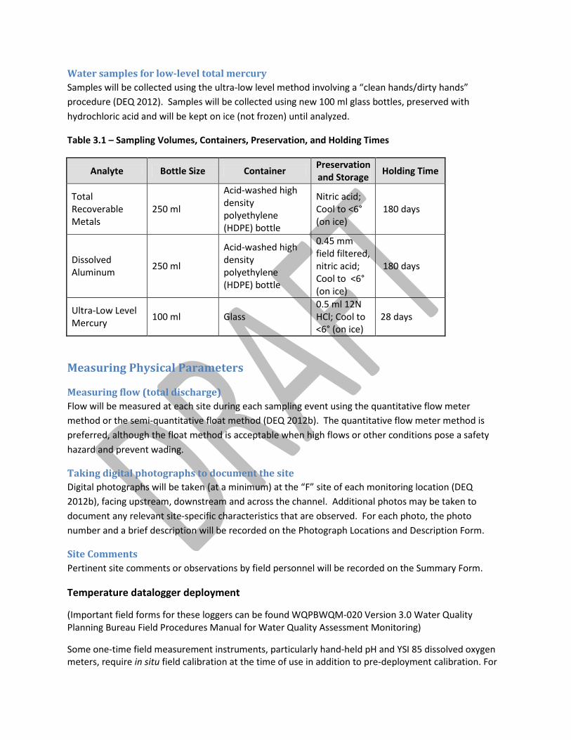
Water samples for low-level total mercury Samples will be collected using the ultra-low level method involving a “clean hands/dirty hands” procedure (DEQ 2012). Samples will be collected using new 100 ml glass bottles, preserved with hydrochloric acid and will be kept on ice (not frozen) until analyzed.
Table 3.1 – Sampling Volumes, Containers, Preservation, and Holding Times
Analyte Bottle Size Container Preservation and Storage Holding Time
Total Recoverable Metals
250 ml
Acid-washed high density polyethylene (HDPE) bottle
Nitric acid; Cool to <6° (on ice)
180 days
Dissolved Aluminum 250 ml
Acid-washed high density polyethylene (HDPE) bottle
0.45 mm field filtered, nitric acid; Cool to <6° (on ice)
180 days
Ultra-Low Level Mercury 100 ml Glass
0.5 ml 12N HCl; Cool to <6° (on ice)
28 days
Measuring Physical Parameters
Measuring flow (total discharge) Flow will be measured at each site during each sampling event using the quantitative flow meter method or the semi-quantitative float method (DEQ 2012b). The quantitative flow meter method is preferred, although the float method is acceptable when high flows or other conditions pose a safety hazard and prevent wading.
Taking digital photographs to document the site Digital photographs will be taken (at a minimum) at the “F” site of each monitoring location (DEQ 2012b), facing upstream, downstream and across the channel. Additional photos may be taken to document any relevant site-specific characteristics that are observed. For each photo, the photo number and a brief description will be recorded on the Photograph Locations and Description Form.
Site Comments Pertinent site comments or observations by field personnel will be recorded on the Summary Form.
Temperature datalogger deployment
(Important field forms for these loggers can be found WQPBWQM-020 Version 3.0 Water Quality Planning Bureau Field Procedures Manual for Water Quality Assessment Monitoring)
Some one-time field measurement instruments, particularly hand-held pH and YSI 85 dissolved oxygen meters, require in situ field calibration at the time of use in addition to pre-deployment calibration. For
all DO field calibrations, record in the instrument logbook the date, time, site location and elevation, and the initials of the analyst performing the calibrations. Refer to instrument-specific operations manuals for instructions on use and calibration. Dissolved oxygen, specific conductivity, and water temperature Immediately upon arrival at the “F” site, turn the YSI 85 (or similar model) instrument on, open the case and allow it to remain undisturbed for ≥15 minutes in a shaded location. Perform field calibration of dissolved oxygen, using the calibration values appendix in the operations manual to verify measurement accuracy. At the “F” site, submerge the probe in the water, shake vigorously to remove any air bubbles trapped near the probe, and position it facing upstream into the flow. Ensure that there are no obstructions in front of the probe (i.e., rocks, macrophytes, debris). If the water is not flowing, gently move the probe from side to side to circulate the water around the probe. Allow a few moments for measurements to stabilize and record dissolved oxygen (mg/L), specific conductivity (μS), and water temperature (oC). pH At the “F” site, submerge the probe in the water. Allow a few moments for instrument measurements to stabilize and record pH. While in the field at the end of each day of sampling, perform a two-point calibration check to verify performance of the meter. Air temperature Place the thermometer in a location with adequate shade and air circulation and allow it to stabilize for several moments. Record temperature (oC).
Section 4 – Sample Handling Procedures Field samples will be collected and preserved in accordance to Section 3. Monitoring crews will be responsible for proper labeling, sample custody documentation and storage in accordance to the specifications in the Field Procedures Manual and QAPP (cite appriopriate QAPP ).
Water chemistry samples will be delivered to Energy Labs in Helena.
Section 5 – Laboratory Analytical Methods Chemistry samples will be analyzed according to the methods listed in Table 5.1. In addition, table 5.1 lists the required reporting limits to effectively evaluate the data to meet the project objectives.
Table 5.1 – Analytical Methods and Required Reporting Values
Analyte Method Required Reporting Limit (ug/L)
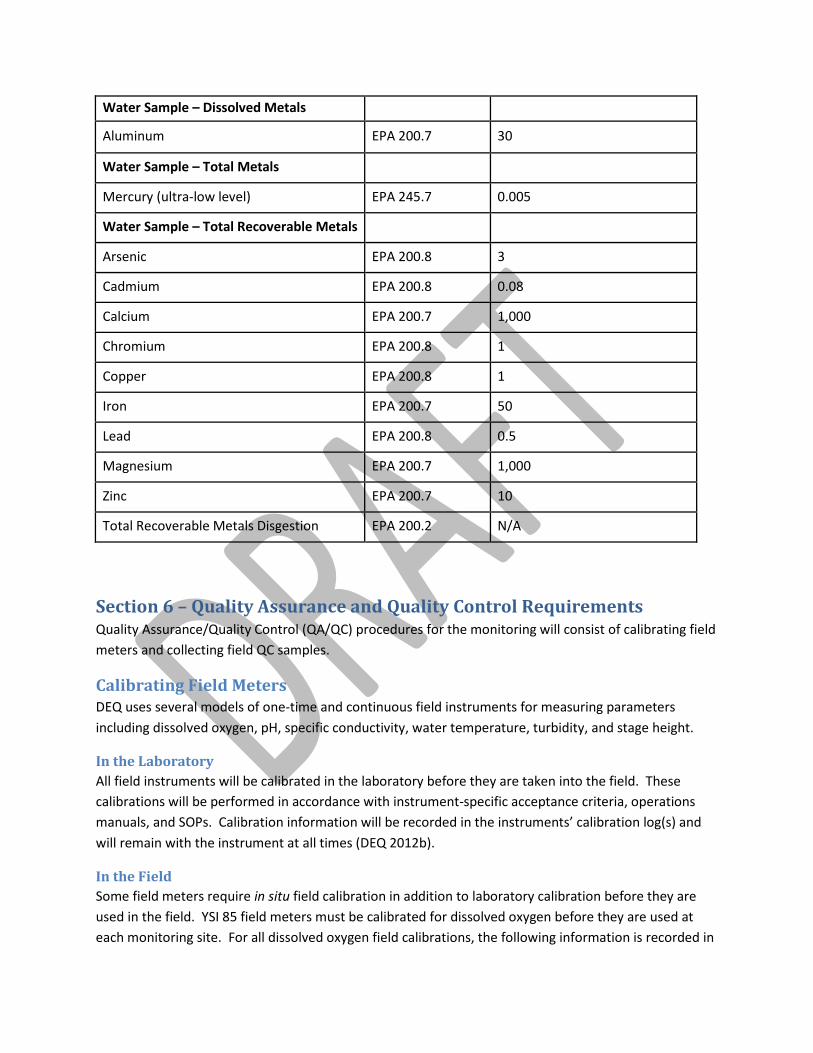
Water Sample – Dissolved Metals
Aluminum EPA 200.7 30
Water Sample – Total Metals
Mercury (ultra-low level) EPA 245.7 0.005
Water Sample – Total Recoverable Metals
Arsenic EPA 200.8 3
Cadmium EPA 200.8 0.08
Calcium EPA 200.7 1,000
Chromium EPA 200.8 1
Copper EPA 200.8 1
Iron EPA 200.7 50
Lead EPA 200.8 0.5
Magnesium EPA 200.7 1,000
Zinc EPA 200.7 10
Total Recoverable Metals Disgestion EPA 200.2 N/A
Section 6 – Quality Assurance and Quality Control Requirements Quality Assurance/Quality Control (QA/QC) procedures for the monitoring will consist of calibrating field meters and collecting field QC samples.
Calibrating Field Meters DEQ uses several models of one-time and continuous field instruments for measuring parameters including dissolved oxygen, pH, specific conductivity, water temperature, turbidity, and stage height.
In the Laboratory All field instruments will be calibrated in the laboratory before they are taken into the field. These calibrations will be performed in accordance with instrument-specific acceptance criteria, operations manuals, and SOPs. Calibration information will be recorded in the instruments’ calibration log(s) and will remain with the instrument at all times (DEQ 2012b).
In the Field Some field meters require in situ field calibration in addition to laboratory calibration before they are used in the field. YSI 85 field meters must be calibrated for dissolved oxygen before they are used at each monitoring site. For all dissolved oxygen field calibrations, the following information is recorded in
the instrument logbook: 1) date, 2) time, 3) site location, 4) elevation, and 5) the initials of the analyst performing the calibrations. Hand-held pH meters must be calibrated daily using a two-point calibration. Calibration instructions for each meter are located in the user manual kept in each instrument’s case.
Field Quality Control Samples
Duplicate Samples For each type of routine water chemistry parameter, duplicate samples will be collected for at least 10% of the total number collected throughout the sampling season. Sites where duplicate samples will be prepared will be randomly selected. When collecting duplicate samples, a sampling location will be chosen that allows for two samples to be taken side-by-side upstream from any previous disturbances. To collect duplicate samples, all procedures performed in collecting, labeling and preserving the routine sample will be followed so that two identical samples have been collected at the same site. Duplicate samples will be submitted to the analytical laboratory along with routine samples.
Field Blanks Field blanks are prepared in the field each time that routine water samples are to be delivered to the analytical laboratory. Field blanks are prepared in the field after sampling the last site of a multi-site sampling trip, or mid-trip if sample holding times require samples to be delivered to the lab part-way through a multi-site sampling trip. Field blanks will be prepared using distilled water provided by the analytical laboratory which field personnel will keep in clean, triple-rinsed HDPE bottles. One field blank will be prepared and submitted per routine sample type collected throughout the trip. Preparing field blanks will follow the same sample collection, labeling and preservation procedures as those used to collect routine samples except distilled water is used instead of stream or lake water.
Section 7 – Handling Sampling Records Site Visit Forms, field forms, and digital photos will be processed the monitoring team using QA/QC procedures described in the QAPP (site appropriate QAPP). Analytical laboratories will provide results to DEQ in the required EDD format. DEQ will perform the necessary data evaluations and will manage the data in accordance with the QAPP.
Section 8 – Schedule The Water Quality Monitoring team will sample 7 streams and at least 20 discharging adits at 14 mine sites within the Little Blackfoot Watershed at the proposed sites (Appendix A). The high flow sampling events for metals will occur in June 2015, whereas the low flow sampling events for metals will occur in July and August 2015. Data collection should be completed no later than September 30, 2015.
Section 9 – Project Team and Responsibilities Currently, specific individuals and organizations responsible for completing the water quality monitoring have not been identified. However, a Water Quality Monitoring team will be created to complete the tasks layed out in this document. Further involvement in these monitoring efforts will come from DEQ AML, DEQ Non-Point Source Program, Trout Unlimited, and Helena National Forest.
Section 10 - References
APHA (American Public Health Association). 2005. Standard methods for the examination of water and wastewater. 21st ed. American Public Health Association, American Water Works Association, and Water Pollution Control Federation. Washington, DC.
Cole, G.A., 1983. Textbook of Limnology, 3rd Edition. Waveland Press.
DEQ (Montana Department of Environmental Quality). 2005. Temperature Data Logger Protocols Standard Operating Procedure. Helena, MT: Montana Department of Environmental Quality. Report WQPBWQM-006.
DEQ (Montana Department of Environmental Quality). 2006. Sample Collection, Handling and Analysis of Escherichia Coli. Water Quality Planning Bureau. WQPBWQM-014. Available at: http://deq.mt.gov/wqinfo/qaprogram/sops.mcpx.
DEQ (Montana Department of Environmental Quality). 2011a. Water Quality Assessment Method. Helena, MT: Montana Department of Environmental Quality.
DEQ (Montana Department of Environmental Quality). 2011b. Sample Collection and Laboratory Analysis of Chlorophyll a Standard Operating Procedure. Prepared by Suplee, M., February 2011. Document No. WQPBWQM-011, Revision 5.
DEQ (Montana Department of Environmental Quality). 2012a. Administrative Rules of Montana.
DEQ (Montana Department of Environmental Quality). 2012b. Water Quality Planning Bureau Field Procedures Manual For Water Quality Assessment Monitoring Version 3.0. Helena, MT: Montana Dept. of Environmental Quality.
DEQ (Montana Department of Environmental Quality). 2012c. Sample Collection, Sorting, Taxonomic Identification, and Analysis of Benthic Macroinvertebrate Communities Standard Operating Procedure. Document No. WQPBWQM-009, Revision 3.
DEQ (Montana Department of Environmental Quality). 2012d. Field Methodology For The Assessment of TMDL Sediment and Habitat Impairments. Helena, MT: Montana Dept. of Environmental Quality. Document No. WQPBWMSSOP-04.
IDEXX, Inc. 2011. How to Use Colilert. [Available at http://www.idexx.com/water/colilert/index.jsp]. Accessed on May 17, 2011.
Kusnierz, Paul., Andy Welch and Darrin Kron. 2013. The Montana Department of Environmental Quality Sediment Assessment Method: Considerations, Physical and Biological Parameters, and Decision Making. Helena, MT: Montana Dept. of Environmental Quality.
Nevers, M.B., and R. L. Whitman. Accessed 2012. Lake Monitoring Field Manual. US Geological Survey, Lake Michigan Ecological Research Station, Porter, Indiana. Accessed 6/4/2012. Available at http://www.glsc.usgs.gov/_files/research/InlandLakesManual.pdf.
Peck, D.V., A.T. Herlihy, B.H. Hill, R.M. Hughes, P.R. Kaufmann, D.J. Klemm, J.M. Lazorchak, F.H. McCormick, S.A. Peterson, P.L. Ringold, T. Magee, and M.R. Cappaert. 2006. Environmental Monitoring and Assessment Program – Surface Waters Western Pilot Study: Field Operations Manual for Wadeable Streams. EPA 620/R-06/003. U.S. Environmental Protection Agency, Office of Research and Development, Washington, D.C.
Suplee, M.W., and R. Sada de Suplee. 2011. Assessment Methodology for Determining Wadeable Stream Impairment Due to Excess Nitrogen and Phosphorus Levels. Helena, MT: Montana Dept. of Environmental Quality.
Suplee, Michael W., Vicki Watson, Walter K. Dodds, and Chris Shirley, 2012. Response of Algal Biomass to Large-Scale Nutrient Controls in the Clark Fork River, Montana, United States. Journal of the American Water Resources Association (JAWRA): 1-14. DOI: 10.1111/j.1752-1688.2012.00666.x.
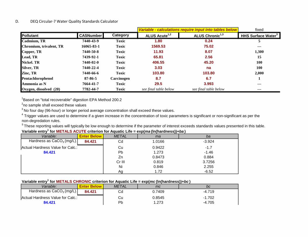
fixedPollutant CASNumber Category ALUS Acute1,2 ALUS Chronic1,3 HHS Surface Water3
Cadmium, TR 7440-43-9 Toxic 1.80 0.24 5Chromium, trivalent, TR 16065-83-1 Toxic 1569.53 75.02 ---Copper, TR 7440-50-8 Toxic 11.93 8.07 1,300Lead, TR 7439-92-1 Toxic 65.81 2.56 15Nickel. TR 7440-02-0 Toxic 406.55 45.20 100Silver, TR 7440-22-4 Toxic 3.03 na 100Zinc, TR 7440-66-6 Toxic 103.80 103.80 2,000Pentachlorophenol 87-86-5 Carcinogen 8.7 6.7 1Ammonia as N 7664-41-7 Toxic 29.5 3.993 ---Oxygen, dissolved (20) 7782-44-7 Toxic see final table below see final table below ---
1Based on "total recoverable" digestion EPA Method 200.22no sample shall exceed these values3 No four day (96-hour) or longer period average concentration shall exceed these values.4 Trigger values are used to determine if a given increase in the concentration of toxic parameters is significant or non-significant as per the non-degredation rules.5 These reporting values will typically be low enough to determine if the parameter of interest exceeds standards values presented in this table. Variable entry1 for METALS ACUTE criterion for Aquatic Life = exp(ma (ln(hardness))+ba )
Variable: Enter Below METAL ma baHardness as CaCO3 (mg/L): 84.421 Cd 1.0166 -3.924
Actual Hardness Value for Calc.: Cu 0.9422 -1.784.421 Pb 1.273 -1.46
Zn 0.8473 0.884Cr III 0.819 3.7256
Ni 0.846 2.255Ag 1.72 -6.52
Variable entry1 for METALS CHRONIC criterion for Aquatic Life = exp(mc (ln(hardness))+bc )Variable: Enter Below METAL mc bc
Hardness as CaCO3 (mg/L): 84.421 Cd 0.7409 -4.719Actual Hardness Value for Calc.: Cu 0.8545 -1.702
84.421 Pb 1.273 -4.705
Variable - calculations require input into tables below
D. DEQ Circular-7 Water Quality Standards Calculator
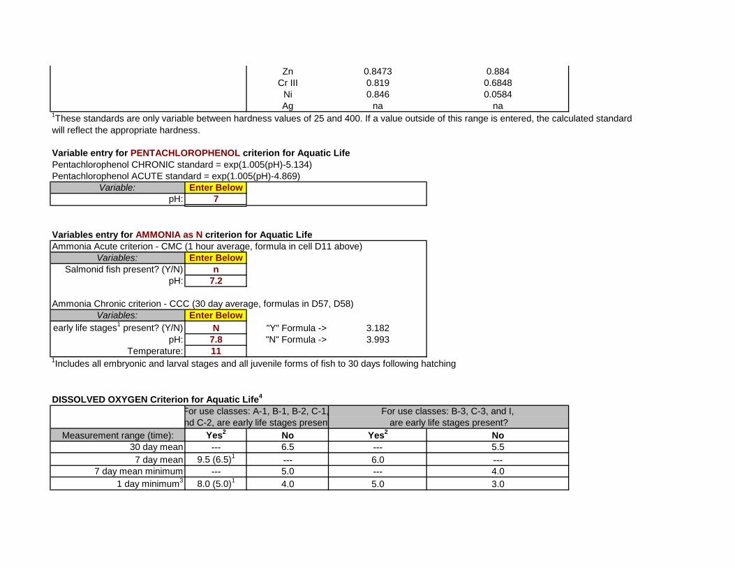
Zn 0.8473 0.884Cr III 0.819 0.6848
Ni 0.846 0.0584Ag na na
1These standards are only variable between hardness values of 25 and 400. If a value outside of this range is entered, the calculated standard will reflect the appropriate hardness.
Variable entry for PENTACHLOROPHENOL criterion for Aquatic LifePentachlorophenol CHRONIC standard = exp(1.005(pH)-5.134)Pentachlorophenol ACUTE standard = exp(1.005(pH)-4.869)
Variable: Enter BelowpH: 7
Variables entry for AMMONIA as N criterion for Aquatic LifeAmmonia Acute criterion - CMC (1 hour average, formula in cell D11 above)
Variables: Enter BelowSalmonid fish present? (Y/N) n
pH: 7.2
Ammonia Chronic criterion - CCC (30 day average, formulas in D57, D58) Variables: Enter Below
early life stages1 present? (Y/N) N "Y" Formula -> 3.182pH: 7.8 "N" Formula -> 3.993
Temperature: 111Includes all embryonic and larval stages and all juvenile forms of fish to 30 days following hatching
DISSOLVED OXYGEN Criterion for Aquatic Life4
Measurement range (time): Yes2 No Yes2 No30 day mean --- 6.5 --- 5.57 day mean 9.5 (6.5)1 --- 6.0 ---
7 day mean minimum --- 5.0 --- 4.01 day minimum3 8.0 (5.0)1 4.0 5.0 3.0
nd C-2, are early life stages present are early life stages present?For use classes: A-1, B-1, B-2, C-1, For use classes: B-3, C-3, and I,
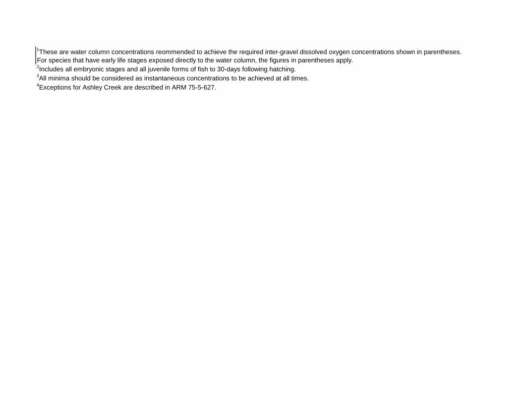
1These are water column concentrations reommended to achieve the required inter-gravel dissolved oxygen concentrations shown in parentheses.For species that have early life stages exposed directly to the water column, the figures in parentheses apply.2Includes all embryonic stages and all juvenile forms of fish to 30-days following hatching.3All minima should be considered as instantaneous concentrations to be achieved at all times.4Exceptions for Ashley Creek are described in ARM 75-5-627.
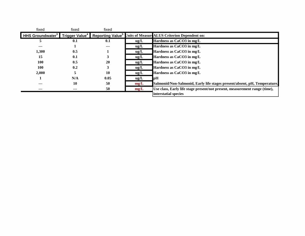
fixed fixed fixedHHS Groundwater3 Trigger Value4 Reporting Value5 Units of MeasureALUS Criterion Dependent on:
5 0.1 0.1 ug/L Hardness as CaCO3 in mg/L--- 1 --- ug/L Hardness as CaCO3 in mg/L
1,300 0.5 1 ug/L Hardness as CaCO3 in mg/L15 0.1 3 ug/L Hardness as CaCO3 in mg/L
100 0.5 20 ug/L Hardness as CaCO3 in mg/L100 0.2 3 ug/L Hardness as CaCO3 in mg/L
2,000 5 10 ug/L Hardness as CaCO3 in mg/L1 N/A 0.05 ug/L pH
--- 10 50 mg/L Salmonid/Non-Salmonid, Early life stages present/absent, pH, Temperature.--- --- 50 mg/L Use class, Early life stage present/not present, measurement range (time),
interstatial species
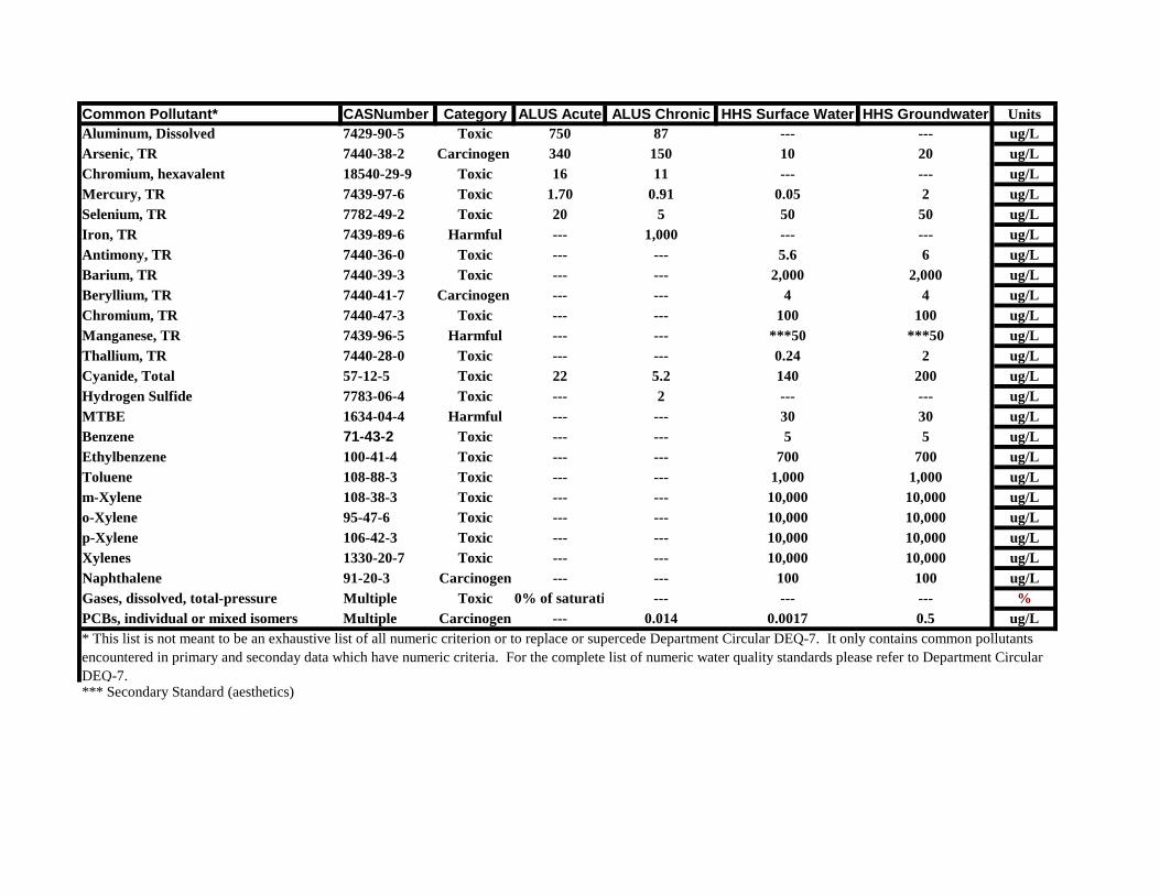
Common Pollutant* CASNumber Category ALUS Acute ALUS Chronic HHS Surface Water HHS Groundwater UnitsAluminum, Dissolved 7429-90-5 Toxic 750 87 --- --- ug/LArsenic, TR 7440-38-2 Carcinogen 340 150 10 20 ug/LChromium, hexavalent 18540-29-9 Toxic 16 11 --- --- ug/LMercury, TR 7439-97-6 Toxic 1.70 0.91 0.05 2 ug/LSelenium, TR 7782-49-2 Toxic 20 5 50 50 ug/LIron, TR 7439-89-6 Harmful --- 1,000 --- --- ug/LAntimony, TR 7440-36-0 Toxic --- --- 5.6 6 ug/LBarium, TR 7440-39-3 Toxic --- --- 2,000 2,000 ug/LBeryllium, TR 7440-41-7 Carcinogen --- --- 4 4 ug/LChromium, TR 7440-47-3 Toxic --- --- 100 100 ug/LManganese, TR 7439-96-5 Harmful --- --- ***50 ***50 ug/LThallium, TR 7440-28-0 Toxic --- --- 0.24 2 ug/LCyanide, Total 57-12-5 Toxic 22 5.2 140 200 ug/LHydrogen Sulfide 7783-06-4 Toxic --- 2 --- --- ug/LMTBE 1634-04-4 Harmful --- --- 30 30 ug/LBenzene 71-43-2 Toxic --- --- 5 5 ug/LEthylbenzene 100-41-4 Toxic --- --- 700 700 ug/LToluene 108-88-3 Toxic --- --- 1,000 1,000 ug/Lm-Xylene 108-38-3 Toxic --- --- 10,000 10,000 ug/Lo-Xylene 95-47-6 Toxic --- --- 10,000 10,000 ug/Lp-Xylene 106-42-3 Toxic --- --- 10,000 10,000 ug/LXylenes 1330-20-7 Toxic --- --- 10,000 10,000 ug/LNaphthalene 91-20-3 Carcinogen --- --- 100 100 ug/LGases, dissolved, total-pressure Multiple Toxic 0% of saturati --- --- --- %PCBs, individual or mixed isomers Multiple Carcinogen --- 0.014 0.0017 0.5 ug/L
*** Secondary Standard (aesthetics)
* This list is not meant to be an exhaustive list of all numeric criterion or to replace or supercede Department Circular DEQ-7. It only contains common pollutantsencountered in primary and seconday data which have numeric criteria. For the complete list of numeric water quality standards please refer to Department Circular DEQ-7.