millard county resource assessment
TRANSCRIPT

Millard County Resource Assessment
MARCH 2013
DELTA & MILLARD CONSERVATION DISTRICTS
Conserving Natural Resources For Our Future
Note: Sevier Lake is a dry lake bed, fed primarily by the Beaver and Sevier rivers; additional inflow comes from the lake’s watershed, which is part of the Escalante-Sevier hydrologic subregion. The lake has been mostly dry throughout recorded
history and is a source of wind-blown dust storms that frequently sweep the Wasatch Front.

Acknowledgments Delta & Millard Conservation District (Millard County) with the: Utah Association of Conservation Districts Utah Department of Agriculture and Food Natural Resources Conservation Service In partnership with the: Utah Conservation Commission Utah Conservation Districts Zone 4 Utah Association of Conservation Districts Utah Department of Agriculture and Food Utah Department of Environmental Quality Utah Department of Natural Resources Utah School and Institutional Trust Lands Administration Utah State University Extension Utah Weed Supervisor Association
Utah Partners for Conservation & Development (UPCD) State Agencies and Organizations: Utah Association of Conservation Districts Utah Department of Agriculture and Food Utah Department of Community and Culture Utah Department of Environmental Quality Utah Department of Natural Resources Utah Resource Conservation & Development Councils Utah School and Institutional Trust Lands Administration Utah State University Cooperative Extension Service Utah Energy Office
Federal Agencies: U.S. Department of Interior Bureau of Land Management U.S. Fish and Wildlife Service Bureau of Reclamation U.S. Department of Agriculture U.S. Forest Service Natural Resources Conservation Service Agriculture Research Service Farm Service Agency
Other State Historical Preservation Office Governor’s Office of Planning and Budget Millard County Commission
Credits David Pace—Resource Coordinator, Zone 4 Tracy Balch—Assistant Coordinator, Zone 4 Anne Johnson—GIS Specialist/Maps/Illustrations, UDAF Patti Sutton—GIS Specialist, NRCS Cherie Quincieu—Document Design, UACD Kandice Johnson—Document Design, UACD
Contributors/Specialists Many thanks to all those that have made comments and suggestions for this project.

Table of Contents
Millard County Resource Assessment i
• Executive Summary ii
Resource Assessments ∙ Natural Resource Priorities and Concerns ∙ General Resource Observations
• Introduction 1
Conservation District Movement ∙ Conservation Progress ∙ Resource Assessment Outreach
• County Overview 2
Background ∙ Land Ownership
• Natural Resource Priorities and Concerns 4
Water Quality, Quantity & Irrigation Efficiency ∙ Invasive Plants & Weeds ∙ Loss of Open Space for
Agricultural Lands ∙ Marketing for Agricultural Products ∙ Soil Erosion & Soil Condition
• General Resource Observations 10
Soil ∙ Water ∙ Air & Climate ∙ Plants ∙ Animals ∙ Humans: Social & Economic Considerations
• References & Credits 20
References

Why a Resource Assessment?
The Delta and Millard Conservation Districts have developed this resource assessment with the goal that conservation ef-forts in the county address the most important local resource needs. This report identifies natural and social resources pre-sent in Millard County and details specific areas of concern. Local, state, and regional entities can use this assessment to develop county resource management plans or to target con-servation assistance needs.
We recognize that all who could have provided information may not have had the opportunity. This document is dynamic and will be updated as additional information is available.
Your comments are requested:
Delta & Millard Conservation Districts 340 North 600 East
Richfield, Utah 84701 435-896-8566
Natural Resource Priorities and Concerns
The Delta and Millard Conservation Districts have identified five nat-ural resource priorities and concerns. These priorities receive special emphasis because of their immediate significance to Millard County.
1. Improve water quality, quantity, and irrigation efficiency
2. Control and/or eradicate invasive plants and weeds
3. Adequate marketing for agricultural products
4. Prevent loss of open space for agricultural lands
5. Reduce the erosion of soil by either wind or water
General Resource Observations
Natural and social resources are categorized as soil, water, air, plants, animals, and humans (SWAPA + H). This assessment describes the general condition of these resources and highlights additional con-cerns in each category. As opportunities become available to address these issues, and as circumstances change, their emphasis should be elevated accordingly.
Millard County Resource Assessment: Executive Summary
ii
Delta CD Supervisors (left to right): Calleen Archibald,
(clerk), Klint Atkinson, Kevin Knight, Brandon Anderson,
Howard Bassett, and Rick Smith.
Millard CD Supervisors (clockwise, left to right): Doyal
Mitchell, Randy Coats, Leo Stott, Kelby Swallow, Lynette
Bond (clerk), and Don Probert.

Conservation districts provide local leadership and education to connect private property owners with state and federal assistance to improve, protect, and sustain
Utah’s soil, water, and
related natural resources.
The Conservation District Movement
The Dust Bowl of the 1930s brought the beginning of na-tional programs for conserving soil and water resources in the United States. On April 27, 1935, Congress declared soil erosion “a national menace” and established the Soil Ero-sion Service. Since then, the agency has changed to the Nat-ural Resources Conservation Service (NRCS). In May of 1936, farmers were allowed to set up their own districts to direct soil conservation practices. Today, Utah has 38 con-servation districts.
Conservation Progress
Since the organization of the Delta Conservation District in 1949 and the Millard Conservation District in 1948, great strides have been made toward increasing and sustaining natural resources in Millard County. Each district provides assistance to farmers in soil and water conservation and im-proved land use.
Public Outreach
In 2008, the Delta and Millard Conservation Districts con-ducted a survey to find out how others viewed the county’s natural resources and what conservation issues were most pressing. Respondents indicated that the issues of highest concern were: 1) improved irrigation water management, 2) control invasive species and noxious weeds, 3) agricultural sustainability, 4) maintained open space for agriculture, and 5) reduced soil erosion by wind and water.
Introduction
Millard County Resource Assessment 1
A great “roller” moves across the land
during the Dust Bowl.
Oak City fire. Photo by David Pace.

Background and Landownership
Millard County is the third largest county in Utah. It has an area of 6,640 square miles, or 4,354,880 acres. Millard County is bordered on the east by the Pahvant Range. West to the Nevada border lie the broad valleys and desert mountain ranges typical of the Great Basin. The Sevier River, which begins in mountains east of Cedar City, drains into the sometimes dry Sevier Lake in central Millard.
The Pahvant Mountains and the Pahvant Valley are named for the Native American tribe that occupied the area when the Mormons arrived. Before settlement, a few Mormon parties had traveled through Millard County and found that the area seemed like a good place to settle, with good grass and water and friendly Utes living there. So, at the direction of Brigham Young, in October 1851 two groups left Salt Lake City for east Millard County. Some 30 families, led by Anson Call, were to make the first permanent white settlement. The county was named after United States President, Millard Fillmore.
The Delta Conservation District is located in the north-central section of Millard County. The district includes the irrigated lands around Delta and the rangelands adjacent to it. There are approximately 920,000 acres of land in the Delta CD.
The Millard Conservation District includes most of Millard County. The district shares a border with Juab County to the north, Sanpete and Sevier Counties to the east, and Beaver County on the south. The western boundary is the Utah-Nevada state line.
2
Millard County Overview
Land Ownership in Millard County

Millard County Resource Assessment 3
M I L L A R D C O U N T Y Left to right, clockwise: Delta Farm Field Day, photo by David Pace; Milford Flat Fire in 2007, photo by Tracy Balch; Solar panel drinker project,
photo by David Pace; Ditch fed linear project, photo by David Pace.

General Resource Observations Natural Resource Priorities and Concerns
WA T E R QUA N T I T Y , QU A L I T Y & IR R I G A T I O N EF F I C I E N C Y
4
Challenges
The Millard CD depends on spring snow melt run-off and wells for its agricultural and municipal water. The Delta CD is the last user of Sevier Riv-er water, so having enough water is always a concern.
Resource Management, Needed Actions & Projects
Concrete ditch lining and land leveling have proven to be the best management practices to improve irrigation efficiency in the Delta CD. The ma-jor distribution canals need to be lined to further increase irrigation water efficiency. Field drainage is also a critical component of irrigation system design, in order to remove soil salts and improve soil and plant health. The Millard CD has few live streams, natural lakes, or reservoirs. Therefore, any new projects that will increase, conserve, or protect water are the highest priority of the Districts. Federal, state, and local programs to assist in these projects are crucial in meeting these needs.
Outreach
Continue to enlist the assistance of the Utah State University Extension Service, federal agencies, conservation districts, and others in conducting meetings with farmers and irrigation companies to gain a better understanding of irrigation water management principles and their use.
Impaired Waters in Millard County

Natural Resource Priorities and Concerns
6
The control of invasive species is a crucial part of improving the range resource.
Challenges
Cheat grass, Russian olive, saltcedar, white top, thistle, and knapweeds are the highest priority invasive species throughout the county.
The negative impact of tamarisk on farmland and habitat is being ameliorated by the use of the tamarisk beetle, but efforts need to continue.
Although not a weed, the alfalfa stem nematode is having a serious negative impact on hay production. Effective control of nematode needs to be developed and implemented.
Resource Management, Needed Actions & Projects
Any projects to re-seed rangeland, develop watering facilities, and increase desirable forage for grazing by livestock and wildlife are high priorities for the Delta and Millard CDs.
Controlling undesirable and noxious plants is important on cropland as well as rangeland. Invasive plants such as cheat grass, sagebrush, mustard, and knap-weeds have few, if any, natural controllers. Their spread has degraded many thousands of acres of wildlife habitat and grazing land.
Outreach
Cooperate and advocate the continued efforts of the Millard County Weed Board, County Commissioners, and Weed Spray Supervisor in controlling invasive species and noxious weeds.
Cooperate with the local Cooperative Weed Management Area (CWMA) and be an advocate for the area.
IN V A S I V E PLA N T S A N D WE E D S
Millard County Resource Assessment 5
Drought affected grazing land in the summer of 2012. Photo by David Pace.

General Resource Observations Natural Resource Priorities and Concerns
LO S S O F OP E N SP A C E F O R AG R I C UL T U R A L LAN D S The majority of the federally owned ground in Millard County is under the jurisdiction of the U.S. Forest Ser-vice (USFS) and the Bureau of Land Management (BLM). The state owned ground is primarily under the jurisdiction of the Utah School and Institutional Trust Land Administration (SITLA). The private ground is primarily farmland and grazing areas. The grazing of do-mestic livestock is an important part of Millard County’s agriculture. Grazing requires a lot of open space.
Challenges
Federal land management agencies that desig-nate limited access, wilderness, wilderness study, or wild lands areas essentially close open space for agricultural uses.
Resource Management, Needed Actions & Projects
Close correlation between the Millard County Commission and the Delta and Millard Conser-vation Districts.
Millard County encourages the Utah Depart-ment of Agriculture and Food and the Utah As-sociation of Conservation Districts to increase their assistance in keeping farmers informed about the Agricultural Protection Area Act (APA) and other programs that preserve and maintain open space.
Outreach
Invite County Commissioners, Forest Service, and BLM personnel to District meetings.
Land Classification in Millard County

Natural Resource Priorities and Concerns
Millard County Resource Assessment 7 8
Challenges
Distance to auctions for livestock.
Distance to viable market for alfalfa.
Diversity of markets.
Resource Management, Needed Actions & Projects
The Delta and Millard CDs encourages the Utah Department of Agriculture and Food and Utah State University Extension to continue to help market agricultural products.
Increase the use of video auctions for livestock.
Promote contacts with reputable hay brokers.
MA R KE T I N G F O R AG R ICU L T U R A L PR O D U CT S
Livestock auction in Utah. Photo from deseretnews.com.

General Resource Observations Natural Resource Priorities and Concerns
SO I L ER O S I O N & S O I L C O N D I T I O N Controlling erosion not only sustains the long-term productivity of the land but also affects the amount of soil, pesticides, fertilizer, and other sub-stances that move into the nation’s waters.
Challenges
Flash floods.
Erosion of main irrigation water conveyance canals and ditches.
Increased erosion on rangeland infested with monocultures of pinyon-juniper, sagebrush, and other invasive vegetation.
Seasonal abandonment of cropland.
Increased risk due to catastrophic fires.
Soil health and drainage.
Resource Management, Needed Actions & Projects
The implementation of Best Management Practices (BMPs) dealing with irrigation and re-vegetation of rangeland, using ARDL, GIP, EQIP, WHIP, etc., is needed to protect soils from erosion.
Outreach
Continue close working relationship with the Natural Resource Conservation Service and local irrigation companies.

Natural Resource Priorities and Concerns
Millard County Resource Assessment 9
Soil Classification in Millard County

General Resource Observations General Resource Observations
SO I L
The soils in Millard County are a result of the erosion of mixed sedimentary and igneous rocks from the adjacent mountains. In the eastern part of the county, the soils are generally very deep and well drained. The bench areas east of Fillmore are generally very stony and are not suitable for agri-culture. The soils in the valley bottoms have fewer rock fragments and are used for crop production and pasture. Many of the soils in the central part of the county, particularly around the Delta area, are somewhat poorly to poorly drained and contain large amounts of salt. The soils that are within the Delta CD area range in texture from fine to sandy. The soils in the western part of the county, near Garrison, are generally very deep and well drained. Information on the soils in Millard County can be obtained from the Web Soil Survey (WSS) located at: http://websoilsurvey.nrcs.usda.gov/. The soil survey provides data and information produced by the National Cooperative Soil Survey, a nationwide partnership of federal, regional, state, and local agencies and private entities and institutions. The WSS allows a user to: 1) define an area, 2) view the survey boundaries and soil types overlaid on a photo, 3) explore various interpretations, and 4) print maps and de-scriptive information.
The soil survey delineates and describes large areas of similar soils. Common uses are evaluating soil suitability for dwellings with basements, landscaping, roads, and septic systems and measuring for vegetative productivity and chemical and physical properties. Using this information, agriculture producers, agencies, counties, and municipalities know the various soil suitabilities and are alerted to soil limitations. This basic resource information is critical when making land-use and management decisions.
When limitations are identified, on-site investigations should be conducted by a soil scientist or soil engineer.
10
S O I L • W A T E R • A IR & C L I M A T E • PL A N T S • A N IM A L S • H U M A N S The NRCS conducts resource inventories to help resource managers make land use decisions. These inventories evaluate the soil, wa-ter, air, plants, and animals and are discussed below. The Delta and Millard Conservation Districts used these inventories to determine its priority concerns for this assessment and in its long range planning process.

Millard County Resource Assessment 11
WA T E R
The water for the Delta CD area is supplied from the Sevier River and numerous wells. Culinary water is from wells only. The water for the rest of Millard County is supplied from mountain streams, rivers and creeks, ground water springs, and pump wells.
Water Quality
The Total Maximum Daily Load (TMDL) water pollution determination process has identified sediment and phosphorus as the primary sources of water contaminants coming from irrigated lands, rangelands, and stream bank. Best Management Practices used to correct the problem are improved irrigation efficiencies and improved range health.
Water Quantity
The Sevier River Basin is reported to be water short on a long term basis. The average annual yield of the river, measured at Leamington, is 261,435 acre feet. Land area producing crops shrinks and swells somewhat from year to year depending on the water supply in the system. The river is listed on the 303d list for water quality im-paired streams based on total dissolved solids. Deep wells are utilized to increase flow for irrigation and to dilute salinity of the stream on an as needed basis. Effective water conserving practices include graded border or level basin irrigation systems and irrigation canal lining.
The water supply for other agricultural areas in the county comes from mountain streams and ground water resources. Steam yield varies widely, for example the aver-age annual yield for Chalk Creek is 21,970 acre feet, for Meadow Creek is 4,636 acre feet, for Corn Creek 1,1803 acre feet, and for Oak Creek is 9,099 acre feet. There are no storage reservoirs built for any of these streams, with the exception of Ivie Creek, which supplies lands surrounding the community of Scipio.
The ground water resources in Pahvant valley are reportedly declining due to less than normal precipitation, extensive pumping, and the elimination of recharge once supplied by the Central Utah Canal. The water quality is generally good, with the exception of the area west of Kanosh. Most irrigation systems using ground water are sprinkler systems. Most communities in Millard County use deep wells or springs for culinary water supplies. The Intermountain Power Plant uses a significant amount of water from the Sevier River and leases water where excess is available.
Water Sources in Millard County

General Resource Observations General Resource Observations
A I R & CL IM A T E
12
General Resource Observations
Air Quality
Air quality in Millard County is not a daily concern, although there are conditions that can be very serious. The three biggest potential negative im-pacts come from blowing dust, smoke and fly-ash from wildfires, and possible emissions from the coal-fired Intermountain Power Plant. Farmers use cultivation techniques to reduce wind blown dust, and some windbreaks have been planted. The power plant uses technology to maintain com-pliance with EQPA and the Utah Department of Environmental Quality air quality standards. The rangelands in Millard County are heavily infested with cheat grass and other invasive weeds and shrubs. This situation provides a fuel load for wildfires that can burn thousands of acres of land and produce huge quantities of smoke and ash that reduce air quality and visibility.
Climate
There are wide local variations in climate in Millard County. Annual temperatures are moderate, as is the growing season. In Millard County there are between 145 to 160 frost-free days.
Precipitation in the District varies directly with topography. The average annual precipitation ranges from seven inches in the west desert to fifteen inches on the western slope of the Pahvant range. Most precipitation falls from November to April; very little rain falls during the growing season.
Annual Precipitation in Millard County

Millard County Resource Assessment 13
NRCS Snow Survey
The NRCS Snow Survey Program provides mountain snow pack data and stream flow forecasts for the western United States. Common applications of snow survey products include water supply management, flood control, climate modeling, recreation, and conservation planning. NRCS operates two SNOTEL (SNOwpack TE-Lemetry) sites within Millard County: the Oak Creek site and the Pine Creek site.
Pine Creek SNOTEL site. Photo by NRCS.

General Resource Observations General Resource Observations
14
Crops and Pasture
The major agricultural plant in the county is alfalfa. In fact, Millard County is the highest producer of alfalfa hay in the state of Utah. Its production is focused on high-quality dairy hay, hay pellets for animal and human consumption, and seed. The alfalfa stem nematode infestation is having a large impact on the hay industry. Other major crops include corn for silage and grain, barley, triticale, and oats. These is some experimentation with oil producing crops for the production of bio-diesel.
Rangeland
Rangeland plants are used for grazing by wildlife and livestock. Domestic livestock grazing is closely regulated by the Bureau of Land Management, the United States Forest Service, and the Utah Division of Forestry, Fire & State Lands. Some private land that is not conducive to cropping is also grazed.
PL A N T S
Land Cover Distribution in Millard County

Millard County Resource Assessment 15
Forest and Woodland
The Fishlake National Forest in central Utah features majestic stands of aspen encircling open mountain meadows that are lush with a diverse community of forbs and grasses. Hunting, fishing, and ATV use are among the most popular forms of recreation enjoyed by forest visitors. As a “working forest”, the Fishlake National Forest is managed for livestock grazing and timber management.
There are five forest service campgrounds in the county:
Maple Grove, south of Scipio just off Highway 6.
Oak Creek Canyon, east of Oak City.
Maple Hollow, east of Holden.
Adelaide, east of Kanosh.
Chalk Creek, east of Fillmore, has picnic areas, some of which are suitable for camping.
The following weeds are officially designated and published as noxious for the State of Utah, as per the authority vested in the Commissioner of Agriculture and Food under Section
4-17-3, Utah Noxious Weed Act.
Bermuda grass (Cynodon dactylon)
Black henbane (Hyoscyamus niger)
Broad-leaved peppergrass (Lepidium latifolium)
Canada thistle (Cirsium arvense)
Dalmation toadflax (Linaria dalmatica)
Diffuse knapweed (Centaurea diffusa)
Dyers woad (Isatis tinctoria)
Field bindweed (wild morning-glory) (Convolvulus arvensis)
Hoary cress (Cardaria drabe)
Houndstounge (Cynoglossum officianale)
Leafy spurge (Euphorbia esula)
Medusahead (Taeniatherum caput-medusae)
Musk thistle (Carduus mutans)
Ox-eye daisy (Chrysanthemum leucanthemum)
Perennial sorghum (Sorghum halepense & Sorghum almum)
Poison hemlock (Conium maculatum)
Purple loosestrife (Lythrum salicaria)
Quackgrass (Agropyron repens)
Russian knapweed (Centaurea repens)
Saltcedar (Tamarix ramosissima)
Scotch thistle (Onopordum acanthium)
Spotted knapweed (Centaurea maculosa)
Squarrose knapweed (Centaurea squarrosa)
St. Johnswort (Hypericum perforatum)
Sulfur cinquefoil (Potentilla recta)
Yellow starthistle (Centaurea solstitialis)
Additional noxious
weeds declared by
Millard County:
Buffalobur
Buffalobur. Photo from USDA.gov.

General Resource Observations General Resource Observations
16
American White Pelican
Bald Eagle
Big Free-Tailed Bat
Black Swift
Bonneville Cutthroat Trout
Brown Bear
Burrowing Owl
Canada Lynx
Greater Sage-Grouse*
Kit Fox
Northern Goshawk
Short-Eared Owl
Three-Toed Woodpecker
Utah Prairie Dog
A t - R i s k S p e c i e s
Included on Utah’s State Listed Conservation Species Agreement with the U.S. Fish and Wildlife Service
and Species of Concern in Millard County:
This list was compiled using known species observations from the Utah Natural Heritage Program within the last 20 years. A comprehensive species list, which is updated quarterly, can be obtained from the Utah Division of Wildlife Resources website at: dwrcdc.nr.utah.gov/ucdc/.
*The greater sage-grouse status as a candidate species is verified and confirmed from U.S. Fish & Wildlife Service News Release Interior Expands Common-Sense Efforts to Conserve Sage Grouse Habitat in the West, dated 3/5/10, available at: www.fws.gov/news/NewsReleases/.
Livestock
Cattle are the most significant livestock in Millard County. There are several large dairies, feed lots, and corrals used in various aspects of cattle husbandry. There are some sheep, goats, horses, and poultry and the keeping of leaf-cutter and honey bees.
Endangered and At-Risk Species
The bald eagle and golden eagle are protected endangered species.
AN I M A L S
Bald eagle. Photo from utahwildlifephotos.com.

Millard County Resource Assessment 17
Local Animal
Priorities
No transplant of wolves.
Increase coyote and other
predator control.
No more transplants of aquatic
species.
No more transplants of endan-
gered species of any kind.
Reduce impact of elk on aspen
regeneration.
Increase numbers of mule
deer.
Wildlife and Aquatic Life
Deer are found in nine herds units in the District. Other big game includes elk, antelope, mountain goats, mountain lions, bears, and coyotes.
Game birds found in the county are pheasant, chucker, and dove. Swamps support the following seasonal fowl: Canada goose, ducks, snow geese, and swans. The Clear Lake Wildlife Refuge at Topaz Slough provides habitat for many species of water fowl, small birds, and raptors.
Non-native cold water fish, such as rainbow and brown trout, crappie, and catfish, are managed for sport.
Public lands are inhabited by many species of insects, rodents, other small mammals and reptiles.
Rocky Mountain elk. Photo by Cullen Balch.
Canada geese. Photo from utahwildlifephotos.com.
A fawn in hiding. Photo by David Pace.

General Resource Observations General Resource Observations
18
Population
Millard County experienced mass out-migration from the 1940s to the 1960s, and the population actually declined significantly in the 1950s and 1960s. Yet, from the 1970s on (and with a little boost from the Intermountain Power Project), the county man-aged to increase its population. Even so, the 1990s weren’t a decade of rapid growth for Millard County.
Recreation
Refresh your mind and restore your spirit with a visit to Millard County, located in west central Utah. You’ll find unblemished and seemingly endless scenery, from the mountains of Fishlake National Forest to barren desert lands. Along the way, you’ll discover historical sites and plenty of outdoor recreation. Delta, Fillmore, and our oth-er communities offer lots of good old-fashioned hospitality.
Four beautiful seasons complement Millard County’s healthy outdoor lifestyle. The average precipitation is just over fourteen inches, with very low relative humidity. The air cools rapidly after sunset even on hot summer days, so keep a sweatshirt or a light jacket handy.
Millard County is famous for its ATV trails, rock hounding areas, and rock crawling course. In addition, there is great opportunity for all kinds of outdoor activities, such as golf courses, swimming pools, ball fields, and other facilities.
HU M A N S : SO C I A L A N D EC O N O M I C CO N S I D E R A T I O N S
Area name Millard
Period Year 2011
Population 12,591
Births 194
Deaths 90
Natural Increase 104
Net Migration -29
Annual Change 75
Annual Rate of Change
0.6%
Millard County Population Data
Source: Utah Population Estimates Committee http://www.governor.state.ut.us/dea/UPEC.html
Trilobite. Photo from millardcounty.org. Rockhounding. Photo from millardcounty.org.
Millard County Resource Assessment 19
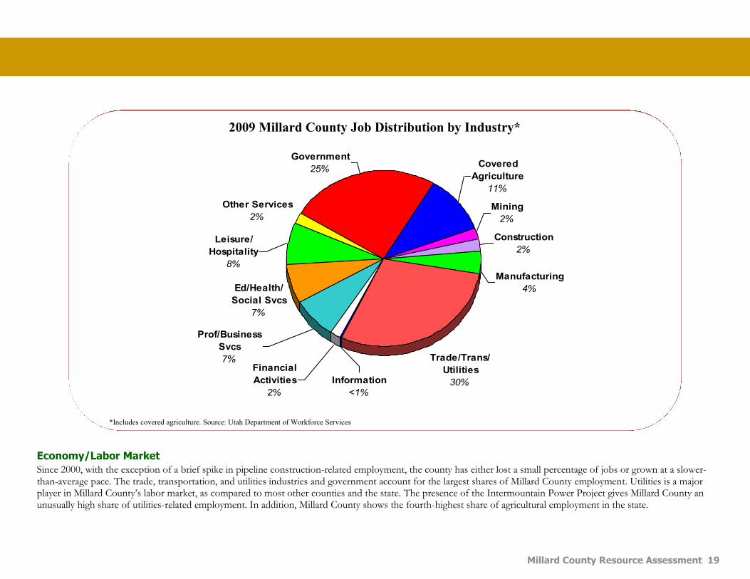
Economy/Labor Market
Since 2000, with the exception of a brief spike in pipeline construction-related employment, the county has either lost a small percentage of jobs or grown at a slower-than-average pace. The trade, transportation, and utilities industries and government account for the largest shares of Millard County employment. Utilities is a major player in Millard County’s labor market, as compared to most other counties and the state. The presence of the Intermountain Power Project gives Millard County an unusually high share of utilities-related employment. In addition, Millard County shows the fourth-highest share of agricultural employment in the state.
Information
<1%
Financial
Activities
2%
Prof/Business
Svcs
7%
Ed/Health/
Social Svcs
7%
Leisure/
Hospitality
8%
Other Services
2%
Government
25%Covered
Agriculture
11%
Mining
2%
Construction
2%
Manufacturing
4%
Trade/Trans/
Utilities
30%
*Includes covered agriculture. Source: Utah Department of Workforce Services
2009 Millard County Job Distribution by Industry*

General Resource Observations General Resource Observations
Bibliography References & Credits
20
References County Overview 1. Millard County. A Brief History of Millard County. Retrieved
from http://pioneer.utah.gov/research/utah_counties/Millard.html.
2. Wikipedia. Millard County, Utah. Retrieved from http://en.wikipedia.org/wiki/Millard_County,_Utah.
PRIORITY CONCERNS Water Improvement 1. Delta CD Board. (Multiple, 2011-2013). Board Meetings. 2. Millard CD Board. (Multiple, 2011-2013). Board Meetings.
3. Utah Department of Agriculture and Food. Retrieved from www.ag.utah.gov.
4. Utah NRCS. Millard County Resource Assessment. Retrieved
from www.ut.nrcs.usda.gov/technical/nri/RA-millard.html. 5. Delta CD Long Range Plan.
6. Millard CD Long Range Plan.
Invasive Species Control 1. Delta CD Board. (Multiple, 2011-2013). Board Meetings. 2. Millard CD Board. (Multiple, 2011-2013). Board Meetings.
3. Utah Department of Agriculture and Food. Retrieved from www.ag.utah.gov.
4. Utah NRCS. Millard County Resource Assessment. Retrieved
from www.ut.nrcs.usda.gov/technical/nri/RA-millard.html. 5. US Fish and Wildlife Service. Information provided by Clint
Wirick, USFWS. 6. Delta CD Long Range Plan.
7. Millard CD Long Range Plan.
Soil Erosion 1. Delta CD Board. (Multiple, 2011-2013). Board Meetings. 2. Millard CD Board. (Multiple, 2011-2013). Board Meetings.
3. Utah Department of Agriculture and Food. Retrieved from
www.ag.utah.gov. 4. Utah NRCS. Millard County Resource Assessment. Retrieved
from www.ut.nrcs.usda.gov/technical/nri/RA-millard.html.
5. US Fish and Wildlife Service. Information provided by Clint
Wirick, USFWS. 6. Delta CD Long Range Plan.
7. Millard CD Long Range Plan.
Agricultural Marketing 1. Delta CD Board. (Multiple, 2011-2013). Board Meetings. 2. Millard CD Board. (Multiple, 2011-2013). Board Meetings.
3. Utah Department of Agriculture and Food. Retrieved from www.ag.utah.gov.
4. Utah NRCS. Millard County Resource Assessment. Retrieved
from www.ut.nrcs.usda.gov/technical/nri/RA-millard.html 5. Delta CD Long Range Plan.
6. Millard CD Long Range Plan.
Prevent Loss of Open Space 1. Delta CD Board. (Multiple, 2011-2013). Board Meetings. 2. Millard CD Board. (Multiple, 2011-2013). Board Meetings.
3. Utah Department of Agriculture and Food. Retrieved from www.ag.utah.gov.
4. Utah NRCS. Millard County Resource Assessment. Retrieved from www.ut.nrcs.usda.gov/technical/nri/RA-millard.html.
5. Delta CD Long Range Plan.
6. Millard CD Long Range Plan.

Millard County Resource Assessment 21
GENERAL RESOURCE OBSERVATIONS Soil 1. Delta CD Board. (Multiple, 2011-2013). Board Meetings.
2. Millard CD Board. (Multiple, 2011-2013). Board Meetings. 3. Soil Survey of Millard County Utah, created by the U.S. Dept. of Ag., Soil
Conservation Service, in cooperation with U.S. Dept. of the Interior, Bureau of Land Management, and the Utah Agricultural Experiment Station.
4. Utah NRCS. Millard County Resource Assessment. Retrieved from www.ut.nrcs.usda.gov/technical/nri/RA-millard.html.
5. Delta CD Long Range Plan. 6. Millard CD Long Range Plan.
Water 1. Delta CD Board. (Multiple, 2011-2013). Board Meetings.
2. Millard CD Board. (Multiple, 2011-2013). Board Meetings. 3. Utah NRCS. Millard County Resource Assessment. Retrieved from
www.ut.nrcs.usda.gov/technical/nri/RA-millard.html. 4. Delta CD Long Range Plan.
5. Millard CD Long Range Plan.
Air and Climate 1. Delta CD Board. (Multiple, 2011-2013). Board Meetings. 2. Millard CD Board. (Multiple, 2011-2013). Board Meetings.
3. Utah NRCS. Millard County Resource Assessment. Retrieved from www.ut.nrcs.usda.gov/technical/nri/RA-millard.html.
4. Delta CD Long Range Plan.
5. Millard CD Long Range Plan.
Plants 1. Delta CD Board. (Multiple, 2011-2013). Board Meetings.
2. Millard CD Board. (Multiple, 2011-2013). Board Meetings.
3. Utah Department of Agriculture and Food. Retrieved from www.ag.utah.gov.
4. Utah NRCS. Millard County Resource Assessment. Retrieved from www.ut.nrcs.usda.gov/technical/nri/RA-millard.html.
5. US Fish and Wildlife Service. Information provided by Clint Wirick, USFWS.
6. Delta CD Long Range Plan. 7. Millard CD Long Range Plan.
Animals 1. Delta CD Board. (Multiple, 2011-2013). Board Meetings.
2. Millard CD Board. (Multiple, 2011-2013). Board Meetings. 3. Utah Division of Wildlife Resources. Information provided by Kendall Bag-
ley, DNR.
4. US Fish and Wildlife Service. Information provided by Clint Wirick, USFWS. 5. Utah NRCS. Millard County Resource Assessment. Retrieved from
www.ut.nrcs.usda.gov/technical/nri/RA-millard.html. 6. Delta CD Long Range Plan.
7. Millard CD Long Range Plan.
Humans 1. Delta CD Board. (Multiple, 2011-2013). Board Meetings. 2. Millard CD Board. (Multiple, 2011-2013). Board Meetings.
3. Utah Department of Workforce Services. Millard County Fact Sheet. Re-
trieved from jobs.utah.gov/wi/regions/western/millard/millardfs.pdf. 4. Utah NRCS. Millard County Resource Assessment. Retrieved from
www.ut.nrcs.usda.gov/technical/nri/RA-millard.html. 5. Delta CD Long Range Plan.
6. Millard CD Long Range Plan.